Peat Deposits of Southeastern New York - USGS · Peat Deposits of Southeastern New York ......
40
Peat Deposits of Southeastern New York GEOLOGICAL SURVEY BULLETIN 1317-B
Transcript of Peat Deposits of Southeastern New York - USGS · Peat Deposits of Southeastern New York ......

Peat Deposits of Southeastern New York
GEOLOGICAL SURVEY BULLETIN 1317-B

Peat Deposits of Southeastern New YorkBy CORNELIA C. CAMERON
STUDIES I N PEAT
GEOLOGICAL SURVEY BULLETIN 1317-B
The use of physical characteristics of peat and geologic settings of the deposits as guides to peat resources
UNITED STATES GOVERNMENT PRINTING OFFICE, WASHINGTON : 1970

UNITED STATES DEPARTMENT OF THE INTERIOR
WALTER J. HICKEL, Secretary
GEOLOGICAL SURVEY
William T. Pecora, Director
Library of Congress catalog-card No. 71-608545
For sale by the Superintendent of Documents, U.S. Government Printing: Office Washington, D.C. 20402 Price 25 cents (Paper cover)

CONTENTSPage
Abstract.................................................................................................................... BlIntroduction ........................................................................................................... 1
General nature and use of peat.............................................................. 1Scope of report and acknowledgments................ .................................... 3
Composition and physical properties of peat.. ................................................ 3Water-holding capacity ............................................................................... 6Organic and ash content. .................................................................. 6
Formulas for obtaining moisture, organic, and ash content.. ... 7Fiber content .... ................................... ...................................................... 7Moisture content ........................................................................................... 8Acidity ................................................. ..... ........................................... 8
Commercial classifications of peat.................................................................. 8Formation and accumulation of peat deposits ............ ....... .. ................. 12
Conditions required for the accumulation of peat................................... 12Climatic environment ............................................................................ 12Topographic environment and vegetation cover.............................. 12
History and stratigraphy of peat deposits..... ......................................... 13Rate of deposition .......................................................................................... 16
Geology of southeastern New York deposits..... ............................................. 17Regional geology and physiography ................................................... 17Classification of peat deposits..................................................................... 18
Resources .... .. ................................................................................................. 19Relation of quantity and quality of peat to geologic setting. ......... 28
Peat mining ............ .............................................................................................. 29Suggestions for peat exploration......... ..... .......... ...................................... 30Outlook for the area ............ .. ..... .......................................................... 31References . . ................................................................................... 31
ILLUSTRATIONS
PageFIGURE 1. Physiographic setting and area of study in southeastern New
York . ................................... ............. .......................................... B22. Index map of study area in southeastern New York, showing
7%-minute quadrangles and locations of peat deposits and peat mines ......................... ... .............. ......... .............. . 4
3. Chart showing relation of fiber size to organic content in sam ples from 66 deposits in southeastern New York ........ ..... 11
4. Chart showing relation of fiber size to water-holding capacityin samples from 66 deposits in southeastern New York....... 11
ill

IV CONTENTS
PageFIGURE 5. Diagrammatic sketches showing stages in the development of
peat ...... .............................. ............--.....-- .......--..-.--..--..-....- B156. Percentage of peat deposits according to class of basin of
accumulation . .. .... ... . ... ........................................... .... 197. Chart showing relation between area of deposit and average
thickness of peat in 66 deposits in southeastern New York.... 208. Tonnage of commercial quality peat according to class of basin
of accumulation . ... .... .. .. . ..... ... ....................... 29
TABLES
PageTABLE 1. Estimated resources of peat in southeastern New York sum
marized by county . ........... ... .. ............ .................................... B192. Test hole locations, geologic sections, and depths of sampled
intervals .................. ..... ................ ........................................... 203. Extent, thickness, and quality of representative samples of peat
deposits in southeastern New York ....... ........................... ..... 274. Quality of peat in southeastern New York, summarized by
county .. .... ... ............... ....... ......................................... .............. 28

STUDIES IN PEAT
PEAT DEPOSITS OF SOUTHEASTERN NEW YORK
By CORNELIA C. CAMERON
ABSTRACTPeat resources of 66 undeveloped deposits investigated in southeastern New
York are estimated at 11,500,000 short tons of air-dried peat, mostly of good quality reed-sedge type. Most of the deposits in the upland areas are 10-100 acres in extent, average 5-15 feet in thickness, and contain 10,000-100,000 tons each on an air-dried basis. Deposits in the lowlands, although less numer ous, are as much as 1,250 acres in area and as much as 25 feet in average thickness; a few contain more than 2 million tons of air-dried peat.
The principal factors that determine the commercial value of peat are water-holding capacity, organic and ash content, fiber content, and acidity. Water-holding capacity of peat in the deposits that were investigated tends to increase as the percentage of fiber greater than 0.15 mm in length increases. Fiber content and percentage of organic material is inversely pro portional to the degree of diagenesis that the peat has undergone. The rela tion of fiber size to water-holding capacity may be demonstrated by analysis and is the basis for an American Society for Testing and Materials Com mittee classification for peat used for nonfuel purposes.
The quality of peat seems to be controlled primarily by the geologic set ting of the basin of peat deposition. Analyses show that characteristics such as ash content are related to the shape of the basin of accumulation and to the distribution of unconsolidated material and to the rocks that compose the depression walls. A fivefold classification of depressions that contain peat deposits, originally applied to the highlands of northeastern Pennsylvania, was found to hold for highland and lowland deposits in southeastern New York. An understanding of the geologic factors relating to the fivefold classification is useful in prospecting for peat deposits in the region.
INTRODUCTIONGENERAL NATURE AND USE OF PEAT
Peat is a light- to dark-brown or black residuum formed by the partial decay and disintegration of plants that grow in marshes and swamps or in similar wet places. It may be (1) fibrous, matted material composed of mosses, ferns, grasses, rushes, reeds, sedges, and woody material from trees and shrubs, (2) finely divided plant debris so decomposed that its biological identity is lost, or
Bl

B2 STUDIES IN PEAT
(3) nonfibrous, plastic, colloidal, and macerated material de posited at the bottom of lakes or other bodies of water. Peat has been burned as a low-rank fuel throughout historic time, but only recently has it been widely used for a soil conditioner and horticul tural material. In 1966 for nonfuel use, 144 peat mines in 28 States produced more than 600,000 short tons of air-dried peat. An addi tional 293,843 tons was imported chiefly from Canada (U.S. Bu reau of Mines, 1967).
In view of the growing demand for peat along the Atlantic sea board, an investigation of peat resources was extended from north eastern Pennsylvania (Cameron, 1968, 1970) into the adjoining southeastern part of New York State from lat 41° to 41°45' N. The area investigated includes Orange, Putnam, and Rockland Coun ties and parts of Ulster, Dutchess, and Westchester Counties.
ADIRONDACK 2 DOME 5
:v
^INTERIOR LOWLAND
NEW YORK
fcATSKILL) P.' Z MASS
APPALACHIAN PLATEAUS
| PENNSYLVANIA
IANHATTAN PRONG
TRIAisiC TROUGH
WEST VIRGINIA
FIGURE 1. Physiographic setting and area of study in southeastern New York (modified from Meyerhoff, 1963, fig. 1).
PEAT DEPOSITS OF SOUTHEASTERN NEW YORK B3
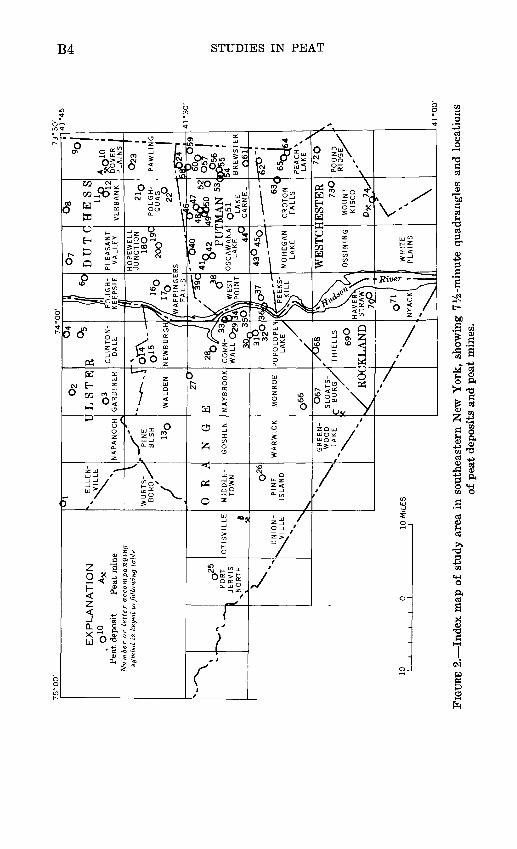
Physiographically, the area extends from the Appalachian Pla teaus to the New England Upland (fig. 1) across the Shawangunk Mountains, the southern end of the Hudson-Champlain trench, the Hudson highlands, and the Taconic Mountains. The southeastern corner covers part of the Triassic trough and the Manhattan prong. Culturally, the area includes part of the New York metro politan district in Westchester County, farming communities chiefly in the lowlands, and forested rugged uplands mostly suit able for recreation. Peat occurs in numerous swamps and marshes scattered over the area (fig. 2).
SCOPE OF REPORT AND ACKNOWLEDGMENTS
The purpose of this report is to provide information for use in the exploitation of peat deposits in southeastern New York and similar deposits elsewhere. Seventy-four undeveloped but repre sentative peat deposits were investigated by traverses across swamps and marshes and by auger holes put down by hand. Auger holes were put down with a Davis sampler and by Hiller and MacAlley peat borers at frequent intervals along the traverses to collect samples of peat and to determine the stratigraphy and thickness of the deposits and the configuration of the depressions in which they lie. The amount of peat in each deposit was esti mated from auger-hole data and from the surface area measured on topographic maps. In calculating tonnages, 1 acre-foot of peat in place was considered equivalent to 200 tons of air-dried peat. Samples from 66 of the 74 deposits were analyzed under the super vision of Irving May in the laboratories of the U.S. Geological Sur vey for moisture, ash, organic content, water-holding capacity, fiber size (exceeding 0.15 mm), and acidity.
The help of Eugene T. Sheridan, U.S. Bureau of Mines, is grate fully acknowledged. Committee reports and suggestions by mem bers of the ASTM (American Society for Testing and Materials) Committee D-29 on peats, mosses, humus, and related products were much appreciated in interpreting sample test data. Methods used in collecting and testing samples were devised or suggested by Rouse S. Farnham, Department of Soil Science, University of Minnesota; Robert E. Lucas, Department of Soil Science, Michigan State University; and Virginia Thorpe, Michigan Testing Laboratory.
Thanks for especially due David E. Schieck who served as field assistant.
COMPOSITION AND PHYSICAL PROPERTIES OF PEATThe properties and composition of peat vary considerably in
different deposits and in different parts of the same deposit
EX
PLA
NA
TIO
N
. O
10
AX
P
ea
t deposi
t P
ea
t m
ine
Nu
mb
er
or
letter
acco
mp
an
yin
g
sym
bol is
keye
d t
o fo
llow
ing
table
N-^~
^
\
10 1
1
1~X-'\ J
PO
RT
|
JER
VIS
^N
OR
TH
fx:
1 'O
TIS
VIL
LE B
_____ X
-
~ U
NIO
N-
^S
^V
ILL
EX
%N
"^T
v E
LLE
N-
\VIL
LE
WU
RT
S-
_s
BO
RO
//
i ^ 0
R
AM
IDD
LE
- T
OW
N o26
PIN
EIS
LA
ND
^
\
I
NA
PA
NO
CH
r
PIN
EB
US
H
130
. N
G
GO
SH
EN
WA
RW
ICK
GRE
EN
WOO
D»
LA
KE
0 10
MIL
ES
i i
i 1
i
02
LS
TE
03
GA
RD
INE
R
"--*-.
\
WA
LD
EN 27o
E MA
YB
RO
OK
MO
NR
OE
o66
O6
7S
LO
AT
S-
. C
B
UR
G/
? /
s/R
OC
^\
°5
R
5
CLIN
TO
N-
DA
LE
OT
4\
01
5
NE
WB
UR
GH / I 1
2Sb
/pL
CO
RN
- 3
3I
WA
LL O
29
^n
3~
^
32
°
PO
PO
LO
PE
NLA
KE
>
jf
//0
68
TH
IEL
LS
69
O
KLA
ND
S»N
^^^^
h POUGH- KE
EP
SIE
T~
J ^
tf/
Of'l
1-7
V
17o
07
1 °8
DU
TC
HE
SS
PLE
AS
AN
T
VA
LLE
Y
HO
PE
WE
LL
JU
NC
TIO
NIS
O 19C
20
O
/WA
PP
ING
ER
S1
FA
LLS
1 /'
^59
C
JS
\ O
5Y
\ W
ES
T
34\Y
j PO
INT
sJ&
o37
ur~~
"
"
X^K
^LL
"^N
il
HA
VE
RX
\ *
ST
RA
W\\ 1*
^\\
NYAC
K!
'
,
- ^540
41S
« pin
OS
CA
WA
NA
LA
KE >i>
iC
444
30
450
MO
HE
GA
NLA
KE
WE
ST
CI
OS
SIN
ING
WH
ITE
PL
AIN
S
VE
RB
AN
K
2k>
PO
UG
H-
QU
AG
22
°
T
ic'
-Q4
6
49
^05
0
O'M
AN
53<
051
LA
KE
CA
RM
EL
.__ --
63C
CR
OT
ON
FA
LLS
IES
TE
R73O
MO
UN
T
KIS
CO
D*<$y
^^ \
90
DO
VE
R
PL
AIN
S
O23
PA
WLIN
G
5^62
T~j
\)
OIQ
60n
|
^5
6 '
BR
EW
ST
ER
061|
-550
': 4P
EA
CH
* LA
KE
*v
72
Q
>
PO
UN
D
R
\DG
E^
bd u I I
CQ
FIG
URE
2.
Ind
ex m
ap o
f st
udy
area
in
sout
heas
tern
New
Yor
k, s
how
ing
7%-m
inut
e qu
adra
ngle
s an
d lo
cati
ons
of p
eat
depo
sits
and
pea
t m
ines
.

PEAT DEPOSITS OF SOUTHEASTERN NEW YORK B5
IIIIPH PH
"3 ^
S
3 3M N.S <n
M
S <-< T3 cd SH "a!
f ! I.S ««3 3O Om m \
.S Si* pi d "2 - « *J«s gg* -S -a 10 «h rt "
It.3 <u«s'3«
W tu hfl
OH °T3 s §!
: !«wgM 3a o
,°PH
O
2 h
t of Rou nter of
McKeags M Armonk.
05H £5 o 05 a21 §^Q-S
> lSH PH
i
sl i !S? 1i-H° Q g -a£ <U P c
£i> "8
<H. o"^
O S .PH °-g
|ss£
O d
<c t- co os d i-i ININ IN IN IN M M to
15 I S j* 15 « |<a | §s To ^O££W>S>S£HWH
.JJ «PHM ss"' " & o os «SH O
§2 y °
Sol SsSKI'0 (U SS c 3 £^ d .-S a< iJ H
mile north i northeast
O Q
jj > 13 a
11D 5" 3fi 2H CO
^'_o
?
a cS b « S»H SH
S °a * § 3 s1 £ 4,
!* to OJ <H 5)O rj
S « SS 10 S'O at<u ti "-10 P ,4
jSU fiS1 ° .S o
^H bfl
W C
llen Ohioville E
iles south of
5i g* ^^, -rfi£ °.K rH
1*-g g>_1-lus 0°M .^ .5 ^
f Poughkeeps heast of cross et and railro:
o *> v^gi3a CMH
.2'S
. o fcfc~ SHa o> ~
tfi S "S|3^£ 0PH C SH (Uo a « s" rt&S «-i5 =>§"?M 0
'a *ih m-=1
S !
^!§d fiT3
&|
ack Swamp, i between Wi crossing to
S 13 Ba "S. 1*" S-I "^H
S JJ
H M
"ficd a(U
£SHO
-M
8 fi_i; Scd
«H
O
1O
d
m
5? fi fiSU
g*HO-M
aV
<u
S cd
CHO
10d
g « C^ ££ +J hs. . tfi 'O o3 I> oi O V D_iIS ^ PH PS ^5 cd ,. _ « ,;cd^^ fi . C S|
"3 o S^i3 d «j§ §«g^KS -S|
II5^| J| ^^°|ll^t^l|2°ir, iin^i^i
-fio-J3^,t.43rt-^bov *J X-*j "t^o +JO-M..-IS 5iw s S c Stf ^ffl." O * O »T M O^1 O HHPH ^ ^ ^ g ^
S gh l>§ 5 7 aOPH
td a;KM _W"S-S
SfM.S-S §a o
MSH O'O-ggC6 S"OX fd-w OSPnO ^"
S5
dISX
Evest of East !
^ s3O
M
O PH
>> (U"3
^>SHO
a mile north
iwamp.
U2SH0 £
Mt- U
d «
E "S(U Ofi PH5Ho bo0 S!|oB S ^SH & 3o m °
1*1 J151-M
SH (U "5O j- IN» H rt
o g05 Od rt
<j «
O i-l IN to H i-l ININININCgiN

B6 STUDIES IN PEAT
because of different types of vegetation from which peat was derived and from varying conditions under which it accumulated and has been preserved. The commercial characteristics and properties of peat vary widely, and the Cooperative Extension Service at Michigan State University (Lucas and others, 1966) has published a guide for users. The principal factors that determine the commercial value are water-holding capacity, organic content, fiber content, and acidity.
WATER-HOLDING CAPACITY
One of the most important properties of peat as a soil con ditioner and horticultural material is its ability to reabsorb water after initial drying, like a sponge. Water-holding capacity, which is measured in percentage by weight, depends upon botan ical character, the degree of decomposition, and the degree of drying to which peat has been subjected. Moss peat will hold water equal to 15-30 times its own dry weight; a good grade of reed-sedge peat will hold water equal to 10-20 times its own dry weight; humus which is highly decomposed peat will hold con siderably less water. Peat tends to reabsorb less water when oven dried than when it is dried in the open air.
Water-holding capacity is determined in the laboratory on samples of peat that have been kept from drying after collection in the field. Twenty to fifty grams of peat is immersed in water at room temperature for 18-24 hours in a tarred-covered con tainer having a wire-screen bottom. The sample is then heated in an oven at 105 °C to constant weight, cooled in a desiccator, and weighed. The ratio of absorbed water to the oven-dry weight is computed from the difference in weight of the sample before and after drying.
Water-holding capacity in a representative sample from each of the 66 New York deposits sampled ranged from 352 to 2,488 percent. Only 12 samples had a water-holding capacity of less than 1,000 percent.
ORGANIC AND ASH CONTENT
Regulations established by the Federal Trade Commission in 1950 define peat as any partially decomposed vegetable matter which is accumulated under water or in a water saturated en vironment through decomposition of mosses, sedges, reeds, tule, trees, or other plants. It is unlawful to label a product "peat" unless 75 percent of the material, by dry weight, is composed of peat as defined and the remainder is composed of normally associated soil materials. In practice, the organic content is equal to the loss in weight when dry peat is heated at 550°C

PEAT DEPOSITS OF SOUTHEASTERN NEW YORK B7
and the solids remaining constitute the ash.The organic content in samples representative of about half of
the New York depostis studied is at least 90 percent. Only samples from 13 deposits contained less than 75 percent organic material.
FORMULAS FOR OBTAINING MOISTURE, ORGANIC, AND ASH CONTENT
In this investigation, moisture, ash, and organic content were determined in successive steps on the same sample. Samples were carried to the laboratory in water-tigh* containers to prevent water loss and were dried in the laboratory at 105° C for 16 hours. The percentage of moisture content equals
weight of sample as received - weight of dried sample 1 .. weight of sample as received
The dried sample was then heated at 550 °C until completely ashed. The percentage of ash equals
weight of ashweight of dried sample
Organic content of the sample was then calculated, in percentageas follows :
weight of dried sample - weight of ash 1ft ~ weight of dried sample
FIBER CONTENT
Fiber content refers to the proportion of stem, leaf, or other plant fragments that make up peat. Because peat with a high percentage of fibers more than 0.15 millimeters in length also tends to have high water-holding capacity and because fiber content correlates well with weight per unit volume (a basis for the sale of peat), a tentative classification based on fiber content has been formulated by the ASTM D-29 Subcommittee I, Clas sification (R. S. Farnham, written commun., 1967).
The amount of fiber exceeding 0.15 mm in length has been measured for each of the 66 deposits sampled in southeastern New York (table 3). The peat samples were oven dried and screened, and the fiber content was calculated by the following formula:
weight of fibers (>0.15) .,-. , ,. , , . . , , 1-^-7 - X 100 = percentage of content more total dry weight than 0 15 mm in length
The deposits were grouped by fiber content as follows : Type I, more than 66%-percent fiber content greater than
0.15 mm in length. Type II, 33%-662/fj percent fiber content greater than
0.15 mm in length.

B8 STUDIES IN PEAT
Type III, less than SS 1/^ percent fiber content greater than0.15 mm in length.In general, sphagnum moss peat appears to be characterized
by long fibers of type I. Most reed-sedge peat falls in type II, and much humus in type III. The peat deposits in southeastern New York are predominantly reed-sedge of type II fiber content.
MOISTURE CONTENT
The water content of peat in the deposit cannot be measured accurately but is very important in the mining and processing of peat. Moisture content in samples from 66 deposits in southeast ern New York ranged from 74.6 to 95.0 percent. Samples from 47 of the deposits contained 90.0-95.0 percent water, and with one exception the remainder contained more than 80 percent. The water that constitutes a large part of the undisturbed peat moves through the deposit very slowly. Both drainage of de posits by ditching to permit excavation and the drying of the peat before stockpiling for sale are slow.
ACIDITY
Natural peat ranges in pH from 3.2 to 7.5. Very acid peats have a pH of 3.2-4.2, acid peats have pH 4.2-5.0, and peats with pH between 5.0 and 7.0 are regarded as low in acidity. Those with pH above 7.0 are alkaline. Peat having a pH of less than 5.0 is classed as calcium deficient, and that having a pH above 5.0 is classed as calcium sufficient.
Most of the New York deposits tested have pH values of 5-6 and are calcium sufficient.
COMMERCIAL CLASSIFICATIONS OF PEAT
Because peat is formed from many kinds of plant material under a wide range of conditions, different varieties are suitable for various uses. Many different modes of classification have, therefore, been proposed. The chief classifications are based on the following factors: (1) physical or chemical characteristics such as texture, organic and mineral composition, water content, and fuel value, (2) the soillike nature of peat and the vegetation that grows upon it, (3) origin, mainly by the type of vegetation represented, (4) the environment of formation, and (5) uses such as for fuel, as a source of chemical and other manufactured products, and as a soil conditioner. Use as a soil conditioner and horticultural material prompted the U.S. Bureau of Mines to devise specifications governing the purchase of peat by the Federal Government. The need for a more specific classification

PEAT DEPOSITS OF SOUTHEASTERN NEW YORK B9
has been recognized by the peat industry, and the ASTM Com mittee on Peat consequently has proposed a classification.
For statistical purposes, the U.S. Bureau of Mines classifies peat into three general types: moss peat, reed-sedge peat, and peat humus. That classification is used in this report. Most peat produced in the United States and most of the unexploited de posits in southeastern New York are either reed-sedge or humus type. Peat of any type may contain a considerable amount of woody material.
Moss peat is formed principally from sphagnum, hypnum, and other mosses. Sphagnum moss peat is light tan to brown, light in weight, porous, high in water-holding capacity, of high acidity, and low in nitrogen content. "Top moss" is the living part of sphagnum and should not be confused with moss peat which has aged and partially decomposed. Hypnum moss peat is darker brown, of low acidity, and physically similar to reed-sedge peat.
Reed-sedge peat is formed principally from reeds, sedges, marsh grasses, cattails, and associated plants. Fibrous, partially decomposed peat is brown to reddish brown but more decom posed peats are darker. The water-holding capacity and the nitrogen content are of medium range.
Peat humus is peat mostly derived from reed-sedge or hypnum moss peat so decomposed that the original plant remains are not identifiable. It is dark brown to black, has low moisture-retention capacity, and a medium to high nitrogen content.
In addition to these three major types of peat, other materials high in organic matter should be mentioned. Sedimentary peat is derived from algae, plankton, pond weeds, and similar plant species. It occurs in the bottom of lakes and ponds and in the lower levels of most peat deposits. Such peat usually contains considerable mineral impurities and in this report is referred to as peaty clay or clayey peat, depending upon the organic con tent. It is too finely divided for most soil improvement purposes, shrinks and swells greatly with varying moisture content, and some has a sheetlike structure and hardens upon drying. Muck is highly weathered peat that has been modified greatly by soil micro-organisms and is usually granular in structure. It has low moisture-retention capacity and is poorly suited for soil- improvement purposes.
Purchase of peat by the Federal Government is subject to specifications developed by the Federal Supply Service of the General Services Administration. Federal Specification Q-P- 166e, dated May 10, 1961, which covers four general types of peat for agricultural use, includes the following specifications:
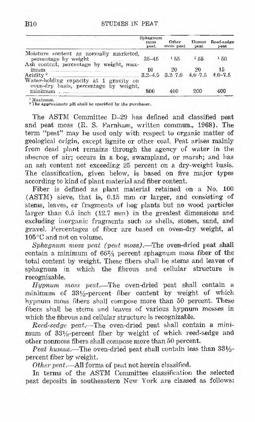
BIO STUDIES IN PEAT
Sphagnummoss Other Humus Reed-sedge peat moss peat peat peat
Moisture content as normally marketed,percentage by weight ...__...___....___.____.... 35-45 L 55 x 55 x 50
Ash content, percentage by weight, max imum ..................................... ........ 10 20 20 15
Acidity 2 .......................................................... 3.2-4.5 3.2-7.0 4.0-7.5 4.0-7.5Water-holding capacity at 1 gravity on
oven-dry basis, percentage by weight, minimum . ..... .... ........ ....... .. ... 800 400 200 400
1 Maximum.2 The approximate pH shall be specified by the purchaser.
The ASTM Committee D-29 has defined and classified peat and peat moss (R. S. Farnham, written commun., 1968). The term "peat" may be used only with respect to organic matter of geological origin, except lignite or other coal. Peat arises mainly from dead plant remains through the agency of water in the absence of air; occurs in a bog, swampland, or marsh; and has an ash content not exceeding 25 percent on a dry-weight basis. The classification, given below, is based on five major types according to kind of plant material and fiber content.
Fiber is defined as plant material retained on a No. 100 (ASTM) sieve, that is, 0.15 mm or larger, and consisting of stems, leaves, or fragments of bog plants but no wood particles larger than 0.5 inch (12.7 mm) in the greatest dimensions and excluding inorganic fragments such as shells, stones, sand, and gravel. Percentages of fiber are based on oven-dry weight, at 105 °C and not on volume.
Sphagnum moss peat (peat moss). The oven-dried peat shall contain a minimum of 66% percent sphagnum moss fiber of the total content by weight. These fibers shall be stems and leaves of sphagnum in which the fibrous and cellular structure is recognizable.
Hypnum moss peat. The oven-dried peat shall contain a minimum of 33%-percent fiber content by weight of which hypnum moss fibers shall compose more than 50 percent. These fibers shall be stems and leaves of various hypnum mosses in which the fibrous and cellular structure is recognizable.
Reed-sedge peat. The oven-dried peat shall contain a mini mum of 33%-percent fiber by weight of which reed-sedge and other nonmoss fibers shall compose more than 50 percent.
Peat humus. The oven-dried peat shall contain less than 33%- percent fiber by weight.
Other peat. All forms of peat not herein classified.In terms of the ASTM Committee classification the selected
peat deposits in southeastern New York are classed as follows:
PEAT DEPOSITS OF SOUTHEASTERN NEW YORK Bll
1UU
90i PERCEN"
8
- 75
1 701-
I
| 60
3 CC O
50
0
1 1 1
_
_
Fiber type III
i i i
i i i
. ;:.! *': -. - " * ** * * .
« * *
Fiber type II
i i i
i i
-.
_
-
_
_
-Fiber type 1
i i10 20 30 40 50 60 70 80
PERCENTAGE OF FIBER LONGER THAN 0.15 MILLIMETERS
90
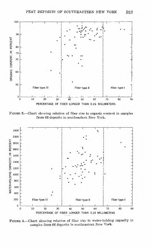
FIGURE 3. Chart showing relation of fiber size to organic content in samples from 66 deposits in southeastern New York.
2400
2200I-
^ 2000
£ 1800
- 1600
O 1400< Q.g 1200
OZ 1000
O 800
QL600
400
200 Fiber type III Fiber type II
I I____i
Fiber type I
10 20 30 40 50 60 70 80
PERCENTAGE OF FIBER LONGER THAN 0.15 MILLIMETERS
90
FIGURE 4. Chart showing relation of fiber size to water-holding capacity in samples from 66 deposits in southeastern New York.

B12 STUDIES IN PEAT
52 deposits are reed-sedge peat; two deposits are peat humus; one is sphagnum moss peat; 10 deposits are other peat; and one deposit is not classified as peat. Relation of fiber content to quality factors is shown in figures 3 and 4. Most of the deposits with organic content greater than 75 percent have 33*4-66% percent of fiber greater than 0.15 mm. As the percentage of fiber greater than 0.15 mm increases, water-holding capacity increases.
FORMATION AND ACCUMULATION OF PEAT DEPOSITS
CONDITIONS REQUIRED FOR THE ACCUMULATION OF PEAT
Peat formation requires the coincidence of several physical and biological factors: a climate and soil that favor growth of plants; a physical setting that favors accumulation of plant debris; and a geologic setting in which peat, once formed, may be preserved.
CLIMATIC ENVIRONMENT
Peat forms in many climates. Temperature is not a limiting factor; just as plants grow from the Arctics to the Tropics, peat deposits also form. The peat bogs of northern latitudes have long been studied and exploited, but the great peat de posits of Florida (Davis, 1946) are not as well known. High temperature is important in stimulating plant growth, but it also increases the rate of decay. Moisture is the most critical climatic factor in promoting plant growth and inhibiting decay, and thus largely controls the formation of peat. The anaerobic conditions in the lower parts of nearly stagnant ponds, swamps, and marshes provide maximum opportunity for preservation (Waksman, 1942, and Waksman and Stevens, 1929, 1932). In cool areas of high rainfall and humidity and consequent low evapora tion, deposits of sphagnum moss may accumulate and form peat on flat or sloping land as along the coast of Maine; under these conditions some peat deposits have been built up more than 20 feet above the surrounding area.
The climate of southeastern New York is humid continental and characterized by long cold winters and short warm summers. Average summer temperatures of 70°-80°F. and precipitation totaling about 60 inches and rather evenly distributed through out the year permit peat to form today in some places chiefly in the highlands. Most of the peat in the area of study was formed during the cooler and more favorable climatic conditions follow ing the melting of the last glacial ice.
TOPOGRAPHIC ENVIRONMENT AND VEGETATION COVER
Three general types of peat deposits can be recognized: (1) the

PEAT DEPOSITS OF SOUTHEASTERN NEW YORK B13
filled basin, (2) built-up or so-called climbing deposits on flat or gentle slopes, and (3) a composite type consisting of built-up deposits underlain by peat of the filled-basin type. The first and third types are represented in the area of study. Here the de posits are in closed depressions on the surface of bedrock or on glacial drift, at elevations ranging from near sea level in the Hudson River gorge to more than 1,000 feet above sea level on the adjacent uplands. Most deposits of peat formed in water- filled depressions left after glacial retreat. The numerous de pressions at various elevations were filled and became marshes, and some changed into swamps; some again became ponds; others were drained completely.
Peat deposits in southeastern New York are chiefly in swamps and are covered dominantly by maple-ash forest type; elm, black and white birch, black gum, and white pine are other common trees. Shrubs and low trees include willow, alder, poison sumac, and high-bush blueberry. Rhododendron is common only in the Shawangunk Mountains; skunk cabbage and cinnamon, royal, and oak leaf ferns are abundant on hummocks that characterize the swamp floor. Swamps with an oak forest in general have little if any peat, apparently because of unfavorable soil and drainage conditions.
A few marshes with tall grasses contain peat chiefly in the Hudson River gorge and in uplands where forest has been cleared or killed by flooding.
The largest deposit, No. 26 in the Pine Island quadrangle in Orange County (fig. 2), is mostly planted to truck gardens.
HISTORY AND STRATIGRAPHY OF PEAT DEPOSITS
Most of the marshes and swamps that contain peat consist, from bottom upward, of glacial drift or bedrock overlain by gray clay, thin layers or streaks of organic clay, peaty clay, clayey peat, and reed-sedge peat that may contain logs and stumps or sphagnum moss in its upper part. An uppermost layer of decomposed peat or muck may cover all or part of the surface of the deposit.
The sequence of peat formation begins when clay is washed in from the sides of a water-filled depression and accumulates on the bottom (fig. 5A). When floating simple organisms such as diatoms and algae die, they mix with clay particles to form the organic clay that appears in thin layers or as streaks within the basal part of the peaty clay layer. As plants increase in abun dance and variety in the pond, peaty clay gives way to clayey or algal peat in the bottom, and reed-sedge peat begins to accumu-

B14 STUDIES IN PEAT
Water table
Clayey or algal peat
Peaty clayClayey or algal peat
Water table
Clayey or algal peat

PEAT DEPOSITS OF SOUTHEASTERN NEW YORK B15
FIGURE 5. Diagrammatic sketches showing stages in the development of peat (not drawn to scale). A, Pond stage. B, marsh stage. C, forest stage. D, return to pond stage. E, stage of lowered water table.
late at the shallow margins where reeds and other grasses, sedges, water lilies, and other semiaquatic plants are able to take root.
Waksman (1942) describes the peaty material deposited below the surface of the pond as the remains of a variety of plants such
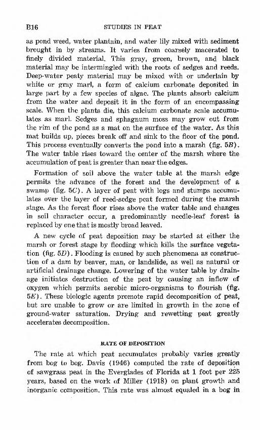
B16 STUDIES IN PEAT
as pond weed, water plantain, and water lily mixed with sediment brought in by streams. It varies from coarsely macerated to finely divided material. This gray, green, brown, and black material may be intermingled with the roots of sedges and reeds. Deep-water peaty material may be mixed with or underlain by white or gray marl, a form of calcium carbonate deposited in large part by a few species of algae. The plants absorb calcium from the water and deposit it in the form of an encompassing scale. When the plants die, this calcium carbonate scale accumu lates as marl. Sedges and sphagnum moss may grow out from the rim of the pond as a mat on the surface of the water. As this mat builds up, pieces break off and sink to the floor of the pond. This process eventually converts the pond into a marsh (fig. 5B). The water table rises toward the center of the marsh where the accumulation of peat is greater than near the edges.
Formation of soil above the water table at the marsh edge permits the advance of the forest and the development of a swamp (fig. 5C). A layer of peat with logs and stumps accumu lates over the layer of reed-sedge peat formed during the marsh stage. As the forest floor rises above the water table and changes in soil character occur, a predominantly needle-leaf forest is replaced by one that is mostly broad leaved.
A new cycle of peat deposition may be started at either the marsh or forest stage by flooding which kills the surface vegeta tion (fig. 5D). Flooding is caused by such phenomena as construc tion of a dam by beaver, man, or landslide, as well as natural or artificial drainage change. Lowering of the water table by drain age initiates destruction of the peat by causing an inflow of oxygen which permits aerobic micro-organisms to flourish (fig. 5E). These biologic agents promote rapid decomposition of peat, but are unable to grow or are limited in growth in the zone of ground-water saturation. Drying and rewetting peat greatly accelerates decomposition.
RATE OF DEPOSITION
The rate at which peat accumulates probably varies greatly from bog to bog. Davis (1946) computed the rate of deposition of sawgrass peat in the Everglades of Florida at 1 foot per 225 years, based on the work of Miller (1918) on plant growth and inorganic composition. This rate was almost equaled in a bog in
PEAT DEPOSITS OF SOUTHEASTERN NEW YORK B17
Quebec, Canada, as shown by the radiocarbon studies of Potzger and Courtemanche (1954). Mitchell (1965), however, calculated the rate of accumulation at Littleton Bog in Ireland at 1 foot per 480 years, by using radiocarbon dates. An average but not constant rate of 1 foot per 1,400 or 1,500 years according to radiocarbon dates was computed for peat accumulation in Bear Meadows Bog in central Pennsylvania by Westerfeld (1961). No radiocarbon dates are available in the area of this report, but average accumulation in nearby Sussex County, K.J., was prob ably 1 foot per 500-1,200 years (Minard, 1959).
GEOLOGY OF SOUTHEASTERN NEW YORK DEPOSITS
REGIONAL GEOLOGY AND PHYSIOGRAPHY
The Hudson highlands, dominating the area of study, rise abruptly from lowlands on the north and south (fig. 1). They are a northeast-trending upland chiefly of granite, gneiss, and schist of Precambrian age. The highlands extend from New Jersey into the complex New England Upland which includes the Taconic Mountains and the Manhattan prong (New York State Museum and Science Service, Geological Survey, 1962). Most elevations in the Hudson highlands range from 500 to 1,300 feet above sea level. This conspicuous topographic feature is marked by ridges and valleys trending northeast parallel to the bedrock structure and is cut by the Hudson River.
The lowlands comprising the southern extension of the Hud- son-Champlain trench have been developed by erosion of soft Ordovician shales between the folded harder rocks that form the ridges of the Shawangunks, the Hudson highlands, and the Taconic Mountains. The Triassic trough south of the Hudson highlands is developed in sandstone and shale and is bordered on the north by the Triassic border fault and the Palisades.
The Taconic Mountains trend north; schists form the hills, and limestone strata underlie the valleys. The topographic grain is much less prominent on the granite and metamorphic rocks in the Manhattan prong.
Glacial drift covers most of the area. At least six moraines, each caused by a temporary ice stand during the retreat of the glacier on the lowlands, caused ponds and lakes to form between the bedrock highlands and moraine features or between the moraines. Swamps and marshes, many containing peat deposits,
B18 STUDIES IN PEAT
mark sites of former lakes and ponds that formed during deglaciation.
CLASSIFICATION OF PEAT DEPOSITS
A fivefold classification of basins of peat accumulation, de veloped during the study of deposits in the highlands of north eastern Pennsylvania (Cameron, 1970), was found to apply to both the uplands and the lowlands of southeastern New York. The kinds of basins are as follows:
Al. Bedrock trough closed at both ends by unconsolidated material.
2. Bedrock trough with unconsolidated material closing both ends and partly mantling the trough.
3. Depression in bedrock closed by unconsolidated material.
Bl. Depression in unconsolidated material closed by bedrock.2. Depression completely within unconsolidated material.The peat deposits (fig. 2) fall into the following groups:
Lowland:Al. Deposits 16-20.
2. Deposits 6, 7, 10, 23, 24, 58.3. Deposits 4, 5, 13.
Bl. Deposit 71.2. Deposits 2, 3, 14, 15, 26-28, 69, 70.
Upland:Al. Deposits 22, 25, 29, 33, 40, 51, 52, 54, 55, 64-66, 68.
2. Deposits 8,12, 21, 32, 43, 45, 60, 62, 67.3. Deposits 9, 11, 30, 31, 34-39, 42, 46-50, 57, 59, 74.
Bl. Deposits 1, 38, 41, 44, 53, 56, 61, 63, 72, 73.
The 50 deposits in the upland group are in the Shawangunk Mountains, Hudson highlands, Manhattan prong, and Taconic Mountains. The topographic grain of these areas roughly par allels the direction of glacial movement from the north and northeast. The 24 deposits in the lowland group are in plains areas within the lower extension of the Hudson-Champlain trench, the Triassic trough, and a broad valley within the Taconic Mountains which contain deposits 10, 23, 24, and 58 in Dover Plains, Pawling, and Brewster quadrangles.
Figure 6 shows the proportion of deposits of commercial quality. Peat deposits of types of Al and A3 are more apt to have

PEAT DEPOSITS OP SOUTHEASTERN NEW YORK B19
higher organic content, higher water-holding capacity, and a higher proportion of long fibers than the others. Deposits of type A2 are higher in organic content than those of type Bl.
C 0
°2 ATP=o| A3|=
0 o B2^=
01
1 1 ' ==l 1
1 ==J 1
=J 1 1 10 20 30 40 0 10 20 30 40
1 I I ii i i i I
Percentage of 24 deposits ' Percentage of 50 deposits LOWLANDS UPLANDS
FIGURE 6. Percentage of peat deposits according to class of basin of accumu lation. Percentage of deposits in each class is shown by length of bar; hatched part indicates percentage of deposits of commercial quality.
RESOURCESThe resources of peat in deposits that were sampled in south
eastern New York are estimated at about 11,500,000 short tons. This estimate is for air-dried peat on a basis of 200 tons of peat per acre-foot. Deposits that were not sampled probably contain about 1,500,000 tons (table 1).
TABLE 1. Estimated resources of peat in southeastern New York summarizedby county
_______________[Estimates given in short tons on an air-dried basis]_______________
Nonsampled County___________________________Sampled deposits____________deposits
Dutchess ____________________ 550,000 200,000Orange ___________________ 5,700,000 650,000Putnam ___________________ 4,000,000 150,000Rockland _____________ ___. 300,000 100,000Ulster _____________________ 230,000 160,000Westchester ____ ___ _ -._ 720,000 240,000
Total ...._.._..__.................._.....__._11,500,000 1,500,000
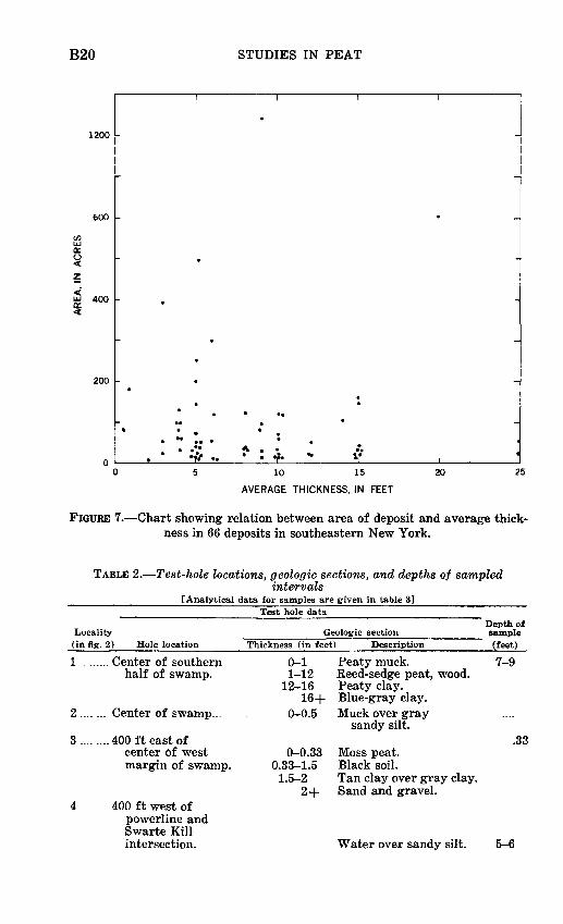
Size of the peat deposits range from 1 to 1,245 acres, with most exceeding more than 2 acres. Thickness of peat in the deposits ranges from 1 to 25 feet (fig. 7). A description of the peat in sampled deposits is shown in table 2, and size, thickness, and quality of the peat is given in table 3. The samples were chosen to represent the quality of most of the peat in the deposit. Quality of peat is summarized by county in table 4.
B20 STUDIES IN PEAT
1200
600
400
200
iL10 15
AVERAGE THICKNESS, IN FEET
20 25
FIGURE 7. Chart showing relation between area of deposit and average thick ness in 66 deposits in southeastern New York.
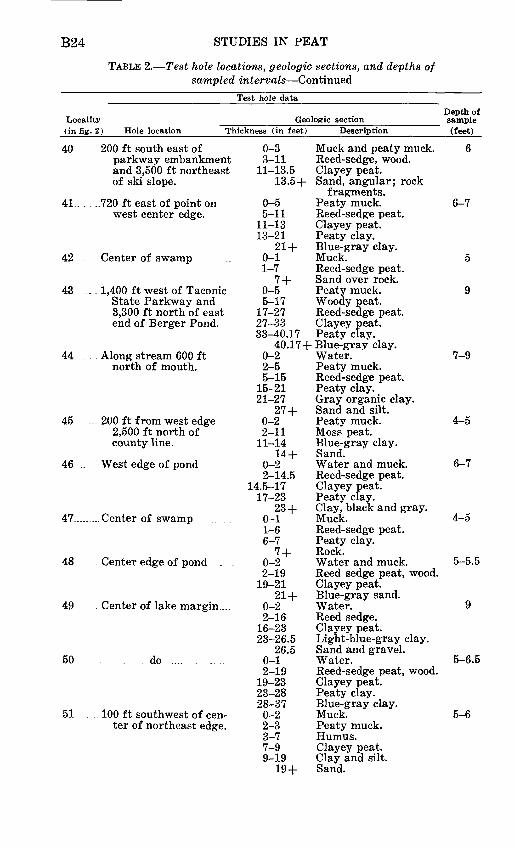
TABLE 2. Test-hole locations, geologic sections, and depths of sampledintervals
[Analytical data for samples are given in table 3]
LOCEility
Test hole dataDepth of
Geologic section sample(in fig. 2) Hole location Thickness (in feet) Description (feet)
1 .
2 ....
8
.... Center of southern half of swamp.
... Center of swamp...
....400 ft east ofcenter of west margin of swamp.
0-1 1-12
12-16 16+
0-0.5
0-0.33 0.33-1.5 1.5-2
2+
Peaty muck. 7-9 Reed-sedge peat, wood. Peaty clay. Blue-gray clay.Muck over gray
sandy silt..33
Moss peat. Black soil. Tan clay over gray clay. Sand and gravel.
4..........400 ft west ofpowerline and Swarte Kill intersection. Water over sandy silt. 5-6

PEAT DEPOSITS OF SOUTHEASTERN NEW YORK B21
TABLE 2. Test hole locations, geologic sections, and depths of sampled intervals Continued
Locality
Test hole data
Geologic section(in fig. 2) Hole location Thickness (in feet) Description
B
6
7. . .
8
9
10
11
13
14
15
16
17
.... 300 ft east of westedge of swamp and 500 ft south of outlet stream.
... Center of swamp,1,500 ft northeast of outlet.
. Center of swamp . ..........
... 1,100 ft northeast ofoutlet and 200 ft west of east edge.
..600 ft west of centerof east edge.
... 900 ft west of pointon west bank of river 0.55 of a mile north west of highway bridge in Wingdale.
..... 1,300 ft northeast ofoutlet and 300 ft west of east edge.
... Center of swamp. ....... ..
... 200 ft north of centerof south edge.
... .Center of swamp westof point on east edge 1 mi northwest of Leptondale.
on edge of swamp 0.77 mile south of Leptondale.
. .Center of swamp.. .........
....... .. ....do. ....... ...
0-1 Water. 1-9 Reed-sedge peat, wood. 9-13 Clayey peat.
13-17 Peaty clay. 17-18.5 Light-blue-gray clay. 0-1 Muck. 1-9 Reed-sedge peat. 9-13 Clayey peat.
13-14 Peaty clay. 14+ light-blue-gray clay.
0-1 Muck. 1-2 Disintegrated peat.
2+ Silt. 0-1 Muck. 1-7 Reed-sedge peat. 7-8 Peaty clay. 8-10 Light-blue-gray clay,
sandy. 10+ Silt.
0-12 Reed-sedge peat. 12-15 Clayey peat. 15-16 Peaty clay. 16-17.5+ Soft light-blue-gray
clay. 0-0.17 Muck.
0.17-0.33 Light-gray soapy clay. 0.33 + Light-gray sandy silt.
0-1 Muck. 1-2 Peaty muck. 2-5 Reed-sedge peat, wood. 5-15 Reed-sedge peat.
15-18 Light-blue-gray clay. 18+ Gravel.
0-2 Muck.2+ Sandy silt.
0-1 Muck. 1-13 Reed-sedge peat.
13-15 Clayey peat. 15+ Light-blue-gray clay.
0-3 Muck. 3-5 Peat, slightly clayey. 5-7 Peaty clay.
7+ Light-blue-gray clay. 0-3 Muck and peaty muck. 3-7 Reed-sedge peat. 7-9 Clayey peat. 9-13 Clay and silt.
13+ Light-blue-gray clay. 0-1 Muck.1-8 Reed-sedge peat. 8-12 Clayey peat.
12+ Light-blue-gray clay. 0-1 Muck.1-9 Reed-sedge peat. 9-18 Peaty clay.
18+ Gray silty clay.
Depth of sample(feet)
5-6
9
5
7-9
5-9
4-6
4-5
5-6
5
5

B22 STUDIES IN PEAT
TABLE 2. Test hole locations, geologic sections, and depths of sampled intervals Continued
Test hole data
Locality Geologic section(in fig. 2) Hole location Thickness (in feet) Description
18
19
20
21 .
22
23
24 .
25
26
200 ft west of eastedge of swamp atpoint 1,500 ft northwest of interchange.
...200 ft northwest ofsoutheast edge ofswamp at point 2,600ft east of TaconicState Parkway.
Center of swamp 1,500ft south of Highway52 at swamp outletstream crossing.
....Center of swamp 300 ftsouth of Highway 55.
200 ft southwest ofnortheast end withinthe 810-ft contourline.
1,800 ft west of pointon west side of StateHighway 22, 800 ftnorth of culvert.
.Along Cotton River,1,000 ft north ofPine Island.
Center of swamp,1,800 ft northeastof outlet.
. 1.8 mile southwest ofDurlandville and 0.85mile southeast ofWallkill River.
0-0.50.5-1.51.5-3
3-88-12
12+0-0.5
0.5-2.52.5-6
6-77 +
0-22-4
4-66-9.5
9.5 +0-2
2+0-15
15-1616 +
0-0.50.5-2.52.5-6.56.5-7.58
7.58-88+
0-11-33-20
20+0-18.5
18.5-19.519.5-21
21 +0-10.5
10.5-1212+
WaterMuck.Slightly disintegrated
peat.Reed-sedge peat.Peaty clay.Very sandy silty clay.Water.Muck.Reed-sedge peat.Peaty clay.Dark-gray sand
and gravel.Muck.Slightly disintegrated
peat.Reed-sedge peat, twigs.Clayey peat.Gray silt.Muck.Silt.Reed-sedge peat.Light-gray clay.Sand and gravel.
Water.Muck.Humus, some wood.Peaty clay.Light-blue-gray clay.Sand and gravel.Water.Silt.Reed-sedge peat, wood.Silty peaty muck.Moss peat.Peaty clay.Light-blue-gray clay.Silty sandy clay.Reed-sedge peat.Peaty clay.Blue-gray clay, silty.
Depth of sample (feet)
5
5
5
6
4
8-9.5
11-13
5-6
27 ..0.65 mile southwest ofBuchanan Hill and 500 ft. west of east edge of swamp.
28 .....200ft. west of east edge of swamp at a point 0.45 of a mile south- southwest of Vails Gate.
0-1 Peaty muck. 7-91-13 Reed-sedge peat, wood.
13-13.75 Peaty clay.13.75+Light-blue-gray clay.
0-0.33 Water. 6-70.33-13 Reed-sedge peat.
13-16.5 Clayey peat.16.5+ Peaty clay.

PEAT DEPOSITS OP SOUTHEASTERN NEW YORK B23
TABLE 2. Test hole locations, geologic sections, and depths of sampled intervals Continued
Locality
Test hole data
Geologic section(in fig. 2) Hole location Thickness (in feet) Description
29
30
31
32
33
34 ..
35
36 ..
37
38
39
Center of marsh
do .
do . .
do . .. . .. ... ... .
do .. . ... .. ... ... .........
do ............... .........
.... South center of swamp ...
... Center of marsh, 150 ft.south of road crossing.
.... Center of swamp ........ ..
West edge of Cat Pond,200 ft north of outlet.
South end of area shownas lake on topographicmap.
0-0.250.25-1
1-33-6.75
6.75-7.337.33+
0-1111-1212-1515-21.5
21.5 +0-55-66-13
13-1414-18
18 +0-1
1 +0-13
13-1717-45
45-5050-54.5
54.5 +0-0.5
0.5-22-8.5
8.5-12.512.5-16.66
16.66+0-22-55-12
13-1717-22
22+0-55-99-24
24-3535-36
0-0.330.33-0.660.66-2
2+0-15
15-1818-25
25+0-11-77-12
12+
WaterMuck and disintegrated
peat.Reed-sedge peat.Clayey peat.Peaty clay.Blue-gray clay, black
streaks.Reed-sedge peat, wood.Clayey peat.Peaty clay.Blue-gray clay.Sand and gravel.Muck.Peaty muck.Reed-sedge peat.Peaty clay.Blue-gray clay.Sandy silty clay.Gray silt.Sandy silt, gravel.Reed-sedge peat.Clayey peat.Peaty clay, leaves of
trees and shrubs.Black organic clay.Gray clay, black streaks.Sand and gravel.Water.Peaty muck.Reed-sedge peat.Clayey peat.Peaty clay.Gray clay.Peaty muck.Moss peat, wood.Reed-sedge and
moss peat.Clayey peat.Peaty clay.Greenish gray clay.Muck.Reed-sedge peat, clay.Reed-sedge peat.Clayey peat.Clay and gravel.Water.Muck.Moss peat.Silty peaty clay.Moss peat, wood.Clayey peat.Peaty clay.Sand and gravel.Muck.Reed-sedge peat.Peaty clay.Greenish-gray clay.
Depth of sample (feet)
2-3
5-6
7-9
3-6
6-7
4-5
15.33-17.33
1-1.5
7-9
5
B24 STUDIES IN PEAT
TABLE 2. Test hole locations, geologic sections, and depths of sampled intervals Continued
Locality(in fig.
40 ..
41.. . .
42 ..
43 ...
Test hole data
Geologic section2) Hole location Thickness (in feet)
. 200 ft south east ofparkway embankmentand 3,500 ft northeastof ski slope.
..720 ft east of point onwest center edge.
Center of swamp
.1,400 ft west of TaconicState Parkway and3,300 ft north of eastend of Berger Pond.
0-33-11
11-13.513.5+
0-55-11
11-1313-21
21 +0-11-7
7 +0-55-17
17-2727-3333-40.17
Description
Muck and peaty muck.Reed-sedge, wood.Clayey peat.Sand, angular; rock
fragments.Peaty muck.Reed-sedge peat.Clayey peat.Peaty clay.Blue-gray clay.Muck.Reed-sedge peat.Sand over rock.Peaty muck.Woody peat.Reed-sedge peat.Clayey peat.Peaty clay.
Depth of sample (feet)
6
6-7
5
9
40.17+ Blue-gray clay.44 ...
45 ....
46 .
47
48 .
49 .
50
51
. Along stream 600 ftnorth of mouth.
.. 200 ft from west edge2,500 ft north ofcounty line.
West edge of pond
Center of swamp .. .
. Center edge of pond . .
..Center of lake margin....
... . .. do ... . ....
100 ft southwest of center of northeast edge.
0-22-55-15
15-2121-27
27 +0-22-11
11-1414 +
0-22-14.5
14.5-1717-23
23 +0-11-66-7
7 +0-22-19
19-2121 +
0-22-16
16-2323-26.5
26.50-12-19
19-2323-2828-370-22-33-77-99-19
19 +
Water.Peaty muck.Reed-sedge peat.Peaty clay.Gray organic clay.Sand and silt.Peaty muck.Moss peat.Blue-gray clay.Sand.Water and muck.Reed-sedge peat.Clayey peat.Peaty clay.Clay, black and gray.Muck.Reed-sedge peat.Peaty clay.Rock.Water and muck.Reed sedge peat, wood.Clayey peat.Blue-gray sand.Water.Reed sedge.Clayey peat.Light-blue-gray clay.Sand and gravel.Water.Reed-sedge peat, wood.Clayey peat.Peaty clay.Blue-gray clay.Muck.Peaty muck.Humus.Clayey peat.Clay and silt.Sand.
7-9
4-5
6-7
4-5
5-5.5
9
5-6.5
5-6

PEAT DEPOSITS OF SOUTHEASTERN NEW YORK B25
TABLE 2. Test hole locations, geologic sections, and depths of sampled intervals Continued
Test hole data
Locality Geologic section(in fig. 2) Hole location Thickness (in feet) Description
52
53
54
55
56 .
57
58
58A
59
60 ..
61
.100 ft southeast ofcenter of northwestedge.
Near center of swamp
Center of swamp
500 ft west of centerof east edge.
.Center of north edgeof pond.
. Center of marsh .
500 ft east of southtip of Pine Island.
. 700 ft northwest ofnorth end of pondedpart of East BranchCoton River northof Route 22.
.. Center of north margin
. 200 ft northeast ofpoint on river, 450 ftupstream from northend of ponded part.
100 ft west of point oneast margin.
0-11-15
15-1818 +
0-11-14.5
14.5-2121-24
24+0-22-99-12
12-1515+
0-11-12
12-2424-25
25+0-17
17+
0-66-10
10-15.5
15.5-18
18-200-11-66-99-21
21-2525-31
31 +0-0.66
0.66-1.51.5-27
27-3232-45
45-53.50-99-26.50-11-99-13
13-17.517.5-
0-0.50.5-15
15+
Muck.Reed-sedge peat.Dark organic clay.Sand.Muck.Reed-sedge peat.Peaty clay.Slightly organic
gray clay.Gravel.Muck.Sedge peat.Clayey peat.Peaty clay.Blue-gray clay.Muck.Reed-sedge peat.Clayey peat.Blue-gray clay.Sand.Reed-sedge peat.Reed-sedge peat,slightly clayed.Peaty muck.Muck and reed-sedge
peat interlayered.Reed-sedge peat slightly
clayey.Dark-greenish-brown
peaty clay.Blue-black organic clay.Muck.Reed-sedge peat, wood.Clayey peat.Reed sedge peat.Clayey peat.Clayey silt.Sandy silt.
Depth of sample (feet)
7-9
7-9
5
5
3-6.5
12-13.5
5
Water. 5.33-7Muck.Slightly weathered reed-
sedge peat, wood.Reed-sedge peat.Clayey peat, catfish
fossil at 30 feet.Peaty clay.Moss peat.Peaty clay.Muck.Reed-sedge peat.Reed-sedge peat, very
slightly clayey.Peaty clay.Gray sand.Muck.Reed-sedge peat. Silty light-blue-gray
clay.
0-7
7-9
7-9

B26 STUDIES IN PEAT
TABLE 2. Test hole locations, geologic sections, and depths of sampled intervals Continued
Locality(in fig.
62 ...
63
64
65 .
66. .
67 .
68 .
69
70 .
71
72 .. ..
73...
74
Test hole data
Geologic section2) Hole location Thickness (in feet) Description
. 400 ft east of a point onwest margin 1,400 ftnorth of outlet.
200 ft northwest of pointon east margin ofsouth arm of swamp500 ft northeastof road.
At edge of lake . ...
At edge of lake . . .....
0.85 of a mile southwestof crest of mountain atedge of stream.
.Center of marsh onnortheast side of road.
Center of swamp, 200 ftnortheast of Route 210.
. Center of swamp, southof Route 202.
.Center of swamp, 500 ftwest of Route 9W.
.East center . .... ........
Near outlet of GilmorePond; 200 ft downstream from artificialdam on south side ofstream
.100 ft south of northedge of swamp andnorth of main stream.
100 ft east of west edgeof swamp at point1,000 ft north ofBanksville Road andRoute 22.
0-1 Muck.1-16 Reed sedge peat.
16-22 Clayey peat.22-26 Peaty clay.26-30 Light-blue-gray clay.
30+ Gray sandy silt.0-3 Muck.3-8 Moss peat.8-10 Peaty clay.
10-12 Silty clay.12+ Sandy silt.
0-5 Water.5-13 Reed-sedge peat.
13+ Reed-sedge peatslightly clayey.
0-4 Muck.4-19 Reed-sedge peat.
19-22 Peaty clay.22+ Light-gray clay.
0-3 Peaty muck.3-10 Reed-sedge peat, wood.
10+ Clayey peat.0-3 Muck and peaty muck.3-7 Reed-sedge peat.7-9 Clayey peat.
9+ Peaty clay.0-0.25 Moss.
0.25-4.5 Red brown humus.4.5-5.5 Red brown moss peat.
5.5+ Rock.0-1.5 Muck.
1.5+ Sand, gravel, boulders.0-2 Muck.2-7 Reed-sedge peat, wood.7-9 Peaty clay.
9+ Pink sandy clay, sand.0-4.5 Silt and clay niter-
layed with muck.4.5-9.5 Reed-sedge peat mixed
with silt clay.9.5-21 Peaty clay.21-30+ Tan clay.0-1.5 Muck.
1.5-4.83 Reed sedge peat, wood.4.83-5.75 Peaty clay.
5.75+ Sand and gravel.
0-1.5 Muck.1.5-4 Reed-sedge peat.
4-4.5+ Gray silt.0-1 Muck.1-3 Peaty muck.3-14 Reed-sedge peat, wood.
14-17 Reed-sedge peat,slightly clayey.
17-25+ Peaty clay.
Depth of sample (feet)
6-7
6
6-7
5-6
6-7
4-5
4.5-5.5
4-5
6-7
1.5-4.17
3-4
8.5-9.5

PEAT DEPOSITS OF SOUTHEASTERN NEW YORK B27
TABLE 3. Extent, thickness, and quality of representative samples of peat deposits in southeastern New York
[See table 2 for location of representative samples. Analyses by C. L. Burton, P. J. Aruscavage, and Leung Mei, U.S. Geol. Survey]
Deposit County (fig. 2)
Dutchess . __ 6789
10111216171819202223
Orange 13141525262728293031323334356667
Putnam 2436373839404142434445464749505152535455565758 58A5960
Surface Quality of representative samplearea Average
of peat thickness of Organic deposit peat content (acres) (feet) (percent)
50185
1535
1501540902040
14090206080
395500120
1,245300
6010151240
657
45406057
12015
1253530
16070
15020204030183530
130452022
} 61018
250
51580
10045554
154935
1096
1069
100
156
10554
252
125845
15101512
81515
51084
12251020
55
88
7396
86
9296889552938893739094908294909392
949195737085766794799097939388869588709585869565946173
/ 89 * 88
9673
PH
5.6
6.56.0
5.8
5J35.36.06.45.85.55.85.55.36.06.56.36.05.64.85.75.45~.6~
5.35.66.05.23.96.35.35.85.66.24.96.75.95.75.55.85.95.85.26.05.86.35.76.05.85.15.9 5.24.56.0
Water- Percentage holding of fiber capacity longer than (percent) 0.15 mm
1,006
1,3321,470
1,024
1,2112,2691,4121,668
8661,305
9021,306
7461,3602,1981,3681,0652,0631,386
9131,364
2,4001,1001,3071,286
7411,077
352967
1,3921,2511,7681,7782,1661,4891,5411,4171,1801,5171,1901,714
4361,6761,4591,1231,7261,2121,529
947 714
2,488907
49
4953
40
4953515042483250394951524481613846
62554842496025476545524653586557526434672656575040253852446650
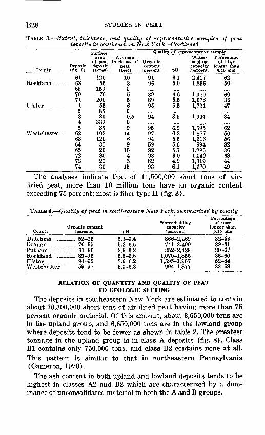
B28 STUDIES IN PEAT
TABLE 3. Extent, thickness, and quality of representative samples of peat deposits in southeastern New York Continued
County
Rockland-... .....
Ulster-.... ......
Westchester -
Deposit (fig. 2)
6168697071
12345
62636465727374
Surface area Average
of peat thickness of deposit peat (acres) (feet)
12055
15070
200558580
33085
1051203020802030
103055600.509
1469
1543
15
Quality of representative sample
Organic content
(percent)
9196
898995
94
9597945982938293
pH6.15.9
6.65.55.5
£9
£26.35.65.65.73.04,96.1
Water- Percentage holding of fiber capacity longer than (percent) 0.15 mm
2,4171,856
1,0701,0781,731
1,907
1,5951,8771,616
9941,2851,0401,3191,670
6250
603647
84
6250563236684449
The analyses indicate that of 11,500,000 short tons of air- dried peat, more than 10 million tons have an organic content exceeding 75 percent; most is fiber type II (fig. 3).
TABLE 4. Quality of peat in southeastern New York, summarized by county
County
Dutchess .... Orange ........Putnam ........RocklandUlster ..__....Westchester
Organic content (percent)
........ 52-96
........ 70-95
._.._ 61-96
........ 89-96
........ 94-95
........ 59-97
pH5.3-6.4 5.2-6.53.9-6.35.5-6.63.9-6.23.0-6.3
Water-holding capacity (percent)
866-2,269 741-2,400352-2,488
1,070-1,8561,595-1,907
994-1,877
Percentage of fiber
longer than 0.15 mm
32-53 39-8130-6736-6062-8432-68
RELATION OF QUANTITY AND QUALITY OF PEAT TO GEOLOGIC SETTING
The deposits in southeastern New York are estimated to contain about 10,300,000 short tons of air-dried peat having more than 75 percent organic material. Of this amount, about 3,650,000 tons are in the upland group, and 6,650,000 tons are in the lowland group where deposits tend to be fewer as shown in table 2. The greatest tonnage in the upland group is in class A deposits (fig. 8). Class Bl contains only 750,000 tons, and class B2 contains none at all. This pattern is similar to that in northeastern Pennsylvania (Cameron, 1970).
The ash content in both upland and lowland deposits tends to be highest in classes A2 and B2 which are characterized by a dom inance of unconsolidated material in both the A and B groups.

PEAT DEPOSITS OF SOUTHEASTERN NEW YORK B29
3,600,000
3,200,000
2,800,000
2,400,000
2,000,000
1,600,000
1.206,000
800,000
400,000
Al A2 A3 Bl B2
Class of basin of accumulation
LOWLANDS
Al A2 A3 Bl B2
Class of basin of accumulation
UPLANDS
FIGURE 8. Tonnage of commercial quality peat according to class of basin of accumulation.
PEAT MININGThe United States produced 611,085 short tons of air-dried peat
in 1966 at 144 plants, and sold 605,858 tons at an average price of $10.73 per ton, for a total of $6,501,281. New York reported five
B30 STUDIES IN PEAT
operations with total reserves at active operations of 942,000 short tons of air-dried peat (U.S. Bureau of Mines, 1967). Three of these peat mines are in the area studied two are in Orange County (fig. 2, mines B and C) and one is in Westchester County (mine D). Since 1966, a mine in Dutchess County (mine A) near Wing- dale opened operations. All four mines handle reed-sedge peat and humus peat and sell in bulk; peat is also packaged at mine C in Orange County.
Compared with other mineral commodities, the investment cost for peat mining is low. A typical operation requires about $90,000 for excavating and hauling equipment and $20,000 for buildings.
Mining usually consists of (1) clearing the bog of timber and brush and removing tree roots and logs buried in the upper few feet, (2) draining the bog, usually by digging drainage ditches rather than by pumps, (3) loosening the surface of the peat with disk and harrows to aid in drying the peat, (4) hauling the dried peat to the nearby plant, and there (5) sieving the peat to re move wood, shredding it, and bagging it or storing it in bulk for sale.
Various mining methods may be adopted for deposits difficult to drain.
SUGGESTIONS FOR PEAT EXPLORATIONIn exploring for peat having low ash content in southeastern
New York, the search should be for deposits with a minimum of introduced silt and clay, for those that are not badly decomposed, and for those large enough to be minable.
Peat deposits having low ash content tend to be in a swamp or marsh (1) not crossed by silt-laden streams subject to overflow, (2) without indications of stream piracy showing that such a silt- laden stream had been present, and (3) in a drainage basin with effective drainage area not more than 10 times the size of the swamp or marsh.
Peat deposits with low ash content and low rate of decomposition also tend to be in swamps or marshes in which the water table has fluctuated little. Such swamps and marshes may be recognized by: (1) absence of outlet streams, (2) outlet streams flowing over bed rock that is not easily eroded, (3) outlet streams with very low gradients for a distance of several hundred feet after leaving the swamp or marsh, and (4) a pond that is within the swamp or marsh, is especially near the outlet, and cannot be easily drained.
Quality and quantity of the peat are affected by the size of the deposits. Deposits in swamps and marshes less than an acre or

PEAT DEPOSITS OF SOUTHEASTERN NEW YORK B31
two in size normally have a high ash content. Such deposits also are too small to mine commercially.
Human activities may adversely affect peat deposits and decrease their value; for example, long delay in exploitation fol lowing draining of the deposits accelerates oxidation; creation of dams for industrial, agricultural, or recreational use may cause silting by backwater; and burning over a swamp to raise blueber- ries, or to drive out game animals during the season of lowest water table.
The most favorable localities for peat deposits in the lowlands are in basins classed as A2 and B2 (p. B18). In the uplands, basins classed under the Al and A3 categories are more apt to provide favorable localities for peat deposits.
OUTLOOK FOR THE AREA
Southeastern New York is readily accessible to major metropoli tan areas along the Atlantic seaboard, in which there is a good market for peat products. The deposits generally are in easily drained localities in contrast with deposits near or at sea level in coastal areas, where drainage is a severe problem. The relatively small size of the deposits in the uplands and the linear shape of those in the lowlands together with the fact that most of them are underlain by firm bedrock or glacial till facilitate mine excavation and hauling. These factors, plus the number of available peat de posits of which 66 are estimated to contain an aggregate of more than 10 million short tons of peat, mostly of a quality adequate to meet Federal trade regulations, give an optimistic outlook for in creased peat production. On the other hand, relatively small peat producers in southeastern New York must sell their product in competition with larger out-of-State producers. All domestice pro ducers must compete with imported peat, which in 1966 totaled 293,843 short tons valued at $11,615,000 (U.S. Bureau of Mines, 1967).
REFERENCES
Cameron, C. C., 1968, Peat in U.S. Geol. Survey and U.S. Bur. Mines, Mineral resources of the Appalachian Region: U.S. Geol. Survey Prof. Paper 580, p. 136-145.
1970, Peat in northeastern Pennsylvania: U.S. Geol. Survey Bull. 1317-A, 90 p.
Davis, J. H., Jr., 1946, The peat deposits of Florida, their occurrence, develop ment and uses: Florida Geol. Survey Bull. 30, 247 p.
B32 STUDIES IN PEAT
Lucas, R. E., Rieke, P. E., and Farnham, R. S., 1966, Peats for soil improve ment and soil mixes: Michigan State Univ. Coop. Ext. Service, Ext. Bull. 516, Farm Sci. Ser., p. 1-11.
Meyerhoff, H. A., 1963, New York's role in the Mesozoic and Tertiary evolu tion of the northern Appalachians in New York State Geological Asso ciation, 35th Annual Meeting, Binghamton, N.Y., May 3-4, 1963, Guidebook, Geology of south-central New York: [Binghamton, N.Y.] New York State Geological Association, p. 1-17.
Miller, C. F., 1918, Inorganic composition of peat and of the plant from which it was formed: Jour. Agr. Research, v. 13, p. 605-609.
Minard, J. P., 1959, Recent saprolite: Science, v. 129, no. 3357, p. 1206-1209.Mitchell, G. F., 1965, Littleton bog, Tipperary, an Irish vegetational record:
Geol. Soc. America Spec. Paper 84, p. 1-16.New York State Museum and Science Service, Geological Survey, 1962, Geo
logic map of New York, 1961: New York State Mus. and Sci. Service, Geol. Survey, Map and Chart Ser. 5, 5 map sheets, scale 1:250,000, and text.
Potzger, J. E., and Courtemanche, Albert, 1954, A radiocarbon date of peat from James Bay in Quebec: Science, v. 119, no. 3104, p. 908-909.
U.S. Bureau of Mines, 1967, Peat, in U.S. Bur. Mines Minerals Yearbook 1966: Washington, B.C., U.S. Govt. Printing Office, v. 1-2, p. 823-831.
Waksman, S. A., 1942, The peats of New Jersey and their utilization: New Jersey Dept. Conserv. and Devel., Geol. ser. Bull. 55, pt. A, 155 p.
Waksman, S. A., and Stevens, K. R., 1929, 1932, Contribution to the chemical composition of peat, V The role of microorganisms in peat function and decomposition: Soil Science, v. 28, p. 315-340, v. 32, p. 95-113.
Westerfeld, W. F., 1961, An annotated list of vascular plants of Centre and Huntington Counties, Pennsylvania: Castanea, v. 26, p. 1-80.
&U.S. GOVERNMENT PRINTING OFFICE: I97O O 398 611