Australia–SE Asia collision: plate tectonics and …searg.rhul.ac.uk/pubs/hall_2011 crustal flow...
35
Australia – SE Asia collision: plate tectonics and crustal flow ROBERT HALL SE Asia Research Group, Department of Earth Sciences, Royal Holloway University of London, Egham, Surrey TW20 0EX, UK (e-mail: [email protected]) Abstract: The Sundaland core of SE Asia is a heterogeneous assemblage of Tethyan sutures and Gondwana fragments. Its complex basement structure was one major influence on Cenozoic tec- tonics; the rifting history of the north Australian margin was another. Fragments that rifted from Australia in the Jurassic collided with Sundaland in the Cretaceous and terminated subduction. From 90 to 45 Ma Sundaland was largely surrounded by inactive margins with localized strike- slip deformation, extension and subduction. At 45 Ma Australia began to move north, and subduc- tion resumed beneath Sundaland. At 23 Ma the Sula Spur promontory collided with the Sundaland margin. From 15 Ma there was subduction hinge rollback into the Banda oceanic embayment, major extension, and later collision of the Banda volcanic arc with the southern margin of the embayment. However, this plate tectonic framework cannot be reduced to a microplate scale to explain Cenozoic deformation. Sundaland has a weak thin lithosphere, highly responsive to plate boundary forces and a hot weak deep crust has flowed in response to tectonic and topographic forces, and sedimentary loading. Gravity-driven movements of the upper crust, unusually rapid vertical motions, exceptionally high rates of erosion, and massive movements of sediment have characterized this region. Eastern Indonesia is at the centre of the convergent region between the Eurasian, Australian and Pacific plates (Fig. 1). It is the site of the gateway between the ancient deep Pacific and Indian Oceans which disappeared in the Early Miocene as Australia began to collide with the Sundaland margin of Eurasia. Today it is the passageway for water which continues to move from the Pacific to the Indian Ocean, by complex routes reflecting the evol- ution of the collision zone since the Early Miocene. This tectonically complex region is known to biol- ogists as Wallacea, with a biota and diversity as complex as the geology. Wallace (1869) recognized in the 19th century that biogeographical patterns in some way reflected geology but we are still very far from understanding the links between geology, palaeogeography, ocean – atmosphere circulation and climate which may have influenced the evol- ution of life. Unravelling the geology is a first step, but remains a difficult one. Here I discuss this first step: the geological development of the Australia – Asia collision, particularly in eastern Indonesia. The Cenozoic, particularly Neogene, develop- ment was strongly influenced by what was present before collision, so this paper begins with an outline of the Mesozoic and Early Cenozoic history of SE Asia, the Jurassic breakup of the north- ern Australian part of Gondwana and the assembly of Gondwana fragments in SE Asia in the Cretac- eous. Rifting of fragments, now in Indonesia, from Gondwana was the first control on the Australian margin and the character of Sundaland, affecting both the shape of the continental margins and the distribution of different types of crust within them. The nature of the Mesozoic Pacific margin is also touched upon, and the possible contribution of Cathaysian fragments to SE Asia. In contrast to most previous reconstructions of the region, the docking of different fragments is interpreted to have terminated subduction around SE Asia from the mid-Cretaceous until the Eocene, except for a short Paleocene episode of subduction beneath West Sulawesi. The effects of the assembly of different blocks, with their different internal structures, and separated by sutures, is then considered. The history of sub- duction resulted in an unusual lithosphere, and a high regional heatflow, and these features, com- bined with the heterogeneous nature of the basement were a major influence on Cenozoic deformation. It is argued that the Sundaland continent is not a craton or shield, but is a large region of generally weak lithosphere with weak and strong parts responding in a complex way to movement of the rigid plates that surround it. This determined the way in which the Australia – Asia collision proceeded and the deformational response of the upper crust to the movements of major plates, and the collision history is next reviewed, particularly the important subduction rollback into the Banda embayment of the Australian margin. Finally, I consider if plate tectonics can be recon- ciled with deformation of the crust and suggest that the region is not behaving as plates or microplates, as illustrated by different parts of eastern Sundaland From:Hall, R., Cottam, M. A. & Wilson, M. E. J. (eds) The SE Asian Gateway: History and Tectonics of the Australia– Asia Collision. Geological Society, London, Special Publications, 355, 75–109. DOI: 10.1144/SP355.5 0305-8719/11/$15.00 # The Geological Society of London 2011.
Transcript of Australia–SE Asia collision: plate tectonics and …searg.rhul.ac.uk/pubs/hall_2011 crustal flow...
Australia–SE Asia collision: plate tectonics and crustal flow
ROBERT HALL
SE Asia Research Group, Department of Earth Sciences, Royal Holloway University of London,
Egham, Surrey TW20 0EX, UK (e-mail: [email protected])
Abstract: The Sundaland core of SE Asia is a heterogeneous assemblage of Tethyan sutures andGondwana fragments. Its complex basement structure was one major influence on Cenozoic tec-tonics; the rifting history of the north Australian margin was another. Fragments that rifted fromAustralia in the Jurassic collided with Sundaland in the Cretaceous and terminated subduction.From 90 to 45 Ma Sundaland was largely surrounded by inactive margins with localized strike-slip deformation, extension and subduction. At 45 Ma Australia began to move north, and subduc-tion resumed beneath Sundaland. At 23 Ma the Sula Spur promontory collided with the Sundalandmargin. From 15 Ma there was subduction hinge rollback into the Banda oceanic embayment,major extension, and later collision of the Banda volcanic arc with the southern margin of theembayment. However, this plate tectonic framework cannot be reduced to a microplate scale toexplain Cenozoic deformation. Sundaland has a weak thin lithosphere, highly responsive toplate boundary forces and a hot weak deep crust has flowed in response to tectonic and topographicforces, and sedimentary loading. Gravity-driven movements of the upper crust, unusually rapidvertical motions, exceptionally high rates of erosion, and massive movements of sediment havecharacterized this region.
Eastern Indonesia is at the centre of the convergentregion between the Eurasian, Australian and Pacificplates (Fig. 1). It is the site of the gateway betweenthe ancient deep Pacific and Indian Oceans whichdisappeared in the Early Miocene as Australiabegan to collide with the Sundaland margin ofEurasia. Today it is the passageway for waterwhich continues to move from the Pacific to theIndian Ocean, by complex routes reflecting the evol-ution of the collision zone since the Early Miocene.This tectonically complex region is known to biol-ogists as Wallacea, with a biota and diversity ascomplex as the geology. Wallace (1869) recognizedin the 19th century that biogeographical patterns insome way reflected geology but we are still very farfrom understanding the links between geology,palaeogeography, ocean–atmosphere circulationand climate which may have influenced the evol-ution of life. Unravelling the geology is a firststep, but remains a difficult one. Here I discussthis first step: the geological development of theAustralia–Asia collision, particularly in easternIndonesia.
The Cenozoic, particularly Neogene, develop-ment was strongly influenced by what was presentbefore collision, so this paper begins with anoutline of the Mesozoic and Early Cenozoichistory of SE Asia, the Jurassic breakup of the north-ern Australian part of Gondwana and the assemblyof Gondwana fragments in SE Asia in the Cretac-eous. Rifting of fragments, now in Indonesia, fromGondwana was the first control on the Australianmargin and the character of Sundaland, affecting
both the shape of the continental margins and thedistribution of different types of crust within them.The nature of the Mesozoic Pacific margin is alsotouched upon, and the possible contribution ofCathaysian fragments to SE Asia. In contrast tomost previous reconstructions of the region, thedocking of different fragments is interpreted tohave terminated subduction around SE Asia fromthe mid-Cretaceous until the Eocene, except for ashort Paleocene episode of subduction beneathWest Sulawesi.
The effects of the assembly of different blocks,with their different internal structures, and separatedby sutures, is then considered. The history of sub-duction resulted in an unusual lithosphere, and ahigh regional heatflow, and these features, com-bined with the heterogeneous nature of the basementwere a major influence on Cenozoic deformation. Itis argued that the Sundaland continent is not a cratonor shield, but is a large region of generally weaklithosphere with weak and strong parts respondingin a complex way to movement of the rigid platesthat surround it. This determined the way in whichthe Australia–Asia collision proceeded and thedeformational response of the upper crust to themovements of major plates, and the collisionhistory is next reviewed, particularly the importantsubduction rollback into the Banda embayment ofthe Australian margin.
Finally, I consider if plate tectonics can be recon-ciled with deformation of the crust and suggest thatthe region is not behaving as plates or microplates,as illustrated by different parts of eastern Sundaland
From: Hall, R., Cottam, M. A. & Wilson, M. E. J. (eds) The SE Asian Gateway: History and Tectonicsof the Australia–Asia Collision. Geological Society, London, Special Publications, 355, 75–109.DOI: 10.1144/SP355.5 0305-8719/11/$15.00 # The Geological Society of London 2011.
and Wallacea. I outline an alternative modelexplaining why the surface topography and bathy-metry, and palaeogeography, have changed veryrapidly during the late Neogene with importantconsequences for ocean currents, local climate,and probably global climate.
Assembly of SE Asia
It is now generally accepted that the core of Sunda-land (Fig. 2) was assembled from continental blocksthat separated from Gondwana in the Palaeozoic andamalgamated with Asian blocks in the Triassic(Metcalfe 2011). The position of the eastern bound-ary of the Indochina–East Malaya block, the natureof crust to the east of it, and when this crust wasadded to Sundaland, are not known because muchof this area is now submerged or covered withyounger rocks. Only in Borneo are there rocksexposed that are older than Mesozoic. Mostworkers have assumed or implied that the
continental core of SW Borneo was attached to Sun-daland well before the Cretaceous. Hamilton (1979)drew a NE–SW line from Java to Kalimantanwidely accepted as the SE limit of Sundaland conti-nental crust, implying much of Borneo was part ofSundaland by the Cretaceous and considered theregion external to this core, from Sarawak to EastJava, as Cretaceous and Tertiary subduction com-plexes. Many workers, including Hamilton (1979),Metcalfe (1988, 1990, 1996), Williams et al.(1988) have suggested broadly south-directed sub-duction beneath north Borneo during the Cretaceousand Early Cenozoic. Cretaceous north-directed sub-duction beneath south Borneo is indicated by thedistribution of ophiolites and HP-LT metamorphicrocks in Java and SE Kalimantan (Parkinsonet al. 1998). However, it is also possible that SWBorneo was added to Sundaland in the Cretaceous,much later than commonly assumed. Metcalfe(1996) shows most of the area north, east andsouth of Borneo as accreted crust, including
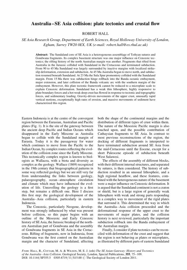
Fig. 1. Geography of SE Asia and surrounding regions. Small black filled triangles are volcanoes from the SmithsonianInstitution, Global Volcanism Program (Siebert & Simkin 2002), and bathymetry is simplified from the Gebco (2003)digital atlas. Bathymetric contours are at 200 m, 1000 m, 3000 m and 5000 m.
R. HALL76

several small continental blocks. There have been anumber of suggestions for the origin of these conti-nental fragments and Borneo crust, and when theybecame part of SE Asia.
Ben-Avraham & Emery (1973) suggested asuture west of Borneo along the Billiton Depressioninterpreted as a transform fault associated with Cre-taceous opening of the South China Sea. Metcalfe(1988, 1990, 1996) identified the SW Borneo andSemitau blocks, both with a South China origin,that moved south after rifting in the Late Creta-ceous, opening the proto-South China Sea. Althoughthe history of the Asian margin, and the interpretedage of the South China Sea, have changed (cf.Ben-Avraham & Uyeda 1973) an Asian origin foroffshore Sarawak and much of Borneo has been sup-ported by obvious Cathaysian characteristics offaunas and floras from the Dangerous Grounds(Kudrass et al. 1986), NW Kalimantan (Williamset al. 1988) and Sarawak (Hutchison 2005).
Others have suggested an Australian origin forparts of Borneo. Luyendyk (1974) suggested theentire islands of Borneo and Sulawesi separatedfrom Australia during Gondwana breakup in the Jur-assic. Johnston (1981) proposed that a fragmentrifted from the NW Shelf in the Late Jurassic col-lided with SE Asia in the mid-Cretaceous andunderlies the area from Java to the eastern Banda
Arc. Smaller blocks have been interpreted as riftedfrom NW Australia in the Jurassic (Hamilton1979; Pigram & Panggabean 1984; Audley-Charleset al. 1988; Metcalfe 1988; Powell et al. 1988). Onemajor fragment was named Mt Victoria Land(Veevers 1988) or Argoland (Powell et al. 1988).Ricou (1994) suggested that Argoland correspondsto the Paternoster ‘plateau’ which he interpreted tohave collided with Borneo in the Paleocene.
However, most authors have interpreted therifted Australian fragments to be much furtheraway than Indonesia. Audley-Charles (1983, 1988)and Charlton (2001) suggested Argoland is now asfar away as south Tibet, but it has most commonlybeen identified with West Burma. This view hasbeen repeated so often that it has become receivedwisdom (Fig. 3) despite the fact that Metcalfe(1990, 1996), who first proposed it on the basis ofTriassic (quartz-rich) turbidites above a pre-Mesozoic schist basement similar to the NWShelf, observed it was ‘speculative’ with ‘as yetno convincing evidence for the origin of this[West Burma] block’. Metcalfe (2009) has sinceabandoned the interpretation. In contrast, for otherauthors West Burma has been part of SE Asiasince the Triassic and is therefore not Argoland.Mitchell (1984, 1992) argued that the Triassic turbi-dites in Burma were deposited on the southern
Fig. 2. The Mesozoic and Cenozoic growth of Sundaland. It is suggested here that Sundaland grew in the Cretaceousby the addition of two main fragments: SW Borneo and East Java–West Sulawesi. In the Early Miocene newcontinental crust was added to Sundaland by collisions in Borneo and East Indonesia. Hamilton’s (1979) SE limitof Cretaceous continental crust is the part of the light blue line crossing the Java Sea from Java to Borneo.
AUSTRALIA–SE ASIA COLLISION 77
margin of Asia, and Barber & Crow (2009) inter-preted West Burma as a continuation of the WestSumatra block, now separated from it by openingof the Andaman Sea, which was part of Sundalandfrom the Late Palaeozoic.
Pulunggono & Cameron (1984) proposed thatnorth Sumatra includes the Sikuleh and Natal conti-nental fragments, either rifted from Sundaland oraccreted to it, and Metcalfe (1996) suggested thesehad a NW Australian origin. Barber (2000) andBarber & Crow (2005) reviewed these suggestionsand argued that there is no convincing evidencefor any microcontinental blocks accreted to themargin of Sundaland in the Cretaceous. They inter-preted the Sikuleh and Natal fragments, likeMitchell (1993), as part of the Woyla intra-oceanicarc thrust onto the Sumatran Sundaland margin inthe mid-Cretaceous.
If the Australian rifted fragments are not inTibet, West Burma or Sumatra then where arethey? There is increasing evidence that they are inBorneo, West Sulawesi and Java, with some Cath-aysian continental crust forming part of NWBorneo and the offshore shelf to the north ofSarawak and east of Vietnam, and that all thesefragments arrived in their present positions duringthe Cretaceous.
Origin of crust of east Sundaland
It is suggested here that the SE Asian promontoryeast of the Indochina–East Malaya block hasgrown by the addition of continental crust in twomajor stages: during the Early to mid-Cretaceous,and during the Neogene (Fig. 2). Some continentalfragments have an Asian origin, but most are Aus-tralian. I suggest that an Asian fragment collidedwith east Sundaland, between Vietnam and northernBorneo, in the mid-Cretaceous and that Australianfragments also docked against the East Malayablock in the Early to mid-Cretaceous. A new recon-struction (Hall et al. 2009a) shows how these frag-ments moved into SE Asia (Figs 4 & 5).
Offshore Vietnam to Borneo
It is commonly assumed that there was an east-facing Andean margin with subduction of Pacificoceanic crust throughout the Mesozoic (e.g. Taylor& Hayes 1983; Metcalfe 1996) in the west Pacific.For South China and Indochina there is evidencefor subduction in the Jurassic and Early Cretaceousbut not in most of the Late Cretaceous. In the SEChina margin Jahn et al. (1976) suggested that aCretaceous (120–90 Ma) thermal episode was
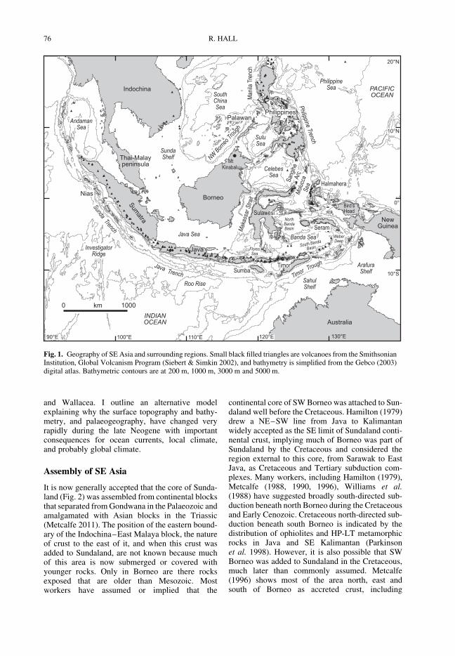
Fig. 3. The most common interpretation of the origin and present position of the rifted blocks from NW Australia shownon reconstructions for 165 and 80 Ma, modified from Wakita & Metcalfe (2005). These interpret the Argo block as riftedfrom the NW Australian margin in the Late Jurassic and added to Asia as the West Burma (WB) block in the Cretaceous.SW Borneo is interpreted as separated from Asia during the Cretaceous by formation of the Proto-South China Sea(Proto-SCS).
R. HALL78
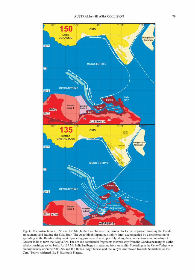
Fig. 4. Reconstructions at 150 and 135 Ma. In the Late Jurassic the Banda blocks had separated forming the Bandaembayment and leaving the Sula Spur. The Argo block separated slightly later, accompanied by a reorientation ofspreading in the Banda embayment. Spreading propagated west, possibly along the continent–ocean boundary ofGreater India to form the Woyla Arc. The arc and continental fragments moved away from the Gondwana margins as thesubduction hinge rolled back. At 135 Ma India had begun to separate from Australia. Spreading in the Ceno-Tethys waspredominantly oriented NW–SE and the Banda, Argo blocks and the Woyla Arc moved towards Sundaland as theCeno-Tethys widened. Ex P, Exmouth Plateau.
AUSTRALIA–SE ASIA COLLISION 79
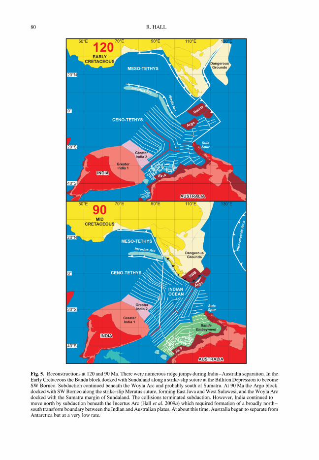
Fig. 5. Reconstructions at 120 and 90 Ma. There were numerous ridge jumps during India–Australia separation. In theEarly Cretaceous the Banda block docked with Sundaland along a strike-slip suture at the Billiton Depression to becomeSW Borneo. Subduction continued beneath the Woyla Arc and probably south of Sumatra. At 90 Ma the Argo blockdocked with SW Borneo along the strike-slip Meratus suture, forming East Java and West Sulawesi, and the Woyla Arcdocked with the Sumatra margin of Sundaland. The collisions terminated subduction. However, India continued tomove north by subduction beneath the Incertus Arc (Hall et al. 2009a) which required formation of a broadly north–south transform boundary between the Indian and Australian plates. At about this time, Australia began to separate fromAntarctica but at a very low rate.
R. HALL80
related to west-directed Pacific subduction. In SouthChina, around Hong Kong, felsic magmatismceased in the Early Cretaceous (Sewell et al.2000), but it is not known whether magmatism con-tinued outboard because this area is submerged.Further to the north in South China, there areyounger Cretaceous magmatic rocks in a beltfurther east interpreted as subduction-related butmagmatism had ceased by 80 Ma (Li & Li 2007).This suggests that there was a trench associatedwith west-dipping Pacific subduction, east of thepresent South China coast, in the Jurassic andEarly Cretaceous but not in the Late Cretaceousafter 80 Ma, and the subduction zone may have con-tinued south across the South China Sea. Zhou et al.(2008) used geophysical data to trace a Jurassic–Early Cretaceous subduction complex south fromTaiwan along the present northern margin of theSouth China Sea which they interpret to have beendisplaced to Palawan by opening of the SouthChina Sea. This belt probably continued intoVietnam where there are Early Cretaceous granites(Nguyen et al. 2004; Thuy et al. 2004) with young-est ages of 88 Ma and may have terminated in southVietnam or, less probably, continued into northernBorneo. From east Vietnam northwards there is noevidence for east-directed subduction after 80 Ma.
There have been many suggestions of west- orsouth-directed subduction beneath north Borneo inthe Late Cretaceous and Early Cenozoic (e.g.Hamilton 1979; Taylor & Hayes 1983; Williamset al. 1988; Tate 1991) although Moss (1998) ident-ified problems with the common interpretation ofthe Rajang Group deepwater clastic sediments assubduction-related. He suggested that subductionhad ceased by about 80 Ma after arrival of micro-continental fragments now beneath the LuconiaShoals and Sarawak, leaving a remnant ocean anda foreland basin in northern Borneo in which theRajang Group was deposited. There is little evi-dence anywhere of subduction-related magmatismyounger than about 80 Ma, and the Late Cretaceouswas a period of rifting and extension of the SouthChina margin (e.g. Taylor & Hayes 1983; Zhouet al. 2008). Although subduction has been inter-preted in Sarawak (Hutchison 1996, 2005) andNW Kalimantan (Williams et al. 1988, 1989),Late Cretaceous and Early Cenozoic sequences arefluviatile and marginal marine. Dredged crust(Kudrass et al. 1986) from the Dangerous Groundsindicates the presence of a continental sedimentaryrocks with Cathaysian affinities and metamorphicrocks with Early Cretaceous ages. In the rest ofthe region of offshore Malaysia and Vietnam littleis known of the basement which is deep below athick sediment cover. Recent offshore studiessuggest a suture could continue towards the SWof Vietnam (Fyhn et al. 2010; Pedersen et al.
2010). Hall et al. (2009a) interpreted a Luconia–Dangerous Grounds block of Asian origin, similarto that named Cathaysia by Zhou et al. (2008).Collision of this block between 90 and 80 Ma witha suture broadly in the position identified by Zhouet al. (2008) can account for Cathaysian continentalcrust, subduction melanges and magmatism inSouth China, Vietnam and NW Borneo. It doesnot require SW Borneo to have been part ofSundaland before this time.
South Borneo and Sulawesi
There have been many suggestions that there was acollision between a Gondwana continental fragmentand the Sundaland margin in the mid Cretaceous(e.g. Sikumbang 1986, 1990; Hasan 1990, 1991;Wakita et al. 1996; Parkinson et al. 1998) with asuture located in the Meratus region. Geochemicalevidence (Elburg et al. 2003) and zircon dating(van Leeuwen et al. 2007) indicate continentalcrust may lie beneath much of west Sulawesi, andit has an Australian origin (van Leeuwen et al.2007). Recent studies in East Java show that atleast the southern part of the island is underlain bycontinental crust (Smyth 2005; Smyth et al. 2007,2008). The igneous rocks of the Early CenozoicSouthern Mountains volcanic arc contain Archaeanto Cambrian zircons and suggest a west Australianorigin for the fragment (Smyth et al. 2008). Conti-nental crust is also suggested to underlie parts ofthe southern Makassar Straits (Hall et al. 2009b)and East Java Sea between Kalimantan and Java,based on basement rocks encountered in explorationwells (Manur & Barraclough 1994).
The evidence for the origin of SW Borneo isadmittedly limited. Palaeomagnetism indicates ithas been at its present latitude since the Cretaceous(Haile et al. 1977; Fuller et al. 1999). The SchwanerMountains are dominated by Cretaceous igneousrocks which intrude a poorly-dated metamorphicbasement suggested to be Permo-Triassic (e.g.Williams et al. 1988; Hutchison 2005) or older.The interpreted older ages are based on correlationof metamorphic rocks from Sarawak to Kalimantan(e.g. Tate 1991, 2002) across important sutures(Lupar Line and Boyan melange). However, thereare convincing links to Australia. Devonian lime-stones from the Telen River in the Kutai basin(Rutten 1940) have a fauna resembling that of Devo-nian limestones from the Canning Basin (M. Bouda-gher Fadel, pers. comm. 2009). Alluvial diamondsfrom Kalimantan have many similarities to dia-monds from NW Australia (Taylor et al. 1990).Interpretations of an Asian origin for SW Borneodiscussed above were based on Cathaysian faunasand floras found in Sarawak and NW Kalimantan,but all these are within the Kuching zone (Hutchison
AUSTRALIA–SE ASIA COLLISION 81
2005) or NW Kalimantan Domain (Williams et al.1988) in, or closely associated with, melanges anddeformed ophiolites. These rocks are interpretedhere as fragments of Asian material accreted dur-ing the Cretaceous which are not part of the SWBorneo block.
SW Borneo is interpreted (Hall et al. 2009a) tobe a block separated from the Banda embaymentat about 160 Ma and added to Sundaland in theEarly Cretaceous. This is consistent with the evi-dence for its origin discussed above, its size, andthe age of rifting on the NW Shelf (Pigram & Pang-gabean 1984). The northern edge of the block was asouth-dipping subduction zone as proposed by manyauthors (e.g. Hamilton 1979; Williams et al. 1988;Tate 1991; Hutchison 1996; Moss 1998) but was notcontinuous with the South China–Vietnam suture.
A small Inner Banda block is interpreted (Hallet al. 2009a) to have followed the Banda block butto have moved relative to it during a later collisionevent, which may now underlie part of Sabah andnorthern West Sulawesi. SW Borneo accreted toSundaland in the Early Cretaceous between about115 and 110 Ma along the Billiton lineament thatruns south from the Natuna area (Ben-Avraham1973; Ben-Avraham & Emery 1973). The EastJava–West Sulawesi block is interpreted as theArgo block, including the offshore continuation ofthe Canning Basin, whose detrital sedimentsprovided the Palaeozoic to Archaean zircons foundin East Java. The East Java–West Sulawesi blockseparated from NW Australia at about 155 Maas rifting propagated west and south (Pigram &Panggabean 1984; Powell et al. 1988; Fullertonet al. 1989; Robb et al. 2005). East Java and WestSulawesi may include a number of separatefragments, rather than a single block, added toSundaland at about 90 Ma at a suture runningfrom West Java towards the Meratus Mountainsand then northward (Hamilton 1979; Parkinsonet al. 1998). Collision of the Woyla arc with theSumatran Sundaland margin occurred at the sametime as the East Java–West Sulawesi fragmentdocked (Hall et al. 2009a).
Termination of subduction
The rifting of fragments from Australia determinedthe shape and character of the Australian marginwhich was to have a major influence on theNeogene development of Australia–SE Asia col-lision. The arrival of the rifted blocks also had a pro-found effect because they terminated subduction(Smyth et al. 2007; Hall 2009a, b; Hall et al.2009a) around Sundaland in the mid-Cretaceousfor 45 million years, and when subductionresumed in the Eocene their deep structure
influenced Cenozoic deformation of SE Asia. Forthe period 90 Ma to 45 Ma around most of Sunda-land, except north of Sumatra, there was no subduc-tion. Australia was not moving north, and there wasan inactive margin south of Sumatra and Java until45 Ma. Thus, no significant igneous activity isexpected and little is recorded (Hall 2009a). Thenew reconstruction (Hall et al. 2009a) does,however, predict NW-directed subduction beneathSumba and West Sulawesi between 63 Ma and50 Ma where, in the latest Cretaceous and Paleo-cene, there was calc-alkaline volcanism interpretedas subduction-related (e.g. van Leeuwen 1981;Hasan 1990; Abdullah et al. 2000; Elburg et al.2002; see Hall 2009a, for review).
Consequences for SE Asian lithosphere
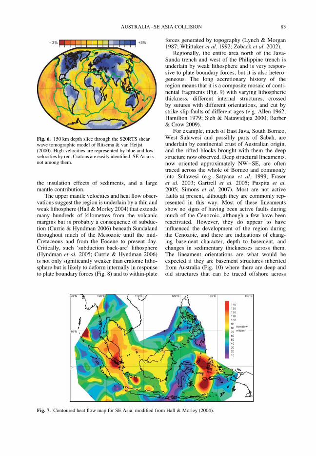
At present the interior of Sundaland, particularly theSunda Shelf, Java Sea and surrounding emergent,but topographically low, areas of Sumatra andBorneo are largely free of seismicity and volcanism(Hamilton 1979; Hall & Morley 2004; Simons et al.2007). This region formed an exposed landmassduring the Pleistocene, and most of the SundaShelf is shallow, with water depths less than200 m and little relief which has led to a misconcep-tion that it is a stable area. Sundaland is oftendescribed as a shield or craton, but seismic tomo-graphy, geological observations and heat flow(Hall & Morley 2004; Currie & Hyndman 2006)show that these terms are not appropriate.
Unlike well-known shields or cratons Sundalandis not underlain by a thick cold lithosphere stabilizedearly in the Precambrian. P and S wave seismic tom-ography (Bijwaard et al. 1998; Ritsema & vanHeijst 2000) show it is an area of low velocities inthe lithosphere and underlying asthenosphere, incontrast to Indian and Australian continental litho-sphere to the NW and SE (Fig. 6). Such lowmantle velocities are commonly interpreted interms of elevated temperature, and this is consistentwith regional high heat flow, but they may alsopartly reflect the mantle composition or elevatedvolatile contents.
Also unlike cratons, there has been significantdeformation within Sundaland during the Mesozoicand Cenozoic. During the Cenozoic there was wide-spread faulting, the formation of numerous sedi-mentary basins, many of which are very deep, andlocalized but significant elevation of mountains(Hall & Morley 2004). Much of the Sundalandinterior has high surface heat flow (Fig. 7), withvalues typically greater than 80 mW/m2, muchgreater than cratons (Artemieva & Mooney 2001).Likely causes are upper crustal heat flow fromradiogenic granites and their erosional products,
R. HALL82
the insulation effects of sediments, and a largemantle contribution.
The upper mantle velocities and heat flow obser-vations suggest the region is underlain by a thin andweak lithosphere (Hall & Morley 2004) that extendsmany hundreds of kilometres from the volcanicmargins but is probably a consequence of subduc-tion (Currie & Hyndman 2006) beneath Sundalandthroughout much of the Mesozoic until the mid-Cretaceous and from the Eocene to present day.Critically, such ‘subduction back-arc’ lithosphere(Hyndman et al. 2005; Currie & Hyndman 2006)is not only significantly weaker than cratonic litho-sphere but is likely to deform internally in responseto plate boundary forces (Fig. 8) and to within-plate
forces generated by topography (Lynch & Morgan1987; Whittaker et al. 1992; Zoback et al. 2002).
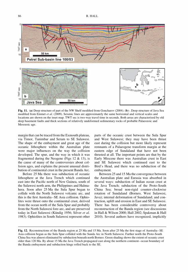
Regionally, the entire area north of the Java-Sunda trench and west of the Philippine trench isunderlain by weak lithosphere and is very respon-sive to plate boundary forces, but it is also hetero-geneous. The long accretionary history of theregion means that it is a composite mosaic of conti-nental fragments (Fig. 9) with varying lithosphericthickness, different internal structures, crossedby sutures with different orientations, and cut bystrike-slip faults of different ages (e.g. Allen 1962;Hamilton 1979; Sieh & Natawidjaja 2000; Barber& Crow 2009).
For example, much of East Java, South Borneo,West Sulawesi and possibly parts of Sabah, areunderlain by continental crust of Australian origin,and the rifted blocks brought with them the deepstructure now observed. Deep structural lineaments,now oriented approximately NW–SE, are oftentraced across the whole of Borneo and commonlyinto Sulawesi (e.g. Satyana et al. 1999; Fraseret al. 2003; Gartrell et al. 2005; Puspita et al.2005; Simons et al. 2007). Most are not activefaults at present, although they are commonly rep-resented in this way. Most of these lineamentsshow no signs of having been active faults duringmuch of the Cenozoic, although a few have beenreactivated. However, they do appear to haveinfluenced the development of the region duringthe Cenozoic, and there are indications of chang-ing basement character, depth to basement, andchanges in sedimentary thicknesses across them.The lineament orientations are what would beexpected if they are basement structures inheritedfrom Australia (Fig. 10) where there are deep andold structures that can be traced offshore across
20°N
10°N
0°
100°E 110°E 120°E 130°E 140°E
140130120110100908070605040302010
Heatfl owmW/m2
Fig. 7. Contoured heat flow map for SE Asia, modified from Hall & Morley (2004).
Fig. 6. 150 km depth slice through the S20RTS shearwave tomographic model of Ritsema & van Heijst(2000). High velocities are represented by blue and lowvelocities by red. Cratons are easily identified; SE Asia isnot among them.
AUSTRALIA–SE ASIA COLLISION 83

the NW Shelf and western Australia (e.g. Cadmanet al. 1993; Goncharov 2004). Furthermore, deepseismic profiles between Borneo and East Java(Emmet et al. 2009) show many resemblances tothe deep structure of Late Palaeozoic sedimentarybasins from offshore western Australia (Fig. 11).This lithosphere was rifted from Australia and wasaccreted to form East Java, SE Borneo and SouthSulawesi and is much thicker, cooler and stronger
than other parts of eastern Indonesia. This isreflected in the absence of significant Cenozoicdeformation of these parts of Sundaland.
In addition, in the eastern part of the region thereare several oceanic basins of different ages. Thus,although overall the region is weak, it includesvery strong parts. The complex deformation of theregion during the Cenozoic reflects all these featuresin addition to the changing forces at the plate edges.This is illustrated particularly well by the collisionof Australia with SE Asia.
Australia collision
The composite character of the SE Asian litho-sphere was a major influence on the way in whichAustralia–SE Asia collision developed, but also ofgreat importance was the nature of the Australianmargin. The Jurassic rifting led to formation of acontinental promontory, the Sula Spur (Klompe1954), that extended west from New Guinea onthe north side of the Banda embayment. Thisembayment was part of the Australian plate and con-tained oceanic crust of Late Jurassic age. Its lastremnant is the Argo Abyssal Plain SW of Timor.From the Late Jurassic to the Neogene the embay-ment was surrounded by a passive continental
Back-arc
Fig. 8. Relative strengths of cratons and subductionbackarc regions from Hyndman et al. (2005). Sundalandlithosphere is expected to be very responsive to plateboundary forces, especially when wet.
Fig. 9. Sundaland blocks that were part of Sundaland by mid-Cretaceous, modified after Metcalfe (1996) and Barberet al. (2005). Ophiolitic sutures are shaded in green. West Sumatra, West Burma and Indochina–East Malaya wereCathaysian blocks added to Eurasia during the Palaeozoic. Sibumasu was accreted along the Raub–Bentong suture inthe Triassic. West Burma and West Sumatra were subsequently moved along the Sundaland margin. The Woyla Arc wasaccreted in the Cretaceous. The Luconia and Dangerous Grounds blocks are interpreted to be Cathaysian fragmentsrifted from Asia and added to Sundaland in the Cretaceous. SW Borneo and East Java–West Sulawesi were rifted fromWest Australia and added in the mid-Cretaceous.
R. HALL84
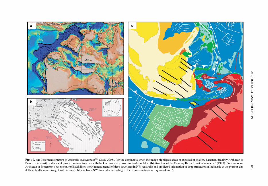
Fig. 10. (a) Basement structure of Australia (Oz SeebaseTM Study 2005). For the continental crust the image highlights areas of exposed or shallow basement (mainly Archaean orProterozoic crust) in shades of pink in contrast to areas with thick sedimentary cover in shades of blue. (b) Structure of the Canning Basin from Cadman et al. (1993). Pink areas areArchaean or Proterozoic basement. (c) Black lines show general trends of deep structures in NW Australia and predicted orientation of deep structures in Indonesia at the present-dayif these faults were brought with accreted blocks from NW Australia according to the reconstructions of Figures 4 and 5.
AU
ST
RA
LIA
–S
EA
SIA
CO
LL
ISIO
N85
margin that can be traced from the Exmouth plateau,via Timor, Tanimbar and Seram to SE Sulawesi.The shape of the embayment and great age of theoceanic lithosphere within the Australian platewere major influences on the way the collisiondeveloped. The spur, and the way in which it wasfragmented during the Neogene (Figs 12 & 13), isthe cause of many of the controversies about col-lision ages, and explains the present unusual distri-bution of continental crust in the present Banda Arc.
Before 25 Ma there was subduction of oceaniclithosphere at the Java Trench which continuedeast into the Pacific north of New Guinea, south ofthe Sulawesi north arm, the Philippines and Halma-hera. Soon after 25 Ma the Sula Spur began tocollide with the North Sulawesi volcanic arc, andthis is the first Australia–SE Asia collision. Ophio-lites were thrust onto the continental crust, derivedfrom the ocean north of the Sula Spur and probablyfrom the North Sulawesi fore-arc, and are preservedtoday in East Sulawesi (Kundig 1956; Silver et al.1983). Ophiolites in South Sulawesi represent other
parts of the oceanic crust between the Sula Spurand West Sulawesi; they may have been thrusteast during the collision but more likely representremnants of a Palaeogene transform margin at theeastern edge of Sundaland that have not beenthrusted at all. The important points are that by theEarly Miocene there was Australian crust in Eastand SE Sulawesi which continued east to theBird’s Head, and there was no subduction of theembayment.
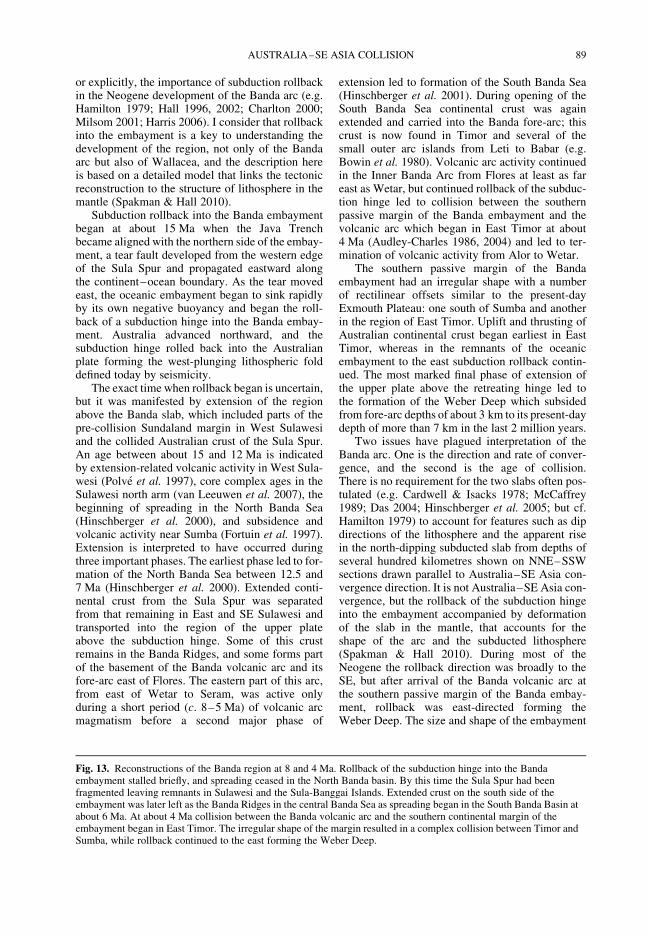
Between 25 and 15 Ma the convergence betweenthe Australian plate and Eurasia was absorbed inseveral ways: subduction of Indian ocean crust atthe Java Trench; subduction of the Proto-SouthChina Sea; broad non-rigid counter-clockwiserotation of Sundaland (Borneo, West Sulawesi,Java); internal deformation of Sundaland; and con-traction, uplift and erosion in East and SE Sulawesi.There has been considerable controversy aboutreconstruction of the Banda region (see discussionsin Hall & Wilson 2000; Hall 2002; Spakman & Hall2010). Several authors have recognized, implicitly
Fig. 11. (a) Deep structure of part of the NW Shelf modified from Goncharov (2004). (b)-. Deep structure of Java Seamodified from Emmet et al. (2009). Seismic lines are approximately the same horizontal and vertical scales andlocations are shown on the inset map. TWT sec is two-way travel time in seconds. Both areas are characterized by olddeep basement faults and thick sections of relatively undeformed sedimentary rocks of probable Palaeozoic andMesozoic age.
Fig. 12. Reconstructions of the Banda region at 25 Ma and 15 Ma. Soon after 25 Ma the first stage of Australia–SEAsia collision began as the Sula Spur collided with the Sunda Arc in North Sulawesi. Farther north the Proto-SouthChina Sea was almost eliminated by subduction beneath north Borneo. Green shading shows the extent of oceanic crustolder than 120 Ma. By about 15 Ma the Java Trench propagated east along the northern continent–ocean boundary ofthe Banda embayment and subduction hinge rolled back to the SE.
R. HALL86

Fig. 12.
AUSTRALIA–SE ASIA COLLISION 87
Fig. 13.
R. HALL88
or explicitly, the importance of subduction rollbackin the Neogene development of the Banda arc (e.g.Hamilton 1979; Hall 1996, 2002; Charlton 2000;Milsom 2001; Harris 2006). I consider that rollbackinto the embayment is a key to understanding thedevelopment of the region, not only of the Bandaarc but also of Wallacea, and the description hereis based on a detailed model that links the tectonicreconstruction to the structure of lithosphere in themantle (Spakman & Hall 2010).
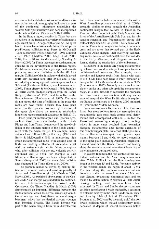
Subduction rollback into the Banda embaymentbegan at about 15 Ma when the Java Trenchbecame aligned with the northern side of the embay-ment, a tear fault developed from the western edgeof the Sula Spur and propagated eastward alongthe continent–ocean boundary. As the tear movedeast, the oceanic embayment began to sink rapidlyby its own negative buoyancy and began the roll-back of a subduction hinge into the Banda embay-ment. Australia advanced northward, and thesubduction hinge rolled back into the Australianplate forming the west-plunging lithospheric folddefined today by seismicity.
The exact time when rollback began is uncertain,but it was manifested by extension of the regionabove the Banda slab, which included parts of thepre-collision Sundaland margin in West Sulawesiand the collided Australian crust of the Sula Spur.An age between about 15 and 12 Ma is indicatedby extension-related volcanic activity in West Sula-wesi (Polve et al. 1997), core complex ages in theSulawesi north arm (van Leeuwen et al. 2007), thebeginning of spreading in the North Banda Sea(Hinschberger et al. 2000), and subsidence andvolcanic activity near Sumba (Fortuin et al. 1997).Extension is interpreted to have occurred duringthree important phases. The earliest phase led to for-mation of the North Banda Sea between 12.5 and7 Ma (Hinschberger et al. 2000). Extended conti-nental crust from the Sula Spur was separatedfrom that remaining in East and SE Sulawesi andtransported into the region of the upper plateabove the subduction hinge. Some of this crustremains in the Banda Ridges, and some forms partof the basement of the Banda volcanic arc and itsfore-arc east of Flores. The eastern part of this arc,from east of Wetar to Seram, was active onlyduring a short period (c. 8–5 Ma) of volcanic arcmagmatism before a second major phase of
extension led to formation of the South Banda Sea(Hinschberger et al. 2001). During opening of theSouth Banda Sea continental crust was againextended and carried into the Banda fore-arc; thiscrust is now found in Timor and several of thesmall outer arc islands from Leti to Babar (e.g.Bowin et al. 1980). Volcanic arc activity continuedin the Inner Banda Arc from Flores at least as fareast as Wetar, but continued rollback of the subduc-tion hinge led to collision between the southernpassive margin of the Banda embayment and thevolcanic arc which began in East Timor at about4 Ma (Audley-Charles 1986, 2004) and led to ter-mination of volcanic activity from Alor to Wetar.
The southern passive margin of the Bandaembayment had an irregular shape with a numberof rectilinear offsets similar to the present-dayExmouth Plateau: one south of Sumba and anotherin the region of East Timor. Uplift and thrusting ofAustralian continental crust began earliest in EastTimor, whereas in the remnants of the oceanicembayment to the east subduction rollback contin-ued. The most marked final phase of extension ofthe upper plate above the retreating hinge led tothe formation of the Weber Deep which subsidedfrom fore-arc depths of about 3 km to its present-daydepth of more than 7 km in the last 2 million years.
Two issues have plagued interpretation of theBanda arc. One is the direction and rate of conver-gence, and the second is the age of collision.There is no requirement for the two slabs often pos-tulated (e.g. Cardwell & Isacks 1978; McCaffrey1989; Das 2004; Hinschberger et al. 2005; but cf.Hamilton 1979) to account for features such as dipdirections of the lithosphere and the apparent risein the north-dipping subducted slab from depths ofseveral hundred kilometres shown on NNE–SSWsections drawn parallel to Australia–SE Asia con-vergence direction. It is not Australia–SE Asia con-vergence, but the rollback of the subduction hingeinto the embayment accompanied by deformationof the slab in the mantle, that accounts for theshape of the arc and the subducted lithosphere(Spakman & Hall 2010). During most of theNeogene the rollback direction was broadly to theSE, but after arrival of the Banda volcanic arc atthe southern passive margin of the Banda embay-ment, rollback was east-directed forming theWeber Deep. The size and shape of the embayment
Fig. 13. Reconstructions of the Banda region at 8 and 4 Ma. Rollback of the subduction hinge into the Bandaembayment stalled briefly, and spreading ceased in the North Banda basin. By this time the Sula Spur had beenfragmented leaving remnants in Sulawesi and the Sula-Banggai Islands. Extended crust on the south side of theembayment was later left as the Banda Ridges in the central Banda Sea as spreading began in the South Banda Basin atabout 6 Ma. At about 4 Ma collision between the Banda volcanic arc and the southern continental margin of theembayment began in East Timor. The irregular shape of the margin resulted in a complex collision between Timor andSumba, while rollback continued to the east forming the Weber Deep.
AUSTRALIA–SE ASIA COLLISION 89
are similar to the slab dimensions inferred from seis-micity, but seismic tomography indicates that partof the continental lithosphere underlying thewestern Sula Spur must have also been incorporatedin the subducted slab (Spakman & Hall 2010).
In the Banda region, notably in Timor but alsoelsewhere in the Banda arc, a variety of radiometricages (most are K–Ar ages with a few Ar–Ar ages)has led to much confusion and claims of multiple orpre-Pliocene collisions (e.g. Berry & McDougall1986; Richardson 1993; Reed et al. 1996; Linthoutet al. 1997; Charlton 2002; Keep et al. 2003,2009; Harris 2006). As discussed by Standley &Harris (2009) for Timor these ages record numerousepisodes in the development of the Banda region.Pre-Miocene metamorphic ages represent eventspredating Australian collision with the SE Asiamargin. Collision of the Sula Spur with the Sulawesinorth arm occurred soon after 25 Ma and is nowrecorded by cooling ages of metamorphic rocks inSulawesi (Parkinson 1998a, b; van Leeuwen et al.2007), Timor (Berry & McDougall 1986; Standley& Harris 2009), dredged samples from the BandaRidges (Silver et al. 1985), and from Kur in theBanda fore-arc (Honthaas et al. 1997). The agesdo not record the time of collision at the place therocks are now found, because they have beenmoved to their present positions by extension ofthe upper plate above the retreating subductionhinge (see reconstruction in Spakman & Hall 2010).
Even younger metamorphic and igneous ages,such as those from rocks dredged in the BandaRidges and from Timor, do not record the age of col-lision of the southern margin of the Banda embay-ment with the Asian margin. For example, manyauthors have followed Berry & Grady (1981) andBerry & McDougall (1986) in interpreting highgrade metamorphosed rocks with cooling ages of8 Ma as marking collision of Australian crustwith the Asian margin despite failing to explainwhy, after collision with the arc, volcanic activitycontinued until 3–4 Ma. For example, a LateMiocene collision age has been interpreted inSumba (Keep et al. 2003) and even older collisionages suggested for Timor (Keep et al. 2009).
The problem cannot be solved by making dis-tinctions between continental crust supposedly ofAsian and Australian origin (cf. Charlton 2002;Harris 2006). As explained above, parts of the Cen-ozoic SE Asian margin were underlain by continen-tal crust of Australian origin that arrived in theCretaceous. On Timor Standley & Harris (2009)demonstrated an important difference between theBanda Terrane, which has detrital zircons up to mid-Cretaceous age, and Australian continental marginbasement which has no detrital zircons youngerthan Permian–Triassic. The Banda Terrane waspart of the Asian margin from the mid-Cretaceous
but its basement includes continental rocks with aWest Australian provenance (Hall et al. 2009a)probably similar to those beneath the Australiancontinental margin that collided in Timor in thePliocene. More important is the Early Miocene col-lision of the Australian origin Sula Spur and its sub-sequent extension and fragmentation during slabrollback (Spakman & Hall 2010). The Banda alloch-thon in Timor is a complex including continentalcrust and arc rocks that formed part of the EarlyCenozoic Asian margin, their overlying sedimen-tary rocks, Australian continental crust that collidedin the Early Miocene, and Neogene arc rocksformed during the subduction of the embayment.
Elsewhere in the Banda Arc young metamorphicages have been used to interpret complex tectoniccollision-related scenarios. For example, meta-morphic and igneous rocks from Seram with agesof 5.5–6 Ma have been used to infer formation ofan ophiolite at 15 Ma and obduction at about 9 Ma(Linthout et al. 1997). Not only are the rocks com-pletely unlike any other sub-ophiolite metamorphicrocks, it is also difficult to reconcile the proposedtwo dimensional reconstruction with any recon-structed map of the West Pacific since it requiresthe Banda volcanic arc to be placed 2000 km northof Timor in the Middle Miocene.
Some confusion results from use of the term col-lision, but more follows from the assumption thatmetamorphic ages must mark contractional defor-mation that accompanied collision – in fact theK–Ar and Ar–Ar ages simply record cooling,which in most cases resulted from extension.Neogene metamorphic ages record extension ofthis complex upper plate. I interpret all the post-SulaSpur collision metamorphic and igneous ages,mainly between 12 and 4 Ma, to record extensionof the upper plate, including Australian-origin con-tinental crust and the Banda fore-arc, and tearingalong the northern oceanic–continent boundary ofthe embayment during rollback.
In eastern Indonesia the first contact of the Aus-tralian continent and the Asian margin was soonafter 25 Ma. Rollback into the Banda embaymentbegan at between 15 and 12 Ma. Volcanic activityin the western Banda arc began at about 12 Ma.The tear along the northern oceanic–continentboundary stalled or ceased at about 6 Ma nearwest Seram, juxtaposing continental crust and hotmantle by delamination (Spakman & Hall 2010),causing melting and metamorphism, laterexhumed. In Timor and Sumba the arc–continentcollision age of about 4 Ma is marked by a cessationof volcanic activity in the inner Banda arc in Wetarand Alor by 3 Ma (Abbott & Chamalaun 1981;Scotney et al. 2005) and by the rapid uplift that fol-lowed collision which moved sedimentary rocksdeposited at depths of several kilometres below
R. HALL90

sea level to their present positions of several kilo-metres above sea level (e.g. Fortuin et al. 1997;Audley-Charles 2011). The very young volcanoesin the eastern part of arc from Damar to Banda(Abbott & Chamalaun 1981; Honthaas et al. 1998,1999) record the latest and final stage of rollbackinto the last remnant of the embayment thataccompanied formation of the Weber Deep.However, the extension that accompanied rollbackinto the embayment formed new oceanic basins inthe Banda Sea. It can be argued that Australian–SE Asia collision began about 25 million yearsago, continues today, and is likely to continue formany millions of years to come as these smallbasins are destroyed. The East Indonesian regionprovides a useful perspective on the debate aboutIndia–Asia collision age, variously estimated asbetween 60 and 35 Ma. For a flavour of thisdebate see Rowley (1996), Aitchison et al. (2007),Garzanti (2008), Khan et al. (2009) and Yin(2010). If there has been disagreement about agesin East Indonesia, where collision began morerecently, is less advanced, and where continentalmargins can be reconstructed, it is easy to see whythere is controversy surrounding timing of eventsin the larger and much more deformed Himalayanorogenic belt.
Plate tectonics v. deformation of the crust
Although the plate model used here (Hall 2002; Hallet al. 2009a) provides a good first order understand-ing of the history and development of the region it isless clear that plate tectonics provides an adequate
basis for understanding the details of the presentor Cenozoic deformation of the region. Clearly,plate movements have been a major control andhave led to the complex distribution of blocks,sutures, and the character of the lithosphere dis-cussed above. However, it is impossible to drawcontinuously connected plate boundaries betweenmajor plates (Australia, Pacific, Philippine Sea) sur-rounding SE Asia, for example to join the JavaTrench to the Philippine Trench. The problemremains even if smaller plates are postulated, andthis is critical for modelling deformation since inter-preted regional stresses are critically dependent onthe geometry and position of inferred plate bound-aries. Furthermore, much of the SE Asian regionis continental, and deformation of continents is sig-nificantly less well understood than that of thestrong oceanic plates; we now know that defor-mation is, and has been, much more complex thaninterpreted from models of rigid blocks separatedby narrow fault zones that cut the lithosphere (e.g.Thatcher 2009).
An alternative is to consider large parts of theregion as a diffuse plate boundary zone (Gordon1998) or wide suture zone (Hall & Wilson 2000;Hall 2009b) within which there is deformation.This type of approach ‘implies that a deformingzone is bounded by two (or more) rigid or nearlyrigid plates in motion relative to each other’(Gordon 1998) but raises the question of identifyingthe rigid areas. Gordon (1998) represents east Asiaand SE Asia (Fig. 14) as a very large deformingregion with large rigid parts, such as the Yangtze,Indochina and Borneo ‘plates’ or ‘blocks’, and
Fig. 14. Diffuse plate boundary zones modified from Gordon (1998). Plate abbreviations are AUS, Australia; CL,Caroline; IN, India; PS, Philippine Sea. East and SE Asia are represented as a very large deforming region with rigidparts, such as the North China (NC), Yangtze (Y), Indochina (I) and Borneo (B) blocks.
AUSTRALIA–SE ASIA COLLISION 91
shows East Indonesia as a wide deforming zone eastof the Makassar Straits. This is consistent with thefact that Sundaland is largely free of seismicityand volcanic activity, which supports proposals ofa SE Asian (McCaffrey 1996) or Sundaland (e.g.Simons et al. 2007) plate separate from Eurasia.However, I suggest that the identification of thisplate does not imply a rigid strong region, but morea contrast with the strong Pacific and Australianplates, from which the Sundaland interior is separ-ated by poorly defined boundary zones that arecharacterized by intense seismicity and volcanism.On the whole, the entire region of east Asia andSE Asia is better considered as non-rigid with rela-tively small strong parts within it, and this has beenthe situation throughout the Cenozoic. The regionbetween the South China Sea and the Bird’s Headof New Guinea exemplifies the character of theregion and highlights some key features of how itis deforming.
Northern Borneo
Hall & Morley (2004) drew attention to the weak-ness of Sundaland during the Cenozoic, recordedby the presence of numerous sedimentary basins,many very deep, and elevated areas. During the Cen-ozoic most of Borneo north of the Paternoster–Lupar lineaments was a weak deforming region,but southern Borneo and South Sulawesi was astronger block, or possibly blocks. To the north ofthe these lineaments are the Rajang–Crocker foldbelts, including thick Upper Cretaceous to Eocene,and Eocene to Lower Miocene, deepwater sedi-ments, thick sediments of the Kutei basin, and thedeep North Makassar Basin. Most of emergentnorth Borneo has a Neogene history of contractionand has been the source of the large volumes of sedi-ment filling Neogene basins onshore and offshore,with clear evidence of significant vertical motionsrelative to sea level, of the order of kilometres, inthe last 10 to 15 million years. In contrast, insouthern Borneo west of the Meratus Mountains isa broad downwarp, the Barito Basin, filled byEocene to Miocene terrestrial to marginal marineclastic sediments and shallow marine limestones,whereas to the east is the long-lived Eocene toMiocene Paternoster–Tonasa carbonate platform.With the exception of a narrow zone of deformationin the Meratus Mountains, which may be a reacti-vated strike-slip suture in the basement, both areasare still largely undeformed. Seismic lines acrossthe Paternoster Platform, and field studies on land,show that Eocene to Recent largely shallowmarine carbonates are of the order of 1–2 km inthickness and record vertical movements relativeto sea level of much smaller amounts over 40million years.
Northern Borneo is the site of important andmisunderstood deformation. Haile (1973) firstrecognized the role of subduction in the history ofnorthern Borneo, and Hamilton (1979) identifiedthe deep NW Borneo–Palawan trough as anextinct subduction trench. Hinz and co-workers(e.g. Hinz & Schluter 1985; Hinz et al. 1989) dis-puted this interpretation and argued that the troughwas the site of northward thrusting but not subduc-tion, and these alternative views continue to createconfusion (e.g. Hutchison 2010).
The history of northern Borneo is reviewed anddiscussed elsewhere (e.g. Hall & Wilson 2000;Hutchison et al. 2000; Hutchison 2005; Hall et al.2008). Subduction of the proto-South China Seabeneath northern Borneo terminated in the EarlyMiocene after collision of the extended SouthChina continental margin crust. However, the sub-duction zone was approximately 150 km south ofthe present NW Borneo Trough and is nowbeneath Sabah. The collision resulted in uplift anderosion in the interior of Borneo which providedsediment to the north, east and south.
After collision there was a brief period of erosionwhich formed the Top Crocker Unconformity (vanHattum et al. 2006; Hall et al. 2008) on land and off-shore. However, soon after the emergence of muchof Sabah, the situation changed again. Although anarrow band of mountains probably remainedalong the present spine of the Crocker Ranges, theareas to the north and south subsided below sealevel and sedimentation resumed. In southernSabah there was a wide basin SE of the CrockerRanges (Noad 1998; Balaguru et al. 2003; Balaguru& Nichols 2004). Most of the sediment fed into thisbasin and carried to the Sulu Sea came from theBorneo interior. River and shallow marine sedi-ments are now preserved in a number of structuresdescribed as circular basins, which are remnants ofthe much larger basin supplied by a large riversystem, flowing NE, which deposited sand andmud in a delta and coastal plain complex. NW ofthe Crocker Ranges there was deposition of thicksediments in deltas and coastal plains of northSabah and Brunei by rivers flowing to the north orNW. In Brunei and offshore Sabah, the position ofthe shelf edge at different times can be identified(Hazebroek & Tan 1993; Sandal 1996) showingthat it moved seaward during the last 15 millionyears. This indicates that the Crocker Ranges werenarrow about 15 million years ago, and havewidened gradually with time.
In offshore Brunei and NW Sabah Morley et al.(2008) noted that inversion, thrusting and uplift ofthe present-day onshore area and inner shelfoccurred during the Middle Miocene to Pliocene,while a deepwater fold and thrust belt developedduring the latest Miocene to Holocene. There was
R. HALL92
a seaward shift of deformation with time (C. K.Morley, pers. comm. 2010) consistent with themovement of the shelf edge. Although some of thedeformation can be attributed to shallow gravita-tional processes in a delta, in places there is moreshortening in the deepwater fold and thrust beltthan there is extension within the Neogene sedimen-tary section. On the shelf thick-skinned contrac-tional deformation has episodically affected theSabah margin from the Middle Miocene to the Plio-cene (C. K. Morley, pers. comm. 2010). Therefore anumber of authors (e.g. Ingram et al. 2004; Morleyet al. 2008; Hesse et al. 2009, 2010; King et al.2010) interpret deformation, shortening magni-tudes, stress orientations, GPS observations(Simons et al. 2007) and recent seismicity to indi-cate a role for tectonic stresses which they attributeto ongoing convergence of blocks or plates, subduc-tion or inheritance from former subduction.
It is noteworthy that almost all the data on whichthese interpretations are based, with the exception ofGPS observations and seismicity (Simons et al.2007), are from offshore NW Sabah and nearbyland areas such as Brunei. Little is published oravailable for the Sulu Sea side of Sabah, yet onland the structural grain is completely differentfrom west Sabah, changing from the NNE-trendingCrocker to the ESE-trending Sulu direction (e.g.Hamilton 1979; Hazebroek & Tan 1993; Tongkul1991, 1994) and offshore fold axes and thrusts areapparently broadly parallel to the Sulu trend. Thisis inconsistent with suggested microplates (e.g.Simons et al. 2007) based on GPS observations,and the deformation history and structural trendsin southern Sabah (Balaguru 2001; Balaguru et al.2003; Tongkul & Chang 2003) are equally incompa-tible. I suggest there is no plate convergence in theNW Borneo region and that deformation is largelya result of topographically-induced stresses andmobility of the deeper crust. NW of the Crockermountains is a very thick Neogene sedimentwedge, including the offshore fold and thrust belt(Fig. 15). Recent studies show thin crust beneaththis sediment wedge (Franke et al. 2008; C. Foss,pers. comm. 2008), which requires thinning ofcrust previously thickened during the EarlyMiocene collision of the Dangerous Groundsmicrocontinental block and the Sabah active conti-nental margin. Seismic lines from oil companies(Hutchison 2010) and new data acquired duringMalaysian Law of the Sea investigations (V. R.Vijayan, pers. comm. 2008) show elevated featureswithin the NW Borneo Trough at water depths closeto 3 km which are capped by carbonates and pinna-cle reefs, indicating major subsidence. There isalmost no seismicity associated with the trough,no volcanic activity on land, and nothing to indicatesouthward subduction; nor is there evidence for
converging plates to produce the fold and thrustbelt. On the other hand there is evidence forrepeated failures of the shelf edge and slumpinginto deepwater (e.g. McGilvery & Cook 2003). Tothe south, on land, there are .2 km high mountainsformed of deformed Eocene to Lower MioceneCrocker deep marine sediments, intruded by the7–8 Ma Kinabalu granite (Cottam et al. 2010)forming a 4 km mountain, and I suggest these obser-vations indicate a link between significant rapid andyoung uplift on land, evidenced by exhumation of a7–8 Ma granite now exposed at 4 km above sealevel, and significant rapid and young subsidenceoffshore. The trough is thus a flexural depressiondue to sediment loading and is associated with aflexural bulge in the Dangerous Grounds. In thisinterpretation the offshore fold and thrust belt, andmajor shelf failures producing huge deepwatermass transport complexes observed on the seafloor and in the Neogene sequences beneath, arethe result of landward normal faulting producingdeepwater thrusting. However, although this is notquite the toe-thrust model of the Shell geologists(e.g. Hazebroek & Tan 1993) developed fromNiger delta studies, there are important similaritiesin area and scale (Corredor et al. 2005).
In contrast, several authors have argued that theNW Borneo margin is significantly different fromthe Niger Delta (e.g. Morley et al. 2008; Hesseet al. 2009, 2010; King et al. 2010) based on differ-ences in modern stress patterns, and the observationthat in parts of the deepwater fold and thrust beltthere is more contraction than extension in theNeogene sedimentary section. I suggest this simplyreflects the absence in west Africa of the severalkilometres of elevation on land in Sabah, and thebalance between contraction v. extension would befound if the section on land were included. Inother words, there is no requirement for regionalconvergence to account for deformation which inany case can explain only deformation of offshoreNW Borneo (if that, e.g. Hesse et al. 2009 showthat fold orientations are inconsistent with GPSobservations) and not that observed in other partsof northern Borneo and offshore. The subsidenceand crustal thinning offshore and uplift onshorecan be explained by movement of the deeper crust,and this is a phenomenon observed in other partsof the region.
West Sulawesi
West Sulawesi has many of the features of northernBorneo except on a larger scale (Fig. 16) but there iseven less information in the public domain. On landin the Lariang and Karama areas shallow marineMiocene rocks are overlain by Pliocene coarseclastic sediments derived from an orogenic belt to
AUSTRALIA–SE ASIA COLLISION 93
the east (Calvert & Hall 2007). There are mountainsup to 3 km above sea level which expose deepcrustal rocks such as garnet granulites and eclogites,intruded by young granites, in the Palu area, andprobably extensively throughout West Sulawesi(T. van Leeuwen & I. Watkinson, pers. comm.2009). Rapid uplift and exhumation provided sedi-ment to the broadly west-vergent offshore fold andthrust belt. From north to south the character andorientation of the fold belt changes. The trend offold axes indicates a radial transport of materialaway from the mountains which terminate relativelyabruptly to the south at the northern edge of theSouth Sulawesi Tonasa–Tacipi platform wherethere has been carbonate deposition since theEocene (e.g. Wilson & Bosence 1996; Ascaria1997; Ascaria et al. 1997). Like northern Borneo
there was a pre-existing deepwater area into whichthe fold belt could grow, the Makassar Straits(Hall et al. 2009b), but seismic lines across thenorthern margin of the Paternoster platform indicateat least 1 km of subsidence of the North Makassarbasin on reactivated faults close to Sulawesi at theend of the Miocene. The subsidence is the sameage as the rapid exhumation on land. Like northBorneo there is a temporal link, and I suggest acausal link, between subsidence and deformationoffshore and uplift and exhumation on land.
North and East Sulawesi
West Sulawesi is not the only part of Sulawesi thatrecords rapid subsidence and uplift. This is truefor most of North and East Sulawesi, possibly for
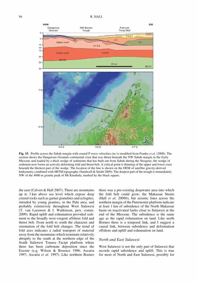
Fig. 15. Profile across the Sabah margin with crustal P wave velocities (m/s) modified from Franke et al. (2008). Thesection shows the Dangerous Grounds continental crust that was thrust beneath the NW Sabah margin in the EarlyMiocene and loaded by a thick wedge of sediments that has built out from Sabah during the Neogene; the wedge ofsediment now forms an actively deforming fold and thrust belt. A critical point is thinning of the upper and lower crustbeneath the thickest part of the wedge. The location of the line is shown on the DEM of satellite gravity-derivedbathymetry combined with SRTM topography (Sandwell & Smith 2009). The deepest part of the trough is immediatelyNW of the 4000 m granite peak of Mt Kinabalu, marked by the black square.
R. HALL94
SE Sulawesi, and certainly for the major enigmaticinter-arm basins of Gorontalo Bay and Bone Gulf.The north and east arms of Sulawesi are striking intheir exceptional elevations (up to 3 km) withinshort distances of the coast, and the narrow widthof these emergent areas. Dating uplift and exhuma-tion is only just beginning. K–Ar and Ar–Arcooling ages of 23–11 Ma from micas and horn-blende are reported by van Leeuwen et al. (2007)from the Malino Complex at the west end of thenorth arm, which they interpret as a core complex.The ages appear to fall into two groups and althoughthere is only a small number (23 ages from 6samples). I speculate that the older ages recordEarly Miocene collision of the Sula Spur, and thecluster of ages from 14–11 Ma record rollback-induced extension. Throughout West, North andEast Sulawesi there is evidence for significant verti-cal motions on land at about 5 Ma, recorded by K–Ar and apatite fission track ages from granites (e.g.Bergman et al. 1996; Elburg et al. 2003; Bellier
et al. 2006), and by widespread and thick CelebesMolasse deposits which indicate rapid exhumationfrom about 5 Ma (e.g. Calvert 2000; van Leeuwen& Muhardjo 2005). The term Celebes Molasse isused for a variety of Neogene terrestrial or shallowmarine deposits found throughout Sulawesi, butalthough it may include Lower Miocene post-ophiolite detrital sediments (e.g. Surono 1995;Surono & Sukarna 1996) there was clearly a majorincrease in output of clastic sediment in the LatestMiocene and/or Early Pliocene in West andEast Sulawesi (e.g. van Bemmelen 1949; Garrardet al. 1988; Davies 1990; Calvert 2000; Calvert &Hall 2007).
Offshore, recently acquired seismic and multi-beam data in Gorontalo Bay show spectacular sub-sidence recorded by numerous pinnacle reefs nowfound within a range of water depths between 1and 2 km many of which, despite the high rates ofsediment supply, are not buried by sediment. Theyindicate very young and rapid subsidence. For
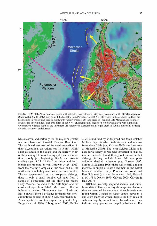
Fig. 16. DEM of the West Sulawesi region with satellite gravity-derived bathymetry combined with SRTM topography(Sandwell & Smith 2009) merged with bathymetry from Puspita et al. (2005). Fold trends in the offshore fold belt arehighlighted in yellow and suggest westwards radial vergence. On land areas of (mainly) Late Miocene and youngergranites are shown in red. The area north of the NW–SE lineament is suggested to be a weak area with significantdeformation whereas south of the lineament the Paternoster Platform and its equivalent in South Sulawesi is a strongarea that is almost undeformed.
AUSTRALIA–SE ASIA COLLISION 95

example, between the north coast of the east arm andthe Togian Islands there is a 50 � 20 km lobe ofsediment with a thickness of up to 2 s TWT(two-way travel time) (Jablonski et al. 2007), thatlinks alluvial fan deposits on land at north andsouth ends of the lobe. The water depths in thearea between the east arm and the Togian Islandsare now up to 1.5 km; 25 km to the south of theeast arm coast elevations exceed 2 km. East ofPoh Head at the end of the east arm are probableplatform carbonates with no sediment cover atwater depths of 1 km, and possible carbonates stilldeeper beneath bedded sediments (Ferdian et al.2010; Watkinson et al. 2011). The platform carbon-ates are likely to be Middle and/or Upper Mioceneby comparison with limestones beneath the CelebesMolasse in the Togian Islands, implying subsidenceof 1 km or more in probably less than 5 Ma.
North Moluccas
A striking feature of East Indonesia is that, althoughthere are undoubtedly some small plates, when plateboundaries are revealed by seismicity (Engdahlet al. 1998) they terminate abruptly and cannot betraced into other boundaries, implying relativelyrapid changes from subduction to distributed defor-mation of the same plate (Fig. 17). Much of thedeformation recorded by the upper crust seems to
be almost independent of the deeper lithosphere.The Philippine Trench terminates at about 38N; tothe north the slab has been subducted to at least100 km, dips steeply and becomes almost vertical,and there is a deep trench. This plate boundaryneither continues southeastwards as often shown,nor does it connect via obvious faults to theMolucca Sea. The abrupt termination of the trenchimplies considerable distributed deformation in thenorth Halmahera area.
In the Molucca Sea seismicity shows the well-known double subduction system (Silver & Moore1978) clearly indicated by seismicity, tomographyand volcanic activity. There is no trench associatedwith either the west or east-dipping slabs, and itappears that the ‘melange wedge’ of the centralMolucca Sea (McCaffrey et al. 1980) is deformingindependently of the subducted Molucca Sea platebeneath. The southern edge of the west-dippingMolucca Sea slab terminates abruptly beneath Gor-ontalo Bay and runs almost due east–west. There isno surface expression, although this is not to beexpected in Gorontalo Bay which forms the upperplate. However, surprisingly the lineament thatwould be expected to mark the former southernboundary of the Molucca Sea Plate, named theNorth Sula Sorong Fault (Hamilton 1979), whichshould be a major left-lateral strike-slip fault, hasno expression on the sea bed, and has no seismicity
Fig. 17. Earthquake hypocentres in East Indonesian from Engdahl et al. (1998) and the Global CMT database (CMTProject 2009). Hypocentres that can be identified with different plate boundaries are shown in colour chosen to matchFigure 19. At the mantle scale these imply a number of sharply demarcated and distinct plates, but at the surface many ofthe plate boundaries are not connected, and the Molucca Sea Plate is completely subducted with no surface expression,being overridden by the two converging fore-arcs which are deformed into the central Molucca Sea wedge.
R. HALL96
in the crust. There are a very small number of hypo-centres below 30 km, a few of which could indicateleft-lateral displacement on a broadly-east–westfault system, but at the sea bed the most obviousstructures in the plate boundary region are south-ward-directed thrusts. Even these do not have the dis-placement expected. Silver et al. (1983) suggestedthat thrusting was related to southward gravity-driven movement of the Molucca Sea wedge, andthis is plausible north of the Sula Islands. How-ever, close to Poh Head the thrusting occurs at thesouthern termination of strands in a right-lateralfault system which can be traced east from land(Simandjuntak 1986; Ferdian et al. 2010; Watkin-son et al. 2011). The existence and displacementon this right-lateral fault system casts doubt on theconnection between the fold belt in the east armsouth of Poh Head (an Early Miocene structure),the interpreted Batui Thrust crossing Poh Head onland, and the Sangihe subduction offshore.
Some of the faults shown on maps of the regiondo exist but are old structures (Fig. 18) that nolonger have surface expression (e.g. the MoluccaSea Trenches). Some plate boundaries do notconnect to others and require distributed defor-mation of the lithosphere to maintain an inter-nally consistent plate model (e.g. the PhilippineTrench). Some of the faults probably do not exist
or are not connected in the ways shown on mostmaps, for example, the NW–SE Greyhound Faultdoes not cross the seabed at all, and its existenceis doubtful. The improvement in the quality ofremotely sensed data (notably SRTM and Asterimagery for the rain forest areas of eastern Indone-sia), and new seismic and multibeam data, meansthat structures can be mapped with more confidence,but there are still many areas of uncertainty. None-theless, it is certain that if the crust in the Sula-wesi–North Moluccas region is broken into aseries of blocks the boundaries do not correspondto those of the known plates. In fact, it is very unli-kely that the upper crust is deforming as a series ofrigid blocks, and some of the relative movements ofthe upper crust are not those predicted by our currentplate models (Fig. 19).
Deformation
If the region is not deforming as plates or micro-plates, nor reflecting microplate movements, howis it responding to movements of the large plates?The common features of the region between off-shore northern Borneo and the North Moluccas arerapid uplift of land to elevations of up to 3 km(and locally higher in the case of Mt Kinabalu at4 km), and rapid subsidence offshore with water
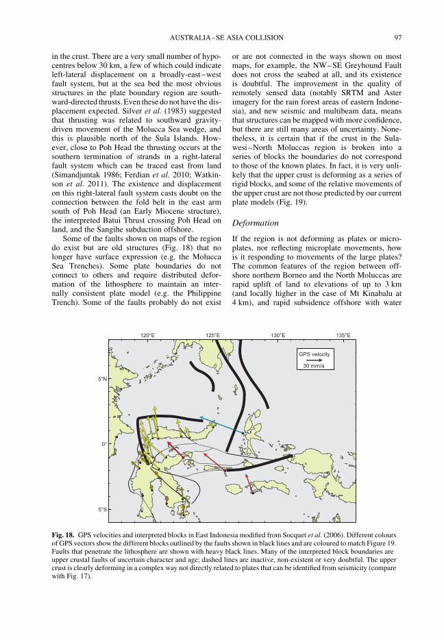
Fig. 18. GPS velocities and interpreted blocks in East Indonesia modified from Socquet et al. (2006). Different coloursof GPS vectors show the different blocks outlined by the faults shown in black lines and are coloured to match Figure 19.Faults that penetrate the lithosphere are shown with heavy black lines. Many of the interpreted block boundaries areupper crustal faults of uncertain character and age; dashed lines are inactive, non-existent or very doubtful. The uppercrust is clearly deforming in a complex way not directly related to plates that can be identified from seismicity (comparewith Fig. 17).
AUSTRALIA–SE ASIA COLLISION 97
depths of more than 2 km and several kilometres ofsediment below the seabed. The term uplift is nowused with reluctance because it is imprecise in spe-cifying what has moved, and it is difficult to quan-tify amounts and rates (England & Molnar 1990).However, it is very probable that what is now theland surface in this region was very close to sealevel only a few million years ago and that slopeswere less steep. Areas now offshore also had lessrelief and were close to sea level, demonstrated forexample, by the distribution of carbonates. Materialthat was at the top of the crust on land severalmillion years ago was eroded, transported offshoreand deposited in sediment layers, above carbonatesdeposited close to sea level, which are in manyplaces now at depths of several kilometres belowsea level. What is now at the surface on land atelevations of up to 3 km in Sulawesi was, a fewmillion years ago, more than 3 km below the landsurface and has been exhumed by high rates oferosion. On land we generally lack the means tobe precise about the amounts of uplift of the landsurface or uplift of rocks within the crust, whereasin offshore regions hydrocarbon exploration drilling
can provide accurate dating, but at present in thefrontier regions of eastern Indonesia ages aregenerally lacking.
Different parts of Borneo and east Indonesiahave risen and subsided since the Early Miocenefollowing Australia’s initial contact with SE Asia.I make the assumption, based on the best butlimited evidence currently available, that very sig-nificant change in relief began at about 8 Ma innorthern Borneo, and at about 5 Ma in West,North and East Sulawesi. In the Halmaheraislands, and probably in Seram, significant reliefchanges are even younger.
From the area of West, North and East Sulawesiaround Gorontalo Bay it is possible to identify anumber of features that are typical of the muchlarger region of eastern Indonesia. Uplift and subsi-dence are intimately interlinked in time. Uplift hasbeen maintained despite high rates of erosion,implying that the forces causing the uplift continueto act. Sometimes high erosion rates are explainedaway by suggesting very weak rocks at surface –this is a possible explanation in Sabah, althoughmany of the rocks now exposed do not seem to be
Fig. 19. 3D cartoon of plate boundaries in the Molucca Sea region modified from Hall et al. (1995). Although seismicityidentifies a number of plates there are no continuous boundaries, and the Cotobato, North Sulawesi and PhilippineTrenches are all intraplate features. The apparent distinction between different crust types, such as Australiancontinental crust and oceanic crust of the Philippine and Molucca Sea, is partly a boundary inactive since the EarlyMiocene (east Sulawesi) and partly a younger but now probably inactive boundary of the Sorong Fault. The upper crustof this entire region is deforming in a much more continuous way than suggested by this cartoon.
R. HALL98
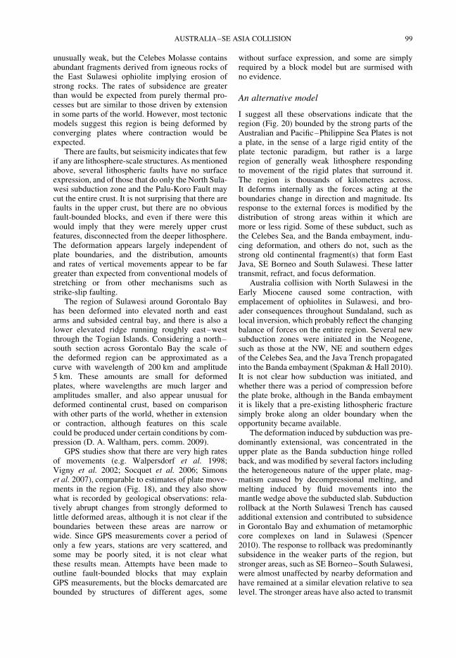
unusually weak, but the Celebes Molasse containsabundant fragments derived from igneous rocks ofthe East Sulawesi ophiolite implying erosion ofstrong rocks. The rates of subsidence are greaterthan would be expected from purely thermal pro-cesses but are similar to those driven by extensionin some parts of the world. However, most tectonicmodels suggest this region is being deformed byconverging plates where contraction would beexpected.
There are faults, but seismicity indicates that fewif any are lithosphere-scale structures. As mentionedabove, several lithospheric faults have no surfaceexpression, and of those that do only the North Sula-wesi subduction zone and the Palu-Koro Fault maycut the entire crust. It is not surprising that there arefaults in the upper crust, but there are no obviousfault-bounded blocks, and even if there were thiswould imply that they were merely upper crustfeatures, disconnected from the deeper lithosphere.The deformation appears largely independent ofplate boundaries, and the distribution, amountsand rates of vertical movements appear to be fargreater than expected from conventional models ofstretching or from other mechanisms such asstrike-slip faulting.
The region of Sulawesi around Gorontalo Bayhas been deformed into elevated north and eastarms and subsided central bay, and there is also alower elevated ridge running roughly east–westthrough the Togian Islands. Considering a north–south section across Gorontalo Bay the scale ofthe deformed region can be approximated as acurve with wavelength of 200 km and amplitude5 km. These amounts are small for deformedplates, where wavelengths are much larger andamplitudes smaller, and also appear unusual fordeformed continental crust, based on comparisonwith other parts of the world, whether in extensionor contraction, although features on this scalecould be produced under certain conditions by com-pression (D. A. Waltham, pers. comm. 2009).
GPS studies show that there are very high ratesof movements (e.g. Walpersdorf et al. 1998;Vigny et al. 2002; Socquet et al. 2006; Simonset al. 2007), comparable to estimates of plate move-ments in the region (Fig. 18), and they also showwhat is recorded by geological observations: rela-tively abrupt changes from strongly deformed tolittle deformed areas, although it is not clear if theboundaries between these areas are narrow orwide. Since GPS measurements cover a period ofonly a few years, stations are very scattered, andsome may be poorly sited, it is not clear whatthese results mean. Attempts have been made tooutline fault-bounded blocks that may explainGPS measurements, but the blocks demarcated arebounded by structures of different ages, some
without surface expression, and some are simplyrequired by a block model but are surmised withno evidence.
An alternative model
I suggest all these observations indicate that theregion (Fig. 20) bounded by the strong parts of theAustralian and Pacific–Philippine Sea Plates is nota plate, in the sense of a large rigid entity of theplate tectonic paradigm, but rather is a largeregion of generally weak lithosphere respondingto movement of the rigid plates that surround it.The region is thousands of kilometres across.It deforms internally as the forces acting at theboundaries change in direction and magnitude. Itsresponse to the external forces is modified by thedistribution of strong areas within it which aremore or less rigid. Some of these subduct, such asthe Celebes Sea, and the Banda embayment, indu-cing deformation, and others do not, such as thestrong old continental fragment(s) that form EastJava, SE Borneo and South Sulawesi. These lattertransmit, refract, and focus deformation.
Australia collision with North Sulawesi in theEarly Miocene caused some contraction, withemplacement of ophiolites in Sulawesi, and bro-ader consequences throughout Sundaland, such aslocal inversion, which probably reflect the changingbalance of forces on the entire region. Several newsubduction zones were initiated in the Neogene,such as those at the NW, NE and southern edgesof the Celebes Sea, and the Java Trench propagatedinto the Banda embayment (Spakman & Hall 2010).It is not clear how subduction was initiated, andwhether there was a period of compression beforethe plate broke, although in the Banda embaymentit is likely that a pre-existing lithospheric fracturesimply broke along an older boundary when theopportunity became available.
The deformation induced by subduction was pre-dominantly extensional, was concentrated in theupper plate as the Banda subduction hinge rolledback, and was modified by several factors includingthe heterogeneous nature of the upper plate, mag-matism caused by decompressional melting, andmelting induced by fluid movements into themantle wedge above the subducted slab. Subductionrollback at the North Sulawesi Trench has causedadditional extension and contributed to subsidencein Gorontalo Bay and exhumation of metamorphiccore complexes on land in Sulawesi (Spencer2010). The response to rollback was predominantlysubsidence in the weaker parts of the region, butstronger areas, such as SE Borneo–South Sulawesi,were almost unaffected by nearby deformation andhave remained at a similar elevation relative to sealevel. The stronger areas have also acted to transmit
AUSTRALIA–SE ASIA COLLISION 99

compressional forces from the plate boundaries, andthis has caused uplift in adjacent weak areas such asthe Central Borneo Mountain Ranges, West Sula-wesi Mountains, and North and East Sulawesi.
Subsidence and uplift in weak areas were tem-porally linked. Morley & Westaway (2006) haveshown that unusually rapid and large amounts ofsubsidence in basins of SE Asia can be explainedby deep crustal flow with thinning of the crustbeneath the basins; they argued that in these settingssediment loading can cause, or contribute signifi-cantly to, subsidence. They suggested that thedeep crust moved away from the depocentre, thin-ning the crust, and flowed towards the sedimentsource regions where the crust was thickened.They focused their attention on the role of crustalflow in producing deep sedimentary basins and noton the regions towards which lower crust was
flowing, except as a source for sediment. Thebasins they studied were formed and largely filledsince the Eocene and are now observed at a rela-tively late stage in their development. However,the Morley & Westaway (2006) model offers anexplanation for the link between subsidence anduplift from northern Borneo eastwards at a muchearlier stage in basin evolution. I suggest that deepcrustal movements not only enhanced subsidenceand provided sediment sources, but flowed laterallyinto areas already elevated and drove significantfurther uplift. This flow maintained relief, erosion,and provided sediment that drove further subsidencein adjacent basins. In particular, it has contributed tothe formation of very high mountains in the last5 Ma. The high short-term sediment yields in SEAsia are commonly attributed to extreme localrelief plus high rainfall, with exceptionally large
Fig. 20. Deformation of East and SE Asia. The region is surrounded by plates that include strong continental andoceanic lithosphere but without completely connected boundaries shown as solid black lines. The white area is adeforming region that cannot be easily assigned to particular plates. GPS vectors from Shen et al. (2005) and Simonset al. (2007) with green arrows show the upper crust is deforming in a complex way not directly connected to platemovements. SE Asia is a largely weak area with strong oceanic and continental parts.
R. HALL100
sediment volumes carried by short mountainousrivers (e.g. Milliman & Syvitski 1992; Millimanet al. 1999). However, in many parts of SE Asiathese high sediment yields have been maintainedfor tens of millions of years (Hall & Nichols 2002;Hall & Morley 2004) which requires a tectonicmechanism to provide relief. Deep crustal flow isa solution to this problem. Once there is movementof the deep crust a feedback process begins. Further-more, the erosional supply may be enhanced bygravitational movement of the upper crust withdetachments at depths up to several kilometres.Figure 21 shows in a cartoon form the process envi-saged. Major uplift and high exhumation rates onland will promote shelf failures and produce off-shore fold and thrust belts such as those documentedfrom offshore northern Borneo and offshore WestSulawesi, similar in style and dimensions to theNiger delta, but differing in their position adjacentto significantly elevated mountains. These fold andthrust belts are largely aseismic as they are not theresult of converging plates. One implication of themodel is that structures in many SE Asian mountainbelts previously interpreted as thrusts are actuallymajor extensional detachments, a now relativelyuncontroversial view in more accessible regionswithout thick rainforest vegetation cover (e.g.Coney 1980; Coney & Harms 1984; Lister et al.1984; Lister & Davis 1989).
This model leaves unanswered the questions ofwhy deep crustal flow starts, and why in someareas rather than others. Ultimately, it could beinitiated by changes such as regional plate reorgan-izations, initiation of subduction and rollback, oreven climate change. Areas unaffected are strong,and include relatively old oceanic lithosphere(e.g. the Celebes Sea) or areas underlain by thickold continental lithosphere (e.g. East Java–WestSulawesi). Areas that are affected are weak, whichmay be the result of processes such as heatingassociated with long term subduction, magmatism,or loss of deeper lithosphere by delamination.
Conclusions
SE Asia is an unusual region. In eastern Indonesiathere have been exceptionally high rates of verticalmovements and rapid but varied horizontal move-ments that are not explicable as movements ofsmall rigid micro-blocks, nor easily described interms of plate tectonics. Plate tectonics providesthe first order description of the region’s history,but to understand it more completely we mustview it as an extensive region of very weak litho-sphere, probably most of East and SE Asia, with aheterogeneous basement structure, within whichare strong areas of old continental lithosphere and
Fig. 21. Cartoon illustrating the concept of deep crustal flow linking basin subsidence and mountain elevation.Deformation of an originally irregular crust is assumed to be initiated by stresses transmitted from stronger rigid platesoutside the area, and the weaker areas are most responsive. Flow of the deep crust in weaker areas then drives subsidenceof basins and elevation of mountains to lead to formation of deepwater fold and thrust belts such as those of northernBorneo and West Sulawesi. Crustal flow may also enhance extension driven by other processes such as subductionrollback, or uplift resulting from delamination, both of which could be contributing to deformation in Borneo andSulawesi.
AUSTRALIA–SE ASIA COLLISION 101
oceanic crust, all deforming in response to the chan-ging balance of forces at boundaries with the strongsurrounding plates of the Pacific, Philippine Sea,Australia and India.
Seismicity shows a relatively simple plate tec-tonic setting with convergence of the Pacific, Philip-pine Sea, Australia and India plates towards SEAsia, but GPS motions record a much morecomplex pattern of deformation. On the whole thisshould not be viewed as reflecting small blockmovements but as a continuum of deformation inthe upper crust which is partly or completelydecoupled from the deeper lithosphere and theresponse of the upper crust to local stresses, suchas those induced by topography. The location ofuplift and subsidence are largely independent ofplate boundaries. Hall & Morley (2004) suggestedthat a continuum model may offer a better descrip-tion than a rigid block model and that deformationmight be understood by finite element modellingof stresses originating from all the plate boundariessurrounding Sundaland combined with those fromtopography. However, even this approach is likelyto be unsuccessful because of the heterogeneity ofthe ‘plate’ and because of the decoupling of uppercrust and lithosphere.
For most of the Cenozoic the strong areas of oldcontinental lithosphere have remained little def-ormed, and several areas (SE Borneo, South Sula-wesi, Banggai-Sula) contain broadly flat lyingsediments deposited close to sea level. In theweaker areas are thick sedimentary successions indeep basins, commonly adjacent to deeply exhu-med elevated areas, which have subsided at highrates as the adjacent mountains have risen, beendeeply exhumed and supplied sediments to thebasins. Rates are greater than those predicted byconventional stretching models and isostaticresponses. Several features suggest that there is aconnection between subsidence and uplift causedby crustal flow at depth, away from the sedimentarybasins, thus causing or contributing to subsidence,and towards the mountains, promoting furtheruplift and maintaining sedimentation. This is differ-ent from the India collision zone where deep crust isflowing away from the thickened area (e.g. Roydenet al. 1997; Clark & Royden 2000; Shen et al. 2005).In East Indonesia positive feedback has maintainedsubsidence, uplift, and fold and thrust deformationfor more than ten million years. It explains theparadox of the high sediment yields from smallland masses in SE Asia that are maintained forlong periods.
The magnitude and rates of vertical motionsraise many questions for tectonic studies, hydro-carbon and mineral exploration, and changes inpalaeogeography and their implications for lifesciences, which remain to be explored. Is eastern
Indonesia an analogue for earlier Cenozoic defor-mation of Sundaland west of the Makassar Straits?Is this region an analogue for other orogenic belts?What initiated the most recent changes in the last10 Ma?
Work by the SE Asia Research Group has been fundedover many years by a consortium of oil companieswho have been generous and open-minded in theirsupport. Several of these companies have shown meoffshore data which stimulated the interpretations inthis paper. Our work has also been funded at timesby the University of London Central Research Fund,the Natural Environment Research Council, and theRoyal Society. I thank Pusat Survei Geologi Bandung,Lemigas, Indonesian Institute of Sciences, and InstitutTeknologi Bandung, for assistance and many colleagues,friends and students in the UK, Europe and SE Asiafor help and discussion. I thank Clive Foss for showingme evidence of crustal thinning beneath sediments fromoffshore Sabah. Alfred Kroner and Chris Morley providedvery helpful reviews and Chris Morley made some challen-ging comments, notably concerning northern Borneo, forwhich I am grateful. I thank Jim Granath and ION-GXTechnology Imaging Solutions for the deep Java Seaimage of Figure 11.
References
Abbott, M. J. & Chamalaun, F. H. 1981. Geochronol-ogy of some Banda Arc volcanics. In: Barber, A. J.& Wiryosujono, S. (eds) The Geology and Tectonicsof Eastern Indonesia. Geological Research andDevelopment Centre, Bandung, Special Publication,2, 253–268.
Abdullah, C. I., Rampnoux, J.-P., Bellon, H., Maury,R. C. & Soeria-Atmadja, R. 2000. The evolutionof Sumba Island (Indonesia) revisited in the light ofnew data on the geochronology and geochemistry ofthe magmatic rocks. Journal of Asian Earth Sciences,18, 533–546.
Allen, C. R. 1962. Circum-Pacific faulting in thePhilippines–Taiwan region. Journal of GeophysicalResearch, 67, 4795–4812.
Aitchison, J. C., Ali, J. R. & Davis, A. M. 2007. Whenand where did India and Asia collide? Journal ofGeophysical Research, 112, B05423, doi: 10.1029/2006JB004706.
Artemieva, I. M. & Mooney, W. D. 2001. Thermalthickness and evolution of Precambrian lithosphere:A global study. Journal of Geophysical Research,106, 16 387–16 414.
Ascaria, A. N. 1997. Carbonate facies developmentand sedimentary evolution of the Miocene TacipiFormation, South Sulawesi, Indonesia. PhD thesis,University of London.
Ascaria, N. A., Harbury, N. & Wilson, M. E. J. 1997.Hydrocarbon potential and development of MioceneKnoll-Reefs, south Sulawesi. In: Howes, J. V. C. &Noble, R. A. (eds) Proceedings of the InternationalConference on Petroleum Systems of SE Asia &Australia, Jakarta, Indonesia. Indonesian PetroleumAssociation, 569–584.
R. HALL102
Audley-Charles, M. G. 1983. Reconstruction of easternGondwanaland. Nature, 306, 48–50.
Audley-Charles, M. G. 1986. Rates of Neogene andQuaternary tectonic movements in the SouthernBanda Arc based on micropalaeontology. Journal ofthe Geological Society, 143, 161–175.
Audley-Charles, M. G. 1988. Evolution of the southernmargin of Tethys (North Australian region) from earlyPermian to late Cretaceous. In: Audley-Charles,M. G. & Hallam, A. (eds) Gondwana and Tethys.Geological Society, London, Special Publications,37, 79–100.
Audley-Charles, M. G. 2004. Ocean trench blocked andobliterated by Banda forearc collision with Australianproximal continental slope. Tectonophysics, 389,65–79.
Audley-Charles, M. G. 2011. Tectonic post-collisionprocesses in Timor. In: Hall, R., Cottam, M. A. &Wilson, M. E. J. (eds) The SE Asian Gateway:History and Tectonics of the Australia–Asia Collision.Geological Society, London, Special Publications,355, 235–260.
Audley-Charles, M. G., Ballantyne, P. D. & Hall, R.1988. Mesozoic–Cenozoic rift-drift sequence of Asianfragments from Gondwanaland. Tectonophysics, 155,317–330.
Balaguru, A. 2001. Tectonic evolution and sedimen-tation of the southern Sabah Basin, Malaysia. PhDthesis, University of London.
Balaguru, A. & Nichols, G. J. 2004. Tertiary stratigra-phy and basin evolution, southern Sabah (MalaysianBorneo). Journal of Asian Earth Sciences, 23,537–5554.
Balaguru, A., Nichols, G. J. & Hall, R. 2003.The origin of the circular basins of Sabah, Malaysia.Geological Society of Malaysia Bulletin, 46,335–351.
Barber, A. J. 2000. The origin of the Woyla Terranesin Sumatra and the Late Mesozoic evolution of theSundaland margin. Journal of Asian Earth Sciences,18, 713–738.
Barber, A. J. & Crow, M. J. 2005. Chapter 4: Pre-Tertiarystratigraphy. In: Barber, A. J., Crow, M. J. &Milsom, J. S. (eds) Sumatra: Geology, Resourcesand Tectonic Evolution. Geological Society, London,Memoir, 31, 24–53.
Barber, A. J. & Crow, M. J. 2009. The structure ofSumatra and its implications for the tectonic assemblyof Southeast Asia and the destruction of Paleotethys.Island Arc, 18, 3–20.
Barber, A. J., Crow, M. J. & de Smet, M. E. M. 2005.Chapter 14: Tectonic evolution. In: Barber, A. J.,Crow, M. J. & Milsom, J. S. (eds) Sumatra:Geology, Resources and Tectonic Evolution. Geologi-cal Society, London, Memoir, 31, 234–259.
Bellier, O., Sebrier, M., Seward, D., Beaudouin, T.,Villeneuve, M. & Putranto, E. 2006. Fissiontrack and fault kinematics analyses for new insightinto the Late Cenozoic tectonic regime changes inWest-Central Sulawesi (Indonesia). Tectonophysics,413, 201–220.
Ben-Avraham, Z. 1973. Structural framework of theSunda shelf and vicinity. PhD thesis, Woods HoleOceanographic Institute & MIT.
Ben-Avraham, Z. & Emery, K. O. 1973. Structuralframework of Sunda Shelf. American Association ofPetroleum Geologists Bulletin, 57, 2323–2366.
Ben-Avraham, Z. & Uyeda, S. 1973. The evolution of theChina Basin and the Mesozoic palaeogeography ofBorneo. Earth and Planetary Science Letters, 18,365–376.
Bergman, S. C., Coffield, D. Q., Talbot, J. P. &Garrard, R. J. 1996. Tertiary tectonic and mag-matic evolution of Western Sulawesi and theMakassar Strait, Indonesia: evidence for a Miocenecontinent–continent collision. In: Hall, R. &Blundell, D. J. (eds) Tectonic Evolution of SEAsia. Geological Society, London, Special Publi-cations, 106, 391–430.
Berry, R. F. & Grady, A. E. 1981. Deformation andmetamorphism of the Aileu formation, north coast,East Timor and its tectonic significance. Journal ofStructural Geology, 3, 143–167.
Berry, R. F. & McDougall, I. 1986. Interpretation of40Ar/39Ar and K/Ar dating evidence from the Aileuformation, East Timor, Indonesia. Chemical Geology,59, 43–58.
Bijwaard, H., Spakman, W. & Engdahl, E. R. 1998.Closing the gap between regional and global traveltime tomography. Journal of Geophysical Research,103, 30 055–30 078.
Bowin, C., Purdy, G. M. et al. 1980. Arc-continent col-lision in the Banda Sea region. American Associationof Petroleum Geologists Bulletin, 64, 868–918.
Cadman, S. J., Pain, L., Vuckovic, V. & le Poidevin,S. R. 1993. Canning Basin. W.A. Bureau ofResource Sciences, Australian Petroleum Accumu-lations Report.
Calvert, S. J. 2000. The Cenozoic geology of the Lariangand Karama regions, western Sulawesi, Indonesia.PhD thesis, University of London.
Calvert, S. J. & Hall, R. 2007. Cenozoic evolution of theLariang and Karama regions, North Makassar Basin,western Sulawesi, Indonesia. Petroleum Geoscience,13, 353–368.
Cardwell, R. K. & Isacks, B. L. 1978. Geometry ofthe subducted lithosphere beneath the Banda Seain eastern Indonesia from seismicity and fault planesolutions. Journal of Geophysical Research, 83,2825–2838.
Charlton, T. R. 2000. Tertiary evolution of the EasternIndonesia collision complex. Journal of Asian EarthSciences, 18, 603–631.
Charlton, T. R. 2001. Permo-Triassic evolution ofGondwanan eastern Indonesia, and the final Mesozoicseparation of SE Asia from Australia. Journal of AsianEarth Sciences, 19, 595–617.
Charlton, T. R. 2002. The structural setting and tectonicsignificance of the Lolotai, Laclubar and Ailue meta-morphic massifs, East Timor. Journal of Asian EarthSciences, 20, 851–865.
Clark, M. K. & Royden, L. H. 2000. Topographic ooze:Building the eastern margin of Tibet by lower crustalflow. Geology, 28, 703–706.
CMT PROJECT 2009. Global Centroid-Moment-Tensor(CMT) Project. www.globalcmt.org/.
Coney, P. J. 1980. Cordilleran metamorphic corecomplexes. In: Crittenden, M. D., Coney, P. J. &
AUSTRALIA–SE ASIA COLLISION 103
Davis, G. H. (eds) Cordilleran Metamorphic CoreComplexes. Geological Society of America, Memoir,153, 7–34.
Coney, P. J. & Harms, T. A. 1984. Cordilleran meta-morphic core complexes: Cenozoic extensional relicsof Mesozoic compression. Geology, 12, 550–554.
Corredor, F., Shaw, J. H. & Bilotti, F. 2005. Structuralstyles in the deep-water fold and thrust belts of theNiger Delta. American Association of PetroleumGeologists Bulletin, 89, 753–780.
Cottam, M. A., Hall, R., Sperber, C. & Armstrong, R.2010. Pulsed emplacement of the Mount KinabaluGranite, North Borneo. Journal of the GeologicalSociety, 167, 49–60.
Currie, C. A. & Hyndman, R. D. 2006. The thermalstructure of subduction zone back arcs. Journal ofGeophysical Research, 111, B08404, doi: 10.1029/2005JB004024.
Das, S. 2004. Seismicity gaps and the shape of the seismiczone in the Banda Sea region from relocated hypocen-tres. Journal of Geophysical Research, 109, B12303,doi: 10.1029/2004JB003192.
Davies, I. C. 1990. Geology and exploration review ofthe Tomori PSC, eastern Indonesia. In: ProceedingsIndonesian Petroleum Association, 19th Annual Con-vention, 41–68.
Elburg, M., van Leeuwen, T., Foden, J. & Muhardjo,2002. Origin of geochemical variability by arc-continent collision in the Biru area, Southern Sulawesi(Indonesia). Journal of Petrology, 43, 581–606.
Elburg, M., van Leeuwen, T., Foden, J. & Muhardjo,2003. Spatial and temporal isotopic domains of con-trasting igneous suites in western and northern Sula-wesi, Indonesia. Chemical Geology, 199, 243–276.
Emmet, P. A., Granath, J. W. & Dinkelman, M. G.2009. Pre-Tertiary sedimentary ‘keels’ provideinsights into tectonic assembly of basement terranesand present-day petroleum systems of the East JavaSea. In: Proceedings Indonesian Petroleum Associ-ation, 33rd Annual Convention, IPA09-G-046, 1–11.
Engdahl, E. R., van der Hilst, R. & Buland, R. 1998.Global teleseismic earthquake relocation withimproved travel times and procedures for depth deter-mination. Bulletin of the Seismological Society ofAmerica, 88, 722–743.
England, P. & Molnar, P. 1990. Surface uplift, upliftof rocks, and exhumation of rocks. Geology, 18,1173–1177.
Ferdian, F., Watkinson, I. M. & Hall, R. 2010. A struc-tural re-evaluation of the North Banggai-Sula area,eastern Sulawesi. In: Proceedings Indonesian Pet-roleum Association, 34th Annual Convention, IPA10-G-009, 1–20.
Fortuin, A. R., van der Werff, W. & Wensink, H. 1997.Neogene basin history and paleomagnetism of a riftedand inverted forearc region, on- and offshore Sumba,Eastern Indonesia. Journal of Asian Earth Sciences,15, 61–88.
Franke, D., Barckhausen, U., Heyde, I., Tingay, M. &Ramli, N. 2008. Seismic images of a collision zoneoffshore NW Sabah/Borneo. Marine and PetroleumGeology, 25, 606–624.
Fraser, T. H., Jackson, B. A., Barber, P. M., Baillie, P.& Myers, K. 2003. The West Sulawesi Fold Belt and
other new plays within the North Makassar Straits –a prospectivity review. In: Proceedings IndonesianPetroleum Association, 29th Annual Convention,431–450.
Fuller, M., Ali, J. R., Moss, S. J., Frost, G. M.,Richter, B. & Mahfi, A. 1999. Paleomagnetism ofBorneo. Journal of Asian Earth Sciences, 17, 3–24.
Fullerton, L. G., Sager, W. W. & Handschumacher,D. W. 1989. Late Jurassic–Early Cretaceous evolutionof the eastern Indian Ocean adjacent to northwestAustralia. Journal of Geophysical Research, 94,2937–2954.
Fyhn, M. B. W., Pedersen, S. A. S. et al. 2010.Palaeocene–early Eocene inversion of the Phuquoc-Kampot Som Basin: SE Asian deformation associatedwith the suturing of Luconia. Journal of the GeologicalSociety, 167, 281–296.
Garrard, R. A., Supandjono, J. B. & Surono. 1988. Thegeology of the Banggai-Sula microcontinent, easternIndonesia. In: Proceedings Indonesian PetroleumAssociation, 17th Annual Convention, 23–52.
Gartrell, A., Hudson, C. & Evans, B. 2005. The influ-ence on basement faults during extension and obliqueinversion of the Makassar Straits rift system: Insightsfrom analog models. American Association ofPetroleum Geologists Bulletin, 89, 495–506.
Garzanti, E. 2008. Comment on “When and where didIndia and Asia collide?” by Jonathan C. Aitchison,Jason R. Ali, and Aileen M. Davis. Jounal of Geo-physical Research, 113, B04411, doi:10.1029/2007JB005276. Journal of Geophysical Research,13, B04411, doi: 10.1029/2007JB005276.
GEBCO 2003. IHO-UNESCO, General Bathymetric Chartof the Oceans, Digital Edition, 2003, http://www.gebco.net/.
Goncharov, A. 2004. Basement and crustal structureof the Bonaparte and Browse basins, Australian north-west margin. In: Ellis, G. K., Baillie, P. & Munson,T. J. (eds) Proceedings of the Timor Sea Symposium.Northern Territory Geological Survey Special Publi-cation, 1, Darwin, Northern Territory, Australia,CD-ROM.
Gordon, R. G. 1998. The plate tectonic approximation:plate nonrigidity, diffuse plate boundaries, and globalplate reconstructions. Annual Review of Earth andPlanetary Sciences, 26, 615–642.
Haile, N. S. 1973. The recognition of former subductionzones in Southeast Asia. In: Tarling, D. H. &Runcorn, S. K. (eds) Implications of ContinentalDrift to the Earth Sciences. 2, Academic Press,London, 885–891.
Haile, N. S., McElhinny, M. W. & McDougall, I.1977. Palaeomagnetic data and radiometric ages fromthe Cretaceous of West Kalimantan (Borneo), andtheir significance in interpreting regional structure.Journal of the Geological Society, 133, 133–144.
Hall, R. 1996. Reconstructing Cenozoic SE Asia.In: Hall, R. & Blundell, D. J. (eds) Tectonic Evol-ution of SE Asia. Geological Society, London,Special Publications, 106, 153–184.
Hall, R. 2002. Cenozoic geological and plate tectonicevolution of SE Asia and the SW Pacific: computer-based reconstructions, model and animations. Journalof Asian Earth Sciences, 20, 353–434.
R. HALL104

Hall, R. 2009a. Hydrocarbon basins in SE Asia: under-standing why they are there. Petroleum Geoscience,15, 131–146.
Hall, R. 2009b. The Eurasian SE Asian margin as amodern example of an accretionary orogen. In:Cawood, P. A. & Kroner, A. (eds) AccretionaryOrogens in Space and Time. Geological Society,London, Special Publications, 318, 351–372.
Hall, R. & Morley, C. K. 2004. Sundaland Basins. In:Clift, P., Wang, P., Kuhnt, W. & Hayes, D. E.(eds) Continent–Ocean Interactions within the EastAsian Marginal Seas. American Geophysical Union,Washington, DC, Geophysical Monograph, 149,55–85.
Hall, R. & Nichols, G. J. 2002. Cenozoic sedimentationand tectonics in Borneo: climatic influences on orogen-esis. In: Jones, S. J. & Frostick, L. E. (eds) SedimentFlux to Basins: Causes, Controls and Consequences.Geological Society, London, Special Publications,191, 5–22.
Hall, R. & Wilson, M. E. J. 2000. Neogene sutures ineastern Indonesia. Journal of Asian Earth Sciences,18, 787–814.
Hall, R., Ali, J. R., Anderson, C. D. & Baker, S. J.1995. Origin and motion history of the PhilippineSea Plate. Tectonophysics, 251, 229–250.
Hall, R., van Hattum, M. W. A. & Spakman, W. 2008.Impact of India–Asia collision on SE Asia: the recordin Borneo. Tectonophysics, 451, 366–389.
Hall, R., Clements, B. & Smyth, H. R. 2009a. Sunda-land: basement character, structure and plate tectonicdevelopment. In: Proceedings Indonesian PetroleumAssociation, 33rd Annual Convention, IPA09-G-134,1–27.
Hall, R., Cloke, I. R., Nur’Aini, S., Puspita, S. D.,Calvert, S. J. & Elders, C. F. 2009b. The NorthMakassar Straits: what lies beneath? PetroleumGeoscience, 15, 147–158.
Hamilton, W. 1979. Tectonics of the Indonesian region.U.S. Geological Survey Professional Paper, 1078.
Harris, R. 2006. Rise and fall of the Eastern Great Indone-sian arc recorded by the assembly, dispersion andaccretion of the Banda Terrane, Timor. GondwanaResearch, 10, 207–231.
Hasan, K. 1990. The Upper Cretaceous Flysch Successionof the Balangbaru Formation, Southwest Sulawesi,Indonesia. PhD thesis, University of London.
Hasan, K. 1991. Upper Cretaceous flysch succession ofthe Balangbaru Formation, Southwest Sulawesi. In:Proceedings Indonesian Petroleum Association, 20thAnnual Convention, 183–208.
Hazebroek, H. P. & Tan, D. N. K. 1993. Tertiary tectonicevolution of the NW Sabah continental margin.Bulletin of the Geological Society of Malaysia, 33,195–210.
Hesse, S., Back, S. & Franke, D. 2009. The deep-waterfold-and-thrust belt offshore NW Borneo: Gravity-driven v. basement-driven shortening. GeologicalSociety of America Bulletin, 121, 939–953.
Hesse, S., Back, S. & Franke, D. 2010. The structuralevolution of folds in a deepwater fold and thrustbelt – a case study from the Sabah continentalmargin offshore NW Borneo, SE Asia. Marine andPetroleum Geology, 27, 442–454.
Hinschberger, F., Malod, J.-A. et al. 2000. Origine etevolution du bassin Nord-Banda (Indonesie): apportdes donnees magnetiques. Comptes Rendus de l’Aca-demie des Sciences, Paris, 331, 507–514.
Hinschberger, F., Malod, J. A., Dyment, J., Honthaas,C., Rehault, J. P. & Burhanuddin, S. 2001. Mag-netic lineations constraints for the back-arc openingof the Late Neogene South Banda Basin (easternIndonesia). Tectonophysics, 333, 47–59.
Hinschberger, F., Malod, J.-A., Rehault, J.-P., Ville-
neuve, M., Royer, J.-Y. & Burhanuddin, S. 2005.Late Cenozoic geodynamic evolution of easternIndonesia. Tectonophysics, 404, 91–118.
Hinz, K. & Schluter, H. U. 1985. Geology of theDangerous Grounds, South China Sea and the conti-nental margin off southwest Palawan: results ofSonne Cruises SO23 & SO27. Energy, 10, 297–315.
Hinz, K., Frisch, J. et al. 1989. Thrust tectonics alongthe continental margin of Sabah, Northwest Borneo.Geologische Rundschau, 78, 705–730.
Honthaas, C., Villeneuve, M. et al. 1997. L’ıle deKur: geologie du flanc oriental du bassin de Weber(Indonesie orientale). Comptes Rendus Academie desSciences: Earth & Planetary Sciences, 325, 883–890.
Honthaas, C., Rehault, J.-P. et al. 1998. ANeogene back-arc origin for the Banda Sea basins:geochemical and geochronological constrains fromthe Banda ridges (East Indonesia). Tectonophysics,298, 297–317.
Honthaas, C., Maury, R. C., Priadi, B., Bellon, H. &Cotten, J. 1999. The Plio-Quaternary Ambon arc,Eastern Indonesia. Tectonophysics, 301, 261–281.
Hutchison, C. S. 1996. The ‘Rajang Accretionary Prism’and ‘Lupar Line’ Problem of Borneo. In: Hall, R. &Blundell, D. J. (eds) Tectonic Evolution of SEAsia. Geological Society, London, Special Publi-cations, 106, 247–261.
Hutchison, C. S. 2005. Geology of North-West Borneo.Elsevier, Amsterdam.
Hutchison, C. S. 2010. The North-West Borneo Trough.Marine Geology, 271, 32–43.
Hutchison, C. S., Bergman, S. C., Swauger, D. A. &Graves, J. E. 2000. A Miocene collisional belt innorth Borneo: uplift mechanism and isostatic adjust-ment quantified by thermochronology. Journal of theGeological Society, 157, 783–793.
Hyndman, R. D., Currie, C. A. & Mazzotti, S. P. 2005.Subduction zone backarcs, mobile belts, and orogenicheat. GSA Today, 15, 4–10.
Ingram, G. M., Chisholm, T. J., Grant, C. J., Hedland,C. J., Stuart-Smith, P. & Teasdale, J. 2004. Deep-water North West Borneo: hydrocarbon accumulationin an active fold thrust belt. Marine and PetroleumGeology, 21, 879–887.
Jablonski, D., Priyono, P., Westlake, S. & Larsen,O. A. 2007. Geology and exploration potential ofthe Gorontalo Basin, central Indonesia – eastern exten-sion of the North Makassar basin? In: ProceedingsIndonesian Petroleum Association, 31st AnnualConvention, 197–224.
Jahn, B.-M., Chen, P. Y. & Yen, T. P. 1976. Rb-Sr ages ofgranitic rocks in southeastern China and their tectonicsignificance. Geological Society of America Bulletin,87, 763–776.
AUSTRALIA–SE ASIA COLLISION 105
Johnston, C. R. 1981. A review of Timor tectonics, withimplications for the development of the Banda arc. In:Barber, A. J. & Wiryosujono, S. (eds) The Geologyand Tectonics of Eastern Indonesia. GeologicalResearch and Development Centre, Bandung, SpecialPublication, 2, 199–216.
Keep, M., Longley, I. & Jones, R. 2003. Sumba and itseffect on Australia’s northwestern margin. In: Hillis,R. & Muller, R. D. (eds) Defining Australia: TheAustralian Plate as Part of Planet Earth. GeologicalSociety, Australia, Special Publication, 22, 309–318.
Keep, M., Barber, L. & Haig, D. 2009. Deformation ofthe Cablac Mountain Range, East Timor: An overthruststack derived from an Australian continental terrace.Journal of Asian Earth Sciences, 35, 150–166.
Khan, S. D., Walker, D. J., Hall, S. A., Burke, K. C.,Shah, M. T. & Stockli, L. 2009. Did the Kohistan–Ladakh island arc collide first with India? GeologicalSociety of America Bulletin, 121, 366–384.
King, R. C., Backe, G., Morley, C. K., Hillis, R. R. &Tingay, M. R. P. 2010. Balancing deformation inNW Borneo: Quantifying plate-scale v. gravitationaltectonics in a delta and deepwater fold-thrust beltsystem. Marine and Petroleum Geology, 27, 238–246.
Klompe, T. H. F. 1954. The structural importance of theSula Spur (Indonesia). Indonesian Journal of NaturalSciences, 110, 21–40.
Kudrass, H. R., Wiedecke, M., Cepeck, P., Kreuser, H.& Muller, P. 1986. Pre-Quaternary rocks dredgedfrom the South China Sea (Reed Bank area) and SuluSea, during Sonne Cruises in 1982–1983. Marineand Petroleum Geology, 3, 19–30.
Kundig, E. 1956. Geology and ophiolite problems ofEast Celebes. Verhandelingen Koninklijk NederlandsGeologisch en Mijnbouwkundig Genootschap,Geologische Serie, 16, 210–235.
Li, Z. X. & Li, X. H. 2007. Formation of the 1300-km-wideintracontinental orogen and postorogenic magmaticprovince in Mesozoic South China: a flat-slab subduc-tion model. Geology, 35, 179–182.
Linthout, K., Helmers, H. & Sopaheluwakan, J. 1997.Late Miocene obduction and microplate migrationaround the southern Banda Sea and the closure of theIndonesian Seaway. Tectonophysics, 281, 17–30.
Lister, G. S. & Davis, G. A. 1989. The origin of meta-morphic core complexes and detachment faultsformed during Tertiary continental extension in thenorthern Colorado River region, U.S.A. Journal ofStructural Geology, 11, 65–94.
Lister, G. S., Banga, G. & Feenstra, A. 1984. Meta-morphic core complexes of Cordilleran type in theCyclades, Aegean Sea, Greece. Geology, 12, 221–225.
Luyendyk, B. P. 1974. Gondwanaland dispersal and theearly formation of the Indian Ocean. In: Luyendyk,B. P. & Davies, T. A. (eds) Deep Sea DrillingProject, Initial Reports. 26, US Government PrintingOffice, Washington, 945–952.
Lynch, H. D. & Morgan, P. 1987. The tensile strengthof the lithosphere and the localization of extension.In: Coward, M. P., Dewey, J. F. & Hancock, P. L.(eds) Continental Extensional Tectonics. GeologicalSociety, London, Special Publications, 28, 53–65.
Manur, H. & Barraclough, R. 1994. Structural controlon hydrocarbon habitat in the Bawean area, East Java
Sea. In: Proceedings Indonesian Petroleum Associ-ation, 23rd Annual Convention, 129–144.
McCaffrey, R. 1989. Seismological constraints andspeculations on Banda Arc tectonics. Proceedingsof Snellius-II Symposium, Theme: Geology andGeophysics of the Banda Arc and Adjacent Areas,part 1. Netherlands Journal of Sea Research, 24,141–152.
McCaffrey, R. 1996. Slip partitioning at convergent plateboundaries of SE Asia. In: Hall, R. & Blundell,D. J. (eds) Tectonic Evolution of SE Asia. GeologicalSociety, London, Special Publications, 106, 3–18.
McCaffrey, R., Silver, E. A. & Raitt, R. W. 1980.Crustal structure of the Molucca Sea collision zone,Indonesia. In: Hayes, D. E. (ed.) The Tectonic andGeologic Evolution of Southeast Asian Seas andIslands. American Geophysical Union, Washington,DC, Geophysical Monograph Series, 23, 161–178.
McGilvery, T. A. & Cook, D. L. 2003. The influence oflocal gradients on accommodation space and linkeddepositional elements across a stepped slope profile,offshore Brunei. In: Roberts, H. R., Rosen, N. C.,Fillon, R. F. & Anderson, J. B. (eds) ShelfMargin Deltas and Linked Down Slope PetroleumSystems: Global Significance and Future ExplorationPotential. GCSSEPM (Gulf Coast Section of theSEPM), Houston, Bob F. Perkins Research Confer-ence, 387–419.
Metcalfe, I. 1988. Origin and assembly of SoutheastAsian continental terranes. In: Audley-Charles,M. G. & Hallam, A. (eds) Gondwana and Tethys.Geological Society, London, Special Publications,37, 101–118.
Metcalfe, I. 1990. Allochthonous terrane processes inSoutheast Asia. Philosophical Transactions RoyalSociety, London, A331, 625–640.
Metcalfe, I. 1996. Pre-Cretaceous evolution of SE Asianterranes. In: Hall, R. & Blundell, D. J. (eds)Tectonic Evolution of SE Asia. Geological Society,London, Special Publications, 106, 97–122.
Metcalfe, I. 2009. Late Palaeozoic and Mesozoic tec-tonic and palaeogeographical evolution of SE Asia.In: Buffetaut, E., Cuny, G., Le Loeuff, J. & Sutee-
thorn, V. (eds) Late Palaeozoic and MesozoicEcosystems in SE Asia. Geological Society, London,Special Publications, 315, 7–23.
Metcalfe, I. 2011. Palaeozoic–Mesozoic history ofSE Asia. In: Hall, R., Cottam, M. A. & Wilson,M. E. J. (eds) The SE Asian Gateway: History andTectonics of the Australia–Asia Collision. GeologicalSociety, London, Special Publications, 355, 7–34.
Milliman, J. D. & Syvitski, J. P. M. 1992. Geomorphictectonic control of sediment discharge to the ocean –the importance of small mountainous rivers. Journalof Geology, 100, 525–544.
Milliman, J. D., Farnsworth, K. L. & Albertin, C. S.1999. Flux and fate of fluvial sediments leaving largeislands in the East Indies. Journal of Sea Research,41, 97–107.
Milsom, J. 2001. Subduction in eastern Indonesia: howmany slabs? Tectonophysics, 338, 167–178.
Mitchell, A. H. G. 1984. Post-Permian events in theZangbo suture zone, Tibet. Journal of the GeologicalSociety, 141, 129–136.
R. HALL106

Mitchell, A. H. G. 1992. Late Permian–Mesozoic eventsand the Mergui group Nappe in Myanmar and Thai-land. Journal of SE Asian Earth Sciences, 7, 165–178.
Mitchell, A. H. G. 1993. Cretaceous–Cenozoic tectonicevents in the western Myanmar (Burma)-Assamregion. Journal of the Geological Society, 150,1089–1102.
Morley, C. K. & Westaway, R. 2006. Subsidence in thesuper-deep Pattani and Malay basins of Southeast Asia:a coupled model incorporating lower-crustal flow inresponse to post-rift sediment loading. Basin Research,18, 51–84.
Morley, C. K., Tingay, M., Hillis, R. & King, R. 2008.Relationship between structural style, overpressures,and modern stress, Baram Delta Province, northwestBorneo. Journal of Geophysical Research, 113,B09410, doi: 10.1029/2007JB005324.
Moss, S. J. 1998. Embaluh group turbidites in Kalimantan:evolution of a remnant oceanic basin in Borneo duringthe Late Cretaceous to Palaeogene. Journal of theGeological Society, 155, 509–524.
Nguyen, T. T. B., Satir, M., Siebel, W. & Chen, S.2004. Granitoids in the Dalat zone, southernVietnam: age constraints on magmatism and regionalgeological implications. International Journal ofEarth Sciences, 93, 329–340.
Noad, J. J. 1998. The sedimentary evolution of the Ter-tiary of Eastern Sabah, Northern Borneo. PhD thesis,University of London.
OZ SEEBASETM STUDY 2005. Public Domain Report toShell Development Australia by FrOG Tech Pty Ltd.http://www.frogtech.com.au/ozseebase/.
Parkinson, C. 1998a. An outline of the petrology, struc-ture and age of the Pompangeo Schist Complex ofcentral Sulawesi, Indonesia. Island Arc, 7, 231–245.
Parkinson, C. 1998b. Emplacement of the East SulawesiOphiolite: evidence from subophiolite metamorphicrocks. Journal of Asian Earth Sciences, 16, 13–28.
Parkinson, C. D., Miyazaki, K., Wakita, K., Barber,A. J. & Carswell, D. A. 1998. An overview andtectonic synthesis of the pre-Tertiary very high-pressure metamorphic and associated rocks of Java,Sulawesi and Kalimantan, Indonesia. Island Arc, 7,184–200.
Pedersen, S. A. S., Boldreel, L. O., Madsen, E. B.,Filtenborg, M. B. & Nielsen, L. H. 2010. Thin-skinned thrust-fault tectonics offshore south-westVietnam. Geological Survey of Denmark and Green-land Bulletin, 20, 99–102.
Pigram, C. J. & Panggabean, H. 1984. Rifting of thenorthern margin of the Australian continent and theorigin of some microcontinents in eastern Indonesia.Tectonophysics, 107, 331–353.
Polve, M., Maury, R. C. et al. 1997. Magmaticevolution of Sulawesi (Indonesia): constraints on theCenozoic geodynamic history of the Sundalandactive margin. Tectonophysics, 272, 69–92.
Powell, C. M., Roots, S. R. & Veevers, J. J. 1988.Pre-breakup continental extension in East Gondwana-land and the early opening of the eastern IndianOcean. Tectonophysics, 155, 261–283.
Pulunggono, A. & Cameron, N. R. 1984. Sumatranmicroplates, their characteristics and their role in theevolution of the Central and South Sumatra Basins.
In: Proceedings Indonesian Petroleum Association,13th Annual Convention, 121–144.
Puspita, S. D., Hall, R. & Elders, C. F. 2005. Structuralstyles of the offshore West Sulawesi fold belt, NorthMakassar Straits, Indonesia. In: Proceedings Indo-nesian Petroleum Association, 30th Annual Conven-tion, 519–542.
Reed, T. A., de Smet, M. E. M., Harahap, B. H. &Sjapawi, A. 1996. Structural and depositional historyof East Timor. In: Proceedings Indonesian PetroleumAssociation, 25th Annual Convention, 297–312.
Richardson, A. 1993. Lithosphere structure anddynamics of the Banda Arc collision zone, EasternIndonesia. Bulletin of the Geological Society ofMalaysia, 33, 105–118.
Ricou, L. E. 1994. Tethys reconstructed – plates, conti-nental fragments and their boundaries since 260 Mafrom Central America to Southeastern Asia. Geodina-mica Acta, 7, 169–218.
Ritsema, J. & van Heijst, H.-J. 2000. Seismic imagingof structural heterogeneity in the Earth’s mantle:evidence for large-scale mantle flow. Science Pro-gress, 83, 243–259.
Robb, M. S., Taylor, B. & Goodliffe, A. M. 2005.Re-examination of the magnetic lineations of the Gas-coyne and Cuvier Abyssal Plains, off NW Australia.Geophysical Journal International, 163, 42–55.
Rowley, D. B. 1996. Age of initiation of collision betweenIndia and Asia: a review of stratigraphic data. Earthand Planetary Science Letters, 145, 1–13.
Royden, L. H., Burchfiel, B. C., King, R. W., Wang, E.,Chen, Z., Shen, F. & Liu, Y. 1997. Surface defor-mation and lower crustal flow in eastern Tibet.Science, 276, 788–790.
Rutten, M. G. 1940. On Devonian limestones withClathrodictyon cf. spatiosum and Heliolites porosusfrom eastern Borneo. Proceedings KoninklijkeNederlandse Akademie van Wetenschappen, 43,1061–1064.
Sandal, S. T. (ed.) 1996. The Geology and HydrocarbonResources of Negara Brunei Darussalam. Syabas,Bandar Seri Begawan, Brunei Darussalam.
Sandwell, D. T. & Smith, W. H. F. 2009. Global marinegravity from retracked Geosat and ERS-1 altimetry:Ridge Segmentation v. spreading rate. Journal ofGeophysical Research, 114, B01411, doi: 10.1029/2008JB006008.
Satyana, A. H., Nugroho, D. & Surantoko, I. 1999.Tectonic controls on the hydrocarbon habitats of theBarito, Kutei, and Tarakan Basins, eastern Kalimantan,Indonesia: major dissimilarities in adjoining basins.Journal of Asian Earth Sciences, 17, 99–122.
Scotney, P. M., Roberts, S., Herrington, R. J., Boyce,A. J. & Burgess, R. 2005. The development of volca-nic hosted massive sulfide and barite gold orebodies onWetar Island, Indonesia. Mineralium Deposita, 40,76–99 549 551.9.
Sewell, R. J., Campbell, S. D. G., Fletcher, C. J. N.,Lai, K. W. & Kirk, P. A. 2000. The Pre-QuaternaryGeology of Hong Kong. Hong Kong GeologicalSurvey, Geological Memoir.
Shen, Z. K., Lu, J., Wang, M. & Burgmann, R. 2005.Contemporary crustal deformation around the south-east borderland of the Tibetan Plateau. Journal of
AUSTRALIA–SE ASIA COLLISION 107
Geophysical Research, 110, B11409, doi: 10.1029/2004JB003421.
Siebert, L. & Simkin, T. 2002. Volcanoes of the World:an Illustrated Catalog of Holocene Volcanoes andtheir Eruptions. Smithsonian Institution, Global Vol-canism Program Digital Information Series, GVP-3,http://www.volcano.si.edu/world/.
Sieh, K. & Natawidjaja, D. 2000. Neotectonics of theSumatran fault, Indonesia. Journal of GeophysicalResearch, 105, 28 295–28 326.
Sikumbang, N. 1986. Geology and tectonics of Pre-Tertiary rocks in the Meratus Mountains, South-EastKalimantan, Indonesia. PhD thesis, University ofLondon.
Sikumbang, N. 1990. The Geology and Tectonics of theMeratus Mountains, South Kalimantan, Indonesia.Geologi Indonesia. Journal of the Indonesian Associ-ation of Geologists, 13, 1–31.
Silver, E. A. & Moore, J. C. 1978. The Molucca Seacollision zone, Indonesia. Journal of GeophysicalResearch, 83, 1681–1691.
Silver, E. A., McCaffrey, R., Joyodiwiryo, Y. &Stevens, S. 1983. Ophiolite emplacement and col-lision between the Sula platform and the Sulawesiisland arc, Indonesia. Journal of GeophysicalResearch, 88, 9419–9435.
Silver, E. A., Gill, J. B., Schwartz, D., Prasetyo, H. &Duncan, R. A. 1985. Evidence of submerged anddisplaced continental borderland, north Banda Sea,Indonesia. Geology, 13, 687–691.
Simandjuntak, T. O. 1986. Sedimentology and tectonicsof the collision complex in the East Arm of Sulawesi,Indonesia. PhD thesis, University of London.
Simons, W. J. F., Socquet, A. et al. 2007. A decade ofGPS in Southeast Asia: resolving Sundaland motionand boundaries. Journal of Geophysical Research,112, B06420, doi: 10.1029/2005JB003868.
Smyth, H. R. 2005. Eocene to Miocene basin history andvolcanic history in East Java, Indonesia. PhD thesis,University of London.
Smyth, H. R., Hamilton, P. J., Hall, R. & Kinny, P. D.2007. The deep crust beneath island arcs: inheritedzircons reveal a Gondwana continental fragmentbeneath East Java, Indonesia. Earth and PlanetaryScience Letters, 258, 269–282.
Smyth, H. R., Hall, R. & Nichols, G. J. 2008. EarlyCenozoic volcanic arc history of East Java, Indonesia:the stratigraphic record of eruptions on a continentalmargin in a tropical setting. In: Draut, A. E., Clift,P. D. & Scholl, D. W. (eds) Formation and Appli-cations of the Sedimentary Record in Arc CollisionZones. Geological Society, America, Special Publi-cation, 436, 199–222.
Socquet, A., Simons, W. et al. 2006. Microblockrotations and fault coupling in SE Asia triple junction(Sulawesi, Indonesia) from GPS and earthquake slipvector data. Journal of Geophysical Research, 111,doi: 10.1029/2005JB003963.
Spakman, W. & Hall, R. 2010. Surface deformationand slab-mantle interaction during Banda Arc subduc-tion rollback. Nature Geoscience, 3, 562–566, doi:10.1038/ngeo917.
Spencer, J. E. 2010. Structural analysis of three exten-sional detachment faults with data from the 2000
Space Shuttle Radar Topography Mission. I, 20,4–10, doi: 10.1130/GSATG59A.1.
Standley, C. E. & Harris, R. A. 2009. Tectonic evol-ution of forearc nappes of the active Banda arc-continent collision: origin, age, metamorphic historyand structure of the Lolotoi Complex, East Timor.Tectonophysics, 479, 66–94.
Surono. 1995. Sedimentology of the Tolitoli Conglomer-ate Member of the Langkowala Formation, SoutheastSulawesi, Indonesia. Journal of Geology and MineralResources, GRDC Bandung, Indonesia, 5, 1–7.
Surono & Sukarna, D. 1996. Sedimentology of theSulawesi molasse in relation to Neogene tectonics,Kendari area, eastern Indonesia. In: Proceedings ofthe 6th International Congress of Pacific NeogeneStratigraphy and IGCP355, Kyoto Institute ofNatural History, 57–72.
Tate, R. B. 1991. Cross-border correlation of geologicalformations in Sarawak and Kalimantan. Bulletin ofthe Geological Society of Malaysia, 28, 63–96.
Tate, R. B. 2002. Geological Map of Borneo 1:1.5 million.Geological Society of Malaysia, Kuala Lumpur.
Taylor, B. & Hayes, D. E. 1983. Origin and history ofthe South China Sea Basin. In: Hayes, D. E. (ed.)The Tectonic and Geologic Evolution of SoutheastAsian Seas and Islands, Part 2. American GeophysicalUnion, Washington, DC, Geophysical MonographsSeries, 27, 23–56.
Taylor, W. R., Jaques, A. L. & Ridd, M. 1990. Nitrogen-defect aggregation characteristics of some Australasiandiamonds: Time–temperature constraints on thesource regions of pipe and alluvial diamonds. Ameri-can Mineralogist, 75, 1290–1310.
Thatcher, W. 2009. How the continents deform: theevidence from tectonic geodesy. Annual Review ofEarth and Planetary Sciences, 37, 237–262.
Thuy, N. T. B., Satir, M., Siebel, W., Venneman, T. &Long, T. V. 2004. Geochemical and isotopic con-straints on the petrogenesis of granitoids from theDalat zone, southern Vietnam. Journal of AsianEarth Sciences, 23, 467–482.
Tongkul, F. 1991. Tectonic evolution of Sabah, Malaysia.Journal of Southeast Asian Earth Sciences, 6,395–406.
Tongkul, F. 1994. The geology of northern Sabah, Malay-sia: its relationship to the opening of the South ChinaSea. Tectonophysics, 235, 131–147.
Tongkul, F. & Chang, F. K. 2003. Structural geologyof the Neogene Maliau Basin, Sabah. Bulletin of theGeological Society of Malaysia, 47, 51–61.
van Bemmelen, R. W. 1949. The Geology of Indonesia.Government Printing Office, Nijhoff, The Hague.
van Hattum, M. W. A., Hall, R., Pickard, A. L. &Nichols, G. J. 2006. SE Asian sediments not fromAsia: Provenance and geochronology of NorthBorneo sandstones. Geology, 34, 589–592.
van Leeuwen, T. M. 1981. The geology of southwestSulawesi with special reference to the Biru area.In: Barber, A. J. & Wiryosujono, S. (eds) TheGeology and Tectonics of Eastern Indonesia. Geologi-cal Research and Development Centre, Bandung,Special Publication, 2, 277–304.
van Leeuwen, T. & Muhardjo 2005. Stratigraphy andtectonic setting of the Cretaceous and Paleogene
R. HALL108
volcanic-sedimentary successions in northwestSulawesi, Indonesia: implications for the Cenozoicevolution of Western and Northern Sulawesi. Journalof Asian Earth Sciences, 25, 481–511.
van Leeuwen, T. M., Allen, C. M. et al. 2007. Petrolo-gic, isotopic, and radiometric age constraints on theorigin and tectonic history of the Malino MetamorphicComplex, NW Sulawesi, Indonesia. Journal of AsianEarth Sciences, 29, 751–777.
Veevers, J. J. 1988. Morphotectonics of Australia’s north-western margin – a review. In: Purcell, P. G. &Purcell, R. R. (eds) The North West Shelf. Proceed-ings of Petroleum Exploration Society of AustraliaSymposium, PESA, Perth, WA, 19–27.
Vigny, C., Perfettini, H. et al. 2002. Migrationof seismicity and earthquake interactions monitoredby GPS in SE Asia triple junction: Sulawesi, Indonesia.Journal of Geophysical Research, 107, ETG71–11.
Wakita, K. & Metcalfe, I. 2005. Ocean plate stratigra-phy in East and Southeast Asia. Journal of AsianEarth Sciences, 24, 679–702.
Wakita, K., Sopaheluwakan, J., Miyazaki, K.,Zulkarnain, I. & Munasri 1996. Tectonic evolutionof the Bantimala Complex, South Sulawesi, Indonesia.In: Hall, R. & Blundell, D. J. (eds) TectonicEvolution of SE Asia. Geological Society, London,Special Publications, 106, 353–364.
Wallace, A. R. 1869. The Malay Archipelago. Periplus,Hong Kong.
Walpersdorf, A., Rangin, C. & Vigny, C. 1998. GPScompared to long-term geologic motion of the northarm of Sulawesi. Earth and Planetary ScienceLetters, 159, 47–55.
Watkinson, I., Hall, R. & Ferdian, F. 2011. Tectonicre-interpretation of the Banggai-Sula–Molucca Sea
margin, Indonesia. In: Hall, R., Cottam, M. A. &Wilson, M. E. J. (eds) The SE Asian Gateway:History and Tectonics of the Australia–Asia Collision.Geological Society, London, Special Publications,355, 197–218.
Whittaker, A., Bott, M. H. P. & Waghorn, G. D. 1992.Stresses and plate boundary forces associated withsubduction plate margins. Journal of GeophysicalResearch, 97, 11 933–11 944.
Williams, P. R., Johnston, C. R., Almond, R. A. &Simamora, W. H. 1988. Late Cretaceous to EarlyTertiary structural elements of West Kalimantan.Tectonophysics, 148, 279–298.
Williams, P. R., Supriatna, S., Johnston, C. R.,Almond, R. A. & Simamora, W. H. 1989. A LateCretaceous to Early Tertiary accretionary complex inWest Kalimantan. Bulletin Geological Research andDevelopment Centre, Bandung, 13, 9–29.
Wilson, M. E. J. & Bosence, D. W. J. 1996. The Tertiaryevolution of South Sulawesi: a record in redepositedcarbonates of the Tonasa Limestone Formation. In:Hall, R. & Blundell, D. J. (eds) Tectonic Evolutionof SE Asia. Geological Society, London, SpecialPublications, 106, 365–389.
Yin, A. 2010. Cenozoic tectonic evolution of Asia:a preliminary synthesis. Tectonophysics, 488,293–325.
Zhou, D., Sun, Z. et al. 2008. Mesozoic paleogeographyand tectonic evolution of South China Sea and adjacentareas in the context of Tethyan and Paleo-Pacific inter-connections. Island Arc, 17, 186–207.
Zoback, M. D., Townend, J. & Grollimund, B. 2002.Steady-state failure equilibrium and deformation ofintraplate lithosphere. International Geology Review,44, 383–401.
AUSTRALIA–SE ASIA COLLISION 109