PC Handbook Final Draft Revised2 - iowaagriculture.gov · recommendation from Project Coordinators...
50
FORWARD In 2010, the Division of Soil Conservation Quality Steering Team received a recommendation from Project Coordinators that a handbook should be developed. A Quality Improvement Process team, consisting primarily of Project Coordinators, was formed to produce the document. The goal of the team was to develop a handbook that would provide Coordinators with guidance on how to conduct a successful water quality improvement project. The first edition of the Project Coordinator Handbook was completed in June, 2011. For more information about the handbook, please contact: Division of Soil Conservation Iowa Department of Agriculture and Land Stewardship Wallace State Office Building 502 E. 9th Street Des Moines, IA 50319 515-281-5851 [email protected] www.iowaagriculture.gov/soilconservation.asp
Transcript of PC Handbook Final Draft Revised2 - iowaagriculture.gov · recommendation from Project Coordinators...
FORWARD In 2010, the Division of Soil Conservation Quality Steering Team received a recommendation from Project Coordinators that a handbook should be developed. A Quality Improvement Process team, consisting primarily of Project Coordinators, was formed to produce the document. The goal of the team was to develop a handbook that would provide Coordinators with guidance on how to conduct a successful water quality improvement project. The first edition of the Project Coordinator Handbook was completed in June, 2011. For more information about the handbook, please contact:
Division of Soil Conservation Iowa Department of Agriculture and Land Stewardship
Wallace State Office Building 502 E. 9th Street
Des Moines, IA 50319 515-281-5851
www.iowaagriculture.gov/soilconservation.asp

TABLE OF CONTENTS PAGE
1. Introduction…………………………………………………………………………………………………… 1
2. Individual Employee Abilities, Goals Expectations………………………………………… 2 2.1 Define Employee Expectations 2.2 Determine Knowledge, Skills & Abilities (KSA’s) 2.3 Develop Individual Development Plan (IDP) 2.4 Available Training Sources
3. Employee Roles & Responsibilities (Daily Expectations)………………………………. 5 3.1 Working with other Field Office Staff 3.2 Working with Partnering Agencies & Organizations 3.3 Working with the Public 3.4 Working with the Media 3.5 Equal Opportunity and Civil Rights 3.6 Personal Identification Information (PII) 3.7 Information Technology Security and Rules of Behavior 3.8 Personal Safety 3.9 Hours of Work 3.10 Vehicles
4. Project Administration & Documentation……………………………………………………… 12 4.1 Assessment & Planning Grant Programs 4.2 Implementation Grant Programs 4.3 Work Plans, Annual Budgets and Contracts 4.4 Project Administration Spreadsheet 4.5 Sediment Delivery Calculator
4.6 Project Amendment and Extension Requests 4.7 Transitioning to a New Project Coordinator
4.8 Implementing Practices on Publicly‐Owned Properties 4.9 Project Implementation in the Post‐Project Phase
5. Project Reporting…………………………………………………………………………………………… 18 5.1 Quarterly Reports 5.2 Annual Reports 5.3 Annual Sediment Loading Reduction Reports 5.4 Annual Project Review Meetings 5.5 Final Reports 5.6 Other Required Reporting Information
6. Assessment & Planning Protocols and Methodologies…………………………………… 20 6.1 Rill & Sheet Erosion Assessments 6.2 Stream Corridor and Shoreline Assessments 6.3 Gully Assessments 6.4 Livestock Assessments 6.5 303(d) List of Impaired Waters 6.6 ADBNet (305(b) Water Quality Assessment Database) 6.7 Stressor Identification (SI) 6.8 Karst Inventories 6.9 Urban Assessments 6.10 Stakeholder Surveys 6.11 Watershed Improvement Plans (aka TMDLs) 6.12 Watershed Management Plans (WMP)
7. Water Monitoring…………………………………………………………………………………………… 27
7.1 Determining Water Monitoring Objectives 7.2 Water Monitoring Plan/Quality Assurance Project Plan (QAPP) 7.3 Common Water Monitoring Parameters 7.4 Water Monitoring Partnering
7.5 Water Monitoring Points of Contact 7.6 Water Monitoring References
8. Public Outreach……………………………………………………………………………………………… 30 8.1 Outline Public Outreach Goals 8.2 Identify Your Audience 8.3 Identify Your Customer’s Needs and Attitudes 8.4 Select & Indicate Public Outreach Techniques 8.5 Measure & Evaluate Effectiveness of Outreach Campaign
8.6 Agency Program & Equal Opportunity Statements 8.7 Other Public Outreach Sources
9. Potential Funding Sources…………………………………………………………….………………… 33 9.1 Iowa Dept. of Agriculture & Land Stewardship/Division of Soil Conservation IDALS/(DSC) 9.2 Iowa Department of Natural Resources (DNR) 9.3 Watershed Improvement Review Board (WIRB) 9.4 Mississippi River Basin Initiative (MRBI) 9.5 United States Department of Agriculture (USDA) 9.6 Private Sector Funding (Foundations, Corporations, etc.)
10. Technical References, Laws and Regulations………………………………………………… 38 10.1 Soil Loss Complaints 10.2 NRCS Compliance Status Reviews 10.3 1972 Clean Water Act 10.4 Iowa DNR Environmental Services Division Field Offices 10.5 Tort Liability
11. Appendixes……………………………………………………………………………………………………. 41 Appendix 1: Individual Development Plan Form Appendix 2: Example of Employees in Field Offices Appendix 3: Points of Contact Links Appendix 4: Technical Resources Links Appendix 5: Common Acronyms Appendix 6: Project Information Flow Chart for 319, DSC and District Funded Projects

1
1. INTRODUCTION
While it is true that most Project Coordinators (PCs) find their jobs to be a rewarding experience, it is equally true that most PCs find their first 6 months on the job to be very stressful. Often, new PCs find few to turn to for advice and support within their local field office since your job is so unique compared to the other staff. But in reality, all watershed efforts are a collaborative effort, as is the administration of the project itself, so no PC is ever really alone since you are the local point person of a much larger team. In time, every PC develops a support network of friends and peers. But this takes time. Both your peers and Division of Soil Conservation (DSC) management recognized this problem and formed a Quality Improvement Process (QIP) Team to develop this handbook. While it is hoped that all PCs may appreciate the usefulness of the handbook, the primary purpose of this effort was to develop a quick reference by borrowing from the experiences of your peers. By not having to “reinvent the wheel”, you will become acclimated into your new job quicker and with less stress, making you more proficient, and your job experience more rewarding. This handbook was prepared to assist all Project Coordinators, regardless of who they are employed by. Typically, Project Coordinators are employed by either a Soil and Water Conservation District (SWCD) or the Iowa Department of Agriculture and Land Stewardship (IDALS). Who you are employed by will impact who your direct supervisor is, and your relationship with partnering agencies and organizations. Please refer to section 3.2 of this document for further clarification. It should be stressed that this document is to serve simply as a general “how to” guidebook and in no way is meant to replace or override the Position Description Questionnaire and Job Classification Description you were hired under. In addition, the State of Iowa Employee Handbook and IDALS Policy and Procedures Manual (for Environmental Specialists) or the District Handbook (for District Employees) will serve as the official guide for your employment. If you feel any conflicts between this handbook and the official documents listed above are found to exist, please contact your Field Representative or District Chairperson for further clarification. This document is updated on an annual basis. Although an effort has been made to keep this document as current as possible, it is possible that some information contained may become outdated before the next review/update takes place. Therefore, you are advised to contact your Basin Coordinator to make sure information such as that contained in Section 4 (Project Administration and Documentation) and Section 9 (Potential Funding Sources) are current. You are also advised to visit the DSC web site and web sites of partner organizations provided throughout the text of this document for the most current information.

2
2. INDIVIDUAL EMPLOYEE ABILITIES, GOALS & EXPECTATIONS
2.1 DEFINE EMPLOYEE EXPECTATIONS People become a PC for different reasons. Some look upon the position as a career choice, spending several years working on multiple watershed projects. Others have taken PC positions as a stepping‐stone toward other natural resources positions. Because of this diversity, it’s important the PC and their supervisor and employer have a basic understanding of what the PC’s intent is in seeking this position. While it is inappropriate to discriminate against the PC for their future career goals, properly identifying them can have a profound impact upon the “agreed to” training opportunities and experiences built into the PC’s Individual Development Plan. 2.2 NEW EMPLOYEE ORIENTATION Project Coordinators hired as IDALS employees will partake in a process to orientate them to their new position and IDALS/DSC. Your Field Representative will be responsible for overseeing this process. If you were hired as a District Employee, please contact your Basin Coordinator to determine the orientation procedures that would be appropriate for you to attend. Although many of the items listed below will be included in this orientation process, portions of the process that will be especially beneficial to you as a Project Coordinator are described below.
2.3 DETERMINE KNOWLEDGE, SKILLS & ABILITIES (KSAS) As you are about to learn, your local partners and supporting funding agencies have certain expectations regarding your ability to achieve the stated goals and objectives associated with your project. To achieve these goals, you will have to exhibit certain KSA’s, many of which you may already possess; others you will gain through additional training, mentoring or job shadowing. 2.4 DEVELOP INDIVIDUAL DEVELOPMENT PLAN (IDP) After determining your current KSA levels, we need to compare that list to the suggested KSA levels as identified by your partners and the supporting agencies for this individual project (a draft IDP form is included in Appendix 1). Included in the IDP should be a comprehensive list of the training needs identified through a collaborative effort between the PC and their supervisor, and if need be, in cooperation with other local partners and sponsoring agencies. The IDP serves two basic needs. First, the various people associated with your project will sit down and complete a detailed assessment of the level of knowledge, skills and abilities you bring into your position. Second, after reviewing a detailed listing of the job expectations associated with your position, a detailed listing of the agreed‐to skills you will need to enhance will be shown in a properly formatted IDP that will include the following components:
3
SHORT TERM TRAINING NEEDS Often such needs are identified to address an immediate problem, therefore, they should be given priority and scheduled accordingly. If the need is that critical, and to expedite the training process, the partners involved may need to consider securing training from outside the existing partners, assuming the need is that great and the necessary resources are available. LONGTERM TRAINING NEEDS ‐ Though not as immediately important as the Short‐Term Training needs, these needs are nonetheless as critical to the ultimate success of the project. In addition, as the project evolves, it may become necessary to expand on the capacity of the project beyond what was originally needed. Should this happen, it may be in the best interest of all the partners to increase the KSA levels of the PC, and adjust the training plan accordingly. POTENTIAL SOURCE(S) OF TRAINING Often more than one source of training is available, and since training opportunities may come and go due to fluctuating budgets, more than one source may be necessary. In addition, multiple sources of training may be necessary to raise the ability of a given PC to the level necessary to conduct their project. RESPONSIBLE PARTIES Identify who will work with the PC to ensure the training is arranged and conducted. If you are an IDALS employee, the Field Representative will be the responsible person for this. SCHEDULE Be as specific as possible as to when the training will need to be completed. FOLLOWUP The training you received may not be sufficient to raise your KSA levels up to acceptable levels, or maybe depending upon changes to your project, the required KSA level required as part of your job may need to be increased. Therefore it is critical the PC and their supervisor periodically review the training plan to ensure both the training needs and training opportunities are up‐to‐date. 2.4 AVAILABLE TRAINING SOURCES PCs are often assigned to projects supported by multiple partners. As a result, PCs often have access to multiple sources of training, including Iowa Department of Agriculture and Land Stewardship (IDALS)/Division of Soil Conservation (DSC), Iowa Department of Natural Resources (DNR) and Natural Resources Conservation Service (NRCS) to name a few. As your level of experience increases, so will your network of contacts within these various agencies and organizations, opening even more opportunities for training. Most PCs receive funding in their annual budgets to enable them to receive formal training. Regrettably, most fail to take full advantage of the opportunity. Therefore, PCs are encouraged to work with their supervisors, and in some cases their principle partners to identify training needs and opportunities in their IDP. MENTORS Sometimes, new Project Coordinators will find the best advice can come from other PCs or agency staff, especially when your projects encounter problems at the field
4
office level. That is why DSC & DNR allow the use of mentors, provided the mentor candidates are pre‐screened and matched up to individual PCs by DSC and/or DNR management. Those wanting a mentor should contact either their Field Representative or Basin Coordinator. After working with you to determine the skill sets you’re seeking, various candidates will be evaluated, and one or more selected and assigned to you. SHADOWING At times, the skills you seek may best be found by having you tag along with those more experienced and observe them as they go about their various job duties. Such an experience often decreases the amount of anxiety experienced by new PCs, which only increases confidence and the likelihood of your project’s success. Like mentors, PCs considering shadowing should contact either their Field Representative or Basin Coordinator. Various candidates will be evaluated, and one or more selected and assigned to work with you.

5
3. EMPLOYEE ROLES & RESPONSIBILITIES (DAILY EXPECTATIONS)
3.1 WORKING WITH OTHER FIELD OFFICE STAFF Within your office, you will be stationed with Soil and Water Conservation District (SWCD), NRCS, IDALS, and in some cases, DNR staff. Job duties, as listed below, are generalizations of the positions being described. Please note that these descriptions of job duties in no way supersede official position descriptions. As each District is independently operated, day‐to‐day activities and administrative operations will naturally vary from site to site. In defining the roles of yourself and your coworkers, it is important to work with your District Conservationist and your Commissioners to learn the inner workings of your office. DISTRICT CONSERVATIONIST (NRCS): Plans and directs NRCS field office operations to assure conservation activities and programs are maintained and implemented. The District Conservationist (commonly referred to as the “DC”) provides assistance to the Soil & Water Conservation District Commissioners in implementing the District's long‐range plans, provides information, advice and guidance to land users and local units of government as well as leadership in the development, analysis, and use of land and water resource data. Resource Conservationists (RC) and Soil Conservationists (SC) have similar job duties, but their administrative actions will vary by District but often includes assisting producers with programs such as Environmental Quality Incentive Program (EQIP), Conservation Reserve Program (CRP), etc. Regardless of how you’re supervised, DSC & DNR seek the participation and input from your local NRCS District Conservationist as to the day‐to‐day activities of both you and your project. Therefore it is critical for you to develop a good working relationship with them. SOIL CONSERVATION TECHNICIAN (NRCS or IDALS): Most likely you will not be the only local field office staff working within your watershed. Technicians are often given the lead in surveying, designing and implementing a variety of conservation practices throughout a given District or management unit. They also oversee practice construction to ensure that agreed‐to design specifications, as specified by the NRCS Field Office Technical Guide, are being met by the contractor. SECRETARY (IDALS): Secretaries are responsible for supporting many of your District’s critical activities, including keeping financial ledgers, developing cost share applications, and taking minutes at District Commissioner’s meetings to name a few. Most importantly, they often serve as the first point of contact for telephone calls and those coming into the field office, including the stakeholders within your watershed. OTHER EMPLOYEES: Other employees under each of these agencies may also be available to provide technical advisement to Project Coordinators. These may include, but are not limited to:

6
SOIL SCIENTISTS (NRCS) may assist in assessment of on‐site soils and general soil conditions, especially when constructing larger structures and wetlands.
CIVIL ENGINEERS AND CIVIL ENGINEERING TECHNICIANS (NRCS) can develop designs for practices beyond the scope of local soil conservation technician. May also assist in recommending practices and developing pre‐implementation cost estimates.
PRIVATE LANDS BIOLOGISTS provide biological training and technical support to NRCS, SWCD, IDALS‐DSC, and DNR Private Lands field staff. This biological assistance incorporates fish, forest, wildlife and water quality considerations into agricultural programs for maximum wildlife and water quality benefits. They may also assist in writing burn plans, conducting wetland feasibility and designs for restoration; and providing outreach to link landowners with conservation programs.
SWCD COMMISSIONERS AND OTHER LOCAL SPONSOR MEMBERS – In some cases, the applicant could be a local organization or unit of government, but in most cases, the local SWCD was the organization who applied for the funding to support your watershed effort. Your role with the SWCD Commissioners depends upon how you were hired. If you were hired as a state employee, then by default, you are an employee of IDALS and will be supervised by the Field Representatives, but will be expected to act as an agent to work on behalf of the SWCD in carrying out the activities associated with the project. If you were hired by the SWCD, then the Commissioners would be your direct supervisors. Regardless as to how you’re employed, the SWCDs are an integral part of our collective water quality efforts in the State of Iowa. Maintaining good relations with the Commissioners is critical for the long term success of your project and the continued relationship between your District, IDALS, NRCS and the Iowa DNR. Appreciating what your co‐workers do will not only establish your credibility with them, but will increase your effectiveness by expanding the number of staff at the local level actively supporting your project. Management has noticed those PCs who establish a great working relationship with the local field office staff and approach their watersheds as a team, often encounter fewer barriers resulting in higher quality water quality projects. 3.2 WORKING WITH PARTNERING AGENCIES & ORGANIZATIONS Other state agencies can provide technical and financial assistance to watershed projects. These agencies include the Iowa Department of Agriculture and Land Stewardship, the Iowa Department of Natural Resources, and the Watershed Improvement Review Board (WIRB). Below is a listing of some of the staff from those organizations. Job duties, as listed below, are generalizations of the positions being described. Please note that these descriptions of job duties in no way supersede official position descriptions. BASIN COORDINATORS (BCS) – The BCs basically have two functions. First, during the development of projects, the BCs assist local applicants with gathering data, conducting assessments and developing locally‐led watershed efforts. The second function is to act as a link between the project and the sponsoring state agencies, and facilitate opportunities to

7
secure additional resources, increase local capacity and overcome barriers. It is important to note, BCs can be a very important technical resource for PCs. But BCs are not expected to play the role of supervisor for the PCs. However, the BCs are often consulted by the actual supervisors when they interact with the Project Coordinators. IDALS FIELD REPRESENTATIVES – Depending upon if you were hired as a state employee or not will define your relationship with the Field Representatives in your area. In all cases, the Field Representatives play a key administrative role linking your SWCD to IDALS in Des Moines. As a state employee, the Field Representatives would also be considered your Supervisor of record, even though others, such as the DCs, may play a more day‐to‐day supervisory role. However, if you were hired locally by the SWCD or some other organization, the supervisory responsibilities would fall to the local applicant, and the Field Representatives would play a supportive role. IOWA DNR PROJECT OFFICERS – If any Environmental Protection Agency (EPA) Section 319 funding is being used in your project, then the DNR Project Officers will play an active role in providing oversight to ensure their interests are being carried out as agreed to in the project’s contract. The Project Officers also serve as a contact with EPA and can answer questions on eligibility for Section 319 funds. They can also assist PCs in making adjustments and reallocations within an existing project’s budget should it be necessary. In addition, DNR is a very diverse and complex agency and finding just the right staff to address a given problem can at times be daunting. The Project Officers often assist PCs find their way through the many layers of DNR and get you to where you need to go. INFORMATION SPECIALISTS – Both DSC and DNR maintain staff to assist you in creating public outreach plans and campaigns, as well as helping develop and review items such as newsletters, displays, websites, etc. OTHER EMPLOYEES Other employees under each of these agencies may also be available to provide technical advisement to project coordinators. These may include, but are not limited to:
MIKE FRANKLIN (IDALS) – Mike maintains the various contracts between IDALS and your project, as well as the Financial and Reports Management System (FARMS). Simply put, Mike should be one of the first phone calls you make if you have any questions about your project’s funding.
URBAN CONSERVATIONIST – IDALS maintains a limited number of urban conservationists across the state. They are currently managed through the lead Urban Conservationist within the Field Services Bureau of IDALS at Des Moines. Their purpose is to provide advice to citizens, local leaders and communities on how best to address storm water runoff and water quality issues within the state’s urban areas.
WIRB COORDINATOR – The Watershed Improvement Review Board is coordinated through IDALS with the assistance of the WIRB Coordinator, located in Des Moines (additional information on the WIRB program can be found in Section 9.3).
8
3.3 WORKING WITH THE PUBLIC As part of your employment as a Project Coordinator, working with the public is an indispensable part of the daily operations of a watershed project. The implementation of practices, coordination of outreach activities, and the assistance of volunteers for monitoring all require active participation of stakeholders in your watershed. Remember, your project will only succeed if your stakeholders voluntarily accept change. Your attitude will either encourage their participation or alienate them, and while it’s easy to change a stakeholder’s opinion from positive to negative, it’s many times more difficult to change them from negative to positive. So, pay attention to what you’re doing when working with stakeholders. SCHEDULING ‐ To maximize public participation, it is important to consider the schedules of your desired audience. Before making contact, consider these questions: “who am I trying to reach?” and “what is my objective for this communication?” Scheduling will vary based on the answers to these questions. AGRICULTURAL PRODUCERS – Can be very difficult to contact during spring and fall, the times corresponding to planting and harvest, respectively. Try contacting these individuals during the mid‐summer months, June, July and August. If a field‐visit is necessary, it is best to do so before the crops grow to the point that they are impeding visibility. URBAN STAKEHOLDERS – Can be more varied in their schedule. While there is less seasonality in their schedule, they are often busy during the normal office hours of a soil and water conservation District, though this may depend on their shift. Should a meeting with urban stakeholders be desired, evening and weekends often work best. COMMERCIAL OR INDUSTRIAL STAKEHOLDERS ‐ Typically maintain hours similar to those of the Soil and Water Conservation District. For this reason, it is often relatively simple to get in touch with people in this group. Be advised, however, that if you require action from these individuals, whether that be encouraging them to attend a conference or meeting, or attempting to implement practices on their land, it is important to begin the communication early as many of these actions must be approved by committees or boards. 3.4 WORKING WITH THE MEDIA While it is true the most effective approach to convince stakeholders of the need for change is still individual, face‐to‐face meetings, there will be time when you wish to engage larger audiences, or even the general public. At these times, the most effective approach may involve the use of mass media using such means as radio, television, newspapers, or trade magazines. Examples of such publications include the Farm Bureau Spokesman, or Wallace’s Farmer. Another approach is to partner with special interest groups, such as sportsmen clubs, to see if you can insert your message into their outreach efforts, including newsletters and websites. Some may find working with the media confusing, but with additional training and support, few find it difficult. The key may be to properly define who your target audience is, then

9
build a focused public outreach campaign around it (more on public outreach can be found in Section 8). Additional information to assist you with the media can be found in “Public Outreach for Watershed Projects – Information & Education Guidebook”, a 3rd edition of an effective guidance developed by DNR outreach specialist. Copies of the guidebook can be downloaded at: http://www.iowadnr.gov/water/watershed/files/ieguidepart1.pdf. Also, both DSC and DNR maintain public outreach specialist to assist PCs in developing public outreach campaigns. 3.5 STATE AND FEDERAL POLICIES There are a number of state and federal policies that project coordinators should be aware of and adhere to. These policies are available for your review via partner web sites and documents, so will not be described in detail here. If you have further questions about any of these policies, please contact your Field Representative.
EQUAL OPPORTUNITY AND CIVIL RIGHTS The SWCDs and the partnering federal & state agencies are committed to equal employment opportunity (EEO) and to the benefits that come from a diverse workforce, and strive to be consistent with all federal, state, and municipal EEO laws. Each employee is responsible for helping to maintain a climate that provides equal opportunity for all. PERSONAL IDENTIFICATION INFORMATION (PII) Homeland Security has instructed United States Department of Agriculture (USDA) and all the partners accessing federal information through the USDA (programs, computer, etc.) to protect PII on behalf of their clients. Rules and other specific considerations governing PII within Iowa Field Offices can be found in the following documents:
Iowa Instruction 110‐380 Private Identification Information (PII), Nov. 24, 2008 OMB, M‐06‐15, “Safeguarding Personally Identifiable Information”
INFORMATION TECHNOLOGY SECURITY AND RULES OF BEHAVIOR In most offices you will be working on computers and networks provided by NRCS partnership. It is important to follow all security expectations and rules of behavior. For more information on IT security, please refer to Office of the Chief Information Office Information Technology Services “Security Expectations and Rules of Behavior.” PERSONAL SAFETY Safety information is available from the Iowa Department of Workforce Development: http://www.iowaworkforce.org/labor/iosh/index.html. ACCIDENT REPORTING AND WORKERS’ COMPENSATION All PCs, regardless if you are a state‐hired Environmental Specialist or District Employee, must report all work place injuries as soon as possible to the IDALS Personnel Bureau, Wallace Building, Des Moines, Iowa 50319, phone (515) 281‐5693 or fax (515) 281‐8503. Failure to do so in a timely fashion could invalidate any future claims if the injury persists or any reimbursements if you fail to secure prior approval for any services rendered (i.e. prescriptions, treatments, etc.). The Personnel Bureau will assist you in completing the “Worker’s Compensation – First Report of Injury or Illness”. If needed, they will direct you to the nearest Worker’s Compensation

10
doctor. Then, as soon as practicable, notify your supervisor, whether this be a DSC Field representative or SWCD Chair. In case of an emergency, you should get treatment first and then take care of the paperwork as soon as possible. Or, if injury happens before or after normal office hours (8:00 am – 4:30 pm) you should seek treatment first and take care of any necessary paperwork as soon as possible. HOURS OF WORK All USDA Service Centers have defined hours of operation. However, with personnel from several agencies within the same building, there will be different hours of work for some staff. The hours of an individual PC will be set by their District and/or DSC and will depend on the needs of that project. It will often be necessary to perform job duties outside of typical office hours. This is particularly true when conducting outreach activities such as field days or workshops. Work with your Commissioners, office staff and if appropriate, DSC Field Representative to develop a schedule that suits your needs. VEHICLES It is likely you will also be using NRCS vehicles. These vehicles should be used for official use only and must be operated in keeping with safety and use guidelines as outlined in training provided by NRCS staff prior to their initial use. Be sure to report any damage or maintenance issues that need to be addressed as soon as possible to the NRCS District Conservationist. Fuel expenses incurred while driving should be charged to the fuel card which is to be kept with the vehicle keys at all times, and receipts should be kept with the mileage sheet. Vehicle mileage should be recorded along with the destination, date of usage, and driver name, before and after each use.
11
4. PROJECT ADMINISTRATION & DOCUMENTATION
As a Project Coordinator, you will be exposed to and involved with the development and submittal of numerous documents over the life of a project. In addition, you will receive several types of documents from the different funding and support agencies as well. A brief description of some of the more common documents is included below. In addition, information on the funding sources associated with them is included under the Section 9 entitled “Potential Funding Sources”. Although an effort has been made to keep this information as current as possible, you are strongly advised to contact your Basin Coordinator to determine if changes in project administration and documentation have taken place. Additionally, be sure to utilize the links provided to find the most up to date information.
DSC administered programs: http://www.iowaagriculture.gov/soilConservation.asp
DNR administered programs: http://www.iowadnr.gov/Environment/WaterQuality/WatershedImprovement.aspx
4.1 ASSESSMENT & PLANNING GRANT PROGRAMS Pulling together a competitive project application can be a very difficult task, given the technical and social complexities associated with conducting a quality watershed assessment. To assist local applicants through this process, DSC & DNR both offer small grant programs to provide applicants with the means to secure additional technical and planning resources. The planning grant application process is generally announced by a funding agency via a Request for Proposals (RFP) or a Request for Applications (RFA) and is accompanied by guidance relative to the application process, with references to a website where additional information is available. These grants can provide funding and technical support to assess the watershed of interest, identify possible sources of resource concerns, determine the interest in the watershed at the local level, and combine and summarize the information collected which would ultimately lead to development of an implementation grant application for the watershed. WATERSHED DEVELOPMENT AND PLANNING ASSISTANCE GRANT – This grant is administered by DSC in cooperation with DNR. Applicants for these grants are Soil and Water Conservation Districts (SWCDs) but local watershed groups may work with the SWCD in order to assist in this assessment and planning process. As stated above, these grants may supply financial, as well as technical support to the applicant for the purpose of collecting and compiling data on a specific watershed and then developing a plan for the watershed based on the information collected. The funding source for this grant is the DSC Watershed Protection Fund (WSPF). If the approved application includes assistance to do water quality monitoring, then this is generally administered and funded by the DNR through financial assistance from the EPA Section 319 Nonpoint Source Management Program. Complete details and guidance with regard to this grant and the application process are included on the Iowa Department of Agriculture and Land Stewardship (IDALS) website: http://www.agriculture.state.ia.us/requestForApplications.asp.

12
WATERSHED PLANNING GRANT – This grant is administered by the DNR and is supported through funding they receive from the EPA Section 319 Nonpoint Source Management Program. Eligible applicants for this grant include a wide array of public and private agencies as well as local watershed groups. This grant is awarded to support many of the same types of assessment and data compilation activities previously described however, it does have some specific guidance and restrictions associated with it which are described in detail on the DNR website. The final product expected to be produced from this grant is a DNR/EPA approved “Watershed Management Plan”. An approved Watershed Management Plan is a requirement in order to be considered eligible to receive funding through a DNR Watershed Implementation Grant. Details about this planning grant and the application process are included on the DNR website. Guidance in developing a Watershed Management Plan, as well as examples of plans that have been approved, is also included on the DNR website: http://www.iowadnr.gov/Environment/WaterQuality/WatershedImprovement/WatershedPlanning/WatershedPlanningGrants.aspx. 4.2 IMPLEMENTATION GRANT PROGRAMS Once the local applicants have conducted a thorough assessment and completed the planning process, the next step is to decide which avenue of funding do you propose to use as your project evolves from assessment over to implementation. More specifically, do you intend to pursue EPA Section 319 funding? If not, then you would be eligible at this time to pursue one or more of the implementation grant programs through DSC such as the Watershed Protection Fund (WSPF), Water Protection Fund (WPF), and Watershed Improvement Review Board (WIRB). Additional details on these programs can be found in Section 9. If you intend to pursue Section 319 funds, then you need to focus on developing a Watershed Management Plan (WMP), and once completed and approved by EPA, then go after an implementation grant (additional details on a WMP can be found in Section 6.12). The funding source(s) you intend to pursue is your choice. Both DSC and DNR programs have their advantages and disadvantages dependent upon the specifics of your individual watershed as well as the current funding levels and eligibility requirements of the various funding programs. You are encouraged to discuss your options with your Basin Coordinator and/or DNR Project Officers to find out which program(s) would be best for you to apply. Even though there are multiple funding programs, there are three basic application packages for you to consider. However, all project applications come with their own specific guidance and/or format that must be followed and templates used in order to be considered for funding. Some of the more basic information that is required in nearly all applications includes a description of the watershed area and resource concern(s), a summary of the assessment data that has been collected, the plan developed and practices and activities proposed to address the resource concern(s), and the cost and timeline for implementing the project. Further explanation of these requirements, as well as additional information about the funding sources previously mentioned, is included under the Section 9 “Potential Funding Sources” section of this handbook.

13
4.3 WORK PLANS, ANNUAL BUDGETS AND CONTRACTS These documents are submitted by the project sponsor(s) on a yearly basis and, as the PC, you will be involved in their development. Work Plans utilize a template that details the activities that are planned for the coming year and should, as best as possible, coincide with the activities scheduled in the approved implementation project application. The Work Plan is also used as a progress reporting tool that compares what has been completed versus what was goaled. A major component of a Work Plan is the Annual Budget page, which also uses a template and should include the funding information that is associated with the project activities proposed for the year. Additional detailed information on Work Plans and Annual Budgets can be found in the Project Reporting Guidance document (see Section 5). After these documents have been reviewed and approved by the sponsoring agencies, they act as the foundation by all parties in the development of annual contracts. The contracts outline the responsibilities and expectations of the parties involved in a project, specify the products that are expected to be produced during the contract period, set the timeline for submittal of products and for overall project completion, and allocate the funding that will be made available for the implementation of the project. The contracts you will encounter primarily fall into one or both of the following: DNR CONTRACTS – Currently, the majority of the contracts that DNR develops for implementation projects utilizing EPA Section 319 funds are executed between DNR and DSC. Then, DSC develops a contract with the project sponsor (primarily SWCDS) to route these funds to the local level. DNR does develop some contracts directly with the project sponsor(s), but mostly with sponsors other than SWCDs, or as part of a development or planning assistance grant. You will receive a copy of the DNR‐DSC contract as this agreement is referenced in the DSC project contract relative to the project reporting requirements. DSC CONTRACTS – The DSC contracts the project will receive include the initial project agreement and, then on a yearly basis, supplements to the project agreement. The project agreement outlines the duties and expectations of those partners involved as well as the timeline for completion of the project. The partners listed in the agreement will generally include the project sponsor(s) (SWCDs), the USDA/NRCS, and IDALS/DSC. The supplements to the project agreement are issued on a yearly basis and these documents include the funding allocations for the year by line item from DSC sources as well as those DNR administered funds, if a contract between DNR and DSC exists. 4.4 PROJECT ADMINISTRATION SPREADSHEET This document is an Excel based workbook used for tracking all project related expenditures. Each year’s spreadsheet includes a section for entering the yearly funding allocations, a section for entering the “administrative” related expenses as well as a section for tracking practice expenses and environmental benefits. The spreadsheet is also used as

14
the primary financial reporting tool for projects. As the PC, you will be responsible for the spreadsheet and updating it as needed, however some PCs choose to maintain the spreadsheet in collaboration with the local field office secretaries to ensure the numbers in the spreadsheet match those in Financial & Report Management System (FARMS). It is important to note, the numbers in the spreadsheet enable you and the SWCD to plan and interface with your stakeholders more effectively. However, all cost share and financial claims made on behalf of your project are routed through FARMS. So, it is critical the numbers in the spreadsheet and FARMS match. You will be trained in the use of the spreadsheet and use of it is also discussed further, and examples are included, in the Project Reporting Guidance document (see Section 5). 4.5 SEDIMENT DELIVERY CALCULATOR This is an Access based tool developed to calculate the sediment delivery reductions associated with the practices that are installed within the project area. The calculator uses soil erosion data in association with the practice drainage area, landscape features, and a sediment delivery ratio to determine the amount of sediment that is delivered to the water body of concern. These reductions will then be included in the reports submitted to the project funding agencies. You will receive training in the use of the calculator and be required to utilize it for reporting purposes. It is important to note, the calculator is located on your computer’s C: drive as required by NRCS. Periodically USDA will replace your computer, however they often fail to transfer data on your C: drive to your new computer. Therefore it is critical that you transfer this data manually before NRCS takes away your old computer. 4.6 PROJECT AMENDMENT AND EXTENSION REQUESTS While quite a bit of thought and effort went in the development of your project, the fact is we work in a world experiencing constant change. Therefore, few if any projects are ever completed without encountering the need for change. A project amendment is used when a significant change is made to a project contract document. It may be issued to extend a completion date of a contract, add a practice or activity to the list of those eligible to receive funding within the project, provide additional funding to a project, change project reporting requirements, or to request a change in any number of other contract items depending on the project. Most changes fall into one of three categories.
1. Project Amendments: This category involves a substantive change to the project’s original objectives and goals. Maybe during the life of your project, a Watershed Improvement Plan was completed suggesting the original loading reduction goal for a particular pollutant needs to be changed? A change of this magnitude may necessitate a face‐to‐face meeting between all of the partners to discuss all the potential alternatives before reaching some form of consensus on how to proceed. It would be best for you to contact either your Basin Coordinator or if any EPA Section 319 funds are used, the DNR Project Officers to discuss such issues further.

15
2. Administrative Amendments: The second category often involves changes to the day‐to‐day administration of your project. These changes impact how a project is being administered, but have little impact on the project’s fundamental core objectives and goals. For example, maybe the SWCD sees a need to shift funding from one line item in the budget within FARMS to another? Maybe your SWCD would like to add additional practices to the list of acceptable Best Management Practices (BMPs)? As such, the local sponsors can submit a request providing details on how the proposed changes will increase the likelihood of project success. Copies of the request must be submitted by the local sponsor, such as the SWCD, and be sent to DSC. If any EPA Section 319 funds are used, the request should also be sent to the DNR.
3. Project Extension Request: If your project is set to expire and the sponsors believe additional activities need to take place in order to bring the project to a successful conclusion, an extension request can be filed asking for additional time to complete the work with no additional funding required or, if the sponsors agree, they may include additional time and funding. Dependent upon the funding source involved, the request may utilize a different format and have a defined timeline for submittal. Guidance with regard to extension requests is distributed each year to the existing implementation projects and is also provided by the funding agency personnel. If in doubt, contact your Basin Coordinator.
While change is inevitable, it is critical for the success of any project the PCs, local partners, as well as the funding sources/agencies are all in agreement as to how to incorporate the potential changes into the administration of your project. Not having all the entities on the same page and moving in the same direction and at the same pace can seriously jeopardize the long‐term success of your project, and as the PC, it is your responsibility to do what you can to avoid such problems. 4.7 TRANSITIONING TO A NEW PROJECT COORDINATOR Watershed projects are ever evolving organisms with the Project Coordinator being the central nervous system of that project. Sometimes unforeseen changes in a Coordinator’s life’s direction may cause an individual to leave in the middle of an ongoing project. When this occurs, it is essential to have a clear and defined pathway of where records and information kept during the life of the project can be accessed by other field office staff, the SWCD Commissioners, project advisory board, or representatives from the funding sources. The following are some ideas on how to archive information.
Store information such as reports, photos, spreadsheets, designs, etc. in an accessible shared drive that still uses the protections of PII with the USDA computer network yet allows qualified field office staff access to all pertinent files. Develop a glossary that is simple to follow to ensure that future persons can easily follow the lineage of the information at hand. Keep it simple and to the point, don’t use acronyms that may be unfamiliar with individuals that may only have a remedial understanding of programs or information characters.

16
If extremely large volumes of information is at hand then set up communal storage devices such as external drives or CDs. Though CDs are readily available, they can also be damaged beyond repair resulting in information being lost.
Making paper hard copies is the most reliable method of archiving information for future reference, though this can be very time consuming and take up large areas of space.
4.8 IMPLEMENTING PRACTICES ON PUBLICLYOWNED PROPERTIES Implementing practices on publicly‐owned properties may create significant opportunities to greatly enhance the overall effectiveness of your watershed project. This being true, implementing practices in these areas can also create a whole new set of challenges. Funding practices on public lands can be subject to restrictions by various programs. Some funding sources cannot be used on public lands while others can but are subject to additional requirements. This may involve, but may not be limited to Cultural Resources investigations, Threatened and Endangered Species evaluations, and Bid‐Letting requirements. These additional requirements can take additional time to address, so it is important to plan well in advance if it would appear that this situation may occur. If there is interest in implementing practices on city, county, state, or federal lands it is best to contact your Basin Coordinator and/or Mike Franklin for assistance in working through the process. These individuals have experience in dealing with these issues and can help avoid lengthy delays in getting these practices implemented. 4.9 PROJECT IMPLEMENTATION IN THE POSTPROJECT PHASE A time will come when the extra resources provided by the partners and funding agencies via grants will cease, but no project really ever ends. There will always be a need for the local sponsors to continue working with the watershed’s stakeholders, possibly even developing a new project should the need arise. Therefore, as a project winds down, it is critical for local staff and sponsors to:
evaluate the need for additional BMPs in priority areas identify potential land use changes, such as future removal of CRP identify critical areas subject to future urban development
The data generated should be collected and periodically reviewed, especially water quality monitoring data to see if the previous efforts are having the desired impact, and to identify any emerging threats to water quality. If a need arises, the SWCDs are encouraged to utilize readily available dollars such as EQIP, CRP and/or Iowa Finance Incentive Program (IFIP) at the normal rates to promote/implement a variety of priority BMPs within targeted watersheds. Should the need exceed the locally available resources, contacts should be made to the DSC Field Representatives and/or Basin Coordinators to evaluate the possibility of developing a follow‐up project.
17
5. PROJECT REPORTING
All projects are required to submit progress reports which document the activities that take place over the life of the project. As a Project Coordinator, you will be involved in, and generally responsible for, the development and submittal of all reporting documents on behalf of the actual sponsor, which in most cases is the SWCD. An explanation of what is required for each of these reports can be found in “Reporting Guidance for DNR Implementation Grants (Section 319) Alone or in combination with IDALS‐DSC Water Protection Fund Projects (WPF), IDALS‐DSC Watershed Protection fund Projects (WSPF)”. This document was the culmination of a collaborative effort between DSC and DNR and can be found at: ftp://ftp.igsb.uiowa.edu/319/Project%20Guidance/Reporting%20Guidance/. A few of the major reporting documents are described below. 5.1 QUARTERLY REPORTS A report is required to be submitted at the end of each quarter of the state fiscal year (July 1 – June 30) with the fourth quarter report being included as part of the annual report. Refer to the Project Reporting Guidance for a description of the required information and materials to be submitted as well as examples. 5.2 ANNUAL REPORTS An annual report is required to be submitted at the end each state fiscal year (June 30) for the life of the project. This is a summary report made up of several documents that will include information on all activities that took place within the project during the year. 5.3 ANNUAL SEDIMENT LOADING REDUCTION REPORTS Each year projects are required to submit a report on the sediment load reductions that can be attributed to the practices installed during the year. A report based on the state fiscal year time period is submitted as part of the annual report. If the project receives support from a DNR Watershed Implementation Grant, then a report is also required to be submitted for the federal fiscal year (October 1 – September 30) time period. Both these reports are produced by the Sediment Delivery Calculator. See the Project Reporting Guidance for additional information on these reports and examples. 5.4 ANNUAL PROJECT REVIEW MEETINGS The annual review meeting is held to discuss the progress made and challenges encountered during the current fiscal year as they relate to the overall goals and objectives of the project. In addition, it serves as a planning session to discuss the activities that will be proposed in the Work Plan for the coming fiscal year. These meetings are scheduled to be held prior to the May 1st submittal date for the next year’s Work Plan. You will work with funding agency personnel to coordinate a date for the meeting as well as to determine those individuals that need to be invited to attend. This meeting is intended to take a hard look at the status of the project and discuss any adjustments that might need to be made in

18
order to achieve the goals and objectives outlined in the implementation project application. 5.5 FINAL REPORTS Upon completion of a project, a final report is required to be submitted and approved before the project is considered to be closed. This is a summary document that includes data on all the activities that took place over the life of the project. Most of the information contained in this report can be taken from the approved implementation project application and previously submitted reports. Please reference the Project Reporting Guidance for a breakdown of the information that is required to be included in this report and examples. 5.6 OTHER REQUIRED REPORTING INFORMATION All projects that are supported by funding provided through a DNR Watershed Implementation Grant are required to submit a Federal Fiscal Year Summary report. This report includes a summary of all practices installed and activities carried out during the federal fiscal year time period. See the Project Reporting Guidance for additional information and examples of this report. In addition, as needed or as program requirements dictate, other reporting documents beyond those listed here may be requested from the project you are associated with.

19
6. ASSESSMENT & PLANNING PROTOCOLS AND METHODOLOGIES
Even though every watershed is uniquely different, DSC and DNR have invested significant resources to develop various assessment tools and methodologies, and provide staff to assist you in their use. Besides the Basin Coordinators, the DNR provides a Geographic Information System (GIS) Specialist to help give you access and training on many of the following tools, as well as reproduce data maps relating to land cover, soil loss, sediment delivery, stream conditions and more. In addition the DNR can print large poster‐sized maps of your watershed that you can use for public meeting or large displays. For more information about these tools please contact your Basin Coordinators, or the Iowa DNR GIS Specialist. 6.1 RILL & SHEET EROSION ASSESSMENTS The DNR is willing to make available tablet computers to help with watershed assessment. The computers allow you to enter land cover information directly into a geographic information system (GIS) while conducting a windshield survey of your watershed. Once completed, the DNR GIS staff will take your data and make a series of soil loss and sediment loading calculations on a 0.2 ac pixel basis throughout your watershed. Then, a series of maps will be generated allowing watershed planners to identify critical source areas contributing most to your watershed’s problems. 6.2 STREAM CORRIDOR AND SHORELINE ASSESSMENTS In addition to the notebook, the DNR also makes available hand‐held Global Positioning System (GIS) units to collect valuable information on the riparian corridor in order to conduct a RASCAL (Rapid Assessment of Stream Conditions Along Length). This assessment is conducted while wading the stream or walking along the banks. With these tools, you can mark the locations of severely eroding streambanks, livestock access, stream channel dynamics, in‐stream and riparian zone habitat, potential problem areas and points of interest. Again, once the collection of data is completed, DNR GIS staff will download the data from GPS units and develop a series of detailed maps showing the spatial location and trends of the various data sets. The next step in this process is to meet with local resource staff to interpret the maps and identify critical source areas. While not designed to specifically assess shoreline areas around lakes, the GPS and other assessment tools can be modified to collect such data. You are encouraged to work with your Basin Coordinator to develop such methodologies. 6.3 GULLY ASSESSMENTS Gully erosion can be a significant source of sediment, especially within timbered areas and crop fields with above average slope lengths. Gullies can be either ephemeral (filled in yearly with tillage equipment) or classic, which tend to be found in non‐cropland

20
areas. Regrettably, gully erosion is not currently accounted for when making RUSLE2 erosion calculations. Project Coordinators should work with their Basin Coordinator and GIS support staff to develop land cover and Light Detection and Ranging (LiDAR) maps, and develop a strategy on how best to assess the impacts of classic or ephemeral gullies in their watershed. It is recommended that Project Coordinators use GPS equipment to document the location and scope of the problem in conjunction with the gully erosion assessment tool built into the Sediment Delivery Calculator to determine erosion and sediment loading rates. Be aware that the size and age of a gully’s headcut and secondary nickpoints need to be considered when planning BMP placement. 6.4 LIVESTOCK ASSESSMENTS The amount of time and resources your watershed project dedicates to addressing livestock issues is directly related to the impact livestock is having on the priority water body you are protecting. As coordinator you can assess the impact of livestock on the watershed by several key methods:
The RASCAL assessment of the watershed will play a key role in the location and distribution of livestock in the watershed. Physically walking the watershed will pinpoint direct locations of cattle access to streams, locations of feedlots in correlation to the primary waterbody, and general location of riparian pasture.
Driving the watersheds roads will allow you to become familiar with the land use in the watershed. At this time take the time to notate the location of livestock facilities.
Water sampling can be used to determine if excess nutrients and bacteria are having an impact on your priority waterbody.
RUSLE II and the Iowa Phosphorus Index Calculator are NRCS tools that can help calculate the impact of nutrients and tillage within your focus watershed.
CNMP/Nutrient Management are tools that take into account all nutrient inputs being applied to the land. A Certified Nutrient Management Plans looks directly at individual fields and weighs the amount of nutrients being applied to the soil type, slope of the land, tillage practices and the rotation of crops to produce a document that can be used as a guideline for nutrient management.
When talking with a producer about livestock issues, be sensitive to that individual regardless of how they perceivably are impacting a priority waterbody. Land owners and producers are typically receptive to conversations about their livestock operation, just be tactful in explaining the role they can play in improving water quality by reducing the amounts of nutrients and bacteria leaving their facility. In Iowa, the regulatory requirements for animal feeding operations is determined by the type of structures used to house the animals, usually a confinement operation or an open feedlot, and by the size of the operation. The following definitions come from Chapter 65 of the Iowa Administrative Code: https://www.legis.iowa.gov/DOCS/ACO/IAC/LINC/01‐25‐2012.Chapter.567.65.pdf.

21
Animal Feeding Operation is “a lot, yard, corral, building, or other area in which animals are confined and fed and maintained for 45 days or more in any 12‐month period, and all structures used for the storage of manure from animals in the operation. An animal feeding operation does not include a livestock market. Open feedlots and confinement feeding operations are considered to be separate animal feeding operations.”
Animal Unit is the term used to provide a common basis for measuring different species or animal types when calculating the size of an animal feeding operation. The number of animal units is determined by multiplying the number of animals in each category by an equivalency factor.
Confinement Feeding Operation is “an animal feeding operation in which animals are confined to areas which are totally roofed.”
Open Feedlot is “a lot, yard, corral, building, or other area used to house animals in conjunction with an open feedlot operation.”
Open Feedlot Operation is “an unroofed or partially roofed animal feeding operation if crop, vegetation, or forage growth or residue is not maintained as part of the animal feeding operation during the period that animals are confined in the animal feeding operation.”
Small Animal Feeding Operation or commonly referred to as a SAFO is a term associated with a confinement feeding operation and is defined as “an animal feeding operation which has an animal unit capacity of 500 or fewer animal units.”
6.5 303(D) LIST OF IMPAIRED WATERS The IDNR updates their impaired waters list, or 303(d) listing, on even numbered years. The list is available at http://www.igsb.uiowa.edu/wqm/ImpairedWaters/303d.html and is composed of those lakes, wetlands, streams, rivers, and portions of rivers that do not meet all state water quality standards. As impaired waterbodies, the state may calculate total maximum daily loads (TMDLs) for pollutants causing impairments. It is critical to note if the waterbody you are focusing on appears on the list. If not, it will be highly unlikely the IDNR will be able to provide any EPA Section 319 funds in support of future watershed efforts. 6.6 ADBNET (305(B) WATER QUALITY ASSESSMENT DATABASE) ADBNet is an online database tracking Iowa's water quality assessments located at: http://programs.iowadnr.gov/adbnet/index.aspx. These assessments are prepared under guidance provided by the US EPA under Section 305b of the Clean Water Act to:
estimate the extent to which Iowa's waterbodies meet the goals of the Clean Water Act and attain state water quality standards, and
share this information with planners, citizens and other partners in basin planning and watershed management activities.
Water quality in Iowa is measured by comparisons of recent monitoring data to the Iowa Water Quality Standards. Results of recent water quality monitoring, special water quality studies, and other assessments of the quality of Iowa's waters are used to determine the

22
degree to which Iowa's rivers, streams, lakes, and wetlands support the beneficial uses for which they are designated in the Iowa Water Quality Standards (for example, aquatic life (fishing), swimming, and/or use as a source of a public water supply). Other information from water quality monitoring and studies that are up to five years old are also used to expand the coverage of assessments in the report. Waters assessed as impaired (that is, either partially supporting or not supporting their designated uses) form the basis for the state's list of impaired waters as required by Section 303(d) of the Clean Water Act. 6.7 STRESSOR IDENTIFICATION (SI) As required by Section 303(d), total maximum daily load (TMDL) development is to be undertaken for applicable pollutants identified through the 303(d) listing process. However, TMDLs cannot be computed on Section 303(d) listings due to biological impairment because the actual stressors causing the impairment have not been determined. The purpose of this study is to identify stressors contributing to biological impairment relating to the non‐attainment of aquatic life use support in the waterbody. For further information, visit: http://www.epa.gov/raf/publications/stressor‐identification‐guidance.htm. 6.8 KARST INVENTORIES The shallow depth to bedrock in portions of northeast and north‐central Iowa can play a significant role in relationship between surface and subsurface water quality. The area’s numerous sinkholes, springs and caves can divert flow frequently from surface to subsurface and back to the surface again. The porous nature of this landscape has even resulted in projects with two distinct watershed boundaries, one based upon traditional surface flow patterns, the other based upon subsurface flow. Because the impact karst can have in watershed assessment & planning, IDNR requires, while DSC encourages, sponsors of potential projects to evaluate if their proposed watersheds have potential karst areas with bedrock shallower than 50 feet. To assist you in making this determination, a karst map is available from DNR at: http://www.igsb.uiowa.edu/webapps/gsbpubs/pdf/ofm‐2010‐07.pdf. The general rule of thumb is, if you have ANY “pink areas” on the map within your proposed watershed, you will need to contact Bob Libra, DNR State Geologist, to initiate a karst review PRIOR to any EPA Section 319 dollars being committed to your effort. DSC is willing to wait and, if necessary, conduct the karst inventory during the development grant phase. On the other hand, IDNR requires the inventory, if needed, to be completed prior to filing a development grant application. The data generated can have a significant impact on the structure of your proposed watershed project. Therefore, the results of the inventory need to be included in any applications. 6.9 URBAN ASSESSMENTS The degree and depth to which urban assessments can be completed is largely dependent on partner resources that are available within the watersheds. While urban and rural watershed assessments have much in common, specific hazards and concerns must be noted during the completion of urban assessments. Much of urban conservation is focused

23
around the treatment of directly connected impervious surface, thus determining the area of impervious surface connected to the stream is a key component in an urban watershed assessment. In a small watershed, much of the assessment can be completed using field instruments. Determining the area of impervious surface within a lot can be easily completed using a measuring wheel. After measurements of a couple of lots are made, the numbers can be extrapolated to other areas of the neighborhood. In larger watersheds, aerial photography can be used to estimate impervious surface. It is advisable to first break the watershed down to subwatersheds. Once estimates are made from the aerial photography, field checks should be made in each subwatershed to determine the degree of error and ensure that it is within acceptable limits. Currently, determining the degree to which impervious surface is connected to the storm sewer system must also be estimated based on field measurements, though GIS models are in development that will allow for larger scale assessments in shorter time. Standard land use files would allow for rapid assessment of land use within the watershed (low density residential, high density residential, commercial, etc.), once this land use assessment is completed the model would make assumptions based on field results from watersheds with similar land uses. Another factor which is unique to urban watershed assessments is the density and importance of infrastructure in and around the stream. When performing the RASCAL assessment, it is necessary to collect information about storm sewer outfalls within the stream channel, their size, condition, and the condition of the streambanks around the outfall. Streambanks where erosion is threatening public or private property including, but not limited to bridges, parking lots and buildings should also be noted, with photographs being taken at the site. An inventory of storm sewers is important to the completion of the assessment as the watershed boundaries, which are typically drawn according to topography, may change as storm sewer systems are expanded to enhance drainage. Depending on the municipality, the engineering office may have GIS layers detailing storm sewer layout. Should this data exist, it should be included in the assessment. If it is not currently available, the degree to which this data can be compiled may depend on the size of the watershed. Similar to the conditions present in karst topography, the connection between inlets and outfalls may not always be apparent, however, on a small enough scale, it may be feasible to determine connections with field studies. Again, it is important to work with municipal staff where possible as they may have access to tools that will aid in this effort. The condition of urban watersheds can change rapidly as development occurs. As a result, it is advisable to build knowledge of the history of the watershed during an assessment. Areas that should be noted are potential brown‐fields, areas of current or past industrial production, and areas where the floodplain has been significantly altered. When developing an urban assessment you will need to coordinate with the State Urban Conservation Program Coordinator. For more information, visit: http://www.iowaagriculture.gov/FieldServices/urbanConservation.asp.

24
6.10 STAKEHOLDER SURVEYS For a project to be successful, some form or level of change in the watershed is required. However, the amount and types of change is ultimately the decision of the watershed’s stakeholders, which could be individual farmers, residential landowners, businesses, and units of government. Therefore it is critical that developing projects involve their stakeholders into shaping their application by asking them to share their beliefs, bias and level of acceptance of the proposed objectives, targeted reductions, and proposed practices. Ultimately, this will enable the project to more effectively match up the existing water quality issues that need to be addressed with effective practices that are acceptable with a majority of stakeholders. To assist in this process the Basin Coordinators and Project Officers can share examples of surveys conducted by other projects with a similar focus, as well as a generic list of questions borrowed from other surveys. In addition, they can provide guidance on how best to conduct surveys and interpret the results. 6.11 WATERSHED IMPROVEMENT PLANS (AKA TMDLS) A Watershed Improvement Plan (WIP) is the new name for what was once a Total Maximum Daily Load (TMDL). A WIP looks at improving a stream or lake on Iowa’s impaired waters list. The plan identifies water quality problems, possible causes of those problems and proposes solutions. But it's also a process that requires the input and action of Iowans to be successful. Most importantly, a WIP establishes how much of a pollutant can enter a specific stream or lake in one day and still allow the lake or stream to meet the state's water quality standards. Steps in developing a WIP:
1. Stream or lake placed on impaired waters list. 2. The DNR meets with locals to learn about problems and possible causes of those
problems in a watershed of an impaired stream or lake. 3. DNR drafts a WIP, which includes:
a. Inventory of sources of pollution in the watershed. b. Actual TMDL calculation as described above. c. Water quality restoration plan (also called an "implementation plan") to be
put into action by local groups in the watershed. 4. The DNR asks locals to review the draft WIP. 5. The DNR meets again with locals to gather their comments on the plan and discuss
how they can use the plan to create a local watershed improvement group and project.
6. Locals use information in the TMDL to form a local watershed group and apply for grant funding to get the project started.
For more information on these topics visit: http://www.iowadnr.gov/Environment/WaterQuality/WatershedImprovement/WatershedResearchData.aspx.

25
6.12 WATERSHED MANAGEMENT PLANS (WMP) Like a road map directing you from the start to finish of your effort, a WMP helps you create a strategic, targeted plan that identifies, quantifies and prioritizes the water quality problems in your watershed, proposes solutions, and creates a strategy for putting those solutions in action. At this time, having a completed WMP is a requirement for applying for DNR Watershed Implementation Grants, The thought process you follow in developing a WMP and the data generated goes a long way to qualifying applicants for other DNR funding sources such as the Lakes Restoration Program. For more information, visit: http://www.iowadnr.gov/Environment/WaterQuality/WatershedImprovement/WatershedResearchData.aspx. While following the planning process associated with a WMP may be helpful, at this time a WMP is not an eligibility requirement for IDALS‐DSC programs such as WPF, WSPF or WIRB.

26
7. WATER MONITORING
Water monitoring is an important component of many watershed improvement projects. Having knowledge of pre‐project, during‐project, and post‐project water quality conditions has many advantages. The data is useful for determining the effectiveness of BMPs, tracking progress towards project goals, and is an excellent way of presenting quantifiable information to project sponsors, partners and the public. If your project has DNR/EPA 319 funding, water monitoring is a required component. The WMP that was developed for your project includes a monitoring plan that will provide a basis for developing a successful monitoring program. Also required for all EPA funded water monitoring programs is a Quality Assurance Project Plan (QAPP), which is described in more detail later in this section of the handbook. If your project is funded by other sources such as WIRB, WSPF, MRBI, etc, then monitoring may not be part of your current work plan. In this case, you can work with your Basin Coordinator to determine if monitoring should be incorporated into your project. The main steps in developing a water monitoring program are determining the monitoring objectives and procedures, project partners, and funding sources. Each of these steps is described in more detail below. 7.1 DETERMINING WATER MONITORING OBJECTIVES Answering the questions below will help you develop a monitoring program that will provide you with the data needed for your particular project. It is highly recommended that you work with the points of contact listed in Section 7.5 to help you answer these questions and develop your plan.
1. Determine the purpose of your monitoring. What water quality questions am I trying to answer? Who will use the data? How will the data be used?
2. Determine the scope of the monitoring.
What parameters do I need to monitor? How many sample sites do I need to collect and where will they be
located? How often do I need to collect the samples?
3. Determine the monitoring personnel.
Who will perform the monitoring? How will they be trained?
4. Determine how the results of the monitoring will be presented.
Who will analyze the data?
27
Who will the data be presented to? 7.2 WATER MONITORING PLAN/QUALITY ASSURANCE PROJECT PLAN (QAPP) When you have answered the monitoring objectives and procedures questions listed above, the next step is to put it all in writing. The written plan, including sampling and analytical methods, sites, parameters, project goals, and data quality considerations will be the guidebook for your monitoring. If your monitoring receives DNR/EPA 319 funding, a more comprehensive Quality Assurance Project Plan (QAPP) is required by law. The quality assurance project plan is a document that outlines the procedures you will use to ensure high quality data when conducting sample collection and analysis in your program. Iowa DNR staff is available to assist you with preparing a quality assurance project plan, please refer to the Points of Contact information in Section 7.5. Even if you don't receive EPA funding, you will find that preparing a written plan is highly advised for the reasons below.
Documents the particulars of your program for leaders, volunteers, and data users
Ensures that all monitoring will be conducted using the same methods and procedures
Educates newcomers to the program and keeps a historical record for future program leaders, volunteers, and data users
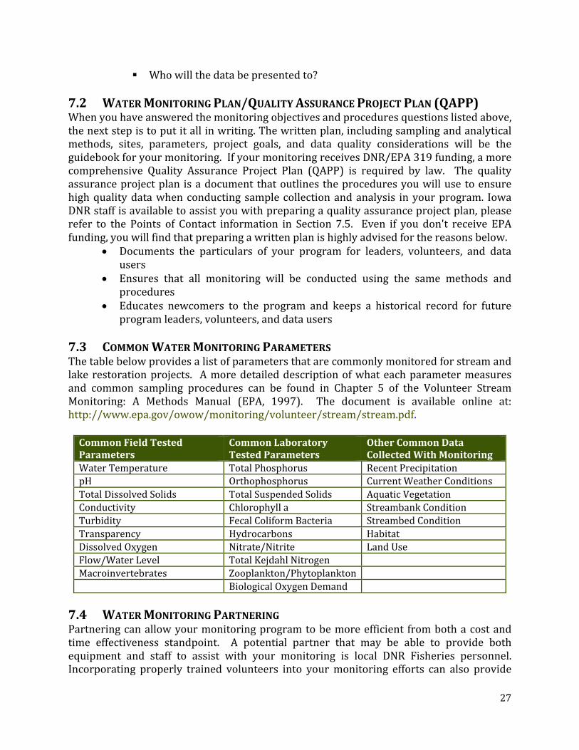
7.3 COMMON WATER MONITORING PARAMETERS The table below provides a list of parameters that are commonly monitored for stream and lake restoration projects. A more detailed description of what each parameter measures and common sampling procedures can be found in Chapter 5 of the Volunteer Stream Monitoring: A Methods Manual (EPA, 1997). The document is available online at: http://www.epa.gov/owow/monitoring/volunteer/stream/stream.pdf.
7.4 WATER MONITORING PARTNERING Partnering can allow your monitoring program to be more efficient from both a cost and time effectiveness standpoint. A potential partner that may be able to provide both equipment and staff to assist with your monitoring is local DNR Fisheries personnel. Incorporating properly trained volunteers into your monitoring efforts can also provide
Common Field Tested Parameters
Common Laboratory Tested Parameters
Other Common Data Collected With Monitoring
Water Temperature Total Phosphorus Recent Precipitation pH Orthophosphorus Current Weather ConditionsTotal Dissolved Solids Total Suspended Solids Aquatic Vegetation Conductivity Chlorophyll a Streambank ConditionTurbidity Fecal Coliform Bacteria Streambed Condition Transparency Hydrocarbons HabitatDissolved Oxygen Nitrate/Nitrite Land Use Flow/Water Level Total Kejdahl NitrogenMacroinvertebrates Zooplankton/Phytoplankton Biological Oxygen Demand

28
multiple benefits. Having volunteers assist with sample collection can not only save you time and effort, but also helps the volunteers connect to your water quality project. Other potential partners and funding sources are as follows:
DNR Watershed Improvement Section (319) – If funding is deemed a necessary part of your project, Section 319 funds can be requested to help implement it.
IOWATER mini‐grants – These grants provide up to $1,000 for water monitoring of streams, rivers, and lakes in Iowa to volunteers trained in the IOWATER program.
Iowa Lakes Restoration Program – If your project is being conducted on a priority publicly owned lake, limited funding for monitoring from this program may be available.
Private Foundations – The Resource Conservation and Development (RC&D) or local Council of Government (CoG) in your area may be able to provide you with a list of local foundations and charities that fund conservation related projects.
Universities/Colleges – Universities and colleges may be willing to assist with a portion of monitoring costs if it is integrated into research they are interest in conducting.
7.5 WATER MONITORING POINTS OF CONTACT General questions about setting up a monitoring program should be directed to your basin coordinator. Another source can be your peers. Several PCs have innovatively developed and are coordinating very complex monitoring efforts as part of their watershed efforts. Finally, DNR water monitoring staff can help you develop more specific monitoring strategies to fit your needs. Current staff information is available at: http://www.iowater.net/about/staff.htm. 7.6 WATER MONITORING REFERENCES United States Environmental Protection Agency, 1997. Volunteer Stream Monitoring: A Methods Manual, Office of Water (EPA 841‐B‐97‐003). A copy of this document can be downloaded at: http://www.epa.gov/owow/monitoring/volunteer/stream/stream.pdf.

29
8. PUBLIC OUTREACH (PO)
The key to having a successful watershed project often lies in the strength of its outreach program. In fact, a public outreach, or Information and Education (I&E), component is usually required in project work plans, regardless of the funding source. If your I&E program is effective, it will take the audience on a cognitive journey, moving them from a condition of unawareness through awareness, knowledge, understanding and finally, the desire to participate. Utilizing the basic marketing strategies listed below will help you conduct a first‐rate I&E program. 8.1 OUTLINE PUBLIC OUTREACH GOALS Your I&E activities should mirror the overall goals of the water quality project. If project goals are to reduce sediment delivery to the stream, concentrate your efforts on promoting the best management practices that do just that. A successful outreach campaign will have stakeholders implementing conservation practices long after the cost share incentives are gone. 8.2 IDENTIFY YOUR AUDIENCE(S) An important step in creating a successful outreach campaign is to identify the target audiences. Multiple mailing lists should be developed to identify primary and secondary targets, e.g., livestock producers, critical area landowners, farm managers, renters and absentee landowners, which will allow you to tailor your outreach methodology to the intended group. For example, if streambank stabilization is an issue, concentrate on contacting only the landowners in the stream corridor. This directed focus will save time and resources, giving you more “bang for the buck.” Mailing lists can be compiled by using a variety of sources: Plat maps, FSA records, NRCS Toolkit, and the county assessor’s office. Selective mailing lists can be acquired by contacting local specialty groups, such as the Beef Producers or Dairy Producers in the area. 8.3 IDENTIFY YOUR CUSTOMERS’ NEEDS AND ATTITUDES Initial I&E activities should begin in the development and planning stages of a watershed project. The old adage “You can lead a horse to water…” applies here; just because cost share dollars and incentives are available doesn’t mean people will want them. Utilize a variety of methods, such as surveys and public meetings, to gauge customer attitudes and their willingness to participate before you expend a lot of time and energy into the project. 8.4 SELECT AND INITIATE PUBLIC OUTREACH TECHNIQUES Your outreach program should include a variety of activities and media venues which will appeal to the contrasting behaviors, attitudes, and personalities of the audience. Traditional media (i.e., newspapers, radio, television, direct mailings, and phone solicitation) may reach the largest audiences, but don’t be afraid to be creative. You can host field days, tours, pasture walks, and workshops; display informational booths at fairs and trade shows. Find out if members of the target audience belong to any special interest

30
groups, e.g., Beef Producers Association, Izaak Walton League, Rotary and local contractor groups. Many of these organizations are on the lookout for guest speakers or articles that can be used in their own newsletters. And don’t overlook youth groups, like 4‐H, FFA, or Boy Scouts. These volunteers may be able to earn community service awards by helping you “spread the word” of your water quality improvement project. 8.5 MEASURE & EVALUATE EFFECTIVENESS OF OUTREACH CAMPAIGN Keep detailed records of your I&E efforts so that you can determine what methods work, and which ones don’t. These records should include a copy of the distributed material, e.g., letters, radio scripts, brochures, articles, etc, and how many people were exposed to the material (i.e. 35 people attended the pasture walk.) Keep in mind that the success of an outreach activity is not necessarily a head count of people reached, but how many water quality practices were initiated as a result of the outreach effort., such as “five producers initiated rotational grazing as a result of attending the pasture walk.” 8.6 AGENCY PROGRAM & EQUAL OPPORTUNITY STATEMENTS Eventually all projects will develop some form of Public Outreach effort to be distributed to your stakeholders, or maybe the public at large. This could take the form of a brochure, newsletter or public display. The key, is whether the effort was intended to be distributed to the public rather than an individual, such as a personal letter? If it is a public document, one of the following statements need to included, depending upon the funding sources being utilized by your project. If your project uses either WSPF or WPF, and Section 319:
“This project is supported in part by the Iowa Department of Agriculture and Land Stewardship, Division of Soil Conservation, through funds of the Water Protection Funds and/or Watershed Protection Fund and, by the Iowa Department of Natural Resources through a grant from the U.S. Environmental Protection Agency under the Federal Non‐point Source Management Program (Section 319 of the Clean Water Act). Technical assistance is provided by the U.S. Department of Agriculture, Natural Resources Conservation Service.”
If your project uses 319, but no WSPF or WPF:
“This project is support by the Iowa Department of Natural Resources through a grant from the U.S. Environmental Protection Agency under the Federal Non‐point Source Management Program (Section 319 of the Clean Water Act). Technical assistance is provided by the U.S. Department of Agriculture, Natural Resources Conservation Service.”
If your project uses WSPF and/or WPF, but no Section 319:

31
“This project is support in part by the Iowa Department of Agriculture and Land Stewardship, Division of Soil Conservation, through funds of the Water Protection Funds and/or Watershed Protection Fund. Technical assistance is provided by the U.S. Department of Agriculture, Natural Resources Conservation Service.”
If your project uses WIRB funding:
“This project is supported in part by the Iowa Watershed Improvement Fund administered by the Iowa Watershed Improvement Review Board with support from the Iowa Department of Agriculture and Land Stewardship, Division of Soil Conservation.”
8.7 OTHER PUBLIC OUTREACH SOURCES It is beyond the scope of this handbook to cover all of the skills, design techniques, and implementation procedures needed to run a successful information and education program. Writing styles, grammar, submission guidelines, creative outreach, media contacts and distribution procedures are just a few topics that need to be researched through other sources. Good sources include:
Iowa DNR I&E Guidebook (contact your Basin Coordinator to receive document) EPA Watershed Toolbox (http://cfpub.epa.gov/npstbx/index.html) Iowa State University Extension Renewing Local Watersheds: Community Leader’s
Guide to Building Watershed Communities: http://cfpub.epa.gov/npstbx/index.html

32
9. POTENTIAL FUNDING SOURCES
Once the assessment and planning process has been completed, the next step is to secure funding to support your project. The funding can be used to provide staff, conduct a public outreach campaign, and maybe most importantly defray a portion of the expenses for stakeholders to implement needed soil and water conservation practices within identified priority areas. At the state level, DSC, DNR, as well as the Watershed Improvement Review Board (WIRB) have access to funding that can be secured through an application process for either a planning grant (DSC and DNR) or implementation project (DSC, DNR, WIRB). In addition, other funding sources may be available to leverage funds or to fund critical practices that fail to qualify through other programs. Regardless, in today’s limited budgetary world, creatively putting together financial packages and spreading the cost can significantly improve the chances of an application being approved. Before filing an application, it’s a good idea to learn more about the potential funding source(s). This way you can see how close your goals and objectives are to the mission of the funding source. The closer you are, the better your chances of success. The further apart you are, the more you may want to seek other sources. In addition, as each agency has specific requirements that must be met in order to qualify for funding, it is the responsibility of the project sponsor(s) to determine which funding source(s) they wish to submit an application. A further discussion of these possible funding sources is included below. Although an effort has been made to keep this information as current as possible, you are strongly advised to contact your Basin Coordinator to determine if changes in potential funding sources have taken place. Additionally, be sure to utilize the links provided to find the most up to date information.
DSC administered programs: http://www.iowaagriculture.gov/soilConservation.asp
DNR administered programs: http://www.iowadnr.gov/Environment/WaterQuality/WatershedImprovement.aspx
9.1 DIVISION OF SOIL CONSERVATION Officially part of the Iowa Department of Agriculture & Land Stewardship, the Division of Soil Conservation (or as its frequently referred to DSC) has funded watershed efforts for over 20 years. While funding levels have ebbed and flowed, the two primary funding sources DSC uses to support efforts in Iowa are as follows: WATER PROTECTION FUND (WPF): Water quality protection projects protect the state’s surface and groundwater resources from point and non‐point sources of contamination. Authorized in Iowa Code Chapter 161C, WPF projects are developed through a locally led process initiated by Soil and Water Conservation Districts, coordinating the resources and programs of a variety of organizations to achieve local objectives. Applications consider the importance of the resource to be protected, the nature and extent of the water quality

33
problem, proposed solutions, landowner interest, and the overall cost effectiveness of the project. WATERSHED PROTECTION FUND (WSPF): WSPF was established in 1999 by the Iowa legislature to accelerate watershed protection efforts across the state. The authorization for these funds is broader than WPF or EPA Section 319 funding, enabling DSC to invest these funds to protect soil & water quality, other natural resources and provide flood reduction. Primary goals include building the capacity of local communities to sponsor watershed protection efforts, and providing resources to leverage other funding available at the federal and local level. Regardless as to program, it is DSC’s belief that water quality protection projects commonly use the watershed approach to address water quality problems. It provides the most comprehensive, efficient and effective way to achieve soil and water quality protection objectives. Successful projects usually have a high level of community support and include strong public information and education programs. They also feature partnerships with federal, state and local agencies and organizations. In addition to WPF/WSPF, DSC also administers various other cost share programs, as well as no‐interest and low‐interest loan programs, which under certain circumstances, can bring even more resources to support watershed efforts. However, it should be pointed out that care must be given to leveraging certain funds with other sources. While there may be exceptions, the general rule of thumb is you can’t match state funds with other state funds or federal funds with other federal funds. But you can often match certain state AND federal funds together. For additional information on which funds can be leveraged together, contact either your Basin Coordinator or appropriate DNR Project Officer. Additional information about all DSC administered grant, cost share and loan programs, including WSPF and WPF can be found at the following Division of Soil Conservation website: http://www.iowaagriculture.gov/soilConservation.asp. 9.2 IOWA DEPARTMENT OF NATURAL RESOURCES Compared to the administrative structure of DSC, the DNR has several more programs and funding streams that can be used to support water quality in the State of Iowa. Besides the Nonpoint Source Program, past projects have successfully leveraged both funding and technical support from others within the DNR, namely Fisheries, Wildlife, Monitoring, Lakes Restoration, Parks & Recreation, Environmental Protection, and the Geological Survey. As you can imagine, new PCs have often found it difficult to initiate contact with just the right people. So, you are encouraged to contact your DNR Project Officer for guidance. Further information on DNR administered grant programs can be found at: http://www.iowadnr.gov/Environment/WaterQuality/WatershedImprovement.aspx. EPA SECTION 319 PROGRAM: DNR’s primary funding source for their Nonpoint Source Management Program comes to them in the form of a yearly grant from the Environmental Protection Agency (EPA), as provided by the 1972 Clean Water Act. Used to support both their Watershed Planning Grants and Watershed Implementation Grants programs, the

34
funds are also used to support staff and activities connected to their watershed improvement activities, impaired waters lists and watershed improvement plans. While the DNR doles out EPA funds using a grant application process similar, and at times in cooperation with DSC, there are a few significant differences:
These funds are primarily targeted to only those watersheds that appear on, or drain directly or indirectly into a water body included on Iowa’s 303(d) List of Impaired Waters.
SWCDs are eligible to apply for these funds as well as local watershed groups and councils, county conservation boards, universities, city and county governments, along with non‐profit organizations and others.
In order to be considered for a Watershed Implementation Grant, a Watershed Management Plan (WMP) must be developed and approved by both EPA and DNR. Funds provided through an implementation grant can be used to support the implementation conservation practices as well as approved administrative costs.
Additional information on DNR’s Watershed Planning and Implementation Grants can be found in Sections 4.1 and 4.2. LAKE RESTORATION PROGRAM: Numerous DSC/DNR watershed projects have successfully leveraged funds from DNR’s Lakes Restoration Program. What makes this annually‐funded program unique is their funds are one of the few that can be used for both inlake measures as well as watershedrelated practices. To be eligible, your lake must appear on the list of Iowa’s Significant Publicly‐Owned Lakes. Additional information this program can be found at: http://www.iowadnr.gov/water/lakerestoration/index.html. 9.3 WATERSHED IMPROVEMENT REVIEW BOARD The Watershed Improvement Review Board (WIRB) is another possible funding source available to watershed/water quality implementation projects. The Board is made up a diverse group of individuals appointed by the governor along with two state senators and two state representatives. The group receives a yearly appropriation and makes grant awards to projects based on applications developed to improve water quality and/or assist with flood prevention. The application process and guidance is similar to that described for the other funding sources. Project applicants for WIRB grants may include local watershed improvement committees, soil and water conservation districts, counties, county conservation boards, public water supply utilities and cities. While the Board is an independent group, DSC does serve as an administrative support agency and additional information about WIRB and their application process is available to you on the IDALS website: http://www.iowaagriculture.gov/IWIRB.asp. 9.4 MISSISSIPPI RIVER BASIN INITIATIVE The Mississippi River Basin Initiative (MRBI) was established by the Natural Resources Conservation Service (NRCS) to improve water quality and wildlife habitat within the 12‐State Initiative area to address nutrient loading in the Mississippi River Basin and the hypoxic zone in the Gulf of Mexico. Through this new Initiative, NRCS and its partners will help producers in selected watersheds to voluntarily optimize their use of nitrogen and

35
phosphorus through a conservation systems approach by implementing conservation practices that avoid, control, and trap nutrient runoff; improve wildlife habitat; and maintain agricultural productivity. For further information on MRBI, visit: http://www.ia.nrcs.usda.gov/programs/MRBI.html. 9.5 USDA Most watershed efforts have successfully leveraged their limited state funding with cost sharing provided by our USDA partners through the following programs. It is important to note, the funding levels and availability of the following programs can change, with new programs being developed every few years. Therefore, when reviewing the various USDA programs available to the stakeholders in your watershed, with work with your local DC or RC to see that you have a current list. Also, utilize the following web site to see up to date information: http://www.ia.nrcs.usda.gov/programs/. CONSERVATION RESERVE ENHANCEMENT PROGRAM (CREP)
Purpose: Work with landowners to develop and install wetlands which are strategically located and designed to remove nitrate from tile‐drainage water from cropland areas.
Eligibility: Enrollment on a continuous basis to landowners within the 37‐county prairie pothole region of north central Iowa; eligible sites must be in landscape position to intercept significant tile flow while not obstructing normal drainage.
Contract: Landowners will enter a 15‐year contract with USDA‐FSA as under the Continuous CRP. DSC funds are used for additional, one‐time, up‐front incentive payment to encourage participating landowners to enter into a required additional 15‐year agreement or permanent easement; FSA and DSC funds will provide for 100% cost‐share.
CONSERVATION RESERVE PROGRAM (CRP) Purpose: To reduce erosion, increase wildlife habitat, and improve water quality
through the application of conservation plans which include practices such as tree planting, grass cover, small wetland restoration, prairie restoration, waterways, terraces, and others.
Eligibility: Varies by soil type and crop history. For general signups, land is accepted into the program if the offer qualifies. Continuous signup is open for buffers, waterways, and environmental practices at all times.
Contract: 10‐15 years depending on the type of practice. Transferable with change in ownership.
CONSERVATION STEWARDSHIP PROGRAM (CSP)
Purpose: To reward farmers and landowners for past conservation work and provide technical and financial assistance to help implement‐ conservation plans that address specific natural resource concerns and complete more conservation work.
Eligibility: Private ag land and non‐industrial forest land planted, except for land in WRP, CRP and GRP. Signup is continuous.

36
Contract: 5‐year contracts; annual payment is based on contract details.
ENVIRONMENTAL QUALITY INCENTIVES PROGRAM (EQIP) Purpose: To provide technical and financial assistance to landowners to develop and
implement conservation plans that address specific natural resource concerns through practices such as: livestock manure management, grazing land management, soil erosion control, and water quality improvement practices.
Eligibility: Agricultural producers on agricultural land are eligible. Projects are selected based on environmental benefits.
Contract: Up to 10 year contracts. WETLANDS RESERVE PROGRAM (WRP)
Purpose: To develop and implement a conservation plan for restoration of wetlands previously altered for agricultural use.
Eligibility: Land that has been owned for seven years and that could be restored to wetland conditions.
Contract: Landowners may restore wetlands with permanent easements, 30‐year easements or 10‐year contracts. Permanent easements pay 100% of the easement value of the land and 100% cost‐share for restoration; 30‐year easements pay 75% of the agricultural value and 75% cost‐share for restoration; 10‐year contracts pay 75% cost‐share of restoration only. Permanent or 30‐year easements are recorded with property easement deeds.
WILDLIFE HABITAT INCENTIVE PROGRAM (WHIP)
Purpose: To develop or improve fish and wildlife habitat on privately owned land through the application of a conservation plans based upon the implementation of grass seeding, tree and shrub plantings, fencing, in‐stream structures, and prairie restoration.
Eligibility: Private agricultural land, non‐industrial private forestland or Indian land. Contract: Usually 5 years to install and maintain the habitat. Financial assistance
may be available for restoration costs, to a maximum of $30,000. Other organizations may provide additional financial assistance.
9.6 PRIVATE SECTOR FUNDING (FOUNDATIONS, CORPORATION, ETC.) When looking for funding sources for your watershed project, don’t discount the important role the private sector can play. Many watershed projects have benefited from cash, equipment, and supplies that have been granted from private sources. A major benefit of private sector grants is that the funding applications can often be completed in a relatively short amount of time when compared to other funding sources. In general, private funds are more easily attained when your funding request will go towards a specific practice, improvement project, or outreach effort. Before applying for private sector grants, a phone call or meeting with the grantor can be very beneficial to ensure that the application matches the mission of the grantor. In order to find potential private grant sources in your area, contact other agencies such as your local Council of Governments. Contacting other Project Coordinators in your area to determine grant sources they have used is also beneficial. Common private funding sources include habitat/wildlife organizations, local

37
foundations, corporations, casinos, and individuals, and may include some of the following: Pheasants Forever, Ducks Unlimited, Trout Unlimited, National Wild Turkey Federation, Delta Waterfowl, Quail Forever, Izaak Walton League and Whitetails Unlimited.
10. TECHNICAL REFERENCES, LAWS & REGULATIONS
10.1 SOIL LOSS COMPLAINTS Iowa Drainage Law grants the right to the owner of land higher in elevation to drain water across a lower neighbor in a natural waterway without interference. However, the lower neighbor has legal rights if his/her property is receiving damage from sediment. Code of Iowa Chapter 161A.44‐.51 (Iowa Sediment Control Law) provides the avenue for the damaged party to initiate legal action. Through the steps detailed in the Code of Iowa, the culpable party may be found at fault by the local Soil & Water Conservation District board and an Administrative Order issued in order for soil erosion control to be implemented on the owner of the higher property. This process may be facilitated by the IDALS‐DSC with legal assistance from the Iowa Attorney General. Current Code of Iowa may be found at http://www.legis.state.ia.us/IowaLaw.html. The pamphlet “Guidelines for filing Soil Loss Complaints under Code of Iowa Chapter 161A.44‐.51” has been approved for distribution by the Iowa Attorney General and is found in the appendices of this document. The IDALS‐DSC website has a link to its Policy & Procedure Manual which directs you to www.iowaagdata.com. The Soil Loss Regulations section contains a complete description of the entire process and well as a soil loss procedure flow chart, a check list, and samples of several of the documents involved. For further assistance, contact IDALS‐DSC or the Iowa Attorney General. 10.2 NRCS COMPLIANCE & STATUS REVIEWS USDA agencies are responsible for ensuring producers comply with Highly Erodible Land Conservation and Wetland Conservation provisions of the Food Security Act of 1985, as amended, in order to be eligible for any USDA benefits and programs. These include, but are not limited to storage payments, loan programs, emergency assistance, CRP, CSP, EQIP, and the Direct and Counter‐Cyclical Program. Since the 1985 Farm Bill, each farm tract containing highly erodible land (HEL) is required to have a compliance plan developed by NRCS for each HEL field. According to current regulations, this plan includes a combination of residue requirements and management components to meet soil loss limits of 2T for each field and also includes controlling all ephemeral gully erosion. Required residue levels must be intact after planting, so all methods of fertilizer and manure application must be taken into consideration by a producer, not just tillage. In addition, Farm Bills and Section 404 of the Clean Water Act also require landowners and producers to protect wetlands on land they own or operate. Referring to their Certified

38
Wetland Determination completed by NRCS, crop production may not be made possible in a wetland, nor may drainage of Farmed Wetlands be increased nor may fill be added to any wetland. Each NRCS field office conducts annual status reviews on tracts randomly determined by National Headquarters. The number of tracts chosen for review may vary from year to year, as determined to accurately assess compliance at the national level. Supplemental tracts may be added by the State Conservationist and at the local level, such as whistleblower complaints. Additional information may be found in Title 180‐Conservation Planning and Application, National Food Security Act Manual, Part 518‐Compliance Review. 10.3 1972 CLEAN WATER ACT The objective of the Federal Water Pollution Control Act, commonly referred to as the 1972 Clean Water Act (CWA), is to restore and maintain the chemical, physical, and biological integrity of the nation's waters. However, based upon whether the source of pollution is defined as point versus nonpoint has a significant impact on the measures the federal government can take to resolve the problem. States may be authorized to implement CWA programs, but the EPA retains oversight responsibilities. More information on the CWA can be found at: http://www.epa.gov/lawsregs/laws/cwa.html. POINT SOURCE POLLUTION ‐ Point source pollution is “any single identifiable source of pollution from which pollutants are discharged, such as a pipe, ditch, ship or factory smokestack”. Factories and sewage treatment plants are two common types of point sources. The CWA gives the EPA the authority to establish effluent limits, thus providing the basic structure for regulating the discharge of pollutants from point sources to waters of the United States. The CWA also requires the acquisition of a National Pollution Discharge Elimination System (NPDES) permit prior to the discharge of pollutants. NONPOINT SOURCE POLLUTION Nonpoint source (NPS) pollution, unlike pollution from industrial and sewage treatment plants, comes from many diffuse sources. NPS pollution is caused by rainfall or snowmelt moving over and through the ground. As the runoff moves, it picks up and carries away natural and human‐made pollutants, finally depositing them into lakes, rivers, wetlands, coastal waters, and even underground sources of drinking water. Because of its diffuse nature, nonpoint source pollution is often difficult to define. Therefore, in many cases (and at this time) participation to reduce nonpoint source pollution is voluntary. 10.4 IOWA DNR ENVIRONMENTAL SERVICES DIVISION FIELD OFFICES The Iowa DNR, through their Field Services and Compliance Bureau, maintain six DNR field offices throughout the state. They are local representatives of the Environmental Services Division and a partial list of the programs they cover include air quality, animal feeding operations, contaminated sites, underground storage tanks, waste management, water supply, and water quality.

39
Among their day‐to‐day tasks includes helping people to understand environmental services programs, enforcing state environmental laws, including inspections of permitted facilities, helping individuals and businesses understand when to apply for a permit and how to meet permit requirements, respond to spills, handle complaints from the public and often resolving disputes between neighbors. If technical assistance and cooperative activities do not resolve a problem, the DNR field office staff may recommend more formal measures to seek compliance. In any compliance actions, field office, central office and legal staff form a team to coordinate each case until it is finally resolved. Additional information on the Environmental Services Division and where their offices are located can be found at: http://www.iowadnr.gov/fo/index.html. Besides providing technical assistance, DNR Field Office staff have frequently provided training to PCs and participated in numerous public outreach efforts conducted by various projects. 10.5 TORT LIABILITY Environmental Specialist and District Employees, as agents of the State of Iowa, are covered under the State's tort liability law as long as they are carrying out their official duties with due care and in good faith. Tort claims are civil claims that are brought on allegations of wrongful death or injury to a person or damage to property. Law suits are typically based on negligence, breach of duty or nuisance. Providing employees are acting within the limits of their duties, the State Attorney General's office will defend them against suits. Contact IDALS‐DSC whenever you maybe unsure about possibility of liability and the IDALS‐DSC will initiate contact with Attorney General’s office.

Appendix 1: Individual Development Plan (IDP)
Field Representative

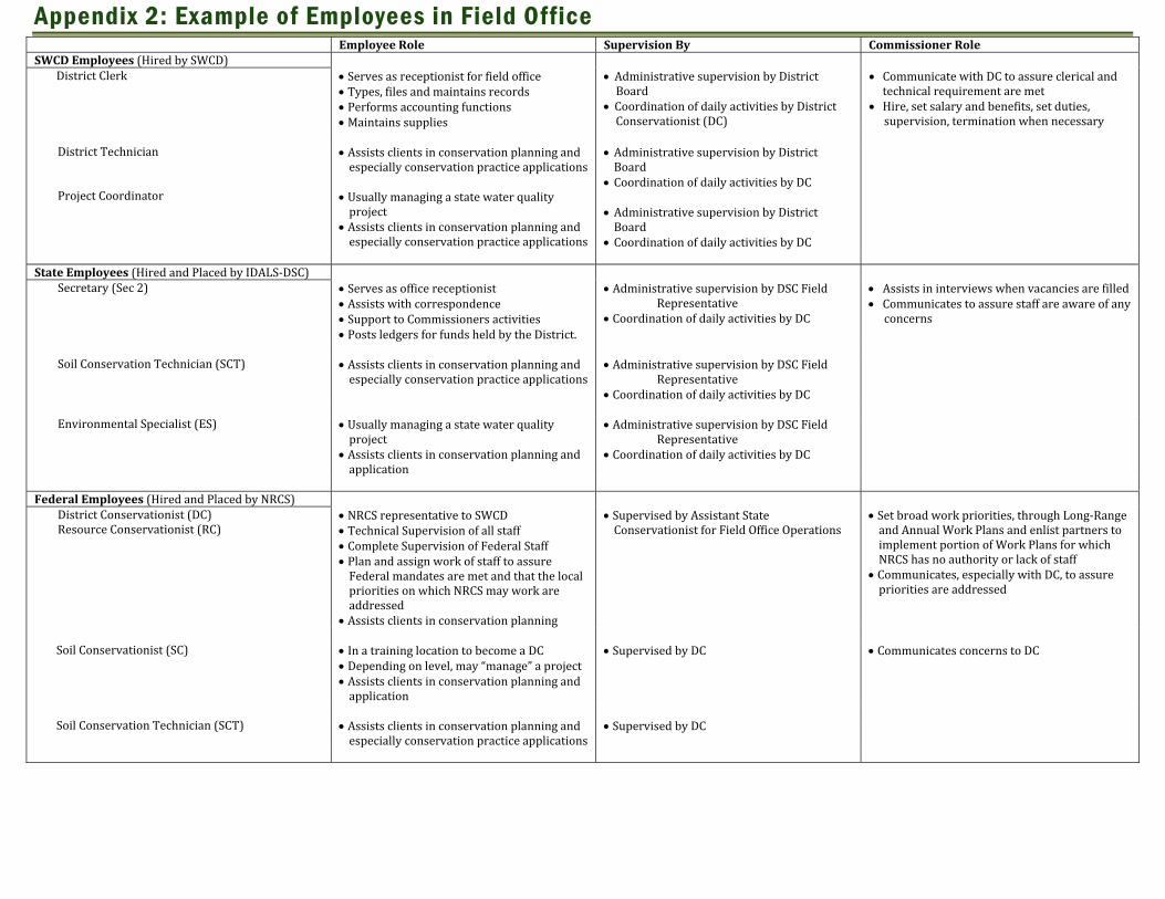
Appendix 2: Example of Employees in Field Office Employee Role Supervision By Commissioner Role SWCD Employees (Hired by SWCD)
District Clerk Serves as receptionist for field office Types, files and maintains records Performs accounting functions Maintains supplies
Administrative supervision by District Board
Coordination of daily activities by District Conservationist (DC)
Communicate with DC to assure clerical and technical requirement are met
Hire, set salary and benefits, set duties, supervision, termination when necessary
District Technician Project Coordinator
Assists clients in conservation planning and especially conservation practice applications
Usually managing a state water quality project
Assists clients in conservation planning and especially conservation practice applications
Administrative supervision by District Board
Coordination of daily activities by DC Administrative supervision by District Board
Coordination of daily activities by DC State Employees (Hired and Placed by IDALS‐DSC)
Secretary (Sec 2) Serves as office receptionist Assists with correspondence Support to Commissioners activities Posts ledgers for funds held by the District.
Administrative supervision by DSC Field Representative
Coordination of daily activities by DC
Assists in interviews when vacancies are filled Communicates to assure staff are aware of any concerns
Soil Conservation Technician (SCT) Assists clients in conservation planning and
especially conservation practice applications Administrative supervision by DSC Field
Representative Coordination of daily activities by DC
Environmental Specialist (ES) Usually managing a state water quality
project Assists clients in conservation planning and application
Administrative supervision by DSC Field Representative
Coordination of daily activities by DC
Federal Employees (Hired and Placed by NRCS)
District Conservationist (DC) Resource Conservationist (RC)
NRCS representative to SWCD Technical Supervision of all staff Complete Supervision of Federal Staff Plan and assign work of staff to assure Federal mandates are met and that the local priorities on which NRCS may work are addressed
Assists clients in conservation planning
Supervised by Assistant State Conservationist for Field Office Operations
Set broad work priorities, through Long‐Range and Annual Work Plans and enlist partners to implement portion of Work Plans for which NRCS has no authority or lack of staff
Communicates, especially with DC, to assure priorities are addressed
Soil Conservationist (SC) In a training location to become a DC
Depending on level, may “manage” a project Assists clients in conservation planning and application
Supervised by DC Communicates concerns to DC
Soil Conservation Technician (SCT) Assists clients in conservation planning and
especially conservation practice applications Supervised by DC

Appendix 3: Points of Contact Links
Division of Soil Conservation Directory http://www.iowaagriculture.gov/emailContact/index.asp
Regional Basin Coordinators and DNR Project Officer Staff (select Staff Contacts link): http://www.iowadnr.gov/water/watershed/coord.html#staff
Field Representatives Areas Map: http://www.agriculture.state.ia.us/FieldServices/pdf/FieldRepsMap.pdf
DNR Watershed Improvement Section Staff (GIS, Outreach, TMDL, etc…): http://www.iowadnr.gov/water/watershed/staff.html
DNR IOWATER and Water Monitoring Staff http://www.iowater.net/about/staff.htm
Iowa USDA Natural Resources Conservation Resources http://www.ia.nrcs.usda.gov/
Soil and Water Conservation District Commissioners: https://idals.iowa.gov/FARMS/index.php/searchEmployees
Watershed Improvement Review Board Information: http://www.agriculture.state.ia.us/IWIRB.asp
Active Water Quality Projects Contact Information: http://www.iowadnr.gov/water/watershed/files/wshedactiveprojects_0410.pdf
List of Current and Past Watershed Projects: http://www.agriculture.state.ia.us/waterResources/pdf/2009AllProjectsList.pdf

Appendix 4: Technical Resources Links
Project Reporting Guidance:
ftp://ftp.igsb.uiowa.edu/319/Project%20Guidance/Reporting%20Guidance/
Watershed Improvement Funding Sources List: http://www.iowadnr.gov/water/watershed/files/fundinglist.pdf
IDALS/DSC Urban Conservation Program: http://www.iowaagriculture.gov/FieldServices/urbanConservation.asp
IDALSDSC Policies and Procedures Manual http://www.iowaagdata.com/(Username and Password required, contact Basin Coordinator)
NRCS Field Office Technical Guide – Iowa http://efotg.sc.egov.usda.gov/efotg_locator.aspx?map=IA
CDI Commissioner Resources (Commissioner Handbook has http://www.cdiowa.org/resources.html
Iowa DNR Animal Feeding Operations http://www.iowadnr.com/afo/index.html
Iowa DNR ADBNet (305(b) Water Quality Assessment Database http://programs.iowadnr.gov/adbnet/search.aspx
Iowa DNR Lakes Information System http://limnology.eeob.iastate.edu/lakereport/
Iowa DNR Watershed Improvement – 303(d) List of Impaired Waters
http://www.iowadnr.gov/water/watershed/impaired.html Iowa Stormwater Management Manual
http://www.intrans.iastate.edu/pubs/stormwater/index.cfm Open Feedlot Construction Permit Requirements:
http://www.iowadnr.com/afo/files/0301fact.pdf State of Iowa Livestock Rules Iowa Administrative Code Chapter 65:
http://www.legis.state.ia.us/Rules/Current/iac/567iac/56765/56765.pdf

Appendix 5: Common Acronyms
The language used to discuss District activities is often incomprehensible and confusing to those unfamiliar with it. Here is a brief guide to the acronyms often used in SWCD offices. 319 A federal EPA program that provides funds for water quality programs. This program is administered by IDNR with project assistance from IDALS‐DSC. AFO Animal Feeding Operations Agricultural enterprises where animals are kept and raised in confinement. ASCFO NRCS Assistant State Conservationist, Field Operations BMP Best Management Practices CAFO Concentrated Animal Feeding Operations, animal feeding operations with 1,000 or more animal units. CDI Conservation Districts of Iowa. A non‐profit organization supporting the work of the SWCDs. CED County Executive Director (FSA) The counterpart of the NRCS DC. CEED County Extension Education Director CES Cooperative Extension Service CNMP Comprehensive Nutrient Management Plan COE Corp of Engineers CREP Conservation Reserve Enhancement Program CRP Conservation Reserve Program CSP Conservation Stewardship Program CTA Conservation Technical Assistance CTIC Conservation Technology Information Center CWA Clean Water Act DC District Conservationist USDA, NRCS DSC Iowa Department of Agriculture & Land Stewardship, Division of Soil Conservation DNR Department of Natural Resources DOT Department of Transportation EBI Environmental Benefits Index Criteria used to determine enrollment of land in CRP. EPA Environmental Protection Agency EQIP Environmental Quality Incentives Program This is a federal program that provides funds on a competitive basis for cost share. EWP Emergency Watershed Program FA Financial Assistance FAC Food and Agriculture Council The committee comprised of county, state and national staff which addresses internal policies and interagency working arrangements. FARMS Financial and Reports Management System FCA Farm Credit Agency FEMA Federal Emergency Management Agency Federal agency providing disaster relief. FOIA Freedom of Information Act FRPP Farmland and Ranchland Protection Program FSA Farm Service Agency USDA FTE Full Time Equivalents GIS Geographic Information System GLCI Grazing Land Conservation Initiative GPS Global Positioning System GRP Grassland Reserve Program HEL Highly Erodible Land HUC Hydrologic Unit Codes ICM Integrated Crop Management IDALS Iowa Department of Agriculture and Land Stewardship IFIP Iowa Financial Incentives Program, program provides state cost‐share funds to landowners IPM Integrated Pest Management, management approach of using a variety of techniques to control pests.

ISCAP Iowa Soil Conservation Awards Program ISUE Iowa State University Extension LESA Land Evaluation Site Assessment LICA Land Improvement Contractors of America LTA Long Term Agreement LWPP Local Water Protection Loan Program Low interest loans MOU Memorandum of Understanding Agreements between agencies, units of government, organizations, etc. MLRA Major Land Resources Areas MRBI Mississippi River Basin Initiative NACD National Association of Conservation Districts NASCA National Association of State Conservation Agencies NEPA National Environmental Protection Act NHEL Non‐highly Erodible Land NGO Non‐government Organizations NPS Non‐point Source NRCS Natural Resources Conservation Service, USDA NRI National Resource Inventory NRWA National Rural Water Association O&M Operation and Maintenance OMB Office of Management and Budget PII Personal Identifiable Information PL566 Federal NRCS program that deals with small watersheds and projects that provide flood control. PRMS Performance Results Measurement System QST Quality Steering Team A group formed to guide Total Quality Management efforts. RC NRCS Resource Conservationist, provide assistance at the field office level under the supervision of the DC RCA Resources Conservation Act RD Rural Development REAP Resource Enhancement and Protection, an Iowa program providing funds for a variety of programs RUSLE2 Revised Universal Soil Loss Equation 2, a formula used to determine the amount of soil erosion from a given field under different circumstances. Replaced the previous equation USLE or the universal soil loss equation. SSCC State Soil Conservation Committee The body established under Iowa Code that is responsible for establishing policy approving administrative rules of IDALS‐DSC. SWCD Soil and Water Conservation District SWCS Soil and Water Conservation Society TA Technical Assistance TMDL Total Maximum Daily Loads TQM Total Quality Management TSP Technical Service Provider Initiative USDA United States Department of Agriculture USFWS United States Fish and Wildlife Service USGS United States Geological Survey WHIP Wildlife Habitat Incentives Program WIRB Watershed Improvement Review Board WPF Water Protection Fund IDALS‐DSC WRP Wetlands Reserve Program NRCS WSPF Iowa Watershed Protection Fund IDALS‐DSC

319 Funded Projects
319 Program Administrator
319 Project Officers
Project Coordinator
Advisory Group
Field Office Staff
Stakeholders
Basin Coordinators
DSC Funded Projects
DSC Field Bureau Chief
Basin Coordinator
Field Representative
District Funded Projects
District Commissioner
Basin Coordinator
Appendix 6: Project Information Flow Chart for 319, DSC & District Funded Projects