PBIC Webinar Intro Template · 2014-04-10 · Statewide Complete Streets: How states are working...
64
Statewide Complete Streets: How states are working with communities for friendlier roads Stefanie Seskin, National Complete Streets Coalition Lauren Blackburn, North Carolina DOT Paula Reeves, Washington State DOT Chris Berrens, Minnesota DOT April 10, 2 pm [IMAGE] PBIC Webinar
Transcript of PBIC Webinar Intro Template · 2014-04-10 · Statewide Complete Streets: How states are working...

Statewide Complete Streets: How states are working with communities for friendlier roads
Stefanie Seskin, National Complete Streets CoalitionLauren Blackburn, North Carolina DOTPaula Reeves, Washington State DOTChris Berrens, Minnesota DOT
April 10, 2 pm
[IMAGE]
PBIC Webinar

Today’s PresentationIntroduction and housekeeping
Audio issues?Dial into the phone line instead of using “mic & speakers”
PBIC Trainings and Webinarswww.pedbikeinfo.org/training
Registration and Archives atpedbikeinfo.org/webinars
PBIC News and updates on Facebookwww.facebook.com/pedbike
Questions at the end

Statewide Complete Streets
Stefanie SeskinDeputy Director, National Complete Streets Coalition
Smart Growth America
April 10, 2014

An approach to transportation decisions
2
Safe, comfortable, and convenient places for walking, driving, bicycling, and taking public transportation

Don’t conflate with output
3

4
Balancing needs while approaching every project from the mindset that people will walk, bicycle, drive, and take public transportation
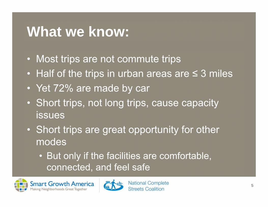
What we know:
5
• Most trips are not commute trips• Half of the trips in urban areas are ≤ 3 miles • Yet 72% are made by car• Short trips, not long trips, cause capacity
issues• Short trips are great opportunity for other
modes• But only if the facilities are comfortable,
connected, and feel safe

“Policy”
6
• Broadly defined• Formal document with clear vision and
intention to make inclusive transportation decisions
• All ages, abilities, incomes, preferences, races and ethnicities
• Walking, bicycling, taking transit, driving all types of vehicles
• Land use

“Accommodations”
7
• “Accommodate” =/= appeasing some users• Must think beyond minimum, especially for
non-automobile modes

Statewide Complete Streets policies
8
• Total: 27 + DC + Puerto Rico• Legislation: 17 states• DOT policies: 15 states

Challenges
9

Long-term planning process is broken
10
SSTI
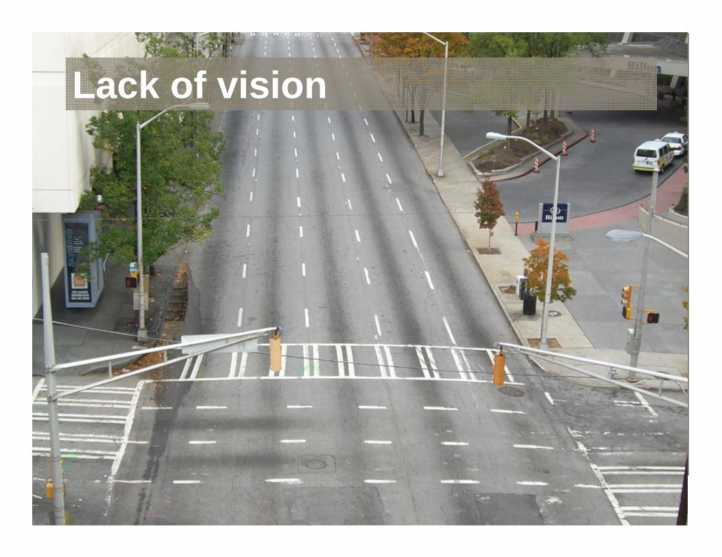
Lack of vision
11

What if we project different outcomes?

Rethink our investments
13
• Pipeline projects far outweigh funding opportunities
• Extensive existing system needs maintenance
• …and replacement.
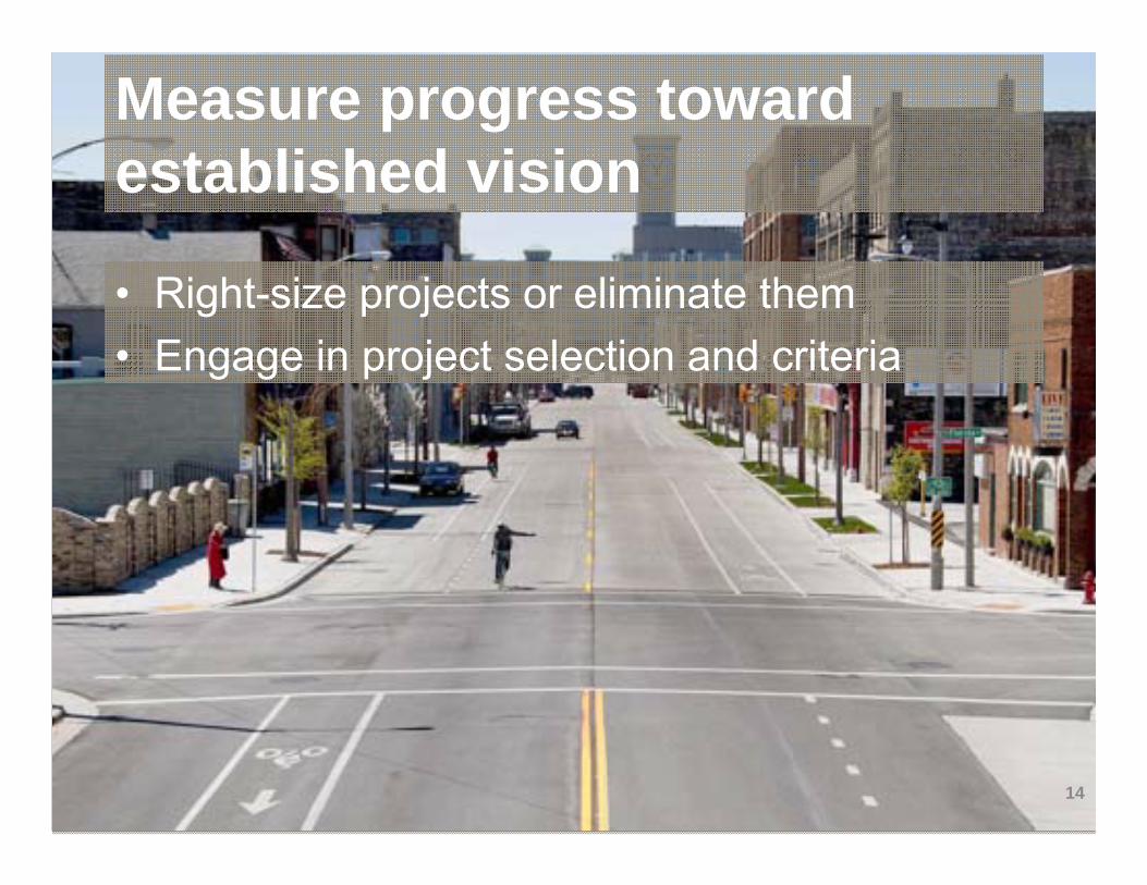
Measure progress toward established vision
14
• Right-size projects or eliminate them• Engage in project selection and criteria

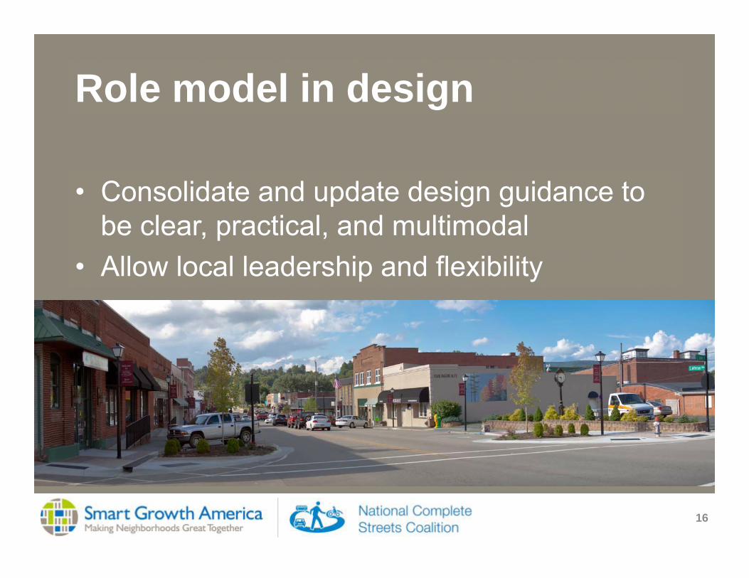
Role model in design
15
• Regardless of the share of streets that are on state network
• Excitement and reluctance both can lead to poor design decisions
Role model in design
16
• Consolidate and update design guidance to be clear, practical, and multimodal
• Allow local leadership and flexibility
Partners in funding
17
• Competitive grant program• Expertise and readiness in local government
• Cost sharing• Non-motorized safety emphasis in SHSP

Land use happens
18
• Joint transportation/land use corridor studies• Integrated corridor management

Communication
19
• Easy to access• Clear explanations• Partner for meaningful public input

CS Training and Implementation in North Carolina
Lauren Blackburn, [email protected], Bicycle and Pedestrian Division

Complete Streets Policy Development
July 2009Complete Streets Policy Adopted
July 2012Design Guidelines Released
Download the Guidelines at www.completestreetsnc.org

NCDOT Complete Streets policy definition
Complete Streets is North Carolina’s approach to interdependent, multi‐modal transportation networks that safely accommodate access and travel for all users.

Goals of the Complete Streets PolicyTo establish transportation choices
Support transportation safety goals
Support economic development goals
Support public health goals
Support local community‐building
Support environmental goals
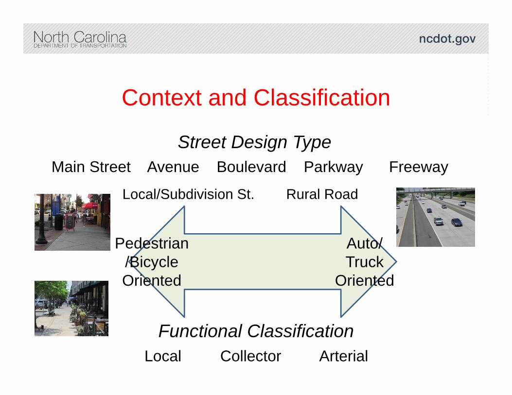
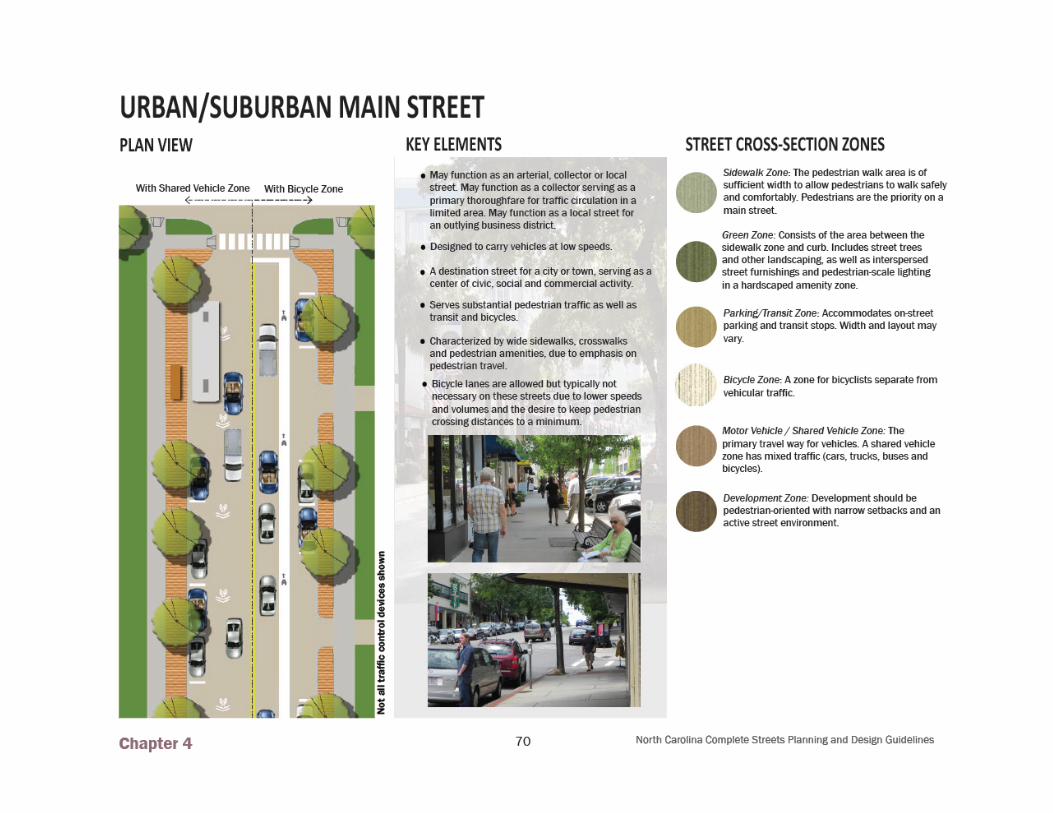
Context and Classification
Pedestrian/BicycleOriented
Auto/Truck
Oriented
Functional ClassificationLocal Collector Arterial
Street Design TypeMain Street Avenue Boulevard Parkway Freeway
Local/Subdivision St. Rural Road


Complete Streets Training OverviewFour regional workshops in 201224 two-day training courses in 2013 (24 completed, 3 in 2014)State and local engineers and planners are strongly encouraged to attendConference to celebrate success stories

Project Specific Context & Process

US 421 Widening in Boone
Widening of corridor by NCDOT –main route into town and campusTown desired a multimodal outcome with gateway featuresMunicipality worked with NCDOT to incorporate bike lanes and sidewalks, in addition to other featuresGood example of late‐stage coordination
Before
After

Main Street Clayton


QUESTIONS?

WSDOT’sComplete Streets & Main Street
HighwaysPaula Reeves, AICP CTPWSDOT Local Programs Division
Pedestrian and Bicycle Information Center WebinarApril 10th, 2014

WSDOT’s Local Programs Division
• We are stewards of federal transportation funding
• We provide technical expertise and services related to federal and state requirements
• We promote cooperative planning and partnerships
We provide educational, technical, and financial support with federal oversight to local customers to help them achieve their transportation goals…
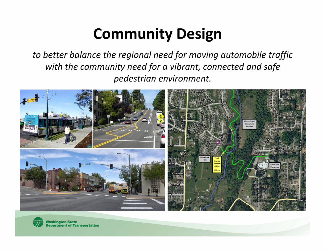
Community Design to better balance the regional need for moving automobile traffic
with the community need for a vibrant, connected and safe pedestrian environment.

The Research:State Highways as Main Streets: A Study of Community Design
• Some State Highways in Washington serve as ‘main streets’ providing local access as well as regional mobility
• Design affects community livability and safety: these roads have the highest rates of pedestrian and traffic collisions in the state.
• Late stage design changes in projects on these highways have increased costs and delayed projects.
SR 203 Carnation WA – Visualization by SVR Design

The Research
• System Analysis
• Case Studies
Storefront Studio ProgramUniversity of Washington College of Built Environments Department of Architecture

Variables Units of MeasureState Route within City Limits Y, NHighway of Statewide Significance Y, NNational Highway System Y, NState Access Control Classification Y, N
Federal Functional ClassificationPrincipal arterials, Minor arterial streets, Collector streets,Local streets
Design Speed MPHPosted Speed MPHYear of Incorporation Year
Freight Classification
T-1 more than 10 million tons per year; T-2 4 million to 10 million tons per year; T-3 300,000 to 4 million tons per year; T-4 100,000 to 300,000 tons per year; T-5 at least 20,000 tons in 60 days
Collision History Number of collisions involving bicyclists and pedestrians
What is a Main Street Highway?Step 1: Screening
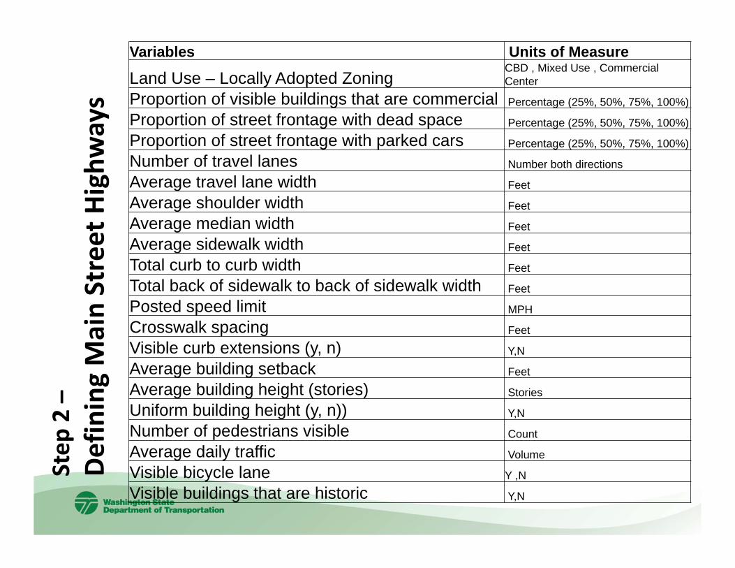
Step
2 –
Defining Main Street Highw
ays
Variables Units of Measure
Land Use – Locally Adopted ZoningCBD , Mixed Use , CommercialCenter
Proportion of visible buildings that are commercial Percentage (25%, 50%, 75%, 100%)
Proportion of street frontage with dead space Percentage (25%, 50%, 75%, 100%)
Proportion of street frontage with parked cars Percentage (25%, 50%, 75%, 100%)
Number of travel lanes Number both directions
Average travel lane width Feet
Average shoulder width Feet
Average median width Feet
Average sidewalk width Feet
Total curb to curb width Feet
Total back of sidewalk to back of sidewalk width Feet
Posted speed limit MPH
Crosswalk spacing Feet
Visible curb extensions (y, n) Y,N
Average building setback Feet
Average building height (stories) Stories
Uniform building height (y, n)) Y,N
Number of pedestrians visible Count
Average daily traffic Volume
Visible bicycle lane Y ,N
Visible buildings that are historic Y,N

Main Street Highways
Research identified approximately 500 miles of “Main Street” highways bisecting 180+ cities based on criteria applied consistently across the state.

Why Define Main Street Highways?
• Ensure a measurable link between goals and transportation investments
--Outcomes vs. throughput or volume to capacity ratio
• Develop the most cost effective transportation projects--Ensure fewer scope and schedule changes
• Identify partnerships, opportunities, and resources.--Transportation, historic preservation, environmental, economic
development, utilities, etc..

Research Findings
• Scope changes: -- More common on Main Street Highways-- 48% of all projects on Main Street Highways vs. 38% on other parts of
the state system
• Retrospective review:-- 40 projects or 20% of WSDOT’s scope, schedule and budget changes
could have directly benefited from additional community design before projects were scoped
• Average possible cost avoidance per project:-- Estimated at over $9 million dollars or 30% of project cost

Pedestrian and Bicyclist Collisions and Fatalities on Main Street Highways 2010 through 2012
0%
10%
20%
30%
40%
50%
60%
70%
Percent ofFatalities
Percent of Collisions
Percent of Highway Miles
State Highways that also serve as City Streets in core commercial areas or “Main Street Highways” – serve as both thoroughfares and community access routes.
Main Street Highways

• Complete Streets Act• Practical Design Reform• New Community Engagement Goal
Moving Forward…
State Route 14 – Bingen
State Route 12 – Morton

Washington’s Complete Streets Act• Created a framework for a Complete Streets Grant
program
• Directed WSDOT to consult with local agencies and consider the needs of all users during project planning and design

WSDOT’s Practical Design Practical Design – a strategy that emphasizes return on investment, encouraging flexibility, innovation, and multi‐modal solutions by increasing the focus on project purpose and need throughout all phases of project development.
• NACTO Urban Street Design Guide (Endorsed by WSDOT in Dec. 2013)
• New Main Streets Section in WSDOT’s Design Manual
• New Policy on Design Speed
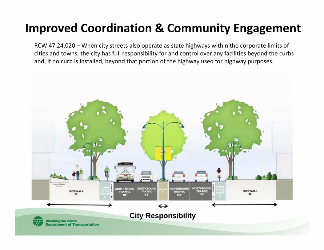
Improved Coordination & Community EngagementRCW 47.24.020 – When city streets also operate as state highways within the corporate limits of cities and towns, the city has full responsibility for and control over any facilities beyond the curbs and, if no curb is installed, beyond that portion of the highway used for highway purposes.
City Responsibility

WSDOT Resources
State Highways as Main Streets: A Study of Community Design and Visioning Publications http://www.wsdot.wa.gov/Research/Reports/700/733.1.htm
Contacts:
Paula ReevesManager, Community Design WSDOT Local [email protected], 360-705-7258http://www.wsdot.wa.gov/LocalPrograms/Planning
UW Storefront Studiohttp://www.storefrontstudio.org/

Minnesota Department of Transportation
Complete Streets Policy Implementation
Overview:• Historical Background
• Complete Streets Policy
• Supporting Technical Memorandum
• What MnDOT is Currently Doing
• Development of Complete Streets Project Reports
• Challenges & Opportunities
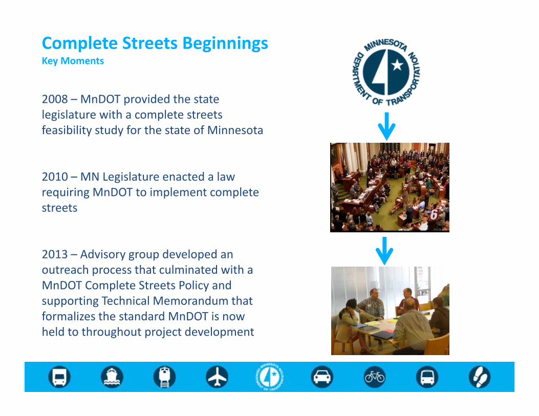
Complete Streets BeginningsKey Moments
ABC
2008 – MnDOT provided the state legislature with a complete streets feasibility study for the state of Minnesota
2010 – MN Legislature enacted a law requiring MnDOT to implement complete streets
2013 – Advisory group developed an outreach process that culminated with a MnDOT Complete Streets Policy and supporting Technical Memorandum that formalizes the standard MnDOT is now held to throughout project development

Complete Streets Policy
Policy Statement The Minnesota Department of Transportation requires that the principles of “Complete Streets” are to be considered at all phases of planning and project development in the establishment, development, operation, and maintenance of a comprehensive, integrated, and connected multimodal transportation system.

Principal Points• The policy is a direct response to the Minnesota
Complete Streets law
• It affects virtually all phases of road activity on trunk highways, from planning to maintenance
• It’s consistent with MnDOT’s Vision and Statewide Multimodal Transportation Plan
• Increase the use of transit, bicycling, and walking as a percentage of all trips
• Preservation projects should be addressed to extent possible
Complete Streets Policy

Policy Assumes Exemptions…• Users are legally prohibited from using a
roadway (eg. Non‐motorized vehicles on the interstate)
• Demonstrated absence of current and future need
• Environmental or safety detriments outweigh enhanced modal access
• Constraints related to local government opposition or right of way acquisition
• Inability to negotiate operational and maintenance responsibility
Complete Streets Policy

CS Tech Memo to the Agency
• Provides technical direction on how the agency now views Complete Streets elements
• Outlines key considerations at each stage of project development
• Calls for the development of a clear protocol for identifying compliance
In the past, the question has typically been “why” to design for anything beyond cars and trucks. Being a complete streets shop means turning that around to asking “why not” instead.

Devil in the Details• What type of documentation is needed?• How do we approach preservation projects?• What type of analysis would justify a lack of future
demand/need?• How should we determine if environmental or safety impacts are
greater than the benefits of enhanced multimodal access?• What process indicators should we use?• How much flexibility should there be? • How do we handle cross movements?

What MnDOT is Doing
Internally• Created a working group of MnDOT staff directly impacted
by Complete Streets policies and designs to develop a weigh in which to integrate Complete Streets into project development
• Outreach with districts and staff throughout MnDOT to address practical and logistical concerns as well as questions
• Developing a mechanism for accountability
Externally • Developing a targeted communications plan for our
transportation stakeholders throughout the state• Creating a guidance document for external partners• Revising the Bikeway Facility Manual• Creating a Statewide Pedestrian Plan and Freight System Plan

Project ReportsSummary
o Project Typeo Existing Site Characteristicso Special Roadway Designations
Overall Project Improvements
Provisions by User Groupo Pedestriano Bicycleo Freighto Transito Other

More detail can be found at our Complete Streets webpage:
http://www.dot.state.mn.us/planning/completestreets/

DiscussionArchive at www.pedbikeinfo.org/webinars
Downloadable and streaming recording, transcript, presentation slides
Questions?Stefanie [email protected]
Lauren [email protected]
Paula [email protected]
Chris [email protected]