PART II APPENDIX 1: DESIGNATIONS - tasman.govt.nz
34
Operative Part II, Appendix 1 - Designations 1 November 2008 Tasman Resource Management Plan Part II, App 1/1 PART II – APPENDIX 1: DESIGNATIONS A body with financial responsibility for a public work which has been approved as a requiring authority under Section 166 of the Act may require land to be designated in the Plan. The following organisations are requiring authorities which have designations in this Plan. Appendix 1 gives descriptions of designations for public works or network utilities that are included in the Plan. All designated land is shown on the planning maps and identified in Figures A1.1 to A1.11. Contents of Appendix 1 Page A1.1 Designating Authority: Telecom New Zealand Limited ......................................................2 Figure A1.1: Telecom New Zealand Limited ......................................................................................................3 A1.2 Designating Authority: Transpower New Zealand Limited ................................................4 Figure A1.2: Transpower New Zealand Limited.................................................................................................5 A1.3 Designating Authority: Network Tasman Limited ...............................................................6 Figure A1.3: Network Tasman Ltd ....................................................................................................................11 A1.4 Designating Authority: Minister of Education ...................................................................12 Figure A1.4: Minister of Education ...................................................................................................................14 A1.5 Designating Authority: Minister of Police ..........................................................................16 Figure A1.5: Minister of Police ..........................................................................................................................17 A1.6 Designating Authority: Minister of Corrections ................................................................18 Figure A1.6: Minister of Corrections ................................................................................................................19 A1.7 Designating Authority: Meteorological Service of New Zealand (Met Service) ..............20 Figure A1.7: Meteorological Service of New Zealand .....................................................................................20 A1.8 Designating Authority: New Zealand Transport Agency ..................................................21 Figure A1.8: New Zealand Transport Agency ..................................................................................................22 A1.9 Designating Authority: Minister of Lands ..........................................................................22 Figure A1.9: Minister of Lands ..........................................................................................................................22 A1.10 Designating Authority: Tasman District Council ..............................................................23 Figure A1.10: Tasman District Council...............................................................................................................26 A1.11 Designating Authority: Broadcast Communications Ltd .................................................33 Figure A1.11: Broadcast Communications Ltd .................................................................................................33 Where a designation is included in the Plan, the requiring authority responsible for the designation may do anything that is in accordance with the designation. No person may, without the prior written consent of the requiring authority, do anything in relation to the land that is the subject of the designation that would prevent or hinder the public work or project or work to which the designation relates. All designations have an underlying zoning shown on the planning maps. The zone rules regulate activities that are not covered by the designation. Most of the designations incorporated in the Plan have been “rolled over” from earlier plans with minor modifications under Clause 4 of the First Schedule to the Act. Most of these works have been given effect to. These are listed as “existing” in the Figures that follow. Designations that did not appear in previous plans are listed as “new” in the Figures. Designations for works that have not been given effect to lapse after five years, unless a longer period has been specifically identified in the Figures or the designated work is given effect to in the specified time period. New designations are accompanied by full details of proposed works.
Transcript of PART II APPENDIX 1: DESIGNATIONS - tasman.govt.nz

Operative Part II, Appendix 1 - Designations 1 November 2008
Tasman Resource Management Plan Part II, App 1/1
PART II – APPENDIX 1: DESIGNATIONSA body with financial responsibility for a public work which has been approved as a requiring authority under Section 166 of the Act may require land to be designated in the Plan. The following organisations are requiring authorities which have designations in this Plan.
Appendix 1 gives descriptions of designations for public works or network utilities that are included in the Plan.
All designated land is shown on the planning maps and identified in Figures A1.1 to A1.11.
Contents of Appendix 1
Page
A1.1 Designating Authority: Telecom New Zealand Limited ......................................................2Figure A1.1: Telecom New Zealand Limited ......................................................................................................3
A1.2 Designating Authority: Transpower New Zealand Limited ................................................4Figure A1.2: Transpower New Zealand Limited.................................................................................................5
A1.3 Designating Authority: Network Tasman Limited ...............................................................6Figure A1.3: Network Tasman Ltd ....................................................................................................................11
A1.4 Designating Authority: Minister of Education ...................................................................12Figure A1.4: Minister of Education ...................................................................................................................14
A1.5 Designating Authority: Minister of Police..........................................................................16Figure A1.5: Minister of Police..........................................................................................................................17
A1.6 Designating Authority: Minister of Corrections ................................................................18Figure A1.6: Minister of Corrections ................................................................................................................19
A1.7 Designating Authority: Meteorological Service of New Zealand (Met Service)..............20Figure A1.7: Meteorological Service of New Zealand .....................................................................................20
A1.8 Designating Authority: New Zealand Transport Agency..................................................21Figure A1.8: New Zealand Transport Agency..................................................................................................22
A1.9 Designating Authority: Minister of Lands..........................................................................22Figure A1.9: Minister of Lands..........................................................................................................................22
A1.10 Designating Authority: Tasman District Council ..............................................................23Figure A1.10: Tasman District Council...............................................................................................................26
A1.11 Designating Authority: Broadcast Communications Ltd .................................................33Figure A1.11: Broadcast Communications Ltd .................................................................................................33
Where a designation is included in the Plan, the requiring authority responsible for the designation may do anything that is in accordance with the designation. No person may, without the prior written consent of the requiring authority, do anything in relation to the land that is the subject of the designation that would prevent or hinder the public work or project or work to which the designation relates. All designations have an underlying zoning shown on the planning maps. The zone rules regulate activities that are not covered by the designation.
Most of the designations incorporated in the Plan have been “rolled over” from earlier plans with minor modifications under Clause 4 of the First Schedule to the Act. Most of these works have been given effect to. These are listed as “existing” in the Figures that follow. Designations that did not appear in previous plans are listed as “new” in the Figures.
Designations for works that have not been given effect to lapse after five years, unless a longer period has been specifically identified in the Figures or the designated work is given effect to in the specified time period. New designations are accompanied by full details of proposed works.

Operative Part II, Appendix 1 – Designations 1 November 2008
Part II, App 1/2 Tasman Resource Management Plan
A1.1 DESIGNATING AUTHORITY: TELECOM NEW ZEALAND LIMITED
Reasons for Designation
(a) All sites currently contain and have for many years, a variety of telecommunication and radiocommunication facilities which are of strategic and functional importance to Telecom New Zealand Limited.
(b) All sites were previously the subject of Ministerial Requirements which provided a statutory and lawful basis for the activities undertaken by Telecom New Zealand Limited and the former New Zealand Post Office on those sites, apart from Korere Microwave Station, Ngatimoti Exchange, Pye Peak Radio Station, Redwood Valley Exchange, Tapawera Microwave Station.
(c) In terms of maintaining a nationwide telecommunication network, there is a need to be able to protect areas of land occupied by telecommunication or radiocommunication facilities. Telecom New Zealand Limited considers that the continuation of these designations is the most appropriate means of ensuring its interests in these properties are protected in terms of:
(i) permitting all activities which are in accord with the designation;
(ii) ensuring that no other person may do anything in relation to the land that is the subject of the designation that would hinder the effective and efficient operation of the telecommunication or radiocommunication activity.
Designation Notation
Telecommunication and Radiocommunication and Ancillary Purposes.
Explanatory Statement
These sites are an integral part of a wider network of communication activities and services, including subscriber telephone, cellular telephone, data communications, and computer and video linking. The network is used for a wide range of purposes, including personal and commercial communications, linking financial institutions to convey critical financial transaction data, fire and burglary monitoring and control facilities and other emergency communications. The safe, reliable and efficient functioning of a national and international telecommunication and radiocommunication system is in the public interest.
Nature of the Works
The structures/works associated with these activities include buildings (of a range of sizes and shapes) for housing equipment and plant and undertaking operations; transmitting and receiving devices such as lines, aerials, antenna and dishes; and support structures for these, such as towers, masts and poles, as well as other ancillary structures.
Environmental Effects/Mitigation Measures
The environmental effects of retaining and operating existing telecommunication and radiocommunication facilities are minor. The principal effects relate to the continued maintenance and servicing of these facilities and are unlikely to change significantly in the future in terms of character, scale or intensity.

Operative Telecom New Zealand Limited 15 December 2018
Tasman Resource Management Plan Part II, App 1/3
Figure A1.1: Telecom New Zealand Limited
ID Location of Site Map1 No
Site Name/Function
Purpose of Designation
Legal Description/Valuation No.
Area (ha)
Duration of
Desig-nation
Existing
D1 Meihana Street Takaka AM 112 Birch Hill
Radio Station
Telecommunication and radiocommunication and ancillary purposes
Part of Part 2 Section 10 Takaka District 0.16 *
D2 37 Ellis Street, Brightwater AM 90 Brightwater
Exchange “ Part Section 1 District of Waimea South Block IX Waimea Survey District 0.0425 *
D3 Main Road, Collingwood AM 72 Collingwood
Exchange “ Part Section 401 Town of Collingwood 0.0164 *
D5 Main Road, Lower Moutere
AM 19, SM 145
Lower Moutere Exchange
“ Sec 6 SO 501573 0.0537 *
D6 149 Aranui Road, Mapua AM 87 Mapua
Exchange “ Part Lot 3A DP 693 Block II Moutere Survey District 0.0314 *
D7 High Street, Motueka AM 116 Motueka
Exchange “ Lot 2 DP 16443 Block IV Motueka Survey District 0.2054 *
D8 7 Hickmott Place Motueka AM 116
Motueka Microwave Station
“ Lot 1 DP 19258 0.24 *
D9 58 Fairfax Street, Murchison AM 92 Murchison
Exchange “ Section 2 SO 14331 Block I Tutaki Survey District 0.6739 *
D10Aorere State Forest No. 2, Burnett Mountains
AM 4Mt Burnett Land Mobile Station
“ Crown Land State Forest No. 2 0.0620 *
D11 297 Queen St, Richmond AM 125 Richmond
Exchange “ Parts of Section 25 District of Waimea East Block VII Waimea Survey District 0.0968 *
D12 Ward Street, St Arnaud AM 94 St Arnaud
Exchange “ Part Sec 102 SQ 46 and Part Sec 22 SQ 46 0.0434 *
D13 86 Commercial Street, Takaka AM 112 Takaka
Exchange “ Part Section 18 Block X District of Takaka Waitapu Survey District 0.1214 *
D14 1A Matai Crescent, Tapawera AM 89 Tapawera
Exchange “ Part Section 141 Upper Motueka District Block IX Wai-iti Survey District 0.0219 *
D15 Baldwin Road, State Highway 60 AM 85 Tasman
Exchange “ Part DP 4049 Block XII Motueka Survey District 0.079 *
D16 Dovedale Road, Dovedale
AM 21, SM 146
Thorpe Exchange “ Part Lot 1 DP 2021 Block II Wai-iti
Survey District 0.0279 *
D17Moutere Highway (opposite George Harvey Road)
AM 88 Upper Moutere “
Part Section 96 Moutere District & Part Section 7 Block XVI Motueka Survey District
0.0301 *
D18 Whitby Road, Wakefield AM 91 Wakefield
Exchange “ Section 2 SO 14333 Block XII Wai-iti Survey District 0.0395 *
NewD20 Orinoco Valley
Road, NgatimotiAM 18, SM 144
Ngatimoti Exchange “ Part Section 22 Square 7 Block X
Motueka Survey District 0.0721 *
D21 Pye Peak, Takaka Hill AM 14 Pye Peak
Radio Station “ Part Section 1 Block XV Takaka Survey District 0.3733 *
D22 Redwood Road AM 56Redwood Valley Exchange
“ Part Lot 1 DP 2110 Block I Waimea Survey District 0.0325 *
D24Golden Downs Forest, Western Boundary Road
AM 27Korere Microwave Station
Telecommunication and radiocommunication and ancillary purposes
State Forest Land Trig Korere, Lot 1 DP 14501 Grid Ref: NZTM 1585620.68 5403018.21
78.54 (m2) *
* Designation has been given effect to.
1 AM = Area Map SM = Special Map

Operative Part II, Appendix 1 - Designations 1 November 2008,
Part II, App 1/4 Tasman Resource Management Plan
A1.2 DESIGNATING AUTHORITY: TRANSPOWER NEW ZEALAND LIMITED
Reasons for Designation
(a) The substations and outdoor switchyards are an integral part of the National Electricity Grid which supplies high voltage electricity to the upper South Island. Accordingly, owing to the importance of the National Grid, it is necessary to designate the substations and outdoor switchyards so that they are given adequate protection and identified by appropriate notation in the Plan.
(b) When ownership of the substations/outdoor switchyard was transferred from the Crown/ECNZ to Transpower, those assets required for the immediate or foreseeable future development, operation and maintenance of the National Grid were allocated to the company, and this transfer of ownership makes Transpower the responsible authority with respect to these designations.
(c) The planning maps and Figure A1.2 give reference to the area over which Transpower wishes its designation to apply.
Designation Notation
(a) Electricity Substation.
(b) Outdoor Switchyard.
Explanatory Statement
The designation of these substations and outdoor switchyards in the Plan recognises these existing facilities and their function.
Nature of the Works
The purpose of the switchyard is to convert power from the generating stations’ relatively low voltage to a high voltage for nationwide transmission through the Grid. Substations contain facilities for line switching and protection of the network as well as voltage support equipment for load flow and management. Substations connect transmission facilities to the local supply authority’s distribution lines.
The structures and facilities associated with substations and outdoor switchyards commonly include conductors, transformers, insulators, bushings, gantry structures, telecommunications systems, screening structures, storage sheds, control buildings, accessways, water supply (where necessary) and security fences.
Environmental Effects/Mitigation Measures
The effects on the environment of the substations and outdoor switchyards are the same as those that currently exist. The company has in place on-site management practices which are designed to ensure the safe and efficient operation of all facilities and structures, including the management of oil which is used to cool the transformers.
In addition, with regard to the electromagnetic fields emitted by the electrical equipment, these are well below the guidelines set by the International Commission on Non-Ionising Radiation Protection. Further, the electromagnetic radiation emissions from the telecommunications network, which controls the substations and outdoor switchyards are also well within the electromagnetic radiation limits set by New Zealand Standard 6609 Pts 1 and 2.

Operative Transpower New Zealand Limited 31 January 2015
Tasman Resource Management Plan Part II, App 1/5
Figure A1.2: Transpower New Zealand Limited
ID Location of Site Map2 No.
Site Name/Function
Purpose of Designation
Legal Description/Valuation No.
Area (ha)
Duration of Desig-
nationExisting
D30 Korere-Tophouse Road AM 31 Kikiwa
SubstationElectricity Substation
Lot 1 DP 14652, Block I Motupiko Survey District (CT 10B/654) 5.8500 *
[Ownership of D31 moved to Network Tasman Ltd] DD 1/12/14
D33 Matiri Valley Road AM 34 SM 149
Murchison Substation “ Pt Section 132 Block II Tutaki Survey District
(CT 9C/754) 0.8094 *
New[Ownership of D34 and D35 moved to Network Tasman Ltd] DD
1/12/14
* Designation has been given effect to.
2 AM = Area Map SM = Special Map

Operative Part II, Appendix 1 - Designations 18 August 2012
Part II, App 1/6 Tasman Resource Management Plan
A1.3 DESIGNATING AUTHORITY: NETWORK TASMAN LIMITED
Reasons for Designation
Designations are site-specific and all the associated works can vary considerably from site to site. Providing rules would be cumbersome, unless they were of a very general nature. Rules of a general nature would not reflect the variety of purposes for which designations exist. In addition to this, Section10 (existing use) protection is not complete and can lead to uncertainties for the designating authority.
D41 — Network Tasman Depot (Hope)
Reason for Designation
The modification to the designation accurately identifies the name of the designating authority and the purposes of the designation.
Designation Notation
Network Tasman network utility operations (depot, workshops, administration, substation and stores).
Explanatory Statement
The designation encompasses a range of activities, including administration, a substation, equipment storage and service workshops to maintain equipment. Resource consents also exist for service facilities, such as the garage, to carry out work for the public.
The facilities include administration and service buildings, storage sheds and the substation areas, which contain transformers and poles. Transformers are approximately three to 3.5 metres high.
Poles vary in height to approximately eight metres. Buildings range in height from approximately four metres to 10 metres high.
Nature of the Works
Line depot, workshops, parts store and substation site.
Environmental Effects/Mitigation Measures
There will be no change to the effects of the activity on the environment, as the activities already exist.
D42 — Substation (Brightwater)
Reason for Designation
The modification to the designation accurately identifies the name of the designating authority and the purposes of the designation.
Designation Notation
Network Tasman network utility operations (substation).
Explanatory Statement
The substation is a facility for managing the distribution of electricity in the Brightwater area. It contains switch-gear and transformers.
Nature of the Works
These are being constructed now and will comprise a domestic scale building housing switching gear and two transformers standing approximately 3.0 to 3.5 metres long, on concrete pads.
Operative Network Tasman Limited 18 August 2012
Tasman Resource Management Plan Part II, App 1/7
Environmental Effects/Mitigation Measures
The effect that the work will have on the environment is the same as at present. That is, no physical effect other than to facilitate the supply of energy to the community.
D43 — Substation and Maintenance Depot (Motupipi Street, Takaka)
Reason for Designation
The modification to the designation accurately identifies the name of the designating authority and the purposes of the designation.
Designation Notation
Network Tasman network utility operations (substation and maintenance depot).
Explanatory Statement
This is the designating authority’s main maintenance depot for serving Golden Bay. It is needed because Golden Bay is remote from the designating authority’s main depot and because from time to time Golden Bay is isolated from other parts of the District, by closure of the Takaka Hill Road.
Nature of the Works
The facilities are a line maintenance depot containing buildings for workshop facilities, communications equipment, parts stores and vehicle storage. There are several sheds of up to two storeys high.
Environmental Effects/Mitigation Measures
There will be no change to the effects of the activity on the environment, as it is an existing activity.
D44 — Substation (Glenview Road, Takaka)
Reason for Designation
The modification to the designation accurately identifies the name of the designating authority and the purposes of the designation.
Designation Notation
Network Tasman network utility operations (substation).
Explanatory Statement
This is a transformer located on private land. Its purpose is to regulate electricity supply in the area.
Nature of the Works
The structure is a transformer approximately 2.5 metres high, located in a paddock on a concrete pad.
Environmental Effects/Mitigation Measures
There will be no change to the effects of the activity on the environment, as it is an existing activity.
D45 — Network Tasman Offices, Workshop and Stores (Richmond)
Reason for Designation
The modification to the designation accurately identifies the name of the designating authority and the purposes of the designation.
Operative Part II, Appendix 1 - Designations 18 August 2012
Part II, App 1/8 Tasman Resource Management Plan
Designation Notation
Network Tasman network utility operations (offices, stores and workshop).
Explanatory Statement
The facility is located in the commercial area of Richmond. Many of the functions carried out in the building are permitted by zoning and are not directly linked with the utility functions of the requiring authority; however, there are communication functions and storage activities which are linked to utility functions.
Nature of the Works
Communications centre for operation of the electricity supply network, administration offices, stores and workshops necessary for maintaining the electricity supply network. Activities on the site, as covered by the designation, are restricted to those already functioning. Most activities are located in a 15 metre high commercial building. Communications masts up to approximately six metres high are located on top of this building. Other activities are located in sheds to the rear of the main building. These comply with District Plan requirements.
Environmental Effects/Mitigation Measures
The effect that the work will have on the environment is as at present and is consistent with other activities undertaken in the vicinity and will not be adverse in terms of effect on the environment.
D32 — Motupipi Substation
Reason for Designation
This designation is for an existing substation which was previously a designation of Transpower New Zealand Ltd.
Designation Notation
Network Tasman network utility operations (substation and workshop); electricity generation.
Explanatory Statement
The designation of this substation in the Plan recognises the existing facility and its function.
Nature of the Works
The substation contains facilities for line switching and protection of the network, as well as voltage support equipment for load flow and management.
Environmental Effects/Mitigation Measures
There will be no change to the effects of the activity on the environment, as it is an existing activity.
D46 - D50 — Concrete Cubicle Substations
Reason for Designation
The designation is needed to formally recognise these existing facilities which are part of Network Tasman Limited’s electricity distribution network.
Designation Notation
Concrete cubicle substations.

Operative Network Tasman Limited 18 August 2012
Tasman Resource Management Plan Part II, App 1/9
Explanatory Statement
These are at various locations in Richmond. They are transformer sites for regulation of electricity supply at a neighbourhood level.
Nature of the Works
These are structures approximately 2.5 to 3.0 metres high, with floor areas of around 12 square metres, which contain transformers in a secure environment.
Environmental Effects/Mitigation Measures
The above listed substations are all existing facilities and no additional work involving them is anticipated. As such, no resource consents are required and there is no need to consider alternative sites.
D52 — Electricity Transmission Substation (Beach Road, Richmond)
Reason for Designation
The site has been owned by Network Tasman Limited for some time. It was acquired for its strategic location, having regard to future need for a substation to some of the industrial area of Richmond and its surrounds. Designation is necessary because the proposed use of the site is not likely to be provided for otherwise in the Plan.
Designation Notation
Network Tasman network utility operations.
Explanatory Statement
The site works will include transformers mounted on concrete pads, with associated bus bars and cooling fans. The cooling fans only activate if the transformers overload. There will also be a single storey building of 80 to 100 square metres in floor area, to accommodate switch-gear. Overhead lines already cross the site.
Nature of the Work
The nature of the work to be undertaken on the site is the placement of electricity transformers and an associated building housing control equipment. All structures to be placed on the site will comply with building bulk and location requirements. It should be noted that the site already accommodates transmission lines and support poles, which are part of Network Tasman Limited’s energy transmission network.
The structures have a utilitarian appearance. A landscape planting strip exists alongside the site, next to the state highway and there is opportunity for landscape screening or fencing on other boundaries, if this is deemed necessary to mitigate adverse effects. Any screening must comply with setback distances and height limits under the electricity supply regulations. Effective screening can be provided whilst having regard to these.
Environmental Effects/Mitigation Measures
The effect of the work on the environment is minimal, given the location of the site and nearby activities. The placement of equipment will not adversely affect the ability of other landowners in the vicinity to use their land or physical resources thereon, or develop them.
D53 — Network Tasman Depot (Murchison)
Reason for Designation
In order to remove the possibility that any alterations to planning provisions affecting the site may adversely affect the designating authority’s activities in the future, it is considered appropriate that the site be designated, as are other similar facilities of the requiring authority.
Operative Part II, Appendix 1 - Designations 18 August 2012
Part II, App 1/10 Tasman Resource Management Plan
Designation Notation
Network Tasman network utility operations (administrative offices, workshops and maintenance depot).
Explanatory Statement
The designation encompasses an existing building and a yard. The building is a combined workshop and truck bay, which is a single-storey but of near two-storey height. The facility is needed as a base for maintenance of the electricity supply network in this remote part of the District.
Nature of the Works
Administrative offices, workshop and maintenance depot connected with the supply of electricity and maintenance depot activities. This involves the storage of equipment and plant necessary to repair and maintain the network utility operator’s electricity supply network served by the Murchison depot.
This involves the day to day movement of vehicles to and from the yard with line equipment and from time to time outside normal working hours, when emergency repairs to the electricity supply network are necessary.
Environmental Effects/Mitigation Measures
The effects on the environment are as can be expected in a commercial area providing for the range of activities which are provided for in a commercial zone. There is a potential adverse effect associated with noise and activity on the site at night-time, but this would be a rare event to the community when power supply is disrupted or cut.
It should be noted that the facility has operated from the site for about thirty years and there has been no record of complaint about activities that Network Tasman Limited is aware of.
The only practicable and necessary mitigation measure is to confine activity on the site to normal working hours, except in cases where emergency situations require that the depot is used.
D54 — Network Tasman Substation (Wakefield)
Reason for Designation
The designation authorises the proposed substation which is necessary to provide security in local electricity supply.
Designation Notation
Network Tasman network utility operations (electricity transmission substation); electricity generation.
Explanatory Statement
The substation is a facility for managing the local distribution of electricity in the Wakefield area.
Nature of the Works
Construction and operation of a 33 kV electricity substation for the purpose of providing a secure supply of electricity to the Wakefield and surrounding area. The building will house switching gear and transformers.
Environmental Effects/Mitigation Measures
The building in which the substation is housed will have a visual appearance comparable with that of a small dwelling, that is no more than minor effect. The cabling to the station is underground.
DAD 5/09

Operative Network Tasman Limited 19 December 2020
Tasman Resource Management Plan Part II, App 1/11
D55 — Substation (Haycock Road, Brightwater)
Reason for Designation
The designation provides for a GXP electricity sub-station to receive electrical feed on the Kikiwa-Stoke 220kV transmission line for conversion by transformers to 33kV. The substation is to supply electricity to the Network serving the Brightwater/Richmond area and beyond.
Designation Notation
Network Tasman network utility operations (substation).
Explanatory Statement
The designation is in anticipation of urban growth in the Brightwater-Richmond area that will eventually exceed the capacity of the existing network facilities. (Network Tasman owns the site.)
Nature of the Works
The substation will include: a switch and control room, transformers and circuit breakers, two lightening masts, one 42-metre high pylon tower, two cable gantries, oil containment system, and perimeter fencing.
Environmental Effects/Mitigation Measures
Planting of native vegetation will be used for screening. Cables carrying electricity from the substation to the distribution network will be lain within the road reserve. The transformer sites will be bunded to contain any spill of cooling oil. An on-site wastewater and stormwater system will be installed.
DD 8/12DAD 9/16
Figure A1.3: Network Tasman Ltd
ID Location of Site Map3
No.Site Name/Function Purpose of Designation Legal Description/
Valuation No.Area (m2)
Duration of Desig-
nationExisting
D31Corner Hursthouse and Chamberlain Streets, Motueka
AM 52 Motueka Substation Electricity Substation Lot 1 DP 14651 and Lot 1
DP 18550 (CT 12B/674) 1.7275 *DD
1/12/14
D32 Glenview Road, Motupipi AM 76 Motupipi
Substation
Network Tasman network utility operations (substation and workshop); electricity generation
Section 220 and Pts Section 163 District of Takaka (CT 9C/759)
0.6703 *
D34 State Highway 60, Upper Takaka AM 81 Upper Takaka
Substation Electricity Substation
Pt Lots 2 and 3 DP 1419 and Pt Section 56 Square 8 Block XI Takaka Survey District (CT 10B/1057), Lot 1 DP 4736 Block XV Takaka Survey District (CT 9C/1352), DP 2665, Pt Section 56 Square 8 Block XI Takaka Survey District (CT 81/129)
1.4134 *
DD 1/12/14
D35 Junction Cobb and Takaka Rivers
AM 13 SM 141
Cobb Outdoor Switchyard Outdoor Switchyard
Section 8 SO 15175 Block XVIII Takaka Survey District
0.0343 *DD
1/12/14
D41 State Highway 6, Hope
AM 127AM 128SM 151
Network Tasman Hope depot
Network Tasman network utility operations (depot, workshops, administration, substations and stores); electricity generation
Lot 3 and 4 DP435942 18000 approx. *
D42 133 Lord Rutherford Road, Brightwater AM 89 Substation
Network Tasman network utility operations (substation); electricity generation
Pt Lot 1 DP 12689 and Pt Lot 5 DP 11885 1421 *
D43 37 Motupipi St, Takaka AM 112
Line maintenance depot and substation
Network Tasman network utility operations (substation and maintenance depot); electricity generation
Lot 4, DP 19429 2013 *
D44 Glenview Road, Takaka AM 76 Substation
Network Tasman network utility operations (substation); electricity generation
Lot 1 DP 5757 Blk X Waitapu SD RT 155/87 675 *
D45281 Queen St and 66 Oxford St, Richmond
AM 125
Network Tasman offices, stores and workshop
Network Tasman network utility operations (offices, stores and workshop)
Secs 4-6 SO 462061 and Pt Sec 25 Waimea East DIST 6487 *
3 AM = Area Map SM = Special Map

Operative Part II, Appendix 1 - Designations 15 December 2018
Part II, App 1/12 Tasman Resource Management Plan
Figure A1.3: Network Tasman Ltd (cont’d)
ID Location of SiteArea Map No.
Site Name/Function Purpose of Designation Legal Description/
Valuation No.Area (m2)
Duration of Desig-
nationNew
D46 22A Churchill Ave, Richmond AM 135 Concrete cubicle
substation
Network Tasman network utility operations (concrete cubicle substation)
Lot 60 DP 7076 13 *
D47 Marlborough Crescent, Richmond AM 135 “ “ Lot 89 DP 7551 10 *
D48 Selbourne Avenue, Richmond AM 135 “ “ Lot 43 DP 9362 7 *
D49 Todd Place, Richmond AM 128 “ “ Lot 26 DP 8191 51 *
D50 37A Wensley Road, Richmond AM 129 “ “ Lot 13 DP 8646 3 *
D52 30 Beach Road, Richmond AM 125 Substation
Network Tasman network utility operations (electricity transmission substation); electricity generation
Lot 1 DP 9218 2833 *DAD 5/09
D53 49 Fairfax Street, Murchison AM 92
Maintenance depot, workshop, offices
Network Tasman network utility operations (administrative offices and workshops, and maintenance depot)
Lot 1 DP 2348 and Pt Section 38 1619 *
D54 5 Fitzsimmons Way, Wakefield AM 91 Proposed
substation
Network Tasman network utility operations (electricity transmission substation); electricity generation
Pt Sec 192 Waimea SD & Secs 1 & 3, SO 14560 0.7913 Until
26/11/2023
DAD 5/09
D55 Haycock Road, Brightwater AM22 Substation
Network Tasman utility operations substation, electricity distribution
Lot 2 DP 344248 12.0039 ha 30 years
DD 8/12DAD 9/16
D56 Swamp Road, Riwaka AM84 Substation Network Tasman utility
operations (66kV substation) Lot 2 DP 435629 633015 years
(from confirmation
in 2010)
DD 30/3/10
* Designation has been given effect to.
A1.4 DESIGNATING AUTHORITY: MINISTER OF EDUCATION
Reason for Designation
(a) These public works have been given effect to. Retaining the designations will provide for the ongoing operation of the schools in terms of the Resource Management Act 1991. Designation is considered to be the most effective means of ensuring that the Ministry of Education’s interest in the sites is protected.
Designation Notation
(a) Primary School, Intermediate School, Secondary School, Area School.
(b) Correspondence Unit.
(c) Outdoor Education Centre.
(d) Special School.
(e) Pre-school Facilities.
Explanatory Statement
(a) Primary School, Intermediate School, Secondary School, Area School
The sites or facilities are used for the purpose of educating children at the primary, intermediate and/or secondary levels.
Operative Minister of Education 18 August 2012
Tasman Resource Management Plan Part II, App 1/13
(b) Correspondence Unit
“Units where tuition cannot be conveniently obtained from a suitable state school”. (Education Amendment Act 1990)
(c) Outdoor Education Centre
“Centre providing instruction in outdoor education and pursuits”. (Education Act 1989)
(d) Special School
“Providing special education or help special education may be provided from a special school, special class or special clinic”. (Education Amendment Act 1990)
(e) Pre-school Facilities
“Premises used mainly or regularly for education or care of three or more children (not being the children of the persons providing the education or care) under six years of age”. (Education Amendment Act 1990)
Note the particular definitions (Education Act 1989) for Correspondence Unit, Outdoor Education Centre, Special School and Pre-School Facilities.
Nature of the Works
(a) Primary School, Intermediate School, Secondary School, Area School
The structures and works associated with the Primary, Intermediate, Secondary and Area schools include buildings such as classrooms, a staffroom, an administration block, a hall, ablution blocks, caretakers room, a boiler room, storage sheds and other ancillary buildings, recreation facilities such as playing grounds and fields and a swimming pool, and vehicle parking. The schools may also have an associated residence generally occupied by the Principal and his family.
(b) Outdoor Education Centre (Marahau)
The centre operates from the old Marahau School which closed in 1969. The original classroom building has been converted to a general-purpose activity room/dining room/kitchen/ablution block and three equipment stores. There is sleeping accommodation for approximately 70 people (two classes and supervisors).
(c) Special School (Salisbury School)
The school provides educational and residential care for 80 girls. The complex is divided into three distinct parts:
(i) The school - four classroom blocks and a gymnasium.
(ii) The hostel - three girls’ residential hostels, kitchen, dining and activities block, hospital annex, and services block (boiler, bulk store and grounds sheds).
(iii) Staff facilities - administration centre, staff hostel, and three staff houses.
(d) Pre-school Facilities
The structures and works associated with Pre-School Facilities usually involve one main building for the education and/or care of pre-schoolers, kitchen and toilet facilities, a staff area and ancillary buildings such as storage sheds and an outdoor play area. The sites are fenced.
Environmental Effects/Mitigation Measures
(a) Collingwood Area School and Collingwood Kindergarten
This involves a new designation. The school has been in operation for approximately 60 years. Designation of the site will not involve any changes in the existing effects on the environment. It merely involves correctly designating the area currently owned and operated by the Ministry of Education.

Operative Part II, Appendix 1 - Designations 19 December 2020
Part II, App 1/14 Tasman Resource Management Plan
Figure A1.4: Minister of Education
ID Location of SiteArea Map No.
Site Name/Function
Purpose of Designation
Legal Description/Valuation No.
Area (ha)
Duration of Desig-
nation
Existing
D60 Moutere Highway, Appleby 56 Appleby School Primary School Pt Section 10 DP 4494, Lot 2 DP 1989,
Pt Lot 6 DP 232, Lot 1 DP 1989 1.4092 *
D61 106 Ellis Street, Brightwater 90 Brightwater
School “
Lots 1 and 2 DP 1829, Section 175 SO 9455, Part 18 SO 14663, Pt Lot 1 DP 7192, Pt lot 1 DP 7485, Pt Sec 17, Pt Sec 17 SO 1208, 14663
1.876 *
D62Corner Old Mill Road and Umukuri Road, Brooklyn
52 Brooklyn School “ Pt Section 13 DP 2938 & Pt Section 13 DP 3857 1.1432 *
D64 Wakefield-Woodstock Road, Dovedale 21 Dovedale School “ Pt Section 72 DP 1967, Block II Wai-iti
Survey District 0.5867 *
D66Corner Rototai Road and State Highway 60, Takaka
110 112
Golden Bay High School
Secondary School
Part 4 of Section G, Lot 1 DP 4000, Part 6 of Section G, Lot 2 DP 2419, Part 15 of Section G, Lot 2 DP 4000, Part 4 of Section G, Takaka District, Block VI
4.4543 *
D67 William Street, Richmond
57129
Henley Primary School and Kindergarten
Primary School and Pre-school Facilities
Part Lot 2 DP 8605, Lot 3 DP 2667, Lot 5 DP 2712, Part Lots 1 & 5 DP 5512, Part Lot 6 DP 5962, DP 457, Block VII
2.67 *11/8/09
D68Corner Aniseed Valley and Paton Roads, Waimea
57 Hope School Primary School Pt Section 7 DP 3920, Pt Section 7 DP 4204, Pt Section 7 SO 9835 1.0150 *
D69 State Highway 63, St Arnaud 94 Lake Rotoiti
School “
Section 1 Town of St Arnaud, SO 7903, Stopped Road SO 12051, Lots 1-5 DP 5718, Block X Motupiko Survey District
1.1229 *
D70 Moutere Highway, Lower Moutere 19 Lower Moutere
School “ Lot 2 DP 2978, Pt Lot 1 DP 2978 2.2989 *
D71 Off Old Coach Road, Mahana 53 Mahana School “ Pt Lot 29 DP 626, Lot 2 DP 695, Lots 37
& 38 DP 1089 2.1424 *
D73 4 Stafford Drive, Ruby Bay 87 Mapua School Primary School Pt Lot 1 DP 2260, Pt Sec 4 Moutere Hills
Dist, Lots 11 & 14 DP 336741 2.2283 * DAD 1/7/13
D74 Sandy Bay-Marahau Road, Marahau 82 Marahau Outdoor
Education Centre
Outdoor Education Centre
Lots 8-10 DP 4958, Pt Section 112 DP 3161, Pt Section 112 District of Motueka
0.6830 *
D75 Grey Street, Motueka 116 Motueka High School
Secondary School
Pt Lots 25-27 DP 1575 Sec 303 SO 13101 10.642 *
D76 High Street, Motueka 119 Motueka South Primary School Primary School Pt Lots 3, 4 & 10, Section 167 SO 9960,
Lot 2 DP 15920 2.6279 *
D77 Abel Tasman Drive 76 Motupipi School “ Pt Section 161 SO 9957, Pt Section 161 1.2495 *
D78 Waller Street, Murchison 92 Murchison Area
School Area School
Pt Section 33 SO 9900, Pt Section 20 DP 3543, Pt Section 20 DP 4356, Pt Section 20, Section 34 SO 5775, Section 35 SO 5634, Lot 1 DP 16258, Section 20 DP 4356
7.7698 *
D80 Motueka Valley Highway 18 Ngatimoti School “ Lot 1 DP 5035, DP 215, Block IX
Motueka Survey District 1.7728 *
D81Corner Pah and Talbot Streets, Motueka
116 Parklands Primary School “ Pt Lot 6, 8 DP 1575, Pt Lot 8 Section
161, SO 7976, Pt Section 161 SO 12086 3.8526 *
D82 Ranzau Road, Hope 57 Ranzau Primary School “ Pt Lot 3 DP 3546, Pt Section 119 District
of Waimea East District Block VI 1.214 *
D83Corner Elizabeth and Florence Streets, Richmond
125 Richmond Kindergarten
Pre-school Facilities Lot 3 DP 4663 0.1065 *
D84 Waverley Street, Richmond 128 Richmond
PlaycentrePre-school Facilities Pt Lot 26 1.2849 *
D85 Dorset Street, Richmond
124125128
Richmond Primary School Primary School Lots 1-3 DP 1497, Lot 24 & Pt Lot 26 1.3704 *
D86 School Road, Riwaka 84 Riwaka School “ Lot 6 DP 2833 1.7088 *
Salisbury School Pre-School Part Lot 1 DP 18938 9.8189 *Salisbury Road,
Richmond St Paul’s School Lot 1 DP 20030 2.0317 *
Part Lot 1 DP 18938 *
D87
D’Arcy St, Richmond
125
Te Kura Kaupapa
Schools
(RM980365)
(RM110365)(RM140034) Lot 20 DP 4663 0.1032 *
DAD 8/11DAD 5/15
DAD 12/20DAD 12/20
D88 Central Takaka Road 50 Central Takaka School Primary School Pt Section 29 DP 2677 1.0117 *
D89 Wadsworth Street, Takaka 110 Takaka Primary
School “ Lot 27 DP 4826 Pt Section 3B of G District of Takaka 4.3815 *
D90 Motueka Valley Highway 89 Tapawera Area
School Area SchoolPt Section 72 DP 2800, Pt Section 72 DP 3171, Pt Section 72 DP 3536, Pt Section 72 DP 4492, Pt Lot 20 DP 2610
5.9706 *

Operative Minister of Education 19 December 2020
Tasman Resource Management Plan Part II, App 1/15
ID Location of SiteArea Map No.
Site Name/Function
Purpose of Designation
Legal Description/Valuation No.
Area (ha)
Duration of Desig-
nation
D91Corner Dickers Road and State Highway 60, Tasman
85 Tasman School Primary School Pt Lots 1 & 2 DP 428, Lot 3 DP 428, Pt Lot 55 DP 375, Pt Section 99 DP 2630 2.0111 *
D92
Corner Moutere Highway and Supplejack Valley Road, Upper Moutere
88 Upper Moutere School “
Pt Section 166, Pt Section 166 DP 3008, Pt Lot 3 DP 184, Pt Section 166 SO 10000
1.5837 *
D93 Salisbury Road, Richmond 123 Waimea
College Secondary School Pt Lots 1 & 2 DP 458, Pt Lot 1 DP 5512 11.94 *
D94 Salisbury Road, Richmond
122 123
Waimea Intermediate
Intermediate School
Pt Lot 2 and Pt Section 67 DP 458 Waimea East, Pt Lot 1 DP 5512 5.6 *
D95 66 Edward Street, Wakefield 91 Wakefield
School Primary SchoolPt Section 85, Pt Section 85, Pt Section 85 Proc 1634 SO 9487, Lot 2 DP 7008, Lot 1 DP 6556
2.4179 *
New
D96 36 Lewis Street, Collingwood 72
Collingwood Area School and Collingwood Playcentre
Area School and Pre-school facilities
Secs 1-2; SO 12706; Secs 1 & 3 SO 15130; Sec 1 SO 14727; Secs 205-209, 217-218, 396-398, 406-407, 418-419; Pt Secs 95-97, 202-203, 215-216, 395 Town of Collingwood
5.1764 *
D97 51 Greenwood Street, Motueka 117 Greenwood
KindergartenPre-school facilities Lot 1 DP 8982 0.111 *
* Designation has been given effect to.

Operative Part II, Appendix 1 - Designations 1 November 2008
Part II, App 1/16 Tasman Resource Management Plan
A1.5 DESIGNATING AUTHORITY: MINISTER OF POLICE
Reason for Designation
(a) Designation of existing New Zealand Police properties is a mechanism used nationally to ensure that interests in current assets are adequately protected.
Designation Notation
(a) Community Policing Centre.
(b) Police Station and Associated Residence.
Explanatory Statement
The Police Stations/Community Policing Centres operate as a base for policing work. They provide varying levels of proactive (preventative) and reactive policing services including incident and offence response, arms and public enquiries, and found property.
Community policing centres are orientated towards the community and preventative policing. The centres have rooms which are open to the community for uses including neighbourhood support meetings, victim support and other appropriate activities. The purpose of making these facilities available to the community is to foster an improved public image and relationship with the community.
Police stations, on the other hand, do not have facilities available for use by the community. The stations are comprised of staff and custodial facilities only.
All stations or centres provide a level of security and safety for the local community. For this and other reasons their ongoing operation is important.
Nature of the Works
The structures associated with these activities include buildings and ancillary buildings of a range of sizes and shapes, and parking for police vehicle operations. The centres or stations generally comprise office space, a watch house, a public counter, kitchen, toilet and storeroom, on-site car parking and garages. The sites are usually fenced. Larger police stations also have holding facilities. There are often on-site telecommunications facilities, such as antennae, as well.
Some of the stations have associated police dwellings which are used by the Constable in charge and his family. These are used purely for residential purposes.
Environmental Effects/Mitigation Measures
The Police Stations/Community Policing Centres provide significant benefits to the community of enhanced safety and security through the education and neighbourhood watch programmes they run, and through their presence in the community.
Richmond and Wakefield Police Stations - Modified notation to more accurately identify the existing use of the site. There is no change in the existing effects on the environment.
Murchison and Motueka Police Station - Modified the boundary to correctly show the area currently used and owned by the Ministry. The designation notation was modified to more accurately identify the existing use of the site. There is no change in the existing effects on the environment.
(a) Takaka Police Station
Traffic Impacts
It is difficult to estimate the number of vehicular movements (operational) to and from the site as this depends to a large extent on the workload. However, it is considered that the number of vehicle movements generated by the station is not significantly high.
The station and dwelling are adequately provided with parking and manoeuvring areas. Vehicle movements to and from the site do not affect pedestrian or other traffic movement.

Operative Minister of Police 28 September 2013
Tasman Resource Management Plan Part II, App 1/17
Noise Impacts
In general, there is minimal noise generated in the operation of the station. The only significant generator of noise is the occasional use of the vehicular siren. This is limited to use out on the road and not when entering or leaving the site. There is also some low-key noise associated with the occasional noisy offender/prisoner. In general, few complaints are received in relation to noise or traffic impacts.
Security/Safety
The presence of the station would be seen to provide a level of security and safety for the local community.
The continued operation of the police station and associated residence will not adversely affect the present state of the environment, on or in the vicinity of the site. Rather it will continue to provide an essential service to the local community of considerable public benefit.
Figure A1.5: Minister of Police
ID Location of SiteArea Map No.
Site Name/Function
Purpose of Designation
Legal Description/Valuation No.
Area (ha)
Duration of Designation
Existing
D100 194 Queen Street, Richmond 129 Richmond
Police StationCommunity Policing Centre
Pt of Lot 1 and Lot 2 DP 4926, Proc 2088 0.1206 * DAD
19/8/13
D101 Clifford Road, Wakefield 91 Wakefield
Police Station
Police Station and Associated Residence
Lot 2 DP 3009, Proc 2121 0.2534 *
D102 Fairfax Street, Murchison 92 Murchison
Police Station
Police Station and Associated Residence
Pt Section 31 Town of Murchison, Proc 1911, excluding public utility corridor, being Valuation No. 1915030802
0.7283 *
D103 66 and 68 High Street, Motueka 116 Motueka Police
StationCommunity Policing Centre
Part Lot 2, Pt Section 160 Motueka Survey District 0.3448 *
New
D104 159 Commercial Street, Takaka 112 Takaka Police
Station
Police Station and Associated Residence
Part Lot 2 DP 726, SO 13018 0.144 -
* Designation has been given effect to.
Operative Part II, Appendix 1 - Designations 1 November 2008
Part II, App 1/18 Tasman Resource Management Plan
A1.6 DESIGNATING AUTHORITY: MINISTER OF CORRECTIONS
Reason for Designation
(a) The reason for this requirement is that the site is currently being used as the Department of Corrections Periodic Detention Centre and the Probation Office for the Motueka area. Designation is considered to be the most appropriate means of ensuring that the Department’s long-term interests in the site are protected.
Designation Notation
(b) Motueka Periodic Detention Centre and Probation Office
Explanatory Statement
Periodic Detention
Periodic Detention (PD) provides an alternative means of dealing with offenders who are convicted by courts of law. A person may be sentenced to a term of PD for a period of up to 12 months. The general objective of PD is to reduce the rate of imprisonment and simultaneously encourage community involvement in the criminal justice system, particularly in relation to the reintegration of offenders into the community.
The PD sentence requires an offender to report to the periodic detention centre and remain in the custody of the Warden for specified periods each week.
For example, currently detainees report two days a week (Friday and Saturday).
There is currently one work party that reports on Friday and two on Saturday. Each work party is made up of approximately 10 detainees.
At present, the reporting time is usually between 8.00 am and 8.30 am. Once organised into work parties, the detainees are then sent off site under the supervision of a Community Corrections Supervisor, to work on prearranged community projects for the day. The detainees return to the Centre between 3.30 pm and 4.00 pm. They are usually dismissed by 4.00 pm, although some may be required to remain for penalty time (i.e. through non-compliance with the terms of PD). This is a maximum of two hours, but more often only one hour. Therefore, detainees are usually only at the centre for 20 minutes at the beginning and end of each working day. The only times when this might be slightly longer are when individuals are held back for penalty time, or when small jobs are started while the lunches are being made.
Projects are predominantly undertaken off site. There are however occasions when the work parties will stay and work at the centre. The times when this might occur are:
(i) When the weather conditions are poor. Detainees in this instance will be assigned jobs inside or under the carport. Work on these occasions often includes cutting wood with handsaws.
(ii) When jobs are urgent or there is not the room to do them off site. Examples of this are work done for the museum (cutting manuka to length by handsaw), a local community youth group (sanding down BMX bikes by hand), the kindergarten (sanding wooden blocks, painting toys, etc.). This type of work is fairly rare and would be in the order of one to two times per month.
(iii) When the Department requires specific jobs done on site, such as basic renovation work. Larger jobs like these are few and far between.
Probation Reporting
Probation reporting involves offenders who have been sentenced to supervision, community service or community care, or who have been released on parole to report to their supervising probation officer under the terms of various orders.
Reporting at this Centre is by appointment only. A typical reporting session would involve an interview between the reportee and the probation officer, at which progress of the offender in the reform programme would be discussed and monitored. Interviews generally do not exceed one hour in duration.
Operative Minister of Corrections 1 November 2008
Tasman Resource Management Plan Part II, App 1/19
The Probation Office is currently open four days a week. The hours of operation are generally from 9.00 am to 6.00 pm but occasionally extend to 7.00 pm.
At present, staffing at the Centre consists of one full-time staff member (Probation Officer/ Periodic Detention Warden); rostered work party supervisors (one on Friday and two on Saturday); and the occasional specialist, including a consultant psychologist who visits the Centre one morning every two weeks.
Nature of the Works
The main building encompasses the workshop with ancillary components (such as toilet, store and kitchen). Attached to the side of the workshop is a carport area. In front of the workshop are the Probation Officer’s and Periodic Detention Warden’s offices and a waiting room. The remaining area of the site fronting Pah Street consists of a hardstanding car park. This area can accommodate eight to nine vehicles.
Environmental Effects/Mitigation Measures
The environmental effects of operating a periodic detention centre are minor and are principally related to the flow of people to and from the site. This flow of people takes place during the hours of operation, which are typical of many activities carried out in this zone. It is contended that this effect does not differ significantly from those arising from any of the other activities expressly permitted in the zone.
The detainees will also from time to time be using other electrical tools on site. In general, the types of electrical tools used are no more than those used by the average home handyman. These include a hand drill, an electric plane, a small skill saw (6½ inch). Other electrical appliances used on site include a vacuum cleaner.
The noise effects from the use of electrical tools are considered to be minor for a number of reasons, including that:
(i) the use of noise-generating electrical tools on site is either unsustained or infrequent; and
(ii) a significant proportion of all work using electrical tools is done inside. The workshop and other buildings are set some distance back from the road. The buildings are behind the Parklands School bike shed. The workshop is a solid concrete walled building. Consequently, the level of sound likely to be heard off site is minimal.
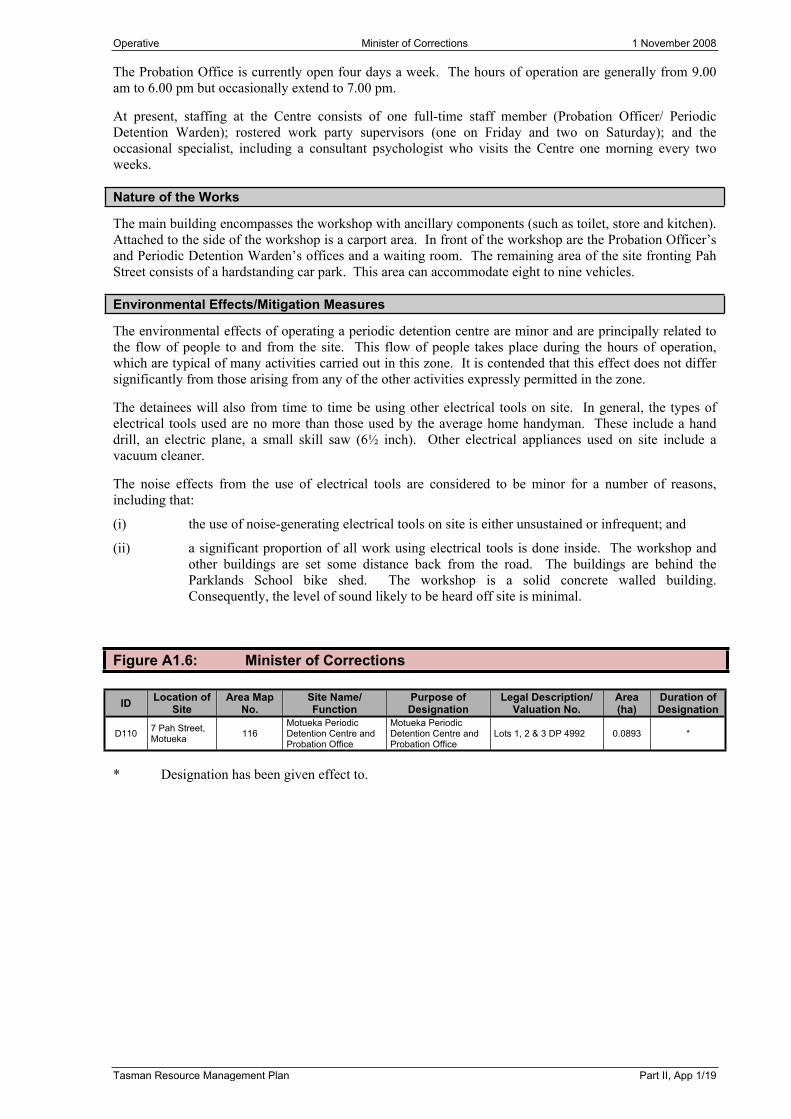
Figure A1.6: Minister of Corrections
ID Location of Site
Area Map No.
Site Name/Function
Purpose of Designation
Legal Description/Valuation No.
Area (ha)
Duration of Designation
D110 7 Pah Street, Motueka 116
Motueka Periodic Detention Centre and Probation Office
Motueka Periodic Detention Centre and Probation Office
Lots 1, 2 & 3 DP 4992 0.0893 *
* Designation has been given effect to.

Operative Part II, Appendix 1 - Designations 1 November 2008
Part II, App 1/20 Tasman Resource Management Plan
A1.7 DESIGNATING AUTHORITY: METEOROLOGICAL SERVICE OF NEW ZEALAND (MET SERVICE)
Reason for Designation
(a) The reason for the designation is to ensure that an important, existing meteorological installation is suitably protected by the Plan and that its future operation, maintenance and upgrading is appropriately provided for.
(b) Met Service is contracted to government to provide a range of extensive weather information for the whole of New Zealand. In order to provide accurate advance warning of weather patterns it is essential to maintain a network of weather observation stations throughout New Zealand. The Farewell Spit Automatic Weather Station is a vital link in Met Service’s national network and provides observations of the weather patterns over the top part of the South Island and Cook Strait.
(c) Met Service is a State Owned Enterprise and has financial responsibility of the installation, operation and maintenance of meteorological activities and associated buildings and equipment. In terms of the Act, Met Service has been granted from the Minister for the Environment approval as a requiring authority.
Designation Notation
(a) Meteorological activities.
Explanatory Statement
The automatic weather station at Farewell Spit fulfils a vital function in the national meteorological network. As such, it is essential that the site is designated to ensure the continued efficient and effective operation of this installation. The designation encompasses the operation of a meteorological facility for observing, collecting and communicating weather information.
Nature of the Works
The designation encompasses the maintenance, replacement, relocation, rearrangement and upgrading of equipment and any other works of a minor nature necessary to ensure the continued operation of the weather station. The installation is an automatic weather station (AWS). Such an installation has the following physical and activity nature:(a) Small equipment buildings.(b) Masts up to 10 metres, poles up to six metres, aerials, antennae.(c) Cable and line connections, radio and satellite links.(d) Security fencing.(e) Continuous automated observation of weather conditions and transmission of information.
Environmental Effects/Mitigation Measures
(a) Environmental Effects
Visual impact of utilitarian buildings, masts and poles.
(b) Mitigation Measures
Any environmental impacts should be offset by the importance of maintaining an essential component of the network.
Figure A1.7: Meteorological Service of New Zealand
ID Location of Site
Area Map No.
Site Name/Function
Purpose of Designation
Legal Description/Valuation No.
Area (ha)
Duration of Designation
D115 Farewell Spit 6, 140 Golden Bay Lighthouse
Meteorological Activities
Pt Sections 4 & 5 Block VIII Onetaua Survey District *
* Designation has been given effect to.

Operative New Zealand Transport Agency 18 August 2012
Tasman Resource Management Plan Part II, App 1/21
A1.8 DESIGNATING AUTHORITY: NEW ZEALAND TRANSPORT AGENCY
Reason for Designation
The existing State Highway 6, State Highway 60, State Highway 63 and State Highway 65 network through the Tasman District are the responsibility of New Zealand Transport Agency.
Designation of state highways is considered the most appropriate mechanism nationally of protecting New Zealand Transport Agency’s interests, with regard to the safe and efficient functioning of these works.
Designation Notation
State highway purposes.
Explanatory Statement
The designation provides for New Zealand Transport Agency, either itself, or through its agents, to control, manage, and improve the state highway network, including planning, design, research, construction and maintenance relating to all land within the designation. Such activities may also involve, but not necessarily be limited to realigning the road, altering its physical configuration, culverts, bridges and associated protection works.
Nature of the Works
The designation encompasses the state highway road reserve. The nominal standard for width of the state highway road reserve is 20 metres. However, this will vary depending on topographical restraints and design requirements, including historical and legal boundaries, volumes of traffic, numbers of lanes, widths of shoulders/berms, intersections and environmental considerations.
Environmental Effects/Mitigation Measures
There will be no change to the effects on the environment resulting from the proposed modification to the notations. These modifications will allow the Tasman Resource Management Plan to show the status of the existing highways in a clear and consistent manner.

Operative Part II, Appendix 1 - Designations 19 December 2020
Part II, App 1/22 Tasman Resource Management Plan
Figure A1.8: New Zealand Transport Agency
ID Location of Site Map4 No.
Site Name/Function
Purpose of Designation
Legal Description/Valuation No.
Area (m2)
Duration ofDesignation
Existing
D120 State Highway 6 Various State highway State highway purposes *
D121 State Highway 60 “ “ “ *
D122 State Highway 63 “ “ “ *
D123 State Highway 65 “ “ “ *
D126 State Highway 6, Hope Saddle AM 30 Hope Saddle
realignment “ Pt Blk III, Pt Blk IV, Hope SD *
D127
Hope Bypass Queen St, Richmond to State Highway 6, South Hope
AM 57, 124, 126, 127, 128,
131SM 151
To provide future limited access road
“
Crown Land Block VI (under action) Waimea Survey District Nelson, Lot 7 DP 12079, Lot 8 DP 12079, Lot 9 DP 12079, Lot 10 DP 12079,Lot 1 DP 20381, Lot 2 DP 19676, Lot 1 DP 307025, Lot 2 DP 307025, Lot 2 DP 10855, Lot 1 DP 5489, Pt Sec 108 Waimea East Dis, Lot 5 DP 3969, Lot 1 DP 370048, Sec 3 SO 506258, Sec 2 SO 506258, Sec 4 SO 506258, Lot 3 DP 470387, Lot 1 DP 446230, Sec 2 SO 521391, Pt Sec 108 Waimea East District, Lot 3 DP 3731, Lot 3 DP 447251, Pt Lot 18 DP 4875, Pt Lot 19 DP 4875, Part Lots 17 & 20 DP 4875, Lot 3 DP 435942, Lot 1 DP 435942, Lot 1 DO 15676, Lot 1 DP 20183, Lot 1 DP 6866, Lot 2 DP 1847, Lot 2 DP 1847, Pt Sec 122 Waimea East Dis, Areas A, B & C, DP 440351
15 years
D129 State Highway 60, Waitapu AM 50 Roading
purposes “Pt Sec 49 Takaka SD, Pt Lot 1 DP 3168, Pt Sec 16 Takaka SD, Pt 14, of B Takaka SD
3583 *
D130State Highway 60, Takaka Hill, Bob’s Lookout
AM 14SM 142
State Highway widening and realignment
“ Pt Lot 1 DP 8379 and Pt Lot 1 DP 8328
13941043 *
D131 State Highway 6, Spooners Range AM 27 Proposed major
highway “ Pt Sec 49 Blk II Gordon SD *
D132 Corner of Stratford and Queen Streets AM 132
Proposed limited access road
“ Sec 4 SO 463421 Until 1/11/2023
D133 Appleby Highway AM 128 Highway widening “ Pt Sec 108 Waimea South District –
Gazette 1948, p. 1226 *
D136 State Highway 60, Takaka Hill
AM 14 SM 143
State highway purposes “ Pt Sec 14 Blk XIV Kaiteriteri SD
Pt Sec 3 Blk VII Kaiteriteri SD *
D137State Highway 6 and Whitby Road – Wakefield
AM 91 Road widening State highway purposes
Pt Sec 81 Waimea South District, Lot 1 DP 6713Pt Sec 81 Waimea South District - Lot 1 DP 5988Lot 1 DP 5285Pt Sec 81 Waimea South DistrictLot 2 DP 3241
Until 1/11/2028
D138 Ruby Bay Bypass AM 19, 54, 85
Limited Access Road
State highway purposes Various *
* Designation has been given effect to.
A1.9 DESIGNATING AUTHORITY: MINISTER OF LANDS
Figure A1.9: Minister of Lands
ID Location of Site
Area Map No.
Site Name/Function
Purpose of Designation
Legal Description/Valuation No.
Area (ha)
Duration of Designation
D140 Champion Road, Richmond 123 Local Purpose Reserve
(Acclimatisation)Local Purpose Reserve (Acclimatisation)
R135, Section 2, Block VII *
* Designation has been given effect to.
4 AM = Area Map SM = Special Map

Operative Tasman District Council 1 November 2008
Tasman Resource Management Plan Part II, App 1/23
A1.10 DESIGNATING AUTHORITY: TASMAN DISTRICT COUNCIL
Refuse Disposal
Reason for Designation
The continued designation of the refuse disposal sites listed in Figure A1.10 is to ensure that these important existing installations are suitably protected by the Plan, and that their future operation, maintenance and upgrading is appropriately provided for.
Designation Notation
(a) Waste management facility.
(b) Sanitary landfill.
(c) Transfer station.
(d) Tip.
Explanatory Statement
(a) Sanitary Landfill
The excavation and reshaping of the area, backfilling with refuse and covering with soil material in a controlled and monitored manner to enable the stabilisation, reshaping and rehabilitation of the area, including protection, planting of trees, shrubs and grasses. The operation may include hazardous waste, the sorting, (including resource recovery) and composting of materials.
(b) Transfer Station/Refuse Transfer Facility
A facility for the management of refuse; collection, processing, treatment and transfer.
(c) Tip
Disposal of refuse to ground to a lesser standard of control than a sanitary landfill.
Nature of the Works
The structures and works associated with refuse management facilities, such as sanitary landfills, transfer stations and tips, including buildings (a range of sizes and shapes) for housing equipment plant and operation and mechanical equipment for earthmoving and refuse cartage and handling. Earthworks, ponds, pipelines, power supply lines, fences, pump stations, monitoring bores, access roads, sealed areas and retaining walls are all associated with the activity.
Environmental Effects/Mitigation Measures
Where possible, landfill and tip facilities have been located away from public view to minimise visual impact and possible odour problems. Transfer stations are located adjacent yet reasonably removed from communities. Potential environmental contamination is monitored and an appropriate construction is designed to minimise adverse effects. Traffic effects generally involve roading improvements to reduce traffic hazards dependant on conditions at each site.
Water Supply and Sewerage Works
Reason for Designation
The continued designation of the water supply and sewerage works sites listed in Figure A1.10 is to ensure that these important existing installations are suitably protected by the Plan, and that their future operation, maintenance and upgrading is appropriately provided for.
Operative Part II, Appendix 1 - Designations 1 November 2008
Part II, App 1/24 Tasman Resource Management Plan
Designation Notation
Public water supply purposes.
Explanatory Statement
The sites have been in use for many years and form essential elements of the public water supply and sewage disposal systems.
Nature of the Works
The water supply pump station sites consist of a building varying in size from small garden shed-size buildings to large dwelling sized buildings. These buildings house the pumping and water treatment equipment including, in some cases, a contact tank for the chlorination process, and on-site lime storage for water treatment.
On-site activities consist of water treatment including chlorination, aeration, and lime dosing and pumping, plus the periodic maintenance and upgrading of the equipment and facilities.
Water supply reservoir sites consist of one or more concrete reservoirs ranging in size from 3.0 metres in diameter and 2.4 metres in height to 33 metres in diameter and 7.0 metres in height. Some sites also contain a small booster pump station housed in a small shed.
Water supply intake sites consist of a small concrete weir across the stream with associated pipeline head works.
Sewer pump station sites consist of an in-ground concrete well finishing flush with ground surface with access hatches and above-ground vents and electrical control cabinets. The main Brightwater site also contains an equipment shed.
Sewage treatment pond sites contain oxidation ponds varying in size from 0.3 hectares to 5.3 hectares with some sites also containing aeration ponds and soakage beds or marsh cells for disposal of treated effluent.
Environmental Effects/Mitigation Measures
Where possible, sites have been located away from public view to minimise the visual impact and possible noise and smell problems. In some cases, the visual aspect is improved by on-site landscaping and facilities painted in colours which blend in with the surrounding environment.
Water supply pump stations produce some degree of noise and the sewer pump stations and ponds can produce odour, but every effort is made to maintain and operate the facilities in an efficient manner to keep these effects to a minimum.
Traffic to and from the sites is infrequent but may be at any time of the day or night.
Car Park
Reason for Designation
The existing service lane and car park network throughout the Tasman District Council is the responsibility of Tasman District Council. The car park designation will provide for the Tasman District Council either itself, or through its agents, to control, manage, plan, design, construct and maintain land within the designation. Designation of this car park is considered the most appropriate mechanism of protecting Tasman District Council’s interest with regard to the safe and efficient functioning of the service lane and car park system.
Designation Notation
Car park.
Operative Tasman District Council 18 August 2012
Tasman Resource Management Plan Part II, App 1/25
Environmental Effects/Mitigation Measures
There will be no change to the effects on the environment resulting from the proposed designation. This designation will allow the Tasman Resource Management Plan to show the status of the existing car park in a clear and consistent manner.
Aerodrome
Reason for Designation
The existing aerodromes, Motueka and Puramahoi, are the responsibility of Tasman District Council. The designation provides for the Tasman District Council either itself or through its agents to control, manage and approve planning, design, research, construction and maintenance relating to all land within the designation. Designation of these aerodromes is considered the most appropriate mechanism of protecting Tasman District Council’s interest with regard to the safe and efficient functioning of the aerodromes.
Designation Notation
Aerodrome.
Environmental Effects/Mitigation Measures
There will be no change to the effects on the environment resulting from the proposed designation. These designations will allow the Tasman Resource Management Plan to show the status of the existing aerodrome in a clear and consistent manner.
Road Widening
Reason for Designation
The existing roading network throughout the Tasman District (apart from state highways) is the responsibility of Tasman District Council.
The road widening designation provides for the Tasman District Council, either itself, or through its agents, to control, manage and improve the roading network, including planning, design, research, construction and maintenance relating to all land within the designation. Such activities may also involve, but not necessarily be limited to, realigning the road, altering its physical configuration, culverts, bridges and associated protection works. Designation of these roads is considered the most appropriate mechanism of protecting Tasman District Council’s interest with regard to the safe and efficient functioning of these works.
Designation Notation
Road widening.
Environmental Effects/Mitigation Measures
There will be no change to the effects on the environment resulting from the proposed designation. These designations will allow the Tasman Resource Management Plan to show the status of the existing roading in a clear and consistent manner.

Operative Part II, Appendix 1 - Designations 20 June 2020
Part II, App 1/26 Tasman Resource Management Plan
Figure A1.10: Tasman District Council
ID Location of Site
Map5 No.
Site Name/Function
Purpose of Designation
Legal Description/Valuation No.
Area (ha)
Duration of Desig-
nation
Refuse Disposal
Existing
D160 Beach Road, Richmond AM 125
Waste management
facility
Waste management
facility
Pt Lot 1 DP 7528 Lot 1 DP 16384 Lot 2 DP 16384 4.25 *
D161 Robinsons Road, Mariri AM 52 Tip Tip Lot 2 DP 5152 3.64 *
D162 State Highway 63, St Arnaud
AM 35 SM 150 “ “
Pt Sections 4, 92 & 102, Sq 46, Section 10, Block XIII, Motupiko Survey District, SO 10406
*
D163 Eves Valley AM 56 Sanitary landfill refuse disposal
Sanitary landfill refuse disposal Lot 1 DP 13422. 1939021801 42.04 *
D164Murchison/ Matakitaki West Bank Road
AM 92Refuse
station/Refuse transfer facility
“ Lot 1 DP 514507, Lot 2 DP 376056 2.55 *
D166 Collingwood West AM 72 Refuse tip Refuse tip Section 393 Town of Collingwood, SO1012 1.173 *
Water Supply and Sewerage Works
Existing
D170 87 Queen St, Richmond AM 129
Queen Street reservoir and pump station
Public water supply purposes Lot 1 DP 8002 0.2680 *
D171 11 Valhalla Lane, Richmond AM 129
Valhalla Lane high level reservoir
“ Lot 1 DP 8046 & Lot 27 DP 15725 0.1283 *
D172 132 Edward St, Wakefield AM 91 Wakefield
reservoir “ Lot 1 DP 8022 0.0837 *
D173 92 Fairfax St, Murchison AM 92 Murchison
pump station “ Part of Lot 2 DP 7755 and Section 57 Murchison Town 0.0225 *
D174 Chalgrave St, Murchison AM 92 Murchison
reservoir “ Lot 1 DP 9463 0.1326 *
D175 Hamama Road AM 13 Hamama water supply intake “ Section 3 Block VI Takaka Survey District 35.8147 *
D176 121 Beach Rd, Richmond AM 125
Beach Road sewer, pump station & tanks
Sewage disposal purposes Lot 1 DP 20180 0.2400 *
D177 Tapawera-Glenhope Road AM 89
Tapawera sewage treatment pond
“ SO 12118 2.2027 *
D178 State Highway 6, Murchison AM 92
Murchison sewage treatment pond
“Sec 1 SO 459034, Sec 1 SO 452166 and parts of Lots 2 & 4 DP 380362, Secs 2,4 & 5 SO 459034
4.700 *DAD 9/16
D179 Thorp St, Motueka
AM 52 SM 115
Motueka sewage treatment pond
“ Section 29 Motueka Rural Block IV Motueka Survey District 60.7028 *
Pt Sec 31 Block V (4 parcels). Refer SO 8906, SO 9422, and Part of Pt Sec 17, Takaka District, Block VI, Waitapu SD and riverbed (2 parcels)
7.9677 *D180 Haldane Rd,
Takaka AM 50 Takaka sewage treatment pond “
Section 1 SO 438846 1.8 * DAD 7/13
D181 Collingwood/Bainham Rd AM 72
Collingwood sewage treatment pond
“ Section 1 SO 14548 and Part of Section 393 Town of Collingwood 1.7000 *
D184 Pomona Rd, Ruby Bay AM 54
Pomona Road reservoir and pump station
Public water supply purposes Lot 3 DP 15755 0.2325 *
D187Lord Rutherford Rd South, Brightwater
AM 90 Brightwater reservoir “ Lot 1 DP 9704 Lot 9 DP 452456 0.2131 *
D189 45 Vahalla Drive, Richmond AM 129
Valhalla Drive Extra High Level Reservoir
“ Lot 27 DP 15725 Lot 1 DP 8046 0.0995 *
New
D185 Brabant Dr, Ruby Bay AM 86
Brabant Drive reservoir and pump station
Public water supply purposes Lot 26 DP 15280 0.0110 *
D186 Lightband Rd, Brightwater AM 90 Brightwater
pump station “ Section 244 Waimea East District SO 12172 0.1303 *
D188 Pigeon Valley Rd, Wakefield AM 91 Wakefield pump
station and well “ Lot 1 DP 15754 & SO 11647 0.0873 *
5 AM = Area Map SM = Special Map

Operative Part II, Appendix 1 - Designations 20 June 2020
Tasman Resource Management Plan Part II, App 1/27
ID Location of Site
Area Map No.
Site Name/Function
Purpose of Designation
Legal Description/Valuation No.
Area (ha)
Duration of Desig-
nation
D190 11 Cropp Place, Richmond AM 135
Cropp Place high level reservoir
“ Easement over Lot 1 DP 13532 0.0036 *
D191 Lower Queen St, Appleby AM 57 Waimea pump
station “ Lot 2 DP 8730 0.0930 *
D192Tapawera-Glenhope Rd, Tapawera
AM 89 Tapawera pump station “ Part of Lot 1 DP 302811 0.0400 *
D193 Totara St, Tapawera AM 89 Tapawera
reservoir “ Part of Lot 2 DP 19139 0.1250 *
D194 10 Fearon St, Motueka AM 114 Fearon’s Bush
pump station “ Part of DP 514 recreation reserve 0.0150 *
D195 Old Wharf Rd, Motueka AM 119
Recreation centre pump station
“ Part of Lot 1 DP 8862 0.0225 *
D196Unnamed stream, Torrent Bay
AM 80Torrent Bay water supply intake
“ Part of Pt Section 1 Block III Kaiteriteri Survey District *
D197 Golden Hills Road AM 56
Redwood Valley No. 1 pump station
“ Lot 5 DP 11138 0.0622 *
D198O’Connor’s Creek, State Highway 60
AM 56Redwood Valley No. 2 pump station
“ Legal road reserve including Lot 1 DP 10646 0.0747 *
D199 Haile Lane AM 77Pohara Valley water supply intake
“ Lot 10 DP 14874 *
D200 Haile Lane AM 77 Pohara Valley pump station “ Lot 16 DP 14874 0.0694 *
D201 Pohara Valley Rd AM 77 Pohara Valley reservoir “ Lot 34 DP 14874 0.0284 *
D203 3 Spencer Pl, Brightwater AM 90
Brightwater main sewer, pump station
Sewage disposal purposes Part of Lot 1 DP 19151 0.0450 *
D204State Highway 60, Upper Takaka
AM 81Upper Takaka sewage treatment pond
“ Lot 14 DP 15996, Block XI Takaka Survey District 0.2788 *
D205State Highway 60, Upper Takaka
AM 81 Upper Takaka reservoir
Public water supply purposes
Part of Pt Section 56 Block XI Takaka Survey District 0.0200 *
D206 State Highway 60, Takaka Hill AM 14
Upper Takaka water supply intake
“ Part of Pt Section 83 Block XI Takaka Survey District 0.001 *
D236 226 Champion Rd, Richmond AM 136
Waimea reservoir and pump station
Public water supply purposes Lot 2 DP 9163. 19430 46603 0.3040 *
D243Headingly Lane & Artillery Place, Richmond
AM 124 Wastewater pipemain
Wastewater disposal
Pt Lot 2 DP 18918, Pt Lot 20 DP 429773, Pt Lots 18 & 22 DP 431433 0.216 *
D244Lower Queen St and McShane Rd, Richmond
AM 124
Water treatment plant and wastewater pump station
Public water supply and wastewater
disposal
Section 1 SO455144 Waimea East District 1.03 20 years
DAD 1/15
D245 McShane Rd, Richmond AM 123 Water wells Public water
supplyPart of Lot 3 DP 379860, Lot 1 DP 20497, Lot 2 DP 315847 0.784 20 years
D246RM1102
30
216 Champion Rd, Richmond AM 135
Richmond East High Level Reservoir
Public water supply purposes Sec 3 SO 452872 0.4800 20 years
DD 12/12
Stormwater and Recreat ion Networks
New
D247
Waimea Inlet to Main Road Hope and Hill St South, Richmond
AM 57,124,
127, 128, 133
Borck Creek and related drains (Eastern Hills, Bateup, Whites, Reed/Andrews)
Local purpose reserve
stormwater and recreation
Hill Street South to Paton RoadSec 1 & 2 SO 533003; Lot 1 DP 526762; Lot 1 DP 8205; Pt Sec 34 Waimea East DIST; Lots 1 & 2 DP 431455; and parts of Lots 3-5 DP 431455, Sec 2 SO 527522, Lot 167 DP 527234, Lots 154-157 DP 523952, and Lots 145, 147 & 148 DP 513715.Paton Road (both ends) to Main RoadParts of Pt Lot 1 DP 17738, Lot 5 DP 446793, Lot 2 DP 17738; Lot 1 DP 361254, Pt Sec 19 Waimea East DIST, Lot 1 DP 6754, Lot 2 DP 15403, Lot 2 DP 8349, Lots 1 & 2 DP 396397 and State Highway 6.Main Road to Appleby HighwayLot 1 DP 15676; Secs 1 & 2 SO 501348; and parts of Lot 3 DP 447251, Lot 9 DP 20535, Lot 2 DP 447251, Lot 1 DP 9920, Lot 3 DP 20535, Sec 3 SO 501348, Crown Land Blk VI Waimea SD and State Highway 60.
20 years
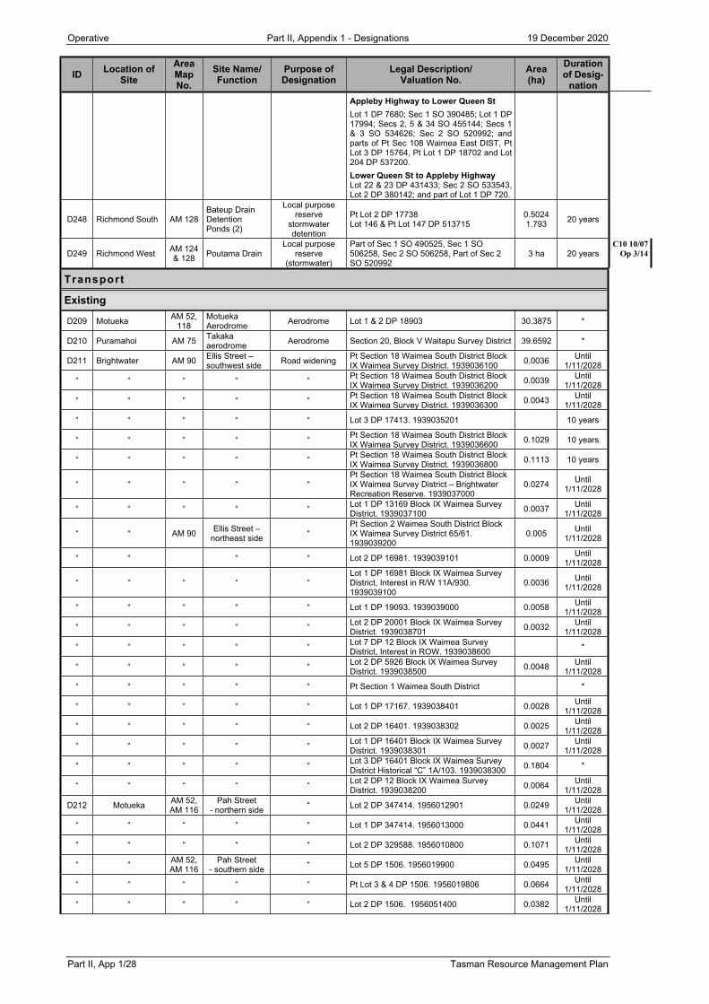
Operative Part II, Appendix 1 - Designations 19 December 2020
Part II, App 1/28 Tasman Resource Management Plan
ID Location of Site
Area Map No.
Site Name/Function
Purpose of Designation
Legal Description/Valuation No.
Area (ha)
Duration of Desig-
nationAppleby Highway to Lower Queen StLot 1 DP 7680; Sec 1 SO 390485; Lot 1 DP 17994; Secs 2, 5 & 34 SO 455144; Secs 1 & 3 SO 534626; Sec 2 SO 520992; and parts of Pt Sec 108 Waimea East DIST, Pt Lot 3 DP 15764, Pt Lot 1 DP 18702 and Lot 204 DP 537200.Lower Queen St to Appleby HighwayLot 22 & 23 DP 431433; Sec 2 SO 533543, Lot 2 DP 380142; and part of Lot 1 DP 720.
D248 Richmond South AM 128Bateup Drain Detention Ponds (2)
Local purpose reserve
stormwater detention
Pt Lot 2 DP 17738Lot 146 & Pt Lot 147 DP 513715
0.50241.793 20 years
D249 Richmond West AM 124 & 128 Poutama Drain
Local purpose reserve
(stormwater)
Part of Sec 1 SO 490525, Sec 1 SO 506258, Sec 2 SO 506258, Part of Sec 2 SO 520992
3 ha 20 yearsC10 10/07
Op 3/14
Transport
Existing
D209 Motueka AM 52, 118
Motueka Aerodrome Aerodrome Lot 1 & 2 DP 18903 30.3875 *
D210 Puramahoi AM 75 Takaka aerodrome Aerodrome Section 20, Block V Waitapu Survey District 39.6592 *
D211 Brightwater AM 90 Ellis Street – southwest side Road widening Pt Section 18 Waimea South District Block
IX Waimea Survey District. 1939036100 0.0036 Until 1/11/2028
“ “ “ “ “ Pt Section 18 Waimea South District Block IX Waimea Survey District. 1939036200 0.0039 Until
1/11/2028
“ “ “ “ “ Pt Section 18 Waimea South District Block IX Waimea Survey District. 1939036300 0.0043 Until
1/11/2028
“ “ “ “ “ Lot 3 DP 17413. 1939035201 10 years
“ “ “ “ “ Pt Section 18 Waimea South District Block IX Waimea Survey District. 1939036600 0.1029 10 years
“ “ “ “ “ Pt Section 18 Waimea South District Block IX Waimea Survey District. 1939036800 0.1113 10 years
“ “ “ “ “Pt Section 18 Waimea South District Block IX Waimea Survey District – Brightwater Recreation Reserve. 1939037000
0.0274 Until 1/11/2028
“ “ “ “ “ Lot 1 DP 13169 Block IX Waimea Survey District. 1939037100 0.0037 Until
1/11/2028
“ “ AM 90 Ellis Street – northeast side “
Pt Section 2 Waimea South District Block IX Waimea Survey District 65/61. 1939039200
0.005 Until 1/11/2028
“ “ “ “ Lot 2 DP 16981. 1939039101 0.0009 Until 1/11/2028
“ “ “ “ “Lot 1 DP 16981 Block IX Waimea Survey District, Interest in R/W 11A/930. 1939039100
0.0036 Until 1/11/2028
“ “ “ “ “ Lot 1 DP 19093. 1939039000 0.0058 Until 1/11/2028
“ “ “ “ “ Lot 2 DP 20001 Block IX Waimea Survey District. 1939038701 0.0032 Until
1/11/2028
“ “ “ “ “ Lot 7 DP 12 Block IX Waimea Survey District, Interest in ROW. 1939038600 *
“ “ “ “ “ Lot 2 DP 5926 Block IX Waimea Survey District. 1939038500 0.0048 Until
1/11/2028
“ “ “ “ “ Pt Section 1 Waimea South District *
“ “ “ “ “ Lot 1 DP 17167. 1939038401 0.0028 Until 1/11/2028
“ “ “ “ “ Lot 2 DP 16401. 1939038302 0.0025 Until 1/11/2028
“ “ “ “ “ Lot 1 DP 16401 Block IX Waimea Survey District. 1939038301 0.0027 Until
1/11/2028
“ “ “ “ “ Lot 3 DP 16401 Block IX Waimea Survey District Historical “C” 1A/103. 1939038300 0.1804 *
“ “ “ “ “ Lot 2 DP 12 Block IX Waimea Survey District. 1939038200 0.0064 Until
1/11/2028
D212 Motueka AM 52, AM 116
Pah Street- northern side “ Lot 2 DP 347414. 1956012901 0.0249 Until
1/11/2028
“ “ “ “ “ Lot 1 DP 347414. 1956013000 0.0441 Until 1/11/2028
“ “ “ “ “ Lot 2 DP 329588. 1956010800 0.1071 Until 1/11/2028
“ “ AM 52, AM 116
Pah Street- southern side “ Lot 5 DP 1506. 1956019900 0.0495 Until
1/11/2028
“ “ “ “ “ Pt Lot 3 & 4 DP 1506. 1956019806 0.0664 Until 1/11/2028
“ “ “ “ “ Lot 2 DP 1506. 1956051400 0.0382 Until 1/11/2028

Operative Part II, Appendix 1 - Designations 20 June 2020
Tasman Resource Management Plan Part II, App 1/29
ID Location of Site
Area Map No.
Site Name/Function
Purpose of Designation
Legal Description/Valuation No.
Area (ha)
Duration of Desig-
nationD213 Motueka AM 52 Queen Victoria
Street “ Pt DP 1516. 1956049400 0.0479 Until 1/11/2028
“ “ “ “ “ Lot 1 DP 3297. 1956049900 0.0105 Until 1/11/2028
“ “ “ “ “ Pt Lot 7 DP 1513. 1956049800 0.0241 Until 1/11/2028
“ “ “ “ “ Lot 8 DP 1513. 1956050000 0.0206 Until 1/11/2028
“ “ “ “ “ Lot 9 DP 1513. 1956050100 0.0620 Until 1/11/2028
“ “ “ “ “ Lot 1 DP 3541. 1956051200 0.0066 Until 1/11/2028
“ “ “ “ “ Lot 2 DP 3541. 1956051100 0.0729 Until 1/11/2028
“ “ “ “ “ Lot 3 DP 3541. 1956051301 0.0070 Until 1/11/2028
“ “ “ “ “ Lot 4 DP 3541. 1956051300 0.0067 Until 1/11/2028
“ “ “ “ “ Lot 1 DP 5241. 1956051101 0.0170 Until 1/11/2028
“ AM 52, AM 118 “ “ Lots 1 & 2 DP 18903 District of Motueka –
Aerodrome 0.2168 Until 1/11/2028
“ “ “ “ “ Lot 7 DP 2625. 1956055504 0.0098 Until 1/11/2028
“ “ “ “ “ Lot 6 DP 2625. 1956055500 0.0072 Until 1/11/2028
“ “ “ “ “ Lot 5 DP 2625. 1956055505 0.0060 Until 1/11/2028
“ “ “ “ “ Lot 4 DP 2625. 1956055501 0.0058 Until 1/11/2028
“ “ “ “ “ Lot 3 DP 2625. 1956055506 0.0059 Until 1/11/2028
“ “ “ “ “ Lot 2 DP 2625. 1956055502 0.0058 Until 1/11/2028
“ “ “ “ “ Lot 1 DP 5374 – 2 flats shown on DP 15419. 1956055402 and 1956055402A 0.0053 Until
1/11/2028
D217 Wakefield AM 91 Pitfure Road “ Lot 36 DP 398748. 1937010502 0.0556 Until 1/11/2028
“ “ “ “ “Pt Section 78 Waimea South District, Block XII Wai-iti Survey District. 1937010400
0.8094 *
“ “ “ “ “Pt Section 78 Waimea South District, Block XIII Wai-iti Survey District. 1937010300
0.035 Until 1/11/2028
“ “ “ “ “Pt Section 78 Waimea South District, Block XII Wai-iti Survey District. 1937010200
1.0279 *
D218 Richmond AM 128 Wensley Road “ Pt Lot 1 DP 4072. 1959004100 Until 1/11/2028
“ “ “ “ “ Lot 2 DP 598. 1959073000 Until 1/11/2028
D219 Richmond AM 129 AM 130 Hill St - north “ Lot 3 DP 2534. 1961038200 1.7108 *
“ “ “ “ “ Lot 1 DP 13308. 1961037600 1.2243 *
“ “ “ “ “ Lot 1 DP 2534. 1961038000 1.5095 *
“ “ “ “ “ Lot 1 DP 17655. 1961037701 0.0122 Until 1/11/2028
“ “ “ “ “ Pt Lot DP 242. 1961036000 0.6265 *
“ “ “ “ “ Lot 4 DP 17501. 1961028010 0.0152 Until 1/11/2028
“ “ “ “ “ Lot 5 DP 17501. 1961028012 0.0113 Until 1/11/2028
“ “ “ “ “ Lot 6 DP 17501. 1961028016 0.0125 Until 1/11/2028
“ “ “ “ “ Pt Section 70 Waimea East District. 1961025900 6.1785 *
“ “ “ “ “ Lot 2 DP 13172 Block VIII Waimea Survey District. 19610/28100 2.0048 *
“ “ “ “ “ Lot 7 DP 17501. 1961028014 0.0008 Until 1/11/2028
“ “ “ “ “ Lots 1 & 9 DP 19426. 1961028017 0.0003 Until 1/11/2028
“ “ “ “ “ Lot 4 DP 19426. 1961028021 0.0003 Until 1/11/2028
“ “ “ “ “ Lot 6 DP 19426. 1961028020 0.0003 Until 1/11/2028
“ “ “ “ “ Lot 7 DP 19426. 1961028019 0.0003 Until 1/11/2028
“ “ “ “ “ Lot 8 DP 19426. 1961028018 0.0013 Until 1/11/2028

Operative Part II, Appendix 1 - Designations 20 June 2020
Part II, App 1/30 Tasman Resource Management Plan
ID Location of Site
Area Map No.
Site Name/Function
Purpose of Designation
Legal Description/Valuation No.
Area (ha)
Duration of Desig-
nation“ “ “ “ “ Lot 17 DP 361354.1961028000 0.0321 Until
1/11/2028
“ “ “ “ “
Sec 2 SO 466402 Lots 28-29 DP 471201, Lots 1-2 DP 306483, Lots 28-29 DP 361354, Lot 8 DP 18941, Lots 4 & 5 17032, Lot 14 DP 17720, Lot 4 DP 18824, Lot 10 DP 19426, Lot 35 DP 307871 – Esplanade and Recreational Reserves
0.0032 Until 1/11/2028
“ “ AM 125 Hill Street - south “ Pt Lot 1 DP 16678 Block VII Waimea
Survey District. 1961093100 10.4282 *
“ “ “ “ “ Pt Lot 1 DP 3416. 1960029000 6.7428 *
D220 Richmond AM 125 Queen Street “ Pt Lot 1 DP 2564 & Pt Lot 1 DP 3473 CTs 3B/128, 3B/220. 1958033500 0.0774 Until
1/11/2028
“ Pt Lot 4 DP 2774. 1958047100 0.1383 Until 1/11/2028
“ “ “ “ “ Pt Lot 1 DP 1532. 1958047000 0.1069 Until 1/11/2028
“ “ “ “ “ Pt Lot 4 DP 1403. 1958046700 0.0035 Until 1/11/2028
“ “ “ “ “ Pt of Section 25 Waimea East Survey District (2 lots). 1958046600 0.1014 *
D221 Richmond AM 125AM 129
Oxford Street – (Cambridge St to Wensley Rd) – northeastern
side
“ Pt Lot 1 DP 1561. 1958038600 0.0107 Until 1/11/2028
“ “ “ “ “ Lot 2 DP 2971. 1958039100 0.1088 *
“ “ “ “ “ Pt Lots 5 & 6 DP 27201958039200 0.012 Until 1/11/2028
D223 Brightwater AM 90
Waimea West Road –
southern and western sides
“ Lot 2 DP 2793. 1939043000 0.0117 Until 1/11/2028
“ “ “ “ “ Lot 1 DP 2793 Block IX Waimea Survey District. 1939043100 0.0101 Until
1/11/2028
“ “ “ “ “ Pt Section 34 Waimea South District, Block IX Waimea Survey District. 1939043300 0.6070 *
“ “ “ “ “ Pt Section 34 Waimea South District, Block IX Waimea Survey District. 1939043400 0.1012 *
“ “ “ “ “ Pt Section 34 Waimea South District, Block IX Waimea Survey District. 1939043500 0.0051 Until
1/11/2028
“ “ “ “ “ Pt Section 34 Waimea South District, Block IX Waimea Survey District. 1939043600 0.0046 Until
1/11/2028
“ “ “ “ “ Pt Section 34 Waimea South District, Block IX Waimea Survey District. 1939043700 0.0043 Until
1/11/2028
“ “ “ “ “ Pt Section 34 Waimea South District, Block IX Waimea Survey District. 1939034904 0.0600 Until
1/11/2028
“ “ “ “ “ Section 5 Block IX Waimea Survey District. 1939044000 0.0244 Until
1/11/2028
“ “ “ “ “ Lot 1 DP 11336. 1939024401 0.0018 Until 1/11/2028
“ “ “ “ “Pt Sections 153 & 154 Waimea West District Blocks V & IX, Waimea Survey District. 1939024500
0.0468 Until 1/11/2028
“ AM 56 “ “Lots 3–4 DP 1970 & Lots 7–8 DP 13223 Pt Sections 153 & 154 Waimea West District. 1939024800
0.2522 Until 1/11/2028
“ “ “ “ “ Lots 1 & 2 DP 1970 Blocks V & IX Waimea Survey District. 1939024900 0.0757 Until
1/11/2028
“ “ “ “ “ Lot 1 DP 311860. Subj to RW. 1939024100 0.0879 Until 1/11/2028
“ “ “ “ “ Lot 2 DP 311860. 1939024101 0.0677 Until 1/11/2028
“ “ “ “ “ Lot 1 DP 9604 Section 145 Waimea West District. 1939026300 0.2647 Until
1/11/2028
“ “ “ “ “Lot 1 DP 12002 Block V Waimea Survey District – sub to ROW, see DP 12453. 1939017201
0.0698 Until 1/11/2028
“ “ AM 56 “ “Pt Lot 1 DP 11267, Block V Waimea Survey District. Interest in ROW over Lot 1 DP 12002. See DP 12453. 1939017200
0.0035 Until 1/11/2028
“ “ “ “ “ Pt Lot 4 DP 11901.1939017300 8.4414 Until 1/11/2028
“ “ “ “ “CU 00174 Pt Section 120 Waimea West District. Local Purpose Reserve, Waimea West Cemetery. 1939017400
0.0197 Until 1/11/2028
“ “ “ “ “ Lot 2 DP 15745, Lot 1 DP 12665, Block V Waimea Survey District. 1939017500 0.0457 Until
1/11/2028
“ “ “ “ “ Lot 1 DP 8990 Block V Waimea Survey District. 1939017301 0.0061 Until
1/11/2028
“ “ “ “ “ Pt Section 121 Block V Waimea Survey District. 1939017600 15.1835 *
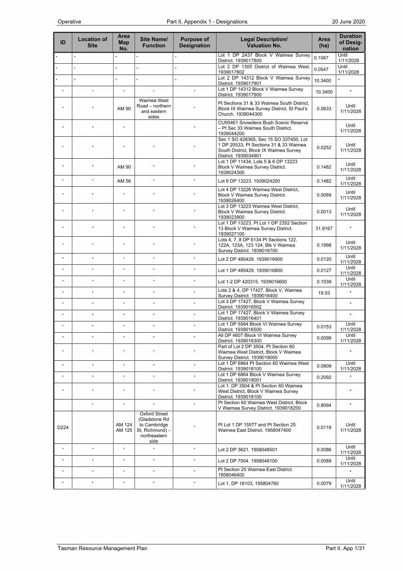
Operative Part II, Appendix 1 - Designations 20 June 2020
Tasman Resource Management Plan Part II, App 1/31
ID Location of Site
Area Map No.
Site Name/Function
Purpose of Designation
Legal Description/Valuation No.
Area (ha)
Duration of Desig-
nation“ “ “ “ “ Lot 1 DP 2437 Block V Waimea Survey
District. 1939017800 0.1067 Until 1/11/2028
“ “ “ “ “ Lot 2 DP 1305 District of Waimea West. 1939017802 0.0547 Until
1/11/2028
“ “ “ “ “ Lot 2 DP 14312 Block V Waimea Survey District. 1939017901 10.3400 *
“ “ “ “ “ Lot 1 DP 14312 Block V Waimea Survey District. 1939017900 10.3400 *
“ “ AM 90
Waimea West Road – northern
and eastern sides
“Pt Sections 31 & 33 Waimea South District, Block IX Waimea Survey District, St Paul’s Church. 1939044300
0.0633 Until 1/11/2028
“ “ “ “CU00461 Snowdens Bush Scenic Reserve – Pt Sec 33 Waimea South District. 1939044200
Until 1/11/2028
“ “ “ “ “
Sec 1 SO 428365, Sec 15 SO 337450, Lot 1 DP 20533, Pt Sections 31 & 33 Waimea South District, Block IX Waimea Survey District. 1939034901
0.0252 Until 1/11/2028
“ “ AM 90 “ “Lot 1 DP 11434, Lots 5 & 6 DP 13223 Block V Waimea Survey District. 1939024300
0.1482 Until 1/11/2028
“ “ AM 56 “ “ Lot 9 DP 13223. 1939024200 0.1482 Until 1/11/2028
“ “ “ “ “Lot 4 DP 13226 Waimea West District, Block V Waimea Survey District. 1939026400
0.0069 Until 1/11/2028
“ “ “ “ “Lot 3 DP 13223 Waimea West District, Block V Waimea Survey District. 1939023900
0.0013 Until 1/11/2028
“ “ “ “ “Lot 1 DP 13223, Pt Lot 1 DP 2352 Section 13 Block V Waimea Survey District. 1939027100
31.9167 *
“ “ “ “ “Lots 4, 7, 8 DP 6134 Pt Sections 122, 122A, 123A, 123 124, Blk V Waimea Survey District. 1939016700
0.1998 Until 1/11/2028
“ “ “ “ “ Lot 2 DP 485429. 1939016900 0.0120 Until 1/11/2028
“ “ “ “ “ Lot 1 DP 485429. 1939016800 0.0127 Until 1/11/2028
“ “ “ “ “ Lot 1-2 DP 420315. 1939016600 0.1039 Until 1/11/2028
“ “ “ “ “ Lots 2 & 4, DP 17427, Block V, Waimea Survey District. 1939016400 19.03 *
“ “ “ “ “ Lot 3 DP 17427, Block V Waimea Survey District. 1939016502 *
“ “ “ “ “ Lot 1 DP 17427, Block V Waimea Survey District. 1939016401 *
“ “ “ “ “ Lot 1 DP 5564 Block VI Waimea Survey District. 1939016500 0.0153 Until
1/11/2028
“ “ “ “ “ All DP 4607 Block VI Waimea Survey District. 1939016300 0.0099 Until
1/11/2028
“ “ “ “ “Part of Lot 2 DP 3504, Pt Section 60 Waimea West District, Block V Waimea Survey District. 1939018000
*
“ “ “ “ “ Lot 1 DP 6864 Pt Section 60 Waimea West District. 1939018100 0.0809 Until
1/11/2028
“ “ “ “ “ Lot 1 DP 6864 Block V Waimea Survey District. 1939018001 0.2092 *
“ “ “ “ “Lot 1, DP 3504 & Pt Section 60 Waimea West District, Block V Waimea Survey District. 1939018100
*
“ “ “ “ Pt Section 60 Waimea West District, Block V Waimea Survey District. 1939018200 0.8094 *
D224 AM 124AM 125
Oxford Street (Gladstone Rd to Cambridge
St, Richmond) – northeastern
side
“ Pt Lot 1 DP 15577 and Pt Section 25 Waimea East District. 1958047400 0.0119 Until
1/11/2028
“ “ “ “ “ Lot 2 DP 3621. 1958048501 0.0086 Until 1/11/2028
“ “ “ “ “ Lot 2 DP 7004. 1958048100 0.0089 Until 1/11/2028
“ “ “ “ “ Pt Section 25 Waimea East District. 1958046400 *
“ “ “ “ “ Lot 1, DP 18103, 195804760 0.0079 Until 1/11/2028

Operative Part II, Appendix 1 - Designations 20 June 2020
Part II, App 1/32 Tasman Resource Management Plan
ID Location of Site
AreaMap No.
Site Name/Function
Purpose of Designation
Legal Description/Valuation No.
Area (ha)
Duration of Desig-
nation
New
D237 High St, Motueka AM 116 Whitwell Carpark Car parking Lot 9 DP 5519. 19560256/00 0.1434 Until
1/11/2028
D238 142 Higgs Rd AM87 Curve realignment Lot 1 DP 8903, Lot 2 DP 6597, 1938029800 0.0030 Until
1/11/2028C22 2/11Op 1/15
“ 83 Higgs Rd AM87 Curve realignment Pt Lot 4 DP 693, 1938028600 0.0164 Until 1/11/2028
D241 Lower Queen St, Richmond
AM 121, 122, 124
Lower Queen St – both sides Road widening
Part of Pt Lot 1 DP 6307, Lot 1 DP 9797, Pt Lot 1 DP 7236, Lot 1 DP 6447, Pt Lot 2 DP 7236, Lot 1 DP 7553, Lot 3 DP 7236, Lot 1 DP 17704, Lot 2 DP 7553, Lot 3 DP 7553, Lot 1 DP 10413, Lot 7 DP 20017, Pt Sec 168 Waimea East District, Lot 4 DP 7553, Pt Sec 101 Waimea East District, Lot 1 DP 3124, Lot 2 DP 3124, Pt Sec 101 Waimea East District, Lot 2 DP 20409, Lot 1 DP 6428, Lot 1 DP 20409, Pt Sec 100 Waimea East District, Lot 1 DP 13664, Pt Sec 100 Waimea East District, Lot 7 DP 3962, Lot 1 DP 3962, Pt Sec 215 Waimea East District, Lot 2 DP 20264, Lot 1 DP 20264, Lot 1 DP 5225, Lot 1 DP 2780, Lot 2 DP 343034, Lot 1 DP 343034, Pt Sec 216 Waimea East District, Pt Sec 217 Waimea East District, Pt Sec 217 Waimea East District, Pt Sec 217 Waimea East District, Sec 218 Waimea East District, Sec 219 Waimea East District, Lot 1 DP 12766, Lot 1 DP 7342
3.02 20 years
D242 McShane Rd, Richmond
AM 123, 124
McShane Rd - both sides Road widening
Part of Pt Sec 160 Waimea East District, Lot 2 DP 15809, Lot 1 DP 15809, Lot 1 DP 6118, Lot 1 DP 337857, Lot 1 DP 7953, Lot 2 DP 384781, Lot 1 DP 302688, Lot 2 DP 315847, Lot 1 DP 315847, Lot 1 DP 20497, Pt Sec 168 Waimea East District, Lot 1 DP 7734, Lot 2 DP 7734, Lot 3 DP 7734, Lot 6 DP 19947, Lot 5 DP 19947, Lot 4 DP 19947, Lot 3 DP 19947, Lot 2 DP 19947, Lot 6 DP 20409, Lot 5 DP 20409, Pt Sec 101 Waimea East District.
1.67 20 years

Operative Part II, Appendix 1 - Designations 15 June 2019
Tasman Resource Management Plan Part II, App 1/33
A1.11 DESIGNATING AUTHORITY: BROADCAST COMMUNICATIONS LTD
Reasons for Designation
To enable the continued maintenance of the transmission and receiving station which is essential to the efficient and effective functioning of public and private broadcasting in the Tasman and West Coast regions.
Designation Notation
Broadcasting and telecommunications.
Explanatory Statement
The facility provides telecommunication facilities to a range of public and private organisations. The services include television and radio broadcasting, and communications networks. Satellite communications may also be included.
Nature of the Works
The designation covers an area of 1370 metres and includes the 52-metre high transmission tower. In addition, there is a transmitter building.
Environmental Effects/Mitigation Measures
The environmental effects of the facility will not be increased by the designation of an existing facility. Any possible effects of further developing the site will be mitigated by the two conditions attached to the designation.
Figure A1.11: Broadcast Communications Ltd
ID Location of Site
Area Map No.
Site Name/Function
Purpose of Designation
Legal Description/Valuation No. Area Duration of
Designation
New
D240 Summit of Mt Murchison 25, 147
Mt Murchison Transmitter Building and Tower
Broadcasting and telecommunications
South of Mt Murchison trig. Crown Land Blk (under action) Matiri Survey District
1370m2 *