PAJARO RIVER FLOOD RISK MANAGEMENT PROJECT SANTA …
45
PAJARO RIVER FLOOD RISK MANAGEMENT PROJECT SANTA CRUZ AND MONTEREY COUNTIES CALIFORNIA PLAN FORMULATION APPENDIX A FEBRUARY 2019
Transcript of PAJARO RIVER FLOOD RISK MANAGEMENT PROJECT SANTA …

PAJARO RIVER FLOOD RISK MANAGEMENT PROJECT
SANTA CRUZ AND MONTEREY COUNTIES
CALIFORNIA
PLAN FORMULATION
APPENDIX A FEBRUARY 2019


1
PAJRO RIVER FLOOD RISK MANAGEMENT PROJECT INTEGRATED GENERAL REEVALUATION REPORT AND
ENVIRONMENTAL ASSESSMENT APPENDIX A - PLAN FORMULATION
TABLE OF CONTENTS
1.0 RECONNAISSANCE PHASE (1993-1994) 2.0 PAJARO FLOODING AND RESPONSE (1998-2000)
2.1 Section 216 Initial Appraisal
3.0 ALTERNATIVE DEVELOPMENT (2002) 4.0 ALTERNATIVE FORMULATION BRIEFING (2004) 5.0 POST-AFB: SEPARABLE ELEMENTS OF ALTERNATIVES AND LOCALLY REQUESTED PLANS (2004-2012)
5.1 Separate Element Reformulation 5.2 Resource Agency Collaborative Alternatives Evaluation 5.3 Addition of Sponsor’s Locally Requested Plans 5.4 Reformulation of Alternative 9D
6.0 FOCUSED ARRAY OF ALTERNATIVES (2012-2014) 6.1 Mainstem Alternatives 6.2 Tributary Alternatives 7.0 EVALUATION OF FOCUSED ARRAY OF ALTERNATIVES (2014-2018) 8.0 COMPARISON OF FOCUSED ARRAY OF ALTERNATIVES (2014-2018) 9.0 FINAL ARRAY OF ALTERNATIVES (2014-2018)
10.1 Mainstem Alternatives 10.2 Tributary Alternatives

2
PAJRO RIVER FLOOD RISK MANAGEMENT PROJECT INTEGRATED GENERAL REEVALUATION REPORT AND
ENVIRONMENTAL ASSESSMENT
PROJECT FORMULATION APPENDIX Originally authorized in 1966, the lengthy history of the Pajaro River Project includes numerous planning iterations. This appendix summarizes alternative plans and concepts developed by USACE, non-federal sponsors, and local stakeholder groups to meet the project’s flood risk management goals. It presents a chronological history of the alternatives development process from 1993 to 2014, provides the rationale for elimination of many of these alternatives and describes the development and selection of the final array of alternatives that were carried forward for detailed analysis in the 2017 GRR. Where this Appendix provides context for the reader, Chapter 3 of the GRR/EA main report presents the most recent and relevant plan formulation information for project reviewers. 1.0 RECONNAISSANCE PHASE (1993-1994) In January 1993, the USACE conducted a Reconnaissance Study with Federal funds, as authorized by the Water Resources Development Act (WRDA) of 1990. The objective of the Reconnaissance Study was to determine federal interest in a project to provide flood risk management by reviewing existing data and documents, conducting preliminary investigations, and identifying preliminary alternatives. During the Reconnaissance Study, meetings were held throughout 1993 with Monterey and Santa Cruz County officials, the public, and local partners to identify problems and opportunities. Stakeholder concerns at this time included the following:
• Avoid encroachment on agricultural land • Maintain/enhance public safety (concern regarding illegal encampments and activities) • Retain pedestrian paths • Protect the environment • Minimize maintenance requirements • Consider off-stream storage (for groundwater recharge)
The Reconnaissance Report was completed in 1994 (USACE 1994). The report determined that a levee or floodwall on the mainstem of the Pajaro River would be economically

3
inefficient. The report identified federal interest for Salsipuedes and Corralitos Creek alternatives which were shown to reduce flood risk in Watsonville, CA 2.0 PAJARO FLOODING AND RESPONSE 2.1.1 Section 216 Initial Appraisal In March 1995, January 1997, and February 1998, shortly after release of the Reconnaissance Study, there was significant flooding events on the Pajaro River (please refer to chapter 2 for more detailed information). This flooding significantly changed the economic and hydrological data of the project, which then needed to be reanalyzed. Flood risk reduction improvements were reevaluated by the Corps using a risk-based analysis in a Section 216 Initial Appraisal (IA) for the Pajaro River, which was completed in September 1998. The IA indicated potential Federal interest for flood control improvements on the Pajaro River. Thus all subsequent alternatives put forth for feasibility-level analyses now include measures on both the mainstem of the Pajaro River and its tributaries Between 1996 and 1998, several meetings were held with local and federal organizations. Together, these meetings produced the following project goals and planning considerations: • Federal Emergency Management Agency (FEMA) certifiable 1% ACE plan is desired by the sponsors; • Take as little land as possible for the new project; the agricultural land produces high value crops
and is the primary economic driver for the City of Watsonville, the Town of Pajaro, and the surrounding area.
Figure 1 presents a summary of measures and alternatives considered for the Study through 2013.

4
Figure 1. Pajaro River Alternative Formulation (1993-2012)

5
From 2001 through 2003, USACE worked collaboratively with Monterey and Santa Cruz counties, regulatory agencies, and others to develop conceptual design alternatives; including over 20 formal meetings, to address flood risk management in and around the Pajaro River and its tributaries, Corralitos and Salsipuedes creeks.
A wide variety of flood risk management measures—including versions of those that were carried forward from the 1994 evaluation—were considered to address the flooding issues in Watsonville, Pajaro and the surrounding areas. Table 1 provides the Reconnaissance measures and alternatives that were reevaluated by stakeholders. Primary reasons for elimination are provided (Table 1). Table 1. Summary and Reevaluation of 1994 Reconnaissance Measures and Alternatives
Alternative/ Measure Description Retained Primary Reasons For Elimination
No Action Yes
Structural
Deferred Project (1963, authorized in 1966) No Economically infeasible, environmentally unacceptable, some project features
no longer practical.
Ring Levee for the City of Watsonville No Economically infeasible.
Ring Levee for the City of Watsonville and town of Pajaro No Not Economically Justified. Safety concerns regarding ring levee around
Pajaro and ability to evacuate.
Bypass Channel With Standard Project Flood Protection No Economically infeasible although controlled levee overtopping and localized
bypass measures are considered further.
Channel Excavation No Economically infeasible although limited channel modification involving bench excavation was carried forward as a measure.
Raise Existing Levees Yes
Divert Flood Flows into Elkhorn Slough No Unacceptable due to environment impacts. High degree of scour would result from the diverted flows into this designated National Estuarine Preserve
Divert Flood Flows into Upper Basin Reservoirs and Lakes No Does not meet project objectives: limited increase in flood risk management.
Technically infeasible. Not Economically Justified.
Floodwalls and/or Levees for Salsipuedes and Corralitos Creeks Yes
River and Creek floodwalls and/or levees Yes
Non-Structural
Raise or Remove Structures No
Not economically feasible. Locally unacceptable. There would be 2,400 residential and commercial structures involved. Relocation infeasible due to high value of prime agricultural land. No flood risk reduction for agricultural lands.
Flood Warning and Relocation of Damageable Property No
Approximately 490 business properties are considered “damageable.” Much content is not portable. No flood risk reduction for agricultural lands. Does not provide an increase in flood risk management for non-portable property. No flood risk reduction for agricultural lands.
Flood Insurance No The National Flood Insurance Program (NFIP) is already implemented in the floodplain and is administered by the Federal Emergency Management Agency (FEMA).
a As noted in the 2004 AFB draft GRR and reflecting rationale at the time of analysis.

6
Subsequent to the reevaluation of the Reconnaissance measures and alternatives, it was determined that the following structural and non-structural measures should be retained for further development and analysis:
• Build floodwalls on top of existing levee systems • Raise existing levee systems • Setback levee systems • Combination of levees, floodwalls, and setbacks. • Dredge and excavate limited parts of the channel and benches • Modify interior drainage to existing levee systems • Build ring levee systems • Modification of existing bridges • Install flood warning system • Riparian vegetation planting and management • Improve College Lake water storage capacity to limit downstream flows. • Levee superiority (designed levee overtopping) • Localized bypass Flood Insurance (retained if the recommended plan provides less than 1% ACE)
The measures listed above were subsequently combined in various ways to form alternatives that provide differing levels of flood risk management. Table 2 presents the results of the additional measure screening.

7
Table 2. Additional Measure Screening (2001)
Flood Damage Reduction Measures
Retain for Further
Evaluation
Remarks No Action Yes
STRUCTURAL MAINSTEM
Authorized/Deferred 1963 Plan No Economically infeasible; environmentally unacceptable; some project features impractical
Ring Levee Watsonville No Economically infeasible; no agric. Protection
Ring Levee Watsonville, Pajaro No Economically infeasible; agric. Impacts
Channel Excavation No Not effective; environmental impacts; economically infeasible Diversion of Flood Flows into Elkhorn Slough No Environmentally unacceptable; some project features impractical;
safety concerns; agric. impacts
Raise Existing Levees Yes Evaluated further assuming less than 1% ACE LOP or raising Main Street Bridge to provide 1% ACE LOP
River & Creek Floodwall/Levee Combination Yes
Setback Levees Yes Pure Floodwall Raise on Existing Alignment No Economically infeasible; environmental impacts; aesthetic
concerns; safety concerns
Wide Environmental Levee Setback/Riparian Corridor No 800’setback required to provide natural channel; takes 1552 ac of
agric. land; not economically feasible
STRUCTURAL TRIBUTARY Corralitos Flow Bypass & Tunnel System No Economically infeasible; environmental impacts; agricultural land
impacts; safety concerns Increase Storage of College Lake No Found to be hydraulically ineffective
Diversion of Flood Flows into Upper Basin Reservoirs & Lakes
No Only addresses limited volumes of water; impractical engineering; economically infeasible
Combination Levee/ Floodwall/Setback Yes
NON –STRUCTURAL
Raise or Remove Structures No 2,400 structures impacted; does not protect agricultural land; structure relocation would take agric. land; major rehabilitation of existing levee required; flood warning & evacuation required; economically infeasible
Flood Warning & Relocation of Damageable Property Yes
Partial protection of contents only; not effective; no agric. protection; will be retained as added measure if recommended plan provides unacceptable flood risk reduction.
Flood Insurance Yes Would be retained if the recommended plan provides less than 1% ACE.
3.0 ALTERNATIVE DEVELOPMENT (2002)

8
In early 2002, the Corps of Engineers proceeded to evaluate some of the potentially acceptable river and creek conceptual designs to determine (1) the level of flood risk management through a risk and uncertainty hydraulic analysis, (2) design and cost estimates, and (3) benefit/cost analysis. On the basis of results from re-evaluation of the 1994 Reconnaissance Report measures and alternatives; preliminary analysis of concept alternatives developed by stakeholders; and additional input and cost information provided by various stakeholder groups, NOAA Fisheries, and an interagency technical review team, the USACE developed a list of alternative plans in 2002 and 2003 for further analysis. This set of alternatives, all structural, included nine for the mainstem Pajaro River and four for the tributaries. Initial costs, a benefit-cost ratio calculation (BCR), and net benefit amounts were calculated for each alternative. In addition, a “Technical Committee” was additional created in May 2002 to involve the resource agencies early on in the planning process of this project. Primary participants include scientists from National Oceanic and Atmospheric Administration (NOAA) Fisheries, California Department of Fish and Game, Corps of Engineers, Monterey County, Santa Cruz County, California Coastal Commission, US Fish and Wildlife Service, and the Regional Water Quality Control Board. The major topics of discussion is the consistency of the proposed project alternatives with laws, regulations and policies, such as, but not limited to, the Endangered Species Act, Clean Water Act, Coastal Zone Management Act and the Fish and Wildlife Coordination Act.

9
Table 3. 2002 Pajaro River Alternatives and Preliminary Screening Results (USACE Planning Process Meeting 12 September 2002)
Alt # Alternative/Measure Description Retain for Further
Evaluation? Remarks
No Action Yes Structural Mainstem Alternative
1 Levee Raise in Place Yes 2 100-foot Setback Levees Yes
3 100-255-foot Setback with 4’ Raise. Hybrid Providing 1% ACE Flood Protection Yes
4 Pure Floodwall Raise on Existing Alignment No Not Economically Justified (BCR: 0.61:1)
5 Wide Environmental Corridor: 500-foot setback on either side of the existing levee alignment for all reaches except the urban reach No Not Economically Justified, high Real Estate Cost. Large loss of
prime agricultural land (BCR: 0.9:1). Structural Tributary Alternatives
T1 Raise Levee and Floodwall on Existing Alignment (2% ACE or 50-year) Yes
T2 Combination 100’ Setback Levee, Raise in Place Levee, Floodwall Levee/Floodwall Heights Increase (2% ACE or 50-year)
Yes Higher cost for same benefits as T1 but retained for further analysis.
T3 Combination Levee Raise, Setback up to 225’ on one side, Excavation, Floodwalls, College Lake Outlet Improvements, Ring Levee Around Orchard Park Subdivision. (1% ACE or 100-year)
Yes
T4 Same as T3 except setback on one side of Salsipuedes Creek would be 100’ instead of 225’ Yes
Storage Increased/Improved Storage at College Lake No Found to be hydraulically ineffective.
Bypass Corralitos Flow Bypass (Floodplain and Tunnel) No Requires extensive relocation of structures; not technically or economically feasible.
Non –Structural Alternative
Raise or Remove Structures No
2,400 structures impacted; does not protect ag land; structure relocation would take agric. land; major rehab of existing levee required; flood warning & evacuation required; economically infeasible
Flood Warning & Relocation of Damageable Property Tentative Yes Partial protection of contents only; not effective; no agric. protection; will be retained as added measure if recommended plan provides unacceptable flood risk reduction.
Flood Insurance No Would be retained if the recommended plan provides more than 1% ACE

DRAFT 10 DRAFT
4.0 ALTERNATIVE FORMULATION BRIEFING (2004) In 2004, the SPN completed a Draft GRR for the Pajaro River FRM Project and submitted it to SPD and HQUSACE for review through an Alternative Formulation Briefing (AFB). The purpose of the AFB was to obtain HQUSACE involvement in the preparation of the Draft GRR prior to release for public review. The 2004 draft GRR and EIS identified a NED and a LPP based on a systems approach to flood risk management.
It is important to note that pre-AFB plan formulation was based on a collaborative stakeholder process, engineering and technical information and data available at that time, and precedents set by the existing project (1944 authorization) and the 1966 authorized but not implemented project. A review of the completed 1949 project and 1966 authorized project concluded that plan formulation was likely based on a systems approach basis with non-separable elements and equivalent levels of protection on both banks of the Pajaro River and Salsipuedes and Corralitos Creeks tributaries. In addition, the collaborative stakeholder process incorporated watershed and system based planning, environmental sustainability, and social justice into decision-making processes. This process was founded in community and stakeholder input and collaboration and sought to provide equal levels of flood risk management to both sides of rivers and streams and to minimize induced flooding amongst residential, business, and political neighbors.
Below, Table 4 provides the 2004 AFB array of alternatives, project BCR, and associated rationale for screening the alternatives. For more information, please refer to the 2004 draft AFB GRR. The AFB conference was held in July 2004 and in August 2004 a Project Guidance Memorandum for the Pajaro GRR AFB was issued. USACE determined that the alternative plans needed to be reformulated based on a cost-effective reach and bank comparison because it appeared that urban damage reduction benefits may subsidize the proposed protection for the agricultural areas. This decision necessitated that all project alternatives be reevaluated to ensure that the economic benefits of each project reach and each bank within that reach must be greater than the costs. Specifically, the future “NED” alternative could not allow the “urban” reaches and associated benefits to economically subsidize the agricultural reaches. After reviewing existing alternatives, the PDT decided to formulate an array of new alternatives. Working collaboratively with the project sponsors and resource agencies the focused array of alternatives was developed to meet following the planning objectives and avoid the planning constraints (Reference Section 2 of the main report of the Final GRR/EA):
Objectives • Reduce the risk of flooding on human life and safety in the City of Watsonville, Town of
Pajaro, and surrounding unincorporated lands. • Reduce the risk of flood damages, including critical infrastructure, in the City of
Watsonville, Town of Pajaro, and surrounding unincorporated lands in the project area.

11
• Improve natural geomorphic processes and ecological functions in conjunction with other flood risk management features in the project area.
• Include environmentally sustainable designs and construction methodologies and to minimize environmental impacts from future operation and maintenance for the recommended plan in conjunction with other flood risk management features in the project area.
• Increase recreational opportunities in conjunction with flood risk management features and existing land uses.
Constraints • Under Section 7 of the Endangered Species Act (ESA), all Federal agencies must ensure
that any actions they authorize, fund, or carry out are not likely to jeopardize the continued existence of a listed species, or destroy or adversely modify its designated critical habitat. The Pajaro Watershed is critical to the long–term sustainability of the Federally listed steelhead, tidewater goby, and California red-legged frog. This project cannot jeopardize the continued existence of the Federally listed steelhead trout, tidewater goby, California red-legged frog or any of the other Federally listed species identified in this report to be present in the lower Pajaro River, Salsipuedes Creek, or Corralitos Creek.
• In accordance the Clean Water Act, the Pajaro River is a 303 (d) listed water body for sediment, nitrate and nutrients, among other pollutants. Section 303(d) of the Clean Water Act requires that the State of California establish priority rankings for waters on the 303(d) list and develop TMDLs. In accordance with Section 303(d), TMDLs have been developed for the Pajaro River, Salsipuedes Creek and Corralitos Creek. Currently, these TMDLs are currently not being met. Among the pollutants in these waterbodies are sediment, nutrients, pesticides, and fecal indicator bacteria. Levels of these pollutants are exacerbated by the degradation of aquatic and riparian habitat and changes in hydrogeomorphologic processes in these waterbodies. The project must not exacerbate levels of these pollutants.

0
Table 4. 2004 Alternative Formulation Briefing Alternatives (as documented in the 2004 Draft GRR)
Alt # Alternative Description BCR No Action NA Yes Structural Mainstem Alternatives
1 Reevaluation of Raise in Place on Existing Alignment. Approximate 4’Raise for all reaches. Levee with floodwall construction for Reach 3. (3.3% ACE , or 30-year LOP) 1.79 Yes
1A Raise Levee In Place (Existing Alignment) with 9’ Raise for all reaches. Mainstreet Bridge modification required due to levee raise. (1% ACE or 100-year LOP) 0.74 No. Not Eco
2 Reevaluation of 100-Foot Setback. 100’ Setback in Reaches 1, 2, and 4. Reach 3 Levee Raise in Place with 5’ Raise Levee with floodwall construction for Reach 3 due to urban area. (60 year LOP)
1.06 No. Alternat higher net be
2A (NED)
100-foot Setback Plan With Reduced Channel Vegetation in Reaches 1, 2, 4. Reach 3 Levee Raise 4’. (1% ACE or 100-year LOP)
1.86 Yes; Tentati
2B 100-foot Setback Plan With Raised Levees. 100’ Setback in Reaches 1, 2, 4. Levee Raise 1’ in Reaches 2 and 4. Levee Raise in Place 6’ in Reach 3. Mainstreet Bridge modification required due to 6’ raise in Reach 3 (1% ACE or 100-year LOP)
1.01 No, Replacin supported.
3 100-225 Setbacks. Reach 1 and 4: 100’ setbacks. Reach 2: 225’ setbacks. Reach 3 Levee Raise in Place with 4-5’ Raise (1% ACE or 100-year LOP)
1.83 Yes
4 Floodwalls along existing alignment 0.61 No. Not env economically
5 Environmental Corridor: 100’ setback in Reaches 1, 2, 4 and leave in place vegetation. No vegetation maintenance. (4% ACE or 25-year LOP) .90 No. Not eco
5A Environmental Corridor with 225-800’ setback levees in Reaches 1, 2, 4. (1% ACE or 100-year LOP) 0.96
No. Not eco supported du prime agricu
Elkhorn Bypass Bypass channel(s) to Elkhorn Slough NA No. Not env
Structural Tributary Alternatives
T1 Combination levee raise and floodwall on existing alignment (2% ACE or 50-year LOP) 8.2 Yes
T2 Combination100’ setback levee, raise in place levee, floodwall Levee/floodwall heights would increase (2% ACE or 50-year LOP)
NA No. Not as a more and req homes
T3 Combination Levee raise, setback up to 225’ on one side, excavation, floodwalls, college lake outlet improvements, ring levee around Orchard Park Subdivision. (1% ACE or 100-year LOP)
7.4 Yes
T4 (NED)
Same as T3 with up to 100’ setback on Salsipuedes Creek. (1% ACE 100-year LOP) 7.3 Yes; Tentati

1
5.0 POST-AFB: SEPARABLE ELEMENTS OF ALTERNATIVES AND LOCALLY REQUESTED PLANS (2004-2012) 5.1 SEPARATE ELEMENT REFORMULATION The 2008-2009 economic and hydraulic reanalysis of the alternatives determined that while some reaches within the Pajaro River project area were independently justified and separable , others reaches were not justified. Specifically, it was found that Reach 1 and the right-bank of Reach 4 were not independently justified and thus could not be included in the NED alternative. After the reformulation, evaluation and comparison of seven additional alternatives, Alternative 9D was identified as the Corps’ tentatively identified NED alternative. 9D was formulated based on the previous NED (2A) but did not include the economically unjustified separable elements. 5.2 RESOURCE AGENCY COLLABORATIVE ALTERNATIVES EVALUATION On October 29, 2008, Corps and the non-federal sponsors held a meeting with NMFS and CDFW to discuss potential impacts that the new suite of alternatives may have on habitat and wildlife in the project area. Feedback received during this meeting and subsequent ongoing coordination NMFS, CDFW, USFWS, and RWQCB facilitated USACE in the analysis of project alternative plans and measures, determining the environmental acceptability of these plans by collaborating with the resource agencies during the formulation process in consideration of requirements associated with ESA and CWA. Following is a list of feedback received pertaining to the specific new project alternatives: Alternatives that did not include setback levees were eliminated from further consideration due to environmental unacceptability. Alternatives that only improve one of the banks in a particular reach and may require eventual armoring of the unimproved banks should be eliminated. 5.3 ADDITION OF SPONSOR’S LOCALLY REQUESTED PLANS In April 2010, in an attempt to formulate an NED plan that met their desired annual exceedence probabilities, Santa Cruz County formally requested that the Corps analyze four additional “Locally Requested Plans” (LRPs) that were provided from the sponsors for Corps formulation, engineering analysis, and evaluation. These LRPs built upon Alternative 9D by adding varying levels of protection to Reach 1 and/or the right-bank of Reach 4 and Santa Cruz County independently funded the hydrology and hydraulic engineering necessary for their inclusion as alternatives. The PDT incorporated the 4 LRPs into the array of alternatives (LRP3, LRP4, LRP5, and LRP6). • LRP 3: 9d with additional levees rebuilt in place in Reach 1 and the portions of Reach 4 that are not independently Federally justified. Designed to provide urban areas 100-year FRM and agricultural reaches 25-year. • LRP 4: Same as LRP 3 but provides agricultural lands with 50-year FRM. • LRP 5: 9D with additional 50’-ft setback levees in portions of Reach 4 that are not independently Federally justified. Designed to provide urban areas 100-year FRM and agricultural reaches 50-year. • LRP 6: 9D with additional levees rebuilt in place in the portions of Reach 4 that are not independently justified. Designed to provide urban areas 100-year FRM and agricultural reaches 25-year.

2
The LRPs were considered, but ultimately not recommended for implementation. 5.4 REFORMULATION OF ALTERNATIVE 9D Inherent to the design of Alternative 9D is the 1-bank levee design in the lower portion of Reach 4. The design only includes the construction of a levee and the associated cutoff levee on the left-bank of the river to provide flood risk reduction to the Town of Pajaro. The Federal levee on the right-bank and the Federal levees upstream of the left-bank cutoff levee would not be improved due to economic considerations. After much deliberation and collaboration with the sponsors, resource agencies, and vertical team, consensus was reached on proceeding with left bank improvements in Reach 4, which will protect the Town of Pajaro and adjacent agricultural areas. 6.0 FOCUSED ARRAY OF ALTERNATIVE PLANS (2012-2014) The focused array of alternative demonstrates the trade–offs between the project objectives, constraints, and the planning criteria. The array includes the no–action alternative as well as twelve (6) mainstem and six (6) tributary alternatives. Below, a description and a map are provided for each alternative in the focused array of alternatives. Table 7 summarizes this information and Table 8 and Table 9 are comparison tables that show which reaches and measures are included in each alternative. Please note that reference to the 1% ACE flood event as a design water surface is retained for some alternatives in this report for the purpose of comparing baseline cost estimates. NO ACTION PLAN
NEPA requires Federal agencies to consider the option of no action as one of the alternatives. The No Action plan, which is synonymous with the "Without–Project Condition,” assumes that no project would be implemented by the Federal Government or by local interests to achieve the planning objectives. The No Action Plan forms the basis against which all other alternative plans are measured. This plan assumes that no future FRM project, structural or non–structural, would be implemented in the project area by the Federal Government. Those non–structural flood risk management alternatives already implemented will continue to be used. The Flood Disaster Protection Act of 1973 requires that local communities participate in the NFIP to continue to be eligible for financing through federally–financed institutions. The degree of flood risk management provided by the existing levees is low. Based on hydrologic, hydraulic, and geotechnical levee data, the Town of Pajaro is subject to flooding from the 18% (5.5-year) ACE flood event (from the Main Stem Pajaro River). Similarly, the City of Watsonville is subject to flooding from the 17% (5.8 -year) ACE flood event (from the Main Stem Pajaro River) in any given year.

3
6.1 MAINSTEM PAJARO ALTERNATIVES Alternative 1 – Raise in Place on Existing Alignment
Alternative 1 consists of removing the existing 11 miles of levee along each side of the river and constructing new levees at a crown elevation 4 feet higher than the current levee. The average current levee height is 6-8 feet. Through the urban reach (Reach 3), an existing levee will be replaced with a new levee, topped by a 4 -foot floodwall, in order to avoid encroachment into the urban area.
Figure 2. Alternative 1

4
Alternative 2A -2004 Consensus Alternative: 100-foot Setback and Formulated Based on a 1% (100-year) ACE. Alternative 2A has project features in Reaches 1-4 (Figure 3). Features include bench lowering in reaches 2 and 4, and levees set back 100-ft from the existing levees in reaches 1, 2, and 4. The existing levees in Reach 3 would be raised in place because of the limited space that exists along the urbanized areas of Watsonville and Pajaro. All levee heights would be raised approximately 4 to 5 ft.
Figure 3. Alternative 2A
9 Reference to the 1% ACE flood event as a design water surface is retained for some alternatives in this report for the purpose of comparing baseline cost estimates. The 1% flood event does have merit as a design flood event based on the step in cost associated with raising bridges above this level. Regardless, the PDT and the Sponsors understand that alternatives that were previously formulated for a specific flood event are subject to change based on the results of an economic optimization analysis. The final alternative(s) may therefore be designed to contain a flood event higher or lower than the water surface of the 1% ACE event.

5
Alternative 5B: Self Sustaining Channel Through coordination with environmental resource agencies, with the California Regional Water Quality Control Board (Water Board) as the lead agency, it was requested that the USACE determine the width of channel required to develop a geomorphically sustainable (natural/planform) channel for the Pajaro River Alternative 5B includes improvements in Reach 2, Reach 3 and lower Reach 4 (Figure 4). It includes 225- foot levee setbacks through Reach 2, built in place levees in Reach 3, and transitions to 850-foot setback in lower Reach 4
Figure 4: Alternative 5B

6
Alternative 9: Pajaro Ring Levee Alternative 9 includes project features in Reach 2, Reach 3 and Reach 4 (Figure 5). Alternative 9 limits the flood risk management areas to the city of Watsonville and the town of Pajaro. Protection provided to agricultural land is limited. In Reach 2, levees would be set back 100 ft on the north side of the Pajaro River. Reach 3 levees would be raised in place to the same level as those in Alternative 2A—approximately 4 to 5 feet above existing elevations. Levees on the south side of Pajaro River would be raised in their current locations starting at a point 100 feet downstream from the railroad bridge to a point 750 feet downstream of Salsipuedes Creek. Project levees would encircle the town of Pajaro.
Figure 5. Alternative 9
7
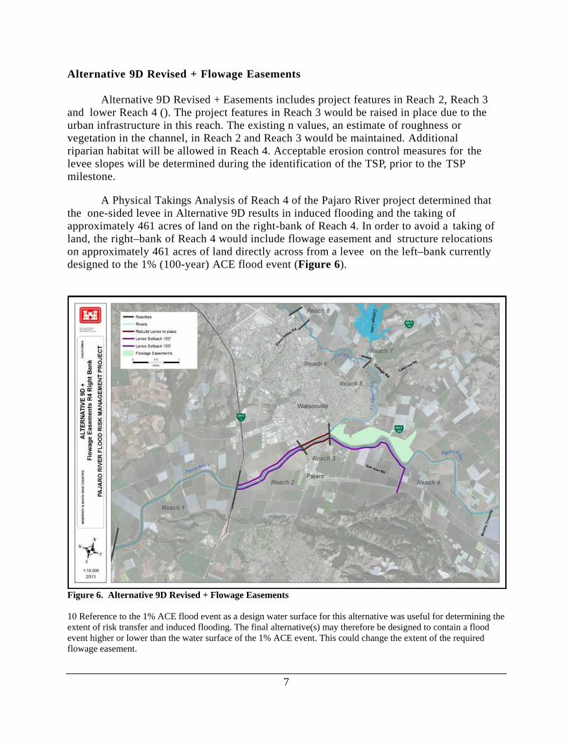
Alternative 9D Revised + Flowage Easements Alternative 9D Revised + Easements includes project features in Reach 2, Reach 3 and lower Reach 4 (). The project features in Reach 3 would be raised in place due to the urban infrastructure in this reach. The existing n values, an estimate of roughness or vegetation in the channel, in Reach 2 and Reach 3 would be maintained. Additional riparian habitat will be allowed in Reach 4. Acceptable erosion control measures for the levee slopes will be determined during the identification of the TSP, prior to the TSP milestone. A Physical Takings Analysis of Reach 4 of the Pajaro River project determined that the one-sided levee in Alternative 9D results in induced flooding and the taking of approximately 461 acres of land on the right-bank of Reach 4. In order to avoid a taking of land, the right–bank of Reach 4 would include flowage easement and structure relocations on approximately 461 acres of land directly across from a levee on the left–bank currently designed to the 1% (100-year) ACE flood event (Figure 6).
Figure 6. Alternative 9D Revised + Flowage Easements 10 Reference to the 1% ACE flood event as a design water surface for this alternative was useful for determining the extent of risk transfer and induced flooding. The final alternative(s) may therefore be designed to contain a flood event higher or lower than the water surface of the 1% ACE event. This could change the extent of the required flowage easement.

8
Alternative 9D Revised + Completion Measures The following 4 alternatives were developed to reduce the risk transfer associated with Alternative 9D in the most cost effective manner. Only one of the following four alternatives will be carried forward. Alternative 9D Revised + Completion Levee is the same as Alternative 9D Revised + Easements, accept the flowage easement would be replaced with a levee along the lower portion of Reach 4 right-bank (Figure 7).
Figure 7. Alternative 9D Revised + Completion Levee
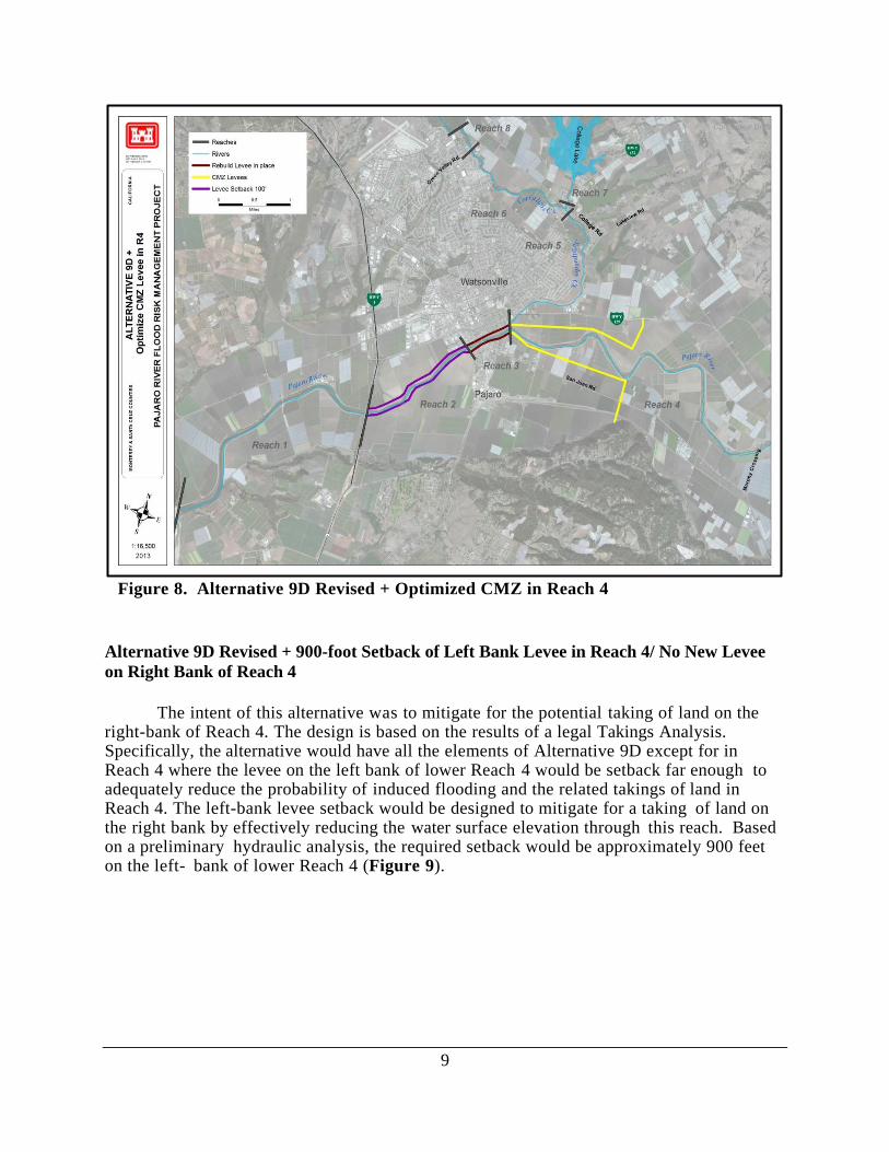
Alternative 9D Revised + Optimized CMZ in Reach 4 Alternative 9D Revised + Optimized CMZ in Reach 4 is the same as Alternative 9D Revised + Easements, accept the Reach 4 levees are designed to consider larger setbacks where space is available at meander bends in order to provide for cost savings on levee construction and O&M as well as to provide for a more self-sustaining channel (Figure 8).
9
Figure 8. Alternative 9D Revised + Optimized CMZ in Reach 4
Alternative 9D Revised + 900-foot Setback of Left Bank Levee in Reach 4/ No New Levee on Right Bank of Reach 4 The intent of this alternative was to mitigate for the potential taking of land on the right-bank of Reach 4. The design is based on the results of a legal Takings Analysis. Specifically, the alternative would have all the elements of Alternative 9D except for in Reach 4 where the levee on the left bank of lower Reach 4 would be setback far enough to adequately reduce the probability of induced flooding and the related takings of land in Reach 4. The left-bank levee setback would be designed to mitigate for a taking of land on the right bank by effectively reducing the water surface elevation through this reach. Based on a preliminary hydraulic analysis, the required setback would be approximately 900 feet on the left- bank of lower Reach 4 (Figure 9).

10
Figure 9. Alternative 9D Revised + 900’ Setback of Left Bank Levee in Reach 4/no New Levee on Right Bank of Reach 4
Alternative 9D Revised + Local Preference of 2% ACE Right–Bank Reach 4 This is the same alternative as Alternative 9D Revised + Completion Levee but the completion levee would be designed to the non-Federal sponsor’s preferred 2% ACE (e.g. 2% instead of 4%; 25-year instead of 50-year, ACE flood event) (Figure 10).

11
Figure 10. Alternative 9D Revised + Local Preference of 2% ACE Right–Bank Reach 4
Alternative LRP5: Locally Requested Plan 5 and a Potential Locally Preferred Plan (LPP) This alternative would include the same features in Reaches 2 and 3 as Alternative 9d, but new levees would be built that are set back 50’ from the river on both sides in Reach 4 where Alternative 9d does not have improvements (Figure 11). The levees would be raised to contain the 2% (50-year) ACE flood event water surface elevation. Reach 1 would remain unimproved as in Alternative 9d.

12
Figure 11. Alternative LRP 5

13
6.2 TRIBUTARY ALTERNATIVES Alternative T1: Raise in Place Levees Alternative T1 would raise levees in place and construct new floodwalls along the existing project alignment and along both banks of Corralitos Creek (Figure 12). This alternative would include a ring levee around Orchard Park.
Figure 12. Tributary Alternative T1 LT3/T4: Variable 225-foot setback levees and Orchard Park ring levee Alternative T3 & T4 are the same alternative with a scaling difference in setback widths. These have been combined into the one alternative and the PDT would determine the most

14
reasonable setback widths based on an optimization analysis. The levee design for the reaches of Salsipuedes and Corralitos Creek provides for the 1% (100-year) ACE flood9, 13. In Reach 5, flood risk management would be achieved by raising existing levees in place with a setback levee on the opposite bank (the setback side switches between right and left–banks), and constructing floodwalls or a combination levee with a floodwall on top where urban development prevents raising existing levees (Figure 13). In Reach 6, new levees would be built on both sides of the Creek, set back from the existing natural streambanks approximately 50–75 feet (edge of channel to centerline of levee). A 490–foot length of floodwall would be constructed on the right–bank at Marigold Avenue, with an average height of approximately 6 feet. In Reach 7, an earthen detention levee structure that transitions into a floodwall on the right–bank of Salsipuedes Creek would be constructed aligned along the northern border of the Orchard Park subdivision. Approximately 1,742 feet of the Pinto Creek ditch would be relocated to accommodate construction of the detention levee because it is situated within the footprint of the proposed levee embankment. Channel improvements downstream of College Lake would be implemented to ensure improved regulation of College Lake during large storm events. In Reach 8, new levee would be constructed on the left–bank only. In Reaches 5–8, both the waterside and landside slopes of the levees will be hydro–seeded to establish grassy vegetation. Alternative T4 will be the same as Alternative T3 except that levees in Reach 5 would only be setback 100’ rather than up to 225’ in some places.

15
Figure 13. Tributary Alternative T3/T4

16
Alternative T5: Urban 100-foot setback and Orchard Park ring levee Alternative T5 would include the same measures as Alternative T3/T4 but would exclude the levees along the left bank of Corralitos Creek (Figure 14). Instead, the PDT will determine if FRM measures such as ring levees or relocations are more cost effective for the Orchard Park subdivision and the School district building along Corralitos Creek.
Figure 14. Tributary Alternative T5

17
CMZ Self-Sustaining Channel Alternative The intent of this alternative (Figure 15) is to provide a baseline for addressing the geomorphic conditions of the Tributaries in the project design. Channel design was based on geomorphic characteristics of the tributary reaches and the channel width necessary for stabilizing the natural channel. In addition to providing more sustainable channel characteristics, benefits would include reduction in O&M costs, reduced levee lengths, increased habitat value, increased channel capacity, and additional floodplain functions.
Figure 15. Tributary Self-Sustaining Channel Alternative
18
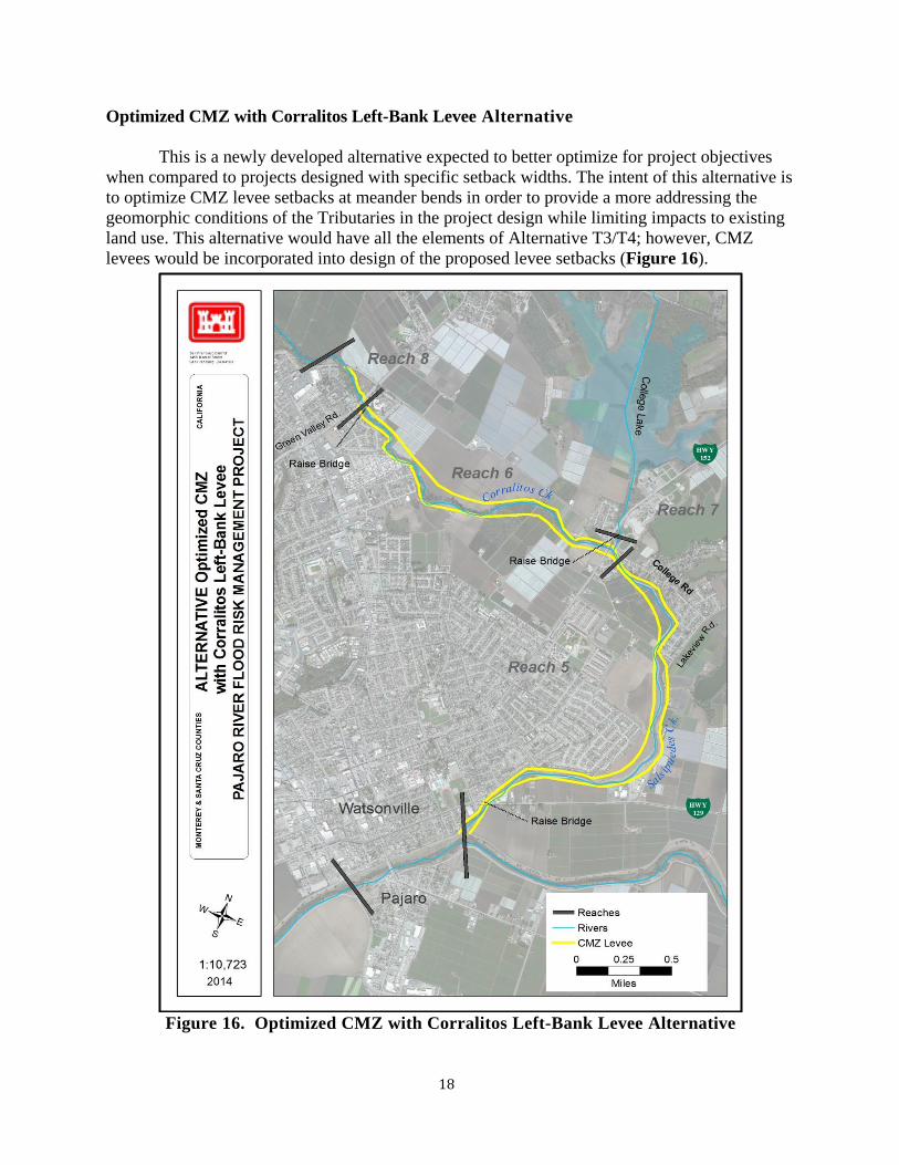
Optimized CMZ with Corralitos Left-Bank Levee Alternative This is a newly developed alternative expected to better optimize for project objectives when compared to projects designed with specific setback widths. The intent of this alternative is to optimize CMZ levee setbacks at meander bends in order to provide a more addressing the geomorphic conditions of the Tributaries in the project design while limiting impacts to existing land use. This alternative would have all the elements of Alternative T3/T4; however, CMZ levees would be incorporated into design of the proposed levee setbacks (Figure 16).
Figure 16. Optimized CMZ with Corralitos Left-Bank Levee Alternative
19
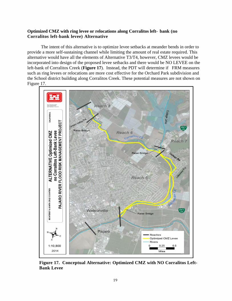
Optimized CMZ with ring levee or relocations along Corralitos left- bank (no Corralitos left-bank levee) Alternative The intent of this alternative is to optimize levee setbacks at meander bends in order to provide a more self-sustaining channel while limiting the amount of real estate required. This alternative would have all the elements of Alternative T3/T4, however, CMZ levees would be incorporated into design of the proposed levee setbacks and there would be NO LEVEE on the left-bank of Corralitos Creek (Figure 17). Instead, the PDT will determine if FRM measures such as ring levees or relocations are more cost effective for the Orchard Park subdivision and the School district building along Corralitos Creek. These potential measures are not shown on Figure 17.
Figure 17. Conceptual Alternative: Optimized CMZ with NO Corralitos Left-Bank Levee

20
Table 7. Focused Array of Alternatives, Description, Formulation Rationale, Justification for Retention Alternative
Basic Description
Formulation Rationale
Annual Chance of Exceedence (Level of
Protection)
Justification
No Action
The No Action Plan is synonymous with the "without- project condition." Major flooding concentrated in the areas along Corralitos and Salsipuedes Creek and the Pajaro River downstream of Murphy’s Road Crossing. ~2,400 structures located in the floodplain, highly developed urban area that contains a large portion of Watsonville's central business district and includes a shopping center and light industrial area.
The USACE of Engineers is required to consider the option of no action in accordance with the National Environmental Policy Act (NEPA).
12.5% (8-year) ACE flood event
Retained per NEPA requirements and for comparison purposes.
Mainstem Alternatives
1
Reaches 1,2,3,4 raise in place 4'. Levee with floodwall construction for Reach 3.
Levee/floodwall height at the Main Street Bridge restricted to 4 ft to preclude the need to modify the existing bridge.
3.3% (30-year) ACE flood event
Decision: retained for comparison as the "bare bones alternative." The build in place was also the starting point for how all alternatives were formulated. Decision 2: Agencies provide letters stating that build in place levees are not acceptable based on ESA and Clean Water Act concerns. This alternative would be difficult or impossible to permit and could result in jeopardy opinion. The PDT prefers a mitigation-in-place solution and developed alternatives with setback levees. This alternative will most likely be found to be unacceptable.
2A
100-foot setback plan with reduced channel vegetation in Reaches 1, 2, 4 and bench excavation in Reaches 2 and 4. Reach 3 Levee raise in place 4’.
Setbacks + bench excavation + reduced vegetation. This alternative was originally formulated to provide a 1% (100- year) ACE flood event level of protection. Design modifies Alt 2 design based on an assumption of reduced vegetation. The "n" value in Reach 2 would decrease from 0.06 to 0.04. The revised hydraulics resulted in a reduction in levee height of about a foot in Reaches 2 and 3, and an increase in levee height of about 0.5 ft upstream of the confluence with Salsipuedes Creek, in Reach 4. This alternative would rely on O&M to retain ACE through Reach 3.
1% (100-year) ACE flood event
Decision: retained for comparison. This is a discrete Alternative that was supported by all stakeholders in 2004 as the tentative NED. It illustrates the incremental cost increases keeping reach 1 and 4 as project features. Alts 2-3 all use various ways to reach the desired capacity. This alternative a conceptually similar alternative as alternatives 2 -3. Likely will be screened out because it is not efficient, does not optimize net benefits in portions of the projects. Portions of Reach 4 and Reach 1 are not independently economically justified based on the 2008 economic analysis
5B
Self-Sustaining Channel, 800-225 Foot Setback in R2, R4 (requires ~1150 acres). Only includes reaches shown to be economically justified (R2, R3, And lower R4).
Channel design was based on geomorphic characteristics of the Pajaro River and the width of channel necessary for a self- sustaining natural channel in the Pajaro Valley. Benefits would be reduction in O&M costs. Provides more room to locate borrow material for levee construction. Concern would be availability of real estate.
TBD
Retained to help define the cost and benefits associated with a self-sustaining river.

21
Alternative
Basic Description
Formulation Rationale
Annual Chance of Exceedence (Level of
Protection)
Justification
9
Ring Levee around Town of Pajaro. Reach 3 left-bank: levee raise + ring levee. Reach 3 right-bank raise in place levee with 4'-5' raise. Reach 2, right-bank: 100' Setback levee with 4-5' Raise. No improvements to Reach 1 or Reach 4
Designed to eliminate levees from not economically-justified reaches. This alternative modifies Alt 2A to remove Reach 1 and reduce the measures in Reach 4 to only those that provide FRM to the town of Pajaro The "9" alternatives started by formulating this ring levee alternative and then considered expanded ring levees for 9A-9D.
TBD
Decision: retained. At the current level of information it appears to be complete, and efficient. It is expected that this alternative will be screened out due to concerns related to human life and safety and social justice related to encircling a small town with a levee (may not be effective or acceptable). High costs to relocate railroad lines n o t included in current cost estimates.
9D Revised + Flowage
Easements
Reach 2 100’ Setback and raise 4-5'. Reach 3 Levee Raise in Place 4-5’. Reach 4 Left Bank levee setback 100’ with a tie in to high ground. Flowage easements on Reach 4 Right-Bank to mitigate for induced levee failure and taking of land.
Takings Analysis and need to avoid takings of land
TBD This alternative is considered complete with the additional of a measure that addresses the taking of land by reducing the risk transfer to an acceptable level.
9D Revised + Completion Levee
Reach 2 100’ Setback and raise 4-5'. Reach 3 Levee Raise in Place 4-5’. Reach 4 Left Bank levee setback 100’ with a tie in to high ground. Reach 4Right-Bank 100' foot setback completion levee to mitigate for induced levee failure and taking of land.
Takings Analysis and need to avoid takings of land
TBD
Decision: retained. Only one of these 9D Revised options will be retained in final array. At the current level of information it appears to be complete, efficient, effective, and acceptable. This alternative is considered complete with the additional of a measure that reduced the risk transfer to an acceptable level.
9D + CMZ
Reach 2 100’ Setback and raise 4-5'. Reach 3 Levee Raise in Place 4-5’. Reach 4 CMZ levees (levees cutting across meander bend –req. 219 acres) with potential for further setbacks to straighten levees in R2
Design for a more self-sustaining channel. Intent is to consider larger setbacks at the meander bends for levee design. This would shorten the constructed levee length but require more real estate. Benefits would be reduction in O&M costs and construction costs. Provides more room to locate borrow material for levee construction Concern would be availability of real estate.
TBD
Decision retained. Only one of these 9D Revised options will be retained in final array. At the current level of information it appears to be complete, efficient, effective, and acceptable. This 9D CMZ alternative is expected to be more self- sustaining than a project designed with specific setback widths. It is expected that the cost of levee construction will be reduced due to r e d u c e d levee length. The costs for real estate wi l l increase. Other benefits include reduction in O&M costs and increases to natural riverine and riparian habitats. There is also more room to locate borrow material for levees, which could lower construction costs. There is concern about the availability of real estate.
9D Revised + 900’ Left Bank Levee setback
Reach 2 100’ Setback and raise 4-5'. Reach 3 Levee Raise in Place 4-5’. One sided levee on the left bank of lower Reach 4 setback ~900’, no new levee on the right bank.
The Reach 4 left bank levee setback is big enough to mitigate for a taking of land on the right bank (attenuates flooding on the right bank for up to a 10% (10-year) ACE flood event
TBD
Decision: Retained. Only one of these 9D Revised options will be retained in final array. Retained as a potential completion measure to address the taking of land that occurs under Alt 9D. At the current level of information it appears to be complete, efficient, effective, and acceptable.
22
Alternative
Basic Description
Formulation Rationale
Annual Chance of Exceedence (Level of
Protection)
Justification
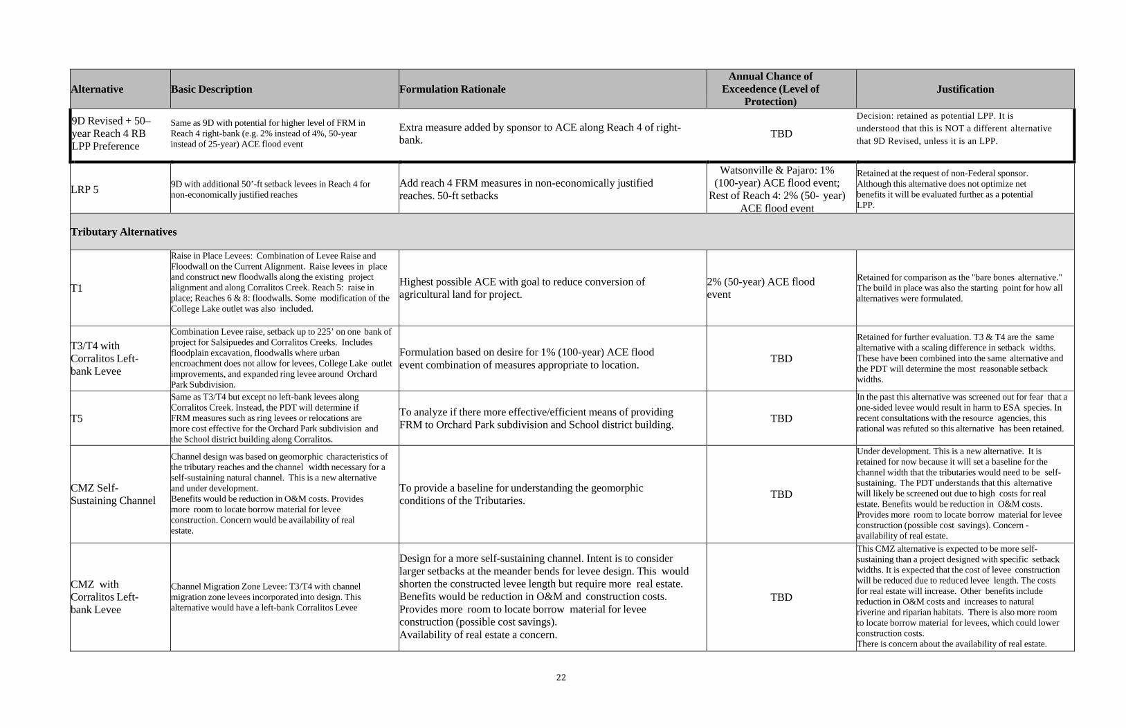
9D Revised + 50– year Reach 4 RB LPP Preference
Same as 9D with potential for higher level of FRM in Reach 4 right-bank (e.g. 2% instead of 4%, 50-year instead of 25-year) ACE flood event
Extra measure added by sponsor to ACE along Reach 4 of right- bank.
TBD
Decision: retained as potential LPP. It is understood that this is NOT a different alternative that 9D Revised, unless it is an LPP.
LRP 5 9D with additional 50’-ft setback levees in Reach 4 for non-economically justified reaches
Add reach 4 FRM measures in non-economically justified reaches. 50-ft setbacks
Watsonville & Pajaro: 1% (100-year) ACE flood event;
Rest of Reach 4: 2% (50- year) ACE flood event
Retained at the request of non-Federal sponsor. Although this alternative does not optimize net benefits it will be evaluated further as a potential LPP.
Tributary Alternatives
T1
Raise in Place Levees: Combination of Levee Raise and Floodwall on the Current Alignment. Raise levees in place and construct new floodwalls along the existing project alignment and along Corralitos Creek. Reach 5: raise in place; Reaches 6 & 8: floodwalls. Some modification of the College Lake outlet was also included.
Highest possible ACE with goal to reduce conversion of agricultural land for project.
2% (50-year) ACE flood event
Retained for comparison as the "bare bones alternative." The build in place was also the starting point for how all alternatives were formulated.
T3/T4 with Corralitos Left- bank Levee
Combination Levee raise, setback up to 225’ on one bank of project for Salsipuedes and Corralitos Creeks. Includes floodplain excavation, floodwalls where urban encroachment does not allow for levees, College Lake outlet improvements, and expanded ring levee around Orchard Park Subdivision.
Formulation based on desire for 1% (100-year) ACE flood event combination of measures appropriate to location.
TBD
Retained for further evaluation. T3 & T4 are the same alternative with a scaling difference in setback widths. These have been combined into the same alternative and the PDT will determine the most reasonable setback widths.
T5
Same as T3/T4 but except no left-bank levees along Corralitos Creek. Instead, the PDT will determine if FRM measures such as ring levees or relocations are more cost effective for the Orchard Park subdivision and the School district building along Corralitos.
To analyze if there more effective/efficient means of providing FRM to Orchard Park subdivision and School district building.
TBD
In the past this alternative was screened out for fear that a one-sided levee would result in harm to ESA species. In recent consultations with the resource agencies, this rational was refuted so this alternative has been retained.
CMZ Self- Sustaining Channel
Channel design was based on geomorphic characteristics of the tributary reaches and the channel width necessary for a self-sustaining natural channel. This is a new alternative and under development. Benefits would be reduction in O&M costs. Provides more room to locate borrow material for levee construction. Concern would be availability of real estate.
To provide a baseline for understanding the geomorphic conditions of the Tributaries.
TBD
Under development. This is a new alternative. It is retained for now because it will set a baseline for the channel width that the tributaries would need to be self-sustaining. The PDT understands that this alternative will likely be screened out due to high costs for real estate. Benefits would be reduction in O&M costs. Provides more room to locate borrow material for levee construction (possible cost savings). Concern - availability of real estate.
CMZ with Corralitos Left- bank Levee
Channel Migration Zone Levee: T3/T4 with channel migration zone levees incorporated into design. This alternative would have a left-bank Corralitos Levee
Design for a more self-sustaining channel. Intent is to consider larger setbacks at the meander bends for levee design. This would shorten the constructed levee length but require more real estate. Benefits would be reduction in O&M and construction costs. Provides more room to locate borrow material for levee construction (possible cost savings). Availability of real estate a concern.
TBD
This CMZ alternative is expected to be more self- sustaining than a project designed with specific setback widths. It is expected that the cost of levee construction will be reduced due to reduced levee length. The costs for real estate will increase. Other benefits include reduction in O&M costs and increases to natural riverine and riparian habitats. There is also more room to locate borrow material for levees, which could lower construction costs. There is concern about the availability of real estate.

23
Alternative
Basic Description
Formulation Rationale
Annual Chance of Exceedence (Level of
Protection)
Justification
CMZ with ring levee or relocations along Corralitos left- bank
CMZ Levee: same as above alternative but no levee along the left-bank or Corralitos levee. Instead, the PDT will determine if FRM measures such as ring levees or relocations are more cost effective for the Orchard Park subdivision and the School district building along Corralitos.
CMZ + To analyze if there are more effective/efficient means of providing FRM to Orchard Park subdivision and School district building.
TBD
This CMZ alternative is expected to be more self- sustaining than a project designed with specific setback widths. It is expected that the cost of levee construction will be reduced due to reduced levee length and the use of ring levees or relocations. The costs for real estate will increase. Other benefits include reduction in O&M costs and increases to natural riverine and riparian habitats. There is also more room to locate borrow material for levees, which could lower construction costs. There is concern about the availability of real estate.

24
7.0 EVALUATION OF FOCUSED ARRAY OF ALTERNATIVE PLANS (2014-2018) Each alternative in the focused array was independently evaluated prior to the Alternatives Milestone in December 2014. The following process was used:
• Perform economic optimization analysis to determine ACE of each project based on net benefits
• Develop and revise cost estimates for focused array alternatives. • Forecast a most likely with-project condition for each alternative. • Compare the without-project to the with-project condition, to determine
net benefits • Compare alternatives • Appraise the differences.
Each alternative will be evaluated individually by using the criteria shown in Table 10. Table 10. Evaluation Metric Criteria
Criteria Evaluation Metric National Economic Development (NED) NET Benefits Achieves Objectives:
Reduce the risk and consequences of flooding
on human life and safety
Number of residential structures, with population per structure Population at risk Critical Infrastructure-Life Safety Evacuation Routes
Reduce the risk of flood damages, including
critical infrastructure
NET Benefits Number of structures Effect on critical infrastructure; miles of roadway, reduction in anticipated interstate closure
Improve natural geomorphic processes and ecological functions in conjunction with other
FRM features
Feet of channel degradation/aggradation (stabilized sedimentation) Hydrologic connectivity Area of vegetation cover
Include environmentally sustainable designs
and construction methodologies and to minimize environmental impacts from future
operation and maintenance in conjunction with other FRM features.
Reduction in O&M requirements Footprint minimizes encroachment upon valuable habitat Efficient use of land resources and minimization of long-term adverse impacts to the site
Control the impacts of the project on the water environment during construction
Increase recreational opportunities in conjunction with FRM features and existing
land uses
Recreation area or miles of trails
Avoids Constraints Minimizes significant induced flooding; minimizes adverse impacts; minimizes impacts to CCSB
25
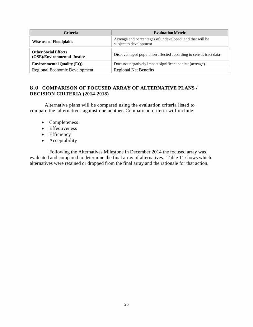
Criteria Evaluation Metric
Wise use of Floodplains Acreage and percentages of undeveloped land that will be subject to development
Other Social Effects (OSE)/Environmental Justice Disadvantaged population affected according to census tract data
Environmental Quality (EQ) Does not negatively impact significant habitat (acreage) Regional Economic Development Regional Net Benefits
8.0 COMPARISON OF FOCUSED ARRAY OF ALTERNATIVE PLANS / DECISION CRITERIA (2014-2018) Alternative plans will be compared using the evaluation criteria listed to compare the alternatives against one another. Comparison criteria will include:
• Completeness • Effectiveness • Efficiency • Acceptability
Following the Alternatives Milestone in December 2014 the focused array was evaluated and compared to determine the final array of alternatives. Table 11 shows which alternatives were retained or dropped from the final array and the rationale for that action.

Table 11. Evaluation of Focused Array of Alternatives Alternative Retained Dropped Rational No Action X The No-Action Plan is synonymous with the without project condition
Main Stem Alternatives
Alternative 1 X Build in place alternative not acceptable based on ESA and Clean Water Act Concerns. Would be difficult to permit and could result in jeopardy opinion.
Alternative 2A X Screened out because it was not efficient, and did not optimize net benefits in portion of the project. Portions of reaches 1 and 4 are not incrementally justified
Alternative 5B X High real estate cost and lack of landowner support for large setback area
Alternative 9 X Complete and Efficient, concern about ring levee around small city and high cost to relocate railroad lines
Alternative 9D Revised and Flowage Easements
X Cost of flowage easements in Reach 4, Right bank
Alternative 9D revised and Completion Levee
X Complete, Efficient, Effective, and Acceptable
Alternative 9D revised and CMZ Levees
X Complete, Efficient, Effective, an Acceptable. CMZ levees expected to be more self-sustaining, reduction in O&M Costs and increase to natural riverine and riparian habitats
Alternative 9D revised and 900’ left bank setback levee
X High real estate cost and lack of landowner support for large setback area
Alternative 9D revised and 50-year Reach 4 RB Completion Levee
X Complete, Efficient, Effective, and Acceptable, potential LPP
Tributary Alternatives
Alternative T1 X Build in place alternative not acceptable based on ESA and Clean Water Act Concerns. Would be difficult to permit and could result in jeopardy opinion.
Alternative T3/T4 with Corralitos Left-Bank
X Complete, Efficient, Effective, and Acceptable
Levee
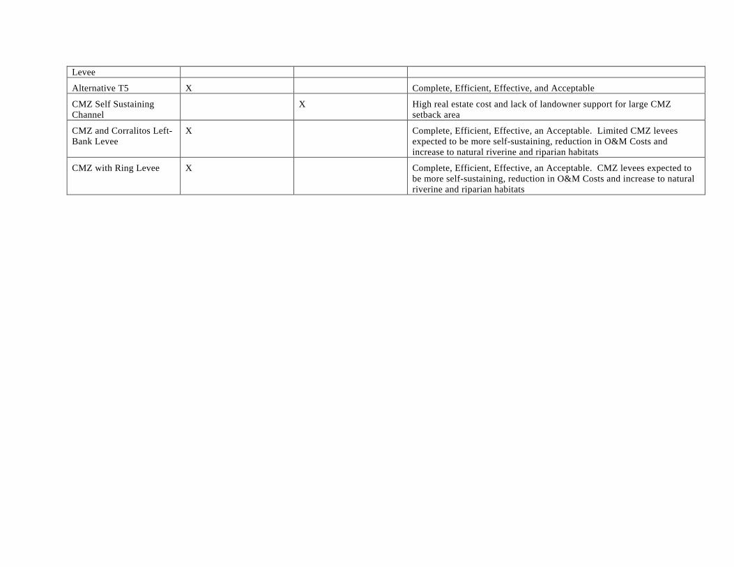
Alternative T5 X Complete, Efficient, Effective, and Acceptable
CMZ Self Sustaining Channel
X High real estate cost and lack of landowner support for large CMZ setback area
CMZ and Corralitos Left-Bank Levee
X Complete, Efficient, Effective, an Acceptable. Limited CMZ levees expected to be more self-sustaining, reduction in O&M Costs and increase to natural riverine and riparian habitats
CMZ with Ring Levee X Complete, Efficient, Effective, an Acceptable. CMZ levees expected to be more self-sustaining, reduction in O&M Costs and increase to natural riverine and riparian habitats

28
9.0 FINAL ARRAY OF ALTERNATIVES (2014-2018) The final array of alternatives are listed below. The tentatively selected plan will be the national economic development (NED) plan The project delivery team (PDT) evaluated two sets of four alternatives –one set of alternatives for the Main Stem Pajaro River and the other set for Corralitos and Salsipuedes Creeks (Tributary Alternatives). The following links the alternative names in the main document with the alternatives described in this plan formulation appendix: These include: 9.1 MAINSTEM ALTERNATIVES
• Alternative 1 (Alternative 9D Revised + Completion Levee with 4% Annual Chance Exceedance [ACE] Design Level in Reach 4 - Right Bank Agricultural Area)
• Alternative 2 (Pajaro Ring Levee + Protection to Urban Watsonville Area) • Alternative 3 (9D Revised + Optimized Channel Migration Zone [CMZ] with 4%
ACE Design Level in Reach 4 - Right Bank Agricultural Area) • Alternative 4 (9D Revised + Local Preference of 2% ACE Design Level in Reach 4 -
Right Bank Agricultural Area) 9.2 TRIBUTARY ALTERNATIVES
• Alternative 5 (T3/T4 – Variable 225-Foot Setback Levees and Orchard Park Ring Levee)
• Alternative 6 (T5 – Urban 100-Foot Setback and Orchard Park Ring Levee) • Alternative 7 (Optimized Channel Migration Zone [CMZ] with Corralitos Creek Left
Bank Levee) • Alternative 8 (Optimized CMZ with Orchard Park Ring Levee or Relocations along
Corralitos Creek Left Bank)
Table 12 provides a comparison of the Final Array of Alternatives to the Study Objectives.

29
Table 12: Comparison of the Final Array of Alternatives to the Study Objectives.
Final Array of Alternatives
Project Objectives
To reduce the risk of flooding on human life and safety in the City of Watsonville, town of Pajaro, and surrounding unincorporated lands.
To reduce the risk of flood damages, including critical infrastructure, in the City of Watsonville, Town of Pajaro, and surrounding unincorporated lands in the project area.
To improve natural geomorphic processes and ecological functions in conjunction with other flood risk management features in the project area.
To include environmentally sustainable designs and construction methodologies and to minimize environmental impacts from future operation and maintenance for the recommended plan in conjunction with other flood risk management features in the project area.
To increase recreational opportunities in conjunction with flood risk management features and existing land uses.
Mainstem Alternative 1 Yes Yes
Yes, setbacks levees in reaches 2 and 4 would improve the natural geomorphic function and ecologic functions
Yes, setback levee would provide environmentally sustainable designs and minimize environmental impacts.
Yes
Mainstem Alternative 2 Yes Yes
To some extent but only in Reach 2
To some extent but only in Reach 2
To some extent but predominantly on the Santa Cruz County side
Mainstem Alternative 3 Yes Yes
Yes, Setback levees in Reach 2 and CMZ levees in Reach 4 would improve the natural geomorphic and ecologic functions
Yes, Setback levees in Reach 2 and CMZ levees in Reach 4 would provide environmentally sustainable designs and minimize environmental impacts.
Yes
Mainstem Alternative 4 Yes Yes
Yes, setbacks levees in reaches 2 and 4 would improve the natural geomorphic function and ecologic functions
Yes, setback levees would provide environmentally sustainable designs and minimize environmental impacts.
Yes
Tributary Alternative 5 Yes Yes
Yes, setback levees in Reach 5 and 6 would improve the natural geomorphic and ecologic functions
Yes, setback levees in reaches 5 and 6 would provide environmentally sustainable designs and minimize environmental impacts.
Yes
Tributary Alternative 6 Yes Yes
Yes, setback levees in Reach 5 and 6 would improve the natural geomorphic and ecologic functions
Yes, setback levees in reaches 5 and 6 would provide environmentally sustainable designs and minimize environmental impacts
Yes

30
Tributary Alternative 7 Yes Yes
Yes, setback levees in Reach 5 and 6 would improve the natural geomorphic and ecologic functions
Yes, setback levees in reaches 5 and 6 would provide environmentally sustainable designs and minimize environmental impacts
Yes
Tributary Alternative 8 Yes Yes
Yes, setback levees in Reach 5 and 6 and CMZ levees would improve the natural geomorphic and ecologic functions
Yes, setback levees in reaches 5 and 6 would provide environmentally sustainable designs and minimize environmental impacts
Yes
Note - Information regarding the evaluation of the Final Array of alternatives and the determination of the Recommended Plan is presented in the Final GRR/EA.


![PAJARO RIVER FLOOD RISK MANAGEMENT GENERAL …...], for the Pajaro River Flood Risk Management Study (Pajaro Study), addresses flood risk in the City of Watsonville, the town of Pajaro,](https://static.fdocuments.us/doc/165x107/5e37354b8f8cd3125a068aa7/pajaro-river-flood-risk-management-general-for-the-pajaro-river-flood-risk.jpg)