Page 1© Crown copyright 2004 SOP-0 Implementation Jim Haywood (Met Office) Jacques Pelon (CNRS)...
26
© Crown copyright 2004 Page 1 SOP-0 Implementation Jim Haywood (Met Office) Jacques Pelon (CNRS) Tony Slingo (ESSC) Paola Formenti (LISA) Philippe Goloub (LOA) Sean Milton (Met Office)
-
date post
21-Dec-2015 -
Category
Documents
-
view
223 -
download
1
Transcript of Page 1© Crown copyright 2004 SOP-0 Implementation Jim Haywood (Met Office) Jacques Pelon (CNRS)...
© Crown copyright 2004 Page 1
SOP-0 Implementation
Jim Haywood (Met Office)Jacques Pelon (CNRS)
Tony Slingo (ESSC)
Paola Formenti (LISA)
Philippe Goloub (LOA)
Sean Milton (Met Office)

© Crown copyright 2004 Page 2
SOP-0 implementation
Objectives:
To provide high quality in-situ and remote sensing measurements of mineral dust and biomass burning aerosol and combinations of the two
To provide high quality spectral measurements of the effects of aerosol upon the radiation budget.
To determine the consistency of in-situ/satellite/ surface based observations/retrievals
To better determine the source regions, source strengths and emission factors of aerosols/gases.
Improvement and validation of numerical models (global and regional, climate and NWP)

ESSC, Reading University, 13 May, 2004

© Crown copyright 2004 Page 4
Mineral dust
Fires (red boxes)Smoke
Gulf of Gineau
SOP-0 implementation
MODIS image, 7th January 2005

© Crown copyright 2004 Page 5
When: January – February, 2006 (SOP-0).Resources:
Aircraft (based in Niamey / Dakar) F20 (40.5hours) ATR-42 (49.5hours) BAe146 (40hrs +40hrs(?))
Surface sites Banizoumbou, Djougou, M’Bour (fully equipped
including aerosol lidar, aerosol and radiation equipment)
CIMELS sunphotometers (8 sites) Mobile ARM facility (Niamey)
Radiosonde ascents 2/day from sites within aircraft operating range
SOP-0
© Crown copyright 2004 Page 6
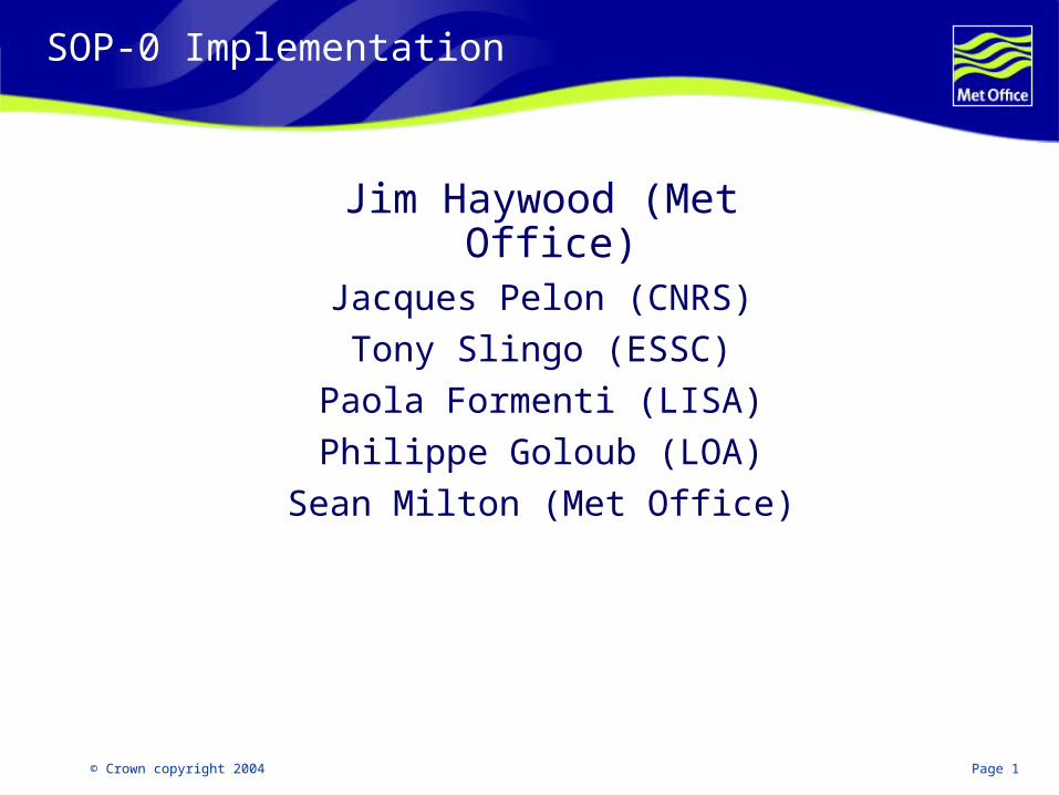
Aircraft Capabilities
Aircraft: F20 ATR-42, BAe146
Operating altitude:
500ft-42,000ft
500ft-25,000ft
50ft-35,000ft
Payload: 1200kg 2500kg 4000kg
Range: 3,200km 3,000km 3,700km
Staffing: 4scientists 7 scientists 2crew
3 crew, 18 scientists
Duration 4.5hours 5.5hours 5.5hours
© Crown copyright 2004 Page 7
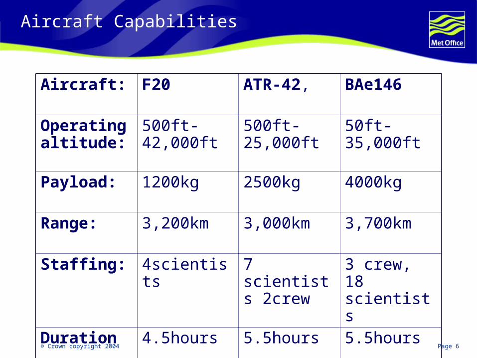
F20 aircraft (concentrate on remote sensing)
The F20 aircraft will perform remote sensing and radiation measurements:-
• Aerosol profiles (lidar LEANDRE New generation (LNG))
• Brightness temperatures (DIRAC IR radiometer)
• Aerosol Optical thickness, Size Distribution (OSIRIS and MINIMIR+MICROPOL, polarization and directionality of earth reflectances from 440 to 2200 nm)
• Brightness temperatures (CLIMAT Multichannel thermal infrared radiometer)
© Crown copyright 2004 Page 8
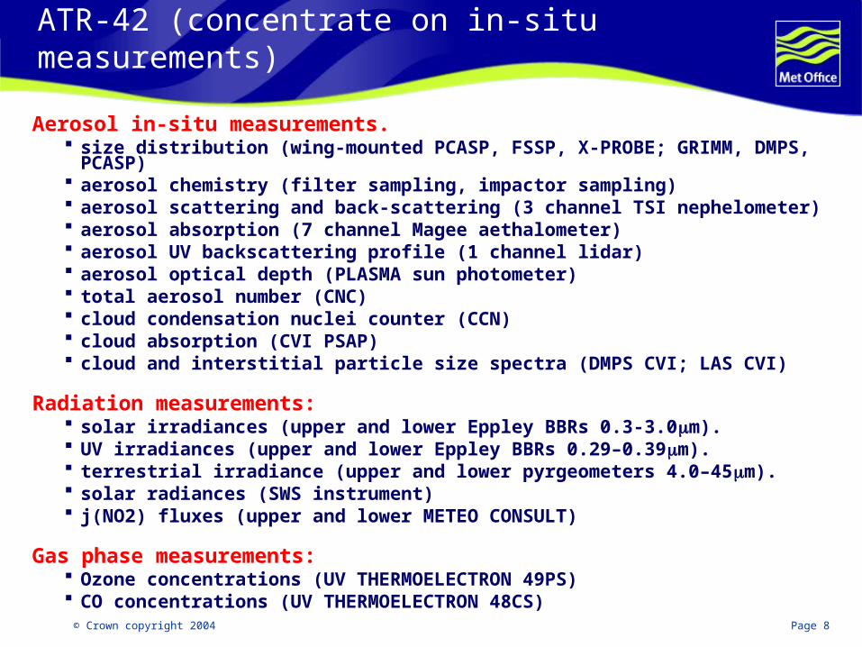
ATR-42 (concentrate on in-situ measurements)
Aerosol in-situ measurements. size distribution (wing-mounted PCASP, FSSP, X-PROBE; GRIMM, DMPS, PCASP) aerosol chemistry (filter sampling, impactor sampling) aerosol scattering and back-scattering (3 channel TSI nephelometer) aerosol absorption (7 channel Magee aethalometer) aerosol UV backscattering profile (1 channel lidar) aerosol optical depth (PLASMA sun photometer) total aerosol number (CNC) cloud condensation nuclei counter (CCN) cloud absorption (CVI PSAP) cloud and interstitial particle size spectra (DMPS CVI; LAS CVI)
Radiation measurements: solar irradiances (upper and lower Eppley BBRs 0.3-3.0m). UV irradiances (upper and lower Eppley BBRs 0.29–0.39m). terrestrial irradiance (upper and lower pyrgeometers 4.0–45m). solar radiances (SWS instrument) j(NO2) fluxes (upper and lower METEO CONSULT)
Gas phase measurements: Ozone concentrations (UV THERMOELECTRON 49PS) CO concentrations (UV THERMOELECTRON 48CS)
© Crown copyright 2004 Page 9
BAe146 instrumentation (in-situ & remote sensing)
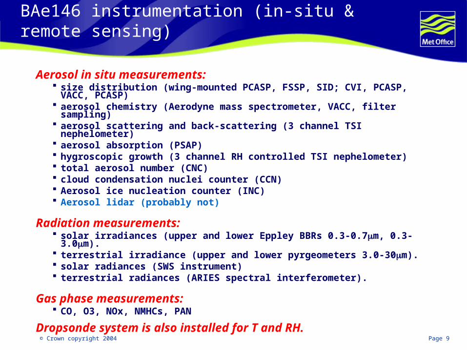
Aerosol in situ measurements: size distribution (wing-mounted PCASP, FSSP, SID; CVI, PCASP, VACC,
PCASP) aerosol chemistry (Aerodyne mass spectrometer, VACC, filter sampling) aerosol scattering and back-scattering (3 channel TSI nephelometer) aerosol absorption (PSAP) hygroscopic growth (3 channel RH controlled TSI nephelometer) total aerosol number (CNC) cloud condensation nuclei counter (CCN) Aerosol ice nucleation counter (INC) Aerosol lidar (probably not)
Radiation measurements: solar irradiances (upper and lower Eppley BBRs 0.3-0.7m, 0.3-3.0m). terrestrial irradiance (upper and lower pyrgeometers 3.0-30m). solar radiances (SWS instrument) terrestrial radiances (ARIES spectral interferometer).
Gas phase measurements: CO, O3, NOx, NMHCs, PAN
Dropsonde system is also installed for T and RH.
© Crown copyright 2004 Page 10
Surface sites - Banizoumbou, Djougou, M’Bour
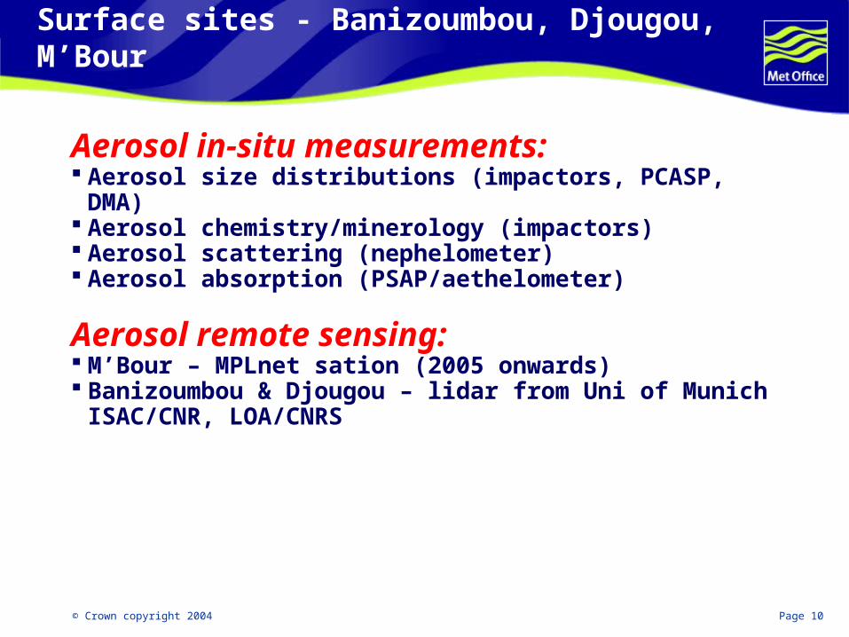
Aerosol in-situ measurements: Aerosol size distributions (impactors, PCASP, DMA) Aerosol chemistry/minerology (impactors) Aerosol scattering (nephelometer) Aerosol absorption (PSAP/aethelometer)
Aerosol remote sensing: M’Bour – MPLnet sation (2005 onwards) Banizoumbou & Djougou – lidar from Uni of Munich
ISAC/CNR, LOA/CNRS

© Crown copyright 2004 Page 11
CIMELS sites
SITE Country Date Long (°) Lat(°) P.I
Capo_Verde Capo_Verde 10.1994 -22.935 16.733 -D. Tanré
Ouagadougou Burkina_Faso 11.1994 -1.4000 12.200 D. Tanré
Banizoumbou Niger 10.1995 2.6648 13.541 D. Tanré
Niamey Niger 01.2006 2.1761 3.467 M Miller
Dakar,M’Bour Sénégal 12.1996 -16.959 14.394 D. Tanré
Agoufou Mali 10.2002 -1.4666 15.333 P. Goloub
Djougou Benin 2.2004 1.5833 9.7500 P. Goloub
CinZana Mali 6.2004 -5.9 13.16 B. Chatenet

© Crown copyright 2004 Page 12
ARM Mobile Facility
ARM mobile facility to be located at Niamey airport
(Tony Slingo, PI Radagast, Peter
Lamb)

© Crown copyright 2004 Page 13
ARM Mobile facility measurements (RADAGAST)
Atmospheric Profiling Balloon-borne Sounding System (BBSS) Microwave Radiometer Profiler (MWR-P). 5-minute temperature, vapour, and
liquid water content profileClouds W-band (95 GHz) Cloud Radar. Microwave Radiometer (MWR) Micropulse Lidar (MPL) Vaisala Ceilometer (VCEIL) Total Sky Imager Radiometers Marine Atmospheric Emitted Radiance Interferometer (MAERI). IR interferometer. Infrared Thermometer (IRT) Multifilter Rotating Shadowband Radiometer (MFRSR) Broad-Band Instruments
Pyranometers Pyrgeometers Pyrheliometers
Radiometric Instrument Systems (groupings of individual broadband instruments at sites)
Upwelling Radiation (GNDRAD) Downwelling Radiation (SKYRAD)
Surface Meteorology Eddy Correlation Flux Measurement System (ECOR) Surface Meteorological Instruments (SMET)
© Crown copyright 2004 Page 14
Radiosonde asents/local synoptic visibility measurements
Radiosonde ascents will be requested 2 times/day during the SOP-0 at sites close to the aircraft operations.
Local synoptic visibility/significant weather from Met stations will be reported to the operations centre at Niamey airport.
© Crown copyright 2004 Page 15
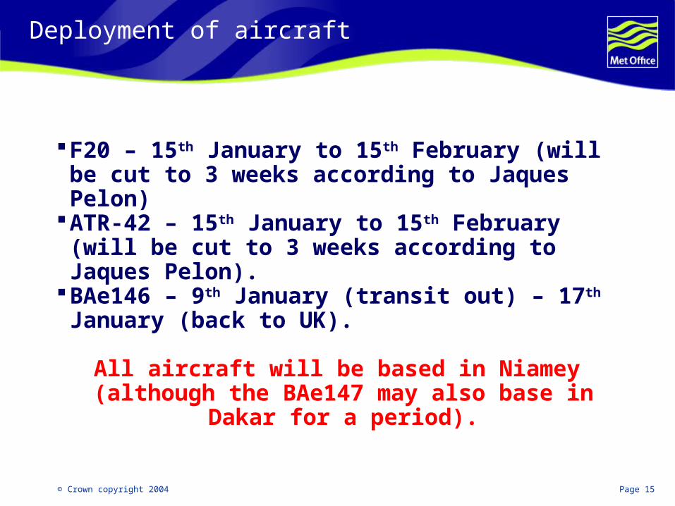
Deployment of aircraft
F20 – 15th January to 15th February (will be cut to 3 weeks according to Jaques Pelon)
ATR-42 – 15th January to 15th February (will be cut to 3 weeks according to Jaques Pelon).
BAe146 – 9th January (transit out) – 17th January (back to UK).
All aircraft will be based in Niamey (although the BAe147 may also base in Dakar for a period).
© Crown copyright 2004 Page 16
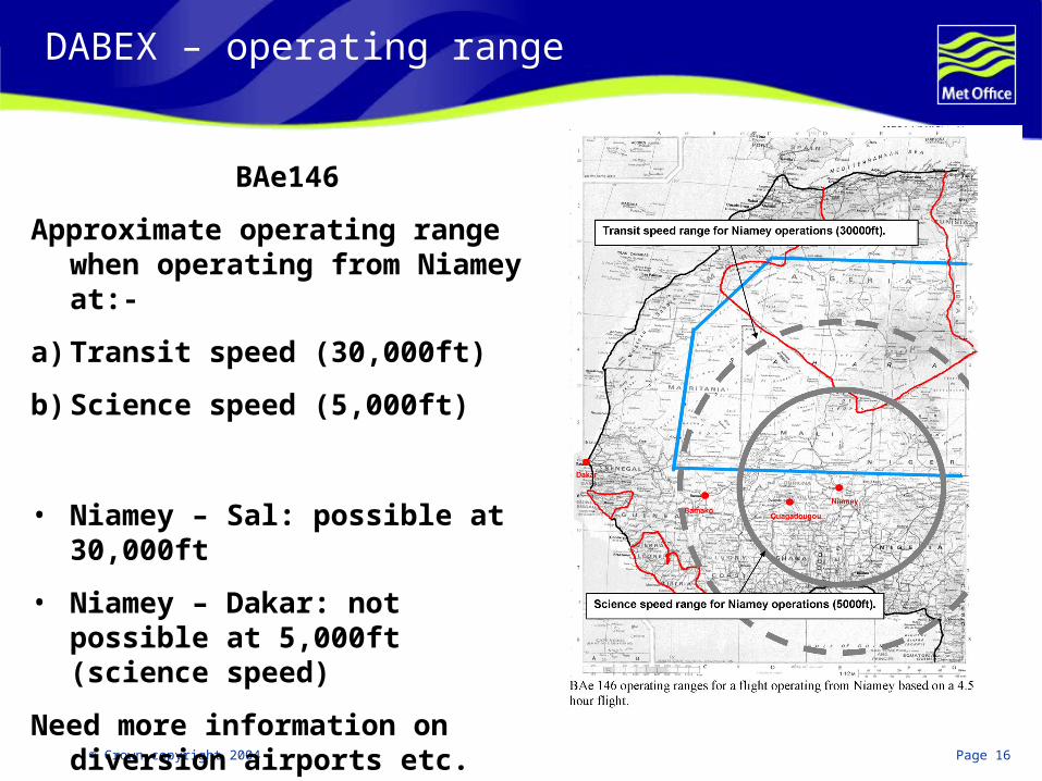
DABEX – operating range
BAe146
Approximate operating range when operating from Niamey at:-
a) Transit speed (30,000ft)
b) Science speed (5,000ft)
• Niamey – Sal: possible at 30,000ft
• Niamey – Dakar: not possible at 5,000ft (science speed)
Need more information on diversion airports etc.
© Crown copyright 2004 Page 17
Satellite retrievals (aerosol)
Polar orbitting satellites with confirmed interest:-MODIS (Kaufman)MISR (Kahn)AATSR (de Leuuw)
Geostationary satellite with confirmed interest:-MSG-8 GERB (Slingo)MSG-8 (Brindley)

© Crown copyright 2004 Page 18
Modelling – NWP & climate models in the Met Office
Met Office global NWP and CAM models have been trialling inclusion of mineral dust. Climate model simulations need improvement via validation.
NWP modelsa) Initial calculations have been performed using fixed climatologies
and show a relatively large effect on AEJ.b) Further calculations are planned using interactive dust model
(under development). The data from SOP-0 will be used for improving the physical and radiative properties of mineral dust and biomass burning particles and for validation of the production/transport/ deposition of aerosols.
Climate modelsa) Biomass burning and mineral dust modules are included, but they
are poorly constrained and do not interact with each other. The model can be driven by meteorological data. Data will be used for both improving the aerosol parameterisations in the climate model.

© Crown copyright 2004 Page 19
Training
Wherever possible African meteorologists/ scientists will be encouraged to fully participate in:-
a)Flight planningb)Flight decision makingc)Flight debriefs
New CAO regulations make it difficult to carry ‘unauthorised’ scientists on the BAe146 which is the only practical aircraft for flying guest scientists.
© Crown copyright 2004 Page 20
Supplemental science follows:
© Crown copyright 2004 Page 21
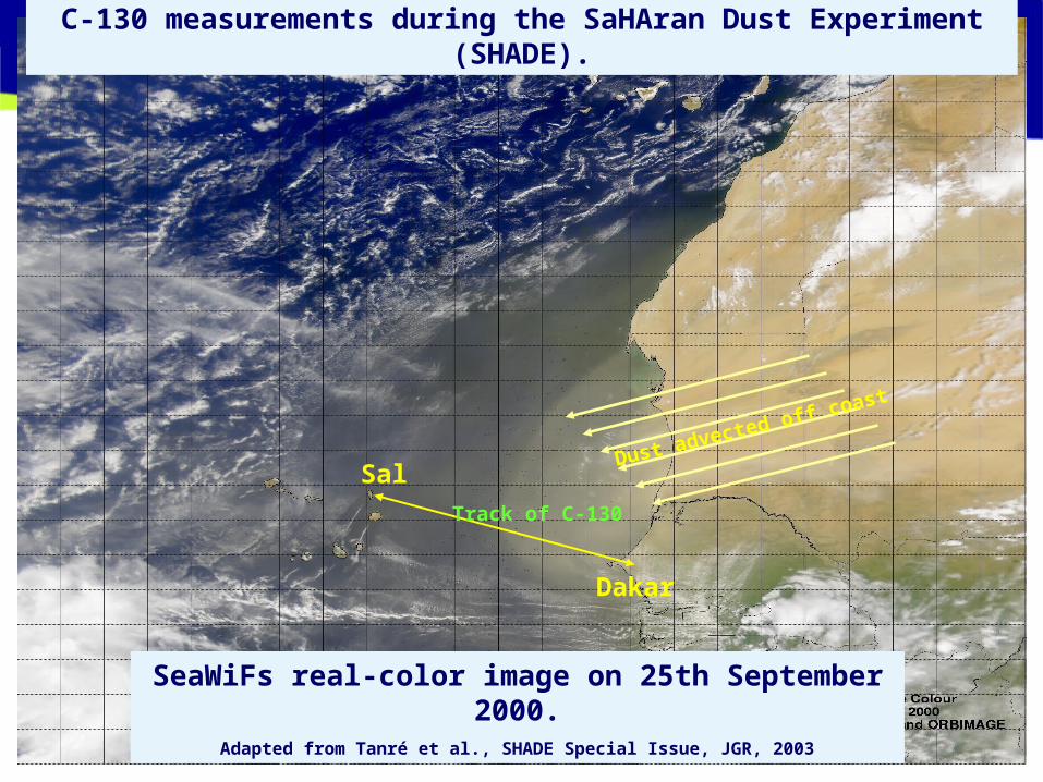
Sal
Dakar
SeaWiFs real-color image on 25th September 2000.
Adapted from Tanré et al., SHADE Special Issue, JGR, 2003
C-130 measurements during the SaHAran Dust Experiment (SHADE).
Dust advected off coast
Track of C-130
© Crown copyright 2004 Page 22
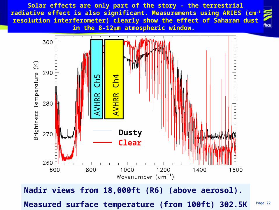
Solar effects are only part of the story - the terrestrial radiative effect is also significant. Measurements using ARIES (cm-1 resolution interferometer) clearly show
the effect of Saharan dust in the 8-12m atmospheric window.
ClearDusty
AV
HR
R C
h4
AV
HR
R C
h5
Nadir views from 18,000ft (R6) (above aerosol).
Measured surface temperature (from 100ft) 302.5K
ESSC, Reading University, 13 May, 2004
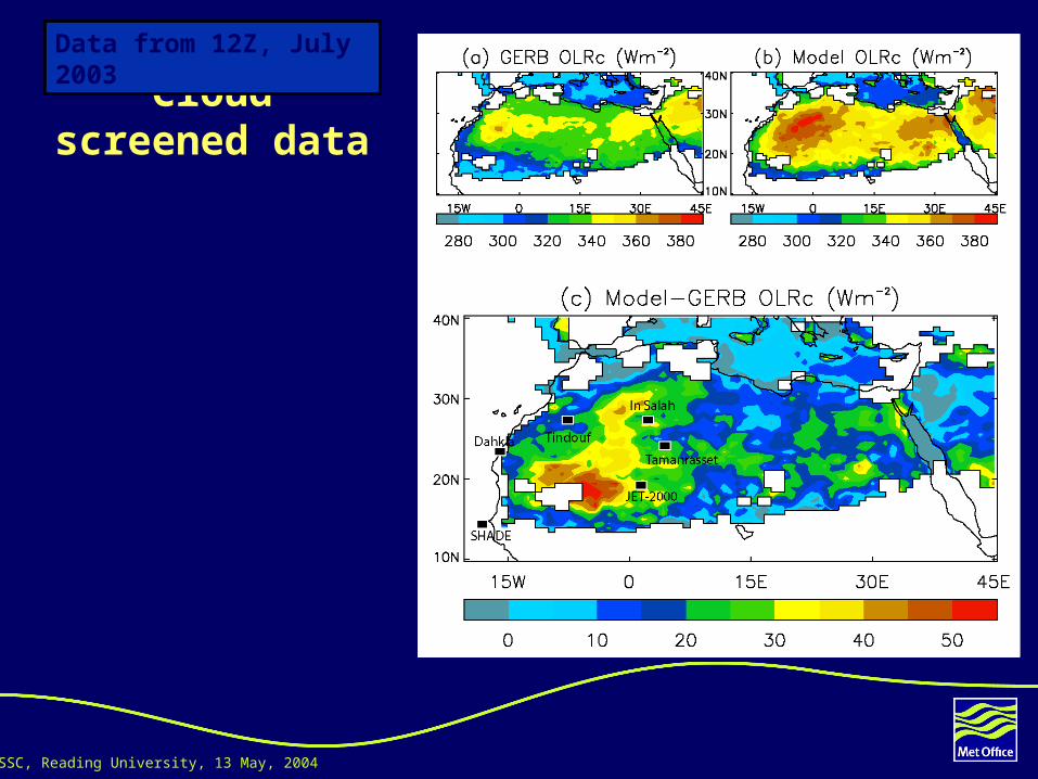
Cloud screened data
The Geostationary Earth Radiation Budget
instrument (GERB) shows significantly less OLR over
regions of the desert during July 2003. What is
the explanation?
Data from 12Z, July 2003

ESSC, Reading University, 13 May, 2004
If we account for the effect of the aerosol on the SW at the surface which reduces the surface temperature and hence reduces the OLR as well, we end up with this.
Which is in good agreement with the dOLR between GERB and the UM.

NWP seminar, 16 July, 2004
dOLR 12Z on 2/07/2003 (24H forecast from 01/07/2003)
OSW Control – OSW Aerosol
Increased reflectionDecreased/neutral reflection
NWP seminar, 16 July, 2004
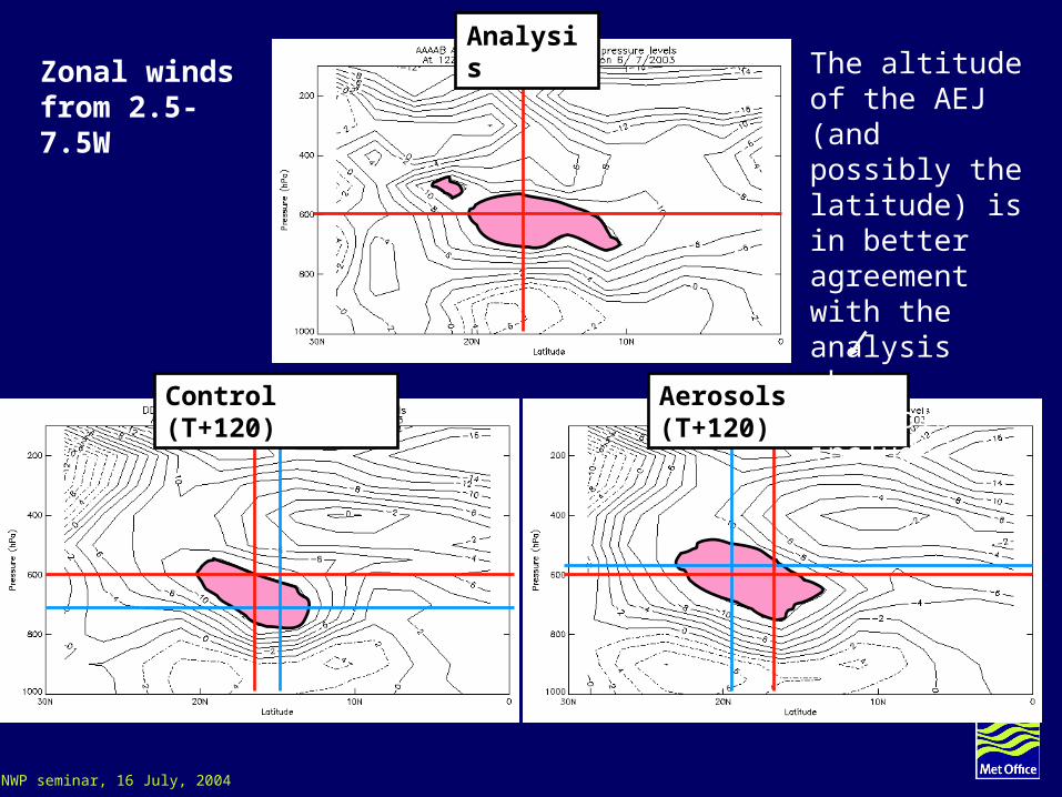
Analysis
Control (T+120) Aerosols (T+120)
The altitude of the AEJ (and possibly the latitude) is in better agreement with the analysis when aerosols included
Zonal winds from 2.5-7.5W