Munehiko Yamaguchi Meteorological Research Institute of Japan Meteorological Agency

WORLD METEOROLOGICAL ORGANIZATION_________________________
REGIONAL ASSOCIATION I
IMPLEMENTATION - COORDINATION MEETING ON THE GTS IN RA I
DAKAR, 28 FEBRUARY-3 MARCH 2006
RA I/ICM-GTS 2006/Doc. 3.2&4(22.II.2006)
____________
ITEM 3.2 and 3.4
ENGLISH only
INFORMATION AND COMMUNICATION TECHNOLOGIES FOR UPGRADING THE GTS
(Origin: Garry Clarke, New Zealand, RA V/WG-PIW)
The document provide detailed information on the very positive experience gained in the South Pacific (WMO Region V) in using RANET satellite data-distribution coupled
with E-mail communications via digital HF. The meeting is invited to consider how these cost-effective techniques could be used in Africa to improve the regional and
national GTS components implementation and operation.
Contents
Pacific RANET Overview...........................................................................................2What is RANET?..................................................................................................2Technology :.........................................................................................................3Pacific RANET......................................................................................................4
RANET Data feed........................................................................................................6Introduction:..........................................................................................................6What is the RANET DATA feed?..........................................................................6How does RANET deliver the data?.....................................................................6Satellite Coverage................................................................................................7
RANET Transmission Schedule..............................................................................11Current schedule................................................................................................11Feeding the data broadcast................................................................................11Possible regional solutions.................................................................................12Agency Benefits..................................................................................................13What does the broadcast look like ?..................................................................13RANET Project future 2006................................................................................15

RA I/ICM-GTS 2006/Doc. 3.2&4, p 2
Pacific RANET Overview
What is RANET?
RANET is an international collaboration to make weather, climate, and related information more accessible to remote and resource poor populations to aid day-to-day resource decisions and prepare against natural hazards. The program combines innovative technologies with appropriate applications and partnerships at the community level to ensure that the networks created serve the entirety of community information needs and is therefore more sustainable
The consortium that comprises RANET is a varied list of organisations that believe that environmental information, while not a panacea to the numerous challenges that face many communities, is nonetheless a vital component of any sustainable development strategy.
RANET activities include training, pilot activities to demonstrate various community technologies, and development of a dissemination network through partnership and platform development.
Africa RANET
RANET began its first pilot activities in Africa. With support from the USAID Office of Foreign Disaster Assistance, the African Centre of Meteorological Applications for Development (ACMAD) began demonstrations and program development in six African countries: Chad, Kenya, Mozambique, Niger, Senegal, Zambia. Three years later the lessons learned in these countries resulted in RANET developing programs or exploring opportunities in 16 other African nations. In addition the lessons from Africa, in particular the application of innovative satellite technologies, have led RANET to begin pilot applications in Asia, and the Pacific.
Several of the participating African countries remain the most advanced of RANET activities. In particular Niger has developed and pioneered Community Communications Centres for Development. Centered around an low-amplitude FM community radio station, these Centres comprise a local commission that own and oversee the manage of the communication network. The Centres are connected to regional and national information sources via digital satellite radio and human extension networks. The incoming information is then blended with locally produced programming and further disseminated in local languages and of local interest.
Following just a few demonstration sites managed by RANET participants, the program has since expanded and led to the development of several dozen more Community Communications Centres for Development by other NGOs and development organisations. Most importantly the communities themselves have requested the assistance and development of these centres.
Based on affordable technology that is easily serviced in the most remote regions, the Centres have led to benefits other than the dissemination of simple climate and weather products. Several communities have noted a benefit of reduced crime, been able to put out a local fire by putting out a call for help, and potentially reduced the spread of a measles outbreak by suggesting that individuals not make courtesy visits to infected friends and relatives. The Community Centres of Niger represent a true integration of appropriate technologies in the local social fabric.

RA I/ICM-GTS 2006/Doc. 3.2&4, p 3
The Uganda program activities are representative of other system model where information is disseminated not through community centres but rather through a network of partnering NGOs. In particular the national weather service of Uganda partners with WorldVision and ActionAid to develop an extension network. Using the First Voice International digital satellite radio broadcast, the weather service is able to disseminate agrometeorological bulletins, crop prices, and other information to remote locations throughout the country. The NGO field offices are then able to place the information on community bulletin boards, deliver it through word-of-mouth networks, and there is some development of broadcasting the information over existing FM radio stations. In total some 40 sites now exist throughout the country due to RANET-Uganda's efforts, thereby getting vital forecast and other information to rural areas. In addition the network is also being used to disseminate other development information, such as HIV/AIDs awareness and educational material.
Technology :
RANET works to identify and train partners in the use of various technologies that are most appropriate for their information needs and are serviceable in their area. Aside from identifying a variety of techniques, RANET works to gain access for rural populations to "common networks" -- large systems likely inaccessible by any one group, but useable by RANET and its partners when used together. Additionally, RANET works to integrate existing networks thereby reinforcing local, existing capabilities -- rather than developing new, resource intensive and unstable networks.
In Africa one of the more successful systems has been an integration of new and existing analogue (FM/AM) radio stations with new digital radio satellite technologies, as provided through the First Voice International. Combined together these technologies allow for both local knowledge and new information to be used in support of rural populations. Radio is one of the most pervasive technologies in use throughout the globe, and RANET's inclusion of radio in its network design helps to ensure the program builds upon existing capabilities, is community owned and operated, locally relevant, and is therefore more sustainable.
Many development projects with a component of telecommunications technology are vulnerable unless appropriate and sustainable solutions are identified and deployed. The lessons learned by RANET underscore the need for a period of consistent follow-up and technical support until the introduced systems, or new integrated networks, can be fully supported locally (or within a region), and therefore be considered sustainable. Such a transition period means identifying serviceable technologies, identifying existing networks and capabilities, training, and the development of a support community. For this reason RANET is embarking on new education and training programs, which allow participants to solve problems that arose during implementation (including revenue generation and sustainability), learn from each other's experiences, and build upon the basic knowledge gained in the initial training sessions and project development
RA I/ICM-GTS 2006/Doc. 3.2&4, p 4
Pacific RANET
Based on the above African model a number of RANET projects have been established in Pacific Island States, with funding and technical assistance from US NOAA OGP, US NOAA NWS, USAID, MetService of New Zealand Ltd., NZAID, Australian Bureau of Meteorology, AusAID, and UK Met Office.
Three initial pilot projects received donations of FM Community Radio stations from ACMAD and a FM Community Radio station manufacturer Wantok Enterprises of Canada. These three pilot projects were at Woleai Atoll, YAP State, Micronesia, Siviri Village, Vanuatu and Liku Village, Niue.
In Africa the First Voice International satellite broadcast on the WorldSpace AfriStar satellite is the backbone for the transmission of information For Africa RANET. In the Pacific we are not so fortunate as there isn’t a Central Pacific WorldSpace Satellite to transmit the broadcast. The WorldSpace AsiaStar satellite in geostationary orbit above Singapore provides a First Voice International signal into the Western Pacific but this is out of the primary footprint of the satellite and requires the use of a 2.4m C-Band satellite dish antennas to receive the weak signal. This signal is usable out to about the dateline but east of the dateline another transmission backbone is required.
Internet email using an HF transceiver and the Pactor digital transmission protocol had been trialed between Tuvalu and New Zealand with some success and this was trialed as a Pacific RANET transmission option. The advantage this offered over the receive-only First Voice International satellite broadcast was that it was a two-way system and allowed feedback and messages to be transmitted back from the remote site. The disadvantage was the low bandwidth of HF Radio Pactor transmission but this really was not a concern with the low volume normal text based meteorological messages.
RA I/ICM-GTS 2006/Doc. 3.2&4, p 5
In the Western Pacific by combining both these systems we are able to provide high-speed inward data via the WorldSpace satellite First Voice International data channel and a two-way slow-speed email channel via HF radio. Because of no WorldSpace coverage east of the dateline HF radio email can be supplemented by the EMWIN or LRIT higher speed data streams from GOES West.
With HF email a laptop or PC is connected to a HF radio modem which in turn controls a HF radio transceiver. Appropriate HF email software is required. In the SW Pacific we are using the Airmail software.
Airmail is a messaging program (similar to Outlook) specifically designed for connection to a HF radio mail-server station. Once connected to a compatible station, message transfer is completely automatic.
Airmail is a 32-bit program which runs under Windows-95, 98, NT, 2000 or XP. Airmail supports the SCS PTC-II and PTC-IIe Pactor-2 modems as well as the original PTC Pactor modem, the Kantronics KAM+ and KAM-98, AEA/Timewave PK-232, PK-900, DSP-1232 and 2232, the MFJ 1276 and 1278B, and the HAL DXP-38 Clover/Pactor modem. (Sound cards are not supported).
Airmail is a program developed specifically for sending messages via HF radio and optimized for low-speed links, not an adaptation of an ordinary email.
Both the uplink for the First Voice International RANET Data channel and the primary HF Email Server station are supported by the Australian Bureau of Meteorology from their main offices in Melbourne. Email messages received containing properly formatted weather bulletins using WMO Abbreviated Bulletin Headers are automatically switch to the GTS while other emails containing Internet email addresses are delivered via the Internet.
The Airmail software contains a telnet client that allows users with an Internet connection the ability to use this telnet client to send and received emails via the internet using a local ISP. Satellite phones that are data capable can also be used to access the Internet and transfer messages with the Airmail Telnet client. This means the same email client on a laptop or PC is able to transfer messages using HF radio, a standard Internet connection or via a data capable satellite phone.
Following on from the initial three demonstration sites in the Pacific further RANET systems have been installed in Tuvalu and Kiribati. Both the National Meteorological Service’s of these countries have unreliable communications from the local provider and since the installation of the RANET systems have been using the HF email systems to transfer their meteorological bulletins to the GTS via the Melbourne RANET HF gateway. The use of this RANET HF system has seen an improvement in the collection of GSN and GUAN data from these countries.
The RANET HF radio network is also ideal as a low cost communications system to collect data from Automatic Weather Stations (AWS). One AWS in Tuvalu has been interfaced into to the RANET HF system and this station’s reports are collected via HF radio.
A Pacific wide network of RANET systems is envisaged with additional HF server stations to transfer the HF email messages to the internet and GTS. The Niue Government has just given approval for a RANET HF server station at the Niue

RA I/ICM-GTS 2006/Doc. 3.2&4, p 6
Meteorological Service. The additional HF server stations will be able to share the traffic and decrease the likelihood of poor HF radio propagation or station technical problems impacting on the throughput of meteorological messages.
RANET Data feed
Introduction:
One key component of the RANET strategy is to provide a free and accessible source of information to remote communities. In the Asia Pacific region one electronic method of delivering significant volumes of information is via the current RANET Satellite system. Although the system is currently focused on meteorological information at the moment , it is also capable of and intended to carry other community focused information as the system expands.
What is the RANET DATA feed?
The RANET DATA feed is a single compilation of a number of sources. These sources include
Internet page grabs Direct GTS switches McIdas Satellite output FTP data ingestions Forecasting model output Email ingestion
This delivers the following unidentifiable products over the satellite system
Forecasts and Warnings Satellite imagery Tidal and climate information Nations meteorological services web pages
All these sources are compiled in the Melbourne GTS message switch hub and delivered to Singapore for unlinking to the WorldSpace satellite system.
How does RANET deliver the data?
The RANET group is able to access the WorldSpace satellite system that provides satellite coverage to Africa and most of the Asia Pacific region. This is a high-powered satellite commercial data transmission system, which aims at being received on inexpensive and small satellite receivers.
This access is donated via the First Voice Organization.
With exclusive access to five percent of the radio and multimedia capacity of the AfriStar™ and AsiaStar™ broadcast satellites, as well as an expanding number of affiliated community radio stations, First Voice is a non profit organization, able to disseminate information efficiently and effectively across Africa and Asia. First Voice has an exclusive five percent of the radio and media capacity. This represents an equivalent commercial value of approximately $500KUSD.

RA I/ICM-GTS 2006/Doc. 3.2&4, p 7
The WorldSpace Satellite Network owns and operates the satellites and manages the earth stations that the RANET data feed is delivered to.
WorldSpace is a commercial company that delivers subscription satellite radio services to a global market. Its founder created the First Voice Organisation in 1997 out of concern about HIV/AIDS and gifted it with five percent of the WorldSpace Capacity .
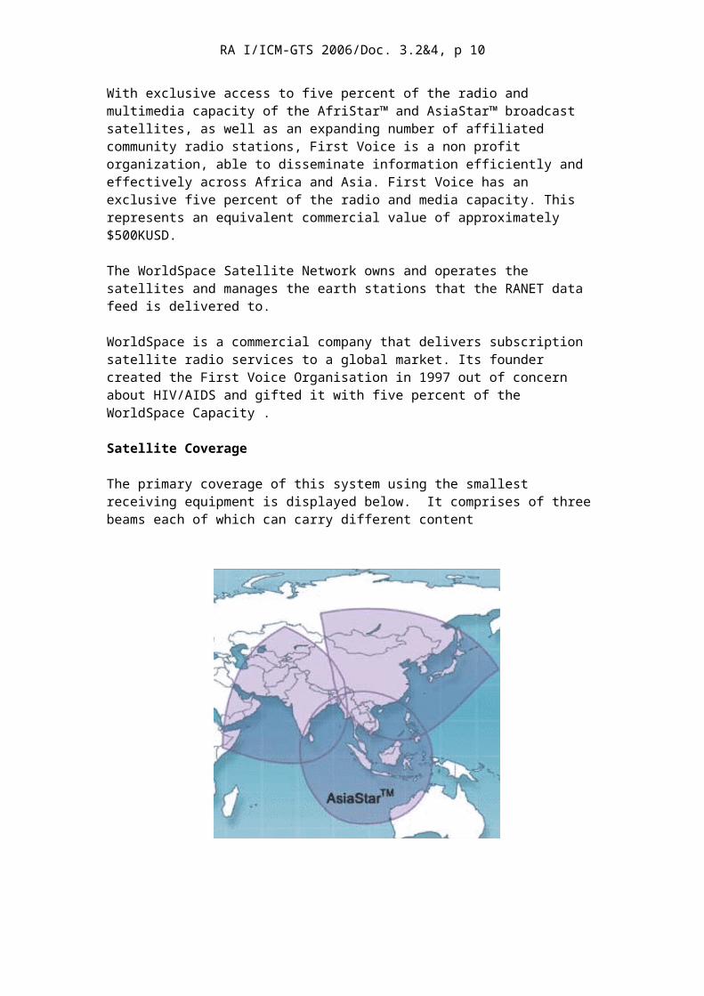
Satellite Coverage
The primary coverage of this system using the smallest receiving equipment is displayed below. It comprises of three beams each of which can carry different content
Within this footprint the following equipment is required to receive the signal
_____________________________________________________
USD $160
Out of footprint coverage is possible by using bigger antennas, dishes or Yagi antennas and this extends the coverage area in the South Pacific to Tonga at the extreme limit of the reception
Insi
U

RA I/ICM-GTS 2006/Doc. 3.2&4, p 8
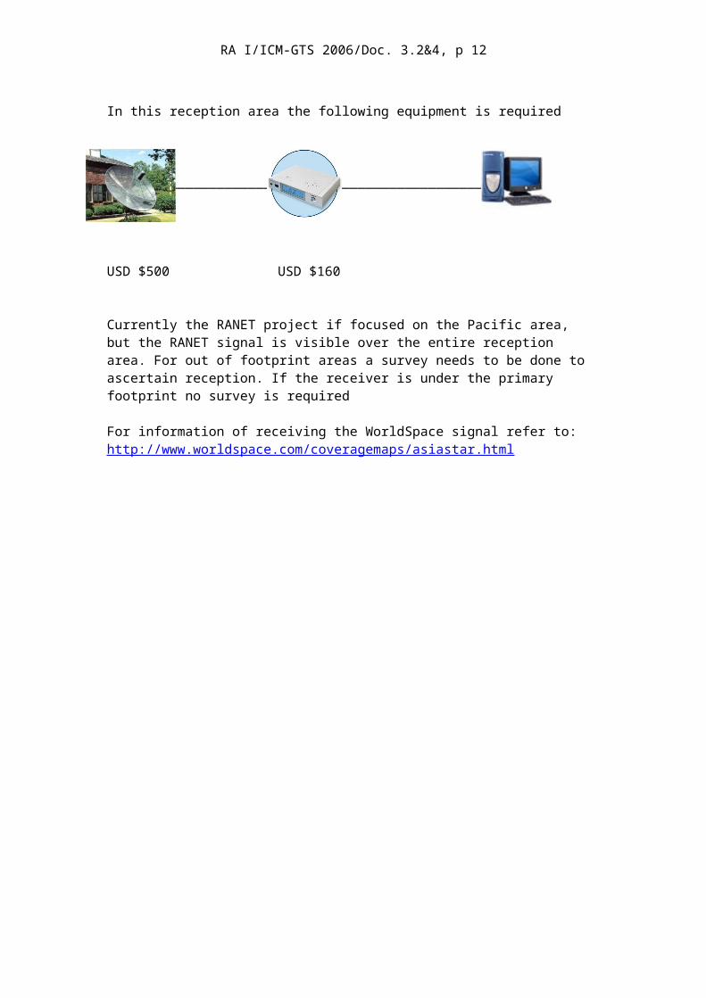
In this reception area the following equipment is required
_____________________________________________________
USD $500 USD $160
Currently the RANET project if focused on the Pacific area, but the RANET signal is visible over the entire reception area. For out of footprint areas a survey needs to be done to ascertain reception. If the receiver is under the primary footprint no survey is required
For information of receiving the WorldSpace signal refer to: http://www.worldspace.com/coveragemaps/asiastar.html

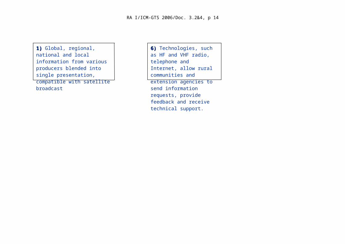
RA I/ICM-GTS 2006/Doc. 3.2&4, p 9RANET DELIVERY SYSTEMRANET DELIVERY SYSTEMSimplified System DiagramSimplified System Diagram
2)2) Presentation sent via Internet to a satellite uplink station (Singapore or Melbourne). Some information automatically updated, others require manual uploading.
3)3) At the top of nearly every hour the uplink station sends the uploaded information to the satellite for broadcast over all of Asia and parts of the Pacific.
5)5) The broadcast can be used by meteorological services, extension agencies, or even local communities who might use the content to improve their own products or to translate information into the local language and according to local interest.
1)1) Global, regional, national and local information from various producers blended into single presentation, compatible with satellite broadcast
6)6) Technologies, such as HF and VHF radio, telephone and Internet, allow rural communities and extension agencies to send information requests, provide feedback and receive technical support.
4)4) The broadcast is then received by digital radios that are hooked into computers.
RA I/ICM-GTS 2006/Doc. 3.2&4, p 11
RANET Transmission Schedule
The portion of the five percent of the WorldSpace bandwidth is allotted to the RANET group on a timeslot basis. There are number of allocations over a weekly period, but there is a regular 1 hourly time slot. This means that the shortest period to update is 1 Hour. The system will be migrating to a real time broadcast in the near future supporting warnings with a more urgent delivery time (i.e. Tsunami)
Current schedule
5 Mb (3-8 minutes) every hour 11Mb (6-12 minutes) every 4 hours 22Mb (10-15) every 4 hours
Total capacity approx 1 GB per week
Each timeslot can be uniquely allocated product. For example each 1 Hour timeslot could transmit different product. Over the course of the day, 5 MB could be transmitted 24 times with different data.
If the receiver was listening for 24 hours they could receive over 150Mb of data.
The RANET system has a mixture of retransmissions and updated data in hourly timeslots. In the four hourly slots less dynamic data is transmitted (Satellite images etc) and in the daily timeslot static data is transmitted (climate reports, web structures)
The entire update is compiled in the message switch and zipped into a single file that is deposited in the WorldSpace uplink server in Singapore. From this server the uplink systems convert the data into an encoded signal for broadcast
Feeding the data broadcast
As the data feed is compiled on a GTS message switch, virtually any GTS data source can be switched onto the broadcast
As well as required GTS product, an EMWIN data set is also included for viewing at the remote sites with freely available EMWIN viewing software. Note that the update time for viewing the EMWIN data is 1 hour (not real time by direct reception)
There are also a number of mechanisms that external agencies can use to lodge data for the next scheduled transmission slot, these include
Email Telnet FTP FTP socket connection

RA I/ICM-GTS 2006/Doc. 3.2&4, p 12
There are also a number of mechanisms that can be used to grab data from clients including “web page grabbers and trawlers. This is useful in picking up pages from small websites such as the Tuvalu Meteorological service and Vanuatu Meteorological service and retransmitting them.
All data structures are view via a web browser with standard HTML; no additional viewing software is required.
Possible regional solutions
RANET can provide local delivery solutions for agencies; this will enable local data that is generated in central offices to be rebroadcast out to outer sites via the WorldSpace satellite system, with the return circuit provided by another mechanism. (HF Email )
To receive this information the outer office would select their country page in the RANET broadcast and select the locally relevant sections.
Meterological Agency
Internet
Core site
Regional site Regional site Regional site Regional site
ABOM
Worldspace Singapore
Asia Star
HFHF HF HF
HF
NZmetservice
NOAA
RA I/ICM-GTS 2006/Doc. 3.2&4, p 13
Agency Benefits
Utilizing this solution provides a number of benefits for the agency.
Reduction in internet usage costs at remote sites Non ongoing costs Able to deliver “one way” web services to remote sites RANET sites exist at non-meteorological sites and can open up broader
community involvement Agencies can better integrate their satellite offices into their organization. These
sites can then become a focus for local information dissemination and better able to warn the communities that are in of hazards and dangers
What does the broadcast look like ?

RA I/ICM-GTS 2006/Doc. 3.2&4, p 14
RA I/ICM-GTS 2006/Doc. 3.2&4, p 15
The data broadcast is available on the web as an uplink mirror site
www.ranetasiapac.org
RANET Project future 2006
As resources allow the system is being converted to “real time “ where the data can be used and transmitted more efficiently and timely
This will allow the RANET data broadcast to be used for more urgent warnings and for immediate updates
In the 2006 period aid donations will allow further development of the website to deliver more relevant content as the number of sites expand. Also as the HF network expands the systems will move to being interactive where the user will request a product via the HF and the reply will return via the satellite system
It is also likely that there will be further integration with other humanitarian programs such as the People First network in the Solomon Is and other locally significant programs
Subject to final approvals Australian Aid has donated a significant grant for the development of all area of the RANET project, which will enable the dedication of focused staff resources for 2006.
This will deliver the following benefits
Expansion of HF sites throughout the Pacific (approx 10 new) Development of RANET website Investigation of new site (Solomon Is, PNG) Further integration of existing sites and regional workshops (Niue, Vanuatu,
Tuvalu , Kiribati) Publishing of RANET materials and handbooks Making existing systems redundant
There are also a number of other agencies US Aid/NZ Aid that are actively contributing to this project in the 2006 period and there is significant in kind support from the regional meteorological agencies.