OUTCROP ANALOG FOR MIXED … · geologic heterogeneity exhibited in outcrop analogs is crucial for...
25
Journal of Sedimentary Research, 2007, v. 77, 34–58 Research Article DOI: 10.2110/jsr.2007.007 OUTCROP ANALOG FOR MIXED SILICICLASTIC–CARBONATE RAMP RESERVOIRS—STRATIGRAPHIC HIERARCHY, FACIES ARCHITECTURE, AND GEOLOGIC HETEROGENEITY: GRAYBURG FORMATION, PERMIAN BASIN, U.S.A. R.J. BARNABY 1 AND W.B. WARD 2 1 ConocoPhillips, 14066 Westlake 2 Building, 580 Westlake Park Boulevard, Houston, Texas 77079 2 Earthworks, LLC and Theoretical and Applied Geology, P.O. Box 178, Newtown, Connecticut 06470, U.S.A. e-mail: [email protected] ABSTRACT: The Grayburg Formation (Late Permian, Guadalupian) is a shallow-marine succession flanking the Delaware and Midland basins of Texas and New Mexico, U.S.A. The Grayburg exemplifies the facies heterogeneity imparted by cyclic interbedding of siliciclastic and carbonate rocks from lithologically diverse, inner-ramp to outer-ramp facies assemblages. High-resolution correlation and mapping of laterally continuous Grayburg strata exposed in the Brokeoff Mountains, New Mexico, allow the stratigraphic architecture, facies distribution, and lateral variability to be characterized in detail. This study provides an outcrop analog for stratigraphically equivalent subsurface reservoirs and comparable carbonate-ramp reservoirs that accumulated during periods of low-amplitude sea-level fluctuations. Vertical and lateral facies successions in the Grayburg record four hierarchical scales of cyclicity. The entire Grayburg is a composite sequence that initiated with transgression of the San Andres platform and culminated with subaerial exposure, followed by a major basinward shift in deposition. This third-order cycle contains four high-frequency sequences defined by transgressive outer-ramp facies overlain by aggradational ramp-crest to inner-ramp facies capped by an unconformity. Each high-frequency sequence contains several composite cycles, intermediate-scale cyclic successions. The high-frequency (fifth- order) cycles constitute the smallest-scale upward-shoaling facies successions that can be recognized and mapped, comprising the basic correlation entity to delineate lithofacies bodies. Lateral heterogeneity in the Grayburg reflects both systematic facies transitions and interwell-scale (meters to hundreds of meters) variability due to geologic complexity. Larger-scale systematic facies changes that reflect primary environmental and/ or depositional controls (e.g., water depth, platform position, accommodation trends) can be characterized using well and/or seismic data abetted by appropriate depositional models. Interwell heterogeneity due to geologic complexity, however, is difficult to recognize from subsurface datasets. Appropriate outcrop analogs provide information on lateral facies dimensions and heterogeneity architecture that is essential for constructing more realistic three-dimensional reservoir models, rather than oversimplified models based on lithofacies correlations forced between wells by linear interpolation. An understanding of geologic heterogeneity exhibited in outcrop analogs is crucial for geoscientists involved with characterizing and modeling subsurface heterogeneity. INTRODUCTION The need to understand, characterize, and model reservoir heteroge- neity at all scales has been the impetus for detailed outcrop studies directed towards development of reservoir analogs. In the Permian Basin, outcrop investigations of the San Andres Formation, one of the most productive units (Fig. 1), demonstrate the application of sequence stratigraphic principles for high-resolution correlation and facies map- ping (Sonnenfeld 1991; Kerans et al. 1994; Kerans and Fitchen 1995). Such outcrop studies illustrate the hierarchy of different stratal surfaces and the landward and seaward facies shifts that define the sequence stratigraphic framework. These studies also document the utility of stratigraphic analysis for characterization of geologic heterogeneity in subsurface reservoirs. Reservoirs in the Grayburg Formation display considerable heteroge- neity due to cyclic interbedding of diverse assemblages of shallow-water, mixed carbonate, and siliciclastic facies. Because depositional fabrics are well preserved in these dolomitized carbonates and quartz sandstones, porosity and permeability are a function of the original depositional fabric (e.g., Lucia 1995). Consequently, characterization of petrophysical heterogeneity requires detailed stratigraphic analysis, correlation, and facies mapping. The data and interpretations presented here are based on description, analysis, and mapping of laterally continuous exposures of Grayburg strata on Plowman Ridge and West Dog Canyon in the Brokeoff Mountains (Figs. 2–5). Closely spaced measured sections, photomosaics, and physical tracing of stratal surfaces and facies established detailed chronostratigraphic correlations for high-frequency cycles and compo- nent lithofacies for up to 6.5 km along depositional dip. Three- dimensional outcrop views exposed in West Dog Canyon by incised meanders and opposite canyon walls, and correlations with strata on Plowman Ridge, 1.0 km across depositional strike, allow the three- dimensional facies heterogeneity to be characterized in detail. Copyright E 2007, SEPM (Society for Sedimentary Geology) 1527-1404/07/077-034/$03.00
-
Upload
trannguyet -
Category
Documents
-
view
215 -
download
0
Transcript of OUTCROP ANALOG FOR MIXED … · geologic heterogeneity exhibited in outcrop analogs is crucial for...

Journal of Sedimentary Research, 2007, v. 77, 34–58
Research Article
DOI: 10.2110/jsr.2007.007
OUTCROP ANALOG FOR MIXED SILICICLASTIC–CARBONATE RAMP RESERVOIRS—STRATIGRAPHICHIERARCHY, FACIES ARCHITECTURE, AND GEOLOGIC HETEROGENEITY: GRAYBURG FORMATION,
PERMIAN BASIN, U.S.A.
R.J. BARNABY1AND W.B. WARD2
1ConocoPhillips, 14066 Westlake 2 Building, 580 Westlake Park Boulevard, Houston, Texas 770792Earthworks, LLC and Theoretical and Applied Geology, P.O. Box 178, Newtown, Connecticut 06470, U.S.A.
e-mail: [email protected]
ABSTRACT: The Grayburg Formation (Late Permian, Guadalupian) is a shallow-marine succession flanking the Delaware andMidland basins of Texas and New Mexico, U.S.A. The Grayburg exemplifies the facies heterogeneity imparted by cyclicinterbedding of siliciclastic and carbonate rocks from lithologically diverse, inner-ramp to outer-ramp facies assemblages.High-resolution correlation and mapping of laterally continuous Grayburg strata exposed in the Brokeoff Mountains, NewMexico, allow the stratigraphic architecture, facies distribution, and lateral variability to be characterized in detail. This studyprovides an outcrop analog for stratigraphically equivalent subsurface reservoirs and comparable carbonate-ramp reservoirsthat accumulated during periods of low-amplitude sea-level fluctuations.
Vertical and lateral facies successions in the Grayburg record four hierarchical scales of cyclicity. The entire Grayburg isa composite sequence that initiated with transgression of the San Andres platform and culminated with subaerial exposure,followed by a major basinward shift in deposition. This third-order cycle contains four high-frequency sequences defined bytransgressive outer-ramp facies overlain by aggradational ramp-crest to inner-ramp facies capped by an unconformity. Eachhigh-frequency sequence contains several composite cycles, intermediate-scale cyclic successions. The high-frequency (fifth-order) cycles constitute the smallest-scale upward-shoaling facies successions that can be recognized and mapped, comprisingthe basic correlation entity to delineate lithofacies bodies.
Lateral heterogeneity in the Grayburg reflects both systematic facies transitions and interwell-scale (meters to hundreds ofmeters) variability due to geologic complexity. Larger-scale systematic facies changes that reflect primary environmental and/or depositional controls (e.g., water depth, platform position, accommodation trends) can be characterized using well and/orseismic data abetted by appropriate depositional models. Interwell heterogeneity due to geologic complexity, however, isdifficult to recognize from subsurface datasets. Appropriate outcrop analogs provide information on lateral facies dimensionsand heterogeneity architecture that is essential for constructing more realistic three-dimensional reservoir models, rather thanoversimplified models based on lithofacies correlations forced between wells by linear interpolation. An understanding ofgeologic heterogeneity exhibited in outcrop analogs is crucial for geoscientists involved with characterizing and modelingsubsurface heterogeneity.
INTRODUCTION
The need to understand, characterize, and model reservoir heteroge-neity at all scales has been the impetus for detailed outcrop studiesdirected towards development of reservoir analogs. In the Permian Basin,outcrop investigations of the San Andres Formation, one of the mostproductive units (Fig. 1), demonstrate the application of sequencestratigraphic principles for high-resolution correlation and facies map-ping (Sonnenfeld 1991; Kerans et al. 1994; Kerans and Fitchen 1995).Such outcrop studies illustrate the hierarchy of different stratal surfacesand the landward and seaward facies shifts that define the sequencestratigraphic framework. These studies also document the utility ofstratigraphic analysis for characterization of geologic heterogeneity insubsurface reservoirs.
Reservoirs in the Grayburg Formation display considerable heteroge-neity due to cyclic interbedding of diverse assemblages of shallow-water,mixed carbonate, and siliciclastic facies. Because depositional fabrics are
well preserved in these dolomitized carbonates and quartz sandstones,porosity and permeability are a function of the original depositionalfabric (e.g., Lucia 1995). Consequently, characterization of petrophysicalheterogeneity requires detailed stratigraphic analysis, correlation, andfacies mapping.
The data and interpretations presented here are based on description,analysis, and mapping of laterally continuous exposures of Grayburgstrata on Plowman Ridge and West Dog Canyon in the BrokeoffMountains (Figs. 2–5). Closely spaced measured sections, photomosaics,and physical tracing of stratal surfaces and facies established detailedchronostratigraphic correlations for high-frequency cycles and compo-nent lithofacies for up to 6.5 km along depositional dip. Three-dimensional outcrop views exposed in West Dog Canyon by incisedmeanders and opposite canyon walls, and correlations with strata onPlowman Ridge, 1.0 km across depositional strike, allow the three-dimensional facies heterogeneity to be characterized in detail.
Copyright E 2007, SEPM (Society for Sedimentary Geology) 1527-1404/07/077-034/$03.00

A major contribution of this study is delineating lateral faciesvariability within the context of a reliable, high-resolution chronostrati-graphic framework. Lateral heterogeneity reflects both larger-scalesystematic facies changes (e.g., due to water depth, platform position,accommodation trends) and interwell-scale (meters to hundreds ofmeters) heterogeneity arising from geologic complexity. Interwell-scaleheterogeneity is difficult to recognize with subsurface data, althoughsimulations based on outcrop-derived petrophysical data demonstratethat such variability strongly influences flow behavior in carbonatereservoirs (Grant et al. 1994; Jennings et al. 2000). Outcrop analogs thusconstitute an essential knowledge base for constructing realistic three-dimensional reservoir models from one-dimensional well data and
stratigraphic interpretations. Consequently, outcrop analogs such as theGrayburg provide an important tool for reservoir geologists tasked withcharacterizing and modeling subsurface heterogeneity.
GEOLOGIC SETTING
The Guadalupian (Late Permian) Grayburg Formation is a shallow-marine, mixed carbonate–siliciclastic succession on the periphery of theDelaware and Midland basins (Fig. 2). In the Guadalupe Mountainsarea, the Grayburg ranges in thickness from 80 meters in the mostlandward exposure on top of the San Andres platform to more than365 meters along the Western Escarpment (Fekete et al. 1986; Franseen et
FIG. 1.— Stratigraphic nomenclature of uppermost Leonardian through Guadalupian strata of the Permian Basin showing relative importance as a hydrocarbon-producing unit. The Grayburg Formation has yielded 2.5 billion barrels of oil from West Texas.
FIG. 2.— Setting of Delaware and Midlandbasins during Grayburg deposition (modifiedfrom Ward et al. 1986). The numbered areas arethe 21 major Grayburg fields (more than10 million barrels production) that occur alongthe Central Basin Platform, the northern shelf ofthe Delaware Basin, and the Ozona Arch. Theoutcrop study area is on the northwestern shelfof the Delaware Basin.
OUTCROP ANALOG FOR MIXED SILICICLASTIC–CARBONATE RAMP RESERVOIRS 35J S R

al. 1989; Kerans and Nance 1991; Kerans et al. 1992; Kerans et al. 1993).This study focused on flat-lying Grayburg strata that accumulatedlandward of the shelf margin (Figs. 3, 4). This is a depositional settingsimilar to that of major Grayburg fields (Fig. 2). The GrayburgFormation grades basinward into fine sandstones and siltstones of theCherry Canyon Formation and passes northward, towards the craton,into evaporites, eolianites, and terrigenous red beds (Silver and Todd1969; Meissner 1972; Nance 1988).
The Permian is a period of transitional sea-level cyclicity between thehigh-amplitude (60 to 100 m) glacial-eustatic icehouse fluctuations of thePennsylvanian (e.g., Crowley and Baum 1991; Soreghan and Giles 1999)and the low-amplitude (less than 10 m) eustatic greenhouse fluctuationsof the Triassic (Goldhammer et al. 1990). The Permian Basin is a forelandthat developed during the Pennsylvanian–Early Permian collisionbetween Laurentia and Gondwana (Horak 1985; Yang and Dorobek1992). The Grayburg was deposited during the passive margin phase oftectonic quiescence.
Paleogeographic reconstructions for the Middle to Late Permian placethe Permian Basin on the Pangea supercontinent at 0u to 5u N latitude(Scotese and McKerrow 1990; Lottes and Rowley 1990; Coffin et al.1992), north of the equatorial-aligned tectonic highlands of the Hercynianorogenic belt (Coffin et al. 1992). Despite the equatorial setting, aridconditions in western North America are indicated by widespreadGuadalupian-age dolomites, evaporites, eolianites, and terrigenous redbeds (Silver and Todd 1969; Meissner 1972). Assembly of the Pangeasupercontinent and orogenic uplift disrupted the wet equatorial easterliesbearing moisture from Tethys, creating a rain shadow in central Pangea(Scotese and McKerrow 1990). Paleoclimate modeling (Parrish andPeterson 1988; Parrish 1993, 1995) suggests that a monsoonal atmo-spheric circulation system developed. During the Northern Hemispherewinter, a high-pressure cell developed over the cold northern landmass,resulting in northeasterly winds (Parrish and Peterson 1988; Parrish 1993,1995). Measured foresets for Permian eolianites of the Colorado Plateau(Peterson 1988) and Anadarko Basin (Kocurek and Kirkland 1998)
FIG. 3.—Physiographic map of the Guadalupe and Brokeoff mountains region, modified from Fitchen (1993). The outcrop study area (shaded rectangle) is landwardof the underlying San Andres margin and is approximately 10 km landward of the Grayburg terminal margin. Line A–A9 delineates general location of the cross sectionof Kerans et al. (1992) and Kerans et al. (1993) shown in Figure 4.
36 R.J. BARNABY AND W.B. WARD J S R

coincide with a dominant northeasterly paleowind direction. Karstassociated with sequence boundaries in the San Andres Formation(e.g., Kerans and Fitchen 1995) and the Grayburg Formation (this study)attest to episodic development of coastal meteoric aquifer systems duringsea-level lowstands.
DEFINITIONS
The high-frequency cycle is the basic stratigraphic unit in this study andrefers to the smallest-scale upward-shallowing facies succession that canbe correlated across different facies tracts. High-frequency cycles recorda single episode of rise and fall in relative sea level (e.g., Grotzinger 1986;Read et al. 1986; Koerschner and Read 1989; Kerans and Tinker 1997)equivalent to the fifth-order cycles of Goldhammer et al. (1990). Thehigh-frequency cycle is analogous to the parasequence (Van Wagoner etal. 1987; Van Wagoner et al. 1990). Grayburg high-frequency cycles rangefrom 0.5 to 10 meters in thickness.
Composite cycles contain several high-frequency cycles arranged intoa larger-scale transgressive–regressive succession bound by marineflooding surfaces that may coincide with sequence boundaries. Compositecycles differ from cycle sets (Kerans and Tinker 1997, 1999; Tinker 1998)or parasequence sets (Van Wagoner et al. 1987; Van Wagoner et al. 1990)in that composite cycles define an intermediate-scale transgressive–regressive cycle, whereas cycle sets and parasequence sets displaya consistent progradational, retrogradational, or aggradational stackingtrend. Grayburg composite cycles are 4 to 12 meters thick.
A high-frequency sequence is a larger-scale cycle composed ofgenetically related, high-frequency cycles and composite cycles andbounded by unconformities or correlative unconformities (e.g., Mitchum1977; Mitchum and Van Wagoner 1991). High-frequency sequencescontain lowstand and transgressive systems tracts separated by a maxi-mum flooding surface from the highstand systems tract. Composite cycles
and high-frequency sequences lie within the range of fourth-order cycles(Goldhammer et al. 1990). Grayburg high-frequency sequences are 30 to45 meters thick.
The composite sequence (e.g., Mitchum and Van Wagoner 1991) is thelowest order cyclicity considered by this study and is comparable toa depositional sequence (e.g., Mitchum et al. 1977; Vail et al. 1977; Vail1987; Van Wagoner et al 1988). Composite sequences contain severalunconformity-bounded high-frequency sequences arranged into a larger-scale succession with well-defined lowstand, transgressive, and highstandcomponents. A composite sequence is equivalent to a third-order cycle(Goldhammer et al. 1990).
METHODS
The Grayburg Formation data and interpretations presented in thispaper are based on more than 4100 meters of vertical section described atPlowman Ridge, West Dog Canyon, and Cork Draw in the BrokeoffMountains in southeastern Otero County, New Mexico (Fig. 5).Although precursor limestones are replaced by dolomite, well-preservedoriginal rock fabrics can be identified readily in the field. Facies weredescribed from outcrop in conjunction with standard petrographic thinsections of rock samples. We utilize Dunham’s (1962) carbonate rockclassification system with Lucia’s (1995) modification that subdividespackstones into mud-dominated and grain-dominated fabrics.
Initial stratigraphic analysis of the Grayburg Formation was based onexposures from Plowman Ridge, a 6.5-km-long, north-trending ridge thatparallels depositional dip (Fig. 5). Vertical sections through the Grayburgwere measured and described (e.g., Fig. 6); interpreted high-frequencycycles, cycle sets, and high-frequency sequences were physically correlatedby walking out bedding surfaces and by tracing the strata on obliquephotographs. The Plowman Ridge stratigraphic cross section (Fig. 7) isbased on high-quality exposures with excellent lateral continuity.
FIG. 4.—Stratigraphic framework of the Leonardian through Guadalupian carbonate platform succession in the Guadalupe and Brokeoff mountains region, compiledby Kerans et. al. (1992) and Kerans et al. (1993), updated by more recent work (Kerans et al. 1994; Kerans and Fitchen 1995). The Grayburg study area is landward of theSan Andres and Grayburg platform margins.
OUTCROP ANALOG FOR MIXED SILICICLASTIC–CARBONATE RAMP RESERVOIRS 37J S R
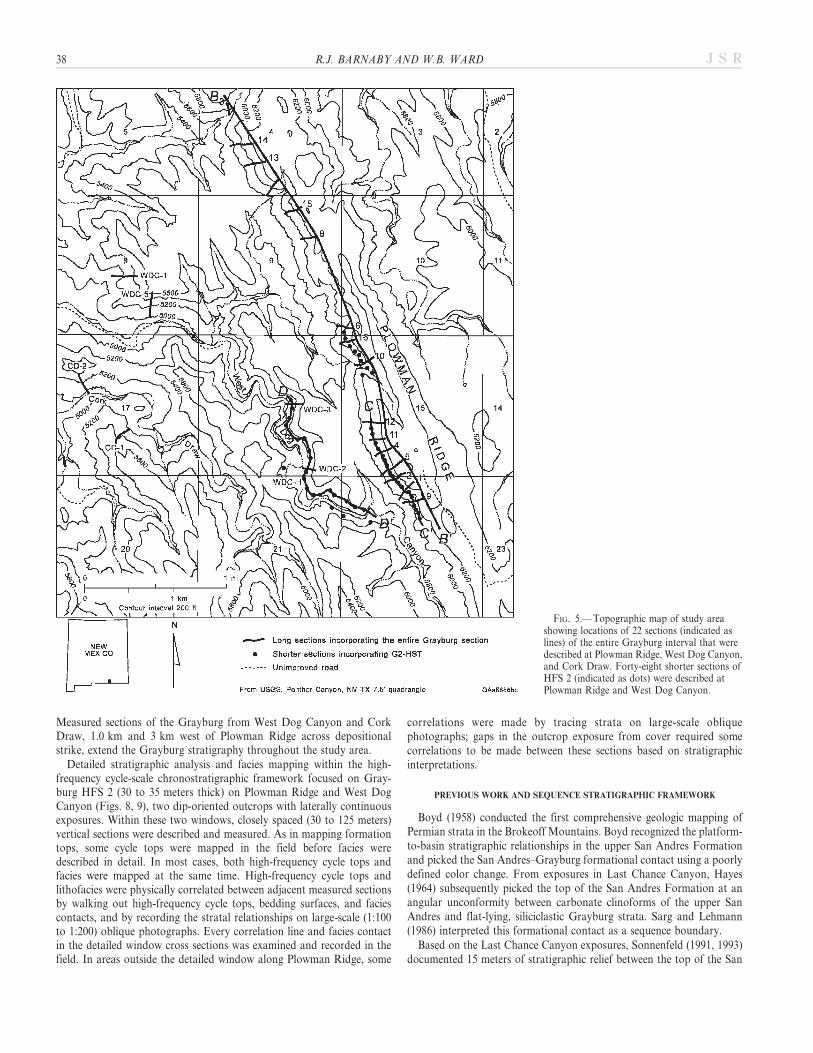
Measured sections of the Grayburg from West Dog Canyon and CorkDraw, 1.0 km and 3 km west of Plowman Ridge across depositionalstrike, extend the Grayburg stratigraphy throughout the study area.
Detailed stratigraphic analysis and facies mapping within the high-frequency cycle-scale chronostratigraphic framework focused on Gray-burg HFS 2 (30 to 35 meters thick) on Plowman Ridge and West DogCanyon (Figs. 8, 9), two dip-oriented outcrops with laterally continuousexposures. Within these two windows, closely spaced (30 to 125 meters)vertical sections were described and measured. As in mapping formationtops, some cycle tops were mapped in the field before facies weredescribed in detail. In most cases, both high-frequency cycle tops andfacies were mapped at the same time. High-frequency cycle tops andlithofacies were physically correlated between adjacent measured sectionsby walking out high-frequency cycle tops, bedding surfaces, and faciescontacts, and by recording the stratal relationships on large-scale (1:100to 1:200) oblique photographs. Every correlation line and facies contactin the detailed window cross sections was examined and recorded in thefield. In areas outside the detailed window along Plowman Ridge, some
correlations were made by tracing strata on large-scale obliquephotographs; gaps in the outcrop exposure from cover required somecorrelations to be made between these sections based on stratigraphicinterpretations.
PREVIOUS WORK AND SEQUENCE STRATIGRAPHIC FRAMEWORK
Boyd (1958) conducted the first comprehensive geologic mapping ofPermian strata in the Brokeoff Mountains. Boyd recognized the platform-to-basin stratigraphic relationships in the upper San Andres Formationand picked the San Andres–Grayburg formational contact using a poorlydefined color change. From exposures in Last Chance Canyon, Hayes(1964) subsequently picked the top of the San Andres Formation at anangular unconformity between carbonate clinoforms of the upper SanAndres and flat-lying, siliciclastic Grayburg strata. Sarg and Lehmann(1986) interpreted this formational contact as a sequence boundary.
Based on the Last Chance Canyon exposures, Sonnenfeld (1991, 1993)documented 15 meters of stratigraphic relief between the top of the San
FIG. 5.— Topographic map of study areashowing locations of 22 sections (indicated aslines) of the entire Grayburg interval that weredescribed at Plowman Ridge, West Dog Canyon,and Cork Draw. Forty-eight shorter sections ofHFS 2 (indicated as dots) were described atPlowman Ridge and West Dog Canyon.
38 R.J. BARNABY AND W.B. WARD J S R

Andres sequence boundary and onlapping Grayburg strata, indicating atleast 15 meters of sea-level fall following San Andres deposition. OnAlgerita and Shattuck escarpments, these stratal relationships indicatea sea-level fall of more than 30 meters (Kerans and Nance 1991). Asimilar magnitude of sea-level fall is documented in the BrokeoffMountains, where paleokarst dolines extend 30 meters below the SanAndres–Grayburg sequence boundary (Fitchen 1993).
Boyd (1958) mapped the Grayburg and Queen formations as anundifferentiated succession. Hayes (1964) placed the top of the Grayburgbelow a ‘‘locally conspicuous sandstone’’ assigned to the Queen
Formation. Sarg and Lehmann (1986) interpreted the top of the Grayburgto represent a sequence boundary. Because subaerial exposure features areonly locally expressed along this surface, however, this contact is probablyinconsistently mapped throughout the area, particularly in areas with pooroutcrops (Kerans and Nance 1991). Limited exposure of the uppermostGrayburg on Plowman Ridge and in West Dog Canyon made it difficultfor us to unequivocally locate the Grayburg–Queen sequence boundary.Near the top of Plowman Ridge, tepee–pisolite–fenestral and algal-laminated facies (uppermost Grayburg?) with grikes filled with dolomiticquartz siltstone and sandstone are unconformably overlain by recessively
FIG. 6.— Measured section of section PR-2 (with interpretations) of entire Grayburg interval from South Plowman Ridge, location indicated on Figure 5.
OUTCROP ANALOG FOR MIXED SILICICLASTIC–CARBONATE RAMP RESERVOIRS 39J S R
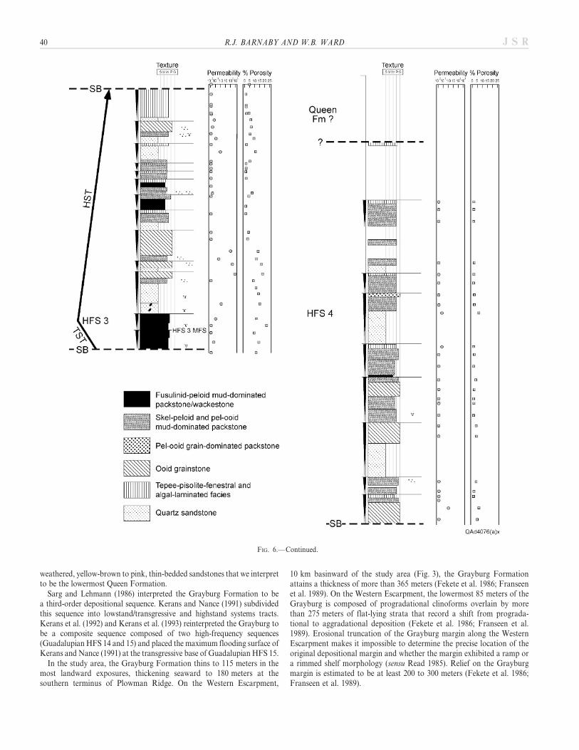
weathered, yellow-brown to pink, thin-bedded sandstones that we interpretto be the lowermost Queen Formation.
Sarg and Lehmann (1986) interpreted the Grayburg Formation to bea third-order depositional sequence. Kerans and Nance (1991) subdividedthis sequence into lowstand/transgressive and highstand systems tracts.Kerans et al. (1992) and Kerans et al. (1993) reinterpreted the Grayburg tobe a composite sequence composed of two high-frequency sequences(Guadalupian HFS 14 and 15) and placed the maximum flooding surface ofKerans and Nance (1991) at the transgressive base of Guadalupian HFS 15.
In the study area, the Grayburg Formation thins to 115 meters in themost landward exposures, thickening seaward to 180 meters at thesouthern terminus of Plowman Ridge. On the Western Escarpment,
10 km basinward of the study area (Fig. 3), the Grayburg Formationattains a thickness of more than 365 meters (Fekete et al. 1986; Franseenet al. 1989). On the Western Escarpment, the lowermost 85 meters of theGrayburg is composed of progradational clinoforms overlain by morethan 275 meters of flat-lying strata that record a shift from prograda-tional to aggradational deposition (Fekete et al. 1986; Franseen et al.1989). Erosional truncation of the Grayburg margin along the WesternEscarpment makes it impossible to determine the precise location of theoriginal depositional margin and whether the margin exhibited a ramp ora rimmed shelf morphology (sensu Read 1985). Relief on the Grayburgmargin is estimated to be at least 200 to 300 meters (Fekete et al. 1986;Franseen et al. 1989).
FIG. 6.— Continued.
40 R.J. BARNABY AND W.B. WARD J S R
MAJOR LITHOFACIES
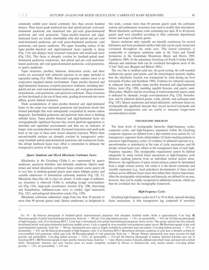
Mixed carbonate and siliciclastic rocks of the Grayburg Formationwere grouped into seven major end-member lithofacies: (1) fusulinid–peloid mud-dominated packstone–wackestone; (2) mudstone and skel–peloid wackestone; (3) skel–peloid and pel–ooid mud-dominated pack-stone; (4) pel–ooid grain-dominated packstone; (5) ooid grainstone;(6) tepee–pisolite–fenestral and algal-laminated facies; and (7) quartzsandstone and quartz sand-rich occurrences of the above carbonatelithofacies. Major lithofacies (Figs. 10, 11, 12) are described in Table 1.
Fusulinid–Peloid Mud-Dominated Packstone–Wackestone
Fusulinid–peloid mud-dominated packstone–wackestone facies (Ta-ble 1, Fig. 10A) are relatively uncommon in the platform interiorGrayburg strata of the study area (Fig. 4). Fusulinid-rich facies areabundant in locales seaward of the San Andres platform margin; e.g., the
Western Escarpment (Fekete et al. 1986; Franseen et al. 1989) and thedowndip southern end of Shattuck Escarpment (Kerans and Nance1991). Similarly, in the subsurface Grayburg of the Central BasinPlatform, fusulinid facies dominate outer-ramp strata of the lowerGrayburg (e.g., Ruppel and Bebout 2001).
The basinward distribution, along with the abundant carbonate mud,open marine fauna, lack of current-generated sedimentary structures, andintense bioturbation, indicate a low-energy, outer-ramp depositionalenvironment. In the lower San Andres Formation, fusulinid-rich faciesare confined to the middle and lower portions of progradational ramp-margin clinoforms; reconstructed depositional profiles from the basin-ward-dipping stratal surfaces indicate water depths of 10 to 120 metersfor this facies (Kerans and Fitchen 1995). This facies is thus interpreted torecord maximum transgressive water depths on the shallow-waterGrayburg platform. Consequently, fusulinid–peloid mud-dominatedpackstone–wackestone facies are stratigraphically significant for inter-preting longer-term accommodation trends.
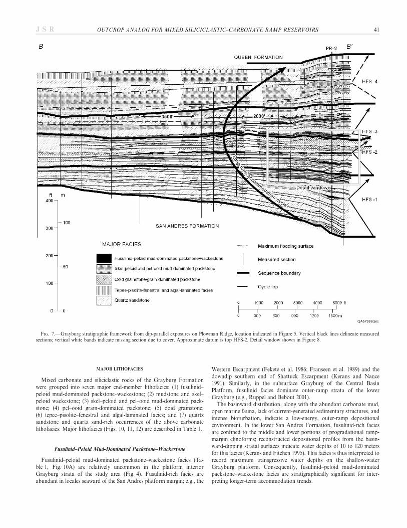
FIG. 7.— Grayburg stratigraphic framework from dip-parallel exposures on Plowman Ridge, location indicated in Figure 5. Vertical black lines delineate measuredsections; vertical white bands indicate missing section due to cover. Approximate datum is top HFS-2. Detail window shown in Figure 8.
OUTCROP ANALOG FOR MIXED SILICICLASTIC–CARBONATE RAMP RESERVOIRS 41J S R

Mudstone and Skel–Peloid Wackestone
Carbonate mudstone and skel–peloid wackestone facies (Table 1)occur locally. True mud-supported fabrics are uncommon in theGrayburg and a relict peloid-supported fabric is usually evident. Mud-supported fabrics record low-energy settings but otherwise provide littledirect evidence of depositional environment; consequently, this faciesprobably records more than one depositional setting. Admixed skeletalmaterial, including crinoids and fusulinids, in outer-platform skel–peloidwackestones suggest proximity to open marine conditions. In platforminterior locations, carbonate mudstone is associated with tepee–pisolite–fenestral and algal-laminated facies, implying a restricted shallow subtidalto peritidal environment.
Skel–Peloid and Pel–Ooid Mud-Dominated Packstone
Skel–peloid and pel–ooid mud-dominated packstone (Table 1,Fig. 10B) is the most abundant carbonate facies in the study area(Fig. 7). Carbonate mud and compacted pseudomatrix completelyocclude interparticle pore space. Because of bioturbation, compaction,and dolomitization, peloids can be difficult to distinguish from mudmatrix.
The interparticle carbonate mud, admixed crinoids and fusulinids, andthe extensive biotic reworking indicate a low-energy subtidal environ-ment. This facies records dominantly quiet-water deposition below fair-weather wave base on the middle ramp, and/or a restricted settingprotected by seaward ramp-crest shoals.
Pel–Ooid Grain-Dominated Packstone
Pel–ooid grain-dominated packstones (Table 1) are grain-supportedrocks that contain minor amounts of carbonate mud; ooids (150 to400 mm) and peloids (60 to 150 mm) are the dominant grain type(Fig. 10D). Cross-stratification is poorly developed or absent. Carbonatemud partially occludes interparticle pores. Grain-dominated packstonelies stratigraphically above skel–peloid and pel–ooid mud-dominatedpackstone facies and is overlain by ooid grainstone. Grain-dominatedpackstone passes basinward into skel–peloid and pel–ooid mud-domi-nated packstone facies and grades landward into ooid grainstone.
Pel–ooid grain-dominated packstone facies record shoaling intoa relatively higher energy environment. Grain-supported fabrics withminor amounts of interparticle mud record a well-winnowed depositionalsetting, the admixed carbonate mud may have been introduced bybioturbation, which obscured or destroyed primary current stratification.
42 R.J. BARNABY AND W.B. WARD J S R
FIG. 8.— Stratigraphic cross section C–C' of HFS 2 from Plowman Ridge, see Figures 5 and 7 for location. High-frequency sequence 2 is composed of 14 high-frequency cycles organized into 4 composite cycles (2A, 2B, 2C, and 2D). Datum is top of cycle 8, maximum flooding event.

Ooid Grainstone
Ooid grainstone (Table 1, Figs. 10C, E, B) facies are especiallyabundant in HFS 2, both in outcrop (Fig. 7) and in the subsurface.Well-sorted ooid grains are 150 to 400 mm in diameter (Fig. 10F). Ooidgrainstones are characterized by current stratification features, describedin Table 1. The lower contact of ooid grainstones is gradational withunderlying pel–ooid grain-dominated packstones, gradational to abruptwith underlying skel–peloid and pel–ooid mud-dominated packstones andquartz sandstones, and abrupt with underlying fusulinid–peloid mud-dominated packstone–wackestone facies. The upper contact of ooidgrainstone facies is generally sharp, except where it grades upward intooverlying tepee–pisolite–fenestral and algal-laminated facies.
Ooid grainstones form sheet-like bodies or channel-form units. Sheet-like bodies consist of stacked medium to thick beds that are amalgamatedinto successions up to 4 meters thick. Cross strata predominantly dipbasinward whereas contacts between individual stacked beds dip land-ward. These units are laterally continuous for up to 1 km or more. Forexample, the grainstone body in Grayburg HFS 2 high-frequency cycle 12(Fig. 13) is oriented parallel to depositional strike and is laterallycontinuous for at least 1000 meters across strike and more than1200 meters along dip. These amalgamated grainstone units locally areinterrupted by thin (less than 0.3 meters thick) intervals of bioturbated
pel–ooid grain-dominated packstone and skel–peloid and pel–ooid mud-dominated packstone, some of which exhibit lateral continuity of a fewhundred meters (Fig. 8) forming potential internal reservoir baffles.
Grainstone channels are up to 4.5 meters thick, with sharp erosionalbases that downcut underlying strata (Fig. 11C). The channels are up toseveral hundred meters wide, oriented parallel to depositional dip(Fig. 14), and extend for at least thousands of meters in a dip direction.Syndepositional relief is at a maximum in these high-energy channels andbars; individual large-scale bedforms have up to 3 to 5 meters of relieffrom topset to toeset.
Ooid grainstones are interpreted to record high-energy conditionsabove fair-weather wave base. Ooid grainstones are stratigraphicallysignificant because they are a sensitive indicator of high-energy, shallow-water deposition on the ramp crest and their distribution throughsuccessive high-frequency cycles reflects longer-term accommodationtrends.
Tepee–Pisolite–Fenestral and Algal-Laminated Facies
Tepee–pisolite–fenestral and algal-laminated facies (Table 1,Figs. 10G, H, 11A), described by Tye (1986) occur throughout theGrayburg. Although they form successions up to 5.5 meters thick, they
FIG. 9.—Stratigraphic cross section D–D9 of HFS 2 from West Dog Canyon, 1 km across depositional strike from Plowman Ridge; location indicated on Figure 5.Section is generally dip-oriented, however, outcrop exposures along the canyon meanders cause various segments of the cross section to differ in their orientation relativeto depositional dip. Datum is top of cycle 8, maximum flooding event.
OUTCROP ANALOG FOR MIXED SILICICLASTIC–CARBONATE RAMP RESERVOIRS 43J S R

44 R.J. BARNABY AND W.B. WARD J S R
commonly exhibit poor lateral continuity (less than several hundredmeters). These facies grade landward into skel–peloid and pel–ooid mud-dominated packstone and basinward into pel–ooid grain-dominatedpackstone and ooid grainstone. Tepee–pisolite–fenestral and algal-laminated facies are locally interbedded with skel–peloid and pel–ooidmud-dominated packstone, pel–ooid grain-dominated packstone, ooidgrainstone, and quartz sandstone. The upper bounding surface of thetepee–pisolite–fenestral and algal-laminated facies typically is sharp(Fig. 11A) and displays local erosional truncation and small-scale karst(Fig. 12G). This facies is abruptly overlain by fusulinid–peloid mud-dominated packstone–wackestone, skel–peloid and pel–ooid mud-dom-inated packstone, pel–ooid grain-dominated packstone, ooid grainstone,or quartz sandstone.
Tepee structures, pisolites, fenestrae, desiccation cracks, and sheetcracks are associated with subaerial exposure in an upper peritidal tosupratidal setting (Tye 1986). Botryoidal aragonite cements attest to anevaporative marginal marine environment. Tepee–pisolite–fenestral andalgal-laminated structures overprint precursor sediments, including skel–peloid and pel–ooid mud-dominated packstone, pel–ooid grain-dominat-ed packstone, ooid grainstone, and quartzose carbonate. These structuresare best developed at the top of these units, grading downwards into morediffuse, poorly defined structures.
Thick accumulations of tepee–pisolite–fenestral and algal-laminatedfacies on the ramp crest represent grainstone and packstone shoals thatformed paleohighs that were subsequently overprinted by marine vadosediagenesis. Interbedded grainstone and packstone beds attest to flankingsubtidal facies. Tepee–pisolite–fenestral and algal-laminated facies arestratigraphically significant because they record platform aggradation tointertidal and supratidal environments and thus are an indicator oflonger–term accommodation trends. Erosional truncation and small-scalekarst at the tops of these units record subaerial exposure. Where theseunconformable surfaces are abruptly overlain by transgressive outer-ramp fusulinid–peloid mud-dominated packstone and wackestone facies,this abrupt landward facies tract offset is interpreted to delineate thetransgressive portion of the ensuing cycle.
Quartz Sandstone and Mixed Siliciclastic–Carbonate Facies
Siliciclastics in the Grayburg (Table 1) are represented by quartzsandstone, quartzose dolomite, and dolomitic sandstone. Quartz sand-stones and mixed siliciclastic–carbonate facies contain coarse quartz siltto very fine- to medium-grained quartz sand, minor feldspar grains, andvariable admixtures of dolomitized carbonate material (Fig. 12E, F).Siliciclastic fines (fine silt to clay) are absent. A wide range of sediment-ary structures is observed (Table 1), including trough cross-laminat-ion (Fig. 12A), large-scale accretionary foresets (Fig. 12B), burrowingand bioturbation, millimeter-scale wavy to crinkly algal lamination(Fig. 12C), and polygonal desiccation cracks (Fig. 12D).
Siliciclastic–carbonate admixtures range from less than 10 percent tomore than 90 percent quartz sand. Quartz sandstones, as designated in
this study, contain more than 60 percent quartz sand; the carbonatecontent and sedimentary structures were used to modify their description.Mixed siliciclastic–carbonate rocks containing less than 30 to 40 percentquartz sand were classified according to their carbonate depositionaltexture and major carbonate grains.
Quartz sandstone units typically are laterally continuous for severalkilometers and form prominent marker beds that can be easily traced andcorrelated throughout the study area. This lateral continuity iscomparable to analogous sandstone units in the Yates and Tansillformations in the Guadalupe Mountains (Borer and Harris 1989;Candelaria 1989). In the subsurface Grayburg (of South Cowden Field),siltstone and sandstone beds can be correlated throughout most of the15 km2 field area (Ruppel and Bebout 2001).
The very fine to medium sand size, the good sorting, the well-roundedmedium-size quartz sand grains, and the mineralogical maturity impliesthat the siliciclastic fraction was transported by wind during sea levellowstands (Fischer and Sarnthein 1988). Evidence for subaerial exposurein subjacent facies includes tepee–pisolite–fenestral and algal-laminatedfabrics, karst (Fig. 12H), mantling regolith breccias, and quartz sand-filled grikes. Shallow marine reworking of wind-transported quartz sandsis indicated by channels, trough cross-lamination (Fig. 12A), bioturba-tion, and by admixed skeletal grains, ooids, peloids, and carbonate mud(Fig. 12F). Quartz sandstones and mixed siliciclastic–carbonate facies arestratigraphically significant because they record sea-level lowstands andsubsequent transgression and are useful to interpret longer-termaccommodation trends.
STRATIGRAPHIC HIERARCHY
The three levels of stratigraphic hierarchy (high-frequency cycles,composite cycles, and high-frequency sequences) within the Grayburgcomposite sequence are defined from a dip-oriented cross section by: (1)transgressive–regressive facies relationships; (2) facies stacking patterns insuccessive high-frequency cycles; (3) evidence of subaerial exposure (e.g.,unconformities or paleokarst) at the tops of cyclic successions; and (4)abrupt vertical facies tract offsets at the transgressive base of each high-frequency sequence. This stratigraphic organization cannot be definedadequately by using vertical facies successions or high-frequency cyclethickness stacking patterns from an individual vertical section alone.Moreover, the significance of many stratal surfaces cannot be determinedfrom a single vertical section, but rather it is the lateral continuity andvariable expression (e.g., local paleokarst development) of these stratalsurfaces across different facies tracts that define their relative importance.After the stratigraphic relationships and hierarchy are defined for an area,however, they can be readily recognized in additional sections, which canthen be correlated into the stratigraphic framework.
High-Frequency Cycles
Grayburg high-frequency cycles are 0.5 to 10 m thick, upward-shoalingfacies successions. A thin transgressive lag, composed of reworked
r
FIG. 10.— A) Outcrop photograph of fusulinid–peloid mud-dominated packstone with abundant fusulinid molds. Knife is approximately 8 cm long. B)Photomicrograph of peloid mud-dominated packstone. Scale bar 5 500 mm. Core plug helium porosity 5 1.0%, air permeability 5 0.01 md. C) Outcrop photographof high-frequency cycle 10 in Grayburg HFS 2. Cycle base is bioturbated ooid–peloid mud-dominated packstone (lower arrow). This grades upward into less intenselybioturbated peloid–ooid grain-dominated packstone (middle arrow). Cycle is capped by cross-stratified ooid grainstone (upper arrow). D) Photomicrograph of pel–ooidgrain-dominated packstone. Scale bar 5 500 mm. Interparticle pore space is largely occluded by carbonate mud and cement. Core-plug helium porosity 5 1.9%, airpermeability 5 0.01 md. E) Outcrop photograph of high-frequency cycle 12 in Grayburg HFS 2. Bioturbated dolomitic sandstone at cycle base is abruptly overlain bycross-stratified ooid grainstone, which caps cycle. F) Photomicrograph of ooid grainstone. Scale bar 5 500 mm. Primary interparticle pore space accounts for highporosity and permeability. Core-plug helium porosity 5 12.0%, air permeability 5 25.6 md. G) Outcrop photograph of laminar fenestral dolomite near top ofGrayburg HFS 1. H) Photomicrograph of tepee–pisolite–fenestral facies. Scale bar 5 2 mm. Matrix consists of pisoids, pelleted (microbial?) mud, and mud with a clottedfabric. Interparticle, fenestral, and early fracture pores are nearly completely occluded by fibrous to inclusion-rich, early marine cement. Core-plug heliumporosity 5 1.0%, air permeability 5 0.01 md.
OUTCROP ANALOG FOR MIXED SILICICLASTIC–CARBONATE RAMP RESERVOIRS 45J S R
46 R.J. BARNABY AND W.B. WARD J S R
sediment and intraclasts from the underlying cycle, occurs at the base ofsome high-frequency cycles. Grayburg high-frequency cycles typically areasymmetric, consisting of basal low-energy, carbonate mud-rich, biotur-bated facies succeeded by more proximal facies. Some high-frequencycycle tops display in situ breccias, sand-filled grikes, paleokarst (Fig. 12G,H), desiccation cracks (Fig. 12D), and erosional truncation. Cycle topstypically are abruptly overlain by low-energy facies at the base of theensuing cycle.
Grayburg high-frequency cycles exhibit diverse facies, facies propor-tions, sedimentary structures, and bounding stratal surfaces. Withina single high-frequency cycle, the component lithofacies and faciesproportions may vary significantly at different locations along thedepositional profile. For example, in high-frequency cycles 4 and 5(Figs. 8, 9) carbonate-dominated facies at one location pass laterally intoequivalent, mixed carbonate–siliciclastic facies, which, in turn, gradelaterally into siliciclastic-dominated facies.
In a low-accommodation, shallow-water setting landward of theplatform margin, high-frequency cycles typically are asymmetric, withabrupt bases of low-energy, mud-rich, bioturbated facies that reflectmaximum flooding followed by successively more proximal facies due toaggradation as sediment infilled accommodation. Fully aggraded high-frequency cycles are capped by peritidal facies. High-frequency cycles arecapped by abrupt stratal surfaces that indicate a period of nondeposition,erosion, and/or subaerial exposure prior to transgression by the ensuingcycle.
The preservation potential of high-frequency cycles reflects long-termaccommodation, constituent lithology, and the depositional environmentof transgressive facies in the overlying cycle. High-frequency cyclesdeposited during periods of low accommodation are less likely to bepreserved due to sediment reworking in an accommodation-limitedsetting. High-frequency cycles composed of carbonate are more likely tobe preserved, because carbonates tend to be indurated by earlycementation during subaerial exposure. High-frequency cycles composedof quartz sandstone are less likely to be preserved, because unconsoli-dated quartz sand is readily reworked by burrowing organisms andcurrents during the ensuing transgression. For example, anomalouslythick successions (up to 10 m) of massive quartz sandstone that displayno internal vertical facies successions may reflect amalgamation of severalvertically stacked cycles. High-energy tidal channel and shoal facies tractsare more likely to rework underlying sediments of the subjacent high-frequency cycle than overlying low-energy, distal facies.
Representative end-member high-frequency cycle types from a mea-sured section on Plowman Ridge (PR-2) are illustrated in Figure 15.
Sandstone-Dominated High-Frequency Cycles.—The base of these cyclesis composed of bioturbated quartz sandstone, with admixed carbonate,including mud, peloids, fusulinids, and other skeletal grains. In oneexample (Fig. 15A), bioturbated sandstone passes upward into troughcross-stratified sandstone, which is capped by wavy-laminated dolomiticsandstone. Some sandstone-dominated high-frequency cycles are cappedby algal stromatolites (Fig. 12C). Erosional truncation, breccias, anddesiccation cracks (Fig. 12D) cap some high-frequency cycles.
Bioturbated quartz sandstones with admixed carbonate mud, grains,and skeletal material record reworking of eolian quartz sands (e.g.,Fischer and Sarnthein 1988) in a low-energy subtidal setting. Trough
cross-stratified sandstones indicate aggradation (or a fall in relative sealevel) into a high-energy shallow subtidal environment. Accommodationinfilling to a peritidal environment is evidenced by wavy to crinklylaminated sandstones that reflect binding by algal mats and by localfenestrae and pisoids. Desiccation cracks and breccias capping some high-frequency cycles attest to subaerial exposure.
Some sandstone-dominated high-frequency cycles do not exhibit a well-defined, upward-shoaling trend, for example, sandstone units composedentirely of bioturbated massive sandstone. In such cases, the existence ofinternal cyclicity must be inferred from the depositional model. Forexample, a thick, laterally continuous bed of quartz sandstone abovea carbonate unit implies a fall in relative sea level and eolian transport ofquartz sand prior to subtidal reworking during the ensuing transgression.
Mixed Carbonate–Sandstone High-Frequency Cycles.—These cyclestypically contain basal quartz sandstones or dolomitic quartz sandstonesthat grade upward into carbonate-dominated lithologies. In one example(Fig. 15B), the cycle base consists of bioturbated quartz sandstone withfusulinids. This is succeeded by dolomitic sandstone with increasinglyabundant admixed carbonate grains that grades upward into a quartzosepel–ooid grain-dominated packstone. The top of this high-frequency cycleis a quartzose cross-stratified ooid grainstone. Another example ofa mixed carbonate–sandstone high-frequency cycle (Fig. 10E) showsbioturbated quartz sandstone abruptly overlain by an ooid grainstone.Some mixed carbonate–sandstone high-frequency cycles are capped byalgal–pisolitic–fenestral quartzose facies with intraclasts and pisoids.High-frequency cycle tops locally display small-scale karst, grikes, anderosional truncation.
In mixed carbonate–sandstone high-frequency cycles, the carbonatefraction typically becomes increasingly dominant upwards, interpreted toreflect diminishing siliciclastic influx as sea level rose and in situ carbonateproduction increased. High-frequency cycles capped by peritidal faciesfully aggraded to intertidal and supratidal depositional environments.Small-scale karst and grikes record subaerial exposure.
Carbonate-Dominated High-Frequency Cycles.—These cycles typicallyhave skel–peloid and pel–ooid mud-dominated packstone facies withintense bioturbation at the base. Skeletal grains are locally abundant.These mud-rich facies pass upward into better sorted, grain-dominatedpackstone and grainstone. Burrowing decreases upward as currentstratification becomes increasingly dominant. An example of this typeof high-frequency cycle (Figs. 10C, 15C) shows bioturbated mud-richfacies succeeded by pel–ooid grain-dominated packstone which gradesupward into trough and accretionary cross-stratified ooid grainstone.Fully aggraded carbonate-dominated high-frequency cycles are capped byperitidal facies.
Skel–peloid and pel–ooid mud-dominated packstone facies at the cyclebase record a low-energy, subtidal setting during flooding. Fusulinids andpelmatozoans attest to an open marine environment. Carbonate mudcontent decreases upward, and the transition from pel–ooid grain-dominated packstone to overlying grainstones with trough and accre-tionary cross-stratification reflects increasingly higher energy deposition.Fully aggraded tidal flat-capped high-frequency cycles record supratidalenvironments; local subaerial exposure is evidenced by small-scale karstand grikes.
r
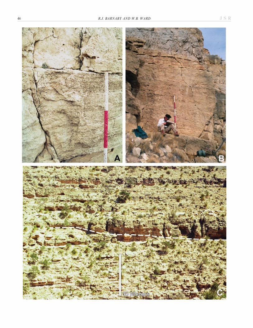
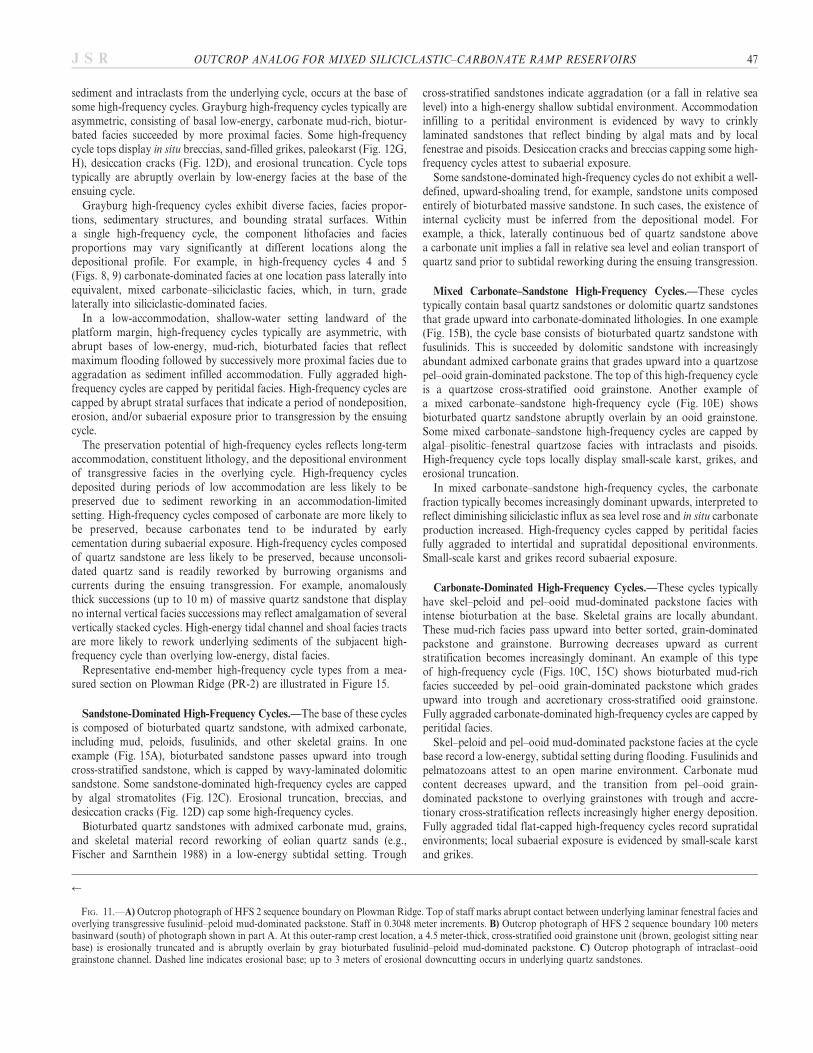
FIG. 11.—A) Outcrop photograph of HFS 2 sequence boundary on Plowman Ridge. Top of staff marks abrupt contact between underlying laminar fenestral facies andoverlying transgressive fusulinid–peloid mud-dominated packstone. Staff in 0.3048 meter increments. B) Outcrop photograph of HFS 2 sequence boundary 100 metersbasinward (south) of photograph shown in part A. At this outer-ramp crest location, a 4.5 meter-thick, cross-stratified ooid grainstone unit (brown, geologist sitting nearbase) is erosionally truncated and is abruptly overlain by gray bioturbated fusulinid–peloid mud-dominated packstone. C) Outcrop photograph of intraclast–ooidgrainstone channel. Dashed line indicates erosional base; up to 3 meters of erosional downcutting occurs in underlying quartz sandstones.
OUTCROP ANALOG FOR MIXED SILICICLASTIC–CARBONATE RAMP RESERVOIRS 47J S R

48 R.J. BARNABY AND W.B. WARD J S R

Composite Cycles
Composite cycles (4 to 12 meters thick) consist of two or more high-frequency cycles arranged into intermediate-scale, transgressive–regres-sive successions (Figs. 8, 9). At the base of each composite cycle, faciestypically consist of fusulinid–peloid or skel–peloid mud-dominatedpackstone with admixed quartz sand or fossiliferous quartz sandstone.High-frequency cycles in the upper portion of composite cycles containincreasing proportions of more proximal facies, including ooid grainstoneand fenestral–pisolite and algal-laminated facies (Figs. 8, 9). Small-scalekarst locally caps the composite cycles.
Composite cycles subdivide the high-frequency sequences into in-termediate-scale cyclic successions within the longer-term accommoda-tion trend imposed by the high-frequency sequences. Transgressive faciesat the base of the composite cycles are succeeded by more proximal ooidgrainstone and fenestral–pisolite and algal-laminated facies, interpretedto represent successive infilling of accommodation to shallow subtidaland peritidal environments. Local karst records subaerial exposurefollowing deposition. For many composite cycles, however, the landwardfacies tract offset at the transgressive base of the overlying compositecycle is the defining aspect of the composite cycle top. This landwardfacies-tract offset is greater in magnitude than that for high-frequencycycles within the composite cycle.
In the subsurface with widely spaced well control, it can be difficult toidentify and correlate individual high-frequency cycles, whereas compos-ite cycles can be more readily recognized. For example, the high-frequency cycle tops within the composite cycle are less well developedthan the tops of the composite cycles. In the study area, high-frequencycycles are best developed on the ramp crest. Off the crest, high-frequencycycles may become less well developed so that the composite cycle may bethe smallest stratigraphic unit that can be recognized and correlated.Composite cycles also are useful chronostratigraphic units where cycleamalgamation has occurred. Amalgamation is restricted to high-frequency cycles within a composite cycle, and cycle amalgamation doesnot occur across composite cycle boundaries, retaining the integrity ofthese chronostratigraphic surfaces.
High-Frequency Sequences
Grayburg high-frequency sequences recognized by this study follow thedefinition of Mitchum (1977) and Mitchum and Van Wagoner (1991).Because the Grayburg accumulated landward of the shelf margin (Fig. 4),sequences consist of a transgressive systems tract separated by a maxi-mum flooding surface from the highstand systems tract. Except for thelowermost Grayburg, which onlaps the San Andres shelf margin, thehigh-frequency sequences do not display diagnostic stratal terminations(e.g., onlap, offlap, and toplap) due to limited accommodation in therelatively flat-lying, shallow-water setting (Fig. 7). The Grayburg high-frequency sequences are primarily recognized from facies stackingpatterns in successive high-frequency cycles. Each high-frequencysequence contains at its base an unconformity, overlain by a retro-gradational succession of high-frequency cycles, succeeded by an
aggradational to progradational succession of high-frequency sequences,and capped by an unconformity.
Stratigraphically significant facies for interpreting the accommodationtrends of the high-frequency sequences include: (1) fusulinid–peloid mud-dominated packstone–wackestone facies, which record transgression andmaximum water depths; (2) ooid grainstones, which indicate aggradationto a shallow-water, high-energy setting; (3) tepee–pisolite–fenestral andalgal-laminated facies, which document platform aggradation to in-tertidal and supratidal environments; and (4) quartz sandstones andmixed siliciclastic–carbonate facies, which represent eolian transportduring sea-level lowstands and subsequent subtidal reworking duringtransgression.
Unconformity-related subaerial exposure is directly indicated bypaleokarst and grikes and can be inferred from overlying lowstand-transported quartz sands. An abrupt landward facies-tract offset over-lying an unconformity is one of the more diagnostic features of thesequence boundary. For example, at the base of HFS 2 (Fig. 8),transgressive fusulinid–peloid mud-dominated packstone–wackestonefacies overlie karsted tidal flat facies of underlying HFS 1, defining thelower sequence boundary.
We interpret four high-frequency sequences (HFS 1–4), each 30 to45 meters thick, in the Grayburg Formation (Fig. 7). Correlation of ourstratigraphic framework with previous studies that subdivide the Gray-burg into 2 sequences (Kerans et al. 1992; Kerans et al. 1993) indicates thatour Grayburg HFS 1 and 2 are equivalent to their Guadalupian HFS 14and our Grayburg HFS 3 and 4 are correlative with their GuadalupianHFS 15. Given that the Grayburg composite sequence is approximately1 Myr in duration (Ross and Ross 1987), the four Grayburg high-frequency sequences may correspond to fourth-order depositional cycles(sensu Goldhammer et al. 1990). The four Grayburg sequences are thoughtto be equivalent to the four sequences interpreted from the subsurfaceGrayburg, for example, in Maljamar Field on the northern shelf ofthe Delaware Basin (Modica 1997) and on the Central Basin Platformin South Cowden Field (Ruppel and Bebout 2001), North CowdenField (Entzminger et al. 2000), and Foster Field (Kerans, personalcommunication 1995). These regional correlations suggest that theGrayburg high-frequency sequences represent intermediate-scale cyclicityin relative sea level superimposed on the longer-term accommodationtrend recorded by the third-order Grayburg composite sequence (Fig. 6).
GRAYBURG STRATIGRAPHIC AND FACIES ARCHITECTURE
Grayburg HFS 1
Description.—The lowermost Grayburg onlaps the San AndresFormation (Fig. 7) and consists of skeletal-rich quartz sandstones andquartzose carbonates that are trough cross-stratified or bioturbated.These subtidal facies cap high-frequency cycles, with local paleokarst andgrikes occurring at the cycle tops. At the top of HFS 1, laterally extensivealgal-laminated and fenestral–pisolite facies (Figs. 8, 9) are succeeded byan erosional surface with local paleokarst (Fig. 12G). The isopach mapfor this interval (Fig. 16) displays a basinward increase in thickness.
r
FIG. 12.— A) Outcrop photograph of quartz sandstone with small-scale trough cross-stratification. B) Outcrop photograph of quartz sandstone with large-scaleaccretionary foresets interpreted to be relict eolian dune. C) Outcrop photograph of wavy to stromatolitic algal laminae in dolomitic sandstone near top of high-frequencycycle. Knife handle is approximately 8 cm long. D) Outcrop photograph of polygonal desiccation cracks in dolomitic sandstone filled with siliciclastic silt and carbonatemud near top of high-frequency cycle. E) Photomicrograph of well-sorted quartz sandstone. Scale bar 5 500 mm. Sediments consist of fine- to medium-grained, roundedto well-rounded, detrital quartz sand and minor peloids. Cements consist of dolomite, quartz overgrowths, and late calcite (stained pink). Porosity includes primaryinterparticle moldic pores (probably leached feldspar grains). Core-plug helium porosity 5 6.1%, air permeability 5 1.93 md. F) Photomicrograph of quartzose ooidgrainstone with very fine- to fine-grained quartz sand. Scale bar 5 500 mm. G) Outcrop photograph of quartzose fenestral dolomite at top of Grayburg HFS 1 cut bykarst dissolution dolines infilled by fusulinid–peloid mud-dominated packstone that delineates onset of transgression for HFS 2. H) Outcrop photograph of karsted cross-stratified ooid grainstone at top of Grayburg HFS 1 (white arrows). Up to 0.7 meters of relief exists; this surface is overlain by quartz sandstone at the base of HFS 2.
OUTCROP ANALOG FOR MIXED SILICICLASTIC–CARBONATE RAMP RESERVOIRS 49J S R

Interpretation.—Grayburg onlap onto the San Andres Formationrepresents a third-order sequence boundary (Sarg and Lehmann 1986).Abundant quartz sand in the lower Grayburg reflects eolian siliciclasticinflux during subaerial exposure of the San Andres Formation. High-frequency cycles capped by subtidal facies with subaerial exposurefeatures are interpreted to have been stranded by cyclic falls in relative sealevel (e.g., Rankey et al. 1999). The first widespread carbonate-dominatedunit is interpreted to represent maximum flooding. Algal-laminated andfenestral–pisolite facies near the top of HFS 1 record aggradation to anupper peritidal to supratidal setting. The erosional surface with localpaleokarst at the top of HFS 1 is a sequence boundary that wassubsequently transgressed by the base of HFS 2.
The onlapping geometries of lowermost Grayburg strata indicate thatthe basinward-thickening trend reflects depositional relief on theseaward-dipping top of the San Andres platform. Antecedent topographywas infilled by the end of HFS 1, as evidenced by well-developed peritidalto supratidal facies at the top of HFS 1 and by the relatively uniformthickness of overlying HFS 2 (Fig. 17).
Grayburg HFS 2
Detailed stratigraphic analysis focused on Grayburg HFS 2 becausethis interval contains grain-dominated packstone and grainstone facies ofinterest in reservoir characterization due to their high porosity andpermeability. The stratigraphic succession is similar for the PlowmanRidge and West Dog Canyon locations, although they display differencesin facies and high-frequency cycle development (Figs. 8, 9). Thesedisparities reflect the slightly different platform location and depositionalvariability along strike.
Transgressive Systems Tract: Description.—The base of HFS 2 (Figs. 8,9) is a fusulinid–peloid mud-dominated packstone–wackestone tofusulinid-bearing dolomitic sandstone. Quartz sand is abundant in thelower TST. Incised channels are common; the largest occurs in West DogCanyon where algal-laminated and fenestral–pisolite facies are downcut4.5 meters (Fig. 9). This channel (Fig. 11C) contains ooid–intraclastgrainstone with sigmoidal and herringbone cross-stratification and isoriented parallel to depositional dip (Fig. 14).
Fusulinid–peloid mud-dominated packstone–wackestone facies insuccessive high-frequency cycles display retrogradational relationshipsand are ultimately succeeded by a widespread unit of this facies (Figs. 8,9).
Transgressive Systems Tract: Interpretation.—Fusulinid-rich facies atthe base of HFS 2 represent an abrupt landward shift in deposition abovekarsted peritidal facies in HFS 1. Abundant quartz sand reflects highsiliciclastic influx during sea-level lowstands; continued transgressioneventually restricted siliciclastic influx. The abundant incised channelsand well-developed sigmoidal and herringbone cross-stratification docu-ment a tidal influence.
The ooid–intraclast grainstone-filled channel (Figs. 11C, 14) isrepresentative of grainstone facies architecture in the transgressivesystems tract. These grainstone bodies typically retain their initialdepositional morphologies and were not extensively reworked. De-velopment of ooid bars and tidal channels is comparable to that observedin Holocene carbonates in the Joulters Cay area of the Bahamas (Harriset al. 1993). The transgressive systems tracts exhibit the greatest lateralheterogeneity of grainstone bodies, many of which formed dip-elongatechannels and bars (Harris et al. 1993). This heterogeneity reflects the tidalsetting that dominated during initial transgression, in which ooids wereproduced and accumulated along dip-oriented tidal channels and bars.Rapid increase in accommodation associated with rising relative sea level
TA
BL
E1.
—S
umm
ary
ofli
thof
acie
sde
scri
ptio
ns.
Fac
ies
Bed
din
gch
arac
teri
stic
sG
rain
typ
esS
edim
enta
ryst
ruct
ure
sC
on
tact
so
ther
feat
ure
s
Fu
suli
nid
-pel
oid
mu
d-
do
min
ated
pac
kst
on
ean
dw
ack
esto
ne
Mas
sive
tob
iotu
rbat
ed,
rece
ssiv
ew
eath
ered
bed
s0.
5–3
mth
ick
Pel
oid
mat
rix,
fusu
lin
ids
(10–
40%
),cr
ino
ids,
mo
llu
sks,
qu
artz
silt
and
very
fin
eto
fin
egr
ain
edq
uar
tzsa
nd
Bio
turb
atio
nA
bru
pt
low
erco
nta
ct,
up
per
con
tact
abru
pt
togr
adat
ion
al
Mu
dst
on
ean
dsk
el-p
elo
idw
ack
esto
ne
Mas
sive
tob
iotu
rbat
ed,
rece
ssiv
ew
eath
ered
bed
s0.
2–1.
5m
thic
k
Mo
llu
sks,
pel
oid
s,cr
ino
ids,
das
ycla
dac
ean
s,fu
suli
nid
s(,
10%
)B
iotu
rbat
ion
Ab
rup
tlo
wer
con
tact
up
per
con
tact
grad
atio
nal
Sk
el-p
elo
idan
dp
el-o
oid
mu
d-d
om
inat
edp
ack
sto
ne
Mas
sive
tob
iotu
rbat
ed,
resi
stan
tle
dge
form
ing
bed
s0.
3–10
mth
ick
Pel
oid
s,o
oid
s,cr
ino
ids,
mo
llu
sks,
fusu
lin
ids
(,10
%),
qu
artz
silt
and
very
fin
e-to
fin
e-gr
ain
edq
uar
tzsa
nd
Bio
turb
atio
n,
loca
lfa
int
par
alle
lla
min
atio
nL
ow
erco
nta
ctab
rup
tto
grad
atio
nal
up
per
con
tact
grad
atio
nal
or
abru
pt
Pel
-oo
idgr
ain
-do
min
ated
pac
kst
on
eM
assi
veto
bio
turb
ated
,re
sist
ant
led
gefo
rmin
gb
eds
0.3–
1.5
mth
ick
Oo
ids,
pel
oid
s,cr
ino
ids,
intr
acla
sts,
qu
artz
silt
and
very
fin
e-to
fin
e-gr
ain
edq
uar
tzsa
nd
Bio
turb
atio
n,
loca
lre
lict
cro
ss-s
trat
ific
atio
nG
rad
atio
nal
up
per
and
low
erco
nta
cts
Oo
idgr
ain
sto
ne
Mas
sive
resi
stan
tcl
iff-
form
ing
un
its
up
to5
mth
ick
Oo
ids,
pel
oid
s,in
trac
last
s,cr
ino
ids,
fin
e-to
med
ium
-gr
ain
edq
uar
tzsa
nd
Tro
ugh
cro
ss-s
trat
ific
atio
n,
shee
tst
rati
fica
tio
n,
accr
etio
nar
yb
edd
ing,
chan
nel
sB
eds
amal
gam
ated
,lo
wer
con
tact
grad
atio
nal
or
abru
pt,
up
per
con
tact
abru
pt
Tep
ee-p
iso
lite
-fen
estr
alan
dal
gal-
lam
inat
edfa
cies
Res
ista
nt
clif
f-fo
rmin
gu
nit
su
pto
6m
thic
kP
iso
ids,
pel
oid
s,p
elle
ted
sed
imen
t,o
oid
s,in
trac
last
s,ve
ryfi
ne-
tom
ediu
m-g
rain
edq
uar
tzsa
nd
Tep
ees,
fen
estr
ae,
alga
lla
min
atio
ns
des
icca
tio
ncr
ack
s,ar
ago
nit
e-ce
men
ted
shee
tcr
ack
sG
rad
atio
nal
low
erco
nta
ct,
abru
pt
up
per
con
tact
Qu
artz
san
dst
on
ean
dm
ixed
sili
cicl
asti
c-ca
rbo
nat
efa
cies
Rec
essi
ve,
slo
pe-
form
ing
un
its,
0.3–
10m
thic
kV
ery
fin
e-to
med
ium
-gra
ined
qu
artz
san
d,
min
or
feld
spar
,m
ediu
msa
nd
grai
ns
are
wel
lro
un
ded
,ve
ryfi
ne
and
fin
esa
nd
grai
ns
are
angu
lar,
oo
ids,
pel
oid
s,fu
suli
nid
s,cr
ino
ids,
intr
acla
sts,
pis
oid
s
Mas
sive
and
bio
turb
ated
,tr
ou
gh-
and
rip
ple
cro
ss-
stra
tifi
cati
on
,ac
cret
ion
ary
fore
sets
,p
lan
ep
aral
lel
lam
inat
ion
,sm
all-
scal
ech
ann
els,
fen
estr
ae,
mm
-sca
lew
avy
alga
lla
min
atio
n
Bed
sam
alga
mat
ed,
abru
pt
low
erco
nta
ct,
grad
atio
nal
toab
rup
tu
pp
erco
nta
ct
50 R.J. BARNABY AND W.B. WARD J S R

resulted in high preservation potential for these dip-elongate grainstonebodies.
Landward-stepping fusulinid–peloid mud-dominated packstone faciesin the late TST record continued transgression, which culminated indeposition of a widespread unit of this facies during maximum flooding inHFS 2 (Figs. 8, 9).
Highstand Systems Tract: Description.—High-frequency cycles in theupper portion of HFS 2 are capped by ooid grainstone beds (Figs. 8, 9)up to 4 meters in thickness. The ooid grainstones display dominantlysouth-dipping accretionary foresets, whereas the contacts betweensuccessive stacked beds dip towards the north. The grainstones containminor amounts of admixed quartz sand.
These grainstone bodies are oriented parallel to depositional strike.For example, the ooid grainstone body in high-frequency cycle 12 attainsa maximum thickness of 4.3 meters and forms a strike-elongate shoal
(Fig. 13). The shoal has a dip width of more than 1200 meters andextends for at least 1000 meters across strike.
Tepee–pisolite–fenestral and algal-laminated facies near at the top ofHFS 2 (Fig. 11A) are capped by an erosional surface with localpaleokarst. This surface is overlain by fusulinid–peloid mud-dominatedpackstone–wackestone facies at the base of HFS 3 (Fig. 11A, B). Theisopach map for HFS 2 (Fig. 17) indicates minor (, 3 meters) variationin thickness.
Highstand Systems Tract: Interpretation.—The ooid grainstones recorda high-energy, ramp-crest environment and are interpreted to representaggradation to shallow subtidal conditions. Strike-parallel ooid grain-stones that are laterally continuous (hundreds of meters to 1 km) alongdip and across strike reflect reworking, coalescence, and amalgamation ofooid grainstone bodies in a limited accommodation highstand setting.South-dipping cross laminae and north-dipping contacts between
FIG. 13.—Isopach map of ooid grainstoneunit in HFS 2 high-frequency cycle 12 (HST) atPlowman Ridge and West Dog Canyon. Themeasured sections indicated by dots and thecontinuous outcrop exposures between measuredsections were used to generate map. Townshipand range lines from Figure 5.
OUTCROP ANALOG FOR MIXED SILICICLASTIC–CARBONATE RAMP RESERVOIRS 51J S R
successive stacked beds indicate that the predominant transport directionwas to the south and that the shoals within a high-frequency cycleamalgamated by migrating southward and climbing atop the precedingshoal. This is consistent with a northeasterly dominant paleowinddirection (Parrish and Peterson 1988; Parrish 1993, 1995) and suggeststhat ooid formation was on the restricted landward side of the ramp crestwhere salinities were elevated by evaporation. Highstand ooid grainstonestypically contain little or no admixed quartz sand, suggesting thatcommunication with the siliciclastic-dominated inner platform wasinhibited by fringing grainstone shoals. This interpretation is consistentwith observations of Holocene carbonates in the Bahamas (Harris et al.1993), where fringing barrier highstand ooid shoals restrict tidalcirculation with the platform interior.
Tepee–pisolite–fenestral and algal-laminated wackestone and pack-stone facies near the top of HFS 2 reflect complete infilling ofaccommodation. The subaerial exposure surface is interpreted torepresent the upper sequence boundary. This surface is transgressed byouter-ramp fusulinid–peloid mud-dominated packstone–wackestone fa-cies at the base of HFS 3.
The isopach map indicates that antecedent relief on the San Andresplatform was largely infilled by the end of HFS 1. Changes in thickness inHFS 2 coincide with the thickness trends in the ooid grainstone bodies andthus reflect syndepositional relief due to depositional processes such assediment production and accumulation on high-energy ramp-crest shoals.
Grayburg HFS 3
Description.—The base of Grayburg HFS 3 is a regionally correlativeinterval of fusulinid–peloid mud-dominated packstone–wackestone facies(Figs. 6, 7). This is the stratigraphically highest occurrence of this facies inthe study area. In more distal locations, such as Shattuck Valley, thisfacies persists throughout HFS 3 (Kerans and Nance 1991).
The HFS 3 high-frequency cycles consist of cyclically interbeddedquartz sandstone and mixed siliciclastic–carbonate facies with skel–peloidand pel–ooid mud-dominated packstone and minor ooid grainstone,some cycles are capped by tepee–pisolite–fenestral and algal-laminatedfacies. We pick the top of HFS 3 immediately above a unit of tepee–pisolite–fenestral and algal-laminated facies (Figs. 6, 7). This surface is
FIG. 14.—Isopach map of ooid–intraclastchannel in HFS 2 high-frequency cycle 2 (TST)in West Dog Canyon. The measured sectionsindicated by dots and the continuous outcropexposures between measured sections were usedto generate map. Township and range linesfrom Figure 5.
52 R.J. BARNABY AND W.B. WARD J S R
abruptly overlain by skel–peloid and pel–ooid mud-dominated packstoneand ooid grainstone at the base of HFS 4.
Interpretation.—The regionally correlative fusulinid–peloid mud-dom-inated packstone–wackestone unit at the base of HFS 3 recordsmaximum regional flooding in the Grayburg composite sequence (Keransand Nance 1991; Kerans et al. 1992; Kerans et al. 1993; this study); thisevent is recognized throughout the Permian Basin in outcrop andsubsurface (e.g., Ruppel and Bebout 2001). The paucity of stratigraphi-cally higher fusulinid–peloid mud-dominated packstone–wackestonefacies in the study area indicates infilling of long-term accommodation.High-frequency cycles in HFS 3 are aggradational successions of inner-ramp to middle-ramp facies. The upper sequence boundary of HFS 3 isinterpreted to be the top of the tepee–pisolite–fenestral and algal-laminated facies. However, due to limited outcrop exposures of thisinterval, this sequence boundary is poorly constrained. This surface istransgressed by skel–peloid and pel–ooid mud-dominated packstones andooid grainstones assigned to the base of HFS 4.
Grayburg HFS 4
Description.—There is poor outcrop control for much of HFS 4 in thestudy area (Fig. 6). The limited exposures are dominated by a suite of
relatively restricted, inner-ramp facies, including massive dolomitic quartzsandstone, skel–peloidal and pel–ooid mud-dominated packstone, andtepee–pisolite–fenestral and algal-laminated facies. Fusulinid–peloidmud-dominated packstone–wackestone facies in HFS 4 are rare inGrayburg strata that accumulated landward of the underlying SanAndres margin (this study; Ruppel and Bebout 2001). In more distallocations basinward of the San Andres margin, outer-ramp fusulinid–peloid packstone facies persist to the Grayburg–Queen sequenceboundary (Fekete et al. 1986; Franseen et al. 1989; Kerans and Nance1991). On Plowman Ridge, the top of the Grayburg Formation is poorlyexposed and is assigned to the top of the uppermost unit of tepee–pisolite–fenestral and algal-laminated facies that is overlain by recessivelyweathered, yellow-brown to pink, thin-bedded sandstones assigned to thelowermost Queen Formation.
Interpretation.—The suite of restricted, inner-ramp facies and thepaucity of fusulinid–peloid mud-dominated packstone–wackestone faciesare consistent with an interpretation that this interval consists ofdominantly aggradational high-frequency cycles that reflect decreasinglong-term accommodation in the Grayburg composite sequence. In morebasinward locations, outer ramp fusulinid–peloid packstone facies persistto the Grayburg–Queen sequence boundary, reflecting greater accommo-dation in more distal outer-ramp locations. Sandstones in the overlyingQueen Formation represent a major basinward shift in depositional facies.
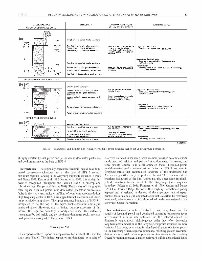
FIG. 15.—Examples of end-member high-frequency cycle types (from measured section PR-2) in Grayburg Formation.
OUTCROP ANALOG FOR MIXED SILICICLASTIC–CARBONATE RAMP RESERVOIRS 53J S R

DISCUSSION
A significant contribution of this study is the detailed faciesdistribution with respect to the hierarchical stratigraphy of the high-frequency sequences, composite cycles, and high-frequency cycles. Criticalfacies for interpreting transgressive–progradational aspects of theaccommodation trends include: (1) outer-ramp fusulinid–peloid mud-dominated packstone–wackestone facies, which record transgression; (2)ramp-crest ooid grainstones, which represent aggradation and prograda-tion to high-energy subtidal environments; (3) tepee–pisolite–fenestraland algal-laminated facies, which indicate aggradation to sea level; and(4) wind-transported quartz sands, which reflect emergence of theplatform during sea-level lowstands. There are no facies, however, thatare unique to the transgressive or highstand systems tracts. Instead, thesystems tracts and high-frequency sequences are defined by the landwardand seaward shifts in facies distribution, facies stacking relationships, andbounding flooding surfaces and unconformities.
For example, in HFS 2, quartz sands are most abundant in thetransgressive systems tract (Figs. 8, 9), recording eolian influx ofsiliciclastics during prolonged sea-level lowstands and subsequentreworking during the ensuing transgression. Quartz sand is least
abundant in high-frequency cycles associated with maximum flooding,because widespread transgression restricted siliciclastic influx. Fusulinid–peloid mud-dominated packstone–wackestone facies occur at the base ofhigh-frequency cycles in both the transgressive and highstand systemstracts. This facies displays a retrogradational distribution in the trans-gressive systems tract, which culminated in deposition of a widespreadunit during maximum transgression. Ooid grainstones are present in bothtransgressive and highstand strata; however, grainstones are bestdeveloped in the highstand, where vertically stacked ooid grainstones insuccessive high-frequency cycles exhibit progradational relationships.Tepee–pisolite–fenestral and algal-laminated facies locally cap compositecycles in both transgressive and highstand systems tracts. In the studyarea, this facies is best developed where it occurs at the top of the high-frequency sequences. For example, in HFS 2, tepee–pisolite–fenestral andalgal-laminated facies cap an overall progradational succession of ooidgrainstone-dominated high-frequency cycles, recording successive infillingof accommodation, followed by an unconformity development duringsea-level lowstand.
The stratigraphic entities represented by the high-frequency cycle,composite cycle, and high-frequency sequence are three-dimensionalbodies. Although the hierarchical stratigraphy may be initially interpreted
FIG. 16.—Isopach map of HFS 1. In additionto the measured sections indicated by dots, thecontinuous outcrop exposures between sectionswere used to generate map.
54 R.J. BARNABY AND W.B. WARD J S R

from a vertical section, at minimum, a dip-oriented cross-sectional view isrequired to fully recognize the hierarchy of stratal surfaces and thelandward and seaward facies shifts that define high-frequency cycles andthe sequence stratigraphic framework. Evaluation of lateral variationacross depositional strike requires information on the shelf orientationand antecedent topography.
The character of the high-frequency cycles and their component faciesreflects their platform location. Grayburg strata examined by this studyaccumulated in shallow-water conditions (0 to 10 meters depth) ina middle-ramp to ramp-crest setting, 10 km landward of the margin.High-frequency cycles are less well developed in the more seawardenvironments represented by the outer shelf, shelf margin, and foreslope(Fekete et al. 1986; Franseen et al. 1989). Landward of the study area,subaerial exposure was more continuous and the interval is dominated bya suite of restricted inner-shelf facies, including quartz sandstone,dolomitic sandstone, and tepee–pisolite–fenestral and algal-laminatedfacies.
Antecedent topography profoundly influenced facies distributionwithin the high-frequency sequences, composite cycles, and high-frequency cycles. For example, the break in slope induced by theunderlying San Andres shelf margin influenced facies distribution in thelower Grayburg (HFS 1 and 2). In the lower Grayburg, below themaximum flooding event in HFS 2, outer-ramp fusulinid–peloid mud-
dominated packstone–wackestone and mudstone and skel–peloid wack-estone facies are generally confined to locations seaward of the SanAndres margin. Widespread deposition of a fusulinid–peloid mud-dominated packstone–wackestone unit during maximum flooding inHFS 2 indicates that the antecedent topography in the study area waslargely infilled by this time, although more subtle topographic variationcontinued to influence the location of outer-ramp-crest ooid grainstonesand inner-ramp-crest tepee–pisolite–fenestral and algal-laminated faciesin the HFS 2 highstand. Smaller-scale variation in antecedent topographycaused by depositional processes impacted facies distribution in the high-frequency cycles and composite cycles. For example, in the transgressivesystems tract of HFS 2, dip-oriented topographic lows and highs createdby channel incision and shoals are maintained in successive high-frequency cycles within a composite cycle. In the highstand systems tractof HFS 2, depositional thicks created by ooid grainstone shoals on theouter ramp crest influence facies distribution in the successive high-frequency cycle.
Detailed characterization of the facies distribution from the Grayburgoutcrops demonstrates the application of sequence stratigraphic princi-ples for high-resolution correlation of well-log and core data forcharacterization of facies heterogeneity in subsurface reservoirs. Thehigh-frequency cycles offer the highest resolution correlation unit todelineate the facies distribution. With widely spaced well data, however,
FIG. 17.—Isopach map of HFS 2 displays lesspronounced basinward thickening than HFS 1.Local isopach thick in West Dog Canyonrepresents depositional relief on a ramp-crestooid shoal that developed at this locale. Inaddition to the measured sections, the continu-ous outcrop exposures between sections wereused to generate map.
OUTCROP ANALOG FOR MIXED SILICICLASTIC–CARBONATE RAMP RESERVOIRS 55J S R
recognition and correlation of individual high-frequency cycles becomesmore difficult, whereas the more significant facies tract offsets recordedby the composite cycles and high-frequency sequences are readilyidentified and confidently correlated. This stratigraphic framework thenprovides a basis for further interpretation of the smaller-scale accommo-dation trends and potential correlation of the high-frequency cycles.
Stratigraphic analysis indicates general relationships between strati-graphic setting, depositional environment, and facies geometry andlateral continuity. For example, subtidally reworked lowstand quartzsands form laterally continuous units (more than several kilometers).Transgressive low-energy carbonates display similar lateral continuity.Ooid grainstones that accumulated in a transgressive setting formed dip-elongate tidal channels and bars that are less than a few hundred meterswide and more than one kilometer in length. Conversely, ooid grainstonesthat accumulated under highstand conditions formed strike-elongateshoals that are laterally continuous along dip and across strike for onekilometer or more.
Prediction of facies distribution and lateral heterogeneity in areas withsparse well data requires knowledge of the general trend of the platformand the relative position within the cyclic hierarchy. Empirical relation-ships such as those described above between stratigraphic setting, faciesorientation, and lateral continuity can be used to improve subsurfacecorrelations and better populate facies in 3-D geocellular models based onlimited well data.
SUMMARY
Mixed siliciclastic and carbonate rocks of the Grayburg Formationaccumulated on the shallow-water periphery of the Delaware andMidland basins. Facies record depositional environments includingouter-ramp, high-energy ramp crest, restricted inner-ramp, and wind-transported lowstand quartz sandstones. Facies successions displayvertical and lateral relationships that define four hierarchical scales ofsea-level cyclicity.
The entire Grayburg Formation is a composite sequence that recordsa third-order cycle in eustatic sea level (Ross and Ross 1987). Grayburgdeposition began with onlap onto the San Andres platform andculminated with subaerial exposure, followed by a major basinward shiftin facies during deposition of the Queen Formation. The Grayburgcomposite sequence contains four high-frequency sequences. Each high-frequency sequence corresponds to an intermediate-scale cycle in relativesea level and comprises a retrogradational succession of transgressivefacies overlain by a progradational to aggradational succession ofhighstand facies, capped by a sequence boundary. The high-frequencysequences can be subdivided into composite cycles, intermediate-scaletransgressive–regressive successions that contain several high-frequencycycles. High-frequency cycles are the smallest-scale, upward-shoalingfacies successions that can be traced laterally across different facies tractsand are interpreted to represent fifth-order cycles in relative sea level.
Detailed characterization of the Grayburg outcrops demonstrates theapplication of sequence stratigraphic principles for high-resolutioncorrelation and facies mapping, documenting the utility of stratigraphicanalysis to interpret and correlate well-log and core data for character-ization of geologic heterogeneity in subsurface reservoirs. The high-frequency cycles form the basic unit for high-resolution chronostrati-graphic correlation and delineation of facies heterogeneity. High-frequency cycles, however, may be difficult to confidently correlate usingwell data at typical 10 to 40 acre well spacings, whereas the longer-termaccommodation trends and greater facies tract offsets recorded by thecomposite cycles and high-frequency sequences allow more confidentchronostratigraphic correlations. These larger-scale correlations thenprovide the framework for further interpretation of the smaller-scale
accommodation trends and potential correlation of the constituent high-frequency cycles.
Because depositional fabrics are well preserved in the dolomitizedcarbonates and quartz sandstones of the Grayburg, porosity andpermeability are a function of the original depositional fabric (Lucia1995) and high-frequency cycles define the basic flow units.
Lateral heterogeneity reflects both larger-scale systematic facieschanges and interwell-scale heterogeneity due to geologic complexity.Systematic facies changes that reflect primary environmental and/ordepositional controls (e.g., water depth, platform position, accommoda-tion trends) can be characterized with subsurface data, abetted bydepositional models where data are sparse. Interwell heterogeneity due togeologic complexity is more difficult to recognize with subsurface data.Appropriate outcrop analogs provide invaluable information on lateralfacies dimensions and heterogeneity styles that can be utilized toconstruct more realistic three-dimensional reservoir models than over-simplified models based on lithofacies correlations forced between wellsby linear interpolation.
ACKNOWLEDGMENTS
This work was completed while the authors were at the Bureau ofEconomic Geology at The University of Texas at Austin. C. Kerans and F.J.Lucia proposed this study, obtained research support, and contributed to theideas and interpretations. The manuscript benefited from reviews by Journalof Sedimentary Research Associate Editor E.C. Rankey and Co-Editor K.Milliken, and editorial review by J.B. Southard. Technical reviews by D.L.Cantrell, M.T. Harris, and E.K. Franseen greatly improved the manuscript;C.R. Handford and S.P. Dutton reviewed early versions of the manuscript.J.G. Grubb, M.H. Kwong, K.A. Kempter, and R. Boghici served as researchand field assistants. J.W. Jennings, Jr. evaluated petrophysical heterogeneityin the Grayburg; this work is described in Jennings (2000). Funding for thisresearch was provided by the U.S. Department of Energy and by theIndustrial Associates of the Reservoir Characterization Research Laboratory.
REFERENCES
BABCOCK, J.A., 1977, Calcareous algae, organic boundstones, and the genesis of upperCapitan Limestone (Permian Guadalupian) Guadalupe Mountains, West Texas andNew Mexico, in Hileman, M.E., and Mazzullo, S.J., eds., Upper Guadalupian Facies,Permian Reef Complex, Guadalupe Mountains, New Mexico and West Texas:Permian Basin Section, SEPM, Publication 77-16, p. 3–44.
BORER, J.M., AND HARRIS, P.M., 1989, Depositional facies and cycles in YatesFormation outcrops, Guadalupe Mountains, New Mexico, in Harris, P.M., andGrover, G.A., eds., Subsurface and Outcrop Examination of the Capitan ShelfMargin, Northern Delaware Basin: SEPM, Core Workshop 13, p. 305–317.
BOYD, D.W., 1958, Permian Sedimentary Facies, Central Guadalupe Mountains, NewMexico: New Mexico Bureau of Mines and Mineral Resources, Bulletin 49, 100 p.
CANDELARIA, M.P., 1989, Shallow marine sheet sandstones, Upper Yates Formation,Northwest Shelf, Delaware Basin, New Mexico, in Harris, P.M., and Grover, G.A.,eds., Subsurface and Outcrop Examination of the Capitan Shelf Margin, NorthernDelaware Basin: SEPM, Core Workshop 13, p. 319–324.
COFFIN, M., GAHAGAN, L., LAWVER, L., LEE, T.-Y., AND ROSENCRANTZ, E., 1992, Atlas ofMesozoic/Cenozoic reconstructions (200 Ma to present day) plates: University ofTexas Institute for Geophysics, Technical Report 122, 49 p.
CROWLEY, T.J., AND BAUM, S.K., 1991, Estimating Carboniferous sea-level fluctuationsfrom Gondwana ice extent: Geology, v. 19, p. 975–977.
DUNHAM, R.J., 1962, Classification of carbonate rocks according to depositionaltexture, in Ham, W.E., ed., Classifications of Carbonate Rocks—A Symposium:American Association of Petroleum Geologists, Memoir 1, p. 108–121.
ENTZMINGER, D.J., FERDINAND, K., LAWSON, D., LOUCKS, R., MESCHER, P., AND PATTY,K., 2000, Corrigan–Cowden unit: the next generation, in Reid, S.T., ed., Geo-2000:Into the Future: American Association of Petroleum Geologists, Southwest Section,Transactions, West Texas Geological Society, Publication 2000-107, p. 139–159.
FEKETE, T.E., FRANSEEN, E.K., AND PRAY, L.C., 1986, Deposition and erosion of theGrayburg Formation (Guadalupian, Permian) at the shelf-to-basin margin, westernescarpment, Guadalupe Mountains, Texas, in Moore, G.E., and Wilde, G.L., eds.,Lower and Middle Guadalupian Facies, Stratigraphy, and Reservoir Geometries, SanAndres–Grayburg Formations, Guadalupe Mountains, New Mexico and Texas:SEPM, Permian Basin Section, Special Publication 25, p. 69–81.
FISCHER, A.G., AND SARNTHEIN, M., 1988, Airborne silts and dune-derived sands in thePermian of the Delaware Basin: Journal of Sedimentary Petrology, v. 58, p. 637–643.
56 R.J. BARNABY AND W.B. WARD J S R

FITCHEN, W.M., 1993, Sequence stratigraphic framework of the Upper San AndresFormation and equivalent basinal strata in the Brokeoff Mountains, Otero County,New Mexico: New Mexico Geological Society, 44th Field Conference, Guidebook,Carlsbad Region, New Mexico and West Texas, p. 185–193.
FRANSEEN, E.K., FEKETE, T.E., AND PRAY, L.C., 1989, Evolution and destruction ofa carbonate bank at the shelf margin: Grayburg Formation (Permian), westernescarpment, Guadalupe Mountains, Texas, in Crevello, P.D., Wilson, J.L., Sarg, J.F.,and Read, J.F., eds., Controls on Carbonate Platform and Basin Development:SEPM, Special Publication 44, p. 289–304.
GALLOWAY, W.E., EWING, T.E., GARRETT, C.M., TYLER, N., AND BEBOUT, D.G., 1983,Atlas of Major Texas Oil Reservoirs: The University of Texas at Austin, Bureau ofEconomic Geology, 139 p.
GOLDHAMMER, R.K., DUNN, P.A., AND HARDIE, L.A., 1990, Depositional cycles,composite sea level changes, cycle stacking patterns, and the hierarchy of stratigraphicforcing—examples from platform carbonates of the Alpine Triassic: GeologicalSociety of America, Bulletin, v. 102, p. 535–562.
GRANT, C.W., GOGGIN, D.J., AND HARRIS, P.M., 1994, Outcrop analog for cyclic-shelfreservoirs, San Andres Formation of Permian Basin: stratigraphic framework,permeability distribution, geostatistics, and fluid flow modeling: American Associa-tion of Petroleum Geologists, Bulletin, v. 78, p. 23–54.
GROTZINGER, J.P., 1986, Cyclicity and paleoenvironmental dynamics, Rocknestplatform, northwest Canada: Geological Society of America, Bulletin, v. 97, p.1208–1231.
HARRIS, P.M., KERANS, C., AND BEBOUT, D.G., 1993, Ancient outcrop and modernexamples of platform carbonate cycles—implications for subsurface correlation andunderstanding reservoir heterogeneity, in Loucks, R.G., and Sarg, J.F., eds.,Carbonate Sequence Stratigraphy: American Association of Petroleum Geologists,Memoir 57, p. 475–492.
HAYES, P.T., 1964, Geology of the Guadalupe Mountains, New Mexico: U.S.Geological Survey, Professional Paper 446, 69 p.
HORAK, R.L., 1985, Tectonic and hydrocarbon maturation history in the Permian Basin:Oil and Gas Journal, v. 83, p. 124–129.
JENNINGS, J.W., JR., 2000, Spatial statistics of permeability data from carbonateoutcrops of West Texas and New Mexico: implications for improved reservoirmodeling: The University of Texas at Austin, Bureau of Economic Geology, Reportof Investigations 258, 50 p.
JENNINGS, J.W., JR., RUPPEL, S.C., AND WARD, W.B., 2000, Geostatistical analysis ofpermeability data and modeling of fluid-flow effects in carbonate outcrops: Society ofPetroleum Engineers, Reservoir Evaluation and Engineering, v. 3, no. 4, p. 292–303.
KERANS, C., AND FITCHEN, W.M., 1995, Sequence hierarchy and facies architecture ofa carbonate-ramp system: San Andres Formation of Algerita Escarpment andWestern Guadalupe Mountains, West Texas and New Mexico: The University ofTexas at Austin, Bureau of Economic Geology, Report of Investigations 235, 86 p.
KERANS, C., AND NANCE, H.S., 1991, High-frequency cyclicity and regional depositionalpatterns of the Grayburg Formation, Guadalupe Mountains, New Mexico, inMeader-Roberts, S., Candelaria, M.P., and Moore, G.E., eds., Sequence Stratigraphy,Facies and Reservoir Geometries of the San Andres, Grayburg and QueenFormations, Guadalupe Mountains, New Mexico and Texas: SEPM, Permian BasinSection Publication 32, p. 53–96.
KERANS, C., AND TINKER, S.W., 1997, Sequence Stratigraphy and Characterization ofCarbonate Reservoirs: SEPM, Short Course Notes 40, 130 p.
KERANS, C., AND TINKER, S.W., 1999, Extrinsic stratigraphic controls on development ofthe Capitan Reef complex, in Saller, A.H., Harris, P.M., Kirkland, B.L., andMazzullo, S.J., eds., Geologic Framework of the Capitan Reef: SEPM, SpecialPublication 65, p. 15–36.
KERANS, C., FITCHEN, W.H., GARDNER, M.S., SONNENFELD, M.D., TINKER, S.W., AND
WARDLAW, B.R., 1992, Styles of sequence development within uppermost Leonardianthrough Guadalupian strata of the Guadalupe Mountains, Texas and New Mexico, inMruk, D.H., and Curran, B.C., eds., Permian Basin Exploration and ProductionStrategies: Applications of Sequence Stratigraphic and Reservoir CharacterizationConcepts: West Texas Geological Society, Symposium, Publication 91, p. 1–7.
KERANS, C., FITCHEN, W.M., GARDNER, M.S., AND WARDLAW, B.R., 1993, Acontribution of evolving stratigraphic framework of Middle Permian strata of theDelaware basin, Texas and New Mexico, in Love, D.W., Hawley, J.W., Kues, B.S.,Adams, J.W., Austin, G.S., and Barker, J.M., eds., New Mexico Geological Society,44th Annual Field Conference Guidebook, Carlsbad Region, New Mexico and WestTexas, p. 175–184.
KERANS, C., LUCIA, F.J., AND SENGER, R.K., 1994, Integrated characterization ofcarbonate ramp reservoirs using Permian San Andres Formation outcrop analogs:American Association of Petroleum Geologists, Bulletin, v. 78, p. 181–216.
KING, P.B., 1948, Geology of the southern Guadalupe Mountains: U.S. GeologicalSurvey, Professional Paper 215, 183 p.
KOCUREK, G., AND KIRKLAND, B.L., 1998, Getting to the source: aeolian influx to thePermian Delaware Basin region: Sedimentary Geology, v. 117, p. 143–149.
KOERSCHNER, W.F., AND READ, J.F., 1989, Field and modeling studies of Cambriancarbonate cycles, Virginia Appalachians: Journal of Sedimentary Petrology, v. 59, p.654–687.
LOTTES, A.L., AND ROWLEY, D.B., 1990, Early and Late Permian reconstructions ofPangaea, in McKerrow, W.S., and Scotese, C.R., eds., Palaeogeography andBiogeography: Geological Society of London, Memoir 12, p. 383–395.
LUCIA, F.J., 1995, Rock-fabric/petrophysical classification of carbonate pore space forreservoir characterization: American Association of Petroleum Geologists, Bulletin,v. 79, p. 1275–1300.
MEISSNER, F.F., 1972, Cyclic sedimentation in Middle Permian strata of the PermianBasin, West Texas and New Mexico: West Texas Geological Society, Publication 60,p. 118–142.
MITCHUM, R.M., 1977, Seismic stratigraphy and global changes of sea level, Part 1:Glossary of terms used in seismic stratigraphy, in C.E. Payton, ed., SeismicStratigraphy—Applications to Hydrocarbon Exploration: American Association ofPetroleum Geologists, Memoir 26, p. 205–212.
MITCHUM, R.M., AND VAN WAGONER, J.C., 1991, High frequency sequences and theirstacking patterns: sequence stratigraphic correlation evidence of high-frequencyeustatic cycles: Sedimentary Geology, v. 70, p. 131–160.
MITCHUM, R.M., VAIL, P.R., AND THOMPSON, S., III, 1977, Seismic stratigraphy andglobal changes in sea level, Part 2: The depositional sequence as a basic unit forstratigraphic analysis, in Payton, C.E., ed., Seismic Stratigraphy—Applications toHydrocarbon Exploration: American Association of Petroleum Geologists, Memoir26, p. 63–81.
MODICA, C.J., 1997, Stratigraphic cyclicity and reservoir heterogeneity within upper SanAndres and Grayburg strata (Upper Permian–Guadalupian), Maljamar Field, SENew Mexico [M.S. Thesis]: College Station, Texas, Texas A&M University, 103 p.
NANCE, H.S., 1988, Interfingering of evaporites and red beds: An example from theQueen/Grayburg Formation, Texas: Sedimentary Geology, v. 56, p. 357–381.
PARRISH, J.T., 1993, Climate of the Supercontinent Pangea: The Journal of Geology,v. 101, p. 215–233.
PARRISH, J.T., 1995, Geological evidence of Permian climate, in Scholle, P.A., Peryt,T.M., and Ulmer-Scholle, D.S., eds., The Permian of Northern Pangea, Volume 1:Paleogeography, Paleoclimates, Stratigraphy: New York, Springer Verlag, p. 53–61.
PARRISH, J.T., AND PETERSON, F., 1988, Wind directions predicted from globalcirculation models and wind directions determined from eolian sandstones of thewestern United States—a comparison, in Kocurek, G., ed., Late Paleozoic andMesozoic Eolian Deposits of the Western Interior of the United States: SedimentaryGeology, v. 56, p. 261–282.
PETERSON, F., 1988, Pennsylvanian to Jurassic eolian transportation systems in thewestern United States, in Kocurek, G., ed., Late Paleozoic and Mesozoic EolianDeposits of the Western Interior of the United States: Sedimentary Geology, v. 56, p.207–260.
RANKEY, E.C., BACHTEL, S.L., AND KAUFMAN, J., 1999, Controls on stratigraphicarchitecture of icehouse mixed carbonate–siliciclastic systems; a case study from theHolder Formation (Pennsylvanian, Virgilian), Sacramento Mountains, New Mexico,in Harris, P.M., Saller, A.H., and Simo, J.A., eds., Advances in Carbonate SequenceStratigraphy; Application to Reservoirs, Outcrops, and Models: SEPM, SpecialPublication 63, p. 127–150.
READ, J.F., 1985, Carbonate platform facies models: American Association ofPetroleum Geologists, Bulletin, v. 69, p. 1–21.
READ, J.F., GROTZINGER, J.P., BOVA, J.A., AND KOERSCHNER, W.F., 1986, Models forgeneration of carbonate cycles: Geology, v. 14, p. 107–110.
ROSS, C.A., AND ROSS, J.R.P., 1987, Late Paleozoic sea levels and depositionalsequences, in Ross, C.A., and Haman, D., eds., Timing and Depositional History ofEustatic Sequences: Constraints on Seismic Stratigraphy: Cushman Foundation forForaminiferal Research, Special Publication 24, p. 137–149.
RUPPEL, S.C., AND BEBOUT, D.G., 2001, Competing effects of stratal architecture anddiagenesis on carbonate reservoir development: Grayburg Formation, South Cowdenfield, West Texas: The University of Texas at Austin, Bureau of Economic Geology,Report of Investigations 263, 62 p.
SARG, J.F., AND LEHMANN, P.J., 1986, Lower–Middle Guadalupian facies andstratigraphy, San Andres–Grayburg formations, Permian Basin, Guadalupe Moun-tains, New Mexico, in Moore, G.E., and Wilde, G.L., eds., Lower and MiddleGuadalupian Facies, Stratigraphy, and Reservoir Geometries, San Andres–GrayburgFormations, Guadalupe Mountains, New Mexico and Texas: SEPM, Permian BasinSection, Special Publication 25, p. 1–36.
SCOTESE, C.R., AND MCKERROW, W.S., 1990, Revised world maps and introduction, inMcKerrow, W.S., and Scotese, C.R., eds., Palaeogeography and Biogeography:Geological Society of London, Memoir 12, p. 1–21.
SILVER, B.A., AND TODD, R.G., 1969, Permian cyclic strata, northern Midland andDelaware basins, West Texas and southeastern New Mexico: American Association ofPetroleum Geologists, Bulletin, v. 53, p. 2223–2351.
SONNENFELD, M.D., 1991, High-frequency cyclicity within shelf-margin and slope strataof the upper San Andres sequence, Last Chance Canyon, in Meader-Roberts, S.,Candelaria, M.P., and Moore, G.E., eds., Sequence Stratigraphy, Facies andReservoir Geometries of the San Andres, Grayburg, and Queen Formations,Guadalupe Mountains, New Mexico and Texas: SEPM, Permian Basin Section,Special Publication 32, p. 11–51.
SONNENFELD, M.D., 1993, Anatomy of offlap: Upper San Andres Formation (Permian,Guadalupian), Last Chance Canyon, Guadalupe Mountains, New Mexico: NewMexico Geological Society, 44th Field Conference, Guidebook, p. 195–203.
SOREGHAN, G.S., AND GILES, K.A., 1999, Amplitudes of Late Pennsylvanianglacioeustasy: Geology, v. 27, p. 255–258.
TINKER, S.W., 1998, Shelf-to-basin facies distributions and sequence stratigraphy ofa steep-rimmed carbonate margin: Capitan depositional system, McKittrick Canyon,New Mexico and Texas: Journal of Sedimentary Research, v. 68, p. 1146–1174.
TYE, E.N., 1986, Stratigraphy and formation of tepee structures in the GuadalupianGrayburg Formation, southeast New Mexico, in Moore, G.E., and Wilde, G.L., eds.,Lower and Middle Guadalupian Facies, Stratigraphy, and Reservoir Geometries, SanAndres–Grayburg Formations, Guadalupe Mountains, New Mexico and Texas:SEPM, Permian Basin Section, Special Publication 25, p. 95–105.
OUTCROP ANALOG FOR MIXED SILICICLASTIC–CARBONATE RAMP RESERVOIRS 57J S R

VAIL, P.R., 1987, Seismic stratigraphy interpretation using sequence stratigraphy, Part1: Seismic stratigraphy interpretation procedure, in Bally, A.W., ed., Atlas of SeismicStratigraphy, vol. 1: American Association of Petroleum Geologists, Studies inGeology 27, p. 1–10.
VAIL, P.R., MITCHUM, R.M., AND THOMPSON, S., III, 1977, Seismic stratigraphy andglobal changes of sea level, Part 4: Global cycles of relative changes of sea level, inPayton, C.E., ed., Seismic Stratigraphy—Applications to Hydrocarbon Exploration:American Association of Petroleum Geologists, Memoir 26, p. 83–97.
VAN WAGONER, J.C., MITCHUM, R.M., JR., POSAMENTIER, H.W., AND VAIL, P.R., 1987,Seismic stratigraphy interpretation using sequence stratigraphy, Part 2: Keydefinitions of sequence stratigraphy, in Bally, A.W., ed., Atlas of SeismicStratigraphy, vol. 1: American Association of Petroleum Geologists, Studies inGeology 27, p. 11–14.
VAN WAGONER, J.C., POSAMENTIER, H.W., MITCHUM, R.M., VAIL, P.R., SARG, J.F.,LOUTIT, T.S., AND HARDENBOL, J., 1988, An overview of the fundamentals of sequencestratigraphy and key definitions, in Wilgus, C.K., Hastings, B.S., Kendall, C.G.ST.C.,Posamentier, H.W., Ross, C.A., and Van Wagoner, J.C., eds., Sea-Level Changes: AnIntegrated Approach: SEPM, Special Publication 42, p. 39–45.
VAN WAGONER, J.C., MITCHUM, R.M., CAMPION, K.M., AND RAHMANIAN, V.D., 1990,Siliciclastic Sequence Stratigraphy in Well Logs, Cores, and Outcrops: AmericanAssociation of Petroleum Geologists, Methods in Exploration Series, 7, 55 p.
WARD, R.F., KENDALL, C.G.ST.C., AND HARRIS, P.M., 1986, Upper Permian(Guadalupian) facies and their association with hydrocarbons—Permian Basin, WestTexas and New Mexico: American Association of Petroleum Geologists, Bulletin,v. 70, p. 239–262.
YANG, K.M., AND DOROBEK, S.L., 1992, Mechanisms for late Paleozoic synorogenicsubsidence of the Midland and Delaware basins, Permian Basin, Texas andNew Mexico, in Mruk, D.H., and Curran, B.C., eds., Permian Basin Explor-ation and Production Strategies: Applications of Sequence Stratigraphic andReservoir Characterization Concepts: West Texas Geological Society, Publication91, p. 45–60.
Received 16 March 2005; accepted 31 May 2006.
58 R.J. BARNABY AND W.B. WARD J S R