
Osm josm os_mmaps
12
What is …OSM …JOSM …a OSM Map?
-
Upload
manfred-a-reiter -
Category
Software
-
view
69 -
download
0
Transcript of Osm josm os_mmaps

What is …OSM …JOSM …a OSM Map?

Looks better ;-)

OSM is a DATABASE!
Do I draw OpenStreetMap with JOSM?
A ?Map? in JOSM The same map OSM - Mapnik
UPLOAD to a DATABASE
From Database to Map is called RENDERING
Rendering is „colour by numbers“ done by a rendering software! ... (Mapnik)

Different renderings->different Maps
http://wiki.openstreetmap.org/wiki/Maps

NotOn
ThisKindOf
Map…
NotOn
MAPNIKStyle
(1)Highway –
(a)secondary, (b)tertitary, (c)residential, (d)turning circle, (e)footway, (f)steps, (g)no exit
(2)Railroad
(3)Natural=water
(4)Soccer Field
(5)Church
(6)Bus-Stop
(7)Cycle way
(8)Recycling
(9)Parking
(10)Traffic sign – City limit
(11)Restaurant
(12)landuse residental (13)Building (14)play ground (15)post-box (16)bridge (17)waterway – (a)stream, (b)river, (c)weir (18)Power line (19)Speed Limit (20)End of Cycle Way
What can I see on maps?
1a
1b
1c
1d 1e
1f
2
3
4
5
6
7
8
91g
10 11
12
13
14
15
16
17a
17b
17c
18
2019

What do I do in JOSM?
Rendering is „colour by numbers“ done by a rendering software!
Here we collect as many data as possible The style of a map depends on the renderer
UPLOAD to a DATABASE
From Database to Map is called RENDERING

Highway=secondaryHow do I describe a … in JOSM?
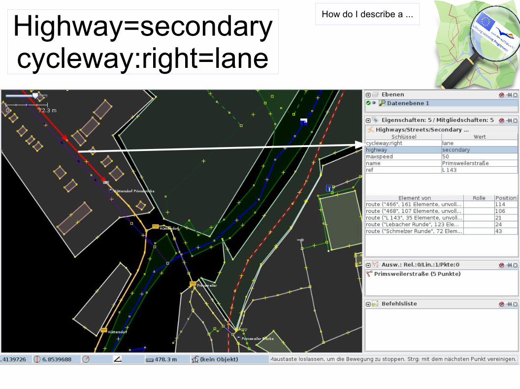
Highway=secondarycycleway:right=lane
How do I describe a ...

highway=crossing
How do I describe a … in JOSM

Main technical and colloquial terms - 1 -The Four Elements
FOUR MAIN ELEMENTSPunkt Node An object with an ID, a Latitude and a Longitude. Nodes can
also have tags.
Linie Way An ordered list of one or more Nodes. Ways get rendered as streets/railways/footpaths/canals etc according to the tag(s) indicating what type of way it is. Ways are contiguous and non-branching. (You can get from beginning to end by following segments of the way, without "jumping" or backtracing)
Fläche Aera In map rendering terms, an area is a shaded polygon representing for example a house, a park or industrial area.
Relation Relation Relations are a new kind of data primitive added more recently. They are basically groups of objects in which each object may take on a specific role. Relations may also have tags.
See: http://wiki.openstreetmap.org/wiki/Glossaryand for translation: http://wiki.openstreetmap.org/wiki/DE:Glossary

Main technical and colloquial terms - 2 -Element → Tag → Key=Value
See: http://wiki.openstreetmap.org/wiki/Glossaryand for translation: http://wiki.openstreetmap.org/wiki/DE:Glossary
TAG
Ele
men
ts

Q & A
http://www.openwhatevermap.org/


![THE ROLE OF GIS IN ENERGY AUDIT OF PUBLIC LIGHTING · Information System [5]. We could use JOSM, an extensible editor for OpenStreetMap (OSM) written in Java, but QGIS provides much](https://static.fdocuments.us/doc/165x107/5fb0ab86f36d2644103a3359/the-role-of-gis-in-energy-audit-of-public-lighting-information-system-5-we-could.jpg)