Oromiya Regional Profile
15
1 General Profile of the Oromiya National Regional State Background Oromiya National Regional State is one of the Regional States in the Federal Democratic Republic of Ethiopia. Geographically, the Region extends from 3 o 24'20"– 10 o 23'26"N latitudes and 34 o 07'37"- 42o58'51"E longitudes. It shares borderlines with all the Regional States in the Federal Democratic Republic of Ethiopia, except Tigray. It also shares international borderlines with the Republic of the Sudan (with 66 km borderline) in the west and Kenya Republic (with 521km) in the south (BoFED, 2008). See Fig. below. Figure 1. Location Map of Oromiya National Regional State The Size and Shape of the Region Oromia National Regional State is the largest Regional state Federal Democratic Republic of Ethiopia. The total area of the Region is 363,136 km 2 , accounting for about 34.3 percent of the total area of the country. Administratively, the Region is divided into 18 administrative zones, 304 woredas (out of which 39 are towns structured with the level of woredas and 265 rural woredas), more than 6,342 farmer and 482 urban dwellers Kebeles. For detail, see the table below.
-
Upload
gudissa-gabissa -
Category
Documents
-
view
110 -
download
0
Transcript of Oromiya Regional Profile

1
General Profile of the Oromiya National Regional State
Background
Oromiya National Regional State is one of the Regional States in the Federal Democratic Republic of
Ethiopia. Geographically, the Region extends from 3o24'20"– 10
o23'26"N latitudes and 34
o07'37"-
42o58'51"E longitudes. It shares borderlines with all the Regional States in the Federal Democratic
Republic of Ethiopia, except Tigray. It also shares international borderlines with the Republic of the
Sudan (with 66 km borderline) in the west and Kenya Republic (with 521km) in the south (BoFED,
2008). See Fig. below.
Figure 1. Location Map of Oromiya National Regional State
The Size and Shape of the Region
Oromia National Regional State is the largest Regional state Federal Democratic Republic of Ethiopia.
The total area of the Region is 363,136 km2, accounting for about 34.3 percent of the total area of the
country. Administratively, the Region is divided into 18 administrative zones, 304 woredas (out of which
39 are towns structured with the level of woredas and 265 rural woredas), more than 6,342 farmer and
482 urban dwellers Kebeles. For detail, see the table below.

2
Table 1: Administrative divisions and subdivisions of Oromiya
No. Zone Capital Town Area (km2) No. of FAs No. Rural
Woredas
No. of Town
Woredas
1 Arsi Asela 21009 567 24 2
2 West Arsi Shashamane 12556 325 12 2
3 Bale Robe 63555 360 18 2
4 Guji Nagelle 33290 301 13 2
5 Borana Yabello 63939 190 13 1
6 East Hararghe Harar 26308 534 19 3
7 West Hararghe Chiro 17779 379 14 2
8 Illu Abba Boru Matu 16884 500 22 2
9 Jimma Jimma 18696 538 17 2
10 East shewa Adama 9547 313 10 5
11 North Shewa Fiche 8989 667 13 1
12 West Shewa Ambo 14371 531 18 1
13 South West
Shewa
Waliso 5813 265 11 1
14 East Wellaga Nakamit 14103 281 17 1
15 Horo Guduru Shambu 7869 172 9 1
16 West Wellaga Gimbi 13131 481 19 2
17 Kelam Wellaga Dambi Dolo 10488 249 10 1
18 Finfine
Surrounding
Finfine 4809 150 6 8
Total 363,136 6342 265 39
Source: Socio-economic profile of Oromia National Regional State, BoFED, 2008
3
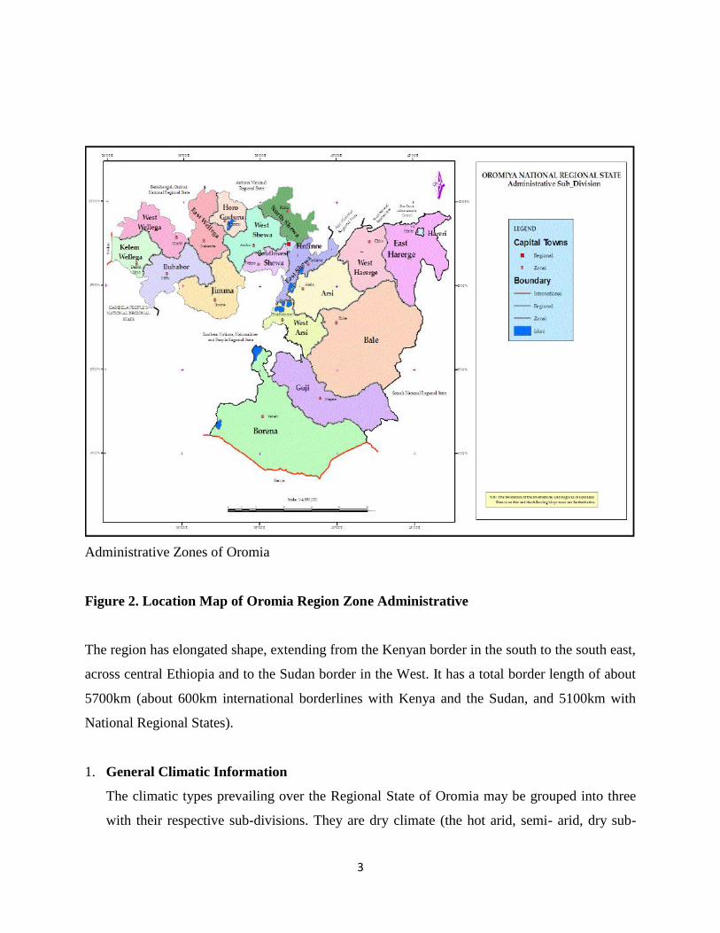
Administrative Zones of Oromia
Figure 2. Location Map of Oromia Region Zone Administrative
The region has elongated shape, extending from the Kenyan border in the south to the south east,
across central Ethiopia and to the Sudan border in the West. It has a total border length of about
5700km (about 600km international borderlines with Kenya and the Sudan, and 5100km with
National Regional States).
1. General Climatic Information
The climatic types prevailing over the Regional State of Oromia may be grouped into three
with their respective sub-divisions. They are dry climate (the hot arid, semi- arid, dry sub-

4
humid climates), tropical rainy climate (the tropical humid and tropical sub-humid climates)
and temperate rainy climate (the warm temperate humid, the warm temperate per humid and
the cool highland climates). Due to its location within the tropics, the region receives high
solar radiation in fact modified by its high altitude. As a result, highland areas of the Region
experience low temperature and high rainfall, while lowland areas (those below 1500m)
experience high temperature and low rainfall.
Rainfall and Distribution
Rainfall is one of the most important climatic variables, which shows the nature and climatic
conditions of Oromia region. The region has four seasons, named as Ganna (summer), Birra
(autumn), Bona (winter) and Arfassa (spring). Ganna and Birra are high rainfall seasons;
whereas, Bona and Arfassa are dry seasons. The region has bi-modal rainy seasons.
Rainfall in Oromia is mainly Orographic, though local Conventional and Frontal types are also
experienced. The duration, amount and spatial distribution of the rainfall of Oromia depends
upon relative location of a place to Atlantic, Indian Ocean, and the Red sea, air pressure and air
circulation systems and variation in elevations. In general, the main controls of the rainfall
distribution of Oromia region are South-Westerly Winds, South-Easterly Winds, North-Easterly
Winds and High pressure cells over North-East Africa and the Arabian Peninsula.
In the region, Ganna is rainy season for most of the places in Western, Central, Southern and
Eastern highlands and associated lowlands. Among these, the Highlands of Ilu Abba Bor that
face the humid equatorial Westerly (South-Westerly Winds) and gets the highest amount of
rainfall (up to 2400) in summer. So, this area is the wettest part of the region. The amount of
rainfall decreases in all directions from the highlands of Ilu Abba Bor. The rest of the highlands
of Ilu Abba Bor, East and West Wellega and Jimma get mean annual rainfall of above 1800mm.
The Shewan plateau, Arba Gugu-Chercher Ranges, most parts of Kelem, East and West Wellega,
Horo Guduru, Arsi- Bale and Guji highlands get annual rainfall of 1200-1800 mm. The low
plateaus of Bale, Borena, East Harerghe, West Harerghe, North Shewa and Guji get the amount
varying from 800-1200mm. The Rift Valley, lowland areas of Borena, Guji, East and West
Harerghe, and Bale zones get 500 to 800mm. However, Southern Borena, the eastern Bale and
Guji zones receive below 500mm annual rainfall.
5
On the other hand, South-Easterly Winds bring rain to the Eastern Oromia during Ganna season.
In fact, highlands of Eastern Oromia get another maximum rainfall in Birra (autumn). Unlike
most parts of the region, the highlands and lowlands of eastern Oromia (south-eastern Borena,
low lands of Bale and Guji) experience period of maximum rainfall in Birra and some amount in
Arfassa. Most parts of the region remain under the influence of dry North-east trade winds
originating from Arabian Peninsula during Bona (winter), which is expressed as a dry season
across the region as well as the country. Generally, the annual rainfall in the region ranges from
400-2400mm (the annual average is set between 450-1800mm when weighted throughout
different localities), where the highest rainfall record is observed in the western regime of the
region, while the lowest precipitation amount is recorded in the low lands of eastern and
southeastern parts.
Temperature
Oromia Region is situated within the tropics and so experiences high incoming solar radiation
due to high angle of the solar rays with over head sun twice a year. However, this tropical nature
of its climate is rather modified by altitude. Lowlands Oromia (having less than 1500m altitude)
experience high temperature and low precipitation; whereas, highlands experience amiable
temperature and ample rainfall. In general, mean annual temperature in the region varies from
less than 100c in high altitudes badda/cool to over 30
0c in tropical lowlands.
During the Arfassa season, Bale and Chilalo-Arba Gugu highlands, high plateaus and ranges in
southern North Shewa, eastern extreme of West Shewa and Gimbichu highland in north western
East Shewa experience mean seasonal temperature of 10-150c. Extensive highlands and high
plateaus of central, the eastern sub-region and highlands of the western sub-region have mean
seasonal temperature of 15-200c during the same season.
In the same token, the low plateaus of the eastern sub-region (upper rift scarps, gradational
slopes Chelbi area in south-western Borena), central Guji, the Rift lakes region, the Ghibe and
upper Didessa, upper Baro and Dabus valleys experience comparatively high mean temperature
ranging from 20 to 250c. The Adal plain in the northern extreme of the rift system, south-eastern
Borena and Guji, northeastern Bale and Baro valley have very high mean seasonal temperature
of over 250c.

6
Ganna is a season of high incoming solar insulation in the region. However, due to high cloud
cover, most areas of Shewa, Hararghe, Arsi-Bale, Jimma highlands experience low mean
seasonal temperature of 10-150C during this period. However, during this season lowlands of
Western Oromia, Borana, Bale and Hararghe enjoy a warm mean temperature of 20-250C.
Birra and Bona are seasons of lowest angle of the sun due to apparent shift to South of the
equator, in most of Oromia. Hence, expect for lowlands of Borana, Bale Hararghe that still
experiences relatively warm to hot weather (200c to 25
0c), it is period of least cloud cover and
low temperature (10-150c) for most areas of the Region. Mean seasonal temperature of over 25
0c
is limited to only the south-eastern extreme Guji and Bale zones.
Generally, the region experiences annual temperature ranging from 100c to 30
0c, with mean
annual temperature of 190c, where the highlands and mountainous areas in the 13 region receive
lowest mean annual temperature, while lowlands and valley bottoms get highest mean annual
temperature records (ORHB, 2009; BoFED, 2008).
Natural Resources Base and Land Use Systems
Oromia Regional State is endowed with diverse natural resources. It has abundant surface and
ground water resources, forests and wildlife resources. The type and existing situations of these
resources and their spatial distribution in the region have been summarized as follows.
Forests and Vegetation Cover
Vegetation cover of the National Regional State of Oromia accounts for about 69% of the total
area of the Region. Afro-Alpine and Sub-Afro Alpine, High forest, Woodland, Riverine,
Grassland, Plantations, and Bush and Shrub lands are major types of vegetation.
Out of the 58 National Forest Priority Areas of the Country, 49 are found in Oromia. Their areal
coverage accounts for about 8.1% of the total surface area of the Region.

7
Wildlife Resource
The Regional State of Oromia is characterized by diversified relief features, which form
favorable habitats for quite a large variety of fauna and flora. The Region represents the whole
range of Ethiopian wildlife resource.
There are three national parks (Bale Mountains, Awash and Abijatta Shalla) and regional
(Dhera Zilfekar), five sanctuaries (Sankalle, Yabello, Babile, Erer-fafen and Kuni Muktar) and
three wildlife reserves (Awash, Bale and Chelbi) and many controlled hunting areas that hosted
mammals, birds, grazers, browsers and hunters. The wildlife of the Region includes endemic and
highly endangered species. Among these, Awash National Park alone has 400 species of birds
and 46 species of animals like lion, Grivet Monkey, Beissa Oryx, Greater Kudu, Lesser Kudu,
Swayne’s Hartebeest, Hamadryas Baboon, Anubis Baboon, Defaffa Waterbuck and Salt’s Dik-
dik. Bale Mountains National Park, has 200 bird species (like Wattled Ibis, Black-winged,
Lovebird, Wattled Crane, Rouget’s Rail, etc) and 46 mammals including Mt. Nyala, Red Fox,
Menelik’s Bushbuck, Duiker, Warthog, Leopard, Bohor Reedbuck, Serval Cat, Colobus Monkey
and Anubis Baboon. And, Abijata-Shalla Lakes National Park hosts 367 different species of
birds (like Great White Pelicans, Greater and Lesser Flamingos and Sacred Ibis) and 31 species
of mammals (spotted hyena, Golden and Black Backed Jackals, Olive Baboon, Grant’s gazelle,
etc). In addition, there are elephants, cheetahs, buffalo, Oribi Warthog, Bohor Reedbuck, Civet
Cat and various birds and other wildlife species in sanctuaries, reserves and controlled hunting
areas in the Region.
Water Resources
Oromia National Regional State is rich for its abundant surface and ground water resource
potentials. Large areas of the region are drained by many major rivers, streams and lake basins.
The volume of water discharge of surface drainage of Oromia is determined by climatic
condition, while its relief controls the flow pattern of rivers. High seasonal fluctuation and
variation of climatic condition characterize precipitation of the Region. So, the volume of
discharge is subjected to high fluctuation, sporadic flash of flood as a result of torrential tropical
rains in summer and dry channels for some rivers and streams in dry season.

8
Mineral Resources
In Oromia, in general, due to intensified mineralization of rocks through crystallization in the
process of metamorphosis, the rocks of crystalline basement complex form important sources of
minerals, particularly ferrous, non-ferrous metals and precious minerals. Sedimentary rocks of
the Mesozoic era, particularly the organogenesis marine sediments are considered to have high
potential for mineral oil and natural gas. Shales and stromatoloid sediments buried by overlain
rock strata were subjected to pressure and heat subsequently forming oil and gas that may be
reserved in permeable rocks. The Mesozoic rocks are also considered as sources of metallic
minerals such as lead, zinc and silver. In addition, they form important sources of limestone,
salts, glass sands, cement limestone, and other industrial and construction minerals.
Cenozoic rocks of Oromia form important potential sources of salt, potassium and calcium
minerals. Intensified weathering process have most probably induced the formation of iron and
aluminum (bauxite) deposits. Continued volcanic activity has created conducive condition for
great potentiality of geothermal energy in the Rift valley of Oromia. In general, there are various
types of mineral deposits known through mineralogical investigations and occurrences in
Oromia. The various minerals occurring in the region consist of coal and iron, precious metals
(gold and platinum), and non-ferrous minerals (Beryllium, Cobalt, Chromium, Copper,
Molybdenum, Lead, Titanium, Uranium etc).
Soils
Soil is one of the most important natural resources on which our food supplies directly or
indirectly depend. The highlands of Oromia are relatively dominated by fertile soils of volcanic
origin. However, some soils may be too acidic or basic, while others may be ferrogenous, sodic
or saline. In general, there are 14 major soil units/types in the Region, which are derived from the
soil formation phases. The dominant soil types of the Region are Nitosols found on flat to sloppy
terrain in high rainfall areas, Vertisols found on flat waterlogged areas, Cambisols found on
slopes of Bale, southwest of West Harerghe and Arsi, Luvisols and Acrisols mostly found on
sloppy terrain of the Region.

9
Energy Resources
The available energy sources in the region include biomass (wood and animal excreta), kerosene,
electric, solar, and biogas. However, most of them are not well developed and used. Thus,
firewood is the most important source of domestic energy supply both in urban and rural areas of
Oromia. This large dependency on such biomass energy sources, of course, accelerates
deforestation in the Region. Even though about 97% of the total hydroelectric power of the
country is generated from Oromia, many towns and villages in the region lack this modern
source of energy. Only about 183 urban centers in the Region have electric light services
(BoFED, 2008).
Land Use Systems
The land use pattern in Oromia region correlates with its population distribution and climatic
conditions. The major land use patterns include cultivation, forest of different types, woodland,
bushes, wetlands, grasslands, barren and settlement areas. The largest proportion of land is under
grassland land use type, 33.87%. These areas are vast range lands and unsettled grazing lands
mainly in Borana, Bale, Guji, East Shewa and West Hararghe. The agricultural land covered by
crops (season and perennial) makes 28.36%, is the second largest category. The highlands of
Bale, Arsi, Shewa, Hararghe, Jimma, Ilu Abba Bor, and Wellega that grow various cereal and
cash crops (including coffee, chat, fruits) account for this land use pattern. Other land use
patterns include forest (8.14%), woodland (2.67%), exposed rocks and barren (2%) and other
small coverage (like wetlands, settlements, riverine vegetation, water bodies etc), according to
BoFED, 2008.
Population
According to the population and housing census report of CSA (2007), the total population of
Oromia National Regional State is 27, 158,471million, which accounted 36.7% of the total
country’s population. In Oromia National Regional State the rural population is 23,788,431
which represents 87.8% of the total population of the region, while the urban population is
3,858,567, which accounts 12.2%. Of the total population in the national regional state, women
constitute about 49.6%, while men constitute 50.4%. According to CSA (2007), the annual
population growth rate of the national regional state is 2.9.
10
Regarding the age distribution of the Region, it is typical of developing countries, i.e., it is
characterized by higher proportion of young ages (0-14) and low proportion of old age (65 years
and above), reflecting the prevailing of higher fertility rate. Young population of the age less
than 15 years accounted for about 46.4% while adult and old age populations accounted for
about 50.2 and 3.4% of the total Regional population, respectively in 2007. Based on
dependency ratio, that is, the young and old age dependency ratio (0-14 age group + 65 and
above age group) of the Region is 99% (92% for the young and 6.9% for the old). This means
that for each 100 persons in the economically active age groups there are about 99 young and old
dependents to be supported in the Region.
As per CSA (2007), the region has an estimated average crude population density of 77 persons
per square kilometer. The total family size of the region is 4.8, with 5.0 for rural areas and 3.8
persons for urban areas. As the Census result of 2007 indicates, the total number of households
was 5,638,268, with 4,746,381 rural and 891,887 urban households.
The religious composition of the population of the region is 47.5% Muslims, 30.4% Orthodox
Christians, 17.7% Protestants, and 3.3% traditional, 0.5% catholic and 0.6% were followers of
other religions. In terms of ethnic composition, based on CSA (2007) census result, the major
ethnic groups within the regional State include 85% Oromo, 9.1% Amhara and the remaining
5.9% constitute other ethnic groups. Afan Oromo, presently inscribed with Latin characters, is
the official language of Oromia National Regional State.
Religion and Cultural practices The Oromo have rich culture. The Oromo had a well-developed age-based system grouping upon
which the religious, political, economic and social life of the people was based. Among others,
the Gada system which organizes Oromo society into age groups and rotates leadership in
egalitarian democracy every eight years is most remarkable. The system has always guided the
religious, social, political, and economic life of the Oromo people. The institution is still
functional in different part of Oromia along with the modern administration system. In the Gada
system, elders, considered to be wiser, were responsible for teaching, resolving conflicts, and
nurturing Oromo culture. Seniority is thus an important factor in Oromo relationships. The
system helps to exercise democracy, participatory government and leadership.

11
On the other hand, before the expansion of Islam and Christianity, the Oromo had their
own traditional African religion called Waaqeffannaa, the belief in Waaq (the supreme
God). The religion teaches safuu (do's and don'ts) for Oromo that helped them to live
together in peace, prosperity and faithfulness to each other.
Crop Production Like most part of Ethiopia mixed farming dominates the livelihood of the region. Land is
an important asset of households for production of crops and rearing of livestock. Livestock
serves as a source of manure and fuel, pay land tax, fertilizers and as a saving to buffer bleak
seasons of food/seed shortage. Oxen are the major ploughing engines. Donkeys, horses and
mules play a significant role in transportation of people, water, and goods. Due to the high
complexity and strong inter-linkage between crop production and livestock tending, it is difficult
to consider the two livelihoods separately (Aune et al. 2006).Oromia has the largest livestock
resources base in Ethiopia. Cattle, sheep, goats, donkey, and camels are the major types of
animals reared and there are about 18.8 million tropical livestock units (TLU) in the region.
According to BoFED (2008), agriculture remains by far the most important sector in the
Region’s economy. Over 90% of the people of Oromia live in the rural area, and agriculture has
been remained the source of livelihood for the overwhelming majority of the people of the
region.
The main crops produced the region include maize, teff, wheat, barely, peas, bean and various
types of oil seeds. Coffee is the main cash crop in the region. Oromia accounts for 51.2% of the
crop production, 45.1% of the area under temporary crops and 44% of the total livestock
population of Ethiopia By virtue of relatively abundant rainfall, suitable soils and other
agricultural potentialities, Oromia remains the major crop producing region in the country.
Accordingly, Oromia has accounted for 49% of major food crops production, 50.8% of cereals,
37% of pulses and 43.56% of oil crops production of total peasant holdings of the country in
2002 /03 Production year (CSA, 1994 E.C).
Coffee is the major source of foreign exchange for the country accounting for 50–60% of total
exports. Oromia accounted for 77.6 percent of coffee plantation as per the 1996–2000 plan
evaluation report and delivered annually about 68% of coffee destined for foreign 26 market.
Similarly, out of 53 districts known for Coffee production in the country 42 (79%) are found in
12
Oromia showing the tremendous resource base the region is endowed with. However, the sector
is characterized by small-scale farmers who are dependent on low input and low output rain fed
mixed farming with traditional technologies dominate the agricultural sector thereby the
production fails to catch up with the rapidly growing population size and needs (BoFED, 2008
and CEEPA, 2006).
Livestock Resource Livestock plays a significant role in the economy of the country as well as the Region in general
and the farmers and households in particular, with variations in significance from lowlanders of
pastoralist society to highlanders of farming community. In general, they provide food (milk,
meat, egg, hides and skins, etc), draught power for cultivation, serve as a means of
transportation and as a saving or hoarding. They are also kept for prestige as an indication of
social status and wealth in the society.
The livestock population size of private farmers holdings of rural Oromia was estimated at 51
million heads (excluding livestock population of Chinakson and Dawe Serer Weredas), that is
about 40.3% of the total country’s livestock population in 2006/07 (1999 E.C). As the CSA
(2006/07) report on livestock, poultry and beehives population indicated, Oromia accounts for
about 45.7 percent of the cattle, 39.3 percent of the sheep and 31.7 percent of the goats stock of
the country. The proportion of horses, donkeys, mules and camels share of the Region from the
country’s total is 63.2, 45.8, 49.3 and 21.3 percent respectively. Moreover, 37.2 percent of the
country’s total poultry and 55.9 percent of the beehives are found in Oromia.
Pastoral and agro pastoral Communities
Pastoralism, a livelihood system based on animal herding, has endured for centuries as a rational
adaptation to often harsh and erratic grassland environments. Founded on mobility and
flexibility, the pastoral system optimizes the use of natural resources to maintain the livestock on
which pastoralists depend for their well-being.
At present, 33 pastoral and agro-pastoral districts of Oromia National Region State are found in
6 zones (Borana, Guji, Bale, east Hararghe, east Shewa and west Hararghe). The pastoral and
agro-pastoral areas of the Region covers about 152,170km2, accounting for about 37% of the
total area of the Region. Its total human population size is estimated to be about 4 million
13
whereas about 30% of the livestock population of the Region is found in pastoral and agro
pastoral areas.
The pastoral and agro-pastoral areas usually receive bimodal, variable, erratic distribution and
insufficient amount of annual rainfall. The main rainy season occurs between March to late May
and the short rainy season is between October and November. Their average temperature ranges
from 250c-35
0c whereas annual rainfall average is 400-700mm. The major livelihood bases of the
pastoralists of the region is livestock whereas that of the agro pastoralists is livestock production
integrated with crop farming.
Livelihoods of pastoral communities in Oromia
The key livelihood of the pastoral and agro pastoral areas is livestock rearing coupled with crop
production. Most households have relatively larger areas of communal grazing lands. As a result,
the rangeland and the livestock holdings have made the rural pastoral communities primarily
dependent on livestock and livestock products and the rest from crops. This implies that
livestock is the most important economic sources as compared to the other type of economic
activities, because livestock and livestock products are the major sources of food, cash and asset
for most households.
Even though the type of livestock rearing depends on the area and importance, the main livestock
species reared in both the pastoral and agro-pastoral areas are cattle, goats, camels and donkeys
and used for wealth ranking. Cattle are primarily used for milk and asset while goats are used as
source of income and camels for milk and transportation. Donkeys are used as pack animals,
providing transportation in rural areas. Traditional and extensive livestock rearing system is
practiced both in the pastoral and agro-pastoral areas. The feed source for livestock is from
homestead during the rainy season and migration to the dry season grazing areas for better
pasture and water including to the neighboring highland areas.
The main source of food in all the pastoral and agro pastoral areas is livestock product followed
by maize from own harvest, purchase of cereals (maize) from market and food aid. However, the
food sources for different wealth groups differ in that the better off and wealthy groups mainly
depend on milk and maize production while the very poor and poor families mainly depend on

14
purchase, wild food and food aid. Major cash income source for the households in all wealth
groups is from livestock sales. Better off and middle income households generate income from
sell of goats, camels and cattle. The very poor and poor also sale few goats and generate
additional income from sell of firewood, charcoal and labor.
Settlement patterns and Distribution of Pastoral Communities
The settlements in the pastoral areas of the
region are predominantly based on
economic and traditional resource
management and easy access to resources.
This means, settlements are strongly based
on well established clusters (Madda) and
grazing lands (dheda). The residents of each
grazing lands depend on common water
sources called ‘Madda’. The individual well
clusters (Madda) are surrounded by grazing
lands (Dheeda). The settlement patterns
thus, are clustered rather than scattered in
the pastoral areas of the region.
Communities of the pastoral area move from
one place to another in search of water and
pasture during dry periods. This mobility
enables them to exploit and utilize widely
Figure 3 Settlement pattern of Borena pastoral
areas, Oromia Region
dispersed pastures at times when they are
nutritious. The movements also facilitate an

15
escape from drought and diseases both
locally and across national boundaries. Herd
separation and splitting into either home-
based or satellite camps are crucial for
mobility and resource management. This
ensures minimal use of the water and
pastures reserved for dry-period grazing.
The Borana also parcel out livestock among
relatives (‘dabarre’) living in different
geographical locations to increase the
chances of survival during droughts or
outbreak of disease.
Communal land ownership and management
of natural resources are central to
pastoralism because they ensure that herd
owners can move freely in search of water
and pasture in different locations at different
seasons of the year.


![OROMIYA - aarc.gov.et · of Oromiya experience temperate climate of moderate temperature, (mean temperature of the coolest month is less than [18 degree C]) and ample precipitation](https://static.fdocuments.us/doc/165x107/5ec53f25320cc925d949c779/oromiya-aarcgovet-of-oromiya-experience-temperate-climate-of-moderate-temperature.jpg)