Ore Deposits and Mining in Ireland - Society of Economic ... · PDF fileOre Deposits and...
83
Ore Deposits and Mining in Ireland A field trip guidebook for Pb-Zn, Au, Cu and halite mineralization in Ireland, Run by the Society of Economic Geologists Student Chapter, Zürich 9-18 Aug, 2016 Organized by: Jakub Sliwinski & Alina Fiedrich Editors: Jakub Sliwinski; Alina Fiedrich; Kateřina Schöglova; Christoph Heinrich Sponsored by:
Transcript of Ore Deposits and Mining in Ireland - Society of Economic ... · PDF fileOre Deposits and...
Ore Deposits and Mining in Ireland A field trip guidebook for Pb-Zn, Au, Cu and halite mineralization in Ireland,
Run by the Society of Economic Geologists Student Chapter, Zürich
9-18 Aug, 2016
Organized by:
Jakub Sliwinski & Alina Fiedrich
Editors:
Jakub Sliwinski; Alina Fiedrich;
Kateřina Schöglova; Christoph Heinrich
Sponsored by:

Cover images (clockwise from top left): (1) Pb-Zn exploration core at Navan; (2) Pyrite-Au mineralization in quartz at the Curraghinalt orogenic Au deposit (Dalradian Resources); (3) Riverwise at Kilkenny (courtesy of
Alina Fiedrich); (4) Geological discussion at the Cliffs of Moher; (5) connellite and langite at the Copper Coast Geopark (courtesy of David Farsky); (6) Cliffs of Moher; (7) Giant’s Causeway; center: Pb-Zn flotation circuit
(courtesy of David Farsky).
2
Ore Deposits and Mining in Ireland
A field trip guidebook for Pb-Zn, Au, Cu and halite mineralization in Ireland,
Run by the Society of Economic Geologists Student Chapter, Zürich
Organized by:
Jakub Sliwinski & Alina Fiedrich
Editors:
Jakub Sliwinski; Alina Fiedrich; Katerina Schöglova
Christoph Heinrich
Institute of Geochemistry and Petrology, ETH Zürich
9-18 Aug, 2016
This Field Guide was assembled from contributions by participating students who take responsibility for correct referencing of data sources, to the best of their knowledge
ISBN: 978-3-906327-52-5
Published in the ETH E-Collections, October 2016
http://e-collection.library.ethz.ch/index.php?lang=en
©ETH Zürich 2016
3
Contents Preface ................................................................................................................................................................ 5
At a Glance .......................................................................................................................................................... 6
Brief Program .................................................................................................................................................... 12
Travel Map ........................................................................................................................................................ 13
Detailed Itinerary .............................................................................................................................................. 14
Logistics ............................................................................................................................................................. 16
List of participants ............................................................................................................................................. 17
Bedrock Geology of Ireland ............................................................................................................................... 18
From Past to Present – The history of mining in Ireland .................................................................................. 22
The Formation of Irish Zn-Pb Ore Deposits: An Overview ................................................................................ 26
Introduction .................................................................................................................................................. 26
Geological Setting ......................................................................................................................................... 27
Mineralization .............................................................................................................................................. 28
Host Rocks .................................................................................................................................................... 28
Geochemistry of mineralizing fluids ............................................................................................................ 29
Timing of Mineralization .............................................................................................................................. 30
Genetic Model .............................................................................................................................................. 30
Navan Pb-Zn Deposit, Co. Meath ...................................................................................................................... 34
Copper Coast Geopark ...................................................................................................................................... 41
Pallas Green ...................................................................................................................................................... 45
Cliffs of Moher .................................................................................................................................................. 50
Outcrop hopping (14 August) ........................................................................................................................... 57
Cavanacaw Orogenic Au deposit (Galantas Irish Gold) ..................................................................................... 59
Giant’s Causeway .............................................................................................................................................. 65
Curraghinalt Orogenic Au Deposit (Dalradian Resources) ................................................................................ 69
Kilroot Salt Mine ............................................................................................................................................... 78
4
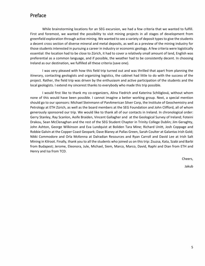
Preface
While brainstorming locations for an SEG excursion, we had a few criteria that we wanted to fulfill. First and foremost, we wanted the possibility to visit mining projects in all stages of development from greenfield exploration through active mining. We wanted to see a variety of deposit types to give the students a decent cross section of diverse mineral and metal deposits, as well as a preview of the mining industry for those students interested in pursuing a career in industry or economic geology. A few criteria were logistically essential: the location had to be close to Zürich, it had to cover a relatively small amount of land, English was preferential as a common language, and if possible, the weather had to be consistently decent. In choosing Ireland as our destination, we fulfilled all these criteria (save one).
I was very pleased with how this field trip turned out and was thrilled that apart from planning the itinerary, contacting geologists and organizing logistics, the cabinet had little to do with the success of the project. Rather, the field trip was driven by the enthusiasm and active participation of the students and the local geologists. I extend my sincerest thanks to everybody who made this trip possible.
I would first like to thank my co-organizers, Alina Fiedrich and Katerina Schlöglová, without whom none of this would have been possible. I cannot imagine a better working group. Next, a special mention should go to our sponsors: Michael Steinmann of PanAmerican Silver Corp, the Institute of Geochemistry and Petrology at ETH Zürich, as well as the board members at the SEG Foundation and John Clifford, all of whom generously sponsored our trip. We would like to thank all of our contacts in Ireland. In chronological order: Gerry Stanley, Ray Scanlon, Aoife Braiden, Vincent Gallagher and at the Geological Survey of Ireland; Foteini Drakou, Sean McClenaghan and the rest of the SEG Student Chapter in Trinity College Dublin; Jim Geraghty, John Ashton, George Wilkinson and Eva Lundquist at Boliden Tara Mine; Richard Unitt, Josh Coppage and Robbie Galvin at the Copper Coast Geopark; Dave Blaney at Pallas Green, Sarah Coulter at Galantas Irish Gold; Nikki Commodore and Orla McKenna at Dalradian Resources and Ryan Carroll and David Lee at Irish Salt Mining in Kilroot. Finally, thank you to all the students who joined us on this trip: Zsuzsa, Kata, Szabi and Barbi from Budapest; Jerome, Eleonora, Jule, Michael, Siem, Marco, Marco, David, Raphi and Dian from ETH and Henry and Isa from TCD.
Cheers,
Jakub
5
At a Glance
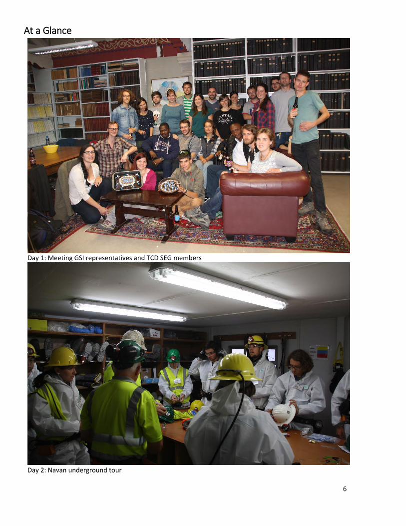
Day 1: Meeting GSI representatives and TCD SEG members
Day 2: Navan underground tour
6
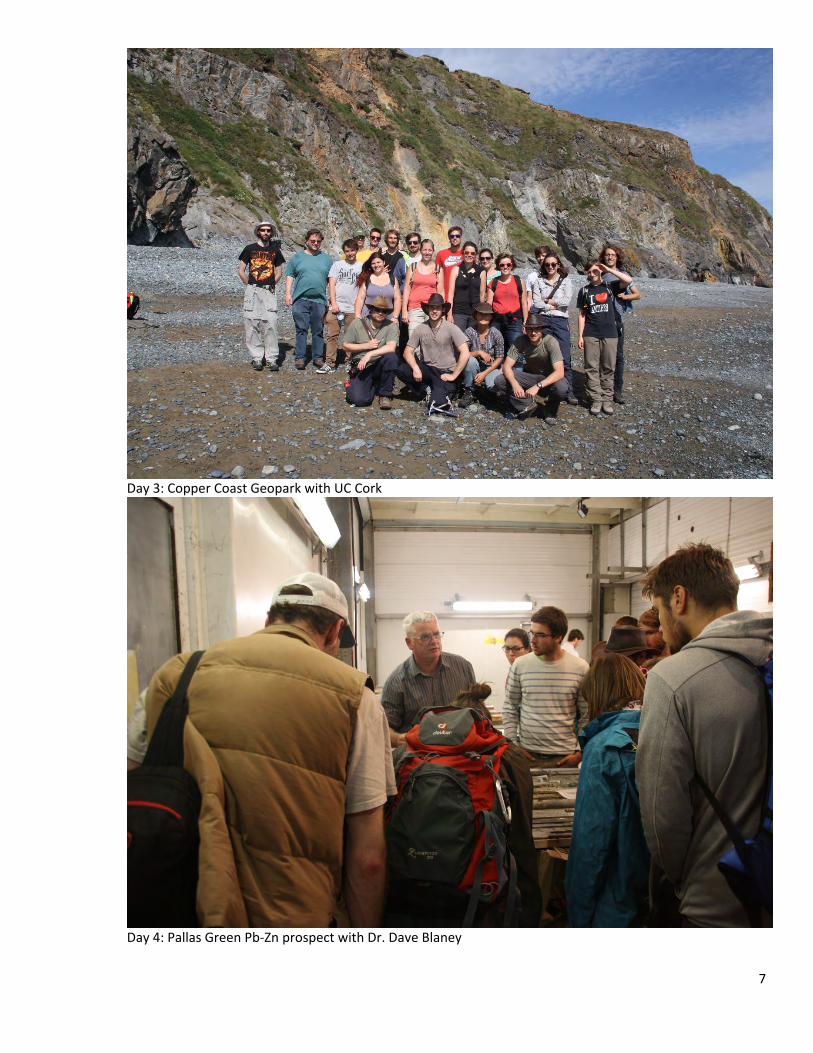
Day 3: Copper Coast Geopark with UC Cork
Day 4: Pallas Green Pb-Zn prospect with Dr. Dave Blaney
7
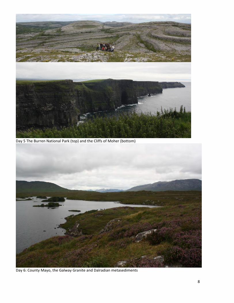
Day 5 The Burren National Park (top) and the Cliffs of Moher (bottom)
Day 6: County Mayo, the Galway Granite and Dalradian metasediments
8

Day 7: Cavanacaw Au (top) and the Giant’s Causeway (bottom)
9
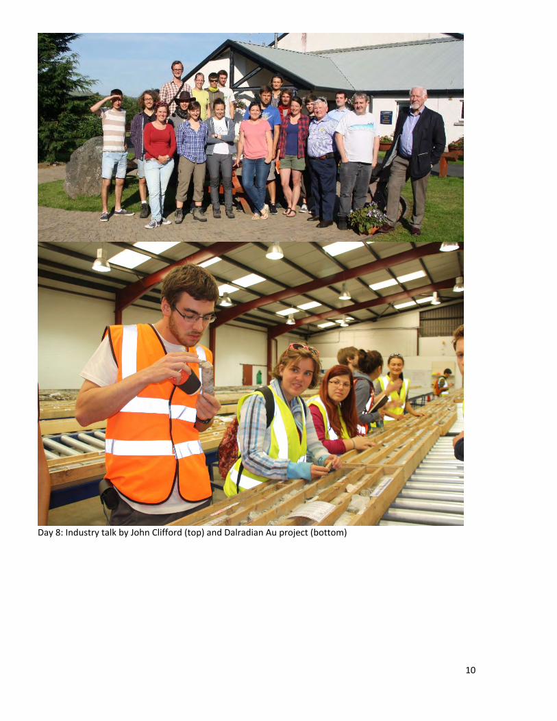
Day 8: Industry talk by John Clifford (top) and Dalradian Au project (bottom)
10
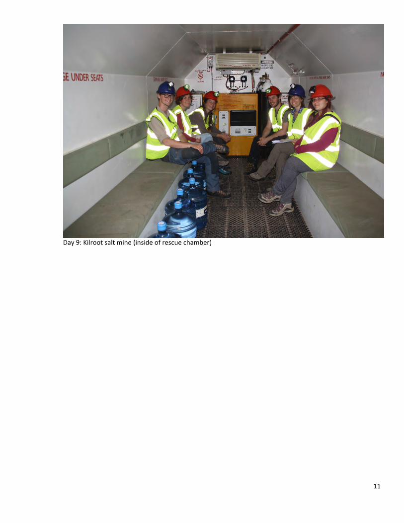
Day 9: Kilroot salt mine (inside of rescue chamber)
11
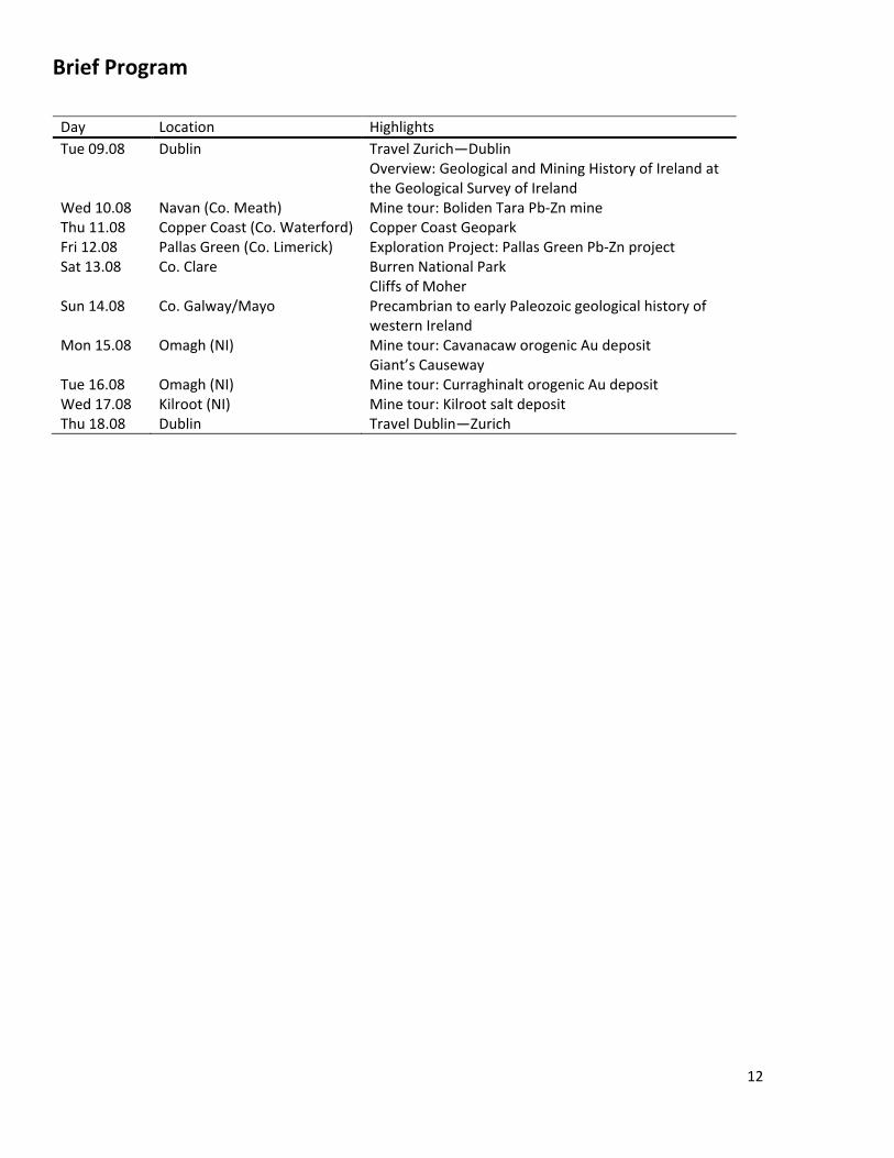
Brief Program
Day Location Highlights Tue 09.08 Dublin Travel Zurich—Dublin
Overview: Geological and Mining History of Ireland at the Geological Survey of Ireland
Wed 10.08 Navan (Co. Meath) Mine tour: Boliden Tara Pb-Zn mine Thu 11.08 Copper Coast (Co. Waterford) Copper Coast Geopark Fri 12.08 Pallas Green (Co. Limerick) Exploration Project: Pallas Green Pb-Zn project Sat 13.08 Co. Clare Burren National Park
Cliffs of Moher Sun 14.08 Co. Galway/Mayo Precambrian to early Paleozoic geological history of
western Ireland Mon 15.08 Omagh (NI) Mine tour: Cavanacaw orogenic Au deposit
Giant’s Causeway Tue 16.08 Omagh (NI) Mine tour: Curraghinalt orogenic Au deposit Wed 17.08 Kilroot (NI) Mine tour: Kilroot salt deposit Thu 18.08 Dublin Travel Dublin—Zurich
12
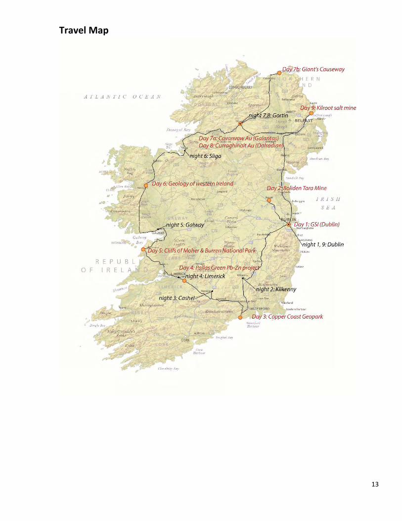
Travel Map
13
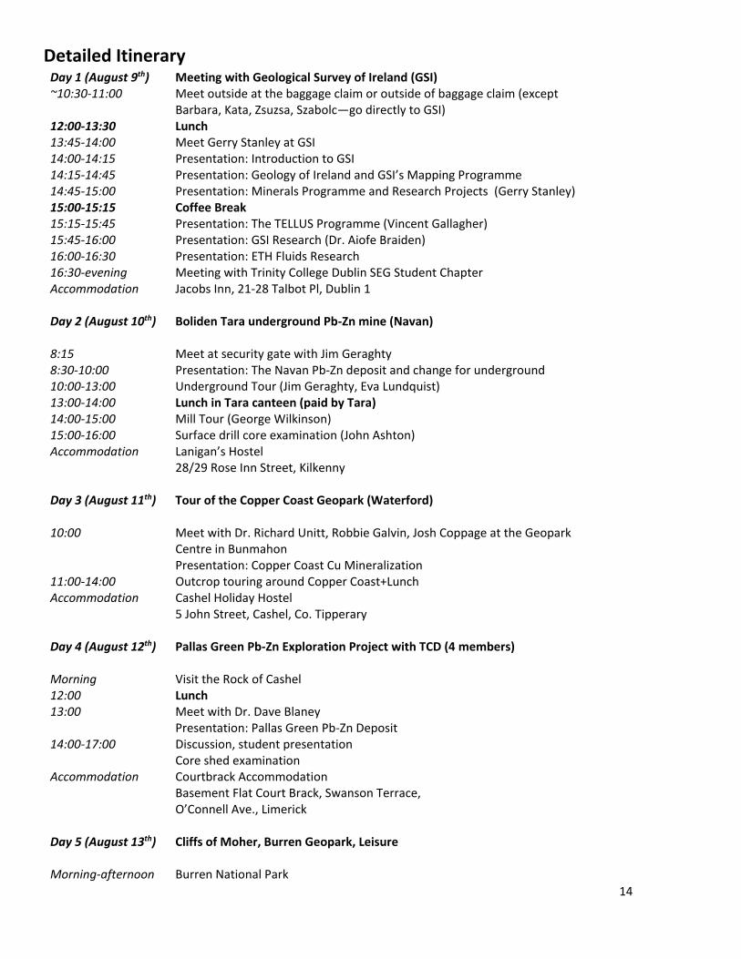
Detailed Itinerary Day 1 (August 9th) Meeting with Geological Survey of Ireland (GSI) ~10:30-11:00 Meet outside at the baggage claim or outside of baggage claim (except
Barbara, Kata, Zsuzsa, Szabolc—go directly to GSI) 12:00-13:30 Lunch 13:45-14:00 Meet Gerry Stanley at GSI 14:00-14:15 Presentation: Introduction to GSI 14:15-14:45 Presentation: Geology of Ireland and GSI’s Mapping Programme 14:45-15:00 Presentation: Minerals Programme and Research Projects (Gerry Stanley) 15:00-15:15 Coffee Break 15:15-15:45 Presentation: The TELLUS Programme (Vincent Gallagher) 15:45-16:00 Presentation: GSI Research (Dr. Aiofe Braiden) 16:00-16:30 Presentation: ETH Fluids Research 16:30-evening Meeting with Trinity College Dublin SEG Student Chapter Accommodation Jacobs Inn, 21-28 Talbot Pl, Dublin 1 Day 2 (August 10th) Boliden Tara underground Pb-Zn mine (Navan) 8:15 Meet at security gate with Jim Geraghty 8:30-10:00 Presentation: The Navan Pb-Zn deposit and change for underground 10:00-13:00 Underground Tour (Jim Geraghty, Eva Lundquist) 13:00-14:00 Lunch in Tara canteen (paid by Tara) 14:00-15:00 Mill Tour (George Wilkinson) 15:00-16:00 Surface drill core examination (John Ashton) Accommodation Lanigan’s Hostel
28/29 Rose Inn Street, Kilkenny Day 3 (August 11th) Tour of the Copper Coast Geopark (Waterford) 10:00 Meet with Dr. Richard Unitt, Robbie Galvin, Josh Coppage at the Geopark
Centre in Bunmahon Presentation: Copper Coast Cu Mineralization
11:00-14:00 Outcrop touring around Copper Coast+Lunch Accommodation Cashel Holiday Hostel
5 John Street, Cashel, Co. Tipperary Day 4 (August 12th) Pallas Green Pb-Zn Exploration Project with TCD (4 members) Morning Visit the Rock of Cashel 12:00 Lunch 13:00 Meet with Dr. Dave Blaney
Presentation: Pallas Green Pb-Zn Deposit 14:00-17:00 Discussion, student presentation
Core shed examination Accommodation Courtbrack Accommodation
Basement Flat Court Brack, Swanson Terrace, O’Connell Ave., Limerick
Day 5 (August 13th) Cliffs of Moher, Burren Geopark, Leisure Morning-afternoon Burren National Park
14
12:00 Lunch Afternoon Cliffs of Moher Accommodation Corrib Village
NUI Galway, Upper Newcastle, Galway City, Co. Galway Day 6 (August 14th) Exploration intrusive igneous history of western Ireland Morning Driving through Galway Granite and surrounding gabbros, diorites to discuss
methods of emplacement, possible mining prospects Accommodation Beehive Hostel
21 Wolfe Tone St, Abbeyquarter North, Sligo Day 7 (August 15th) Cavanacaw Orogenic Au Deposit (Galantas) 10:00 Meet Dr. Sarah Coulter at Galantas
Presentation: regional and ore geology of Cavanacaw deposit Mill Tour Mine ramp/outcrop Core shed tour
13:00 Lunch 15:00-evening Giant’s Causeway Accommodation Gortin Outdoor Recreation Centre
62 Main Street, Gortin, Co Tyrone, BT79 8 NH Day 8 (August 16th) Curraghinalt Orogenic Au Deposit (Dalradian) 10:00 Meet Nikki Commodore at Omagh office 10:00-12:30 Presentation: Curraghinalt Orogenic Au Deposit
Core examination Afternoon Meeting with John Clifford, IAEG (?) Accommodation Gortin Outdoor Recreation Centre
62 Main Street, Gortin, Co Tyrone, BT79 8 NH Day 9 (August 17th) Kilroot Salt Mine Visit 10:00-14:30 Introduction with Ryan Carrol and David Lee
Salt mine tour Accommodation Jacobs Inn
21-28 Talbot Pl, Dublin 1 Day 10 (August 18th)
Flights back to Zurich, Budapest, Amsterdam
15
Logistics
Academic:
• This field trip is offered as the Mobility Course: “Special Field Trip: Ore Deposits of Ireland D-ERDW” (MOB-001) and is worth 2 ECTS credit points
• Credit will be awarded on a pass/fail basis
Travel:
• Participants are expected to be at Dublin International Airport by 10:45 am on August 9th. For those travelling before the 9th (e.g. Budapest participants), please meet directly at the GSI Office located at: Haddington Road, Beggar’s Bush, Dublin by 13:45.
• Road travel will be via three minivans, driven by Jakub, Katerina and Jule. Additional drivers are required for each van.
• There will be about 2 hours of driving per day, occasionally more (especially over the weekend or when outcrop visits are present).
• Flights back from Dublin are mostly on the 18th of August. The last night paid for by the field trip is the 17th, after which the excursion is officially over and participants are free to travel home or stay in Ireland as they prefer.
Lodging:
• All lodging will be held in hostels throughout Ireland, so no tents are required for this trip. • Please bring your own towel and toiletries, as these may or may not be available at all locations. If
you have a small plate or travel bowl, portable utensils and cooking tools, please bring those. A few people will be asked to bring cooking pots and burners (for when kitchens are not available).
Food:
• Food will be provided by a combination of restaurants, mine canteens and group dinners. We will stop a few times throughout the trip to do some food shopping, and we will let you know how many meals (breakfasts, lunches and dinners) to prepare for. Some of the mines have offered to provide food, in which case be prepared that not every dietary preference may be accommodated. If you have specific dietary restrictions, please prepare in advance and have a “backup plan” on hand.
Clothing:
• Generally, summer clothing should be appropriate, including good hiking shoes (with a solid tread—this is very important for some of the mine visits!) and, given that Ireland can be very wet, a good rain jacket, umbrella and other raingear. Other things, like headlamps, sunglasses, field books and pencils, hats, gloves etc are always handy, as is swimwear for when we encounter a pool or swimming hole (or a particularly nasty rainstorm).
16
List of participants
Name Position University Burkhard, Raphael MSc ETH Zürich Cserép, Barbara BSc Eötvös Loránd Budapest Dankers, Dian MSc ETH Zürich Farsky, David BSc ETH Zürich Fiedrich, Alina PhD ETH Zürich Hörler, Jerome MSc ETH Zürich Loretz, Marco MSc ETH Zürich Molnár, Kata PhD Eötvös Loránd Budapest Molnár, Zsuzsa PhD Eötvös Loránd Budapest Orbán, Szalbolcs MSc Eötvös Loránd Budapest Petricca, Eleonora MSc ETH Zürich Rebecchi, Marco BSc ETH Zürich Rouwendaal, Simon MSc ETH Zürich Schirra, Michael PhD ETH Zürich Schlöglová, Katerina PhD ETH Zürich Sliwinski, Jakub PhD ETH Zürich Troch, Juliana PhD ETH Zürich
17
Bedrock Geology of Ireland Marco Loretz
The Irish island consists mostly of Precambrian and Paleozoic rocks with some small areas of Mesozoic and very little Tertiary coverage (Holland, 2001). Precambrian and Dalradian schists, gneisses and quartzites most prominently outcrop in the north around the cities of Derry and Letterkenny and in the northwestern coast. These are overlain by Ordovician to Silurian shales and sandstones, which outcrop in the eastern part between Cavan, Dublin and Belfast and in the south eastern region between Waterford, Wexford and Dublin. These shales and sandstones on the other hand are overlain by Devonian sandstones and even more prominent Carboniferous Limestone which cover large parts of the exposed bedrock in Ireland. Famous examples for Carboniferous rocks are ‘the Burren’ (Fig. 1; south of Galway, see Day 5), built from lower Carboniferous limestones and the ‘Cliffs of Moher’ (Fig. 2; southwest of Galway) from Upper Carboniferous Sandstones and Shales. In the north, west of Letterkenny, in the region west of Galway and in a broad line between Dublin and Waterford, sedimentary rocks are intruded by Ordovician to Devonian granites. Early Tertiary intrusions of Basalts are very prominently exposed in the north eastern part of Ireland and conclude large magmatic activity of the Island. The most significant tectonic feature of the geological history of Ireland is the Caledonian orogeny in Devonian Times. This event welded SE-Ireland (part of eastern Avalonian paleo-continent) and NE-Ireland (part of Laurentian paleo-continent) together (Holland, 2001). The origin of these components is described in detail below.
Fig. 1 Mullaghmor viewpoint (burrennationalpark.ie) Fig. 2 Cliffs of Moher
In Neoproterozoic times, the first supercontinent of Rodinia was build up by several paleo-continents such as Laurentia in its center, Siberia, Baltica and parts of Gondwana surrounding it (Woodcock & Strachan, 2009). Rodinia broke up at ~770-750 Ma, creating several orogens, paleo-ocean openings and ultimately leading to the formation of the late Neoproterozoic Vendian Supercontinent composed of Gondwana, Laurentia and Baltica (Woodcock & Strachan, 2009). During this time, the Avalonian orogenic belt formed simultaneously with the subduction of oceanic lithosphere, growing by accretion of island arcs, and formation of back-arc basins (Woodcock & Strachan, 2009). The Vendian Supercontinent broke apart between 600 and 580 Ma, opening the Iapetus Ocean by separating Gondwana from Laurentia (Woodcock & Strachan, 2009). During the lifespan of the Iapetus Ocean between 540 and 460 Ma episodes of volcanic arc accretions in several orogenies, including the Gampian Orogeny (470-460 Ma), resulted in closure of marginal basins and obduction of ophiolites (Woodcock & Strachan, 2009). In early Ordovician, the paleo-
18
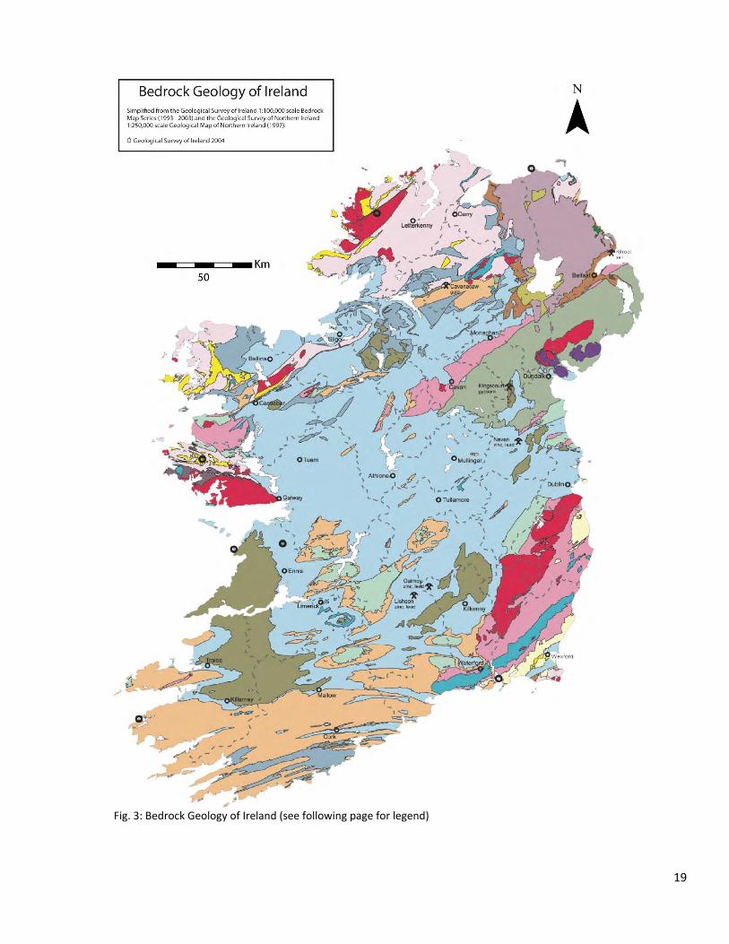
Fig. 3: Bedrock Geology of Ireland (see following page for legend)
19
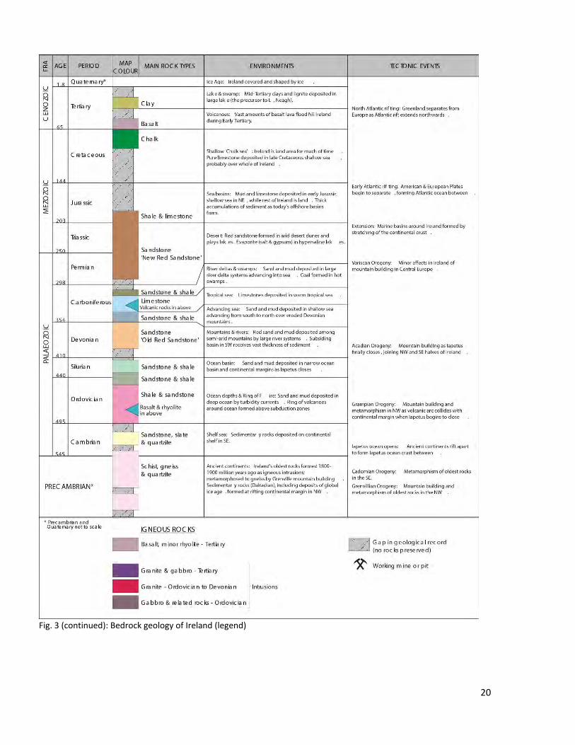
Fig. 3 (continued): Bedrock geology of Ireland (legend)
20
continent of Avalonia broke off Gondwana and rifted away towards Laurentia, slowly closing the Iapetus oceans but contemporaneously opening the new Rheic Ocean (Woodcock & Strachan, 2009). On the Baltic paleo-continent subduction occurred at the western margin while it was rotating towards Laurentia (Woodcock & Strachan, 2009). The Iapetus Ocean finally closed in Silurian times with deformation continuing to Devonian times. More fragments of Gondwana rifted towards Laurentia, closing the interjacent and opened new oceans, merging into Laurentia as the Acadinan (400 Ma) and Ligerian Orogeny (390-370 Ma) (Woodcock & Strachan, 2009). Finally, Gondwana and Laurentia collided with the formation of the Variscan Orogeny (370-290 Ma) into the Pangea Supercontinent (Woodcock & Strachan, 2009). After collision, consolidation of the supercontinent continued and due to rotation the region of Britain and Ireland was moved to the northern hemisphere (Woodcock & Strachan, 2009). In Jurassic times, the central Atlantic Ocean opened, leading to a separation of North America, South America and Africa followed by the separation of South America and Africa in Cretaceous by the opening of the south Atlantic Ocean (Woodcock & Strachan, 2009). The north Atlantic Ocean opened by late cretaceous with the separation of Greenland from Eurasia, while rotation of Africa caused the Alpine Orogeny (Woodcock & Strachan, 2009).
References:
Holland, C. H. (2001). The geology of Ireland: Dunedin Academic. Woodcock, N. H., & Strachan, R. A. (2009). Geological history of Britain and Ireland: John Wiley & Sons.
21
From Past to Present – The history of mining in Ireland Juliana Troch
Mining in Ireland has a long history with active use of stone quarries starting in the Stone Age and the first documented metal mining in the Bronze Age. From then on, techniques developed continuously while changes in supply and demand, as well as new discoveries, have shaped Ireland’s role as a metal producer into modern times. This text will briefly introduce some key eras and events in the history of mining in Ireland (deposits that will be visited during this excursion are marked in bold).
From Stone to Iron Age
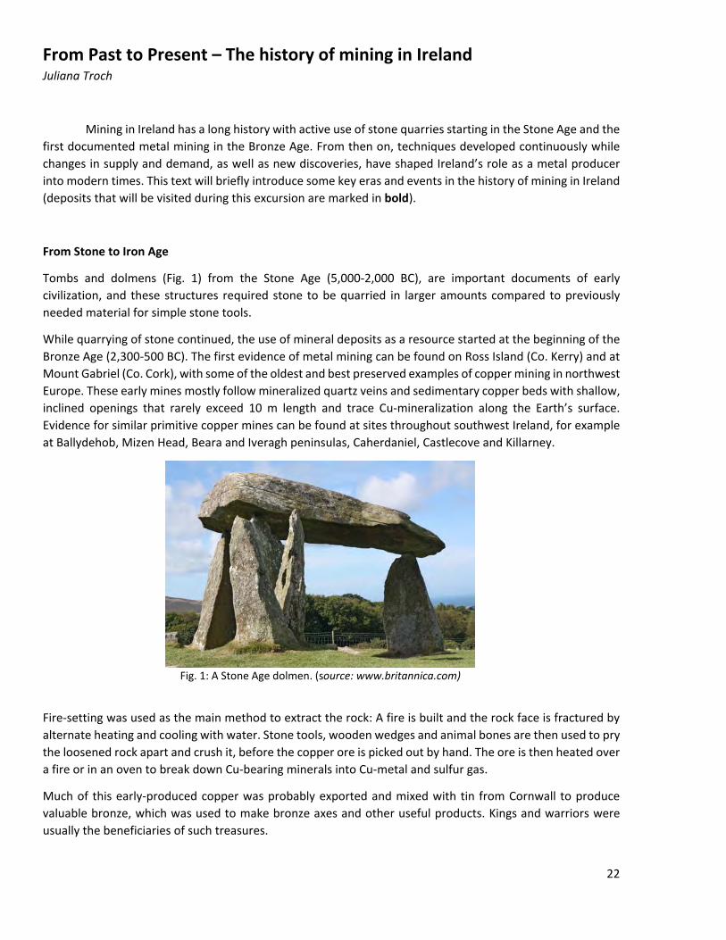
Tombs and dolmens (Fig. 1) from the Stone Age (5,000-2,000 BC), are important documents of early civilization, and these structures required stone to be quarried in larger amounts compared to previously needed material for simple stone tools.
While quarrying of stone continued, the use of mineral deposits as a resource started at the beginning of the Bronze Age (2,300-500 BC). The first evidence of metal mining can be found on Ross Island (Co. Kerry) and at Mount Gabriel (Co. Cork), with some of the oldest and best preserved examples of copper mining in northwest Europe. These early mines mostly follow mineralized quartz veins and sedimentary copper beds with shallow, inclined openings that rarely exceed 10 m length and trace Cu-mineralization along the Earth’s surface. Evidence for similar primitive copper mines can be found at sites throughout southwest Ireland, for example at Ballydehob, Mizen Head, Beara and Iveragh peninsulas, Caherdaniel, Castlecove and Killarney.
Fig. 1: A Stone Age dolmen. (source: www.britannica.com)
Fire-setting was used as the main method to extract the rock: A fire is built and the rock face is fractured by alternate heating and cooling with water. Stone tools, wooden wedges and animal bones are then used to pry the loosened rock apart and crush it, before the copper ore is picked out by hand. The ore is then heated over a fire or in an oven to break down Cu-bearing minerals into Cu-metal and sulfur gas.
Much of this early-produced copper was probably exported and mixed with tin from Cornwall to produce valuable bronze, which was used to make bronze axes and other useful products. Kings and warriors were usually the beneficiaries of such treasures.
22
Around this time, gold was discovered as well, and there is evidence that gold was mined around 1600 BC at a site close to Dublin. Ireland was well-known for gold ornaments in pre-Christian times, and beautiful brooches, bracelets, amulets and necklaces were produced, although their exact source of gold is unknown.
During the Iron Age (500 BC to 400 AD), Celtic invaders introduced iron weapons. Their arrival probably initiated a search for local sources of this new material, and iron mining was carried out at Lough Allen (Co. Leitrim) at a mountain called Sliabhaniairn, meaning “Mountain of iron”. While iron is more abundant, it is also more difficult to work than copper as it requires higher temperatures and several processing steps. However, knowledge grew quickly and new tools and utensils were developed. Metal mining eventually declined due to exhaustion of accessible deposits.
Minor mining from early Christian period to 17th century
Only sparse records for mining activities in Ireland exist for the time between the early Christian period and the 17th century, although mining certainly took place as metal demand increased and extracting methods improved. Evidence suggests there was some iron mining at Avoca in the 2nd century, iron and copper mining in the 9th century, alum mining in the 12th century and Pb-Ag and Cu production around 1500. The 16th and 17th century saw widespread small-scale iron ore production across the eastern half of Ireland, which was mostly exported to England. Ores mainly consisted of gossans (“Brauneisen/Eisenhut”), carbonate ore (“ironstone”/”Eisenspat” = siderite) from coalfields, hematite and widespread goethite (“bog iron”/”Raseneisenerz”). The industry declined when charcoal sources were exhausted and the last charcoal furnace closed in 1765.
Industrial revolution and the gold rush
An unprecedented demand for iron and other metals in Britain led to flowering of metal mining in Ireland. A new technique of smelting iron was invented in 1730, making the production process cheaper and thus fueling the construction of factories, machines, railways and steamships. The growing demand for iron was accompanied by a growing hunger for coal in order to run the countless smelters.
Mining employment was at peak levels. Southwest Ireland saw a mining boom in copper to a point where almost every coastal county had a mine. These were mostly high-grade low-tonnage vein deposits. Today, the heavily mined area around Bunmahon is assigned “Copper Coast Geopark”.
Other commodities were also mined and by the 19th century mining was active in Avoca (Pb, Cu, pyrite), West Cork (barite and Cu), Glendasan-Glendalough-Glenmalure (Pb), and Abbeytown and Silvermines for Pb and Ag. West Cork was one of the most productive mining areas with the Allihies copper mine opening in 1811. By 1851, more than 1,200 people worked in the mine, which was initially designed as open-pit but then moved underground when surface deposits were exhausted. The miners had to climb over wooden ladders to depths up to 360 m below the surface.
In 1795 discovery of gold led to a veritable gold rush along the Gold Mines River. Eighty kg of gold were extracted in the first six weeks alone from alluvial gravel. Following state intervention, the government took over the mining activity in 1796, before responsibility was transferred to the local population in 1804 and eventually taken over by a private company in 1860. An estimated total amount of 7,000-9,000 oz of gold were extracted.
23
The fall and depression
Metal prices fell considerably by 1880, turning many production centers uneconomical. Until the 1950s, mining activity consisted of bauxite production in northern Ireland, mining of pyrite for sulphur at Avoca, phosphate from western Ireland, barite from Benbulben (1942-1960) and gypsum from the Kingscourt area (1936 and onwards). Some mining of thin coal seems also continued.
Rise to recent
Governmental measures such as the Minerals Development Act (1940) and tax reductions in the Finance Act (1956) triggered a new era of mineral exploration in Ireland and attracted several Canadian exploration companies. Close to Abbeytown, economic reserves of Pb and Zn were discovered in Lower Carboniferous rocks. Exploration now focused on this stratigraphic level and soon led to the discovery of the Ballyvergin copper deposit in 1957. In 1961, the Tynagh Zn-Pb-Ag orebody was found in a geological setting, which was previously not recognized for economic amounts of mineralization, leading to several other findings. At the time of production, the newly discovered Ballynoe barite deposit counted as 5th largest barite producer in the world.
In the late 1970s, the large-tonnage Navan Zn-Pb deposit was discovered and production started in 1977. This led to increased international demand for prospecting licenses throughout Ireland – at some point covering half of Ireland’s land area. However, no other large-tonnage prospects were identified, resulting in many international exploration companies leaving Ireland. The remaining vacuum was filled by a growing number of junior Irish exploration companies that remained active during times with low base metal prices and limited funding.
The discovery of the Curraghinalt gold prospect in northern Ireland in 1983 led to a boost in Au exploration activity since gold prices were high between 1982 and 1988, resulting in the discovery of the Lecanvey and Cregganbaun deposits.
In 1986, significant reserves of Zn-Pb were discovered at Galmoy, a finding that revived the base metal industry in Ireland and led to the come-back of multinational companies. Only four years later, another Zn-Pb deposit was found at Lisheen and the reserves at both Navan and Galmoy turned out larger than expected, thus extending their mine life significantly. With Navan, Galmoy and Lisheen in full production, Ireland rose to being the largest producer of Pb and Zn in Europe and tenth largest in the world. Even with Galmoy being closed in 2009, Ireland remains one of the largest Pb-Zn producers in Europe.
24
Sources:
Cole, G.A.J. (1922): Memoir and Map of Localities of Minerals of Economic Importance and Metalliferous Mines in Ireland. Memoirs of the Geological Survey of Ireland, 155pp.
Dunnels, D., Hitzman, M.W. (1992): History of mining in Ireland. Fact sheet. Irish Association for Economic Geology, Fact Sheet 4, 4pp.
O'Brien, W. (1996) From the Fiery Furnace: copper sources and early Irish metallurgy. Royal Dublin Society, Occasional Paper 12, 16pp.
“The top 55 deposits” publication by the Exploration and Mining Division in cooperation with the Geological Survey of Ireland, Department of Communications, Marine and Natural Resources.
http://www.mineralsireland.ie/NR/rdonlyres/2463FF0E-656F-4F48-8A8B-C856FBCA0AAF/0/Top55_2005.pdf
25
The Formation of Irish Zn-Pb Ore Deposits: An Overview Michael Schirra
Introduction
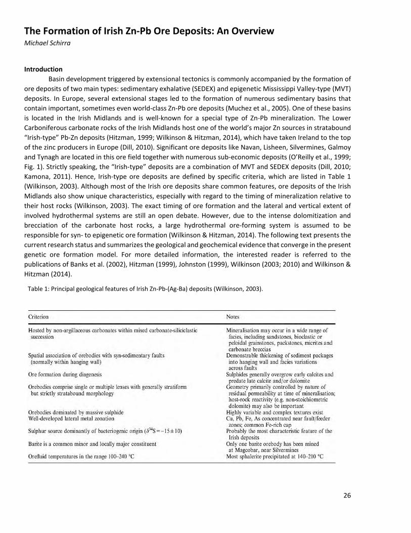
Basin development triggered by extensional tectonics is commonly accompanied by the formation of ore deposits of two main types: sedimentary exhalative (SEDEX) and epigenetic Mississippi Valley-type (MVT) deposits. In Europe, several extensional stages led to the formation of numerous sedimentary basins that contain important, sometimes even world-class Zn-Pb ore deposits (Muchez et al., 2005). One of these basins is located in the Irish Midlands and is well-known for a special type of Zn-Pb mineralization. The Lower Carboniferous carbonate rocks of the Irish Midlands host one of the world’s major Zn sources in stratabound “Irish-type” Pb-Zn deposits (Hitzman, 1999; Wilkinson & Hitzman, 2014), which have taken Ireland to the top of the zinc producers in Europe (Dill, 2010). Significant ore deposits like Navan, Lisheen, Silvermines, Galmoy and Tynagh are located in this ore field together with numerous sub-economic deposits (O’Reilly et al., 1999; Fig. 1). Strictly speaking, the “Irish-type” deposits are a combination of MVT and SEDEX deposits (Dill, 2010; Kamona, 2011). Hence, Irish-type ore deposits are defined by specific criteria, which are listed in Table 1 (Wilkinson, 2003). Although most of the Irish ore deposits share common features, ore deposits of the Irish Midlands also show unique characteristics, especially with regard to the timing of mineralization relative to their host rocks (Wilkinson, 2003). The exact timing of ore formation and the lateral and vertical extent of involved hydrothermal systems are still an open debate. However, due to the intense dolomitization and brecciation of the carbonate host rocks, a large hydrothermal ore-forming system is assumed to be responsible for syn- to epigenetic ore formation (Wilkinson & Hitzman, 2014). The following text presents the current research status and summarizes the geological and geochemical evidence that converge in the present genetic ore formation model. For more detailed information, the interested reader is referred to the publications of Banks et al. (2002), Hitzman (1999), Johnston (1999), Wilkinson (2003; 2010) and Wilkinson & Hitzman (2014).
Table 1: Principal geological features of Irish Zn-Pb-(Ag-Ba) deposits (Wilkinson, 2003).
26
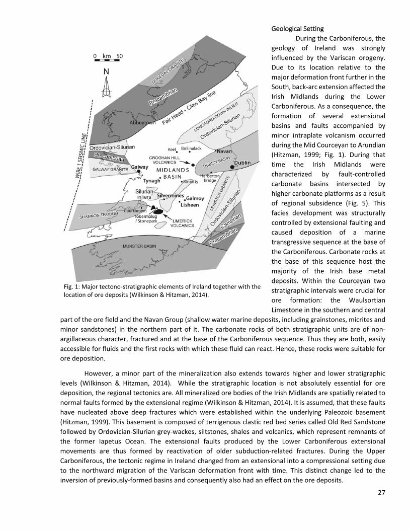
Geological Setting During the Carboniferous, the
geology of Ireland was strongly influenced by the Variscan orogeny. Due to its location relative to the major deformation front further in the South, back-arc extension affected the Irish Midlands during the Lower Carboniferous. As a consequence, the formation of several extensional basins and faults accompanied by minor intraplate volcanism occurred during the Mid Courceyan to Arundian (Hitzman, 1999; Fig. 1). During that time the Irish Midlands were characterized by fault-controlled carbonate basins intersected by higher carbonate platforms as a result of regional subsidence (Fig. 5). This facies development was structurally controlled by extensional faulting and caused deposition of a marine transgressive sequence at the base of the Carboniferous. Carbonate rocks at the base of this sequence host the majority of the Irish base metal deposits. Within the Courceyan two stratigraphic intervals were crucial for ore formation: the Waulsortian Limestone in the southern and central
part of the ore field and the Navan Group (shallow water marine deposits, including grainstones, micrites and minor sandstones) in the northern part of it. The carbonate rocks of both stratigraphic units are of non-argillaceous character, fractured and at the base of the Carboniferous sequence. Thus they are both, easily accessible for fluids and the first rocks with which these fluid can react. Hence, these rocks were suitable for ore deposition.
However, a minor part of the mineralization also extends towards higher and lower stratigraphic levels (Wilkinson & Hitzman, 2014). While the stratigraphic location is not absolutely essential for ore deposition, the regional tectonics are. All mineralized ore bodies of the Irish Midlands are spatially related to normal faults formed by the extensional regime (Wilkinson & Hitzman, 2014). It is assumed, that these faults have nucleated above deep fractures which were established within the underlying Paleozoic basement (Hitzman, 1999). This basement is composed of terrigenous clastic red bed series called Old Red Sandstone followed by Ordovician-Silurian grey-wackes, siltstones, shales and volcanics, which represent remnants of the former Iapetus Ocean. The extensional faults produced by the Lower Carboniferous extensional movements are thus formed by reactivation of older subduction-related fractures. During the Upper Carboniferous, the tectonic regime in Ireland changed from an extensional into a compressional setting due to the northward migration of the Variscan deformation front with time. This distinct change led to the inversion of previously-formed basins and consequently also had an effect on the ore deposits.
Fig. 1: Major tectono-stratigraphic elements of Ireland together with the location of ore deposits (Wilkinson & Hitzman, 2014).
27
Mineralization The main sulfide minerals of economic interest within the Irish ore deposits are sphalerite, galena,
pyrite and marcasite. Locally, barite is also a major economic mineral, like in the Silvermines zinc-lead-barite deposit (Samson & Russell, 1987). Also copper, mainly present as chalcopyrite, is an important resource in some deposits. Throughout the Irish ore field, there is a general zonation from Cu-rich deposits with low Zn/Pb ratios in the South to Cu-poor deposits with higher Zn/Pb ratios in the North. Also within the ore deposits, a stratigraphically-upward increase of the Zn/Pb ratios is observable (Johnston, 1999). This may indicate a rather heterogeneous source of the metals or different thermochemical conditions during metal extraction (Wilkinson & Hitzman, 2014). The source of the metals and fluids and their transport to the site of sulfide mineral precipitation, probably caused by abrupt changes in the physicochemical conditions, are key factors for metallogenesis. For this reason, the petrology of the host rocks, the geochemistry of the fluid, and the timing of the mineralizing event were in focus of much research during the last decades (e.g. Everett et al., 1999; Hitzman, 1999; Johnston, 1999; Kucha, 1985; Wilkinson et al., 2005).
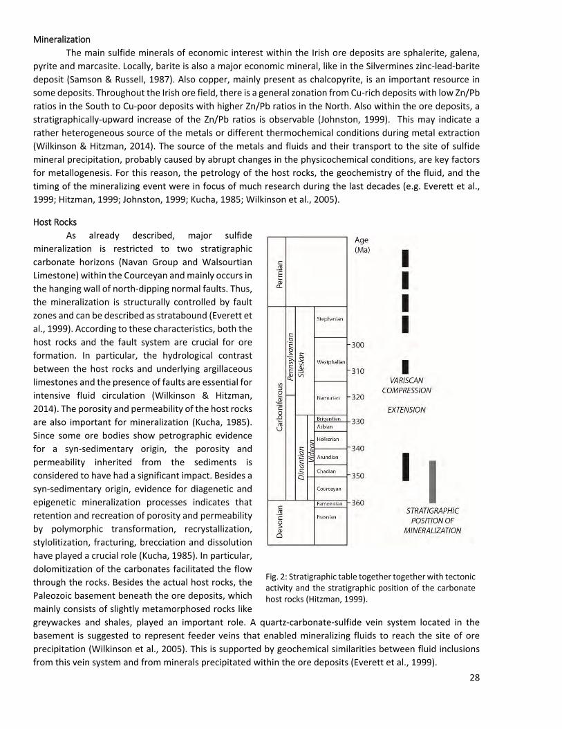
Host Rocks As already described, major sulfide
mineralization is restricted to two stratigraphic carbonate horizons (Navan Group and Walsourtian Limestone) within the Courceyan and mainly occurs in the hanging wall of north-dipping normal faults. Thus, the mineralization is structurally controlled by fault zones and can be described as stratabound (Everett et al., 1999). According to these characteristics, both the host rocks and the fault system are crucial for ore formation. In particular, the hydrological contrast between the host rocks and underlying argillaceous limestones and the presence of faults are essential for intensive fluid circulation (Wilkinson & Hitzman, 2014). The porosity and permeability of the host rocks are also important for mineralization (Kucha, 1985). Since some ore bodies show petrographic evidence for a syn-sedimentary origin, the porosity and permeability inherited from the sediments is considered to have had a significant impact. Besides a syn-sedimentary origin, evidence for diagenetic and epigenetic mineralization processes indicates that retention and recreation of porosity and permeability by polymorphic transformation, recrystallization, stylolitization, fracturing, brecciation and dissolution have played a crucial role (Kucha, 1985). In particular, dolomitization of the carbonates facilitated the flow through the rocks. Besides the actual host rocks, the Paleozoic basement beneath the ore deposits, which mainly consists of slightly metamorphosed rocks like greywackes and shales, played an important role. A quartz-carbonate-sulfide vein system located in the basement is suggested to represent feeder veins that enabled mineralizing fluids to reach the site of ore precipitation (Wilkinson et al., 2005). This is supported by geochemical similarities between fluid inclusions from this vein system and from minerals precipitated within the ore deposits (Everett et al., 1999).
Fig. 2: Stratigraphic table together together with tectonic activity and the stratigraphic position of the carbonate host rocks (Hitzman, 1999).
28
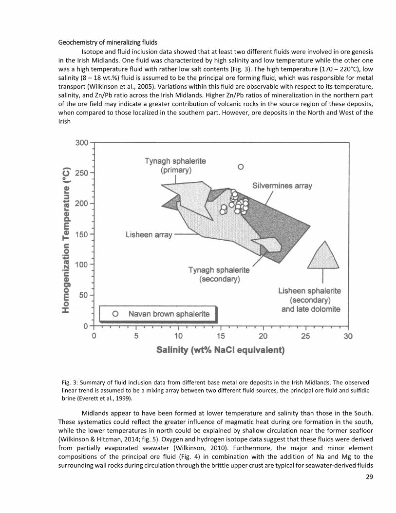
Geochemistry of mineralizing fluids Isotope and fluid inclusion data showed that at least two different fluids were involved in ore genesis
in the Irish Midlands. One fluid was characterized by high salinity and low temperature while the other one was a high temperature fluid with rather low salt contents (Fig. 3). The high temperature (170 – 220°C), low salinity (8 – 18 wt.%) fluid is assumed to be the principal ore forming fluid, which was responsible for metal transport (Wilkinson et al., 2005). Variations within this fluid are observable with respect to its temperature, salinity, and Zn/Pb ratio across the Irish Midlands. Higher Zn/Pb ratios of mineralization in the northern part of the ore field may indicate a greater contribution of volcanic rocks in the source region of these deposits, when compared to those localized in the southern part. However, ore deposits in the North and West of the Irish
Midlands appear to have been formed at lower temperature and salinity than those in the South. These systematics could reflect the greater influence of magmatic heat during ore formation in the south, while the lower temperatures in north could be explained by shallow circulation near the former seafloor (Wilkinson & Hitzman, 2014; fig. 5). Oxygen and hydrogen isotope data suggest that these fluids were derived from partially evaporated seawater (Wilkinson, 2010). Furthermore, the major and minor element compositions of the principal ore fluid (Fig. 4) in combination with the addition of Na and Mg to the surrounding wall rocks during circulation through the brittle upper crust are typical for seawater-derived fluids
Fig. 3: Summary of fluid inclusion data from different base metal ore deposits in the Irish Midlands. The observed linear trend is assumed to be a mixing array between two different fluid sources, the principal ore fluid and sulfidic brine (Everett et al., 1999).
29
(Wilkinson et al., 2005). During fluid circulation at depth (probably along the fault zones), the fluid efficiently extracts metals from the source rocks as indicated by a light zinc isotope signature between -0.1 and +0.3 per mil. Consequently, the fluid acquired high metal concentrations (Pb up to 890 µg/g and Zn up to about 5,000 µg/g) at very low sulfur contents (Wilkinson & Hitzman, 2014). Thus, the required amount of sulfur had to be added by another fluid phase, namely sulfidic brine. This second fluid was a low temperature, high-salinity and Br-rich brine formed by evaporation of seawater past the point of halite precipitation (Wilkinson, 2003). Sulfur isotopes of sulfide minerals suggest that the sulfur is mainly of bacteriogenic origin (32S enriched relative to the CDT international standard) and hence support a near-surface origin. Therefore, it is assumed that the major process, responsible for ore precipitation was mixing of the metal-rich principal ore fluid with the sulfidic brine at rather shallow depths (Johnston, 1999; Wilkinson et al., 2005; Wilkinson & Hitzman, 2014). However, due to the fact that sulfur isotope characteristics changes with depth towards a rather hydrothermal signature of the sulfur, another precipitation-causing factor might have been involved during later stages of ore formation at greater depths (Wilkinson & Hitzman, 2014). As source for the metal charge which was transported by the principal ore fluid, the Lower Paleozoic basement has been taken into account. This is supported by lead isotope studies showing evidence for leaching of the weakly metamorphosed lower Paleozoic basement (Wilkinson et al., 2005). In addition, experimental studies have shown that greywackes are a fertile source for metals which can be easily leached by hot acidic fluids (Bischoff et al., 1981). The Carboniferous basins on the other hand are unlikely to represent a possible source for the metals due to the low thickness (Wilkinson & Hitzman, 2014).
Timing of Mineralization A maximum stratigraphic age of ore formation is given by the age of the host rocks, but the exact
timing of the mineralization event relative to the host rocks is still a matter of debate. Generally, it is accepted that ore formation was genetically linked to extension in the Lower Carboniferous, but interpretations range from synchronous with deposition of the host carbonate to about 15 Ma later after diagenesis of the host rocks (Wilkinson et al., 2011). The depth of ore formation is also still unclear and estimations range from few to hundreds of meters beneath the seafloor. Petrographic observations such as mineralized fossil hollow tubes (Boyce et al., 2003) and finely laminated pyrite, together with sulfur isotope characteristics, indicate a syn-sedimentary origin of the ore near the surface. This early onset of mineralization relative to host rock formation is also supported by Re-Os geochronology in pyrite from the Lisheen mine, which revealed an age of 347±3 Ma. Sphalerite yielded even younger ages of 360±5 Ma by Rb-Sr dating (Wilkinson & Hitzman 2014). However, the majority of ore bodies were formed by replacement processes (Kamona, 2011). Kucha (1989) emphasized a later formation of the ore bodies after diagenesis as indicated by replacement textures. In particular, the occurrence of mineralized dolomite breccias in the Silvermines deposit is an indication for post-diagenetic ore formation at deeper levels (Sevastopulo & Redmond, 1999). Consequently, the second extensional phase during the Asbian and Brigantian times (Fig. 2) might have also been accompanied by ore formation processes. At least the Zn-Pb mineralization at Abbeytown, for example, is assumed to have been formed during the Asbian (Wilkinson, 2003 and references therein). Thus, a long period of base-metal metallogenesis ranging from the Couceyan-Chadian boundary (355-350 Ma) to the Asbian (335 Ma) is assumed for the Irish Midlands. Where spatially and temporally related to volcanic activity, like in the Limerick Subdistrict (including Pallas Green, Stonepark, and Tobermalug prospects) radiometric dating of those rocks could provide a further hint to the age of mineralization in these areas (Wilkinson & Hitzman 2014).
Genetic Model The actual ore formation model involves a seawater-derived fluid penetrating into the brittle upper
crust via Caledonian structures that were reactivated during extensional movements. During the Lower Carboniferous, the climate conditions and the formation of shallow marine sedimentary basins intersected by paleo-plateaus above the sea level was ideal for seawater evaporation, as indicated by evaporate minerals in some mine sequences (Banks et al., 2002 and references therein). Lead isotope data indicate that shales and greywackes beneath the Carboniferous basin were the source of the metal which was leached and transported
30

by the principal ore fluid (Wilkinson et al., 2005). The Paleozoic basement was accessible and intensively leachable through a vein-system which is assumed to have acted as feeder veins. Subsequent ascent and mixing of this metalliferous fluid with a sulfur-rich brine acted as a trap that triggered sulfide mineral precipitation close to the ancient seafloor (Wilkinson & Hitzman, 2014). Sulfur isotopes indicate that the second sulfidic fluid was formed by bacteriogenic reduction of marine sulfur shallow beneath the seafloor.
Fig. 4: Seawater-normalized major and minor elemental composition of the Irish principal ore fluid derived from fluid inclusions hosted by the lower Paleozoic feeder dykes. For comparison modern hydrothermal vents from the Mid-Atlantic Ridge Kane (MARK-2), the East Pacific Rise (21°N OBS) and Trans-Atlantic Geotraverse (TAG) are shown. The negative Mg anomaly together with enrichment in the transition metals is a common feature of seawater-derived fluids that interact with basaltic crust. The anomalous levels of Ba, Sr and Pb point towards a modification by interaction with continental rocks (Wilkinson et al., 2005).
Thus, the permeability of the host rocks in combination with the location of the faults were essential for mixing of two fluids from different sources. To connect the two critical fluid reservoirs, bacteriogenic sulfide production is assumed to have taken place above faults which acted as conduits for fluid up-flow. The presence or absence of this connection was probably a critical factor that locally facilitated or limited mineralization. Additionally, fluid temperature as the controlling key factor of base metal solubility played an important role. However, the source of heat which is necessary for a long-lived hydrothermal system and effective metal transport is still in question. Since a significant increase of the geothermal gradient by crustal extension is implausible, the presence volcanic rocks (albeit restricted in extent) may provide clues to the answer. During Lower Carboniferous extension, decompression melting of the subcontinental asthenosphere could have produced mafic intrusions in the lower or mid crust (Wilkinson & Hitzman, 2014). Also the sulfur isotopic composition (δ34S = 0 to + 10 per mil relative to the CDT international standard) of ore minerals that have precipitated at deeper levels is consistent with a basaltic origin. Wilkinson & Hitzman (2014) suggest the emplacement of a mafic sill complex beneath the southern part of the ore field to explain the ore formation temperature decrease to the North, where evidence for magmatism is lacking (Fig. 5). However, the actual model is purely hypothetical with respect to some aspects and thus there are still a lot of gaps in the understanding of the Irish mineralizing system. For example, the relationship between magmatism and ore formation is only visible in the Limerick Basin near Silvermines and hence not well understood in the rest of
31
the ore field. Consequently, the heat source required for the hydrothermal system is also still in question. Seismic surveys of the Irish Midlands could identify the presence of mid-crustal intrusions and additionally image major structures that have facilitated fluid flow through the upper crust. Furthermore, variations within the Paleozoic basement rocks assumed to have produced the heterogeneity of the ore forming fluids are still unconfirmed and metal extraction processes are not well understood. Further research is necessary in order to fully understand the metallogenesis of the Carboniferous base metal ore deposits.
References
Banks D. A., Boyce A. J., Samson I. M. (2002): Constraints on the Origins of Fluids forming Irish Zn-Pb-Ba Deposits: Evidence from the Composition of Fluid Inclusions. Econ. Geol. 97, 471-480.
Bischoff J. L., Radtke A. S., Rosenbauer R. J. (1981): Hydrothermal alteration of greywacke by brine and seawater: roles of alteration and chloride complexing on metal solubilization at 200°C and 350°C. Econ. Geol. 76, 659-676.
Boyce A. J., Little C. T. S., Russell M. J. (2003): A new fossil vent biota in the Ballynoe Barite Deposit, Silvermines, Ireland: Evidence for intracratonic sea-floor hydrothermal activity about 352 Ma. Econ. Geol. 98, 649-656.
Dill H. G. (2010): The “chessboard” classification scheme of mineral deposits: Mineralogy and geology from aluminium to zirconium. Earth Sci. Rev. 100, 1-420.
Hitzman M. W. (1999): Extensional faults that localize Irish syndiagenetic Zn-Pb deposits and their reactivation during Variscan compression. In: McCaffery K. J. W., Longergan L. & Wilkinson J. J. (eds) Fractures, Fluid Flow and Mineralization. Geological Society, London, Special Publications 155, 233-245.
Johnston J. D. (1999): Regional fluid flow and the genesis of Irish Carboniferous base metal deposits. Miner. Deposita 34, 571-598.
Everett C.E., Wilkinson J.J., Rye D.M. (1999): Fracture-controlled fluid flow in the lower Palaeozoic basement rocks of Ireland: Implications for the genesis of Irish-type Zn-Pb deposits. In: McCaffery K. J. W., Longergan L. & Wilkinson J. J. (eds) Fractures, Fluid Flow and Mineralization. Geological Society, London, Special Publications 155, p. 247–276.
Kamona F. (2011): Carbonate-hosted Base Metal Deposits. In: Dar I. A. (ed) Earth and Environmental Sciences, 393-422.
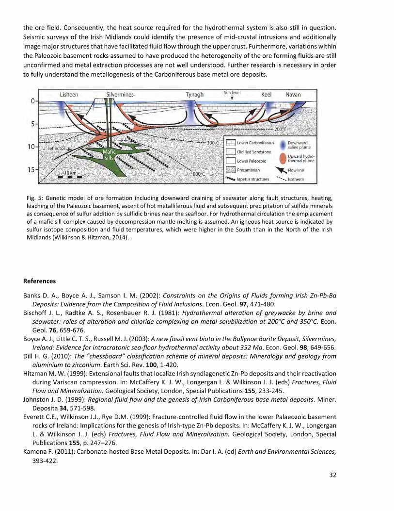
Fig. 5: Genetic model of ore formation including downward draining of seawater along fault structures, heating, leaching of the Paleozoic basement, ascent of hot metalliferous fluid and subsequent precipitation of sulfide minerals as consequence of sulfur addition by sulfidic brines near the seafloor. For hydrothermal circulation the emplacement of a mafic sill complex caused by decompression mantle melting is assumed. An igneous heat source is indicated by sulfur isotope composition and fluid temperatures, which were higher in the South than in the North of the Irish Midlands (Wilkinson & Hitzman, 2014).
32

Kucha H. (1985): The significance of Diagenesis in Emplacement of Strata-Bound Zn-Pb. – In: Friedrich G. H. & Herzig P. M. (eds) Base Metal Sulfide Deposits in Sedimentary and Volcanic Environments, Aachen, Special Publication of the Society for Geology applied to Mineral Deposits 5, 109-120.
Muchez P., Heijlen W., Banks D., Blundell D., Boni M., Grandia F. (2005): Extensional tectonics and the timing and formation of basin-hosted deposits in Europe. Ore Geol. Rev. 27, 241-267.
O'Reilly B. M., Readman P. W. & Murphy T. (1999): Gravity lineaments and Carboniferous-hosted base metal deposits of the Irish Midlands. In: McCaffery K. J. W., Longergan L. & Wilkinson J. J. (eds) Fractures, Fluid Flow and Mineralization. Geological Society, London, Special Publications 155, 313-321.
Samson I. M. & Russell M. J. (1987): Genesis of the Silvermines zinc-lead-barite deposit, Irland; fluid inclusion and stable isotope evidence. Econ. Geol. 82, 371-394.
Sevastopulo G. D. & Redmond P. (1999): Age of mineralization of carbonate-hosted, base metal deposits in the Rathdowney Trend, Ireland. In: McCaffery K. J. W., Longergan L. & Wilkinson J. J. (eds) Fractures, Fluid Flow and Mineralization. Geological Society, London, Special Publications 155, 303-311.
Willkinson J. J. (2003): On diagenesis, dolomitization and mineralization in the Irish Zn-Pb orefield. Miner. Deposita 38, 969-983.
Wilkinson J. J. (2010): A review of fluid inclusion constraints on mineralization in the Irish orefield and implications for the genesis of sediment-hosted Zn-Pb deposits. Econ. Geol. 105, 417-442.
Wilkinson J. J., Everett C. E, Boyce A. J., Gleeson S. A., Rye D. M. (2005): Intracratonic crustal seawater circulation and the genesis of subseafloor zinc-lead mineralization in the Irish orefield. Geology 33, 805-808.
Willkinson J. J., Crowther H. L., Coles B. J. (2011): Chemical mass transfer during hydrothermal alteration of carbonates: Controls of seafloor subsidence, sedimentation and Zn-Pb mineralization in the Irish Caboniferous. Chem. Geol. 289, 55-75.
33
Navan Pb-Zn Deposit, Co. Meath David Farsky & Rebecca Keusch
Date: August 10, 2016 STOP No.: 1 Main commodity: Zn-Pb(-Ag) Geological setting or genetic model: carbonate-hosted “Irish-type” Zn-Pb Current development status: Operating Underground WGS Latitude: 53.65318 WGS Longitude: -6.72039 Location & access: 1 km northwest of Navan, by road N51 and Townparks, asphalt street on site Geological domain: Central Ireland Basin Geological unit: Early Carboniferous Owner (2014): New Boliden, operated by Tara Mines Limited Address: Knockumber Road, Navan, Co. Meath, Ireland
Regional geological setting:
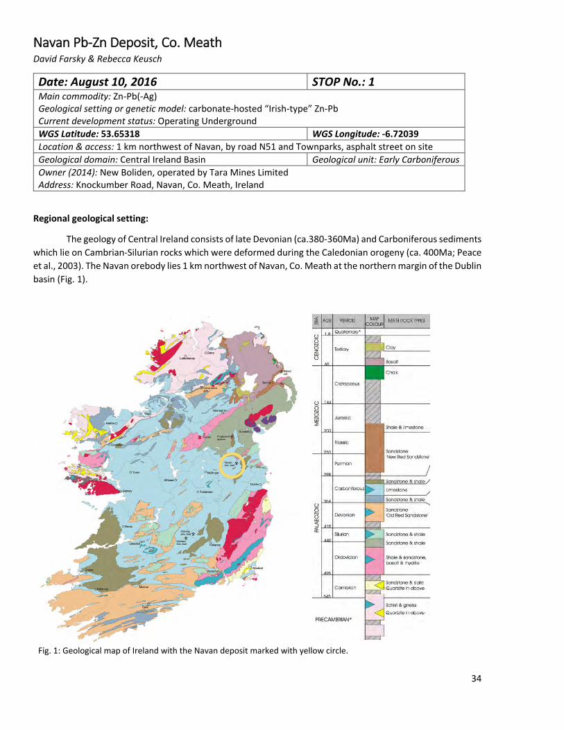
The geology of Central Ireland consists of late Devonian (ca.380-360Ma) and Carboniferous sediments which lie on Cambrian-Silurian rocks which were deformed during the Caledonian orogeny (ca. 400Ma; Peace et al., 2003). The Navan orebody lies 1 km northwest of Navan, Co. Meath at the northern margin of the Dublin basin (Fig. 1).
Fig. 1: Geological map of Ireland with the Navan deposit marked with yellow circle.
34

The sediments in which the Navan orebody lies is made up of 5 subunits: the Red Beds, laminated beds, muddy limestone, shaley Pale Beds and the Pale Beds. The Pale Beds, which host >97% of the Navan Ore, are made of micritic mudstones and wackestones at the base and change gradually to grainstones and packstones
at the top. The depositional environment is a gradually deepening ocean on a high-energy carbonate ramp. On top of the Navan Group the argillaceous bioclastic limestone, an open marine shelf sediment, are deposited. They are succeeded by the Waulsortian mudbank limestone, which dominantly consists of micritic mud mounds (Fig.2; Peace & Wallace, 2000)
An unconformity of middle Carboniferous age (345 Ma) in the form of a submarine erosion surface crosscuts the units of the Navan Group and is followed by the deposition of the Boulder Conglomerate. This unit hosts up to ~3% of the ore at Navan and is called the Conglomerate Group Ore. This conglomerate consists of sand- to boulder-sized clasts of the Pale Beds and Waulsortian limestones in a mix of matrix and clast-supported
Fig. 2: Vertical profile through the geological units at Navan mine site
Fig 3. Aerial view of the Navan mine site
35
sediment. On top are deposited a sequence of turbiditic limestones and shales of early (350 Ma) to middle Carboniferous age (345 Ma), called the upper dark limestones (Peace & Wallace, 2000).
Tectonic evolution:
The ore-carrying units are Early Carboniferous shallow water carbonates. Paleogeographically, Ireland was on the continental margin of Laurasia and subsiding under an equatorial, shallow ocean. This subsidence was accompanied by an early ENE-trending, NW-dipping, extensional fault system in a horst-graben structure, which the deposit is focused along. This was controlled by a large, southeast-dipping extensional fault that developed during the early stages of rifting of the Dublin Basin (Wilkinson et al., 2005a).
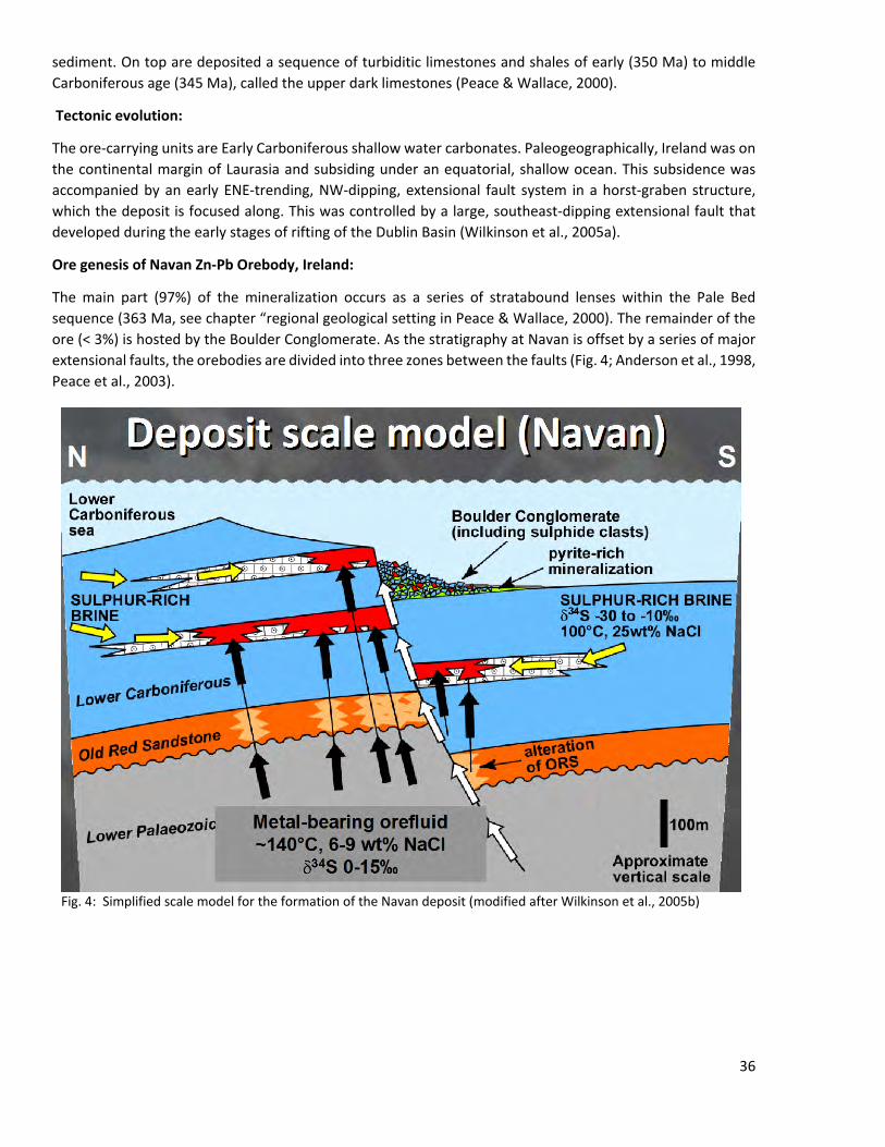
Ore genesis of Navan Zn-Pb Orebody, Ireland:
The main part (97%) of the mineralization occurs as a series of stratabound lenses within the Pale Bed sequence (363 Ma, see chapter “regional geological setting in Peace & Wallace, 2000). The remainder of the ore (< 3%) is hosted by the Boulder Conglomerate. As the stratigraphy at Navan is offset by a series of major extensional faults, the orebodies are divided into three zones between the faults (Fig. 4; Anderson et al., 1998, Peace et al., 2003).
Fig. 4: Simplified scale model for the formation of the Navan deposit (modified after Wilkinson et al., 2005b)
36

Ore minerals and textures:
The ore mineralogy of the Pale Beds consists mainly of sphalerite and galena (5:1 ratio), with small quantities of silver (ca. 10 – 15 g/t of ore, main silver minerals: freibergite (Ag6[Cu4Fe2]Sb4S13) and pyrargyrite (Ag3SbS3)). Minor minerals in the Pale Beds are pyrite and marcasite with barite, calcite and dolomite as gangue minerals (Anderson et al., 1998).
Mineralization took place in a wide variety of styles and relationships to the host rock, depending on local lithology and intensity of mineralization. It ranges from massive, high-grade mineralization (up to >40% Zn+Pb) in conformable lenses, irregular anastomosing networks of sulfides and bedding-parallel ore horizons (Anderson et al., 1998). In addition, brecciated zones occur where host rock clasts are cemented by sulfides as well as disseminated sulfides, where sphalerite replaces bioclastic components (Fig. 5; Anderson et al., 1998).
The dominant sulfide depositional mechanisms are open-space precipitation (cavity and fractures), veining and replacement of host lithologies. Sulfide textures of dendritic-skeletal, stalactitic, geopetal, coliform, coarse-bladed growths and sphalerite sediment represent deposition in open spaces in the carbonate host rock (Anderson et al., 1998). Such voids formed by hydrothermal dissolution of the limestone directly beneath dolomite. The competency contrast between the dolomitic lithology and the underlying limestone enables the lateral flow of hydrothermal fluids. The overlying less permeable units have been well-cemented by the time of mineralization, and acted as barriers to the ore fluid (Peace et al., 2003).
Rapidly precipitated ore textures, like dendritic, stalactitic and rhythmically banded forms are explained by mixing of two fluids. The complex chaotic clasts are indicative of continual disruption of the sulfides during the mineralization event, which can be related to ongoing extension during mineralization (Anderson et al., 1998).
The Conglomerate Group ore is comprised of typically highly pyritic massive sulfide with a moderately developed bedding-parallel layering and a highly variable composition of Fe and Zn-Pb sulfides. The bulk of the ore consists of high-grade massive sulfides as complex breccia’s and intergrowth of marcasite-pyrite, sphalerite and galena (Anderson et al., 1998).
37
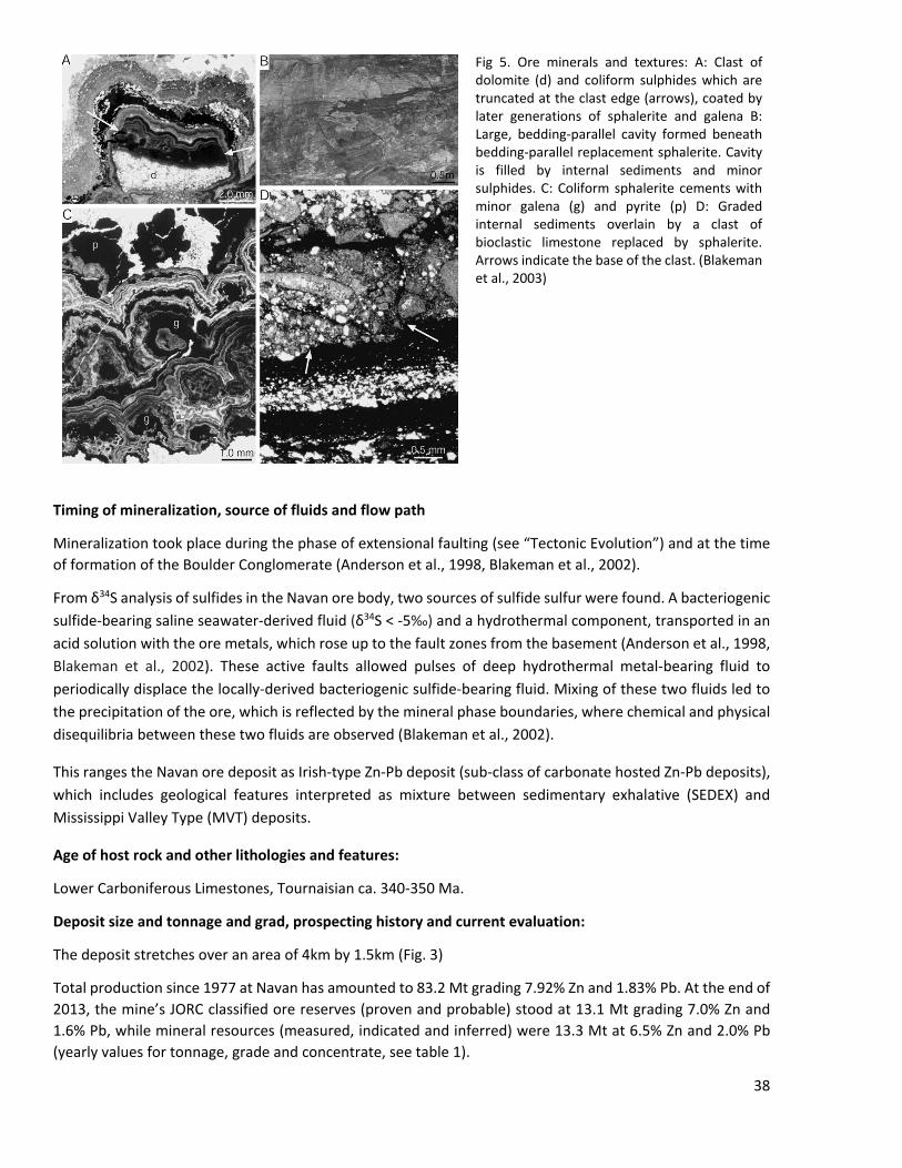
Fig 5. Ore minerals and textures: A: Clast of dolomite (d) and coliform sulphides which are truncated at the clast edge (arrows), coated by later generations of sphalerite and galena B: Large, bedding-parallel cavity formed beneath bedding-parallel replacement sphalerite. Cavity is filled by internal sediments and minor sulphides. C: Coliform sphalerite cements with minor galena (g) and pyrite (p) D: Graded internal sediments overlain by a clast of bioclastic limestone replaced by sphalerite. Arrows indicate the base of the clast. (Blakeman et al., 2003)
Timing of mineralization, source of fluids and flow path
Mineralization took place during the phase of extensional faulting (see “Tectonic Evolution”) and at the time of formation of the Boulder Conglomerate (Anderson et al., 1998, Blakeman et al., 2002).
From δ34S analysis of sulfides in the Navan ore body, two sources of sulfide sulfur were found. A bacteriogenic sulfide-bearing saline seawater-derived fluid (δ34S < -5‰) and a hydrothermal component, transported in an acid solution with the ore metals, which rose up to the fault zones from the basement (Anderson et al., 1998, Blakeman et al., 2002). These active faults allowed pulses of deep hydrothermal metal-bearing fluid to periodically displace the locally-derived bacteriogenic sulfide-bearing fluid. Mixing of these two fluids led to the precipitation of the ore, which is reflected by the mineral phase boundaries, where chemical and physical disequilibria between these two fluids are observed (Blakeman et al., 2002).
This ranges the Navan ore deposit as Irish-type Zn-Pb deposit (sub-class of carbonate hosted Zn-Pb deposits), which includes geological features interpreted as mixture between sedimentary exhalative (SEDEX) and Mississippi Valley Type (MVT) deposits.
Age of host rock and other lithologies and features:
Lower Carboniferous Limestones, Tournaisian ca. 340-350 Ma.
Deposit size and tonnage and grad, prospecting history and current evaluation:
The deposit stretches over an area of 4km by 1.5km (Fig. 3)
Total production since 1977 at Navan has amounted to 83.2 Mt grading 7.92% Zn and 1.83% Pb. At the end of 2013, the mine’s JORC classified ore reserves (proven and probable) stood at 13.1 Mt grading 7.0% Zn and 1.6% Pb, while mineral resources (measured, indicated and inferred) were 13.3 Mt at 6.5% Zn and 2.0% Pb (yearly values for tonnage, grade and concentrate, see table 1).
38

(Data retrieved from:
http://webapp1.dlib.indiana.edu/virtual_disk_library/index.cgi/2870166/FID3366/PDF/664.PDF (15.5.16)
http://www.pdac.ca/docs/default-source/technical-program-abstracts/zinc---ashton.pdf?sfvrsn=4 (15.5.16)
http://www.mineralsireland.ie/NR/rdonlyres/4F451964-DF10-4216-B728-FD5E6F76283A/0/IndustryNewsMay2014.pdf (15.5.16))
Table 1 Tonnage, Grade and Concentrate gained from mining in the mentioned years at Navan New Boliden Taras Mine.
39
References & online sources:
Anderson, I. K., Asthon, J. H., Boyce, A. J., Fallick, A. E., Russel, M. J. (1998) Ore Depositional Processes in the Navan Zn-Pb Deposit, Irleland, Society of Economic Geologists, Inc., vol. 93, pp. 535-563
Blakeman, R. J., Ashton, J. H., Boyce, A. J., Fallic, A. E., Russel, M. J. (2002) Timing of Interplay between Hydrothermal and Surface Fluids in the Navan Zn+Pb Orebody: Evidence from Metal Distribution Trends, Mineral Textures, and δ34S Analysis, Economic Geology, vol. 97, pp. 73-91
Peace, W. M., Wallace, M. W., Holdstock, M. P., Asthon, J. H. (2003) Ore textures within the U lens of the Navan Zn-Pb deposit, Ireland, Mineralium Deposita, vol. 38, pp. 568 – 584
Peace, W. M., Wallace, M. W., Timing of mineralization at the Navan Zn-Pb deposit: A post- Arundian age for Irish mineralization, 2000)
Wilkinson, J.J., Everett, C.E. Boyce, A.J. Gleeson, S.A., Rye, D.M. (2005a) Intracratonic crustal seawater circulation and the genesis of subseafloor zinc-lead mineralization in the Irish orefield, Geological Society of America, vol. 22, no.10, p. 805-808
Wilkinson, J.J., Weiss, D.J., Mason, T.F.D., and Coles, B.J. (2005b) Zinc isotope variation in hydrothermal systems: Preliminary evidence from the Irish Mid- lands orefield, Economic Geology and the Bulletin of the Society of Economic Geologists, vol. 100
[Boissonnas, Omenetto, 1988] J. Boissonnas: Mineral Deposits within the European Community, Springer Verlag, Heidelberg, 1988
[Sawkins, 1984] F.J. Sawkins: Metal Deposits in Relation to Plate Tectonics, Springer Verlag, Heidelberg, 1984
http://webapp1.dlib.indiana.edu/virtual_disk_library/index.cgi/2870166/FID3366/PDF/664.PDF (15.5.16)
http://www.pdac.ca/docs/default-source/technical-program-abstracts/zinc---ashton.pdf?sfvrsn=4 (15.5.16)
http://www.mineralsireland.ie/NR/rdonlyres/4F451964-DF10-4216-B728-FD5E6F76283A/0/IndustryNewsMay2014.pdf (15.5.16)
References of Figures and Tables:
Fig. 1: http://geoschol.com/ireland.html 15.5.16
Fig. 2: http://econgeol.geoscienceworld.org/content/econgeo/97/1/73/F3.large.jpg 16.5.16
Fig. 3: http://www.imcexploration.com/base-metal-deposits 16.5.16
Table 1: http://www.imcexploration.com/base-metal-deposits (15.5.16)
40
Copper Coast Geopark Siem Rouwendaal & Marco Rebecchi
Geology of the Copper Coast (Co. Waterford)
The following summary is taken from Meere et al. (2003), the website of the Copper Coast Geopark and geological reports from the County Waterford. The Copper Coast is a copper mining district along the southern coast of Ireland, in the County Waterford. It has been mined from 1824 to 1908 for its copper, lead and silver content from cross-cutting quartz-veins in Ordovician volcanic and sedimentary rocks. Along the southern coast of Ireland in Avoca, nearby the Copper Coast, there is volcanogenic massive sulphide deposit with Cu mineralization (Platt, 1977), which might hold a connection to the Copper Coast deposit. This is currently being researched.
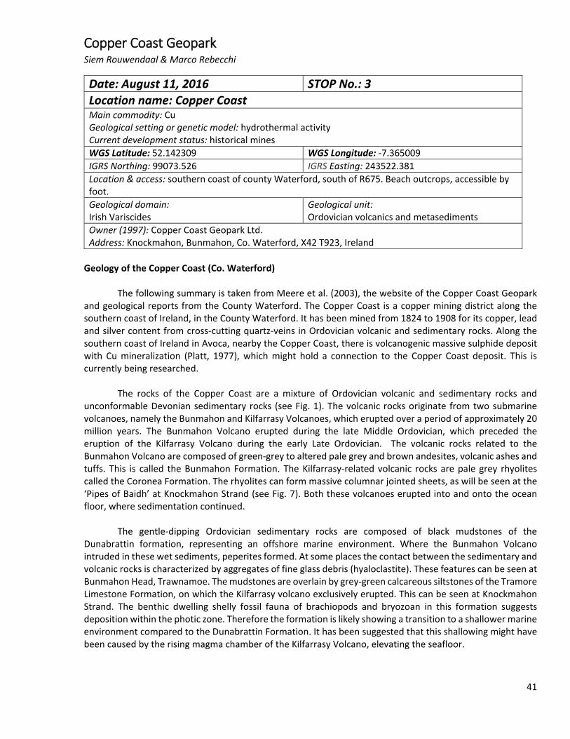
The rocks of the Copper Coast are a mixture of Ordovician volcanic and sedimentary rocks and unconformable Devonian sedimentary rocks (see Fig. 1). The volcanic rocks originate from two submarine volcanoes, namely the Bunmahon and Kilfarrasy Volcanoes, which erupted over a period of approximately 20 million years. The Bunmahon Volcano erupted during the late Middle Ordovician, which preceded the eruption of the Kilfarrasy Volcano during the early Late Ordovician. The volcanic rocks related to the Bunmahon Volcano are composed of green-grey to altered pale grey and brown andesites, volcanic ashes and tuffs. This is called the Bunmahon Formation. The Kilfarrasy-related volcanic rocks are pale grey rhyolites called the Coronea Formation. The rhyolites can form massive columnar jointed sheets, as will be seen at the ‘Pipes of Baidh’ at Knockmahon Strand (see Fig. 7). Both these volcanoes erupted into and onto the ocean floor, where sedimentation continued.
The gentle-dipping Ordovician sedimentary rocks are composed of black mudstones of the Dunabrattin formation, representing an offshore marine environment. Where the Bunmahon Volcano intruded in these wet sediments, peperites formed. At some places the contact between the sedimentary and volcanic rocks is characterized by aggregates of fine glass debris (hyaloclastite). These features can be seen at Bunmahon Head, Trawnamoe. The mudstones are overlain by grey-green calcareous siltstones of the Tramore Limestone Formation, on which the Kilfarrasy volcano exclusively erupted. This can be seen at Knockmahon Strand. The benthic dwelling shelly fossil fauna of brachiopods and bryozoan in this formation suggests deposition within the photic zone. Therefore the formation is likely showing a transition to a shallower marine environment compared to the Dunabrattin Formation. It has been suggested that this shallowing might have been caused by the rising magma chamber of the Kilfarrasy Volcano, elevating the seafloor.
Date: August 11, 2016 STOP No.: 3 Location name: Copper Coast Main commodity: Cu Geological setting or genetic model: hydrothermal activity Current development status: historical mines WGS Latitude: 52.142309 WGS Longitude: -7.365009 IGRS Northing: 99073.526 IGRS Easting: 243522.381 Location & access: southern coast of county Waterford, south of R675. Beach outcrops, accessible by foot. Geological domain: Irish Variscides
Geological unit: Ordovician volcanics and metasediments
Owner (1997): Copper Coast Geopark Ltd. Address: Knockmahon, Bunmahon, Co. Waterford, X42 T923, Ireland
41
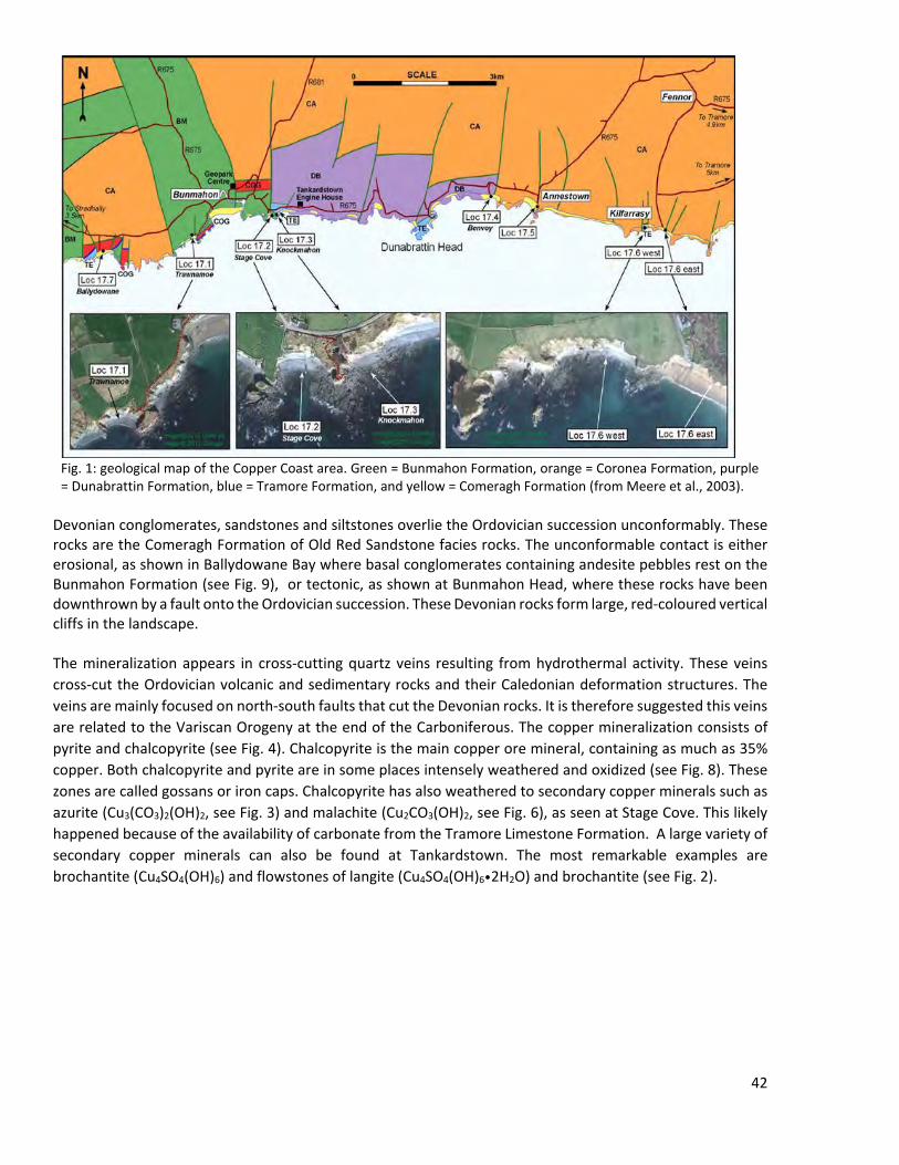
Devonian conglomerates, sandstones and siltstones overlie the Ordovician succession unconformably. These rocks are the Comeragh Formation of Old Red Sandstone facies rocks. The unconformable contact is either erosional, as shown in Ballydowane Bay where basal conglomerates containing andesite pebbles rest on the Bunmahon Formation (see Fig. 9), or tectonic, as shown at Bunmahon Head, where these rocks have been downthrown by a fault onto the Ordovician succession. These Devonian rocks form large, red-coloured vertical cliffs in the landscape. The mineralization appears in cross-cutting quartz veins resulting from hydrothermal activity. These veins cross-cut the Ordovician volcanic and sedimentary rocks and their Caledonian deformation structures. The veins are mainly focused on north-south faults that cut the Devonian rocks. It is therefore suggested this veins are related to the Variscan Orogeny at the end of the Carboniferous. The copper mineralization consists of pyrite and chalcopyrite (see Fig. 4). Chalcopyrite is the main copper ore mineral, containing as much as 35% copper. Both chalcopyrite and pyrite are in some places intensely weathered and oxidized (see Fig. 8). These zones are called gossans or iron caps. Chalcopyrite has also weathered to secondary copper minerals such as azurite (Cu3(CO3)2(OH)2, see Fig. 3) and malachite (Cu2CO3(OH)2, see Fig. 6), as seen at Stage Cove. This likely happened because of the availability of carbonate from the Tramore Limestone Formation. A large variety of secondary copper minerals can also be found at Tankardstown. The most remarkable examples are brochantite (Cu4SO4(OH)6) and flowstones of langite (Cu4SO4(OH)6•2H2O) and brochantite (see Fig. 2).
Fig. 1: geological map of the Copper Coast area. Green = Bunmahon Formation, orange = Coronea Formation, purple = Dunabrattin Formation, blue = Tramore Formation, and yellow = Comeragh Formation (from Meere et al., 2003).
42
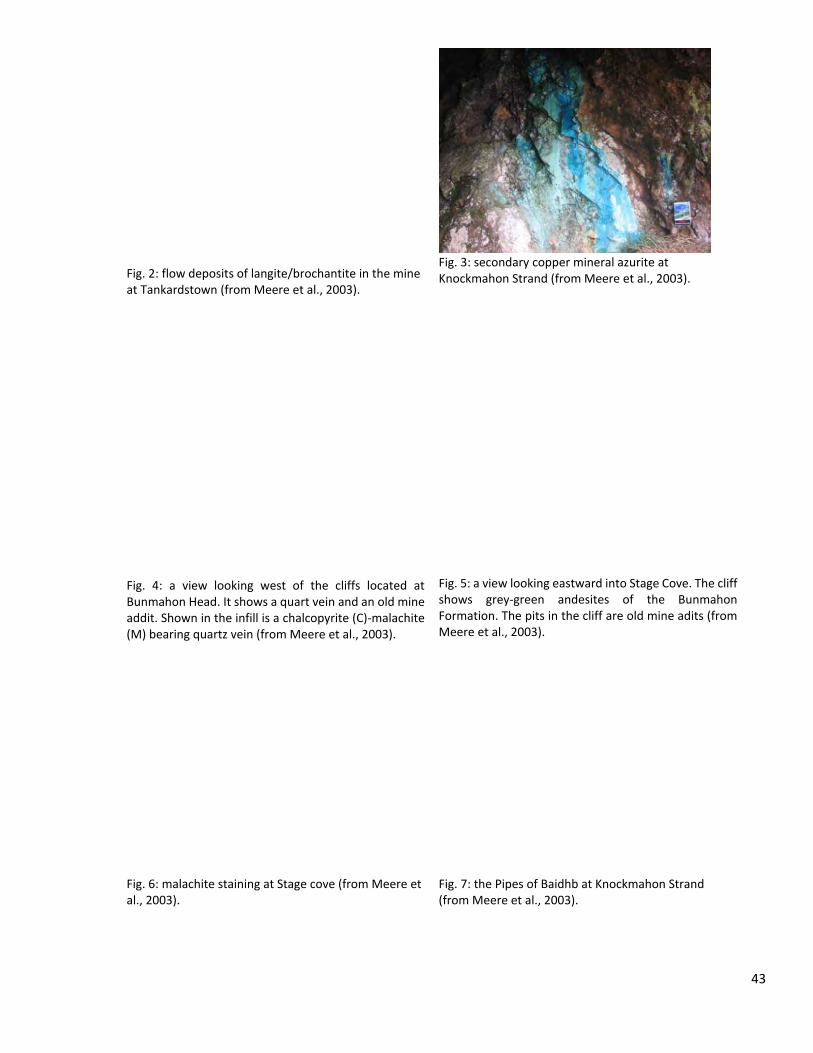
Fig. 2: flow deposits of langite/brochantite in the mine at Tankardstown (from Meere et al., 2003).
Fig. 3: secondary copper mineral azurite at Knockmahon Strand (from Meere et al., 2003).
Fig. 4: a view looking west of the cliffs located at Bunmahon Head. It shows a quart vein and an old mine addit. Shown in the infill is a chalcopyrite (C)-malachite (M) bearing quartz vein (from Meere et al., 2003).
Fig. 5: a view looking eastward into Stage Cove. The cliff shows grey-green andesites of the Bunmahon Formation. The pits in the cliff are old mine adits (from Meere et al., 2003).
Fig. 6: malachite staining at Stage cove (from Meere et al., 2003).
Fig. 7: the Pipes of Baidhb at Knockmahon Strand (from Meere et al., 2003).
43
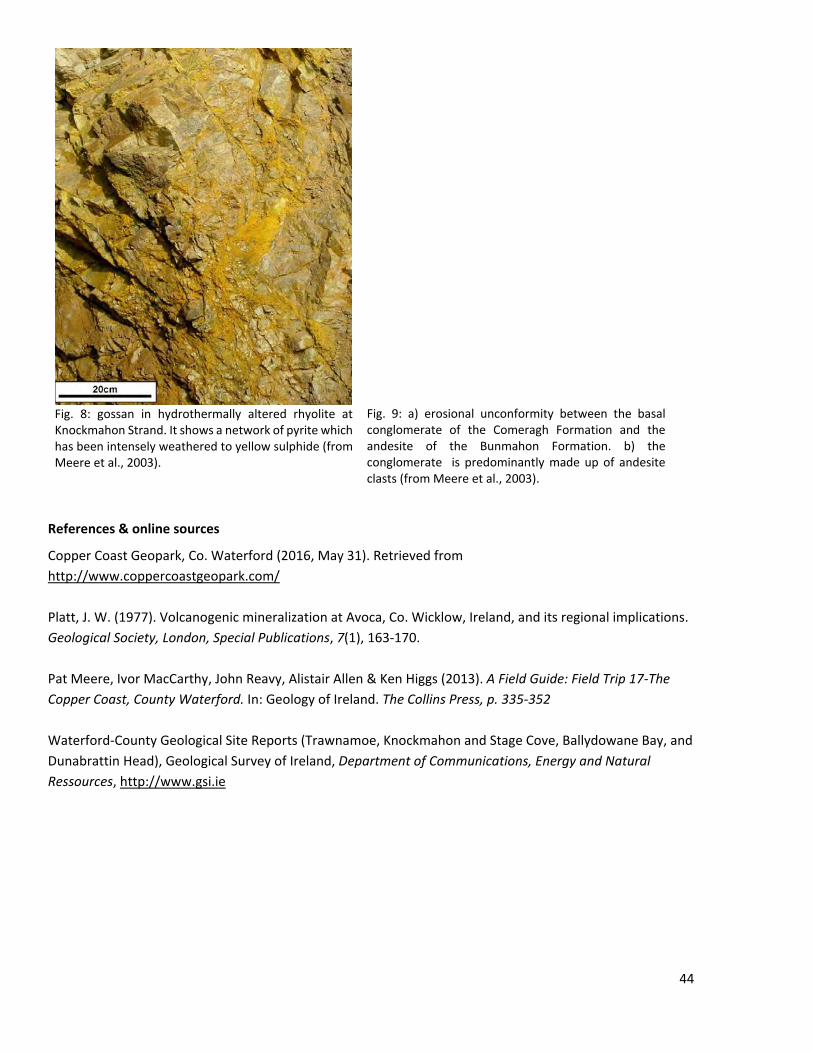
Fig. 8: gossan in hydrothermally altered rhyolite at Knockmahon Strand. It shows a network of pyrite which has been intensely weathered to yellow sulphide (from Meere et al., 2003).
Fig. 9: a) erosional unconformity between the basal conglomerate of the Comeragh Formation and the andesite of the Bunmahon Formation. b) the conglomerate is predominantly made up of andesite clasts (from Meere et al., 2003).
References & online sources
Copper Coast Geopark, Co. Waterford (2016, May 31). Retrieved from http://www.coppercoastgeopark.com/ Platt, J. W. (1977). Volcanogenic mineralization at Avoca, Co. Wicklow, Ireland, and its regional implications. Geological Society, London, Special Publications, 7(1), 163-170. Pat Meere, Ivor MacCarthy, John Reavy, Alistair Allen & Ken Higgs (2013). A Field Guide: Field Trip 17-The Copper Coast, County Waterford. In: Geology of Ireland. The Collins Press, p. 335-352 Waterford-County Geological Site Reports (Trawnamoe, Knockmahon and Stage Cove, Ballydowane Bay, and Dunabrattin Head), Geological Survey of Ireland, Department of Communications, Energy and Natural Ressources, http://www.gsi.ie
44

Pallas Green Jerome Hörler
Date: August 12, 2016 STOP No.: 4 Locality name: Pallas Green Main commodity: Zn-Pb-Ag Geological setting or genetic model: Carbonate hosted, Sedex or MVT Current development status: Pre-feasibility WGS Latitude: 52.5508 WGS Longitude: -8.338536 UTM Northing: 29U 5822508 UTM Easting: 29U 544850 Location & access: Situated between Limerick and Tipperary, access through N24 Geological domain: Midland Orefields, Ireland Geological unit: Lower to middle Carboniferous,
Waulsortian “Reef” mudbank Owner (2014): Glencore
Geology:
The Pallas Green zinc and lead prospect lies in the so called “Midland Orefield”. The Midlands of Ireland are composed of upper Paleozoic rocks. Around half of the country is underlain by Carboniferous lithologies, mostly dominated by sediments. The Waulsortian (Upper Tournaisian to Lower Visean) limestone facies was deposited in the Lower Carboniferous in low paleolatitudes, south of the equator during a time of transgression, forming a 300 m deep basin. These limestones are underlain by a succession of terrigenous, clastic red sandstones of late Devionian age (see Fig. 3). Most of the Zn-Pb deposits are hosted within the Waulsortian Reef in the hanging walls of large, complex normal faults (see Fig. 5). They were formed in response to an extensional tectonic setting in the Tournaisian and early Visean (early Lower Carboniferous), but could also be controlled by pre-existing faults within the lower Paleozoic basement. This extensional setting introduced volcanic activity with basalts and trachytes being deposited just southeast of Limerick (Wilkinson et al. 2014).
Fig 1: Regional geological map with the Pallas Green prospect highlighted with a red dot. The Lishen and Galmoy mines are not active anymore. http://ontherocks.ie/2014/12/04/a-history-of-the-giants-causeway/
45
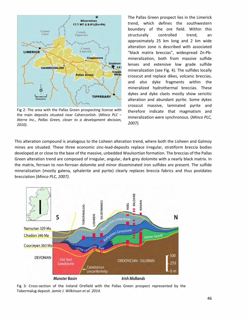
The Pallas Green prospect lies in the Limerick trend, which defines the southwestern boundary of the ore field. Within this structurally controlled trend, an approximately 25 km long and 2 km wide alteration zone is described with associated “black matrix breccias”, widespread Zn-Pb-mineralization, both from massive sulfide lenses and extensive low grade sulfide mineralization (see Fig. 4). The sulfides locally crosscut and replace dikes, volcanic breccias, and also dyke fragments within the mineralized hydrothermal breccias. These dykes and dyke clasts mostly show sericitic alteration and abundant pyrite. Some dykes crosscut massive, laminated pyrite and therefore indicate that magmatism and mineralization were synchronous. (Minco PLC, 2007).
This alteration compound is analogous to the Lisheen alteration trend, where both the Lisheen and Galmoy mines are situated. These three economic zinc-lead-deposits replace irregular, stratiform breccia bodies developed at or close to the base of the massive, unbedded Waulsortian formation. The breccias of the Pallas Green alteration trend are composed of irregular, angular, dark grey dolomite with a nearly black matrix. In the matrix, ferroan to non-ferroan dolomite and minor disseminated iron sulfides are present. The sulfide mineralization (mostly galena, sphalerite and pyrite) clearly replaces breccia fabrics and thus postdates brecciation (Minco PLC, 2007).
Fig 3: Cross-section of the Ireland Orefield with the Pallas Green prospect represented by the Tobermalug deposit. Jamie J. Wilkinson et al. 2014.
Fig 2: The area with the Pallas Green prospecting license with the main deposits situated near Caherconlish. (Minco PLC – Xterra Inc., Pallas Green, closer to a development decision, 2010).
46
Drilling accomplished by Minco Plc. in 2008 was mainly focusing on targets at Tobermalug, Caherconlish South and Srahane West on the western part of the Pallas Green license block (see Fig 2). The Tobermalug deposit comprises a north-south oriented mineralization of massive to semi-massive sulfide mineralization of 3.3 km in length and 350 to 750 m in width (see Fig 5). The massive sulfide bodies are generally strata bound, flat-lying and defined by the basal part of the Waulsortian formation, replacing extensive black matrix brecciation (see Fig. 6). The mineralization zone remains open to the north, south, northeast and northwest. (Minco PLC – Xtierra Inc., 2010). Resource estimates from Minco Plc. in May 2009 report 13.8 Mt averaging 10.14% zinc and 1.88% lead with a cutoff grade of 6% (Zn, Pb combined). The smaller deposits at Caherconlish South and Srahane West both are reported to have around 1 Mt with 9% zinc and 1 % lead. (Minco PLC, 2008). Newer results from Glencore from 2014, estimate the resource at Pallas Green to be 42 Mt at 7% zinc and 1 % lead with a 4% combined cut-off grade (http://www.imqs.ie).
Tectonic movements, centered in the Limerick trend, during the sedimentation of the Waulsortian reef resulted in localized erosion and deep karstification, what led to formation of the black matrix breccias.
A genetic model was proposed by J. Wilkinson & M. Hitzman, 2014, where the Paleozoic basement was thought to be the source for the metals which inhibits a prominent U-reflector (seismic reflection pattern derived from a U-shaped basement structure) in depth around 6km (see Fig. 5 in “Formation of Irish Pb-Zn Ore Deposits: An Overview”). This structure is thought to confine most of the ore fluid flow. The principal drive mechanism for the fluid flow was probably thermohaline convection. The downward flow of cool, dense brines enhanced fluid fluxes and heat advection. In the Southern part of the Midland Orefield igneous intrusions raised the isotherms and provided heat for a hot ore-fluid and a long-lived hydrothermal system to generate the extensive mineralization observed in the Pallas Green alteration trend.
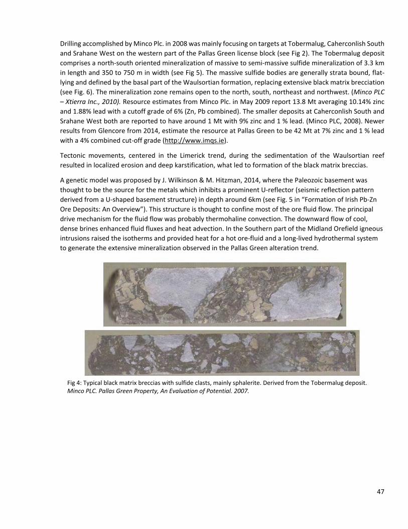
Fig 4: Typical black matrix breccias with sulfide clasts, mainly sphalerite. Derived from the Tobermalug deposit. Minco PLC. Pallas Green Property, An Evaluation of Potential. 2007.
47
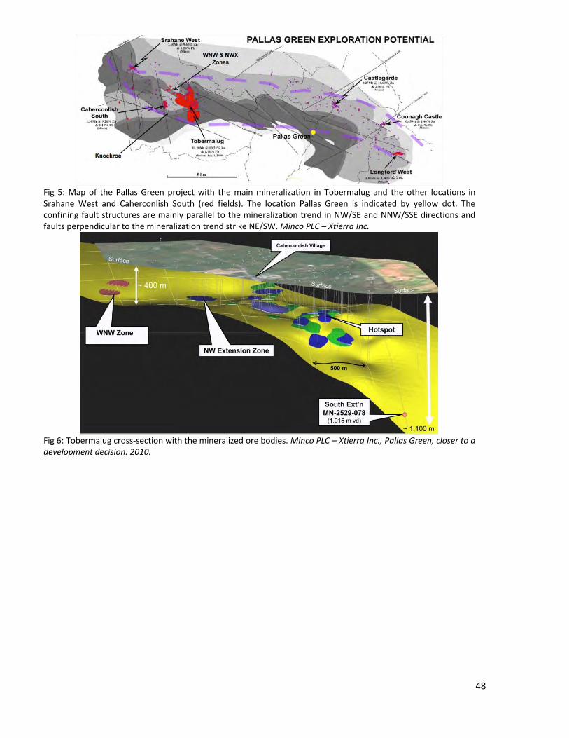
Fig 5: Map of the Pallas Green project with the main mineralization in Tobermalug and the other locations in Srahane West and Caherconlish South (red fields). The location Pallas Green is indicated by yellow dot. The confining fault structures are mainly parallel to the mineralization trend in NW/SE and NNW/SSE directions and faults perpendicular to the mineralization trend strike NE/SW. Minco PLC – Xtierra Inc.
Fig 6: Tobermalug cross-section with the mineralized ore bodies. Minco PLC – Xtierra Inc., Pallas Green, closer to a development decision. 2010.
48
References & online sources: G. Balassone et al.. Ore Geology Reviews 33, 168–186. 2008. Jamie J. Wilkinson et al. The Irish Zn-Pb Ore-field: The View from 2014, Irish Association for Economic Geology. 2014. Xtierra Inc., Pallas Green, closer to a development decision. 2010. Minco PLC Annual Report & Accounts 2008. A new mine in the making at Pallas Green. 2008 Minco PLC. Pallas Green Property, An Evaluation of Potential. 2007. http://ontherocks.ie/2014/12/04/a-history-of-the-giants-causeway/. Last active 28.07.2016. http://www.imqs.ie/NewsEventsViewer/tabid/93/ArticleId/516/Glencore-XSTRATA-Pallas-Green-Results-Inferred-Resources-of-42-Mt-at-8-combined-Zinc-Lead.aspx. Last active 28.07.2016.
49
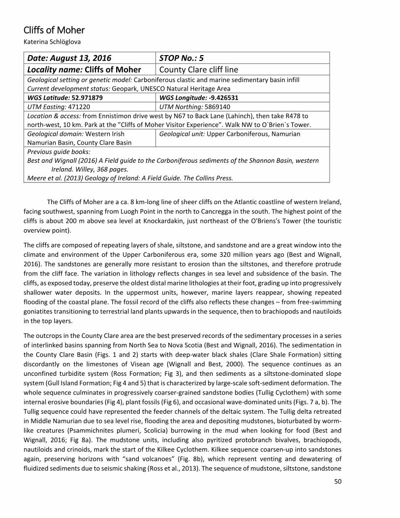
Cliffs of Moher Katerina Schlöglova
Date: August 13, 2016 STOP No.: 5 Locality name: Cliffs of Moher County Clare cliff line Geological setting or genetic model: Carboniferous clastic and marine sedimentary basin infill Current development status: Geopark, UNESCO Natural Heritage Area WGS Latitude: 52.971879 WGS Longitude: -9.426531 UTM Easting: 471220 UTM Northing: 5869140 Location & access: from Ennistimon drive west by N67 to Back Lane (Lahinch), then take R478 to north-west, 10 km. Park at the ”Cliffs of Moher Visitor Experience”. Walk NW to O`Brien`s Tower. Geological domain: Western Irish Namurian Basin, County Clare Basin
Geological unit: Upper Carboniferous, Namurian
Previous guide books: Best and Wignall (2016) A Field guide to the Carboniferous sediments of the Shannon Basin, western
Ireland. Willey, 368 pages. Meere et al. (2013) Geology of Ireland: A Field Guide. The Collins Press.
The Cliffs of Moher are a ca. 8 km-long line of sheer cliffs on the Atlantic coastline of western Ireland, facing southwest, spanning from Luogh Point in the north to Cancregga in the south. The highest point of the cliffs is about 200 m above sea level at Knockardakin, just northeast of the O'Briens's Tower (the touristic overview point).
The cliffs are composed of repeating layers of shale, siltstone, and sandstone and are a great window into the climate and environment of the Upper Carboniferous era, some 320 million years ago (Best and Wignall, 2016). The sandstones are generally more resistant to erosion than the siltstones, and therefore protrude from the cliff face. The variation in lithology reflects changes in sea level and subsidence of the basin. The cliffs, as exposed today, preserve the oldest distal marine lithologies at their foot, grading up into progressively shallower water deposits. In the uppermost units, however, marine layers reappear, showing repeated flooding of the coastal plane. The fossil record of the cliffs also reflects these changes – from free-swimming goniatites transitioning to terrestrial land plants upwards in the sequence, then to brachiopods and nautiloids in the top layers.
The outcrops in the County Clare area are the best preserved records of the sedimentary processes in a series of interlinked basins spanning from North Sea to Nova Scotia (Best and Wignall, 2016). The sedimentation in the County Clare Basin (Figs. 1 and 2) starts with deep-water black shales (Clare Shale Formation) sitting discordantly on the limestones of Visean age (Wignall and Best, 2000). The sequence continues as an unconfined turbidite system (Ross Formation; Fig 3), and then sediments as a siltstone-dominated slope system (Gull Island Formation; Fig 4 and 5) that is characterized by large-scale soft-sediment deformation. The whole sequence culminates in progressively coarser-grained sandstone bodies (Tullig Cyclothem) with some internal erosive boundaries (Fig 4), plant fossils (Fig 6), and occasional wave-dominated units (Figs. 7 a, b). The Tullig sequence could have represented the feeder channels of the deltaic system. The Tullig delta retreated in Middle Namurian due to sea level rise, flooding the area and depositing mudstones, bioturbated by worm-like creatures (Psammichnites plumeri, Scolicia) burrowing in the mud when looking for food (Best and Wignall, 2016; Fig 8a). The mudstone units, including also pyritized protobranch bivalves, brachiopods, nautiloids and crinoids, mark the start of the Kilkee Cyclothem. Kilkee sequence coarsen-up into sandstones again, preserving horizons with “sand volcanoes” (Fig. 8b), which represent venting and dewatering of fluidized sediments due to seismic shaking (Ross et al., 2013). The sequence of mudstone, siltstone, sandstone
50
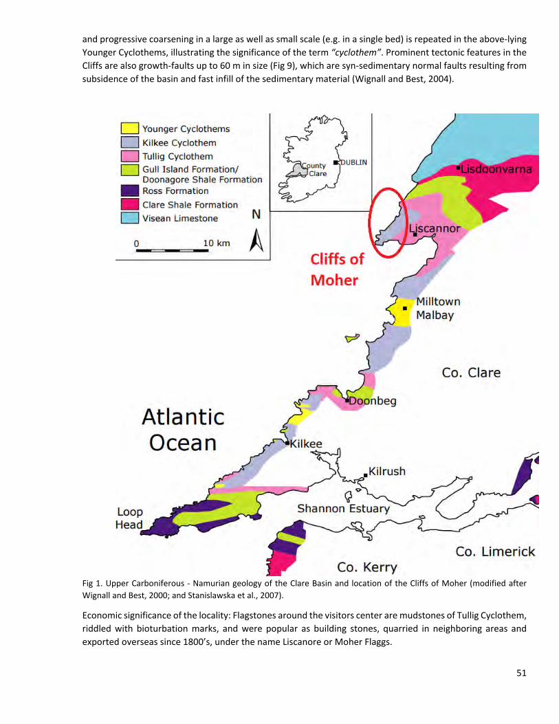
and progressive coarsening in a large as well as small scale (e.g. in a single bed) is repeated in the above-lying Younger Cyclothems, illustrating the significance of the term “cyclothem”. Prominent tectonic features in the Cliffs are also growth-faults up to 60 m in size (Fig 9), which are syn-sedimentary normal faults resulting from subsidence of the basin and fast infill of the sedimentary material (Wignall and Best, 2004).
Fig 1. Upper Carboniferous - Namurian geology of the Clare Basin and location of the Cliffs of Moher (modified after Wignall and Best, 2000; and Stanislawska et al., 2007).
Economic significance of the locality: Flagstones around the visitors center are mudstones of Tullig Cyclothem, riddled with bioturbation marks, and were popular as building stones, quarried in neighboring areas and exported overseas since 1800’s, under the name Liscanore or Moher Flaggs.
51
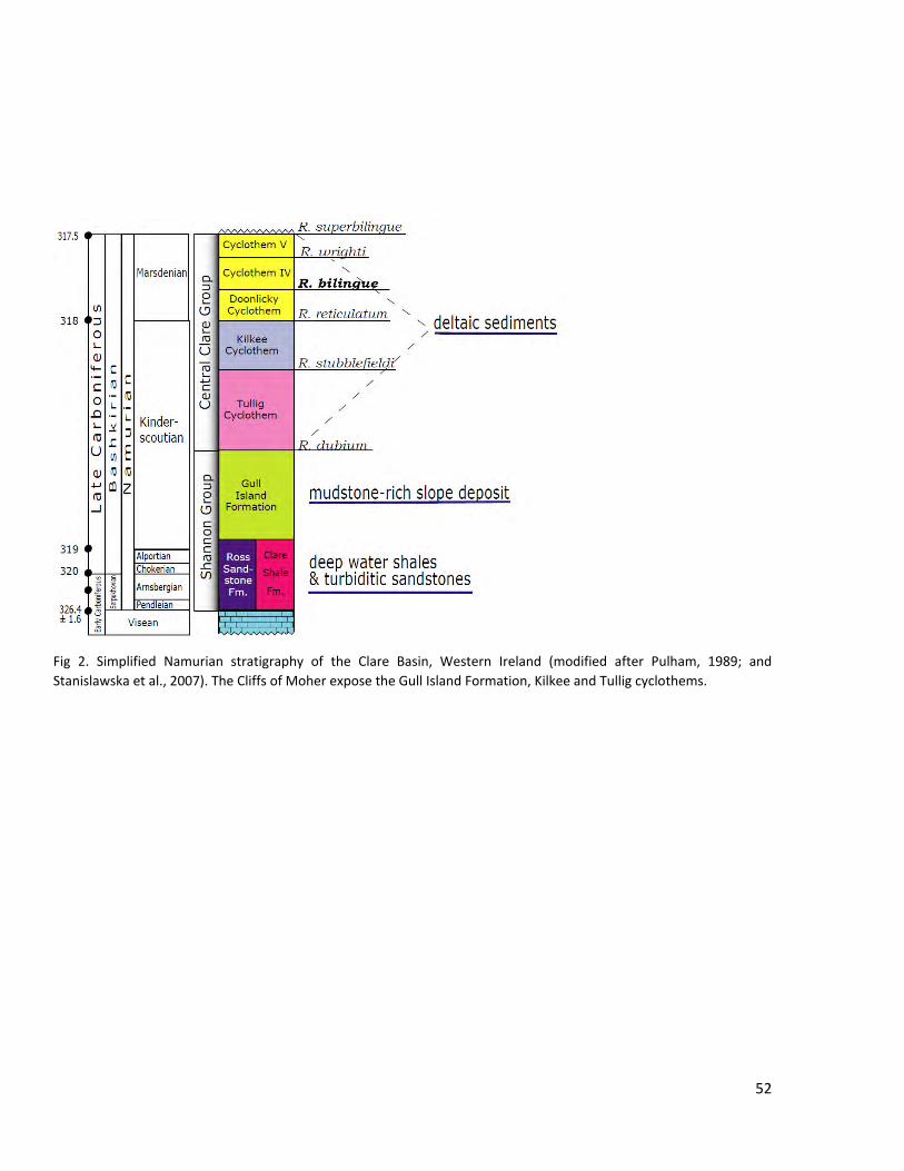
Fig 2. Simplified Namurian stratigraphy of the Clare Basin, Western Ireland (modified after Pulham, 1989; and Stanislawska et al., 2007). The Cliffs of Moher expose the Gull Island Formation, Kilkee and Tullig cyclothems.
52
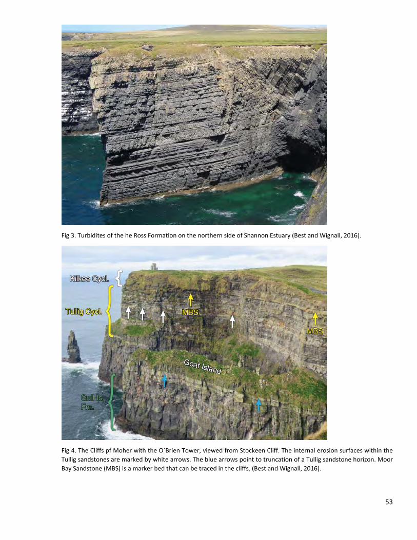
Fig 3. Turbidites of the he Ross Formation on the northern side of Shannon Estuary (Best and Wignall, 2016).
Fig 4. The Cliffs pf Moher with the O`Brien Tower, viewed from Stockeen Cliff. The internal erosion surfaces within the Tullig sandstones are marked by white arrows. The blue arrows point to truncation of a Tullig sandstone horizon. Moor Bay Sandstone (MBS) is a marker bed that can be traced in the cliffs. (Best and Wignall, 2016).
53
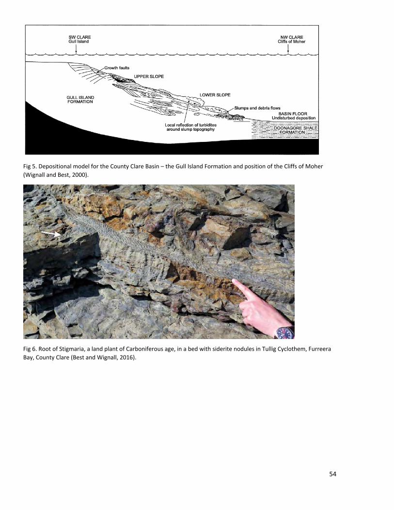
Fig 5. Depositional model for the County Clare Basin – the Gull Island Formation and position of the Cliffs of Moher (Wignall and Best, 2000).
Fig 6. Root of Stigmaria, a land plant of Carboniferous age, in a bed with siderite nodules in Tullig Cyclothem, Furreera Bay, County Clare (Best and Wignall, 2016).
54
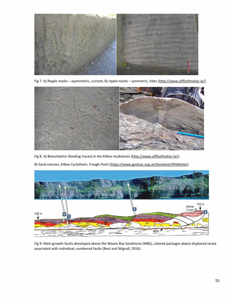
Fig 7. A) Ripple marks – asymmetric, current; B) ripple marks – symmetric, tides (http://www.cliffsofmoher.ie/).
Fig 8. A) Bioturbation (feeding traces) in the Kilkee mudstones (http://www.cliffsofmoher.ie/);
B) Sand volcano, Kilkee Cyclothem, Freagh Point (https://www.geolsoc.org.uk/GeositesCliffsMoher).
Fig 9. Main growth-faults developed above the Moore Bay Sandstone (MBS), colored packages depict displaced strata associated with individual, numbered faults (Best and Wignall, 2016).
55
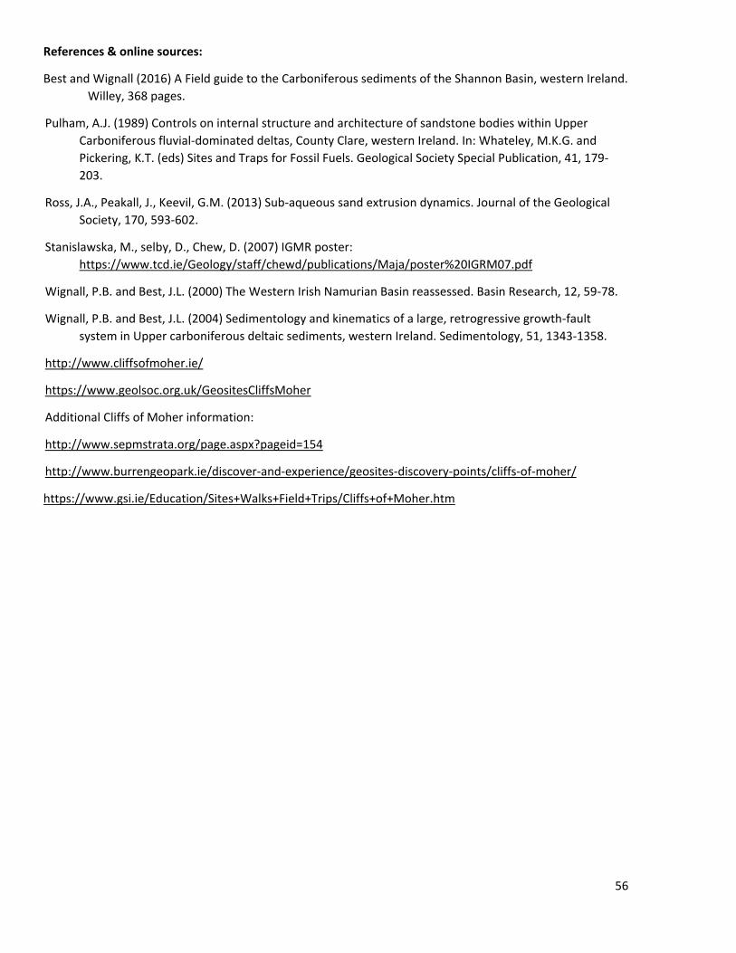
References & online sources:
Best and Wignall (2016) A Field guide to the Carboniferous sediments of the Shannon Basin, western Ireland. Willey, 368 pages.
Pulham, A.J. (1989) Controls on internal structure and architecture of sandstone bodies within Upper Carboniferous fluvial-dominated deltas, County Clare, western Ireland. In: Whateley, M.K.G. and Pickering, K.T. (eds) Sites and Traps for Fossil Fuels. Geological Society Special Publication, 41, 179-203.
Ross, J.A., Peakall, J., Keevil, G.M. (2013) Sub-aqueous sand extrusion dynamics. Journal of the Geological Society, 170, 593-602.
Stanislawska, M., selby, D., Chew, D. (2007) IGMR poster: https://www.tcd.ie/Geology/staff/chewd/publications/Maja/poster%20IGRM07.pdf
Wignall, P.B. and Best, J.L. (2000) The Western Irish Namurian Basin reassessed. Basin Research, 12, 59-78.
Wignall, P.B. and Best, J.L. (2004) Sedimentology and kinematics of a large, retrogressive growth-fault system in Upper carboniferous deltaic sediments, western Ireland. Sedimentology, 51, 1343-1358.
http://www.cliffsofmoher.ie/
https://www.geolsoc.org.uk/GeositesCliffsMoher
Additional Cliffs of Moher information:
http://www.sepmstrata.org/page.aspx?pageid=154
http://www.burrengeopark.ie/discover-and-experience/geosites-discovery-points/cliffs-of-moher/
https://www.gsi.ie/Education/Sites+Walks+Field+Trips/Cliffs+of+Moher.htm
56
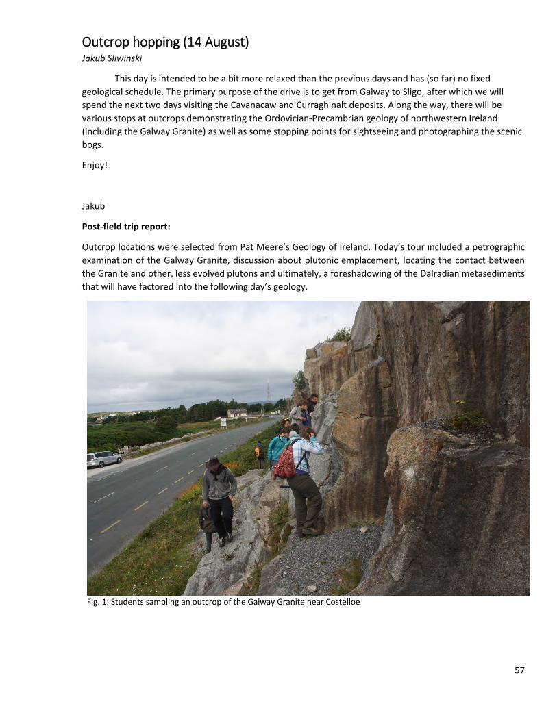
Outcrop hopping (14 August) Jakub Sliwinski
This day is intended to be a bit more relaxed than the previous days and has (so far) no fixed geological schedule. The primary purpose of the drive is to get from Galway to Sligo, after which we will spend the next two days visiting the Cavanacaw and Curraghinalt deposits. Along the way, there will be various stops at outcrops demonstrating the Ordovician-Precambrian geology of northwestern Ireland (including the Galway Granite) as well as some stopping points for sightseeing and photographing the scenic bogs.
Enjoy!
Jakub
Post-field trip report:
Outcrop locations were selected from Pat Meere’s Geology of Ireland. Today’s tour included a petrographic examination of the Galway Granite, discussion about plutonic emplacement, locating the contact between the Granite and other, less evolved plutons and ultimately, a foreshadowing of the Dalradian metasediments that will have factored into the following day’s geology.
Fig. 1: Students sampling an outcrop of the Galway Granite near Costelloe
57
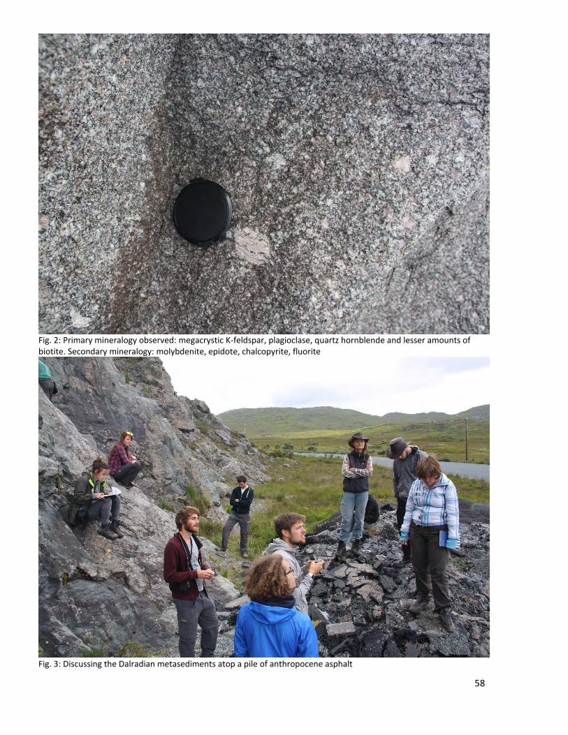
Fig. 2: Primary mineralogy observed: megacrystic K-feldspar, plagioclase, quartz hornblende and lesser amounts of biotite. Secondary mineralogy: molybdenite, epidote, chalcopyrite, fluorite
Fig. 3: Discussing the Dalradian metasediments atop a pile of anthropocene asphalt
58
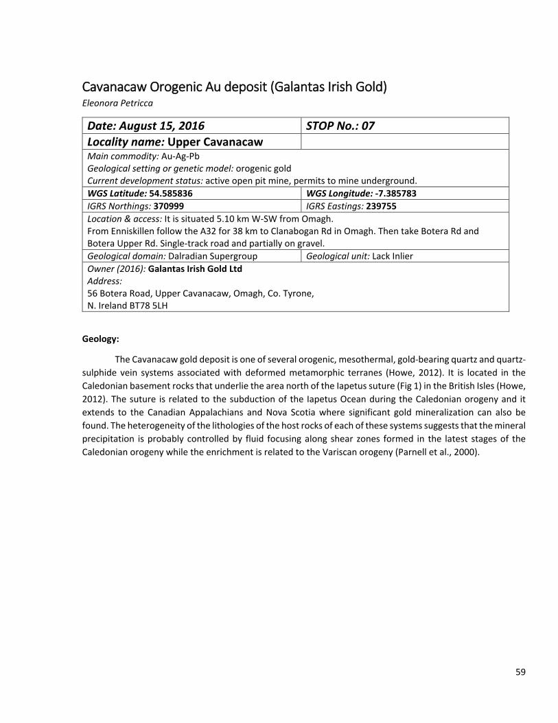
Cavanacaw Orogenic Au deposit (Galantas Irish Gold) Eleonora Petricca
Date: August 15, 2016 STOP No.: 07 Locality name: Upper Cavanacaw Main commodity: Au-Ag-Pb Geological setting or genetic model: orogenic gold Current development status: active open pit mine, permits to mine underground. WGS Latitude: 54.585836 WGS Longitude: -7.385783 IGRS Northings: 370999 IGRS Eastings: 239755 Location & access: It is situated 5.10 km W-SW from Omagh. From Enniskillen follow the A32 for 38 km to Clanabogan Rd in Omagh. Then take Botera Rd and Botera Upper Rd. Single-track road and partially on gravel. Geological domain: Dalradian Supergroup Geological unit: Lack Inlier Owner (2016): Galantas Irish Gold Ltd Address: 56 Botera Road, Upper Cavanacaw, Omagh, Co. Tyrone, N. Ireland BT78 5LH
Geology:
The Cavanacaw gold deposit is one of several orogenic, mesothermal, gold-bearing quartz and quartz-sulphide vein systems associated with deformed metamorphic terranes (Howe, 2012). It is located in the Caledonian basement rocks that underlie the area north of the Iapetus suture (Fig 1) in the British Isles (Howe, 2012). The suture is related to the subduction of the Iapetus Ocean during the Caledonian orogeny and it extends to the Canadian Appalachians and Nova Scotia where significant gold mineralization can also be found. The heterogeneity of the lithologies of the host rocks of each of these systems suggests that the mineral precipitation is probably controlled by fluid focusing along shear zones formed in the latest stages of the Caledonian orogeny while the enrichment is related to the Variscan orogeny (Parnell et al., 2000).
59
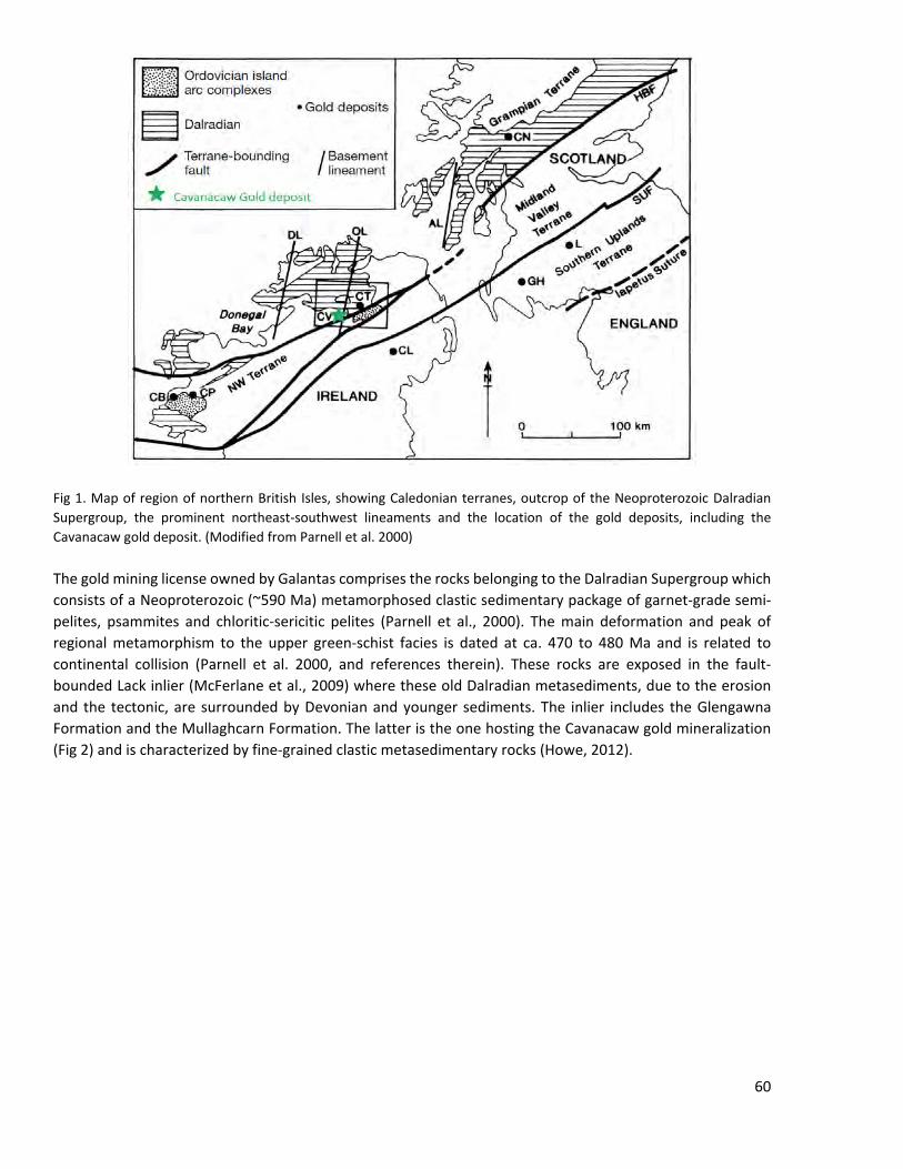
Fig 1. Map of region of northern British Isles, showing Caledonian terranes, outcrop of the Neoproterozoic Dalradian Supergroup, the prominent northeast-southwest lineaments and the location of the gold deposits, including the Cavanacaw gold deposit. (Modified from Parnell et al. 2000)
The gold mining license owned by Galantas comprises the rocks belonging to the Dalradian Supergroup which consists of a Neoproterozoic (~590 Ma) metamorphosed clastic sedimentary package of garnet-grade semi-pelites, psammites and chloritic-sericitic pelites (Parnell et al., 2000). The main deformation and peak of regional metamorphism to the upper green-schist facies is dated at ca. 470 to 480 Ma and is related to continental collision (Parnell et al. 2000, and references therein). These rocks are exposed in the fault-bounded Lack inlier (McFerlane et al., 2009) where these old Dalradian metasediments, due to the erosion and the tectonic, are surrounded by Devonian and younger sediments. The inlier includes the Glengawna Formation and the Mullaghcarn Formation. The latter is the one hosting the Cavanacaw gold mineralization (Fig 2) and is characterized by fine-grained clastic metasedimentary rocks (Howe, 2012).
60
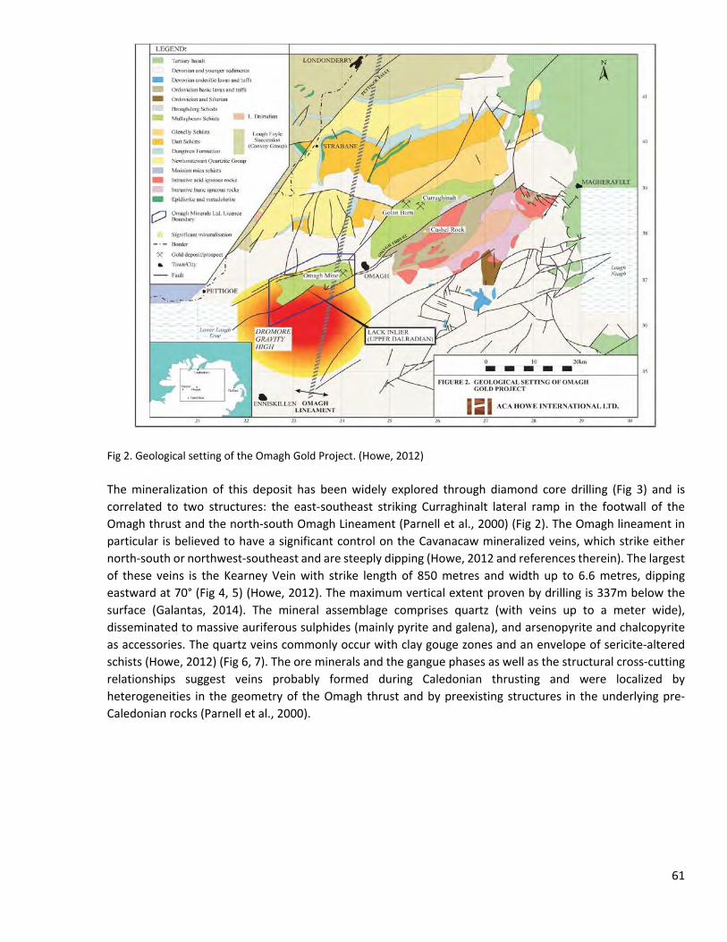
Fig 2. Geological setting of the Omagh Gold Project. (Howe, 2012)
The mineralization of this deposit has been widely explored through diamond core drilling (Fig 3) and is correlated to two structures: the east-southeast striking Curraghinalt lateral ramp in the footwall of the Omagh thrust and the north-south Omagh Lineament (Parnell et al., 2000) (Fig 2). The Omagh lineament in particular is believed to have a significant control on the Cavanacaw mineralized veins, which strike either north-south or northwest-southeast and are steeply dipping (Howe, 2012 and references therein). The largest of these veins is the Kearney Vein with strike length of 850 metres and width up to 6.6 metres, dipping eastward at 70° (Fig 4, 5) (Howe, 2012). The maximum vertical extent proven by drilling is 337m below the surface (Galantas, 2014). The mineral assemblage comprises quartz (with veins up to a meter wide), disseminated to massive auriferous sulphides (mainly pyrite and galena), and arsenopyrite and chalcopyrite as accessories. The quartz veins commonly occur with clay gouge zones and an envelope of sericite-altered schists (Howe, 2012) (Fig 6, 7). The ore minerals and the gangue phases as well as the structural cross-cutting relationships suggest veins probably formed during Caledonian thrusting and were localized by heterogeneities in the geometry of the Omagh thrust and by preexisting structures in the underlying pre-Caledonian rocks (Parnell et al., 2000).
61
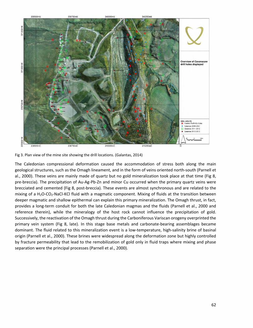
Fig 3. Plan view of the mine site showing the drill locations. (Galantas, 2014)
The Caledonian compressional deformation caused the accommodation of stress both along the main geological structures, such as the Omagh lineament, and in the form of veins oriented north-south (Parnell et al., 2000). These veins are mainly made of quartz but no gold mineralization took place at that time (Fig 8, pre-breccia). The precipitation of Au-Ag-Pb-Zn and minor Cu occurred when the primary quartz veins were brecciated and cemented (Fig 8, post-breccia). These events are almost synchronous and are related to the mixing of a H2O-CO2-NaCl-KCl fluid with a magmatic component. Mixing of fluids at the transition between deeper magmatic and shallow epithermal can explain this primary mineralization. The Omagh thrust, in fact, provides a long-term conduit for both the late Caledonian magmas and the fluids (Parnell et al., 2000 and reference therein), while the mineralogy of the host rock cannot influence the precipitation of gold. Successively, the reactivation of the Omagh thrust during the Carboniferous Variscan orogeny overprinted the primary vein system (Fig 8, late). In this stage base metals and carbonate-bearing assemblages became dominant. The fluid related to this mineralization event is a low-temperature, high-salinity brine of basinal origin (Parnell et al., 2000). These brines were widespread along the deformation zone but highly controlled by fracture permeability that lead to the remobilization of gold only in fluid traps where mixing and phase separation were the principal processes (Parnell et al., 2000).
62
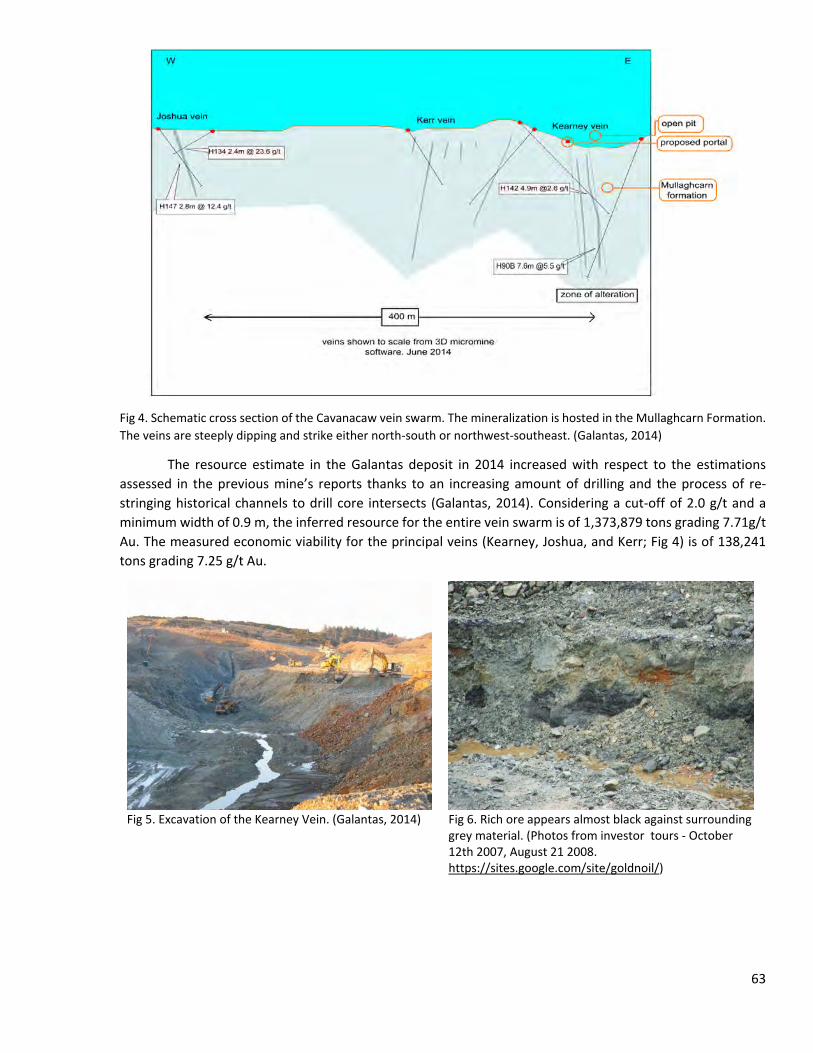
Fig 4. Schematic cross section of the Cavanacaw vein swarm. The mineralization is hosted in the Mullaghcarn Formation. The veins are steeply dipping and strike either north-south or northwest-southeast. (Galantas, 2014)
The resource estimate in the Galantas deposit in 2014 increased with respect to the estimations assessed in the previous mine’s reports thanks to an increasing amount of drilling and the process of re-stringing historical channels to drill core intersects (Galantas, 2014). Considering a cut-off of 2.0 g/t and a minimum width of 0.9 m, the inferred resource for the entire vein swarm is of 1,373,879 tons grading 7.71g/t Au. The measured economic viability for the principal veins (Kearney, Joshua, and Kerr; Fig 4) is of 138,241 tons grading 7.25 g/t Au.
Fig 5. Excavation of the Kearney Vein. (Galantas, 2014)
Fig 6. Rich ore appears almost black against surrounding grey material. (Photos from investor tours - October 12th 2007, August 21 2008. https://sites.google.com/site/goldnoil/)
63
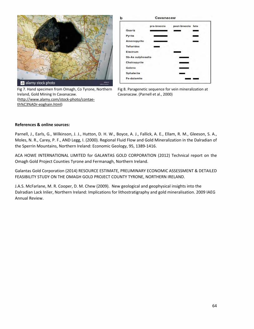
Fig 7. Hand specimen from Omagh, Co Tyrone, Northern Ireland, Gold Mining In Cavanacaw. (http://www.alamy.com/stock-photo/contae-th%C3%ADr-eoghain.html)
Fig 8. Paragenetic sequence for vein mineralization at Cavanacaw. (Parnell et al., 2000)
References & online sources:
Parnell, J., Earls, G., Wilkinson, J. J., Hutton, D. H. W., Boyce, A. J., Fallick, A. E., Ellam, R. M., Gleeson, S. A., Moles, N. R., Carey, P. F., AND Legg, I. (2000). Regional Fluid Flow and Gold Mineralization in the Dalradian of the Sperrin Mountains, Northern Ireland: Economic Geology, 95, 1389-1416.
ACA HOWE INTERNATIONAL LIMITED for GALANTAS GOLD CORPORATION (2012) Technical report on the Omagh Gold Project Counties Tyrone and Fermanagh, Northern Ireland.
Galantas Gold Corporation (2014) RESOURCE ESTIMATE, PRELIMINARY ECONOMIC ASSESSMENT & DETAILED FEASIBILITY STUDY ON THE OMAGH GOLD PROJECT COUNTY TYRONE, NORTHERN IRELAND.
J.A.S. McFarlane, M. R. Cooper, D. M. Chew (2009). New geological and geophysical insights into the Dalradian Lack Inlier, Northern Ireland: Implications for lithostratigraphy and gold mineralisation. 2009 IAEG Annual Review.
64
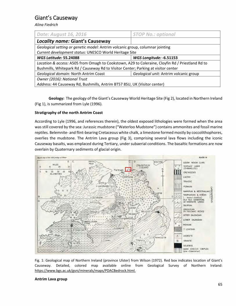
Giant’s Causeway Alina Fiedrich
Date: August 16, 2016 STOP No.: optional Locality name: Giant’s Causeway Geological setting or genetic model: Antrim volcanic group, columnar jointing Current development status: UNESCO World Heritage Site WGS Latitude: 55.24088 WGS Longitude: -6.51153 Location & access: A505 from Omagh to Cookstown, A29 to Coleraine, Cloyfin Rd / Priestland Rd to Bushmills, Whitepark Rd / Causeway Rd to Visitor Center; Parking at visitor center Geological domain: North Antrim Coast Geological unit: Antrim volcanic group Owner (2016): National Trust Address: 44 Causeway Rd, Bushmills, Antrim BT57 8SU, UK (Visitor center)
Geology: The geology of the Giant’s Causeway World Heritage Site (Fig 2), located in Northern Ireland (Fig 1), is summarized from Lyle (1996).
Stratigraphy of the north Antrim Coast
According to Lyle (1996, and references therein), the oldest exposed lithologies were formed when the area was still covered by the sea: Jurassic mudstone (“Waterloo Mudstone”) contains ammonites and fossil marine reptiles. Belemnite- and flint-bearing Cretaceous white chalk, a limestone formed mostly by coccolithophores, overlies the mudstone. The Antrim Lava group (Fig 3), comprising several lava flows including the iconic Causeway basalts, was emplaced during Tertiary, under subaerial conditions. The basaltic formations are now overlain by Quaternary sediments of glacial origin.
Fig. 1: Geological map of Northern Ireland (province Ulster) from Wilson (1972). Red box indicates location of Giant’s Causeway. Detailed, colored map available online from Geological Survey of Northern Ireland: https://www.bgs.ac.uk/gsni/minerals/maps/PDACBedrock.html.
Antrim Lava group 65
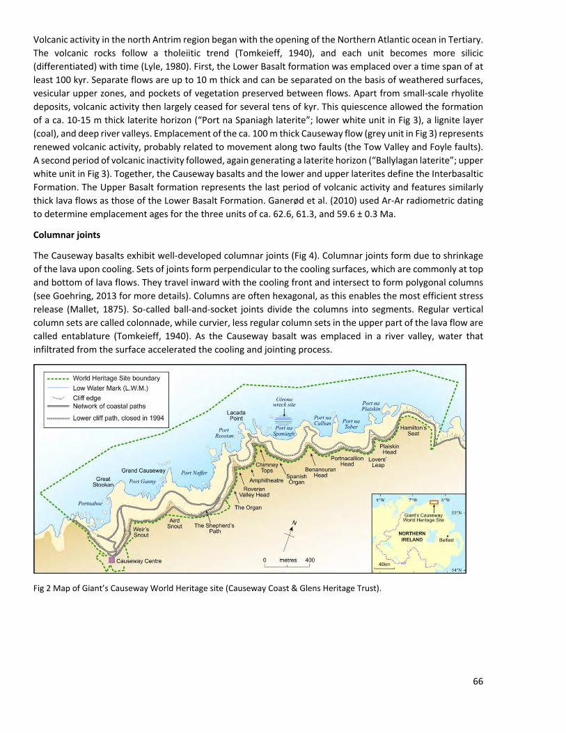
Volcanic activity in the north Antrim region began with the opening of the Northern Atlantic ocean in Tertiary. The volcanic rocks follow a tholeiitic trend (Tomkeieff, 1940), and each unit becomes more silicic (differentiated) with time (Lyle, 1980). First, the Lower Basalt formation was emplaced over a time span of at least 100 kyr. Separate flows are up to 10 m thick and can be separated on the basis of weathered surfaces, vesicular upper zones, and pockets of vegetation preserved between flows. Apart from small-scale rhyolite deposits, volcanic activity then largely ceased for several tens of kyr. This quiescence allowed the formation of a ca. 10-15 m thick laterite horizon (“Port na Spaniagh laterite”; lower white unit in Fig 3), a lignite layer (coal), and deep river valleys. Emplacement of the ca. 100 m thick Causeway flow (grey unit in Fig 3) represents renewed volcanic activity, probably related to movement along two faults (the Tow Valley and Foyle faults). A second period of volcanic inactivity followed, again generating a laterite horizon (“Ballylagan laterite”; upper white unit in Fig 3). Together, the Causeway basalts and the lower and upper laterites define the Interbasaltic Formation. The Upper Basalt formation represents the last period of volcanic activity and features similarly thick lava flows as those of the Lower Basalt Formation. Ganerød et al. (2010) used Ar-Ar radiometric dating to determine emplacement ages for the three units of ca. 62.6, 61.3, and 59.6 ± 0.3 Ma.
Columnar joints
The Causeway basalts exhibit well-developed columnar joints (Fig 4). Columnar joints form due to shrinkage of the lava upon cooling. Sets of joints form perpendicular to the cooling surfaces, which are commonly at top and bottom of lava flows. They travel inward with the cooling front and intersect to form polygonal columns (see Goehring, 2013 for more details). Columns are often hexagonal, as this enables the most efficient stress release (Mallet, 1875). So-called ball-and-socket joints divide the columns into segments. Regular vertical column sets are called colonnade, while curvier, less regular column sets in the upper part of the lava flow are called entablature (Tomkeieff, 1940). As the Causeway basalt was emplaced in a river valley, water that infiltrated from the surface accelerated the cooling and jointing process.
Fig 2 Map of Giant’s Causeway World Heritage site (Causeway Coast & Glens Heritage Trust).
66
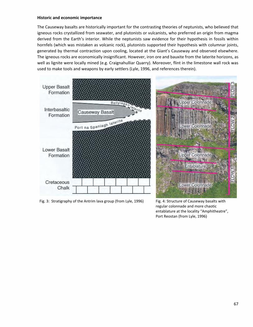
Historic and economic importance
The Causeway basalts are historically important for the contrasting theories of neptunists, who believed that igneous rocks crystallized from seawater, and plutonists or vulcanists, who preferred an origin from magma derived from the Earth’s interior. While the neptunists saw evidence for their hypothesis in fossils within hornfels (which was mistaken as volcanic rock), plutonists supported their hypothesis with columnar joints, generated by thermal contraction upon cooling, located at the Giant’s Causeway and observed elsewhere. The igneous rocks are economically insignificant. However, iron ore and bauxite from the laterite horizons, as well as lignite were locally mined (e.g. Craignahulliar Quarry). Moreover, flint in the limestone wall rock was used to make tools and weapons by early settlers (Lyle, 1996, and references therein).
Fig. 3: Stratigraphy of the Antrim lava group (from Lyle, 1996) Fig. 4: Structure of Causeway basalts with
regular colonnade and more chaotic entablature at the locality “Amphitheatre”, Port Reostan (from Lyle, 1996)
67
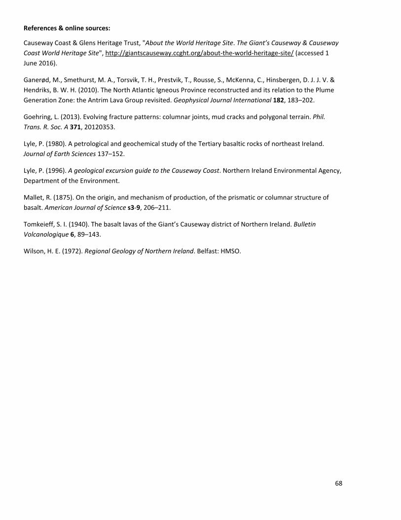
References & online sources:
Causeway Coast & Glens Heritage Trust, "About the World Heritage Site. The Giant’s Causeway & Causeway Coast World Heritage Site", http://giantscauseway.ccght.org/about-the-world-heritage-site/ (accessed 1 June 2016).
Ganerød, M., Smethurst, M. A., Torsvik, T. H., Prestvik, T., Rousse, S., McKenna, C., Hinsbergen, D. J. J. V. & Hendriks, B. W. H. (2010). The North Atlantic Igneous Province reconstructed and its relation to the Plume Generation Zone: the Antrim Lava Group revisited. Geophysical Journal International 182, 183–202.
Goehring, L. (2013). Evolving fracture patterns: columnar joints, mud cracks and polygonal terrain. Phil. Trans. R. Soc. A 371, 20120353.
Lyle, P. (1980). A petrological and geochemical study of the Tertiary basaltic rocks of northeast Ireland. Journal of Earth Sciences 137–152.
Lyle, P. (1996). A geological excursion guide to the Causeway Coast. Northern Ireland Environmental Agency, Department of the Environment.
Mallet, R. (1875). On the origin, and mechanism of production, of the prismatic or columnar structure of basalt. American Journal of Science s3-9, 206–211.
Tomkeieff, S. I. (1940). The basalt lavas of the Giant’s Causeway district of Northern Ireland. Bulletin Volcanologique 6, 89–143.
Wilson, H. E. (1972). Regional Geology of Northern Ireland. Belfast: HMSO.
68
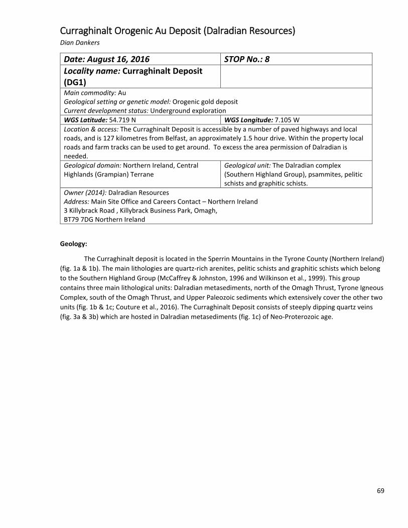
Curraghinalt Orogenic Au Deposit (Dalradian Resources) Dian Dankers
Date: August 16, 2016 STOP No.: 8 Locality name: Curraghinalt Deposit (DG1)
Main commodity: Au Geological setting or genetic model: Orogenic gold deposit Current development status: Underground exploration WGS Latitude: 54.719 N WGS Longitude: 7.105 W Location & access: The Curraghinalt Deposit is accessible by a number of paved highways and local roads, and is 127 kilometres from Belfast, an approximately 1.5 hour drive. Within the property local roads and farm tracks can be used to get around. To excess the area permission of Dalradian is needed. Geological domain: Northern Ireland, Central Highlands (Grampian) Terrane
Geological unit: The Dalradian complex (Southern Highland Group), psammites, pelitic schists and graphitic schists.
Owner (2014): Dalradian Resources Address: Main Site Office and Careers Contact – Northern Ireland 3 Killybrack Road , Killybrack Business Park, Omagh, BT79 7DG Northern Ireland
Geology:
The Curraghinalt deposit is located in the Sperrin Mountains in the Tyrone County (Northern Ireland) (fig. 1a & 1b). The main lithologies are quartz-rich arenites, pelitic schists and graphitic schists which belong to the Southern Highland Group (McCaffrey & Johnston, 1996 and Wilkinson et al., 1999). This group contains three main lithological units: Dalradian metasediments, north of the Omagh Thrust, Tyrone Igneous Complex, south of the Omagh Thrust, and Upper Paleozoic sediments which extensively cover the other two units (fig. 1b & 1c; Couture et al., 2016). The Curraghinalt Deposit consists of steeply dipping quartz veins (fig. 3a & 3b) which are hosted in Dalradian metasediments (fig. 1c) of Neo-Proterozoic age.
69
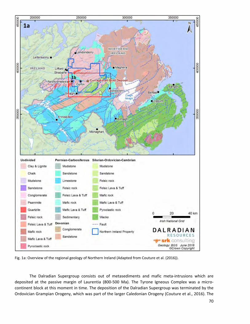
Fig. 1a: Overview of the regional geology of Northern Ireland (Adapted from Couture et al. (2016)).
The Dalradian Supergroup consists out of metasediments and mafic meta-intrusions which are deposited at the passive margin of Laurentia (800-500 Ma). The Tyrone Igneous Complex was a micro-continent block at this moment in time. The deposition of the Dalradian Supergroup was terminated by the Ordovician Grampian Orogeny, which was part of the larger Caledonian Orogeny (Couture et al., 2016). The
1a
1b
70
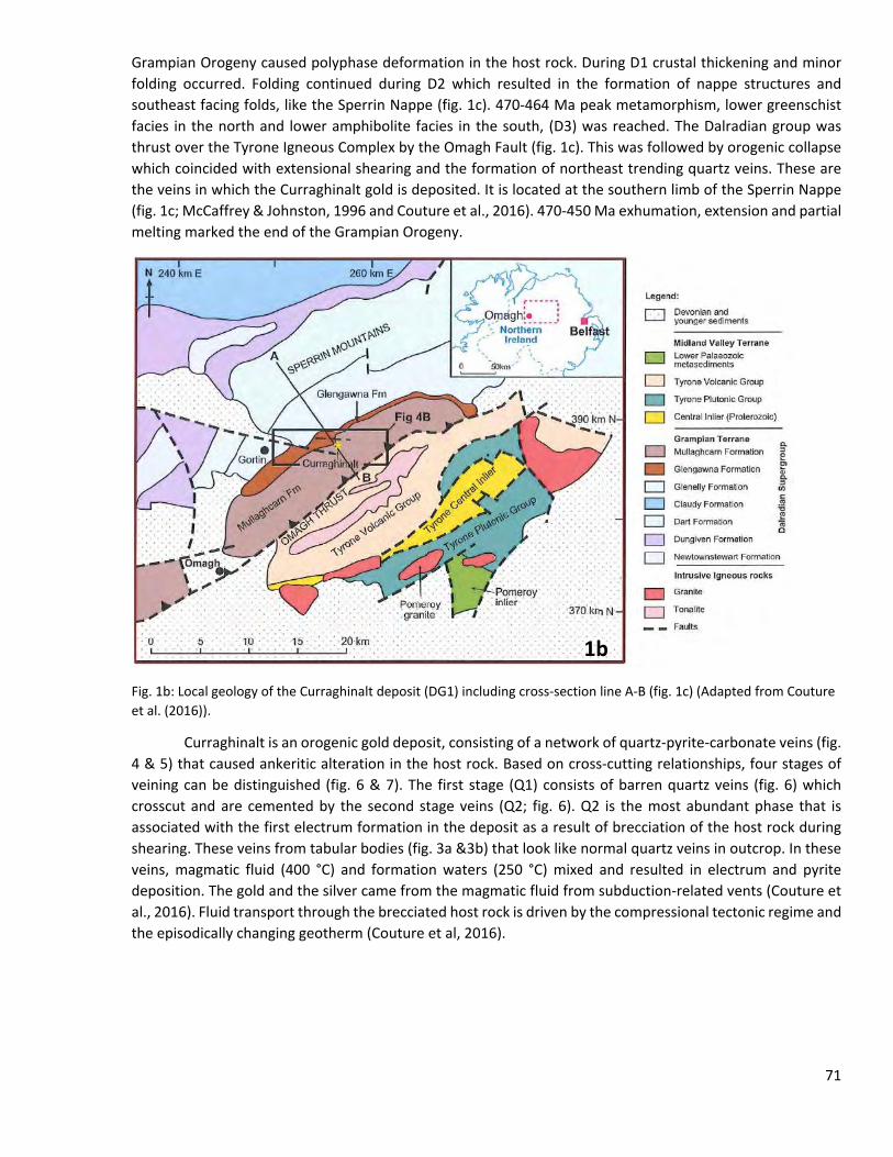
Grampian Orogeny caused polyphase deformation in the host rock. During D1 crustal thickening and minor folding occurred. Folding continued during D2 which resulted in the formation of nappe structures and southeast facing folds, like the Sperrin Nappe (fig. 1c). 470-464 Ma peak metamorphism, lower greenschist facies in the north and lower amphibolite facies in the south, (D3) was reached. The Dalradian group was thrust over the Tyrone Igneous Complex by the Omagh Fault (fig. 1c). This was followed by orogenic collapse which coincided with extensional shearing and the formation of northeast trending quartz veins. These are the veins in which the Curraghinalt gold is deposited. It is located at the southern limb of the Sperrin Nappe (fig. 1c; McCaffrey & Johnston, 1996 and Couture et al., 2016). 470-450 Ma exhumation, extension and partial melting marked the end of the Grampian Orogeny.
Fig. 1b: Local geology of the Curraghinalt deposit (DG1) including cross-section line A-B (fig. 1c) (Adapted from Couture et al. (2016)).
Curraghinalt is an orogenic gold deposit, consisting of a network of quartz-pyrite-carbonate veins (fig. 4 & 5) that caused ankeritic alteration in the host rock. Based on cross-cutting relationships, four stages of veining can be distinguished (fig. 6 & 7). The first stage (Q1) consists of barren quartz veins (fig. 6) which crosscut and are cemented by the second stage veins (Q2; fig. 6). Q2 is the most abundant phase that is associated with the first electrum formation in the deposit as a result of brecciation of the host rock during shearing. These veins from tabular bodies (fig. 3a &3b) that look like normal quartz veins in outcrop. In these veins, magmatic fluid (400 °C) and formation waters (250 °C) mixed and resulted in electrum and pyrite deposition. The gold and the silver came from the magmatic fluid from subduction-related vents (Couture et al., 2016). Fluid transport through the brecciated host rock is driven by the compressional tectonic regime and the episodically changing geotherm (Couture et al, 2016).
1b
71
Fig. 1c: NW-SE cross-section through the Curraghinalt Gold deposit (Couture et al., 2016).
Q3 and Q4 concentrate themselves in the center of the ore deposit and are late vuggy phases of vein growth (fig. 6). It is those two types of veins that carry the high grade mineralizations (up to 55 g/ton Au over 2.7 m) and this is the second generation of electrum precipitation. This is the volumetrically largest part of the gold deposit. It is associated with reactivation of faults during the Variscan Orogeny (327 Ma) and renewed hydrothermal activity (Wilkinson et al., 1999). Two types of fluid inclusions can be found inside this late-stage quartz veins (Q3 and Q4). Type 1 has first-melting temperatures that represent eutectic melting of NaCl-KCl-H2O system. The fluid is considered to be a low salinity (0.1-15.4 wt% NaCl eq.), intermediate temperature fluid (fig. 8). The type 2 fluids are part of the NaCl-CaCl-H2O system. They have a high salinity (12->21 wt% NaCl eq.) and were entrapped at a higher temperature (fig. 8; Wilkinson et al., 1999). They are believed to represent the infiltration of basin-derived brine (type 2 inclusions) into high temperature formation water (type 1 inclusions). Gold was remobilized from the first generation electrum by the low temperature brine and the gold was redeposited in the core of the Curraghinalt deposit. However the mode of transport of the gold is still unclear. It is most likely transported as bisulfide complexes, but the relatively low brine flux cannot explain the large volume of redeposited gold (Wilkinson et al., 1999).
The Curraghinalt deposit is the largest gold resource of the UK. Dalradian Resources Inc. released a new mineral resources statement on the 17th of June 2016 in which they present new indicated and measured resources data. This resource estimation is based on 568 core drill holes (131,643 m) and 497 underground channels (1,863 m) (fig. 2). They estimated the inferred resources to be 7,130,000 tons (fig. 9) with an average grade of 10.06 g/t gold. In this report they state that the economic feasibility is still unknown and thus exploration is still continuing (Couture et al., 2016 and Dalradian Resources Inc., 2016, May 5).
72
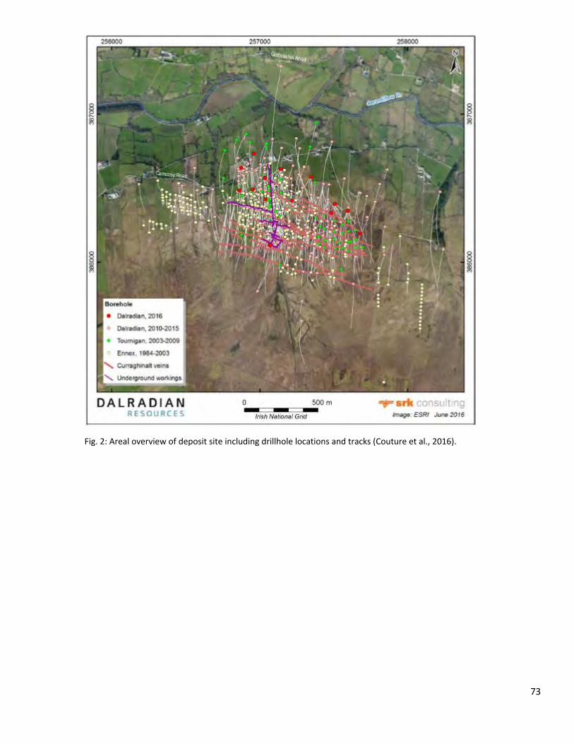
Fig. 2: Areal overview of deposit site including drillhole locations and tracks (Couture et al., 2016).
73
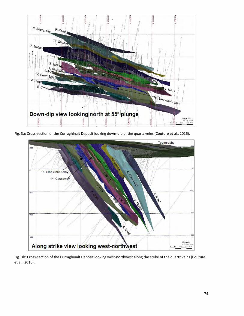
Fig. 3a: Cross-section of the Curraghinalt Deposit looking down-dip of the quartz veins (Couture et al., 2016).
Fig. 3b: Cross-section of the Curraghinalt Deposit looking west-northwest along the strike of the quartz veins (Couture et al., 2016).
74
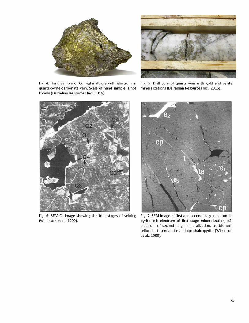
Fig. 4: Hand sample of Curraghinalt ore with electrum in quartz-pyrite-carbonate vein. Scale of hand sample is not known (Dalradian Resources Inc., 2016).
Fig. 5: Drill core of quartz vein with gold and pyrite mineralizations (Dalradian Resources Inc., 2016).
Fig. 6: SEM-CL image showing the four stages of veining (Wilkinson et al., 1999).
Fig. 7: SEM image of first and second stage electrum in pyrite. e1: electrum of first stage mineralization, e2: electrum of second stage mineralization, te: bismuth telluride, t: tennantite and cp: chalcopyrite (Wilkinson et al., 1999).
75
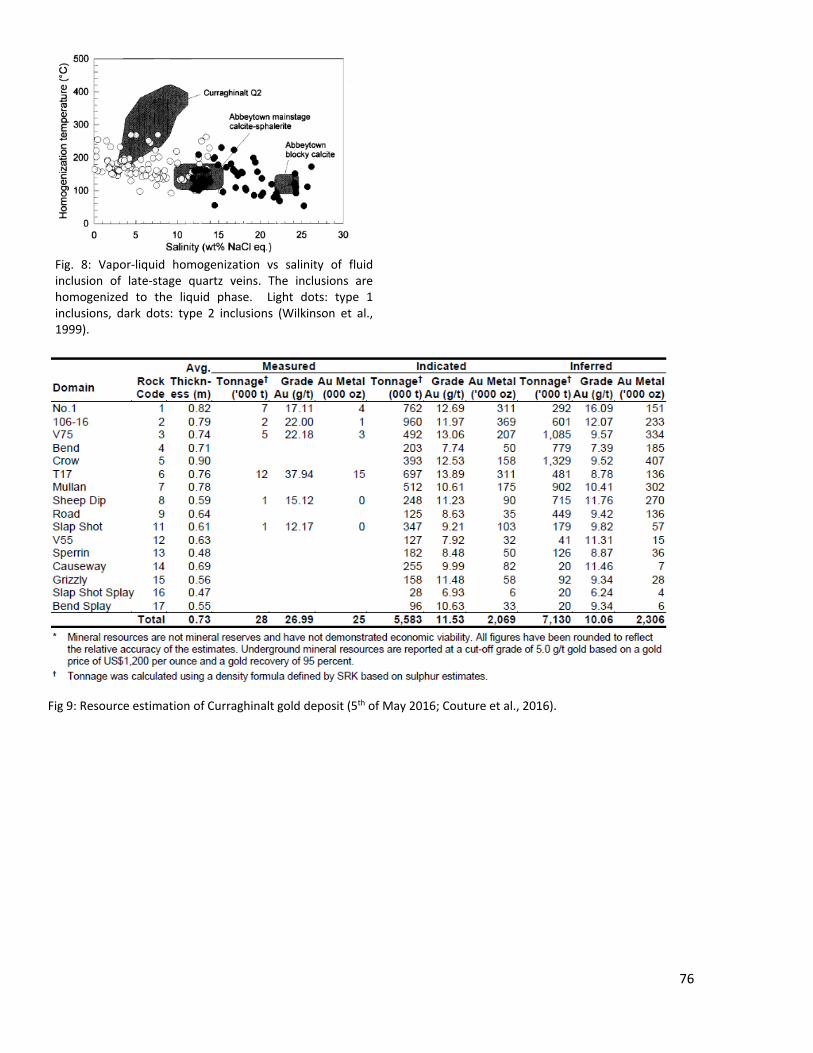
Fig. 8: Vapor-liquid homogenization vs salinity of fluid inclusion of late-stage quartz veins. The inclusions are homogenized to the liquid phase. Light dots: type 1 inclusions, dark dots: type 2 inclusions (Wilkinson et al., 1999).
Fig 9: Resource estimation of Curraghinalt gold deposit (5th of May 2016; Couture et al., 2016).
76

References & online sources:
Couture, J.-F., Leuangthong, O., & Freudigmann, S. (2016). Technical Report for the Nothern Ireland Gold Project, Northern Ireland. Toronto, Canada: SRK Consulting.
Dalradian Resources Inc. (2016, May 5). Dalradian - Dalradian Announces New Mineral Resource Statement for Curraghinalt, Including a 109% Increase in Measured & Indicated Gold Ounces. Accessed in June 2016, from Dalradian Resources: http://www.dalradian.com/news-and-events/news-releases/news-releases-details/2016/Dalradian-Announces-New-Mineral-Resource-Statement-for-Curraghinalt-Including-a-109-Increase-in-Measured--Indicated-Gold-Ounces/default.aspx
Dalradian Resources Inc. (2016). Dalradian - News & Events - Videos and Photos. Accessed in June 2016, from Dalradian Resources: http://www.dalradian.com/news-and-events/image-gallery/default.aspx
McCaffrey, K., & Johnston, J. (1996). Fractural Analysis of a mineralized vein deposit: Curraghinalt gold deposit, County Tyrone. Mineralium Deposita, 52-58.
Wilkinson, J. J., Boyce, A. J., Earls, G., & Fallick, A. E. (1999). Cold remobilazation by low-temperature brines: evidence from the Curradghinalt gold deposit, Nothern Ireland. Econmic Geology, 289-296.
77
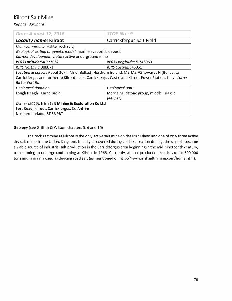
Kilroot Salt Mine Raphael Burkhard
Date: August 17, 2016 STOP No.: 9 Locality name: Kilroot Carrickfergus Salt Field Main commodity: Halite (rock salt) Geological setting or genetic model: marine evaporitic deposit Current development status: active underground mine WGS Latitude:54.727062 WGS Longitude:-5.748969 IGRS Northing:388871 IGRS Easting:345051 Location & access: About 20km NE of Belfast, Northern Ireland. M2-M5-A2 towards N (Belfast to Carrickfergus and further to Kilroot), past Carrickfergus Castle and Kilroot Power Station. Leave Larne Rd for Fort Rd. Geological domain: Lough Neagh - Larne Basin
Geological unit: Mercia Mudstone group, middle Triassic (Keuper)
Owner (2016): Irish Salt Mining & Exploration Co Ltd Fort Road, Kilroot, Carrickfergus, Co Antrim Northern Ireland, BT 38 9BT
Geology (see Griffith & Wilson, chapters 5, 6 and 16)
The rock salt mine at Kilroot is the only active salt mine on the Irish island and one of only three active dry salt mines in the United Kingdom. Initially discovered during coal exploration drilling, the deposit became a viable source of industrial salt production in the Carrickfergus area beginning in the mid-nineteenth century, transitioning to underground mining at Kilroot in 1965. Currently, annual production reaches up to 500,000 tons and is mainly used as de-icing road salt (as mentioned on http://www.irishsaltmining.com/home.htm).
78
Fig 1: Bedrock geology map of Carrickfergus. Kilroot Mine lies within Permo-Triassic sediments, near Belfast in Northern Ireland. Approximate mine location is indicated with a red arrow, which is also N direction. Note that much of this area is covered with quaternary deposits and thus the outcrops are not visible.
The mine lies in lithology 75 "Continental redbed facies, lagoonal & shallow marine; Sandstone & mudstone with evaporite", which is Triassic. The purple rock corresponds to lithology 79, green is 76, light blue corresponds to 77. (source: http://dcenr.maps.arcgis.com/apps/webappviewer/ index.html?id=ebaf90ff2d554522b438ff313b0c197a&scale=0)
As is typical for rock salt, this deposit is of sedimentary origin. Evaporites, like halite, are formed in a warm and shallow, semi-enclosed marine environment, where evaporation is very intense and thus saturation may be reached. After saturation, minerals start to precipitate: first calcite, later gypsum and then halite. Similar to other European salt deposits, the salt field at Carrickfergus is of Triassic age, when the to-be Northern Ireland was located further south, in a warmer environment.
In the Lower Permian, there was intense subaerial erosion with sedimentation of brockram (a polymictic breccia). The upper Permian shows transgression, seen in sedimentation of magnesian limestone, marls and sandstones. Griffith and Wilson (1982) mention that the Permian-Triassic boundary actually may lie within the reddish marls, which were originally considered to be entirely from the Upper Permian. The following part of the lower Triassic is present as sandstones with mudstone interlayers (Sherwood sandstone group) which is followed by the Mercia Mudstone group, which is the rock-salt bearing lithology (see Fig. 2). Salt is present within the Mercia mudstones in a number of layers. There is no outcrop of rock salt, as it is covered by quaternary deposits (Griffith and Wilson 1982).
79

Halite content in this group ranges from zero ("uncontaminated mudstone") to pure halite, with everything in between. The halite is usually of reddish to brownish color (Fig. 6), likely due to iron-containing impurities. Also, folding and faulting in the rock salt is reported, but only on small scale. Griffith and Wilson (1982) even suggest that those could be caused by mining activity, since these features are only known from mining outcrops. On the other hand, it seems that folding and faulting did affect the salt-bearing layers on a larger scale, because the rock salt did not always occur in boreholes at expected positions. A source of variance in thickness of the salt layers could furthermore be plastic rheologic behavior, which is a common feature of rock salt. The extent of salt reserves are not clear or not published.
In general, the Triassic rocks show a gentle dip towards NW, and some folding is present. Since there is local evidence of pre-Cretaceous erosion (eroding through the Jurassic into the Triassic), and because there is no borehole that penetrated the whole group, the actual thickness of the Mercia Mudstone is not clear. It is stated that, locally, the thickness is at least 535 m (Griffith and Wilson 1982).
Fig. 2: A profile of the Carrickfergus salt field, showing evidence from boreholes and geophysical studies. The profile line is not straight, see small figure on bottom left. Economic halite deposits are within the Mercia Mudstone group (MM). Fig. from McCaffrey (1992).
80

Fig 3: Aerial view of the mining complex. Some salt from Kilroot is exported, even to North America. For marine shipping a pier was constructed. (source: http://www.irishcentral.com/culture/craic/Fun-snow-fact-Ireland-is-a-major-source-of-road-salt.html) Fig 4: Newly-constructed (2013) entry to the mine, what is called an "access drift". (source: http://www.six-west.com/?p=902)
81
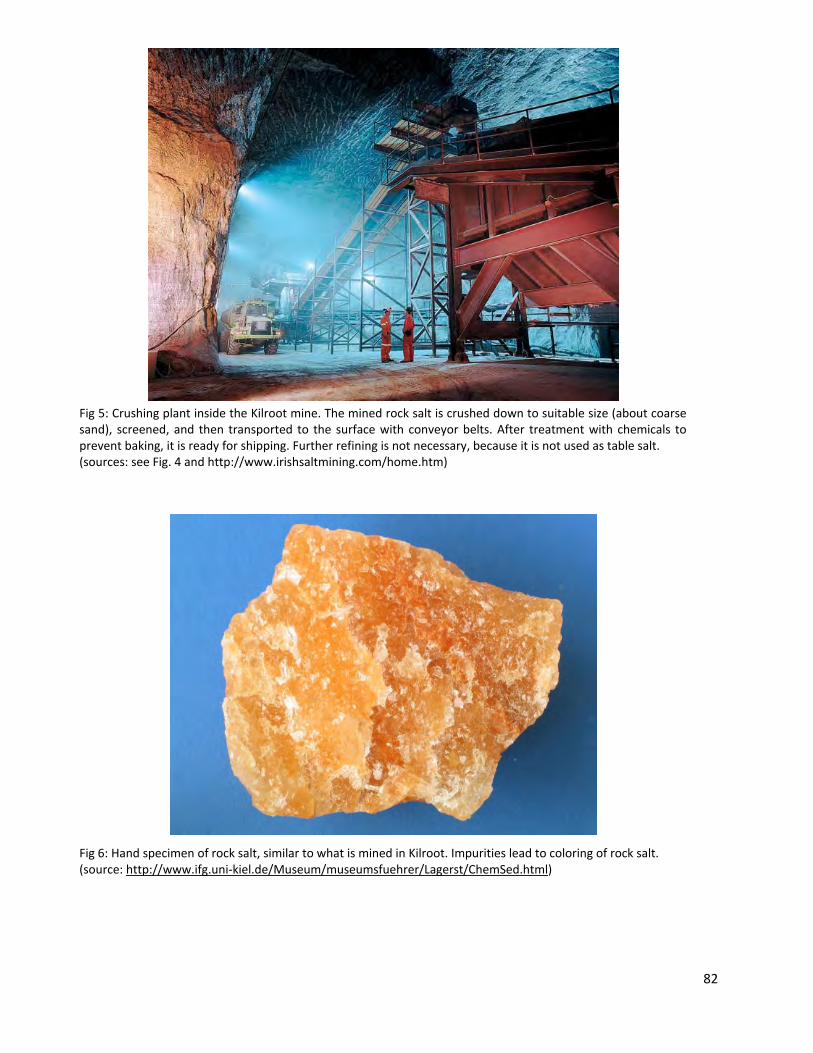
Fig 5: Crushing plant inside the Kilroot mine. The mined rock salt is crushed down to suitable size (about coarse sand), screened, and then transported to the surface with conveyor belts. After treatment with chemicals to prevent baking, it is ready for shipping. Further refining is not necessary, because it is not used as table salt. (sources: see Fig. 4 and http://www.irishsaltmining.com/home.htm) Fig 6: Hand specimen of rock salt, similar to what is mined in Kilroot. Impurities lead to coloring of rock salt. (source: http://www.ifg.uni-kiel.de/Museum/museumsfuehrer/Lagerst/ChemSed.html)
82

References & online sources: Griffith, A.E., & Wilson, H.E. (1982). Geology of the country around Carrickfergus and Bangor: Memoir for one-inch geological sheet 29. (Ed.2 ed.). Belfast: Her Majesty's Stationery Office. McCaffrey, R.J., & McCann, N. Post-Permian basin history of northeast Ireland, Geological Society, London, Special Publications 1992, v. 62, p. 277-290 http://www.irishsaltmining.com/home.htm (the company's official website)
83