ORDINANCE NO. 19491 - s3.amazonaws.com · 1 1 (Published in the Topeka Metro News December 13,...
79
1 (Published in the Topeka Metro News December 13, 2010) 1 2 ORDINANCE NO. 19491 3 4 A CITY OF TOPEKA ORDINANCE introduced by City Manager Norton N. Bonaparte, 5 Jr. pertaining to an amendment to the text and map of the Topeka 6 Comprehensive Metropolitan Plan. (CPA 10/2) 7 8 BE IT ORDAINED by the Governing Body of the City of Topeka, Kansas, on this 9 7 th day of December, 2010, as follows: 10 Section 1 . The Comprehensive Metropolitan Plan for the City of Topeka may 11 be adopted by the Governing Body upon the recommendation of the Topeka Planning 12 Commission. 13 Section 2. Section 110-72 of the Topeka City Code lists the elements that may 14 be included in the Comprehensive Metropolitan Plan, and specifies that the Plan may 15 include neighborhood plans for all geographic sub-areas of Topeka. 16 Section 3 . The Central Highland Park Neighborhood Plan, a copy of which is 17 attached hereto as Attachment A and incorporated by reference as if fully set forth 18 herein, provides long-range guidance for the future growth and development of the area 19 generally bounded by I-70 to the north, SE California Avenue to the east, SE 29 th Street 20 to the south, and SE Adams Street to the west. The Neighborhood Plan sets forth a ten 21 (10) year vision with goals and strategies relating to land use, commercial and image 22 corridors, housing, parks, infrastructure, public safety, and community organization in a 23 comprehensive manner that recognizes the desire to increase the livability of the 24 Central Highland Park Neighborhood. 25 Section 4 . The Topeka Comprehensive Metropolitan Plan is hereby amended 26 by the addition of the Central Highland Park Neighborhood Plan as a separate Plan 27 Element. 28
Transcript of ORDINANCE NO. 19491 - s3.amazonaws.com · 1 1 (Published in the Topeka Metro News December 13,...

1
(Published in the Topeka Metro News December 13, 2010) 1 2
ORDINANCE NO. 19491 3 4 A CITY OF TOPEKA ORDINANCE introduced by City Manager Norton N. Bonaparte, 5
Jr. pertaining to an amendment to the text and map of the Topeka 6 Comprehensive Metropolitan Plan. (CPA 10/2) 7
8 BE IT ORDAINED by the Governing Body of the City of Topeka, Kansas, on this 9
7th day of December, 2010, as follows: 10
Section 1. The Comprehensive Metropolitan Plan for the City of Topeka may 11
be adopted by the Governing Body upon the recommendation of the Topeka Planning 12
Commission. 13
Section 2. Section 110-72 of the Topeka City Code lists the elements that may 14
be included in the Comprehensive Metropolitan Plan, and specifies that the Plan may 15
include neighborhood plans for all geographic sub-areas of Topeka. 16
Section 3. The Central Highland Park Neighborhood Plan, a copy of which is 17
attached hereto as Attachment A and incorporated by reference as if fully set forth 18
herein, provides long-range guidance for the future growth and development of the area 19
generally bounded by I-70 to the north, SE California Avenue to the east, SE 29th Street 20
to the south, and SE Adams Street to the west. The Neighborhood Plan sets forth a ten 21
(10) year vision with goals and strategies relating to land use, commercial and image 22
corridors, housing, parks, infrastructure, public safety, and community organization in a 23
comprehensive manner that recognizes the desire to increase the livability of the 24
Central Highland Park Neighborhood. 25
Section 4. The Topeka Comprehensive Metropolitan Plan is hereby amended 26
by the addition of the Central Highland Park Neighborhood Plan as a separate Plan 27
Element. 28

2
Section 5. This ordinance shall take effect and be in force from and after its 29
passage, approval and publication in the official City newspaper. 30
PASSED and APPROVED by the Governing Body December 7, 2010. 31 32 33 34 William W. Bunten, Mayor 35 ATTEST: 36 37 38 Brenda Younger, City Clerk 39
APPROVED AS TO FORM AND LEGALITY DATE _______________ BY_______________ TO BE CODIFIED _______________________ NOT TO BE CODIFIED ___________________

Central Highland Park Neighborhood Plan
December, 2010 1
CCEENNTTRRAALL HHIIGGHHLLAANNDD PPAARRKK T o p e k a , K a n s a s
Neighborhood Plan
An Element of the
Topeka Comprehensive Plan 2025
A Cooperative Effort By:
The Central Highland Park Neighborhood Improvement Association
& Topeka Planning Department
ADOPTED: Topeka Planning Commission, October 25, 2010.
Topeka Governing Body, December 7, 2010.

Central Highland Park Neighborhood Plan
December, 2010 2
ACKNOWLEDGEMENTS
Central Highland Park Neighborhood Improvement Association
Wesley Marshall, President
Danetta Stevens-Miller, Vice-President Peggy Lewis, Secretary
Barbara Worford, Treasurer
City of Topeka Mayor
Bill Bunten
Topeka City Council
John Alcala Bob Archer Richard Harmon Karen Hiller Jeff Preisner Sylvia Ortiz Deborah Swank Jack Woelfel Larry Wolgast Deborah Swank
Topeka Planning Commission
Mike Lackey, Chairman
Richard Beardmore Peter Hancock Kevin Beck Brett Klausman
John Federico Lee Williams, Vice-Chairman June Ewing Dawn Wright
Topeka Planning Department
David Thurbon, AICP, Director
Bill Fiander, AICP, Deputy Director (Project Manager) Cylus Scarbrough, AICP, Planner I (Project Staff)
Loreena Munoz, Office Specialist

Central Highland Park Neighborhood Plan
December, 2010 3
TABLE OF CONTENTS I. Introduction & Purpose…………...……………………....................
4
II. Neighborhood Profile………………………………………………. A. Setting & History……………………………………….............. B. Existing Conditions……………………………………………… C. Socio-Economic Trends…………………………………….......... D. Profile Summary……………………………………….………. E. Sub-Area Profiles……………...………………………...............
6 6 8
13
14 15
III. Vision & Goals……………..…………………………………............ A. Vision Statement…………………………….……………......... B. Goals & Guiding Principles……………….……………............
18 18 18
IV. Future Land Use Plan…………………………………..................... A. Land Use Categories……………………………………………
20 20
V. Revitalization Strategy…………………………………………….. A. Themes of Revitalization…..………….………………………...... B. Target Area Concept/Strategies……………………….................
C. Neighborhood-Wide Strategies……………...…………………... 1. Infrastructure & Circulation……………………….……...……. 2. Community Building...…………..……………………………… 3. Housing……...….………………………………………............. 4. Parks, Open Space & Recreational Facilities…………………..
25 25 26 36 36 43 46 51
VI. Implementation………...………………………………………….. A. Key Action Priorities……………………………..……………..... B. Target Areas……………………………………………………. C. Re-Zoning………………………………………………………..
VII. Appendix…………………………………….………………
Existing Conditions & Socioeconomic Tables Existing Conditions Maps 1-6 Key Actions Survey Visioning Meetings Results Criteria Used to Evaluate Structural Defects Address Map
52 52 54 57 59
Maps & Illustrations
1. Future Land Use Map...………………………........................................
24 2. Target Area Concept Map…………………………………………. 28 3. Biddle Creek “Daylighting” Illustration…………………...................... 4. Sidewalk Priorities Map…………………………………………….. 5. Proposed Zoning Map………………………………………………
34 39 58

Central Highland Park Neighborhood Plan
December, 2010 4
Purpose
The purpose of this document is two-fold: (1) to examine existing conditions of the neighborhood and (2) to provide long-range guidance and clear direction to the City, its agencies, residents, and private/public interests for potential revitalization activities that occur within the Central Highland Park neighborhood. This document was prepared in collaboration with the Central Highland Park NIA and Topeka Planning Department and is intended to be an element of the City’s overall Comprehensive Plan. It establishes a 10-year vision with supportive goals, strategies and actions, and provides the policy basis from which to identify appropriate zoning, capital improvements and other initiatives for implementation. A neighborhood plan in of itself is not a binding agreement or contract. It is a set of general principals and recommendations for action. It is impractical to expect all recommendations of this plan to be implemented in a timely manner, if at all. Recommendations for infrastructure, housing and parks all involve major City expenditures that are constrained by the amount of tax revenues the City collects. Other NIA’s compete for such allocations as well. Reliance on non-City funding sources will also determine the pace of implementation. Thus, another purpose of this plan is to provide guidance for priorities in order to determine the most prudent expenditures with limited resources.
Process
This document has primarily been prepared in collaboration with the Central Highland Park NIA, with input from residents and other stakeholders in the neighborhood as well. Beginning in the spring of 2010, planning staff conducted a property-by-property land use/housing survey of the neighborhood and collected pertinent demographic data. The information was shared and presented during four “visioning” meetings in which Planning Staff also conducted a visual preference survey and gathered input from attendees in order to understand the neighborhood’s priorities. The NIA was divided into three geographic sub-areas – North, Central, and South – with each area having a dedicated visioning session and survey. These meetings occurred on April 19th, April 26th, May 3rd, along with a summary presentation on May 10th at the NIA’s regularly scheduled meeting at the Hillcrest Community Center. The NIA has also devoted portions of their monthly meetings in 2010 in order to formulate the goals, guiding principles, strategies and actions recommended in this Plan. The attendees of these meetings were notified about subsequent working group meetings on infrastructure and land use/zoning to give greater guidance to Planning Department staff on those issues. A summary of the final plan was presented to the community and the Planning Commission at a confirmation/wrap-up meeting held on September 27th, 2010 at Highland Park High School. A public hearing was held before the Planning Commission on October 25, 2010. All property owners in the NIA boundary were specifically notified by mail at least twice of specific meetings and opportunities for input along the way. Some owners in the potential re-zoning areas were notified by mail a third time. 10 meetings in the neighborhood were held with citizens and Planning staff to develop the plan.
I. INTRODUCTION & PURPOSE

Central Highland Park Neighborhood Plan
December, 2010 5

Central Highland Park Neighborhood Plan
December, 2010 6
Location The Central Highland Park neighborhood is located in
the southeast portion of the City of Topeka, Kansas approximately two miles from the Capitol building and the Central Business District. Central Highland Park is bounded by I-70 to the north, SE California Avenue to the east, SE 29th Street to the south and SE Adams Street to the west. The neighborhood is very large and encompasses a total area of about 916 acres, the majority of which is used for single-family residential purposes.
Nearby attractions and institutions include Highland
Park High School east of SE California Avenue, Shawnee Country Club south of SE 29th Street and Hillcrest Community Center within the confines of the neighborhood itself just north of SE 21st Street. Lake Shawnee and its attractions are only about a mile east of the neighborhood. SE California Avenue serves the everyday shopping needs of a large population in southeast Topeka, in the form of both shopping centers and “strip” commercial development. Many retail buildings along both sides of SE California Avenue, however, have experienced long periods of vacancy or underutilization as the population of the neighborhood has dwindled over time. The Dillon’s grocery store at SE 29th Street and California Avenue, for example, meets a vital need for the area but is small by comparison to other similar stores in Topeka.
History The earliest days of Highland Park began in June of 1886, when a man named Joseph
Kennedy Hudson took title to a section of land on a hill just southeast of the Capital City. Joseph Hudson was born in 1840, in the town of Carrollton, Ohio. His father was publisher of several newspapers throughout Ohio, and was a strong Abolitionist whose home became a well known station along the Underground Railroad during the Civil War. In 1861, Hudson was stationed at Ft. Leavenworth, Kansas and eventually rose to the rank of General before his retirement. At the time of his promotion, Joseph Hudson was one of only two Generals serving in the Army. In 1879, he founded the Topeka Daily Capital, which was soon recognized as one of the most influential newspapers throughout the Midwest and espoused the cause of prohibition. Hudson acquired all rights to the land from a fellow Topekan and architect named George W. Veale, and filed the plat known as Highland Park in March of 1887. The design of this plat was complete with 25’ wide lots, streets, alleys, and even a dedicated right-of-way for the Highland Park Circle Railway to connect his “distant” suburb with the City of Topeka, proper.
II. NEIGHBORHOOD PROFILE
A. SETTING & CHARACTER
Central Highland
Park
Highland Park High
School

Central Highland Park Neighborhood Plan
December, 2010 7
Gen. Joseph Kennedy Hudson. Died 1907, buried in the Topeka Cemetery. Source: Kansas State Historical Society
Early settlers were limited to a minimum purchase of 6 lots, so as to spread out the construction of homes. Several prominent citizens built homes in the fledgling neighborhood before the City’s building boom crashed, which halted progress until long after his death. Electricity was the first “service” to be provided (1900) followed by water (1918), pavement of the neighborhood’s first road (1920), and finally gas service (1928). Sewer service was eventually extended by the City of Topeka to the Highland Park area in 1948 and 1949, greatly increasing the neighborhood’s prospects as a suburban residential destination. In fact, most of the physical fabric of modern day Highland Park was built after that time. Many of the larger and more stately homes within the interior of the neighborhood were built between the years approximately 1880-1940, several of which were envisioned by Joseph Hudson himself as part of his model home concept that sought to market the neighborhood’s suburban character with modest homes on large lots. During this period, housing styles varied from ranch, bungalow, homestead and Victorian-era houses. Over time, however, one of the most abundant housing styles in the neighborhood became minimal traditional (post-World War II style), which were designed with affordability in mind. Central Highland Park has a traditional grid street pattern because many of the blocks were platted in the early 1900’s before the widespread use of the automobile. SE Maryland Avenue, in fact, was intended to be the main streetcar thoroughfare in the neighborhood, which never came to fruition.
Above left: 2424 SE Pennsylvania, one of Joseph Hudson’s concept homes built to market the neighborhood’s rural and expansive setting with large lot homeownership. Above right: post-World War II house on a small-lot characteristic within the Central Highland Park neighborhood.

Central Highland Park Neighborhood Plan
December, 2010 8
* Tables and Maps are located in the Appendix.
Health The Neighborhood Element of the Comprehensive Plan establishes a neighborhood health rating system for all neighborhoods in Topeka in order to prioritize planning assistance and resource allocation. The health rating system tracks residential property values, percent of persons below the poverty level, homeownership, boarded houses and persons per Type I crimes. According to the 2007 Neighborhood Health Map, the Central Highland Park neighborhood is divided between blocks designated as “healthy”, ”out-patient” and “at-risk.” “At-risk” neighborhoods have the second most level of distressed conditions and are considered a high priority for investment. These blocks are concentrated between I-70 to the north and SE 21st Street to the south, as well as several blocks at the very southeastern portion of the neighborhood near SE 29th Street and California Avenue.
The Neighborhood Health Map of 2007 shows an improvement in neighborhood conditions from the Health Map of 2003, as blocks between SE 21st to 26th Street improved from “out-patient” to “healthy”, as well as from “at-risk” to “out-patient.” The blocks presently designated as “at-risk” remain unchanged from 2003, and no blocks within the neighborhood were downgraded to a lower neighborhood health designation between these years. In fact, the blocks immediately south of SE 21st Street became the first area in the East Topeka/Highland Park/Hi-Crest portion of the city to achieve an overall “healthy” rating since the onset of the rating system in 2000.
Land Use
The neighborhood is primarily low-density residential with 88% of all parcels and 74% of the land area devoted to residential uses (see Table #1 and Map #1). In fact, 86% of all parcels are Single-Family Residential and there are very few houses that have been divided into apartments, which can be attributed to the modest sizes of homes in the neighborhood. There is a large amount of vacant land that accounts for 9% of all parcels and over 13% of the total land area in the neighborhood. Commercial development is very minimal within the neighborhood itself (1.3% of all parcels). The highest concentration of commercial/retail uses are on the neighborhood’s perimeter located at SE California Avenue and 29th Street. Several pockets of neighborhood retail are located in the interior of the neighborhood just west of Highland Park Central Elementary School on SE 27th Street, as well as near the intersection of SE 21st Street and Maryland Avenue (U-Market). Public park space accounts for only 4% of the total land area in the neighborhood.
Zoning
Most of the blocks within the Central Highland Park neighborhood have retained their original zoning designations since the area was annexed into the city between 1957-’58 (refer to Map #2). Low-density single-family residential is the primary zoning pattern within the neighborhood (“R-1” and “R-2” districts). There is a large area of the neighborhood north of SE 21st Street along SE Adams Street, Massachusetts, Pennsylvania and Maryland Avenue where the existing zoning classifications (“M-1” & “M-2” Two/Multiple-Family Districts) do not reflect or match the existing land use of these properties, which is almost entirely single-family residential. The same is true along the 2100 blocks of SE Virginia, Ohio and Kentucky Avenue that have “M-1” zoning, yet all of the homes are inhabited as single-family dwellings. The most recent and notable change in zoning has occurred at the intersection of SE 21st and
B. EXISTING CONDITIONS*
Central Highland Park Neighborhood Plan
December, 2010 9
Adams Street in order to accommodate medium-density affordable duplexes and apartment units (Pioneer Townhomes), as well as a small commercial center with a convenience store at SE 15th Street and Adams Street.
Housing Density
The overall density level of 2.7 dwelling units per acre in the neighborhood is very low. This is partly due to the fact that a large number of single-family homes in the post-World War II style are simply not big enough to divide into apartments (refer to Table #2). This figure, however, could have been higher if it were not for the amount of vacant land within the north Sub-Area of the neighborhood.
Housing Conditions
Housing conditions vary throughout the neighborhood but remain stable as 65% of all residential structures exhibit only Minor Deficiencies (refer to Table #3, Map #3). The blocks south of SE 21st Street and west of SE Indiana Ave are generally among the healthiest, and comprise a large part of the original Highland Park subdivision. The worst housing conditions occur within the northwest portion of the neighborhood, the eastern portion of the Central Sub-Area, as well as blocks along SE Colorado AVE that are adjacent to commercial development (refer to Sub-Area Profiles).
Tenure
More than half of all residential units are owner-occupied (53.4%). However, considering that single-family homes account for a great majority of the land uses in the neighborhood this figure could be much higher. Only 6 out of 10 single-family homes, in fact, are owner-occupied in Central Highland Park (refer to Table #4). Duplex and apartment units only account for 9% of all housing units in the neighborhood, and thus do not affect Central Highland Park’s overall owner-occupancy rate by any significant degree. The most surprising blocks with low homeownership levels (below 50%) occur along SE Illinois AVE adjacent to Highland Park Central Elementary School, the 2600 blocks of SE Maryland and Virginia AVE just north of the St. Matthew’s property, as well as the blocks immediately west of Hillcrest Park (refer to Map #4).
Public Safety
Map #5 illustrates the number of reported major crimes committed by block between 2008 and 2009 according to crime statistics provided by the Topeka Police Department. The highest concentrations of reported major crimes occurred within the 2800 block in the southern portion of the neighborhood, directly adjacent to a major arterial (SE 29th Street). Major crimes are defined as Part 1 crimes – theft, robbery, burglary, aggravated assault, rape, murder. Based upon crime statistics and population figures, Central Highland Park actually has a comparatively low crime rate among Topeka neighborhoods. As Table #5 shows, Central Highland Park has a substantially lower crime rate per every 1,000 residents than several other Neighborhood Improvement Associations, and has a lower crime rate than the City at large. This may be due in part to the presence of single-family owner-occupied homes, as well as the lack of apartment units and commercial property in the neighborhood. Population figures are from the 2000 Census.

Central Highland Park Neighborhood Plan
December, 2010 10
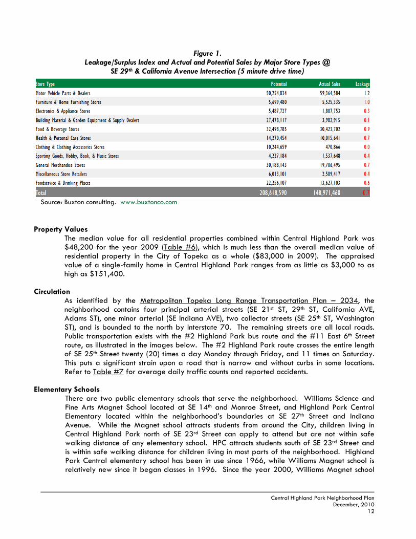
Infrastructure Since most of the neighborhood was built in the county prior to annexation, infrastructure throughout Central Highland Park is not adequate by today’s standards. A number of local streets in the neighborhood are as narrow as 18-20’ in width and rely upon culvert drainage systems to carry storm water away from the street rather than a curb and gutter system. The drop in elevation adjacent to the streets caused by the culvert system represents a chief safety hazard for motorists if they go off the road, even at low speeds. Sidewalks are few and far between even along important routes leading to Highland Park Central Elementary School, which leads to children walking in the street or in the ditches. Pedestrians and motorists, as a result, have very little space to maneuver through very narrow streets with ditches on both sides. This problem is exacerbated in the winter months when the streets are icy or snow is plowed to the side. Map #6 shows the existing conditions of infrastructure in the neighborhood. Along the arterial streets, infrastructure is mostly in place. Surrounding Highland Park Central Elementary School, infrastructure is adequate but several important walking routes directly adjacent to the school lack sidewalks (i.e., SE Illinois, SE 27th and SE 28th Street). Within the interior of the neighborhood, however, most of the residential blocks need intermediate or major repairs to the existing street pavement, curb and gutters, sidewalks or alleys. Roughly a third of the neighborhood is in need of total re-construction of sub-standard streets (around 42 blocks).
The Images above are only a few examples of the sub-standard condition of streets in the Central Highland Park neighborhood. The culvert drainage system (ditches) is not adequate for the needs of the neighborhood and has a negative impact on the health and safety of its residents. As one can see in the images, storm water collects in front yards and is not carried away to sewer lines, and the ditches represent hazards for drivers as well. Combined with the lack of sidewalks, these streets become very dangerous for children walking to Highland Park Central Elementary School and other pedestrians who have to share sub-standard roads with motor vehicles.
Development Activity
Central Highland Park has not received much development activity in the last decade. A few single-family building permits and demolitions have comprised much of the activity until recently. According to the 2000 Census, a large portion (36%) of the homes in the neighborhood were built between 1950 and 1959, which represents the greatest number of
2600 Block of SE Pennsylvania Ave 2700 Block of SE Massachusetts Ave

Central Highland Park Neighborhood Plan
December, 2010 11
homes built in a ten-year period in the neighborhood. There has been very little new home construction in the neighborhood since 1970, as only about 12% of the homes were built between 1970 and the present. Despite the lack of new single-family home development, there are several new developments in the neighborhood that have recently finished construction or are nearing completion. The Pioneer Adams Townhomes I & II located at the intersection of SE 21st and Adams Street have provided an additional 96 units of affordable housing in the neighborhood. Hudson Crossing convenience store and shopping center is the most recent commercial development in the neighborhood at the intersection of SE 15th and Adams Street, and was built utilizing Tax-Increment Financing (TIF) with the assistance from the City of Topeka. There is potential for even more new commercial development at this site as well. Office space for the Kansas Department of Health and Environment is under construction at the former site of Rosa’s Mexican Restaurant near SE 21st and California Avenue.
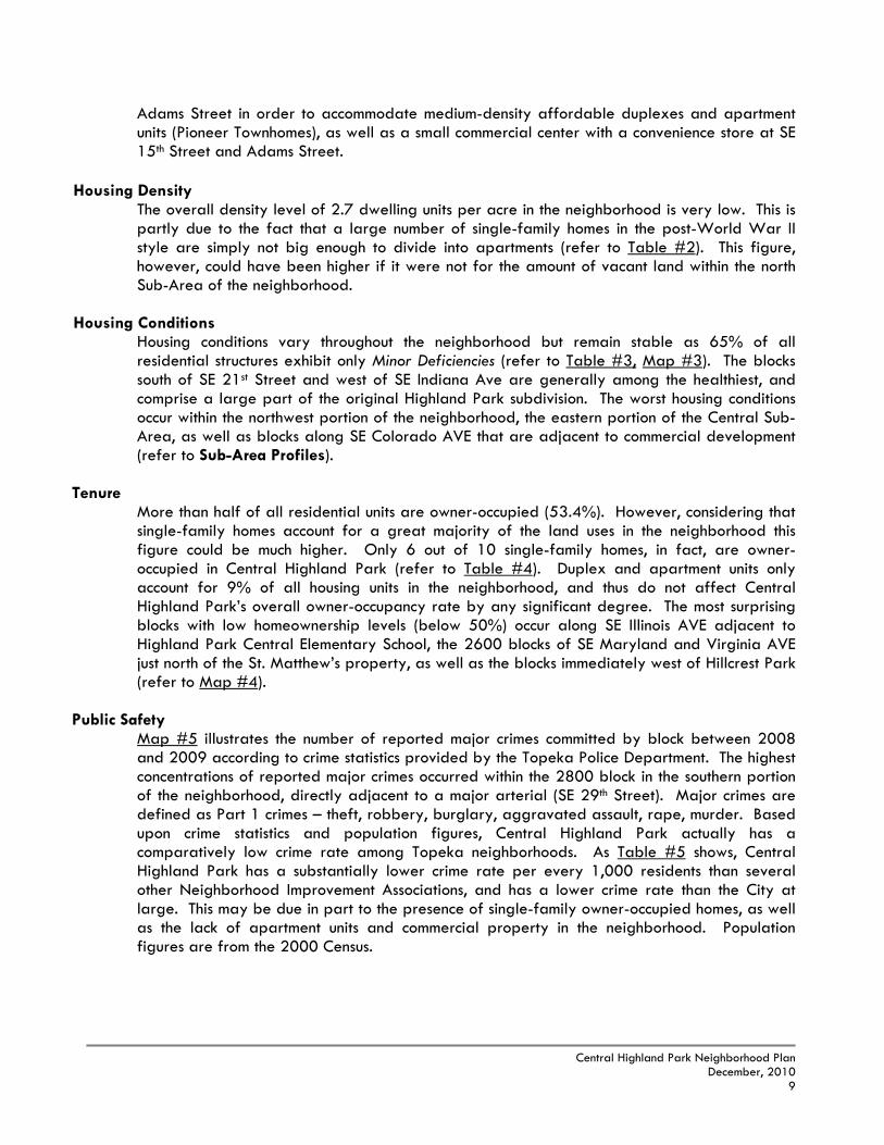
Retail Activity The following table is the result of a retail “leakage” analysis that was completed with the support of the City of Topeka. The study analyzes the amount of retail dollars that are captured within a 5-minute drive time of the intersection of SE 29th and California Avenue. Types of retail activity are divided into eleven categories. The study analyzes the potential amount of retail dollars that could be spent by the surrounding community due to population figures and household incomes, and compares this information to the actual sales that occur within this 5-minute drive time boundary. Retail “leakage” means that residents are spending more for products than local businesses actually receive. Retail sales leakage suggests that there is an unmet demand in the area and that the community can support additional store space for that type of business. However, retail leakage does not necessarily translate into opportunity. For example, there could be a strong competitor in a neighboring community that dominates the market for that type of product or store. Any leakage figure above 1.0 indicates that retail dollars for that category are being spent within the community, while a figure below 1.0 indicates these dollars being spent in other areas of the City, or even outside of the City itself. As the table indicates, motor vehicle parts and dealers are the only category of retail activity in which the area is not losing potential customers and is actually drawing dollars from other parts of the City. All other categories indicate that the community is spending their money on everyday needs in other parts of the City. For example, clothing and clothing accessories are a type of retail activity in which the intersection of SE 29th and California Avenue is not meeting potential demand, most likely due to the lure of shopping at the mall and other nearby stores.
Central Highland Park Neighborhood Plan
December, 2010 12
Figure 1. Leakage/Surplus Index and Actual and Potential Sales by Major Store Types @
SE 29th & California Avenue Intersection (5 minute drive time)
Source: Buxton consulting. www.buxtonco.com
Property Values The median value for all residential properties combined within Central Highland Park was $48,200 for the year 2009 (Table #6), which is much less than the overall median value of residential property in the City of Topeka as a whole ($83,000 in 2009). The appraised value of a single-family home in Central Highland Park ranges from as little as $3,000 to as high as $151,400.
Circulation
As identified by the Metropolitan Topeka Long Range Transportation Plan – 2034, the neighborhood contains four principal arterial streets (SE 21st ST, 29th ST, California AVE, Adams ST), one minor arterial (SE Indiana AVE), two collector streets (SE 25th ST, Washington ST), and is bounded to the north by Interstate 70. The remaining streets are all local roads. Public transportation exists with the #2 Highland Park bus route and the #11 East 6th Street route, as illustrated in the images below. The #2 Highland Park route crosses the entire length of SE 25th Street twenty (20) times a day Monday through Friday, and 11 times on Saturday. This puts a significant strain upon a road that is narrow and without curbs in some locations. Refer to Table #7 for average daily traffic counts and reported accidents.
Elementary Schools
There are two public elementary schools that serve the neighborhood. Williams Science and Fine Arts Magnet School located at SE 14th and Monroe Street, and Highland Park Central Elementary located within the neighborhood’s boundaries at SE 27th Street and Indiana Avenue. While the Magnet school attracts students from around the City, children living in Central Highland Park north of SE 23rd Street can apply to attend but are not within safe walking distance of any elementary school. HPC attracts students south of SE 23rd Street and is within safe walking distance for children living in most parts of the neighborhood. Highland Park Central elementary school has been in use since 1966, while Williams Magnet school is relatively new since it began classes in 1996. Since the year 2000, Williams Magnet school

Central Highland Park Neighborhood Plan
December, 2010 13
and Highland Park Elementary school have each had an increasing student enrollment rate of 10.0% and 6.4% respectively, according to the Kansas State Department of Education.
*Refer to the Appendix for Socio-Economic Tables
Central Highland Park is located in Census Tract 12, Block Group 2, and all of Census Tract 13. Information from the 2000 & 1990 U.S. Census are summarized in the tables in the Appendix. The total population of the neighborhood declined by -4.5% from the years 1990 to 2000. The neighborhood did experience, however, a significant increase in the Black and Hispanic population (24% and 73% respectively). While the number of households in the neighborhood decreased only slightly, the number of married couples decreased by -20%, and the number of female-headed households with children under the age of 18 increased by 16%. The number of young people in the neighborhood under the age of 19 decreased significantly (-23.8%), while the number of people age 65 and over declined as well (-14.6%). The decline of residents within these two age groups may have a large impact upon the needs within the community as the school age population has decreased, and established residents of the neighborhood have moved out of the community. However, the increase in the number of persons between 35 and 54 does explain the growth in income and the drop in poverty rates, as well as a significant reduction in the unemployment rate (refer to Table #9). This increase in buying power and the number of residents in the workforce should be an indication that the local economy of the neighborhood has been stable and that there may be an increase in the commercial shopping needs within and surrounding the Central Highland Park neighborhood.
The Central Highland Park Neighborhood is a proud community rooted in single-family development. Due to the sheer size of the neighborhood, it is not unexpected to find areas of stability, transition and decline within the confines of its 920 acres. Some of the strengths of the neighborhood to build upon include:
Strengths/Opportunities
Despite pockets of deterioration, the majority of the housing stock in the neighborhood
show only Minor Deficiencies, or no deficiencies at all. Single-family residential is the primary land use in the neighborhood. There are very few
blocks where higher-intensity development has threatened the stability of single-family homes in the neighborhood.
Homeownership in the neighborhood is above 50% due to the large presence of single-family homes, but this figure could improve.
C. SOCIOECONOMIC TRENDS
D. PROFILE SUMMARY

Central Highland Park Neighborhood Plan
December, 2010 14
Hillcrest Park & Community Center has first-rate outdoor recreational facilities including a swimming pool, and offers educational programs for youths and adults.
New commercial development has occurred at the intersection of SE 15th and Adams Street, and more opportunities exist in this area for new commercial and residential development.
The Pioneer Adams Town Homes have added almost 100 units of affordable infill units that are well-maintained.
School enrollment increased in the past 10 years due to kindergarten growth. On the other hand, there are many constraints that need to be addressed and overcome in order to increase the quality of life and attract new homeowners: Needs/Constraints Inadequate infrastructure to serve an urban environment that will be costly to rebuild and
improve. 42 blocks need re-built streets; very few sidewalks. An aging housing stock that is not competitive with other markets due to the small average
size of most homes in the neighborhood. There is a lack of park space in the South and Central Sub-Areas. Commercial shopping buildings along SE California Avenue are aging and some have
experienced long periods of vacancy. Overall population of the neighborhood declined -4.5% from 1990-2000; young people
under the age of 19 declined in population as well (-24%). The number of female-headed households raising children alone increased by almost
16% from 1990-2000.

Central Highland Park Neighborhood Plan
December, 2010 15
Central Highland Park (North) 1990 Population = 1,509 (Census Tract 12.2, 12.3) 2000 Population = 1,390 (Census Tracts 12.2)
N
Vital Signs1 Stability Indicators2 Poverty Rate (‘00): 21% high Population Change (’90-‘00): -8% Crimes Reported Rank (’08-‘09): average New Residential/Demolition Ratio(’00-‘07): 1:3 Median Resid. Property Value (‘09): $39,500 low School Enrollment Change (’00-’09): 10.0%
(Williams Magnet School) Single-Family Homeownership (‘09): 52% average Boarded Houses (‘07): average
DIAGNOSIS: At-Risk Declining The North sub-area of Central Highland Park is the neighborhood’s largest “At-Risk” area. Homes in this portion of the neighborhood have limited square footage and are upon small lots, which is characteristic of developments mass-produced after World War II. A number of blocks rely upon a ditch drainage system, and have no sidewalks, curbs or gutters. The area’s hilly landscape is a prime development feature of this part of the neighborhood, as views of the State Capital Building and the Downtown are notable particularly along SE Adams Street, Massachusetts and Pennsylvania Avenue. Recent private sector development at the intersection of SE 15th and Hudson Street have improved this important gateway into the neighborhood, and additional vacant property at this location provide even more opportunities for growth and improvement. Hillcrest Park & Community Center is an important anchor institution in the neighborhood and provides the area with needed open space and recreational facilities. The hilly landscape, unfortunately, is also a detriment to development in the interior blocks as the narrow and confusing road system east of SE Adams Street illustrates. Vacant property and irregularly-shaped lots have caused blocks between SE Maryland and Washington Avenue to remain vacant or with deteriorated housing. The construction of Interstate 70 along the northern boundary further isolated this part of the neighborhood and hindered its stability. Code enforcement issues and trash dumping within these secluded blocks are also a problem. Demolition of sub-standard housing is a rising trend, and is partly the result of a declining population.
1. Source: Topeka Planning Department (Neighborhood Health Maps) 2. Source: US Census Bureau, Topeka Planning Department, & Kansas State Department of Education.
E. SUB-AREA PROFILES

Central Highland Park Neighborhood Plan
December, 2010 16
1. Source: Topeka Planning Department (Neighborhood Health Maps) 2. Source: US Census Bureau, Topeka Planning Department, & Kansas State Department of Education.
Central Highland Park (Central) 1990 Population = 2,648 (Census Tracts 13.1, 13.2, 13.5, 13.6) 2000 Population = 2,605 (Census Tracts 13.1, 13.2)
N
Vital Signs1 Stability Indicators2 Poverty Rate (‘00): 12% average Population Change (’90-‘00): -1.5% Crimes Reported Rank (’08-‘09): average New Residential/Demolition Ratio (’00-‘07): 1:1.6 Median Resid. Property Value (‘09): $50,350 average
School Enrollment Change (’00-’09): 6.4% (Highland Park Central)
Single-Family Homeownership (‘09): 60% average
Boarded Houses (‘07): low DIAGNOSIS: Healthy/Out-Patient Stable
The Central sub-area of the neighborhood is a tale of two halves. The blocks west of SE Indiana Avenue that were part of the original Highland Park subdivision are some of the healthiest in the neighborhood. The blocks between SE Indiana and Minnesota Avenue, however, have very poor streets and thus exhibit deteriorating housing conditions. The area was bisected by Biddle Creek which made it less attractive for development, which is also why the creek was enclosed with concrete in 1961. Many of the blocks east of SE Indiana Avenue exhibit a characteristically rural atmosphere with very low density housing. Due to this, the area has become isolated from the rest of the community and image and code enforcement problems have become commonplace. Park space is also very limited for the blocks south of SE 21st Street, as Jayhawk Park is too small and inaccessible and needs new play equipment. Despite a scattering of churches, there are no anchor institutions in the Central sub-area to provide stability or passive open space for residents.

Central Highland Park Neighborhood Plan
December, 2010 17
Central Highland Park (South) 1990 Population = 1,510 (Census Tracts 13.3, 13.4) 2000 Population = 1,419 (Census Tracts 13.3, 13.4)
N
Vital Signs1 Stability Indicators2 Poverty Rate (‘00): 24% high Population Change (’90-‘00): -6% Crimes Reported Rank (’08-‘09): high New Residential/Demolition Ratio (’00-‘07): 1:2.25 Median Resid. Property Value (‘09): $52,600 average
School Enrollment Change (’00-’09): 6.4% (Highland Park Central)
Single-Family Homeownership (‘09): 60% average
Boarded Houses (‘07): low
DIAGNOSIS: Out-Patient/At-Risk Declining The South sub-area contains some of the neighborhood’s earliest development built as part of Joseph K. Hudson’s model home concept for the neighborhood in the 1880’s including the St. Matthew’s church grounds. While most of the blocks remain solidly single-family, there are areas where higher-intensity zoning districts and commercial land uses have caused instability, resulting in more deteriorated housing conditions and decreased homeownership levels. This is most notable along the 2700-2800 blocks of SE Iowa and Colorado Avenue where it is adjacent to strip commercial development along SE California Avenue. There are also pockets of deterioration and low homeownership levels in the 2600 blocks from SE Virginia to Illinois Avenue, which is partly due to the mix of commercial and multi-family zoning, but also because of the moderately built houses within these blocks. The commercial establishments adjacent to the elementary school provide character to the neighborhood but are in need of façade improvements. The presence of St. Matthew’s campus and Highland Park Central Elementary School provide stability and give this area the best hope for turning around an underachieving part of the neighborhood. 1. Source: Topeka Planning Department (Neighborhood Health Maps) 2. Source: US Census Bureau, Topeka Planning Department, & Kansas State Department of Education.

Central Highland Park Neighborhood Plan
December, 2010 18
loys behaviors that treat all with respect, and works collaboratively with
“The Central Highland Park neighborhood has a growing population due to the desire of families that want to be within proximity to quality schools, jobs, housing, and first-rate recreational facilities. The growing population has fostered greater demand for commercial services in the east side of Topeka, and thus area businesses that were once on the brink of closing are now thriving. Children and parents in the neighborhood can safely walk or ride their bikes to school, park spaces, neighbors, bus stops and commercial businesses on a street or sidewalk that is safe from vehicles passing by. All streets are “complete” in order to accommodate all users.”
We have sidewalks on our major
streets and accessing neighborhood destinations
LAND USE Goal – Protect single-family land uses, while accommodating commercial, office and multiple-family residential within established higher intensity areas.
Guiding Principles: Single-family residential land use, which is the majority land use within the neighborhood,
should remain viable and be protected from encroachment of higher-intensity land uses particularly within the interior of the neighborhood.
Maintain integrity of single-family character that fronts SE Adams Street. Support expansion of existing small businesses that are compatible with a residential
neighborhood when that expansion meets the needs of its residents, occurs in a commercial setting, and creates a more viable long-term use for that property.
Discourage “strip” commercial development along the SE California Avenue, 29th Street, and SE 21st Street corridors.
Large-scale commercial service-oriented land uses should be provided for at concentrated nodes at arterial street intersections or on the east side of SE California Avenue where commercial land uses are established.
Increase public park space so that it is more central and functional for all residents of the Central Highland Park neighborhood.
Support the adaptive re-use of the former Armory Building and adjacent land for institutional uses.
HOUSING Goal – Central Highland Park should be a neighborhood of homeowners where residents can age in place through a variety of housing choices.
III. VISION AND GOALS
A. VISION STATEMENT
B. GOALS & GUIDING PRINCIPLES

Central Highland Park Neighborhood Plan
December, 2010 19
Guiding Principles: Increase homeownership levels in all sub-areas by placing a high priority on assisting
blocks to achieve greater than 50% owner-occupancy. Subsidized rental units should not be further intensified in the neighborhood. Support housing options that allow elderly residents to age in place. Invest in the neighborhood to ultimately make it attractive for market-rate homeowners. Combine housing improvements with infrastructure improvements for a greater and longer-
lasting impact at the block level. Identify, preserve and restore historic structures. INFRASTRUCTURE / COMMUNITY CHARACTER Goal – Central Highland Park should be a neighborhood of modern infrastructure and public facilities that will lead to private re-investment and a higher quality of life.
Guiding Principles: Provide safe patterns of circulation for motorists and non-motorists compatible with quality
of life expectations. Create pedestrian walkways that are safe and accessible along important streets (i.e.,
school routes, collector streets). Repair and upgrade streets to urban standards and eliminate “ditch” drainage systems. Develop an alternative street edge design that is appropriate for the neighborhood and
will improve storm water management and increase visual appeal along residential blocks (i.e. “green” streets).
Prioritize improvements based upon safety, volume of traffic, routes to schools, density of homeowners, and access to commercial services (in that order).
Enhance gateway streetscapes to improve the neighborhood’s image and identity; particularly SE California Avenue as the neighborhood’s main “image” corridor.
NUISANCE / CRIME PREVENTION Goal – Create a safe and clean environment for all those in Central Highland Park to live, learn, work, and play.
Guiding Principles: Work cooperatively to prevent nuisance and housing code violations from occurring while
prioritizing enforcement efforts on more persistent and severe violations. Organize to be actively involved in community-based crime prevention programs such as
National Night Out and the Neighborhood Watch program. Increase resident and stakeholder involvement in the NIA; work together with community
anchors, institutions and employers to capitalize on their positive relationships with the neighborhood.
Create more opportunities for neighbors to help neighbors and welcome a diversity of people.
Promote educational efforts so residents are fully aware of “what to look for” in detecting and preventing crime.
Improve pedestrian lighting for better feeling of safety.

Central Highland Park Neighborhood Plan
December, 2010 20
"In the long run men hit only what they aim at."
‐Henry David Thoreau
The Central Highland Park Future Land Use Plan (see page 24) graphically illustrates a conceptual guide for future development of the neighborhood that embodies the vision and goals presented in Section III. The map illustrates preferred land use concepts and is explained more fully in the following descriptions below. The following land uses, zoning districts, and densities are the “maximum recommended” and do not preclude lower-intensity land uses, zoning districts, or housing density levels.
Residential – Low Density (Urban): This category reserves the lower density area of Central Highland Park that primarily fronts local low volume streets. Where it is designated along arterial streets, such as on SE Adams Street, it is generally considered to be stable and in need of preservation with local street frontage. Along SE 29th Street and California Avenue, single-family homes have more side and rear frontages and are considered stable land uses. Adequate transitions from commercial development along SE California will be necessary to protect existing single-family homes from encroaching high-intensity development, and in particular “strip” commercial development. Despite the presence of “M-2” Multiple-Family zoning generally occurring in the 1700-1900 blocks of SE Adams Street to SE Maryland Avenue, the low-density designation of the Future Land Use Plan along these blocks is intended to recognize and maintain the presence and stability of existing single-family homes in this part of the neighborhood. New development within the Residential – Low Density designation should be compatible with the existing single-family character, which would include churches, schools and other institutional uses, as well as parks and recreational facilities. Primary Uses: Single-family dwellings Zoning Districts: R-1, R-2 (Single-Family) Density: 4 dwelling units/acre (net)
Residential – Two-Family: This category is primarily applied to blocks along the periphery of the neighborhood near or fronting arterial streets where they act as a transition between commercial development and single-family residential development. This designation is also intended to spur re-development along arterial street frontages in which the existing single-family character has eroded into vacant or deteriorated property (i.e., SE 21st Street, SE California Ave). Two-family development along SE Adams Street, if proposed, may be appropriate within blocks where existing single-family housing is not as cohesive and established, such as near the intersections with SE 21st and 29th Streets. Primary Uses: Single-family dwellings to two-family (duplex) dwellings Zoning Districts: R-1, R-2 (Single-Family) M-1 (Two-Family) Density/Intensity: 4-6 dwelling units/acre
IV. FUTURE LAND USE PLAN
A. LAND USE CATEGORIES

Central Highland Park Neighborhood Plan
December, 2010 21
Residential – Medium Density: This category is applied to areas with existing apartment
structures along SE 21st Street, such as the Pioneer Adams Town Homes and the Topeka Community Healthcare Center, which is a nursing home facility. The purpose of this category is to recognize the existing or potential medium density nature of these areas while also limiting future development from achieving an excessive concentration of high-density uses in proximity to surrounding single-family blocks.
* Any future development on the vacant site along SE Adams Street should not have access onto SE 17th Street or Massachusetts Avenue in order to prevent unnecessary “through” traffic upon local side streets. New construction should also respect views of the State Capital building by having single-story units only. Primary Uses: Single-family, two-family, and multiple-family dwellings. Zoning Districts: M-1 (Two-Family), M-1A (Limited Multiple-Family), M-2 (Multiple-Family) Density/Intensity: 8-14 dwelling units/acre
Mixed-Use: Properties within this boundary along SE 27th Street from SE Ohio to Indiana Avenue
have a mix of existing land uses such as single-family and multiple-family residential, as well as religious and commercial establishments. The zoning within this area, however, is primarily “C-2” Commercial. While the Plan recognizes existing commercial businesses within the Mixed-Use designation, no new commercial establishments should develop in the heart of the neighborhood. Neighborhood-scale retail and service uses such as ice cream shops, hair salons and antique shops are appropriate within the core of the neighborhood and should be limited to existing commercial buildings. Transitions from commercial to single-family residential should step-down in intensity so as to be more compatible with residential uses (i.e., office or two-family uses). Zoning within the Mixed-Use boundary should be no greater than “C-1” Commercial.
Primary Uses: Commercial retail/service, Office, Institutional Zoning Districts: C-1(Commercial) or lower to reflect current use Density/Intensity: Low
The Highland Park Pharmacy (above right) is a type of “mom and pop” neighborhood business along SE 27th Street permitted within the “C-1” Commercial district.
View from vacant property along SE Adams Street zoned for “M-2” Multiple-Family.

Central Highland Park Neighborhood Plan
December, 2010 22
Commercial: This category recognizes existing commercial areas at major intersections, as well
as small businesses along SE 21st Street such as the U-Market. The Plan also recognizes the potential for expansion of these businesses, yet discourages further “strip” commercial development along the arterial streets. For example, commercial development should be prevented from encroaching on the existing residential character along SE California Avenue between SE 22nd Street to SE 25th Street. Also, the expanded commercial designation within the 2800 block of SE Colorado is meant for the expansion of commercial businesses that front SE California Avenue, not for new commercial uses to front SE Colorado Avenue. While the Plan foresees the expansion of commercial uses in a few locations (SE 21st and California, SE 29th and Adams, SE 29th and Colorado), it is recognized that new commercial uses are better suited for established commercial areas east of SE California Avenue.
Primary Uses: Commercial retail/service Zoning Districts: C-2 to C-4 (Commercial) Density/Intensity: Medium
Institutional: This designation recognizes existing
schools, churches, utilities, and off-site parking lots. If feasible, the former Armory Building located at SE 21st and Indiana Avenue should be adaptively re-used for community-wide uses. Major expansion of existing churches or schools off-site is not anticipated at this time but will be assessed accordingly. Ideally, large-scale uses that attract heavy traffic onto local interior streets should be avoided or mitigated. Primary Uses: Schools, churches, etc. Zoning Districts: primarily R-2 (Single-Family) Intensity: Medium (limited occurrences)
Open Space/Parks: This designation represents existing (Jayhawk Park, Hillcrest Park & Community Center) and other future park spaces, as well as open space used for other needs (Topeka Cemetery). It recognizes that the development of these sites should be reserved for public open space and should not be developed for non-park or non-public uses.
* * A new park upon existing vacant land just north of Highland Park Central Elementary School would bring much needed accessible open space for the neighborhood. A community center or multi-purpose building that has accessible open space within the site would be appropriate as well. Any future development of this site for non-park or non-public purposes should be reserved for single-family residential development. Primary Use: Parks, Public Facilities Zoning District: OS-1 (Open Space) Intensity: Low
Former Armory building at SE Washington & 21st Street.

Central Highland Park Neighborhood Plan
December, 2010 23
Transition Areas: Blocks marked with solid black lines indicate areas that could potentially re-develop at higher intensity levels for non-single family purposes due to the existing underlying zoning, the presence of vacant land or deteriorated/blighted structures, or because of the possibility that adjacent non-residential uses will need to expand. It is recommended that if non-residential development (or higher intensity residential development) is pursued within these areas, that it be within a Planned Unit Development (PUD) or similar zoning designation. The PUD designation would provide a more restricted range of base permitted land uses, while applying more appropriate conditions upon higher intensity uses. Development within the Transition Areas should consider appropriate design standards in terms of materials, access, building orientation, scale, architecture, screening, buffering, and lighting. Generally, appropriate uses within the Transition Areas would be office, institutional, two-family residential, and some limited expansion of an existing business or parking. Particular emphasis should be placed on the “transitional” use to match the character and form of the surrounding neighborhood.

Central Highland Park Neighborhood Plan
December, 2010 24

Central Highland Park Neighborhood Plan
December, 2010 25
“Organizing is what you do before you do something so that when you do it, it is not all mixed up.”
‐A.A. Milne
“Curb” Appeal – The state of infrastructure in the neighborhood poses a significant challenge
to the future of the area. Not only are missing curbs, sidewalks, pavement, etc., a safety issue, but symbolic to prospective homeowners that something is not quite right. While there is no “magic bullet” solution to improving the quality of life within Central Highland Park, building infrastructure to modern standards in a manner that is appropriate for the neighborhood will lay the foundation for its long-term health. It will also show that the public sector has shown a commitment to the long-term stability and health of Central Highland Park as well.
Quality of Life Expectations – Central Highland Park must compete as a livable area. The
number one indicator of an area’s health is whether or not there is a demand to live there. Demand is driven by expectations in the quality of life families look for when deciding where to live. Good schools, pedestrian-friendly streets, park spaces, convenience goods/services, well-built and maintained homes, housing choices, safety, etc., are all on the quality of life checklist. To sustain homeowner interest for the long-term, Central Highland Park must be that type of neighborhood to families.
Teamwork – A unified voice that can represent Central Highland Park’s vision is paramount in achieving successful long-term revitalization. A commitment must be made by all stakeholder groups involved (including schools and local government) to work together as a team by “keeping their eyes on the prize”: a better neighborhood. No individual’s self-interest should stand above the interest of the community as a whole. There are many wonderful people in Central Highland Park that are trying to make a difference on their own. If they were to all pull together, the whole would be greater than the sum of their parts. Central Highland Park is a large area and has many different needs. Highest support should be given to stakeholders who are willing to advance the guiding principles and priorities of the Plan in synch with other stakeholders’ efforts.
Take Ownership – The NIA must champion the implementation of this Plan, take the lead in
what happens in the neighborhood, knock on doors, re-energize its volunteer system, and provide clear direction/input to decision-makers on how to realize neighborhood goals. No greater impact will be felt than if the NIA can stay committed and organized to the Plan’s causes, as well as maintain grassroots efforts and strong connections with neighborhood residents.
V. REVITALIZATION STRATEGY
A. THEMES

Central Highland Park Neighborhood Plan
December, 2010 26
Target Concept and Principles Neighborhoods make up the fabric of a city, but blocks make up the fabric of a neighborhood. When the fabric is strong, the city or the neighborhood is strong. If the fabric becomes frayed, wears down and tears, the city or neighborhood becomes weak and susceptible to accelerated decay. The most successful strategies in neighborhood revitalization involve the repairing and re-weaving of this fabric. To do this, a neighborhood revitalization strategy must protect key assets or anchors, isolate weaknesses, and re-position them as strengths. The Target Area Concept Map depicts these current features in Central Highland Park’s as defined below:
Anchor – These are rigid points of support that give a neighborhood its identity. They are
long-term community investments that draw people to them as destination thereby lending stability to the area and making them desirous for residential investment (e.g., schools, churches, parks, shopping, etc.).
Strength/Potential – These areas are the relatively strongest blocks of a neighborhood that
exhibit staying power and/or recent investment. These are also underachieving areas that have the potential to become strengths or anchors given an appropriate stimulus.
Weakness – In general, weaknesses are areas that have the highest concentrations of negative
conditions such as low homeownership, vacant/boarded houses, poverty, substandard infrastructure, and high crime. The more concentrated these are, the greater social problems occur and the more entrenched they become. Diluting their concentration gives surrounding areas a greater chance to revitalize on their own. In the Central Highland Park neighborhood, the major weakness is substandard infrastructure, such as streets and sidewalks. While there are pockets of poor housing in the neighborhood, these generally follow areas with poor infrastructure.
Spatial relationships play a dynamic role in the overall concept. Spread too thin, anchors or areas of strength will fail to influence beyond their natural reach leaving poorly performing areas little hope of turning around on their own. Conversely, much like a shopping mall where the stores between two anchors will benefit from greater pedestrian traffic, weaker blocks isolated between two closely placed areas of strength will be prone to more investment because they are “attaching” themselves to something more stable and desirable. In a similar fashion, a neighborhood can only be re-woven back together if the new threads (i.e., investment) are attached to something worth attaching itself to for the long-term. If you try to attach new threads to a frayed piece of fabric, you will ultimately and more quickly fail in its purpose to mend. If the new investment is “public dollars”, the most effective and fair use of such an investment in a neighborhood is to do just that – maximize the impact and transformation of the neighborhood. Spreading out dollars throughout a neighborhood dilutes its effectiveness and impact. Combining the same amount of dollars for infrastructure and housing investments into a targeted 3-5 block area will give that area a much better chance to transform itself and become a another strength upon which to build. The more areas of strength or fewer areas of
B. TARGET AREA STRATEGIES

Central Highland Park Neighborhood Plan
December, 2010 27
weakness for a neighborhood, the better it will be. The keys to this concept are that the targeted area will have an even greater chance to succeed if it can:
attach itself to an anchor and/or area of strength (protect assets) address a significant need or weakness (transform) provide a benefit to the greatest number of people possible (can include image) leverage private investment to the greatest extent possible (sustainable)
All of those factors should go into selecting the priorities for which “target area” is first, second, third, etc. And if done correctly, the targeted public investment will lead to its highest and best purpose – to re-establish market forces and stabilize property values. Simply put, this means that if you put money into your house you will get that money out at the time of sale. Proposed Target Areas In Central Highland Park, the overriding sentiment expressed through citizen input is the need to improve the substandard street conditions. It is without a doubt a major weakness that holds down the potential of the neighborhood. Generally, the condition of the infrastructure also correlates to the condition of the housing. It is because of this that the target area approach for Central Highland Park should first look at those areas where a ditch drainage system is prevalent and then rank those areas in accordance with the general principles for the target areas above. The Target Area Concept Map on the following page shows those areas. The matrix below rates each proposed target area with the general targeting principles. Ratings are High (3), Medium (2), and Low (1).
Proposed Target Areas vs. Target Area Principles Northwest West Central Southwest East Central Southeast Attach to Strength and Protect Assets
High High High Medium Medium
Significant Need/ Weakness
High (At Risk) Medium High High High (At Risk)
# of People Benefit
Medium High High Low Medium
Leverage and Sustainable
Medium High High Low Low
total 10 11 12 7 8 Based on these ratings, the Southwest, West Central, and Northwest Target Areas should be considered the first priorities for targeting. SW and WC have a widespread major need (high number of substandard streets), they have a high density of dwelling units – approximately 170 single family per area – that front the substandard streets, an ability to leverage private investment as evidenced by the current and potential level of homeownership thereby making it more sustainable, and they are attaching themselves to anchors or an area of strength (e.g., schools, stable blocks). The only caveat to this is that West Central is in a “Healthy” category making it less of a need area for the neighborhood and should be more dependent on private investment. In contrast, the East Central Target Area has a significant need in terms of substandard streets but it lacks the density of people to benefit, large areas of strength to attach itself to, and the homeowners or quality of housing opportunities to leverage and sustain private investment.

Central Highland Park Neighborhood Plan
December, 2010 28

Central Highland Park Neighborhood Plan
December, 2010 29
In addition, the Infrastructure and Circulation section of the Plan takes prioritization one step further by listing the guiding principles for infrastructure improvements. Those include safety, busy streets, school routes (i.e., kids walking to school), density of homeowners, and access to commercial services. The matrix below rates each proposed target area by its effectiveness in matching the infrastructure guiding principles. Ratings are High (3), Medium (2), and Low (1).
Proposed Target Areas vs. Infrastructure Guiding Principles Northwest West Central Southwest East Central Southeast Safety High High High High High Busy Streets Low Medium Medium Low Medium School Routes Low Medium High Medium Medium Homeownership Medium High High Low Low Commercial Areas High Low Low Low High
total 10 11 12 8 11
When infrastructure guiding principles are applied to the target areas, the ratings are a little closer but the Southwest Target Area slightly separates itself from the West Central Target Area as a higher priority mainly because of its proximity to schools and school routes. Safety concerns were prevalent in all the areas and presented concerns to the Fire Department who drove all the streets. Based on their report, they believe East Central presented the most problems from an access standpoint particularly in the winter months when icing and snow could be a problem. However, all areas did exhibit similar road width issues.
The idea behind targeting is to focus a critical mass of improvements in a concentrated number of blocks so that it stimulates additional investment by adjacent property owners, increases property values, and leaves behind a visible transformation of the area. If the improvements are not visible enough, then the stabilization of that area is marginalized and investments to the area will not be leveraged. Each Target Area may require a different set of strategies for improvement. Ultimately, public funding is limited for improvement and some of the strategies outlined for these areas will not be made in as timely of a manner as it should be. Detailed descriptions of the proposed Target Areas follows based on their recommended order of priority. The most significant needs within each Target Area should be adequately addressed before moving on to the next area.
1a. Southwest Target Area o SE 25th Street; SE Adams, Massachusetts, Pennsylvania, & Maryland Avenue (2500-
2800 blocks).
SE 25th Street from Adams to Virginia lack curbs and gutters, as well as sidewalks. Since SE 25th Street is a busy collector street and is also a bus route for #2 Highland Park, completing this thoroughfare with standard street infrastructure is a very high priority and will have a major impact on the image and potential for investment within the neighborhood due to its high visibility.

Central Highland Park Neighborhood Plan
December, 2010 30
Local streets adjacent to this portion of SE 25th Street should be targeted next in order to build upon this initial investment.
Infrastructure along SE Massachusetts, Pennsylvania and Maryland Avenue (particularly south of SE 25th Street) are not only incomplete and inadequate, they pose more serious safety threats to drivers and pedestrians than many other areas of the neighborhood due to the narrow width of the roadway, and the steep drop in elevation of the ditches.
It is in a strategic location between two anchor areas (Boys & Girls Club, St. Matthew campus) and has more exposure within the neighborhood due to its accessible street pattern that leads to important destinations within the neighborhood (Highland Park Central Elementary).
Homeownership and housing conditions along SE Adams and Massachusetts Street rank below average.
SE Maryland Avenue is a very prominent street in the neighborhood that leads to St. Matthew Catholic Church with stable blocks of owner-occupied housing. It does not pose the same safety hazards to motorists and pedestrians as do SE Massachusetts and SE Pennsylvania Avenue and would be a lower priority.
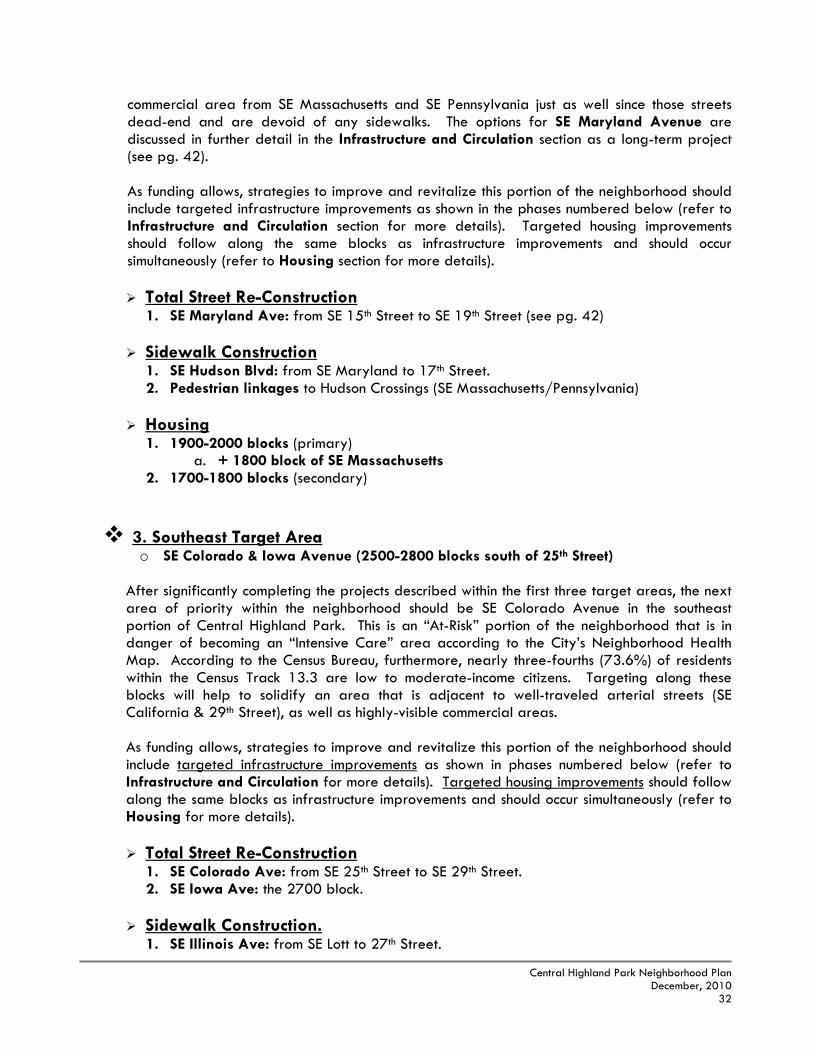
As funding allows, strategies to improve and revitalize this portion of the neighborhood should include targeted infrastructure improvements as shown in the phases numbered below (refer to Infrastructure and Circulation section for more details). Targeted housing improvements should follow along the same blocks as infrastructure improvements and should occur simultaneously (refer to Housing section for more details). Total Street Re-Construction/Housing.
1. SE 25th Street: from SE Adams to Virginia Avenue. 2. SE Massachusetts Ave: from SE 25th to SE 28th Street. 3. SE Pennsylvania Ave: from SE 26th to 29th Street. 4. SE Maryland Ave: from SE 25th to 29th Street. 5. SE Adams Street: from SE 25th to 29th Street (mill & overlay 2010).
The image above left is located along the 2600 block of SE Pennsylvania, while the image above right is located at the intersection of SE 25th Street and Massachusetts Avenue. As one can see clearly, storm water collects in front yards and is not absorbed or carried away to sewer lines fast enough. Combined with the lack of curbing and sidewalks, these streets become very dangerous for pedestrians and motor vehicle drivers.

Central Highland Park Neighborhood Plan
December, 2010 31
1b. West Central Target Area o SE Adams, Massachusetts, Pennsylvania, & Maryland Avenue (2100-2400 blocks
north of 25th Street) This area north of SE 25th Street should capitalize and build upon the investments made within the Southwest Target Area. However, the housing and property values are more stable in this portion of the neighborhood and it is not located near any anchor areas or school pedestrian routes as much as the Southwest Target Area. This area should be considered as an additional investment area to the Southwest area that could be addressed with the creation of a benefit district. The objective with this option is to address several strategic blocks, such as the 2400 blocks just north of SE 25th Street in order to capitalize upon existing improvements. It should not be considered for significant investment with public tax dollars unless additional private investment for the re-construction of streets, curbs and sidewalks will be used to leverage this assistance beyond the 2400 blocks. As funding allows, strategies to improve and revitalize this portion of the neighborhood should include targeted infrastructure improvements as shown in the phases numbered below (refer to Infrastructure and Circulation section for more details). Targeted housing improvements should follow along the same blocks as infrastructure improvements and should occur simultaneously (refer to Housing section for more details). Total Street Re-Construction/Housing.
1. SE Massachusetts Ave: the 2200 & 2400 block. 2. SE Pennsylvania Ave: from SE 21st to 25th Street. 3. SE Maryland Ave: from SE 21st to 25th Street. 4. SE Adams Street: from SE 21st to 25th Street (mill & overlay 2010).
2. Northwest Target Area o 1900-2000 SE Adams, SE Massachusetts, SE Pennsylvania, SE Maryland Ave & SE
Hudson Blvd
Targeting within the northwest portion of the neighborhood should focus upon blocks that are adjacent to recent and/or potential new construction of commercial and housing developments. While the infrastructure needs in this portion of the neighborhood are not as severe as in other locations, the area is still designated as “At-Risk” by the Neighborhood Health Map and housing conditions are below-average. The homeownership rate in the 1700-1800 blocks from SE Adams to Pennsylvania Avenue is greater than 50% and should be protected from any uncertainty caused by changing land uses and poor housing conditions around it. By revitalizing existing housing and infrastructure along SE Adams, Massachusetts and Pennsylvania Avenue, and re-establishing these blocks as strengths within the neighborhood, this will have the effect of supporting private investments in the area and will help to secure more retail activity. A sidewalk and/or road widening project should be built along SE Hudson Boulevard leading to the new commercial area in order to improve pedestrian safety (see pg. 37). In addition, it is important to establish other necessary pedestrian linkages to the
Central Highland Park Neighborhood Plan
December, 2010 32
commercial area from SE Massachusetts and SE Pennsylvania just as well since those streets dead-end and are devoid of any sidewalks. The options for SE Maryland Avenue are discussed in further detail in the Infrastructure and Circulation section as a long-term project (see pg. 42). As funding allows, strategies to improve and revitalize this portion of the neighborhood should include targeted infrastructure improvements as shown in the phases numbered below (refer to Infrastructure and Circulation section for more details). Targeted housing improvements should follow along the same blocks as infrastructure improvements and should occur simultaneously (refer to Housing section for more details). Total Street Re-Construction
1. SE Maryland Ave: from SE 15th Street to SE 19th Street (see pg. 42)
Sidewalk Construction 1. SE Hudson Blvd: from SE Maryland to 17th Street. 2. Pedestrian linkages to Hudson Crossings (SE Massachusetts/Pennsylvania)
Housing
1. 1900-2000 blocks (primary) a. + 1800 block of SE Massachusetts
2. 1700-1800 blocks (secondary)
3. Southeast Target Area o SE Colorado & Iowa Avenue (2500-2800 blocks south of 25th Street)
After significantly completing the projects described within the first three target areas, the next area of priority within the neighborhood should be SE Colorado Avenue in the southeast portion of Central Highland Park. This is an “At-Risk” portion of the neighborhood that is in danger of becoming an “Intensive Care” area according to the City’s Neighborhood Health Map. According to the Census Bureau, furthermore, nearly three-fourths (73.6%) of residents within the Census Track 13.3 are low to moderate-income citizens. Targeting along these blocks will help to solidify an area that is adjacent to well-traveled arterial streets (SE California & 29th Street), as well as highly-visible commercial areas. As funding allows, strategies to improve and revitalize this portion of the neighborhood should include targeted infrastructure improvements as shown in phases numbered below (refer to Infrastructure and Circulation for more details). Targeted housing improvements should follow along the same blocks as infrastructure improvements and should occur simultaneously (refer to Housing for more details). Total Street Re-Construction
1. SE Colorado Ave: from SE 25th Street to SE 29th Street. 2. SE Iowa Ave: the 2700 block.
Sidewalk Construction.
1. SE Illinois Ave: from SE Lott to 27th Street.

Central Highland Park Neighborhood Plan
December, 2010 33
2. SE 27th Street: from SE Indiana Ave to California Ave.
Housing 1. SE Colorado Avenue 2. SE Iowa Ave
4. East Central Target Area o SE Minnesota Ave (2100-2400 blocks south of 21st Street)
As discussed in the Sub-Area Profiles section, the blocks between SE Indiana and Minnesota Avenue exhibit deteriorating housing conditions and very poor infrastructure. Due to the design and construction of these subdivisions, many of the blocks east of SE Indiana Avenue exhibit a characteristically rural atmosphere with very low density housing. Due to this, the area has become isolated from the rest of the community and image and code enforcement problems have become common. Investment within this portion of the neighborhood, therefore, will require long-term planning and large-scale projects to make a difference in the quality of life within these blocks. This area should not be an immediate priority for public investment because of the relatively isolated conditions within these blocks and the need for public and private initiatives to integrate into a cohesive plan of action. Public investment in this area should begin first along SE Minnesota Avenue as this is an important “through” street that connects the interior parts of the neighborhood with SE 21st Street and California Avenue. One “outside-of-the-box” proposal that can provide the infrastructure, housing, and quality of life improvements this area of the neighborhood needs is discussed further below:
Biddle Creek “Daylighting” – The idea is to restore Biddle Creek to its natural state after a
storm sewer and drainage improvement project in 1961 channeled the beginning branches of Biddle Creek into reinforced concrete boxes, running approximately 1,800’ from south to northwest, where it then flows into the main leg of Biddle Creek. This channel drains over 658 acres of the surrounding neighborhood without any Best Management Practices (BMPs) implemented to treat runoff before it flows into the Shunganunga Creek and eventually to the Kansas River (the City’s drinking water supply). The project would implement a green storm water management system, open up new green space and possibilities for topographical reconfiguration that would give the neighborhood a distinctive character and offer potential for new infill residential development.
In fact, this portion of Biddle Creek runs through the middle of a residential area that the most sparsely developed and has poor housing conditions. The creek connects with Hillcrest Park and Community Center and would allow for a potential trail linkage for residents. The trail could also be linked to Highland Park High School, just blocks away on SE California. Significant property acquisition for public purposes, however, may be necessary and this is only an initial concept. A much greater planning and public participation process will need to be conducted in order to develop a more detailed plan, and grant funding sources will need to be identified before any movement can begin.
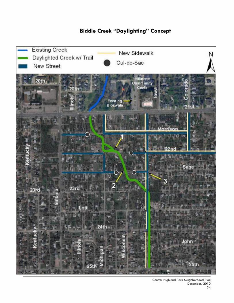
Central Highland Park Neighborhood Plan
December, 2010 34
Biddle Creek “Daylighting” Concept

Central Highland Park Neighborhood Plan
December, 2010 35
Images 1 & 2 illustrate the existing conditions along Biddle Creek and how it was “boxed-in” with concrete. The existence of the creek has been nearly forgotten and the more hidden and obscure areas of the creek have been the site for illegal dumping and abandoned vehicles, as shown in Image 2.
Small homes on small lots that front SE Minnesota Avenue are primarily rental properties that have become eyesores within the neighborhood. Properties such as these might possibly need to be removed for a street improvement project along SE Minnesota that will allow for improved safety and for the inclusion of a potential walking/biking trail in connection with Biddle Creek.

Central Highland Park Neighborhood Plan
December, 2010 36
The following recommendations will expand upon the Target Area Strategies previously discussed in the Plan to include the remainder of the neighborhood. Strategies related to citizen participation, neighborhood character and image, infrastructure, community facilities and safety are all critical to an environment of livability that emphasizes a traditional neighborhood quality of life. These strategies can add significant value to the “demand-side” of the neighborhood and are discussed in greater detail in the following pages.
As previously discussed in the Existing Conditions section, many blocks within Central Highland Park are lacking adequate infrastructure for an urban environment even along arterial and collector streets. While upgrading and repairing the entire neighborhood’s current infrastructure conditions will be costly, it will also be the most significant step to take in order to maintain private investment in the long-term. In order to improve the safety and quality of life for residents within Central Highland Park, priorities will have to be identified to make the most effective improvements first. The “guiding principles” identified during citizen input process, including the visual preference survey, include the following:
1. Safety (ditches and road width) 2. Busy Streets (arterials and collector streets with high traffic volume that
serve the entire neighborhood) 3. School Routes (kids walking or riding bikes to school) 4. Homeownership (density of single-family residences) 5. Commercial Areas (access or proximity to)
Basic Infrastructure – Street and circulation improvements should be prioritized by their adherence to the above guiding principles. Specific improvement projects following these guidelines are reflected in both the Target Area Strategies section and the Implementation section. The more general strategies to follow are outlined below:
o Total Street Re-Construction – While mill and overlay (pavement repair) of all
streets in the neighborhood is essential, simply re-paving streets will not be adequate to the needs of this neighborhood as many of these streets are not fully completed with basic infrastructure such as curbs and gutters or pavement width. These local streets are narrow and pose safety threats to pedestrians and motorists. A number of local and side streets are also extremely narrow and have unsafe elevation changes due to the existing culvert drainage systems. Streets that pose the most significant safety threats, therefore, should be at the top of the list for total street re-construction. This will entail new pavement, street widening (if necessary), construction of curb and guttering, grading and filling of the culvert drainage systems, and sidewalks on at least one side of the street. In some cases, the standard 29 foot width from the back of the curb on one side of the street, to the back of the curb on the other side could be modified so that the base of the street can remain intact. The road beds are generally well-compacted and can be re-
C. NEIGHBORHOOD-WIDE STRATEGIES
1. INFRASTRUCTURE & CIRCULATION

Central Highland Park Neighborhood Plan
December, 2010 37
used. A modified street width should be considered to further accelerate road development. “Green” street edges should also be considered as discussed further in this section. Installing curbs and gutters, along with storm inlets along all streets in the neighborhood will improve motorist and pedestrian safety, and will also increase the visual appeal of the neighborhood as well. The picture below left shows a foot bridge constructed by the adjacent homeowner over a ditch drainage basin as a sidewalk from the house to the street. This image rated poorly at a community survey meeting because it was not viewed as a permanent solution to the neighborhood’s needs. In some cases, greater engineering requirements will need to be met in order to widen the street or fill in the ditches to build sidewalks.
Above left: foot bridge constructed by the homeowner to access the street and the mailbox from the front of the house due to missing infrastructure. Above right: re-built curbs and gutters, and new sidewalks constructed at the intersection of SE 6th and 10th Avenue in the East Topeka neighborhood.
o Sidewalks & Safe Routes to School – Sidewalks should be completed along the entire length of the busiest streets in the neighborhood in order to affect the most people and provide a neighborhood-wide impact. These streets are the arterials and collectors of the area that carry the most traffic and are spaced within a 5 minute walk of most properties in the neighborhood - SE Indiana Avenue, SE 25th Street, and SE 29th. The next priority for sidewalks should be streets that lead to and from Highland Park Central Elementary School and St. Matthew School (see Sidewalk Priorities Map page 39). Priority should be given to streets that are ready to receive sidewalks with curbs/gutters already in place at least on one side of the block – this will accelerate their implementation and lower the cost. The first phase of Safe Routes sidewalks should be within a block radius of Highland Park Central including SE 27th and the 2500-2800 blocks of SE Kentucky, Illinois, and Michigan.
One project of special note is extension of a sidewalk along the east side of SE Hudson leading to the new commercial development at SE Adams and SE 15th. It would connect the residential blocks to the commercial services. It is very unsafe since there is limited site distance curving down the hill without shoulders; however, it is a costly project that may involve widening the street. There is also concern that public dollars should not fund it since the new commercial development generated

Central Highland Park Neighborhood Plan
December, 2010 38
the need. Either way, it is a need that should be addressed within the time-frame of this plan.
o Alleys – Although alley re-construction can improve traffic circulation and drainage of storm water, the need for street improvements in the neighborhood is simply too great to spend limited funding for concrete alleys. Most properties in the neighborhood do not use direct access from the alley and it is mainly used by garbage trucks on a regular basis. Alley re-construction, therefore, should be considered on a very limited basis when funding permits. Where possible, recycled concrete shavings from other streets in the City may be used as a “green” construction alternative.
o Pedestrian Lighting / Additional Street Lights – As part of the further effort to
improve the safety and image of the neighborhood and potential bikeways, decorative street lights should be installed along SE Indiana Avenue. Lighting glare along these roadways will need to be appropriate for a residential neighborhood instead of along a major thoroughfare. A funding source to cover the maintenance and ongoing electricity costs of the lights, however, has not yet been identified. The City of Topeka’s current energy provider (Westar Energy) will pay for the installation of additional mid-block standard street lights in low/moderate income neighborhoods, as long as the adjacent homeowner/s will pay the additional electricity costs.

Central Highland Park Neighborhood Plan
December, 2010 39

Central Highland Park Neighborhood Plan
December, 2010 40
“Green” Storm Water Infrastructure – As an alternative to the Basic Infrastructure techniques discussed in the previous pages, there exist other practical and attractive solutions to urban infrastructure problems that have a lesser impact upon the surrounding environment and landscape. One example of an alternative street-edge is a vegetated channel or bioswale with native plantings to filter storm water. Also known as infiltration swales, biofilters, grassed swales, or in-line biorentention, bioswales are vegetated open channels specifically designed to attenuate and treat storm water runoff before it reaches our creeks, rivers and lakes that we use for drinking and recreation.
Like open ditches, they convey larger storm water events from a source to a discharge point, but unlike ditches they intentionally promote slowing, cleansing and infiltration along the way. This helps to filter pollutant run-off before it travels into our waterways and slows down discharge into the storm water system, thus reducing erosion and potential flooding downstream. In some cases, it may be possible to incorporate features to enhance their pollutant removal or infiltration using small dams along the ditch that trap sediment and slow runoff. A sloped base to facilitate this water movement distinguishes vegetated channels from rain gardens. Vegetated channels typically cost less to construct than a standard curb and drainage pipe system, while also providing a greater amount of visual appeal and storm water infiltration than the existing open ditches currently found in Central Highland Park.
Important Note: Grassed channels still do not provide a level street edge that is needed for a greater level of motor vehicle and pedestrian safety in the neighborhood. A standard curb and pipe system would get rid of the open ditches and potentially allow for the widening of the street, which is needed along many blocks as the streets are too narrow for cars and pedestrians to pass safely. There are also maintenance issues with a grass channel. Ultimately, the City of Topeka and the Central Highland Park NIA will need to meet with landscape architects and other design professionals to develop a model program that establishes a list of appropriate plantings, maintenance techniques and construction ideas that will provide the neighborhood clear direction and ensure continuity among blocks that utilize this technique.
Above left: An example of an existing grassed channel in Downtown Topeka at SW 8th and Jackson Street. Above right: An existing bioswale within the Hillcrest Community Center parking lot used for storm water management.
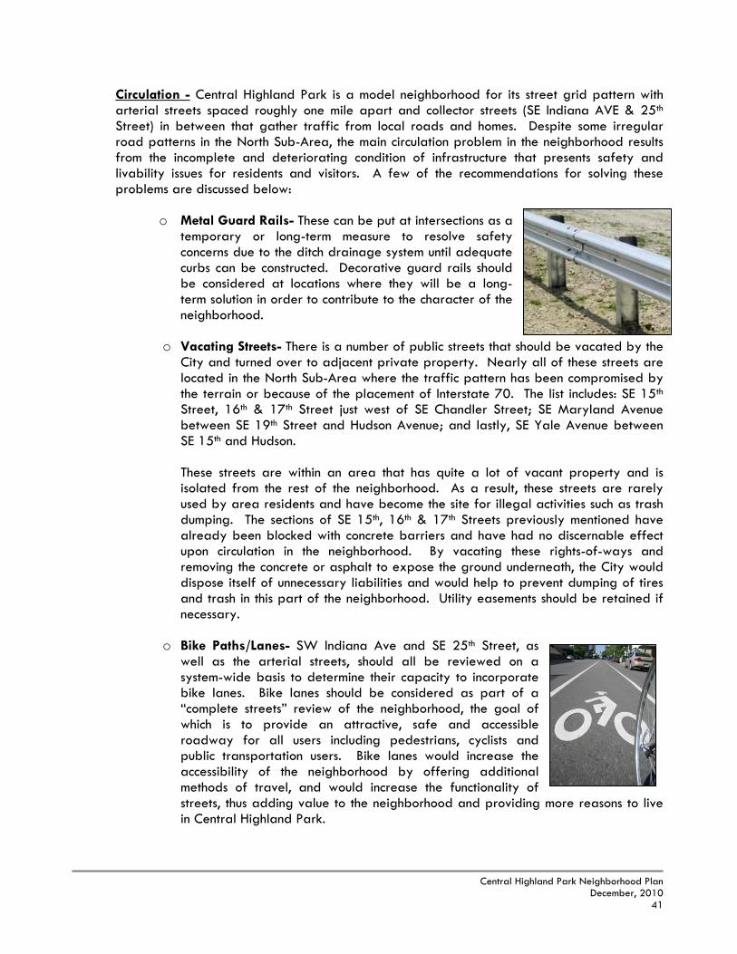
Central Highland Park Neighborhood Plan
December, 2010 41
Circulation - Central Highland Park is a model neighborhood for its street grid pattern with arterial streets spaced roughly one mile apart and collector streets (SE Indiana AVE & 25th Street) in between that gather traffic from local roads and homes. Despite some irregular road patterns in the North Sub-Area, the main circulation problem in the neighborhood results from the incomplete and deteriorating condition of infrastructure that presents safety and livability issues for residents and visitors. A few of the recommendations for solving these problems are discussed below:
o Metal Guard Rails- These can be put at intersections as a
temporary or long-term measure to resolve safety concerns due to the ditch drainage system until adequate curbs can be constructed. Decorative guard rails should be considered at locations where they will be a long-term solution in order to contribute to the character of the neighborhood.
o Vacating Streets- There is a number of public streets that should be vacated by the
City and turned over to adjacent private property. Nearly all of these streets are located in the North Sub-Area where the traffic pattern has been compromised by the terrain or because of the placement of Interstate 70. The list includes: SE 15th Street, 16th & 17th Street just west of SE Chandler Street; SE Maryland Avenue between SE 19th Street and Hudson Avenue; and lastly, SE Yale Avenue between SE 15th and Hudson.
These streets are within an area that has quite a lot of vacant property and is isolated from the rest of the neighborhood. As a result, these streets are rarely used by area residents and have become the site for illegal activities such as trash dumping. The sections of SE 15th, 16th & 17th Streets previously mentioned have already been blocked with concrete barriers and have had no discernable effect upon circulation in the neighborhood. By vacating these rights-of-ways and removing the concrete or asphalt to expose the ground underneath, the City would dispose itself of unnecessary liabilities and would help to prevent dumping of tires and trash in this part of the neighborhood. Utility easements should be retained if necessary.
o Bike Paths/Lanes- SW Indiana Ave and SE 25th Street, as well as the arterial streets, should all be reviewed on a system-wide basis to determine their capacity to incorporate bike lanes. Bike lanes should be considered as part of a “complete streets” review of the neighborhood, the goal of which is to provide an attractive, safe and accessible roadway for all users including pedestrians, cyclists and public transportation users. Bike lanes would increase the accessibility of the neighborhood by offering additional methods of travel, and would increase the functionality of streets, thus adding value to the neighborhood and providing more reasons to live in Central Highland Park.

Central Highland Park Neighborhood Plan
December, 2010 42
o SE California Avenue- SE California Avenue may be the single most important image corridor for the “Highland Park” area and the east side of the City. The medians south of SE 21st Street should be re-built and improved with decorative brick inlays and landscaping in order to increase appeal along this thoroughfare. This would be a continuation of median improvements that begin from the I-70 off-ramp along SE California Avenue to SE 21st Street, an example of which is pictured at right. No additional turning lanes or expansion of the street are anticipated due to limited right-of-way.
o SE Maryland Avenue- SE Maryland Avenue within the North sub-area is one of the poorest stretches of local streets within any neighborhood. It is very narrow running through a low draw with deep ditches and sparsely developed with deteriorated homes. It evokes an unsafe character due to its isolation which leads to higher than normal crime and illegal dumping of trash, tires, etc. It contributes to the destabilization of the otherwise decent blocks to the west and east and leads directly to the new commercial development, including a potential grocery store, in a Tax Increment Financing district nearby. As of now, the street is rarely used and its image discourages private investment in nearby blocks.
There is some question as to the need for this street given its function. It may be better to vacate the street and acquire properties for stormwater purposes as a drainage easement. But it would seem too unsafe to plan a trail through a wooded park-like drainage area without significant improvements. Alternatively, significant public investment could be made by cutting across the corner of SE 19th, widening the street, replacing the ditches with curbs, placement of a wide sidewalk/trail on one side, and adding more lighting. Maybe if the two approaches were combined, SE Maryland could be used as a model for neighborhood “green” stormwater infrastructure as discussed in this section and seek funding through environmental grant sources. This way a safe passable street for vehicles and pedestrians could be put in place with stormwater detention and filtering techniques integrated.
SE California Ave & 21st St
SE Maryland Ave & 19th

Central Highland Park Neighborhood Plan
December, 2010 43
o SE Minnesota Avenue - SE Minnesota Avenue, between SE 21st & 25th Street, suffers from a poor image due to the narrow unsafe conditions of the street, as well as the presence of deteriorated homes on small lots. Several of the intersections along this stretch of SE Minnesota have narrow turning radii that are difficult to maneuver for large vehicles such as school buses or fire trucks. Redevelopment along SE Minnesota Avenue should occur whether or not this is an identified Target Area. A street improvement project to widen the street, install curbs and gutters as well as yield or stop signs at all intersections, and mill and overlay of the street pavement should be addressed within the time-frame of this plan. As previously discussed in the Proposed Target Areas section in connection with the “daylighting” of Biddle Creek, acquiring property for additional right-of-way may
be necessary in order to widen the street, install sidewalks as well as a potential walking/biking trail. Planned City funding to improve SE Minnesota itself could be used to leverage grant funding for the “daylighting” portion of the project. The image to the left is the intersection of SE Sage and Minnesota Ave and illustrates the deep ditches along this road which create hazardous driving conditions.
Community Building is a key part of a neighborhood revitalization strategy because its focus is on making the neighborhood a stronger advocate for itself. Empowering the residents and institutions of a neighborhood with the notion that they can foster change that impacts the neighborhood in a positive manner is one of the goals of community building. Two aspects of community building – organizing & public safety – are explored below to help create a better sense of community. Organizing - Successful organizations have the wherewithal to succeed. A neighborhood’s ability to complete a competitive grant application, run successful meetings that are open to all residents of the neighborhood, and complete projects in a timely manner demonstrates to decision makers and funding organizations that the neighborhood is serious about getting things done. Ideally, the neighborhood should function like a business. Below are strategies to increase organizational capacity:
o Neighborhood Improvement Association Meetings: The City supports regularly scheduled meetings between neighborhood improvement association officers and citizens to increase awareness in the neighborhood.
2. COMMUNITY BUILDING

Central Highland Park Neighborhood Plan
December, 2010 44
o Neighborhood Empowerment Initiative: This grant program through the City of Topeka funds public facility and infrastructure projects. Grants will encourage a match by the neighborhood organization or a match generated in the form of volunteer labor. NIA’s that are currently receiving target area assistance (i.e., Chesney Park and Ward-Meade for the years 2010 & 2011) are not eligible for this program. The final allocations of these project funds are made by the City Council.
o Education and Training: NIA leaders should consider attending seminars and
conferences that deal with community building, neighborhood revitalization and other community issues. As an example, Neighborhoods USA holds an annual conference and the Neighborhood Reinvestment Training Institute conducts a number of training conferences every year as well. It is recommended that the NIA and City explore ways to encourage neighborhood leaders to attend.
o Strength in Numbers: When opportunities present themselves for the neighborhood
to appear before decision makers, the neighborhood must be able to demonstrate a unified voice with a large number of people. The NIA’s monthly newsletter is currently used as a way to rally supporters and to notify residents of activities taking place in the neighborhood.
o Social Activities: Fun activities that bring neighbors together are an important
element of a strong neighborhood. Fourth of July block parties bring neighbors together, as well as other events such as pancake feeds, potlucks, and neighborhood socials with live music and games held at the Park.
Public Safety - A major goal of this Plan is to create a safe, clean and livable environment for all residents of Central Highland Park to live, learn, work and play. A crime problem is a multifaceted issue. There is no magic solution that is going to erase the occurrence or even the perception of crime within the community. Implementing the revitalization strategies described previously will go a long way towards making the neighborhood safer for residents of the area. In the short-term, however, here are a few programs and activities that citizens can do to reverse the negative cycle of crime and begin to reclaim their neighborhood.
o Neighborhood Watch Program: Neighborhood Watch is an organized partnership between the community, law enforcement, and Safe Streets. Community members serve as the eyes and ears for law enforcement reporting suspicious activity, holding neighborhood meetings, and establishing a relationship with their community officer.
o Young Citizens Academy: Sponsored by Safe Streets of Topeka, the academy strives to bring together a diverse group of 7th and 8th grade students to teach them about goal setting, achievement, citizenship, life choices, and healthy choices about drug and alcohol use.
o Citizen Patrols: The neighborhood should continue public safety activities such as
“Stroll Patrols” that put more “eyes” on the street and discourage crime from happening in the area. The Citizen Patrol Coalition of Topeka-Shawnee County is a program to assist law enforcement in their fight against neighborhood crime, and

Central Highland Park Neighborhood Plan
December, 2010 45
residents can apply to become members. The desired effect of Citizen Patrol is to increase the cooperation of private citizens with law enforcement to watch, record, and report crime throughout the City.
o Takeover / Makeover (Neighborhood Clean-Up): The neighborhood should continue
to take part in annual clean-ups such as the Takeover/Makeover event in which the City of Topeka and Shawnee County Refuse and Waste Management will haul away specific types of trash & debris that is placed at the curb in front of area properties at no cost. The event is a good capacity-building event in which individuals volunteer their manpower to help improve the neighborhood. They are also important in order to avoid environmental code problems as well as deterring crime by showing that residents care about the appearance of their neighborhood.
o Westar Energy Inc., will pay for the installation of standard street lights within
low/moderate income neighborhoods for individual homeowners who are then required to pay the monthly electricity costs (varies).
o Crime Prevention through Environmental Design (CPTED): Safe Streets and the
Police Department can help the neighborhood determine which property configurations discourage criminal activity. For example, the “5 & 2” rule states that trees should be trimmed to at least five feet high and bushes should be trimmed so that they are no higher than two feet tall as well.
o Crime Free Multi-Housing Program: The Topeka Police Department, Safe Streets
and the City’s Code Compliance department have teamed up to provide landlords with free education in keeping their tenants safe and preventing crimes against their properties. The program uses a three-step process to help landlords and property managers make their units secure, prevent and identify drug operators, screen tenants effectively and learn about liability laws. The three steps landlords must take to earn certification as a Crime Free Multi-Housing property are to complete the eight-hour class, have a property inspection by code compliance services and police, as well as conduct a “Safety Social” for residents of the rental property at least once a year.
o Neighbor to Neighbor Volunteers: The “broken windows” theory states that the
presence of even the slightest traces of neglected property such as broken windows can cause a ripple effect in which other adjacent property owners lose confidence in the neighborhood or where criminals begin to prey upon areas that “don’t care.”
This can be prevented through volunteer “neighbor to neighbor” programs that address smaller housing maintenance issues – painting, porches, gutters, etc. – that prolong the life of the existing housing stock and prevent the “broken windows” cycle. The NIA could also utilize existing volunteer rehab programs such as Rebuilding Together in order to accomplish the same purpose. Local businesses, churches and individuals donate money for materials used to repair homes for elderly residents who cannot afford to make the repairs themselves.
o Code Enforcement: Enforcement of housing, zoning, and environmental codes is an ongoing city-wide program that is used to assure a minimum level of maintenance

Central Highland Park Neighborhood Plan
December, 2010 46
and compatible uses of properties occur. In light of the high number of conversions and absentee landlords in the neighborhood, the enforcement of these codes can be an effective tool when combined with programs that encourage owners to participate in the rehabilitation process.
Youth & Education – Youth are critical for the ongoing revitalization of the neighborhood. As these children grow up and are faced with choices about where to live, they are going to be more inclined to stay in the neighborhood if they had good experiences growing up in a place that provide a positive environment. If Central Highland Park is “kid-friendly”, it will have the two-fold benefit of attracting/retaining families in the short-term and becoming assets to the community in the long-term. Support expanded capacity of the Antioch Family Life Center to offer mentoring, tutoring
and recreational support of youth in the neighborhood. The Center currently offers one-on-one tutoring to school age students during the school year. Students are picked up from nearby elementary schools and brought to the AFLC. Tutors from Washburn University provide the tutoring and recreational activities for these students. A small fee is required to be paid on a weekly basis and includes a snack for each day. Support after-school programs at Highland Park Central Elementary that provide
valuable learning experiences that can help students achieve in higher education. Encourage youth to help with neighborhood clean-ups. Develop a mural or art project within the community that utilizes the talents of youth.
When City funds are used, priority investments into housing rehabilitation should be focused in the areas outlined in the Target Area Strategies section previously recommended in the Plan. Upgrading houses in a randomly dispersed pattern only dilutes the impact upon the neighborhood and will not lead to any spin-off effect in nearby blocks. In the case of the Central Highland Park neighborhood, housing rehabilitation efforts should follow the direction of targeted infrastructure improvements (see Infrastructure and Circulation page 36) due to the fact that housing concerns were expressed as a lower priority during meetings with the NIA and its residents. This is supported by the Housing Conditions Table (Appendix) and Map that show relatively favorable conditions in the neighborhood (only 3% of all structures have Major Deficiencies). The following programs are administered with federal funds through the Housing and Neighborhood Department (HND) of the City of Topeka on an income-eligible basis for low/moderate income households:
o Housing Rehabilitation - This HND program is intended for both low-income owner
and renter-occupied properties in need of interior and exterior repairs within selected target areas. Additional funding is geared towards owner-occupied units. Funds may also be provided to assist with lead-paint controls and weatherproofing. The assistance, however, may be available to properties that have documented historic significance and are in need of exterior repairs.
o Emergency Repairs - Emergency home repair assistance (primarily repairs that are
of an immediate health or safety nature) can be provided for low income owner-
3. HOUSING

Central Highland Park Neighborhood Plan
December, 2010 47
occupants throughout the neighborhood. This assistance is intended for higher cost, major emergency repairs. Minor maintenance and repairs remain the primary responsibility of the homeowner.
o Accessibility Modifications - This assistance is available to income-qualified persons
with disabilities throughout the City, whether they are owner-occupants or tenants. This assistance is intended to provide access into and out of the home. The priority is to build exterior ramps, widen doorways, and provide thresh-holds.
o KDOC Affordable Housing - This program is a cooperative venture with the Kansas
Department of Corrections, in which KDOC provides women inmates, tools and equipment to form two crews for the rehabilitation of affordable housing units and sidewalk improvements.
o TOTO-II - Assistance is provided as a 2nd mortgage, deferred loan subsidizing the
purchase and rehab costs of a home for families at or below 80% of median income. While the program is available Citywide, it is structured to encourage home purchases in at-risk and intensive care areas. Homeownership and debt counseling assistance are provided by Housing and Credit Counseling Inc. Lending institutions participate by managing the maintenance escrow.
o Neighborhood Revitalization Program - The City offers a 10-year 95% property
tax rebate for improvements that increase the value of the property by more than 10%. The rebate period can be extended up to 15 years for historic landmark properties. Improvements must be consistent with the adopted design guidelines for the neighborhood. The City’s Planning Department administers the program.
o Land-Banking - Land Banks are governmental or nonprofit entities that acquire,
temporarily retain ownership, manage and dispose of tax-delinquent or abandoned property. They can also receive property or resources through donations or direct transfers from other governmental agencies. They are granted the authority to facilitate the resale of these properties or execute a redevelopment plan to mitigate the negative impacts that abandoned properties have on communities and neighborhoods by achieving long-term planning goals such as fulfilling affordable housing provisions and creating a stronger tax base. However, lengthy state or local foreclosure processes and methods to obtain clear titles to these properties can often prolong redevelopment efforts.
The Land Bank Entity WILL: Consolidate responsibility for the management, marketing and sale of
abandoned property within a single agency with resources and staff. Adopt universal sales policies and priorities with input from the Land Bank
Board of Trustees.

Central Highland Park Neighborhood Plan
December, 2010 48
The Land Bank Entity WILL NOT: The land bank WILL NOT utilize condemnation through eminent domain to take
property from one private individual and transfer it to another private individual.
The Land Bank WILL NOT be a vehicle for the City Of Topeka or Shawnee County to acquire and retain permanent ownership of property.
o Infill Development - Funds can be used to facilitate and support housing development by providing infrastructure development, land acquisition, clearance, demolition, site development, housing construction, soft-second mortgages, closing cost assistance and construction-related associated costs. The land could be held and marketed for development at a future date that adheres to the objectives of the Plan. Demolition and re-construction will need to be coordinated through HND in order to ensure expenditures follow federal regulations.
An opportunity for infill housing exists within City-owned land that is part of Hillcrest Park along SE Indiana near Interstate 70. The City should explore the opportunity of selling the land to either a for-profit or not-for-profit housing agency that will build single-family/duplex housing units with the goal of increasing homeownership. There may, however, be soil and terrain issues that will prohibit the construction of basements, as well as title issues associated with the property. Please refer to the Future Land Use Plan on page 24, as well as the Preferred Housing Types section on page 50 for more details.
o Historic Designation / Rehabilitation – Historic designations are recommended for homes that have identified significant architectural features, or social or cultural connections that are important to the history of local or national landscape. Historic designations may come in the form of both individually-listed properties or in a group of properties that have identified historic significance. There are state and national designations for both residential and commercial buildings that carry economic incentives for rehabilitation. A state or national designation may be viable for some of the neighborhood’s earliest development related to Joseph Kennedy Hudson, as well as the Carruth House on the St. Matthew Catholic Church and School grounds.
A Local Landmarks designation could also be utilized as a viable alternative, either for a historic district or for properties listed individually. This is a program started by the Topeka Landmarks Commission that recognizes residential properties that have historic architectural or cultural significance. It is a voluntary designation and does not require ‘environs’ that place limits on adjacent properties as do buildings listed in the State or National Register of Historic Places. This designation is simply a matter of pride for the homeowner and represents a demonstrated commitment to historic preservation. Local landmarks, however, must still maintain their architectural integrity and requires approval by the Landmarks Commission for exterior alterations. The designation is applied as an overlay zoning district and can only be approved or removed through the City’s zoning procedures.

Central Highland Park Neighborhood Plan
December, 2010 49
Above left: the Carruth House used by the St. Matthew Church Parish, which is private ground and is not a registered historic property. This was the original site of Joseph Hudson’s cabin in the neighborhood. Above right: 2844 SE Maryland, which is designated as a Local Landmark.
o Voluntary Demolition – Assistance may be provided for the demolition of
substantially deteriorated and vacant structures. The intent is to remove blighted structures that are beyond feasible repair (i.e. the cost to rehabilitate is more than 30% of the replacement value). For those structures that are privately owned, the City may institute a method of repayment for the demolition services provided, yet would not gain ownership of the property in question.

Central Highland Park Neighborhood Plan
December, 2010 50
Preferred Housing Types (Based on Visual Preference Surveys Conducted on April 19th, April 26th, and May 3rd, 2010).
This 1 1/2-story traditional bungalow, built circa 1920, rated highest among a survey of housing preferences in the neighborhood. Notice the multiple gables for the roof, front porch with columns, window trimming, and a detached garage in the rear.
This one-story affordable home also rated very well among the same housing preference survey. Notice the multiple front gables and fish-scale siding above the front porch. This house also had an attached garage in the back, which can provide an additional sense of safety for residents.
Within more traditional neighborhoods this manufactured home would not be a preferred housing type. Due to the varied housing patterns in Central Highland Park, however, this home would be a major improvement over other prefabricated housing styles in the neighborhood and rated well in the community survey. One recommendation: the garage should be set back behind the front face of the house, or should be a side-entry garage.

Central Highland Park Neighborhood Plan
December, 2010 51
Despite the large size of Hillcrest Park, there is very minimal public park space and children’s play areas within a 5-minute walk for a majority of the neighborhood. In fact, for such a large neighborhood, open space accounts for only 4% of the total land area and most of that includes the Community Center’s property. The only other centrally-located park space in the neighborhood is Jayhawk Park, which is a mere half-acre in size at SE Lott and Michigan Avenue. Highland Park Central Elementary School and the Antioch Family Life Center have open space and children’s play areas, but they are not accessible to the public. The Boys and Girls Club across SE Adams Street, however, has open space and holds recreational activities for youth just west of the neighborhood.
Recommendations. Increase access to neighborhood park space so that it is not necessary to cross arterial streets by:
1) Acquiring vacant property on a voluntary basis over time that is accessible to the areas of the neighborhood currently lacking open space within a 5 minute walk. The area bounded by SE Indiana, Adams, 21st, and 25th Street should be the first priority. This type of park space should be designed more as a “tot-lot” that caters to pre-school and early grade school children. 2) Designing new park space with public or private improvement projects. Several opportunities for this exist including the vacant property north of HPC Elementary school at SE 27th and Indiana, the Biddle Creek “Daylighting” project, and the SE Maryland project in the north sub-area. The latter two projects could function as a linear parkway with accompanying pedestrian/bike trails, natural vegetation, and water features.
While the Hillcrest Community Center and Park has excellent indoor and outdoor recreation facilities, as well as a large amount of passive open space, there are still opportunities for improvement and land available for new recreational equipment and activities. One such opportunity exists upon empty land within the Park just north of the Community Center parking lot and basketball courts, which is also in a clear and visible location from the Community Center. The City should look into the possibility of including multi-use athletic fields (e.g., soccer field, baseball fields) in order to take advantage of the Park’s size and to fill community needs. This could also be the location for an all-weather building such as the Big Gage Shelter House at Gage Park that can be rented and used for community events, family group gatherings, and non-profit events. The shelter house should have amenities such as heating, air conditioning, stove, refrigerator and indoor restrooms.
Big Gage Shelter House
4. PARKS, OPEN SPACE & RECREATIONAL FACILITIES

Central Highland Park Neighborhood Plan
December, 2010 52
“Success is not final, failure is not fatal; it is the courage to continue that counts.”
Winston Churchill
After all that is written of what should be done, the reality is that it means nothing unless something is done. The implementation of the goals and strategies in the plan becomes the measuring stick for the success of a plan. The purpose of this section is to provide a “framework for action” that outlines how the community’s vision for Central Highland Park can be realized over the next 10 years and the costs and responsibilities that may be incurred along the way. This section should be used by all stakeholders to guide their decision-making implementing the priorities of the Plan.
The community was surveyed at two meetings held on August 25th at the Hillcrest Community Center, and September 27th, 2010, at Highland Park High School to determine their priorities for implementing specific strategies and actions of this Plan. The actions below are organized based on the rankings received at that meeting as well as stakeholder meetings held since April, 2010. They are not necessarily inclusive of all potential actions, but a checklist of some of the more major actions that should be undertaken. The final tally of results for this survey is located in the Appendix.
1. Do These First Infrastructure
1. SE 25th Street – Curbs and Gutters (Adams to Virginia) and Sidewalk (Adams to California) 2. SE Indiana – Sidewalk (23rd-29th) and Sidewalk (20th to 21st) 3. SE Massachusetts – Curbs, Gutters, and Sidewalk (25th to 29th) 4. SE Pennsylvania – Curbs, Gutters, and Sidewalk (25th to 29th) 5. SE Maryland –Curbs, Gutters, and Sidewalk (25th to 29th)
Other 1. Re-zoning of local residential streets to R-2 (Single Family) 2. Use eligible CDBG housing funds under SORT program for new streets 3. Target remaining housing funds for rehab/infill on SE Mass, Penn, and Maryland (25th to 29th)
2. Do These Next Infrastructure
1. Safe School Routes I – Sidewalks w/in 2 blocks of school connecting to 25th and 29th a. 27th Street (Maryland to California) b. Illinois (25th to 27th) c. Kentucky (25th to 29th) d. Michigan (25th to 26th)
VI. IMPLEMENTATION
A. KEY ACTION PRIORITIES
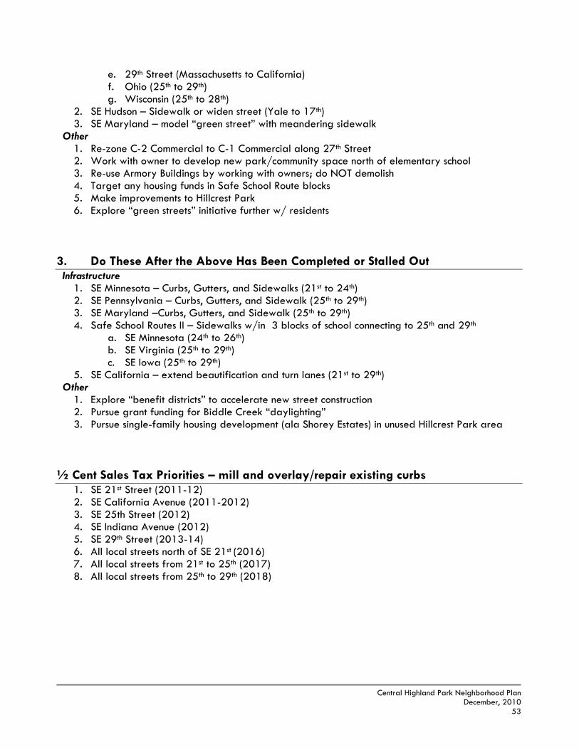
Central Highland Park Neighborhood Plan
December, 2010 53
e. 29th Street (Massachusetts to California) f. Ohio (25th to 29th) g. Wisconsin (25th to 28th)
2. SE Hudson – Sidewalk or widen street (Yale to 17th) 3. SE Maryland – model “green street” with meandering sidewalk
Other 1. Re-zone C-2 Commercial to C-1 Commercial along 27th Street 2. Work with owner to develop new park/community space north of elementary school 3. Re-use Armory Buildings by working with owners; do NOT demolish 4. Target any housing funds in Safe School Route blocks 5. Make improvements to Hillcrest Park 6. Explore “green streets” initiative further w/ residents
3. Do These After the Above Has Been Completed or Stalled Out Infrastructure
1. SE Minnesota – Curbs, Gutters, and Sidewalks (21st to 24th) 2. SE Pennsylvania – Curbs, Gutters, and Sidewalk (25th to 29th) 3. SE Maryland –Curbs, Gutters, and Sidewalk (25th to 29th) 4. Safe School Routes II – Sidewalks w/in 3 blocks of school connecting to 25th and 29th
a. SE Minnesota (24th to 26th) b. SE Virginia (25th to 29th) c. SE Iowa (25th to 29th)
5. SE California – extend beautification and turn lanes (21st to 29th) Other
1. Explore “benefit districts” to accelerate new street construction 2. Pursue grant funding for Biddle Creek “daylighting” 3. Pursue single-family housing development (ala Shorey Estates) in unused Hillcrest Park area
½ Cent Sales Tax Priorities – mill and overlay/repair existing curbs
1. SE 21st Street (2011-12) 2. SE California Avenue (2011-2012) 3. SE 25th Street (2012) 4. SE Indiana Avenue (2012) 5. SE 29th Street (2013-14) 6. All local streets north of SE 21st (2016) 7. All local streets from 21st to 25th (2017) 8. All local streets from 25th to 29th (2018)

Central Highland Park Neighborhood Plan
December, 2010 54
The tables below show the cost and timing of infrastructure improvements for the proposed target areas and other infrastructure recommendations of the plan. By combining several major actions within a concentrated area of a neighborhood, a greater cumulative impact can be realized than if they were dispersed throughout the larger planning area. In this manner, it is intended that multiple target areas can be worked on in various stages of completion. Once the first area is “finished”, the majority of the public investment can then be shifted to the second area, then the third, etc. A unique recommendation for Central Highland Park supported by citizen input is the desire to devote more funding to infrastructure than housing. Housing funds through federal funding allocations to the City of Topeka for rehabilitation and potential infill housing should still be applied to target areas but only after any eligible portions of the CDBG funding could be re-directed to infrastructure needs in that area. Also due to the size of the area, the NIA should explore funding applications for more than one target area. Important Note: The priorities and costs estimates for infrastructure and housing rehabilitation projects in the neighborhood are provided for informational purposes only and should not be relied upon for future costs or as actual bids for future projects. Increases in material costs, overhead and labor can change greatly in a short period of time. Funding is subject to availability as provided by federal grants and the governing body, and allocations change annually. The housing costs in the following tables represent subsidies from City Consolidated Plan funding (CDBG/HOME) and are intended to leverage private dollars. Costs for infrastructure and parks reflect City of Topeka capital costs from sources typically found within the City’s Capital Improvement Program (CIP), unless otherwise indicated. Cost assumptions are detailed at the bottom of this section.
Safe Routes to School - The following is a list of streets that are classified as primary walking routes or feeder walking routes to Highland Park Central Elementary School (as well as St. Matthew Catholic School) as designated by USD 501 (see Sidewalk Priorities Map). The blocks listed below already have curbs in place, which makes it much more feasible for sidewalk construction to occur before all other areas.
B. TARGET AREAS

Central Highland Park Neighborhood Plan
December, 2010 55
SW Target Area
NW Target Area
SE Target Area

Central Highland Park Neighborhood Plan
December, 2010 56
EC Target Area
WC Target Area
Assumptions (costs are approximate): Costs measured in linear feet. Average block length in Central Highland Park = 600 ft. Total street re-construction (pavement, curb & gutter, sidewalk, grading, etc.) = $228,000. Alleys w/sewer = $80,000 per block; w/o sewer = $60,000 per block. Curbs & gutters (concrete) = $32 per linear foot, both sides of street where needed. Mill & overlay (street re-pavement) = $17,000 per block. Sidewalks (concrete) = $32 per linear foot; one side of street unless otherwise indicated. Benefit Districts The Neighborhood Improvement Association and its residents should explore the possibility of developing one or more voluntary “Benefit Districts” or “Special Districts” in which property owners, usually within a single block or neighborhood area, group together to pay the costs associated with a public improvement such as associated with streets. With the addition of public resources to be used for arterial/collector streets that receive heavier traffic, as well as selectively targeted local streets that pose safety hazards, the creation of one or more Benefit Districts for the development of streets, curbs and sidewalks will greatly accelerate the revitalization of the neighborhood, and will also leverage and provide justification for the use of public investment within the Central Highland Park neighborhood. The costs of a District are distributed equally among property owners and are phased in over a period of 20 years in the form of higher property taxes, including interest payments. The improvements will take place immediately (as scheduling permits) and is normally associated with improvements that have a local property owner interest, thus a majority (51%) of property owners in the improvement area will need to voluntarily agree to the district. The creation of a Benefit District allows property owners direct control over what improvements are made to their area of the neighborhood and does not rely upon the City to be the sole funding source for the development of these improvements.

Central Highland Park Neighborhood Plan
December, 2010 57
Since local infrastructure such as curbs and sidewalks that front residential properties are normally paid for by adjacent property owners in the form of housing costs, the Central Highland Park area is in a unique position because this infrastructure was not in place when many of the homes in the neighborhood were constructed. Central Highland Park was originally meant to be a very low-density neighborhood in which urban infrastructure was not constructed in order to keep housing costs low. This has created a conundrum now that the neighborhood has become more populated with sanitary sewer utilities. While housing costs in Central Highland Park are lower than other parts of the City, property owners also have a lower average income, which makes it difficult for residents to shoulder the entire costs of improving infrastructure along local streets.
There are a number of areas within the neighborhood where existing land uses are zoned higher than their existing land use and would be inconsistent with the Future Land Use Plan. For example, many blocks north of SE 21st Street from SE Adams Street to Maryland Avenue, as well as the 2100 blocks from SE Virginia to Indiana Avenue are zoned for multiple-family purposes but are primarily single-family residential housing. The same is true for the 2600-2700 blocks from SE Ohio to Indiana Avenue, which are zoned for two-family purposes. Where single-family properties have a zoning classification inconsistent with the Future Land Use Plan, a re-zoning initiated by the Planning Commission is recommended. In the “mixed use” area along SE 27th on the interior streets of the neighborhood, the commercial properties should have a zoning classification no higher than “C-1” Commercial as supported by the land use principles of the Comprehensive Plan and recommended in the Future Land Use Plan. A re-zoning should be initiated by the Planning Commission to reflect as such. The Proposed Zoning Map on the next page illustrates potential zoning patterns in the neighborhood based upon these modifications.
C. RE-ZONING

Central Highland Park Neighborhood Plan
December, 2010 58
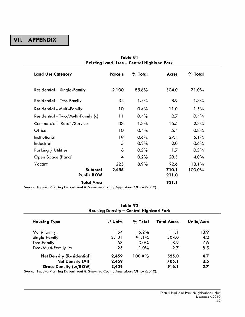
Central Highland Park Neighborhood Plan
December, 2010 59
Table #1 Existing Land Uses – Central Highland Park
Land Use Category Parcels
% Total Acres
% Total
Residential – Single-Family
2,100
85.6%
504.0
71.0%
Residential – Two-Family
34
1.4%
8.9
1.3%
Residential - Multi-Family 10 0.4% 11.0 1.5%
Residential - Two/Multi-Family (c) 11 0.4% 2.7 0.4%
Commercial - Retail/Service 33 1.3% 16.5 2.3%
Office 10 0.4% 5.4 0.8%
Institutional 19 0.6% 37.4 5.1% Industrial 5 0.2% 2.0 0.6%
Parking / Utilities 6 0.2% 1.7 0.2%
Open Space (Parks) 4 0.2% 28.5 4.0%
Vacant 223 8.9% 92.6 13.1% Subtotal 2,455 710.1 100.0%
Public ROW 211.0
Total Area 921.1 Source: Topeka Planning Department & Shawnee County Appraisers Office (2010).
Table #2
Housing Density – Central Highland Park
Housing Type
# Units
% Total
Total Acres
Units/Acre
Multi-Family 154 6.2% 11.1 13.9 Single-Family 2,101 91.1% 504.0 4.2 Two-Family 68 3.0% 8.9 7.6 Two/Multi-Family (c) 23 1.0% 2.7 8.5
Net Density (Residential) 2,459 100.0% 525.0 4.7 Net Density (All) 2,459 705.1 3.5
Gross Density (w/ROW) 2,459 916.1 2.7 Source: Topeka Planning Department & Shawnee County Appraisers Office (2010).
VII. APPENDIX

Central Highland Park Neighborhood Plan
December, 2010 60
Table #3 Housing Conditions – Central Highland Park
Housing Type Minor
Deficiencies Intermediate Deficiencies
Major Deficiencies Total
# Prop. % # Prop. % # Prop. % # Prop.
Multi-Family 8 77.8% 2 22.2% 0 0.0% 10 Single-Family 1,378 65.6% 662 31.5% 61 2.9% 2,101 Two-Family 17 50.0% 14 41.2% 3 8.8% 34 Two/Multi-Family (c) 4 36.4% 4 36.4% 3 27.3% 11
Total 1,407 65.2% 682 31.6% 67 3.1% 2,156 Source: Topeka Planning Department & Shawnee County Appraisers Office (2010).
Table #4 Housing Tenure – Central Highland Park
Housing Types Owner-Occupied Renter-Occupied Vacant Total
# Units % # Units % # Units % # Units
Multi-Family 4 2.3% 138 85.7% 17 11.0% 154 Single-Family 1,224 58.3% 771 36.7% 106 5.0% 2,101 Two-Family 2 2.9% 52 76.5% 14 20.6% 68 Two/Multi-Family (c) 2 8.7% 15 65.2% 6 26.1% 23
Total 1,232 53.4% 935 40.6% 138 6.0% 2,305 Source: Topeka Planning Department & Shawnee County Appraisers Office (2010). Vacancy estimates are considered to be conservative because the survey was limited to the exterior of the structure.
Table #5 Crime Rate per 1,000 Residents – City of Topeka and Sample NIAs
NIA 2000 Census
Pop. 2008
CRIMES ‘08 CRIME
RATE 2009
CRIMES ‘09 CRIME
RATE
Central Highland Park 5,158 283 54.8 293 56.8
Central Park 2,399 268 111.7 197 82.1 Chesney Park 1,392 130 93.3 117 84.0
East Topeka 5,380 411 76.3 375 69.7 Highland Crest 5,580 336 60.2 290 51.9
Historic Holliday Park 1,056 133 125.9 98 92.8 Old Town 2,798 319 114.0 269 96.1
Ward-Meade 2,330 146 62.6 178 76.3
CITY 122,554 7,975 65.0 7,449 60.7 Source: Topeka Police Department and Planning Department.

Central Highland Park Neighborhood Plan
December, 2010 61
Table #6 Median Residential Property Values – Central Highland Park
Land Use 2009 Median Value
Single-Family $48,100 Two-Family $49,900 Two / Multi-Family (c) $50,950
Multi-Family $75,950 Average Land Value / Acre $11,895
Source: Topeka Planning Department & Shawnee County Appraisers Office (2010). Land Value/Acre for residential property only.
Table #7 Average Annual Daily Traffic (AADT) & Accidents – Central Highland Park
Intersection
Classification
AADT
Accidents
SE Adams, south of 15th Street Arterial 12,640 19 SE Adams, north of 25th Street Arterial 11,000 7 SE California, south of 21st Street Arterial 16,625 13 SE California, north of 29th Street Arterial 14,865 16 SE 29th, east of Indiana Avenue Arterial 14,240 8 SE Indiana, north of 25th Street Minor Arterial 2,895 0
Source: Topeka Traffic Engineer (AADT 2007, Accidents 2008 & 2009).

Central Highland Park Neighborhood Plan
December, 2010 62
Table #8 Population & Race – Central Highland Park
Table #9 Age – Central Highland Park
2000 % 1990 % Change '90-'00 Population 5,336 100% 5,589 100% -4.5% Gender Female 2,759 51.7% 2,882 51.6% -4% Male 2,577 48.3% 2,707 48.4% -5% Race White 3,025 56.7% 4,083 73.1% -26% Black 1,196 22.4% 967 17.3% 24% Other 379 7.1% 113 2.0% 235% Hispanic 736 13.8% 426 7.6% 73%
2000 % 1990 % Change '90-'00Age Under 5 years 427 8.0% 446 8.0% -4.3% 5 to 9 years 421 7.9% 474 8.5% -11.2% 10 to 14 years 340 6.4% 364 6.5% -6.6% 15 to 19 years 340 6.4% 346 6.2% -1.7% 20 to 24 years 371 7.0% 365 6.5% 1.6% 25 to 34 years 714 13.4% 989 17.7% -27.8% 35 to 44 years 891 16.7% 704 12.6% 26.6% 45 to 54 years 733 13.7% 500 8.9% 46.6% 55 to 64 years 395 7.4% 577 10.3% -31.5% 65 and Over 704 13.2% 824 14.7% -14.6%
Total Persons 5,336 5,589
Median Age 35 Median Age Topeka 37

Central Highland Park Neighborhood Plan
December, 2010 63
Table #10 Households –Central Highland Park
Table #11 Income and Work – Central Highland Park
All Income figures in 2009 dollars. 2000 College 4 yrs. + for individuals 25+ yrs. of age. 2000 Unemployment Rate for Persons 16+ yrs. of age in Labor Force
2000 % 1990 % % Change '90-'00 Households 2,103 100% 2,138 100% -1.6% Families 1,150 54.7% 1,515 70.9% -24.1% Husband-Wife 879 41.8% 1,097 51.3% -19.9% Female-Headed w/child <18 271 12.9% 234 10.9% 15.8% Persons per HH 2.54 2.61 -2.9%Persons per Family 4.64 3.69 25.8%
2000 1990 % Change
Median Household Income $38,735 $37,400 4%Median Family Income $43,700 $42,630 2.5%Per Capita Income $17,870 $16,400 9.0%
Below Poverty % Persons 16.7% 17.5% -4.7% % Children <18 26.3% 30.1% -12.8%
Work & Education Persons (16+ yrs.) 63% 49.2% 29.0%College 4 yrs.+ 9.9% 9.6% 3.1%Unemployment Rate 5.7% 7.9% -28.5%
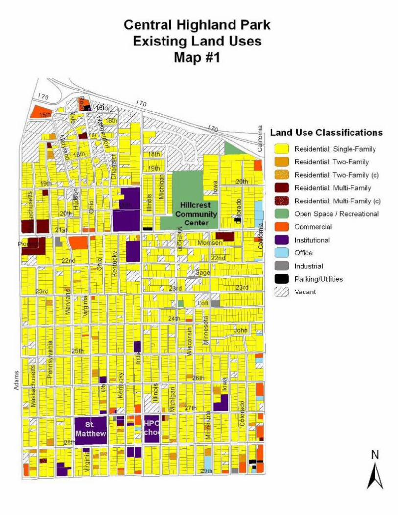
Central Highland Park Neighborhood Plan
December, 2010 64

Central Highland Park Neighborhood Plan
December, 2010 65

Central Highland Park Neighborhood Plan
December, 2010 66

Central Highland Park Neighborhood Plan
December, 2010 67

Central Highland Park Neighborhood Plan
December, 2010 68

Central Highland Park Neighborhood Plan
December, 2010 69
Central Highland Park Map #6

Central Highland Park Neighborhood Plan
December, 2010 70
1 Re-zone single-family blocks to single-family zoning. Go Slow Wait/Stop
Ttl. Votes
19 79% 4 16% 1 4% 242 Re-zone commercial property along SE 27th from “C-2” to “C-1”.
13 59% 6 27% 3 14% 223 Single-story elderly housing along Adams St with no through traffic
on Massachusetts?
10 43% 5 22% 8 35% 23
4 TARGET AREA: 2500-2800 blocks of Massachusetts, Pennsylvania, and Maryland.
12 52% 6 26% 5 22% 23
5 After sidewalk is completed on SE 25th and SE Indiana, BEGIN next sidewalk project on…
27th Street Illinois Hudson
8 44% 2 11% 8 44% 18
6 Sidewalk, curbs, and gutters on all NEW streets. 13 54% 6 25% 4 16% 24
7 Use CDBG housing funds under SORT program for new streets (approx. $300,000).
15 71% 2 9% 4 19% 21
8 Use voluntary “benefit district” to help pay for new local streets. 10 45% 3 14% 9 41% 22
9 Explore “Green Street” concept further w/ residents to lower cost of street construction and beautify open spaces along street.
8 38% 8 38% 5 24% 2110 Explore returning Biddle Creek to its natural state to provide
redevelopment options and potential trail link to Hillcrest.
2 9% 14 70% 5 21% 21
11 Continue improvements on SE California (5 lanes, landscaped medians, bike lanes, etc.)
9 41% 7 32% 6 27% 22
12 New housing (single-family) on unused portion of Hillcrest park along SE Indiana.
5 24% 9 43% 7 33% 21
13 Make improvements to Hillcrest Park. 8 38% 10 48% 3 14% 21
Key Actions Survey Results August 25th & September 27th, 2010

Central Highland Park Neighborhood Plan
December, 2010 71
14
Turn area north of Highland Park Central Elementary into a neighborhood park.
12 54% 6 27% 4 18% 22 15
Demolish Armory Buildings.
3 14% 4 18% 15 68% 22
16
Street Improvements to SE Maryland between 15th & 19th Streets for storm water drainage and walking.
7 54% 4 31% 2 15% 13

Central Highland Park Neighborhood Plan
December, 2010 72
Visioning Meetings Results (April 17th & 26th, May 3rd, 2010). Question 1: If there is one thing about the neighborhood that you could fix/change (above all others), what would it be? Question 2: If there is one thing about the neighborhood that you could keep (above all others), what would it be? Question 3: If you left the neighborhood and came back in 20 years, what would you want to see?
Streets 17 39.0% Code Enforcement/
Beautification 7 16.2%
Homeownership 5 11.6% Curbs/Gutters 5 11.6% Housing Rehab/ New Housing
4 9.3%
Sidewalks 4 9.3% Other 1 2.0%
Total
43
100.0%
Homeowners/ Young Families
9 29.0%
Churches/Schools 7 22.5% Community Center/
Park/Pool/Playground 6 19.4%
Pride 4 13.0% Green Space 3 9.6% 15th Street
Gateway 1 3.2%
Keep Nothing 1 3.2% Total
31
100.0%
Better Infrastructure 13 34.0% More Homeowners 8 21.0% Cleaned-Up
& Beautified 6 15.7%
Other 6 15.7% Any Change 2 5.0% Stronger Commercial
Businesses 2 5.0%
No Abandoned Homes
1 2.6%
Total
38
100.0%

Central Highland Park Neighborhood Plan
December, 2010 73
TOP 6 MOST PREFERRED IMAGES
Slide #1 Total Median Score = 4.63 Slide #2 Total Median Score = 4.50 South =4.50 Central =4.50 North=5.00 South =4.50 Central =3.83 North=2.50
Slide #3 Total Median Score = 4.50 Slide #4 Total Median Score = 4.33 South =4.50 Central =4.50 North= .50 South =4.20 Central =4.30 North=4.75
Slide #5 Total Median Score = 4.27 Slide #6 Total Median Score = 4.25 South =4.29 Central =3.90 North=5.00 South =4.30 Central =4.50 North=3.50

Central Highland Park Neighborhood Plan
December, 2010 74
BOTTOM 6 LEAST PREFERRED IMAGES
Slide #7 Total Median Score = -3.75 Slide #8 Total Median Score = -2.83 South = -3.25 Central = -4.06 North= -3.50 South = -2.33 Central = -2.63 North= -0.17
Slide #9 Total Median Score = -2.75 Slide #10 Total Median Score = -2.00 South = -3.63 Central = -1.50 North= -2.25 South = -3.50 Central = -0.63 North= -0.50
Slide #11 Total Median Score = -1.83 Slide #12 Total Median Score = -1.57

Central Highland Park Neighborhood Plan
December, 2010 75
South = -1.50 Central = -2.25 North= -1.50 South = -0.88 Central = -2.20 North= -0.50 Criteria Used to Evaluate Structural Defects
Minor Defects – deficiencies corrected during the course of regular maintenance. Missing shrubbery or bare spots on lawn, trash and garbage accumulation Deteriorated or lacking window screens. Weathered paint, minor painting needed. Wear on or light damage to steps, window and door sills, frames and porches. Weathering of mortar and small amounts of loose, missing material between bricks. Cracked window panes, loose putty. Handrails deteriorated or missing. Missing splash blocks at foot of down spouts. Lacking porch lights. Intermediate Defects – deficiencies serious enough to require more extensive repair than required by regular maintenance. Gutters or drain spouts rotten or parts missing. Sagging, cracked, rotted or missing roofing, overhang or lattice work. Foundation or bearing walls cracked or sagging or with loose, missing material. Erosion of landscape due to improper drainage, abandoned vehicle, cracked or uneven sidewalks. Deteriorated fencing with loose or missing material. Rotted, cracked or sagging porches, columns, door frames and stairways. Cracked or missing material from chimney. Broken or missing window panes and/or rotted window sills. Peeling or cracked paint, complete paint job needed. Damaged or missing air vents in foundation. Major Defects – condition of structural components which can be corrected only by major repairs. Holes, open cracks, rotted or missing material in foundations, walls, roofing, porches, columns, etc. Sagging or leaning of any portion of house indicating insufficient load bearing capacity: foundation, walls, porches, chimneys. Defective conditions caused by storms, fires, floods or land settlements. Inadequate or poor quality material used in permanent construction. Inadequate conversion for use involved. Major deteriorated or dilapidated out building or garage. Evidence of a lack of, or inadequate indoor plumbing such as no roof vents.

Central Highland Park Neighborhood Plan
December, 2010 76
Category Definition
Buildings/Properties Minor Deficiencies (Sound)
No major defects and no more than 1 intermediate defect and less than 4 minor defects. (3 points)
Intermediate Deficiencies No major defects with 2 or more intermediate
defects; no major defects with 1 intermediate defect and 4 or more minor defects. (2 points)
Major Deficiencies 1 to 4 (5+ is dilapidated) major defects in
combination with intermediate or minor defects. (1 point)
Blocks Sound Average 3.0 – 2.5 points per block Minor Deterioration Average 2.49 – 2.0 points per block Intermediate Deterioration Average 1.99 – 1.5 points per block Significant Deterioration Average less than 1.5 points per block

Central Highland Park Neighborhood Plan
December, 2010 77