Oracle Spatial Summitdownload.oracle.com/.../biwa2015_uc_geomarketinganalysis_sacchi.pdf · Oracle...
44
Oracle Spatial Summit 2015 Geomarketing Analysis A developed solution for Italy’s Leading Supermarket Chain, Unicoop Firenze Michele Sacchi, Project Leader Bridge Consulting
Transcript of Oracle Spatial Summitdownload.oracle.com/.../biwa2015_uc_geomarketinganalysis_sacchi.pdf · Oracle...

Oracle Spatial Summit 2015
Geomarketing Analysis A developed solution for Italy’s Leading Supermarket Chain, Unicoop Firenze Michele Sacchi, Project Leader Bridge Consulting

Bridge Consulting Unicoop Firenze- Geomarketing Analysis OVERVIEW • Customer : Unicoop Firenze • Italy’s Leading Supermarket Chain: 120 Stores on 180K Sq. Mts,
Sales of € 2.5 billion, 1.3M Consumer Members, 8K employees • Supports Strategic Marketing, Development and Top
Management divisions
CHALLENGES / OPPORTUNITIES • Need to have a simple to use, standardized, complete and
shared solution • Need to integrate disparate data sets (statistical & internal) • Need to relate more than 1.2 Million records with lat/long
coordinates • Need to decrease operational time costs
SOLUTIONS • Oracle Database Enterprise Edition
• Spatial Option with Network Data Model • Partitioning
• Oracle Fusion Middleware 11.1.1.7 • MapViewer
• Oracle Business Intelligence Enterprise Edition • Oracle Exadata
RESULTS – • Consolidation of geo data and network data model • Standardization of all addresses in a consistent format • The Organization now better understands activities in
context of location and directs marketing and future development of the stores
• The Organization now explains the business events dependent on territorial characteristics
• The solution allows to save 35% of operational costs of the people involved
• Daily used by Strategic Marketing, Top Management, Development Departments

Oracle Spatial Summit 2015
Michele Sacchi
• Project Leader and Senior BI Functional Analyst
• 10+ years experience in BI Themes
• With team management experience, functional & technical leader of a development team in Bridge Consulting

Oracle Spatial Summit 2015
Agenda 1. Presentation 2. Functional Requirements 3. Demo live 4. Used Infrastructure 5. Developed Solution 6. Return on Investment
Oracle Spatial Summit 2015
• Based in Florence, Italy. • Founded in 1998 by five professionals. • 100+ employees. • Oracle certified on BI Foundation, on Plsql/sql and on Db Administration. • • Business Fields: Fashion, Retail, Manufacturing, Risk Management

Oracle Spatial Summit 2015
The first consumer cooperative was founded in Florence, Italy in 1891.
Now Unicoop Firenze Group has:
• 120 Stores on more than 180,000 Sq. Mts. • Sales of over 2.5 billion euros • More than 1.3 Million Consumer Members • More than 8000 employees
Unicoop Firenze

Oracle Spatial Summit 2015
Agenda 1. Presentation
2. Functional Requirements 3. Demo live 4. Used Infrastructure 5. Developed Solution 6. Return on Investment

Oracle Spatial Summit 2015
Objectives TERRITORIAL ANALYSIS • Analysis of sales transactions (‘receipts’) • Analysis of consumer-member behaviors • Product traceability
GEOMARKETING ANALYSIS • Location relationships between consumers and supermarkets • Territory potential study • Distribution of market share • Consumer-members and supermarket placement

Oracle Spatial Summit 2015
STORE BY STORE • Do we need to improve the marketing in
some areas?
• Members’ and Stores’ receipts analysis
• During the 24th week, how many Sesto resident members bought in Sesto store?
• In the same week, how much did sales decrease in Sesto store?
Sesto Fiorentino Store
2014, 24th week Territorial Analysis

Oracle Spatial Summit 2015
Territorial Analysis MEMBERS’ BEHAVIOR
• Analysis on consumer-members’ behavior
in a specific store based on:
1. Age groups 2. Sales bands 3. Sales time slots

Oracle Spatial Summit 2015
Territorial Analysis PRODUCT TRACEABILITY • To know who purchased a specific product (and when) • To contact the customer in case of any fault or problem • To send an email or a letter of “product alert”
Oracle Spatial Summit 2015
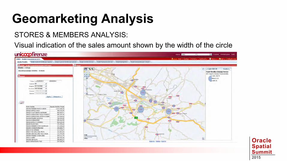
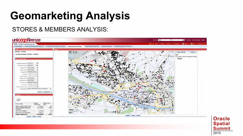
STORES & MEMBERS ANALYSIS: Visual indication of the sales amount shown by the width of the circle
Geomarketing Analysis
Oracle Spatial Summit 2015
STORES & MEMBERS ANALYSIS: • Purchasing Amount Store View of a town or postal code made by members
of a specific territory.
• For example, you can show the city center store where purchases have
been made by customer members residing in suburban areas • How customer-members are distributed in a specific territory
Geomarketing Analysis
Oracle Spatial Summit 2015
STORES & MEMBERS ANALYSIS:
Geomarketing Analysis

Oracle Spatial Summit 2015
DEMOGRAPHIC ANALYSIS • Census Area visualization of a portion of land colored by the tertiles of
statistical consumption Amount.
• The first tertile is composed of sections, whose impact on the total weighs up to 33%, the second tertile by a weight between 34% and 66%, the third between 67% and 100%.
• The user can dynamically choose which weight to give to which band
Geomarketing Analysis

Oracle Spatial Summit 2015
Geomarketing Analysis DEMOGRAPHIC ANALYSIS

Oracle Spatial Summit 2015
Agenda 1. Presentation 2. Functional Requirements
3. Demo live 4. Used Infrastructure 5. Developed Solution 6. Return on Investment

Oracle Spatial Summit 2015
D E M O N S T R A T I O N
GeoMarketing Demo
Oracle Spatial Summit 2015
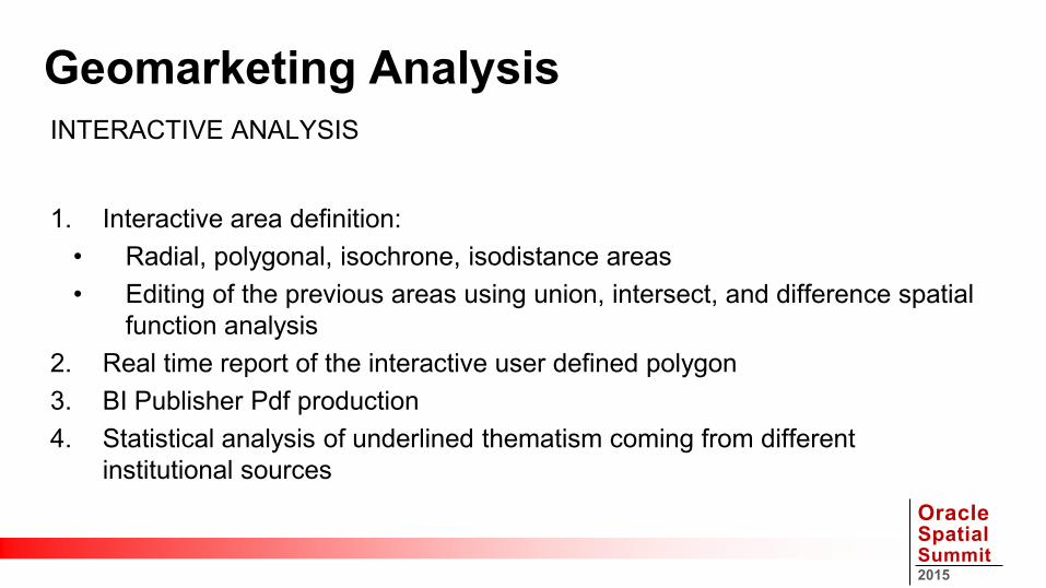
INTERACTIVE ANALYSIS
1. Interactive area definition:
• Radial, polygonal, isochrone, isodistance areas • Editing of the previous areas using union, intersect, and difference spatial
function analysis 2. Real time report of the interactive user defined polygon 3. BI Publisher Pdf production 4. Statistical analysis of underlined thematism coming from different
institutional sources
Geomarketing Analysis

Oracle Spatial Summit 2015
ISO-CHRONUS AND ISO-DISTANCE ANALYSIS • Business data road map display for user defined (500, 1000, etc. meters)
walking path distance • Isodistance analysis based on walking path distance • Isochronus analysis based on the traveling road speed • Path definition "from" and "towards" a chosen point • Isochronus/Isodistance sales analysis
Geomarketing Analysis

Oracle Spatial Summit 2015
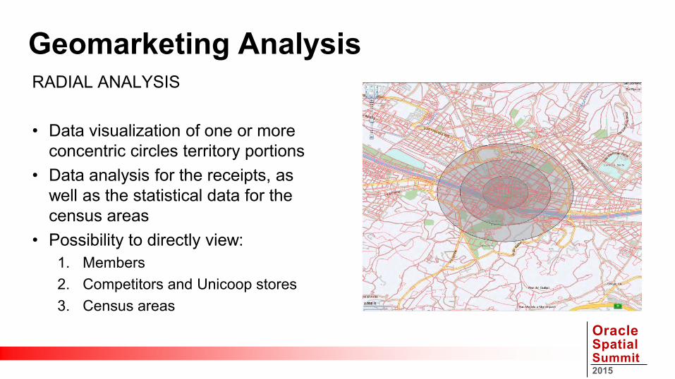
RADIAL ANALYSIS • Data visualization of one or more
concentric circles territory portions • Data analysis for the receipts, as
well as the statistical data for the census areas
• Possibility to directly view:
Geomarketing Analysis

Oracle Spatial Summit 2015
RADIAL ANALYSIS • Data visualization of one or more
concentric circles territory portions • Data analysis for the receipts, as
well as the statistical data for the census areas
• Possibility to directly view: 1. Members
Geomarketing Analysis

Oracle Spatial Summit 2015
RADIAL ANALYSIS • Data visualization of one or more
concentric circles territory portions • Data analysis for the receipts, as
well as the statistical data for the census areas
• Possibility to directly view: 1. Members 2. Competitors and Unicoop stores
Geomarketing Analysis
Oracle Spatial Summit 2015
RADIAL ANALYSIS • Data visualization of one or more
concentric circles territory portions • Data analysis for the receipts, as
well as the statistical data for the census areas
• Possibility to directly view: 1. Members 2. Competitors and Unicoop stores 3. Census areas
Geomarketing Analysis

Oracle Spatial Summit 2015
RADIAL ANALYSIS
Geomarketing Analysis

Oracle Spatial Summit 2015
ISO-CHRONUS AND ISO-DISTANCE ANALYSIS
Geomarketing Analysis

Oracle Spatial Summit 2015
Geomarketing Analysis AREA MANUAL MODELING

Oracle Spatial Summit 2015
Geomarketing Analysis AREA MANUAL MODELING

Oracle Spatial Summit 2015
AVAILABLE DATA ON RADIALS AND ISO-ANALYSIS • Member Consumers: active and total number • Information on the competitor stores included in the analysis territory
(dimensional attributes and sales) • Information on Unicoop stores where the members who live in the analysis
territory have made a purchase • Information on the census area included in the analysis territory (types of
consumption, resident population, pro capita income and consumption)
Geomarketing Analysis

Oracle Spatial Summit 2015
Agenda 1. Presentation 2. Functional Requirements 3. Demo live
4. Used Infrastructure 5. Developed Solution 6. Return on Investment

Oracle Spatial Summit 2015
• Oracle Exadata Quarter Rack • Database EE 11.2.0.2.7 • Spatial Option (NDM, Geocoding, Sdo_Geom Package) • Partitioning Option • Obiee 11.1.1.7 on Windows 64bit
(on Windows Server 2008 R2 Standard ) • Oracle Maps • NavTeq Dataset, ODF (Oracle Data Format)
Used Infrastructure

Oracle Spatial Summit 2015
Agenda 1. Presentation 2. Functional Requirements 3. Demo live 4. Used Infrastructure
5. Developed Solution 6. Return on Investment

Oracle Spatial Summit 2015
GEO - PROCESS
• Geographic ELT • Geo Data Acquisition • Statistical Data Acquisition • Geocoding & Normalization
• Geo Datawarehousing • Geo Data Access
• Obiee Reporting • Bi Publisher Reporting • Java Integration
Technical Details
Oracle Spatial Summit 2015
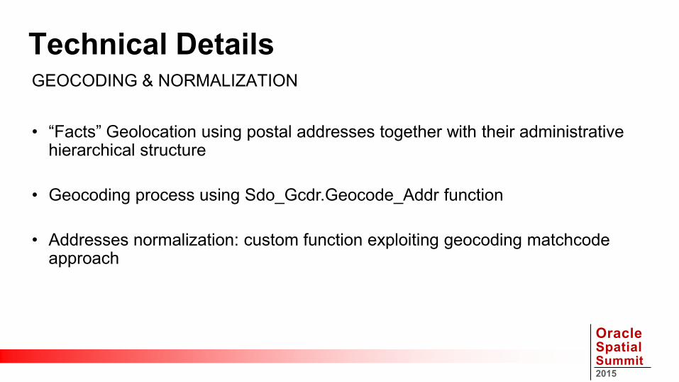
Technical Details GEOCODING & NORMALIZATION
• “Facts” Geolocation using postal addresses together with their administrative
hierarchical structure
• Geocoding process using Sdo_Gcdr.Geocode_Addr function
• Addresses normalization: custom function exploiting geocoding matchcode approach

Oracle Spatial Summit 2015
Technical Details WHY IS A CUSTOM NORMALIZATION NECESSARY?
For example to correct the street name:
DECLARE addr sdo_geo_addr;
BEGIN addr := sdo_geo_addr() ; addr.municipality := 'FIRENZE'; addr.settlement := 'PONTE DI MEZZO' ; addr.postalcode := '50127' ; addr.country := 'ITALIA' ; addr.Streettype := 'Via' ; addr.StreetName := 'Ippolito Rosellini'; (Right ) addr.housenumber := '10' ; addr.matchmode := 'default' ;
SELECT SDO_GCDR.GEOCODE_ADDR('GEO',addr) INTO addr FROM dual;
END;
ADDRESS MATCHCODE = 1
STREET MATCHVECTOR = 0
DECLARE addr sdo_geo_addr;
BEGIN addr := sdo_geo_addr() ; addr.municipality := 'FIRENZE'; addr.settlement := 'PONTE DI MEZZO' ; addr.postalcode := '50127‘ ; addr.country := 'ITALIA' ; addr.Streettype := 'Via' ; addr.StreetName := 'I. Rosellini' ; (Wrong) addr.housenumber := '10' ; addr.matchmode := 'default' ;
SELECT SDO_GCDR.GEOCODE_ADDR('GEO',addr) INTO addr FROM dual;
END;
ADDRESS MATCHCODE = 4
STREET MATCHVECTOR = 3

Oracle Spatial Summit 2015
GeoDatawarehouse Schema Table
J2EE Container
JDBC
Oracle DBMS 11.2
Oracle WLS
Client (browser) IsoChroneArea Editing
IsoChrone OBI-Report
Bi Publisher NDM WithinCostAnalysis MapViewer
Polygon Editing - Jsp
Sdo_Geom Package (Intersection, Union, Difference ..)
Bridge GeoBI Package
Technical Details GEOMARKETING ARCHITECTURE

Oracle Spatial Summit 2015
• V_Sdo_poly_n := • '(MDSYS.SDO_GEOMETRY(2003,8307,NULL,MDSYS.SDO_ELEM_INFO_ARRAY(1,1003,1),
MDSYS.SDO_ORDINATE_ARRAY ('||P_Poly_Ord_00n||')))‘; P_Query_Geo := V_Sdo_poly_00n;
• V_Sdo_poly_n+1 := ‘(MDSYS.SDO_GEOMETRY(2003,8307,NULL,MDSYS.SDO_ELEM_INFO_ARRAY(1,1003,1), MDSYS.SDO_ORDINATE_ARRAY('||P_Poly_Ord_n+1||')))‘;
• CASE P_Poly_Ope_n
WHEN 'UNION‘ THEN V_Query_Geo_n+1 := '(sdo_geom.sdo_union('|| P_Query_Geo ||','||V_Sdo_poly_n+1||',0.05))'; WHEN 'MINUS‘ THEN V_Query_Geo_n+1 := '(sdo_geom.sdo_difference('|| P_Query_Geo ||','|| V_Sdo_poly_n+1 ||',0.05))'; WHEN 'INTERSECT' THEN V_Query_Geo_n+1 = '(sdo_geom.sdo_intersection('|| P_Query_Geo ||','|| V_Sdo_poly_n+1 ||',0.05))'; END CASE; P_Query_Geo := V_Query_Geo_n+1 ;
• EXECUTE IMMEDIATE 'select '|| P_Query_Geo ||' from dual' INTO P_Sdo_Geom_Poly; (OUTPUT PARAMETER)
Technical Details HOW BRIDGE PACKAGE CALCULATES THE FINAL POLYGON

Oracle Spatial Summit 2015
SELECT td00x.t_store Store, td00x.t_address Address, td00x.t_municipality Municipality, td00x.c_postal_code Postal_Code, td00x.n_sqr_mts Square_Meters, tf00y.n_amount_food Food_Amount, tf00y.n_amount_no_food NoFood_Amount
FROM td00x_store_dim td00x, tf00y_store_fact tf00y
WHERE td00x.c_store = tf00y.c_store AND td00x.c_store IN
(SELECT tg00z.c_store FROM tg00z_store_spatial tg00z WHERE sdo_inside(tg00z.c_geo,&P_Query_Geo) = TRUE')
AND td00x. n_sqr_mts >= :P_SQUARE_METERS AND tf00y.n_year= :P_YEAR order by td00x. t_store
Technical Details HOW BI PUBLISHER RETURNS GEO DATA

Oracle Spatial Summit 2015
Agenda 1. Presentation 2. Functional Requirements 3. Demo live 4. Used Infrastructure 5. Developed Solution
6. Return on Investment

Oracle Spatial Summit 2015
Return on Investment TANGIBLE BENEFITS • The previous “Geomarketing & Territorial Analysis” proprietary
application had an annual fee of 66,000 euros
• Bridge Consulting solution is amortized over three years
• From the fourth year there is a saving of 75% compared to the previous proprietary application
• 35% immediate savings on operational costs of the people involved in the activity

Oracle Spatial Summit 2015
Return on Investment BUSINESS BENEFITS
• A simple to use, standardized, complete and shared solution
• Ability to direct future development policies
(identifying the areas where there is still margin for investment)
• Opportunity to explain the business events dependent on territorial characteristics
• Analysis of the catchment area of a territory to locate new stores
• Availability to identify how the flows of the members change depending on structural and marketing events

Oracle Spatial Summit 2015
Key Takeaways • Geomarketing • Oracle Spatial • Network Data Model • Business Intelligence • Oracle Fusion Middleware 11.1.1.7 • Open Data • Exadata

Oracle Spatial Summit 2015

Oracle Spatial Summit 2015