
OPS BINDER SECTOR 59 - IVAO USA · 2015-06-13 · OPS BINDER SECTOR 59 04/27/2012 ZMA 7220.8I...
17
Page 1 of 17 OPS BINDER SECTOR 59 04/27/2012 ZMA 7220.8I APPENDIX - OCEAN 59 TABLE OF CONTENTS 1 NARRATIVE 1.1 Traffic Flow 1.2 Adjacent Sector/Facility Coordination 1.3 Potential Trouble Spots 2 ASSIGNMENT OF AIRSPACE 2.1 Delegation of Approach Control Airspace 2.2 West Atlantic Route System (WATRS) Airspace 2.3 Sectors Normally Combined 2.4 Military Airspace Delegation 2.5 SUA/SAA Activation Procedures 3 SECTOR INFORMATION 3.1 Frequency Information 3.2 Indirect Access (IA) Dial Codes 3.3 Sector Equipment Configurations 3.4 Sector Description 4 SECTOR PROCEDURES 4.1 Special Consideration for Military Aircraft 4.2 Radar Procedures 4.3 Non-Radar Procedures 4.4 Sector Specific Directives 4.5 LOA Procedures 4.6 Interim Altitude Waivers 4.7 Angulation of Flight Progress Strips 4.8 Normally Used Holding Fixes 4.9 URET Operations
Transcript of OPS BINDER SECTOR 59 - IVAO USA · 2015-06-13 · OPS BINDER SECTOR 59 04/27/2012 ZMA 7220.8I...

Page 1 of 17
OPS BINDER SECTOR 59 04/27/2012 ZMA 7220.8I APPENDIX - OCEAN 59
TABLE OF CONTENTS 1 NARRATIVE 1.1 Traffic Flow 1.2 Adjacent Sector/Facility Coordination 1.3 Potential Trouble Spots 2 ASSIGNMENT OF AIRSPACE 2.1 Delegation of Approach Control Airspace 2.2 West Atlantic Route System (WATRS) Airspace 2.3 Sectors Normally Combined 2.4 Military Airspace Delegation 2.5 SUA/SAA Activation Procedures 3 SECTOR INFORMATION 3.1 Frequency Information 3.2 Indirect Access (IA) Dial Codes 3.3 Sector Equipment Configurations 3.4 Sector Description 4 SECTOR PROCEDURES 4.1 Special Consideration for Military Aircraft 4.2 Radar Procedures 4.3 Non-Radar Procedures 4.4 Sector Specific Directives 4.5 LOA Procedures 4.6 Interim Altitude Waivers 4.7 Angulation of Flight Progress Strips 4.8 Normally Used Holding Fixes 4.9 URET Operations

04/27/2012 ZMA 7220.8I APPENDIX-OCEAN 59
Page 2 of 17
5 FLIGHT DATA REQUIREMENTS 5.1 Primary and Backup Printers 5.2 Alternate Methods of Relaying/Requesting Information 5.3 Strip Postings 5.4 Sources to Obtain Weather Information 5.5 Data Requiring Expeditious Handling 5.6 Status Information Area

04/27/2012 ZMA 7220.8I APPENDIX-OCEAN 59
Page 3 of 17
1 NARRATIVE 1.1 Traffic Flows 1.1.1 Sector 59 is a high and low altitude sector (SFC and above), and the
types of traffic vary from air carrier jets to single engine private aircraft. Sector 59 handles a significant amount of overflight traffic to and from South America, the Caribbean and Europe.
1.2 Adjacent Sector/Facility Coordination 1.2.1 Sector 59 coordinates with Sectors 01, 18, 19, 21, 40, 44, 58, 60 and
61, ZQA and ZNY Centers. 1.3 Potential Trouble Spots 1.3.1 Due to a potential language barrier, emphasis should be placed on
monitoring read backs from foreign pilots to ensure compliance with clearances.
1.3.2 Nassau (QJS) and Georgetown (QFK) RADAR are secondary RADAR
only. 1.3.3 Be aware that many of the pilots flying to and from the islands are not
veterans to the area and do not always know local procedures. 1.3.4 Use caution when issuing non-radar clearances to aircraft requesting
IFR clearances on the frequency or through Nassau FSS. Ensure the exact position and altitude prior to issuing clearances.
1.3.5 The radar team must look for and be aware of conflicts with non-radar
traffic, especially inbound from ZNY. 1.3.6 Frequency coverage is limited at lower altitudes and also at the fringes
of the sector to the NE at higher altitudes. Applicable backup frequency assignments and/or lost communications procedures should be utilized.
1.3.7 Due to the variety of surrounding airspace and control facilities,
heightened awareness to limited data blocks is necessary. 2 ASSIGNMENT OF AIRSPACE. 2.1 Delegation of Approach Control Airspace N/A 2.2 West Atlantic Route System (WATRS) Airspace
04/27/2012 ZMA 7220.8I APPENDIX-OCEAN 59
Page 4 of 17
2.2.1 Sector 59 is classified as WATRS Plus airspace. A detailed description
of this airspace can be found in JO 7110.65, Chapter 8. 2.3 Sectors Normally Combined 2.3.1 Sector 59 is normally combined at Sector 58. 2.4 Military Airspace Delegation 2.4.1 Tailhook Areas are located north of ANGLL intersection. SEALORD
must coordinate use of Tailhook Areas D, E, F, and/or G on a real-time basis, including altitudes requested for G. These areas, except F and G, are not located within The Caribbean/Oceanic Area however, when these areas are in use Caribbean/Oceanic controllers may be required to reroute aircraft. Normally, the Military Specialist will notify affected areas that Tailhook is in use, subject to one-hour call up. This one hour call up is to allow controllers time to reroute aircraft as necessary.
2.4.2 The MANATEE Area is located in Sectors 58 and 59 and is called up
on a real time basis, usually AOB FL250. 2.4.3 W497B is located in Ocean Area Sector 59 and in Area Atlantic
Airspace and is called up on a real time basis, usually SFC to unlimited.
2.4.4 AW023 is located east of Bimini and extends to the Northeast of
Nassau. This area is used for AWACS operations and normally operates between FL260 and FL310, as assigned by ATC.
2.5 SPECIAL USE AIRSPACE (SUA)/SPECIAL ACTIVITY AIRSPACE (SAA) NOTIFICATION / ACTIVATION PROCEDURES: 2.5.1 The Miami Center Mission Position (MOS) is the focal point for all SUA/SAA. 2.5.2 When specific SUA/SAA is requested, the MOS must:
A. Call the appropriate Area FLM/CIC and relay the request. B. Once the request is approved; update the NTML Log if needed
with the appropriate information. C. Alert the Area FLM/CIC that the SUA/SAA is active and the
updated information is in the ESIS Queue to display on the Area ESIS.
D. Update information into URET/EDST.
04/27/2012 ZMA 7220.8I APPENDIX-OCEAN 59
Page 5 of 17
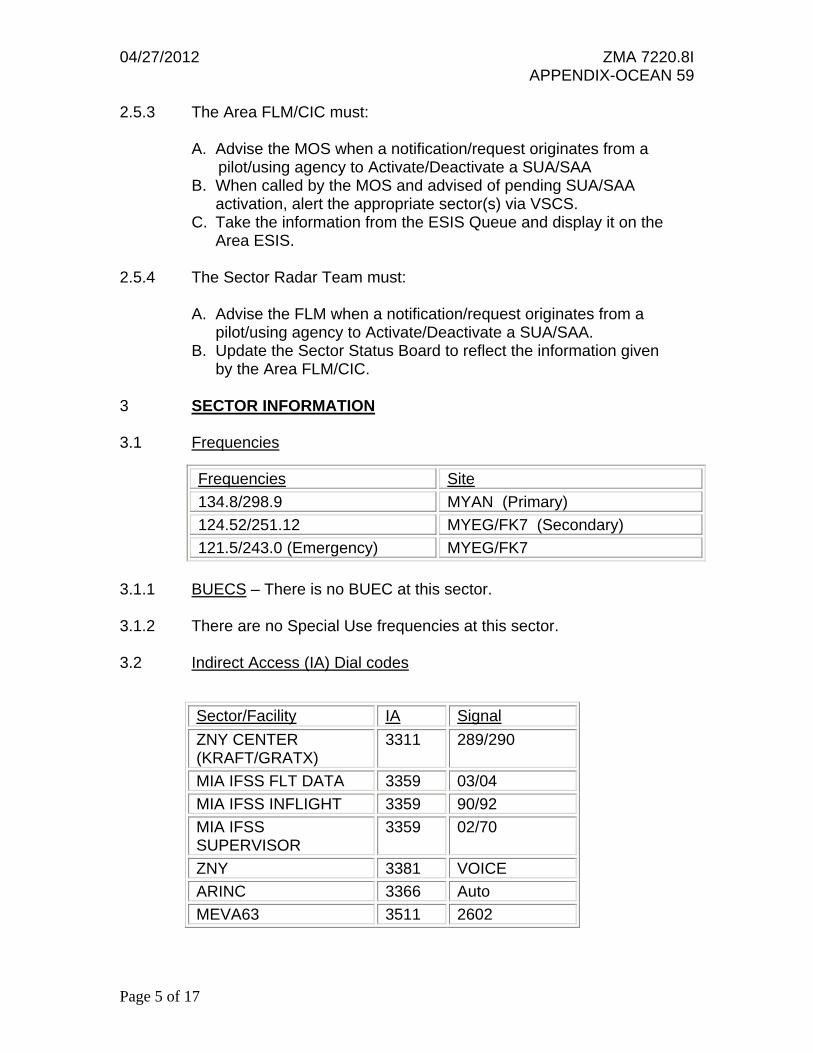
2.5.3 The Area FLM/CIC must: A. Advise the MOS when a notification/request originates from a
pilot/using agency to Activate/Deactivate a SUA/SAA B. When called by the MOS and advised of pending SUA/SAA activation, alert the appropriate sector(s) via VSCS. C. Take the information from the ESIS Queue and display it on the Area ESIS. 2.5.4 The Sector Radar Team must: A. Advise the FLM when a notification/request originates from a pilot/using agency to Activate/Deactivate a SUA/SAA. B. Update the Sector Status Board to reflect the information given by the Area FLM/CIC. 3 SECTOR INFORMATION 3.1 Frequencies
3.1.1 BUECS – There is no BUEC at this sector. 3.1.2 There are no Special Use frequencies at this sector. 3.2 Indirect Access (IA) Dial codes
Frequencies Site
134.8/298.9 MYAN (Primary)
124.52/251.12 MYEG/FK7 (Secondary)
121.5/243.0 (Emergency) MYEG/FK7
Sector/Facility IA Signal
ZNY CENTER (KRAFT/GRATX)
3311 289/290
MIA IFSS FLT DATA 3359 03/04
MIA IFSS INFLIGHT 3359 90/92
MIA IFSS SUPERVISOR
3359 02/70
ZNY 3381 VOICE
ARINC 3366 Auto
MEVA63 3511 2602

04/27/2012 ZMA 7220.8I APPENDIX-OCEAN 59
Page 6 of 17
3.3 SECTOR EQUIPMENT CONFIGURATIONS 3.3.1 DC View
NEXRAD Layers 000B600
NEXRAD Levels 1-2-3 On
RNG FIX Optional
WX-1/WX-2/WX-3-- Optional**
Strobe Lines-- Optional
Map 1 (Sec./Center boundaries)-- On
Map 2 (Overlying high/low sectors)-- On
Map 3 (Apch. Ctl. Boundaries)-- On
Special Areas-- Optional*
Inbound List Optional
Departure List Optional
Hold List Optional
Full Data Block On
All Lim. Data Block Optional
Select Lim. Data Block On
Emergency Airports Optional
All Primaries On
Non Mode "C” On
Select Beacon On
CTAS List Optional
* Note: Indicates mandatory "ON" position when special area in your sector is active. (May remain “OFF” if another method is used to display Special Areas. ** Note: One of these must be “ON” when WX is in the area. When NEXRAD is “Not” available,
NAS WX-1/WX-2/WX-3, must be selected as appropriate.
04/27/2012 ZMA 7220.8I APPENDIX-OCEAN 59
Page 7 of 17
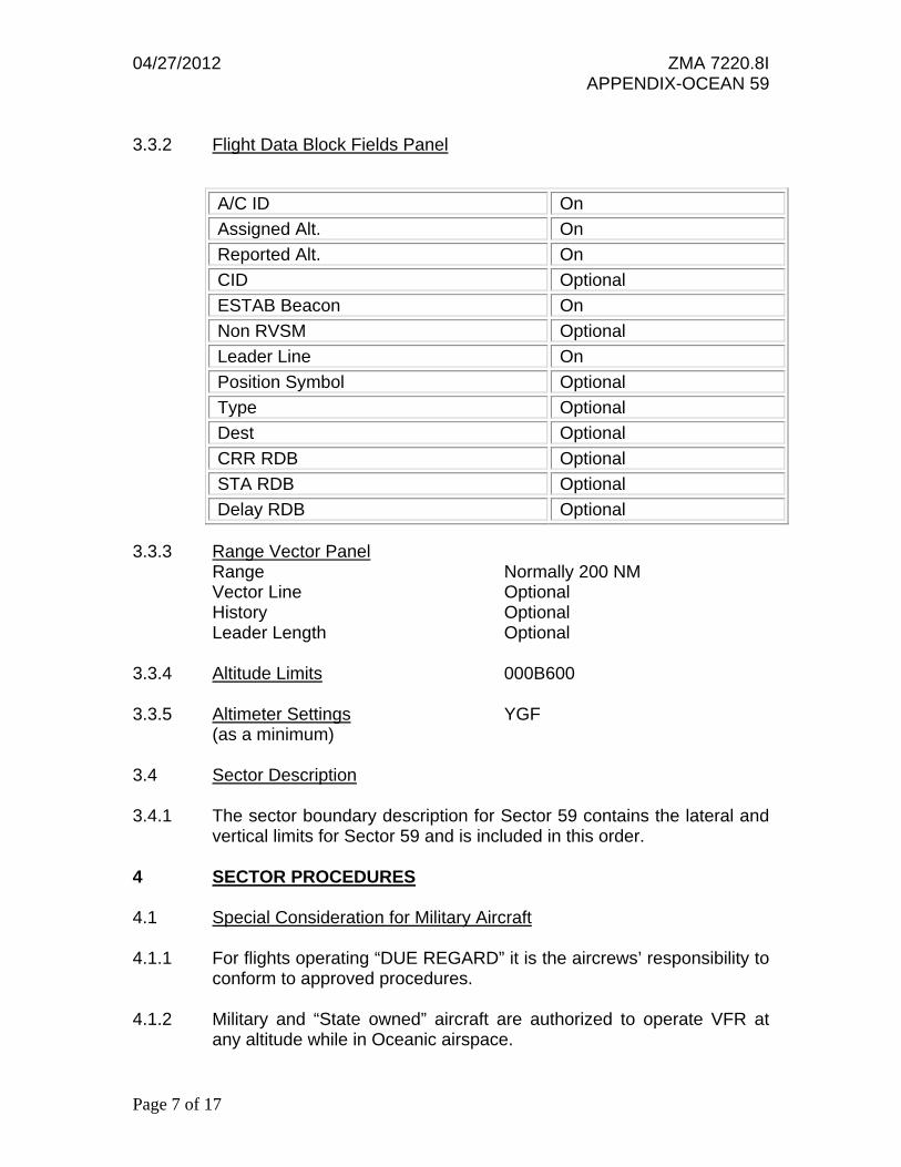
3.3.2 Flight Data Block Fields Panel
3.3.3 Range Vector Panel Range Normally 200 NM Vector Line Optional History Optional Leader Length Optional 3.3.4 Altitude Limits 000B600 3.3.5 Altimeter Settings YGF
(as a minimum) 3.4 Sector Description 3.4.1 The sector boundary description for Sector 59 contains the lateral and
vertical limits for Sector 59 and is included in this order. 4 SECTOR PROCEDURES 4.1 Special Consideration for Military Aircraft 4.1.1 For flights operating “DUE REGARD” it is the aircrews’ responsibility to
conform to approved procedures. 4.1.2 Military and “State owned” aircraft are authorized to operate VFR at
any altitude while in Oceanic airspace.
A/C ID On
Assigned Alt. On
Reported Alt. On
CID Optional
ESTAB Beacon On
Non RVSM Optional
Leader Line On
Position Symbol Optional
Type Optional
Dest Optional
CRR RDB Optional
STA RDB Optional
Delay RDB Optional

04/27/2012 ZMA 7220.8I APPENDIX-OCEAN 59
Page 8 of 17
4.2 Radar Procedures: (The following subparagraphs apply to aircraft remaining in radar coverage)
4.2.1 The Ocean Area controller who initially establishes radar control or accepts a radar handoff of an aircraft must:
4.2.1.1 Clear aircraft AOA FL240 landing the Miami Terminal area via JUNUR/FLIPR, or CAREY..DEKAL as appropriate and assign the required STAR.
4.2.1.2 Clear aircraft inbound from ZNY airspace landing the Miami Terminal
area direct FOWEE, CAREY..DEKAL, or ZFP as appropriate, and assign the required STAR.
4.2.1.3 Clear aircraft via ISAAC.BR54V.PBI, CVIKK.Y585.OMN, SRQ, REMIS
(Q100) or CIGAR (Q102), as appropriate. 4.2.1.4 Clear overflight aircraft routed over ORL via FLL ORL unless routed
over OMN. 4.2.1.5 Ensure that aircraft proceeding over OMN through Sector 01 are able
to cross the 01/59 boundary AOA FL370. Assign the preferential routing via FLL..ORL if the aircraft is unable to cross the 01/59 boundary AOA FL370.
4.2.1.6 Aircraft landing MCO/ORL/SFB/OCF/ISM and Orlando area airports
must be routed as follows: FILED AT OR ABOVE FL240, cleared via direct FLL: then either direct PHK.GOOFY STAR if not RNAV equipped; or direct BAIRN.BAIRN STAR if RNAV equipped. Aircraft that will cross the Sector 01 boundary between 2100-0700 (LCL) may be routed direct TRV or BAIRN and the appropriate STAR. Aircraft AOB FL230 may be routed TRV and BAIRN and the appropriate STAR during all hours.
4.2.1.7 Clear aircraft transiting from ZNY airspace and landing MYNN via:
OHBEE..MYNN with a computer update. 4.2.1.7.1 For aircraft landing Nassau and Abaco area airports and descending to
FL240, Sectors 44 and 61 shall have control for lower after acceptance of a radar handoff from Sector 58 and 59.
4.2.1.8 Clear aircraft transitioning LAL/CTY/SZW no further north than: AOA
FL280 via PBI..CTY or PBI..SZW, and aircraft AOB FL270 via PBI..LAL.
Rev. 2 Effective 9/20/12

04/27/2012 ZMA 7220.8I APPENDIX-OCEAN 59
Page 9 of 17
4.2.1.9 Clear aircraft landing KNIP/KJAX via: AOB FL230 direct TRV..ORL..POGIE..KNIP or TRV..ORL..KJAX as appropriate. AOA FL240 direct FLL..ORL..POGIE..KNIP or FLL..ORL..KJAX as appropriate.
4.2.1.10 Clear aircraft entering ZNY, MTEG, MUHF or MDCS no further direct
than the ZMA FIR boundary fixes in the route of flight consistent with the applicable LOA.
4.2.1.11 Clear MUGM arrivals to BYGON as a clearance limit. 4.2.2 Clear aircraft northeast of BR1L AOB FL200 via an airway through
Sector 58. 4.2.3 Clear aircraft on or southwest of BR1L AOB FL160 via an airway
through Sector 58. 4.2.4 Sector 59 must vector non area navigation equipped aircraft that are
routed over the JUNUR ATA to join the FOWEE STAR, with coordination.
4.2.5 Sector 01 must not clear aircraft any further direct than ZIN/JOSES
(A315/Y586), ZFP (BR1L), HARDE (A555/Y587), OMALY (G446), RENAH (Y585), SEKAR (A554), ASIVO (W10), or OREDE..MBPV (landing MBPV).
4.3 Non-Radar Procedures
4.3.1 A fix estimate and altitude confirmation must be verbally passed to the next sector/facility for aircraft not provided radar service.
4.3.2 The following restrictions apply during radar outages: 4.3.2.1 When GTK radar is out of service G446 is closed between LYMIN and
GTK 4.3.2.2 During a QJS and QFK or QFK and GDT radar outage BR1L will be a
southeast bound airway only AOA FL280 unless otherwise coordinated.
4.3.2.3 When GTK radar is out of service, aircraft landing within Provo
Approach’s airspace must be routed AVNEY.BR1L.OREDE. 4.3.2.4 When GTK radar is out of service Y585 closed in Sector 63. 4.3.2.5 When GTK radar is out of service L463 closed BTLER to JUELE.
Rev. 2 Effective 9/20/12

04/27/2012 ZMA 7220.8I APPENDIX-OCEAN 59
Page 10 of 17
4.4 Sector Specific Directives 4.4.1 Monitors 121.5/243.0 MHz for emergency transmissions. 4.4.2 Clear SE bound traffic AOB FL120 no further direct than ACMEE,
ROSEA or INDEE. 4.4.3 Clear aircraft landing in PBI Terminal area AOB FL280 prior to
entering Sector 40’s airspace. 4.4.4 Traffic proceeding NW bound over OMN must cross the Sector 01/59
boundary AOA FL360. 4.4.5 For aircraft transitioning from Sector 61 through Sector 59 via the
INGRA DTA: 4.4.5.1 Sector 59 shall have control for turns after radar handoff and frequency
change. 4.4.5.2 Aircraft transitioning from Sector 61 through Sector 59 via
ANGLL/OMN/ZFP must be cleared via the INGRA DTA G437 ELBOW, then as follows:
a) O/OMN: direct CVIKK Y585 or direct OMN if west of BARTS b) AR routes: over LENDS, CANIT, OHLAA, ETECK or NUCAR as
appropriate.
4.4.6 For traffic from the Atlantic Area that will proceed into Havana Center’s airspace: Sector 59 must feed Sector 60 odd altitudes.
4.4.7 For traffic from Havana Center airspace that will transition to the
Atlantic Area: Sector 60 must feed Sector 59 even altitudes. 4.4.8 Sector 01, after acceptance of a handoff from Sector 59, shall have
control for turns on northwest bound aircraft from heading 270 through heading 330. Sector 59, after acceptance of a handoff from Sector 01, shall have control for turns on southeast bound aircraft from heading 090 through heading 150.
4.4.9 The following procedures apply to aircraft landing MYNN 4.4.9.1 Traffic from Sectors 01 or 19 must be cleared over HANKX. 4.4.9.2 Traffic from Sector 19 must cross the 59/19 boundary AOB FL340.
Sector 59 has control for descent 20 NM north of the 59/19 boundary.
04/27/2012 ZMA 7220.8I APPENDIX-OCEAN 59
Page 11 of 17
4.4.9.3 Traffic from Sector 01 must cross the 59/01 boundary AOB FL350 descending to FL240.
4.4.9.4 Traffic landing at all other airports within MYNN TMA: via direct the
airport. 4.4.10 The following procedures apply to aircraft transitioning to/from sectors
59 and 19: 4.4.10.1 Sector 59 must feed traffic to Sector 19 at ODD altitudes. 4.4.10.2 Sector 19 must feed traffic to Sector 59 at EVEN altitudes. 4.4.10.3 North bound aircraft may be cleared no farther east than direct
NUCAR. 4.4.10.4 Aircraft south/southeast bound are released for turns between
headings of 130 to 190 degrees. 4.4.10.5 Aircraft north/northwest bound are released for turns between
headings of 300 to 360 degrees. 4.4.11 Aircraft transitioning from the Atlantic Area through Sector 59 must not
be cleared direct DYNAH without prior approval from Sector 60. 4.4.12 When Sector R63 is open aircraft proceeding into ZSU airspace that
enter Sector 59 on or south of BR1L must be routed through Sector 62 as per the ZSU LOA. Aircraft proceeding into ZSU airspace that enter Sector 59 north of BR1L must be routed clear of Sector 62 then over ELMUC, then per the ZSU LOA. Note: These aircraft may be cleared through Sector 62 as per the ZSU LOA at the FLM’s discretion.
4.4.13 Clear aircraft landing within Provo Approach airspace to the outer fixes
as specified in the PROVO LOA, “no delay expected”. 4.4.14 The procedures contained in this Directive may be modified on a case-
by-case basis with prior verbal coordination. 4.4.15 Acceptance of a radar handoff on an aircraft from Sector 59 by Sector 61
constitutes transfer of control for speed adjustments and the issuance of a pilot’s discretion descent.

04/27/2012 ZMA 7220.8I APPENDIX-OCEAN 59
Page 12 of 17
4.5 LOA Procedures 4.5.1 All LOAs pertaining to Sector 59 are:
San Juan CERAP New York Center
U.S. Customs Nassau Centre/IFSS Aeronautical Radio, Inc.
Miami AIFSS Air Defense Miami Center/Jacksonville Center/FACSFACJAX
4.6 Interim Altitude Waivers 4.6.1 A waiver of the computer entry of assigned altitude when aircraft are
transitioning to a higher altitude stratum has been issued to Sector 44 & 61.
4.7 Angulation of Flight Progress Strips 4.7.1 The flight progress strip must be angulated (or highlighted during
URET ops) and remain angulated or highlighted until no further action is required when any of the following situations occur:
4.7.2 When coordination is required. 4.7.3 Required control actions not covered by a directive or letter of
agreement. 4.7.4 The flight progress strip must be angulated for conflictions. 4.8 Normally used holding fixes: HANKS 4.9 URET Operations 4.9.1 URET Operations must conform to all applicable national and local
directives. 4.9.2 Where automated coordination with a facility/sector is not available
(e.g., an international facility or VFR tower), use a flight progress strip to annotate manual coordination status.
4.9.3 The sector must keep the appropriate strips posted until one of the
following conditions is met:

04/27/2012 ZMA 7220.8I APPENDIX-OCEAN 59
Page 13 of 17
4.9.3.1 The pilot of the aircraft cancels IFR. 4.9.3.2 A radar handoff has been accomplished, all known and potential
conflictions have been resolved, and the appropriate communications instructions have been issued.
4.9.3.3 The strip is no longer needed for control purposes.
5 FLIGHT DATA REQUIREMENTS
5.1 PRIMARY PRINTER: 59, backup 58 5.2 Alternate Methods of Relaying/Requesting Information: 5.2.1 Alternate means of radio communications: 5.2.1.1 Relay through other aircraft. 5.2.1.2 ARINC (HF, SEL Call, or ACARS) 5.2.1.3 Emergency Frequencies 5.2.1.4 Miami/Nassau/Freeport FSS. 5.2.2 Alternate means of landline communication: 5.2.2.1 Relay through adjacent facilities via available landlines. 5.2.2.2 Autovon 5.2.2.3 Commercial Telephone 5.2.2.4 AFTN 5.2.2.5 Clear aircraft to a boundary fix and have them pass their own estimate
to the next facility and receive clearance beyond the fix. 5.3 Strip Postings Departures are normally sequenced on the bottom of
the bay with the earliest time at the bottom of the bay. Active traffic is normally sequenced above the departures, using fix estimate times with the earliest time at the bottom of the bay.
04/27/2012 ZMA 7220.8I APPENDIX-OCEAN 59
Page 14 of 17
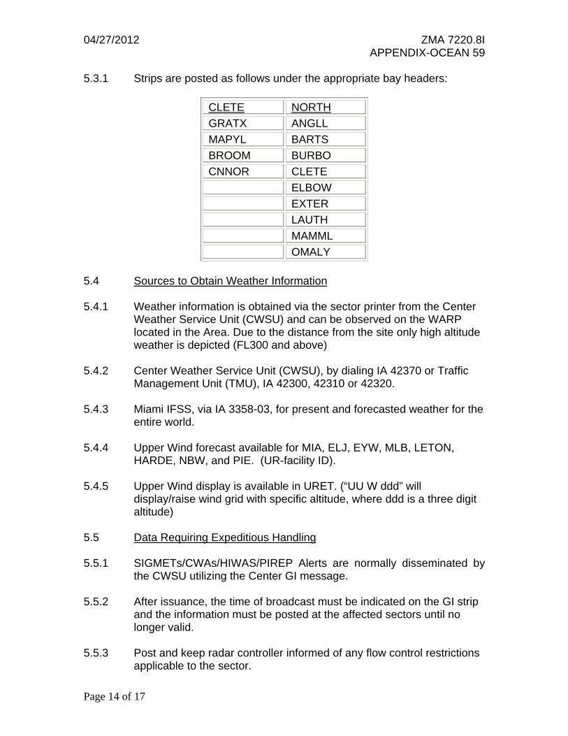
5.3.1 Strips are posted as follows under the appropriate bay headers:
CLETE NORTH
GRATX ANGLL
MAPYL BARTS
BROOM BURBO
CNNOR CLETE
ELBOW
EXTER
LAUTH
MAMML
OMALY
5.4 Sources to Obtain Weather Information 5.4.1 Weather information is obtained via the sector printer from the Center
Weather Service Unit (CWSU) and can be observed on the WARP located in the Area. Due to the distance from the site only high altitude weather is depicted (FL300 and above)
5.4.2 Center Weather Service Unit (CWSU), by dialing IA 42370 or Traffic
Management Unit (TMU), IA 42300, 42310 or 42320. 5.4.3 Miami IFSS, via IA 3358-03, for present and forecasted weather for the
entire world. 5.4.4 Upper Wind forecast available for MIA, ELJ, EYW, MLB, LETON,
HARDE, NBW, and PIE. (UR-facility ID). 5.4.5 Upper Wind display is available in URET. (“UU W ddd” will
display/raise wind grid with specific altitude, where ddd is a three digit altitude)
5.5 Data Requiring Expeditious Handling 5.5.1 SIGMETs/CWAs/HIWAS/PIREP Alerts are normally disseminated by
the CWSU utilizing the Center GI message. 5.5.2 After issuance, the time of broadcast must be indicated on the GI strip
and the information must be posted at the affected sectors until no longer valid.
5.5.3 Post and keep radar controller informed of any flow control restrictions
applicable to the sector.

04/27/2012 ZMA 7220.8I APPENDIX-OCEAN 59
Page 15 of 17
5.6 Status Information Area 5.6.1 The following information is required for display in the Status
Information Area: Review Status Information Area Airspace Equipment Weather Flow Traffic Radar Non-Radar Required Altitude Changes Fix Estimates Verified/Coordinated
04/27/2012 ZMA 7220.8I APPENDIX-OCEAN 59
Page 16 of 17 Chg. 1 Effective 5/31/12

04/27/2012 ZMA 7220.8I APPENDIX-OCEAN 59
Page 17 of 17 Chg. 1 Effective 5/31/12
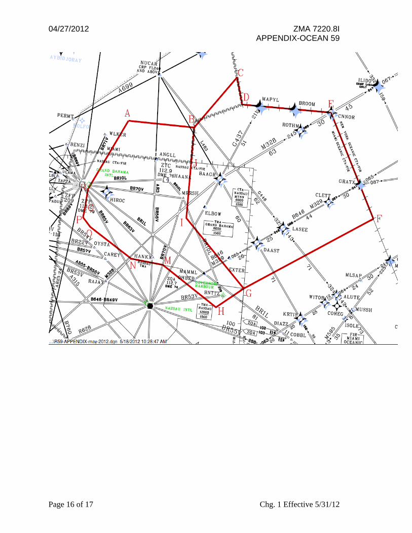
ABACO
R59 BOUNDARY DESCRIPTION
Beginning at
B 27-28-00N/77-00-00W Direct J 27-00-30N/77-00-00W Direct I 26-15-00N/77-00-00W Direct G 25-23-00N/76-00-00W Direct F 26-28-00N/74-02-00W Direct E 27-50-00N/74-50-00W Direct D 27-50-00N/76-15-52W Direct C 28-11-18N/76-22-56W Direct to point of beginning from surface to FL239. Except for the following airspace beginning at A 27-28-00N/78-03-30W Direct B 27-28-00N/77-00-00W Direct C 28-11-18N/76-22-56W Direct D 27-50-00N/76-15-52W Direct E 27-50-00N/74-50-00W Direct F 26-28-00N/74-02-00W Direct G 25-23-00N/76-00-00W Direct H 25-05-49N/76-24-45W Direct M 25-35-40N/77-18-30W Direct N 25-38-00N/77-48-50W Direct O 26-00-00N/78-30-30W Direct P 26-07-01N/78-38-06W Direct Q 26-14-53N/78-37-13W Direct R 26-30-00N/78-36-00W Direct to point of beginning from FL240 and above.