OPERATIONALITY OF GEOGRAPHIC PROFILING THROUGH … · OPERATIONALITY OF GEOGRAPHIC PROFILING...
14
BSGLg, 60, 2013, 43-55 OPERATIONALITY OF GEOGRAPHIC PROFILING THROUGH A HYPOTHETICO-DEDUCTIVE METHOD. A REVIEW OF CONSTRAINTS AND FACTORS Marie TROTTA, André LEMAÎTRE & Jean-Paul DONNAY Abstract This paper is dedicated to the identification of the constraints and factors enabling the compu- tation of an effective geographic profile, with the specificity of focusing only on the elements that could be available during an investigation. It aimed at filling the gap between the inductive demarche of environmental criminology and the deductive, operational procedure followed by geographic profilers. It reviews successively the relationship between the premeditation, the seriousness of the facts, the nature of the offences and the spatio-temporal pattern of the crimes with the criteria required to build effective likelihood surfaces in geographic profiling. A deci- sion tree is provided as a tool for evaluating the risks of an ineffective geographic profile with regard to the non-respect of the different conditions. Keywords environmental criminology, decision making, inference, serial offenders, geographic(al) profi- ling, spatio-temporal analysis Résumé Cet article est dédié à l’identification des contraintes et facteurs permettant la construction d’un profil géographique efficace, avec la particularité de s’intéresser aux seuls élements disponibles durant une enquête criminelle. L’article cherche à combler le vide méthodologique entre la démarche inductive de la criminologie environnementale et la procédure déductive et opéra- tionnelle suivie par les profileurs géographiques. Il examine successivement la relation entre la préméditation, la gravité des faits, la nature de l’infraction et la configuration spatio-temporelle des crimes avec les critères nécessaires à la construction de surfaces de vraisemblance efficaces dans le profilage géographique. En synthèse, un arbre de décision permet d’évaluer les risques d’un profile erroné en fonction du non-respect des différentes conditions. Mots-clés: criminologie environnementale, prise de décision, inférence, auteurs en série, profilage géographique, analyse spatio-temporelle I. INTRODUCTION: TOWARD MORE OPERA- TIONAL CONCERNS IN CRIME MAPPING Pin Mapping is a common practice carried out by ana- lysts such as geographers, statisticians and practitioners in various disciplines (epidemiology, marketing, crimi- nology). If such approach is not recent in criminology (work of Quetelet and Guery in the 19th.), the study of the geographical environment in order to understand the offender’s spatial decision process is a more recent approach developed by the environmental criminology (Brantingham and Brantingham, 1981a). Several stu- dies in this field concern the journey-to-crime, with the elementary but fundamental finding that there is a friction with the distance (the distance decay effect) between the crime location and the offender’s home or anchor point (Phillips, 1980, Rhodes and Conly 1981, Rengert et al., 1999). According to the crime pattern theory, offenders generally are less likely to commit their crimes far from their activity nodes (Brantingham and Brantingham, 1990). Since the nineties, Geographic Profiling (GP) presents several issues distinct from the environmental crimino- logy (Rossmo, 1997). The principle of distance decay is maintained and makes possible to build a likelihood surface under certain conditions. However, unlike the largely inductive approach developed in environmental criminology, GP seeks the residence or anchor for an unresolved series of crimes. It corresponds to a hypo- thetico-deductive process. Therefore, it must rely on a model and on assumptions limiting or favouring the GP application in order to make it consistent with such a
-
Upload
phungkhanh -
Category
Documents
-
view
235 -
download
0
Transcript of OPERATIONALITY OF GEOGRAPHIC PROFILING THROUGH … · OPERATIONALITY OF GEOGRAPHIC PROFILING...
BSGLg, 60, 2013, 43-55
OPERATIONALITY OF GEOGRAPHIC PROFILINGTHROUGH A HYPOTHETICO-DEDUCTIVE METHOD.
A REVIEW OF CONSTRAINTS AND FACTORS
Marie TROTTA, André LEMAÎTRE & Jean-Paul DONNAY
AbstractThis paper is dedicated to the identifi cation of the constraints and factors enabling the compu-tation of an effective geographic profi le, with the specifi city of focusing only on the elements that could be available during an investigation. It aimed at fi lling the gap between the inductive demarche of environmental criminology and the deductive, operational procedure followed by geographic profi lers. It reviews successively the relationship between the premeditation, the seriousness of the facts, the nature of the offences and the spatio-temporal pattern of the crimes with the criteria required to build effective likelihood surfaces in geographic profi ling. A deci-sion tree is provided as a tool for evaluating the risks of an ineffective geographic profi le with regard to the non-respect of the different conditions.
Keywordsenvironmental criminology, decision making, inference, serial offenders, geographic(al) profi -ling, spatio-temporal analysis
RésuméCet article est dédié à l’identifi cation des contraintes et facteurs permettant la construction d’un profi l géographique effi cace, avec la particularité de s’intéresser aux seuls élements disponibles durant une enquête criminelle. L’article cherche à combler le vide méthodologique entre la démarche inductive de la criminologie environnementale et la procédure déductive et opéra-tionnelle suivie par les profi leurs géographiques. Il examine successivement la relation entre la préméditation, la gravité des faits, la nature de l’infraction et la confi guration spatio-temporelle des crimes avec les critères nécessaires à la construction de surfaces de vraisemblance effi caces dans le profi lage géographique. En synthèse, un arbre de décision permet d’évaluer les risques d’un profi le erroné en fonction du non-respect des différentes conditions.
Mots-clés:criminologie environnementale, prise de décision, inférence, auteurs en série, profi lage géographique, analyse spatio-temporelle
I. INTRODUCTION: TOWARD MORE OPERA-TIONAL CONCERNS IN CRIME MAPPING
Pin Mapping is a common practice carried out by ana-lysts such as geographers, statisticians and practitioners in various disciplines (epidemiology, marketing, crimi-nology). If such approach is not recent in criminology (work of Quetelet and Guery in the 19th.), the study of the geographical environment in order to understand the offender’s spatial decision process is a more recent approach developed by the environmental criminology (Brantingham and Brantingham, 1981a). Several stu-dies in this fi eld concern the journey-to-crime, with the elementary but fundamental fi nding that there is a friction with the distance (the distance decay effect) between the crime location and the offender’s home or
anchor point (Phillips, 1980, Rhodes and Conly 1981, Rengert et al., 1999). According to the crime pattern theory, offenders generally are less likely to commit their crimes far from their activity nodes (Brantingham and Brantingham, 1990). Since the nineties, Geographic Profi ling (GP) presents several issues distinct from the environmental crimino-logy (Rossmo, 1997). The principle of distance decay is maintained and makes possible to build a likelihood surface under certain conditions. However, unlike the largely inductive approach developed in environmental criminology, GP seeks the residence or anchor for an unresolved series of crimes. It corresponds to a hypo-thetico-deductive process. Therefore, it must rely on a model and on assumptions limiting or favouring the GP application in order to make it consistent with such a
44 Marie TROTTA, André LEMAÎTRE & Jean-Paul DONNAY
deductive approach.
Among the fi rst constraints that allow the application of GP, we fi nd the classical distinction between marau-der and commuter offenders (Canter and Larkin, 1993). The fi rst commit their crimes in their home range while the latter are travelling outside it. Therefore, GP applies preferentially to marauders. Rossmo (1997) classifi -cation between poachers and hunters is quite similar, and only the actions of the former are candidates for a GP analysis. Rossmo adds yet an important crite-rion to which this paper returns later: premeditation. As only the marauders can be studied by GP, several analyses have sought to distinguish them from commu-ters. Literature suggests simple geometric but hardly discriminating theories: the circle or convex polygon theory, the nearest neighbour index, etc. Laukkanen and Santtila (2006) try to connect the distance travelled by the offender to characteristics of crime to facilitate the distinction between commuters and marauder. On the other hand Paulsen (2007) adds a valuable time cri-terion: longer cool-off period between offences tends to refl ect marauder behaviour. However he distinguished both behaviours on the idealized geometrical criterion of the circle theory.
Behind those categories characterized by a diffi cult dis-tinction, Rossmo (1997) lists other conditions to allow the creation of a likelihood surface:
• The profi le must be based on several crime scenes. It can be locations of different crimes or several places associated to the same crime.
• The crime scenes must have been attributed to a same offender. Rossmo and Velarde (2008:36) re-defi ned this postulate as: the linkage analysis for the crime series is accurate and reasonably com-plete (i.e. there are not a signifi cant number of un-linked crimes that should be part of the series).
• The offender’s residence or anchor point and the area of criminal activity must not be separated by a too long journey.
• The targets are distributed more or less throughout space.
• The offender must not change his anchor point or operates from several different anchor points du-ring his crime series.
However, these conditions are questionable. There is no consensus on the minimum number of crimes to constitute a series (5 according to Rossmo, least or more according to other authors). The latter condition cannot be validated in the case of an on-going inves-
tigation, without any knowledge of the offender or a suspect. Besides, the metric used to measure distances should vary according to the organization of the road network. Generally, the environment, as perceived and described in North American cities, is different from that of the old European cities (street network, density, etc.) what can lead to quite distinct distribution of tar-gets and crimes (Brantingham and Brantingham, 1990) as well as different micro-spatial offender’s behaviours (Alston, 1994 and 2001).
The use of GP in an operational situation is only pos-sible under favourable conditions, which can only be inferred from the characteristics of the recorded crimes. “This will include everything that the police may know before the offender is identifi ed” (Canter, 2011: p6) However, what is the relationship between the crime characteristics and the GP applicability ? Recent lite-rature in geographic profi ling (e.g. Knabe-Nicol and Alison, 2011, Canter, 2005) tries to answer to this question. It recognises that such a deductive approach requires a theoretical framework as well as hypotheses strictly defi ned on both the offender’s decision-making behaviour and on the way to deal with available spatio-temporal information.
In order to improve the operability of geographic profi ling, this paper has for objective to identify the constraints and factors enabling the computation of an effective geographic profi le, with the specifi city of fo-cusing only on the elements that could be available du-ring an investigation. It aimed at fi lling the gap between the inductive demarche of environmental criminology and the deductive, operational procedure followed by geographic profi lers. Inspired by Capone and Nichols (1975),(i) the kind of offence, (ii) elements from the crime scene and (iii) temporal aspects will be analysed through their relationship with the spatial dimension.
II. CONSTRAINTS FOR THE APPLICATION OF GEOGRAPHIC PROFILING
What are the circumstances for which an application of geographic profi ling may not be effective? The de-termination of the constraints aims at answering to this question. A constraint is a binary, excluding criterion that implies two possible situations: the respect or not of the constraint. If this one is not respected, the imple-mentation should be rejected. Constraints will be discussed successively through se-veral characteristics that generally maybe inferred from the crime scene: the seriousness of the facts, the preme-ditation and the relationship between the victim and the offender. The reader may consult (Douglas et al., 1992) for explanation on the relationships between the crime scenes elements and those characteristics.
45Operationality of geographic profi ling through a hypothetico-deductive method.A review of constraints and factors
A. The seriousness of criminal activities
The seriousness of the crimes infl uences the resources spent for the investigation and the information collec-ted by the police force.
A priori both petty and violent crimes could benefi t from a geographic profi ling.. However, in practise, petty crimes are too numerous and treated by diverse municipalities so that the spatial and temporal informa-tion collected for such facts is too often incomplete to implement GP analyses. Besides, victim’s expectations for such offences are lower so that fewer resources are spent for solving them.
It is worth noting that, with time, mapping and GIS-like softwares (eg: CrimeSTAT, RIGEL ,Dragnet res-pectively developed on the research works of Levine, Rossmo and Canter) have reduced the time and the qualifi cations required to apply GP techniques. Today literature proposes examples of GP applications to less serious offences such as vehicle theft (Tonkin et al., 2010) or burglaries (Laukkanen et al., 2008).
Nevertheless these last studies neglect the way the offences could be linked together before the solving of the investigation. Crime series is defi ned as seve-ral crimes attributed to the same single or group of suspect(s). Tracing techniques such as DNA, ballistic, etc. are the best and often the only way to demonstrate or at least suppose the belonging to a series. Failing that, a comparison of the modus operandi is at least re-quired to link offences. For these many reasons, vio-lent crimes involving thorough investigations are often better connected to each other.
Moreover GP is always based on some offender’s spa-tial or spatio-temporal behaviour. In order to build this hypothesis, it may be necessary to resort to psycholo-gical profi le which is mainly studied for violent crimes. The VICAP (Violent Criminal Apprehension Program -United States) and the VICLAS (Violent Crimes Lin-kage Analysis System - Canada, United Kingdom, Bel-gium, etc.) allow a systematic tracking of the recidivist offenders by identifying the similar behaviours and modus operandi. And these systems are again focused on violent crimes and attempts (sexual offence, murder, kidnapper, child luring).
B. The premeditation
The distinction between premeditated and not premedi-tated acts is fundamental to apprehend the spatio-tem-poral hypotheses on the offender’s behaviour. For se-ries of violent crimes, premeditation presupposes one or more choices on the part of the offender: victim (specifi c or specifi c type), place and time, and possibly
the route to follow to reach or leave the crime location from or towards a single anchor point.
In premeditated acts, offender is driven by the crime, what Elffers (2004) calls a crime-led journey. This concept is crucial as it refl ects a logical, calculated be-haviour that suits well to the rational choice theory. Pre-meditation may involve a prior identifi cation of crime sites and journeys, which is not without consequences in the analyse of the offender’s travels. In contrast, the opportunistic crimes are more infl uenced by external choices without a specifi c choice of victim. In those situations, the infl uence of environmental factors can affect the consistency of the offender’s behavioural (Alison et al., 2002). This, in turn, makes diffi cult the connection with the other crimes of the series. The major difference between opportunistic and pre-meditated decisions is that the journey followed to commit the offence in premeditated acts is driven by the rational choice. The minimisation of distances in the journeys-to-crime is mainly based on this theory, considering that travelling far from the anchor point has a cost (Beauregard et al. ,2007,Brantingham and Brantingham 1990).
In opportunistic situations, places and moments are ran-domly chosen. At best, it can be assumed that opportu-nistic crimes are committed in a low risk area what cor-responds to an offender’s known spatial environment. It could be not far from his residence, but equally not far from any well-known location such as relative’s re-sidence, work place, shopping place, etc. In such situa-tions, the anchor point is probably not constant in the series, making event more diffi cult the implementation of GP. These observations explain why GP should be restricted to premeditated behaviours.
Premeditation also underlies the categories of “or-ganized” offenders (vs. disorganized) identifi ed by Ressler et al.(1988) and “ritualistic” offenders (vs. im-pulsive) recognized by Hazelwood and Warren (2000). Paradoxically, greater mobility is observed in preme-ditated acts (organised and ritualistic offenders) what might seem weaken the assumption of a distance decay effect. But the principle of cost minimization, often cited to explain this assumption, only makes sense if the offender adopts a rational behaviour to reduce si-multaneously his travel expenditures (time, cost) and crime risks. In Rossmo’s typology (2000), geographic profi ling is only applied to the hunter who leaves his residence with the purpose to commit an offence and looks for interesting target from this place. This cate-gory is explicitly linked to premeditation.
The distinction between expressive vs instrumental crimes may also be related to the criterion of preme-ditation. In terms of distances Fritzon (2001) mentions several studies according to which an offender travel
46 Marie TROTTA, André LEMAÎTRE & Jean-Paul DONNAY
greater distances to commit an instrumental crime. This can be compared to the observations for premeditated acts. The meaning of instrumental may, however, dif-fer from one author to another, implying different rela-tionships with the concept of premeditation. In Santtila et al. (2008:346), an offence is « instrumental when the offender attempts to achieve goals that serve some ul-terior purpose which is external to the actual offence ». According to this defi nition, even if premeditated, the instrumental crime will not be the fi nal purpose of the offender. This implies that there may be inter-depen-dence between the journeys or spatial choices made to commit both the instrumental and the fi nal crimes. In such a situation, instrumental crimes should not be di-rectly introduced in a geographic profi le.
According to Wortley (2008), an instrumental violence is defi ned as ” a planned attack with a clearly formu-lated purpose while an expressive violence is an im-pulsive reaction to events carried out in the heat of the moment “. With regard to this defi nition for which the premeditation criterion is explicit, murders or sexual assault can, according to the circumstances, be classi-fi ed as instrumental or expressive offences. In this case, it is clear that GP profi le will be much more effective for instrumental offences.
This section shows that distinguishing premeditated and opportunistic events before applying GP is very im-portant. For this reason, the premeditation has to been estimated, before any geographic profi le, by agents specialized in behavioural analyses. They may evaluate it thanks to elements from the crime scenes such as the use of weapons, similar modus operandi for several of-fences, etc. A large literature exists on the subject but is not the purpose of this article.
C. The nature of criminal activities
The nature of criminal activities plays a key role in the creation of a geographic profi le. Typologies based on the offender’s characteristics are often restricted to a single type of activities because of the different spa-tial or behavioural hypotheses they imply. Typologies based on offender’s characteristics are often built for a specifi c crime type as behavioural hypotheses will be different for burglars or sexual offender for example. They are not governed by the same motivation; they do not have the same constraints, etc.
As this paper considers the situations favouring the application of GP, we can only focus on the types of crimes that do not contradict criteria relevant for the use of spatial and temporal data. Geographic profi ling will then preferentially be applied to the most serious offences (mainly the violent crimes) due to their better documentation and the opportunity to build a series for which a rational behaviour is conceivable. Those vio-
lent crimes are homicides, rapes and sexual assaults, and arsons according to the FBI classifi cation (Douglas et al., 1992). Burglaries may be added in the specifi c situation where offences have previously been linked by the comparison of modus operandi or ballistic / DNA analyses.
With regard to rapes and sexual assaults, geographical data are useless for domestic acts. Specifi c situations of multiple offenders have also to be excluded as it mul-tiplies the risk of several anchor points. Apart from those situations, rapes and sexual assaults are probably the best category of crimes that can benefi t from the geographical profi ling. Series of offences can often be tracked with precision (DNA) while the victim’s testi-mony facilitates the precise determination of place and time as well as the offender(s)’description (mode of transportation, for example).
The ViCLAS system records the homicides,i.e. the deaths of a human person caused by another one. If they fall obviously into voluntary acts, only a part of them are premeditated and very few can be connected with a series. The expression “serial murder” refers to” the unlawful killing of two or more victims by the same offender(s), in separate events” (ViCAP, 2008). The presence of a cooling-off period distinguishes the serial murder from the mass murder who commits all crimes simultaneously (Lundrigan and Canter, 2001).
The serial murder can select his victims in specifi c ca-tegories of the society (according to the social status, the race, the religion, etc.). The more specialised is this selection, the weaker will be the relationship between the crime locations and its anchor point as the offender typically travels to very precise places where those vic-tims are located.
The mobility is also varying according to the nature of the offences. Property offenders travel on average fur-ther than rapists (e.g. White, 1932, Rhodes and Conly, 1981 cited in Beauregard et al., 2005). For serial mur-ders, Holmes and De Burger (1988) distinguished geo-graphically stable and transient ones. While the geo-graphically stable murders live, kill and dispose of the bodies in the same or nearby area for some time, the geographically transient murders travel continuously from one area to the next and dispose of bodies in far-fl ung places (Lundrigan and Canter, 2001). However, this last study demonstrates that the home location has a strong centralizing infl uence on the spatial patterns of disposal locations. The highest risk of failure for a geo-graphic profi le is then the possible change of residence between crimes for murders presenting a transient be-haviour.
Finally homicides motivated by fanaticism and terro-rism should be considered in isolation. Bennell and
47Operationality of geographic profi ling through a hypothetico-deductive method.A review of constraints and factors
Corey (2007) have studied the applicability of geo-graphic profi ling for terrorism. . One diffi culty lies in the multitude of anchor locations as in the terrorism, criminality is organised around a widespread network of membership with multiple offenders who can live in different areas. Besides, It requires a very good knowle-dge of the organisation and their objective as those in-fl uence the choice of targets.” terrorists with a specifi c target-selection strategy will be more likely to exhibit commuting behaviour.”(Bennell and Corey, 2007:194)
III. FACTORS FAVOURING THE APPLICATION OF GEOGRAPHIC PROFILING
The previous sections described non-spatial elements of criminal investigation that deeply constrain the implementation of geographic profi ling. Even if not spatial, those elements already provide essential in-formation about the possible relationship between the crime locations and the offender anchor point. This is essential to assess the validity of the spatial hypotheses underlying GP methodologies.
Complementary to the constraints, some elements may be more favourable to the implementation of geogra-phic profi ling without constituting excluding criteria. Those elements correspond to the factors which are quantitative (or ordered) criteria strengthening or redu-cing the relevance of an alternative (here the effecti-veness of the geographic profi le). The next section is dedicated to the discussion of three categories of such criteria: the offender’s characteristics, the spatial fac-tors and the temporal properties imbricated with the spatial dimension.
A. Offender’s characteristics
Among the multiple social and economic factors descri-bing the offender, three of them have a major infl uence on the geographical data characterizing a criminal in-vestigation: (i) the offender’s age, (ii) the socio-econo-mic environment where he grew up and where he lives, and (iii) its mode(s) of transportation. Those characte-ristics may be estimated thanks to the information pro-vided by the victim or some witnesses.
The age and the socio-economic environment indirectly interfere on the geography of crimes via the experience and knowledge of the environment. It is accepted that the length of the journey-to-crime increases with age, younger offender’s having a more limited knowledge (Brantingham and Brantingham, 1981b). This is sup-ported by several studies in different countries such as Canada, England, the Netherlands, and the United States but also for different types of crime such as bur-glary, rape, arson, robbery murder (many references in
Snook, 2004).
Mutatis mutandis, the living environment would have the same kind of infl uence. A rich environment is asso-ciated with a wider offender’s area of activity. This ten-dency is partially explained by the opportunity to travel with car as lower socioeconomic status or young age might make it more challenging to use a car and move about when committing crimes. (Snook, 2004, Lauk-kanen et al., 2008)
The mode of transportation is a key factor in GP ana-lyses. Snook showed that distances to crime vary in function of the mode of transportation (Snook et al., 2005). Private vehicle, public transport and footpath are the three modes to distinguish. Different travelling speeds are associated to each of them and therefore dif-ferent time distances, itineraries and even specifi c sche-dules. The private vehicle is the less constraining mode and, used alone or with another mode of transportation, it considerably widens the geographical area for the investigation while keeping limited to street network and traffi c plans. The mode of transportation also in-fl uences the spatial pattern of crime locations. Public transportation implies a pattern concentrated around access locations. The more poorly the mode of trans-portation deserves the region, the more concentrate the pattern will be.
In the deductive process of GP, the assumption concer-ning the mode of transportation will then greatly in-fl uence the location and shape of the prior search area. An assumption of pedestrian behaviour will suited to the classical application of the journey-to-crimes func-tion with Euclidean distances. Car-driver ones would require the development of other methods based on road-network distances where the distance-decay ef-fect has less infl uence. Levine and Block (2011:226), among others, note that: “more research is needed on integrating additional information to narrow the likely origin location of the offender, such as land use infor-mation and actual travel networks (e.g., roads, tran-sit).”
B. Spatial factors
As this paper aims at developing a procedure for eva-luating the effectiveness of geographic profi ling, the spatial properties of the crime locations, directly avai-lable for the investigation, have to be deeply taken into account. The principle according to which the charac-teristics of crime locations are connected to the offen-der’s spatial behaviour is fundamental in any methodo-logy of geographic profi ling. Geographers are familiar with the analysis of such components and this section proposes to investigate three geographical concepts: the place attractiveness, the density and the proximity.
48 Marie TROTTA, André LEMAÎTRE & Jean-Paul DONNAY
1. The place attractiveness impacts the distance decay from the crime locationThe concept of attractiveness has been deeply studied from a spatial perspective. It forms the basis of the cen-tral place theory (Christaller, 1966) according to which the urban centres with the higher levels of services are characterized by larger hinterlands than those with lower levels.
This reasoning can be transposed in the fi eld of the en-vironmental criminology: places offering the most cri-minal opportunities attract offenders who are willing to travel longer distances. Correlatively, such places are those where the proportion of local offenders is relati-vely smaller.
Brantingham and Brantingham (1981a) make an inte-resting distinction between the crime generators and attractors. The crime generators are places attracting a large number of people but for reasons unrelated with criminal motivations. By contrast, the crime attrac-tors are particular areas well known by offenders for their criminal opportunities. Offender may travel quite long distances to reach those locations. In addition to these two categories, the same authors defi ne the crime neutral areas as place that do not create particular of-fending opportunities and do not particularly attract people. When an offence occurs in such a place, there is a high probability that it was committed by a local in-sider. Distance decay or simple pathway models seem appropriate to model the offender’s journey-to-crime for these specifi c places (Brantingham and Branting-ham, 2008).
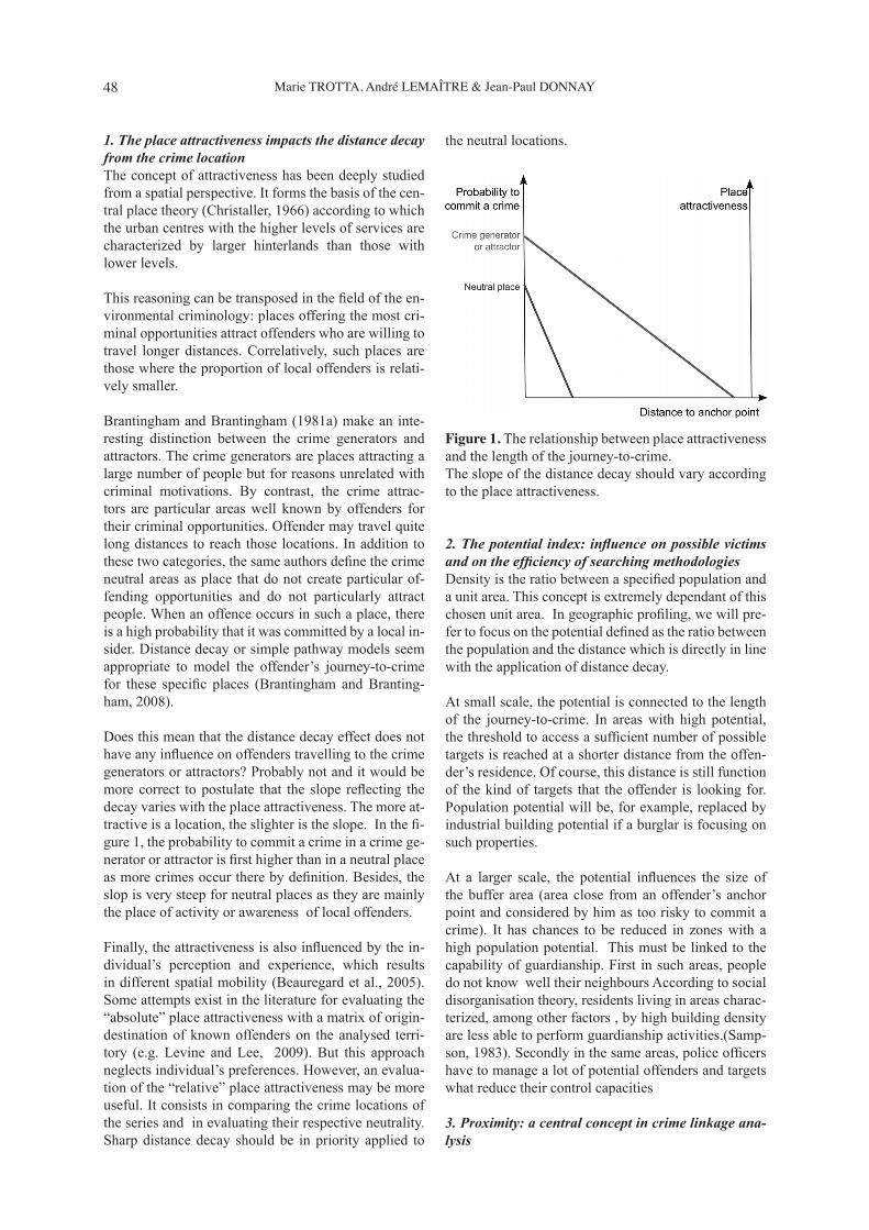
Does this mean that the distance decay effect does not have any infl uence on offenders travelling to the crime generators or attractors? Probably not and it would be more correct to postulate that the slope refl ecting the decay varies with the place attractiveness. The more at-tractive is a location, the slighter is the slope. In the fi -gure 1, the probability to commit a crime in a crime ge-nerator or attractor is fi rst higher than in a neutral place as more crimes occur there by defi nition. Besides, the slop is very steep for neutral places as they are mainly the place of activity or awareness of local offenders.
Finally, the attractiveness is also infl uenced by the in-dividual’s perception and experience, which results in different spatial mobility (Beauregard et al., 2005). Some attempts exist in the literature for evaluating the “absolute” place attractiveness with a matrix of origin-destination of known offenders on the analysed terri-tory (e.g. Levine and Lee, 2009). But this approach neglects individual’s preferences. However, an evalua-tion of the “relative” place attractiveness may be more useful. It consists in comparing the crime locations of the series and in evaluating their respective neutrality. Sharp distance decay should be in priority applied to
the neutral locations.
Figure 1. The relationship between place attractiveness and the length of the journey-to-crime. The slope of the distance decay should vary according to the place attractiveness.
2. The potential index: infl uence on possible victims and on the effi ciency of searching methodologiesDensity is the ratio between a specifi ed population and a unit area. This concept is extremely dependant of this chosen unit area. In geographic profi ling, we will pre-fer to focus on the potential defi ned as the ratio between the population and the distance which is directly in line with the application of distance decay.
At small scale, the potential is connected to the length of the journey-to-crime. In areas with high potential, the threshold to access a suffi cient number of possible targets is reached at a shorter distance from the offen-der’s residence. Of course, this distance is still function of the kind of targets that the offender is looking for. Population potential will be, for example, replaced by industrial building potential if a burglar is focusing on such properties.
At a larger scale, the potential infl uences the size of the buffer area (area close from an offender’s anchor point and considered by him as too risky to commit a crime). It has chances to be reduced in zones with a high population potential. This must be linked to the capability of guardianship. First in such areas, people do not know well their neighbours According to social disorganisation theory, residents living in areas charac-terized, among other factors , by high building density are less able to perform guardianship activities.(Samp-son, 1983). Secondly in the same areas, police offi cers have to manage a lot of potential offenders and targets what reduce their control capacities
3. Proximity: a central concept in crime linkage ana-lysis
49Operationality of geographic profi ling through a hypothetico-deductive method.A review of constraints and factors
The concept of proximity is central in the linkage of criminal activities. If the fi rst meaning of proximity is the nearness in space or time, it must be analysed in combination with its second defi nition: nearness or closeness in a series. Does proximity in space and/or time help to link criminal events and to which degree of effectiveness?
Firstly, proximity makes easier comparisons between cases and their modus operandi. If all the offences occur in the same police area, the investigators are generally aware of the other similar cases. By contrast, commu-nication can be very limited between different police services especially for the most common offences. This comparison is also easier with temporal proximity. The reason is not directly connected with communication but more with memory, the capacity to remember si-milar events in the past. It will be easier to remember a similar modus operandi if the previous offence occurs only some days or weeks ago.
However, crime offi cers can have a more proactive behaviour by monitoring possible linkages for typical offences. In the context of an exploratory research, the spatial and temporal proximities are two dimensions of the hyperspace of information (Turton et al., 2000) with respect to which data mining can search for nearby events. By blocking a range of space and time, the po-lice may have a systematic comparison of the modus operandi of nearby events.
In the cases described above, the linkage is based on si-milar modus operandi while the spatio-temporal proxi-mity facilitates their comparison. However, the tempo-ral and spatial proximities of crimes can be themselves important criteria for the linkage.
The impacts of geographical and temporal proximities in linkage have been studied for offences such as se-rial burglaries, serial car thefts or serial sex offences (Bennell and Canter, 2002; Bennell and Jones, 2005; Goodwill and Alison, 2006; Tonkin et al., 2008; Gru-bin et al., 2001 cited in Markson et al., 2010). The analysis of pairs to link crimes showed that there was greater consistency in the spatial and temporal simila-rities than those in the modus operandi (Goodwill and Alison, 2006; Grubin et al., 2001). In order to estimate geographical proximity, studies mainly used the mean inter-crime distance. Studying temporal proximity, Goodwill and Alison (2006) showed that the day inter-val was a better indicator of crime linkage than the time of crimes (hours).
4. Unit area issue and its impacts on factorsThe problem of the modifi able unit area (MAUP) is well-known in geography where it is considered as a source of bias in multiple spatial analyses (Openshaw, 1984; Cressie, 1996; Unwin, 1996). Geographic profi -
ling obviously is not exception to this issue. As soon as point data – occurrences or measures - are aggregated by postcode areas or police precincts for instance, the selected boundaries affect the meaning and the signi-fi cance of the fi gures. This section does not develop deeply all the impacts of the MAUP but highlights the infl uence it has on already discussed factors.
The most frequent inconsistency is a scale issue: the unit areas are too small or too large related to the phe-nomenon under investigation. For example, police crime statistics aggregated at the municipal level make impossible the identifi cation of crime attractors or ge-nerators at the street or city-block levels. The popula-tion potential computed for each unit may hide great variations inside the area. In the same vein, measuring the overall attractiveness of a city can hide signifi cant spatial variations between its different neighbourhoods. Recent studies advised to choose a small spatial unit (Weisburd et al., 2009), especially for studying the at-tractiveness of crime places (Bernasco, 2010).
However, they do generally not propose to consider simultaneously several levels to evaluate place attrac-tiveness. They neglect the fact that a place may have different attractive infl uences in function of the level of observation. A city with potential attractive functions, at a national level for example, has also ordinary func-tions for which the attractiveness is reduced to local vicinity. For example, the common bar institutions, located outside the most frequented neighbourhoods probably do not have a greater attractiveness than those located in smaller, medium sized cities. A fi rst advice is then to favour multi-scale analysis for the evaluation of this factor.
Secondly, the spatial partition forced / imposed by the use of unit areas may confl ict with a phenomenon which is intrinsically spatially continuous. The distance decay model used in geographic profi ling is precisely a spatially continuous model (in an isotropic or anisotro-pic space) which can hardly be correlated with fi gures aggregated in arbitrary areal units. For example, the infl uence of nearby units may be important (Bernasco and Block, 2011 ) when the units are small in com-parison with the length covered by the distance decay (smooth slope). In addition, arbitrary space discretiza-tion generates a segmentation of information. Thus, a police offi cer investigating a crime committed on the edge of a spatial entity and who is not aware of similar crimes in a neighboring entity, will tend to move the assumed anchor point towards the centre of the entity under investigation (Rengert and Lockwood, 2009).
There is also concern about the impact of unit size on the calculation of rasterized surfaces. Thus, the accura-cy of the likelihood surfaces is affected by the over-or underestimation of distances depending on the position
50 Marie TROTTA, André LEMAÎTRE & Jean-Paul DONNAY
of crime sites in cells superimposed on the study area. A second advice should be to pay attention to the pos-sible infl uence of close units when small unit areas are chosen. This infl uence should be taken into account in the modelling with a kernel density estimator (Levine, 2004).
C. Integration of the temporal properties to com-plete spatial factors
The previous section revealed that the temporal dimen-sion is extremely linked to the spatial factors condi-tioning an effective geographic profi le. Capone and Nichols (1975) already observed that time impacts the average distance to crime. Crime generators during shop opening hours are different from those during the night. Spatial proximity is useless without the temporal one.
Introducing temporal information presents several is-sues. First, the information is often missing, police offi -cers failing to record the temporal elements (Branting-ham and Brantingham, 2003). Besides, when recorded, it is often imprecise as the victim is not capable to re-port an accurate time of when the crime occurs because of his absence (burglary) or because of the choc (rapes). Thereby, the precision about the moment of crime va-ries, among others, in function of the offence type with better precision for robbery, assault or street offences than burglaries (Ratcliffe, 2002 ).
However, even when it is imprecise, temporal infor-mation may still be useful. The temporal dimension is multi-scale: from the years to the seconds, with seve-ral dichotomies organising people activities: night/day, working/vacation days, or even categories such as the days of the week, the hours, etc. Chainey and Ratcliffe (2005) describe several temporal categories: the mo-ments, the duration, the structured time (hours), time as a distance and time span, and all those categories can be used in an investigation. The following sections ana-lyses successively several temporal categories that may bring new insight on the offender’s spatial behaviour. It details the relationship between the offender’s crime locations and anchor point thanks to the introduction of the temporal dimension.
1. The Moment of crimes: relation with offender’s ac-tivities, potential targets and absence of guardianshipThe moment when crime occurs is infl uencing our un-derstanding of the offender’s decision process (evalua-tion of risks, costs and benefi ts according to the ratio-nal choice). From the temporal point of view, place properties are not static. They evolves over long time periods but also according to the hourly rhythm of hu-man activities. Time infl uences the three components of the crime described by the routine activity theory: the presence/absence of offender, potential target and
capable guardian (Cohen and Felson, 1979). As” the relevant actors – victims, offenders, guardians, and place managers – adjust their relative densities over time and around specifi c places, the opportunities for crime shift and coagulate “(Ratcliffe, 2010:15).
From the perspective of profi ling, the timing of the crimes informs police investigators about the offen-der’s activities or constraints. Indeed, the facts taking place as well during the day as during the night will ra-ther be liaised with someone unemployed, with a ram-bling lifestyle. By contrast, the facts occurring on very small time slots could mean more constraints for the offender such as work with a regular schedule, a family to whom he must justify his absences, etc.
Potential victims are also changing through time. The concepts of crime attractor and generators are particu-larly closely related to the temporal dimension (Brant-ingham and Brantingham, 2008). Depending on day or night, a location can be either a crime generator or a crime attractor or a neutral place for the same crime type. Supermarkets or commercial locations are crime generators only during the day for pickpockets. A very busy place during the day may become completely de-serted at night, for example in business districts, and vice versa for residential areas. This results in diffe-rences in the presence of guards during the day. The integration of temporal dimension is then crucial when analysing the pattern of crime locations in order to evaluate if they can be considered as neutral so that the distance decay could have some positive impact.
2. Spatio-temporal clusteringAmong conditions enumerated by Rossmo (2000 ), the presence of a stable anchor point is generally required for any GP methodology. This condition, if diffi cult to validate, can be better estimated with the integration of the temporal dimension.
Indeed, the analysis of spatio-temporal clusters is a fi rst indication of multiple anchor points or different modes of transportation. The offender or victim’s mode of transportation can vary according to the days of week. As an example, a young offender is studying in one city, leaving there during the week, travelling mainly with public transportations. During the weekend, he comes back to his parent’s house in the countryside. He travels there only as a pedestrian. By dividing the series into two sub-series (week and weekend), the two spa-tial patterns around his two anchor points will be clear-ly identifi ed. Besides, the mean inter-crime distances for the weekend pattern will probably be shorter than the week one. Besides, the clustering can be explained by the choice of victims such as a rapist operating in the vicinity of bus stops in the morning hours but never during the weekend given the lack of victims.
51Operationality of geographic profi ling through a hypothetico-deductive method.A review of constraints and factors
3. ChronologyThe chronology of events allows to precise another of the Rossmo’s assumption: the presence of several crime locations. As it was described above, Lundrigan and Canter (2001) studying serial murders, insisted on an interesting temporal aspect: the presence of an emotional ”cooling-off period” between each crime as opposed to the mass or spree type, in which all crimes occur more or less simultaneously. If all the crimes oc-cur in a few hours, there is a high probability to face one or multiple offenders commuting to the areas. The several locations are only steps in the same journey-to-crime. Several crimes locations are then not enough; they must also be separated in time to build a likelihood surface based on multiple journeys-to-crime.
This cooling-off period can be days, weeks or months. A smaller number of days between crimes seems to be correlated with a commuter behaviour (Paulsen, 2007). By contrast, if crimes occur during several months or years at locations not far from each other, the conditions of stable anchor point and small journey-to-crimes will often be satisfi ed. However, longer time periods in-crease the probability of a moving anchor point.
If an offender doesn’t go back to his residence after a crime, conducting a circuit path, the chronology indi-cates the direction/sense of this path. It provides then information about his provenance.
The relationship between distances travelled by the offender and the chronology of events is reviewed by Snook et al. (2005) for serial murders. Both a decrease and an increase in distances from home base to crime locations have been observed (Godwin and Canter, 1997, Rossmo, 2000) and fi nd a logical explanation. An increase in travelled distances could be explained by the fear to be recognised, leading the offender to tra-vel further from his anchor point. A decrease would be the result of a confi dence-building, the offender taking more and more risks.
“Closely associated with series chronology is the belief that serial offenders live in closer proximity to their fi rst crime location than their subsequent crime locations (Canter, 1994, Canter and Larkin, 1993, Warren et al., 1995)” in (Snook et al., 2005: 150). A more steady dis-tance decay to home should then be observed from this crime location. But even this believed is not always ob-served. While Rossmo (2000) found that 41% of serial murders commit their fi rst crime at the nearest location from home, the closest offence location corresponds to the fi rst one for only 18% of the serial rapists studied by Warren et al. (1995)Besides, in an operational perspective, police investi-gators can never be sure that the fi rst offence recorded in the series was the fi rst committed by the offender. Some victims may have not complained their injury.
Or even, the offender was maybe already involved in other criminal activities before which had some in-fl uence on its knowledge of crime locations.
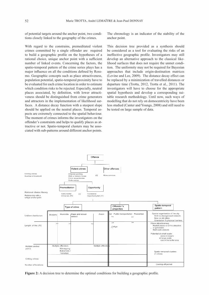
IV. DISCUSSION: A DECISION TREE SYNTHE-TIZING CONSTRAINTS AND FACTORS.
A decision tree synthetises the relationships between the constraints and factors discussed in the paper and the usual conditions required to build an effective like-lihood surface in GP. The tree is a tool for investigators confronted to a new investigation for which it should be decided to build or not the geographic profi le. It should be read from top to bottom. At each step, the investigator can check which conditions (italic) depend on the constraint or factor. The constraints of the pre-meditation and the seriousness of the offence have a bi-nary reading while the factors have a more gradual im-pact on the application of GP. Premeditation is linked to a rational choice for which a single anchor point and short distances are more frequent than in opportunis-tic situations. Violent crimes are preferred to the other offences for the resources spent in linking such crimes and to meet the higher expectancies of the victims.
At the third level of the three, decisions must be taken with regard to different components: the type of crime, the offender’s properties and the spatio-temporal pat-tern of the crime locations. For example, serial rapes and sexual assaults are the crime for which an applica-tion of GP generally presents the best conditions: small journeys-to-crime, easy determination of multiple of-fenders by contrast to arsonists who are often acting in groups. The application to serial murders is also possible if some categories such as the extremists or terrorism are rejected. For the spatio-temporal pattern, neutral places are crucial for applying distance decays functions but place attractiveness should always be evaluated for a specifi c moment.
V. CONCLUSION
This paper had for objective to identify the constraints and factors enabling the computation of an effective geographic profi le, with the specifi city of focusing only on the elements that could be available during an investigation. It aimed at fi lling the gap between the inductive demarche of environmental criminology and the studies on the journey-to-crime and the hypothe-tico-deductive, operational procedure followed by geo-graphic profi lers.
The article was based on the conditions, mainly defi ned by Rossmo (2000), necessary for the implementation of likelihood surfaces with a particular attention to the respect of the distance decay and uniform distribution
52 Marie TROTTA, André LEMAÎTRE & Jean-Paul DONNAY
of potential targets around the anchor point, two condi-tions closely linked to the geography of the crimes.
With regard to the constrains, premeditated violent crimes committed by a single offender are required to build a geographic profi le on the hypotheses of a rational choice, unique anchor point with a suffi cient number of linked events. Concerning the factors, the spatio-temporal pattern of the crime series plays has a major infl uence on all the conditions defi ned by Ross-mo. Geographic concepts such as place attractiveness, population potential, spatio-temporal proximity have to be evaluated for each crime location in order to estimate which condition risks to be rejected. Especially, neutral places associated, by defi nition, with lower attracti-veness should be distinguished from crime generators and attractors in the implementation of likelihood sur-faces. A distance decay function with a steepest slope should be applied on the neutral places. Temporal as-pects are extremely connected to the spatial behaviour. The moment of crimes informs the investigators on the offender’s constraints and helps to qualify places as at-tractive or not. Spatio-temporal clusters may be asso-ciated with sub-patterns around different anchor points.
The chronology is an indicator of the stability of the anchor point.
This decision tree provided as a synthesis should be considered as a tool for evaluating the risks of an ineffective geographic profi le. Investigators may still develop an alternative approach to the classical like-lihood surfaces that does not require the unmet condi-tion. The uniformity may not be required for Bayesian approaches that include origin-destination matrices (Levine and Lee, 2009). The distance decay effect can be replaced by a minimization of travelled distances or departure time (Trotta, 2012, Trotta et al., 2011). The investigators will have to choose for the appropriate spatial hypothesis and develop a corresponding sui-table research methodology. Until now, such ways of modelling that do not rely on domocentricity have been less studied (Canter and Youngs, 2008) and still need to be tested on large sample of data.
Figure 2: A decision tree to determine the optimal conditions for building a geographic profi le.
53Operationality of geographic profi ling through a hypothetico-deductive method.A review of constraints and factors
REFERENCES
Alison, L., Bennell, C., Mokros, A., & Ormerod, D. (2002). The personality paradox in offender profi -ling: A theoretical review of the processes involved in deriving background characteristics from crime scene actions. Psychology, Public Policy, and Law, 8(1), 115-135.
Alston, J. (1994). The Serial Rapist’s Spatial Pattern of Target Selection. Master Thesis Simon Fraser Uni-versity, Barnaby.
Alston, J. (2001). The Serial Rapist’s Spatial Pattern of victim selection. . In M. G. Godwin (Ed.), Criminal Psychology and Forensic Technology: A Collabora-tive Approach to Effective Profi ling (pp. 231-249). Boca Raton: CRC Press.
Beauregard, E., Proulx, J., & Rossmo, D. K. (2005). Spatial patterns of sex offenders: Theoretical, em-pirical, and practical issues. Aggression and Violent Behavior, 10(5), 579-603.
Beauregard, E., Rossmo, D., & Proulx, J. (2007). A Descriptive Model of the Hunting Process of Serial Sex Offenders: A Rational Choice Perspective. Jour-nal of Family Violence, 22(6), 449-463. doi: 10.1007/s10896-007-9101-3
Bennell, C., & Canter, D. V. (2002). Linking commer-cial burglaries by modus operandi: tests using re-gression and ROC analysis. Science & Justice, 42, 153-164.
Bennell, C., & Corey, S. (2007). Geographic Profi ling of Terrorist Attacks. In R. N. Kocsis (Ed.), Criminal Profi ling (pp. 189-203): Humana Press.
Bennell, C., & Jones, N. J. (2005). Between a ROC and a hard place: a method for linking serial burglaries by modus operandi. Journal of Investigative Psychology and Offender Profi ling, 2, 23-41.
Bernasco, W. (2010). Modeling Micro-Level Crime Location Choice: Application of the Discrete Choice Framework to Crime at Places. Journal of Quanti-tative Criminology, 26(1), 113-138. doi: 10.1007/s10940-009-9086-6
Bernasco, W., & Block, R. (2011). Robberies in Chica-go: A Block-Level Analysis of the Infl uence of Crime Generators, Crime Attractors, and Offender Anchor Points. Journal of Research in Crime and Delinquen-cy, 48(1), 33-57. doi: 10.1177/0022427810384135
Brantingham, P.J, & Brantingham, P. L (1981a). Envi-ronmental Criminology: Waveland Press.
Brantingham, P. L., & Brantingham, P. J. (1981b). Notes on the Geometry of Crime. In B. P.L. & B. P.J. (Eds.), Environmental Criminology (pp. 27-54). Beverly Hills: Sage.
Brantingham, P. J., & Brantingham, P. L. (1990). En-vironmental Criminology, . Long Grove, Illinois,: Waveland Press.
Brantingham, P. J., & Brantingham, P. L. (2003). An-ticipating the displacement of crime using the prin-ciples of environmental criminology. In M. J. Smith
& D. B. Cornish (Eds.), Theory for Practice in Si-tuational Crime Prevention (Vol. 16, pp. 119-148). Devon, UK: Willan Publishing.
Brantingham, P.L & Brantingham, P.J (2008). Crime pattern theory. In R. Wortley & L. Mazerolle (Eds.), Environmental Criminology and Crime Analysis (pp. 78-93). Cullompton, Devon Willan Publishing.
Canter, D. (1994). Criminal shadows: Inside the mind of the serial killer. London: Harper Collins.
Canter, D. (2005). Confusing operational predicaments and cognitive explorations: comments on Rossmo and Snook et al. Applied Cognitive Psychology, 19(5), 663-668.
Canter, D.. (2011). Resolving the offender “profi ling equations” and the emergence of an investigative psychology. Current Directions in Psychological Science, 20(1), 5-10.
Canter, D., & Larkin, P. (1993). The Environmental Range of Serial Rapists. Journal of Environmental Psychology, 13, 63-69.
Canter, D., & Youngs, D. (2008). Geographical Offen-der Profi ling: Origins and Principles In D. Canter & D. Youngs (Eds.), Principles of Geographical Offen-der Profi ling (pp. 1-18). Burlington, USA: Ashgate Publishing Company.
Capone, D., & Nichols, W. (1975). Crime and distance: An analysis of offender behaviour in space. Procee-dings of the Association of American Geographers, 45-49.
Chainey, S., & Ratcliffe, J. (2005). GIS and crime map-ping. West Sussex: John Wiley & Sons
Christaller, W. (1966). Central Places in Southern Ger-many. Translate by C. Baskin. Die zentralen Orte in Süddeutschland. Eine ökonomisch-geographische Untersuchung über die Gesetzmäbigkeit der Ver-breitung und Entwicklung der Siedlungen mit städtis-chen Funktionen Jena; Fischer Verlag ; Dissertation ; 1933.: Prentice Hall.
Cohen, L., & Felson, M. (1979). Social change and crime rate trends: A routine activity approach. Ame-rican Sociological Review, 44, 588-608.
Cressie, N. (1996). Change of support and the modi-fi able areal unit problem. Geographical Systems, 3, 159-180.
Douglas, J. E. (1992). Crime classifi cation manual. New York, Toronto: Lexington Books , Maxwell Macmillan Canada, Maxwell Macmillan Internatio-nal.
Douglas, J. E., Burgess, A. W., Burgess, A. G., & Ress-ler, R. K. (1992). Pocket Guide to the Crime Classifi -cation Manual . A Standard System for Investigating and Classifying Violent Crimes. New York Lexing-ton Books
Elffers, H. (2004). Decision models underlying the journey to crime. In G. Bruinsma, H. Elffers & J. W. de Keijser (Eds.), Punishment, Places and Perpe-trators. Developments in Criminology and Criminal Justice Research (pp. 182–197). Cullompton: Willan
54 Marie TROTTA, André LEMAÎTRE & Jean-Paul DONNAY
Publishing.Fritzon, K. (2001). An examination of the relationship
between distance travelled and motivational as-pects of fi resetting behaviour [doi: DOI: 10.1006/jevp.2000.0197]. Journal of Environmental Psycho-logy, 21(1), 45-60.
Godwin, M., & Canter, D. (1997). Encounter and Death - The Spatial Behavior of US Serial Killers. Policing: An International Journal of Police Strategies & Ma-nagement, 20, 24-24.
Goodwill, A. M., & Alison, L. J. (2006). The develop-ment of a fi lter model for prioritising suspects in bur-glary offences. [doi: 10.1080/10683160500056945]. Psychology, Crime & Law, 12(4), 395-416. doi: 10.1080/10683160500056945
Grubin, D., Kelly, P., & Brundson, C. (2001). Linking serious sexual assaults through behaviour (Vol. 215). London: Home Offi ce Research Study.
Hazelwood, R. R., & Warren, J. (2000). The sexual-ly violent offender - Impulsive or ritualistic? [doi:10.1016/S1359-1789(99)00002-6]. Aggression and Violent Behavior, 5, 267-279.
Holmes, R., & De Burger, J. (1988). Serial murder: studies in crime law and justice. Newbury Park, CA.
Knabe-Nicol, S., & Alison, L. (2011). The cognitive expertise of Geographic Profi lers. In L. Alison & S. L. Rainbow (Eds.), Professionalizing Offender Profi ling: Forensic and Investigative Psychology in Practice (pp. 296). London & New York: Routledge. Taylor & Francis group.
Laukkanen, M., & Santtila, P. (2006). Predicting the re-sidential location of a serial commercial robber. [doi: DOI: 10.1016/j.forsciint.2005.03.020]. Forensic Science International, 157(1), 71-82.
Laukkanen, M., Santtila, P., Jern, P., & Sandnabba, K. (2008). Predicting offender home location in ur-ban burglary series. Forensic science international, 176(2-3), 224-235.
Levine, N. (2004). CrimeStat III: A spatial statistics program for the analysis of crime incident locations. Version 3.0. Houston, TX, and Washington, DC: Ned Levine and Associates and the National Institute of Justice.
Levine, N., & Block, R. (2011). Bayesian Jour-ney-to-Crime Estimation: An Improve-ment in Geographic Profi ling Methodolo-gy. [doi: 10.1080/00330124.2010.547152]. The Professional Geographer, 63(2). doi: 10.1080/00330124.2010.547152
Levine, N., & Lee, P. (2009). Bayesian journey-to-crime modelling of juvenile and adult offenders by gender in Manchester. [References]. Journal of Investigative Psychology and Offender Profi ling, Vol.6(3), 237-251.
Lundrigan, S., & Canter, D. (2001). A multivariate analysis of serial murderers’ disposal site location choice. [doi: DOI: 10.1006/jevp.2001.0231]. Jour-nal of Environmental Psychology, 21(4), 423-432.
Markson, L., Woodhams, J., & Bond, J. W. (2010). Lin-king serial residential burglary: comparing the utility of modus operandi behaviours, geographical proxi-mity, and temporal proximity. Journal of Investiga-tive Psychology and Offender Profi ling, 7(2), 91-107.
Openshaw, w. (1984). The modifi able areal unit pro-blem Concepts and Techniques in Modern Geogra-phy (Vol. 28). Norwich: Geo Books.
Paulsen, D. (2007). Improving Geographic Profi ling through Commuter/Marauder Prediction. Police Practice and Research, 8(4), 347 - 357.
Phillips, P. (1980). Characteristics and typology of the journey to crime. In D. E. Georges-Abeyie & K. D. Harries (Eds.), Crime: A spatial perspective (pp. 167-180). New York: Columbia University Press.
Ratcliffe, J. (2002). Aoristic Signatures and the Spatio-Temporal Analysis of High Volume Crime Patterns. Journal of Quantitative Criminology, 18(1), 23-43.
Ratcliffe, J. (2010). Crime Mapping: Spatial and Tem-poral Challenges. In A. R. Piquero & D. Weisburd (Eds.), Handbook of Quantitative Criminology (pp. 5-24): Springer New York.
Rengert, G. F., & Lockwood, B. (2009). Geographical Units of Analysis and the Analysis of Crime. In D. Weisburd, W. Bernasco & G. J. N. Bruinsma (Eds.), Putting Crime in its Place (pp. 109-122): Springer New York.
Rengert, G. F., Piquero, A. R., & Jones, P. R. (1999). Distance decay re-examined. Criminology, 37(2), 427-446. doi: 10.1111/j.1745-9125.1999.tb00492.x
Ressler, R. K., Burgess, A. W., & Douglas, J. E. (1988). Sexual homicide: patterns and motives. New York
Rhodes, W. M., & Conly , C. (1981). Crime and Mobi-lity - An Empirical Study In P. J. Brantingham & P. L. Brantingham (Eds.), Environmental Criminology (pp. 167-188). Prospect Heights: Waveland Press Inc.
Rossmo, D. K. (1997). Geographic Profi ling. In J. L. Jackson & D. A. Bekerian (Eds.), Offender Profi ling: Theory, Research and Practice.: Wiley and Sons.
Rossmo, K. (2000). Geographic profi ling. Boca Raton.: CRC Press.
Rossmo, K., & Velarde, L. (2008). Geographic Profi -ling Analysis: Principles, Methods and Applications. In L. T. Spencer Chainey (Ed.), Crime Mapping Case Studies (pp. 33-43).
Sampson, R. J. (1983). Structural Density and Crimi-nal Victimization. Criminology, 21(2), 276-293. doi: 10.1111/j.1745-9125.1983.tb00262.x
Santtila, P., Laukkanen, M., Zappala, A., & Bosco, D. (2008). Distance travelled and offence characteristics in homicide, rape, and robbery against business. Le-gal and Criminological Psychology, Vol.13(12), Sep 2008, pp.
Snook, B. (2004). Individual differences in distance travelled by serial burglars. Journal of Investigative Psychology and Offender Profi ling, 1(1), 53-66.
Snook, B., Cullen, R. M., Mokros, A., & Harbort, S.
55Operationality of geographic profi ling through a hypothetico-deductive method.A review of constraints and factors
(2005). Serial murderers’ spatial decisions: factors that infl uence crime location choice. Journal of In-vestigative Psychology and Offender Profi ling, 2(3), 147-164.
Tonkin, M., Grant, T., & Bond, J. W. (2008). To link or not to link: a test of the case linkage principles using serial car theft data. Journal of Investigative Psychology and Offender Profi ling, 5(1-2), 59-77. doi: 10.1002/jip.74
Tonkin, M., Woodhams, J., Bond, J. W., & Loe, T. (2010). A theoretical and practical test of geogra-phical profi ling with serial vehicle theft in a U.K. context. Behavioral Sciences & the Law, 28(3), 442-460.
Trotta, M. (2012). New hypotheses on serial offender’s spatial behaviour Paper presented at the 1 st AGILE Phd School 2012, Wernigerode.
Trotta, M., Bidaine, B., & Donnay, J.-P. (2011). Deter-mining the Geographical Origin of a Serial Offender Considering the Temporal Uncertainty of the Re-corded Crime Data. Paper presented at the GEOPro-cessing 2011 : The Third International Conference on Advanced Geographic Information Systems, Appli-cations, and Services, Gosier.
Turton, I., Openshaw, S., Brunsdon, C., Turner, A., & Macgill, J. (2000). Testing space-time and more complex hyperspace geographical analysis tools. In P. Atkinson & D. Martin (Eds.), GIS and Geocompu-tation (pp. 87-102): Taylor and Francis.
Unwin, D. J. (1996). GIS, spatial analysis and spatial statistics. Progress in Human Geography, 20(4), 540-551.
National Center for the Analysis of Violent Crime. (2008). Serial Murder: Multi-Disciplinary Perspec-tives for Investigators. In R. J. Morton (Ed.).
Warren, J., Reboussin, R., & Hazelwood, R. R. (1995). The geographic and temporal sequencing of serial rape. Washington: DC: Government Printing Offi ce.
Weisburd, D., Bruinsma, G. J. N., & Bernasco, W. (2009). Units of Analysis in Geographic Crimino-logy: Historical Development, Critical Issues, and Open Questions. . In D. Weisburd, W. Bernasco & G. J. N. Bruinsma (Eds.), Putting Crime in its Place (pp. 3-31): Springer New York.
White, R. C. (1932). The Relation of Felonies to En-vironmental Factors in Indianapolis. Social Forces, 10(4), 498-509.
Wortley, R. (2008). Situational precipitators of crime In R. Wortley & L. Mazerolle (Eds.), Environmental Criminology and Crime Analysis (pp. 294). Devon: Willan Publishing.
Coordonnées des auteurs :
Marie TROTTA Research Fellow F.R.S – FNRS
Unité de Géomatique, Université de LiègeAllée du 6 août 17, B5a, 4000 Liège, Belgium
Marie.Trotta @ulg.ac.be
André LEMAÎTREInstitut des Sciences humaines et sociales /
Criminologie, Université de LiègeBoulevard du Rectorat 7, B31, 4000 Liège, Belgium.
Jean-Paul DONNAYUnité de Géomatique, Université de Liège
Allée du 6 août 17, B5a, 4000 Liège, [email protected]

56