Open Space Seattle 2100 Book - University of Washington
9
DUWAMISH Team Leaders: Mark Johnson, Jim Brennan Student Team Members: Kari Stiles, Melissa Martin Team Members: Cari Simson, Karen Janosky, Dottie Faris, James Rasmussen, Sarah Kavage, Eric Higbee, Tom Knaublaugh, Scott Holsapple -185- A RIVER LOOM
Transcript of Open Space Seattle 2100 Book - University of Washington

DUWAMISH
Team Leaders: Mark Johnson, Jim BrennanStudent Team Members: Kari Stiles, Melissa MartinTeam Members: Cari Simson, Karen Janosky, Dottie Faris, James Rasmussen, Sarah Kavage, Eric Higbee, Tom Knaublaugh, Scott Holsapple
-185-
A RIVER LOOM
Duw
maish
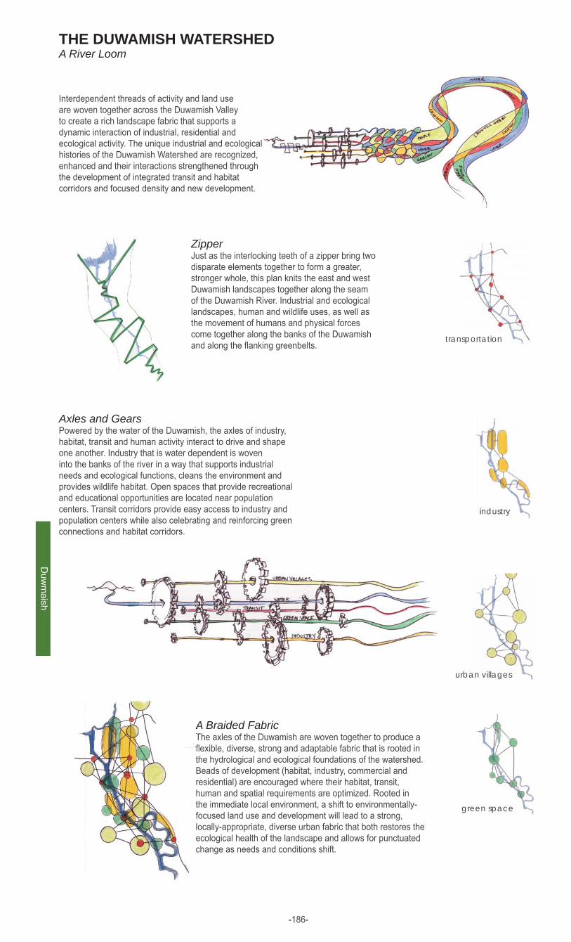
THE DUWAMISH WATERSHED A River Loom
ZipperJust as the interlocking teeth of a zipper bring two disparate elements together to form a greater, stronger whole, this plan knits the east and west Duwamish landscapes together along the seam of the Duwamish River. Industrial and ecological landscapes, human and wildlife uses, as well as the movement of humans and physical forces come together along the banks of the Duwamish and along the fl anking greenbelts.
Axles and GearsPowered by the water of the Duwamish, the axles of industry, habitat, transit and human activity interact to drive and shape one another. Industry that is water dependent is woven into the banks of the river in a way that supports industrial needs and ecological functions, cleans the environment and provides wildlife habitat. Open spaces that provide recreational and educational opportunities are located near population centers. Transit corridors provide easy access to industry and population centers while also celebrating and reinforcing green connections and habitat corridors.
A Braided FabricThe axles of the Duwamish are woven together to produce a fl exible, diverse, strong and adaptable fabric that is rooted in the hydrological and ecological foundations of the watershed. Beads of development (habitat, industry, commercial and residential) are encouraged where their habitat, transit, human and spatial requirements are optimized. Rooted in the immediate local environment, a shift to environmentally-focused land use and development will lead to a strong, locally-appropriate, diverse urban fabric that both restores the ecological health of the landscape and allows for punctuated change as needs and conditions shift.
urban villages
industry
transportation
green space
Interdependent threads of activity and land use are woven together across the Duwamish Valley to create a rich landscape fabric that supports a dynamic interaction of industrial, residential and ecological activity. The unique industrial and ecological histories of the Duwamish Watershed are recognized, enhanced and their interactions strengthened through the development of integrated transit and habitat corridors and focused density and new development.
-186-

Duw
amis
h
River mouth area
Alaskan Way container canyon
Kellogg Island
Terraced development
New river channel
Charrette 100 year plan
Charrette Conceptual Plans
-187-
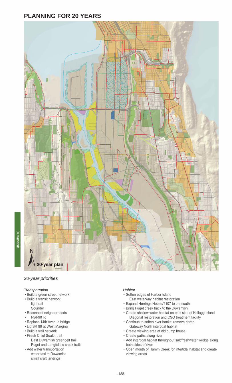
PLANNING FOR 20 YEARS
TransportationBuild a green street networkBuild a transit network
light rail Sounder
Reconnect neighborhoods I-5/I-90 lidReplace 14th Avenue bridgeLid SR 99 at West Marginal Build a trail networkFinish Chief Sealth trail
East Duwamish greenbelt trail Puget and Longfellow creek trails
Add water transportation water taxi to Duwamish small craft landings
••
••••••
•
HabitatSoften edges of Harbor Island
East waterway habitat restorationExpand Herrings House/T107 to the southBring Puget creek back to the DuwamishCreate shallow water habitat on east side of Kellogg Island
Diagonal restoration and CSO treatment facilityContinue to soften river banks; remove riprap
Gateway North intertidal habitatCreate viewing area at old pump house Create paths along riverAdd intertidal habitat throughout salt/freshwater wedge along both sides of riverOpen mouth of Hamm Creek for intertidal habitat and create viewing areas
•
•••
•
•••
•
±20-year priorities
Duw
maish
-188-

Duw
amis
h
LOOKING FORWARD 100 YEARS,
Strategies and implementationPercent of State Sales Tax applied to lidding regional transportation corridorsIncrease incentives for Transfer of Development Rights and Conservation Easements to increase designated habitat acreageDevelop citywide fi nancial incentives to encourage implementation of Green Energy Technology and Sustainable Development (i.e. wind, microhydro, solar, green roofs)Public Purchase of waterfront and greenbelt parcels to create continuous terrestrial and waterfront habitat corridorsUse Real Estate Excise Tax to develop public open space amenities (i.e. parks, green streets, rain gardens and green roofs)Develop transportation networks that facilitate industrial development in non critical (i.e. non-waterfront) habitat areas
•
•
•
•
•
•
proposed transportationBridge
Designated Bicycle Corridor
Green Street
Mass Transit
Neighborhood Green Street
Off Street Trail
Pedestrian Corridor
Street Car
Water taxi
proposed water featuresCreated Estuary
Created River
Created Stream
Daylit Stream
Existing Stream
Historic Stream
proposed habitatBackyard Habitat
CSO Living Machine
Estuary
Habitat Corridor
Mixed Forest
Puget Sound Riparian Area
Stream Riparian Area
Urban Waterfront Habitat
proposed water and drainageGreen Roof
Rain Garden
Rain Plaza
proposd community amenitiesActive Park
Civic Space
Lidded Open Space
Passive Park
Urban Agriculture
proposed urban centersCommercial Area
Industrial Area
New Urban Hub
New Urban Village
Urban Corridor
±existing areas
existing gardens
existing greenbelts
existing park
existing urban villages
existing habitatexisting habitat
existing trailsexisting arterials
existing bike trails
existing trails
duwamish study areaduwamish study area
duwamish buffer areaduwamish buffer area
-189-

Duw
maish
industrial, commercial, residential
transportation connections
habitat connections
habitat zoneall development prioritizes restoration of Duwamish River habitats and processes
•
•
ACTIVITY
Exploring Multi-Use and Mobile Spaces along the 8th Avenue Corridor
local energy harvest powers new developments
microturbines use water running under new developments to power local neighborhoodswind is harvested on rooftops and across the Duwamishsolar energy is captured on rooftops of all new developmentsgreen fuel is produced in local wetland and terrestrial nursery beds
•
•
•
•
ENERGY
industrial zonelocal development focuses on providing opportunities for water-based industry\habitat is seamlessly integrated into industrial infrastructure
•
integration zonehuman access to the river is prioritized natural and built infrastructure is integrated and exposed to reveal interactions between the built and natural environment
•
•
-190-

Duw
amis
h
8th avenue corridorDuwamish River Park bridges the habitat and pedestrian gap between Georgetown and South Park
wetlands, forests and agriculturethe fl ood zone, the landfi ll and the slide zone have been reclaimed for estuary habitat and native plant nurseries
spanning the Duwamishhabitat, pedestrian corridors and windmills replace the street grid across the Duwamish
2100. looking northSouth Park, Georgetown, and River city have grown up around Duwamish River Park
seep walls reveal the subsurface water movement and recycled building materials
bridges provide pedestrian and habitat connections while also harvesting wind energy
water plaza collects and fi lters stormwater
convertible plaza space for agriculture, plant nurseries, native gardens and community gathering spacesnative riparian habitat
and passive park space
native estuary habitat
wetland agricultural space grows food for local communities and native plants for restoration projects
landfi ll and fl ood zones are reclaimed by shoreline and forest vegetation
boardwalks provide pedestrian access throughout reclaimed landscapes
-191-
Duw
maish
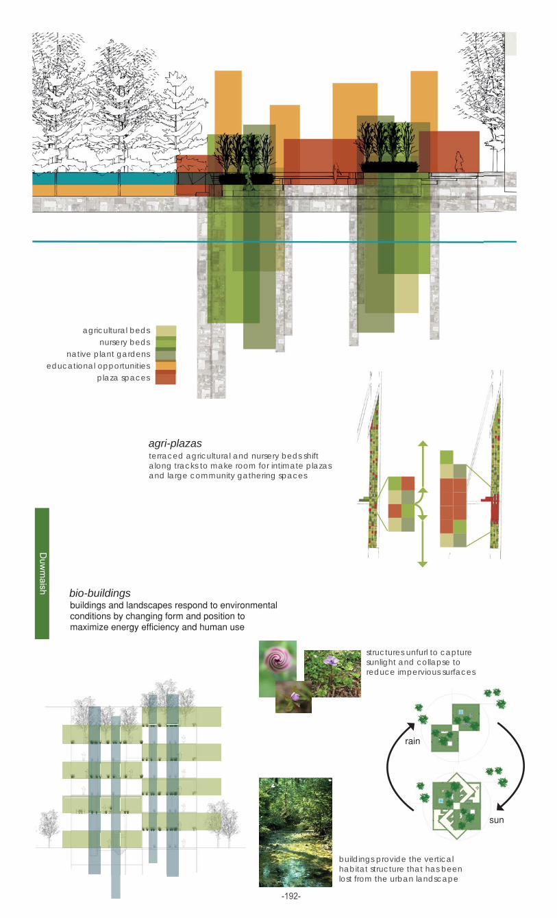
agricultural bedsnursery beds
native plant gardenseducational opportunities
plaza spaces
terraced agricultural and nursery beds shift along tracks to make room for intimate plazas and large community gathering spaces
agri-plazas
bio-buildings
buildings provide the vertical habitat structure that has been lost from the urban landscape
structures unfurl to capture sunlight and collapse to reduce impervious surfaces
-192-

Duw
amis
h
55%
Inte
rtid
al/S
hallo
w W
ater
/Est
uary
Recr
eatio
nal A
rea(
10%
tree
d)
Sho
relin
e Ri
paria
n Ar
ea
Str
eam
with
Rip
aria
n Ar
ea
G
reen
Roo
f/Li
dded
Urb
an A
gric
ultu
re
Mai
n/Bo
ulev
ard
Gre
en S
tree
t
Pas
sive
Par
k (7
0% fo
rest
ed)
Ra
in G
arde
n/Ra
in P
laza
Ba
ckya
rd H
abita
t
Nei
ghbo
rhoo
d G
reen
Str
eet
Fore
st/G
reen
belt/
Hab
itat C
orrid
or
ECOLOGICAL BENEFIT EVALUATIONanalysis of hydrological and habitat improvements: ballard and duwamish study areas
hydrology
100%
90%
80%
70%
60%
50%
40%
30%
20%
10%
habitat
www.ci.cypress.ca.us
www.briansmallphoto.com
www.ics.uci.edu/~eppstein/pix/orcas/obstruction-pass/Madrone-m.jpg
www.troop2ithaca.org
www.zoology.ubc.ca/~keeley/coho.htm
http://counties.cce.cornell.edu/suffolk/habitat_restoration/eelgrass.htm
Throughout the world, cities fragment, isolate, and degrade natural habitat. Application of the principles of landscape ecology, including interactions among patches, corridors, and metapopulation habitat networks, is valuable for enhancing urban ecological health. By improving habitat quantity, quality, and connectivity, it is possible to conserve and protect native plant and animal species.
797 acres
2,855 acres
5,531 acres
increased habitat qualityexpanded stepping stones
limited corridor connectivitylow habitat qualitylimited interior habitatfew stepping stones
improved corridor connectivityenhanced habitat qulaityincreased interior habitatexpanded stepping stones
4,799 acres effective pervious surface
2,636 acres effective pervious surface
1,369 acres effective pervious surface
205,194 CCF
822,164 CCF
970,476 CCF
Duwamish Study Area Results study area size: 1,230,036 acres area of improvements (20 years): 959 acres area of improvements (100 years): 3054 acres
curr
ent
100
year
20 y
ear
curr
ent
100
year
20 y
ear
-193-