OPEN-CAST AND UNDERGROUND COAL MINING Biodiversity and
76
USUTU COLLIERY ECOLOGICAL ASSESSMENT REPORT Page 0 15 APRIL 2012 VUNENE MINING (PTY) LTD– USUTU COLLIERY OPEN-CAST AND UNDERGROUND COAL MINING Biodiversity and Ecological Assessment Authored by: VUYOKAZI APRIL ( PR.SCI.NAT. ) ENVIRONMENTAL SPECIALIST ENVIRONMENTAL ASSURANCE (PTY) LTD. 394 Tram Street New Muckleneuk Pretoria 0181 Phone: 012-460-9768 Fax: 012-460-3071 E-mail: [email protected] www.envass.co.za Project Number: USU-ECO-325d Revision: 01/ 08 May’12 Distribution: 1x Copy VUNENE (Pty) Ltd 1X Copy ENVASS ECOLOGICAL REPORT
Transcript of OPEN-CAST AND UNDERGROUND COAL MINING Biodiversity and
USUTU COLLIERY ECOLOGICAL ASSESSMENT REPORT Page 0
15 APRIL 2012
27 April 2012 VUNENE MINING (PTY) LTD– USUTU COLLIERY
OPEN-CAST AND UNDERGROUND COAL MINING
Biodiversity and Ecological Assessment
Authored by: V U Y O K A Z I A P R I L ( P R . S C I . N A T . ) E N V I R O N M E N T A L S P E C I A L I S T
E N V I R O N M E N T A L A S S U R A N C E ( P T Y ) L T D . 394 Tram Street
New Muckleneuk
Pretoria
0181
Phone: 012-460-9768
Fax: 012-460-3071
E-mail: [email protected]
www.envass.co.za
Project Number: USU-ECO-325d Revision: 01/ 08 May’12 Distribution: 1x Copy VUNENE (Pty) Ltd 1X Copy ENVASS
EC
OL
OG
ICA
L R
EP
OR
T
USUTU COLLIERY ECOLOGICAL ASSESSMENT REPORT Page 1
1. Foreword This Biodiversity and Ecological Assessment study was undertaken as part of the
Environmental Impact Assessment (EIA). The Environmental Impact Assessment
(EIA) process followed is in compliance with the National Environmental
Management Act, 1998 (Act 107 of 1998), as amended and the Environmental
Impact Assessment Regulations of 2010 (Government Notice No’s R543, 544 and
545 in Government Gazette No 33306 of 18 June 2010) As corrected by “Correction
Notice 1” (GN No. R. 660 of 30 July 2010) and “Correction Notice 2” (GN No. R.
1159 of 10 December 2010).
This study was done for: Environmental Assurance (PTY) LTD
Name : Ilze Ueckermann
Designation : Senior Environmental Consultant
Date : 19-20 January and 16-17 April 2012
Signature :
Quality control and review was done by:
Name : Retha Weir
Date : 17 May 2012
Signature :
This report was reviewed and approved by:
Name : Henno Engelbrecht
Designation : Programme Manager
Date : 28 May 2012
Signature :

USUTU COLLIERY ECOLOGICAL ASSESSMENT REPORT Page 2
2. Executive Summary Environmental Assurance (Pty) Ltd (Envass), as an independent environmental
consultant have been appointed by Vunene Mining (Pty) Ltd to undertake an
Environmental Impact Assessment (EIA) for the proposed coal mining at USUTU
Colliery. The proposed activity is aimed to take place on the following farms, namely:
Jan Hendriksfontein 263IT,
Witpunt 267IT,
Leeuwenburg 137IT,
Holbank 265IT,
Transutu 257IT,
Mooiplats 290IT,
Roodewal 270IT and
Vlakfontein 266IT and 269IT.
The work plan proposed is a combination of open cast and underground mining of
certain portions of the above mentioned farms. An activity of this magnitude entails
that the Environmental Impact Assessment (EIA) be conducted in terms of National
Environmental Management Act (no 107 of 1998).
As part of the EIA requirements, an ecological assessment was conducted and the
study aimed to assess the occurrence and diversity of flora and fauna species
associated with the site, the ecological functionality and conditions that influence the
area’s ecosystems interactions. This report presents the findings obtained following
desktop research and field work undertaken within the study area.
The USUTU Colliery is located in the Msukaligwa Local Municipality (MP302) 5-10
kilometers south East of Ermelo in the Mpumalanga Province. From a biodiversity
point of view, the area has no formal land base protected areas, thus it has been
prone to extensive natural habitat loss due to land-use activities within the area.
The study has found and concluded that the proposed mining activity will cause a
significant environmental impact to the remaining natural environment. The study
area contains numerous wetlands types. A few of those wetland types, mainly the
floodplains still maintain their functionality and offer a series of species ecological
important ecosystem services. These include their use as breeding sites and as
general species habitat.
The proposed activity will include the removal of vegetation thus causing habitat loss
for species such as African grass owl. The obstruction of water flow would result in
wetland drainage or dryness which will prevent species functioning, mainly for birds

USUTU COLLIERY ECOLOGICAL ASSESSMENT REPORT Page 3
that use this environment for breeding and migratory purposes. Further disturbance
to the area will lead to more alien species invasion and remaining natural area loss.
It is therefore recommended that the proposed mining, should it be authorized,
includes rehabilitation, especially of wetlands in their Environmental Management
Plans. Furthermore, there should be an allowance for species movement by leaving
strips of natural vegetation that would serve as corridors for species movement. The
client should adhere to the buffering zones recommended by the specialists. Lastly,
further monitoring of the ecological function pre and during mining should be
considered in order to maintain and manage the biodiversity of the area prior to
rehabilitation.
Due to the intensity of land-use activity in the area, it should be understood that the
cumulative environmental impacts on the area are the results of the combination of
the agricultural, infrastructure and mining activities in the vicinity. Therefore, it is
important to consider the severity of each activity and where they interlink in order to
implement a correct ecological management of the area.

USUTU COLLIERY ECOLOGICAL ASSESSMENT REPORT Page 4
3. Declaration of independence This study was conducted by Vuyokazi April in her capacity as flora and fauna
specialist for the Environmental Assurance (Pty) Ltd (Envass). Envass is an
independent consultant to Vunene Mining (Pty) Ltd. – USUTU Colliery and has no
business, financial, personal or other interest in the activity, application or appeal in
respect of which they were appointed other than fair remuneration for work
performed in connection with the activity, application or appeal. There are no
circumstances that compromise the objectivity of this specialist performing such
work.
Miss April is registered with the South African Council for Natural Scientific
Professions (SACNASP) (400260/11) as a biological scientist and has six years of
combined experience in conducting EIA of exotic introduced plants and insects on
indigenous flora and fauna; and as a biodiversity conservation planner.
The findings, results, observations, conclusions and recommendations given in this
report are based on the author’s best scientific and professional knowledge as well
as available information.
3.1 Project Team:
Team Members Field Qualifications
Vuyokazi April Biological Sciences and
Ecology
MSc in Natural Science
(majoring with Zoology
and Entomology),
Registered SACNASP
member 400260/11
Emile van Druten Ecology and Project
Management
MSc in Project
Management
Henno Engelbrecht Project Management Hons. Environmental
Management
USUTU COLLIERY ECOLOGICAL ASSESSMENT REPORT Page 5
4. Contents
1. FOREWORD ...................................................................................................................................... 1
2. EXECUTIVE SUMMARY ...................................................................................................................... 2
3. DECLARATION OF INDEPENDENCE .................................................................................................... 4
3.1 PROJECT TEAM: ................................................................................................................................................................ 4
5. ACRONYMS ...................................................................................................................................... 7
6. INTRODUCTION ................................................................................................................................ 8
7. TERMS OF REFERENCE .................................................................................................................... 10
7.1 DESKTOP RESEARCH AND LITERATURE REVIEW ................................................................................................................ 10
7.2 SITE SCREENING OR GROUND TRUTHING.......................................................................................................................... 10
7.3 FIELD SURVEY AND SAMPLING .......................................................................................................................................... 10
8. OBJECTIVES AND SCOPE OF THE STUDY ........................................................................................... 11
8.1 OBJECTIVES ................................................................................................................................................................... 11
8.2 SCOPE OF THE STUDY ..................................................................................................................................................... 11
9. METHODOLOGY ............................................................................................................................. 12
9.1 DESKTOP STUDY ............................................................................................................................................................. 12
9.2 FIELD ASSESSMENT ......................................................................................................................................................... 13
10. APPLICABLE LEGISLATION ............................................................................................................... 14
11. SITE DESCRIPTION .......................................................................................................................... 15
11.1 THE PROVINCE ............................................................................................................................................................. 15
11.2 THE LOCATION .............................................................................................................................................................. 15
11.2.1 Geology ............................................................................................................................................. 15
11.2.2 Hydrology .......................................................................................................................................... 16
11.2.3 Vegetation .......................................................................................................................................... 16
11.3 PROJECT DESCRIPTION ................................................................................................................................................. 16
12. STUDY ASSUMPTION AND LIMITATION ........................................................................................... 19
13. FINDINGS AND RESULTS ................................................................................................................. 20
13.1 VEGETATION COMMUNITIES ........................................................................................................................................... 20
13.2 FLORA COMMUNITIES .................................................................................................................................................... 26
13.3 FAUNAL COMMUNITIES .................................................................................................................................................. 35
14. SPECIES OF SPECIAL CONCERN ........................................................................................................ 41
14.1 FLORA 41
14.2 FAUNA 41
14.2 ALIENS AND INVASIVES .................................................................................................................................................. 43

USUTU COLLIERY ECOLOGICAL ASSESSMENT REPORT Page 6
15. ENVIRONMENTAL IMPACTS AND RECOMMENDATIONS ................................................................... 44
16. REFERENCES ................................................................................................................................... 46
17. ANNEXURE ..................................................................................................................................... 48
17.1 IUCN CATEGORIES (SOURCE: WWW.IUCNREDLIST.ORG)................................................................................................. 48
17.2 IMPACT ASSESSMENT CATEGORIES ............................................................................................................................... 48
17.3 INPUT SPATIAL LAYERS .................................................................................................................................................. 49
17.4 SOFTWARE USED .......................................................................................................................................................... 49
17.5 ASSESSMENT OF PLANT SPECIES ................................................................................................................................... 49
17.6 ASSESSMENT OF FAUNA ................................................................................................................................................ 49
18. GLOSSARY ...................................................................................................................................... 50
19. APPENDICES ................................................................................................................................... 52
APPENDIX 1: LIST OF INTERNATIONAL AGREEMENTS AND FRAMEWORKS FOR BIODIVERSITY CONSERVATION AND
MANAGEMENT. ...................................................................................................................................................................... 52
APPENDIX 2: LIST OF SOUTH AFRICAN LEGISLATION PERTAINING TO THE BIODIVERSITY CONSERVATION AND
MANAGEMENT ....................................................................................................................................................................... 54
APPENDIX 3: LIST OF POLICY AND FRAMEWORKS ASSOCIATED WITH BIODIVERSITY CONSERVATION AND MANAGEMENT ............. 58
APPENDIX 5: FLORAL DIVERSITY SNAPSHOTS OBSERVED WITHIN AND AROUND USUTU MINING AREA ....................................... 64
APPENDIX 6: ANIMAL HOLES, SPOORS AND DROPPINGS OBSERVED AT USUTU ....................................................................... 71
APPENDIX 7: ENVIRONMENTAL IMPACTS ASSOCIATED WITH MINING OBSERVED AT USUTU ...................................................... 73
List of Tables and Figures
Table 1: Environmental Data Sources ...................................................................................................................... 12
Table 2: South African ecological zones and their conservation status ........................................................... 21
Table 3: The twelve vegetation types under most pressure from mining potential ranked from highest
to lowest and the mining pressure from high to medium (Rouget et.al., 2004). ............................................ 22
Table 4:- List of flora observed in the study area .................................................................................................... 29 Table 5:- List of fauna observed in the study area, their conservation status is based on the Red list
categories of 2011 ............................................................................................................................................................. 38
Figure 1: USUTU Colliery locality map ........................................................................................................................ 9
Figure 2: Hierarchy of Biodiversity legislation, policies and programmes (adopted from Kuntonen-van‘t
Riet, 2007) ........................................................................................................................................................................... 14 Figure 3: Site description map ...................................................................................................................................... 17
Figure 4: Portions that falls within the USUTU Colliery mine boundary .......................................................... 18 Figure 5: South African biome distribution (Mucina & Rutherford, 2006) ....................................................... 20
Figure 6: Vegetation types that falls within the study area .................................................................................. 22 Figure 7: National Spatial Biodiversity Assessment considers the remaining natural ecosystem status
where USUTU Colliery is situated endangered -Vunerable (NSBA, 2004) .................................................... 23 Figure 8: The Mpumalanga Terrestrial Ecosystem Biodiversity Conservation Plans which designate
the remaining natural vegetation types of the study site as highly significant (MPBCP, 2006) ............... 24
USUTU COLLIERY ECOLOGICAL ASSESSMENT REPORT Page 7
Figure 9: Transects and visual observation sampling points ............................................................................. 26
Figure 10: South African taxa of conservation concern (source SANBI, 2011) ........................................... 37 Figure 11: South African Ecosystem status (source: SANBI, 2011) ................................................................ 43
5. Acronyms AIP’s – Alien and Invasive Plants
BGIS – Biodiversity Geographical Information System
BLSA – Bird Life South Africa
CARA – Conservation of Agricultural Resource Acts
ECA – Environmental Conservation Act
EIA – Environmental Impact Assessment
EMP – Environmental Management Plans
Envass – Environmental Assurance
IUCN – International Union for the Conservation of Nature
MPBCP – Mpumalanga Biodiversity Conservation Plans
NBA* - National Biodiversity Assessment formerly known as National Spatial
Biodiversity Assessment (NSBA)
NBSAP – National Biodiversity Strategy and Action Plans
NEMA – National Environmental Management Act
NEMBA – National Environmental Management Biodiversity Act
NEMPAA – National Environmental Management Protected Areas Act
NFEPA – National Freshwater Ecosystem Priority Areas
POSA – Plants of South Africa
PRECIS – Pretoria Computerised Information Systems
PrSciNat – Registration as a Professional Natural Scientist
QDS – Quarter degree square
SABAP2 – South African Bird Atlas Phase 2
SABCA – South African Butterfly Conservation Assessment
SACNASP – South African Council for Natural Scientific Professions
SANBI – South African National Biodiversity Institute
SARCA – South African Reptile Conservation Assessment
SIBIS – SABIF – SANBI’s Biodiversity Information System
ToR – Term of Reference
TSP – Threaten Species Programme
UCT-ADU – University of Cape Town – Animal Demographic Unit

USUTU COLLIERY ECOLOGICAL ASSESSMENT REPORT Page 8
6. Introduction Biodiversity forms the most crucial environmental aspects and is used to formulate
decision makings pertaining to activities with significant environmental impacts. The
inclusion of biodiversity on decision making has been aimed to bridge a gap between
economic development and land destruction. It is used to assist in mitigating the
environmental effects these developments may pose whilst maintaining a functioning
biodiversity (Driver et al., 2005). Therefore, as part of the Environmental Impact
Assessment guidelines it is important to assess the potential impact of any proposed
activity listed in terms of section 52 of the National Environmental Management
Biodiversity Act 10 of 2004 if it poses direct or indirect impacts to the receiving
environment.
In general, biodiversity represents the variety of species within a specified
ecosystem and can thus be used to assess the ecosystem health. The importance of
biodiversity is not limited to its species diversity but also includes number of
ecosystem goods and services offered. As useful and precious as biodiversity might
be, it has been severely impacted by socio-economy activities, resulting in some
organisms and species becoming extinct or critically threatened. Some of these
activities requires removal or alteration of vegetation and soil in the project areas,
thus depriving the animals and plants their habitats to thrive in. With this knowledge
in mind, efforts to align the importance of biodiversity and also maintain the socio-
economic development needs, requires a thorough assessment. This would help to
weigh the different impacts land use developments inflicts on the environment in
order to make sustainable ecological and social decisions (Driver et. al., 2005, Ferrar
& Lötter, 2007).
This document prepares to report on the biodiversity and ecological assessment
done for Vunene Mining (Pty) Ltd by Environmental Assurance (Pty) Ltd on selected
farm portions of Jan Hendriksfontein 263IT, Witpunt 267IT, Vlakfontein 266IT and
269IT, Holbank 265IT, Mooiplats 290IT, Leeuwenburg, 137IT, Transutu 257IT and
Roodewal 270IT in Msukaligwa Local Municipality, Mpumalanga (Figure 1). The
assessment entailed the investigation of the biome, dominating vegetation types
and, flora and fauna species present in the vicinity of the proposed activity. The aim
was to ascertain the possibility of sensitive species occurrence, their ecological
status, the distribution and presence of any Red list ecological data associated with
the study area that would be affected by the proposed activity. As a result, offer
possible ecological recommendations and alternatives to mitigate the environmental
impacts that the proposed activity might pose. This report will be incorporated into
the Environmental Impact Assessment (EIA) report for the proposed Usutu Colliery
coal mining application.
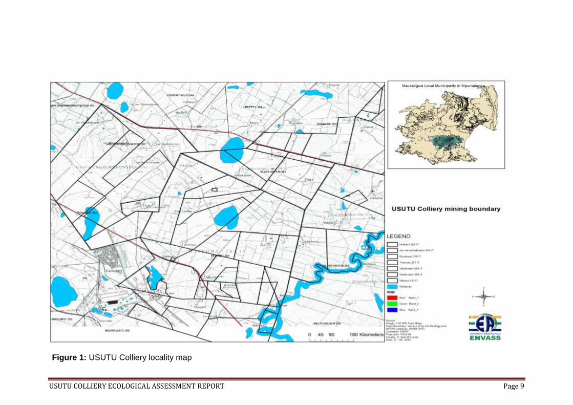
USUTU COLLIERY ECOLOGICAL ASSESSMENT REPORT Page 9
Figure 1: USUTU Colliery locality map
USUTU COLLIERY ECOLOGICAL ASSESSMENT REPORT Page 10
7. Terms of Reference To comply with the requirements of the Provincial Authorities, Departmental divisions
and regional requirements, the Terms of Reference (ToR) for this project the report
entailed three (3) components viz:
7.1 Desktop research and literature review The available provincial biodiversity data sets, red listed fauna and flora data,
species conservation status data and, relevant legislation and policies information
were researched and included for constructive environmental impact assessment
conclusion. Previously conducted studies for proposed activities on the site and in
the region were reviewed and used as references (e.g. The Natural Scientific
Services Biodiversity Assessment Reports) to give the hawk eye view of the area
before the proposed activity. The specialist also liaised and communicated with
relevant sectors whose mandate it is to conserve and be custodians of biodiversity.
Maps and any spatial data on biodiversity (where available) were used to determine
the species occurrence, distribution and status.
7.2 Site screening or Ground truthing The site visit to understand the magnitude of the impact that the proposed activity
will have was conducted on the 19-20 January 2012 for Jan Hendriksfontein 263IT,
Transutu 257IT, Witpunt 267IT and Vlakfontein 266IT. Farms Holbank 265 IT,
Vlakfontein 269IT, Mooiplaats 290 IT and Leeuwenburg 137 IT were screened 16-17
April 2012. These visits were also used to verify if the results yielded by the desktop
research and other reference material were significantly accurate and whether there
were any other changes (macro or micro) in the area that had not yet been
documented. This component entailed a visual assessment of the area, monitoring
of species activities and other activities taking place within or adjacent to the
proposed project area. Lastly, the sites visit also permitted the opportunity to identify
and observe species that the desktop study mentioned.
7.3 Field survey and sampling This component aimed to assess terrestrial biodiversity by visual observations and
by using transects to measure floral species distribution. The visual observations
were conducted during different time intervals (i.e. morning, noon/afternoon and in
the evening) to ensure all faunal activity patterns were covered. Flora and fauna
observed during this component were recorded and the results were compared with
the desktop reviews and used to conclude on the ecological sensitivity of the area
with regards to the proposed activity. This particular assessment was done on the
19-20 January, 14-15 March, 16-17 April 2012 and 19-20 July 2012.
USUTU COLLIERY ECOLOGICAL ASSESSMENT REPORT Page 11
8. Objectives and Scope of the study
8.1 Objectives The objectives of the study were:
To assess the current status of the habitat components and its
conservation status
To identify the floral species on site and to recommend steps to be taken
should a Red list or protected species be found
To identify the fauna species on the site and to recommend steps to be
taken should a Red list species be found
To highlight the potential impacts the development may have on the
ecosystem components of the study area
Provide management recommendation to mitigate negative impacts and
enhance positive impacts of the proposed activity
8.2 Scope of the study This report
List flora identified during the study
List fauna identified during the study
Comment on the ecological/conservation status of both the flora and fauna
observed in the study site
Offer recommendation regarding preservation of the indigenous and protected
plant species found in the site
Offer recommendation to reduce and minimise impacts associated with the
proposed activity.
USUTU COLLIERY ECOLOGICAL ASSESSMENT REPORT Page 12
9. Methodology
9.1 Desktop study The desktop study yielded the lists of plant and animal species occurring on the
USUTU Colliery proposed mining activity boundary and within the quarter degree
squares (QDS) 2630CA and 2630CB of the Msukaligwa Local municipality in
Mpumalanga Province. The list includes the plants and the animals that are
endemic, their occurrence, those who use the area for breeding, nesting or foraging
purposes and those whose distribution extends towards the area. The data was
sourced from a wide range of conservation agency listed in (Table 1) and was used
to generate the fauna and flora species checklists for the area of study.
Table 1: Environmental Data Sources
Source Data Purpose Accessed
SANBI Vegetation
Map (2006)
Spatial layer of vegetation
types occurring within the
country, Lesotho and
Swaziland. For this
specific analysis we looked
at the vegetation of
Mpumalanga Province.
South Africa.
17 January 2012
PRECIS-
POSA
Provided the checklist of
all the plant species
endemic and occurring
within QDS 2630CA and
2630CB
Download from
POSA
(http://posa.sanbi.org)
on February 2, 2012,
1:39 pm
BGIS Obtain spatial layers for
Mpumalanga Biodiversity
Conservation Plans and
NFEPA wetlands shape
file
17January 2012
SIBIS-SABIF Provided a checklist of the
SARCA for QDS 2630CA
and 2630CB
17 January 2012
TSP A collaboration with SANBI
to provide a Red data list
of threaten floral species
17 January 2012
UCT-ADU SABAP2 Provided a checklist of
observed Bird species in
QDS 2630CA and 2630CB
30 January 2012
SABCA Checklist for South African 2012/02/02

USUTU COLLIERY ECOLOGICAL ASSESSMENT REPORT Page 13
Butterflies and those
occurring in QDS 2630CA
and 2630CB
Google Google Earth Generate the site maps 2012/03/02
Chrome
Accessed for literature
review and related
information pertaining the
proposed activity
2012/03/02 -2012/03
/14
Bird Life
South Africa
BLSA Generated a birds of
Mpumalanga checklist
17 January 2012
9.2 Field assessment The site was visited and reviewed to determine the various plant communities
occurring on the site. Plots were selected at random using a 100 meter measuring
tape. Vegetation cover was inspected at every 2 meter for plants falling inside a 1m
quadrant. The plants species observed were identified, categorized according to the
growth form, habitat type and conservation status. Ground laying plants within the
quadrant were inspected by paddling through tall grass species to expose the
underlying vegetation. All observed species were recorded and samples were taken
for further identification.
Due to the extent of the mining area, the survey was done mostly on foot and via
driving using a motor vehicle. This provided an opportunity to visually assess the
faunal species that might use the site as their habitat and those occurring within the
study area. The Avian population was assessed visually and identified using Sasol
Birds of Southern Africa (Sinclair et. al., 2002), South African Bird Atlas Phase 2 and
Bird Life South Africa for species occurring in the area. Animals and small mammals
where identified within the study site using sitings, spoor, tracts, signs and droppings
as well as holes and nesting sites on the grounds where possible.
The butterflies observed on the site were also identified and recorded with further
identity verification done using South African Butterflies Conservation Assessment
list for the Lepidopterans occurring in the quarter degree squares (QDS) 2630CA
and 2630CB.
Reptiles and amphibians were not encountered although they were looked out for.
Personal communication with farmers around the area and consultation of relevant
conservation lists was conducted as part of the assessment to verify species
occurrence in the area as noted in the Natural Science Services study (Usutu Eskom
Biodiversity Assessment 2010/2011). All the observed flora and fauna species were
identified, recorded and used to compile the ecological impact assessment report.

USUTU COLLIERY ECOLOGICAL ASSESSMENT REPORT Page 14
10. APPLICABLE LEGISLATION Certain legislation, policies and programmes’ regulations (see Appendice 1, 2 and 3)
offer guidelines for integrating biodiversity assessments in Environmental Impact
Assessment. Below is a hierarchy of the most important biodiversity legislations,
policies and programmes that are accountable for biodiversity conservation and
management in the country (Figure 2). These are therefore applicable to every
environmental aspect assessed for this study.
*National Biodiversity Assessment (NBA) used to be known as National Spatial Biodiversity Assessment (NSBA)
Figure 2: Hierarchy of Biodiversity legislation, policies and programmes
(adopted from Kuntonen-van‘t Riet, 2007)
NATIONAL ENVIRONMENTAL
MANAGEMENT ACT 1998 (Act No. 107 of 1998)
National Environmental Management : Biodiversity
Act 2004 (Act No. 10 of 2004)
National Environmental Management: Protected Areas Act (Act No. 57 of
2003)
National biodiversity Strategy and Action Plans
(NBSAP)
National Biodiversity Assessment (NBA)*
Coastal zones management (draft)

USUTU COLLIERY ECOLOGICAL ASSESSMENT REPORT Page 15
11. Site Description
11.1 The Province Mpumalanga province lies in the eastern part of South Africa and constitutes 6.5% of
the country’s area, thus making it one of the two smallest South African provinces.
Mpumalanga, loosely translated as “where the sun rise” is divided into two sub
regions namely, the Highveld and the Lowveld, by the Drankesberg mountains. The
Highveld is the western part of the province which is cooler and often receives
severe frost with temperatures ranging from 23˚C-12 ˚C during summer and 15˚C-
1˚C in winter and the annual rainfall of 878 mm (WeatherSA, 2012). The Lowveld is
in the east and subtropical part of the province with average temperatures ranges
from 29˚C-19˚C during summer and 23˚C-6˚C in winter with annual rainfall of 767mm
(WeatherSA, 2012). Furthermore, the Highveld and the Lowveld also possesses a
distinct variation in their vegetation; the Highveld is mainly grassland whereas the
Lowveld is mostly savanna.
The province boasts diverse and special fauna and flora species and also offers a
variety of land use activities such as agriculture and mining. The agricultural sector
use more than 68 % of the province for farming activities such as crops, livestock
and forestry industries. However, mining is the biggest and most extensive economic
activity in the province; various minerals are found and extracted from Mpumalanga
including the coal. The coal mining is the biggest mining activity happening in the
area with Mpumalanga producing 83% of the countries coal for electricity and
synthetic fuel. Mpumalanga is the third largest coal producing and exporting region in
the world.
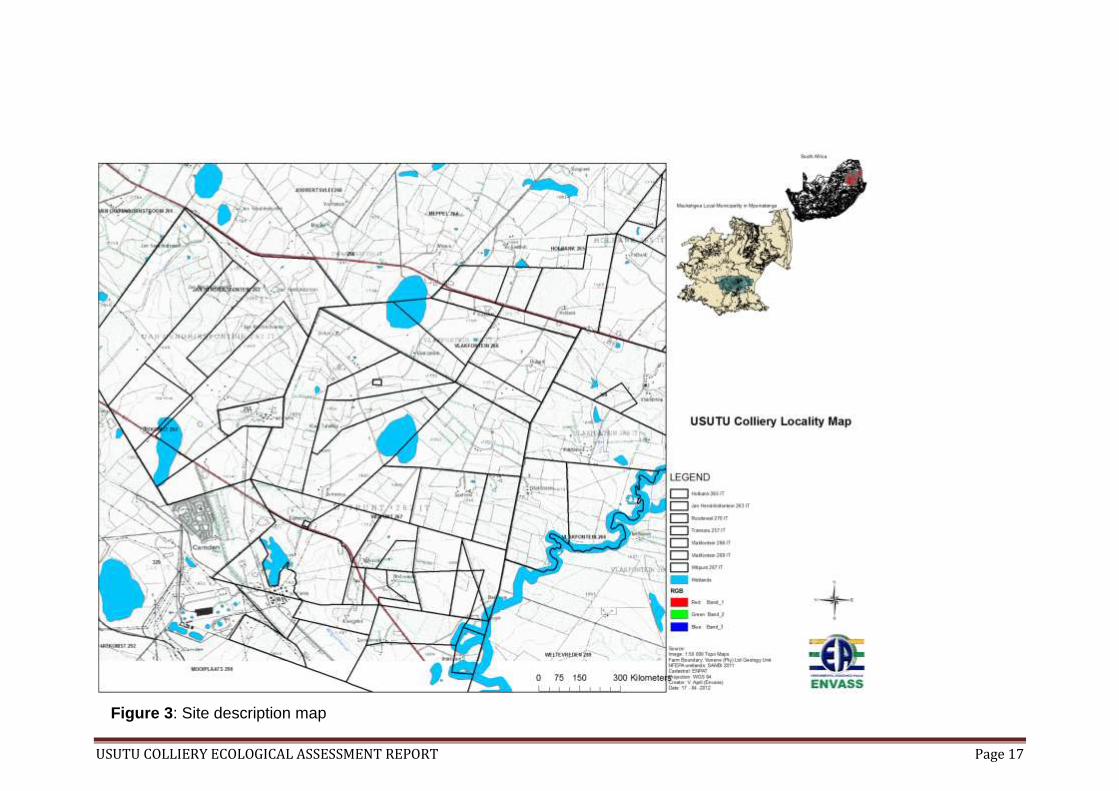
11.2 The location The project is near Ermelo in the Msukaligwa local municipality (MP302), situated in
the Gert Sibande District Municipality in the Highveld sub region of Mpumalanga(S:
25˚35ˊ00˝ and E: 30˚05ˊ00˝). The municipality occupies 601566 ha of the province
with an estimated population of 127 000 (Figure 3). Ermelo is the educational,
industrial and commercial centre of the Msukaligwa. Different land use activities such
as agricultural mixed farming and different mining activities make Ermelo the hub of
immigrants and employment seekers.
11.2.1 Geology
USUTU Colliery mining area is in the Ermelo coalfields of the well known Middle
Ecca stage. The coalfields extends from Carolina in the north all the way to
Dirkiesdorp in the south encompassing the surface area of 11 250 km2. The
coalfields comprise sedimentary rocks of the Dwyka formation and Ecca group which
is dominated by the Vryheid formation.
USUTU COLLIERY ECOLOGICAL ASSESSMENT REPORT Page 16
11.2.2 Hydrology
The study site area falls within the C11A and C11B Quaternary Catchments of the
Vaal River. As a Highveld region of the Mpumalanga province there are numerous
endorheic wetlands located in the vicinity of the study site. These wetlands are
considered as ecosystems of ecological importance and among the most threaten
aquatic habitats in the country (Cowan & van Riet 1998, Ferrar & Lötter 2007). They
are known to support variety of floral and faunal species.
11.2.3 Vegetation
The area is highly dominated by grassland a typical feature of a Highveld with six (6)
vegetation types occurring in the area, namely the Amersfoort Highveld Clay
grassland, Eastern temperate Freshwater wetlands, Eastern Highveld grassland,
Soweto Highveld grassland, Wakkerstroom Montane Grassland and KaNgwane
Montane grassland (Mucina & Rutherford, 2006). The area in terms of biodiversity is
considered sensitive and important to the national and provincial conservation
sectors and agencies. The USUTU Colliery is situated in close proximity to small
scale operating collieries, agricultural farms and game farms.
11.3 Project description The Vunene Pty Ltd Mining group’s proposed coal mining project plan compromise
of underground and open cast coal mining (Figure 4). The underground mining will
be achieved by using a board and pillar mining system varying between 80 meters
for Vlakfontein 266IT and between 80-120 meters below surface level for the
Holbank, Roodewal, Mooiplats and Vlakfontein 269IT. The underground mining is
aimed at using continuous miners and the planned production will commence on the
West underground main highwall. The opencast mining will be achieved using the
truck and shovel lateral roll-over mining method accessed through a 17˚ pit. The
open cast mining would be constructed on certain portions of Jan Hendriksfontein
263IT.
The haul road will be extended to the existing nearby road to access the mining
area.
USUTU COLLIERY ECOLOGICAL ASSESSMENT REPORT Page 17
Figure 3: Site description map

USUTU COLLIERY ECOLOGICAL ASSESSMENT REPORT Page 18
Figure 4: Portions that falls within the USUTU Colliery mine boundary
USUTU COLLIERY ECOLOGICAL ASSESSMENT REPORT Page 19
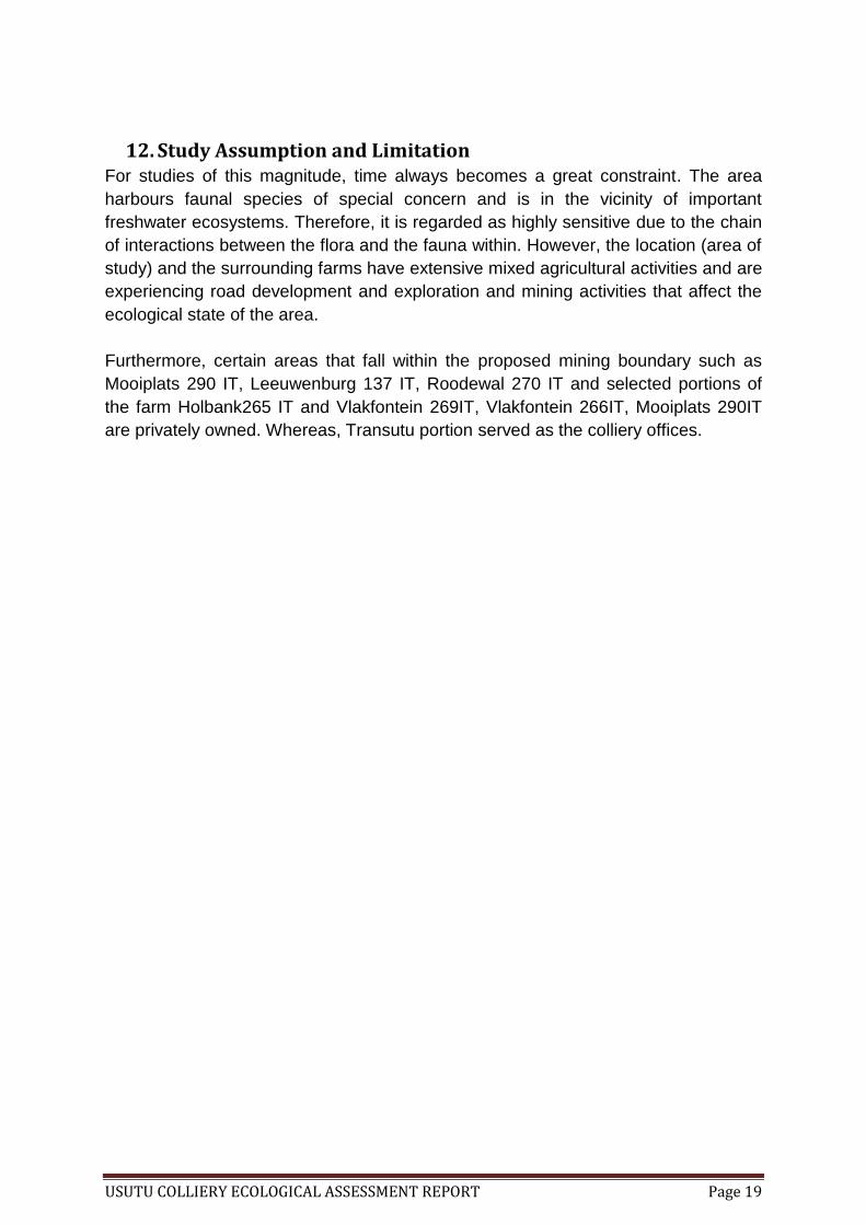
12. Study Assumption and Limitation For studies of this magnitude, time always becomes a great constraint. The area
harbours faunal species of special concern and is in the vicinity of important
freshwater ecosystems. Therefore, it is regarded as highly sensitive due to the chain
of interactions between the flora and the fauna within. However, the location (area of
study) and the surrounding farms have extensive mixed agricultural activities and are
experiencing road development and exploration and mining activities that affect the
ecological state of the area.
Furthermore, certain areas that fall within the proposed mining boundary such as
Mooiplats 290 IT, Leeuwenburg 137 IT, Roodewal 270 IT and selected portions of
the farm Holbank265 IT and Vlakfontein 269IT, Vlakfontein 266IT, Mooiplats 290IT
are privately owned. Whereas, Transutu portion served as the colliery offices.

USUTU COLLIERY ECOLOGICAL ASSESSMENT REPORT Page 20
13. Findings and Results
13.1 Vegetation communities South Africa is home to nine biomes or ecological life zones that are distributed
among the nine provinces (Figure 5) and the area in which USUTU Colliery falls is
largely dominated by the Grassland biome, a critically endangered and vulnerable
eco-zone (Table 2). It occupies the whole area of Ermelo and six vegetation types
occur within namely:
the Amersfoort Highveld Clay grassland,
Eastern temperate Freshwater wetlands,
Eastern Highveld grassland,
Soweto Highveld grassland,
Wakkerstroom Montane Grassland and
KaNgwane Montane grassland
The study area where the USUTU Colliery is currently operating is dominated by two
of these vegetation types, namely the Eastern Highveld grassland (GM 12) and
sparsely distributed Eastern Temperate Freshwater (Azf 3) (Figure 6). These two
vegetation types are listed as A1 Vulnerable threatened ecosystems (DEA, 2011).
The Eastern Highveld grassland is classified as an endangered vegetation type
(Rouget et al., 2004; Mucina & Rutherford, 2006, Ferrar & Lötter, 2007) due to
mining activities within the provinces (see Table 3).
Figure 5: South African biome distribution (Mucina & Rutherford, 2006)

USUTU COLLIERY ECOLOGICAL ASSESSMENT REPORT Page 21
Table 2: South African ecological zones and their conservation status
Biomes Distribution Conservation Status Land area covered (%)
Fynbos In south and south west
regions of the country.
Vulnerable – Critically
endangered
Over 6
Forests Frost free areas along the
southern and eastern coasts
of the country; and inland
along the eastern edge of
the escarpment.
Critically Endangered 1
Grasslands In high central plateau and
inland areas in the eastern
part of the country.
Vulnerable – Critically
endangered
26
Nama-Karoo Namaqualand in dry rocky
areas and deserts on the
western half of the central
plateau.
Vulnerable 23
Savanna In northern and north-
eastern parts of the country,
but small patches have
developed in the south-east.
Vulnerable -
Endangered
46
Succulent Karoo Western and southern edges
of the central escarpment.
Vulnerable -
Endangered
6.5
Thicket It occurs as narrow strips
along the southern, mostly
the eastern coast.
Vulnerable -
Endangered
Over 3%
Wetlands In areas with water table
that stands near the land
surface seasonally or
permanently and supports
hydrophytes. They are the
ecotones between dry land
and water bodies.
Vulnerable – Critically
endangered

USUTU COLLIERY ECOLOGICAL ASSESSMENT REPORT Page 22
Figure 6: Vegetation types that falls within the study area
Table 3: The twelve vegetation types under most pressure from mining potential ranked from highest to lowest and the mining pressure from high to medium (Rouget et.al., 2004).
Vegetation Type % High % Medium
Namib Seashore Vegetation 100 0
Subtropical Seashore Vegetation
96 0
Richtersveld Coastal Duneveld 87 0
Subtropical Dune Thicket 87 0
Northern Escarpment Dolomite Grassland
67 0
Namaqualand Seashore Vegetation
58 0
Wakkerstroom Montane Grassland
0.5 89
Nwambyia-Pumbe Sandy Bushveld
0 83
Eastern Highveld Grassland 0.2 72
Springbokvlakte Thornveld 0.3 66
Soweto Highveld Grassland 46 61
Delagoa Lowveld 0 53

USUTU COLLIERY ECOLOGICAL ASSESSMENT REPORT Page 23
The land use practices of the Mpumalanga province had inflicted an enormous
change in the terrestrial ecosystem. Current regional, provincial and national
environmental conservation agency such as NSBA and MPBCP has considered the
area very important and of biodiversity significance thus requires protection (Driver et
al, 2004; Ferrar & Lötter, 2006). The portion of remaining natural habitat in the
province requires maintenance and an optimum management plan to avoid further
loss. The terrestrial ecosystem where the USUTU Colliery is situated is severely
affected by the developments and unfortunately none of the land around it is formally
protected making the area prone to exploitations (Figure 7 and Figure 8).
Figure 7: National Spatial Biodiversity Assessment considers the remaining natural ecosystem status where USUTU Colliery is situated endangered -Vulnerable (NSBA, 2004)

USUTU COLLIERY ECOLOGICAL ASSESSMENT REPORT Page 24
Figure 8: The Mpumalanga Terrestrial Ecosystem Biodiversity Conservation Plans which designate the remaining natural vegetation types of the study site as highly significant (MPBCP, 2006)
Findings show that:-
13.1.1. Land use description of each study site
The underground mining portions Holbank 256IT portion 0,3,5,7,8,16,18,19,20 and
21; Vlakfontein 266IT portion 4, 5, 6, 7,8, 13 and 14; Vlakfontein 265IT portion 0, 1, 2
and 3; Leeuwenburg 137IT portion 4 and Roodewal 270IT portion 4, 12 and 17 were
mainly used for agricultural purposes such as commercial farming and livestock
grazing. Whereas, portion 4 of Vlakfontein 269IT is a power sub-station.
Furthermore, Mooiplaats 290IT portion 1, 2, 6, 7 and 8 land use is a combination of
farming and coal mining operated by Coal of Africa (Pty) Ltd. Transutu 257IT is
where the Colliery infrastructure is situated. Witpunt 267IT is a combination of
mining, game farming, grazing land and a lodge. The proposed activity is intended to
happen at Jan Hendriksfontein 263IT where a portion of portion 3 and 4, a portion of
portion 9 and portions of portion 6 and 14 will be mined using an opencast mining
method. The rest of the portions of Jan Hendriksfontein are mined out and being
rehabilitated; whereas a large part of the farm serves as grazing land, and is used
for cultivation and a residential area (Figure 10).

USUTU COLLIERY ECOLOGICAL ASSESSMENT REPORT Page 25
13.1.2. Ecosystem functioning for each area of study
The ecology of the study area show a diverse and important ecosystem functioning.
Firstly, there are National Freshwater Ecological Priority Areas (NFEPA) recognised
wetlands randomly distributed through the sites and rivers running within and across
the mining boundaries. The occurrence of these two ecosystems within the proposed
mining sites automatically highlights the sensitivity of the area. A diverse array of
biodiversity such as plants and fauna depend and interact within these ecosystems.
The ecological assessment covered the whole Usutu mining area but focussed
especially on the farm portions (i.e. Jan Hendriksfontein) where opencast mining
method is proposed (Figure 9). The assessed areas constituted open grassland with
a variety of active and depressed hydrological zones that are scattered around the
sites. Vegetation cover within open areas (i.e. areas that have minimal human
modification) was identified using Braun-Blanquet vegetation cover scale to be a
class 5 as the ground was completely covered.
Two (2) types of floral species were observed, namely
Cryptophytes and
Gramniods
The Cryptophytes observed were a variety of geophytes, helopytes and hydrophytes
which grew along the floodplains (i.e. Ramsar recognised type of a wetland),
whereas the gramniods mainly of Poaceae family covered the remaining portions of
the area. The detailed list of the observed flora in the study site is tabulated in Table
5
USUTU COLLIERY ECOLOGICAL ASSESSMENT REPORT Page 26
Figure 9: Transects and visual observation sampling points
13.2 Flora communities Floral communities presented within the study site were differentiated into 3 groups
of the above mentioned floral types, namely:
Flora species of special conservation concern
Pioneer plants species
Invasive and noxious plant species
The flora species of special conservation concern (SCC) were identified as plant
species that play an optimum role in the ecosystem functionality. These plants were
found to occur around the wetland areas within the study sites (Table 4) (NSS, 2011,
Lubbe, 2011). Their existence is necessary for the continuous functionality of the
wetland.
Table 4: List of flora species of special concern that has a potential to occur at the study site and their Red List status
Family Scientific name Red list status Occurrence
Cyperaceae Pycreus macranthus Least concern Highly likely
Poaceae Themeda triandra Least concern Highly likely
Poaceae Aristida junciformis Least concern Highly likely
Typhaceae Typha capensis Least concern Highly likely
Cyperaceae Schoenoplectus
brachyceras
Least concern Highly likely
Cyperaceae Carex acutiformis Least concern Highly likely
Legend:
-
Sample
points

USUTU COLLIERY ECOLOGICAL ASSESSMENT REPORT Page 27
Cyperaceae Schoenoplectus pugens Least concern Highly likely
Poaceae Eragrostis plana Least concern Highly likely
Poaceae E.curvula Least concern Highly likely
Poaceae Stipagrostis uniplumis Least concern Highly likely
Hyacinthaceae Eucomis autamnalis Vulnerable Highly likely
Amaryllidaceae Nerine gracilis Endangered Likely
Cyperaceae Fuirena pubescens Least concern Highly likely
Poaceae Arundinella nepalensis Least concern Highly likely
Poaceae Gladiolus crassifolius Least concern Highly likely
Poaceae Aristida congesta Least concern Highly likely
Poaceae Egrostis lachnantha Least concern Highly likely
Poaceae Andropogon eucomus Least concern Highly likely
Poaceae Sporobolus africanus Least concern Highly likely
Poaceae Imperata cylindrical Least concern Highly likely
Orchidaceae Bletilla ochracea Least concern Highly likely
Anacardiaceae Searsia dentata Least concern Highly likely
Asteraceae Gazania krebsiana Least concern Highly likely
Amaryllidaceae Brunsvigia randulosa Least concern Highly likely
Rubiaceae Richardia brasiliensis Least concern Highly likely
Lobeliaceae Lobelia flaccid Least concern Highly likely
Cyperaceae Carex cognata Least concern Highly likely
Gunneraceae Gunnera perpensa Declining Highly likely
Poaceae Andropogon
appendiculantus
Least concern Highly likely
Poaceae Miscanthus capensis Least concern Highly likely
Cyperaceae Fimbristylis complanata Least concern Highly likely
Cyperaceae Kyllinga erecta Least concern Highly likely
Amaryllidaceae Hermanthus hirsutus Declining Highly likely
Amaryllidaceae Crinum bulbispermum Least concern Highly likely
Anemiaceae Mohria nudiuscula Least concern Highly likely
Aquifoliaceae Ilex mitis Declining Highly likely
Colchicaceae Colchicum striatum Least concern Highly likely
Brassicaceae Cardamine Africana Least concern Highly likely
Asphodelaceae Kniphofia typhoides Rare Likely
Campanulaceae Wahlenbergia undulata Least concern Highly likely
Iridaceae Gladiolus malvinus Vulnerable Highly likely
Oleaceae Jasminum streptopus Least concern Highly likely
Myrsinaceae Myrsine africana Least concern Highly likely
Asphodelaceae Aloe kniphofioides Vulnerable Highly likely
Geraniaceae Geranium
wakkerstroomianum
Least concern Highly likely
Lythraceae Nesaea sagittifolia Least concern Highly likely

USUTU COLLIERY ECOLOGICAL ASSESSMENT REPORT Page 28
Poaceae Setaria nigrirostis Least concern Highly likely
Poaceae Urochloa panicoides Least concern Highly likely
Pioneer plant species observed in the area were represented by Cosmos
bipinnatus, Verbana bonariensis and Leersia hexandra, Hyparrhenia hirta which are
plants that uses any opportunity to invade a disturbed or transformed for such a
short period of time. Some pioneer plants like Cosmos are environmentally
acceptable and regarded as important as their flowers offers a breath taking and a
welcome change to the landscape by beautifying the area.
The invasive and noxious weeds observed in the area were Circium vulgare,
Conyza bonariensis, Pennisetum clandestinum, Salix babylonica, Datura
stramonium, Tribulus terrestris, Phragmites australis, Arundo donax, Oak,
Eucalyptus sp, Pine trees and few Weeping willow tree species stand. These plants
are often used as indicators of disturbed areas. They use such opportunity to invade,
infest and encroach in the area gradually displacing endemic species. They become
problematic to the invaded or introduce area because they outcompete and displace
indigenous plant species, and they use large amount of ground and surface water
drying the rivers, dams or any water source close to their range.
The list of all the flora communities observed within the study site is tabulated under
Table 5 below.

Figure 10: Usutu whole mining extent
USUTU COLLIERY ECOLOGICAL ASSESSMENT REPORT Page 30
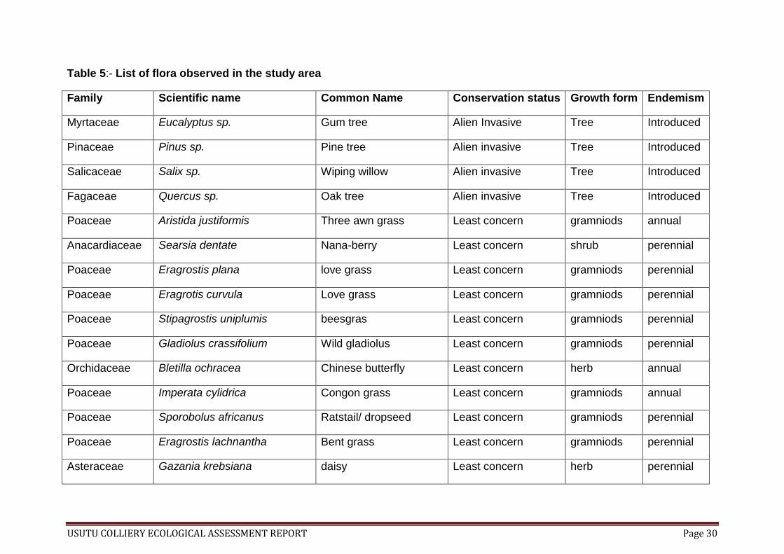
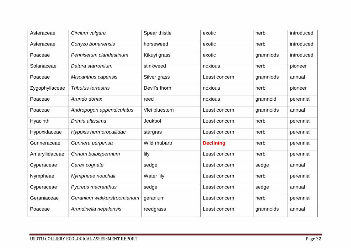
Table 5:- List of flora observed in the study area
Family Scientific name Common Name Conservation status Growth form Endemism
Myrtaceae Eucalyptus sp. Gum tree Alien Invasive Tree Introduced
Pinaceae Pinus sp. Pine tree Alien invasive Tree Introduced
Salicaceae Salix sp. Wiping willow Alien invasive Tree Introduced
Fagaceae Quercus sp. Oak tree Alien invasive Tree Introduced
Poaceae Aristida justiformis Three awn grass Least concern gramniods annual
Anacardiaceae Searsia dentate Nana-berry Least concern shrub perennial
Poaceae Eragrostis plana love grass Least concern gramniods perennial
Poaceae Eragrotis curvula Love grass Least concern gramniods perennial
Poaceae Stipagrostis uniplumis beesgras Least concern gramniods perennial
Poaceae Gladiolus crassifolium Wild gladiolus Least concern gramniods perennial
Orchidaceae Bletilla ochracea Chinese butterfly Least concern herb annual
Poaceae Imperata cylidrica Congon grass Least concern gramniods annual
Poaceae Sporobolus africanus Ratstail/ dropseed Least concern gramniods perennial
Poaceae Eragrostis lachnantha Bent grass Least concern gramniods perennial
Asteraceae Gazania krebsiana daisy Least concern herb perennial

USUTU COLLIERY ECOLOGICAL ASSESSMENT REPORT Page 31
Amaryllidaceae Brunsvigia randulosa Candelabra flower Least concern herb perennial
Rubiaceae Richardia brasiliensis Mexican clover Least concern herb
Lobeliaceae Lobelia flaccid Wild lobelia Least concern herb
Amaryllidaceae Hermanthus hirsutus hirsutus Declining herb endemic
Asteraceae Cosmos bipinnatus cosmos Least concern herb pioneer
Cyperaceae Kyllinga erecta kyllinga Least concern herb perennial
Poaceae Paspalum dilatatum Paspalum grass Least concern gramniods perennial
Poaceae Themeda triandra Rooi grass Least concern gramniods perennial
Poaceae Aristida junciformis Ngongoni grass Least concern gramniods annual
Poaceae Aristida congesta Tassel three awn Least concern gramniods annual
Poaceae Andropogon eucomus Snowflake grass Least concern gramniods Annual
Convolvulaceae Convolvulus arvensis akkerwinde exotic herb perennial
Zygophyllaceae Tribulus terrestris Devil’s thorn exotic herb perennial
Verbaneceae Verbena bonariensi verbana exotic herb pioneer
Poaceae Leersia hexandro Rice grass Invasive alien gramniods introduced
Poaceae Hyperhenia hirta Thatching grass Least concern gramniods annual
Cyperaceae Fimbristylis complanata sedge Least concern Sedge annual
USUTU COLLIERY ECOLOGICAL ASSESSMENT REPORT Page 32
Asteraceae Circium vulgare Spear thistle exotic herb introduced
Asteraceae Conyzo bonariensis horseweed exotic herb introduced
Poaceae Pennisetum clandestinum Kikuyi grass exotic gramniods introduced
Solanaceae Datura starromium stinkweed noxious herb pioneer
Poaceae Miscanthus capensis Silver grass Least concern gramniods annual
Zygophyllaceae Tribulus terrestris Devil’s thorn noxious herb pioneer
Poaceae Arundo donax reed noxious gramnoid perennial
Poaceae Andropogon appendiculatus Vlei bluestem Least concern gramnoids annual
Hyacinth Drimia altissima Jeukbol Least concern herb perennial
Hypoxidaceae Hypoxis hermerocallidae stargras Least concern herb perennial
Gunneraceae Gunnera perpensa Wild rhubarb Declining herb perennial
Amaryllidaceae Crinum bulbispermum lily Least concern herb perennial
Cyperaceae Carex cognate sedge Least concern sedge annual
Nympheae Nympheae nouchali Water lily Least concern herb perennial
Cyperaceae Pycreus macranthus sedge Least concern sedge annual
Geraniaceae Geranium wakkerstroomianum geranium Least concern herb perennial
Poaceae Arundinella nepalensis reedgrass Least concern gramnoids annual

USUTU COLLIERY ECOLOGICAL ASSESSMENT REPORT Page 33
Convolvulaceae Ipomoea obscura Morning glory Least concern herb perennial
Cyperaceae Fuirena pubescens sedge Least concern sedge annual
Asteracea Helichrysum splendidum Yellow daisy Least concern herb perennial
Cyperaceae Carex acutiformis Pond sedge Least concern sedge perennial
Asteraceae Helichrysum pallidum Silver hottentot tea Least concern herb perennial
Asteraceae Haplocarpha scaposa False gerbera Least concern herb perennial
Poaceae Phragmites australis Common reed Introduced/invasive gramnoids annual
Asteraceae Gerbera piloselloides gerbera Least concern herb perennial
Typhaceae Typha capensis Cape bulrush Least concern sedge annual
Iridaceae Gladiolus crassifolius gladioli Least concern herb perennial
Cyperaceae Schoenoplectus brachyceras sedge Least concern sedge perennial
Cyperaceae Schoenoplectus sp. sedge Least concern sedge perennial
Orchidaceae Eulophia clavicomis orchid Least concern herb perennial
Amaryllidaceae Crinum bulbispermum River lily Least concern herb perennial
Anemiaceae Mohria nudiuscula - Least concern herb perennial
Aquifoliaceae Ilex mitis Waterboom/African holly Declining shrub perennial

USUTU COLLIERY ECOLOGICAL ASSESSMENT REPORT Page 34
Colchicaceae Colchicum striatum - Least concern herb perennial
Brassicaceae Cardamine Africana - Least concern herb perennial
Campanulaceae Wahlenbergia undulate - Least concern Herb perennial
Iridaceae Gladiolus malvinus - Vulnerable herb perennial
Oleaceae Jasminum streptopus - Least concern shrub perennial
Myrsinaceae Myrsine Africana - Least concern shrub perennial
Asphodelaceae Aloe kniphofioides - Vulnerable herb perennial
Lythraceae Nesaea sagittifolia - Least concern shrub perennial
Poaceae Setaria nigrirostis - Least concern grass perennial
Poaceae Urochloa panicoides - Least concern perennial annual

USUTU COLLIERY ECOLOGICAL ASSESSMENT REPORT Page 35
13.3 Faunal Communities The USUTU Colliery area and the surrounding areas are recognised as Upper
Management Areas by South African National Biodiversity Institute due to the
numerous wetlands found there. These wetlands are known to be the crucial source
of life to animals that use Moist grassland areas for habitat, breeding and as a
migratory den. Due to the extensive mining and agricultural land use happening in
that area, some of the wetlands have been affected and tampered with to a point of
disfunctionality (
Figure 11). However, the remaining natural and some of the transformed wetlands
does still offer ecosystem functions mainly to avi-fauna observed in the study site.
There was little to nothing observed with regards to the game or small mammals
within the area, only livestock feeding in adjacent farms were observed. In one
instance a Duiker spoor was observed in Jan Hendriksfontein area. It should be
noted that there were old and new burrows of varying sizes indicating the presence
of ground dwelling animals at the above mentioned farm area.
The avi-fauna observed in the study area were grouped into two categories:
Birds of special conservation status Common birds
USUTU COLLIERY ECOLOGICAL ASSESSMENT REPORT Page 36
The birds of special conservation status observed in the study area were Tyto
capensis, Geronticus calvus, Sagittarius serpentarius, Falco biarmicus and Falco
amurensis.
Common birds observed were made up of birds that were observed during site visits
and sampling together with the birds that are used as indicators of disturbance. The
observed birds during the study were, Streptolia semitorquata, Vidua macroura,
Bubulcus ibis, Apus caffer, Cisticola juncidis,Corvus albus, Myrmecocichla
formicivora, Plegadis falcinellus, Fulica cristata, Anas undulate, Pternistis wainsonii,
Amaurornis flavirostris, Acrocephalus beaticatus, Phalacrocrax lucidus, Charadrius
tricollaris,Riparia paludicola, Bostrychia hagedash, Ploceus velatus, Euplectes orix,
Hirundo rustica, Passer domesticus, Motacilla capensis and Vanellus coronatus.
However, birds such as Blue Crane have been reported on and around the area
together with the occurrence of reptiles such as rinkhals and molesnakes
Pseudaspis cana, neither of these were observed or encountered during the study.
The site carrying capacity for wild game was observed to be low due to the fact that
the study area is significantly disturbed. The informal settlement encroachment
nearby, the mixed agricultural farming and the road construction all add more
disturbance pressure to the area on top of the operational mining activities.
Therefore, it is certain that the game unlike avian fauna would either move away
from the area of disturbance or decline to the point of non-existence in the area. The
only wildlife observed were springbuck at one of the nearby lodges, but there was an
animal spore observed on the Jan Hendriksfontein site and it has been identified as
a Duiker Sylvicarpa grimma spoor.
The insects observed on the site included the Lepidopterans, the Coleopterans,
Isopterans, Hymenopterans and Orthoptera. The Lepidopterans were the dominating
group among these insects with Danus Chrysippus sp. orientis being the most
common butterfly seen fluttering around the area. It was followed by Belenois aurota,
Danaus chrysippus, Eurema brigitta and Chilandes trochylus also observed at the
site.
The list of all the faunal species observed and recorded around the USUTU Colliery
and surrounding areas are tabulated in Table 6.
USUTU COLLIERY ECOLOGICAL ASSESSMENT REPORT Page 37
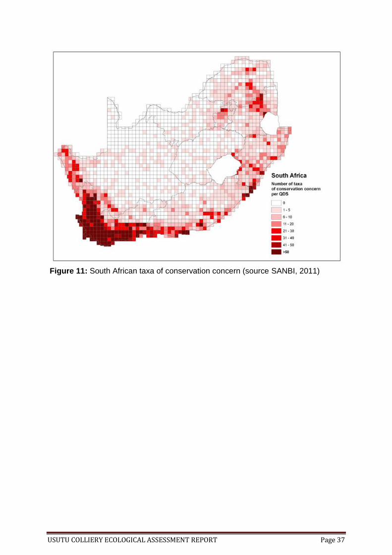
Figure 11: South African taxa of conservation concern (source SANBI, 2011)
USUTU COLLIERY ECOLOGICAL ASSESSMENT REPORT Page 38
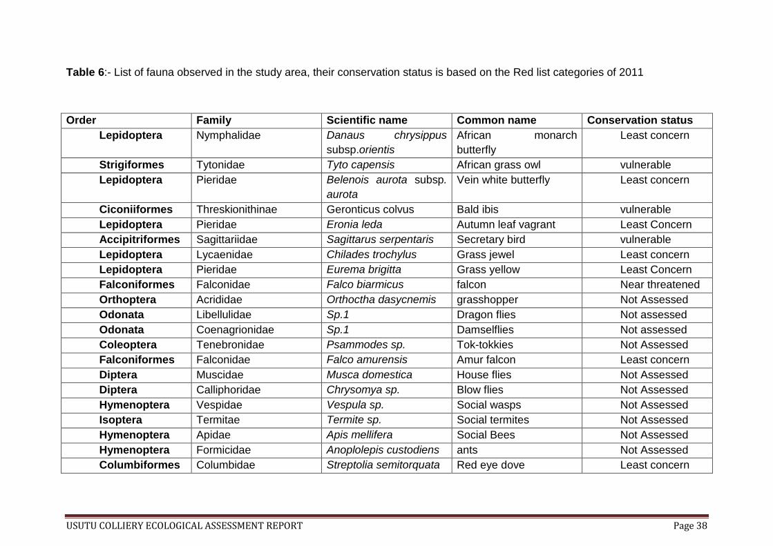
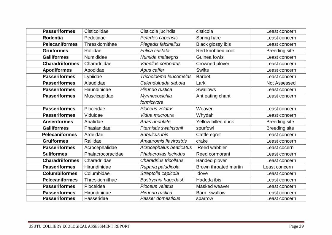
Table 6:- List of fauna observed in the study area, their conservation status is based on the Red list categories of 2011
Order Family Scientific name Common name Conservation status
Lepidoptera Nymphalidae Danaus chrysippus
subsp.orientis
African monarch
butterfly
Least concern
Strigiformes Tytonidae Tyto capensis African grass owl vulnerable
Lepidoptera Pieridae Belenois aurota subsp.
aurota
Vein white butterfly Least concern
Ciconiiformes Threskionithinae Geronticus colvus Bald ibis vulnerable
Lepidoptera Pieridae Eronia leda Autumn leaf vagrant Least Concern
Accipitriformes Sagittariidae Sagittarus serpentaris Secretary bird vulnerable
Lepidoptera Lycaenidae Chilades trochylus Grass jewel Least concern
Lepidoptera Pieridae Eurema brigitta Grass yellow Least Concern
Falconiformes Falconidae Falco biarmicus falcon Near threatened
Orthoptera Acrididae Orthoctha dasycnemis grasshopper Not Assessed
Odonata Libellulidae Sp.1 Dragon flies Not assessed
Odonata Coenagrionidae Sp.1 Damselflies Not assessed
Coleoptera Tenebronidae Psammodes sp. Tok-tokkies Not Assessed
Falconiformes Falconidae Falco amurensis Amur falcon Least concern
Diptera Muscidae Musca domestica House flies Not Assessed
Diptera Calliphoridae Chrysomya sp. Blow flies Not Assessed
Hymenoptera Vespidae Vespula sp. Social wasps Not Assessed
Isoptera Termitae Termite sp. Social termites Not Assessed
Hymenoptera Apidae Apis mellifera Social Bees Not Assessed
Hymenoptera Formicidae Anoplolepis custodiens ants Not Assessed
Columbiformes Columbidae Streptolia semitorquata Red eye dove Least concern
USUTU COLLIERY ECOLOGICAL ASSESSMENT REPORT Page 39
Passeriformes Cisticolidae Cisticola jucindis cisticola Least concern
Rodentia Pedetidae Petedes capensis Spring hare Least concern
Pelecaniformes Threskiornithae Plegadis falcinellus Black glossy ibis Least concern
Gruiformes Rallidae Fulica cristata Red knobbed coot Breeding site
Galliformes Numididae Numida melaegris Guinea fowls Least concern
Charadriiformes Charadriidae Vanellus coronatus Crowned plover Least concern
Apodiformes Apodidae Apus caffer Swifts Least concern
Passeriformes Lybiidae Tricholoema leucomelas Barbet Least concern
Passeriformes Alaudidae Calenduluada sabota Lark Not Assessed
Passeriformes Hirundinidae Hirundo rustica Swallows Least concern
Passeriformes Muscicapidae Myrmecocichla
formicivora
Ant eating chant Least concern
Passeriformes Ploceidae Ploceus velatus Weaver Least concern
Passeriformes Viduidae Vidua mucroura Whydah Least concern
Anseriformes Anatidae Anas undulate Yellow billed duck Breeding site
Galliformes Phasianidae Pternistis swainsonii spurfowl Breeding site
Pelecaniformes Ardeidae Bubulcus ibis Cattle egret Least concern
Gruiformes Rallidae Amauromis flavirostris crake Least concern
Passeriformes Acrocephalidae Acrocephalus beaticatus Reed wabbler Least cocern
Suliformes Phalacrocoracidae Phalacroxas lucindus Reed cormorant Least concern
Charadriiformes Charadriidae Charadrius tricollaris Banded plover Least concern
Passeriformes Hirundinidae Ruparia paludicola Brown throated martin Least concern
Columbiformes Columbidae Streptolia capicola dove Least concern
Pelecaniformes Threskiornithae Bostrychia hagedash Hadeda ibis Least concern
Passeriformes Ploceidea Ploceus velatus Masked weaver Least concern
Passeriformes Hirundinidae Hirundo rustica Barn swallow Least concern
Passeriformes Passeridae Passer domesticus sparrow Least concern

USUTU COLLIERY ECOLOGICAL ASSESSMENT REPORT Page 40
Passiformers Motacillidae Motacilla capensis wangtail Least concern
Passeriformes Corvidae Corvus albus Black crow Least concern
Pelecaniformes Ardeidae Ardea melanocepla Black heron Least concern
Passeriformes Ploceidae Euplectes orix Red bishop Least concern
Artiodactyla Bovidae Bos primigenius Cattle/cow Domesticated
Passeriformes Ploceidae Euplectes afer Yellow crown bishop Least concern

USUTU COLLIERY ECOLOGICAL ASSESSMENT REPORT Page 41
14. Species of special concern
14.1 Flora The findings of this ecological study highlighted the fact that the study sites are areas
of conservation importance. Their ecology shows a diverse ecosystem functionality
and biodiversity variation. The ecosystems such as wetlands (floodplains, seeps,
pans and rivers) observed within the study sites are extensively used as habitats.
Such habitats are important for species as the areas of establishment and
persistence.
Plants and grasses observed during the study plays a major role as they offer soil
coverage (i.e. ground cover) thus prevent erosion. Plants are the most conspicuous
component of wetland ecosystems and play a pivotal role; they function as one of
the primary producers by bringing energy to the system. They provide oxygen,
critical habitat for fauna and influence water chemistry. Plant roots are used to
stabilize the soil and absorb toxic material thus purifying water systems. The
occurrence of plants helps reduce the flow of rivers and filters the runoffs therefore
minimizing the possibility of sedimentation.
14.2 Fauna The fauna species in particular the avi-fauna were mostly observed utilizing the
wetland area and their presence on the sites is mainly associated with the wetlands.
These wetlands and plants are used as habitats, breeding and nesting. Furthermore,
the plants are also used as food source and as shelters, thus the areas which are
still intact and functioning should be maintained and managed to avoid further habitat
loss or disturbance.
The establishment of the opencast mine will signify that the vegetation together with
a variety of flora be removed. Therefore, species would lose their habitat and the
ecosystem functioning will be disturbed or interrupted. This will cause immerse
environmental impacts to the area, the floodplains that offers ecological variation to
the site and serve as flora and fauna species habitat will be affected by this method
of mining. These ecosystems provide flood protection and control erosion; they purify
our water supply, and are a major source of recreation and aesthetic appreciation.
To protect wetlands it is imperative to ensure the survival of plant genes, species,
and natural communities in these ecosystems.
Underground mining in comparison with the opencast mining is not highly destructive
but has its own share of environmental impacts. The underground mining plays a
minor role in vegetation loss and faunal disturbance, but it is known to cause severe
effects on groundwater, surface water and soil stability, which in turn can affect flora
and fauna in the area.
USUTU COLLIERY ECOLOGICAL ASSESSMENT REPORT Page 42
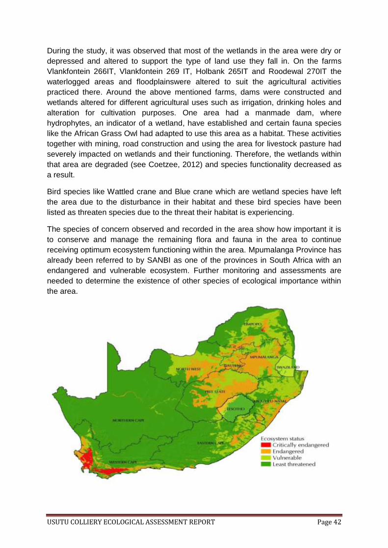
During the study, it was observed that most of the wetlands in the area were dry or
depressed and altered to support the type of land use they fall in. On the farms
Vlankfontein 266IT, Vlankfontein 269 IT, Holbank 265IT and Roodewal 270IT the
waterlogged areas and floodplainswere altered to suit the agricultural activities
practiced there. Around the above mentioned farms, dams were constructed and
wetlands altered for different agricultural uses such as irrigation, drinking holes and
alteration for cultivation purposes. One area had a manmade dam, where
hydrophytes, an indicator of a wetland, have established and certain fauna species
like the African Grass Owl had adapted to use this area as a habitat. These activities
together with mining, road construction and using the area for livestock pasture had
severely impacted on wetlands and their functioning. Therefore, the wetlands within
that area are degraded (see Coetzee, 2012) and species functionality decreased as
a result.
Bird species like Wattled crane and Blue crane which are wetland species have left
the area due to the disturbance in their habitat and these bird species have been
listed as threaten species due to the threat their habitat is experiencing.
The species of concern observed and recorded in the area show how important it is
to conserve and manage the remaining flora and fauna in the area to continue
receiving optimum ecosystem functioning within the area. Mpumalanga Province has
already been referred to by SANBI as one of the provinces in South Africa with an
endangered and vulnerable ecosystem. Further monitoring and assessments are
needed to determine the existence of other species of ecological importance within
the area.

USUTU COLLIERY ECOLOGICAL ASSESSMENT REPORT Page 43
Figure 12: South African Ecosystem status (source: SANBI, 2011)
14.2 Aliens and Invasives Aliens and invasive plants are opportunistic plants that invade areas that are
disturbed, thus competing and replacing endemic plants. They have a potential to
degrade the area and make it more susceptible to fire as their fuel content is high
and uses more water than the indigenous plant species. Land uses that often
disturbed the environment such as mining, agriculture and mismanagement of the
environment results in the area being susceptible to alien and invasive plant
invasion. In terms for CARA 43 of 1983 alien and invasive plants need to be
controlled and prevented (Henderson, 2004).
The AIP’s observed during the study were mainly scattered stands of red gum trees,
pine trees and weeping willow trees that were found to occur on certain parts of Jan
Hendriksfontein and Vlakfontein portions. These tree stands grows along the edges
of the water logged and floodplain areas thus emphasizing their high use of water.
Growing among these tree stands are a variety of invasive grasses and noxious
weeds that took the opportunity to invade disturbed areas. Invasive grasses
depending on their palability and nutrient contents can be used as fodder for
livestock (Milton, 2004).
The proposed project area is already prone to disturbance and invasive and noxious
plant establishment and hence rehabilitation measures should be considered as
further disturbance would trigger more alien and noxious weed invasion.
USUTU COLLIERY ECOLOGICAL ASSESSMENT REPORT Page 44
15. Environmental Impacts and recommendations There are 2875 wetlands found in Msukaligwa local municipality and all this together
with vegetation communities within the municipality are severely endangered and
their functionality is threatened by land use activity such as mining, agriculture, and
infrastructure development such as road construction taking place. The study area
has no formal land based protected areas thus make it susceptible to unmonitored
and destructive land use activities. However, the area is regarded as an important
biodiversity area and most of the importance is due to the scattered wetlands within
the area that support flora and fauna life forms (Lubbe, 2011; Mare, 2012). It is in
this regard that the area is extensively being used by fauna and flora.
The area is currently disturbed and should the proposed activity be authorised,
additional environmental impact could occur, such as:
Further disturbance to water zones or wetlands that still maintain their functionality,
The habitat loss due to vegetation removal for the open cast mining, mainly
areas around Jan Hendriksfontein (portion 6B, 6C, 9, 14 and block D portion
3 and 4 would be highly susceptible to irreversible vegetation removal.
The tampering or obstruction of groundwater recharge and discharge which is often linked with underground mining and soil erosions.
As a result, species would lose their breeding and habitat sites which may lead to:
Species declining to the levels of endangerment or critical endangered or even extinction.
The mining activity in the area will also cause the influx of job seeking individuals
therefore:
More natural remaining habitats might be lost due to those people using the vacant land for improper settlement.
Furthermore, the increase in the traffic due to importation and exportation of
products will results to:
Air pollution with plants gathering dust that come off the ground, Increase in animal or bird road kill by the moving vehicles and Habitat fragmentation due to new roads being constructed for access.
The soil structure will also be impacted by the underground mining and it has been
reported that:
USUTU COLLIERY ECOLOGICAL ASSESSMENT REPORT Page 45
A sedimentary strata displacement had occurred due to Diorite intrusion in the area (NSS report, 2011).
Therefore, it should be considered that with further underground disturbance there
might be the probability of this displacement to re-occur and the probability of it
intensifying through the area.
The proposed mining poses high environmental risks as mentioned above. However,
with correct mitigation the probability will have a medium to low significance.
Should the proposed mining project be approved by authorities, the following
recommendations should be used in order to minimise the environmental impacts.
USUTU colliery should:-
Due to the status of the area they are operating on (with regards to wetlands found in the area), a water use license under section 21 (c) and (i) application should be considered,
During their open cast mining implementation, the client should remove the vegetation gradually offering corridors for species movement to undisturbed areas by leaving strips of vegetation intact,
It is important that the client construct its Environmental Management Plans document to include rehabilitation, maintenance of existing wetlands and invasive alien plant control in the site. The USUTU Colliery pre-rehabilitation measure should start with the harvesting and propagation of endemic flora and wetland species that would be used in the final rehabilitation before they remove the vegetation.
Pre-cautious underground mining methods should be applied in order to avoid further displacements as experienced before. The area where displacement occurred and around that vicinity should be considered sensitive.
Care should be taken to prevent pollution of plants by dust and road kill by putting a speed limiting notices that should be adhere to by the drivers including speed bumps to maintain the speed limit,
Should the proposed activity be authorized, it is important for the company to put up security measures that will not allow the use of vacant land to be used for settlement purposes,
USUTU Colliery should be responsible for maintenance of soil on the areas where the vegetation has been removed; it is in their interest to rehabilitate those areas in order to prevent further soil loss through erosion
Any faunal species found in the vicinity should not be killed or damaged, the wandering species should be aimed to be returned to their designated area or be left around until the time it decides to move on its own.
It is important to understand that the area is a very important conservation
management area and further disturbance to it will provoke ecosystem sensitivity,
thus bi-annual monitoring of the species during and after the operational phases of
the mine should be done in order to maintain and manage further ecological loss.
USUTU COLLIERY ECOLOGICAL ASSESSMENT REPORT Page 46
16. References Bromilow, C. 2001. Problem Plants of South Africa : A guide to the identification and
control of more than 300 invasive plants and other weeds. Briza
publishers, South Africa
Driver, A., Maze, K., Rouget, M., Lombard, A.T., Nel, J., Turpie, J.K., Cowling, R.M.,
Desmet, P., Goodman, P., Harris, J., Jonas, Z., Reyers, B., Sink, K. &
Strauss, T. 2005. National Spatial Biodiversity Assessment 2004:
priorities for biodiversity conservation in South Africa. Strelitzia 17.
South African National Biodiversity Institute, Pretoria. 45pp.
www.sanbi.org.
Department of Environmental Affairs and Tourism. 2006 Guide to the
Environmental Impact Assessment Regulations. DEAT. South Africa
Department of Water Affairs and Forestry. 2005. A practical field procedure for
identification of wetlands and riparian areas. DWAF. South Africa
Edwards, P.J., Abivardi, C. 1998. The value of biodiversity: Where ecology and
economy blend. Biological Conservation 83(3). Pp 239-246
Henderson, L. 2004. Alien weeds and invasive plants: A complete guide to declared
weeds and invaders in South Africa. Plant Protection Research Institute
Handbook no. 12. Agricultural Research Council. Pretoria
Henning, G.A., Terblanche, R.F. & Ball, J.B. 2009. South African Red Data Book:
butterflies. SANBI Biodiversity Series 13. Pp. 158. South African
National Biodiversity Institute, Pretoria.
IUCN. 2009. Red List of Threatened Species. IUCN Species Survival Commission,
Cambridge Available: http://www.iucnredlist.org/ (Accessed 17/03/2012).
Kuntonen-van’t Riet, J. 2007. Strategic review of the status of biodiversity
management in the South African mining industry. Matrix + Consulting.
South Africa
Lötter, M. C. & Ferrar, A. A. 2006. Mpumalanga Biodiversity Conservation Plan
Map. Mpumalanga Parks Board, Nelspruit.
Lubbe, W. (2011). Usutu Colliery Wetland delineation Report. Strategic
Environmental Focus (SEF 504206) (Draft)
Manning, J. 2010. Wild flowers of South Africa. Random Struik publishers. South
Africa
Mare, J. (2012). Usutu Colliery Wetland delination Report. MENCO
(Wet/Usutu/2012/01 (R1) (Draft)
Maze, K., Driver, A., Brownlie, S. 2003. Mining and Biodiversity in South Africa: A
discussion paper. In Driver A, Cowling, R.M., Maze, K. (2003) Planning
for living landscapes: Perspective and lessons from South Africa.
USUTU COLLIERY ECOLOGICAL ASSESSMENT REPORT Page 47
Washington DC: Centre for Applied Biodiversity Science and
Conservation. BotSoc. South Africa
Milton, S.J. 2004. Grasses as invasive aliens in South Africa. South African Journal
of Science 100. Pp 69-75
Mucina, L., Rutherford, M. C. & Powrie, L. W. 2005. Vegetation Map of South Africa,
Lesotho and Swaziland. South African National Biodiversity Institute.
ISBN 1-919976-22-1
Mpumalanga DACE. 2003. 2003 Mpumalanga State of Environment Report.
Mpumalanga Department of Agriculture, Conservation and Environment,
Nelspruit
Natural Scientific Services CC (2011), Usutu Eskom Biodiversity Assessment
Report (Draft)
Raimondo, D., von Staden, L., Foden, W., Victor, J.E., Helme, N.A., Turner, R.C.,
Kamundi, D.A.., Manyama, P.A. 2009. Red List of South African Plants.
Strelitzia 25. South African National Biodiversity Institute. Pretoria
Richardson, D.W., van Wilger, B.W. 2004. Invasive Alien Plants in South Africa:
How well do we understand the ecological impacts. South African
Journal of Science 100. Pp 45-52
Rouget, M., Reyers, B., Jonas, Z., Desmet, P., Driver, A., Maze, K., Egoh, B.,
Cowling, R.M., Mucina, L. & Rutherford, M. 2004. South African National
Spatial Biodiversity Assessment Technical Report. Volume 1: Terrestrial
Component. South African National Biodiversity Institute, Pretoria.
Sinclair, I., Hockey, P., Tarboton., W. 2002. Sasol Birds of Southern Africa. Struik
publishers, South Africa
Taggart K., Abell, S., Cauldwell, A., Clark, T., McEwan, K & Blignaut, T 2011.
Eskom Usutu Biodiversity Assessment (Draft Report). Natural Scientific
Services Consultation Company. South Africa
Tainton, N. 2000. Pasture Management in South Africa. University of Natal Press,
Pietermaritzburg. South Africa
van Oudtshoorn, F. 1992. Guide to grasses of South Africa. Briza publishers, South
Africa
van Oudtshoorn, F. 2002. Guide to grasses of Southern Africa. Briza publishers,
South Africa

USUTU COLLIERY ECOLOGICAL ASSESSMENT REPORT Page 48
17. Annexure
17.1 IUCN Categories (Source: www.iucnredlist.org)
Critically Endangered (CR) : A taxon is Critically Endangered when the
best available evidence indicates that it meets any of the criteria A to E for
Critically Endangered (see Section V), and it is therefore considered to be
facing an extremely high risk of extinction in the wild.
Endangered (EN): A taxon is Endangered when the best available
evidence indicates that it meets any of the criteria A to E for Endangered
(see Section V), and it is therefore considered to be facing a very high risk
of extinction in the wild.
Vulnerable (VU): A taxon is Vulnerable when the best available evidence
indicates that it meets any of the criteria A to E for Vulnerable (see Section
V), and it is therefore considered to be facing a high risk of extinction in the
wild.
Near Threaten (NT): A taxon is Near Threatened when it has been
evaluated against the criteria but does not qualify for Critically
Endangered, Endangered or Vulnerable now, but is close to qualifying for
or is likely to qualify for a threatened category in the near future.
Least Concern (LC): A taxon is Least Concern when it has been
evaluated against the criteria and does not qualify for Critically
Endangered, Endangered, Vulnerable or Near Threatened. Widespread
and abundant taxa are included in this category.
17.2 Impact Assessment Categories
Nature of Impact : The type of effect the project would have on the
environment
Extent of the impact: Understand whether the impact of the proposed
project is limited to the study area and its immediate surrounding
(regional /national scale)
Duration : Indicate the life span of the impact (short/ medium/ long)
Consequences: The degree to which the impact would change
conditions or quality of the environment (High/ Medium/Low)
Probability of Occurrence: The probability of the impact actually
occurring (Probable/ Improbable/ Highly Probable/ Definite)
Confidence: Expert confidence for the predicted impact based on
available information (High/Medium/Low)
USUTU COLLIERY ECOLOGICAL ASSESSMENT REPORT Page 49
17.3 Input spatial Layers Mpumalanga Province in 1:50 000 national grids
PNAT of Mpumalanga Province
BGIS municipality biodiversity layers for Msukaligwa Local Municipality
Googled map layer for site 26˚35’S 30˚05’E with ecological assessed
sites
South African species of conservation concern and ecosystem status
(accessed at www.sanbi.org.za on 16 February 2012)
Mpumalanga Terrestrial Biodiversity Conservation Assessment Status
map (accessed at www.sanbi.org.za on 05 April 2012
17.4 Software used ArcMap-ArcInfo (ArcGIS v. 9.2, ESRI-SA)
ArcMap-ArcEditor (ArcGIS v. 9.2, ESRI, SA)
17.5 Assessment of plant species Plant species were assessed by:
The ground cover in the sample area
Assessment of visible plant species and digging (paddling) through tall grass
species to expose the ground lying and short plant species underneath.
All plant species were identified using Oudtshoorn 1992 and 2002 Guide to
Grasses of South Africa.
Flowering plants were identified using Manning’s 2010 Wild Flowers of
South Africa.
The alien and invasive problematic plants and weeds were identified using
Bromilow’s 2001 Problem Plant of South Africa and Henderson’s 2004
Alien weeds and invasive plants textbooks.
17.6 Assessment of fauna Birds were visually assessed and identified using Sinclair et al., 2002 Sasol
Birds of Southern Africa guide, no trapping or mounting of mist net was
attempted.
Butterflies were also assessed visually and identified using the wings color
patterns and confirm with SABCA virtual museum butterflies data base.
DISCLAIMER: No collection or preservation of the species was done during the
study.
USUTU COLLIERY ECOLOGICAL ASSESSMENT REPORT Page 50
18. Glossary Assessment: process of documenting, usually in measurable terms, knowledge,
skills, attitudes and beliefs
Biodiversity: is the degree of variation of life forms within a given species, it is a measure
of the ecosystem health
Breeding: is the reproduction OR producing of offspring by animals or plants
Checklist: Template useful to do list tips and task management
Colliery: A coal mine together with its physical plant and outbuildings
Conservation: movement aimed to protect animals, fungi, plants and their habitats.
Cryptophytes: collective word of geophytes, helophytes and hydrophytes
Displacement: the act or process of removing something from its usual or proper
place or the state resulting to dislocation
Ecology: the relations that living organisms have with respect to each other and their
natural environment
Ecosystem: is a biological system consisting of all the living organisms in a
particular area and the nonliving organisms which the organisms interact
Endangered: species whose existence are being threaten by environmental effects
Floodplain: is a flat or nearly flat land adjacent a stream or river that stretches from
the banks of its channel to the base of the enclosing valley walls and experiences
flooding during periods of high discharge
Geophytes: plants that grow in dry area or part of the land
Gramniods: Collective word for grass species
Habitat: an area or site where plants or animals persist or used
Helophytes: Plants that occupy marshy or pod edges
Herbaceous: plants with no persistent woody stem above the ground
Hydrophytes: plant growing in water or on a substrate that is at least periodically
deficient in oxygen as a result of excessive water content
Indicator species: species that indicate a specific condition
Invader: a species that is not indigenous to a particular area
Migration: Movement of species from one area to another

USUTU COLLIERY ECOLOGICAL ASSESSMENT REPORT Page 51
Noxious: a weed or plant proclaimed in the Weeds Act 42 of 1937
Pioneer: a plant capable of invading bare or undisturbed sites and persisting there
until replaced by other species
Portion: a piece of land in an area distributed into small areas that are shared,
commonly known as farm
Protection levels: Are areas of biodiversity importance that are formally and
informally protected under NEMPA 57 of 2003
Rehabilitation: process of restoring a land to its original or near original after it has
been used or disturbed
Riparian: area is the interface between land and a river or stream
Seepage: The slow escape of a liquid or gas through porous material or small holes.
Vulnerability: are species whose status is vulnerable or sensitive to the
environmental conditions in an area where it persist
Waterlogged: saturation of the soil by groundwater sufficient to prevent or hinder
agriculture
Wetlands: Wetlands are considered as those ecosystems defined by the National
Water Act (NWA) as “land which is transitional between terrestrial and aquatic
systems where the water table is usually at or near the surface, or the land is
periodically covered with shallow water, and which land in normal circumstances
supports or would support vegetation typically adapted to life in saturated soil.”
However, there are two definitions used to define what a wetland is; according to
NWA a wetland is a hydrological zone that would be present without human
modification. Whereas RAMSAR Convention defines a wetland as areas of marsh,
fen, peatland or water, whether natural or artificial, permanent or temporary, with
water that is static or flowing, fresh, brackish or salt, including areas of marine water
the depth of which at low tide does not exceed six metres. For this study, the
wetlands observed are considered as the one that are defined by the RAMSAR even
though the ecosystem is best defined using NWA definition.
USUTU COLLIERY ECOLOGICAL ASSESSMENT REPORT Page 52
19. Appendices
Appendix 1: List of international agreements and frameworks for biodiversity conservation and management.
Convention Purpose
The Convention on
Biological Diversity
(CBD) 1993 (5)
Signed by South Africa in 1995 provides broad principles for the conservation of biodiversity, sustainable use of its
components and fair and equitable sharing of benefits arising from genetic resources. The CBD is being implemented through
several national policies and laws, including the National Biodiversity Strategy and Action Plan 2005 (NBSAP), the National
Environmental Management: Biodiversity Act, 2004 (Act No. 10 of 2004; NEMBA) and the Protected Areas Act, 2003 (Act No.
57 of 2003 as amended 2005).
Cartagena Protocol on
Biosafety, 2000 (6)
Ratified by South Africa in 2003, is a supplementary agreement to the CBD. The Protocol seeks to protect biological diversity
from the potential risks posed by living modified organisms resulting from modern biotechnology. This protocol will be
implemented through the Genetically Modified Organisms Act, 1997 (Act No. 15 of 1997), which is currently under review, to
incorporate the protocol’s requirements.
Cites Convention on
international trade in
endangered species of
wild fauna and flora
1973 (8)
Ratified by South Africa 1975. Cites was developed to control international trade in wildlife and wildlife products in order to
prevent over exploitation and extinction of species. This convention is implemented through the NEMBA.
UN Framework
Convention on Climate
Change (UNFCCC), 1994
and the Kyoto Protocol
1997 (12)
The UNFCCC was ratified by South Africa in 1997 and the Kyoto Protocol in 2002. The UNFCCC sets out an overall framework
for intergovernmental efforts to tackle the challenge posed by climate change. It is based on the understanding that the
climate system is a shared resource, which is affected by global industrial and other emissions of carbon dioxide and other
greenhouse gases. Signatories to the UNFCCC commit to gathering and sharing information on greenhouse gas emissions,
policies and best practice, developing and implementing national strategies to address greenhouse gas emissions and the

USUTU COLLIERY ECOLOGICAL ASSESSMENT REPORT Page 53
needs to adapt to expected impacts as well as to cooperate in preparing for adaptations to the impacts of climate change.
The Kyoto Protocol was developed to strengthen the UNFCCC by setting legally binding greenhouse gas emission reduction
targets for Annex I countries. However, South Africa is a non-Annex I country and does not have limits set in the original
round of negotiations. It is anticipated that carbon limits will be introduced for the non-Annex I countries that are high carbon
emitters, (such as South Africa) in the next round of negotiations in 2012. South Africa is addressing the UNFCCC
commitments through a Climate Change Response Strategy, which was launched in October 2004.13
United Nations
Convention to Combat
Desertification
(UNCCD) 1994 (15)
Ratified by South Africa in 1997. Signatories to the UNCCD commit to prepare and implement action programmes to prevent
land degradation. The objective is to combat desertification and mitigate the effects of drought, particularly in countries
experiencing severe droughts and desertification through effective action at all levels, supported by international cooperation
and partnerships. South Africa is addressing the commitments of the UNCCD through a national action programme.
World Heritage
Convention 1972 (17)
Ratified by South Africa in 1997, was developed to establish an effective system of collective protection of natural and
cultural heritage sites that are deemed to have universal importance. South Africa has seven such sites. Six of these are
natural heritage sites with high biodiversity value. This convention is implemented through the World Heritage Convention
Act, 1999 (Act No. 49 of 1999).

USUTU COLLIERY ECOLOGICAL ASSESSMENT REPORT Page 54
Appendix 2: List of South African legislation pertaining to the biodiversity conservation and management Acts Purpose
The Constitution of the Republic of South Africa,
1996 (Act No. 108 of 1996)
The Constitution is South Africa’s overarching law. It prescribes minimum standards with which
existing and new laws must comply. Chapter 2 of the Constitution contains the Bill of Rights in which
basic human rights are enshrined. Section 24 of this chapter states that “Everyone has the right to an
environment that is not harmful to their health or well-being and to have the environment
protected, for the benefit of present and future generations, through reasonable legislative and
other measures that prevent pollution and ecological degradation; promote conservation; and
secure ecologically sustainable development and use of natural resources while promoting
justifiable economic and social development.” Government's commitment to give effect to the
environmental rights enshrined in the Constitution is evident from the enactment of various pieces
of environmental legislation since 1996, including the National Water Act, the National
Environmental Management Act, etc.
National Environmental Management Act
(NEMA), 1998 (Act No. 107 of 1998)
NEMA replaces a number of the provisions of the Environment Conservation Act, 1989 (Act No. 73 of
1989). The Act provides for cooperative environmental governance by establishing principles for
decision-making on matters affecting the environment, institutions that will promote cooperative
governance and procedures for coordinating environmental functions. The principles enshrined in
NEMA guide the interpretation, administration and implementation of the Act with regards to the
protection and / or management of the environment. These principles serve as a framework within
which environmental management must be formulated. Section 2(4)a specifies that “sustainable
development requires the consideration of all relevant factors including the following aspects
specifically relevant to biodiversity”:
The disturbance of ecosystems and loss of biological diversity are avoided, or, where they
cannot be altogether avoided, are minimized and remedied;
The development, use and exploitation of renewable resources and the ecosystems of which
they are part do not exceed the level beyond which their integrity is jeopardized;
A risk-averse and cautious approach is applied, which takes into account the limits of current
USUTU COLLIERY ECOLOGICAL ASSESSMENT REPORT Page 55
knowledge about the consequences of decisions and actions; and
Negative impacts on the environment and on people's environmental rights be anticipated
and prevented, and where they cannot be altogether prevented, are minimized and remedied.
The costs of remedying pollution, environmental degradation and consequent adverse health
effects and of preventing, controlling or minimizing further pollution, environmental damage
or adverse health effects must be paid for by those responsible for harming the environment.
Sensitive, vulnerable, highly dynamic or stressed ecosystems, such as coastal shores,
estuaries, wetlands, and similar systems require specific attention in management and
planning procedures, especially where they are subject to significant human resource usage
and development pressure.
Of particular importance are the Environmental Impact Assessment (EIA) regulations of the Act,
which identify activities that may have a substantial detrimental effect on the environment. The
identification of these activities results in the activity being prohibited unless the competent
authority has granted a written authorization after the consideration of an environmental impact
assessment or basic assessment. Mining has been included in these regulations but will only come
into effect on 1 July 2007. Importantly, the overlapping authorization processes described in both
NEMA and the MPRDA still needs to be clarified
National Environmental Management
Biodiversity Act (NEMBA), 2004 (Act No. 10 of
2004)
NEMBA provides for the management and conservation of biological diversity and components
thereof; the use of indigenous biological resources in a sustainable manner; the fair and equitable
sharing of benefits rising from bio-prospecting of biological resources; and cooperative governance
in biodiversity management and conservation within the framework of NEMA. The Act also gives
effect to international Strategic Review of the Status of Biodiversity Management in the South
African Mining Industry agreements relating to biodiversity. The Act states that the Minister of
Environmental Affairs and Tourism may identify any process or activity in a listed ecosystem as a
threatening process and will, thereafter, be regarded as an activity contemplated in Section 24(2)(b)
of NEMA which states that:
(a) Specified activities may not be commenced without prior authorization from the Minister or
MEC and specify such activities. This Act allows for any person, organization or organ of
USUTU COLLIERY ECOLOGICAL ASSESSMENT REPORT Page 56
state to contribute to biodiversity management. Such a party may submit to the Minister a
draft management plan for an ecosystem or species. Should the Minister approve the
management plan, an agreement can be entered into in regards the implementation of the
plan.
(b) The NEMBA established the South African National Biodiversity Institute (SANBI) and
gives it a mandate in regards the monitoring, advising and co-coordinating biodiversity issues
in South Africa.
(c) The NEMBA calls for the development of a National Biodiversity Framework and sets the
stage for bioregional plans. It also calls for the protection of threatened ecosystems and
species, the control of alien invasive species, genetically modified organisms and regulates
bio-prospecting.
National Environmental Management:
Biodiversity Act (NEMBA), 2004 (Act No. 10 of
2004): Threatened or protected species
regulations
The DEAT published the Threatened or Protected Species Regulations, developed in terms of
NEMBA, on 23 February 2007. These regulations set the rules for hunting, and, for example, prohibit
canned game hunting.
The Minerals and Petroleum Resource
Development Act (MPRDA), 2002 (Act No. 28 of
2002)
According to the MPRDA, any prospecting or mining operations must not result in unacceptable
pollution, ecological degradation or damage to the environment and must be conducted in
accordance with generally accepted principles of sustainable development by integrating social,
economic and environmental factors into the planning and implementation of projects. Section 37
(1) of the MPRDA acknowledges that the principles set out in Section 2 of the NEMA, apply to all
prospecting and mining operations and serve as guidelines for the interpretation, administration and
implementation of the environmental requirements of this Act. In addition, mining right holders
must give effect to the objectives of integrated environmental management as laid out in Chapter 5
of the NEMA. The MPRDA also obliges the owner of the mining right to rehabilitate disturbed areas
and holds the owner responsible for any environmental degradation on his site.
National Environmental Management: Air
Quality Act (NEMAQA), 2004 (Act No. 39 of
The law relating to air pollution in South Africa is in the process of being reformed. The Atmospheric
Pollution Prevention Act (APPA), 1965 (Act No. 45 of 1965), which largely governed point-source
emission control and therefore did not take into consideration the cumulative impacts of air

USUTU COLLIERY ECOLOGICAL ASSESSMENT REPORT Page 57
2004)
pollution, has been repealed by the NEMAQA. Amongst other objectives, the Act provides for the
“prevention of air pollution and ecological degradation”
The Environment Conservation Act (ECA), 1989
(Act No. 73 of 1989)
ECA provides for the protection and control of the environment. Following the enactment of NEMA,
NEMBA, NEMPAA and NEMAQA, a number of the provisions of the Environment Conservation Act
have been repealed. The remaining provisions of the Act deal with littering, waste-management and
regulations on noise, vibration and shock.
Conservation of Agricultural Resources Act
(CARA), 1983 (Act No. 43 of 1983)
South Africa has numerous problematic alien invaders, such as black wattle, lantana and queen of
the night. CARA sets out to combat invasive plants. The Act categorizes weeds into three categories,
with varying degrees of action required for each category of weeds. CARA is currently in the process
of being revised. In addition the drafting of new regulations on alien and invasive species for the
National Environmental Management: Biodiversity Act (NEMBA), Act 10 of 2004 is in progress.

USUTU COLLIERY ECOLOGICAL ASSESSMENT REPORT Page 58
Appendix 3: List of policy and frameworks associated with biodiversity conservation and management Policy Purpose
Bioregional Plans Aims to provide maps of biodiversity priorities with accompanying land-use planning and decision
making guidelines in order to inform decisions associated to land-use planning, environmental
assessment, natural resource management and authorization.
Biodiversity Management Plans BMP’s ensure the long term survival in nature of species; to provide the responsible person or organ
of state effective monitoring and reporting on species progress and to be consistent with acts,
frameworks and applicable bioregional plans or any plans issued in terms of Chapter 3 of the NEMA
or any municipal integrated development plans etc.
National Biodiversity Strategy and Action Plans NBSAP goal is to conserve and managed terrestrial and aquatic biodiversity to ensure a sustainable
and equitable benefits
National Biodiversity Assessment* Formerly known as NSBA which is a systematic biodiversity planning approach that aims to give a
comprehensive biodiversity assessment (previously it focused on spatial only) throughout the
country. Its focus is to mainstream biodiversity priorities throughout the economy and making links
between biodiversity and socio-economic development.
Mpumalanga Nature Conservation Act (Act 10
of 1998)
Act makes provision with respect to nature conservation in the Mpumalanga province. It provides
for protection of wildlife, hunting, fisheries, protection of endangered fauna and flora as listed in the
Convention on international Trade in Endangered Species of Wild Fauna and Flora, the control of
harmful animals, freshwater pollution and enforcement.
Mpumalanga Tourism and Parks Agency (Act 5
of 2005)
Aims to promote and sustainably manage tourism and nature conservation; and provide sustainable
use of natural resources
Mpumalanga Department of Agriculture,
Conservation and Environment (State of the
province Environment)
Provide information on the current state of the environment, what is causing environmental change
and what is being done about it. The aim is to improve understanding of environmental issues, and
to give guidelines for sound general management.

USUTU COLLIERY ECOLOGICAL ASSESSMENT REPORT Page 59
Appendix 4: USUTU Colliery Ecological snapshots

USUTU COLLIERY ECOLOGICAL ASSESSMENT REPORT Page 60

USUTU COLLIERY ECOLOGICAL ASSESSMENT REPORT Page 61
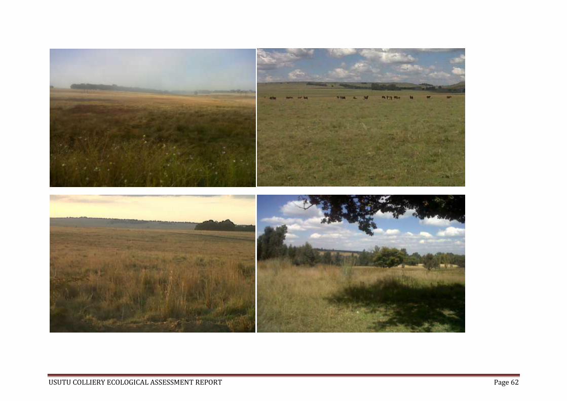
USUTU COLLIERY ECOLOGICAL ASSESSMENT REPORT Page 62

USUTU COLLIERY ECOLOGICAL ASSESSMENT REPORT Page 63
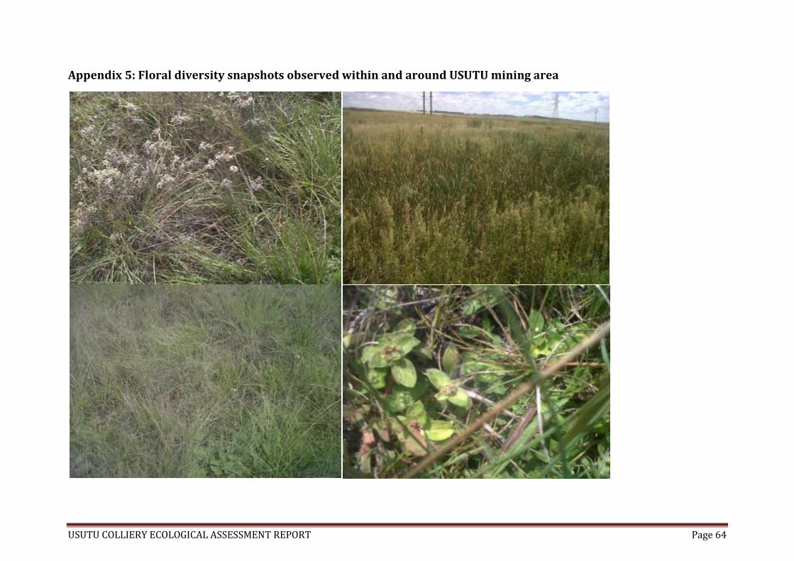
USUTU COLLIERY ECOLOGICAL ASSESSMENT REPORT Page 64
Appendix 5: Floral diversity snapshots observed within and around USUTU mining area
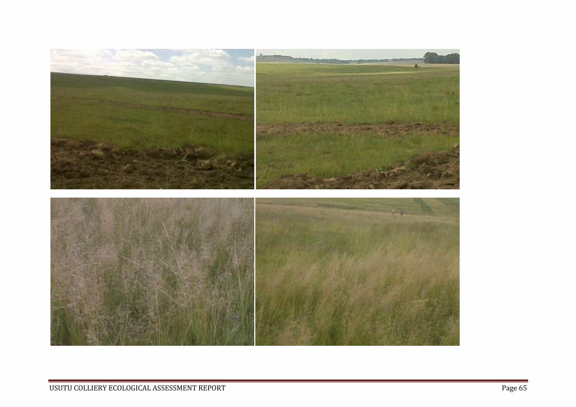
USUTU COLLIERY ECOLOGICAL ASSESSMENT REPORT Page 65
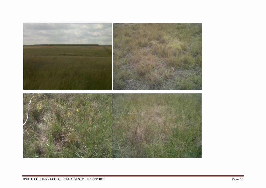
USUTU COLLIERY ECOLOGICAL ASSESSMENT REPORT Page 66

USUTU COLLIERY ECOLOGICAL ASSESSMENT REPORT Page 67

USUTU COLLIERY ECOLOGICAL ASSESSMENT REPORT Page 68

USUTU COLLIERY ECOLOGICAL ASSESSMENT REPORT Page 69
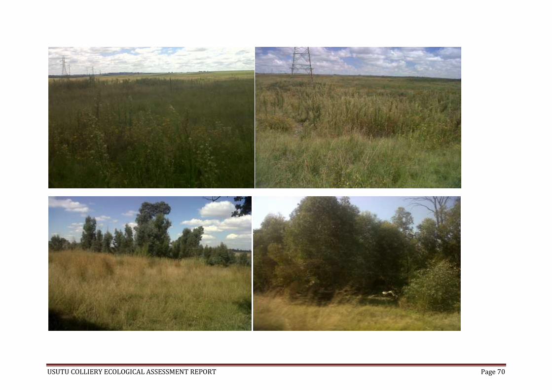
USUTU COLLIERY ECOLOGICAL ASSESSMENT REPORT Page 70

USUTU COLLIERY ECOLOGICAL ASSESSMENT REPORT Page 71
Appendix 6: Animal holes, spoors and droppings observed at USUTU
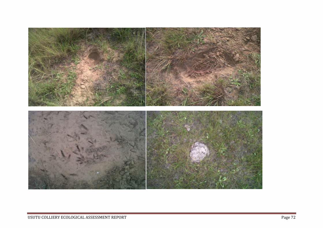
USUTU COLLIERY ECOLOGICAL ASSESSMENT REPORT Page 72

USUTU COLLIERY ECOLOGICAL ASSESSMENT REPORT Page 73
Appendix 7: Environmental impacts associated with mining observed at USUTU

USUTU COLLIERY ECOLOGICAL ASSESSMENT REPORT Page 74
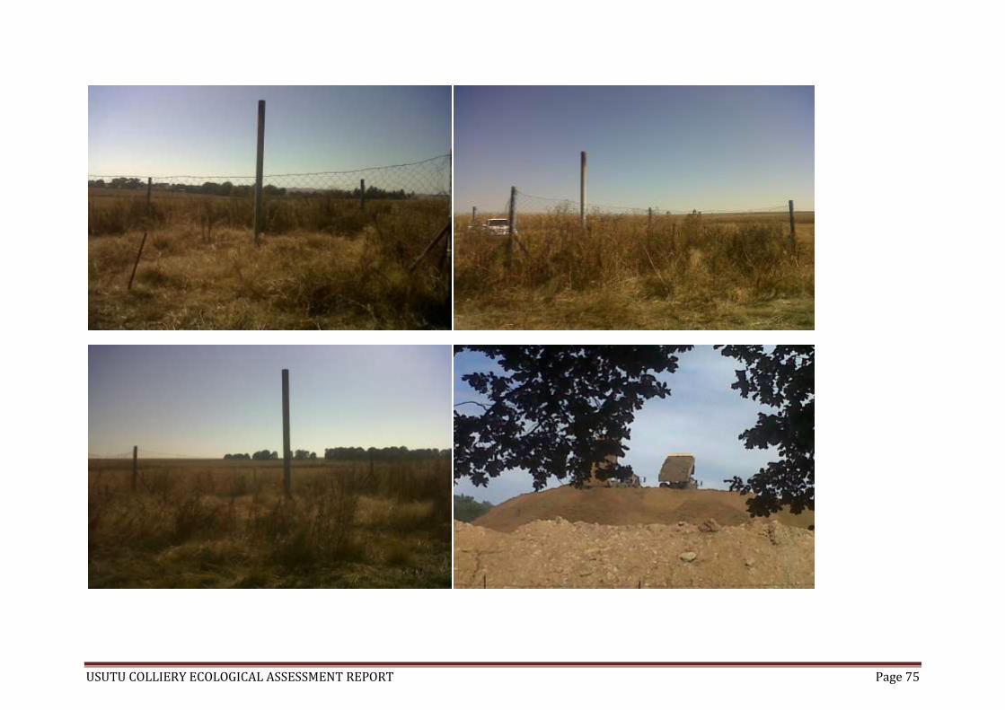
USUTU COLLIERY ECOLOGICAL ASSESSMENT REPORT Page 75