Online Open House
13
Online Open House Red Cedar / Cedar Avenue Class Environmental Assessment Study from Langstaff Road East to High Tech Road
Transcript of Online Open House
Online Open House
Red Cedar / Cedar AvenueClass Environmental Assessment Study
from Langstaff Road East to High Tech Road

Study Area, Open House Purpose and Municipal Class EA Process
York Region is undertaking a transportation Environmental
Assessment (EA) Study for the extension of Red Cedar / Cedar
Avenue from Langstaff Road East to High Tech Road in the City
of Richmond Hill and City of Markham.
Description of Project Environmental Assessment (EA)
An EA is a planning process for municipal infrastructure, legislated by the Ontario
Environmental Assessment Act.
The Study was initially assessed to be undertaken as a Schedule ‘B’ EA. As the Study
progressed additional infrastructure requirements to support the recommendations were
identified. Upon York Region’s review it was concluded that a change from a Schedule
‘B’ EA to a Schedule ‘C’ EA was required to address the proposed recommendations.
The study therefore is being conducted as a Schedule ‘C’ project under the Municipal
Class EA document (October 2000, as amended in 2007, 2011 and 2015).
The Red Cedar / Cedar Avenue EA incorporates York Region’s Transportation Master
Plan (TMP) process and recommendations which differs from the traditional Municipal
Class EA process.
Purpose of Open House
Introduce the Project
Summarize the Region’s 2016 TMP Recommendations for the corridor
Present the evaluation of alternatives
Share the Recommended Plan
Obtain your input about the project
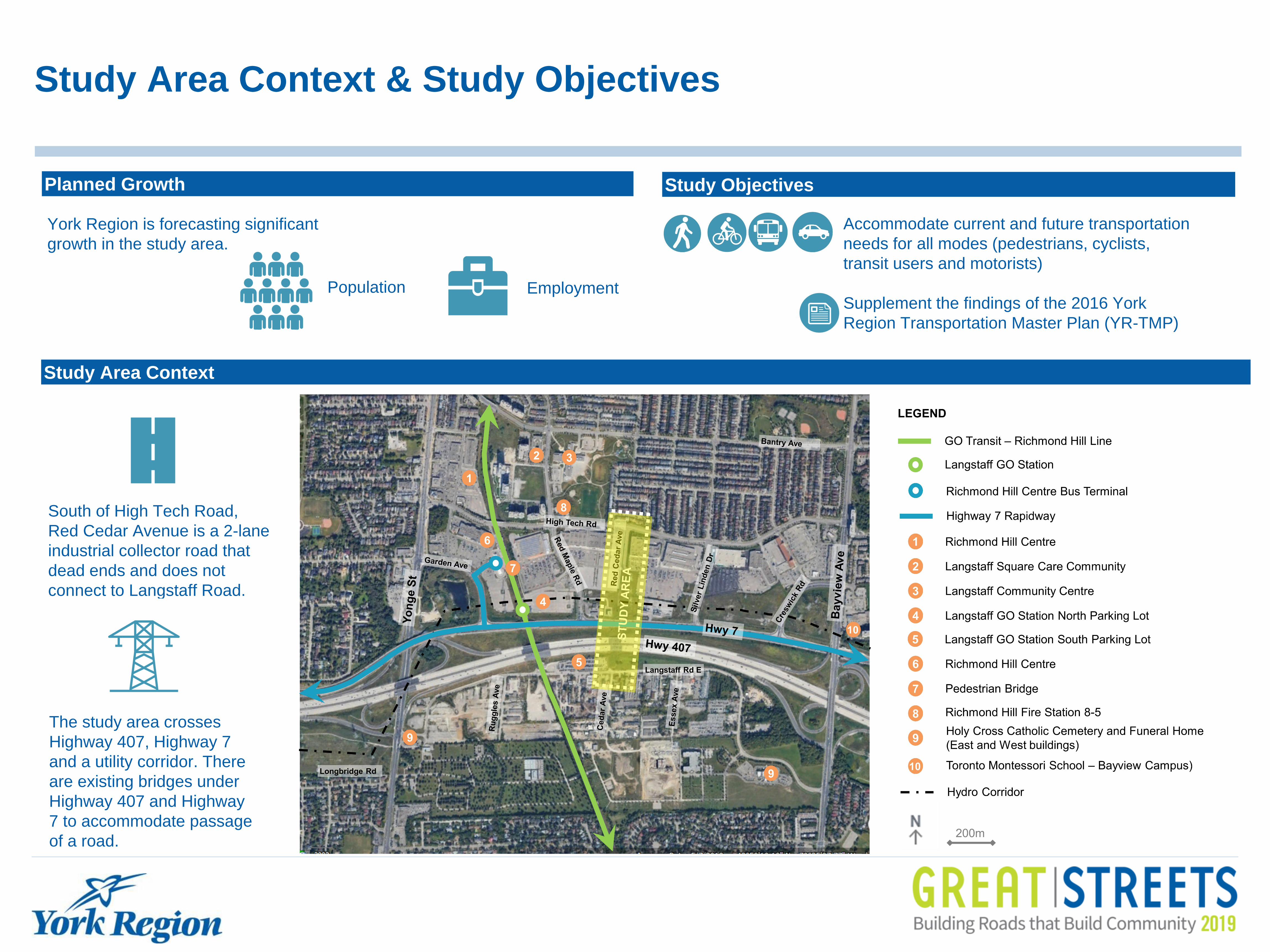
Study Area Context & Study Objectives
South of High Tech Road,
Red Cedar Avenue is a 2-lane
industrial collector road that
dead ends and does not
connect to Langstaff Road.
Study Area Context
The study area crosses
Highway 407, Highway 7
and a utility corridor. There
are existing bridges under
Highway 407 and Highway
7 to accommodate passage
of a road.
Planned Growth
York Region is forecasting significant
growth in the study area.
Study Objectives
Accommodate current and future transportation
needs for all modes (pedestrians, cyclists,
transit users and motorists)
Supplement the findings of the 2016 York
Region Transportation Master Plan (YR-TMP)
EmploymentPopulation

What We’ve Heard So Far
Online Survey
79% general support for project
Hopes for the Project:
Provide Connectivity and Alternate Routes
Congestion Relief
Improve overall access to businesses and services
Provide opportunities for Active Transportation facilities
for pedestrians and cyclists
Community Outreach
Direct mail notices Newspaper notices
Open House
York Region social media (Facebook and Twitter)
Project website (york.ca/cedaravenue)
Road SignsPostcard
Technical Review
Agencies
Concerns:
Traffic infiltration into neighbourhoods
Solutions that promote driving will increase vehicular traffic
Impacts to commuter parking at GO Station
Construction Impacts
Notice Road SignProject Website Postcard
Utilities
Ratepayers
Associations
Residential Property
Owners
Commercial
Property Owners
CN Rail
General Public
Ministry of
Environment,
Conservation and
Parks
Places of Worship
Metrolinx Indigenous
Communities
City of Markham
Ministry of
Transportation
407ETR
City of
Richmond Hill
Stakeholders Identified
Community Centres
York Region Transit
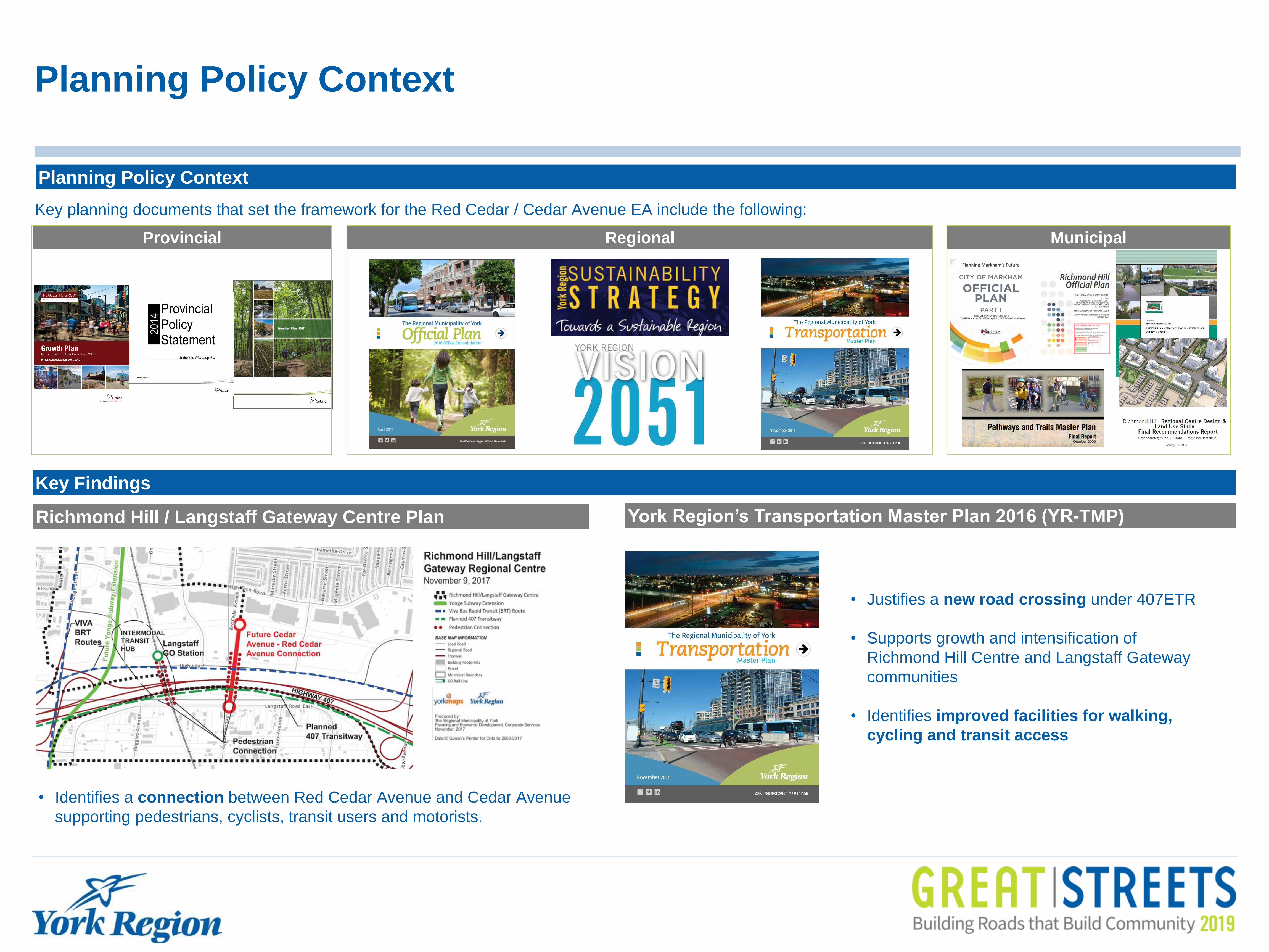
Planning Policy Context
Planning Policy Context
Key planning documents that set the framework for the Red Cedar / Cedar Avenue EA include the following:
Provincial Regional Municipal
Key Findings
• Identifies a connection between Red Cedar Avenue and Cedar Avenue
supporting pedestrians, cyclists, transit users and motorists.
Richmond Hill / Langstaff Gateway Centre Plan York Region’s Transportation Master Plan 2016 (YR-TMP)
• Justifies a new road crossing under 407ETR
• Supports growth and intensification of
Richmond Hill Centre and Langstaff Gateway
communities
• Identifies improved facilities for walking,
cycling and transit access
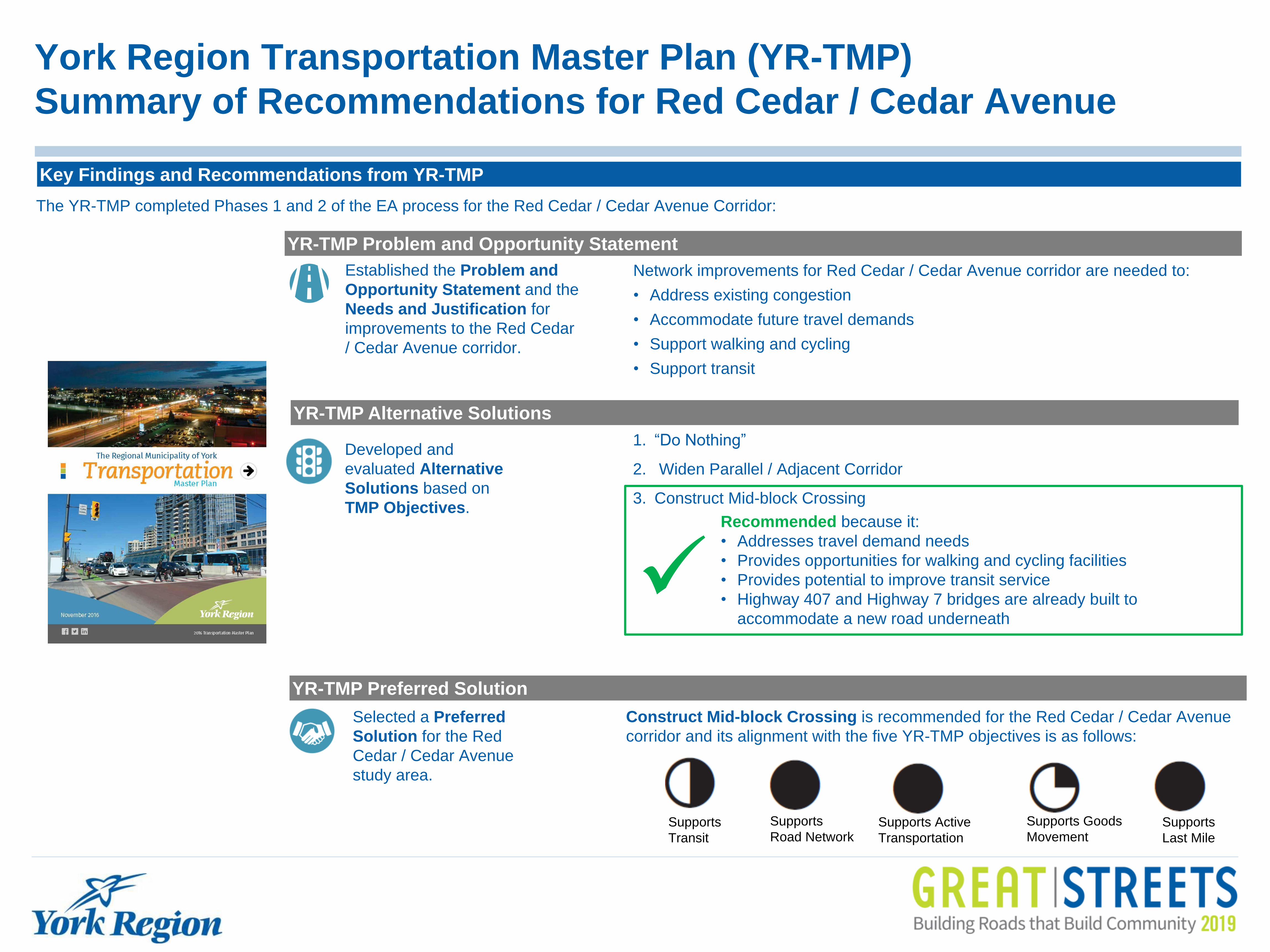
York Region Transportation Master Plan (YR-TMP)
Summary of Recommendations for Red Cedar / Cedar Avenue
Key Findings and Recommendations from YR-TMP
Network improvements for Red Cedar / Cedar Avenue corridor are needed to:
• Address existing congestion
• Accommodate future travel demands
• Support walking and cycling
• Support transit
Established the Problem and
Opportunity Statement and the
Needs and Justification for
improvements to the Red Cedar
/ Cedar Avenue corridor.
YR-TMP Problem and Opportunity Statement
Developed and
evaluated Alternative
Solutions based on
TMP Objectives.
YR-TMP Alternative Solutions
Selected a Preferred
Solution for the Red
Cedar / Cedar Avenue
study area.
Recommended because it:
• Addresses travel demand needs
• Provides opportunities for walking and cycling facilities
• Provides potential to improve transit service
• Highway 407 and Highway 7 bridges are already built to
accommodate a new road underneath
1. “Do Nothing”
2. Widen Parallel / Adjacent Corridor
3. Construct Mid-block Crossing
YR-TMP Preferred Solution
Supports
Transit
Supports Active
Transportation
Supports
Road NetworkSupports
Last Mile
Supports Goods
Movement
Construct Mid-block Crossing is recommended for the Red Cedar / Cedar Avenue
corridor and its alignment with the five YR-TMP objectives is as follows:
The YR-TMP completed Phases 1 and 2 of the EA process for the Red Cedar / Cedar Avenue Corridor:

Land Use and Active Transportation
Existing Active Transportation Conditions
No cycling facilities on less
busy streets with less lanes
Land Use
Predominantly industrial / commercial land
use.
Intensification through high-rise residential
development is expected.
South of the industrial / commercial
area, there are cemeteries and low-rise
residential properties
The proposed developments within the study
area will substantially increase future traffic
demand in the surrounding road network.
North of Highway 7 in the City of
Richmond Hill, there are the Richmond
Hill Centre, low density residential
properties, and a utility corridor
No sidewalks, crosswalk markings,
crossing medians, curbs or protected
controls for turning movements
Failure to satisfy AODA minimum
requirements
8
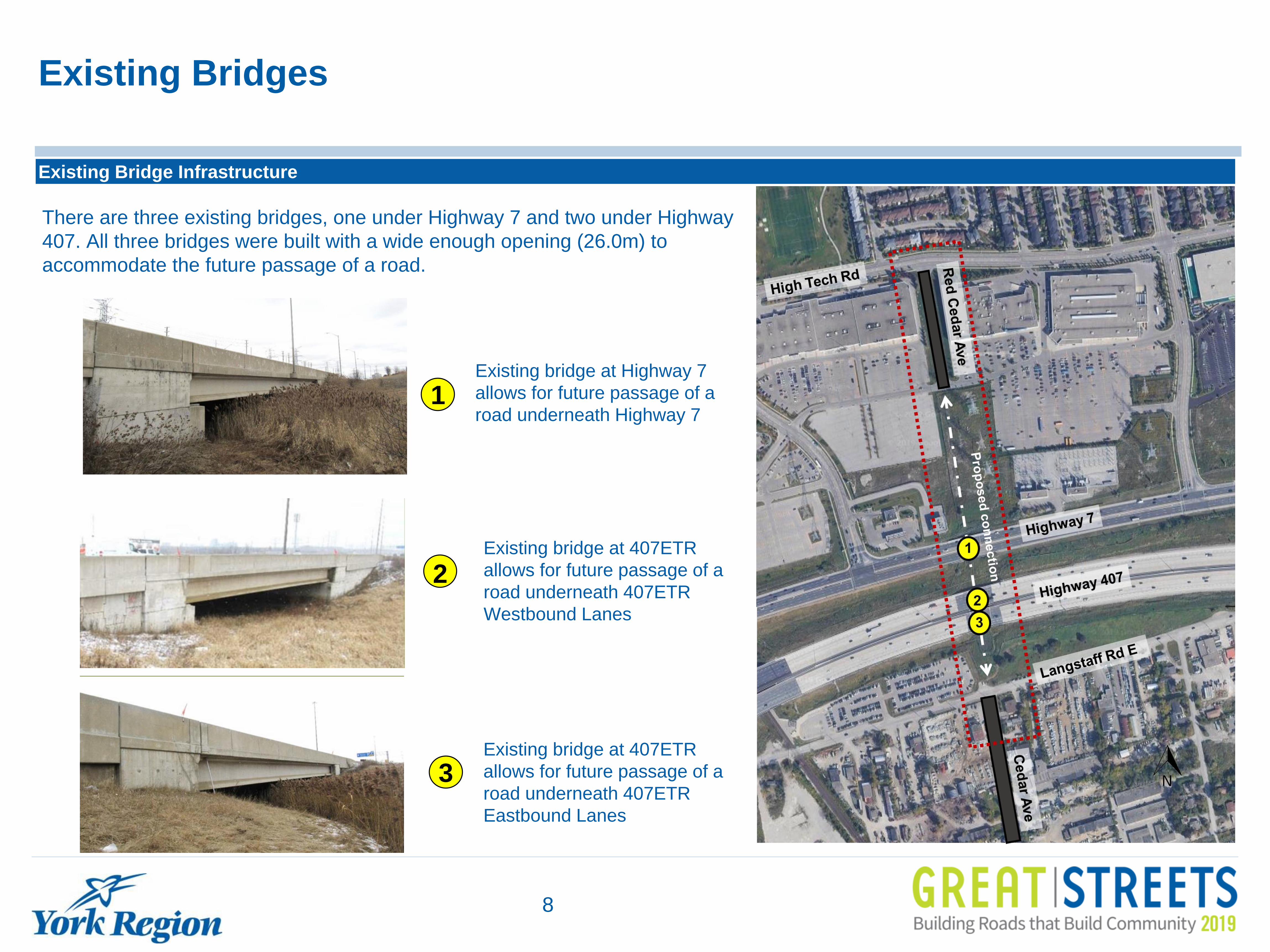
Existing Bridges
Existing Bridge Infrastructure
Existing bridge at 407ETR
allows for future passage of a
road underneath 407ETR
Eastbound Lanes
Existing bridge at 407ETR
allows for future passage of a
road underneath 407ETR
Westbound Lanes
2
3
There are three existing bridges, one under Highway 7 and two under Highway
407. All three bridges were built with a wide enough opening (26.0m) to
accommodate the future passage of a road.
Existing bridge at Highway 7
allows for future passage of a
road underneath Highway 71

Traffic Operations and Recommendations
Existing Traffic Conditions
The intersections experiencing the worst congestion and delays* are:
Yonge Street at Garden
Avenue (during the morning
peak hour)
Bayview Avenue at High Tech
Road (during the afternoon peak
hour)
*Delay is an indicator of how long a vehicle must wait to complete a movement
Traffic operations for weekday morning (AM) and afternoon (PM)
peak hours were assessed at intersections within the broader study
area network.
The broader study area today experiences traffic congestion and
delays particularly on Yonge Street and Bayview Avenue.
Traffic signals are recommended at Red Cedar Avenue
and High Tech Road and at Cedar Avenue and Langstaff
Road East.
Both a 2-lane and 4-lane Red Cedar / Cedar Avenue
extension are appropriate to serve the anticipated
vehicular demand in the area.
Analysis of Future 2041 Traffic for the Red Cedar / Cedar Avenue
corridor concluded:
Future 2041 Traffic Conditions
Vehicle Travel Lane Screening and Recommendation
The number of vehicle travel lanes for Red Cedar / Cedar Avenue was reviewed.
• Accommodates all travel modes within 26.0m right-of-way
• Provides streetscaping opportunities
• Does not accommodate all travel modes within 26.0m right-of-way
• Limits streetscaping opportunities
Both a 2-lane and 4-lane Red Cedar / Cedar Avenue
extension require accommodation of additional turning
lanes at intersections.
2 travel lanes (+ turning lanes at intersection)
Recommended

Transportation Service
• Promote a high quality pedestrian and cyclist experience (i.e.
improves pedestrian and cyclist accessibility and connectivity)
• Improve Mode Choice
• Promotes safety for all modes
Social Environment
• Improve Visual Aesthetics
• Improve Community Character
• Minimizes impacts to archaeological / cultural heritage features
• Accommodate Streetscaping
Natural Environment
• Protect Designated Natural Areas
• Protect Vegetation
• Protect Wildlife
• Protect Aquatic Habitat
• Surface water and Groundwater Management
• Improve Air Quality
• Minimize Effects on Climate Change
Infrastructure Design
• Minimize utility relocation
• Compatibility with existing infrastructure
Economic Environment and Cost Effectiveness
• Accommodate planned development and growth
• Improve access to businesses and key employment areas
• Minimize Impacts on Business Properties
• Maximize Construction Value
• Minimize Property Requirements
• Minimize Operating Costs
Key Technical Studies and Evaluation Criteria
Evaluation Criteria
Key Technical Studies
Drainage and Stormwater
Management Report
Natural Heritage
Impact Assessment
Archaeological
Assessment
Structural
Assessment
Geotechnical and
Pavement Assessment
Hydrogeological
AssessmentCultural Heritage
Resource Assessment
Contamination
Overview Study
Noise Impact
Assessment

Active Transportation (AT) Facilities
Active Transportation Configuration Options
The following alternatives were considered to determine how best to
accommodate pedestrians and cyclists. On-street cycling facilities were not
carried forward as they do not provide increased separation from vehicles.
Option 2: MUP on one side, sidewalk on the other
Option 1: Multi-use Path (MUP) on both sides
Evaluation and Recommendations
Sidewalk and Boulevard Cycle Track on Both Sides is
preferred because:
This option provides multi-modal network connectivity and promotes
significant improvement for the public realm with dedicated, separated
and continuous cycling and pedestrian facilities and opportunities for
landscaping on both boulevards.
Sidewalk
Option 3: Sidewalk and cycle track on both sides
Sidewalk Sidewalk
CRITERIA
Option 1:
MUP on both
sides
Option 2
MUP on one side,
sidewalk on the other
Option 3:
Sidewalk and cycle track on
both sides
Transportation Service
Social Environment
Natural Environment
Infrastructure Design
Economic Environment and
Cost Effectiveness
Summary
Recommended

Preferred Design Concept
Extend Red Cedar / Cedar Avenue to a two lane road (one in each direction) with turning
lanes, sidewalks and boulevard cycle tracks, and streetscaping in both boulevards.
Summary of Preferred Design Concept
Proposed Red Cedar /
Cedar Avenue Extension
Extension of Red
Cedar / Cedar
Avenue for two
lanes with turning
lane
Key Features
Boulevard Cycle tracks on
both sides
Sidewalks on both sides
Plantings in the
boulevards
Source: Google Streetview
Traffic Signals at High Tech
Road and Langstaff Road
Source: York Region
Source: York Region
Source: York Region
Source:
https://safety.fhwa.dot.gov/road_diets/c
ase_studies/

Timing of Improvements and Next Steps
Your input is very valuable to us!
Please fill in a comment form or provide your comments
by mail, email or phone by January 31, 2020.
Contact Us
For more information visit: york.ca/cedaravenue
Please send your thoughts or opinions about the
corridor by sending us an email at: [email protected]
Next Steps
Join the Study Mailing List
Review feedback from the public
Refine Preferred Design
Prepare Environmental Study Report (ESR) and place
on public record for review
Look out for
Direct mail or e-mail notices
Newspaper notices
Updates on York Region
social media (Facebook
and Twitter)
Updates on the Project
Website
Timing of Improvements
Recommended improvements:
• Construction to commence
in 2022
Timing of Improvements for Red Cedar / Cedar Avenue are
identified in the 2019 10-Year Roads and Transit Capital
Construction Program and subjected to annual review