on the Implementation of the Water Framework Directive ... · LU, NL 105670 54.0 Ems DE3000 NL...
87
EN EN EUROPEAN COMMISSION Brussels, 14.11.2012 SWD(2012) 379 final 8/30 COMMISSION STAFF WORKING DOCUMENT Member State : Germany Accompanying the document REPORT FROM THE COMMISSION TO THE EUROPEAN PARLIAMENT AND THE COUNCIL on the Implementation of the Water Framework Directive (2000/60/EC) River Basin Management Plans {COM(2012) 670 final}
Transcript of on the Implementation of the Water Framework Directive ... · LU, NL 105670 54.0 Ems DE3000 NL...
EN EN
EUROPEAN COMMISSION
Brussels, 14.11.2012
SWD(2012) 379 final
8/30
COMMISSION STAFF WORKING DOCUMENT
Member State : Germany
Accompanying the document
REPORT FROM THE COMMISSION TO THE EUROPEAN PARLIAMENT AND
THE COUNCIL
on the Implementation of the Water Framework Directive (2000/60/EC)
River Basin Management Plans
{COM(2012) 670 final}
2
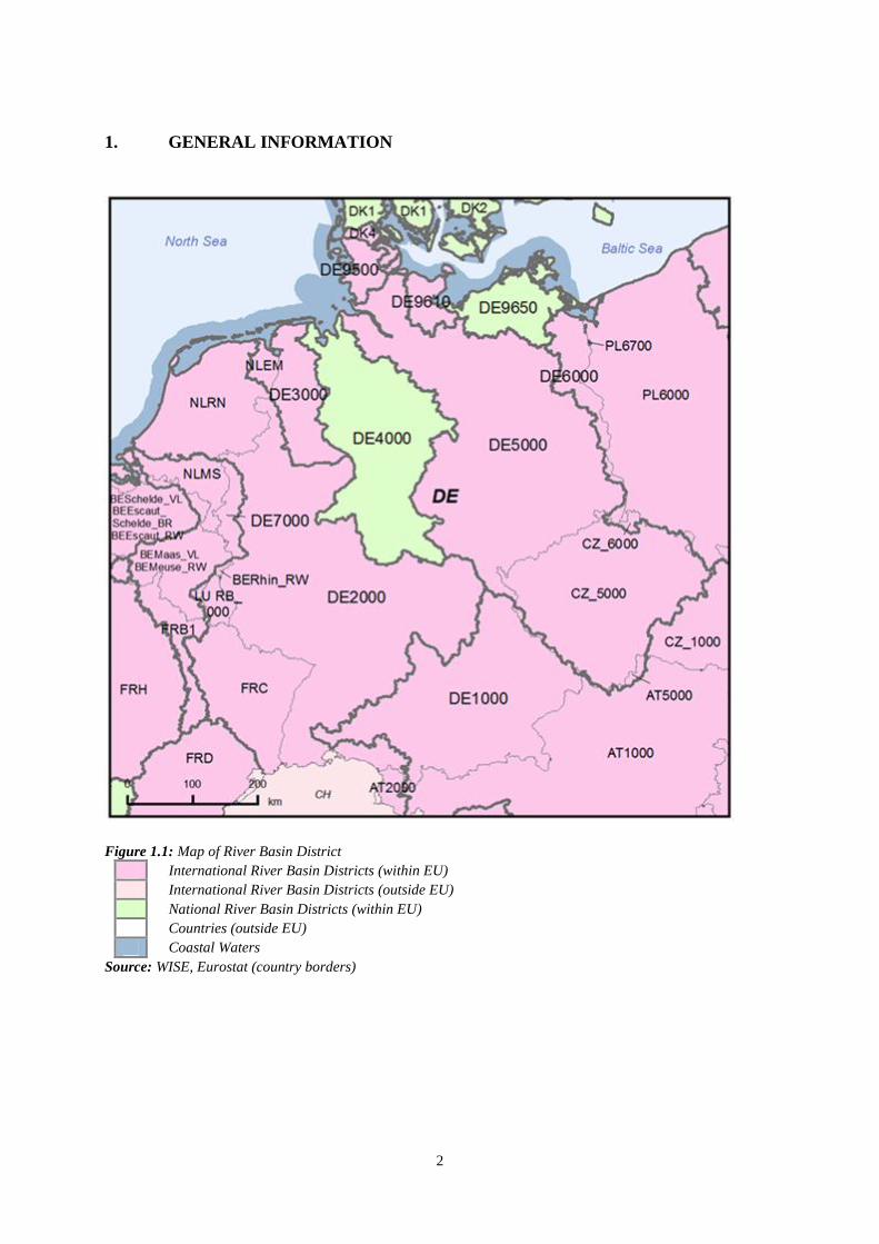
1. GENERAL INFORMATION
Figure 1.1: Map of River Basin District
International River Basin Districts (within EU)
International River Basin Districts (outside EU)
National River Basin Districts (within EU)
Countries (outside EU)
Coastal Waters
Source: WISE, Eurostat (country borders)

3
Population: 82 million
Total area: 356854 km²
RBD Name Size1 (km
2)
% share of
total basin in
DE
Countries
sharing RBD
DE1000 Danube 801000 (56259 in DE) 7
AT, BA, BG, CH,
CZ, HR, HU, IT,
MD, ME, MK,
PL, RO, RS, SI,
SK, UA, AL
DE2000 Rhine 197177 (105775 in DE) 54 AT, BE, CH, FR,
IT, LI, LU, NL
DE3000 Ems 20246 (17117 in DE) 84 NL
DE4000 Weser 49063 100 -
DE5000 Elbe 150558 (99506 in DE) 65.5 AT, CZ, PL
DE6000 Odra 124000 (9600 in DE) 7.7 CZ, PL
DE7000 Meuse 34364 (3984 in DE) 11.6 BE, FR, LU, NL
DE9500 Eider 9202 (DE only2) - DK
DE9610 Schlei/Trave 9218 (DE only3) 99.95 DK
DE9650 Warnow/Peene 21088 100 -
Table 1.1: Overview of Germany’s River Basin Districts
Source: River Basin Management Plans reported to WISE4: http://cdr.eionet.europa.eu/de/eu/wfdart13
1 Area includes coastal waters.
2 Total size not possible to determine as the Danish section is part of a larger river basin.
3 Total size not possible to determine as the Danish section is part of a larger river basin.
4 This MS Annex reflects the information reported by the MS to WISE which may have been updated since the
adoption of the RBMPs. For this reason there may be some discrepancies between the information reported
in the RBMPs and WISE.
4
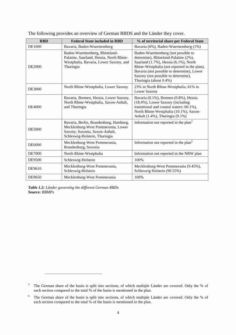
The following provides an overview of German RBDS and the Länder they cover.
RBD Federal State included in RBD % of territorial share per Federal State
DE1000 Bavaria, Baden-Wuerttemberg Bavaria (6%), Baden-Wuerttemberg (1%)
DE2000
Baden-Wuerttemberg, Rhineland-
Palatine, Saarland, Hessia, North Rhine-
Westphalia, Bavaria, Lower Saxony, and
Thuringia
Baden-Wuerttemberg (not possible to
determine), Rhineland-Palatine (2%),
Saarland (1.7%), Hessia (6.1%), North
Rhine-Westphalia (not reported in the plan),
Bavaria (not possible to determine), Lower
Saxony (not possible to determine),
Thuringia (about 0.4%)
DE3000 North Rhine-Westphalia, Lower Saxony 23% in North Rhine-Westphalia, 61% in
Lower Saxony
DE4000
Bavaria, Bremen, Hessia, Lower Saxony,
North Rhine-Westphalia, Saxon-Anhalt,
and Thuringia
Bavaria (0.1%), Bremen (0.8%), Hessia
(18.4%), Lower Saxony (including
transitional and coastal waters: 60.1%),
North Rhine-Westphalia (10.1%), Saxon-
Anhalt (1.4%), Thuringia (9.1%)
DE5000
Bavaria, Berlin, Brandenburg, Hamburg,
Mecklenburg-West Pommerania, Lower
Saxony, Saxonia, Saxon-Anhalt,
Schleswig-Holstein, Thuringia
Information not reported in the plan5
DE6000 Mecklenburg-West Pommerania,
Brandenburg, Saxonia
Information not reported in the plan6
DE7000 North Rhine-Westphalia Information not reported in the NRW plan
DE9500 Schleswig-Holstein 100%
DE9610 Mecklenburg-West Pommerania,
Schleswig-Holstein
Mecklenburg-West Pommerania (9.45%),
Schleswig Holstein (90.55%)
DE9650 Mecklenburg-West Pommerania 100%
Table 1.2: Länder governing the different German RBDs
Source: RBMPs
5 The German share of the basin is split into sections, of which multiple Länder are covered. Only the % of
each section compared to the total % of the basin is mentioned in the plan.
6 The German share of the basin is split into sections, of which multiple Länder are covered. Only the % of
each section compared to the total % of the basin is mentioned in the plan.
5
Name
international
river basin National RBD
Countries
sharing
RBD
Co-ordination category
1 3
km² % km² %
Danube DE1000
AT, BA, BG,
CH, CZ, HR,
HU, IT, MD,
ME, MK, PL,
RO, RS, SI,
SK, UA, AL
56184 7.0
Rhine DE2000
AT, BE, CH,
FR, IT, LI,
LU, NL
105670 54.0
Ems DE3000 NL 15008 84.0
Ems-Dollart DE3000 NL 482 3.0
Elbe DE5000 AT, CZ, PL 99730 65.5
Odra DE6000 CZ, PL 9602 7.7
Meuse DE7000 BE, FR, LU,
NL 3984 11.6
Vidaa/Wiedau
(Rudboel
Soe/Ruttebülle
r See)
DE9500 DK 261 19.0
Jardelund
Groeft/Jardelu
nder
Graben/Bongsi
eler Kanal
DE9500 DK 732 99.0
Krusaa/Krusau DE9610 DK 6 26
Table 1.3: Transboundary river basins by category (see CSWD section 8.1) and % share in Germany7
Category 1: Co-operation agreement, co-operation body, RBMP in place.
Category 2: Co-operation agreement, co-operation body in place.
Category 3: Co-operation agreement in place.
Category 4: No co-operation formalised.
Source: EC Comparative study of pressures and measures in the major river basin management plans in the EU.
2. STATUS OF RIVER BASIN MANAGEMENT PLAN REPORTING AND
COMPLIANCE
The RBMPs were adopted on 22 December 2009 or earlier8. RBMPs were reported to the
Commission in March 2010: the Danube, Elbe, Weser, Meuse and Schlei/Trave on the 4th
; the
Eider and Warnow/Peene on the 9th
; the Odra on the 19th
; and the Ems and the Rhine on the
22nd
.
Germany is a federal state and this is reflected by the different approaches to co-ordination in
the context of the WFD. Some Länder worked together to submit one plan, while other
7 Categorisation determined under the EC Comparative study of pressures and measures in the major river
basin management plans in the EU (Task 1b: International co-ordination mechanisms).
8 Depending on the international commissions and the Länder.

6
Länder produced individual plans for the same basin, sometimes to varying degree of detail.
The result of these differences is only a patchwork of information on how the WFD is being
implemented9.
Nevertheless, one of the strengths of the plans is that they all follow a similar structure,
making them easy to follow and compare. This has been helpful during the public
participation phase. In general, the RBMPs are readable, even for non-technical persons. The
German RBMPs are useful information tools that summarise the work being carried out under
the WFD. Specific information on precise implementation is found in other documents, which
have not been officially submitted.
On the other hand, the plans give only a limited picture of which methodologies have been
used or which measures will be implemented. It is also not always clear what has been co-
ordinated by the LAWA (LänderarbeitsgruppeWasser) with respect to monitoring, status and
economic assessments. The information as regards methodologies required to implement the
GWD is often missing but this could be explained by the fact the GWD had not been
transposed into national law when the plans were drafted. In addition, the plans give a short
summary regarding the work to be carried out under the programmes of measures.
Information regarding the allocation of the financial resources to measure implementation is
lacking, so it is unclear what will be achieved in the 1st
planning cycle.
Strengths and Weaknesses of the German RBMPs were:
Of the river basin districts that fall within the borders of Germany – the Danube, Rhine, Maas,
Ems, Weser, Oder, Elbe, Eider, Warnow/Peene and Schlei/Trave - eight extend into other
countries, with only the Weser and Warnow/Peene being managed in Germany alone.
Germany is a federal state made up of sixteen Länder sharing these 10 basins. This federal
structure is reflected by the different approaches to coordination in the context of the WFD.
The following is a summary of the main strengths and weaknesses of the German plans:
Governance:
The federal structure requires additional efforts for water management. A specific working
group “Länderarbeitsguppe Wasser” was set up to co-ordinate among Länder. The aim was to
develop common methodologies and approaches. In addition some Länder formed a national
River Basins commission. So some “Länder” worked more closely together to submit one
plan, while other Länder produced individual plans for the same basin, sometimes to varying
degrees of detail and with different methodologies. The result of these differences is only a
patchwork of information on how the WFD is being implemented. Nevertheless, the strength
of the plans is that they all follow a similar structure, making them easy to follow and
compare. This has been helpful during the public participation phase. In general, the RBMPs
are readable, even for non-technical persons. The German RBMPs are useful information
tools to get a general idea of the working being carried out under the WFD. Specific
information on precise implementation is found in other documents, which have not been
officially submitted.
Characterisation of the RBDs:
9 The federal structure of Germany defines these competencies in the German Constitution.

7
In general the German RBMPs reported that typologies have been developed and are in place
for all water categories in all river basins. Furthermore, a common approach was taken by all
RBDs. However, some individual RBDs have no defined transitional water bodies and no
information as to why is provided in the plans (Odra, Schlei/ Trave, Warnow/Peene).
A largely uniform nationwide approach LAWA (LänderarbeitsgruppeWasser), based on the
EU CIS guidance, has been applied for the identification of pressures and impacts in the
German RBDs, allowing for easy comparison. Yet, in some RBMPs specific
criteria/thresholds to identify significant pressures are not described.
Reference conditions are well developed in all German RBDs with some shortcomings in
some RBDs regarding the water categories “rivers, lakes and coastal waters”.
Monitoring
The German plans indicate a high level of ambition with respect to monitoring: often the
monitoring networks go significantly beyond the explicit and implicit WFD minimum
requirements. The monitoring of chemical substances especially has been extensively
addressed. Nevertheless, with respect to BQEs, there are unclear or inconsistent approaches to
selected BQEs most sensitive to pressures, making it difficult to compare RBDs between
Länder. In addition, not all monitoring sites measure BQEs.
Assessment of Ecological Status of Surface Waters
For the most part, nationwide standards and approaches (through LAWA and RAKON) have
been developed and applied in the German RBDs for type-specific ecological status
assessments. Previously lacking assessment methodology for BQEs have now been developed
and especially sensitive BQEs have been identified. Despite the progress on methodologies,
there are still some gaps in implementation for some water categories (e.g. lakes) and BQEs
(e.g. macroinvertebrates). Transparency is still an issue as regards how ecological assessments
are addressed for transitional and coastal waters. In the plans, information for the assessment
of the status quality assurance is very general, making it difficult to judge whether
uncertainties have been properly addressed.
Designation of HMWBs
The designation of HMWB mostly followed the steps in the CIS guidance. Information on
methodologies for setting GEP was not that clear in all RBMPs.
Assessment of Chemical Status
The first assessment of chemical quality was supported by a comprehensive assessment of all
priority substances. This serves as a strong basis for undertaking trend analyses in the future
and developing future programmes on the basis of the trends. A very few substances,
however, still lack proper analytical tools to make a proper chemical quality assessment. In
addition, there appear to be different and partly non WFD compliant measurement frequencies
for priority substances with too little information provided in the RBMPs.
Assessment of Groundwater Status
Strategies and approaches to assess groundwater status were harmonised at the national level
but still enabled regions to take local circumstances into account. This has enabled a high

8
level of comparability between RBDs. The methodology for deriving groundwater threshold
values is quite sophisticated as it can be applied to all types of substances and can take
regional characteristics into account. On the other hand, information on groundwater status
remains at a general level and provides few details. Moreover, RBMPs where Länder
developed separate plans have not provided a comprehensive view of the whole basin.
Information regarding the status of groundwater bodies is missing in the plans although
threshold values are exceeded at some monitoring points. It is not clear which groundwater
bodies are at good status or at risk of failing good status.
Environmental objectives and exemptions
In total 80% of the German water bodies are subject to an exemption with 79% being subject
to an extended deadline (Article 4.4.). Only for 1% of the water bodies will lower objectives
be applied (Article 4.5). This seems to be a precautionary approach as there is a lot of
uncertainty to the effectiveness of measures. The justification in relation to technical and
natural reasons is well defined. For disproportionate costs, the justification provided is unclear
as no detailed methodology was reported. Also new derogations under Article 4.7 will not be
used.
Programme of Measures
As with the other sections of the RBMPs, the programmes of measures were developed at the
national level under the LAWA. Measures have been developed for each respective theme
(i.e. agriculture, groundwater, hydromorphology, water pricing, etc). On the one hand, this
ensures a common approach in the Länder, especially in RBDs with multiple administrative
districts. On the other hand, the information provided in the plans remains very general as
only overarching categories of measures are provided. Detailed information on measures – for
example, exactly what will be implemented, whether it will be implemented and how it will
be financed – is missing in the PoM summaries found in the RBMPs. Although Länder level
PoMs were developed in Germany, these were not officially reported, leading to a lack of
transparency on what is being planned in the individual basins. Additionally, the
implementation of the measures is the responsibility of the Länder, so it is hard to assess their
comparability within a RBD.
With respect to the definition of costs, the plans are working with a narrow interpretation of
water services and estimations of the contributions of the different water users to the costs of
water services are lacking. Details regarding financial cost recovery are also lacking, as well
as for environmental and resource costs. Nevertheless, significant efforts were made to
coordinate work on Article 9 among the different Länder. Moreover, historically strong
incentive structures through pricing and economic instruments had existed even before WFD
implementation.
Climate change adaptation, water scarcity and droughts
Climate change as well as adaptation is addressed in all the river basins. A climate check was
carried out by the majority of river basins to better align the setting of objectives and the
selection of measures. However, the details of the methodologies to do so have not been
presented.
9
3. GOVERNANCE
3.1 Timeline of implementation
The German draft RBMPs were made available to the public from 22 December 2008 until 22
July 2009. The final RBMPs were published on 22 December 2009. As stated above, the
RBMPs were reported to the Commission in March 2010: the Danube, Elbe, Weser, Meuse
and Schlei/Trave on the 4th
; the Eider and Warnow/Peene on the 9th
; the Odra on the 19th
; and
the Ems and the Rhine on the 22nd
. There were no resubmissions.
3.2 Administrative arrangements - river basin districts and competent authorities
Based on the federal structure of Germany, the Federal States (and therein the relevant
ministries) are responsible for water management within the Länder. The environmental
ministries cover water issues as well as other water relevant sectors such as agriculture,
energy or climate protection or health10
. A division of competences among water categories is
not applied in any of the “Länder”11
.
In cases where a RBD (all RBDs except the Eider, Meuse and Warnow/Peene) is governed by
different Länder, bi- or multilateral agreements have been set up. Bavaria and Baden-
Wuerttemberg co-ordinated their RBMPs for the Danube through the 'Co-ordination Group
upper Danube'. In the German part of the Rhine RBD, the river basin management planning
was structured into RBMPs for each Federal State, in accordance with the federal framework
for the political, water law and administrative responsibilities in Germany. In preparing the
RBMP, the competent ministries of the Federal States and their subordinate agencies were in
charge and took over co-ordination tasks. More specialized agencies, e.g. regarding Nature
Conservation, Agriculture and Forestry, Health, Consumer Protection and the Water and
Shipping Administration of the federal government, were involved when required. For the
national co-ordination of the implementation of the WFD in the Ems, Lower Saxony and
North Rhine-Westphalia signed an administrative agreement setting up the Ems River Basin
Commission (FGG Ems), consisting of the “Emsrat” and the management office Ems. For the
Weser an administrative agreement between the Federal States for the establishment of the
Weser river basin authority was signed in 2003 and updated in 2009. For the Elbe, the 10
Federal States set up a coordinating institution called 'FGG Elbe' in 2004 to co-ordinate the
development of the RBMP and POMs (at the B-level) for the German part of the Elbe. The
three Federal States that make up the German part of the Oder produced a common RBMP ('B
level') without putting an 'official' co-ordination institution in place (like e.g. the FGG Elbe).
The Schlei/Trave RBMP was developed under the co-ordination of the Federal State of
Schleswig-Holstein (the Ministry for Agriculture, Environment and Rural Areas). The co-
ordination with Mecklenburg-Vorpommern took place through the contacts between the two
10 This differs from Land to Land.
11 Reference to reporting on Art. 3 (8) in 2004 for every RBD, e.g. for
Danube:http://www.wasserblick.net/servlet/is/36207/ANLAGE03_DONAU_KOMPLETT.pdf?command=do
wnloadContent&filename=ANLAGE03_DONAU_KOMPLETT.pdf For an overview of reporting
see:http://www.wasserblick.net/servlet/is/3477
10
ministries. An intensive exchange of information and data took place between the
administrations so that a commonly developed RBMP exists.
The guidelines drawn up within the framework of the Common Implementation Strategy
played an important role in Germany’s efforts to ensure the uniform interpretation of key
provisions of the WFD within Germany. In some cases, however, the discussion processes
surrounding the CIS guidelines were still on-going whilst practical implementation work had
begun at national level, driven by the ambitious timetable of the WFD. As such, full
consideration could not be given to these guidelines in the first round of RBMPs. Additional
national guidelines were prepared within the RBDs and in the “Länderarbeitsgemeinschaft
Wasser” (LAWA). As a result, methodologies and approaches to the implementation of the
WFD vary slightly among the Länder but the approaches are nevertheless all compatible with
CIS guidelines. These differences can be mainly found in the following areas: inventory
(including inventory of priority substance discharges), monitoring structures and methods,
criteria for the designation of heavily modified water bodies and determination of good
ecological potential, exemptions and the justification thereof, supra-regional management
objectives, individual aspects of financial analysis, and reporting modalities. Being aware of
different approaches taken among the Länder, in 2011 the LAWA initiated a further
harmonisation of methodologies for the second management cycle within its work programme
"River basin management (Flussgebietsbewirtschaftung)".
The co-ordination among the Länder has led to the following situation when it comes to the
development of RBMPs:
Danube: No common German plan (B-Level) was developed. Both Länder
developed their own river basin management plans for their territorial share of the
Danube basin.
Rhine: No common German plan (B-Level) was developed. The following
Länder submitted their own territorial plans for the Rhine: Baden-Wuerttemberg,
Bavaria, Rhineland-Palatine, North Rhine-Westphalia, Saarland, Thuringia and
Hessia. Lower Saxony has also developed its own RBMP12
and its territory is
covered by the international plan.
Ems: No common German plan (B-Level) was developed. North Rhine-
Westphalia developed its own territorial plan covering all the RBDs in its
jurisdiction, including the Ems. Lower Saxony did not develop its own RBMP and its
territory is covered by the international plan.
Weser: One German plan (B-Level) was developed among the Länder. In
addition, North Rhine-Westphalia developed its own territorial plan covering all the
RBDs in its jurisdiction, including the Weser.
Elbe: One German plan (B-Level) was developed among the Länder.
Odra: One German plan (B-Level) was developed among the Länder.
12 The C-Level Plan is available at:
http://www.nlwkn.niedersachsen.de/download/25758/nds_Beitrag_zum_Bewirtschaftungsplan_Rhein.pdf

11
Meuse: Only one Länder lies in the basin. North Rhine-Westphalia developed
its own territorial plan covering all the RBDs in its jurisdiction, including the Meuse.
Eider: The basin lies solely within one federal state.
Schlei/Trave: One German plan (B-Level) was developed and co-ordinated by
the two Länder included in the RBD.
Warnow/Peene: The basin lies solely within one federal state.
3.3 RBMPs - Structure, completeness, legal status
The adopting authorities are the Federal States/Länder. The type of adoption act varies from
one Federal State to another. Some laws of the Federal States lay down provisions that allow
the adoption of parts of PoMs as legally binding ordinances if needed. There is a general
obligation to take the RBMPs into account when individual decisions are taken, including
when interpreting broad legal notions. There is no specific provision governing this
interpretation and the situation varies between the Federal states, but the general consensus is
that RBMPs and PoMs are binding for the authorities responsible for water management. The
provisions of RBMPs and PoMs have, for example, specific determining effects as regards the
management discretion of authorities when they decide on water use permits. Authorities may
also invoke them to interpret and specify broad legal notions, for example the notion ‘adverse
changes to waters’.
At the Federal level, the legal effect is not regulated. At the level of the Federal State it is
partly regulated. In Schleswig Holstein, the environment ministry may declare the entire or
parts of RBMPs and PoMs legally binding for all authorities. In North-Rhine Westphalia all
administrative decision related to the RBMPs and PoMs are legally binding for the parts of
the river basins situated North-Rhine Westphalia. In other Federal States the legal effect of the
RBMP is not regulated.
3.4 Consultation of the public, engagement of interested parties
According to Article 14 of the WFD, the Member States are responsible for public
participation, and under German law this responsibility rests with the Länder. As such each
federal state conducted its own consultation process. Public participation in accordance with
the WFD has clearly shown the expediency of involving stakeholders and in some cases the
general public, from an early stage in order to avoid or minimise conflicts of interest further
down the line.
The consultation process on the draft RBMP was carried out through a number of different
routes, including written consultation and web based comments (only in the Danube, Rhine,
Ems and Warnow/Peene). In Baden-Wuerttemberg and Bavaria, several informal meetings
with local and regional stakeholder groups took place before the formal public participation
process. Information on the consultation process could be obtained through the media,
internet, printed media, local authorities (not in Schlei/Trave or the Eider); round tables and
cooperation between regions were also organized. The stakeholders involved in the
consultation included a wide range of sectors, such as water and sanitation, agriculture,
energy, fisheries, industry and NGOs. Involvement was through regular meetings as well as
round tables and thematic working groups (Odra). Continuous involvement of these
12
stakeholders or the general public took place. The comments provided led to adjustments in
specific measures (Danube, Rhine) as well as changes to the selection of measures (e.g. in the
Danube, Rhine, Elbe). A full list of these changes as a result of the comments gathered during
the public participation phase has not been provided in the individual RBMPs13
.
In consultations regarding the draft river basin management plans, in the case of international
RBDs, German-language versions of the draft international plans have always been published
as well, so that the general public has access to overview planning for the entire RBD.
However, public participation experience has clearly shown that interest among organised
interest groups and the general public tends to focus mainly on regional or local issues, and
they are only motivated to become involved when such issues are under debate. Public
participation became more active as the debate surrounding local changes and improvements
became more detailed and opportunities were available to exert a direct influence.
Most often as a result of the consultations, additional information was added to the RBMPs.
Only in the case of the Danube, Rhine and Elbe did the consultations lead to changes in the
selection of measures or adjustments to measures. Changes in methodologies used were also
reported in the Danube and the Rhine14
. In the Baden-Württemberg part of the Rhine, some
issues will be clarified in the 2nd
planning cycle. Public participation in the consultations was
very low in Eider and Schlei/Trave due to a previous consultation; as such the impact of the
consultation on draft plans was considered low. Information for the Ems and Meuse was
difficult to separate as North Rhine-Westphalia produced one plan for both basins; therefore,
the impact of the consultations for the both basins is unknown as the information was not
disaggregated15
. However, the RBMP mentions that the comments have been integrated as far
as possible.
3.5 International cooperation and coordination
As set out in Table 1.1, Germany contains 8 international RBDs. For the Danube, the Rhine,
the Elbe, the Odra, the Ems and the Meuse international plans have been developed. These
international plans have been part of the official reporting process.
The co-ordination and management of the international plans and the German level plans was
split into three levels: Part A, Part B and Part C. Part A comprises the international RBMPs
and includes information relating to the transnational significant water management issues
(SWMIs) and environmental objectives. Part B is the German level plan where one plan was
co-ordinated among all affected Länder (see section 1 for details). Part B plans focus on the
national level and provide additional national level SWMIs, environmental objectives, etc.
13 Several RBMPs explicitly mention the outcomes of public participation (e.g. NI:
http://www.nlwkn.niedersachsen.de/wasserwirtschaft/egwasserrahmenrichtlinie/ergebnisse_anhoerung/45590
.html; BW: http://www.um.baden-wuerttemberg.de/servlet/is/49918/
14 Most feedback took place during WFD advisory boards with participation of all stakeholders, not during the
official public participation in accordance with Art. 14
15 For the individual impact of public participation see:
http://www.flussgebiete.nrw.de/Dokumente/NRW/Bewirtschaftungsplan_2010_2015/Bewirtschaftungsplan/0
9_BP_Zusammenfassung_des_Ma__nahmenprogramms.pdf , p 9-7 and Chapter 12.

13
Part C covers plans developed by individual Länder for each of the basins covered in their
territory.
All the IRBDs in Germany except the Eider and Schlei/Trave co-operated to develop an
international RBMP. International Commissions governed by international agreements have
long been established to facilitate co-operation in these IRBDs, all16
of which predate the
WFD. To facilitate the developments of the international RBMPs, technical working groups
were set up. Reference is made by the German plans to the two levels of the management for
the international basins: Part A, parts of the river basin management plans in case of
international RBD, established in co-ordination with all basin countries on international level,
which deal with the umbrella management issues of the transboundary basin,; and Part B, the
national plans for the national parts of the basins, which focuses on German management
issues, objectives and measures. Most of the plans reflect the Part A plans and/or the umbrella
management issues in the national plans (e.g., the Elbe and the Baden-Württemberg RBMP
for the Danube).
The Eider and Schlei/Trave only share a very small part with Denmark and as such an
international plan was deemed unnecessary. Co-ordination with Denmark, however, is
regulated through an international agreement. As such, for both RBDs Germany and Denmark
worked together on a number of topics, including monitoring, environmental objectives,
development of PoMs, exemptions and public participation.
Integration with other sectors
All RBMPs contain links to other sectors and related plans and programmes, mainly
agriculture, through the Nitrates National Action Programme and the Rural Development
Programmes, the chemical industry, through the IPPC licensing programme, and biodiversity
through nature conservation plans.
4. CHARACTERISATION OF RIVER BASIN DISTRICTS
4.1 Water categories in the RBD
All four water categories, rivers, lakes, transitional and coastal waters, occur in Germany. The
four WFD water categories vary in occurrence over the 10 German RBDs. The following
shows the water categories included in the respective German RBDs:
i) Danube, Rhine and Meuse: two water categories - rivers and lakes.
ii) Odra, Schlei/Trave, Warnow/Peene: three water categories - rivers, lakes and coastal
waters17.
iii) Ems, Weser, Elbe, Eider - four water categories - rivers, lakes, transitional and coastal
waters.
16 In all RBDs international commissions existed before; only in case of Meuse there has been a new treaty but
a commission existed before.
17 No delineation of transitional water bodies was undertaken.

14
4.2 Typology of surface waters
The RBMPs show that typologies have been developed for all water categories in the German
RBDs. The following table shows the number of defined surface water types for each RBD
and water category:
RBD Rivers Lakes Transitional Coastal
DE1000 21 8 0 0
DE2000 25 9 0 0
DE3000 15 3 1 5
DE4000 24 10 1 5
DE5000 24 11 1 4
DE6000 13 6 0 1
DE7000 11 1 0 0
DE9500 6 3 1 5
DE9610 9 6 0 4
DE9650 8 5 0 4
Table 4.2.1: Surface water body types at RBD level
Source: WISE
In general, the approaches follow the LAWA guidelines (Bund/Länderarbeitsgemeinschaft
Wasser). LAWA documents that have been developed to identify typologies for the water
categories of the German RBDs are the RAKON B - Arbeitspapier I_Entwurf_21-11-06
(typology, reference conditions, class boundaries) and RAKON B - Arbeitspapier
II_Stand_07_03_2007 (thresholds for physical parameters), and RAKON B - Arbeitspapier
III_Entwurf_22-11-2006. The LAWA documents were used as a common approach to define
typology in the German RBDs.18
Abiotic typologies were validated against biological data for all water categories in each
RBD except for the lakes and coastal waters in the Odra RBD and for coastal waters in the
Elbe RBD. The reason for this was the on-going development of biological assessment
methods and missing data on reference conditions for these water categories.
When it comes to the development of reference conditions in general, it can be summarised
that these have been established for all water categories in most RBDs. However, it is
reported that certain gaps still exist. The RBMPs report that reference conditions are not yet
fully developed for rivers for the RBDs of Ems, Weser, Odra and Meuse nor for both lakes
and coastal waters in the Odra RBD and coastal waters in the Elbe RBD. The reason for this
relates to missing reference data regarding certain Biological Quality Elements (WISE chapter
3.1.1.1) when the RBMPs were drafted. For the Ems RBD it is reported that the process on
reference conditions is not complete because the development of biological assessment and
quantification methods in DE and NL is not fully complete. In addition, the RBMP of North
Rhine Westphalia, covering parts of the Weser, Ems and Meuse RBDs, further clarifies the
18 http://www.gesetze-im-internet.de/bundesrecht/ogewv/gesamt.pdf

15
lack of reference conditions indicating the difficulties in defining these for certain basin
sharing rivers in karstic areas, which seasonally fall dry. Missing data on reference condition
assessment will be supplemented in the next WFD cycle. Therefore, respective results can be
expected to be part of the 2015 RBMPs.
4.3 Delineation of surface water bodies
In the context of the LAWA, a common approach for most issues related to the delineation of
water bodies has been developed that is based on the CIS EU guidance on Water Body
Delineation. This approach has been applied in all German RBDs. Small water bodies have
been taken into account for all RBDs within the delineation approach based on a requirement
of the German water act that small waters also need to be addressed accordingly19
. The
minimum thresholds for delineation applied for the different water categories are the same for
all RBDs. For rivers, the delineation was undertaken for catchment areas >10 km2, for lakes
>0,5 km2, for transitional waters >10 km
2 and for coastal waters up to 1 sea mile off the coast.
The indications on methods to delineate water bodies in transitional water bodies vary. While
the delineation is not relevant for all RBDs (e.g. Danube, Rhine) other RBDs have not
delineated transitional water bodies20
(Odra, Schlei/Trave, Warnow/Peene). The respective
RBMPs (Odra, Schlei/Trave, Warnow/Peene) do not outline why no transitional water bodies
have been delineated21
. For the other RBDs both the CIS guidance and the Coast guidance
was used for water body delineation. The indicators eco-region, salinity and tidal action have
been used for delineation.
For the Elbe RBMP, a comparison of water body numbers reported in WISE and the ones in
the RBMP resulted in differences in relation to some pressures (e.g. diffuse pollution). This
difference could be explained by differing survey structures and evaluation algorithms applied
for statistical analysis. This will be eliminated in the next planning cycle22
.
Table 4.3.1 presents the numbers and areas of water bodies in the German RBDs/water
category23
.
19 After reporting the RBMPs, German authorities have provided more information about the reason for not
delineating some of the transitional waters. On the basis of a common proposal of the Federal coastal States
in Germany, the inner coastal waters of the Baltic Sea have uniformly been categorized as coastal waters
since they are characterized by wind-driven current dynamics generic for the category coastal waters.
Transitional waters are not identified. Transitional waters in terms of article 2 number 6 of Directive
2000/60/EC require an important influence by freshwater currents.
20 As informed by the German authorities after the RBMPs reporting (please see footnote number 19).
21 Transitional water bodies have not been designated in RBDs of Odra, Schlei/Trave, Warnow/Peene. All other
relevant RBDs have designated transitional water bodies.
22 As indicated by the German authorities after the RBMP reporting.
23 Water bodies for Germany have been merged since 2009 and figures may differ in comparison to this table.
16
RBD
Surface Water Groundwater
Rivers Lakes Transitional Coastal
Number
Average
Length
(km)
Number
Average
Area
(sq km)
Number
Average
Area
(sq km)
Number
Average
Area
(sq km)
Number
Average
Area
(sq km)
DE1000 621 31 50 6 0 0 0 0 46 1318
DE2000 2208 18 71 8 0 0 0 0 399 264
DE3000 502 11 6 2 2 98 6 518 40 351
DE4000 1380 12 27 3 1 208 6 263 144 328
DE5000 2773 12 359 3 1 395 5 511 224 445
DE6000 453 7 49 2 0 0 1 288 23 412
DE7000 227 7 1 1 0 0 0 0 32 125
DE9500 135 12 16 2 1 16 11 418 23 227
DE9610 274 7 51 3 0 0 25 124 19 426
DE9650 499 9 82 2 0 NaN 20 381 39 359
Total 9072 14 712 3 5 163 74 309 989 372
Table 4.3.1: Surface water bodies, groundwater bodies and their dimensions
Source: WISE
4.4 Identification of significant pressures and impacts
In the context of the LAWA a largely uniform nationwide approach has been applied for the
identification of pressures and impacts in the German RBDs. The work was guided by the
documents ‘Arbeitshilfe zur Umsetzung der EG-Wasserrahmenrichtlinie’, (2003) and the
LAWA paper ‘Significant Pressures – Signifikante Belastungen’ (2003), that include
criteria/thresholds to determine anthropogenic pressures from relevant drivers and to assess
their impacts in time to report to the EC. The general method (contained in the mentioned
documents) to define significance is based on the EU guidance and includes Länder specific
approaches. In general, the DE approaches consider a pressure that is not of natural origin to
be significant in the DE RBDs if it is likely to cause a water body to fail the ‘good status’.

17
RBD No pressures Point source
Diffuse
source
Water
abstraction
Water flow
regulations
and
morphological
alterations
River
management
Transitional
and coastal
water
management
Other
morphological
alterations
Other
pressures
No. % No. % No. % No. % No. % No. % No. % No. % No. %
DE1000 155 23.1 110 16.39 352 52.46 88 13.11 386 57.53 0 0 0 0 0 0 42 6.26
DE2000 313 13.73 1403 61.56 1456 63.89 50 2.19 1767 77.53 0 0 0 0 0 0 250 10.97
DE3000 27 5.23 180 34.88 452 87.6 0 0 484 93.8 0 0 0 0 0 0 158 30.62
DE4000 88 6.22 296 20.93 1199 84.79 0 0 1303 92.15 0 0 0 0 0 0 0 0
DE5000 282 8.99 546 17.4 2385 76 42 1.34 2411 76.83 0 0 0 0 0 0 89 2.84
DE6000 52 10.34 40 7.95 369 73.36 3 0.6 367 72.96 0 0 0 0 0 0 1 0.2
DE7000 22 9.65 181 79.39 140 61.4 0 0 200 87.72 0 0 0 0 0 0 35 15.35
DE9500 7 4.29 0 0 156 95.71 0 0 136 83.44 0 0 0 0 0 0 0 0
DE9610 8 2.29 0 0 342 97.71 0 0 274 78.29 0 0 0 0 0 0 0 0
DE9650 53 8.82 6 1 518 86.19 0 0 499 83.03 0 0 0 0 0 0 0 0
Total 1007 10.21 2762 28 7369 74.71 183 1.86 7827 79.36 0 0 0 0 0 0 575 5.83
Table 4.4.1: Number and percentage of surface water bodies affected by significant pressures
Source: WISE

18
Figure 4.4.1: Graph of percentage of surface water bodies affected by significant pressures
1 = No pressures
2 = Point source
3 = Diffuse source
4 = Water abstraction
5 = Water flow regulations and morphological alterations
6 = River management
7 = Transitional and coastal water management
8 = Other morphological alterations
9 = Other pressures
Source: WISE
19
Pressures from point and diffuse source pollution
Regarding point source pollution, it can be summarised that for the Danube and Rhine RBD
significance of pressures is assessed through a combined application of numerical tools and
expert judgement, whereas for the Ems, Weser, Elbe, Odra, Meuse, Schlei/Trave and
Warnow/Peene RBDs numerical tools have been used exclusively. Regarding significance of
diffuse source pollution a combination of numerical tools and expert judgement has been
applied for the Danube, Rhine, Weser, Meuse, Eider, Schlei/Trave and Warnow/Peene RBDs.
Numerical tools have been used in the Ems, Elbe and Odra RBDs.
Respective information on approaches can be found in the Article 5 assessments as well as in
the international RBMPs of the RBDs and in the above-mentioned German guidance
documents. According to the LAWA document on ‘Significant pressures – Signifikante
Belastungen’, the identification of pressure significance from point and diffuse sources is
performed on the water body level based on emission data and via in-stream assessments. The
estimated degree and type of pressures is assessed against in-stream data and thresholds.
Pressure assessments for point sources address urban wastewater treatment plants > 2000 PE,
industrial emissions and other point source pollution like stormwater overflow. For diffuse
pollution load estimations are undertaken to identify pressure significance. In case of absence
of respective monitoring data for such estimates, expert judgement is applied. In consequence,
two options are implemented to estimate if a pressure is significant regarding diffuse
pollution: (i) the emission approach using different nutrient models like MONERIS,
MOBINEG or MODIFFUS – (Modell zur Abschätzung diffuser Stoffeinträge in die
Gewässer) to estimate the relevance of the diffuse pollution on the water body and (ii) the in-
stream approach that aims to assess which pollution sources stem from point sources in order
to estimate the remaining diffuse load. Threshold values – relevant for point and diffuse
pollution - exist for specific chemical substances (WFD Annex VIII), nitrogen, phosphorous,
for saprobic organic pollution, eutrophication, biological quality elements, salinity, acidity
and water temperature.
The LAWA approach – outlined above - is applied for all RBDs and through the Länder as
the basic national approach for the identification of significant pressures and impacts. In
addition, the Länder undertook RBD specific variations/differences to adapt to specific
situations, which included:
The exceedance of in-stream and emission values was used to determine
significance including values laid down in specific licences.
Additional aspects to exceedance of emission values were applied in the RBDs
and the Länder according to principles of the Directives 91/271 EEG and
76/464/EEG.
Almost all RBDs and Länder used the basic principle that significance can be
identified if the load from point sources has a major share to the overall load.
Further, pressure significance in relation to point and diffuse sources has been
defined in many RBDs and the Länder, if a biological quality element was less than
good status due to a pressure (e.g. Ems, Elbe, Schlei/Trave, Warnow/Peene RBDs).
For nutrients it is often stated that significance is defined where 20% of the
total load comes from a specific source (e.g. Eider and Schlei/Trave RBDs).

20
Regarding diffuse pollution, various models have been applied (e.g. MONERIS
– Modelling Nutrient Emission in River Systems, Behrendt et al., 200024
in the
Danube RBD and MEPHOS in the Rhine RBD).
Pressures from water abstraction, water flow regulation and morphological alterations
Regarding pressures due to water abstraction, it can be summarised that for all German RBDs
numerical tools have been applied for significance definition. Exclusively for the
Warnow/Peene RBD a combination of numerical tools and expert judgement has been used.
Regarding pressure significance caused by water flow regulation and morphological
alterations, a combination of expert judgement was applied for most of the RBDs except the
Eider and Schlei/Trave RBDs where exclusively numerical tools have been used. The
significance of other pressures has been estimated through expert judgement.
Respective information on approaches applied to determine the significance of all pressures
above can be found in the Article 5 assessments as well as in the international RBMPs of the
RBDs as well as in the above-mentioned German guidance documents. According to the
LAWA document on ‘Significant pressures – Signifikante Belastungen’, guidance is provided
for all pressures of water abstraction, water flow regulation and morphological alterations.
Water abstraction
According to the LAWA document, water abstraction larger than 1/3 of the Mean Low-Flow
Discharge (MNQ) and unregulated abstractions of in-stream minimum flow have to be
considered as significant pressure and respective information needs to be collected in follow-
up25
. Therefore, a water abstraction is considered significant when it causes a minimum flow
that is less than 2/3 of the Mean Low-Flow Discharge26
or it causes significant impacts on the
biological quality elements.
It can be said that the above LAWA criteria for pressure significance due to water abstraction
have been applied in all RBDs and by all Länder. Some variations occur to adapt to specific
cases and data bases. In some cases additional criteria have been applied to the LAWA
criterion (water abstraction larger than 1/3 of the Mean Low-Flow Discharge): therefore,
significance was defined if 50 l/s were abstracted without recharge (e.g. Rhine RBD, Elbe,
Eider, Weser, Odra; Hesse, Saxony-Anhalt). It is reported in the RBMPs, that significance
was sometimes defined if 10% of the average flow was abstracted and not discharged back27
(e.g. Ems RBD, Elbe RBD, LS/Bremen and Thuringia). The international Ems RBMP also
refers to licenses and significance thresholds for the German Länder, which have to be met
regarding water abstraction. However, the thresholds are not explicitly mentioned in the
RBMPs and are reported to be set on case-by-case basis if needed.
24 http://moneris.igb-berlin.de/index.php/uba_en.html
25 Next RBMP cycle.
26 This criterion for significance ‘ a minimum flow = less than 2/3 of the mean flow discharge’ is part of the
LAWA document. In addition, some Länder also applied the significance criterion ‘10% of average flow
abstraction’ (e.g. see next paragraph). Comparable with 2/3 mean annual flow discharge criterion - directly
referring to the abstraction.
27 This criterion has been frequently used for significance determination. Now many EU MS apply further
assessments/habitat effect modelling as a case by case approach (e.g. before granting licences for
hydropower).

21
Water flow regulation and morphological alterations
The LAWA developed a classification scheme to assess morphological alterations for rivers
and which has been implemented in all DE RBDs. The scheme includes various parameters
and 7 classes. Whereas class 1 stands for rivers that are morphologically not altered, class 7
indicates complete alteration of river morphology. This classification scheme was used in all
RBDs and by all Länder to assess significant pressures due to water flow regulation and
morphological alterations. Additional respective criteria are outlined in the following
paragraphs.
Water flow regulations that are assessed with classes 6 and 7 for the parameters ‘difference in
height (Absturzhöhe)’ and/or class 7 in relation to the parameter impoundment according to
the respective LAWA classification scheme for morphological alteration, are to be assessed in
detail for pressure significance. For morphological alterations and according to the LAWA
document, water bodies that have been allocated to classes 6 and 7 according to
morphological alterations have been further investigated on the significance of pressures28
.
The following criteria determine the final significance of identified pressures as impacts from
flow regulations and morphological alterations. Significance is defined if (i) classes 6 and 7
regarding overall morphological alteration according to LAWA are assessed, (ii) the
biological quality elements are significantly impacted, and/or (iii) up- as well as downstream
migration for fish and macroinvertebrates is hindered.
It can be said that the above LAWA criteria for pressure significance due to flow regulation
and morphological alterations have been applied in all RBDs and also the Länder. A broad
spectrum of criteria supports the definition of respective significant pressures. These include
in summary connectivity, barriers, energy production, morphology, hydrological cycle,
recreation, fishing, drainage, shipping, flood defence, water supply, agriculture and forestry,
industrial activities, urbanisation, water transfers, agriculture and others.
In some RBDs and Länder additional criteria to LAWA were applied to define significance
and to adapt to specific situations. The international Danube RBMP states significance criteria
for the Danube mainstream and its tributaries regarding river continuity and habitat
interruption and impoundments impacting on flow for the German parts. Baden-Württemberg
and Bavaria also introduced several criteria to define significance for the Danube. Baden-
Württemberg summarised these in a respective document (Methodenband –
Bestandsaufnahme der WRRL in BW, LfZ, 2005). Significance was defined where the
ecological water status was less than good (e.g. Odra, Schlei/Trave, Warnow/Peene RBDs).
The Bavarian RBMP describes several drivers and impacts caused by morphological
alterations. Criteria for pressure significance include changes in flow regimes, changes in
river connectivity, and impacts due to channelling, bank modifications and river bed
modifications. The RBMP does not, however, report the specific values for significance.
North-Rhine Westphalia performed an additional assessment of continuity interruptions and
their impact on upstream/downstream fish migration regarding passability for fish, correct
operation of bypass channels and fish damage in turbines when migrating downstream. In
Lower Saxony, Eider RBD, Schlei/Trave RBD and Warnow/Peene RBD continuity
interruptions with a vertical drop > 30cm are considered as significant pressure. For the RBDs
of Weser, Elbe and Odra not only was a classification of 6 and 7 according to the LAWA
28 If significance is determined according to the mentioned criteria, (operational) monitoring has been
undertaken to assess water status (using the most indicative BQE).

22
morphological classification scheme assessed as a significant pressure but also a class 5
assessment. When it comes to ecological assessment, all RBDs used the Biological Quality
Elements fish, macroinvertebartes and macrophytes as monitoring indicators for flow
regulation and morphological alteration.
Other pressures (besides the ones addressed above) have been partly reported in the RBMPs
for almost all DE RBDs. No other pressures are mentioned for the Weser RBD and it is
reported in the Warnow/Peene RBMP that no other pressures have been identified. Other
pressures in DE RBDs include for example invasive species, scarcity and drought, climate
changes, sediments transport and quality and thermal load29
. The definition of significance
was based on expert judgement for all RBDs and most of the respective approaches were
based on a case-by-case approach (e.g. Ems, Elbe, Odra, Meuse, Eider, Schlei/Trave).
The sectors listed as contributing significantly to chemical pollution include: industrial
emissions (directs and indirect discharges), households (including through sewage treatment
plants), atmospheric deposition as well as several other sectors including contaminated lands
comprising mining, acid-mine-drainage, corrosion of metallic surfaces as well as roofs and
paved areas.
4.5 Protected areas
The below table provides an over view on identified protected areas in the German RBDs.
RBD
Number of PAs
Art
icle
7
Ab
stra
ctio
n
for
dri
nk
ing
wa
ter
Ba
thin
g
Bir
ds
Eu
rop
ean
Oth
er
Fis
h
Ha
bit
ats
Lo
cal
Na
tio
na
l
Nit
rate
s
Sh
ellf
ish
UW
WT
DE1000 78 345 59 10 376 26
DE2000 732 516 210 98 1219 32
DE3000 44 90 24 16 107 11
DE4000 157 207 149 71 620 26
DE5000 272 551 401 76 1818 29
DE6000 21 70 111 1 384 9
DE7000 35 13 1 8 45 2
DE9500 12 61 7 9 61 1
DE9610 17 211 27 4 135 2
DE9650 50 207 33 2 113 1
Total 1418 2271 1022 295 4878 139
Table 4.5.1: Number of protected areas of all types in each RBD and for the whole country, for surface and
groundwater30
Source: WISE
29 German authorities have informed that significance criteria for temperature change are included in LAWA
paper “Significant Pressures (2003)”.
30 This information corresponds to the reporting of protected areas under the WFD. More/other information
may have been reported under the obligations of other Directives.

23
5. MONITORING
5.1 Introduction
Figure 5.1.1: Maps of surface water (left) and groundwater (right) monitoring stations
• River monitoring stations
• Lake monitoring stations
• Transitional water monitoring stations
• Coastal water monitoring stations
• Unclassified surface water monitoring stations
• Groundwater monitoring stations
River Basin Districts
Countries outside EU
Source: WISE, Eurostat (country borders)
The German surface and groundwater monitoring network had already been organised by
2006 and integrated the WFD monitoring requirements. The design incorporates EU wide,
national, RBD and Länder specific and historic considerations (in the sense that historic time
series may contain information, relevant for the WFD implementation and should not be
interrupted). Since 2006 it has undergone further modifications for different reasons and due
to new legal requirements. Experience with the design and the results of the measurement
programmes have led to changes in the programme and since 1.3.2010 there is a new German
federal water act31
. The federal water act has been developed as a consequence of the German
federalism reform (2006).
The concurrent legislative competence for water management is with the German federal
authorities while in the new water act the execution remains the responsibility of the Länder.
31 The new German water act came into force after the deadline for the RBMP.

24
Therefore, the Länder are responsible for the performing the measurements and monitoring
programmes while the federal authorities (UBA, BfG for instance) are responsible for data
compilation, reporting (EU, EEA) and harmonisation at the state level. Further changes with
relevance for monitoring concern the transposition of Directive 2008/105/EC into national
law (further details on this topic are contained in Chapter 9 Assessment of chemical status).
In order to ensure a harmonised approach to monitoring for the entire German territory and all
German RBDs the Länderarbeitsgemeinschaft Wasser (LAWA) has issued a number of
papers, defining the framework and modalities of surface and groundwater monitoring.
Several aspects and further details of monitoring are also covered in guidance published by
the Länder authorities. This top down approach will guarantee consistency across different
legal and territorial units.
Due to the multidimensionality of monitoring networks (water categories, objectives,
programmes, locations, parameters and frequencies) and the complexity of German
administrative structures (Federal, RBD specific and Länder structures), requirements for
WFD compliant monitoring are addressed in numerous ways, that can only be assessed in
detail on a case-by-case basis.
The most significant change since the 2009 EC report on monitoring is the increase of the
number of operational monitoring sites for rivers.

25
RBD
Rivers Lakes
QE
1.1
Ph
yto
pla
nk
ton
QE
1.2
Oth
er a
qu
ati
c fl
ora
QE
1.2
.3 M
acr
op
hy
tes
QE
1.2
.4 P
hy
tob
enth
os
QE
1.3
Ben
thic
in
ver
teb
rate
s
QE
1.4
Fis
h
QE
1.5
Oth
er s
pec
ies
QE
2 H
yd
rom
orp
ho
log
ica
l
QE
s
QE
3.1
Gen
era
l P
ara
met
ers
QE
3.3
o
n p
rio
rity
sp
ecif
ic
po
llu
tan
ts
QE
3.4
Oth
er n
ati
on
al
po
llu
tan
ts
QE
1.1
Ph
yto
pla
nk
ton
QE
1.2
Oth
er a
qu
ati
c fl
ora
QE
1.2
.3 M
acr
op
hy
tes
QE
1.2
.4 P
hy
tob
enth
os
QE
1.3
Ben
thic
in
ver
teb
rate
s
QE
1.4
Fis
h
QE
1.5
Oth
er s
pec
ies
QE
2 H
yd
rom
orp
ho
log
ica
l
QE
s
QE
3.1
Gen
era
l P
ara
met
ers
QE
3.3
No
n p
rio
rity
sp
ecif
ic
po
llu
tan
ts
QE
3.4
Oth
er n
ati
on
al
po
llu
tan
ts
DE1000
DE 2000
DE3000
DE4000
DE5000
DE6000
DE7000
DE9500
DE9610
DE9650

26
RBD
Transitional Coastal
QE
1.1
Ph
yto
pla
nk
ton
QE
1.2
Oth
er a
qu
ati
c fl
ora
QE
1.2
.1 M
icro
alg
ae
QE
1.2
.2 A
ng
iosp
erm
s
QE
1.3
Ben
thic
in
ver
teb
rate
s
QE
1.4
Fis
h
QE
1.5
Oth
er s
pec
ies
QE
2 H
yd
rom
orp
ho
log
ica
l Q
Es
QE
3.1
Gen
era
l P
ara
met
ers
QE
3.3
No
n p
rio
rity
sp
ecif
ic
po
llu
tan
ts
QE
3.4
Oth
er n
ati
on
al
po
llu
tan
ts
QE
1.1
Ph
yto
pla
nk
ton
QE
1.2
Oth
er a
qu
ati
c fl
ora
QE
1.2
.1 M
icro
alg
ae
QE
1.2
.2 A
ng
iosp
erm
s
QE
1.3
Ben
thic
in
ver
teb
rate
s
QE
1.4
Fis
h
QE
1.5
Oth
er s
pec
ies
QE
2 H
yd
rom
orp
ho
log
ica
l Q
Es
QE
3.1
Gen
era
l P
ara
met
ers
QE
3.3
No
n p
rio
rity
sp
ecif
ic
po
llu
tan
ts
QE
3.4
Oth
er n
ati
on
al
po
llu
tan
ts
DE1000
DE 2000
DE3000
DE4000
DE5000
DE6000
DE7000
DE9500
DE9610
DE9650
Table 5.1.1: Quality elements monitored
QE Monitored
QE Not monitored
- Not Relevant
Source: WISE

27
RBD Rivers Lakes Transitional Coastal Groundwater
Surv Op Surv Op Surv Op Surv Op Surv Op Quant
DE1000 54 948 12 37 0 0 0 0 499 67 179
DE2000 102 3388 5 35 0 0 0 0 1552 1088 1315
DE3000 9 137 0 8 1 10 3 17 344 359 489
DE4000 43 880 2 25 1 6 2 19 1180 698 903
DE5000 48 2321 28 246 2 4 5 5 1475 1208 4054
DE6000 8 328 6 34 0 0 1 1 94 108 844
DE7000 4 89 0 1 0 0 0 0 116 199 237
DE9500 3 62 0 4 1 0 7 8 75 52 200
DE9610 9 105 6 33 0 0 10 16 78 28 449
DE9650 7 90 8 26 0 0 4 34 59 61 293
Total by type of
site 287 8348 67 449 5 20 32 100 5472 3868 8963
Total number of
monitoring
sites32
8561 516 24 117 13088
Table 5.1.2: Number of monitoring sites by water category.
Surv = Surveillance, Op = Operational, Quant = Quantitative
Source: WISE
5.2 Monitoring of surface waters
In Germany, roughly 400 surveillance monitoring stations have been established for surface
water monitoring. For surveillance monitoring the WFD requires the assessment of all
quality elements which are relevant for the respective water category. In Germany all the
relevant QEs are monitored for the majority of the surveillance sites. In those cases where
quality elements have not been assessed, the selection of quality elements depends upon the
RBDs and Länder and the reasoning behind these selections is made transparent.
With regard to biological quality elements, all BQEs are monitored at river surveillance sites
for 210 (out of 24733
) sites across the entire German territory. This number results in an
average area of 1700km2 per river surveillance site with a full BQE programme the WFD
requires one site per 2500km2). Certain selected biological quality elements have not been
monitored where no meaningful results were expected. In all these cases, justifications are
provided. These justifications refer to, for example, the validity of an assessment method with
respect to the specific character of individual water bodies or types. In Germany this
concerns:
QE 1-4 fish in extremely steep rivers (Danube/BY);
QE 1-1 phytoplankton in transitional water bodies (Rhine RBD).
32 The total number of monitoring sites may differ from the sum of monitoring sites by type because some sites
are used for more than one purpose.
33 Reported number WISE 2009, while 290 is the reported number in a publication of the German
environmental agency (2010).
28
Whether phytobenthos is covered cannot be assessed in detail as it is summarised under the
aggregated category QE1-2 and thus not distinguished from macrophytes at this reporting
level. This is due to a specific method development based on a combination of QE1-2
parameters in DE34
.
All biological quality elements are monitored at 49 (out of 67) lake surveillance sites. This is
also the case in 19 (out of 30) coastal and 1 (out of 3) transitional water bodies.
The situation regarding chemical and physico-chemical parameters (QE3) and
hydromorphological parameters (QE2) which are required to be monitored at all
surveillance sites depends on the specific Länder, due to the distribution of competences. If
Länder-specific approaches are relevant, these are reflected in the RBMPs. Further differences
result from (minor) inconsistencies between the exact locations of surveillance sites and those
of previously existing monitoring networks. Level 2 reporting refers to aggregated
information. Information is aggregated to ‘groups’ of quality elements but in some cases an
unambiguous assessment would need to be based on single (level 3) quality elements and not
on level 2 ‘groups’ of quality elements. This applies, for instance, to QE 2-1 Hydrological
regime – rivers where two level 3 parameters are differentiated; or to QE 1-2 where different
water types need to be assessed for different level 3 elements of QE 1-2.
However, there is a common and WFD-compliant understanding of the role of QE 3-1 general
parameters, which are a subgroup of QE 3 chemical and physico-chemical parameters. This
common understanding is represented by a national guidance paper (RAKON II paper35
)
which was, according to the German authorities, duly implemented. The German approach
covers the requirements of the WFD and the relevant CIS guidance to support biological
assessment with the assessment of QE 3-1 (general physico-chemical parameters). This
approach is described in detail in the RAKON II paper and can be summarised as follows.
Type-specific ‘background’ values are defined to separate high from good status and
orientation standards (‘Orientierungswerte’) are applied to differentiate good from moderate
status. The interpretation of these quality elements is done systematically and jointly with the
biological quality elements. The process and reasoning behind this methodology is
extensively described in the RAKON II paper.
An indicator for the completeness of the surveillance monitoring is that the number of
reported measurement results (for the relevant parameters) is equal to the number of
surveillance sites. In the information reported by Germany and explained in the RBMPs, cases
are described where there is a mismatch between the reported number of sites and relevant
parameters/measurement and/or classification results. These include:
Amalgamation of surveillance and operational monitoring (Elbe). The WFD
allows for the simultaneous attribution of the same monitoring site to different
34 The German assessment method for macrophytes and phytobenthos (PHYLIB) distinguishes between three
different modules: macrophytes, phytobenthos without diatoms and with diatoms. In case one or two of these
modules provide no reliable result then only the module(s) with reliable results is/are used for assessment.
This specific approach (at level 3) has been handled in reporting by using the aggregated category QE1-2 -
other aquatic flora.
35 LAWA-AO, Rahmenkonzeption Monitoring, Teil B: Bewertungsgrundlagen und Methodenbeschreibungen;
Arbeitspapier II: Hintergrund- und Orientierungswerte für physikalisch-chemische Komponenten.

29
monitoring programmes. Differences are possible in frequencies of monitoring and
parameters monitored. For example, operational monitoring may consist of a subset
of surveillance parameters but these are measured with a higher frequency. This way
a site may produce surveillance and/or operational results depending on the year or
monitoring cycle. In addition, the WFD allows, under certain circumstances, for
reduced surveillance frequencies. Therefore, merely counting the number of results
and comparing these with the number of surveillance sites may be ambiguous or
even misleading. However, it is an indicator for the completeness of surveillance and
better information is currently not available.
There are cases where existing/traditional hydromorphological sites may not
coincide with the exact location of surveillance sites, but may still be representative
of them (Elbe). Two sites may be representative of different properties of the same
water body but they may have different names/locations. There is no commonly
accepted methodology to decide on representativity: expert judgement is often the
only option.
Different frequencies for different QEs at the same site (sometimes all e.g.
every 6 years). Different (minimum) frequencies for different QEs are described in
Annex V 1.3.4 of the WFD (from 3 months to 6 years). Different frequencies are
allowed if minimum frequencies are maintained and the necessary level of
confidence and precision requires an assessment with higher frequencies.
For non-priority specific pollutants (QE3-3) and other national pollutants
(QE3-4) in the Danube, Rhine and Elbe it is explicitly said that different programmes
(i.e. different parameter selections) are due to heterogeneous pollution situations. For
the other RBDs this topic is not explicitly mentioned. The Directive allows for such
selections if pollutants are released in ‘significant quantities’ in the respective
(sub)river basin. However, harmonisation within RBDs between the Länder, and
nationwide, is considered as an on-going task as indicated by the German authorities.
Operational programmes have been established for all RBDs in Germany. Complementary
to the generic nature of surveillance monitoring, operational monitoring relates to pressures.
Therefore a crucial aspect of operational monitoring concerns the selection of the biological
quality element(s) considered to be most sensitive to a pressure. This selection of the most
sensitive BQE is complicated by the fact that most water bodies are subject to more than one
pressure. In Germany the selection of the most sensitive BQE differentiates single pressures
and pressure combinations. The information regarding significance for single pressures is
compiled and made transparent in the assessment templates. It is not homogeneous across all
Länder or Germany. There are different understandings concerning the selection of which
BQE is most sensitive to a certain pressure. Reporting shows which BQEs have been selected
for certain pressures but the differences in this selection process between the Länder and/or
RBDs cannot be described in detail because the reporting does not provide the reasons for the
selection. The reporting on this topic needs to cover 3 variables: 1) pressures, 2) water type
(river, lake, transitional, coastal), and 3) location (RBD/Länder). For Germany this results in
248 possible situations (representing combinations of pressure, water type and RBD/ Länder).
In 56 occurrences, information on the most sensitive BQEs for the respective situation is
provided. For the remaining 190, theoretically possible combinations of information on the
most sensitive BQEs are not available. Most of these combinations are irrelevant because they
do not occur in reality. However, from the available sources it cannot be said whether the
selection of the most sensitive BQE has been made for all practical situations.
30
An investigative monitoring programme has been established, comprising 375 river
monitoring sites.
Concerning the assessment of chemical status36
, it has been reported for all German RBDs
that all pollutant groups as listed in the WFD that discharged (in significant quantities) into
the (sub)basin are monitored. The respective questionnaire and compliance assessment used
the abbreviations QE 3-2, 3-3, 3-4 for these substance groups. The methodology for substance
selection is summarised under section 9 Assessment of chemical status.
Priority substances (QE3-2) and other specific pollutants (QE3-3) are monitored in all
German RBDs. Other nationally regulated pollutants (QE3-4) are reported to be monitored in
6 out of 10 RBDs (Rhine, Ems, Weser, Elbe, Oder, Meuse) in the frame of surveillance
monitoring for rivers.
The approach to compile a list of RBD-specific substances37
and the determination of
corresponding EQS was initially based on a common list of 110 substances and co-ordinated
by LAWA (2003-2006). For the selection of other specific pollutants (QE3-3) and other
national pollutants (QE3-4) different approaches are reported for the Länder and the RBDs.
Essentially this selection is based on past monitoring or screening results as an emission-
oriented criterion, or on emission data and/or on modelling approaches (e.g. HE). As a general
rule a substance is integrated into the monitoring programmes if past measurements showed
that 50% of the EQS was exceeded. This 50% threshold value is a translation of the WFD
term ’significant quantities’38
into practical technical terms. Different parameter selections
between Länder within an RBD are generally justified with spatially differentiated pressure
situations (Danube, Rhine, Elbe). The transposition of the Directive 2008/105/EC (which was
not legally binding at the time of designing and starting the monitoring programmes) into
national law (notification to the EC under MNE(2011)55568) has led to harmonisations in the
selection process. Although the process of selecting chemical parameters in a WFD-compliant
way is transparent and well-developed, there is still an ambition for further harmonisation and
streamlining of the selection methodologies. This harmonisation should lead to a further
refinement of substance lists across RBDs and Länder. It is explicitly said to be desired and an
on-going process for the Rhine and Elbe under the LAWA, the FGGs and/or the international
River Basin Commissions.
For priority substances MS are required to monitor those that are ‘discharged’ into a river
basin. In Germany the chemical monitoring is done at the Länder level and the subsequent
reporting is done for RBDs at the federal level. A selection of priority substances has not been
made but in a precautionary approach all priority substances have been measured. The
reporting in this case is available at a detailed Länder-level for single parameters/substances.
A compilation of all 33 priority substances across all 16 Länder provided by the federal
authorities shows that only 5% of the substances were not monitored, either because of
insufficient analytical tools or because they are not discharged (further details see under
section 9 Assessment of chemical status). What is not evident from the above mentioned
compilation is whether the priority substances are monitored within surveillance and/or
36 The term ‘chemical status’ used in this context is not consistent with the WFD meaning of ‘chemical status’.
37 Term used for both, other specific pollutants (QE3-3) and other national pollutants (QE3-4).
38 WFD Annex V 1.1.1-1.1.4 and 1.3.1-1.3.3.

31
operational monitoring with a WFD-compliant frequency. This means that the compilation
mentioned above provides a good overview but it does not cover all important aspects.
Monitoring of sediments and biota for priority substances (according to the option described
in Directive 2008/105/EC) has started without concrete results being reported. The
preliminary programme entails sediments in the Rhine, Danube, Weser and Warnow/Peene
RBD and biota only in the Danube RBD39
. Monitored parameters include priority substances
(QE3-2) but also some other relevant pollutants (QE3-3). The corresponding EQS
determination, substance selection, method development and other specifications are only in
only in an early phase and a complete and consistent picture cannot be given from the
available sources.
Grouping of water bodies is mentioned in the RBMPs and the methodology is largely
described in a consistent way. It either refers to the logic of the CIS guidance and allows for
grouping according to similar/same type and pressure, or to a North Rhine-Westphalian
(NRW) regional guidance document (Leitfaden Oberflächengewässer Teil B (2008)). This
NRW guidance on monitoring goes beyond the usual approach to grouping by introducing a
proposal for a validation of grouping. It is proposed in the NRW guidance to rotate
monitoring sites and assess whether results are equivalent. There are remaining differences in
the understanding and application of grouping of water bodies. Examples for different
understandings and approaches to grouping are:
Some Länder use the term ‘grouping’ if the result of the BQE assessment in
one water body is considered to be valid for other neighbouring or similar water
bodies, while other Länder (BW) state explicitly that this is not ‘grouping’.
In the Danube RBD grouping is mentioned as a tool in the RBMP but almost
all water bodies are monitored, thus no extensive application of grouping has been
made, while in other cases there is no reference to grouping in the RBMP but the
monitoring results show that a significant share of status classification is based on
grouping (Elbe, Schlei/Trave, Warnow/Peene, Odra, Elbe, Weser). The results
mentioned above result from a comparison of the number of monitored water bodies
with the number of classified water bodies.
Apart from the methodological approach, described above, the practical application of
grouping is assessed at the RBD level, based on an evaluation of German reports on
monitoring and status classification. These have been provided for all German RBDs. The
evaluation shows that the importance of grouping is very different between the RBDs. For
example, 95% of the water bodies in the Danube RBD have been monitored but only 18% of
the water bodies in the Warnow/Peene RBD. The interpretation of these results needs to take
the different water body sizes into account (mean size from 31 km (Danube) to 9 km
(Warnow/Peene) for river water bodies).
There was no grouping of transitional water bodies. 82% of all coastal water bodies have
been monitored.
For the Danube (IKSD), Rhine (IKSR), Elbe (ICPER), Odra (ICPO) and Meuse (IMC)
international monitoring is covered in the national/international RBMP and/or reported to
39 No information is provided on additional ones

32
WISE. The approaches to international monitoring are, however, different between the RBDs
and information is provided at different levels of detail. For example: 1) Rhine mentions
IKSR and provides a link while 2) Elbe considers all national monitoring as part of
international efforts and gives details about shared stations; 3) neither the RBMP for the Ems
nor the information reported to WISE refers to international monitoring co-ordination.40
The following papers are of relevance for monitoring and they are mentioned in reporting
(even when they are named as drafts, they are duly implemented and taken into account by the
‘Länder’):
RAKON B - Arbeitspapier I_Entwurf_21-11-06.
RAKON B - Arbeitspapier II_Stand_07_03_2007 (English version available)
RAKON B - Arbeitspapier III_Entwurf_22-11-200641
In addition there is a regional monitoring guidance for NRW, entitled:
Leitfaden Oberflächengewässer Teil B (2008)
5.3 Monitoring of groundwater
The required groundwater monitoring programmes (quantitative, chemical surveillance/
operational) have been established. The table below compiles the reported basic summary and
generic data for all German RBDs.
Reporting includes evidence collected at parameter level. Other pollutants (QE3) are reported
in an aggregated way as a group.
As for all other topics the selection of parameters and the programme design for groundwater
monitoring highlights the differences between the RBDs and Länder. The descriptions of
design considerations are qualitative and they reflect the Directive and guidance. The design
considerations emphasise that the selection of chemical parameters/other pollutants (apart
from those that are compulsory) depend on the pressure situation/risks (Article 5), land use,
trends and on past measurement results. It is also mentioned that threshold values for GWD
Annex II pollutants have been applied and that the monitoring often goes beyond these
substances.
In all plans trend detection is mentioned and since 2008 there is a LAWA42
method for trend
detection (most plans make an explicit reference to this method developed prior to the
transposition of the GWD).
40 In the information provided to the Commission under the Pressures and Measures project it has been pointed
by the German authorities that internationally coordinated monitoring will be in place
41 all RAKON papers available under: http://www.wasserblick.net/servlet/is/42489/
42 LAWA (UA GWTR), Bundesweit einheitliche Methode zur Ermittlung signifikanter und anhaltend
steigender Schadstofftrends nach Artikel 5 und Anhang IV GWTR“ (Teil 3) in LAWA-Ausschuss
„Grundwasser und Wasserversorgung“.
33
In some RBMPs trend (and trend reversal) detection is mentioned in the context of
operational monitoring and in others as a design consideration for surveillance (depending on
programme, RBD and Länder). This may pose some difficulties in establishing the link
between long term trend detection and the assessment of the effect of measures. The
sensitivity and performance of trend detection depends on the existence of long term time
series and historical datasets. Due to missing time series (over at least the period of 6 years as
required by the Directive) trend analysis could not be performed for all groundwater
bodies/all substances of concern.
There is only one international groundwater body in the Danube catchment shared between
DE and AT. There is a bilateral agreement for the management of the groundwater body.
References:
The LAWA document: FACHLICHE UMSETZUNG DER RICHTLINIE ZUM SCHUTZ
DES GRUNDWASSERS VOR VERSCHMUTZUNG UND VERSCHLECHTERUNG
(2006/118/EG) is mentioned regarding the topic of trend detection.
5.4 Monitoring of protected areas
In the case of surface water abstractions specific programmes have been established,
mentioned and described in the RBMPs (with references to the DWD and Article 7 WFD). In
other cases it was stated explicitly that no drinking water abstractions exist (Odra, Eider,
Schlei/Trave, BW). For groundwater the general statement across all RBDs is that no
additional monitoring arises in terms of station numbers, locations or parameters. The total
number of groundwater monitoring sites associated with drinking water abstractions is
reported to be 1338 (no stations in Eider, Schlei/Trave RBDs).
For the other protected areas the following numbers of surface water monitoring sites have
been reported:
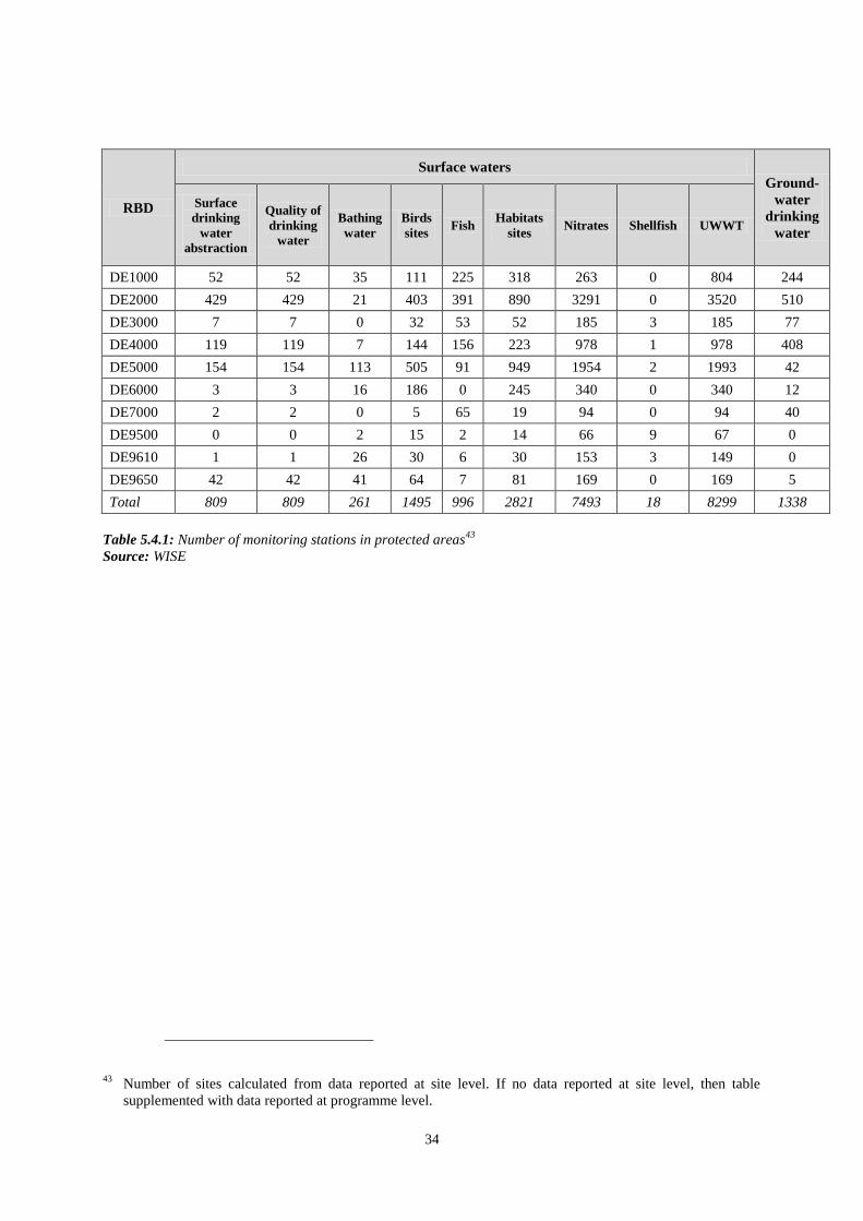
34
RBD
Surface waters Ground-
water
drinking
water
Surface
drinking
water
abstraction
Quality of
drinking
water
Bathing
water
Birds
sites Fish
Habitats
sites Nitrates Shellfish UWWT
DE1000 52 52 35 111 225 318 263 0 804 244
DE2000 429 429 21 403 391 890 3291 0 3520 510
DE3000 7 7 0 32 53 52 185 3 185 77
DE4000 119 119 7 144 156 223 978 1 978 408
DE5000 154 154 113 505 91 949 1954 2 1993 42
DE6000 3 3 16 186 0 245 340 0 340 12
DE7000 2 2 0 5 65 19 94 0 94 40
DE9500 0 0 2 15 2 14 66 9 67 0
DE9610 1 1 26 30 6 30 153 3 149 0
DE9650 42 42 41 64 7 81 169 0 169 5
Total 809 809 261 1495 996 2821 7493 18 8299 1338
Table 5.4.1: Number of monitoring stations in protected areas43
Source: WISE
43 Number of sites calculated from data reported at site level. If no data reported at site level, then table
supplemented with data reported at programme level.

35
6. OVERVIEW OF STATUS (ECOLOGICAL, CHEMICAL, GROUNDWATER)
The following information regarding the assessment of ecological status in Germany has been
reported.
RBD Total High Good Moderate Poor Bad Unknown
No. (%) No. (%) No. (%) No. (%) No. (%) No. (%)
DE1000 549 4 0.7 126 23.0 221 40.3 134 24.4 34 6.2 30 5.5
DE2000 1320 6 0.5 228 17.3 417 31.6 301 22.8 188 14.2 180 13.6
DE3000 95 0 0 11 11.6 19 20.0 32 33.7 31 32.6 2 2.1
DE4000 544 4 0.7 88 16.2 191 35.1 158 29.0 102 18.8 1 0.2
DE5000 1450 37 2.6 123 8.5 439 30.3 513 35.4 336 23.2 2 0.1
DE6000 230 5 2.2 15 6.5 70 30.4 88 38.3 52 22.6 0 0
DE7000 70 0 0 17 24.3 17 24.3 19 27.1 17 24.3 0 0
DE9500 27 0 0 0 0 12 44.4 9 33.3 5 18.5 1 3.7
DE9610 189 0 0 15 7.9 61 32.3 89 47.1 23 12.2 1 0.5
DE9650 258 20 7.8 33 12.8 90 34.9 100 38.8 14 5.4 1 0.4
Total 4732 76 1.6 656 13.9 1537 32.5 1443 30.5 802 16.9 218 4.6
Table 6.1: Ecological status of natural surface water bodies.
Source: WISE
RBD Total High Good Moderate Poor Bad Unknown
No. (%) No. (%) No. (%) No. (%) No. (%) No. (%)
DE1000 122 0 0 27 22.1 58 47.5 26 21.3 4 3.3 7 5.7
DE2000 959 0 0 77 8.0 214 22.3 275 28.7 335 34.9 58 6.0
DE3000 421 0 0 7 1.7 80 19.0 167 39.7 167 39.7 0 0
DE4000 870 0 0 18 2.1 204 23.4 324 37.2 317 36.4 7 0.8
DE5000 1688 0 0 93 5.5 561 33.2 672 39.8 359 21.3 3 0.2
DE6000 273 0 0 19 7.0 50 18.3 108 39.6 96 35.2 0 0
DE7000 158 0 0 9 5.7 24 15.2 43 27.2 81 51.3 1 0.6
DE9500 136 0 0 6 4.4 82 60.3 48 35.3 0 0 0 0
DE9610 161 0 0 0 0 94 58.4 67 41.6 0 0 0 0
DE9650 343 0 0 0 0 42 12.2 220 64.1 81 23.6 0 0
Total 5131 0 0 256 5.0 1409 27.5 1950 38.0 1440 28.1 76 1.5
Table 6.2: Ecological potential of artificial and heavily modified water bodies.
Source: WISE
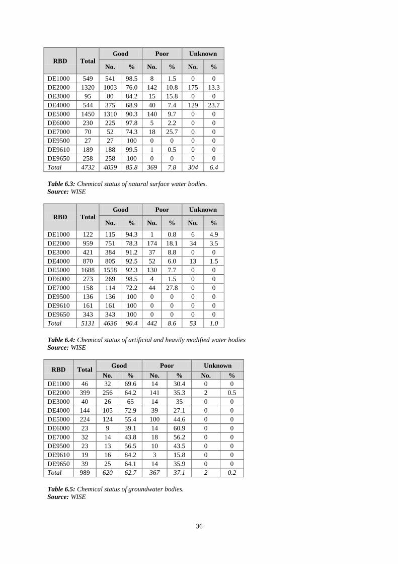
36
RBD Total Good Poor Unknown
No. % No. % No. %
DE1000 549 541 98.5 8 1.5 0 0
DE2000 1320 1003 76.0 142 10.8 175 13.3
DE3000 95 80 84.2 15 15.8 0 0
DE4000 544 375 68.9 40 7.4 129 23.7
DE5000 1450 1310 90.3 140 9.7 0 0
DE6000 230 225 97.8 5 2.2 0 0
DE7000 70 52 74.3 18 25.7 0 0
DE9500 27 27 100 0 0 0 0
DE9610 189 188 99.5 1 0.5 0 0
DE9650 258 258 100 0 0 0 0
Total 4732 4059 85.8 369 7.8 304 6.4
Table 6.3: Chemical status of natural surface water bodies.
Source: WISE
RBD Total Good Poor Unknown
No. % No. % No. %
DE1000 122 115 94.3 1 0.8 6 4.9
DE2000 959 751 78.3 174 18.1 34 3.5
DE3000 421 384 91.2 37 8.8 0 0
DE4000 870 805 92.5 52 6.0 13 1.5
DE5000 1688 1558 92.3 130 7.7 0 0
DE6000 273 269 98.5 4 1.5 0 0
DE7000 158 114 72.2 44 27.8 0 0
DE9500 136 136 100 0 0 0 0
DE9610 161 161 100 0 0 0 0
DE9650 343 343 100 0 0 0 0
Total 5131 4636 90.4 442 8.6 53 1.0
Table 6.4: Chemical status of artificial and heavily modified water bodies
Source: WISE
RBD Total Good Poor Unknown
No. % No. % No. %
DE1000 46 32 69.6 14 30.4 0 0
DE2000 399 256 64.2 141 35.3 2 0.5
DE3000 40 26 65 14 35 0 0
DE4000 144 105 72.9 39 27.1 0 0
DE5000 224 124 55.4 100 44.6 0 0
DE6000 23 9 39.1 14 60.9 0 0
DE7000 32 14 43.8 18 56.2 0 0
DE9500 23 13 56.5 10 43.5 0 0
DE9610 19 16 84.2 3 15.8 0 0
DE9650 39 25 64.1 14 35.9 0 0
Total 989 620 62.7 367 37.1 2 0.2
Table 6.5: Chemical status of groundwater bodies.
Source: WISE
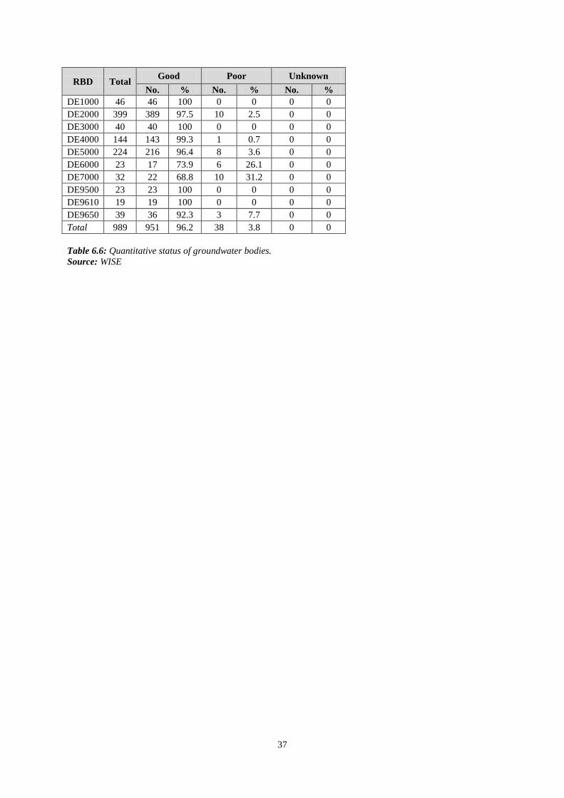
37
RBD Total Good Poor Unknown
No. % No. % No. %
DE1000 46 46 100 0 0 0 0
DE2000 399 389 97.5 10 2.5 0 0
DE3000 40 40 100 0 0 0 0
DE4000 144 143 99.3 1 0.7 0 0
DE5000 224 216 96.4 8 3.6 0 0
DE6000 23 17 73.9 6 26.1 0 0
DE7000 32 22 68.8 10 31.2 0 0
DE9500 23 23 100 0 0 0 0
DE9610 19 19 100 0 0 0 0
DE9650 39 36 92.3 3 7.7 0 0
Total 989 951 96.2 38 3.8 0 0
Table 6.6: Quantitative status of groundwater bodies.
Source: WISE

38
RBD Total
Global status (ecological and chemical) Good
ecological
status 2021
Good
chemical
status 2021
Good
ecological
status 2027
Good
chemical
status 2027
Global exemptions 2009 (% of
all SWBs)
Good or better
2009
Good or better
2015
Increase
2009 -
2015
Art
4.4
Art
4.5
Art
4.6
Art
4.7
No. % No. % % No. % No. % No. % No. % % % % %
DE1000 671 157 23.4 275 41 17.6 58 0 0 0
DE2000 2279 293 12.9 571 25.1 12.2 67 1 0 0
DE3000 516 18 3.5 22 4.3 0.8 95 0 0 0
DE4000 1414 88 6.2 134 9.5 3.3 87 4 0 0
DE5000 3138 242 7.7 453 14.4 6.7 86 0 0 0
DE6000 503 39 7.8 51 10.1 2.4 90 0 0 0
DE7000 228 23 10.1 25 11 0.9 87 3 0 0
DE9500 163 6 3.7 86 52.8 49.1 47 0 0 0
DE9610 350 15 4.3 123 35.1 30.9 65 0 0 0
DE9650 601 53 8.8 53 8.8 0 91 0 0 0
Total 9863 934 9.5 1793 18.2 8.7 79 1 0 0
Table 6.7: Surface water bodies: overview of status in 2009 and expected status in 2015, 2021 and 202744
Waterbodies with good status in 2009 fall into the following category:
1. Ecological status is high or good and the chemical status is good, exemptions are not considered
Waterbodies expected to achieve good status in 2015 fall into the following categories:
1. Ecological status is high or good and the chemical status is good, exemptions are not considered
2. Chemical status is good, and the ecological status is moderate or below but no ecological exemptions
3. Ecological status is high or good, and the chemical status is failing to achieve good but there are no chemical exemptions
4. Ecological status is moderate or below, and chemical status is failing to achieve good but there are no ecological nor chemical exemptions
Note: Waterbodies with unknown/unclassified/Not applicable in either ecological or chemical status are not considered
Source: WISE (for data on status in 2009, 2015 and exemptions) and RBMPs (for data on status in 2021 and 2027)
44 Data for 2009 and 2015 extracted from WISE. Data for 2021 and 2027 established during the compliance assessment of the RBMPs.
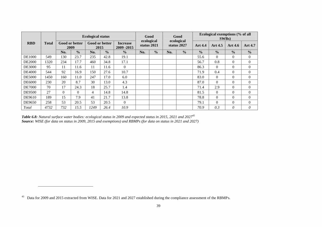
39
RBD Total
Ecological status Good
ecological
status 2021
Good
ecological
status 2027
Ecological exemptions (% of all
SWBs)
Good or better
2009
Good or better
2015
Increase
2009 -2015 Art 4.4 Art 4.5 Art 4.6 Art 4.7
No. % No. % % No. % No. % % % % %
DE1000 549 130 23.7 235 42.8 19.1 55.6 0 0 0
DE2000 1320 234 17.7 460 34.8 17.1 56.7 0.8 0 0
DE3000 95 11 11.6 11 11.6 0 86.3 0 0 0
DE4000 544 92 16.9 150 27.6 10.7 71.9 0.4 0 0
DE5000 1450 160 11.0 247 17.0 6.0 83.0 0 0 0
DE6000 230 20 8.7 30 13.0 4.3 87.0 0 0 0
DE7000 70 17 24.3 18 25.7 1.4 71.4 2.9 0 0
DE9500 27 0 0 4 14.8 14.8 81.5 0 0 0
DE9610 189 15 7.9 41 21.7 13.8 78.8 0 0 0
DE9650 258 53 20.5 53 20.5 0 79.1 0 0 0
Total 4732 732 15.5 1249 26.4 10.9 70.9 0.3 0 0
Table 6.8: Natural surface water bodies: ecological status in 2009 and expected status in 2015, 2021 and 202745
Source: WISE (for data on status in 2009, 2015 and exemptions) and RBMPs (for data on status in 2021 and 2027)
45 Data for 2009 and 2015 extracted from WISE. Data for 2021 and 2027 established during the compliance assessment of the RBMPs.

40
BD Total
Chemical status Good
chemical
status 2021
Good chemical
status 2027
Chemical exemptions (% of all
SWBs)
Good or better
2009
Good or better
2015
Increase
2009 -2015 Art 4.4 Art 4.5 Art 4.6 Art 4.7
No. % No. % % No. % No. % % % % %
DE1000 549 541 98.5 549 100 1.5 0 0 0 0
DE2000 1320 1003 76.0 1045 79.2 3.2 6.7 1.0 0 0
DE3000 95 80 84.2 84 88.4 4.2 11.6 0 0 0
DE4000 544 375 68.9 379 69.7 0.7 5.1 1.5 0 0
DE5000 1450 1310 90.3 1379 95.1 4.8 5.2 0 0 0
DE6000 230 225 97.8 225 97.8 0 2.2 0 0 0
DE7000 70 52 74.3 53 75.7 1.4 17.1 7.1 0 0
DE9500 27 27 100 27 100 0 0 0 0 0
DE9610 189 188 99.5 188 99.5 0 0.5 0 0 0
DE9650 258 258 100 258 100 0 0 0 0 0
Total 4732 4059 85.8 4187 88.5 2.7 4.7 0.5 0 0
Table 6.9: Natural surface water bodies: chemical status in 2009 and expected status in 2015, 2021 and 202746
Source: WISE (for data on status in 2009, 2015 and exemptions) and RBMPs (for data on status in 2021 and 2027)
46 Data for 2009 and 2015 extracted from WISE. Data for 2021 and 2027 established during the compliance assessment of the RBMPs.
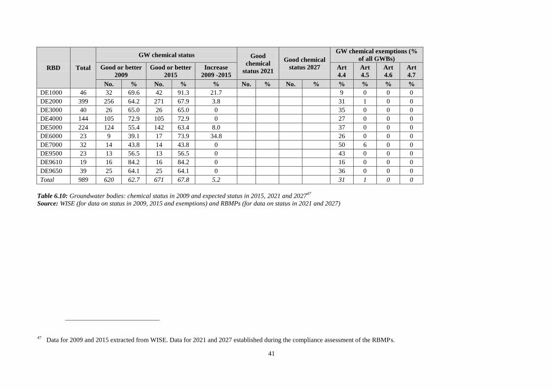
41
RBD Total
GW chemical status Good
chemical
status 2021
Good chemical
status 2027
GW chemical exemptions (%
of all GWBs)
Good or better
2009
Good or better
2015
Increase
2009 -2015
Art
4.4
Art
4.5
Art
4.6
Art
4.7
No. % No. % % No. % No. % % % % %
DE1000 46 32 69.6 42 91.3 21.7 9 0 0 0
DE2000 399 256 64.2 271 67.9 3.8 31 1 0 0
DE3000 40 26 65.0 26 65.0 0 35 0 0 0
DE4000 144 105 72.9 105 72.9 0 27 0 0 0
DE5000 224 124 55.4 142 63.4 8.0 37 0 0 0
DE6000 23 9 39.1 17 73.9 34.8 26 0 0 0
DE7000 32 14 43.8 14 43.8 0 50 6 0 0
DE9500 23 13 56.5 13 56.5 0 43 0 0 0
DE9610 19 16 84.2 16 84.2 0 16 0 0 0
DE9650 39 25 64.1 25 64.1 0 36 0 0 0
Total 989 620 62.7 671 67.8 5.2 31 1 0 0
Table 6.10: Groundwater bodies: chemical status in 2009 and expected status in 2015, 2021 and 202747
Source: WISE (for data on status in 2009, 2015 and exemptions) and RBMPs (for data on status in 2021 and 2027)
47 Data for 2009 and 2015 extracted from WISE. Data for 2021 and 2027 established during the compliance assessment of the RBMPs.

42
RBD Total
Groundwater quantitative status Good
quantitative
status 2021
Good
quantitative
status 2027
GW quantitative exemptions
(% of all GWBs)
Good or better
2009
Good or better
2015
Increase
2009 -2015
Art
4.4
Art
4.5
Art
4.6
Art
4.7
No. % No. % % No. % No. % % % % %
DE1000 46 46 100 46 100 0 0 0 0 0
DE2000 399 389 97.5 390 97.7 0.2 0 0 0 0
DE3000 40 40 100 40 100 0 0 0 0 0
DE4000 144 143 99.3 143 99.3 0 1 0 0 0
DE5000 224 216 96.4 216 96.4 0 2 1 0 0
DE6000 23 17 73.9 17 73.9 0 22 4 0 0
DE7000 32 22 68.8 22 68.8 0 0 31 0 0
DE9500 23 23 100 23 100 0 0 0 0 0
DE9610 19 19 100 19 100 0 0 0 0 0
DE9650 39 36 92.3 36 92.3 0 8 0 0 0
Total 989 951 96.2 952 96.3 0.1 2 2 0 0
Table 6.11: Groundwater bodies: quantitative status in 2009 and expected status in 2015, 2021 and 202748
Source: WISE (for data on status in 2009, 2015 and exemptions) and RBMPs (for data on status in 2021 and 2027)
48 Data for 2009 and 2015 extracted from WISE. Data for 2021 and 2027 established during the compliance assessment of the RBMPs.
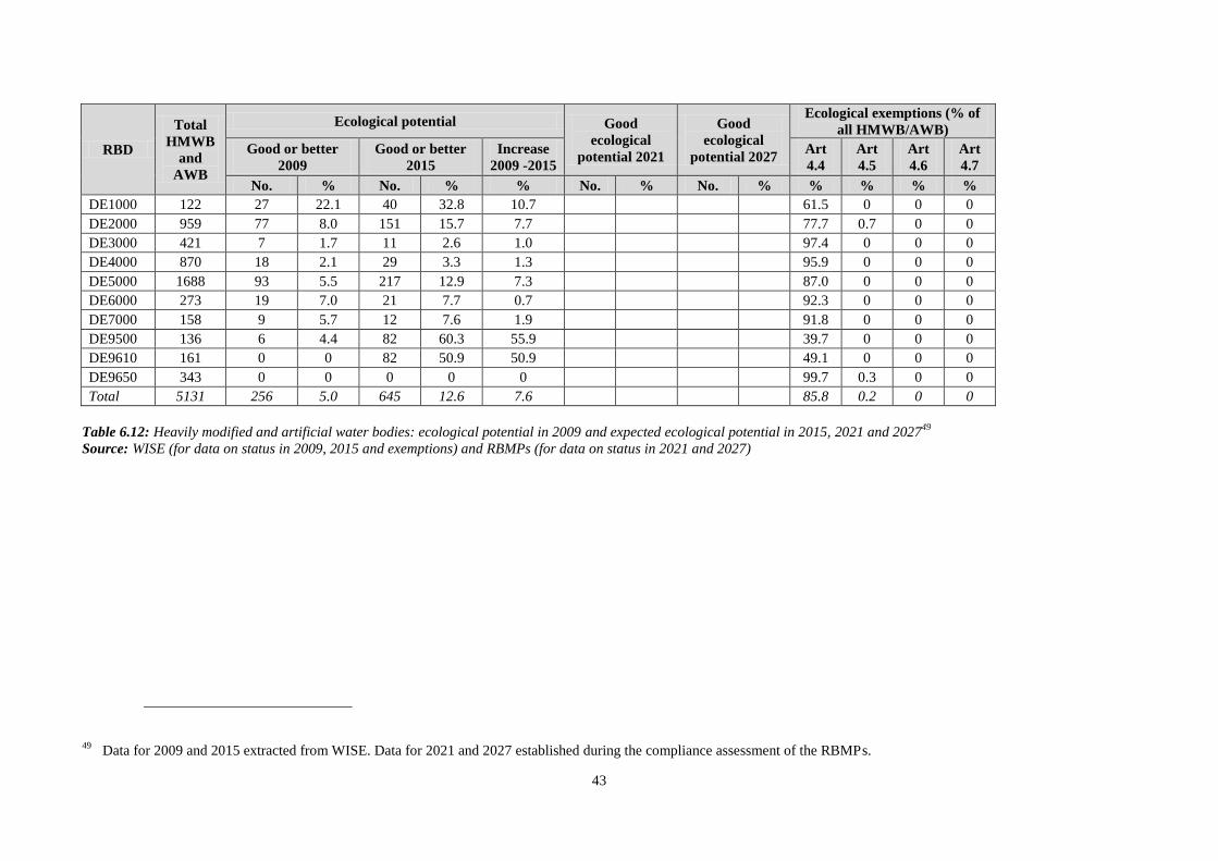
43
RBD
Total
HMWB
and
AWB
Ecological potential Good
ecological
potential 2021
Good
ecological
potential 2027
Ecological exemptions (% of
all HMWB/AWB)
Good or better
2009
Good or better
2015
Increase
2009 -2015
Art
4.4
Art
4.5
Art
4.6
Art
4.7
No. % No. % % No. % No. % % % % %
DE1000 122 27 22.1 40 32.8 10.7 61.5 0 0 0
DE2000 959 77 8.0 151 15.7 7.7 77.7 0.7 0 0
DE3000 421 7 1.7 11 2.6 1.0 97.4 0 0 0
DE4000 870 18 2.1 29 3.3 1.3 95.9 0 0 0
DE5000 1688 93 5.5 217 12.9 7.3 87.0 0 0 0
DE6000 273 19 7.0 21 7.7 0.7 92.3 0 0 0
DE7000 158 9 5.7 12 7.6 1.9 91.8 0 0 0
DE9500 136 6 4.4 82 60.3 55.9 39.7 0 0 0
DE9610 161 0 0 82 50.9 50.9 49.1 0 0 0
DE9650 343 0 0 0 0 0 99.7 0.3 0 0
Total 5131 256 5.0 645 12.6 7.6 85.8 0.2 0 0
Table 6.12: Heavily modified and artificial water bodies: ecological potential in 2009 and expected ecological potential in 2015, 2021 and 202749
Source: WISE (for data on status in 2009, 2015 and exemptions) and RBMPs (for data on status in 2021 and 2027)
49 Data for 2009 and 2015 extracted from WISE. Data for 2021 and 2027 established during the compliance assessment of the RBMPs.
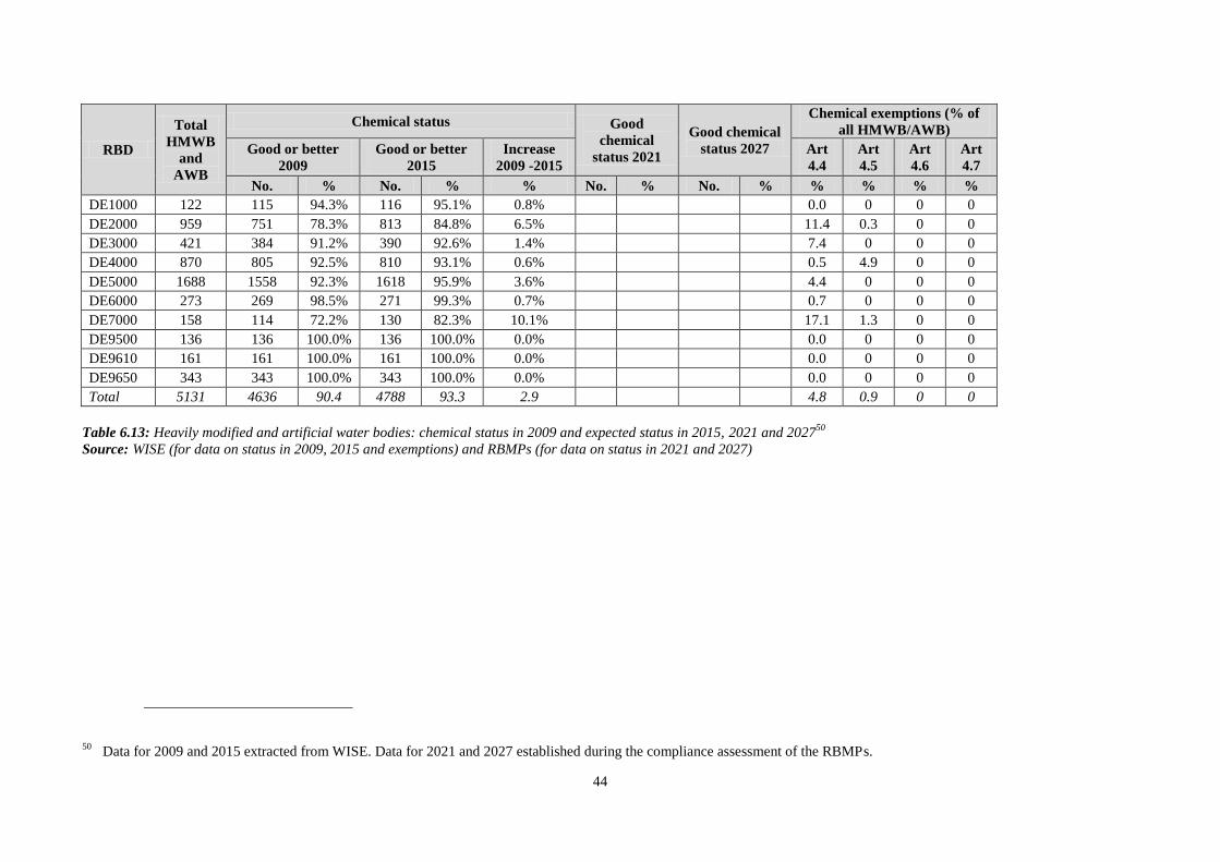
44
RBD
Total
HMWB
and
AWB
Chemical status Good
chemical
status 2021
Good chemical
status 2027
Chemical exemptions (% of
all HMWB/AWB)
Good or better
2009
Good or better
2015
Increase
2009 -2015
Art
4.4
Art
4.5
Art
4.6
Art
4.7
No. % No. % % No. % No. % % % % %
DE1000 122 115 94.3% 116 95.1% 0.8% 0.0 0 0 0
DE2000 959 751 78.3% 813 84.8% 6.5% 11.4 0.3 0 0
DE3000 421 384 91.2% 390 92.6% 1.4% 7.4 0 0 0
DE4000 870 805 92.5% 810 93.1% 0.6% 0.5 4.9 0 0
DE5000 1688 1558 92.3% 1618 95.9% 3.6% 4.4 0 0 0
DE6000 273 269 98.5% 271 99.3% 0.7% 0.7 0 0 0
DE7000 158 114 72.2% 130 82.3% 10.1% 17.1 1.3 0 0
DE9500 136 136 100.0% 136 100.0% 0.0% 0.0 0 0 0
DE9610 161 161 100.0% 161 100.0% 0.0% 0.0 0 0 0
DE9650 343 343 100.0% 343 100.0% 0.0% 0.0 0 0 0
Total 5131 4636 90.4 4788 93.3 2.9 4.8 0.9 0 0
Table 6.13: Heavily modified and artificial water bodies: chemical status in 2009 and expected status in 2015, 2021 and 202750
Source: WISE (for data on status in 2009, 2015 and exemptions) and RBMPs (for data on status in 2021 and 2027)
50 Data for 2009 and 2015 extracted from WISE. Data for 2021 and 2027 established during the compliance assessment of the RBMPs.

45
Figure 6.1: Map of ecological status of natural surface water bodies 2009
Figure 6.2: Map of ecological status of natural surface water bodies 2015
Note: Standard colours based on WFD Annex V, Article 1.4.2(i).
Source: WISE, Eurostat (country borders)
High
Good
Moderate
Poor
Bad
Unknown
River Basin Districts
Countries outside EU

46
Figure 6.3: Map of ecological potential of artificial and heavily modified water bodies 2009
Figure 6.4: Map of ecological potential of artificial and heavily modified water bodies 2015
Note: Standard colours based on WFD Annex V, Article 1.4.2(ii).
Source: WISE, Eurostat (country borders)
Good or better
Moderate
Poor
Bad
Unknown
River Basin Districts
Countries outside EU

47
Figure 6.5: Map of chemical status of natural surface water bodies 2009
Figure 6.6: Map of chemical status of natural surface water bodies 2015
Note: Standard colours based on WFD Annex V, Article 1.4.3.
Source: WISE, Eurostat (country borders)
Good
Failing to achieve good
Unknown
River Basin Districts
Countries outside EU
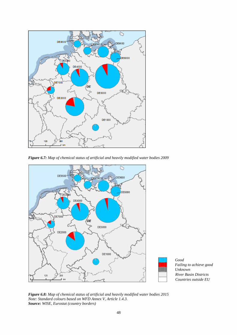
48
Figure 6.7: Map of chemical status of artificial and heavily modified water bodies 2009
Figure 6.8: Map of chemical status of artificial and heavily modified water bodies 2015
Note: Standard colours based on WFD Annex V, Article 1.4.3.
Source: WISE, Eurostat (country borders)
Good
Failing to achieve good
Unknown
River Basin Districts
Countries outside EU
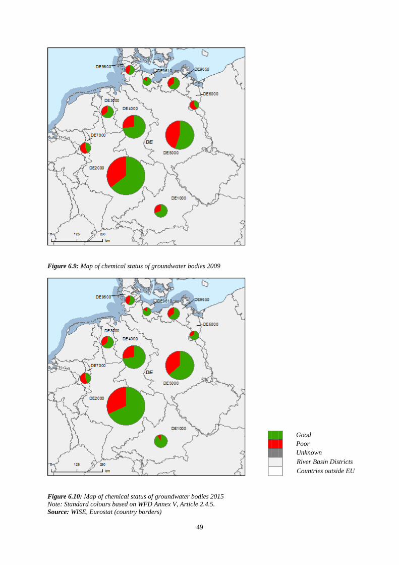
49
Figure 6.9: Map of chemical status of groundwater bodies 2009
Figure 6.10: Map of chemical status of groundwater bodies 2015
Note: Standard colours based on WFD Annex V, Article 2.4.5.
Source: WISE, Eurostat (country borders)
Good
Poor
Unknown
River Basin Districts
Countries outside EU

50
Figure 6.11: Map of quantitative status of groundwater bodies 2009
Figure 6.12: Map of quantitative status of groundwater bodies 2015
Note: Standard colours based on WFD Annex V, Article 2.2.4.
Source: WISE, Eurostat (country borders)
Good
Poor
Unknown
River Basin Districts
Countries outside EU

51
7. ASSESSMENT OF ECOLOGICAL STATUS OF SURFACE WATERS
In general, national methodological approaches for ecological status assessment follow the
LAWA guidelines (Bund Länderarbeitsgemeinschaft Wasser) for all RBDs and for all four
water categories (rivers, lakes, transitional and coastal waters) in Germany. These guidelines
are:
RAKON B - Arbeitspapier I, Entwurf 21-11-06;
RAKON B - Arbeitspapier II, Stand 07-03-2007;
RAKON B - Arbeitspapier III, Entwurf 22-11-2006.
There was noticeable improvement when the situation on ecological assessment methods
available for Germany in 2007 was compared to the assessment methods reported in all
available DE RBMPs. Ecological assessment methods that were lacking for all BQEs and for
all water categories in the RBDS Elbe, Weser, Ems and Odra in 2007 are now in place.
Analysis and assessment methodologies were further refined. As per the end of 2009, across
all water body categories and biological quality elements, a total of 12 out of 15 assessment
methods required under the WFD had been nationally agreed and were ready to use- as
pointed by the German authorities.
7.1 Ecological status assessment methods
EU WFD compliant assessment methods for ecological status in Germany are reported to be
fully developed in all RBDs for the water category rivers and for all biological
quality elements,
partly developed for the water category lakes in all RBDs as methods for BQEs
macroinvertebrates and fish are lacking;
partly developed for transitional waters in the relevant RBDs of Eider, Elbe,
Weser and Ems;
fully developed in coastal waters in the relevant RBDs of Eider, Elbe, Odra,
Weser, Ems, Schlei/Trave, Warnow/Peene.
Although assessment methods for ecological status are reported to be in place as outlined
above, for some water categories and biological quality elements they are still missing. These
are:
Lakes in all RBDs: BQEs macroinvertebartes and fish.
Transitional waters (RBDs Eider, Elbe, Weser and Ems): BQE phytoplankton.
For all RBDs it is reported in the plans that methods for the assessment on ecological status
regarding fish and macroinvertebrates are under development. Various RBMPs state that
some results still await the outcomes of the intercalibration exercises to ensure final
confidence and precision of methods. Details are provided in the following paragraphs. In

52
general, all RBMPs refer to the national RAKON method for ecological assessment and also
report them in specific national documents.
Also as outlined in Chapter 5 of this report (operational monitoring), the RBMPs report that
specific sensitive biological quality elements are used to assess ecological status in relation to
certain key pressures and impacts (eutrophication, organic enrichment, acidification,
hydromorphological alterations, specific chemical pollutant).
Standards have been developed for the general physico-chemical parameters (QE 3-1),
which are assessed in support of the biological quality elements. A guidance document, issued
by the Bund/Länderarbeitsgemeinschaft Wasser (LAWA) describes the approach that has
been implemented (RAKON B - Arbeitspapier II, Stand 07-03-2007). This guidance
differentiates ‘background’ values which distinguishes high from good status. ‘Orientation’
values indicate boundaries between good and moderate as well as worse status.
The German methodological approach to deal with the supporting role of general physico-
chemical parameters could be considered reasonable and in line with the meaning and the
wording of the legal pieces51
.
Hydromorphological classification was undertaken in Germany to identify the significance of
pressures for the water categories. However, specific standards or methods regarding
hydromorphological quality elements for ecological status assessment are not reported in the
RBMPs for all RBDs and all “Länder”. In addition, no class boundaries for hydromorphology
are yet reported to support biological elements in ecological status assessment. All of this is
valid for rivers, lakes, transitional and coastal waters.
Specifically, for the water category of rivers all German RBMPs report that
hydromorphological assessments support the BQEs in overall ecological status assessment but
respective methods have not been reported52
. In case a BQE is close to a class boundary,
information for supporting elements is used to upgrade or downgrade the assessment class. It
is outlined that a comprehensive method to determine and assess hydromorphological quality
elements in rivers is not yet in place. A respective development will be undertaken in the
second WFD implementation cycle. For lakes, no detailed methods on hydromorphological
assessments are reported in the RBMPs for all the DE RBDs, neither for hydrological regime
nor morphological condition. Transitional waters are relevant for the RBDs of Elbe, Ems,
Weser and Eider. Although, it has been reported for all of these RBDs that hydromorphology
supports the assessment on ecological status, the specific method has not been reported.
Coastal waters are relevant for the RBDs of Elbe, Ems, Weser, Odra and Eider and in the
RBMPs no specific method is reported on how hydromorphology supports the assessment on
ecological status. For the RBDs of Ems, Weser, Elbe, Odra and Eider the hydromorphological
quality element ‘tidal regime’ is mentioned in the context that the element needs ‘yet to be
measured’. No further specification is given.
51 The assessment of general physico-chemical parameters cannot overrule the biological quality elements but
require joint interpretation. If there are contradictory results from the assessment of biological and physico-
chemical QEs, the latter may only lead to a different classification if the BQEs are affected with high
uncertainties.
52 German authorities have informed after the RBMPs reporting that an overview about these relationships is
given in the UBA research report “Further development of biological investigation procedures for consistent
implementation of the EU Water Framework Directive” and will be published in the series „UBA-Texte“.
53
Ecological Quality Standards have been set and applied for other specific pollutants (QE 3-
3) and other national pollutants (QE 3-4) at the time of developing the RBMPs. This process
was undertaken separately on the German “Länder” level but overall coordination at the
federal level was done initially through the LAWA (2003-2006). For the selection of relevant
pollutants a common list of substances was the starting point. The selection of relevant
substances from this initial list was done at the “Länder” level and justified with regionally
different pressure and in-stream situations. The selection was done based on data sources such
as monitoring results, screening exercises, modelling and emission data, depending on
availability of information. As a common rule, it was established that a substance is
considered relevant if the concentration in past monitoring exercises exceeded 50% of the
environmental quality standard. This is a technically sound approach to deal with the term
‘discharged in significant quantities’ from the WFD.
Ordinances on substance selection and EQS have been developed at the “Länder” level and
the RBMPs of BY, MV, SH, RP also refer to these ordinances. Further references are made to
the RAKON and LAWA guidances (without further details). In 2010, however, a draft
ordinance for the German federal level was developed53
that integrates and complements the
“Länder” specific ordinances. This initiative shall lead to a harmonisation of the lists of
relevant pollutants and the corresponding EQS. EQS are based on EU chemicals assessment
and according to Annex V, 1.2.6 WFD. From valid long-term toxicity tests at different species
levels the most sensitive value is selected for further processing. Many EQS are set for
suspended matter/sediments due to analytical difficulties with very low concentration levels in
the whole water sample.
The assessment of the ecological status for water bodies in relation to the different biological
quality elements is clearly based on the ‘one-out-all-out’ principle for all water categories
and RBDs in Germany.
Concerning confidence, precision and uncertainties for biological assessments, in all
German RBMPs reference is made to the RAKON III guidance paper, which exhibits a short
section on quality assurance of biological data. This chapter only provides very general advice
on how a quality assurance could be introduced, how it should look like and what should be
included but it does not provide concrete advice, data or procedures. RBMPs of BY, NRW
and others clearly state that the BQE methods are newly developed and not much experience
exist to address the issue of uncertainty and its different sources. Although only some RBMPs
state this fact of uncertainty explicitly, it applies to all RBDs. Longer time series or more
assessments over the years and improved reference values are said to be the major factors to
reduce uncertainty. However, different levels are differentiated in the Rhine, Danube and Elbe
RBMPs and these levels are linked to the application of standardised methods. Level 1) low:
the assessment is carried out by experts, 2) medium: LAWA and WFD compliant assessment
methods have been used but not all assessment results for all QEs are ready, 3) high: The
assessment has been fully performed with LAWA and WFD compliant assessment methods.
For temporal and spatial variability - as a general remark – the need to increase sampling
number is mentioned, but no systematic approach is outlined. Temporal variability is said to
be specifically an issue for Phytoplankton. The RAKON guidance paper on EQS for general
physico-chemical parameters mentions the role of these parameters in case of highly variable
53 Oberflächengewässerverordnung OGewV

54
BQE assessment results. Another aspect in the context of confidence/precision/uncertainty
concerns the validity of grouping of water bodies. The NRW regional guidance document
(Leitfaden Oberflächengewässer Teil B (2008)) proposes in this concern to validate the
grouping approach. It is proposed to move the sampling site that is considered to be
representative for the whole group of water bodies, from one water body to the next and to
evaluate the differences found.
Regarding type specific ecological assessment for all water categories, the available
German RBMPs report that ecological assessment methods address all types identified for
rivers in the German RBDs and class boundaries are reported except for the Eider RBD. Lake
types are addressed with ecological assessment and class boundaries are in place for most
cases except for the Eider, Ems and Weser RBDs. For transitional and coastal waters the
picture in how far different types are addressed with ecological assessment in the RBDs is not
reported in full transparency as part of the respective RBMPs. Gaps can be identified but are
not reported in specific in the RBMPs.
Comparing intercalibration class boundaries of the national German classification guidance
(RAKON documents) with the boundaries of the EC Intercalibration Decision54
certain issues
remain open and are listed in the paragraph below. For rivers in the RBDs Danube, Rhine,
Ems, Weser, Elbe, Odra, Meuse, Eider, Schlei/Trave, and Warnow/Peene class boundaries
given for macroinvertebrates are aligned with those in the EC Intercalibration Decision
(2008/915/EC).
The boundaries given for other aquatic flora indicate different sets of boundaries for same
type and same metric. Only a few values are aligned to the boundaries of the EC
Intercalibration Decision (2008/915/EC). However, the RBMPs refer to this inconsistency and
report respectively for inconsistent boundaries that intercalibration is not yet completed. No
further details are reported.
For lakes and the BQE phytoplankton in the RBDs Danube, Rhine, Ems, Weser, Elbe, Eider,
Schlei/Trave, and Warnow/Peene class boundaries are consistent or even more stringent (0.8
for HG and 0.6 for GM) than boundaries in the official IC decision given for Chlorophyll-a
(0.55 for HG and 0.32 for GM). The boundaries for other aquatic flora (macrophytes) are
consistent with or slightly more stringent than those given for lake macrophytes in the EC
Intercalibration Decision(2008/915/EC). Class boundaries reported for Chlorophyll-a in lakes
of the Odra RBD are fully matching with the values of the EC Intercalibration Decision
(2008/915/EC). No information on class boundaries for the reported lake in the Meuse RBD
(also see Chapter 4 of this Annex) is reported.
For coastal waters of the Odra, Schlei/Trave and Warnow/Peene RBDs the reported class
boundaries for both angiosperms and phytoplankton match the values of the EC
Intercalibration Decision (2008/915/EC). For the RBDs Ems and Weser the reported class
boundaries are partly aligned to the values of the EC Intercalibration Decision. For the Eider
RBD the values are consistent. However, for angiosperms two sets of boundaries are reported
for the same national type and only one of them has the consistent boundaries (0.9 for HG and
54 2008/915/EC: Commission Decision of 30 October 2008 establishing, pursuant to Directive 2000/60/EC of
the European Parliament and of the Council, the values of the Member State monitoring system
classifications as a result of the intercalibration exercise (notified under document number C(2008) 6016).

55
0.7 for GM), whereas the other set has less stringent boundaries (0.8 for HG and 0.6 for GM)
than the ones of the EC Intercalibration Decision.
Some open issues remain when it comes to the translation of intercalibration results to the
national German surface water types. This is in particular the case for rivers, lakes and
coastal waters in the RBDs of the Ems, Weser, Odra, Meuse and Eider. However, referring to
the above paragraphs, class boundary values regarding macroinvertebrates for rivers are
aligned with the values of the EC Intercalibration Decision for all RBDs. For lakes the
intercalibration results are fully translated to national types in the Elbe, Schlei/Trave and
Warnow/Peene RBDs and partly for the Danube RBD. Regarding coastal waters full
translation of IC values to national types is given in the RBDs of Schlei/Trave and
Warnow/Peene and partly in the Elbe RBD.

56
RBD
Rivers Lakes Transitional Coastal
Ph
yto
pla
nk
ton
Ma
cro
ph
yte
s
Ph
yto
ben
tho
s
Ben
thic
in
ver
teb
rate
s
Fis
h
Ph
ysi
co-C
hem
ica
l
Hy
dro
mo
rph
olo
gic
al
Ph
yto
pla
nk
ton
Ma
cro
ph
yte
s
Ph
yto
ben
tho
s
Ben
thic
in
ver
teb
rate
s
Fis
h
Ph
ysi
co-C
hem
ica
l
Hy
dro
mo
rph
olo
gic
al
Ph
yto
pla
nk
ton
Ma
cro
alg
ae
An
gio
sper
ms
Ben
thic
in
ver
teb
rate
s
Fis
h
Ph
ysi
co-C
hem
ica
l
Hy
dro
mo
rph
olo
gic
al
Ph
yto
pla
nk
ton
Ma
cro
alg
ae
An
gio
sper
ms
Ben
thic
in
ver
teb
rate
s
Ph
ysi
co-C
hem
ica
l
Hy
dro
mo
rph
olo
gic
al
DE1000 - - - - - - - - - - - - -
DE2000 - - - - - - - - - - - - -
DE3000
DE4000
DE5000
DE6000 - - - - - - -
DE7000 - - - - - - - - - - - - -
DE9500
DE9610 - - - - - - -
DE9650 - - - - - - -
Table 7.1.1: Availability of biological assessment methods
Assessment methods fully developed for all BQEs
Assessment methods partially developed or under development for all or some BQEs
Assessment methods not developed for BQEs, no information provided on the assessment methods, unclear
information provided
- Water category not relevant Source: RBMPs
57
7.2 Application of methods and ecological status results
The German RAKON guidance states clearly that all quality elements need to be monitored at
surveillance sites. There is evidence about coverage of biological quality elements at
surveillance sites. All biological quality elements have been reported for 210 surveillance
sites at rivers, for 49 surveillance sites at lakes, 19 surveillance sites in coastal waters and 1
surveillance site in a transitional water body. Based on these numbers, a number of
surveillance sites are not addressed and not all biological quality elements have been assessed.
Justifications are reported that a BQE was not included in the monitoring programme if no
meaningful result could be expected. For instance, this is the case for the BQE fish in rivers
with extremely high slopes or in high mountainous altitude where the natural species
composition is too poor for an assessment. Also the BQE phytoplakton in the plankton phase-
out zone of transitional waters may result in implausible classifications. Further explanations
for missing results of biological assessments were not found in the available RBMPs and
sources.
All general physico-chemical parameters were assessed for all surveillance sites across the
entire national territory. The same is true for other specific pollutants, which were measured
at all 287 rivers, 36 lakes, 32 coastal and 5 transitional German surveillance sites. For
hydromorphology the situation is very heterogenous and remains unclear for the different
parameters and regional aspects. After the German RBMPs were officially reported, the
German authorities indicated that a harmonised assessment method (“Strukturkartierung”)
was used and that the assessment of hydromorphology at surveillance sites was made by
integrating elements of a distinct water stretch. The authorities concluded that an assessment
at the site itself does not give useful results. This approach may result in slightly different site
selections and hydromorphological parameters may therefore not be present for the exact
location of a surveillance site, but still be transferable and valid for this site.
In general the most sensitive biological quality elements have been selected to detect key
pressures and impacts and this is therefore reflected in the design of operational monitoring
networks. Different understanding can be analysed concerning the decision, which BQE is
most sensitive to a certain pressure/impact. For rivers of all RBDs Danube, Weser, Elbe,
Meuse, Eider, Schlei/Trave, and Warnow/Peene the operational monitoring clearly uses the
most sensitive BQE for ecological status assessment regarding specific pressures/impacts. The
operational monitoring of the Odra RBD applies all BQEs for status assessment. Furthermore,
it appears that for rivers in the Rhine, Ems and Weser RBDs that all BQEs are monitored for
ecological status assessment.
Operational monitoring for lakes, transitional and coastal waters in the RBDs of Danube,
Weser, Elbe, Meuse, Eider, Schlei/Trave, and Warnow/Peene uses the most sensitive BQE to
investigate on specific pressures and impacts. Again for the Odra RBD, all BQEs are used for
pressure related assessment of ecological status in the lakes and for coastal waters only the
BQE of macroinvertebrates is applied plus an undefined supportive general quality element.
For the Rhine RBD the most sensitive BQE is used for status assessment in lakes but it is not
reported which ones. For the RBDs Ems and Weser it is reported that for lakes all BQEs
except some elements like ‘other species’ and fish are included. Supporting quality elements
are part of operational monitoring except elements like hydromorphology and other national
pollutants. For the mentioned RBD’s transitional waters, the BQEs phytoplankton, priority
58
substances, non-priority specific pollutants, and other national pollutants55
are not addressed
but all other BQEs and supporting QE are monitored. For related coastal waters all BQEs
except elements like other species and hydromorphological quality elements are monitored.
When it comes to confidence, precision and uncertainty of monitoring results information is
limited. It is reported for all RBDs and water categories that certain methods are applied
without indicating in detail which ones. One indicated reason for many RBDs is that
assessment methods have only recently been developed. Uncertainties in assessment relate to
seasonal and inter-annual variability and sampling in certain times of the year increases the
confidence (benthic and macrophytes, fish). Also several years of sampling will likely reduce
uncertainty.
Improvement on the situation of uncertainties is reported to be planned in all RBMPs for all
German RBDs. This includes the need to fill gaps in relation to missing reference sites and
incomplete databases through the further development of assessment procedures/methods, the
finalisation of the incomplete intercalibration processes and the increase data exchange.
7.3 River basin specific pollutants
RBD CAS Number Substance Percentage Water Bodies
Failing Status (%)
DE1000 Bentazon
DE1000 Chloridazon
DE1000 Copper Surface Water Body in
Bavaria (Illerkanal)
DE1000 Dibutylzinn 1 Surface Water Body in
Bavaria (Lech)
DE1000 Dichlorprob
DE1000 MCPA
DE1000 MCPA BW: 1 WB (Stehebach)
DE1000 Mecoprob
DE1000 Metolachlor
DE2000 Bentazon Bavaria - 'some' agricultural
areas
DE2000
Bentazon, Chloridazon,
linuron, Dimethoat,
Dichlorprop, MCPa,
Mecoprop, Parathionethyl
R-P RBMP, 61 WBs faling
GES due to these substances
- no dissagregation
DE2000 Heavy metals (Arsen,
Chrome, Copper, Zinc)
Hessen RBMP, approx. 9
WBs
DE2000 MCPA BW, Neckar, 2 WBs
DE2000 Mecoprop (MCPP) BW, Neckar, 2 WBs
DE2000
Mecoprop, MCPA,
Dichlorprop, Chloridazon,
Bentazon
BW, Alpenrhine-Bodensee,
agricultural areas; in 2 WBs
GES is 'at risk', but not
failing GES
DE2000 Non-priority heavy metals
NRW RBMP, 19,8% of the
NRW Federal State area
facing a 'signficant pressure'
from these substances
DE2000 Non-priority PSMs
NRW RBMP, 3% of the
NRW Federal State WBs
failing the EQS
55 Different indications are reported on non-specific pollutants regarding monitoring.

59
RBD CAS Number Substance Percentage Water Bodies
Failing Status (%)
DE2000 Parathion-Ethyl BW, Neckar, 1 WB
DE2000 PCB Hessen RBMP, 11 WBs
DE2000 PCB 153 R-P RBMP, no number of
WBs
DE2000 polychloriertes Biphenylen
(PCB) 138
R-P RBMP, no number of
WBs
DE2000 PSM (pesticides) Hessen RBMP, approx. 51
WBs
DE2000 PSM (pesticides) overall
BW, Main: 2 WBs,
Oberrhein: 4 WBs failing
GES
DE2000 Pyrazon (Chloridazon) BW, Neckar, 1 WB
DE2000 Zinc R-P RBMP, 3 SWBs
DE3000 Arsenic 4,1% of surface water
bodies
DE3000 Copper
DE3000 Nitrogen
DE3000 PCB 52
DE3000 Phosphorus
DE3000 Zinc
DE4000 Chloride Werra and Weser
DE4000 Kalium Werra and Weser
DE4000 Magnesium Werra and Weser
DE5000
DE6000
DE7000 Arsenic
DE7000 Chrome 0,1% of surface water
bodies
DE7000 Copper
DE7000 Dichlorvos
DE7000 Fenthion
DE7000 Hexazinon
DE7000 MCPA
DE7000 Mecoprop
DE7000 Nitrogen
DE7000 PCB 52
DE7000 Phosphorsäuretributylester
DE7000 Phosphorus
DE7000 Zinc
DE9500 Nitrogen
DE9500 Phosphorus
DE9610 Bentazon 7 WB
DE9610 Malathion 1 WB
DE9610 Mecoprop 1 WB
DE9610 Nitrogen
DE9610 Phosphorus
DE9650 Nitrogen
DE9650 Phosphorus
Table 7.3.1: River basin specific pollutants causing failure of status
Source: RBMPs

60
8. DESIGNATION OF HEAVILY MODIFIED WATER BODIES (HMWB) AND
ASSESSMENT OF GOOD ECOLOGICAL POTENTIAL
Figure 8.1: Map of percentage Heavily Modified and Artificial waterbodies by River Basin District
0 – 5 %
5 – 20 %
20 – 40 %
40 – 60%
60 – 100 %
No data reported
River Basin Districts
Countries outside EU
Source: WISE, Eurostat (country borders)
In Germany, the designation of the number of rivers as heavily modified ranges greatly
among the RBDs: the Danube designated 11.59% of its rivers as HMWBs, whereas 62.56% of
the river water bodies in the Meuse were designated as HMWB. The German wide average is
38.92%. For lakes the values range between 0% in the RBDs of the Odra, Meuse, Eider,
Schlei/Trave and 50% in the Ems. The German average is 12.92%. Transitional water bodies
are 100% HMWB and coastal water bodies (German average) to the extent of 6.76%.
In the case of AWB, designation ranges between 5.31% (Danube) and 36.64% (Odra) of the
river water bodies; values for each RBD are presented in the figure below The German wide
average is 15.29%. For lakes the values range between 0% in the RBDs of the
Warrnow/Peene, Schlei/Trave and 100% in the Meuse. The German average is 15.59%.
8.1 Designation of HMWBs
The main water uses that have led to the designation are navigation, recreation, water supply,
power generation, irrigation, water regulation, flood protection, land drainage and other
human activities such as urban settlements and conservation of ancient monuments.

61
To enable the water uses mentioned above, different types of physical modifications to water
bodies are needed, such as dams, weirs, polders, channelization, etc. The link between these
physical modifications and a water body being designated as a HMWB or AWD was only
reported in the Odra, the Warnow/Peenne, the Danube and the Weser. All basins mention
weirs as leading to a water body being designated as a HMWB or AWD. The Warnow/Peenne
RBMP also mentions channelization, bank reinforcement and land reclamation. The Weser
RBMP mentions that agricultural land (including drainage) use has led to morphological
changes in waters.
The overall designation process of HMWB water bodies followed the CIS Guidance nº4,
either completely (Odra, Meuse, Eider, Schlei/Trave, Ems, Weser) or some but not all steps
were carried out (Warnow/Peene, Danube, Elbe). For the Rhine the “Länder” also followed
the CIS Guidance nº4 but not all “Länder” performed all steps as laid out in the guidance. The
RBMPs did not report which uncertainties were considered in the designation process. A
specific guidance document for Germany was developed “LAWA-ArbeitshilfezurUmsetzung
der EG-Wasserrahmenrichtlinie (2003)” which is mentioned in WISE and some of the plans
but has not been officially reported.
8.2 Methodology for setting good ecological potential (GEP)
All German river basins have defined GEP. When doing so to both approaches (the reference-
based approach (according to the CIS Guidance), and the mitigation measures approach
(Prague approach)) can be found. The reference-based approach was reported for the Eider,
Schlei/Trave and the Danube. The Prague approach has been reported for Odra, Meuse,
Warnow/Peene, Ems, Weser and Elbe. In the Rhine both approaches have been used,
depending on the “Länder” involved. In the case of NRW both approaches are described but
the Prague approach was applied. In BW and TH the RBMPs clearly state that the Prague
approach was used. For HE it is not fully clear which approach has been followed but it is
most likely the Prague approach. There is a statement that the GEP is defined as 70% of all
measures that would be needed to achieve the Maximum Ecological Potential. No further
details are provided. While the RP RBMP for the Rhine defines GEP, it does not report any
information regarding the approach taken. The SL RBMP for the Rhine refers to a specific
methodological handbook (Annex VI) for the methodology for HMWB designation. This
handbook has not been submitted and found on the web. Therefore, in SL it remains unclear
which approach has been used. In BY there is no clear mention of the CIS approach but the
approach described refers to the fact that the GEP is based on the ‘reference-based approach’
(or ‘CIS approach’). In other words, the GEP was assessed based on the definition and
assessment of GES. In BY an additional check was performed if a use leads to a change in
typology (e.g. from a river to a lake due to a dam). In cases where there is no change in
typology a change in the 'class' was performed.
9. ASSESSMENT OF CHEMICAL STATUS OF SURFACE WATERS
9.1 Methodological approach to the assessment
In all German RBDs the chemical status has been assessed against EQS. Almost all priority
substances have been measured and assessed. Exemptions concern missing analytical tools
e.g. Brominated diphenylether in BY, C1-13 chloroalkanes in BW and BY, Tributyltin
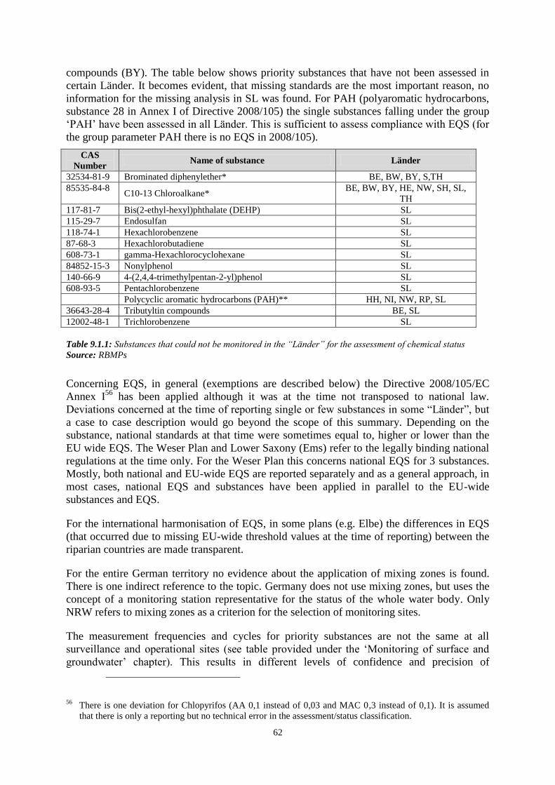
62
compounds (BY). The table below shows priority substances that have not been assessed in
certain Länder. It becomes evident, that missing standards are the most important reason, no
information for the missing analysis in SL was found. For PAH (polyaromatic hydrocarbons,
substance 28 in Annex I of Directive 2008/105) the single substances falling under the group
‘PAH’ have been assessed in all Länder. This is sufficient to assess compliance with EQS (for
the group parameter PAH there is no EQS in 2008/105).
CAS
Number Name of substance Länder
32534-81-9 Brominated diphenylether* BE, BW, BY, S,TH
85535-84-8 C10-13 Chloroalkane*
BE, BW, BY, HE, NW, SH, SL,
TH
117-81-7 Bis(2-ethyl-hexyl)phthalate (DEHP) SL
115-29-7 Endosulfan SL
118-74-1 Hexachlorobenzene SL
87-68-3 Hexachlorobutadiene SL
608-73-1 gamma-Hexachlorocyclohexane SL
84852-15-3 Nonylphenol SL
140-66-9 4-(2,4,4-trimethylpentan-2-yl)phenol SL
608-93-5 Pentachlorobenzene SL
Polycyclic aromatic hydrocarbons (PAH)** HH, NI, NW, RP, SL
36643-28-4 Tributyltin compounds BE, SL
12002-48-1 Trichlorobenzene SL
Table 9.1.1: Substances that could not be monitored in the “Länder” for the assessment of chemical status
Source: RBMPs
Concerning EQS, in general (exemptions are described below) the Directive 2008/105/EC
Annex I56
has been applied although it was at the time not transposed to national law.
Deviations concerned at the time of reporting single or few substances in some “Länder”, but
a case to case description would go beyond the scope of this summary. Depending on the
substance, national standards at that time were sometimes equal to, higher or lower than the
EU wide EQS. The Weser Plan and Lower Saxony (Ems) refer to the legally binding national
regulations at the time only. For the Weser Plan this concerns national EQS for 3 substances.
Mostly, both national and EU-wide EQS are reported separately and as a general approach, in
most cases, national EQS and substances have been applied in parallel to the EU-wide
substances and EQS.
For the international harmonisation of EQS, in some plans (e.g. Elbe) the differences in EQS
(that occurred due to missing EU-wide threshold values at the time of reporting) between the
riparian countries are made transparent.
For the entire German territory no evidence about the application of mixing zones is found.
There is one indirect reference to the topic. Germany does not use mixing zones, but uses the
concept of a monitoring station representative for the status of the whole water body. Only
NRW refers to mixing zones as a criterion for the selection of monitoring sites.
The measurement frequencies and cycles for priority substances are not the same at all
surveillance and operational sites (see table provided under the ‘Monitoring of surface and
groundwater’ chapter). This results in different levels of confidence and precision of
56 There is one deviation for Chlopyrifos (AA 0,1 instead of 0,03 and MAC 0,3 instead of 0,1). It is assumed
that there is only a reporting but no technical error in the assessment/status classification.
63
calculated annual average values and also of detected maxima. No information was found in
the existing reporting whether and how different levels of confidence and precision have been
taken into account in assessing the compliance with EQS.
In compliance with Annex I Part B of the Directive 2008/105/EC, the assessment of chemical
quality concerned the (filtered/whole) water sample. Assessment of hexachlorobenzene,
hexachlorobutadiene and mercury for biota has not been reported in SL because of missing
analytical tools/methods. For the same reason no assessments of priority substances in
sediment have been reported in all RBDs. These assessments will be introduced as soon as the
methods are available.
Bioavailability (according to Annex I Part B Point 3.b) has been mentioned for Cadmium in
combination with water hardness in some RBDs. Whether the approach is applied across all
RBDs/ “Länder” in a harmonised manner remains unclear.
Background concentrations have not been considered in the assessment (due to missing
guidance on the setting of background levels). NRW addresses the future plans in this concern
by starting to plan the introduction of background concentrations as soon as there are common
standards.
Substances causing exceedances, affected water body (types).
A total of 811 water bodies (8%) of 9860 total number of water bodies in Germany fail to
achieve good chemical status. Another 350 or 3.5% of the water bodies (mainly 300 natural
river water bodies) are categorised as unknown/no information.
The following table57
splits this total number according to RBD and aggregated substance
groups (heavy metals, pesticides, industrial and other pollutants). Single substances cannot be
assessed based on the available sources due to different structures of the RBMPs and
reporting formats (% of river length, numbers of WBs). Other pollutants and heavy metals
(mainly Pb-, Cd- and compounds) substance groups caused the major part of the failures to
achieve good chemical status, followed by pesticides.
57 Double counting is possible in the table if a water body fails good chemical status due to more than one
substance group.

64
RBD
Heavy metals -
aggregated
Pesticides -
aggregated
Industrial
pollutants -
aggregated
Other pollutants -
aggregated
No. % No. % No. % No. %
DE1000 2 0.3 6 0.89 1 0.45
DE2000 103 4.52 106 4.65 14 0.61 125 5.48
DE3000 14 2.71 8 1.55 22 4.26
DE4000 52 3.68 24 1.7 14 0.99
DE5000 37 1.18 4 0.13 13 0.41 107 3.41
DE6000 2 0.4 5 0.99
DE7000 18 7.89 23 10.09 4 1.75 4 1.75
DE9500
DE9610 1 0.29
DE9650
Total 228 2.51 172 1.89 31 0.34 278 3.06
Table 9.1.2: Number and percentage of water bodies that fail to achieve good chemical status, differentiated
according to RBDs
Source: WISE
10. ASSESSMENT OF GROUNDWATER STATUS
At the time when the RBMPs were established, the Groundwater Directive (GWD) was not
yet implemented into German legislation - as it is now - and the assessment was based on the
requirements of the WFD and a guidance document about the technical implementation of the
GWD; which was developed by the LAWA and is in compliance with the Water Framework
Directive and the Groundwater Directive.
For Germany as a whole, for 2009 about 62 % (609) of the 989 groundwater bodies (GWBs)
(representing 63% in terms of area) were reported to be both of good chemical and
quantitative status which is expected to increase by 5% in 2015 (in terms of number of
groundwater bodies and area). At the level of RBDs, the percentage of GWBs of good status
in 2009 ranges between 26–84% (28–86% in terms of area) and is about to increase to 38–
91% (28–96% in terms of area) in 2015. An improvement of good status between 2009 and
2015 was only reported to be expected in 4 of 10 RBDs (RBD Danube, Rhine, Elbe and
Oder).
As the sizes of German groundwater bodies cover a broad range from 0.014 km² up to 5,577
km², the percentage of groundwater bodies of good status can considerably deviate from the
percentage of represented area, e.g. in the RBD Oder about 26% of the groundwater bodies
are of good status in 2009, but representing about 69% in terms of the total area of
groundwater bodies in the RBD.

65
10.1 Groundwater chemical status
All RBMPs and sub-RBMPs reported that the groundwater chemical status was not only
assessed on the basis of whether the extent of exceedance of groundwater quality standards
and threshold values whether it presents a significant environmental risk, but also considering
the impact of groundwater on associated aquatic and dependent terrestrial ecosystems and
considering saline intrusion and the impairment of human uses of groundwater.
Regarding groundwater chemical status 620 (about 63 % in terms of number and area) of the
989 groundwater bodies were reported to be of good chemical status in 2009, with a range of
39–84% at RBD level (32–86% in terms of area). For two groundwater bodies in the Rhine
the status is unknown. In total 365 groundwater bodies were identified of failing good status
due to exceedances of quality standards or threshold values and in 4 groundwater bodies
saline intrusions were causing poor status. Neither failure to meet environmental objectives in
associated surface water bodies or significant diminution of the ecological or chemical status
of such bodies, nor significant damage to terrestrial ecosystems which depend directly on the
groundwater body was reported to cause poor status at any groundwater body.
Information on the number of groundwater bodies or groups of bodies characterised as being
at risk, and on the pollutants and indicators of pollution which contribute to this classification,
was rarely reported. Baden-Wuertemberg and Bavaria are the only two Länder (covering the
Danube and Rhine parts of their territory) that reported such information. This information
had been updated by the results of the surveillance monitoring and presented in the RBMPs in
the form of maps. Regarding the consideration of ecosystems, although they were considered
in the assessment, neither further detail was provided about the definition of significant
diminution of aquatic ecosystems and significant damage to terrestrial ecosystems, nor about
the procedure of the assessment.
In all German RBMPs, the assessment of the extent of exceedance of quality standards and
threshold values followed a unified national approach which is clearly described in a guidance
document of the LAWA and summarised in WISE. No information was reported regarding
groundwater bodies which are considered of good chemical status although quality standards
or threshold values were exceeded. Recent information from the German authorities provided
a general list of the occurrence of exceedances of substances at ‘Länder’ level was provided
but not at the level of RBDs or groundwater bodies.
Germany established groundwater threshold values at the national level, which were
uniformly considered in all RBDs and reported to WISE. All values are laid down in a well-
documented guidance document of the LAWA (Geringfügigkeitsschwellenwerte). It includes
values for all Annex II substances except for ammonium, for which a threshold value was
established later by the LAWA. The guidance document lists threshold values for in total 71
substances or groups of substances including those listed in Annex II, which are identified
relevant of posing a threat to groundwater in Germany, not only in connection with the
implementation of the WFD. The values are derived from eco-toxicological (aquatic and
terrestrial ecosystems) and human-toxicological (drinking water standards) criteria values in
accordance with the requirements laid down in Annex II of the Groundwater Directive. For
naturally occurring substances, German-wide natural background concentrations were
considered within the threshold values. The procedure for the derivation of the German-wide
natural background concentrations is clearly explained in a separate document. In case a
groundwater body exhibits natural background concentrations higher than the threshold
values (e.g. in the RBD Elbe), then the natural background level is taken as threshold value

66
for this particular case, following a procedure outlined in the guidance document. These
individual threshold values deviating from the national TVs were not reported in the RBMPs.
Not all of the national threshold values laid down in the LAWA guidance document
(Geringfügigkeitsschwellenwerte) were considered for status assessment in each RBMP. Only
those which were identified relevant within the risk assessment were considered.
All RBMPs reported of having considered the uniform procedure for trend and trend reversal
assessment laid down in a LAWA guidance document in detail. Trend assessment was
performed for all groundwater bodies identified at risk and for the substances contributing to
this assessment. Due to the lack of sufficiently long time series (6 years) trend assessment
could not be performed in all RBDs for this first RBMP. The starting point for trend reversal
of 75% of the threshold values was only established after the RBMPs were prepared.
10.2 Groundwater quantitative status
Regarding groundwater quantitative status 38 (about 4 % in terms of number and 3 % in terms
of area) of the 989 groundwater bodies were reported to fail good quantitative status in 2009,
with a range of up to about 30% at RBD level (in terms of number groundwater bodies and
area). Main reason for poor groundwater quantitative status is that groundwater abstraction
exceeds the available groundwater resource at 35 groundwater bodies, for 2 groundwater
bodies groundwater abstraction leads to significant diminution of the status of surface waters
and for one groundwater body good status failed due to saline or other intrusion.
In the RBD Danube, Ems, Eider and Schlei/Trave all groundwater bodies are of good
quantitative status.
The assessment of groundwater quantitative status is in all RBMPs based on the comparison
between long-term average abstractions and long-term average rates of recharge and the
analysis of temporal developments of groundwater levels (as far as appropriate time series are
available). Indications of impacts of groundwater quantity on the health of associated aquatic
and groundwater dependent terrestrial ecosystems and saline intrusion were considered as far
as relevant. The assessment methodology is described in WISE but not in the individual
RBMPs.
10.3 Protected areas
In total 870 drinking water protected areas are connected to groundwater bodies. Each
protected area is associated to only one groundwater body and each groundwater body is
associated to exactly one protected area. All drinking water protected areas are in good status.

67
RBD Good Failing to
achieve good Unknown
DE1000 45
DE2000 325
DE3000 34
DE4000 143
DE5000 208
DE6000 21
DE7000 26
DE9500 12
DE9610 17
DE9650 39
Total 870 0 0
Table 10.3.1: Number and status of groundwater drinking water protected areas.
Source: WISE
11. ENVIRONMENTAL OBJECTIVES AND EXEMPTIONS
In Germany 9.5% of all surface water bodies are currently in good or better status. The
percentage of the share varies widely among the RBDs with the lowest values in the Ems
(3.5%) and the highest values in the Danube (23.4%). The situation is expected to improve
until 2015, where 18.2% of the German water bodies are foreseen to be in good or better
status. The biggest improvements are expected to happen in the Eider (49.1% of
improvement). For further details see table below.
RBD Category Total Good or
better 2009
Good or
better
2009 (%)
Good or
better in
2015
Good or
better in
2015 (%)
All RBDs All categories 9863 934 9.5 1793 18.2
Danube
All categories 671 157 23.4 275 41
River 621 128 20.6 246 39,6
Lake 50 29 58 29 58
Rhine All categories 2279 293 12.9 571 25.1
River 2208 276 12.5 543 24.6
Lake 71 17 23.9 28 39.4
Ems All categories 516 18 3.5 22 4.3
River 502 17 3.4 21 4.2
Lake 6 1 16.7 1 16.7
Transitional water 2 0 0 0 0
Coastal Water 6 0 0 0 0
Weser All categories 1414 88 6.2 134 9.5
River 1380 78 5.7 120 8.7
Lake 27 10 37 14 51.9
Transitional water 1 0 0 0 0
Coastal Water 6 0 0 0 0
Elbe All categories 3138 242 7.7 453 14.4
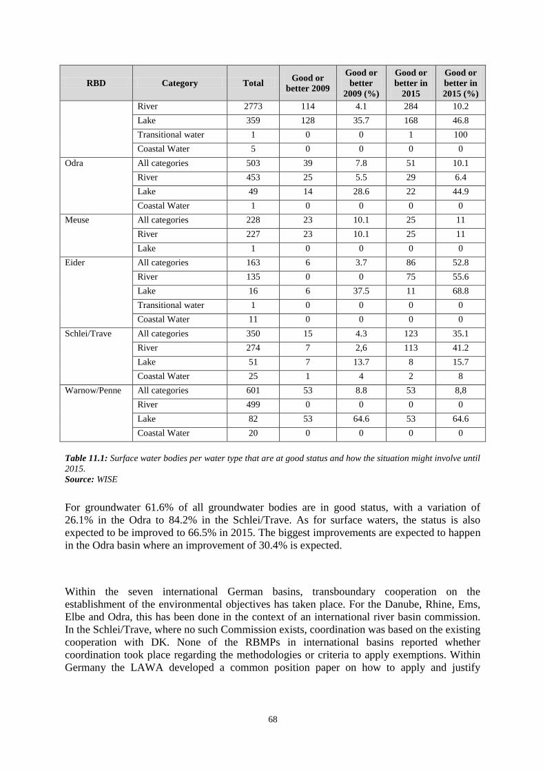
68
RBD Category Total Good or
better 2009
Good or
better
2009 (%)
Good or
better in
2015
Good or
better in
2015 (%)
River 2773 114 4.1 284 10.2
Lake 359 128 35.7 168 46.8
Transitional water 1 0 0 1 100
Coastal Water 5 0 0 0 0
Odra All categories 503 39 7.8 51 10.1
River 453 25 5.5 29 6.4
Lake 49 14 28.6 22 44.9
Coastal Water 1 0 0 0 0
Meuse All categories 228 23 10.1 25 11
River 227 23 10.1 25 11
Lake 1 0 0 0 0
Eider All categories 163 6 3.7 86 52.8
River 135 0 0 75 55.6
Lake 16 6 37.5 11 68.8
Transitional water 1 0 0 0 0
Coastal Water 11 0 0 0 0
Schlei/Trave All categories 350 15 4.3 123 35.1
River 274 7 2,6 113 41.2
Lake 51 7 13.7 8 15.7
Coastal Water 25 1 4 2 8
Warnow/Penne All categories 601 53 8.8 53 8,8
River 499 0 0 0 0
Lake 82 53 64.6 53 64.6
Coastal Water 20 0 0 0 0
Table 11.1: Surface water bodies per water type that are at good status and how the situation might involve until
2015.
Source: WISE
For groundwater 61.6% of all groundwater bodies are in good status, with a variation of
26.1% in the Odra to 84.2% in the Schlei/Trave. As for surface waters, the status is also
expected to be improved to 66.5% in 2015. The biggest improvements are expected to happen
in the Odra basin where an improvement of 30.4% is expected.
Within the seven international German basins, transboundary cooperation on the
establishment of the environmental objectives has taken place. For the Danube, Rhine, Ems,
Elbe and Odra, this has been done in the context of an international river basin commission.
In the Schlei/Trave, where no such Commission exists, coordination was based on the existing
cooperation with DK. None of the RBMPs in international basins reported whether
coordination took place regarding the methodologies or criteria to apply exemptions. Within
Germany the LAWA developed a common position paper on how to apply and justify
69
exemptions according to Article 4.5 and Article 4.558
. However, its application within the
Länder remains unclear as information has not been reported in the plans.
11.1 Additional objectives in protected areas
The protected areas found in Germany include drinking water protected areas, shellfish waters
(only in the Rhine, Weser, Elbe, Eider and Schlei/Trave), bathing waters, and Natura 2000
sites. Most of the German plans do not make any explicit statement on the establishment of
additional objectives in protected areas. The Eider RBMP states for bathing water areas there
is a transition period until 2011 to implement the new bathing water Directive. For E-Coli and
Enterokokken lower thresholds (Maßnahmenwerte) have been set. If these thresholds are
exceeded more controls and bathing restrictions will be set. Regarding the objectives from the
Shellfish Directive, the aim is to achieve all relevant objectives by 2015, except in two RBDs
(Eider and Schlei-Trave), for which it is stated that the shellfish water quality objectives have
already been achieved.
Regarding the objectives from the Shellfish Directive, all RBDs with Shellfish PAs include
the requirement to comply with the Directive (transposed into Federal State regulations,
where appropriate, e.g. Lower Saxony). The aim is to achieve all relevant objectives by 2015.
In two RBDs however (Eider and Schlei-Trave), shellfish water quality objectives have
already been achieved and thus don't need additional measures.
There is no mention of EU Hygiene Regulations or the three different levels (A, B, C) of
designated shellfish production areas, nor is there any specific indication whether all Shellfish
PAs correspond to Shellfish production areas.
11.2 Exemptions according to Article 4(4) and 4(5)
The application of exemptions according to Article 4(4) and 4(5) varies widely across the
German RBDs. In total 80% of the German water bodies are subject to an exemption with
79% being subject to an extended deadline. Only for 1% of the water bodies lower objectives
will be applied. The basin with the lowest exemptions applied is the Eider (47%), the one with
the highest is the Ems (95%). The main reasons for applying exemptions according to Art 4.4
are technical feasibility and natural conditions. Disproportional costs are less often used as a
justification.
58 See LAWA- Ausschuss Oberirdische Gewässer und Küstengewässer - Ad hoc-Unterausschuss
„Wirtschaftliche Analyse“ -Gemeinsames Verständnis von Begründungen zu Fristverlängerungen nach § 25
c WHG (Art. 4 Abs. 4 WRRL)und Ausnahmen nach § 25 d Abs. 1 WHG (Art. 4 Abs. 5WRRL).
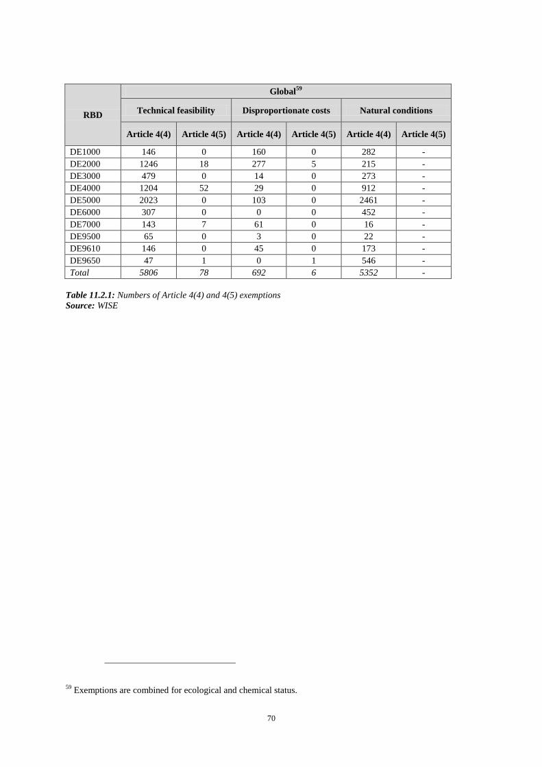
70
RBD
Global59
Technical feasibility Disproportionate costs Natural conditions
Article 4(4) Article 4(5) Article 4(4) Article 4(5) Article 4(4) Article 4(5)
DE1000 146 0 160 0 282 -
DE2000 1246 18 277 5 215 -
DE3000 479 0 14 0 273 -
DE4000 1204 52 29 0 912 -
DE5000 2023 0 103 0 2461 -
DE6000 307 0 0 0 452 -
DE7000 143 7 61 0 16 -
DE9500 65 0 3 0 22 -
DE9610 146 0 45 0 173 -
DE9650 47 1 0 1 546 -
Total 5806 78 692 6 5352 -
Table 11.2.1: Numbers of Article 4(4) and 4(5) exemptions
Source: WISE
59 Exemptions are combined for ecological and chemical status.
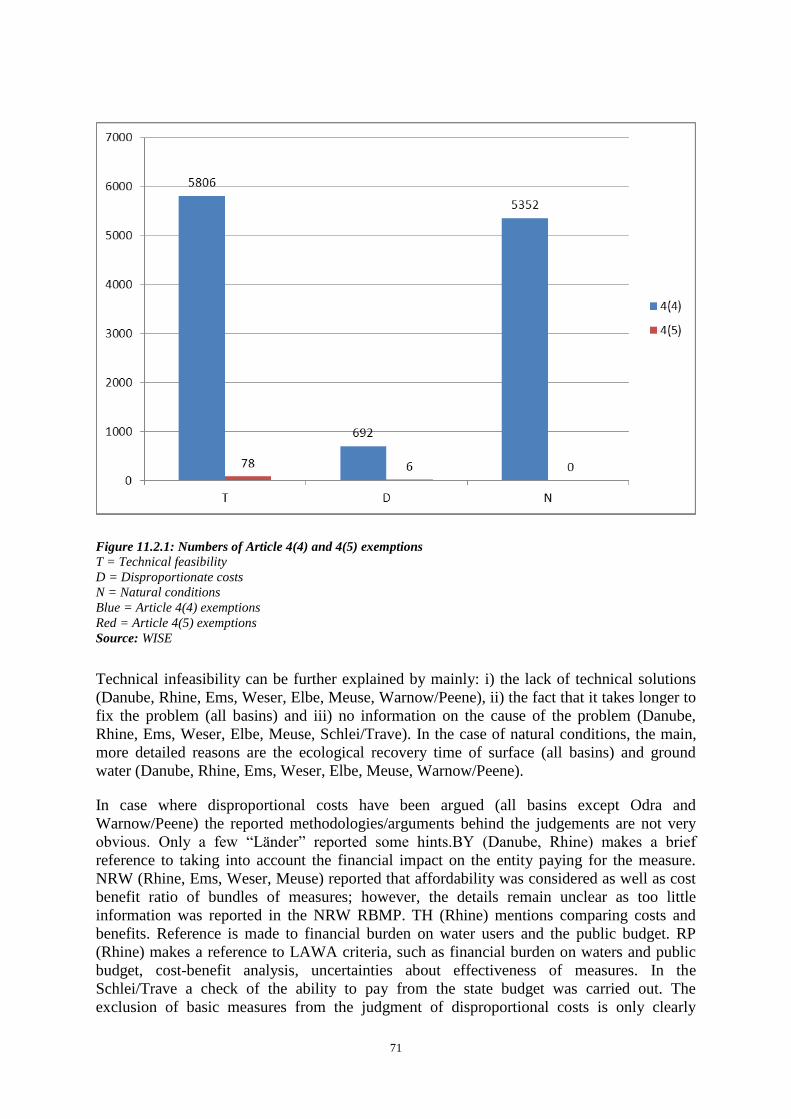
71
Figure 11.2.1: Numbers of Article 4(4) and 4(5) exemptions
T = Technical feasibility
D = Disproportionate costs
N = Natural conditions
Blue = Article 4(4) exemptions
Red = Article 4(5) exemptions
Source: WISE
Technical infeasibility can be further explained by mainly: i) the lack of technical solutions
(Danube, Rhine, Ems, Weser, Elbe, Meuse, Warnow/Peene), ii) the fact that it takes longer to
fix the problem (all basins) and iii) no information on the cause of the problem (Danube,
Rhine, Ems, Weser, Elbe, Meuse, Schlei/Trave). In the case of natural conditions, the main,
more detailed reasons are the ecological recovery time of surface (all basins) and ground
water (Danube, Rhine, Ems, Weser, Elbe, Meuse, Warnow/Peene).
In case where disproportional costs have been argued (all basins except Odra and
Warnow/Peene) the reported methodologies/arguments behind the judgements are not very
obvious. Only a few “Länder” reported some hints.BY (Danube, Rhine) makes a brief
reference to taking into account the financial impact on the entity paying for the measure.
NRW (Rhine, Ems, Weser, Meuse) reported that affordability was considered as well as cost
benefit ratio of bundles of measures; however, the details remain unclear as too little
information was reported in the NRW RBMP. TH (Rhine) mentions comparing costs and
benefits. Reference is made to financial burden on water users and the public budget. RP
(Rhine) makes a reference to LAWA criteria, such as financial burden on waters and public
budget, cost-benefit analysis, uncertainties about effectiveness of measures. In the
Schlei/Trave a check of the ability to pay from the state budget was carried out. The
exclusion of basic measures from the judgment of disproportional costs is only clearly

72
reported in the case of the Ems, Meuse, Elbe and the NRW part of the Rhine and the Weser.
In all other cases no information was reported. However, the common position paper on
exemptions by the LAWA clearly states the exclusion of basic measures from the judgment
of disproportional costs is not possible.
11.3 Exemptions according to Article 4(6)
In all German RBDs Art 4.6 has not been applied so far. In the future, the NRW plan
covering parts of the Rhine, Weser, Ems and Mosel states that the application of Art 4.6 will
be further developed in the next planning cycles. In the Eider and Schlei/Trave future
potential reasons for the Art 4.6 and prevention measures are reported in WISE. Potential
reasons for applying Article 4.6 mentioned it includes exceptional natural causes such as
extreme floods or extreme weather conditions. Unforeseen accidents include fires, accidents,
technical failure or operator error in industrial enterprises, sewage treatment plants or
pipelines, and shipping accidents and accidents with discharge of pollutants in coastal waters
or in navigable inland waters. Prevention measures include: technical protection measures at
facilities for storage and transfer of water polluting substances; safety inspections and
monitoring of water-polluting substances; and establishment of early warning systems for
chemical water pollution. During extreme natural events or unforeseeable accidents, fire
trucks, technical assistance and central commands will be in a constant state of readiness to
act if necessary. Coastal federal states and federal government keep combat ships and other
equipment on hand to deal with oil or chemical spills in coastal waters including equipment
to clean up contaminated beaches. There is also the possibility of using the Federal Army and
private companies to help deal with big ship accidents and catastrophes on the ocean. In all
other basins no further information on Art 4.6 is reported.
11.4 Exemptions according to Article 4(7)
The RBDs Eider, Ems, Schlei/Trave, Warnow/Peene, Elbe, Odra, Weser, clearly state that
there is no application of Art 4.7. In the Danube the BY plan specifically mentions that
Article 4.7 is not being applied at this time. BW does not mention article 4.7 in its chapter on
exemptions. Until now, in the Rhine less stringent environmental objectives pursuant to
Article 4.7 of the WFD have only been applied in the NRW part of the Rhine RBD in a few
exceptional cases for groundwater and for surface waters. The exemption clause pursuant to
Article 4, paragraph (7) of the WFD has not otherwise been used in the German part of the
Rhine RBD. The NRW RBMP explicitly states that use has been made of Article 4,
paragraph (7) in conjunction with lignite mining in NRW. This concerns the catchment areas
of both the Rhine and the Maas. Unlike the consequences of open-cast lignite mining,
exemptions from the “non-deterioration principle” on the basis of Article 4, paragraph (7) of
the WFD are not envisaged.
11.5 Exemptions to Groundwater Directive
None of the German RBDs has reported on an inventory of exemptions from measures
required to prevent or limit inputs into groundwater.

73
12. PROGRAMMES OF MEASURES
According to Annex VII of the WFD, the RBMPs should contain a summary of the
programmes of measures (PoM), including the ways in which Member States expect to
achieve the objectives of Article 4 WFD. The programmes should have been established by
2009, but are required to become operational only by December 2012. The assessment in this
section is based on the PoM as summarised by the Member State in its RBMP, and the
compliance of this with the requirements of Article 11 and Annex VII of the WFD.
It therefore does not include a comprehensive assessment of compliance with the
requirements of Article 11(3)60
on basic measures. It focuses in particular on key sets of
measures. Member States will report to the Commission by December 2012 on the full
implementation of their PoMs, including on the progress on the implementation of basic
measures as required by Article 11(3). The Commission will assess what Member States
report and will publish its assessment in accordance with Article 18 WFD.
12.1 Programme of measures – general
The selection of measures was most importantly based on the status assessments in
combination with significant pressures and the respective environmental objectives.
Additional criteria were also taken into account such as impact of the measure; synergies with
other directives and initiatives; cost-efficiency; implications of non-action;
certainty/uncertainty of measures (“no-regret-measures”); measures that can be implemented
in a short time span; urgency of the problem to be solved by the measure; financing; and
public acceptability.
With the exception of the Schlei/Trave RB, all other German river basins coordinated with
their international counterparts to draw up international RBMPs; this work was largely
carried out under the auspices of international river basin organisations. Within the Elbe,
Danube, Rhine, and Ems, the PoMs have been coordinated to different degrees (see section 1
for detailed information on coordination). For the other basins the information regarding
international coordination in the development of PoMs was not reported in the plans. At
international level a cost-effectiveness analysis was not reported in any of the basins.
The RBMPs do not provide information about the percentage between basic and
supplementary measures or the ratio of measures based on sector/pressure. WISE lists the
supplementary measures, but instead of indicating the type of measure, a number code is
provided that refers to the German federal LAWA catalogue of measures61
.
60 These are the minimum requirements to be complied with and include the measures required under other
Community legislation as well as measures to achieve the requirements of other WFD Articles and to ensure
appropriate controls on different activities affecting water management.
61 In Germany, the LAWA working group developed a generic catalogue of measures at federal level where
each measure is assigned a code. The measures are general in nature, e.g. measures to address water
abstraction or measures to address diffuse pollution from agriculture. These general categories were used in
the summary chapter regarding PoMs in the RBMP. The PoMs for each RBD, which have not been officially
reported, define in more detail sub-measures within each general category.
74
Measures are to be implemented on a number of levels; the geographic scope for
implementation varies from the national level, the RBD level and the sub-basin or water body
level. National and local authorities as well as private stakeholders (enterprises, farmers and
individuals) will share responsibility for measure implementation, depending on the type or
measure and sector in which it applies. Information regarding energy-related measures is not
clear as they are not listed separately. Regional authorities are not involved in navigation
related measures in Schlei-Trave. Local authorities cover all sectors except navigation and
energy (except in the Elbe).
There is no information on the costs of the PoM reported at river basin level. A total cost
estimate of the planned measures has been provided for the Federal Republic of Germany.
The budget needed to finance the measures where regional agencies are concerned are
included in the respective budget plans of the Federal Government, “Länder” and local
authorities. Non-public agents are also involved in the implementation of measures. These
measures may be funded by private sources or with the help of funding programmes of the
EU, Federal Government or “Länder”. Some “Länder” provide cost information at state scale
(e.g. BW, NRW) but this is not disaggregated according to the river basins. With the
exception of the Danube and Rhine (where information was either unclear or not reported),
the other river basins reported carrying out a cost-effectiveness analysis of measures. All
measures listed in the LAWA catalogue of measures are deemed to be cost-efficient;
therefore, to a certain degree, in all RBDs in Germany the cost-efficiency of measures has
been considered.
All the RBMPs stated that the PoMs will become operational in 2012, with the exception of
the Elbe where no information was found to this effect.
12.2 Measures related to agriculture
The pressures on water from agriculture include pressures on water quality from diffuse
sources of pollutants such as nutrients (and its associated eutrophication) and pesticides, as
well as morphological modifications. Water abstraction is only mentioned in the Odra but
without a clear link to agriculture; no other RBDs mention water abstraction as a pressure.
Technical measures selected to address agricultural pressures include: fertilizer and pesticide
reduction (e.g. restrictions on applications), low input farming (e.g. organic farming), and
hydromorphological measures like floodplain restoration and re-meandering measures. Soil
measures were found in half of the basins and water savings measures were only found in the
Danube river basin. Economic measures include: compensation for land cover and
cooperative agreements. Non-technical measures include codes of good practice, training,
and to some extent awareness and knowledge raising. Detailed information on non-technical
measures is not provided, as only general categories are reported. A more detailed list of the
agricultural measures mentioned is presented in the table below. There was an extensive
public participation programme put in place for the development of the first RBMP in the
different Federal States (see section 3 for more details). Public participation of the
agricultural sector has been considered through participation of agriculture stakeholders in

75
Advisory boards. Nevertheless, the NRW river basin management plan refers in detail the
specific approach taken with regard to agriculture62
.
The geographic extent of the application of measures is provided in all river basins except
Warnow/Peene. A mix of sub-basin and water body level is used. In terms of the timing of
the implementation of measures, information provided by the river basins and “Länder” vary.
Some indicate that measures will be operational in the period 2009-2015, while some river
basins (Elbe, Weser) and “Länder” (LS in the Ems) did not report information to this effect.
Information was not reported on how gaps, if any, will be addressed in the future.
General information is provided regarding funding of agricultural measures, e.g. through EU,
national and communal level funds. Within the same basins, some “Länder” indicated general
sources of funds while others do not report information to this effect. For example, in the
Ems, NRW mentions user fees and multi-level government funding, while LS does not
provide any information to this effect. In the Rhine, the Federal States, with the exception of
TH and SR, mention various financing sources; HE indicates a working group on funding at
“Länder” level but its RBMP does not report any details. Funding information is provided by
both German “Länder” (BV and BW) separately for the Danube. General funding
information was stated in the plans of the river basins where only one RBMP was developed
(i.e. Weser, Elbe, Eider, Warnow/Peene and Schlei/Trave). With the exception of the Weser,
all the PoMs mention that the river basin will take advantage of Rural Development
Regulation (RDR) financing, although Art. 38 is not referenced by any of the plans.
62http://www.flussgebiete.nrw.de/Dokumente/NRW/Bewirtschaftungsplan_2010_2015/Bewirtschaftungsplan/1
2_BP_Information_Anh__rung_und_Beteiligung_der___ffentlichkeit____ffentlichkeitsbeteiligung.pdf

76
Measures
DE
10
00
DE
20
00
DE
30
00
DE
40
00
DE
50
00
DE
60
00
DE
70
00
DE
95
00
DE
96
10
DE
96
50
Technical measures
Reduction/modification of fertiliser
application
Reduction/modification of pesticide
application
Change to low-input farming (e.g.
organic farming practices)
Hydromorphological measures leading
to changes in farming practices
Measures against soil erosion
Multi-objective measures (e.g. crop
rotation, creation of enhanced buffer
zones/wetlands or floodplain
management)
Technical measures for water saving
Economic instruments
Compensation for land cover
Co-operative agreements
Water pricing specifications for
irrigators
Nutrient trading
Fertiliser taxation
Non-technical measures
Additions regarding the
implementation and enforcement of
existing EU legislation
Institutional changes
Codes of agricultural practice
Farm advice and training
Raising awareness of farmers
Measures to increase knowledge for
improved decision-making
Certification schemes
Zoning (e.g. designating land use based
on GIS maps)
Specific action plans/programmes
Land use planning
Technical standards
Specific projects related to agriculture
Environmental permitting and licensing
Table 12.2.1: Types of WFD measures addressing agricultural pressures, as described in the PoM Source: RBMPs
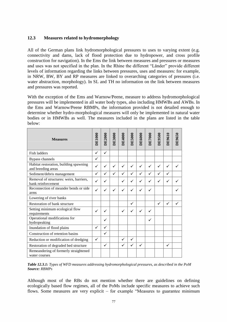
77
12.3 Measures related to hydromorphology
All of the German plans link hydromorphological pressures to uses to varying extent (e.g.
connectivity and dams, lack of flood protection due to hydropower, and cross profile
construction for navigation). In the Ems the link between measures and pressures or measures
and uses was not specified in the plan. In the Rhine the different “Länder” provide different
levels of information regarding the links between pressures, uses and measures: for example,
in NRW, BW, BY and RP measures are linked to overarching categories of pressures (i.e.
water abstraction, morphology). In SL and TH no information on the link between measures
and pressures was reported.
With the exception of the Ems and Warnow/Peene, measure to address hydromorphological
pressures will be implemented in all water body types, also including HMWBs and AWBs. In
the Ems and Warnow/Peene RBMPs, the information provided is not detailed enough to
determine whether hydro-morphological measures will only be implemented in natural water
bodies or in HMWBs as well. The measures included in the plans are listed in the table
below:
Measures
DE
10
00
DE
20
00
DE
30
00
DE
40
00
DE
50
00
DE
60
00
DE
70
00
DE
95
00
DE
96
10
DE
96
50
Fish ladders
Bypass channels
Habitat restoration, building spawning
and breeding areas
Sediment/debris management
Removal of structures: weirs, barriers,
bank reinforcement
Reconnection of meander bends or side
arms
Lowering of river banks
Restoration of bank structure
Setting minimum ecological flow
requirements
Operational modifications for
hydropeaking
Inundation of flood plains
Construction of retention basins
Reduction or modification of dredging
Restoration of degraded bed structure
Remeandering of formerly straightened
water courses
Table 12.3.1: Types of WFD measures addressing hydromorphological pressures, as described in the PoM Source: RBMPs
Although most of the RBs do not mention whether there are guidelines on defining
ecologically based flow regimes, all of the PoMs include specific measures to achieve such
flows. Some measures are very explicit – for example “Measures to guarantee minimum

78
ecological flow” found in the Danube, Rhine, Weser, Elbe, Odra, Meuse and Warnow/Peene
– while other measures will lead to improved flow regimes (e.g. natural retention or natural
hydromorphological dynamic of the river, etc.). With respect to guidelines, the BV Danube
plans briefly references a proposal for guidelines to determine an ecologically and
economically balanced minimum flow proposal for existing small hydropower plants. In the
BW Danube plans, reference is made to guidelines establishing minimum flow 'Gemeinsames
Amtsblatt 2007, p.105 ff) but no details are provided.
12.4 Measures related to groundwater
Groundwater quantitative status
According to the information on the strategic concepts of the programmes of measures which
was provided to WISE, basic measures are implemented in all RBMPs, for surface waters and
for groundwater independently of the status of groundwater bodies. They cover controls of
water abstraction and recharge, measures to promote efficient and sustained water use and
measures for the recovery of costs for water services. The basic measures mostly already
existed, mainly in the form of federal legislation and individual “Länder” laws and by-laws
regulating permits, authorisations, registers etc. This means that in RBDs shared by several
“Länder”, the operative measures vary from one ‘Land’ to another.
Supplementary measures tackling over abstraction were reported to be needed and
established in the RBDs Rhine, Elbe, Oder and Maas regarding the reduction of water
abstractions (mainly from mining), and in the RBD Warnow/Peene.
Groundwater chemical status
All RBMPs reported the implementation of measures to prevent inputs of hazardous
pollutants and to limit inputs of non-hazardous pollutants into groundwater. A main national
measure is the general prohibition of any discharge to groundwater with adverse effects on
groundwater and requirements regarding the storage of such substances established in the
federal law. In addition, further laws and by-laws tackle point and diffuse source pollution,
like preventing significant losses of pollutants from technical installations and preventing
and/or reducing the impact of accidental pollution. Compliance is checked by water
inspection authorities.
Supplementary measures were established in all RBDs, mainly supplementary to the Nitrates
Directive, tackling agricultural activities, both from diffuse pollution and point sources of
pollution from fertilizers and pesticides. Further supplementary measures tackle point source
pollution from contaminated sites and diffuse pollution from mining activities, leaking sewers
and the implementation of specific measures in safeguard zones.
Further frequently reported and supplementary measures cover the establishment or adaption
of support programmes, advisory programmes, further investigations, voluntary co-
operations, information and education programmes.
No RBMP reported specific measures being established in that part of groundwater bodies
where quality standards or threshold values were exceeded, although the groundwater body is
of good status.
79
During the international coordination in the Danube RBD the effect of national measures on
the Danube basin-wide scale is estimated and presented. The Elbe RBMP shows only limited
coordination regarding the PoMs. In Rhine RBD there are linkages between national PoMs
and Rhine level activities, but their effect on each other are not clear.
12.5 Measures related to chemical pollution
In the WFD, chemical pollution is regulated through Art.10 (stating the combined approach
principle for the control of both point and diffuse sources of discharges); Art. 11 on
programmes of measures and Art.16, which requires the establishment of a list of priority
substances (Annex X). As there is no reporting requirement, no inventory of sources of
chemical pollution is mentioned in any of the German RBMPs. Bavaria refers to the webpage
of the German Federal Environment Agencies´ Pollutant register in its plans for the Rhine
and Danube; no other plan or “Land” does the same. Most of the RBMPs mention chemical
pollution and its source in the chapters on anthropogenic pressures. Significant pressures can
be found in relation to DOC, N, chloride, fluoride as well as lead, copper, zinc, cadmium and
nickel (mentioned in the RBMPs of the Odra, Elbe, Rhine and Danube (no heavy metals).
Some RBMPs (e.g. Weser (NRW), Elbe, Odra, Eider, Schlei/Trave, Warnow/Peene) mention
point sources only and some also describe diffuse pollution from nutrients (nitrogen and
phosphorus).
General measures do not target a specific chemical substance but focus on industrial and
household emissions. Additionally, the Danube and the Rhine include emissions from
agriculture and the Weser includes emissions from potash mining. In the Danube and the
Rhine, there was no common approach among the “Länder” in developing and reporting on
general measures to address chemical pollution. For all the RBDs, WISE mentions basic and
supplementary measures. The basic measures cover regulations/laws/by-laws that regulate
permitting/emission standards (combined approach) aiming at industrial point sources and
waste water treatment plants. Examples of supplementary measures from WISE (from a list
of many) are: 'measures for the reduction of pesticide pollution from agriculture'; 'realization
and continuation of specific water protection measures in drinking water areas'; 'conceptual
measure: development of concepts / studies / expert reports'; 'conceptual measure: conducting
R&D and demonstration projects'; 'conceptual measure: information and training measures'.
Information pertaining to substance specific measures was not found in the RBMPs of the
Rhine and Danube due to a lack of a common approach63
among the “Länder”). However,
some information on substance-specific measures is given in most RBMPs.
12.6 Measures related to Article 9 (water pricing policies)
“Water services” have been narrowly defined in Germany based on a legal interpretation of
the legal definition64
; it is explicitly stated that only water supply and sanitation (waste water
63 E.g. for ubiquitous substances there is none available.
64 This issue is the subject of infringement actions by the Commission against a number of Member States,
including Germany.

80
collection and treatment) are considered as water services for the purposes of Art. 9. Only
Baden-Wuerttemberg mentions also industrial self-supply, agricultural water supply
(irrigation) and direct discharges from industry qualifying as water services but without
analysing their cost recovery further. Certain activities are explicitly mentioned as not being
water services such as impoundments for navigation, flood protection and hydropower
generation.
In all RBD/Federal States, at least households, industry and agriculture are defined as water
uses.
The cost recovery is calculated for both water services identified, that is water supply and
sanitation. The obligation to cover the cost of water supply and wastewater disposal is
anchored in all community charges legislation in the Federal States, and is supplemented in
individual cases by measures within the framework of the enforcing authorities’ managerial
discretion.
Within cost recovery calculation operational costs are included. It is not clear whether other
financial costs such as investment costs, maintenance costs, and administrative costs were
taken into account.
Subsidies are included in cost recovery calculation. It is stated that cross-subsidization
between different user groups of water services is largely avoided by a differentiated
charging; selected analysis suggests that, overall, at an aggregate level no cross-subsidization
between user groups (households, industry, agriculture) and between the water services
(water supply, sanitation) is taking place. It is planned to extend the calculation of cost
recovery regarding operational costs and subsidies in more transparent way in the second
implementation cycle of the WFD.
Environmental and resource costs were not explicitly quantified for the cost recovery
calculation, with the explanation that a practicable method is not available for this and in
view of a lack of data, whose rectification would have necessitated a disproportionately high
input of time and financial resources. Environmental and resource costs are reported to be
kept as low as possible/as not existent via licensing conditions and retrospective charges, and
at a national level, internalisation of those by the originators through waste water charges and
water abstraction fees and administrative laws. German authorities reported that efforts are
underway to improve the data situation for the second management cycle.
The polluter-pays-principle is mentioned in most RBMP as a basic principle of German water
pricing policy and as being reflected in the contributions of the different water users to cost
recovery. At the same time, calculations of the contributions of the different water users to
the cost recovery have not been done, only limited water services were taken into account and
ERC were not calculated what put into question implementation of polluter pays principle.
Regarding if adequate incentives are provided by the water pricing policy for users to use
water resources efficiently, only general statements can be found, but no precise information
given on how this was done. It is stated that the incentive effects of the water pricing system
is evidenced through the continuous decrease in water consumption and water body
contamination in Germany.
The provisions of Art 9(4) and flexibility provisions of Art 9 have not been used in Germany.

81
Overall, a predominantly national approach to Art 9 implementation has been taken in
Germany. Thus, significant efforts were done in coordinating the work done on Art 9 in the
different Federal States. Efforts were reported regarding international cooperation on Art 9
issues, focussing mainly on exchanges of experiences on Art 9 implementation.
12.7 Additional measures in protected areas
None of the RBDs clearly identified water bodies and protected areas in need of additional
measures. Also, none of the RBMPs mentioned included additional measures to reach the
more stringent objectives of other EU environmental objectives (Birds, Habitats, Shellfish,
etc.).
For Shellfish protected areas, for example, details of additional measures have either not been
provided or have not even been set as the objectives had already been reached and it was
therefore deemed unnecessary to establish them. Measures to comply with the WFD status
seem sufficient (Elbe). In one RBDs however the additional measures aim to comply with
regional regulation transposing Directives 2006/113/EC and 2006/44/EC, i.e. Lower
Saxony.65
With respect to the need for additional measures in protected areas, the general concept is that
improving the status of water bodies within the meaning of the WFD supports the area-
specific protection targets. The planning of specific measures always entails a comparison
between the objectives of the WFD and those of the respective protected areas. Because the
implementation of the Natura 2000 Directives was delayed, however, the conservation targets
were often not yet defined at the time PoMs under the WFD were prepared. Synergies are
taken into account with the selection of measures (e.g. creation of passability, habitat
improvements in the shore and water body zone).
In the process of establishing the Rhine PoMs, it was checked if the WFD-measures are in
correspondence with protected area measures. In the seldom cases where there was a
contradiction between objectives, the relevant authorities cooperated to find solutions or to
prioritize objectives. In the Danube, the BY RBMP mentions that additional measures could
potentially be necessary but states that detailed information is currently not available, while
the BW RBMP mentions a general need for additional measures. The Elbe and Odra RBMPs
mention that by improving the ecological status of water bodies 'usually' specific objectives
of other Directives are supported and that “no contradicting goals exist”. These RBMPs also
state that the analysis of the effects of the WFD and other directive´s measures on each other
will be conducted within the individual “Länder”. The RBMPs of the Weser and
Warnow/Peene do not provide information to this effect. The Meuse and Ems RBMPs only
state that additional measures are not necessary.
In all German river basins with the exception of the Danube safeguard zones are reported to
have been established for water bodies supplying drinking water; these are corresponding to
the protection zones according to Art. VII (3) WFD. Three river basins – the Ems, Weser, and
65 Information extracted from 'EC Comparative Study of Pressures and Measures in the major river basin
management plans in the EU'.
82
Meuse - mention the implementation of an additional measure to protect surface and
groundwater bodies in drinking water protection areas. However, none of the plans provide
information regarding the scope of the measure or the water body/bodies affected. In the
Ems, while NRW mentions establishing zones and implementing additional measures, LS did
not submit information to this effect.
13. CLIMATE CHANGE ADAPTATION, WATER SCARCITY AND
DROUGHTS AND FLOOD RISK MANAGEMENT
13.1 Water Scarcity and Droughts
Water scarcity and droughts are not significant problems in the German river basins with only
a few exceptions. In the Elbe and the Danube RBDs there are local/sub-basin drought
occurrences but these are not considered to be significant. Empirical analyses of the overall
water availability in the Elbe river basin suggest that water scarcity is of no concern in the
basin as a whole, although locally (especially in mining areas) surface and groundwater
bodies seem to be negatively affected. The Elbe RBMP concludes that in the near future
(until 2015) droughts will be of no relevance in the river basin; in the long-term, however, it
could become relevant. Although in the Odra and Meuse RBDs several groundwater bodies
are reported to have bad quantitative status in WISE, this is not the result of water scarcity or
drought; rather, lignite mining in the region is responsible for the large-scale lowering of the
groundwater level due to over-abstraction.
Also rare extreme meteorological events such as the heat wave in summer 2003, which
temporarily caused low water levels in some regions, did not have any significant
consequences for the general public or industry. There were no serious, lasting limitations on
the water supply for industry and households; only the cooling water supply to some power
plants was temporarily restricted. Quite contrary to this topic, the trend in Germany is moving
towards an increase in water availability due to the decrease in consumption by industry and
households.
According to the information in the plans, water scarcity and drought might become relevant
in 5 river basins due to climate change after 2015 (Rhine, Ems, Weser, Odra and Meuse).
Current and future drivers of water scarcity and drought issues are linked to irregular rainfall
patterns in the Danube, Rhine, Ems, Weser, Elbe, Odra and Meuse. The RBMP Rhine of
Saarland, Rhinland-Palatinate and Hessen do not report information on future drivers of
WS&D. Although most of the German basins do not consider WS&D a significant issue, the
RBMPs acknowledge that changing future hydrological regimes should be taken in account
in long-term planning.
To determine the future water scarcity potential of basin, water demand and availability
trends were reported in the RBMs with varying approaches:
All the basins provide water demand trend scenarios itemised by water use.
In the German part of the Danube, future water demand is projected using low -
medium - high consumption scenarios and descriptions in qualitative terms.

83
In the Rhine, the approaches per federal state is as follows: In North Rhine-
Westphalia demand scenarios are based on assumptions of the future economic
growth; in Rhineland-Palatine, Baden-Wuerttemberg and Bavaria, future water
demand is projected using low - medium - high consumption scenarios and
descriptions in qualitative terms; in Thuringia and Saarland future water demand
scenarios, are provided for agriculture and the domestic sector; and in Hessen, future
water demand is provided via three different scenarios, but not itemized by water
use.
In the North Rhine-Westphalia part of the Ems and the Meuse, future water demand
scenarios are based on assumptions of the future economic growth; water
consumption scenarios are provided for the whole federal state are not aggregated by
river basin. Lower Saxony did not report any details to this effect.
In the Elbe, future water demand is described qualitatively, using aggregated data on
population and economic growth, as well as assumptions on more efficient
technologies being used.
In the Odra, demand trend scenarios are provided itemized by sector until 2015.
In the Eider, Schlei/Trave and Warnow, Peene, future water demand scenarios for
the domestic sector and industry, without stating concrete numbers assume that
water demand will be lower in the future (i.e. 2015).
With respect to water availability trends, the Rhine, Ems, Weser, Odra, Meuse and
Warnow/Peene basins provide water availability trend scenarios (not itemised by
water use). No data on future water availability trend scenarios are provided in the
Ems, Elbe, Eider and Schlei/Trave RBMPs as existing data are deemed too
inconclusive to draw conclusions.
As all German plans indicate a low importance of water scarcity and droughts, WS&D
measures have for the most part not been included in the RBMPs. The Rhine, Weser, Elbe,
Eider, Schlei/Trave and Warnow/Peene river basins reported these measures as not relevant
given the low pressure. In the Danube, Bavaria and Baden-Württemberg mention additional
research is needed to develop concrete actions. No information was reported on the existence
or not of WS&D measures in the Ems, Odra and the Meuse.
Although water scarcity and drought problems in Germany are only found at the local level,
nevertheless international cooperation took place in the Danube, Rhine, Elbe and Meuse with
respect to future challenges arising from climate change; coordination did not take place in
the Ems as WS&D have not been identified as basin-wide problems.
13.2 Flood Risk Management
Floods are mentioned in a number of places in the RBMP. Flood risk management is
considerable concern across much of Germany in the context of climate change. Measures to
reduce flood risk were identified in all the river basins with the exception of the Elbe
although no explicit climate change adaptation measures are mentioned. Examples include:
renaturation of wetlands, increasing water retention and the reallocation of dykes.
84
Flooding has been used a reason for HMWB designation in the Odra, Meuse, Danube, Rhine,
Weser and Elbe. Germany is not applying article 4(6) or 4(7) at this time (except NRW, see
chapter 11).
13.3 Adaptation to Climate Change
For the first management period up until 2015, current findings suggest that no significant
impacts from climate change are anticipated, however climate change as well as adaptation is
addressed in all the river basins. The following issues are mentioned in relation to adaptation
to climate change:
Climate change scenarios focusing on change in temperature and precipitation
were reported in all river basins; Uncertainties related to climate change (e.g. with
respect to status assessment or effects of measures) were at the same time reported.
Impacts on water status due to climate change (Water quality and biodiversity
in aquatic systems) were reported in all river basins with the exception of the Elbe.
Impacts on coastal zones were reported in the Ems and Eider RBMPs.
Water availability and water demand issues were reported by all the river
basins with the exception of Schlei/Trave RBD.
Water Scarcity and drought risks were reported by the Danube, the Rhine,
Weser, Elbe, and Meuse (droughts only) river basin disctricts.
Flood risks were reported with the exception of the Eider, Schlei/Trave and
Warnow/Peene RBMPs.
Vulnerability of certain sectors/water uses were reported in the Danube, Rhine,
Ems, Weser, Odra, Meuse and Eider RBDs.
In addition, concrete adaptation measures were reported in all the basins with the exception
of the Ems RBD. The focus is mostly on flood risks with measures included such as water
retention, reallocation of dykes, revitalization of wetlands, and river restauration. Additional
measures include more efficient use of water (Odra) and control of ground water abstraction
(Rhine).
A climate check of the Programmes of Measures was carried out by the majority of river
basins to better align the setting of objectives (with the exception of the Weser and the
Meuse) and in the selection of measures (with the exception of the Danube and Weser
RBDs). However the details of the methodologies to do so have not been presented. In the
Danube climate change was not included due to continued uncertainties surrounding the
impacts of climate change. Given the lack of clarity regarding the impacts of climate change,
the comprehensive progress in scientific findings and the short monitoring period of the
management plans until 2015, the German river basins intend to update the climate change
related information for the next management cycle. Targeted analyses are planned for
subsequent management cycles, including in particular RBD-wide analyses. The International
Commission for the Protection of the Rhine against Pollution and the International

85
Commission for the Protection of the Danube against Pollution are working on this, with
Germany's active involvement.
14. RECOMMENDATIONS
Despite some shortcomings of the RBMPs, the German plans show that considerable efforts
have been made and the plans already indicate that issues will become clearer in the 2nd
cycle.
Following the steps of river basin planning as set out in the WFD should ensure that water
management is based on a better understanding of the main risks and pressures in a river
basin and as a result, interventions are cost effective and ensure the long term sustainable
supply of water for people, business and nature.
To deliver successful water management requires linking these different steps. Information
on pressures and risks should feed into the development of monitoring programmes,
information from the monitoring programmes and the economic analysis should lead to the
identification of cost effective programmes of measures and justifications for exemptions.
Transparency on this whole process within a clear governance structure will encourage
public participation in both the development and delivery of necessary measures to deliver
sustainable water management
To complete the 1st river basin management cycle, and in preparing for the second cycle of
the WFD, the following recommendations are made:
Better address each RBD individually when providing relevant information via the
'electronic' WISE templates. In addition the information in WISE and the plans should
be more streamlined.
Ensure the coordinated implementation of the Directive both at international level, as
well as for the national parts of each of the RBDs. The implementation of the
Directive would be coordinated across the RBDs, to ensure the achievement of the
environmental objectives established under Article 4. In particular all PoMs are to be
coordinated for the whole of the river basin district, including within a Member State.
Fill existing gaps regarding lacking reference conditions.
Provide more transparent information regarding how waters were classified in order
to avoid gaps (e.g. why no transitional water bodies have been identified).
The ecological status assessment should be completed in a coherent way for all water
categories and quality elements, providing a fully transparent picture on the selection
of most sensitive BQEs for pressure/impact assessment and aligning the assessment
results to the intercalibration class boundaries of the EC Intercalibration Commission
Decision in a transparent way.
86
The designation of HMWBs should comply with all the requirements of Article 4(3).
The assessment of significant adverse effects on their use or the environment and the
lack of significantly better environmental options should be specifically mentioned in
the RBMPs. This is needed to ensure transparency of the designation process.
Groundwater trend assessment should be carried out as soon as long (sufficiently
reliable) time series are available.
In groundwater bodies shared by different Länder, coordinated methodologies and
measures should be applied. The way national guidance is used should be explained in
the different RBMPs.
Report about groundwater bodies at risk (and the related parameters) as this is an
important element in the status assessment and in the programme of measures.
The frequency of chemical monitoring should be harmonised across the
"Länder"/RBMPs according to the requirements of the WFD.
Mercury, hexachlorobenzene and hexachlorobutadiene are indeed not the only priority
substances for which monitoring in a non-water matrix (biota in these three instances)
is appropriate. The requirement for trend monitoring in sediment or biota as specified
for several substances in Directive 2008/105/EC Article 3(3) will also need to be
reflected in the next RBMP.
Meaningful information regarding the scope, the timing and the funding of the
measures should be included in the PoM so that the approach to achieve the objectives
is clear. All the relevant information on basic and supplementary measures should be
included in the summary of the PoM to ensure transparency of the planned actions for
the achievement of the environmental objectives set out in the WFD.
A significant number of exemptions have been applied in the first cycle of RBMPs.
The application of exemptions needs to be more transparent and the reasons for the
exemptions should be clearly justified in the plans.
The cost-recovery should address a broad range of water services, including
impoundments, abstraction, storage, treatment and distribution of surface waters, and
collection, treatment and discharge of waste water, also when they are "self-services",
for instance self-abstraction for agriculture. The cost recovery should be transparently
presented for all relevant user sectors, and environment and resource costs should be
included in the costs recovered. Information should also be provided on the incentive
function of water pricing for all water services, with the aim of ensuring an efficient
use of water. Information on how the polluter pays principle has been taken into
account should be provided in the RBMPs.
Concerning Agriculture, i) a strategy mainly built on voluntary measures will not
deliver. A right balance between voluntary actions and a strong baseline of mandatory
measures needs to be set up, ii) the baseline for water protection needs to be very
87
clear so that all farmers know the rules and the authorities in charge of the CAP funds
can adequately set up Rural Development programmes and cross compliance water
requirements.
Further harmonisation of several aspects such as methodologies, design of measures
considerations, terminology, reporting formats and measurement frequencies would
contribute to a more streamlined approach across RBDs and Länder.