On Enabling Mobile Crowd Sensing for Data Collection in ...
11
1 On Enabling Mobile Crowd Sensing for Data Collection in Smart Agriculture- A Vision Yuanhao Sun, Weimin Ding ? , Lei Shu ? , Edmond Nurellari, Kailiang Li, Yu Zhang, Zhangbing Zhou, and Guangjie Han Abstract—Smart agriculture enables the efficiency and intel- ligence of production in physical farm management. Though promising, due to the limitation of the existing data collection methods, it still encounters few challenges that are required to be considered. Mobile Crowd Sensing (MCS) embeds three beneficial characteristics: a) cost-effectiveness, b) scalability, and c) mobility and robustness. With the Internet of Things (IoT) be- coming a reality, the smart phones are widely becoming available even in remote areas. Hence, both the MCSs characteristics and the plug and play widely available infrastructure provides huge opportunities for the MCS-enabled smart agriculture.opening up several new opportunities at the application level. In this paper, we extensively evaluate the Agriculture Mobile Crowd Sensing (AMCS) and provide insights for agricultural data collection schemes. In addition, we provide a comparative study with the existing agriculture data collection solutions and conclude that AMCS has significant benefits in terms of flexibility, collecting implicit data, and low cost requirements. However, we note that AMCSs may still posses limitations in regard to data integrity and quality to be considered as a future work. To this end, we perform a detailed analysis of the challenges and opportunities that concerns the MCS-enabled agriculture by putting forward six potential applications of AMCS-enabled agriculture. Finally, we propose future research and focus on agricultural characteristics, e.g., seasonality and regionality. Index Terms—Mobile crowd sensing, smart agriculture, data collection, Internet of Things I. I NTRODUCTION Big Data technology combines the mathematical models in the smart agriculture domain to seamlessly analyse a large amount of data in agricultural production and provide valuable insights to the farmer without the need of the dedicated specialist. It is one of the most promising approach to solve the long-standing challenges [1], e.g., unmarketable agricul- tural products due to lack of information exchange between farmers and consumers. Currently, two main approaches have been widely applied in agricultural data acquisition: a) Site survey with dedicated professionals [2]; b) Sensing technology based on Space-Air-Ground Integrated Network (SAGIN) [3]. Nevertheless, both the aforementioned approaches are not feasible and scalable in the current and future agriculture paradigm. Just to mentioned few of them, e.g., the site survey approach is not suitable for Big Data technology because it is time-consuming, labour-intensive, and only samples small- scale local data/information. On the other hand, the SAGIN approach has several limitations, e.g., very high deployment and operational cost. In addition, it does not allow further ? Weimin Ding and Lei Shu are corresponding authors improvements in terms of the flexibility and scalability of deployed devices, which is clearly a bottleneck and highly de- sirable in the context of Agriculture. Thus, this work provides a platform that evaluates and proposes new data collection approaches to overcome the aforementioned limitations. Mobile Crowd Sensing (MCS) is a technique where a large number of individuals having mobile devices, e.g., smart phones and wearable equipment, capable of sensing and sharing information of interest, aiming to complete large-scale and complex sensing tasks with three beneficial characteristics: 1) cost-effectiveness, 2) scalability and 3) mobility [4] - [7]. Recently, there has been a growing interest on research based on the existing developed systems that proposes different approaches to improve the availability of MCS technology for different application scenarios. The existing typical applica- tions of MCS can be divided into seven parts, as shown in Table I. • Environmental Monitoring. Sensing environmental in- formation is fundamental for sustainable urban develop- ment and can improve citizens’ quality of life. Aiming to monitor air quality, in [8], authors proposed a frame- work, namely CrowdRecruiter, to minimize incentive payments by selecting a small number of participants while still satisfying probabilistic coverage constraint. GRC-Sensing [10] and Urban Safety [11] were utilized to monitor noise pollution and information of damaged urban infrastructure, respectively. In [24], the authors first built the SenSquare system to embrace data availability and device heterogeneity. Then, they constantly improved the system’s function, e.g., classifying heterogeneous data [25] and designing an easy visual programming plugin [26]. • Living Service. This category can help citizens get a better life experience. In [9], CrowdQTE was presented to utilize the sensor-enhanced mobile devices and crowd human intelligence to monitor and provide real-time queue time information for various queuing scenarios. Authors designed Mobibee to realize indoor localization by inspiring citizens to contribute their data [19] and proposed a truth discovery algorithm to detect falsified data [20]. Besides, there are also other services, e.g., recy- cling waste with WasteApp [22] and measuring wireless performance with MCNet [23]. • Disaster Prediction. Large magnitude earthquakes can continue to kill and injure a large of people, inflicting lasting societal and economic disasters. The prediction
Transcript of On Enabling Mobile Crowd Sensing for Data Collection in ...
1
On Enabling Mobile Crowd Sensing for DataCollection in Smart Agriculture- A Vision
Yuanhao Sun, Weimin Ding?, Lei Shu?, Edmond Nurellari, Kailiang Li, Yu Zhang, Zhangbing Zhou, andGuangjie Han
Abstract—Smart agriculture enables the efficiency and intel-ligence of production in physical farm management. Thoughpromising, due to the limitation of the existing data collectionmethods, it still encounters few challenges that are requiredto be considered. Mobile Crowd Sensing (MCS) embeds threebeneficial characteristics: a) cost-effectiveness, b) scalability, andc) mobility and robustness. With the Internet of Things (IoT) be-coming a reality, the smart phones are widely becoming availableeven in remote areas. Hence, both the MCSs characteristics andthe plug and play widely available infrastructure provides hugeopportunities for the MCS-enabled smart agriculture.opening upseveral new opportunities at the application level. In this paper,we extensively evaluate the Agriculture Mobile Crowd Sensing(AMCS) and provide insights for agricultural data collectionschemes. In addition, we provide a comparative study with theexisting agriculture data collection solutions and conclude thatAMCS has significant benefits in terms of flexibility, collectingimplicit data, and low cost requirements. However, we note thatAMCSs may still posses limitations in regard to data integrity andquality to be considered as a future work. To this end, we performa detailed analysis of the challenges and opportunities thatconcerns the MCS-enabled agriculture by putting forward sixpotential applications of AMCS-enabled agriculture. Finally, wepropose future research and focus on agricultural characteristics,e.g., seasonality and regionality.
Index Terms—Mobile crowd sensing, smart agriculture, datacollection, Internet of Things
I. INTRODUCTION
Big Data technology combines the mathematical modelsin the smart agriculture domain to seamlessly analyse a largeamount of data in agricultural production and provide valuableinsights to the farmer without the need of the dedicatedspecialist. It is one of the most promising approach to solvethe long-standing challenges [1], e.g., unmarketable agricul-tural products due to lack of information exchange betweenfarmers and consumers. Currently, two main approaches havebeen widely applied in agricultural data acquisition: a) Sitesurvey with dedicated professionals [2]; b) Sensing technologybased on Space-Air-Ground Integrated Network (SAGIN) [3].Nevertheless, both the aforementioned approaches are notfeasible and scalable in the current and future agricultureparadigm. Just to mentioned few of them, e.g., the site surveyapproach is not suitable for Big Data technology because itis time-consuming, labour-intensive, and only samples small-scale local data/information. On the other hand, the SAGINapproach has several limitations, e.g., very high deploymentand operational cost. In addition, it does not allow further
? Weimin Ding and Lei Shu are corresponding authors
improvements in terms of the flexibility and scalability ofdeployed devices, which is clearly a bottleneck and highly de-sirable in the context of Agriculture. Thus, this work providesa platform that evaluates and proposes new data collectionapproaches to overcome the aforementioned limitations.
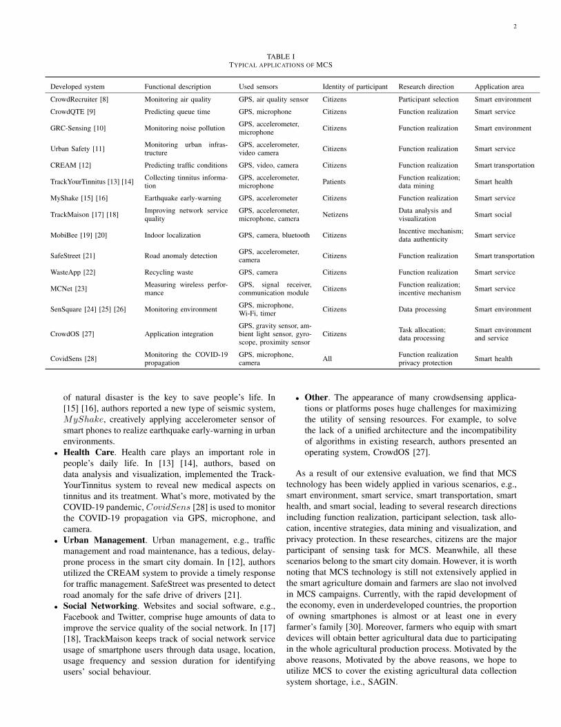
Mobile Crowd Sensing (MCS) is a technique where alarge number of individuals having mobile devices, e.g.,smart phones and wearable equipment, capable of sensing andsharing information of interest, aiming to complete large-scaleand complex sensing tasks with three beneficial characteristics:1) cost-effectiveness, 2) scalability and 3) mobility [4] - [7].Recently, there has been a growing interest on research basedon the existing developed systems that proposes differentapproaches to improve the availability of MCS technology fordifferent application scenarios. The existing typical applica-tions of MCS can be divided into seven parts, as shown inTable I.
• Environmental Monitoring. Sensing environmental in-formation is fundamental for sustainable urban develop-ment and can improve citizens’ quality of life. Aimingto monitor air quality, in [8], authors proposed a frame-work, namely CrowdRecruiter, to minimize incentivepayments by selecting a small number of participantswhile still satisfying probabilistic coverage constraint.GRC-Sensing [10] and Urban Safety [11] were utilizedto monitor noise pollution and information of damagedurban infrastructure, respectively. In [24], the authors firstbuilt the SenSquare system to embrace data availabilityand device heterogeneity. Then, they constantly improvedthe system’s function, e.g., classifying heterogeneous data[25] and designing an easy visual programming plugin[26].
• Living Service. This category can help citizens get abetter life experience. In [9], CrowdQTE was presentedto utilize the sensor-enhanced mobile devices and crowdhuman intelligence to monitor and provide real-timequeue time information for various queuing scenarios.Authors designed Mobibee to realize indoor localizationby inspiring citizens to contribute their data [19] andproposed a truth discovery algorithm to detect falsifieddata [20]. Besides, there are also other services, e.g., recy-cling waste with WasteApp [22] and measuring wirelessperformance with MCNet [23].
• Disaster Prediction. Large magnitude earthquakes cancontinue to kill and injure a large of people, inflictinglasting societal and economic disasters. The prediction
2
TABLE ITYPICAL APPLICATIONS OF MCS
Developed system Functional description Used sensors Identity of participant Research direction Application area
CrowdRecruiter [8] Monitoring air quality GPS, air quality sensor Citizens Participant selection Smart environment
CrowdQTE [9] Predicting queue time GPS, microphone Citizens Function realization Smart service
GRC-Sensing [10] Monitoring noise pollution GPS, accelerometer,microphone Citizens Function realization Smart environment
Urban Safety [11] Monitoring urban infras-tructure
GPS, accelerometer,video camera Citizens Function realization Smart service
CREAM [12] Predicting traffic conditions GPS, video, camera Citizens Function realization Smart transportation
TrackYourTinnitus [13] [14] Collecting tinnitus informa-tion
GPS, accelerometer,microphone Patients Function realization;
data mining Smart health
MyShake [15] [16] Earthquake early-warning GPS, accelerometer Citizens Function realization Smart service
TrackMaison [17] [18] Improving network servicequality
GPS, accelerometer,microphone, camera Netizens Data analysis and
visualization Smart social
MobiBee [19] [20] Indoor localization GPS, camera, bluetooth Citizens Incentive mechanism;data authenticity Smart service
SafeStreet [21] Road anomaly detection GPS, accelerometer,camera Citizens Function realization Smart transportation
WasteApp [22] Recycling waste GPS, camera Citizens Function realization Smart service
MCNet [23] Measuring wireless perfor-mance
GPS, signal receiver,communication module Citizens Function realization;
incentive mechanism Smart service
SenSquare [24] [25] [26] Monitoring environment GPS, microphone,Wi-Fi, timer Citizens Data processing Smart environment
CrowdOS [27] Application integrationGPS, gravity sensor, am-bient light sensor, gyro-scope, proximity sensor
Citizens Task allocation;data processing
Smart environmentand service
CovidSens [28] Monitoring the COVID-19propagation
GPS, microphone,camera All Function realization
privacy protection Smart health
of natural disaster is the key to save people’s life. In[15] [16], authors reported a new type of seismic system,MyShake, creatively applying accelerometer sensor ofsmart phones to realize earthquake early-warning in urbanenvironments.
• Health Care. Health care plays an important role inpeople’s daily life. In [13] [14], authors, based ondata analysis and visualization, implemented the Track-YourTinnitus system to reveal new medical aspects ontinnitus and its treatment. What’s more, motivated by theCOVID-19 pandemic, CovidSens [28] is used to monitorthe COVID-19 propagation via GPS, microphone, andcamera.
• Urban Management. Urban management, e.g., trafficmanagement and road maintenance, has a tedious, delay-prone process in the smart city domain. In [12], authorsutilized the CREAM system to provide a timely responsefor traffic management. SafeStreet was presented to detectroad anomaly for the safe drive of drivers [21].
• Social Networking. Websites and social software, e.g.,Facebook and Twitter, comprise huge amounts of data toimprove the service quality of the social network. In [17][18], TrackMaison keeps track of social network serviceusage of smartphone users through data usage, location,usage frequency and session duration for identifyingusers’ social behaviour.
• Other. The appearance of many crowdsensing applica-tions or platforms poses huge challenges for maximizingthe utility of sensing resources. For example, to solvethe lack of a unified architecture and the incompatibilityof algorithms in existing research, authors presented anoperating system, CrowdOS [27].
As a result of our extensive evaluation, we find that MCStechnology has been widely applied in various scenarios, e.g.,smart environment, smart service, smart transportation, smarthealth, and smart social, leading to several research directionsincluding function realization, participant selection, task allo-cation, incentive strategies, data mining and visualization, andprivacy protection. In these researches, citizens are the majorparticipant of sensing task for MCS. Meanwhile, all thesescenarios belong to the smart city domain. However, it is worthnoting that MCS technology is still not extensively applied inthe smart agriculture domain and farmers are slao not involvedin MCS campaigns. Currently, with the rapid development ofthe economy, even in underdeveloped countries, the proportionof owning smartphones is almost or at least one in everyfarmer’s family [30]. Moreover, farmers who equip with smartdevices will obtain better agricultural data due to participatingin the whole agricultural production process. Motivated by theabove reasons, Motivated by the above reasons, we hope toutilize MCS to cover the existing agricultural data collectionsystem shortage, i.e., SAGIN.
3
In our previous study [31], we just proposed the conceptof AMCS and analyzed three benefits, i.e., cheaper cost,superior scalability, and balance data granularity and excellentflexibility, of using MCS technology to obtain agricultural datathrough comparing with SAGIN. However, our previous workneeds to improve further due to the lack of considering thechallenges caused by integrating MCS with agriculture andthe limitations of AMCS. Thus, in this paper, we will fullyexplore the application of AMCS towards smart agriculture.Compared to traditional MCS applications that mainly focusedon urban areas, AMCS is expected to improve the existingagricultural data collection system and facilitate innovativeagriculture development.
A. Contributions & Organization
The main contributions of our work are:(i) Based on the deployed MCS system, we review the
typical MCS’s applications designed for different urban sce-narios. Comparing with existing agricultural data collectionmethod, we further analyze the advantages and disadvantagesof applying AMCS in the farming scenario.
(i) We analyze the crucial factors of combining MCS withagriculture, including the number of potential users, developedagriculture-related APPs, farmer’s experience, and cooperationbetween agribusiness and farmers;
(iii) We propose six application scenarios and list futureresearch issues of AMCS.
The rest of the paper is structured as follows. SectionII reviews the research status of data collection in smartagriculture and further analyzes the advantages and disadvan-tages through comparing AMCS with existing methods forcollecting agricultural data. Section III examines the crucialfactors of combining AMCS with agriculture. We furtherelaborate on the potential applications and future researchissues of AMCS in section IV and section V, respectively.Finally, conclusions are drawn in Section VI.
II. DATA COLLECTION IN SMART AGRICULTURE
According to the different factors of production, agriculturalindustries, i.e., farming, stockbreeding, forestry, aquaculture,and sideline, serve different products with a similar productionprocess. Therefore, in this section, farming is taken as anexample to investigate data varieties and the existing datacollection system.
A. Data varieties in farming
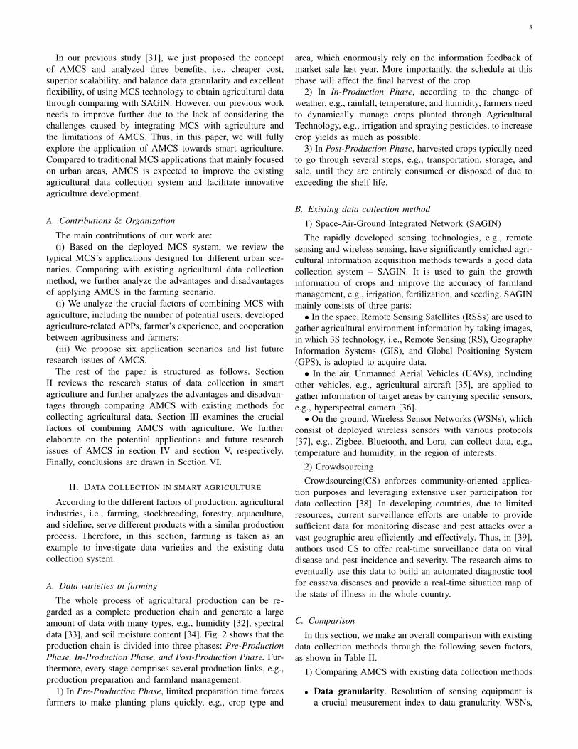
The whole process of agricultural production can be re-garded as a complete production chain and generate a largeamount of data with many types, e.g., humidity [32], spectraldata [33], and soil moisture content [34]. Fig. 2 shows that theproduction chain is divided into three phases: Pre-ProductionPhase, In-Production Phase, and Post-Production Phase. Fur-thermore, every stage comprises several production links, e.g.,production preparation and farmland management.
1) In Pre-Production Phase, limited preparation time forcesfarmers to make planting plans quickly, e.g., crop type and
area, which enormously rely on the information feedback ofmarket sale last year. More importantly, the schedule at thisphase will affect the final harvest of the crop.
2) In In-Production Phase, according to the change ofweather, e.g., rainfall, temperature, and humidity, farmers needto dynamically manage crops planted through AgriculturalTechnology, e.g., irrigation and spraying pesticides, to increasecrop yields as much as possible.
3) In Post-Production Phase, harvested crops typically needto go through several steps, e.g., transportation, storage, andsale, until they are entirely consumed or disposed of due toexceeding the shelf life.
B. Existing data collection method
1) Space-Air-Ground Integrated Network (SAGIN)The rapidly developed sensing technologies, e.g., remote
sensing and wireless sensing, have significantly enriched agri-cultural information acquisition methods towards a good datacollection system – SAGIN. It is used to gain the growthinformation of crops and improve the accuracy of farmlandmanagement, e.g., irrigation, fertilization, and seeding. SAGINmainly consists of three parts:• In the space, Remote Sensing Satellites (RSSs) are used to
gather agricultural environment information by taking images,in which 3S technology, i.e., Remote Sensing (RS), GeographyInformation Systems (GIS), and Global Positioning System(GPS), is adopted to acquire data.• In the air, Unmanned Aerial Vehicles (UAVs), including
other vehicles, e.g., agricultural aircraft [35], are applied togather information of target areas by carrying specific sensors,e.g., hyperspectral camera [36].• On the ground, Wireless Sensor Networks (WSNs), which
consist of deployed wireless sensors with various protocols[37], e.g., Zigbee, Bluetooth, and Lora, can collect data, e.g.,temperature and humidity, in the region of interests.
2) CrowdsourcingCrowdsourcing(CS) enforces community-oriented applica-
tion purposes and leveraging extensive user participation fordata collection [38]. In developing countries, due to limitedresources, current surveillance efforts are unable to providesufficient data for monitoring disease and pest attacks over avast geographic area efficiently and effectively. Thus, in [39],authors used CS to offer real-time surveillance data on viraldisease and pest incidence and severity. The research aims toeventually use this data to build an automated diagnostic toolfor cassava diseases and provide a real-time situation map ofthe state of illness in the whole country.
C. Comparison
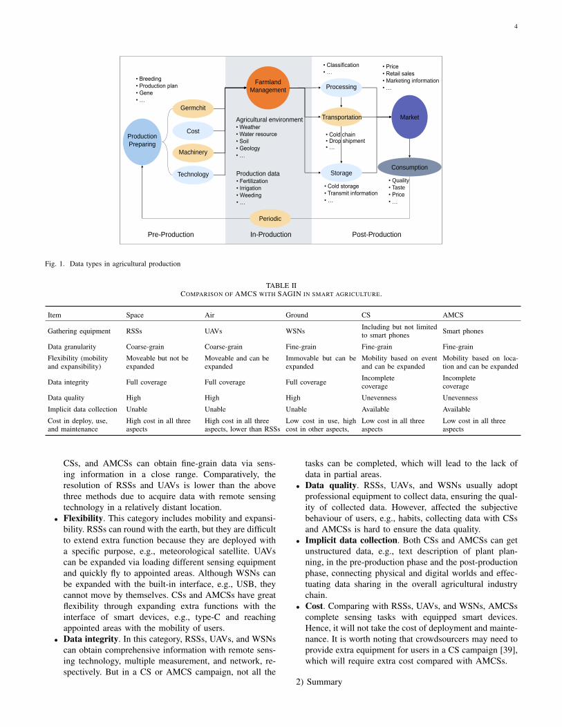
In this section, we make an overall comparison with existingdata collection methods through the following seven factors,as shown in Table II.
1) Comparing AMCS with existing data collection methods
• Data granularity. Resolution of sensing equipment isa crucial measurement index to data granularity. WSNs,
4
Post-ProductionIn-Production
Storage
Market
Consumption
Agricultural environment• Weather
• Water resource
• Soil
• Geology
• …
Production data• Fertilization
• Irrigation
• Weeding
• …
• Breeding
• Production plan
• Gene
• …
• Quality
• Taste
• Price
• …
• Price
• Retail sales
• Marketing information
• …
• Classification
• …
• Cold chain• Drop shipment• …
• Cold storage
• Transmit information
• …
Production
Preparing
Cost
Germchit
Machinery
Technology
Farmland
Management Processing
Transportation
Pre-Production
Periodic
Fig. 1. Data types in agricultural production
TABLE IICOMPARISON OF AMCS WITH SAGIN IN SMART AGRICULTURE.
Item Space Air Ground CS AMCS
Gathering equipment RSSs UAVs WSNs Including but not limitedto smart phones Smart phones
Data granularity Coarse-grain Coarse-grain Fine-grain Fine-grain Fine-grain
Flexibility (mobilityand expansibility)
Moveable but not beexpanded
Moveable and can beexpanded
Immovable but can beexpanded
Mobility based on eventand can be expanded
Mobility based on loca-tion and can be expanded
Data integrity Full coverage Full coverage Full coverage Incompletecoverage
Incompletecoverage
Data quality High High High Unevenness Unevenness
Implicit data collection Unable Unable Unable Available Available
Cost in deploy, use,and maintenance
High cost in all threeaspects
High cost in all threeaspects, lower than RSSs
Low cost in use, highcost in other aspects,
Low cost in all threeaspects
Low cost in all threeaspects
CSs, and AMCSs can obtain fine-grain data via sens-ing information in a close range. Comparatively, theresolution of RSSs and UAVs is lower than the abovethree methods due to acquire data with remote sensingtechnology in a relatively distant location.
• Flexibility. This category includes mobility and expansi-bility. RSSs can round with the earth, but they are difficultto extend extra function because they are deployed witha specific purpose, e.g., meteorological satellite. UAVscan be expanded via loading different sensing equipmentand quickly fly to appointed areas. Although WSNs canbe expanded with the built-in interface, e.g., USB, theycannot move by themselves. CSs and AMCSs have greatflexibility through expanding extra functions with theinterface of smart devices, e.g., type-C and reachingappointed areas with the mobility of users.
• Data integrity. In this category, RSSs, UAVs, and WSNscan obtain comprehensive information with remote sens-ing technology, multiple measurement, and network, re-spectively. But in a CS or AMCS campaign, not all the
tasks can be completed, which will lead to the lack ofdata in partial areas.
• Data quality. RSSs, UAVs, and WSNs usually adoptprofessional equipment to collect data, ensuring the qual-ity of collected data. However, affected the subjectivebehaviour of users, e.g., habits, collecting data with CSsand AMCSs is hard to ensure the data quality.
• Implicit data collection. Both CSs and AMCSs can getunstructured data, e.g., text description of plant plan-ning, in the pre-production phase and the post-productionphase, connecting physical and digital worlds and effec-tuating data sharing in the overall agricultural industrychain.
• Cost. Comparing with RSSs, UAVs, and WSNs, AMCSscomplete sensing tasks with equipped smart devices.Hence, it will not take the cost of deployment and mainte-nance. It is worth noting that crowdsourcers may need toprovide extra equipment for users in a CS campaign [39],which will require extra cost compared with AMCSs.
2) Summary
5
Base Station
Space
Air
Ground
Sensors (WSNs)
UAVs
Aircrafts
Remote Sensing Satellites
Farmer
Smart Devices
(AMCS)
Marketing
Channel ?
Production
Plan?
Planting
Scale?
Expectation?
Crop Farming
Pre-Production
Data: production plan ...
Application:
planning data collection
In-Production
Data: pest; production ...
Application:
pest data collection
Post-Production
Data: consumption ...
Application:
consumption data collection
.....?
Pest
Cultivated
Area
Production.....
Transportation Market
Consumer
Storage
Smart Devices
(AMCS)
Smart Devices
(AMCS)
SAGIN
i-SAGIN
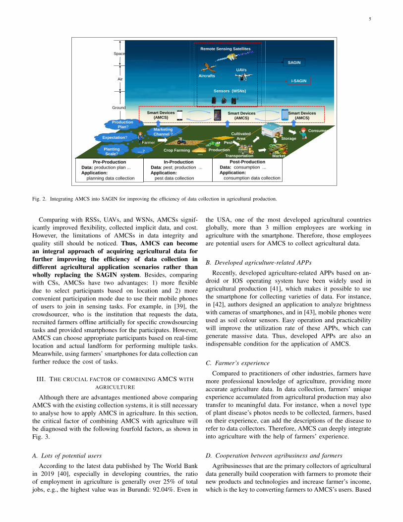
Fig. 2. Integrating AMCS into SAGIN for improving the efficiency of data collection in agricultural production.
Comparing with RSSs, UAVs, and WSNs, AMCSs signif-icantly improved flexibility, collected implicit data, and cost.However, the limitations of AMCSs in data integrity andquality still should be noticed. Thus, AMCS can becomean integral approach of acquiring agricultural data forfurther improving the efficiency of data collection indifferent agricultural application scenarios rather thanwholly replacing the SAGIN system. Besides, comparingwith CSs, AMCSs have two advantages: 1) more flexibledue to select participants based on location and 2) moreconvenient participation mode due to use their mobile phonesof users to join in sensing tasks. For example, in [39], thecrowdsourcer, who is the institution that requests the data,recruited farmers offline artificially for specific crowdsourcingtasks and provided smartphones for the participates. However,AMCS can choose appropriate participants based on real-timelocation and actual landform for performing multiple tasks.Meanwhile, using farmers’ smartphones for data collection canfurther reduce the cost of tasks.
III. THE CRUCIAL FACTOR OF COMBINING AMCS WITHAGRICULTURE
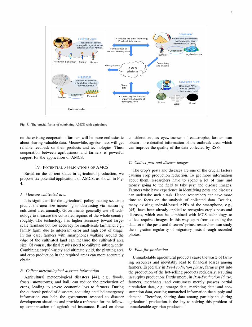
Although there are advantages mentioned above comparingAMCS with the existing collection systems, it is still necessaryto analyse how to apply AMCS in agriculture. In this section,the critical factor of combining AMCS with agriculture willbe diagnosed with the following fourfold factors, as shown inFig. 3.
A. Lots of potential users
According to the latest data published by The World Bankin 2019 [40], especially in developing countries, the ratioof employment in agriculture is generally over 25% of totaljobs, e.g., the highest value was in Burundi: 92.04%. Even in
the USA, one of the most developed agricultural countriesglobally, more than 3 million employees are working inagriculture with the smartphone. Therefore, those employeesare potential users for AMCS to collect agricultural data.
B. Developed agriculture-related APPs
Recently, developed agriculture-related APPs based on an-droid or IOS operating system have been widely used inagricultural production [41], which makes it possible to usethe smartphone for collecting varieties of data. For instance,in [42], authors designed an application to analyze brightnesswith cameras of smartphones, and in [43], mobile phones wereused as soil colour sensors. Easy operation and practicabilitywill improve the utilization rate of these APPs, which cangenerate massive data. Thus, developed APPs are also anindispensable condition for the application of AMCS.
C. Farmer’s experience
Compared to practitioners of other industries, farmers havemore professional knowledge of agriculture, providing moreaccurate agriculture data. In data collection, farmers’ uniqueexperience accumulated from agricultural production may alsotransfer to meaningful data. For instance, when a novel typeof plant disease’s photos needs to be collected, farmers, basedon their experience, can add the descriptions of the disease torefer to data collectors. Therefore, AMCS can deeply integrateinto agriculture with the help of farmers’ experience.
D. Cooperation between agribusiness and farmers
Agribusinesses that are the primary collectors of agriculturaldata generally build cooperation with farmers to promote theirnew products and technologies and increase farmer’s income,which is the key to converting farmers to AMCS’s users. Based
6
AgribusinessesFarmers
Cooperation
Cooperation
Farmers cooperated with
agribusinesses can
become AMCS’ users.
PictureWord Sound
Developed APPs
Developed APPs
can be used to
collect various data.
FarmerFishermanHerdsman Rosser
Potential Users
Thousands of people
engaged in agriculture are
potential users of AMCSs.
FarmlandFarmers
Experience
Farmers’ experience
is helpful for collecting
agricultural data.
Experience
Farmer side
• Collect agricultural data
• Improve the function of
developed APPs
AMCS
platform
• Provide the latest technology
• Feedback information
Share
data
Farm as uses to
conduct sensing tasks
Data mining
and analysisGive guidance
Fig. 3. The crucial factor of combining AMCS with agriculture
on the existing cooperation, farmers will be more enthusiasticabout sharing valuable data. Meanwhile, agribusiness will getreliable feedback on their products and technologies. Thus,cooperation between agribusiness and farmers is powerfulsupport for the application of AMCS.
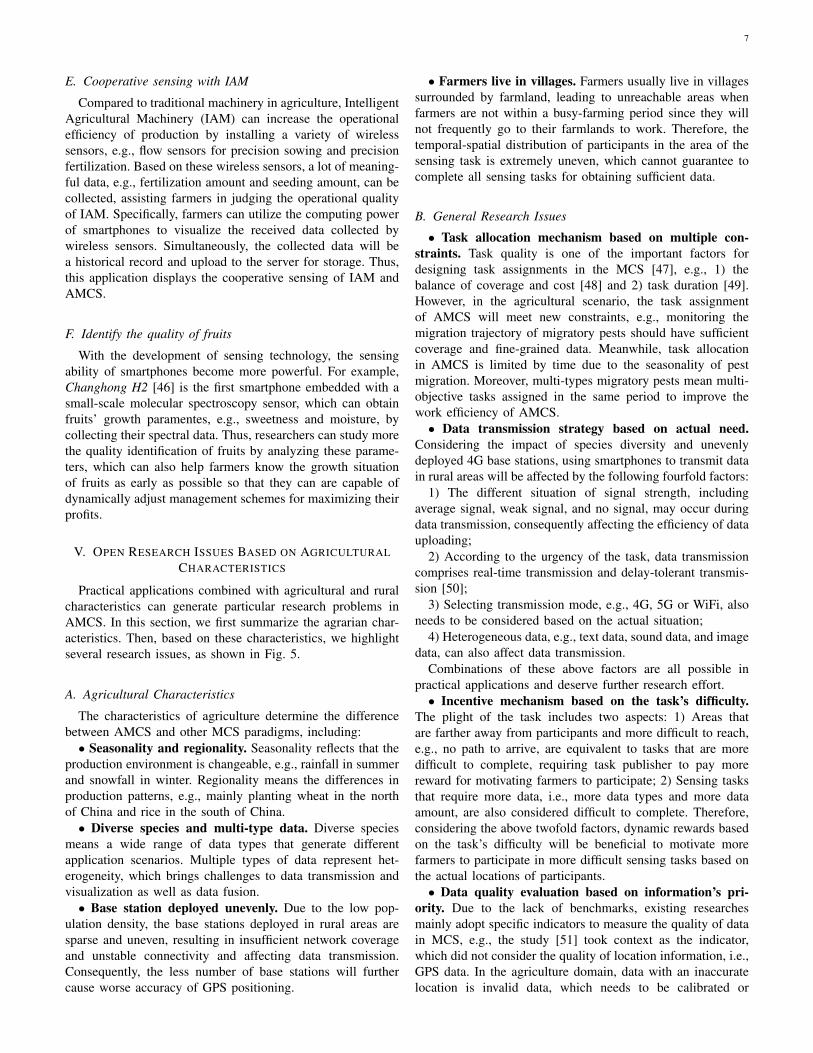
IV. POTENTIAL APPLICATIONS OF AMCS
Based on the current states in agricultural production, wepropose six potential applications of AMCS, as shown in Fig.4.
A. Measure cultivated area
It is significant for the agricultural policy-making sector topredict the area size increasing or decreasing via measuringcultivated area annually. Governments generally use 3S tech-nology to measure the cultivated regions of the whole countryroughly. The technology has higher accuracy toward large-scale farmland but low accuracy for small-scale farmland, e.g.,family farm, due to intolerant error and high cost of usage.In this case, farmers with smartphones walking around theedge of the cultivated land can measure the cultivated areasize. Of course, the final results need to calibrate subsequently.Combining crops’ variety and ultimate yield, the planting areaand crop production in the required areas can more accuratelyobtain.
B. Collect meteorological disaster information
Agricultural meteorological disasters [44], e.g., floods,frosts, snowstorms, and hail, can reduce the production ofcrops, leading to severe economic loss to farmers. Duringthe outbreak period of disasters, acquiring detailed emergencyinformation can help the government respond to disasterdevelopment situations and provide a reference for the follow-up compensation of agricultural insurance. Based on these
considerations, as eyewitnesses of catastrophe, farmers canobtain more detailed information of the outbreak area, whichcan improve the quality of the data collected by RSSs.
C. Collect pest and disease images
The crop’s pests and diseases are one of the crucial factorscausing crop production reduction. To get more informationabout them, researchers have to spend a lot of time andmoney going to the field to take pest and disease images.Farmers who have experience in identifying pests and diseasescan undertake such a task. Hence, researchers can save moretime to focus on the analysis of collected data. Besides,many existing android-based APPs of the smartphone, e.g.,[45], have been already applied to recognize crop’s pests anddiseases, which can be combined with MCS technology tocollect required images. In this way, apart from extending thedata set of the pests and diseases’ prints, researchers can studythe migration regularity of migratory pests through recordedphotos.
D. Plan for production
Unmarketable agricultural products cause the waste of farm-ing resources and inevitably lead to financial losses amongfarmers. Especially in Pre-Production phase, farmers put intothe production of the hot-selling products recklessly, resultingin surplus production. Furthermore, in Post-Production Phase,farmers, merchants, and consumers merely possess partialcirculation data, e.g., storage data, marketing data, and con-sumption data, causing unmatched information the supply anddemand. Therefore, sharing data among participants duringagricultural production is the key to solving this problem ofunmarketable agrarian products.
7
E. Cooperative sensing with IAM
Compared to traditional machinery in agriculture, IntelligentAgricultural Machinery (IAM) can increase the operationalefficiency of production by installing a variety of wirelesssensors, e.g., flow sensors for precision sowing and precisionfertilization. Based on these wireless sensors, a lot of meaning-ful data, e.g., fertilization amount and seeding amount, can becollected, assisting farmers in judging the operational qualityof IAM. Specifically, farmers can utilize the computing powerof smartphones to visualize the received data collected bywireless sensors. Simultaneously, the collected data will bea historical record and upload to the server for storage. Thus,this application displays the cooperative sensing of IAM andAMCS.
F. Identify the quality of fruits
With the development of sensing technology, the sensingability of smartphones become more powerful. For example,Changhong H2 [46] is the first smartphone embedded with asmall-scale molecular spectroscopy sensor, which can obtainfruits’ growth paramentes, e.g., sweetness and moisture, bycollecting their spectral data. Thus, researchers can study morethe quality identification of fruits by analyzing these parame-ters, which can also help farmers know the growth situationof fruits as early as possible so that they can are capable ofdynamically adjust management schemes for maximizing theirprofits.
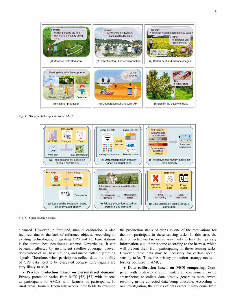
V. OPEN RESEARCH ISSUES BASED ON AGRICULTURALCHARACTERISTICS
Practical applications combined with agricultural and ruralcharacteristics can generate particular research problems inAMCS. In this section, we first summarize the agrarian char-acteristics. Then, based on these characteristics, we highlightseveral research issues, as shown in Fig. 5.
A. Agricultural Characteristics
The characteristics of agriculture determine the differencebetween AMCS and other MCS paradigms, including:
• Seasonality and regionality. Seasonality reflects that theproduction environment is changeable, e.g., rainfall in summerand snowfall in winter. Regionality means the differences inproduction patterns, e.g., mainly planting wheat in the northof China and rice in the south of China.
• Diverse species and multi-type data. Diverse speciesmeans a wide range of data types that generate differentapplication scenarios. Multiple types of data represent het-erogeneity, which brings challenges to data transmission andvisualization as well as data fusion.
• Base station deployed unevenly. Due to the low pop-ulation density, the base stations deployed in rural areas aresparse and uneven, resulting in insufficient network coverageand unstable connectivity and affecting data transmission.Consequently, the less number of base stations will furthercause worse accuracy of GPS positioning.
• Farmers live in villages. Farmers usually live in villagessurrounded by farmland, leading to unreachable areas whenfarmers are not within a busy-farming period since they willnot frequently go to their farmlands to work. Therefore, thetemporal-spatial distribution of participants in the area of thesensing task is extremely uneven, which cannot guarantee tocomplete all sensing tasks for obtaining sufficient data.
B. General Research Issues
• Task allocation mechanism based on multiple con-straints. Task quality is one of the important factors fordesigning task assignments in the MCS [47], e.g., 1) thebalance of coverage and cost [48] and 2) task duration [49].However, in the agricultural scenario, the task assignmentof AMCS will meet new constraints, e.g., monitoring themigration trajectory of migratory pests should have sufficientcoverage and fine-grained data. Meanwhile, task allocationin AMCS is limited by time due to the seasonality of pestmigration. Moreover, multi-types migratory pests mean multi-objective tasks assigned in the same period to improve thework efficiency of AMCS.• Data transmission strategy based on actual need.
Considering the impact of species diversity and unevenlydeployed 4G base stations, using smartphones to transmit datain rural areas will be affected by the following fourfold factors:
1) The different situation of signal strength, includingaverage signal, weak signal, and no signal, may occur duringdata transmission, consequently affecting the efficiency of datauploading;
2) According to the urgency of the task, data transmissioncomprises real-time transmission and delay-tolerant transmis-sion [50];
3) Selecting transmission mode, e.g., 4G, 5G or WiFi, alsoneeds to be considered based on the actual situation;
4) Heterogeneous data, e.g., text data, sound data, and imagedata, can also affect data transmission.
Combinations of these above factors are all possible inpractical applications and deserve further research effort.• Incentive mechanism based on the task’s difficulty.
The plight of the task includes two aspects: 1) Areas thatare farther away from participants and more difficult to reach,e.g., no path to arrive, are equivalent to tasks that are moredifficult to complete, requiring task publisher to pay morereward for motivating farmers to participate; 2) Sensing tasksthat require more data, i.e., more data types and more dataamount, are also considered difficult to complete. Therefore,considering the above twofold factors, dynamic rewards basedon the task’s difficulty will be beneficial to motivate morefarmers to participate in more difficult sensing tasks based onthe actual locations of participants.• Data quality evaluation based on information’s pri-
ority. Due to the lack of benchmarks, existing researchesmainly adopt specific indicators to measure the quality of datain MCS, e.g., the study [51] took context as the indicator,which did not consider the quality of location information, i.e.,GPS data. In the agriculture domain, data with an inaccuratelocation is invalid data, which needs to be calibrated or
8
Farmer:
• My farmland is flooded.
• Taking photos for claim.
Farmer:
• Walking around the field.
• Recording trajectory using
GPS.
Research:
• Who can help me collect these data ?
Framer:
• I can help you
take photos.
Pest Disease
• Brix
• Fruit moistureWireless sensors
Server
database
Sharing data with Smart phone
Farmer Merchant Consumer
(a) Measure cultivated area (b) Collect meteor-disaster information (c) Collect pest and disease images
(d) Plan for production (e) Cooperative sensing with IAM (f) Identify the quality of fruits
Fig. 4. Six potential applications of AMCS
(b) Data transmission strategy
based on actual need
(a) Task assignment based on
multiple constraints
Task assignmentMulti-task
Coverage Fine-grain Time
Constraints
(c) Incentive mechanism based on
task difficulty
Signal strength Event urgency
Transfer modeHeterogeneous data
Data
transfer Incentive
mechanism
Task difficulty
Easy Hard
Reward
MuchLess
Distance and
data volume
Remuneration
allocation
(d) Data quality evaluation based
on information priority
(e) Privacy protection based on
personalized demand(f) Data calibration based on MCS
computing
Data quality
Location Content
First step Second step
I don't want my business data to be
leaked.
Personalized
demand
Mechanism
design
Data error
Improper
operationSensor
error
Phone
model
MCS
computingData
calibration
Fig. 5. Open research issues.
cleansed. However, in farmland, manual calibration is alsoincorrect due to the lack of reference objects. According toexisting technologies, integrating GPS and 4G base stationsis the current best positioning scheme. Nevertheless, it canbe easily affected by insufficient satellite coverage, unevendeployment of 4G base stations, and uncontrollable jammingsignals. Therefore, when participants collect data, the qualityof GPS data need to be evaluated because GPS signals arevery likely to shift.
• Privacy protection based on personalized demand.Privacy protection varies from MCS [52] [53] with citizensas participants to AMCS with farmers as participants. Inrural areas, farmers frequently access their fields to examine
the production status of crops as one of the motivations forthem to participate in these sensing tasks. In this case, thedata collected via farmers is very likely to leak their privacyinformation, e.g., their income according to the harvest, whichwill prevent them from participating in these sensing tasks.However, these data may be necessary for certain specialsensing tasks. Thus, the privacy protection strategy needs tofurther optimize in AMCS.• Data calibration based on MCS computing. Com-
pared with professional equipment, e.g., spectrometer, usingsmartphones to collect data directly generates more errors,resulting in the collected data being unusable. According toour investigation, the causes of data errors mainly come from
9
the following three aspects: 1) caused by the non-standardoperation of the user; 2) caused by the sensor accuracyof a smartphone; 3) caused by sensor accuracy differenceamong different types of smartphones. To ensure the sameaccuracy as that of traditional equipment, smartphones withpowerful computing capacity [41] need to integrate calibrationalgorithms for improving the quality of collected data.
VI. CONCLUSION AND INSIGHT
As a promising paradigm, smart agriculture integrates ad-vanced intelligent technologies, e.g., Big Data and the Internetof Things, into agricultural production, leading to many areasof research and applications, e.g., Agricultural Big Data. How-ever, it still has has significant limitations for data collectionin terms of cost, scalability, data granularity, and flexibility.In this paper, to solve these problems, we propose to applyMCS in the smart agriculture domain. Through comprehensiveanalysis, we find AMCS is feasible to collect agricultural dataand has significant benefits. The insights of this paper arethreefold:
• For farmers, smartphones are not merely the traditionalequipment for communication. Nowadays, they can becomean essential tool for managing agricultural production andincreasing income.
• We update and expand the concept of AMCS for im-proving its applicability. Meanwhile, by considering the largenumber of potential users, developed agriculture-related APPs,farmers experience, and cooperation between agribusiness, wehave justified the feasibility of AMCS.
• Consequently, we explore the potential applications andthe research issues of AMCS for further studies.
ACKNOWLEDGMENT
This work was supported in part by the National NaturalScience Foundation of China under Grant 62072248 and inpart by China Scholarship Council (CSC).
REFERENCES
[1] S. Wolfert, L. Ge, C. Verdouw, and M. J. Bogaardt, “Big data in smartfarming: a review,” Agricultural Systems, Vol. 153, pp. 69-80, Feb. 2017.
[2] J. Hammond, S. Fraval, J. Van Etten, J. G. Suchini, L. Mercado,T. Pagella, and V. D. albuena, “The rural household multi-indicatorsurvey for rapid characterisation of households to inform climate smartagriculture interventions: description and applications in east africa andcentral america.” Agricultural Systems, Vol. 151, pp. 225-233, 2017.
[3] J. Liu, Y. Shi, Z. D. Fadlullah, and N. Kato, “Space-Air-Ground inte-grated network: a survey,” IEEE Communications Surveys & Tutorials,Vol. 20, No. 4, pp. 2714-2741, May. 2018.
[4] H. Ma, D. Zhao, and P. Yuan, “Opportunities in mobile crowd sensing,”IEEE Communications Magazine, Vol. 52, No. 8, pp. 29-35, Aug. 2014.
[5] R K. Ganti, F. Ye, and H. Lei, “Mobile crowd sensing: current state andfuture challenges,” IEEE Communications Magazine, Vol. 49, No. 11,pp. 32-39, Nov. 2011.
[6] L. Wang, D. Zhang, Y. Wang, C. Chen, X. Han, and A. M’hamed,“Sparse mobile crowdsensing: challenges and opportunities.” IEEECommunications Magazine, Vol.54 No. 7, pp. 161-167, 2016.
[7] Z. Zhou, H. Liao, B. Gu, K. M. S. Huq, S. Mumtaz, and J. Rodriguez,“Robust mobile crowd sensing: when deep learning meets edge com-puting.” IEEE Network, Vol. 32, No. 4, pp. 54-60, 2018.
[8] D. Zhang, H. Xiong, and L. Wang, “CrowdRecruiter: selecting partic-ipants for piggyback crowdsensing under probabilistic coverage con-straint,” Proc. 2014 Acm International Joint Conference on Pervasiveand Ubiquitous Computing, pp. 703-714.
[9] J. Wang, Y. Wang, and D. Zhang, “Real-time and generic queuetime estimation based on mobile crowdsensing,” Frontiers of ComputerScience, Vol. 11, No. 1, pp. 49-60, 2017.
[10] W. Zamora, E. Vera, and C. Calafate, “GRC-Sensing: an architecture tomeasure acoustic pollution based on crowdsensing,” Sensors, Vol. 18,No. 8, 2018.
[11] X Zhao, N Wanga, and R Han, “Urban infrastructure safety systembased on mobile crowdsensing,” International Journal of Disaster RiskReduction, Vol. 27, pp. 427-438, 2018.
[12] X. Wang, Z. Ning, and X. Hu, “A city-wide real-time traffic managementsystem: enabling crowdsensing in social internet of vehicles,” IEEECommunications Magazine, Vol. 56, No. 9, pp. 19-25, Sept. 2018,
[13] R. Pryss, M. Reichert, and B. Langguth, “Mobile crowd sensing ser-vices for tinnitus assessment, therapy, and research,” Proc. 2015 IEEEInternational Conference on Mobile Services, pp. 352-359.
[14] R. Pryss, W. Schlee, and B. Hoppenstedt, “Applying machine learning todaily-life data from the TrackYourTinnitus mobile health crowdsensingplatform to predict the mobile operating system used with high accuracy:longitudinal observational study,” Journal of Medical Internet Research,Vol. 22, No. 6, 2020.
[15] Q. Kong, R M. Allen, and L. Schreier, “MyShake: a smartphone seismicnetwork for earthquake early warning and beyond,” Science Advances,Vol. 2, No. 2, Feb. 2016.
[16] Q. Kong, A. Inbal, and R. M. Allen, “Machine learning aspects of theMyShake global smartphone seismic network” Seismological ResearchLetters, Vol. 90, No. 2A, PP. 546-552, 2019.
[17] F. Anjomshoa, M. Catalfamo, and D. Hecker, “Mobile behaviometricframework for sociability assessment and identification of smartphoneusers,” Proc. 2016 IEEE Symposium on Computers and Communication,pp. 1084-1089.
[18] Z. Rauen, F. Anjomshoa, B. Kantarci, “Empowering human-computerinteraction in securing smartphone sensing,” Proc. 2018 IEEE 23rdInternational Workshop on Computer Aided Modeling and Design ofCommunication Links and Networks (CAMAD), pp. 1-6.
[19] Q. Xu, R. Zheng, “Mobibee: A mobile treasure hunt game for location-dependent fingerprint collection,” Proc. 2016 ACM International JointConference on Pervasive and Ubiquitous Computing: Adjunct, pp.1472-1477.
[20] Q. Xu, R. Zheng, and E. Tahoun, “Detecting location fraud in indoormobile crowdsensing,” Proc. 2017 the First ACM Workshop on MobileCrowdsensing Systems and Applications, pp. 44-49.
[21] V. Singh, D. Chander, and U. Chhaparia, “SafeStreet: an automatedroad anomaly detection and early-warning system using mobile crowd-sensing,” Proc. 2018 10th International Conference on CommunicationSystems & Networks (COMSNETS), pp. 549-552.
[22] D. Bonino, M. T. D. Alizo, and C. Pastrone, “WasteApp: smarter wasterecycling for smart citizens,” Proc. 2016 International MultidisciplinaryConference on Computer and Energy Science (SpliTech), pp. 1-6.
[23] S. Rosen, S. Lee, and J. Lee, “MCNet: crowdsourcing wireless per-formance measurements through the eyes of mobile devices,” IEEECommunications Magazine, Vol. 52, No. 10, pp. 86-91, 2014.
[24] F. Montori, L. Bedogni, and A. Di Chiappari, “SenSquare: a mobilecrowdsensing architecture for smart cities,” Proc. 2016 IEEE 3rd WorldForum on Internet of Things (WF-IoT), pp. 536-541.
[25] F. Montori, L. Bedogni, and L.Bononi, “A collaborative internet ofthings architecture for smart cities and environmental monitoring,” IEEEInternet of Things Journal, Vol.5, No. 2, pp. 592-605, 2017.
[26] F. Montori, L. Bedogni, and G. Iselli, “Delivering iot smart servicesthrough collective awareness, mobile crowdsensing and open data,”Prof. 2020 IEEE International Conference on Pervasive Computing andCommunications Workshops (PerCom Workshops), pp. 1-6.
[27] Y. Liu, Z. Yu, and B. Guo, “CrowdOS: a ubiquitous operating systemfor crowdsourcing and mobile crowd sensing,” IEEE Transactions onMobile Computing, 2020. (Early Access)
[28] M. T. Rashid, D. Wang, “CovidSens: a vision on reliable social sensingfor COVID-19,” Artificial Intelligence Review, Vol. 54, No. 1, pp. 1-25,2021.
[29] G. Yang, S. He, Z. Shi, and J. Chen, “Promoting cooperation by thesocial incentive mechanism in mobile crowdsensing,” IEEE Communi-cations Magazine, Vol. 55, No. 3, pp. 86-92, 2017.
[30] O. A. Ogbeide and I. Ele, “Smallholder farmers and mobile phonetechnology in Sub-Sahara Agriculture,” Mayfair Journal of Informationand Technology Management in Agriculture, Vol. 1, No. 1, pp. 1-19,2015.
[31] Y. Sun, W. Ding, L. Shu, K. Huang, K. Li, Y. Zhang, and Z. Huo,“Poster: when mobile crowd sensing meets smart agriculture,” Proc.2019 Acm Turing Celebration Conference-China, No. 49.
10
[32] S. R. Prathibha, A. Hongal, and M. P. Jyothi, “IoT based monitoringsystem in smart agriculture,” Proc. 2017 International Conferenceon Recent Advances in Electronics and Communication Technology(ICRAECT), pp. 81-84, March. 2017.
[33] L. Ravikanth, D. S. Jayas, N. D. White, P. G. Fields, and D. W.Sun, “Extraction of spectral information from hyperspectral data andapplication of hyperspectral imaging for food and agricultural products,”Food and Bioprocess Technology, Vol. 10, No. 1, pp. 1-33, 2017.
[34] D. D. Alexakis, F. D. K. Mexis, A. E. K. Vozinaki, I. N. Daliakopoulos,and I. K.Tsanis, “Soil moisture content estimation based on sentinel-1 and auxiliary earth observation products: a hydrological approach,”Sensors, Vol. 17, No. 6, pp. 1455, 2017.
[35] E. R. Hunt Jr and C. S. Daughtry, “What good are unmanned aircraftsystems for agricultural remote sensing and precision agriculture?”International Journal of Remote Sensing, Vol. 39, No. 15, pp. 5345-5376, 2018.
[36] R. Nsi, E. Honkavaara, M. Blomqvist, P. Lyytikinen-Saarenmaa, T.Hakala, N. Viljanen, and M. Holopainen, “Remote sensing of barkbeetle damage in urban forests at individual tree level using a novelhyperspectral camera from UAV and aircraft,” Urban Forestry andUrban Greening, Vol. 30, pp. 72-83, 2018.
[37] D. Shinghal and N. Srivastava,“Wireless sensor networks in agriculture:for potato farming,” Neelam, Wireless Sensor Networks in Agriculture:For Potato Farming, Sept, 2017.
[38] A. Ghezzi, D. Gabelloni, A. Martini, and A. Natalicchio, “Crowdsourc-ing: a review and suggestions for future research,” International Journalof Management Reviews, Vol. 20, No. 2, pp. 343-363, 2018.
[39] D. Mutembesa, C. Omongo, and E. Mwebaze, “Crowdsourcing real-time viral disease and pest information: A case of nation-wide cassavadisease surveillance in a developing country,” Proc. 2018 Sixth AAAIConference on Human Computation and Crowdsourcing, June. 2018.
[40] “Employment in agriculture country rankings”,https://www.theglobaleconomy.com/rankings/, accessed: 2020-01-23.
[41] S. Pongnumkul, P. Chaovalit, and N. Surasvadi, “Applications ofsmartphone-based sensors in agriculture: a systematic review of re-search,” Journal of Sensors, 2015.
[42] S. Sumriddetchkajorn, “How optics and photonics is simply appliedin agriculture?” Proc. 2013 International Conference on PhotonicsSolutions, Vol. 8883, June. 2013.
[43] L. Gomez-Robledo, N. L opez-Ruiz, M. Melgosa, A. J. Palma, and L. F.Capitan-Vallvey, “Using the mobile phone as munsell soil-colour sensor:an experiment under controlled illumination conditions,” Computers andElectronics in Agriculture, Vol. 99, pp. 200-208, 2013.
[44] X. Yu, X. Yu, and Y. Lu, “Evaluation of an agricultural meteorologicaldisaster based on multiple criterion decision making and evolutionaryalgorithm,” International Journal of Environmental Research and PublicHealth, Vol. 15, No. 4, pp. 612, 2018.
[45] Q. Yao, C. Zhang, Z Wang, B. Yang, and J. Tang, “Design and exper-iment of agricultural diseases and pest image collection and diagnosissystem with distributed and mobile device,” Transactions of the ChineseSociety of Agricultural Engineering, Vol. 33, pp. 184-191, 2017.
[46] “Phone with ’infrared vision’ knows how fat you are (hands-on),”https://www.cnet.com/reviews/changhong-h2-preview/, accessed: 2017-01-06.
[47] W. Gong, B. Zhang, C. Li,“Task assignment in mobile crowdsensing:Present and future directions,” IEEE Network, Vol. 32, No. 4, pp. 100-107, 2018.
[48] H. Xiong, D. Zhang, G. Chen, L. Wang, V. Gauthier, and L. Barnes,“iCrowd: Near-optimal task allocation for piggyback crowdsensing,”IEEE Transactions on Mobile Computing, Vol. 15, No. 8, pp. 2010-2022, 2015.
[49] M. Xiao, J. Wu, L. Huang, R. Cheng, and Y. Wang, “Online taskassignment for crowdsensing in predictable mobile social networks,”IEEE Transactions on Mobile Computing, Vol. 16, No. 8, pp. 2306-2320, 2016.
[50] B. Guo, Y. Liu, W. Wu, Z. Yu, and Q. Han, “Activecrowd: A frameworkfor optimized multitask allocation in mobile crowdsensing systems”,IEEE Transactions on Human-Machine Systems, Vol. 47, No. 3, pp.392-403, 2016.
[51] S. Liu, Z. Zheng, F. Wu, S. Tang, and G. Chen, “Context-aware dataquality estimation in mobile crowdsensing,” Proc. 2017 Conference onComputer Communications, pp. 1-9.
[52] D. He, S. Chan, and M. Guizani, “User privacy and data trustworthinessin mobile crowd sensing,” IEEE Wireless Communications, Vol. 22, No.1, pp. 28-34, 2015.
[53] M. Pouryazdan and B. Kantarci, “The smart citizen factor in trustworthysmart city crowdsensing,” IT Professional, Vol. 18, No. 4, pp. 26-33,2016.
[54] B. Guo, Z. Wang, Z. Yu, Y. Wang, N. Yen, R. Huang, and X. Zhou, “Mo-bile crowd sensing and computing: The review of an emerging human-powered sensing paradigm,” Proc. 2015 ACM Computing Surveys, pp.7.
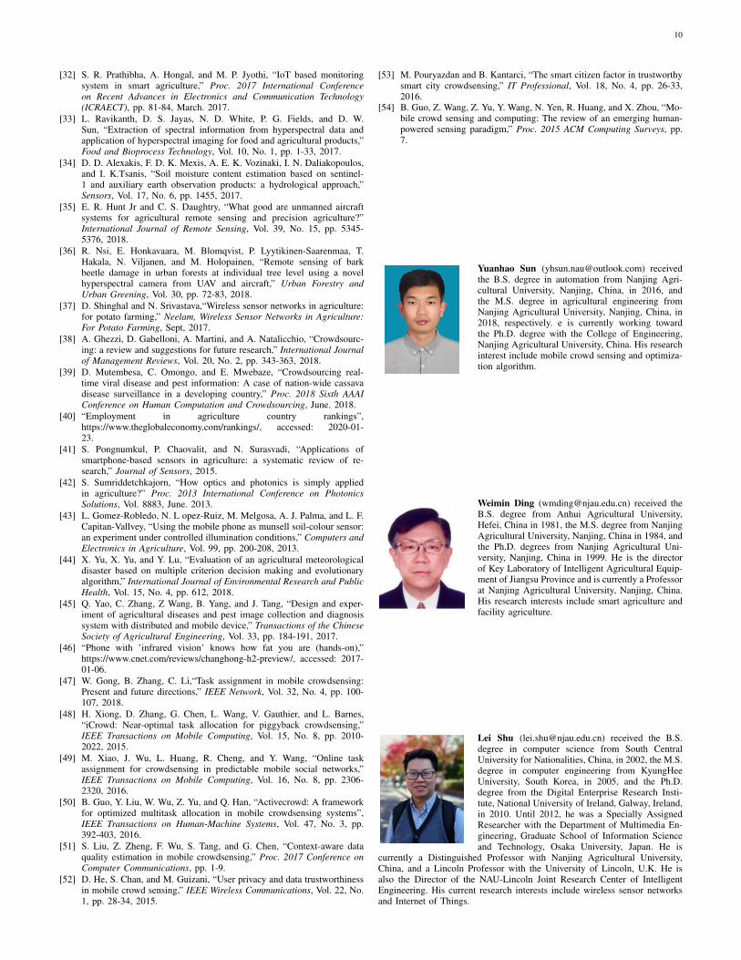
Yuanhao Sun ([email protected]) receivedthe B.S. degree in automation from Nanjing Agri-cultural University, Nanjing, China, in 2016, andthe M.S. degree in agricultural engineering fromNanjing Agricultural University, Nanjing, China, in2018, respectively. e is currently working towardthe Ph.D. degree with the College of Engineering,Nanjing Agricultural University, China. His researchinterest include mobile crowd sensing and optimiza-tion algorithm.
Weimin Ding ([email protected]) received theB.S. degree from Anhui Agricultural University,Hefei, China in 1981, the M.S. degree from NanjingAgricultural University, Nanjing, China in 1984, andthe Ph.D. degrees from Nanjing Agricultural Uni-versity, Nanjing, China in 1999. He is the directorof Key Laboratory of Intelligent Agricultural Equip-ment of Jiangsu Province and is currently a Professorat Nanjing Agricultural University, Nanjing, China.His research interests include smart agriculture andfacility agriculture.
Lei Shu ([email protected]) received the B.S.degree in computer science from South CentralUniversity for Nationalities, China, in 2002, the M.S.degree in computer engineering from KyungHeeUniversity, South Korea, in 2005, and the Ph.D.degree from the Digital Enterprise Research Insti-tute, National University of Ireland, Galway, Ireland,in 2010. Until 2012, he was a Specially AssignedResearcher with the Department of Multimedia En-gineering, Graduate School of Information Scienceand Technology, Osaka University, Japan. He is
currently a Distinguished Professor with Nanjing Agricultural University,China, and a Lincoln Professor with the University of Lincoln, U.K. He isalso the Director of the NAU-Lincoln Joint Research Center of IntelligentEngineering. His current research interests include wireless sensor networksand Internet of Things.
11
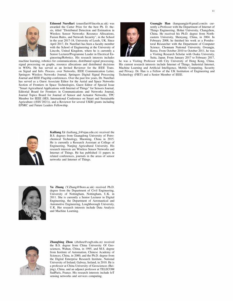
Edmond Nurellari ([email protected]) wasawarded the Carter Prize for the best Ph. D. the-sis, titled ”Distributed Detection and Estimation inWireless Sensor Networks: Resource Allocations,Fusion Rules, and Network Security”, in the Schoolin the year 2017-18, University of Leeds, UK. SinceApril 2017, Dr. Nurellari has been a faculty memberwith the School of Engineering at the University ofLincoln, United Kingdom, where he is currently aSenior Lecturer/Programme Leader in Electrical En-gineering/Robotics. His research interests includes
machine learning, robotics for communications, distributed signal processing,signal processing on graphs, resource allocations and distributed decisionsin WSNs. He has served as an Invited Reviewer for the IEEE Trans.on Signal and Info. Process. over Networks, IEEE Communication Letter,Springers Wireless Networks Journal, Springers Digital Signal ProcessingJournal and IEEE Flagship conferences. Over the past few years, Dr. Nurellarihas served as a Guest Associate Editor for the Aerial and Space NetworksSection of Frontiers in Space Technologies, Guest Editor of Special Issue”Smart Agricultural Applications with Internet of Things” for Sensors Journal,Editorial Board for Frontiers in Communications and Networks Journal,Journal Topics Board for Journal of Sensor and Actuator Networks, TPCMember for IEEE iSES, International Conference on Smart and SustainableAgriculture ((SSS’2021)), and a Reviewer for several UKRI grants includingEPSRC and Future Leaders Fellowship.
Kailiang Li (kailiang [email protected]) received theB.S. degrees from Guangdong University of Petro-chemical Technology, Maoming, China in 2015.He is currently a Research Assistant at College ofEngineering, Nanjing Agricultural University. Hisresearch interests are Wireless Sensor Networks andInternet of Things. He has published 11 papers inrelated conferences, journals in the areas of sensornetworks and Internet of Things.
Yu Zhang ([email protected]) received Ph.D.degree from the Department of Civil Engineering,University of Nottingham, Nottingham, U.K. in2011. She is currently a Senior Lecturer in DigitalEngineering, the Department of Aeronautical andAutomotive Engineering, Loughborough University,U.K. Her research interests include Data Analysisand Machine Learning.
Zhangbing Zhou ([email protected]) receivedthe B.S. degree from China University Of Geo-sciences, Wuhan, China, in 1995, and M.S. degreefrom Institute of Automation, Chinese Academy ofSciences, China, in 2000, and the Ph.D. degree fromthe Digital Enterprise Research Institute, NationalUniversity of Ireland, Galway, Ireland, in 2010. He isa professor at China University of Geosciences (Bei-jing), China, and an adjunct professor at TELECOMSudParis, France. His research interests include loTsensing networks and services computing.
Guangjie Han ([email protected])is cur-rently a Professor with the Department of Internet ofThings Engineering, Hohai University, Changzhou,China. He received his Ph.D. degree from North-eastern University, Shenyang, China, in 2004. InFebruary 2008, he finished his work as a Postdoc-toral Researcher with the Department of ComputerScience, Chonnam National University, Gwangju,Korea. From October 2010 to October 2011, he wasa Visiting Research Scholar with Osaka University,Suita, Japan. From January 2017 to February 2017,
he was a Visiting Professor with City University of Hong Kong, China.His current research interests include Internet of Things, Industrial Internet,Machine Learning and Artificial Intelligence, Mobile Computing, Securityand Privacy. Dr. Han is a Fellow of the UK Institution of Engineering andTechnology (FIET) and a Senior Member of IEEE.