Old Colony Ave Case PDF
7
Case for Bike Route: Old Colony Avenue, South Boston 1.0 Overview [Bikeways for Everybody] 1.1 Introduction: The Boston Cyclists Union is a nonprofit organization acting as a catalyst in the process of designing and implementing Boston’s bike routes. People use bikes as a way to get places faster, avoid traffic, and for recreational use. Boston’s bike infrastructure is not up yet up to the standards of cities such as San Francisco or Austin, Texas, however, steps are being made in the right direction. Thus far we have a multitude of wins that include the most recent cycle track victory on Commonwealth Ave, and the Casey Arborway reconstruction project. In the 30year Boston Bike Network Plan, cycle tracks are proposed on many of Boston’s main streets, including Old Colony Ave from the Broadway Tstop to the JFK/UMass T stop. 1.2 Background: Bikeways for Everybody (B4E) is a campaign project born through the BCU with the intent to connect at least 60 miles of bike routes in Boston. The five crosstown bikeways will span through Boston, Brookline, Cambridge and Somerville, connecting existing bike routes with bike routes in the ideastage, designstage, and constructionunderway stage. With the existing designated bike lanes, the Bike Union is planning and promoting the design of cycle tracks to make commuting safer and easier. We want to see each crosstown route be made continuous so that bicyclists may ride and commute safely down roads with designated bike lanes. Focusing on these major commuting routes is the quickest and cheapest way for Boston to accomplish a connective network. Figure A
-
Upload
holly-clarke -
Category
Documents
-
view
134 -
download
0
Transcript of Old Colony Ave Case PDF
Case for Bike Route: Old Colony Avenue, South Boston
1.0 Overview [Bikeways for Everybody] 1.1 Introduction: The Boston Cyclists Union is a non-‐profit organization acting
as a catalyst in the process of designing and implementing Boston’s bike routes. People use bikes as a way to get places faster, avoid traffic, and for recreational use. Boston’s bike infrastructure is not up yet up to the standards of cities such as San Francisco or Austin, Texas, however, steps are being made in the right direction. Thus far we have a multitude of wins that include the most recent cycle track victory on Commonwealth Ave, and the Casey Arborway reconstruction project. In the 30-‐year Boston Bike Network Plan, cycle tracks are proposed on many of Boston’s main streets, including Old Colony Ave from the Broadway T-‐stop to the JFK/UMass T-‐stop.
1.2 Background: Bikeways for Everybody (B4E) is a campaign project born
through the BCU with the intent to connect at least 60 miles of bike routes in Boston. The five crosstown bikeways will span through Boston, Brookline, Cambridge and Somerville, connecting existing bike routes with bike routes in the idea-‐stage, design-‐stage, and construction-‐underway stage. With the existing designated bike lanes, the Bike Union is planning and promoting the design of cycle tracks to make commuting safer and easier. We want to see each crosstown route be made continuous so that bicyclists may ride and commute safely down roads with designated bike lanes. Focusing on these major commuting routes is the quickest and cheapest way for Boston to accomplish a connective network.
Figure A
Connecting Boston’s bikeways will bring together people from all of Boston’s, and the Greater Boston area’s, diverse neighborhoods. Cycling brings awareness to parts of the city otherwise surpassed by car-‐drivers. B4E is a network that benefits everyone because it is an affordable mode of transportation. It will benefit local business, as passer-‐by bicyclists are more readily willing to explore new places. Studies of protected bike lanes in NYC prove increased retail sales. On the health scale, bicycling is a form of exercise and environmental justice. It controls weight and prevents cardiovascular disease while decreasing gas consumption, improving the city’s environmental nature. A healthier lifestyle is an unprecedented outcome of the B4E project.
1.3 Harborline Bikeway: The
Harborline Bikeway is one of the five cross-‐town routes in B4E. It spans from the Mystic River Path to the Truman Parkway and Brush Hill Road. This is a total of 17.3 miles, with 22.54% of the bike routes completed and the other 77.46% in working phases. Our ideal outlook for the Harborline Bikeway is to be fully completed by 2025, in time for the Boston Bike Network’s 30-‐year plan.
1.4 Figure B: Old Colony Ave
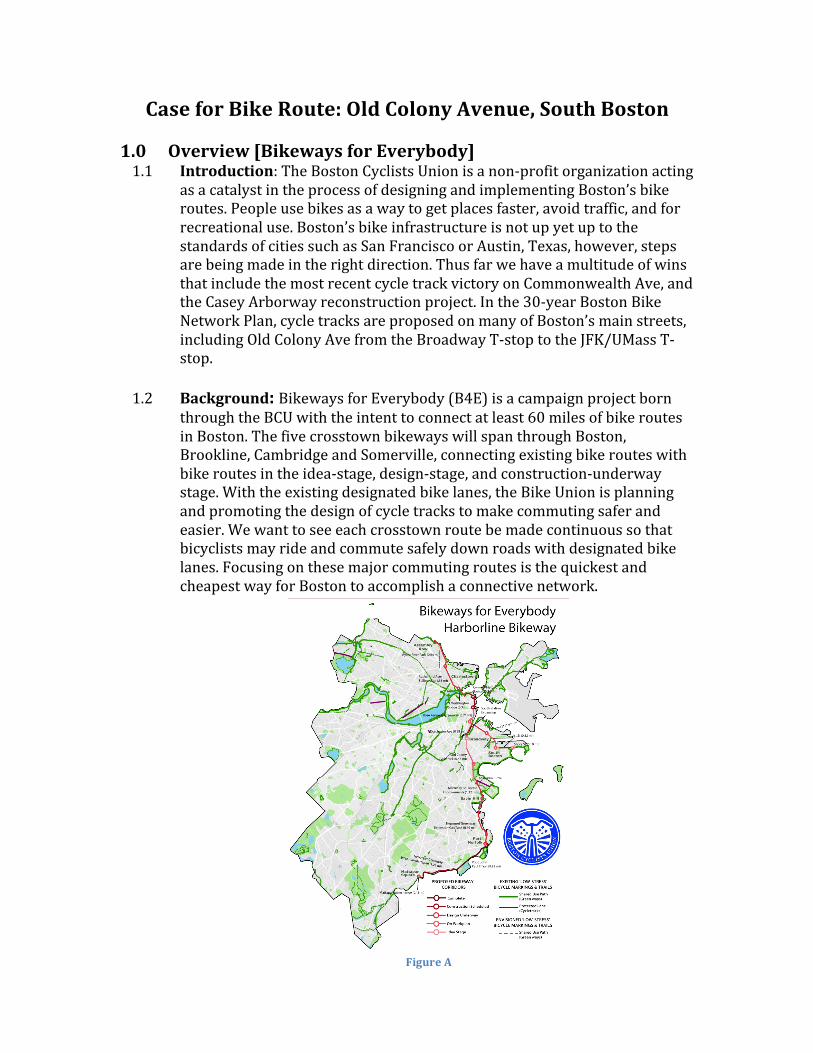
1.5 Objective: To create road
infrastructure that is safe to bike on. In this section of South Boston there is very little access to affordable transportation, with the closest train stops at UMass/JFK and Broadway along the Red Line and bus routes 5 and 16. Neither bus routes nor train make Old Colony Ave easily accessible. As a result, this case introduces the design for a “Road Diet”, a technique to reduce the number of travel lanes in order to achieve ease of transportation. This means less traffic and promotion of a bikeable and walkable route. The proposed design for the cycle track would span from the intersection of Dorchester Ave and Old Colony Ave, and continue south bound to the rotary at Moakley Park.
Figure B: Section of Old Colony Ave in South Boston that this case focuses on
2.0 Analysis of Existing Conditions
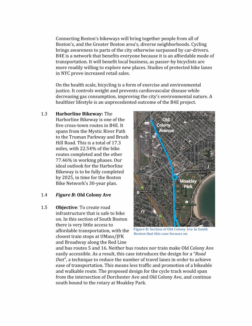
2.1 Location: Old Colony Ave [42.336555, -‐71.056021] @ intersection of Old Colony Ave and C St.
2.2 Measurements: Sidewalk [8ft] – Parking [7’10”] – Lane 1 [11’6”] – Lane 2 [10’5”] Fog Lines [6’6”] -‐ Median Curb [4’10”] Lane 3 [10’3”] – Lane 4 [11’] – Parking [8’] – Sidewalk [7’2”]
2.3 Figure C: Bicycle Crash
Map & Data 2.4 Figure D: MassHighway
Intersection Crash Rate Worksheet
2.4.1 A Northeastern Study in
2009 calculated the number of cars and crashes at the rotary connecting Old Colony Ave, Columbia Road, and Preble Street. The total daily approach volume is 32,010 cars. The average number of crashes per year is 7.67. This rotary is important in the discussion of Old Colony Ave because it connects Moakley Park with the north side of the Avenue. Pedestrians and cyclists alike will use this rotary so it is of high priority to put in a one-‐way cycle track for safety and ease of transit.
Figure C: Stars outlined in green represent bike collisions that occurred between 2009 and 2012
Rotary
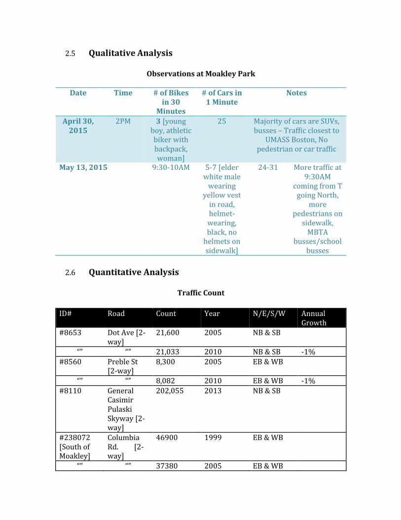
2.5 Qualitative Analysis
Observations at Moakley Park
Date Time # of Bikes in 30
Minutes
# of Cars in 1 Minute
Notes
April 30, 2015
2PM 3 [young boy, athletic biker with backpack, woman]
25 Majority of cars are SUVs, busses – Traffic closest to
UMASS Boston, No pedestrian or car traffic
May 13, 2015 9:30-‐10AM 5-‐7 [elder white male wearing
yellow vest in road, helmet-‐wearing, black, no helmets on sidewalk]
24-‐31 More traffic at 9:30AM
coming from T going North,
more pedestrians on sidewalk, MBTA
busses/school busses
2.6 Quantitative Analysis
Traffic Count
ID# Road Count Year N/E/S/W Annual
Growth #8653 Dot Ave [2-‐
way] 21,600 2005 NB & SB
“” “” 21,033 2010 NB & SB -‐1% #8560 Preble St
[2-‐way] 8,300 2005 EB & WB
“” “” 8,082 2010 EB & WB -‐1% #8110 General
Casimir Pulaski Skyway [2-‐way]
202,055 2013 NB & SB
#238072 [South of Moakley]
Columbia Rd. [2-‐way]
46900 1999 EB & WB
“” “” 37380 2005 EB & WB
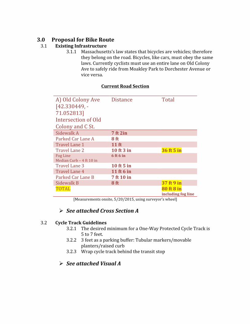
3.0 Proposal for Bike Route 3.1 Existing Infrastructure
3.1.1 Massachusetts’s law states that bicycles are vehicles; therefore they belong on the road. Bicycles, like cars, must obey the same laws. Currently cyclists must use an entire lane on Old Colony Ave to safely ride from Moakley Park to Dorchester Avenue or vice versa.
Current Road Section
A) Old Colony Ave [42.330449, -‐71.052813] Intersection of Old Colony and C St.
Distance Total
Sidewalk A 7 ft 2in Parked Car Lane A 8 ft Travel Lane 1 11 ft Travel Lane 2 10 ft 3 in 36 ft 5 in Fog Line Median Curb – 4 ft 10 in
6 ft 6 in
Travel Lane 3 10 ft 5 in Travel Lane 4 11 ft 6 in Parked Car Lane B 7 ft 10 in Sidewalk B 8 ft 37 ft 9 in TOTAL 80 ft 8 in
including fog line [Measurements onsite, 5/20/2015, using surveyor’s wheel]
! See attached Cross Section A
3.2 Cycle Track Guidelines
3.2.1 The desired minimum for a One-‐Way Protected Cycle Track is 5 to 7 feet.
3.2.2 3 feet as a parking buffer: Tubular markers/movable planters/raised curb
3.2.3 Wrap cycle track behind the transit stop
! See attached Visual A
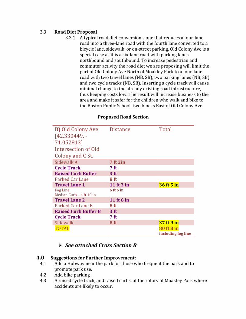
3.3 Road Diet Proposal 3.3.1 A typical road diet conversion s one that reduces a four-‐lane
road into a three-‐lane road with the fourth lane converted to a bicycle lane, sidewalk, or on-‐street parking. Old Colony Ave is a special case as it is a six-‐lane road with parking lanes northbound and southbound. To increase pedestrian and commuter activity the road diet we are proposing will limit the part of Old Colony Ave North of Moakley Park to a four-‐lane road with two travel lanes (NB, SB), two parking lanes (NB, SB) and two cycle tracks (NB, SB). Inserting a cycle track will cause minimal change to the already existing road infrastructure, thus keeping costs low. The result will increase business to the area and make it safer for the children who walk and bike to the Boston Public School, two blocks East of Old Colony Ave.
Proposed Road Section
B) Old Colony Ave [42.330449, -‐71.052813] Intersection of Old Colony and C St.
Distance Total
Sidewalk A 7 ft 2in Cycle Track 7 ft Raised Curb Buffer 3 ft Parked Car Lane 8 ft Travel Lane 1 11 ft 3 in 36 ft 5 in Fog Line Median Curb – 4 ft 10 in
6 ft 6 in
Travel Lane 2 11 ft 6 in Parked Car Lane B 8 ft Raised Curb Buffer B 3 ft Cycle Track 7 ft Sidewalk 8 ft 37 ft 9 in TOTAL 80 ft 8 in
including fog line
! See attached Cross Section B 4.0 Suggestions for Further Improvement: 4.1 Add a Hubway near the park for those who frequent the park and to
promote park use. 4.2 Add bike parking 4.3 A raised cycle track, and raised curbs, at the rotary of Moakley Park where
accidents are likely to occur.
5.0 Conclusion: The area along Old Colony Avenue through South Boston is not
a safe or easy place to bike. Without a designated bike lane, bicyclists must be doubly aware as they are dodging 4,000 pounds of metal. Old Colony Ave is a residential area with kids and families playing in the streets and around Moakley Park. The four-‐lane road that turns into a six-‐lane road towards JFK/UMass creates a high-‐hazard zone for pedestrians and bikers alike. Not only will a bike route along Old Colony Ave make a safer transit environment, but also can enhance business growth in the area. As we know, economies grow and thrive based on the business that exists and the public’s interest in that area. South Boston is a working-‐class neighborhood. The businesses that line the streets of Old Colony Ave include D’Angelo, Dunkin Donuts, Domino’s Pizza, Castle Self-‐Storage, mirror and sign shops, and a few bars, diners, and liquor shops. Compare this area to across route 3A where the average pedestrian or biker sees a Whole Foods, boutique coffee shops, libraries, and medical centers. There is easier access to public transport (i.e. busses, trains, and Hubway). Above all there are designated bike lanes or shared bike paths that extend through the South End.
If we look at the South End’s growth over the past ten years we see a dramatic improvement in the economic environment that is a result of the ease of transit. South Boston has the resources and research to mimic the steps that the South End took to change the transportation environment. With a bike lane, South Boston can become a place that is easily accessible for people and reducing car traffic. In 2012 the City of Boston created a $1.8 billion for a 5-‐year capital plan, which includes $217 million for new project authorization. Funds for a bike route case like this could also come from the Browne Fund, the TIGER Grant, Mission Main Street Grants, and the Green Lane Project by People for Bikes. At the end of the day, Bikeways for Everybody, the Harborline Bikeway, and specifically this section on Old Colony Avenue will make people feel happier, more confident, and more comfortable to bike. This design is a suggestion to speed up the process of redesign and reconstruction of Old Colony Avenue in South Boston. We are open to collaboration with MassDOT and other city transportation committees. The sooner we can begin this project, the closer we are to our vision of bike routes for 2030.
Resources 1. MassDOT Highway, Transportation Data Management System,
http://mhd.ms2soft.com/tcds/tsearch.asp?loc=Mhd&mod= 2. Conroy, Hipp, Pacileo, Ruby, Old Colony Bikeway Report, 4/23/2009. 3. http://www.ctps.org/map/www/apps/lrtpNeedsAssessmentApp/index.html
http://www.ctps.org/apps/bike_ped5/bike_ped_countloc_detail.cfm?loc_id=20102&html_municipality=Boston&html_facility_name=998&html_date=02-‐JAN-‐1900