Okanagan TSA Predictive Ecosystem Mapping (PEM) Compilation Project ... · Okanagan TSA Predictive...
62
Okanagan TSA Predictive Ecosystem Mapping (PEM) Compilation Project Final Report FIA Project # SOTSA229059002 Prepared for: Glen Dick Okanagan Innovative Forestry Society R.R. #2 4280 Highway 6 Lumby, B.C. V0E 2G7 Prepared by: Timberline Natural Resource Group Ltd. #601 – 1207 Douglas St. Victoria, BC V8Z 2E7 (250) 480-1101 Timberline Project Number: BC03010432 MARCH 05, 2010
Transcript of Okanagan TSA Predictive Ecosystem Mapping (PEM) Compilation Project ... · Okanagan TSA Predictive...

Okanagan TSA Predictive Ecosystem Mapping
(PEM) Compilation Project
Final Report
FIA Project # SOTSA229059002
Prepared for:
Glen Dick
Okanagan Innovative Forestry Society
R.R. #2 4280 Highway 6
Lumby, B.C.
V0E 2G7
Prepared by:
Timberline Natural Resource Group Ltd.
#601 – 1207 Douglas St.
Victoria, BC V8Z 2E7
(250) 480-1101
Timberline Project Number: BC03010432
MARCH 05, 2010
Okanagan TSA Predictive Ecosystem Mapping Compilation Project
2010
Final Report
________________________________________________________________________
Page i
ACKNOWLEDGEMENTS
We would like to thank Glen Dick, Executive Director, Okanagan Innovative Forest Practices
Society (Okanagan IFPA) for his positive ongoing support for this project over the past eight
years and as the client and active liaison between government, licensees, and consultants.
Between 2002 and 2010 the modeling efforts in the Okanagan TSA over the Dry, Wet and Very
Belt BEC variants have utilized the skills of many people between two organizations, JMJ
Holdings Inc. and Timberline Natural Resource Group Ltd.
For the three individual PEM projects that were compiled over the Okanagan TSA we would like
to re-iterate the following acknowledgements;
Field personnel for the Okanagan Dry Belt PEM sampling project were Grant Burns, Jennifer
Shypitka, Tedd Robertson, Cory Bird, Keyes Lessard, Gareth Kernaghan, Mary Searchfield,
Donna Ross, and Rayanne MacKay. Vicky Lipinski, Donna Ross and Catherine Littlewood of
JMJ Holdings Inc. entered field PEM data into VENUS 4.2 and patiently corrected the data base
after internal and external review of the plot data. Dr. Steve Wilson, Ecologic Research undertook
the statistical analysis of the SIBEC and PEM model building data.
Thanks to Tim Brierley, Jo-Anne Stacey and Cory Erwin of Ministry of Sustainable Resource
Management in Victoria for Quality Assurance. We greatly appreciate Dennis Lloyd, Regional
Ecologist, Kamloops Region for his input into early discussions of the nature of mapping entities
and for his ongoing work on the new BGC classification in the subzones of the study area.
Thanks to Dave Clark, Ministry of Sustainable Resource Management for coordination of Quality
Assurance activities for the PEM portion of this project.
Special thanks to our technical monitor, Dave Moon of CDT Technologies for his input into all
aspects of this project. His involvement will greatly improve the quality of the PEM, its
documentation and credibility both within British Columbia and throughout the ecological
mapping modeling community as a whole.
Field personnel for the Okanagan Wet Belt PEM field data sampling project were, Gareth
Kernaghan, Donna Ross, Catherine Littlewood, Keyes Lessard, Vicky Lipinski, Matt Kalmakov,
Grant Burns, Patrick Williams, Ben Shock, Maureen Ketcheson, Jake Ketcheson and Don
Shillington of JMJ Holdings Inc. Thanks to them for their meticulous attention to detail in all
aspects of field sampling and data handling. Special acknowledgement goes to Gareth Kernaghan
for his superlative coordination and management of the field sampling effort and to Donna Ross
for her perseverance and grace under circumstances ranging from wildlife fires to blizzards. The
entire sampling crew worked hard and long hours under often difficult circumstances, knowing
Okanagan TSA Predictive Ecosystem Mapping Compilation Project
2010
Final Report
________________________________________________________________________
Page ii
that it was JMJ’s last big field sampling project. Thank you to everyone for your friendship, hard
work and top notch data collection over the years!
Many thanks to field sampling Quality Assurance personnel Colleen Jones and Terry Conville,
we appreciated their support and useful comments and their timely quality reviews. Thanks to
Cory Erwin of Ministry of Sustainable Resource Management in Victoria for his support over the
life of the project and for spatial and data base Quality Assurance.
Special credit goes to Brian Calder and Kim Everett, for picking up the middle of the PEM
process started by Lawson Bradley and Tom Dool of JMJ Holdings Inc. and assisting us to bring
the project to successful completion in a cheerful and timely manner using innovative raster-
based processing techniques to speed up processing time for each PEM run.
Field personnel for the Very Dry Belt PEM field data sampling project were, Kim Everett, Peter
Richardson, Sherri Elwell, Tanya Seebacher, Scott Hawker and Iain Smith of Timberline Natural
Resource Group Ltd. Thanks to them for their meticulous attention to detail in all aspects of field
sampling and data handling. The entire sampling crew worked hard and long hours under often
difficult circumstances. Generalized materials mapping was completed by Sherri Elwell and
reviewed by Maureen Ketcheson, knowledge bases were compiled and tested by Maureen
Ketcheson and Sherri Elwell. Internal accuracy assessments were completed by Sherri Elwell and
Iain Smith. Data entry and final report compilation was completed by Sherri Elwell. Final
reporting was completed by Maureen Ketcheson and Sherri Elwell.
Special credit goes to Iain Smith, GIS Department Timberline, Victoria, for being instrumental to
the project and its successful completion through preparation of input layers, query composition
and testing and preparation of final deliverables.

Okanagan TSA Predictive Ecosystem Mapping Compilation Project 2010
Final Report
________________________________________________________________________
Page 3
March 05, 2010
TNRG File number: BC0310432
OKIFPS Project Number: SOTSA229059002
Reference: Okanagan TSA Predictive Ecosystem
Mapping (PEM) Roll Up Final Report
Dear Glen;
Please accept this final report for the above-mentioned project.
Thank you, it has been a pleasure working with you.
Yours truly,
Maureen V. Ketcheson M.Sc. R.P.Bio
Ecology Manager, Victoria Branch Office.
TIMBERLINE NATURAL RESOURCE GROUP LTD.
Okanagan TSA Predictive Ecosystem Mapping Compilation Project 2010
Final Report
________________________________________________________________________
Page 4
EXECUTIVE SUMMARY
The Okanagan TSA PEM was completed over a period of eight years. There were three separate projects,
the Dry Belt PEM completed in 2002. Wet Belt PEM completed in 2006, revised in 2008 and the Very
Dry Belt PEM completed in 2009. The Dry and Wet Belt PEMs passed external accuracy assessment tests
and have been deemed suitable for use in Timber Supply Review (TSR). The Very Dry Belt PEM model
was not tested for accuracy externally because the area has low timber values and will not be used for
TSR. The Very Dry Belt PEM modeled areas that had not been TEM mapped, and the TEM mapping was
included in the final result.
The ecological classification for the Okanagan TSA was under revision concurrent to the implementation
of the Dry and Wet Belt PEM projects. The classification has stabilized and the site series predicted
within these projects have been brought up to the version of the BEC classification posted on the BC
Ministry of Forests ftp site listed below.
http://www.for.gov.bc.ca/ftp/rsi/external/!publish/Dennis_Lloyd_BEC_Materials/.
The Biogeoclimatic subzone and variant mapping has also evolved over the period of this project and the
results of each individual PEM model have been re-calibrated to reflect the BGC line work version known
as BEC7. The final compiled PEM predictions do not include woodland, parkland or alpine BGC
variants. The BEC7 data is described and can be obtained from the following link.
https://apps.gov.bc.ca/pub/geometadata/metadataDetail.do?recordUID=4294&recordSet=ISO19115
Twenty-six BGC variants are represented in the compiled PEM projects, within them 399 map entities
were predicted.
The spatial data represented in the final output for the Okanagan TSA reflects the most up to date
classifications of subzone variants and site series. The methods used to predict these result are
documented in detail in the individual project reports which have been updated, streamlined and
submitted as separate files as part of the standard PEM data submission. A list of all the files submitted as
the standard documentation (Ecological Data Committee,2000, Ministry of Sustainable Resource
Management, 2004, RIC, 1999, RISC 2004) for the compiled Okanagan TSA PEM is presented in the
meta data file submitted with this report (pem_5511_mta.csv). These files include field data in three
separate data bases, knowledge bases, meta data, spatial data, data bases and project documentation.
Spatial data is presented as a single coverage in raster, vector and RISC 2004 format representing the site
series listed in this project report.
Okanagan TSA Predictive Ecosystem Mapping Compilation Project 2010
Final Report
________________________________________________________________________
Page 5
Table of Contents
Acknowledgements ........................................................................................................................................ i
Executive Summary ...................................................................................................................................... 4
1.1 The History of Predictive Ecosystem Models in the Okanagan TSA ................................................. 6
2.0 Objectives of the Okanagan TSA PEM Compilation Project ................................................................. 7
3.0 Methods................................................................................................................................................... 8
3.1 Re-allocation of Map Entities Where BGC Variants Changed ........................................................... 8
3.2 Final BEC Classification ..................................................................................................................... 8
3.3 Final Knowledge Bases ..................................................................................................................... 28
3.31 Site Series Knowledge Bases ...................................................................................................... 28
3.32 Structural Stage Knowledge Base ............................................................................................... 28
3.4 Input Data Quality Assessment ......................................................................................................... 29
3.5 Field Data .......................................................................................................................................... 29
4.0 Results ................................................................................................................................................... 29
5.0 Discussion and Sources of Error ........................................................................................................... 44
References Cited ......................................................................................................................................... 45
List of Tables.
Table 1. Mapped Entities for the Okanagan TSA PEM Compilation………………………………………9
Table 2. Area of Predicted Map Entities for the Okanagan TSA……………………………………...….30
List of Appendices
Appendix 1 Cross-walk table to allocate PEM predicted entities to BEC7 variants……………………47

Okanagan TSA Predictive Ecosystem Mapping Compilation Project 2010
Final Report
________________________________________________________________________
Page 6
1.0 Introduction
The Okanagan TSA covers 2.22 million hectares and includes the communities of Penticton, Vernon,
Kelowna and Salmon Arm. The Okanagan Innovative Forestry Society (OIFS) is a registered non profit
Society made up of forest companies and two First Nations Tribal Councils. The OIFS acts as a legal
Society for identifying and implementing investment opportunities into the 1.6 million hectares of public
forest lands of the Okanagan Timber Supply Area in British Columbia Canada. The Okanagan TSA is a
diverse area with a broad range in climates, ranging from the south, where the some of the driest climates
in British Columbia occur, to the north, where some of the wettest climates occur.
Between 2001 and 2010 the OIFS invested heavily into the completion of ecological mapping to support
innovative forest practices in the Okanagan TSA using a predictive model approach. This type of
ecological inventory is called Predictive Ecosystem Mapping (PEM) and has been completed in several
TSA’s in the Southern Interior Region, they include Invermere, Cranbrook, Arrow, Boundary and
Revelstoke.
1.1 The History of Predictive Ecosystem Models in the Okanagan TSA
PEM in the Okanagan TSA was initiated in 2001 in the BEC variants of the Dry Belt (Ketcheson et al
2002). It was completed in 2002. This PEM project used an innovative, raster based approach to
prediction. The knowledge base that linked spatial input data to the site series classification used a
“scoring” approach to determination of the site series. A cumulative score was calculated and the
“winning” site series was attributed to the raster. Concurrent to the Dry Belt PEM project an inventory of
terrain, using the bioterrain approach, was completed. The bioterrain data was an important part of the
predictive model. Intensive field sampling was completed using a stratified random sampling design. The
Dry Belt model was tested independently for accuracy using the Meidinger (2003) protocol and after
some modifications was passed and deemed suitable for use in Timber Supply Analysis. Concurrent to
PEM field data collection the OIFS also collected ecological and site index data to calibrate Provincial
SIBEC data and local tree productivity data.
Between 2003 and 2006 the BEC variants of the Okanagan Wet Belt (Ketcheson et al 2006) were
modeled using a raster based approach, but in this project the spatial input data was queried for specific
attributes rather than using a scoring approach. This project also utilized bioterrain data as an important
input to the model. The Wet Belt model was independently assessed for accuracy in 2007 using the Moon
(2005) protocol, based on that result some revisions were made to the model, and ultimately the result
was approved for use in Timber Supply Analysis.
In 2008 and 2009 a field sampling program was initiated in the Very Dry climatic belt of the Okanagan
TSA (Timberline 2009). The intention was to sample ecosystem, site and terrain relationships in areas
where Terrestrial Ecosystem Mapping (TEM) with Sensitive Ecosystem Inventories (SEI) by Iverson et al
(2001, 2003, 2006) had not been completed over the past several years and to use PEM modeling
techniques to fill the gaps in the ecological inventory. The Very Dry Belt is a critically important area of
the Okanagan TSA supporting unique biodiversity, species at risk and rare ecosystem values. In 2009 a
PEM was completed in the Very Dry Belt where TEM was lacking. The PEM was joined to the TEM
Okanagan TSA Predictive Ecosystem Mapping Compilation Project 2010
Final Report
________________________________________________________________________
Page 7
coverage to complete a spatial depiction of site series for that area. The PEM was not tested for accuracy
because the ecosystems would not be areas subject to timber harvest. The TEM and SEI was also not
tested independently for accuracy, so the reliability of this part of the model is only reported within the
Very Dry Belt PEM final project report using data collected to build and calibrate the model. Field data
was used to train the PEM model and its relationship to the Very Dry PEM model output was reported in
Timberline (2009).
In 2007 BGC variant delineation by MOF Research Branch personnel was completed in the Okanagan
TSA (Lloyd 2007). Changes to BGC variant lines and stabilization to changes to the BEC site series
classification meant that revisions to the predictions of both the Dry and Wet Belt models were now
necessary to bring them up to date. BGC lines were reapplied to the results of the Dry and Wet Belt
PEMs, site series were updated where necessary using a cross-walk table that identified dated
nomenclature from both the Dry and Wet Belt and the predictions updated. Knowledge bases for the Dry
and Wet Belt PEMs were also updated to reflect the most up to date site series nomenclature. The updated
Dry and Wet Belt models were then joined to the Very Dry Belt model, whose classifications and line
work were current, and this single coverage and its associated documentation are what is represented in
this compilation project.
2.0 Objectives of the Okanagan TSA PEM Compilation Project
1. To compile the original Dry Belt, Wet Belt and Very Dry Belt PEM projects into a single
spatial coverage for the Okanagan TSA
2. To apply the most up to date BGC lines to the single PEM coverage of the Okanagan TSA
3. To compile the PEM site series predictions into a single legend using the most up-to-date BEC
site series.
4. To calibrate the original site series predictions from the 2002 Dry Belt PEM to the most up-to-
date BEC site series
5. To compile standard documentation from all three PEM projects into a standard MOE digital
data warehouse format and nomenclature
6. To upload the data as a single PEM project under it own unique BAPID number pem_5511 to
the MOE digital data warehouse.
Okanagan TSA Predictive Ecosystem Mapping Compilation Project 2010
Final Report
________________________________________________________________________
Page 8
3.0 Methods
3.1 Re-allocation of Map Entities Where BGC Variants Changed The results of each PEM model after external accuracy assessment and subsequent modifications were
compiled into a single spatial coverage in raster format. A unique sort of predicted map entities were
generated within each 2007 BGC variant’s boundaries for all variants excluding woodland, parkland and
alpine for the compiled PEM areas. This list documents areas where the BGC variant boundaries have
changed between the original PEM date of completion and the final BGC from BEC7. The changes in
variants between 2002 and 2007 primarily affected the result of the Dry Belt PEM, although there were
some slivers where BEC7 boundaries had shifted within the Wet Belt PEM as well. The Very Dry Belt
PEM used BEC7 line work and did not have to be adjusted.
A cross-walk table was developed to re-allocate a map entities between variants. This table can be found
in Appendix 1. The result was applied to the compiled PEM.
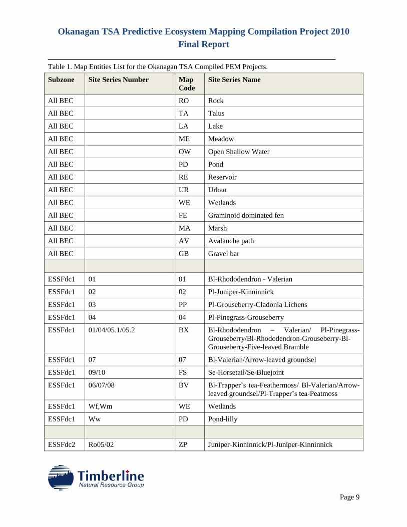
3.2 Final BEC Classification
The final classification for the compiled Okanagan TSA PEM is presented in Table 1. Nomenclature and
site series names are from Lloyd 2005 Guides to Site Identification housed under the following link:
http://www.for.gov.bc.ca/ftp/rsi/external/!publish/Dennis_Lloyd_BEC_Materials/
The map codes housed in the PEM data base are also listed in Table 1. All map entities were approved by
Dennis Lloyd (Dry Belt, Wet Belt) or Mike Ryan (Very Dry Belt), MOF Research Branch, Southern
Interior Region.
Okanagan TSA Predictive Ecosystem Mapping Compilation Project 2010
Final Report
________________________________________________________________________
Page 9
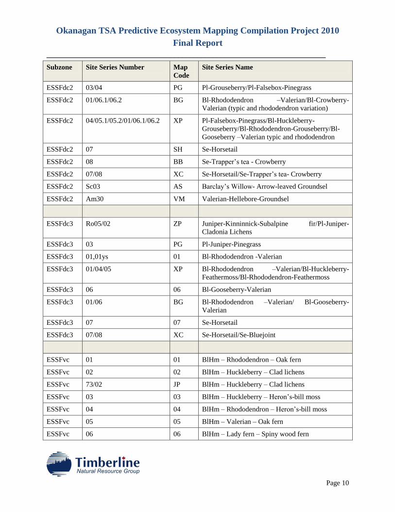
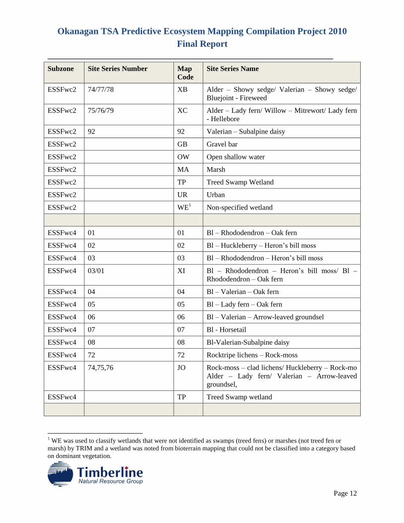
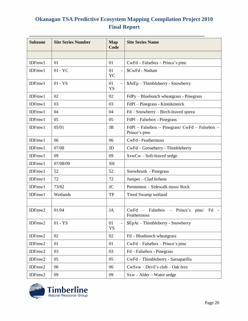
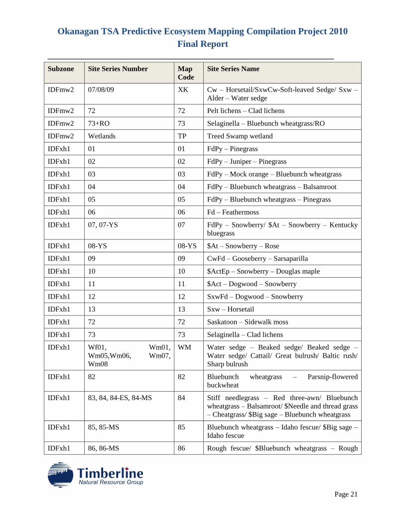
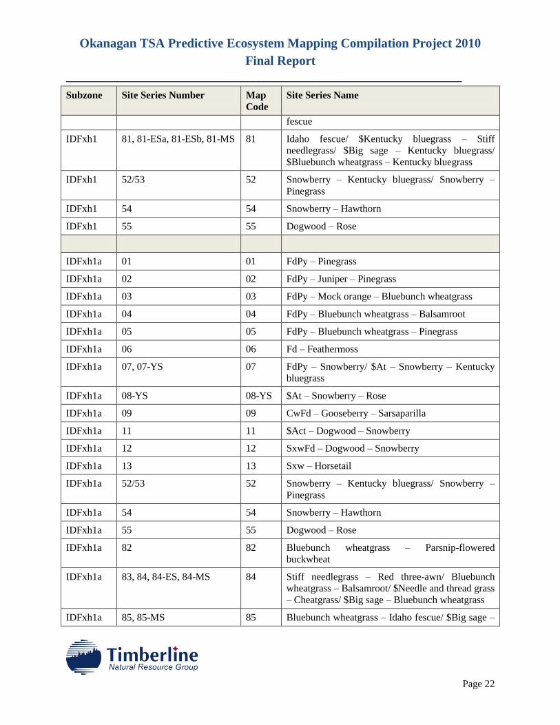
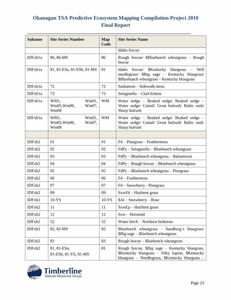
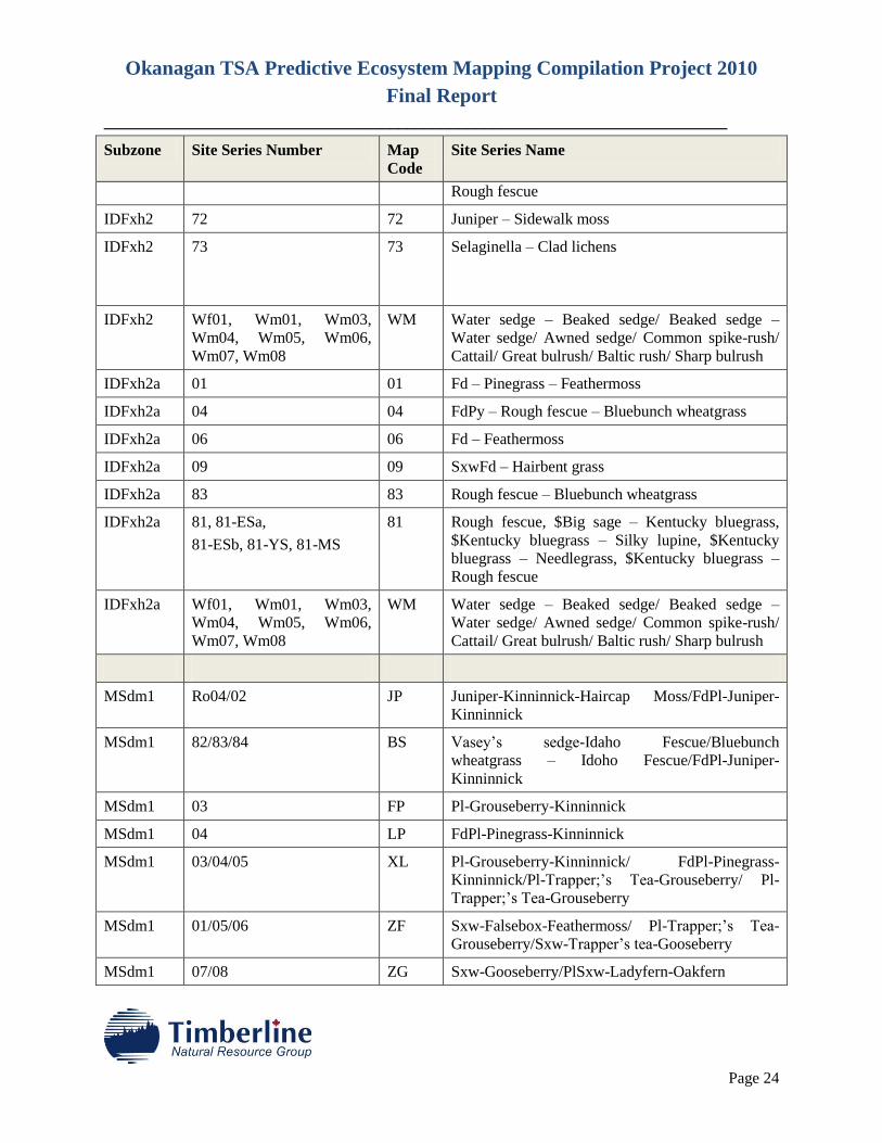
Table 1. Map Entities List for the Okanagan TSA Compiled PEM Projects.
Subzone Site Series Number Map
Code
Site Series Name
All BEC RO Rock
All BEC TA Talus
All BEC LA Lake
All BEC ME Meadow
All BEC OW Open Shallow Water
All BEC PD Pond
All BEC RE Reservoir
All BEC UR Urban
All BEC WE Wetlands
All BEC FE Graminoid dominated fen
All BEC MA Marsh
All BEC AV Avalanche path
All BEC GB Gravel bar
ESSFdc1 01 01 Bl-Rhododendron - Valerian
ESSFdc1 02 02 Pl-Juniper-Kinninnick
ESSFdc1 03 PP Pl-Grouseberry-Cladonia Lichens
ESSFdc1 04 04 Pl-Pinegrass-Grouseberry
ESSFdc1 01/04/05.1/05.2 BX Bl-Rhododendron – Valerian/ Pl-Pinegrass-
Grouseberry/Bl-Rhododendron-Grouseberry-Bl-
Grouseberry-Five-leaved Bramble
ESSFdc1 07 07 Bl-Valerian/Arrow-leaved groundsel
ESSFdc1 09/10 FS Se-Horsetail/Se-Bluejoint
ESSFdc1 06/07/08 BV Bl-Trapper’s tea-Feathermoss/ Bl-Valerian/Arrow-
leaved groundsel/Pl-Trapper’s tea-Peatmoss
ESSFdc1 Wf,Wm WE Wetlands
ESSFdc1 Ww PD Pond-lilly
ESSFdc2 Ro05/02 ZP Juniper-Kinninnick/Pl-Juniper-Kinninnick
Okanagan TSA Predictive Ecosystem Mapping Compilation Project 2010
Final Report
________________________________________________________________________
Page 10
Subzone Site Series Number Map
Code
Site Series Name
ESSFdc2 03/04 PG Pl-Grouseberry/Pl-Falsebox-Pinegrass
ESSFdc2 01/06.1/06.2 BG Bl-Rhododendron –Valerian/Bl-Crowberry-
Valerian (typic and rhododendron variation)
ESSFdc2 04/05.1/05.2/01/06.1/06.2 XP Pl-Falsebox-Pinegrass/Bl-Huckleberry-
Grouseberry/Bl-Rhododendron-Grouseberry/Bl-
Gooseberry –Valerian typic and rhododendron
ESSFdc2 07 SH Se-Horsetail
ESSFdc2 08 BB Se-Trapper’s tea - Crowberry
ESSFdc2 07/08 XC Se-Horsetail/Se-Trapper’s tea- Crowberry
ESSFdc2 Sc03 AS Barclay’s Willow- Arrow-leaved Groundsel
ESSFdc2 Am30 VM Valerian-Hellebore-Groundsel
ESSFdc3 Ro05/02 ZP Juniper-Kinninnick-Subalpine fir/Pl-Juniper-
Cladonia Lichens
ESSFdc3 03 PG Pl-Juniper-Pinegrass
ESSFdc3 01,01ys 01 Bl-Rhododendron -Valerian
ESSFdc3 01/04/05 XP Bl-Rhododendron –Valerian/Bl-Huckleberry-
Feathermoss/Bl-Rhododendron-Feathermoss
ESSFdc3 06 06 Bl-Gooseberry-Valerian
ESSFdc3 01/06 BG Bl-Rhododendron –Valerian/ Bl-Gooseberry-
Valerian
ESSFdc3 07 07 Se-Horsetail
ESSFdc3 07/08 XC Se-Horsetail/Se-Bluejoint
ESSFvc 01 01 BlHm – Rhododendron – Oak fern
ESSFvc 02 02 BlHm – Huckleberry – Clad lichens
ESSFvc 73/02 JP BlHm – Huckleberry – Clad lichens
ESSFvc 03 03 BlHm – Huckleberry – Heron’s-bill moss
ESSFvc 04 04 BlHm – Rhododendron – Heron’s-bill moss
ESSFvc 05 05 BlHm – Valerian – Oak fern
ESSFvc 06 06 BlHm – Lady fern – Spiny wood fern

Okanagan TSA Predictive Ecosystem Mapping Compilation Project 2010
Final Report
________________________________________________________________________
Page 11
Subzone Site Series Number Map
Code
Site Series Name
ESSFvc 07 07 BlHm – Devil’s Club – Lady fern
ESSFvc 08 08 BlHm – Arrow-leaved groundsel - Valerian
ESSFvc 09 09 BlHm - Horsetail
ESSFvc 72 72 Rocktripe lichens – Rock-moss
ESSFvc 73 73 Rock-moss – Clad lichens
ESSFwc1 01 01 Bl – Rhododendron – Oak fern
ESSFwc1 02 02 PlBl – Rock moss – Clad lichens
ESSFwc1 03 03 PlBl – Huckleberry – Haircap moss
ESSFwc1 03/01 XI PlBl – Huckleberry – Haircap moss/ PlBl –
Huckleberry – Haircap moss
ESSFwc1 04 04 Bl – Rhododendron – Five-leaved bramble
ESSFwc1 05 05 Bl – Oak fern - Foamflower
ESSFwc1 06 06 Bl – Lady fern - Foamflower
ESSFwc1 07 07 Bl – Devil’s club – Lady fern
ESSFwc1 08 08 Bl - Horsetail
ESSFwc1 72 72 Red raspberry - Feathermoss
ESSFwc1 Wetlands TP Swamp wetland
ESSFwc2 01 01 Bl – Azalea – Oak fern
ESSFwc2 02 02 Bl-Huckleberry-Heron’s bill moss
ESSFwc2 03 03 Bl – Rhododendron – Heron’s-bill moss
ESSFwc2 04 04 Bl – Valerian – Oak fern
ESSFwc2 05 05 Bl – Devil’s club – Lady fern
ESSFwc2 06 06 Bl – Lady fern – Oak fern
ESSFwc2 07 07 Bl – Valerian – Arrow-leaved groundsel
ESSFwc2 08/09/10 (Wb) XA Pl – Dwarf blueberry – Peat-moss/ Bl – Horsetail –
Peat-moss/ Bl - Bluejoint
ESSFwc2 72 72 Rocktripe lichens – rock-moss
ESSFwc2 73 73 Huckleberry – Rock-moss
Okanagan TSA Predictive Ecosystem Mapping Compilation Project 2010
Final Report
________________________________________________________________________
Page 12
Subzone Site Series Number Map
Code
Site Series Name
ESSFwc2 74/77/78 XB Alder – Showy sedge/ Valerian – Showy sedge/
Bluejoint - Fireweed
ESSFwc2 75/76/79 XC Alder – Lady fern/ Willow – Mitrewort/ Lady fern
- Hellebore
ESSFwc2 92 92 Valerian – Subalpine daisy
ESSFwc2 GB Gravel bar
ESSFwc2 OW Open shallow water
ESSFwc2 MA Marsh
ESSFwc2 TP Treed Swamp Wetland
ESSFwc2 UR Urban
ESSFwc2 WE1 Non-specified wetland
ESSFwc4 01 01 Bl – Rhododendron – Oak fern
ESSFwc4 02 02 Bl – Huckleberry – Heron’s bill moss
ESSFwc4 03 03 Bl – Rhododendron – Heron’s bill moss
ESSFwc4 03/01 XI Bl – Rhododendron – Heron’s bill moss/ Bl –
Rhododendron – Oak fern
ESSFwc4 04 04 Bl – Valerian – Oak fern
ESSFwc4 05 05 Bl – Lady fern – Oak fern
ESSFwc4 06 06 Bl – Valerian – Arrow-leaved groundsel
ESSFwc4 07 07 Bl - Horsetail
ESSFwc4 08 08 Bl-Valerian-Subalpine daisy
ESSFwc4 72 72 Rocktripe lichens – Rock-moss
ESSFwc4 74,75,76 JO Rock-moss – clad lichens/ Huckleberry – Rock-mo
Alder – Lady fern/ Valerian – Arrow-leaved
groundsel,
ESSFwc4 TP Treed Swamp wetland
1 WE was used to classify wetlands that were not identified as swamps (treed fens) or marshes (not treed fen or
marsh) by TRIM and a wetland was noted from bioterrain mapping that could not be classified into a category based
on dominant vegetation.
Okanagan TSA Predictive Ecosystem Mapping Compilation Project 2010
Final Report
________________________________________________________________________
Page 13
Subzone Site Series Number Map
Code
Site Series Name
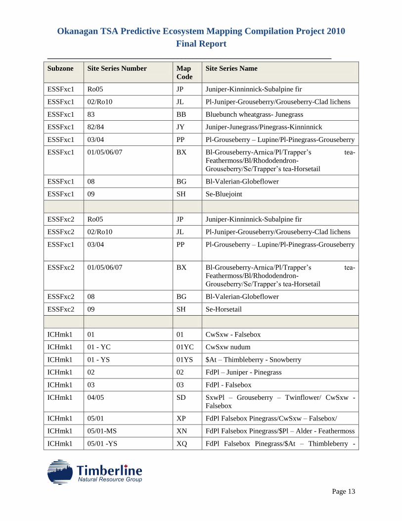
ESSFxc1 Ro05 JP Juniper-Kinninnick-Subalpine fir
ESSFxc1 02/Ro10 JL Pl-Juniper-Grouseberry/Grouseberry-Clad lichens
ESSFxc1 83 BB Bluebunch wheatgrass- Junegrass
ESSFxc1 82/84 JY Juniper-Junegrass/Pinegrass-Kinninnick
ESSFxc1 03/04 PP Pl-Grouseberry – Lupine/Pl-Pinegrass-Grouseberry
ESSFxc1 01/05/06/07 BX Bl-Grouseberry-Arnica/Pl/Trapper’s tea-
Feathermoss/Bl/Rhododendron-
Grouseberry/Se/Trapper’s tea-Horsetail
ESSFxc1 08 BG Bl-Valerian-Globeflower
ESSFxc1 09 SH Se-Bluejoint
ESSFxc2 Ro05 JP Juniper-Kinninnick-Subalpine fir
ESSFxc2 02/Ro10 JL Pl-Juniper-Grouseberry/Grouseberry-Clad lichens
ESSFxc1 03/04 PP Pl-Grouseberry – Lupine/Pl-Pinegrass-Grouseberry
ESSFxc2 01/05/06/07 BX Bl-Grouseberry-Arnica/Pl/Trapper’s tea-
Feathermoss/Bl/Rhododendron-
Grouseberry/Se/Trapper’s tea-Horsetail
ESSFxc2 08 BG Bl-Valerian-Globeflower
ESSFxc2 09 SH Se-Horsetail
ICHmk1 01 01 CwSxw - Falsebox
ICHmk1 01 - YC 01YC CwSxw nudum
ICHmk1 01 - YS 01YS $At – Thimbleberry - Snowberry
ICHmk1 02 02 FdPl – Juniper - Pinegrass
ICHmk1 03 03 FdPl - Falsebox
ICHmk1 04/05 SD SxwPl – Grouseberry – Twinflower/ CwSxw -
Falsebox
ICHmk1 05/01 XP FdPl Falsebox Pinegrass/CwSxw – Falsebox/
ICHmk1 05/01-MS XN FdPl Falsebox Pinegrass/$Pl – Alder - Feathermoss
ICHmk1 05/01 -YS XQ FdPl Falsebox Pinegrass/$At – Thimbleberry -
Okanagan TSA Predictive Ecosystem Mapping Compilation Project 2010
Final Report
________________________________________________________________________
Page 14
Subzone Site Series Number Map
Code
Site Series Name
Snowberry
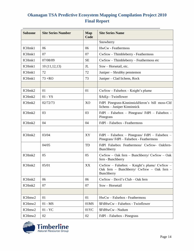
ICHmk1 06 06 HwCw - Feathermoss
ICHmk1 07 07 CwSxw – Thimbleberry - Feathermoss
ICHmk1 07/08/09 SE CwSxw – Thimbleberry – Feathermoss etc
ICHmk1 10 (11,12,13) JL Sxw – Horsetail, etc.
ICHmk1 72 72 Juniper – Shrubby penstemon
ICHmk1 73 +RO 73 Juniper – Clad lichens, Rock
ICHmk2 01 01 CwSxw – Falsebox – Knight’s plume
ICHmk2 01 - YS $AtEp - Twinflower
ICHmk2 02/72/73 XO FdPl Pinegrass-KinninnickHeron’s bill moss-Cld
lichens – Juniper Kinninnick
ICHmk2 03 03 FdPl – Falsebox – Pinegrass/ FdPl – Falsebox -
Pinegrass
ICHmk2 04 04 FdPl – Falsebox - Feathermoss
ICHmk2 03/04 XY FdPl – Falsebox – Pinegrass/ FdPl – Falsebox –
Pinegrass/ FdPl – Falsebox - Feathermoss
04/05 TD FdPl Falsebox Feathermoss/ CwSxw- Oakfern-
Bunchberry
ICHmk2 05 05 CwSxw – Oak fern – Bunchberry/ CwSxw – Oak
fern - Bunchberry
ICHmk2 05/01 XX CwSxw – Falsebox – Knight’s plume/ CwSxw –
Oak fern – Bunchberry/ CwSxw – Oak fern -
Bunchberry
ICHmk2 06 06 CwSxw – Devil’s Club – Oak fern
ICHmk2 07 07 Sxw – Horsetail
ICHmw2 01 01 HwCw – Falsebox - Feathermoss
ICHmw2 01 - MS 01MS $FdHwCw – Falsebox - Twinflower
ICHmw2 01 - YC 01YC $FdHwCw - Nudum
ICHmw2 02 02 FdPl – Falsebox - Pinegrass
Okanagan TSA Predictive Ecosystem Mapping Compilation Project 2010
Final Report
________________________________________________________________________
Page 15
Subzone Site Series Number Map
Code
Site Series Name
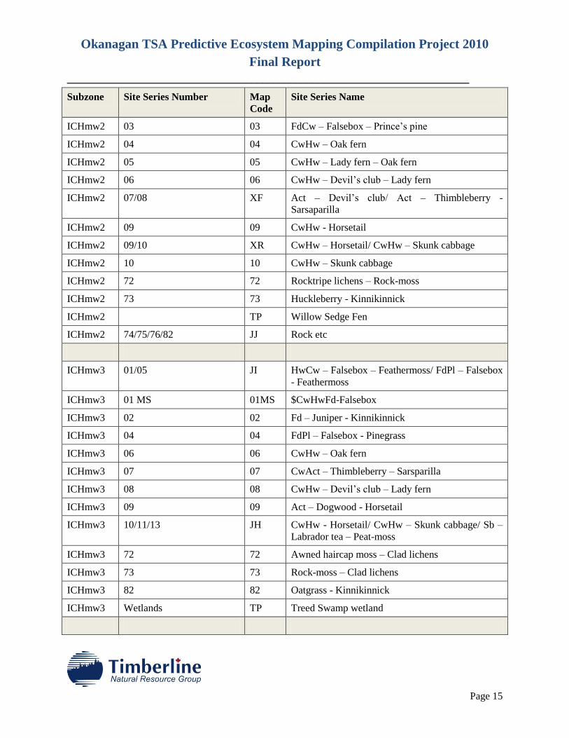
ICHmw2 03 03 FdCw – Falsebox – Prince’s pine
ICHmw2 04 04 CwHw – Oak fern
ICHmw2 05 05 CwHw – Lady fern – Oak fern
ICHmw2 06 06 CwHw – Devil’s club – Lady fern
ICHmw2 07/08 XF Act – Devil’s club/ Act – Thimbleberry -
Sarsaparilla
ICHmw2 09 09 CwHw - Horsetail
ICHmw2 09/10 XR CwHw – Horsetail/ CwHw – Skunk cabbage
ICHmw2 10 10 CwHw – Skunk cabbage
ICHmw2 72 72 Rocktripe lichens – Rock-moss
ICHmw2 73 73 Huckleberry - Kinnikinnick
ICHmw2 TP Willow Sedge Fen
ICHmw2 74/75/76/82 JJ Rock etc
ICHmw3 01/05 JI HwCw – Falsebox – Feathermoss/ FdPl – Falsebox
- Feathermoss
ICHmw3 01 MS 01MS $CwHwFd-Falsebox
ICHmw3 02 02 Fd – Juniper - Kinnikinnick
ICHmw3 04 04 FdPl – Falsebox - Pinegrass
ICHmw3 06 06 CwHw – Oak fern
ICHmw3 07 07 CwAct – Thimbleberry – Sarsparilla
ICHmw3 08 08 CwHw – Devil’s club – Lady fern
ICHmw3 09 09 Act – Dogwood - Horsetail
ICHmw3 10/11/13 JH CwHw - Horsetail/ CwHw – Skunk cabbage/ Sb –
Labrador tea – Peat-moss
ICHmw3 72 72 Awned haircap moss – Clad lichens
ICHmw3 73 73 Rock-moss – Clad lichens
ICHmw3 82 82 Oatgrass - Kinnikinnick
ICHmw3 Wetlands TP Treed Swamp wetland
Okanagan TSA Predictive Ecosystem Mapping Compilation Project 2010
Final Report
________________________________________________________________________
Page 16
Subzone Site Series Number Map
Code
Site Series Name
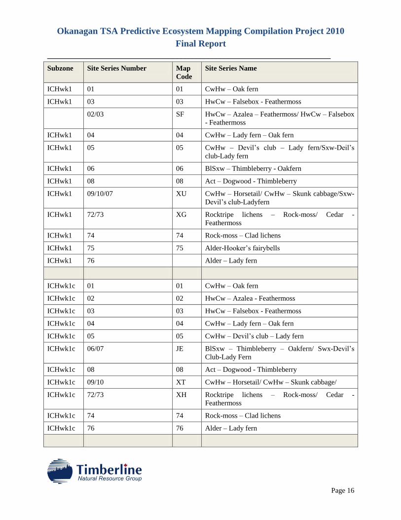
ICHwk1 01 01 CwHw – Oak fern
ICHwk1 03 03 HwCw – Falsebox - Feathermoss
02/03 SF HwCw – Azalea – Feathermoss/ HwCw – Falsebox
- Feathermoss
ICHwk1 04 04 CwHw – Lady fern – Oak fern
ICHwk1 05 05 CwHw – Devil’s club – Lady fern/Sxw-Deil’s
club-Lady fern
ICHwk1 06 06 BlSxw – Thimbleberry - Oakfern
ICHwk1 08 08 Act – Dogwood - Thimbleberry
ICHwk1 09/10/07 XU CwHw – Horsetail/ CwHw – Skunk cabbage/Sxw-
Devil’s club-Ladyfern
ICHwk1 72/73 XG Rocktripe lichens – Rock-moss/ Cedar -
Feathermoss
ICHwk1 74 74 Rock-moss – Clad lichens
ICHwk1 75 75 Alder-Hooker’s fairybells
ICHwk1 76 Alder – Lady fern
ICHwk1c 01 01 CwHw – Oak fern
ICHwk1c 02 02 HwCw – Azalea - Feathermoss
ICHwk1c 03 03 HwCw – Falsebox - Feathermoss
ICHwk1c 04 04 CwHw – Lady fern – Oak fern
ICHwk1c 05 05 CwHw – Devil’s club – Lady fern
ICHwk1c 06/07 JE BlSxw – Thimbleberry – Oakfern/ Swx-Devil’s
Club-Lady Fern
ICHwk1c 08 08 Act – Dogwood - Thimbleberry
ICHwk1c 09/10 XT CwHw – Horsetail/ CwHw – Skunk cabbage/
ICHwk1c 72/73 XH Rocktripe lichens – Rock-moss/ Cedar -
Feathermoss
ICHwk1c 74 74 Rock-moss – Clad lichens
ICHwk1c 76 76 Alder – Lady fern
Okanagan TSA Predictive Ecosystem Mapping Compilation Project 2010
Final Report
________________________________________________________________________
Page 17
Subzone Site Series Number Map
Code
Site Series Name
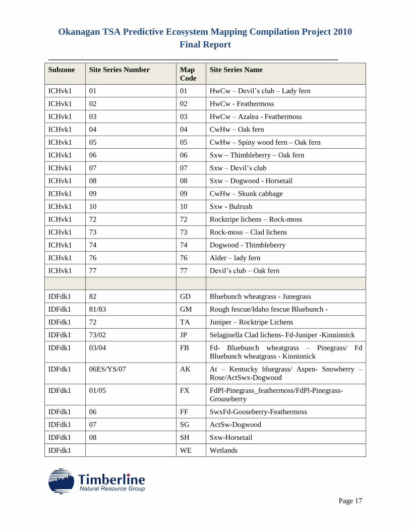
ICHvk1 01 01 HwCw – Devil’s club – Lady fern
ICHvk1 02 02 HwCw - Feathermoss
ICHvk1 03 03 HwCw – Azalea - Feathermoss
ICHvk1 04 04 CwHw – Oak fern
ICHvk1 05 05 CwHw – Spiny wood fern – Oak fern
ICHvk1 06 06 Sxw – Thimbleberry – Oak fern
ICHvk1 07 07 Sxw – Devil’s club
ICHvk1 08 08 Sxw – Dogwood - Horsetail
ICHvk1 09 09 CwHw – Skunk cabbage
ICHvk1 10 10 Sxw - Bulrush
ICHvk1 72 72 Rocktripe lichens – Rock-moss
ICHvk1 73 73 Rock-moss – Clad lichens
ICHvk1 74 74 Dogwood - Thimbleberry
ICHvk1 76 76 Alder – lady fern
ICHvk1 77 77 Devil’s club – Oak fern
IDFdk1 82 GD Bluebunch wheatgrass - Junegrass
IDFdk1 81/83 GM Rough fescue/Idaho fescue Bluebunch -
IDFdk1 72 TA Juniper – Rocktripe Lichens
IDFdk1 73/02 JP Selaginella Clad lichens- Fd-Juniper -Kinninnick
IDFdk1 03/04 FB Fd- Bluebunch wheatgrass – Pinegrass/ Fd
Bluebunch wheatgrass - Kinninnick
IDFdk1 06ES/YS/07 AK At – Kentucky bluegrass/ Aspen- Snowberry –
Rose/ActSwx-Dogwood
IDFdk1 01/05 FX FdPl-Pinegrass_feathermoss/FdPl-Pinegrass-
Grouseberry
IDFdk1 06 FF SwxFd-Gooseberry-Feathermoss
IDFdk1 07 SG ActSw-Dogwood
IDFdk1 08 SH Sxw-Horsetail
IDFdk1 WE Wetlands
Okanagan TSA Predictive Ecosystem Mapping Compilation Project 2010
Final Report
________________________________________________________________________
Page 18
Subzone Site Series Number Map
Code
Site Series Name
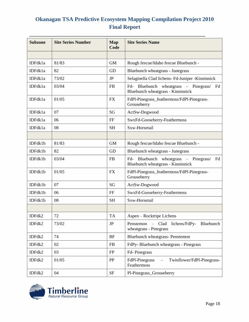
IDFdk1a 81/83 GM Rough fescue/Idaho fescue Bluebunch -
IDFdk1a 82 GD Bluebunch wheatgrass - Junegrass
IDFdk1a 73/02 JP Selaginella Clad lichens- Fd-Juniper -Kinninnick
IDFdk1a 03/04 FB Fd- Bluebunch wheatgrass – Pinegrass/ Fd
Bluebunch wheatgrass - Kinninnick
IDFdk1a 01/05 FX FdPl-Pinegrass_feathermoss/FdPl-Pinegrass-
Grouseberry
IDFdk1a 07 SG ActSw-Dogwood
IDFdk1a 06 FF SwxFd-Gooseberry-Feathermoss
IDFdk1a 08 SH Sxw-Horsetail
IDFdk1b 81/83 GM Rough fescue/Idaho fescue Bluebunch -
IDFdk1b 82 GD Bluebunch wheatgrass - Junegrass
IDFdk1b 03/04 FB Fd- Bluebunch wheatgrass – Pinegrass/ Fd
Bluebunch wheatgrass - Kinninnick
IDFdk1b 01/05 FX FdPl-Pinegrass_feathermoss/FdPl-Pinegrass-
Grouseberry
IDFdk1b 07 SG ActSw-Dogwood
IDFdk1b 06 FF SwxFd-Gooseberry-Feathermoss
IDFdk1b 08 SH Sxw-Horsetail
IDFdk2 72 TA Aspen – Rocktripe Lichens
IDFdk2 73/02 JP Penstemon – Clad lichens/FdPy- Bluebunch
wheatgrass - Pinegrass
IDFdk2 74 BF Bluebunch wheatgrass- Penstemon
IDFdk2 02 FB FdPy- Bluebunch wheatgrass - Pinegrass
IDFdk2 03 FP Fd- Pinegrass
IDFdk2 01/05 PP FdPl-Pinegrass – Twinflower/FdPl-Pinegrass-
Feathermoss
IDFdk2 04 SF Pl-Pinegrass_Grouseberry
Okanagan TSA Predictive Ecosystem Mapping Compilation Project 2010
Final Report
________________________________________________________________________
Page 19
Subzone Site Series Number Map
Code
Site Series Name
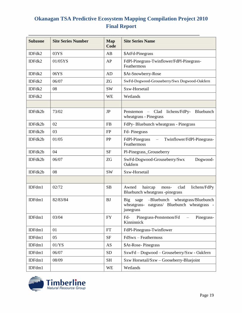
IDFdk2 03YS AB $AtFd-Pinegrass
IDFdk2 01/05YS AP FdPl-Pinegrass-Twinflower/FdPl-Pinegrass-
Feathermoss
IDFdk2 06YS AD $At-Snowberry-Rose
IDFdk2 06/07 ZG SwFd-Dogwood-Grouseberry/Swx Dogwood-Oakfern
IDFdk2 08 SW Sxw-Horsetail
IDFdk2 WE Wetlands
IDFdk2b 73/02 JP Penstemon – Clad lichens/FdPy- Bluebunch
wheatgrass - Pinegrass
IDFdk2b 02 FB FdPy- Bluebunch wheatgrass - Pinegrass
IDFdk2b 03 FP Fd- Pinegrass
IDFdk2b 01/05 PP FdPl-Pinegrass – Twinflower/FdPl-Pinegrass-
Feathermoss
IDFdk2b 04 SF Pl-Pinegrass_Grouseberry
IDFdk2b 06/07 ZG SwFd-Dogwood-Grouseberry/Swx Dogwood-
Oakfern
IDFdk2b 08 SW Sxw-Horsetail
IDFdm1 02/72 SB Awned haircap moss- clad lichens/FdPy
Bluebunch wheatgrass -pinegrass
IDFdm1 82/83/84 BJ Big sage –Bluebunch wheatgrass/Bluebunch
wheatgrass- oatgrass/ Bluebunch wheatgrass -
junegrass
IDFdm1 03/04 FY Fd- Pinegrass-Penstemon/Fd – Pinegrass-
Kinninnick
IDFdm1 01 FT FdPl-Pinegrass-Twinflower
IDFdm1 05 SF FdSwx – Feathermoss
IDFdm1 01/YS AS $At-Rose- Pinegrass
IDFdm1 06/07 SD SxwFd – Dogwood – Grouseberry/Sxw - Oakfern
IDFdm1 08/09 SH Sxw Horsetail/Sxw – Gooseberry-Bluejoint
IDFdm1 WE Wetlands
Okanagan TSA Predictive Ecosystem Mapping Compilation Project 2010
Final Report
________________________________________________________________________
Page 20
Subzone Site Series Number Map
Code
Site Series Name
IDFmw1 01 01 CwFd – Falsebox – Prince’s pine
IDFmw1 01 - YC 01 -
YC
$CwFd - Nudum
IDFmw1 01 - YS 01 -
YS
$AtEp – Thimbleberry - Snowberry
IDFmw1 02 02 FdPy – Bluebunch wheatgrass - Pinegrass
IDFmw1 03 03 FdPl – Pinegrass - Kinnikinnick
IDFmw1 04 04 Fd – Snowberry – Birch-leaved spirea
IDFmw1 05 05 FdPl – Falsebox - Pinegrass
IDFmw1 05/01 JB FdPl – Falsebox – Pinegrass/ CwFd – Falsebox –
Prince’s pine
IDFmw1 06 06 CwFd - Feathermoss
IDFmw1 07/08 JD CwFd – Gooseberry - Thimbleberry
IDFmw1 09 09 SxwCw – Soft-leaved sedge
IDFmw1 07/08/09 SH
IDFmw1 52 52 Snowbrush - Pinegrass
IDFmw1 72 72 Juniper – Clad lichens
IDFmw1 73/82 JC Penstemon – Sidewalk moss/ Rock
IDFmw1 Wetlands TP Treed Swamp wetland
IDFmw2 01/04 JA CwFd – Falsebox – Prince’s pine/ Fd -
Feathermoss
IDFmw2 01 - YS 01 -
YS
$EpAt – Thimbleberry - Snowberry
IDFmw2 02 02 Fd – Bluebunch wheatgrass
IDFmw2 01 01 CwFd – Falsebox – Prince’s pine
IDFmw2 03 03 Fd – Falsebox - Pinegrass
IDFmw2 05 05 CwFd – Thimbleberry - Sarsaparilla
IDFmw2 06 06 CwSxw – Devil’s club – Oak fern
IDFmw2 09 09 Sxw – Alder – Water sedge
Okanagan TSA Predictive Ecosystem Mapping Compilation Project 2010
Final Report
________________________________________________________________________
Page 21
Subzone Site Series Number Map
Code
Site Series Name
IDFmw2 07/08/09 XK Cw – Horsetail/SxwCw-Soft-leaved Sedge/ Sxw –
Alder – Water sedge
IDFmw2 72 72 Pelt lichens – Clad lichens
IDFmw2 73+RO 73 Selaginella – Bluebunch wheatgrass/RO
IDFmw2 Wetlands TP Treed Swamp wetland
IDFxh1 01 01 FdPy – Pinegrass
IDFxh1 02 02 FdPy – Juniper – Pinegrass
IDFxh1 03 03 FdPy – Mock orange – Bluebunch wheatgrass
IDFxh1 04 04 FdPy – Bluebunch wheatgrass – Balsamroot
IDFxh1 05 05 FdPy – Bluebunch wheatgrass – Pinegrass
IDFxh1 06 06 Fd – Feathermoss
IDFxh1 07, 07-YS 07 FdPy – Snowberry/ $At – Snowberry – Kentucky
bluegrass
IDFxh1 08-YS 08-YS $At – Snowberry – Rose
IDFxh1 09 09 CwFd – Gooseberry – Sarsaparilla
IDFxh1 10 10 $ActEp – Snowberry – Douglas maple
IDFxh1 11 11 $Act – Dogwood – Snowberry
IDFxh1 12 12 SxwFd – Dogwood – Snowberry
IDFxh1 13 13 Sxw – Horsetail
IDFxh1 72 72 Saskatoon – Sidewalk moss
IDFxh1 73 73 Selaginella – Clad lichens
IDFxh1 Wf01, Wm01,
Wm05,Wm06, Wm07,
Wm08
WM Water sedge – Beaked sedge/ Beaked sedge –
Water sedge/ Cattail/ Great bulrush/ Baltic rush/
Sharp bulrush
IDFxh1 82 82 Bluebunch wheatgrass – Parsnip-flowered
buckwheat
IDFxh1 83, 84, 84-ES, 84-MS 84 Stiff needlegrass – Red three-awn/ Bluebunch
wheatgrass – Balsamroot/ $Needle and thread grass
– Cheatgrass/ $Big sage – Bluebunch wheatgrass
IDFxh1 85, 85-MS 85 Bluebunch wheatgrass – Idaho fescue/ $Big sage –
Idaho fescue
IDFxh1 86, 86-MS 86 Rough fescue/ $Bluebunch wheatgrass – Rough
Okanagan TSA Predictive Ecosystem Mapping Compilation Project 2010
Final Report
________________________________________________________________________
Page 22
Subzone Site Series Number Map
Code
Site Series Name
fescue
IDFxh1 81, 81-ESa, 81-ESb, 81-MS 81 Idaho fescue/ $Kentucky bluegrass – Stiff
needlegrass/ $Big sage – Kentucky bluegrass/
$Bluebunch wheatgrass – Kentucky bluegrass
IDFxh1 52/53 52 Snowberry – Kentucky bluegrass/ Snowberry –
Pinegrass
IDFxh1 54 54 Snowberry – Hawthorn
IDFxh1 55 55 Dogwood – Rose
IDFxh1a 01 01 FdPy – Pinegrass
IDFxh1a 02 02 FdPy – Juniper – Pinegrass
IDFxh1a 03 03 FdPy – Mock orange – Bluebunch wheatgrass
IDFxh1a 04 04 FdPy – Bluebunch wheatgrass – Balsamroot
IDFxh1a 05 05 FdPy – Bluebunch wheatgrass – Pinegrass
IDFxh1a 06 06 Fd – Feathermoss
IDFxh1a 07, 07-YS 07 FdPy – Snowberry/ $At – Snowberry – Kentucky
bluegrass
IDFxh1a 08-YS 08-YS $At – Snowberry – Rose
IDFxh1a 09 09 CwFd – Gooseberry – Sarsaparilla
IDFxh1a 11 11 $Act – Dogwood – Snowberry
IDFxh1a 12 12 SxwFd – Dogwood – Snowberry
IDFxh1a 13 13 Sxw – Horsetail
IDFxh1a 52/53 52 Snowberry – Kentucky bluegrass/ Snowberry –
Pinegrass
IDFxh1a 54 54 Snowberry – Hawthorn
IDFxh1a 55 55 Dogwood – Rose
IDFxh1a 82 82 Bluebunch wheatgrass – Parsnip-flowered
buckwheat
IDFxh1a 83, 84, 84-ES, 84-MS 84 Stiff needlegrass – Red three-awn/ Bluebunch
wheatgrass – Balsamroot/ $Needle and thread grass
– Cheatgrass/ $Big sage – Bluebunch wheatgrass
IDFxh1a 85, 85-MS 85 Bluebunch wheatgrass – Idaho fescue/ $Big sage –
Okanagan TSA Predictive Ecosystem Mapping Compilation Project 2010
Final Report
________________________________________________________________________
Page 23
Subzone Site Series Number Map
Code
Site Series Name
Idaho fescue
IDFxh1a 86, 86-MS 86 Rough fescue/ $Bluebunch wheatgrass – Rough
fescue
IDFxh1a 81, 81-ESa, 81-ESb, 81-MS 81 Idaho fescue/ $Kentucky bluegrass – Stiff
needlegrass/ $Big sage – Kentucky bluegrass/
$Bluebunch wheatgrass – Kentucky bluegrass
IDFxh1a 72 72 Saskatoon – Sidewalk moss
IDFxh1a 73 73 Selaginella – Clad lichens
IDFxh1a Wf01, Wm01,
Wm05,Wm06, Wm07,
Wm08
WM Water sedge – Beaked sedge/ Beaked sedge –
Water sedge/ Cattail/ Great bulrush/ Baltic rush/
Sharp bulrush
IDFxh1a Wf01, Wm01,
Wm05,Wm06, Wm07,
Wm08
WM Water sedge – Beaked sedge/ Beaked sedge –
Water sedge/ Cattail/ Great bulrush/ Baltic rush/
Sharp bulrush
IDFxh2 01 01 Fd – Pinegrass – Feathermoss
IDFxh2 02 02 FdPy – Selaginella – Bluebunch wheatgrass
IDFxh2 03 03 FdPy – Bluebunch wheatgrass – Balsamroot
IDFxh2 04 04 FdPy – Rough fescue – Bluebunch wheatgrass
IDFxh2 05 05 FdPy – Bluebunch wheatgrass – Pinegrass
IDFxh2 06 06 Fd – Feathermoss
IDFxh2 07 07 Fd – Snowberry - Pinegrass
IDFxh2 09 09 SxwFd – Hairbent grass
IDFxh2 10-YS 10-YS $At – Snowberry – Rose
IDFxh2 11 11 SxwEp – Hairbent grass
IDFxh2 12 12 Sxw – Horsetail
IDFxh2 52 52 Water birch – Northern bedstraw
IDFxh2 82, 82-MS 82 Bluebunch wheatgrass – Sandberg’s bluegrass/
$Big sage – Bluebunch wheatgrass
IDFxh2 83 83 Rough fescue – Bluebunch wheatgrass
IDFxh2 81, 81-ESa,
81-ESb, 81-YS, 81-MS
81 Rough fescue, $Big sage – Kentucky bluegrass,
$Kentucky bluegrass – Silky lupine, $Kentucky
bluegrass – Needlegrass, $Kentucky bluegrass –
Okanagan TSA Predictive Ecosystem Mapping Compilation Project 2010
Final Report
________________________________________________________________________
Page 24
Subzone Site Series Number Map
Code
Site Series Name
Rough fescue
IDFxh2 72 72 Juniper – Sidewalk moss
IDFxh2 73 73 Selaginella – Clad lichens
IDFxh2 Wf01, Wm01, Wm03,
Wm04, Wm05, Wm06,
Wm07, Wm08
WM Water sedge – Beaked sedge/ Beaked sedge –
Water sedge/ Awned sedge/ Common spike-rush/
Cattail/ Great bulrush/ Baltic rush/ Sharp bulrush
IDFxh2a 01 01 Fd – Pinegrass – Feathermoss
IDFxh2a 04 04 FdPy – Rough fescue – Bluebunch wheatgrass
IDFxh2a 06 06 Fd – Feathermoss
IDFxh2a 09 09 SxwFd – Hairbent grass
IDFxh2a 83 83 Rough fescue – Bluebunch wheatgrass
IDFxh2a 81, 81-ESa,
81-ESb, 81-YS, 81-MS
81 Rough fescue, $Big sage – Kentucky bluegrass,
$Kentucky bluegrass – Silky lupine, $Kentucky
bluegrass – Needlegrass, $Kentucky bluegrass –
Rough fescue
IDFxh2a Wf01, Wm01, Wm03,
Wm04, Wm05, Wm06,
Wm07, Wm08
WM Water sedge – Beaked sedge/ Beaked sedge –
Water sedge/ Awned sedge/ Common spike-rush/
Cattail/ Great bulrush/ Baltic rush/ Sharp bulrush
MSdm1 Ro04/02 JP Juniper-Kinninnick-Haircap Moss/FdPl-Juniper-
Kinninnick
MSdm1 82/83/84 BS Vasey’s sedge-Idaho Fescue/Bluebunch
wheatgrass – Idoho Fescue/FdPl-Juniper-
Kinninnick
MSdm1 03 FP Pl-Grouseberry-Kinninnick
MSdm1 04 LP FdPl-Pinegrass-Kinninnick
MSdm1 03/04/05 XL Pl-Grouseberry-Kinninnick/ FdPl-Pinegrass-
Kinninnick/Pl-Trapper;’s Tea-Grouseberry/ Pl-
Trapper;’s Tea-Grouseberry
MSdm1 01/05/06 ZF Sxw-Falsebox-Feathermoss/ Pl-Trapper;’s Tea-
Grouseberry/Sxw-Trapper’s tea-Gooseberry
MSdm1 07/08 ZG Sxw-Gooseberry/PlSxw-Ladyfern-Oakfern
Okanagan TSA Predictive Ecosystem Mapping Compilation Project 2010
Final Report
________________________________________________________________________
Page 25
Subzone Site Series Number Map
Code
Site Series Name
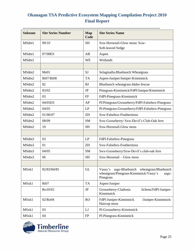
MSdm1 09/10 SH Sxw-Horsetail-Glow moss/ Sxw-
Soft-leaved Sedge
MSdm1 07/08ES AB Aspen
MSdm1 WE Wetlands
MSdm2 Me01 SJ Selaginalla-Bluebunch Wheatgrass
MSdm2 Rt07/Rt08 TA Aspen-Juniper/Juniper-Kinninnick
MSdm2 82 BJ Bluebunch wheatgrass-Idaho fescue
MSdm2 83/02 JP Pinegrass-Kinninnick/FdPl/Juniper/Kinninnick
MSdm2 03 FF FdPl-Pinegrass-Kinninnick
MSdm2 04/05ES AP Pl/Pinegrass/Grouseberry/FdPl-Falsebox-Pinegrass
MSdm2 04/05 LP Pl-Pinegrass-Grouseberry/FdPl-Falsebox-Pinegrass
MSdm2 01/06/07 ZH Sxw-Falsebox-Feathermoss
MSdm2 08/09 SM Sxw-Gooseberry/ Sxw-Devil’s Club-Oak fern
MSdm2 10 SH Sxw-Horsetail-Glow moss
MSdm3 03 LP FdPl-Falsebox-Pinegrass
MSdm3 01 ZH Sxw-Falsebox-Feathermoss
MSdm3 04/05 SM Swx-Gooseberry/Sxw-Devil’s club-oak fern
MSdm3 06 SH Sxw-Horsetail – Glow moss
MSxk1 82/83/84/85 GL Vasey’s sage-Bluebunch wheatgrass/Bluebunch
wheatgrass/Pinegrass-Kinninnick/Vasey’s sage-
Pinegrass
MSxk1 Rt07 TA Aspen-Juniper
Ro10/02 JP Grouseberry-Cladonia lichens/FdPl-Juniper-
Kinninnick
MSxk1 02/Ro04 RO FdPl-Juniper-Kinninnick /Juniper-Kinninnick-
Haircap moss
MSxk1 03 LJ Pl-Grouseberry-Kinninnick
MSxk1 04 FP Pl-Pinegrass-Kinninnick
Okanagan TSA Predictive Ecosystem Mapping Compilation Project 2010
Final Report
________________________________________________________________________
Page 26
Subzone Site Series Number Map
Code
Site Series Name
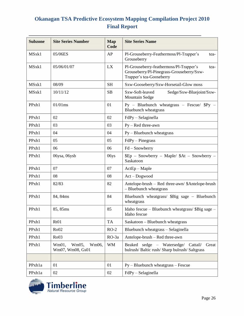
MSxk1 05/06ES AP Pl-Grouseberry-Feathermoss/Pl-Trapper’s tea-
Grouseberry
MSxk1 05/06/01/07 LX Pl-Grouseberry-feathermoss/Pl-Trapper’s tea-
Grouseberry/Pl-Pinegrass-Grouseberry/Sxw-
Trapper’s tea-Gooseberry
MSxk1 08/09 SH Sxw-Gooseberry/Sxw-Horsetail-Glow moss
MSxk1 10/11/12 SB Sxw-Soft-leaved Sedge/Sxw-Bluejoint/Sxw-
Mountain Sedge
PPxh1 01/01ms 01 Py – Bluebunch wheatgrass – Fescue/ $Py –
Bluebunch wheatgrass
PPxh1 02 02 FdPy – Selaginella
PPxh1 03 03 Py – Red three-awn
PPxh1 04 04 Py – Bluebunch wheatgrass
PPxh1 05 05 FdPy – Pinegrass
PPxh1 06 06 Fd – Snowberry
PPxh1 06ysa, 06ysb 06ys $Ep – Snowberry – Maple/ $At – Snowberry –
Saskatoon
PPxh1 07 07 ActEp – Maple
PPxh1 08 08 Act – Dogwood
PPxh1 82/83 82 Antelope-brush – Red three-awn/ $Antelope-brush
– Bluebunch wheatgrass
PPxh1 84, 84ms 84 Bluebunch wheatgrass/ $Big sage – Bluebunch
wheatgrass
PPxh1 85, 85ms 85 Idaho fescue – Bluebunch wheatgrass/ $Big sage –
Idaho fescue
PPxh1 Rt01 TA Saskatoon – Bluebunch wheatgrass
PPxh1 Ro02 RO-2 Bluebunch wheatgrass – Selaginella
PPxh1 Ro03 RO-3a Antelope-brush – Red three-awn
PPxh1 Wm01, Wm05, Wm06,
Wm07, Wm08, Gs01
WM Beaked sedge – Watersedge/ Cattail/ Great
bulrush/ Baltic rush/ Sharp bulrush/ Saltgrass
PPxh1a 01 01 Py – Bluebunch wheatgrass – Fescue
PPxh1a 02 02 FdPy – Selaginella
Okanagan TSA Predictive Ecosystem Mapping Compilation Project 2010
Final Report
________________________________________________________________________
Page 27
Subzone Site Series Number Map
Code
Site Series Name
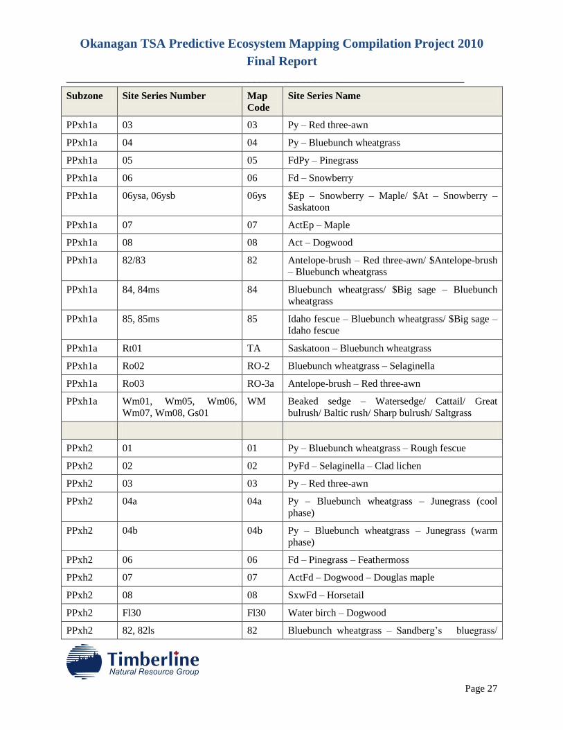
PPxh1a 03 03 Py – Red three-awn
PPxh1a 04 04 Py – Bluebunch wheatgrass
PPxh1a 05 05 FdPy – Pinegrass
PPxh1a 06 06 Fd – Snowberry
PPxh1a 06ysa, 06ysb 06ys $Ep – Snowberry – Maple/ $At – Snowberry –
Saskatoon
PPxh1a 07 07 ActEp – Maple
PPxh1a 08 08 Act – Dogwood
PPxh1a 82/83 82 Antelope-brush – Red three-awn/ $Antelope-brush
– Bluebunch wheatgrass
PPxh1a 84, 84ms 84 Bluebunch wheatgrass/ $Big sage – Bluebunch
wheatgrass
PPxh1a 85, 85ms 85 Idaho fescue – Bluebunch wheatgrass/ $Big sage –
Idaho fescue
PPxh1a Rt01 TA Saskatoon – Bluebunch wheatgrass
PPxh1a Ro02 RO-2 Bluebunch wheatgrass – Selaginella
PPxh1a Ro03 RO-3a Antelope-brush – Red three-awn
PPxh1a Wm01, Wm05, Wm06,
Wm07, Wm08, Gs01
WM Beaked sedge – Watersedge/ Cattail/ Great
bulrush/ Baltic rush/ Sharp bulrush/ Saltgrass
PPxh2 01 01 Py – Bluebunch wheatgrass – Rough fescue
PPxh2 02 02 PyFd – Selaginella – Clad lichen
PPxh2 03 03 Py – Red three-awn
PPxh2 04a 04a Py – Bluebunch wheatgrass – Junegrass (cool
phase)
PPxh2 04b 04b Py – Bluebunch wheatgrass – Junegrass (warm
phase)
PPxh2 06 06 Fd – Pinegrass – Feathermoss
PPxh2 07 07 ActFd – Dogwood – Douglas maple
PPxh2 08 08 SxwFd – Horsetail
PPxh2 Fl30 Fl30 Water birch – Dogwood
PPxh2 82, 82ls 82 Bluebunch wheatgrass – Sandberg’s bluegrass/
Okanagan TSA Predictive Ecosystem Mapping Compilation Project 2010
Final Report
________________________________________________________________________
Page 28
Subzone Site Series Number Map
Code
Site Series Name
$Big sage – Bluebunch wheatgrass
PPxh2 83, 83ls 83 Rough fescue – Bluebunch wheatgrass/ $Big sage
– Rough fescue
PPxh2 84, 84es 84 Rough fescue/ $Big sage – Kentucky bluegrass
PPxh2 Rt01 TA Saskatoon – Bluebunch wheatgrass
PPxh2 Ro01 RO-3a Bluebunch wheatgrass – Sidewalk moss
PPxh2 Ro02 RO-2 Bluebunch wheatgrass – Selaginella
PPxh2 Wm01, Wm05, Wm06,
Wm07, Wm08, Gs01
WM Beaked sedge – Water sedge/ Cattail/ Great
bulrush/ Baltic rush/ Sharp bulrush/ Saltgrass
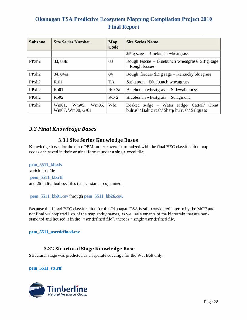
3.3 Final Knowledge Bases
3.31 Site Series Knowledge Bases Knowledge bases for the three PEM projects were harmonized with the final BEC classification map
codes and saved in their original format under a single excel file;
pem_5511_kb.xls
a rich text file
pem_5511_kb.rtf
and 26 individual csv files (as per standards) named;
pem_5511_kb01.csv through pem_5511_kb26.csv.
Because the Lloyd BEC classification for the Okanagan TSA is still considered interim by the MOF and
not final we prepared lists of the map entity names, as well as elements of the bioterrain that are non-
standard and housed it in the “user defined file”, there is a single user defined file.
pem_5511_userdefined.csv
3.32 Structural Stage Knowledge Base Structural stage was predicted as a separate coverage for the Wet Belt only.
pem_5511_sts.rtf
Okanagan TSA Predictive Ecosystem Mapping Compilation Project 2010
Final Report
________________________________________________________________________
Page 29
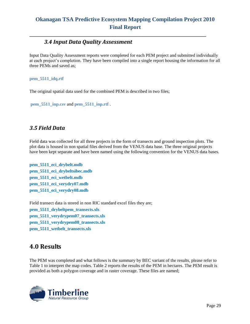
3.4 Input Data Quality Assessment
Input Data Quality Assessment reports were completed for each PEM project and submitted individually
at each project’s completion. They have been compiled into a single report housing the information for all
three PEMs and saved as;
pem_5511_idq.rtf
The original spatial data used for the combined PEM is described in two files;
pem_5511_inp.csv and pem_5511_inp.rtf .
3.5 Field Data
Field data was collected for all three projects in the form of transects and ground inspection plots. The
plot data is housed in non spatial files derived from the VENUS data base. The three original projects
have been kept separate and have been named using the following convention for the VENUS data bases.
pem_5511_eci_drybelt.mdb
pem_5511_eci_drybeltsibec.mdb
pem_5511_eci_wetbelt.mdb
pem_5511_eci_verydry07.mdb
pem_5511_eci_verydry08.mdb
Field transect data is stored in non RIC standard excel files they are;
pem_5511_drybeltpem_transects.xls
pem_5511_verydrypem07_transects.xls
pem_5511_verydrypem08_transects.xls
pem_5511_wetbelt_transects.xls
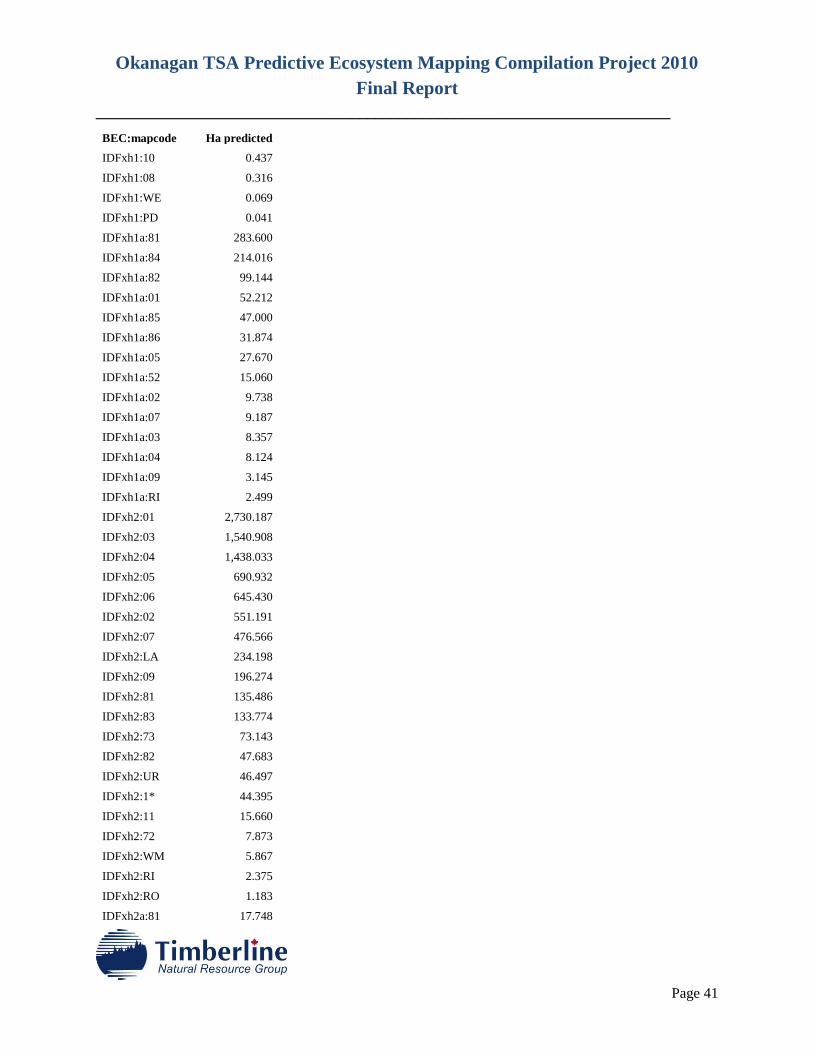
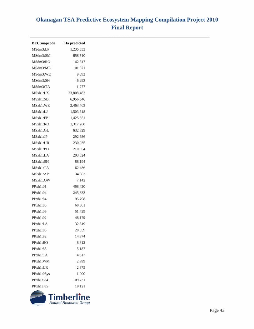
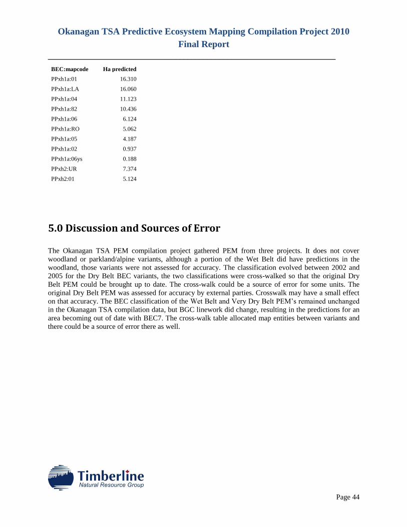
4.0 Results
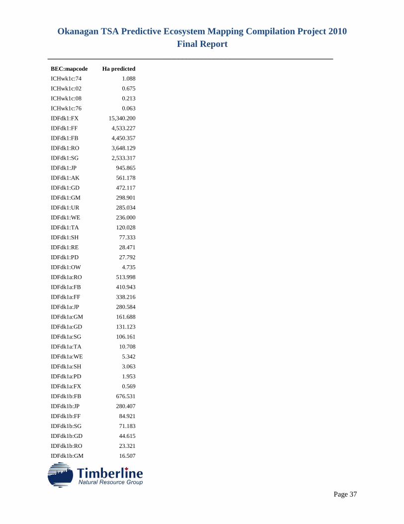
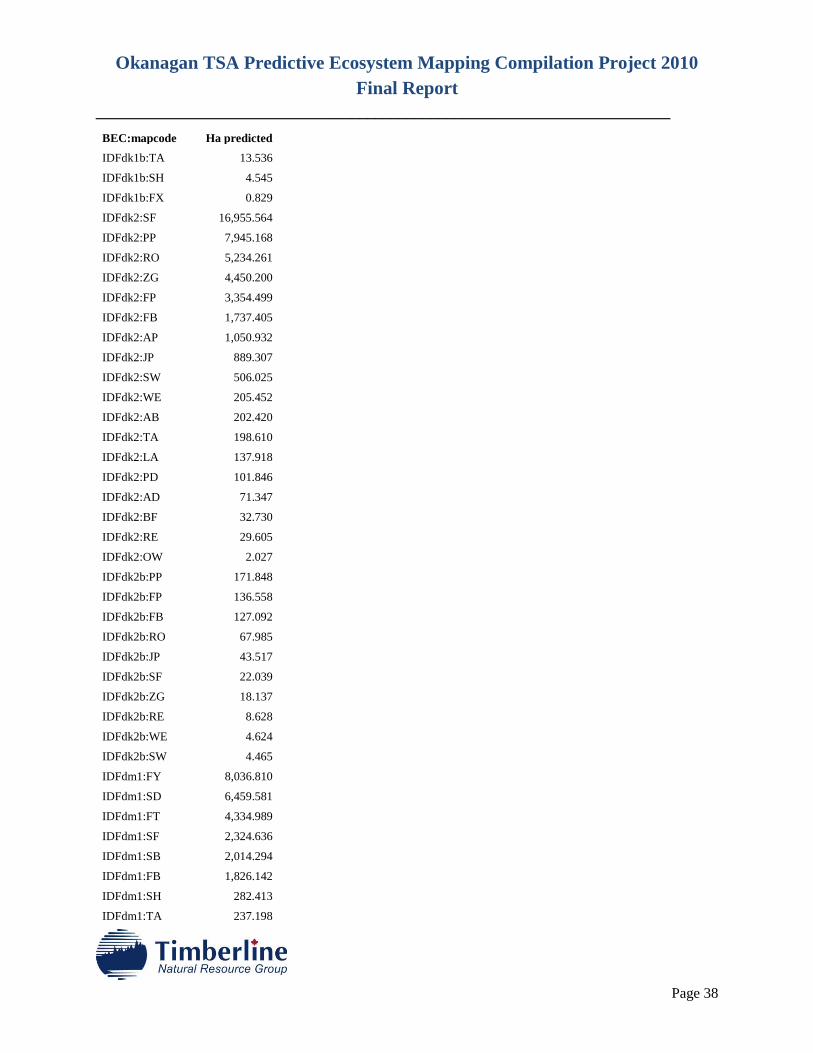
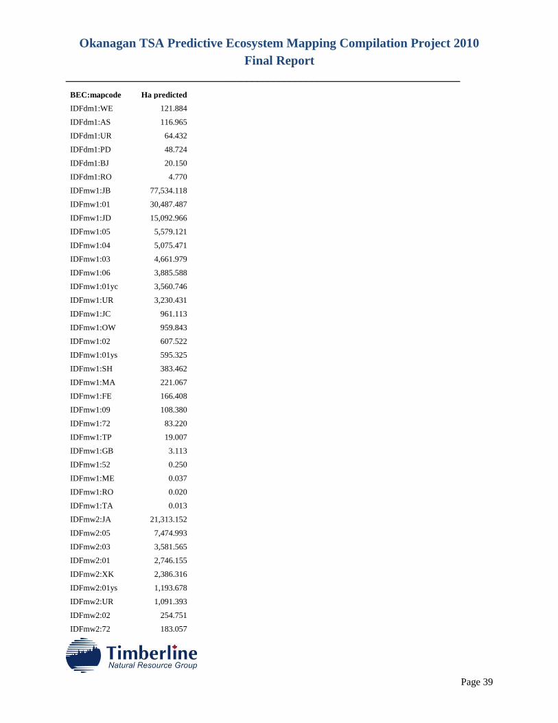
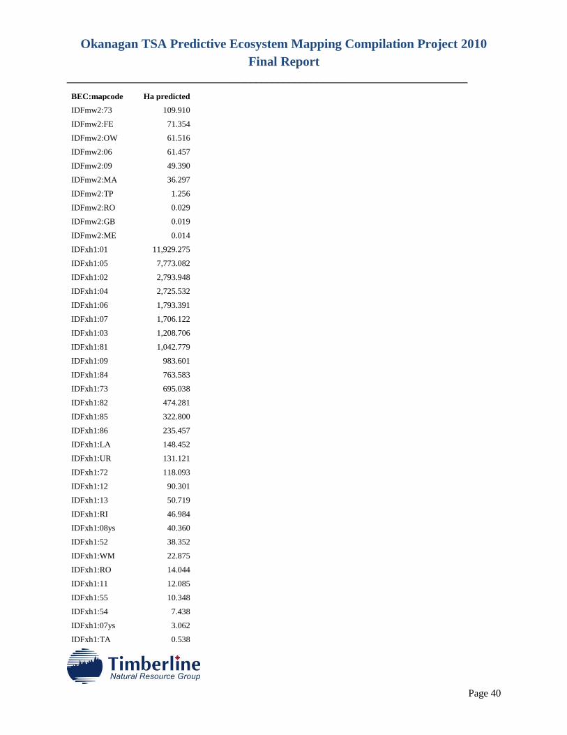
The PEM was completed and what follows is the summary by BEC variant of the results, please refer to
Table 1 to interpret the map codes. Table 2 reports the results of the PEM in hectares. The PEM result is
provided as both a polygon coverage and in raster coverage. These files are named;
Okanagan TSA Predictive Ecosystem Mapping Compilation Project 2010
Final Report
________________________________________________________________________
Page 30
pem_5511_ecp.e00 (spatial) and pem_5511_ecp.csv (data base) Polygon
pem_5511_ecp_attributes_attached.e00 Raster
The PEM map entity predictions provide a description of up to three map entities per polygon, or pixel in
the former Dry and Wet Belt PEM’s because an important input layer was derived from bioterrain
mapping, which reports proportional data within the bioterrain polygon. Features like rock outcrops,
avalanche paths, wetlands etc. were described as proportional data within the original bioterrain polygon.
The bioterrain polygons were rasterized and each raster retained the proportional information,
consequently predictions also retained the proportions reflected by the bioterrain data, even if the final
result is reported in raster format.
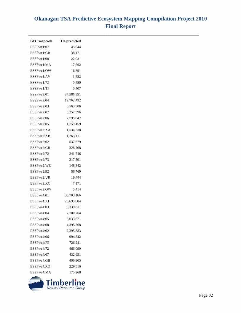
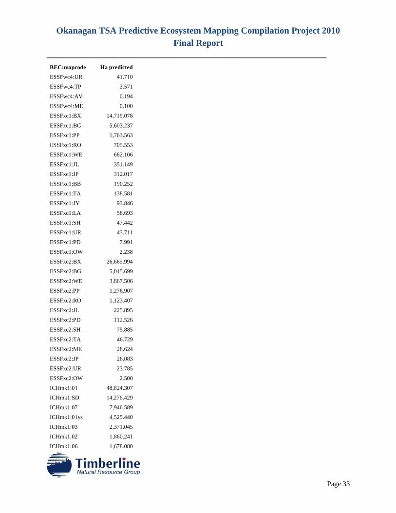
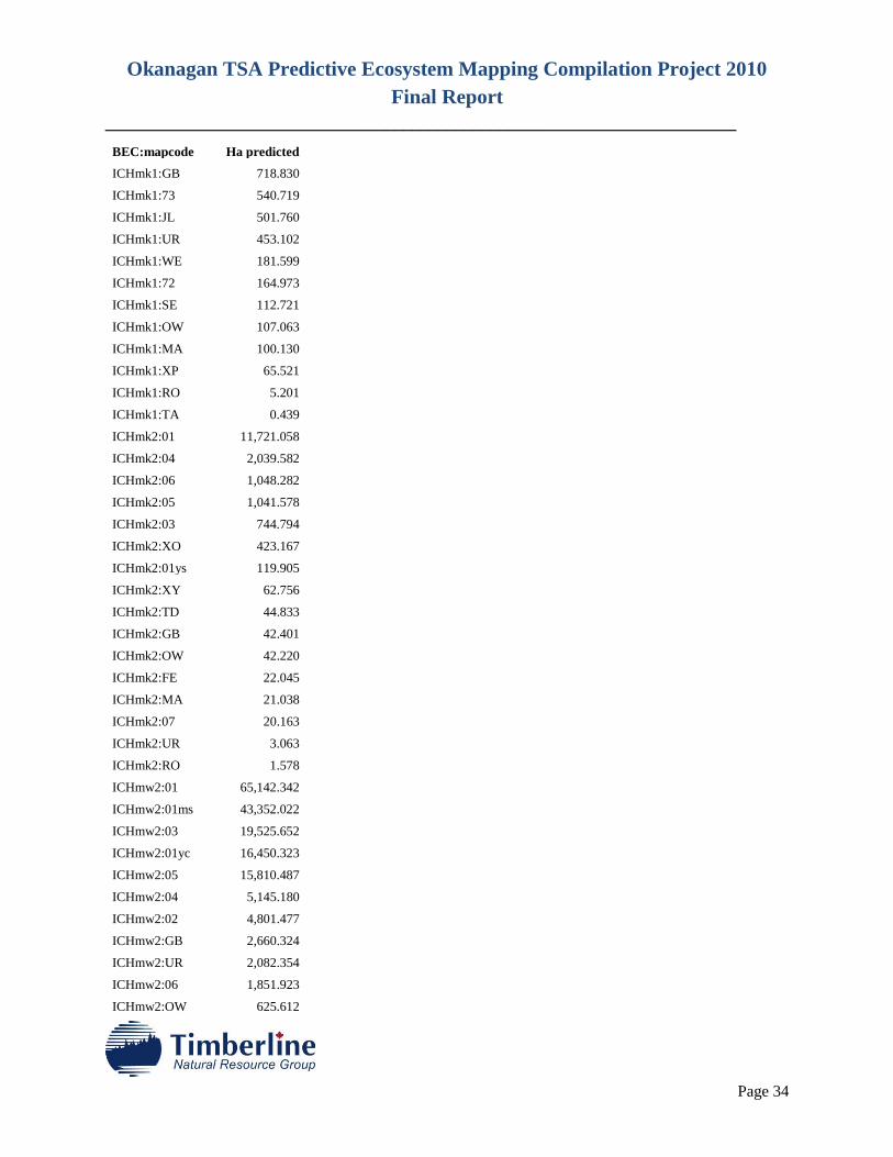
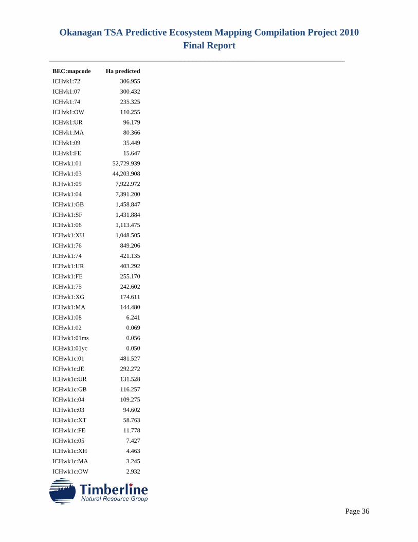
Table 2. Area of PEM Map Entities Predicted
BEC:mapcode Ha predicted
ESSFdc1:BX 39,495.417
ESSFdc1:BV 11,956.370
ESSFdc1:RO 7,670.394
ESSFdc1:WE 1,852.939
ESSFdc1:PP 811.450
ESSFdc1:TA 313.730
ESSFdc1:UR 244.502
ESSFdc1:PD 113.917
ESSFdc1:LA 101.599
ESSFdc1:FS 81.979
ESSFdc1:RE 0.939
ESSFdc2:BG 9,560.315
ESSFdc2:BB 7,019.740
ESSFdc2:PG 3,775.809
ESSFdc2:XC 2,149.756
ESSFdc2:ZP 2,045.874
ESSFdc2:WE 529.092
ESSFdc2:VM 252.550
ESSFdc2:UR 224.352
ESSFdc2:PD 106.734
ESSFdc2:TA 58.688
ESSFdc2:RO 41.453
ESSFdc2:SH 15.352
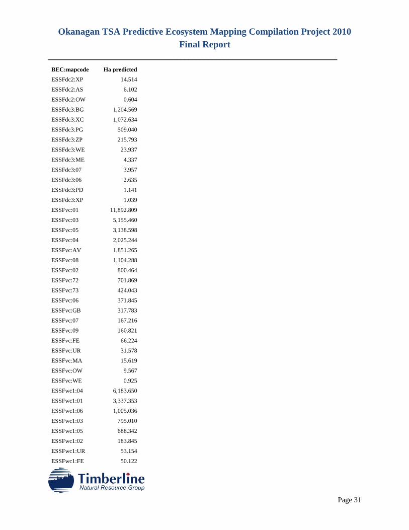
Okanagan TSA Predictive Ecosystem Mapping Compilation Project 2010
Final Report
________________________________________________________________________
Page 31
BEC:mapcode Ha predicted
ESSFdc2:XP 14.514
ESSFdc2:AS 6.102
ESSFdc2:OW 0.604
ESSFdc3:BG 1,204.569
ESSFdc3:XC 1,072.634
ESSFdc3:PG 509.040
ESSFdc3:ZP 215.793
ESSFdc3:WE 23.937
ESSFdc3:ME 4.337
ESSFdc3:07 3.957
ESSFdc3:06 2.635
ESSFdc3:PD 1.141
ESSFdc3:XP 1.039
ESSFvc:01 11,892.809
ESSFvc:03 5,155.460
ESSFvc:05 3,138.598
ESSFvc:04 2,025.244
ESSFvc:AV 1,851.265
ESSFvc:08 1,104.288
ESSFvc:02 800.464
ESSFvc:72 701.869
ESSFvc:73 424.043
ESSFvc:06 371.845
ESSFvc:GB 317.783
ESSFvc:07 167.216
ESSFvc:09 160.821
ESSFvc:FE 66.224
ESSFvc:UR 31.578
ESSFvc:MA 15.619
ESSFvc:OW 9.567
ESSFvc:WE 0.925
ESSFwc1:04 6,183.650
ESSFwc1:01 3,337.353
ESSFwc1:06 1,005.036
ESSFwc1:03 795.010
ESSFwc1:05 688.342
ESSFwc1:02 183.845
ESSFwc1:UR 53.154
ESSFwc1:FE 50.122
Okanagan TSA Predictive Ecosystem Mapping Compilation Project 2010
Final Report
________________________________________________________________________
Page 32
BEC:mapcode Ha predicted
ESSFwc1:07 45.044
ESSFwc1:GB 38.171
ESSFwc1:08 22.031
ESSFwc1:MA 17.692
ESSFwc1:OW 16.891
ESSFwc1:AV 1.582
ESSFwc1:72 0.550
ESSFwc1:TP 0.407
ESSFwc2:01 34,586.351
ESSFwc2:04 12,762.432
ESSFwc2:03 6,563.906
ESSFwc2:07 5,257.396
ESSFwc2:06 2,795.847
ESSFwc2:05 1,759.459
ESSFwc2:XA 1,534.338
ESSFwc2:XB 1,263.111
ESSFwc2:02 537.679
ESSFwc2:GB 328.768
ESSFwc2:72 241.746
ESSFwc2:73 217.591
ESSFwc2:WE 148.342
ESSFwc2:92 56.769
ESSFwc2:UR 19.444
ESSFwc2:XC 7.171
ESSFwc2:OW 5.414
ESSFwc4:01 35,703.166
ESSFwc4:XI 25,695.084
ESSFwc4:03 8,339.811
ESSFwc4:04 7,700.764
ESSFwc4:05 6,033.671
ESSFwc4:08 4,395.368
ESSFwc4:02 2,395.883
ESSFwc4:06 994.842
ESSFwc4:FE 726.241
ESSFwc4:72 466.090
ESSFwc4:07 432.651
ESSFwc4:GB 406.905
ESSFwc4:RO 229.516
ESSFwc4:MA 175.268
Okanagan TSA Predictive Ecosystem Mapping Compilation Project 2010
Final Report
________________________________________________________________________
Page 33
BEC:mapcode Ha predicted
ESSFwc4:UR 41.710
ESSFwc4:TP 3.571
ESSFwc4:AV 0.194
ESSFwc4:ME 0.100
ESSFxc1:BX 14,719.078
ESSFxc1:BG 5,603.237
ESSFxc1:PP 1,763.563
ESSFxc1:RO 705.553
ESSFxc1:WE 682.106
ESSFxc1:JL 351.149
ESSFxc1:JP 312.017
ESSFxc1:BB 190.252
ESSFxc1:TA 138.581
ESSFxc1:JY 93.846
ESSFxc1:LA 58.693
ESSFxc1:SH 47.442
ESSFxc1:UR 43.711
ESSFxc1:PD 7.991
ESSFxc1:OW 2.238
ESSFxc2:BX 26,665.994
ESSFxc2:BG 5,045.699
ESSFxc2:WE 3,867.506
ESSFxc2:PP 1,276.907
ESSFxc2:RO 1,123.407
ESSFxc2:JL 225.895
ESSFxc2:PD 112.526
ESSFxc2:SH 75.885
ESSFxc2:TA 46.729
ESSFxc2:ME 28.624
ESSFxc2:JP 26.083
ESSFxc2:UR 23.785
ESSFxc2:OW 2.500
ICHmk1:01 48,824.307
ICHmk1:SD 14,276.429
ICHmk1:07 7,946.589
ICHmk1:01ys 4,525.440
ICHmk1:03 2,371.045
ICHmk1:02 1,860.241
ICHmk1:06 1,678.080
Okanagan TSA Predictive Ecosystem Mapping Compilation Project 2010
Final Report
________________________________________________________________________
Page 34
BEC:mapcode Ha predicted
ICHmk1:GB 718.830
ICHmk1:73 540.719
ICHmk1:JL 501.760
ICHmk1:UR 453.102
ICHmk1:WE 181.599
ICHmk1:72 164.973
ICHmk1:SE 112.721
ICHmk1:OW 107.063
ICHmk1:MA 100.130
ICHmk1:XP 65.521
ICHmk1:RO 5.201
ICHmk1:TA 0.439
ICHmk2:01 11,721.058
ICHmk2:04 2,039.582
ICHmk2:06 1,048.282
ICHmk2:05 1,041.578
ICHmk2:03 744.794
ICHmk2:XO 423.167
ICHmk2:01ys 119.905
ICHmk2:XY 62.756
ICHmk2:TD 44.833
ICHmk2:GB 42.401
ICHmk2:OW 42.220
ICHmk2:FE 22.045
ICHmk2:MA 21.038
ICHmk2:07 20.163
ICHmk2:UR 3.063
ICHmk2:RO 1.578
ICHmw2:01 65,142.342
ICHmw2:01ms 43,352.022
ICHmw2:03 19,525.652
ICHmw2:01yc 16,450.323
ICHmw2:05 15,810.487
ICHmw2:04 5,145.180
ICHmw2:02 4,801.477
ICHmw2:GB 2,660.324
ICHmw2:UR 2,082.354
ICHmw2:06 1,851.923
ICHmw2:OW 625.612

Okanagan TSA Predictive Ecosystem Mapping Compilation Project 2010
Final Report
________________________________________________________________________
Page 35
BEC:mapcode Ha predicted
ICHmw2:XR 446.751
ICHmw2:73 353.076
ICHmw2:FE 320.418
ICHmw2:MA 293.466
ICHmw2:JJ 242.596
ICHmw2:XF 136.603
ICHmw2:72 52.678
ICHmw2:TP 27.826
ICHmw2:09 0.275
ICHmw3:JI 57,028.512
ICHmw3:01ms 16,243.004
ICHmw3:08 5,955.539
ICHmw3:06 3,232.737
ICHmw3:GB 2,232.249
ICHmw3:UR 1,351.444
ICHmw3:02 648.946
ICHmw3:07 601.511
ICHmw3:JH 516.116
ICHmw3:09 217.332
ICHmw3:MA 158.755
ICHmw3:73 109.744
ICHmw3:04 104.557
ICHmw3:82 96.003
ICHmw3:AV 70.904
ICHmw3:72 63.814
ICHmw3:TP 44.846
ICHmw3:OW 13.918
ICHvk1:01 19,331.341
ICHvk1:03 8,195.950
ICHvk1:04 3,780.766
ICHvk1:05 2,837.514
ICHvk1:77 2,439.850
ICHvk1:02 1,693.079
ICHvk1:10 1,446.554
ICHvk1:76 817.116
ICHvk1:06 808.426
ICHvk1:GB 597.719
ICHvk1:08 412.359
ICHvk1:73 339.533
Okanagan TSA Predictive Ecosystem Mapping Compilation Project 2010
Final Report
________________________________________________________________________
Page 36
BEC:mapcode Ha predicted
ICHvk1:72 306.955
ICHvk1:07 300.432
ICHvk1:74 235.325
ICHvk1:OW 110.255
ICHvk1:UR 96.179
ICHvk1:MA 80.366
ICHvk1:09 35.449
ICHvk1:FE 15.647
ICHwk1:01 52,729.939
ICHwk1:03 44,203.908
ICHwk1:05 7,922.972
ICHwk1:04 7,391.200
ICHwk1:GB 1,458.847
ICHwk1:SF 1,431.884
ICHwk1:06 1,113.475
ICHwk1:XU 1,048.505
ICHwk1:76 849.206
ICHwk1:74 421.135
ICHwk1:UR 403.292
ICHwk1:FE 255.170
ICHwk1:75 242.602
ICHwk1:XG 174.611
ICHwk1:MA 144.480
ICHwk1:08 6.241
ICHwk1:02 0.069
ICHwk1:01ms 0.056
ICHwk1:01yc 0.050
ICHwk1c:01 481.527
ICHwk1c:JE 292.272
ICHwk1c:UR 131.528
ICHwk1c:GB 116.257
ICHwk1c:04 109.275
ICHwk1c:03 94.602
ICHwk1c:XT 58.763
ICHwk1c:FE 11.778
ICHwk1c:05 7.427
ICHwk1c:XH 4.463
ICHwk1c:MA 3.245
ICHwk1c:OW 2.932
Okanagan TSA Predictive Ecosystem Mapping Compilation Project 2010
Final Report
________________________________________________________________________
Page 37
BEC:mapcode Ha predicted
ICHwk1c:74 1.088
ICHwk1c:02 0.675
ICHwk1c:08 0.213
ICHwk1c:76 0.063
IDFdk1:FX 15,340.200
IDFdk1:FF 4,533.227
IDFdk1:FB 4,450.357
IDFdk1:RO 3,648.129
IDFdk1:SG 2,533.317
IDFdk1:JP 945.865
IDFdk1:AK 561.178
IDFdk1:GD 472.117
IDFdk1:GM 298.901
IDFdk1:UR 285.034
IDFdk1:WE 236.000
IDFdk1:TA 120.028
IDFdk1:SH 77.333
IDFdk1:RE 28.471
IDFdk1:PD 27.792
IDFdk1:OW 4.735
IDFdk1a:RO 513.998
IDFdk1a:FB 410.943
IDFdk1a:FF 338.216
IDFdk1a:JP 280.584
IDFdk1a:GM 161.688
IDFdk1a:GD 131.123
IDFdk1a:SG 106.161
IDFdk1a:TA 10.708
IDFdk1a:WE 5.342
IDFdk1a:SH 3.063
IDFdk1a:PD 1.953
IDFdk1a:FX 0.569
IDFdk1b:FB 676.531
IDFdk1b:JP 280.407
IDFdk1b:FF 84.921
IDFdk1b:SG 71.183
IDFdk1b:GD 44.615
IDFdk1b:RO 23.321
IDFdk1b:GM 16.507
Okanagan TSA Predictive Ecosystem Mapping Compilation Project 2010
Final Report
________________________________________________________________________
Page 38
BEC:mapcode Ha predicted
IDFdk1b:TA 13.536
IDFdk1b:SH 4.545
IDFdk1b:FX 0.829
IDFdk2:SF 16,955.564
IDFdk2:PP 7,945.168
IDFdk2:RO 5,234.261
IDFdk2:ZG 4,450.200
IDFdk2:FP 3,354.499
IDFdk2:FB 1,737.405
IDFdk2:AP 1,050.932
IDFdk2:JP 889.307
IDFdk2:SW 506.025
IDFdk2:WE 205.452
IDFdk2:AB 202.420
IDFdk2:TA 198.610
IDFdk2:LA 137.918
IDFdk2:PD 101.846
IDFdk2:AD 71.347
IDFdk2:BF 32.730
IDFdk2:RE 29.605
IDFdk2:OW 2.027
IDFdk2b:PP 171.848
IDFdk2b:FP 136.558
IDFdk2b:FB 127.092
IDFdk2b:RO 67.985
IDFdk2b:JP 43.517
IDFdk2b:SF 22.039
IDFdk2b:ZG 18.137
IDFdk2b:RE 8.628
IDFdk2b:WE 4.624
IDFdk2b:SW 4.465
IDFdm1:FY 8,036.810
IDFdm1:SD 6,459.581
IDFdm1:FT 4,334.989
IDFdm1:SF 2,324.636
IDFdm1:SB 2,014.294
IDFdm1:FB 1,826.142
IDFdm1:SH 282.413
IDFdm1:TA 237.198
Okanagan TSA Predictive Ecosystem Mapping Compilation Project 2010
Final Report
________________________________________________________________________
Page 39
BEC:mapcode Ha predicted
IDFdm1:WE 121.884
IDFdm1:AS 116.965
IDFdm1:UR 64.432
IDFdm1:PD 48.724
IDFdm1:BJ 20.150
IDFdm1:RO 4.770
IDFmw1:JB 77,534.118
IDFmw1:01 30,487.487
IDFmw1:JD 15,092.966
IDFmw1:05 5,579.121
IDFmw1:04 5,075.471
IDFmw1:03 4,661.979
IDFmw1:06 3,885.588
IDFmw1:01yc 3,560.746
IDFmw1:UR 3,230.431
IDFmw1:JC 961.113
IDFmw1:OW 959.843
IDFmw1:02 607.522
IDFmw1:01ys 595.325
IDFmw1:SH 383.462
IDFmw1:MA 221.067
IDFmw1:FE 166.408
IDFmw1:09 108.380
IDFmw1:72 83.220
IDFmw1:TP 19.007
IDFmw1:GB 3.113
IDFmw1:52 0.250
IDFmw1:ME 0.037
IDFmw1:RO 0.020
IDFmw1:TA 0.013
IDFmw2:JA 21,313.152
IDFmw2:05 7,474.993
IDFmw2:03 3,581.565
IDFmw2:01 2,746.155
IDFmw2:XK 2,386.316
IDFmw2:01ys 1,193.678
IDFmw2:UR 1,091.393
IDFmw2:02 254.751
IDFmw2:72 183.057
Okanagan TSA Predictive Ecosystem Mapping Compilation Project 2010
Final Report
________________________________________________________________________
Page 40
BEC:mapcode Ha predicted
IDFmw2:73 109.910
IDFmw2:FE 71.354
IDFmw2:OW 61.516
IDFmw2:06 61.457
IDFmw2:09 49.390
IDFmw2:MA 36.297
IDFmw2:TP 1.256
IDFmw2:RO 0.029
IDFmw2:GB 0.019
IDFmw2:ME 0.014
IDFxh1:01 11,929.275
IDFxh1:05 7,773.082
IDFxh1:02 2,793.948
IDFxh1:04 2,725.532
IDFxh1:06 1,793.391
IDFxh1:07 1,706.122
IDFxh1:03 1,208.706
IDFxh1:81 1,042.779
IDFxh1:09 983.601
IDFxh1:84 763.583
IDFxh1:73 695.038
IDFxh1:82 474.281
IDFxh1:85 322.800
IDFxh1:86 235.457
IDFxh1:LA 148.452
IDFxh1:UR 131.121
IDFxh1:72 118.093
IDFxh1:12 90.301
IDFxh1:13 50.719
IDFxh1:RI 46.984
IDFxh1:08ys 40.360
IDFxh1:52 38.352
IDFxh1:WM 22.875
IDFxh1:RO 14.044
IDFxh1:11 12.085
IDFxh1:55 10.348
IDFxh1:54 7.438
IDFxh1:07ys 3.062
IDFxh1:TA 0.538
Okanagan TSA Predictive Ecosystem Mapping Compilation Project 2010
Final Report
________________________________________________________________________
Page 41
BEC:mapcode Ha predicted
IDFxh1:10 0.437
IDFxh1:08 0.316
IDFxh1:WE 0.069
IDFxh1:PD 0.041
IDFxh1a:81 283.600
IDFxh1a:84 214.016
IDFxh1a:82 99.144
IDFxh1a:01 52.212
IDFxh1a:85 47.000
IDFxh1a:86 31.874
IDFxh1a:05 27.670
IDFxh1a:52 15.060
IDFxh1a:02 9.738
IDFxh1a:07 9.187
IDFxh1a:03 8.357
IDFxh1a:04 8.124
IDFxh1a:09 3.145
IDFxh1a:RI 2.499
IDFxh2:01 2,730.187
IDFxh2:03 1,540.908
IDFxh2:04 1,438.033
IDFxh2:05 690.932
IDFxh2:06 645.430
IDFxh2:02 551.191
IDFxh2:07 476.566
IDFxh2:LA 234.198
IDFxh2:09 196.274
IDFxh2:81 135.486
IDFxh2:83 133.774
IDFxh2:73 73.143
IDFxh2:82 47.683
IDFxh2:UR 46.497
IDFxh2:1* 44.395
IDFxh2:11 15.660
IDFxh2:72 7.873
IDFxh2:WM 5.867
IDFxh2:RI 2.375
IDFxh2:RO 1.183
IDFxh2a:81 17.748

Okanagan TSA Predictive Ecosystem Mapping Compilation Project 2010
Final Report
________________________________________________________________________
Page 42
BEC:mapcode Ha predicted
IDFxh2a:83 1.312
IDFxh2a:UR 0.875
IDFxh2a:01 0.625
IDFxh2a:09 0.562
IDFxh2a:06 0.250
IDFxh2a:04 0.188
MSdm1:ZF 65,185.310
MSdm1:LP 26,850.307
MSdm1:XL 12,653.573
MSdm1:ZG 6,855.480
MSdm1:RO 6,516.985
MSdm1:FP 3,446.632
MSdm1:WE 3,333.356
MSdm1:LA 1,256.739
MSdm1:JP 975.966
MSdm1:SH 952.928
MSdm1:PD 653.183
MSdm1:AB 366.724
MSdm1:UR 264.367
MSdm1:TA 234.400
MSdm1:OW 2.295
MSdm2:ZH 38,332.210
MSdm2:LP 14,499.163
MSdm2:SM 11,904.813
MSdm2:WE 5,322.642
MSdm2:RO 3,510.515
MSdm2:UR 972.586
MSdm2:FF 714.608
MSdm2:AP 657.303
MSdm2:SJ 613.987
MSdm2:JP 517.634
MSdm2:PD 306.704
MSdm2:LA 206.271
MSdm2:SH 152.135
MSdm2:BJ 101.535
MSdm2:TA 97.433
MSdm2:RE 87.974
MSdm2:OW 3.593
MSdm3:ZH 1,776.870
Okanagan TSA Predictive Ecosystem Mapping Compilation Project 2010
Final Report
________________________________________________________________________
Page 43
BEC:mapcode Ha predicted
MSdm3:LP 1,235.333
MSdm3:SM 658.510
MSdm3:RO 142.617
MSdm3:ME 101.871
MSdm3:WE 9.092
MSdm3:SH 6.293
MSdm3:TA 1.277
MSxk1:LX 23,808.482
MSxk1:SB 6,956.546
MSxk1:WE 2,463.403
MSxk1:LJ 1,503.618
MSxk1:FP 1,425.351
MSxk1:RO 1,317.268
MSxk1:GL 632.829
MSxk1:JP 292.686
MSxk1:UR 230.035
MSxk1:PD 210.854
MSxk1:LA 203.824
MSxk1:SH 88.194
MSxk1:TA 62.486
MSxk1:AP 34.863
MSxk1:OW 7.142
PPxh1:01 468.420
PPxh1:04 245.333
PPxh1:84 95.798
PPxh1:05 68.301
PPxh1:06 51.429
PPxh1:02 48.179
PPxh1:LA 32.619
PPxh1:03 20.059
PPxh1:82 14.874
PPxh1:RO 8.312
PPxh1:85 5.187
PPxh1:TA 4.813
PPxh1:WM 2.999
PPxh1:UR 2.375
PPxh1:06ys 1.000
PPxh1a:84 109.731
PPxh1a:85 19.121
Okanagan TSA Predictive Ecosystem Mapping Compilation Project 2010
Final Report
________________________________________________________________________
Page 44
BEC:mapcode Ha predicted
PPxh1a:01 16.310
PPxh1a:LA 16.060
PPxh1a:04 11.123
PPxh1a:82 10.436
PPxh1a:06 6.124
PPxh1a:RO 5.062
PPxh1a:05 4.187
PPxh1a:02 0.937
PPxh1a:06ys 0.188
PPxh2:UR 7.374
PPxh2:01 5.124
5.0 Discussion and Sources of Error
The Okanagan TSA PEM compilation project gathered PEM from three projects. It does not cover
woodland or parkland/alpine variants, although a portion of the Wet Belt did have predictions in the
woodland, those variants were not assessed for accuracy. The classification evolved between 2002 and
2005 for the Dry Belt BEC variants, the two classifications were cross-walked so that the original Dry
Belt PEM could be brought up to date. The cross-walk could be a source of error for some units. The
original Dry Belt PEM was assessed for accuracy by external parties. Crosswalk may have a small effect
on that accuracy. The BEC classification of the Wet Belt and Very Dry Belt PEM’s remained unchanged
in the Okanagan TSA compilation data, but BGC linework did change, resulting in the predictions for an
area becoming out of date with BEC7. The cross-walk table allocated map entities between variants and
there could be a source of error there as well.
Okanagan TSA Predictive Ecosystem Mapping Compilation Project 2010
Final Report
________________________________________________________________________
Page 45
References Cited
Ecological Data Committee 2000. Ecosystem Mapping (TEM) Digital Data Capture in British Columbia;
Ecosystem Technical Standards and Database Manual. Version 3.0. Province of British Columbia
Resources Inventory Committee.
Iverson et al. 2001. Terrestrial Ecosystem mapping of the Central Okanagan with a Sensitive Ecosystem
Inventory (SEI).
Iverson, K and A. Haney. 2006. An Updated Terrestrial Ecosystem Map (TEM) for the Southern
Okanagan Valley (with Sensitive Ecosystems Inventory – SEI).
Iverson, K. and J. Shypitka. 2003. Sensitive Ecosystem Inventory (SEI) based on Terrestrial Ecosystem
Mapping: Bella Vista – Goose Lake Range.
Ketcheson, M., et al. 2002. Okanagan Dry Belt PEM and SIBEC Project Final Report. Unpublished report
to Okanagan Innovative Forestry Society.
Ketcheson, M. et al. 2006. Okanagan Wet Belt PEM Project Final Report. Unpublished report to
Okanagan Innovative Forestry Society.
Lloyd, D. 2007. Revisions to Lloyd et al. (2006). Long Floristic Tables- Draft BC Ministry of Forests and
Range, Kamloops BC.
Meidinger, D. 2003. Protocol for Accuracy Assessment of Ecosystem Maps. BC Ministry of Forests,
Forest Sciences Program Technical Report 011.
Ministry of Sustainable Resource Management 2004. Standards for Terrestrial Ecosystem Mapping
Digital Data Capture in British Columbia, Version 3.0 (2000) Errata No.1.0
Moon, D. 2005. A Protocol for Assessing Thematic Map Accuracy Using Small-area Sampling. BC
Ministry of Forest, Forest Science Program Technical Report 023
Resource Inventory Committee. 1999. Standards for Predictive Ecosystem Mapping – Inventory
Standards, TEM Mapping Alternative Task Force, Victoria BC.
Resources Inventory Standards Committee (2004) . Standards for Predictive Ecosystem Mapping (PEM)
Digital Data Capture in British Columbia. Errata No.1.0. Ministry of Sustainable Resource Management.
Resource Information Branch.
Okanagan TSA Predictive Ecosystem Mapping Compilation Project 2010
Final Report
________________________________________________________________________
Page 46
Timberline Natural Resource Group. 2009. Very Dry BEC Variants of the Okanagan TSa Predictive
Ecosystem Mapping (PEM) Final Report. Unpublished report to the Okanagan Innovative Forestry
Society.

Okanagan TSA Predictive Ecosystem Mapping Compilation Project 2010
Final Report
________________________________________________________________________
Page 47
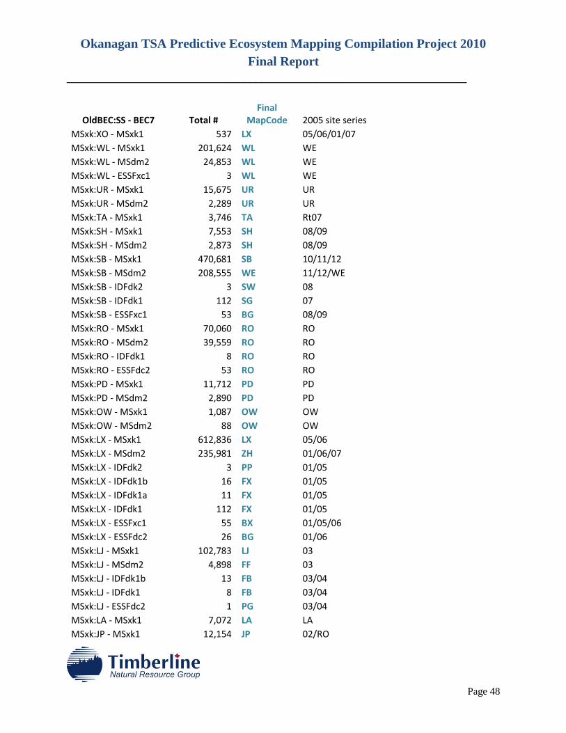
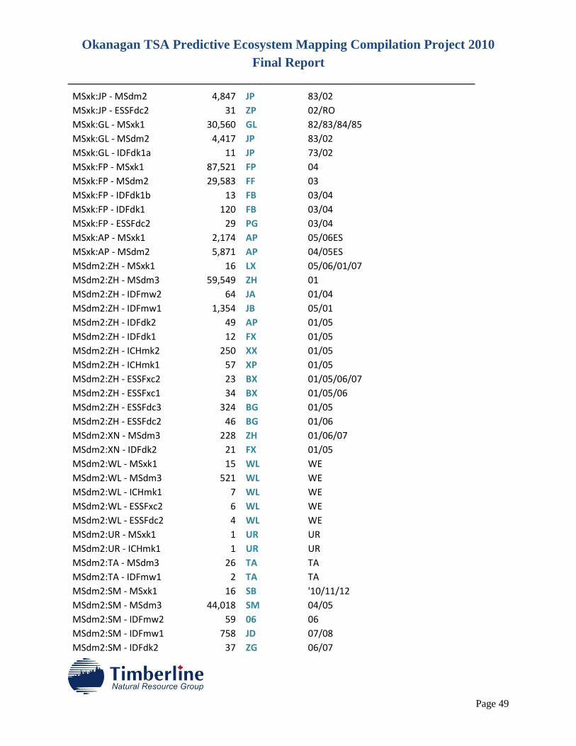
APPENDIX 1.
CROSS-WALK TABLE TO RE-ALLOCATIE MAP ENTITIES TO BEC7 WHERE VARIANTS
HAD CHANGES
Okanagan TSA Predictive Ecosystem Mapping Compilation Project 2010
Final Report
________________________________________________________________________
Page 48
OldBEC:SS - BEC7 Total # Final
MapCode 2005 site series MSxk:XO - MSxk1 537 LX 05/06/01/07 MSxk:WL - MSxk1 201,624 WL WE
MSxk:WL - MSdm2 24,853 WL WE MSxk:WL - ESSFxc1 3 WL WE MSxk:UR - MSxk1 15,675 UR UR MSxk:UR - MSdm2 2,289 UR UR MSxk:TA - MSxk1 3,746 TA Rt07 MSxk:SH - MSxk1 7,553 SH 08/09 MSxk:SH - MSdm2 2,873 SH 08/09 MSxk:SB - MSxk1 470,681 SB 10/11/12 MSxk:SB - MSdm2 208,555 WE 11/12/WE
MSxk:SB - IDFdk2 3 SW 08 MSxk:SB - IDFdk1 112 SG 07 MSxk:SB - ESSFxc1 53 BG 08/09 MSxk:RO - MSxk1 70,060 RO RO MSxk:RO - MSdm2 39,559 RO RO MSxk:RO - IDFdk1 8 RO RO MSxk:RO - ESSFdc2 53 RO RO MSxk:PD - MSxk1 11,712 PD PD MSxk:PD - MSdm2 2,890 PD PD MSxk:OW - MSxk1 1,087 OW OW MSxk:OW - MSdm2 88 OW OW MSxk:LX - MSxk1 612,836 LX 05/06 MSxk:LX - MSdm2 235,981 ZH 01/06/07 MSxk:LX - IDFdk2 3 PP 01/05 MSxk:LX - IDFdk1b 16 FX 01/05 MSxk:LX - IDFdk1a 11 FX 01/05 MSxk:LX - IDFdk1 112 FX 01/05 MSxk:LX - ESSFxc1 55 BX 01/05/06 MSxk:LX - ESSFdc2 26 BG 01/06 MSxk:LJ - MSxk1 102,783 LJ 03 MSxk:LJ - MSdm2 4,898 FF 03 MSxk:LJ - IDFdk1b 13 FB 03/04 MSxk:LJ - IDFdk1 8 FB 03/04 MSxk:LJ - ESSFdc2 1 PG 03/04 MSxk:LA - MSxk1 7,072 LA LA MSxk:JP - MSxk1 12,154 JP 02/RO
Okanagan TSA Predictive Ecosystem Mapping Compilation Project 2010
Final Report
________________________________________________________________________
Page 49
MSxk:JP - MSdm2 4,847 JP 83/02 MSxk:JP - ESSFdc2 31 ZP 02/RO MSxk:GL - MSxk1 30,560 GL 82/83/84/85
MSxk:GL - MSdm2 4,417 JP 83/02 MSxk:GL - IDFdk1a 11 JP 73/02 MSxk:FP - MSxk1 87,521 FP 04 MSxk:FP - MSdm2 29,583 FF 03 MSxk:FP - IDFdk1b 13 FB 03/04 MSxk:FP - IDFdk1 120 FB 03/04 MSxk:FP - ESSFdc2 29 PG 03/04 MSxk:AP - MSxk1 2,174 AP 05/06ES MSxk:AP - MSdm2 5,871 AP 04/05ES MSdm2:ZH - MSxk1 16 LX 05/06/01/07
MSdm2:ZH - MSdm3 59,549 ZH 01 MSdm2:ZH - IDFmw2 64 JA 01/04 MSdm2:ZH - IDFmw1 1,354 JB 05/01 MSdm2:ZH - IDFdk2 49 AP 01/05 MSdm2:ZH - IDFdk1 12 FX 01/05 MSdm2:ZH - ICHmk2 250 XX 01/05 MSdm2:ZH - ICHmk1 57 XP 01/05 MSdm2:ZH - ESSFxc2 23 BX 01/05/06/07
MSdm2:ZH - ESSFxc1 34 BX 01/05/06 MSdm2:ZH - ESSFdc3 324 BG 01/05 MSdm2:ZH - ESSFdc2 46 BG 01/06 MSdm2:XN - MSdm3 228 ZH 01/06/07 MSdm2:XN - IDFdk2 21 FX 01/05 MSdm2:WL - MSxk1 15 WL WE MSdm2:WL - MSdm3 521 WL WE MSdm2:WL - ICHmk1 7 WL WE MSdm2:WL - ESSFxc2 6 WL WE MSdm2:WL - ESSFdc2 4 WL WE MSdm2:UR - MSxk1 1 UR UR MSdm2:UR - ICHmk1 1 UR UR MSdm2:TA - MSdm3 26 TA TA MSdm2:TA - IDFmw1 2 TA TA MSdm2:SM - MSxk1 16 SB '10/11/12 MSdm2:SM - MSdm3 44,018 SM 04/05 MSdm2:SM - IDFmw2 59 06 06 MSdm2:SM - IDFmw1 758 JD 07/08 MSdm2:SM - IDFdk2 37 ZG 06/07
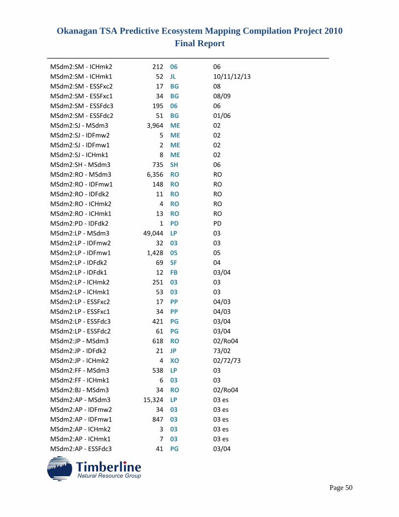
Okanagan TSA Predictive Ecosystem Mapping Compilation Project 2010
Final Report
________________________________________________________________________
Page 50
MSdm2:SM - ICHmk2 212 06 06 MSdm2:SM - ICHmk1 52 JL 10/11/12/13
MSdm2:SM - ESSFxc2 17 BG 08 MSdm2:SM - ESSFxc1 34 BG 08/09 MSdm2:SM - ESSFdc3 195 06 06 MSdm2:SM - ESSFdc2 51 BG 01/06 MSdm2:SJ - MSdm3 3,964 ME 02 MSdm2:SJ - IDFmw2 5 ME 02 MSdm2:SJ - IDFmw1 2 ME 02 MSdm2:SJ - ICHmk1 8 ME 02 MSdm2:SH - MSdm3 735 SH 06 MSdm2:RO - MSdm3 6,356 RO RO MSdm2:RO - IDFmw1 148 RO RO MSdm2:RO - IDFdk2 11 RO RO MSdm2:RO - ICHmk2 4 RO RO MSdm2:RO - ICHmk1 13 RO RO MSdm2:PD - IDFdk2 1 PD PD MSdm2:LP - MSdm3 49,044 LP 03 MSdm2:LP - IDFmw2 32 03 03 MSdm2:LP - IDFmw1 1,428 05 05 MSdm2:LP - IDFdk2 69 SF 04 MSdm2:LP - IDFdk1 12 FB 03/04 MSdm2:LP - ICHmk2 251 03 03 MSdm2:LP - ICHmk1 53 03 03 MSdm2:LP - ESSFxc2 17 PP 04/03 MSdm2:LP - ESSFxc1 34 PP 04/03 MSdm2:LP - ESSFdc3 421 PG 03/04 MSdm2:LP - ESSFdc2 61 PG 03/04 MSdm2:JP - MSdm3 618 RO 02/Ro04 MSdm2:JP - IDFdk2 21 JP 73/02 MSdm2:JP - ICHmk2 4 XO 02/72/73 MSdm2:FF - MSdm3 538 LP 03 MSdm2:FF - ICHmk1 6 03 03 MSdm2:BJ - MSdm3 34 RO 02/Ro04 MSdm2:AP - MSdm3 15,324 LP 03 es MSdm2:AP - IDFmw2 34 03 03 es MSdm2:AP - IDFmw1 847 03 03 es MSdm2:AP - ICHmk2 3 03 03 es MSdm2:AP - ICHmk1 7 03 03 es MSdm2:AP - ESSFdc3 41 PG 03/04
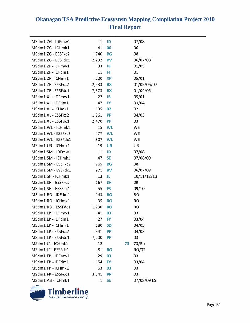
Okanagan TSA Predictive Ecosystem Mapping Compilation Project 2010
Final Report
________________________________________________________________________
Page 51
MSdm1:ZG - IDFmw1 1 JD 07/08 MSdm1:ZG - ICHmk1 41 06 06 MSdm1:ZG - ESSFxc2 740 BG 08 MSdm1:ZG - ESSFdc1 2,292 BV 06/07/08 MSdm1:ZF - IDFmw1 33 JB 01/05 MSdm1:ZF - IDFdm1 11 FT 01 MSdm1:ZF - ICHmk1 220 XP 05/01 MSdm1:ZF - ESSFxc2 2,533 BX 01/05/06/07
MSdm1:ZF - ESSFdc1 7,373 BX 01/04/05 MSdm1:XL - IDFmw1 22 JB 05/01 MSdm1:XL - IDFdm1 47 FY 03/04 MSdm1:XL - ICHmk1 135 02 02 MSdm1:XL - ESSFxc2 1,961 PP 04/03 MSdm1:XL - ESSFdc1 2,470 PP 03 MSdm1:WL - ICHmk1 15 WL WE MSdm1:WL - ESSFxc2 477 WL WE MSdm1:WL - ESSFdc1 507 WL WE MSdm1:UR - ICHmk1 19 UR UR MSdm1:SM - IDFmw1 1 JD 07/08 MSdm1:SM - ICHmk1 47 SE 07/08/09 MSdm1:SM - ESSFxc2 765 BG 08 MSdm1:SM - ESSFdc1 971 BV 06/07/08 MSdm1:SH - ICHmk1 13 JL 10/11/12/13
MSdm1:SH - ESSFxc2 167 SH 09 MSdm1:SH - ESSFdc1 55 FS 09/10 MSdm1:RO - IDFdm1 143 RO RO MSdm1:RO - ICHmk1 35 RO RO MSdm1:RO - ESSFdc1 1,730 RO RO MSdm1:LP - IDFmw1 41 03 03 MSdm1:LP - IDFdm1 27 FY 03/04 MSdm1:LP - ICHmk1 180 SD 04/05 MSdm1:LP - ESSFxc2 941 PP 04/03 MSdm1:LP - ESSFdc1 7,200 PP 03 MSdm1:JP - ICHmk1 12 73 73/Ro MSdm1:JP - ESSFdc1 81 RO RO/02 MSdm1:FP - IDFmw1 29 03 03 MSdm1:FP - IDFdm1 154 FY 03/04 MSdm1:FP - ICHmk1 63 03 03 MSdm1:FP - ESSFdc1 3,541 PP 03 MSdm1:AB - ICHmk1 1 SE 07/08/09 ES
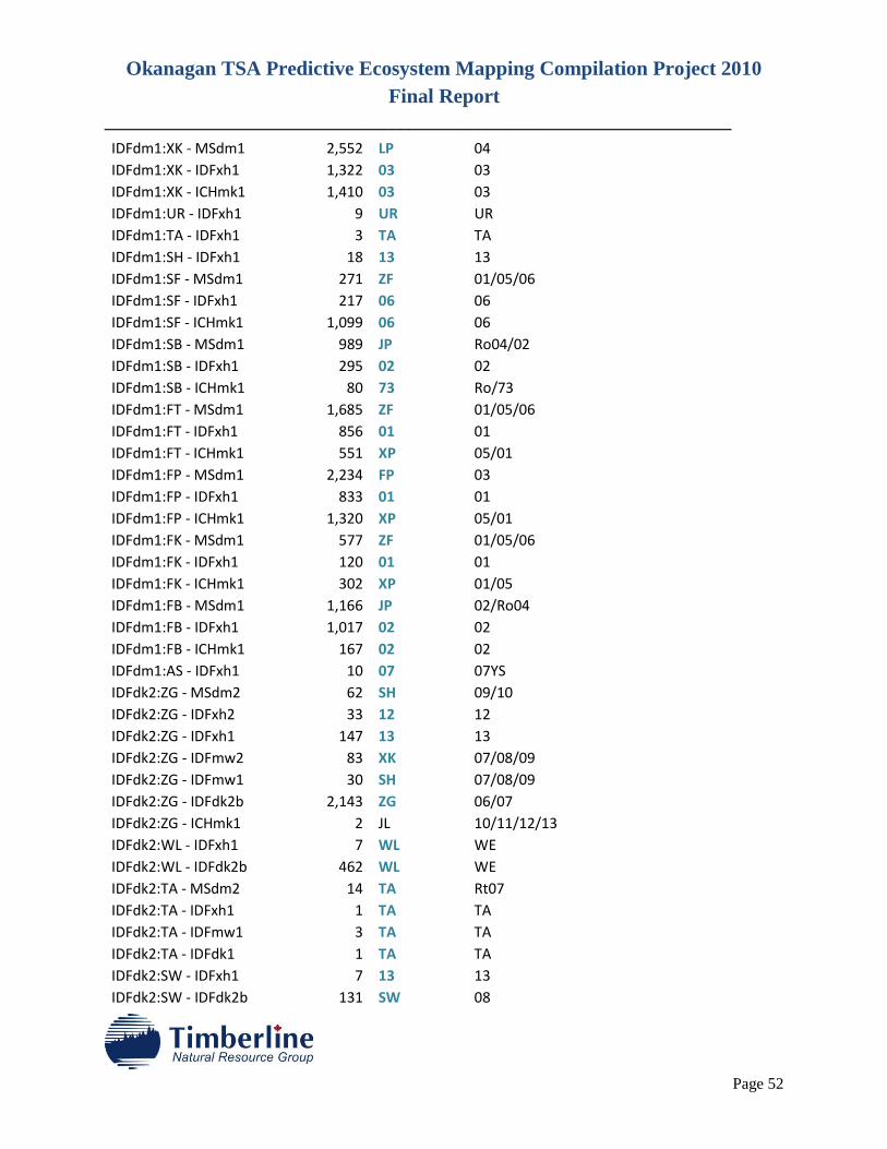
Okanagan TSA Predictive Ecosystem Mapping Compilation Project 2010
Final Report
________________________________________________________________________
Page 52
IDFdm1:XK - MSdm1 2,552 LP 04 IDFdm1:XK - IDFxh1 1,322 03 03 IDFdm1:XK - ICHmk1 1,410 03 03 IDFdm1:UR - IDFxh1 9 UR UR IDFdm1:TA - IDFxh1 3 TA TA IDFdm1:SH - IDFxh1 18 13 13 IDFdm1:SF - MSdm1 271 ZF 01/05/06 IDFdm1:SF - IDFxh1 217 06 06 IDFdm1:SF - ICHmk1 1,099 06 06 IDFdm1:SB - MSdm1 989 JP Ro04/02 IDFdm1:SB - IDFxh1 295 02 02 IDFdm1:SB - ICHmk1 80 73 Ro/73 IDFdm1:FT - MSdm1 1,685 ZF 01/05/06 IDFdm1:FT - IDFxh1 856 01 01 IDFdm1:FT - ICHmk1 551 XP 05/01 IDFdm1:FP - MSdm1 2,234 FP 03 IDFdm1:FP - IDFxh1 833 01 01 IDFdm1:FP - ICHmk1 1,320 XP 05/01 IDFdm1:FK - MSdm1 577 ZF 01/05/06 IDFdm1:FK - IDFxh1 120 01 01 IDFdm1:FK - ICHmk1 302 XP 01/05 IDFdm1:FB - MSdm1 1,166 JP 02/Ro04 IDFdm1:FB - IDFxh1 1,017 02 02 IDFdm1:FB - ICHmk1 167 02 02 IDFdm1:AS - IDFxh1 10 07 07YS IDFdk2:ZG - MSdm2 62 SH 09/10 IDFdk2:ZG - IDFxh2 33 12 12 IDFdk2:ZG - IDFxh1 147 13 13 IDFdk2:ZG - IDFmw2 83 XK 07/08/09 IDFdk2:ZG - IDFmw1 30 SH 07/08/09 IDFdk2:ZG - IDFdk2b 2,143 ZG 06/07 IDFdk2:ZG - ICHmk1 2 JL 10/11/12/13
IDFdk2:WL - IDFxh1 7 WL WE IDFdk2:WL - IDFdk2b 462 WL WE IDFdk2:TA - MSdm2 14 TA Rt07 IDFdk2:TA - IDFxh1 1 TA TA IDFdk2:TA - IDFmw1 3 TA TA IDFdk2:TA - IDFdk1 1 TA TA IDFdk2:SW - IDFxh1 7 13 13 IDFdk2:SW - IDFdk2b 131 SW 08

Okanagan TSA Predictive Ecosystem Mapping Compilation Project 2010
Final Report
________________________________________________________________________
Page 53
IDFdk2:SF - MSxk1 4 09 09 IDFdk2:SF - MSdm2 179 10 10 IDFdk2:SF - IDFxh2 39 12 12 IDFdk2:SF - IDFxh1 214 13 13 IDFdk2:SF - IDFmw2 183 XK 07/08/09 IDFdk2:SF - IDFmw1 34 SH 07/08/09 IDFdk2:SF - IDFdk2b 1,229 SF 04 IDFdk2:SF - IDFdk1 1 FB 03/04 IDFdk2:SF - ICHmk2 3 XY 03/04 IDFdk2:SF - ICHmk1 2 03 03 IDFdk2:RO - MSdm2 53 RO RO IDFdk2:RO - IDFxh2 8 RO RO IDFdk2:RO - IDFxh1 210 RO RO IDFdk2:RO - IDFmw2 24 RO RO IDFdk2:RO - IDFmw1 15 RO RO IDFdk2:RO - IDFdk2b 2,446 RO RO IDFdk2:RO - IDFdk1 1 RO RO IDFdk2:RO - ICHmk2 3 RO RO IDFdk2:RO - ICHmk1 2 RO RO IDFdk2:RE - IDFdk2b 248 RE RE IDFdk2:PP - MSdm2 27 ZF 01/05/06 IDFdk2:PP - IDFxh2 17 01 01 IDFdk2:PP - IDFxh1 221 01 01 IDFdk2:PP - IDFmw2 14 01 01 IDFdk2:PP - IDFmw1 14 01 01 IDFdk2:PP - IDFdk2b 7,506 PP 01/05 IDFdk2:PD - IDFxh1 2 PD PD IDFdk2:LA - IDFmw1 4 LA LA IDFdk2:JP - IDFxh1 79 02 02 IDFdk2:JP - IDFdk2b 1,501 JP 73/02 IDFdk2:FP - MSxk1 4 JP Ro04/Ro10/02
IDFdk2:FP - MSdm2 36 FF 03 IDFdk2:FP - IDFxh2 13 03 03 IDFdk2:FP - IDFxh1 214 03 03 IDFdk2:FP - IDFmw2 36 03 03 IDFdk2:FP - IDFmw1 8 03 03 IDFdk2:FP - IDFdk2b 6,724 FP 03 IDFdk2:FB - MSxk1 4 LJ 03 IDFdk2:FB - IDFxh2 16 03 03 IDFdk2:FB - IDFxh1 174 03 03
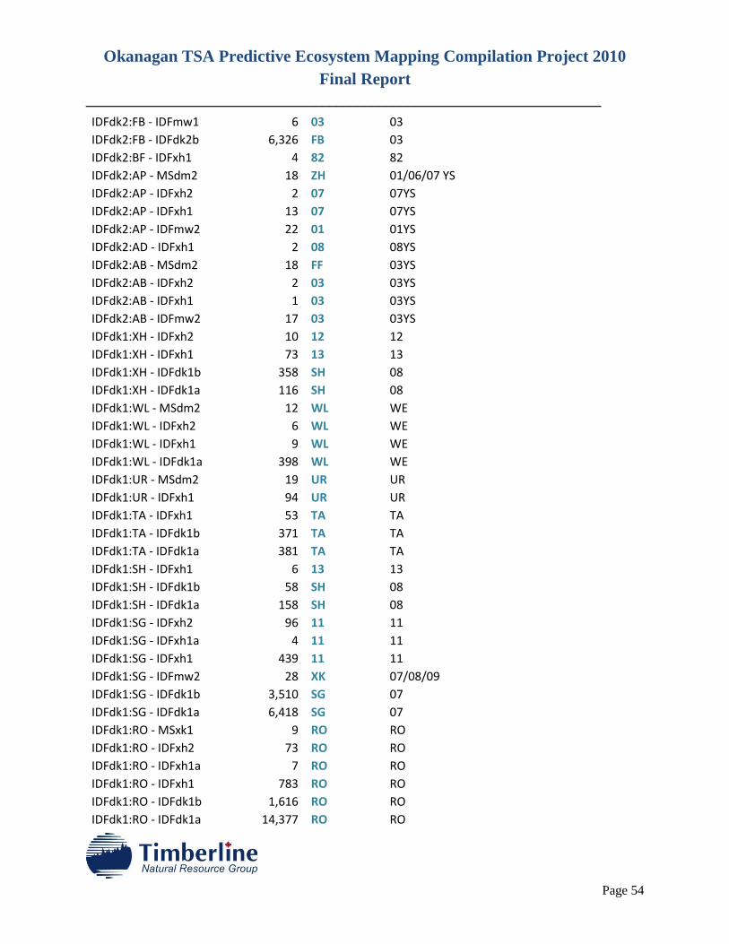
Okanagan TSA Predictive Ecosystem Mapping Compilation Project 2010
Final Report
________________________________________________________________________
Page 54
IDFdk2:FB - IDFmw1 6 03 03 IDFdk2:FB - IDFdk2b 6,326 FB 03 IDFdk2:BF - IDFxh1 4 82 82 IDFdk2:AP - MSdm2 18 ZH 01/06/07 YS
IDFdk2:AP - IDFxh2 2 07 07YS IDFdk2:AP - IDFxh1 13 07 07YS IDFdk2:AP - IDFmw2 22 01 01YS IDFdk2:AD - IDFxh1 2 08 08YS IDFdk2:AB - MSdm2 18 FF 03YS IDFdk2:AB - IDFxh2 2 03 03YS IDFdk2:AB - IDFxh1 1 03 03YS IDFdk2:AB - IDFmw2 17 03 03YS IDFdk1:XH - IDFxh2 10 12 12 IDFdk1:XH - IDFxh1 73 13 13 IDFdk1:XH - IDFdk1b 358 SH 08 IDFdk1:XH - IDFdk1a 116 SH 08 IDFdk1:WL - MSdm2 12 WL WE IDFdk1:WL - IDFxh2 6 WL WE IDFdk1:WL - IDFxh1 9 WL WE IDFdk1:WL - IDFdk1a 398 WL WE IDFdk1:UR - MSdm2 19 UR UR IDFdk1:UR - IDFxh1 94 UR UR IDFdk1:TA - IDFxh1 53 TA TA IDFdk1:TA - IDFdk1b 371 TA TA IDFdk1:TA - IDFdk1a 381 TA TA IDFdk1:SH - IDFxh1 6 13 13 IDFdk1:SH - IDFdk1b 58 SH 08 IDFdk1:SH - IDFdk1a 158 SH 08 IDFdk1:SG - IDFxh2 96 11 11 IDFdk1:SG - IDFxh1a 4 11 11 IDFdk1:SG - IDFxh1 439 11 11 IDFdk1:SG - IDFmw2 28 XK 07/08/09 IDFdk1:SG - IDFdk1b 3,510 SG 07 IDFdk1:SG - IDFdk1a 6,418 SG 07 IDFdk1:RO - MSxk1 9 RO RO IDFdk1:RO - IDFxh2 73 RO RO IDFdk1:RO - IDFxh1a 7 RO RO IDFdk1:RO - IDFxh1 783 RO RO IDFdk1:RO - IDFdk1b 1,616 RO RO IDFdk1:RO - IDFdk1a 14,377 RO RO
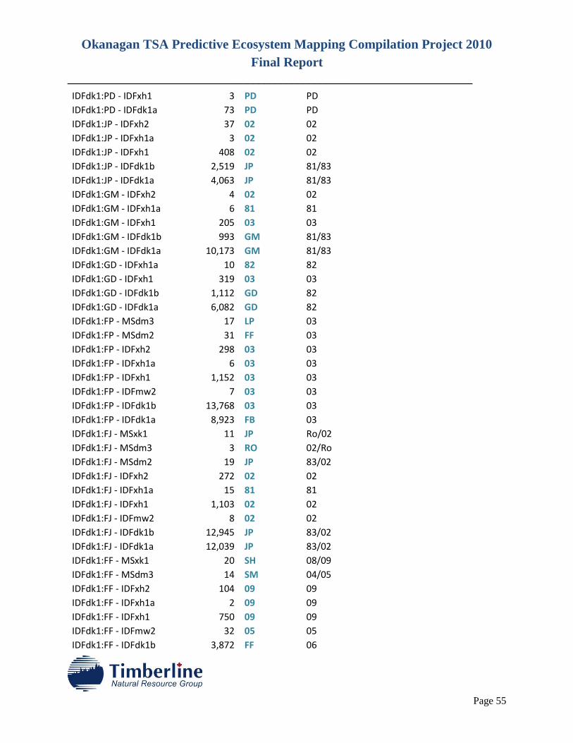
Okanagan TSA Predictive Ecosystem Mapping Compilation Project 2010
Final Report
________________________________________________________________________
Page 55
IDFdk1:PD - IDFxh1 3 PD PD IDFdk1:PD - IDFdk1a 73 PD PD IDFdk1:JP - IDFxh2 37 02 02 IDFdk1:JP - IDFxh1a 3 02 02 IDFdk1:JP - IDFxh1 408 02 02 IDFdk1:JP - IDFdk1b 2,519 JP 81/83 IDFdk1:JP - IDFdk1a 4,063 JP 81/83 IDFdk1:GM - IDFxh2 4 02 02 IDFdk1:GM - IDFxh1a 6 81 81 IDFdk1:GM - IDFxh1 205 03 03 IDFdk1:GM - IDFdk1b 993 GM 81/83 IDFdk1:GM - IDFdk1a 10,173 GM 81/83 IDFdk1:GD - IDFxh1a 10 82 82 IDFdk1:GD - IDFxh1 319 03 03 IDFdk1:GD - IDFdk1b 1,112 GD 82 IDFdk1:GD - IDFdk1a 6,082 GD 82 IDFdk1:FP - MSdm3 17 LP 03 IDFdk1:FP - MSdm2 31 FF 03 IDFdk1:FP - IDFxh2 298 03 03 IDFdk1:FP - IDFxh1a 6 03 03 IDFdk1:FP - IDFxh1 1,152 03 03 IDFdk1:FP - IDFmw2 7 03 03 IDFdk1:FP - IDFdk1b 13,768 03 03 IDFdk1:FP - IDFdk1a 8,923 FB 03 IDFdk1:FJ - MSxk1 11 JP Ro/02 IDFdk1:FJ - MSdm3 3 RO 02/Ro IDFdk1:FJ - MSdm2 19 JP 83/02 IDFdk1:FJ - IDFxh2 272 02 02 IDFdk1:FJ - IDFxh1a 15 81 81 IDFdk1:FJ - IDFxh1 1,103 02 02 IDFdk1:FJ - IDFmw2 8 02 02 IDFdk1:FJ - IDFdk1b 12,945 JP 83/02 IDFdk1:FJ - IDFdk1a 12,039 JP 83/02 IDFdk1:FF - MSxk1 20 SH 08/09 IDFdk1:FF - MSdm3 14 SM 04/05 IDFdk1:FF - IDFxh2 104 09 09 IDFdk1:FF - IDFxh1a 2 09 09 IDFdk1:FF - IDFxh1 750 09 09 IDFdk1:FF - IDFmw2 32 05 05 IDFdk1:FF - IDFdk1b 3,872 FF 06
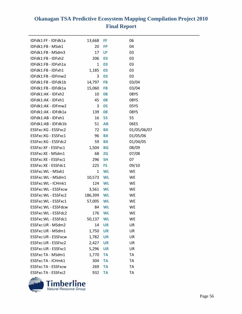
Okanagan TSA Predictive Ecosystem Mapping Compilation Project 2010
Final Report
________________________________________________________________________
Page 56
IDFdk1:FF - IDFdk1a 13,668 FF 06 IDFdk1:FB - MSxk1 20 FP 04 IDFdk1:FB - MSdm3 17 LP 03 IDFdk1:FB - IDFxh2 206 03 03 IDFdk1:FB - IDFxh1a 1 03 03 IDFdk1:FB - IDFxh1 1,185 03 03 IDFdk1:FB - IDFmw2 3 03 03 IDFdk1:FB - IDFdk1b 14,797 FB 03/04 IDFdk1:FB - IDFdk1a 15,060 FB 03/04 IDFdk1:AK - IDFxh2 10 08 08YS IDFdk1:AK - IDFxh1 45 08 08YS IDFdk1:AK - IDFmw2 3 05 05YS IDFdk1:AK - IDFdk1a 139 08 08YS IDFdk1:AB - IDFxh1 16 55 55 IDFdk1:AB - IDFdk1b 51 AB 06ES ESSFxc:XG - ESSFxc2 72 BX 01/05/06/07
ESSFxc:XG - ESSFxc1 96 BX 01/05/06 ESSFxc:XG - ESSFdc2 59 BX 01/04/05 ESSFxc:XF - ESSFxc1 1,504 BG 08/09 ESSFxc:XE - MSdm1 68 ZG 07/08 ESSFxc:XE - ESSFxc1 296 SH 07 ESSFxc:XE - ESSFdc1 225 FS 09/10 ESSFxc:WL - MSxk1 1 WL WE ESSFxc:WL - MSdm1 10,573 WL WE ESSFxc:WL - ICHmk1 124 WL WE ESSFxc:WL - ESSFxcw 3,561 WL WE ESSFxc:WL - ESSFxc2 186,399 WL WE ESSFxc:WL - ESSFxc1 57,005 WL WE ESSFxc:WL - ESSFdcw 84 WL WE ESSFxc:WL - ESSFdc2 176 WL WE ESSFxc:WL - ESSFdc1 50,137 WL WE ESSFxc:UR - MSdm2 14 UR UR ESSFxc:UR - MSdm1 1,750 UR UR ESSFxc:UR - ESSFxcw 1,782 UR UR ESSFxc:UR - ESSFxc2 2,427 UR UR ESSFxc:UR - ESSFxc1 5,296 UR UR ESSFxc:TA - MSdm1 1,770 TA TA ESSFxc:TA - ICHmk1 304 TA TA ESSFxc:TA - ESSFxcw 269 TA TA ESSFxc:TA - ESSFxc2 932 TA TA
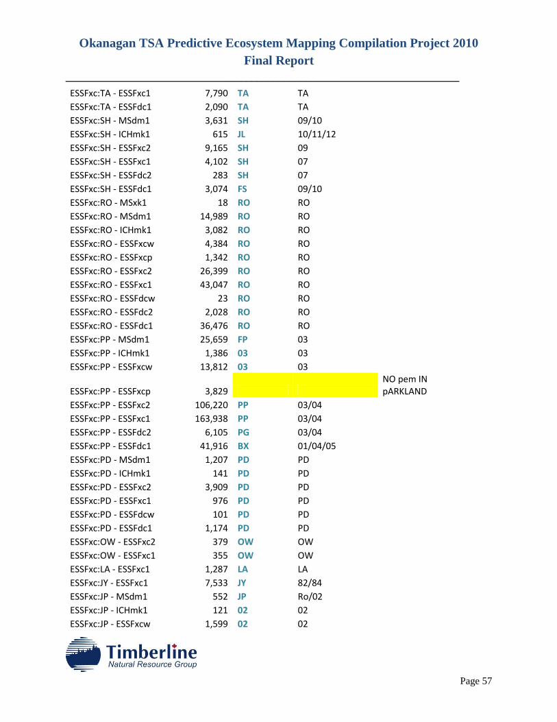
Okanagan TSA Predictive Ecosystem Mapping Compilation Project 2010
Final Report
________________________________________________________________________
Page 57
ESSFxc:TA - ESSFxc1 7,790 TA TA ESSFxc:TA - ESSFdc1 2,090 TA TA ESSFxc:SH - MSdm1 3,631 SH 09/10 ESSFxc:SH - ICHmk1 615 JL 10/11/12 ESSFxc:SH - ESSFxc2 9,165 SH 09 ESSFxc:SH - ESSFxc1 4,102 SH 07 ESSFxc:SH - ESSFdc2 283 SH 07 ESSFxc:SH - ESSFdc1 3,074 FS 09/10 ESSFxc:RO - MSxk1 18 RO RO ESSFxc:RO - MSdm1 14,989 RO RO ESSFxc:RO - ICHmk1 3,082 RO RO ESSFxc:RO - ESSFxcw 4,384 RO RO ESSFxc:RO - ESSFxcp 1,342 RO RO ESSFxc:RO - ESSFxc2 26,399 RO RO ESSFxc:RO - ESSFxc1 43,047 RO RO ESSFxc:RO - ESSFdcw 23 RO RO ESSFxc:RO - ESSFdc2 2,028 RO RO ESSFxc:RO - ESSFdc1 36,476 RO RO ESSFxc:PP - MSdm1 25,659 FP 03 ESSFxc:PP - ICHmk1 1,386 03 03 ESSFxc:PP - ESSFxcw 13,812 03 03
ESSFxc:PP - ESSFxcp 3,829 NO pem IN pARKLAND
ESSFxc:PP - ESSFxc2 106,220 PP 03/04 ESSFxc:PP - ESSFxc1 163,938 PP 03/04 ESSFxc:PP - ESSFdc2 6,105 PG 03/04 ESSFxc:PP - ESSFdc1 41,916 BX 01/04/05 ESSFxc:PD - MSdm1 1,207 PD PD ESSFxc:PD - ICHmk1 141 PD PD ESSFxc:PD - ESSFxc2 3,909 PD PD ESSFxc:PD - ESSFxc1 976 PD PD ESSFxc:PD - ESSFdcw 101 PD PD ESSFxc:PD - ESSFdc1 1,174 PD PD ESSFxc:OW - ESSFxc2 379 OW OW ESSFxc:OW - ESSFxc1 355 OW OW ESSFxc:LA - ESSFxc1 1,287 LA LA ESSFxc:JY - ESSFxc1 7,533 JY 82/84 ESSFxc:JP - MSdm1 552 JP Ro/02 ESSFxc:JP - ICHmk1 121 02 02 ESSFxc:JP - ESSFxcw 1,599 02 02
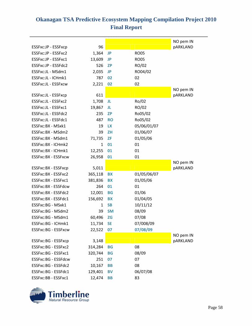
Okanagan TSA Predictive Ecosystem Mapping Compilation Project 2010
Final Report
________________________________________________________________________
Page 58
ESSFxc:JP - ESSFxcp 96 NO pem IN pARKLAND
ESSFxc:JP - ESSFxc2 1,364 JP RO05 ESSFxc:JP - ESSFxc1 13,609 JP RO05 ESSFxc:JP - ESSFdc2 526 ZP RO/02 ESSFxc:JL - MSdm1 2,035 JP RO04/02 ESSFxc:JL - ICHmk1 787 02 02 ESSFxc:JL - ESSFxcw 2,221 02 02
ESSFxc:JL - ESSFxcp 611 NO pem IN pARKLAND
ESSFxc:JL - ESSFxc2 1,708 JL Ro/02 ESSFxc:JL - ESSFxc1 19,867 JL RO/02 ESSFxc:JL - ESSFdc2 235 ZP Ro05/02 ESSFxc:JL - ESSFdc1 487 RO Ro05/02 ESSFxc:BX - MSxk1 19 LX 05/06/01/07
ESSFxc:BX - MSdm2 39 ZH 01/06/07 ESSFxc:BX - MSdm1 71,735 ZF 01/05/06 ESSFxc:BX - ICHmk2 1 01 01 ESSFxc:BX - ICHmk1 12,255 01 01 ESSFxc:BX - ESSFxcw 26,958 01 01
ESSFxc:BX - ESSFxcp 5,011 NO pem IN pARKLAND
ESSFxc:BX - ESSFxc2 365,118 BX 01/05/06/07 ESSFxc:BX - ESSFxc1 381,836 BX 01/05/06
ESSFxc:BX - ESSFdcw 264 01 01 ESSFxc:BX - ESSFdc2 12,001 BG 01/06 ESSFxc:BX - ESSFdc1 156,692 BX 01/04/05 ESSFxc:BG - MSxk1 1 SB 10/11/12 ESSFxc:BG - MSdm2 39 SM 08/09 ESSFxc:BG - MSdm1 60,496 ZG 07/08 ESSFxc:BG - ICHmk1 11,734 SE 07/008/09
ESSFxc:BG - ESSFxcw 22,522 07 07/08/09
ESSFxc:BG - ESSFxcp 3,148 NO pem IN pARKLAND
ESSFxc:BG - ESSFxc2 314,284 BG 08 ESSFxc:BG - ESSFxc1 320,744 BG 08/09 ESSFxc:BG - ESSFdcw 251 07 07 ESSFxc:BG - ESSFdc2 10,167 BB 08 ESSFxc:BG - ESSFdc1 129,401 BV 06/07/08 ESSFxc:BB - ESSFxc1 12,474 BB 83
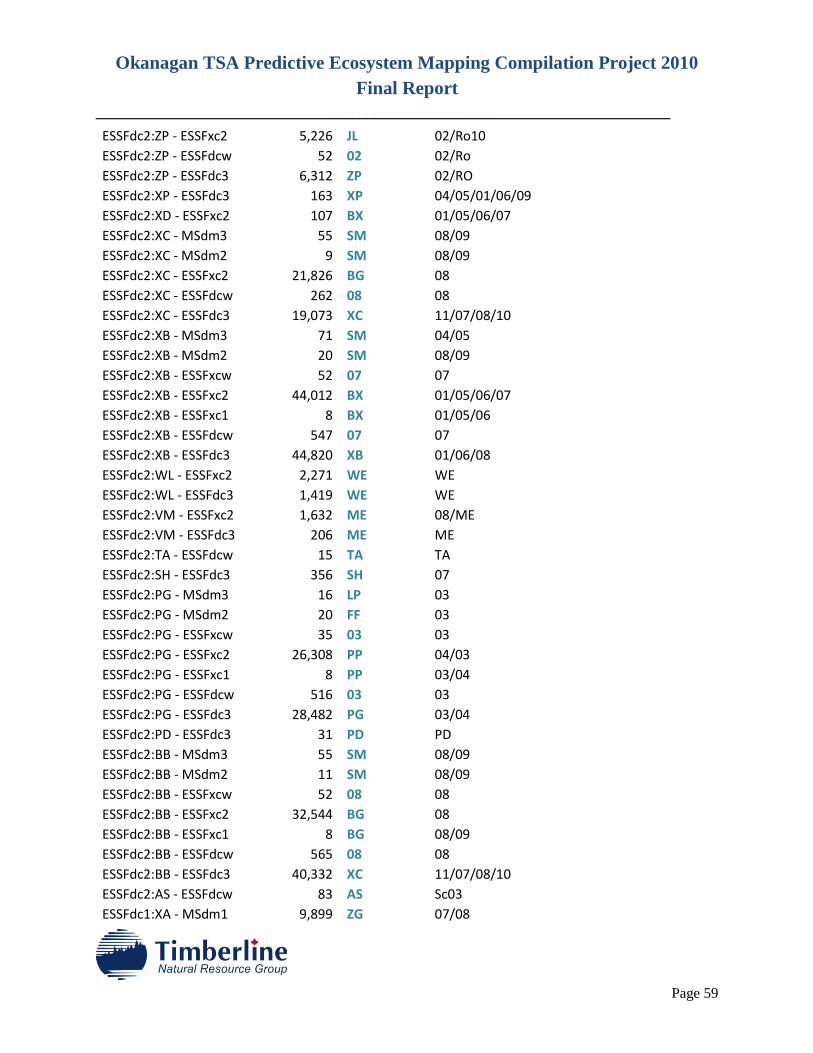
Okanagan TSA Predictive Ecosystem Mapping Compilation Project 2010
Final Report
________________________________________________________________________
Page 59
ESSFdc2:ZP - ESSFxc2 5,226 JL 02/Ro10 ESSFdc2:ZP - ESSFdcw 52 02 02/Ro ESSFdc2:ZP - ESSFdc3 6,312 ZP 02/RO ESSFdc2:XP - ESSFdc3 163 XP 04/05/01/06/09
ESSFdc2:XD - ESSFxc2 107 BX 01/05/06/07 ESSFdc2:XC - MSdm3 55 SM 08/09
ESSFdc2:XC - MSdm2 9 SM 08/09 ESSFdc2:XC - ESSFxc2 21,826 BG 08 ESSFdc2:XC - ESSFdcw 262 08 08 ESSFdc2:XC - ESSFdc3 19,073 XC 11/07/08/10
ESSFdc2:XB - MSdm3 71 SM 04/05 ESSFdc2:XB - MSdm2 20 SM 08/09 ESSFdc2:XB - ESSFxcw 52 07 07 ESSFdc2:XB - ESSFxc2 44,012 BX 01/05/06/07
ESSFdc2:XB - ESSFxc1 8 BX 01/05/06 ESSFdc2:XB - ESSFdcw 547 07 07 ESSFdc2:XB - ESSFdc3 44,820 XB 01/06/08 ESSFdc2:WL - ESSFxc2 2,271 WE WE ESSFdc2:WL - ESSFdc3 1,419 WE WE ESSFdc2:VM - ESSFxc2 1,632 ME 08/ME ESSFdc2:VM - ESSFdc3 206 ME ME ESSFdc2:TA - ESSFdcw 15 TA TA ESSFdc2:SH - ESSFdc3 356 SH 07 ESSFdc2:PG - MSdm3 16 LP 03 ESSFdc2:PG - MSdm2 20 FF 03 ESSFdc2:PG - ESSFxcw 35 03 03 ESSFdc2:PG - ESSFxc2 26,308 PP 04/03 ESSFdc2:PG - ESSFxc1 8 PP 03/04 ESSFdc2:PG - ESSFdcw 516 03 03 ESSFdc2:PG - ESSFdc3 28,482 PG 03/04 ESSFdc2:PD - ESSFdc3 31 PD PD ESSFdc2:BB - MSdm3 55 SM 08/09 ESSFdc2:BB - MSdm2 11 SM 08/09 ESSFdc2:BB - ESSFxcw 52 08 08 ESSFdc2:BB - ESSFxc2 32,544 BG 08 ESSFdc2:BB - ESSFxc1 8 BG 08/09 ESSFdc2:BB - ESSFdcw 565 08 08 ESSFdc2:BB - ESSFdc3 40,332 XC 11/07/08/10
ESSFdc2:AS - ESSFdcw 83 AS Sc03 ESSFdc1:XA - MSdm1 9,899 ZG 07/08
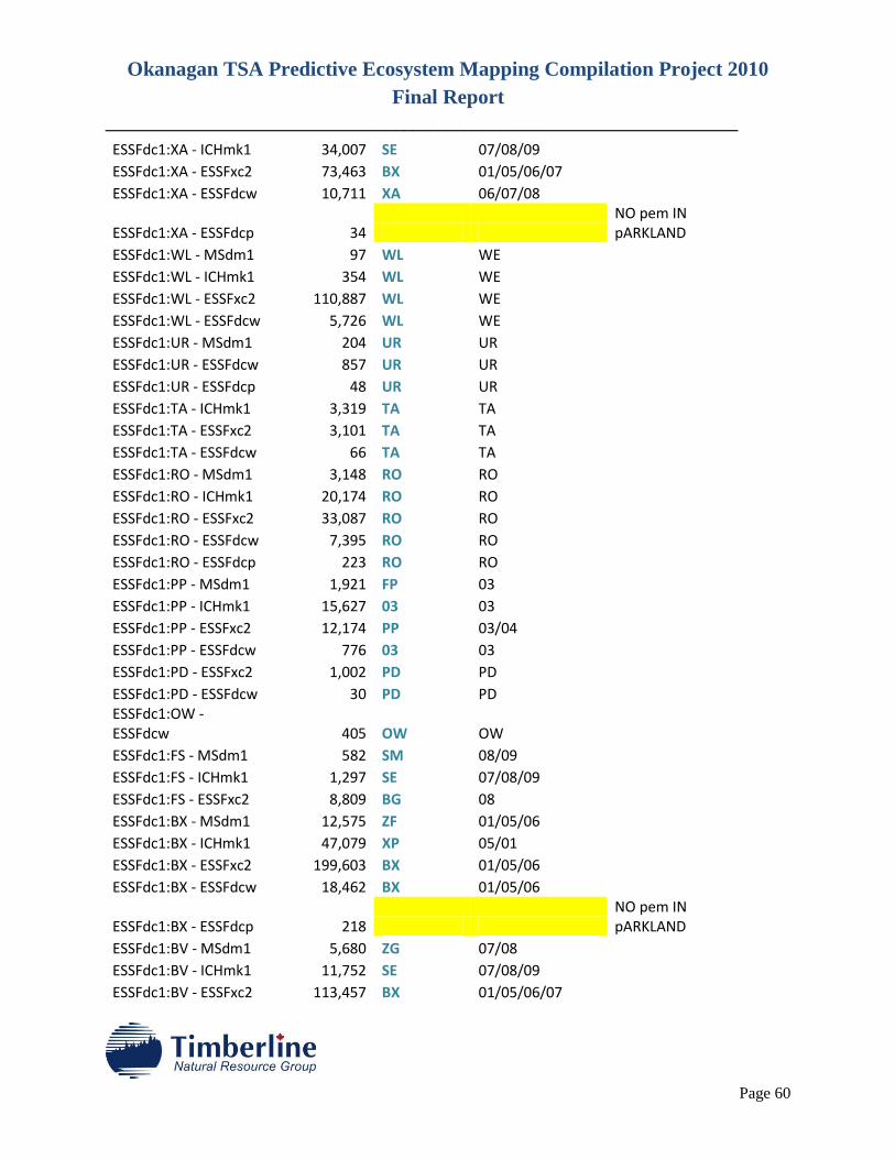
Okanagan TSA Predictive Ecosystem Mapping Compilation Project 2010
Final Report
________________________________________________________________________
Page 60
ESSFdc1:XA - ICHmk1 34,007 SE 07/08/09 ESSFdc1:XA - ESSFxc2 73,463 BX 01/05/06/07
ESSFdc1:XA - ESSFdcw 10,711 XA 06/07/08
ESSFdc1:XA - ESSFdcp 34 NO pem IN pARKLAND
ESSFdc1:WL - MSdm1 97 WL WE ESSFdc1:WL - ICHmk1 354 WL WE ESSFdc1:WL - ESSFxc2 110,887 WL WE ESSFdc1:WL - ESSFdcw 5,726 WL WE ESSFdc1:UR - MSdm1 204 UR UR ESSFdc1:UR - ESSFdcw 857 UR UR ESSFdc1:UR - ESSFdcp 48 UR UR ESSFdc1:TA - ICHmk1 3,319 TA TA ESSFdc1:TA - ESSFxc2 3,101 TA TA ESSFdc1:TA - ESSFdcw 66 TA TA ESSFdc1:RO - MSdm1 3,148 RO RO ESSFdc1:RO - ICHmk1 20,174 RO RO ESSFdc1:RO - ESSFxc2 33,087 RO RO ESSFdc1:RO - ESSFdcw 7,395 RO RO ESSFdc1:RO - ESSFdcp 223 RO RO ESSFdc1:PP - MSdm1 1,921 FP 03 ESSFdc1:PP - ICHmk1 15,627 03 03 ESSFdc1:PP - ESSFxc2 12,174 PP 03/04 ESSFdc1:PP - ESSFdcw 776 03 03 ESSFdc1:PD - ESSFxc2 1,002 PD PD ESSFdc1:PD - ESSFdcw 30 PD PD ESSFdc1:OW -
ESSFdcw 405 OW OW ESSFdc1:FS - MSdm1 582 SM 08/09 ESSFdc1:FS - ICHmk1 1,297 SE 07/08/09 ESSFdc1:FS - ESSFxc2 8,809 BG 08 ESSFdc1:BX - MSdm1 12,575 ZF 01/05/06 ESSFdc1:BX - ICHmk1 47,079 XP 05/01 ESSFdc1:BX - ESSFxc2 199,603 BX 01/05/06 ESSFdc1:BX - ESSFdcw 18,462 BX 01/05/06
ESSFdc1:BX - ESSFdcp 218 NO pem IN pARKLAND
ESSFdc1:BV - MSdm1 5,680 ZG 07/08 ESSFdc1:BV - ICHmk1 11,752 SE 07/08/09 ESSFdc1:BV - ESSFxc2 113,457 BX 01/05/06/07
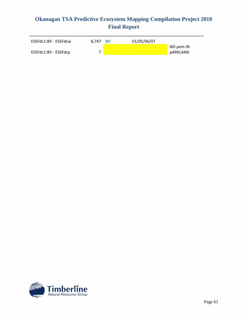
Okanagan TSA Predictive Ecosystem Mapping Compilation Project 2010
Final Report
________________________________________________________________________
Page 61
ESSFdc1:BV - ESSFdcw 8,747 BV 01/05/06/07
ESSFdc1:BV - ESSFdcp 7 NO pem IN pARKLAND