OGC Testbed-14: Semantically Enabled Aviation Data Models...
83
OGC Testbed-14 Semantically Enabled Aviation Data Models Engineering Report
Transcript of OGC Testbed-14: Semantically Enabled Aviation Data Models...
OGC Testbed-14Semantically Enabled Aviation Data Models
Engineering Report

Table of Contents1. Summary . . . . . . . . . . . . . . . . . . . . . . . . . . . . . . . . . . . . . . . . . . . . . . . . . . . . . . . . . . . . . . . . . . . . . . . . . . . . . . . . 4
1.1. Requirements & Research Motivation . . . . . . . . . . . . . . . . . . . . . . . . . . . . . . . . . . . . . . . . . . . . . . . . . . . 4
1.2. Prior-After Comparison. . . . . . . . . . . . . . . . . . . . . . . . . . . . . . . . . . . . . . . . . . . . . . . . . . . . . . . . . . . . . . . . 4
1.3. Recommendations for Future Work . . . . . . . . . . . . . . . . . . . . . . . . . . . . . . . . . . . . . . . . . . . . . . . . . . . . 5
1.4. What does this ER mean for the Working Group and OGC in general . . . . . . . . . . . . . . . . . . . . . . 6
1.5. Document contributor contact points . . . . . . . . . . . . . . . . . . . . . . . . . . . . . . . . . . . . . . . . . . . . . . . . . . . 6
1.6. Foreword . . . . . . . . . . . . . . . . . . . . . . . . . . . . . . . . . . . . . . . . . . . . . . . . . . . . . . . . . . . . . . . . . . . . . . . . . . . . 6
2. References . . . . . . . . . . . . . . . . . . . . . . . . . . . . . . . . . . . . . . . . . . . . . . . . . . . . . . . . . . . . . . . . . . . . . . . . . . . . . . . 8
3. Terms and definitions . . . . . . . . . . . . . . . . . . . . . . . . . . . . . . . . . . . . . . . . . . . . . . . . . . . . . . . . . . . . . . . . . . . . . 9
3.1. Semantics . . . . . . . . . . . . . . . . . . . . . . . . . . . . . . . . . . . . . . . . . . . . . . . . . . . . . . . . . . . . . . . . . . . . . . . . . . . . 9
3.2. Service Description. . . . . . . . . . . . . . . . . . . . . . . . . . . . . . . . . . . . . . . . . . . . . . . . . . . . . . . . . . . . . . . . . . . . 9
3.3. Service-Oriented Architecture (SOA) . . . . . . . . . . . . . . . . . . . . . . . . . . . . . . . . . . . . . . . . . . . . . . . . . . . . 9
3.4. Registry . . . . . . . . . . . . . . . . . . . . . . . . . . . . . . . . . . . . . . . . . . . . . . . . . . . . . . . . . . . . . . . . . . . . . . . . . . . . . . 9
3.5. System Wide Information Management (SWIM) . . . . . . . . . . . . . . . . . . . . . . . . . . . . . . . . . . . . . . . . . 9
3.6. Taxonomy . . . . . . . . . . . . . . . . . . . . . . . . . . . . . . . . . . . . . . . . . . . . . . . . . . . . . . . . . . . . . . . . . . . . . . . . . . . . 9
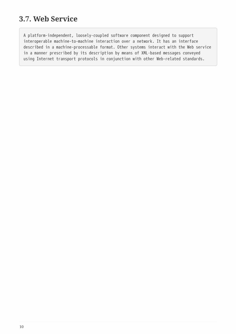
3.7. Web Service . . . . . . . . . . . . . . . . . . . . . . . . . . . . . . . . . . . . . . . . . . . . . . . . . . . . . . . . . . . . . . . . . . . . . . . . . 10
4. Abbreviated Terms . . . . . . . . . . . . . . . . . . . . . . . . . . . . . . . . . . . . . . . . . . . . . . . . . . . . . . . . . . . . . . . . . . . . . . 11
5. Overview . . . . . . . . . . . . . . . . . . . . . . . . . . . . . . . . . . . . . . . . . . . . . . . . . . . . . . . . . . . . . . . . . . . . . . . . . . . . . . . 12
6. Review of Data Models . . . . . . . . . . . . . . . . . . . . . . . . . . . . . . . . . . . . . . . . . . . . . . . . . . . . . . . . . . . . . . . . . . . 13
6.1. Information Exchange Models . . . . . . . . . . . . . . . . . . . . . . . . . . . . . . . . . . . . . . . . . . . . . . . . . . . . . . . . 13
6.1.1. Flight Information Exchange Model (FIXM). . . . . . . . . . . . . . . . . . . . . . . . . . . . . . . . . . . . . . . . . 13
6.1.2. Aeronautical Information Exchange (AIXM) Model. . . . . . . . . . . . . . . . . . . . . . . . . . . . . . . . . . 13
6.1.3. Weather Information Exchange Model (WXXM) . . . . . . . . . . . . . . . . . . . . . . . . . . . . . . . . . . . . 14
6.1.4. NASA Air Traffic Management (ATM) Model . . . . . . . . . . . . . . . . . . . . . . . . . . . . . . . . . . . . . . . . 14
6.2. Service description models . . . . . . . . . . . . . . . . . . . . . . . . . . . . . . . . . . . . . . . . . . . . . . . . . . . . . . . . . . . 19
6.2.1. Service Description Conceptual Model (SDCM) . . . . . . . . . . . . . . . . . . . . . . . . . . . . . . . . . . . . . . 19
6.2.2. Web Service Description Ontological Model (WSDOM). . . . . . . . . . . . . . . . . . . . . . . . . . . . . . . 23
6.2.3. SWIM Documentation Controlled Vocabulary (FAA) . . . . . . . . . . . . . . . . . . . . . . . . . . . . . . . . . 25
7. Semantic Enablement Approaches . . . . . . . . . . . . . . . . . . . . . . . . . . . . . . . . . . . . . . . . . . . . . . . . . . . . . . . . 27
8. Metadata level semantic enablement . . . . . . . . . . . . . . . . . . . . . . . . . . . . . . . . . . . . . . . . . . . . . . . . . . . . . . 33
8.1. Issues with existing metadata standards . . . . . . . . . . . . . . . . . . . . . . . . . . . . . . . . . . . . . . . . . . . . . . . 34
8.1.1. Identification of Resources . . . . . . . . . . . . . . . . . . . . . . . . . . . . . . . . . . . . . . . . . . . . . . . . . . . . . . . . 34
8.1.2. Resolvable URI . . . . . . . . . . . . . . . . . . . . . . . . . . . . . . . . . . . . . . . . . . . . . . . . . . . . . . . . . . . . . . . . . . . 34
8.1.3. Multilingual Support . . . . . . . . . . . . . . . . . . . . . . . . . . . . . . . . . . . . . . . . . . . . . . . . . . . . . . . . . . . . . 35
8.1.4. External Resource Descriptions . . . . . . . . . . . . . . . . . . . . . . . . . . . . . . . . . . . . . . . . . . . . . . . . . . . 35
8.1.5. Controlled Vocabulary Management . . . . . . . . . . . . . . . . . . . . . . . . . . . . . . . . . . . . . . . . . . . . . . . 36
8.1.6. Keywords Types . . . . . . . . . . . . . . . . . . . . . . . . . . . . . . . . . . . . . . . . . . . . . . . . . . . . . . . . . . . . . . . . . 37
8.1.7. Keyword Labeling Inconsistencies . . . . . . . . . . . . . . . . . . . . . . . . . . . . . . . . . . . . . . . . . . . . . . . . . 37
8.1.8. Authority for Controlled Vocabularies . . . . . . . . . . . . . . . . . . . . . . . . . . . . . . . . . . . . . . . . . . . . . 38
8.2. Relevant ontologies . . . . . . . . . . . . . . . . . . . . . . . . . . . . . . . . . . . . . . . . . . . . . . . . . . . . . . . . . . . . . . . . . . 39
8.2.1. DCAT. . . . . . . . . . . . . . . . . . . . . . . . . . . . . . . . . . . . . . . . . . . . . . . . . . . . . . . . . . . . . . . . . . . . . . . . . . . . 39
8.2.2. DCAT-AP . . . . . . . . . . . . . . . . . . . . . . . . . . . . . . . . . . . . . . . . . . . . . . . . . . . . . . . . . . . . . . . . . . . . . . . . 40
8.2.3. Asset Description Metadata Schema (ADMS) . . . . . . . . . . . . . . . . . . . . . . . . . . . . . . . . . . . . . . . . 40
8.2.4. Project Open Data (POD) . . . . . . . . . . . . . . . . . . . . . . . . . . . . . . . . . . . . . . . . . . . . . . . . . . . . . . . . . . 41
8.2.5. GeoDCAT-AP . . . . . . . . . . . . . . . . . . . . . . . . . . . . . . . . . . . . . . . . . . . . . . . . . . . . . . . . . . . . . . . . . . . . . 44
8.2.6. SRIM . . . . . . . . . . . . . . . . . . . . . . . . . . . . . . . . . . . . . . . . . . . . . . . . . . . . . . . . . . . . . . . . . . . . . . . . . . . . 45
8.3. Approaches . . . . . . . . . . . . . . . . . . . . . . . . . . . . . . . . . . . . . . . . . . . . . . . . . . . . . . . . . . . . . . . . . . . . . . . . . 48
8.3.1. Semantic Mapping of SDCM Service to SRIM . . . . . . . . . . . . . . . . . . . . . . . . . . . . . . . . . . . . . . . . 48
8.3.2. Dataset metadata . . . . . . . . . . . . . . . . . . . . . . . . . . . . . . . . . . . . . . . . . . . . . . . . . . . . . . . . . . . . . . . . 49
8.3.3. SRIM Registry. . . . . . . . . . . . . . . . . . . . . . . . . . . . . . . . . . . . . . . . . . . . . . . . . . . . . . . . . . . . . . . . . . . . 49
9. Data Silos Semantic Enablement . . . . . . . . . . . . . . . . . . . . . . . . . . . . . . . . . . . . . . . . . . . . . . . . . . . . . . . . . . 50
9.1. Approach for Semantic-Enablement . . . . . . . . . . . . . . . . . . . . . . . . . . . . . . . . . . . . . . . . . . . . . . . . . . . 50
9.1.1. Extension of existing RESTful services protocol . . . . . . . . . . . . . . . . . . . . . . . . . . . . . . . . . . . . . 50
9.1.2. Semantic mapping . . . . . . . . . . . . . . . . . . . . . . . . . . . . . . . . . . . . . . . . . . . . . . . . . . . . . . . . . . . . . . . 51
9.1.3. Web API Semantic Wrapper. . . . . . . . . . . . . . . . . . . . . . . . . . . . . . . . . . . . . . . . . . . . . . . . . . . . . . . 53
9.1.4. RDFa . . . . . . . . . . . . . . . . . . . . . . . . . . . . . . . . . . . . . . . . . . . . . . . . . . . . . . . . . . . . . . . . . . . . . . . . . . . . 54
9.1.5. SAWSDL. . . . . . . . . . . . . . . . . . . . . . . . . . . . . . . . . . . . . . . . . . . . . . . . . . . . . . . . . . . . . . . . . . . . . . . . . 55
9.1.6. GRDDL . . . . . . . . . . . . . . . . . . . . . . . . . . . . . . . . . . . . . . . . . . . . . . . . . . . . . . . . . . . . . . . . . . . . . . . . . . 56
9.1.7. W3C Annotation . . . . . . . . . . . . . . . . . . . . . . . . . . . . . . . . . . . . . . . . . . . . . . . . . . . . . . . . . . . . . . . . . 56
9.1.8. Microdata . . . . . . . . . . . . . . . . . . . . . . . . . . . . . . . . . . . . . . . . . . . . . . . . . . . . . . . . . . . . . . . . . . . . . . . 57
9.1.9. Embedded JSON-LD . . . . . . . . . . . . . . . . . . . . . . . . . . . . . . . . . . . . . . . . . . . . . . . . . . . . . . . . . . . . . . 58
9.2. Pure RDF approach . . . . . . . . . . . . . . . . . . . . . . . . . . . . . . . . . . . . . . . . . . . . . . . . . . . . . . . . . . . . . . . . . . 59
10. The role of Controlled Vocabularies . . . . . . . . . . . . . . . . . . . . . . . . . . . . . . . . . . . . . . . . . . . . . . . . . . . . . . 60
10.1. Controlled Vocabulary Definition . . . . . . . . . . . . . . . . . . . . . . . . . . . . . . . . . . . . . . . . . . . . . . . . . . . . 61
10.2. Vocabulary Classification . . . . . . . . . . . . . . . . . . . . . . . . . . . . . . . . . . . . . . . . . . . . . . . . . . . . . . . . . . . . 61
10.3. Encoding of Controlled Vocabularies . . . . . . . . . . . . . . . . . . . . . . . . . . . . . . . . . . . . . . . . . . . . . . . . . 62
10.3.1. SKOS. . . . . . . . . . . . . . . . . . . . . . . . . . . . . . . . . . . . . . . . . . . . . . . . . . . . . . . . . . . . . . . . . . . . . . . . . . . 62
10.3.2. Ontology languages . . . . . . . . . . . . . . . . . . . . . . . . . . . . . . . . . . . . . . . . . . . . . . . . . . . . . . . . . . . . . 63
10.4. Improvements on existing vocabularies . . . . . . . . . . . . . . . . . . . . . . . . . . . . . . . . . . . . . . . . . . . . . . 64
10.4.1. CodeList, Taxonomy and Thesauri conversion to OWL . . . . . . . . . . . . . . . . . . . . . . . . . . . . . 64
10.4.2. Considerations on Ontology Lifecycle and Code List Conversion. . . . . . . . . . . . . . . . . . . . . 65
10.4.3. Gazetteer for Aviation . . . . . . . . . . . . . . . . . . . . . . . . . . . . . . . . . . . . . . . . . . . . . . . . . . . . . . . . . . . 66
10.4.4. Best practices for domain ontology design. . . . . . . . . . . . . . . . . . . . . . . . . . . . . . . . . . . . . . . . . 67
Appendix A: Sample datasets . . . . . . . . . . . . . . . . . . . . . . . . . . . . . . . . . . . . . . . . . . . . . . . . . . . . . . . . . . . . . . . 69
Appendix B: Revision History . . . . . . . . . . . . . . . . . . . . . . . . . . . . . . . . . . . . . . . . . . . . . . . . . . . . . . . . . . . . . . . 78
Appendix C: Bibliography. . . . . . . . . . . . . . . . . . . . . . . . . . . . . . . . . . . . . . . . . . . . . . . . . . . . . . . . . . . . . . . . . . . 79
Publication Date: 2019-02-07
Approval Date: 2018-12-13
Submission Date: 2018-11-27
Reference number of this document: OGC 18-035
Reference URL for this document: http://www.opengis.net/doc/PER/t14-D002
Category: Public Engineering Report
Editor: Stephane Fellah
Title: OGC Testbed-14: Semantically Enabled Aviation Data Models Engineering Report
OGC Engineering Report
COPYRIGHT
Copyright (c) 2019 Open Geospatial Consortium. To obtain additional rights of use, visithttp://www.opengeospatial.org/
WARNING
This document is not an OGC Standard. This document is an OGC Public Engineering Report createdas a deliverable in an OGC Interoperability Initiative and is not an official position of the OGCmembership. It is distributed for review and comment. It is subject to change without notice andmay not be referred to as an OGC Standard. Further, any OGC Engineering Report should not bereferenced as required or mandatory technology in procurements. However, the discussions in thisdocument could very well lead to the definition of an OGC Standard.
1
LICENSE AGREEMENT
Permission is hereby granted by the Open Geospatial Consortium, ("Licensor"), free of charge andsubject to the terms set forth below, to any person obtaining a copy of this Intellectual Property andany associated documentation, to deal in the Intellectual Property without restriction (except as setforth below), including without limitation the rights to implement, use, copy, modify, merge,publish, distribute, and/or sublicense copies of the Intellectual Property, and to permit persons towhom the Intellectual Property is furnished to do so, provided that all copyright notices on theintellectual property are retained intact and that each person to whom the Intellectual Property isfurnished agrees to the terms of this Agreement.
If you modify the Intellectual Property, all copies of the modified Intellectual Property must include,in addition to the above copyright notice, a notice that the Intellectual Property includesmodifications that have not been approved or adopted by LICENSOR.
THIS LICENSE IS A COPYRIGHT LICENSE ONLY, AND DOES NOT CONVEY ANY RIGHTS UNDER ANYPATENTS THAT MAY BE IN FORCE ANYWHERE IN THE WORLD. THE INTELLECTUAL PROPERTY ISPROVIDED "AS IS", WITHOUT WARRANTY OF ANY KIND, EXPRESS OR IMPLIED, INCLUDING BUTNOT LIMITED TO THE WARRANTIES OF MERCHANTABILITY, FITNESS FOR A PARTICULARPURPOSE, AND NONINFRINGEMENT OF THIRD PARTY RIGHTS. THE COPYRIGHT HOLDER ORHOLDERS INCLUDED IN THIS NOTICE DO NOT WARRANT THAT THE FUNCTIONS CONTAINED INTHE INTELLECTUAL PROPERTY WILL MEET YOUR REQUIREMENTS OR THAT THE OPERATION OFTHE INTELLECTUAL PROPERTY WILL BE UNINTERRUPTED OR ERROR FREE. ANY USE OF THEINTELLECTUAL PROPERTY SHALL BE MADE ENTIRELY AT THE USER’S OWN RISK. IN NO EVENTSHALL THE COPYRIGHT HOLDER OR ANY CONTRIBUTOR OF INTELLECTUAL PROPERTY RIGHTSTO THE INTELLECTUAL PROPERTY BE LIABLE FOR ANY CLAIM, OR ANY DIRECT, SPECIAL,INDIRECT OR CONSEQUENTIAL DAMAGES, OR ANY DAMAGES WHATSOEVER RESULTING FROMANY ALLEGED INFRINGEMENT OR ANY LOSS OF USE, DATA OR PROFITS, WHETHER IN AN ACTIONOF CONTRACT, NEGLIGENCE OR UNDER ANY OTHER LEGAL THEORY, ARISING OUT OF OR INCONNECTION WITH THE IMPLEMENTATION, USE, COMMERCIALIZATION OR PERFORMANCE OFTHIS INTELLECTUAL PROPERTY.
This license is effective until terminated. You may terminate it at any time by destroying theIntellectual Property together with all copies in any form. The license will also terminate if you failto comply with any term or condition of this Agreement. Except as provided in the followingsentence, no such termination of this license shall require the termination of any third party end-user sublicense to the Intellectual Property which is in force as of the date of notice of suchtermination. In addition, should the Intellectual Property, or the operation of the IntellectualProperty, infringe, or in LICENSOR’s sole opinion be likely to infringe, any patent, copyright,trademark or other right of a third party, you agree that LICENSOR, in its sole discretion, mayterminate this license without any compensation or liability to you, your licensees or any otherparty. You agree upon termination of any kind to destroy or cause to be destroyed the IntellectualProperty together with all copies in any form, whether held by you or by any third party.
Except as contained in this notice, the name of LICENSOR or of any other holder of a copyright in allor part of the Intellectual Property shall not be used in advertising or otherwise to promote the sale,use or other dealings in this Intellectual Property without prior written authorization of LICENSORor such copyright holder. LICENSOR is and shall at all times be the sole entity that may authorizeyou or any third party to use certification marks, trademarks or other special designations to
2

indicate compliance with any LICENSOR standards or specifications.
This Agreement is governed by the laws of the Commonwealth of Massachusetts. The application tothis Agreement of the United Nations Convention on Contracts for the International Sale of Goods ishereby expressly excluded. In the event any provision of this Agreement shall be deemedunenforceable, void or invalid, such provision shall be modified so as to make it valid andenforceable, and as so modified the entire Agreement shall remain in full force and effect. Nodecision, action or inaction by LICENSOR shall be construed to be a waiver of any rights orremedies available to it.
None of the Intellectual Property or underlying information or technology may be downloaded orotherwise exported or reexported in violation of U.S. export laws and regulations. In addition, youare responsible for complying with any local laws in your jurisdiction which may impact your rightto import, export or use the Intellectual Property, and you represent that you have complied withany regulations or registration procedures required by applicable law to make this licenseenforceable.
3

Chapter 1. SummaryThis Engineering Report (ER) summarizes the OGC Testbed-14 findings and recommendations to“semantically enable” existing data and metadata models used in the aviation industry. Examples ofsuch data and metadata models include Aeronautical Information Exchange Model (AIXM) [1],Weather Information Exchange Model (WXXM) [2], Flight Information Exchange Model (FIXM) [3],Web Service Description Document (WSDD), Service Description Conceptual Model (SDCM) [4]).These models use Linked Data standards to represent this information and aim to improve thesearch and discovery of services and information in the aviation domain using the System WideInformation Management (SWIM) environment. This report provides a review of the existing datamodels and explore different approaches to provide a semantic representation of the currentmetadata and data models used in the aviation domain. The ER also discusses the role andimportance of the controlled vocabularies.
1.1. Requirements & Research MotivationThe current SWIM developed by Federal Aviation Administration (FAA) provides an API to searchand discover web services. The current service model is based on the SDCM model, which isinspired by the Semantic Markup for Web Services (OWL-S) [5] specification of the World WideWeb Consortium (W3C). However, the response returned by the API is encoded in ExtensibleMarkup Language (XML) and uses XML Schema for validation. The description of the service isfocused on defining how the service input/output can be constructed and manipulated (e.g., XMLschemas, Web Service Description Language (WSDL) [6] files) but has limited semantics about theinformation it operates on. The current service description standards (e.g., WSDL and XML Schema)operate almost entirely at the syntactic level, focusing only on describing exposed functionality(methods signatures, input/output types) and failing to capture enough semantics (i.e., they definestructure, not meaning). The standards for free-text, human-consumable documents, (e.g., FAA’sWSDD), support a sufficient amount of semantics but are not suitable for automated discovery andprovide very limited support for semantic interoperability.
The following requirements were to be addressed in the OGC Testbed-14:
• Testbed-14 shall provide recommendations for making existing data models used in aviationindustry (e.g., AIXM, WXXM, and FIXM) “semantically enabled”.
• The data models shall be enabled to present their contents in formats suitable for adaptation bySemantic Web technologies, including considerations for role and applicability of ontologiesand linked data approaches to complex information realms such as SWIM.
• The work shall provide a clear definition of next steps.
1.2. Prior-After ComparisonThe topic of semantic-enablement of models used in the domain of aviation has been exploredpreviously in OGC Testbeds (OGC 16-039 [7],OGC 17-036 [8]). In past demonstrations, analysesrecommended the use of run-time registries and complex use cases for service discovery and datataxonomy/ontology. However, much of the information exchanged within the FAA NationalAirspace System (NAS) [9] System-Wide Information Management (SWIM) network is made up of
4

various data models using XML schema encoding (such as AIXM), which addresses only thestructure and syntax of information exchanged between systems, but not the semantic aspect of themodel. Testbed-12 [7] and 13 [8] have made progress toward the semantic enablement of thecontrolled vocabularies using the Simple Knowledge Organization System (SKOS) [10] encoding butthese vocabularies were still referred from the XML document based on structure and syntax. Thishybrid approach does not allow the usage of off-the-shelf solutions for Linked Data such as linkingheterogeneous domain entities, deductive reasoning and unified access to information. Systems arecurrently built around specific data models and unable to communicate and link to each othercausing duplication of information and making difficult to search and discover information thatare relevant for users.
The goal of this ER is to formulate an approach to semantically enable the different data models,taxonomy and service descriptions that can incorporate enough semantic metadata, includingdescriptive metadata, geospatial-temporal characteristics, quality information for fitness-of-use)about the services and data information, so that they can facilitate the integration of informationand services, improve search and discovery in the current registry, and increase the level ofautomation (reasoning, access by agents) in systems.
1.3. Recommendations for Future WorkThe solutions described in this engineering report may provide further insights if implemented as agreater solution for information registries. Furthermore, implementation of the recommendationsfor SDCM will provide a path forward for prototyping and implementation of SWIM registries andsearch/discovery of services and information.
This engineering report proposes the following tasks to be explored for future testbeds:
• Controlled Vocabulary Management: The management and governance of controlledvocabularies play a crucial role in the semantic "tagging" of resources managed by NAS(Datasets, Services, Maps, Layers, Documents,etc..) and the search and discovery of theseresources. Vocabularies also enable semantic enrichment, reasoning and provide a commonframework to represent information based on Linked Data representation facilitating theintegration of information silos. Future testbeds should investigate the requirements, designand implementation of an API for a controlled vocabulary services that manages ontologies andtaxonomies (encoded in SKOS).
• Development of a Semantic Registry Information Model (SRIM) [11] Application Profile forSWIM that extends the current SRIM model (which is based on a number of well-knownvocabularies such as the W3C Data Catalog (DCAT) [12], GeoDCAT-AP [13], Dublin Core, SKOS [10], Provenance, Authoring and Versioning (PAV) ontology [14]) to describe services anddatasets specific for the aviation domain and that aligns with the current SDCM effort.
• SRIM Semantic Registry implementation [11] of the SWIM Application Profile that showcasesthe search and discovery of the assets managed by the SWIM ecosystem, focusing in particularto Services and Datasets.
• Investigation of the modularization and encoding of aviation ontologies using the NASA ATMontology as a starting point and identification of gaps with the current existing standards(AIXM, WXXM,FIXM).
• Demonstration of the use of semantic enablement of aviation data using Linked Data
5
representation based on the ontologies developed in the previous recommendations bydeploying a Linked Data API that offers a Representational State Transfer (REST) API and aGeoSPARQL Endpoint), as well as demonstration of the link to the Dataset metadata descriptionregistered in a Semantic Registry.
1.4. What does this ER mean for the Working Groupand OGC in generalThis engineering report documents the findings, approaches and recommendations to semanticallyenable existing data models used in the aviation domain. The semantic-enablement of theseexisting models will improve search and discovery of aviation-related information using a semanticregistry.
The chosen working group for review of this ER is the Geosemantics Domain Working Group(DWG). This work may also be applicable to the Aviation DWG which is co-sponsored by the FAAand EUROCONTROL.
The scope of the Geosemantics DWG is any aspect of semantic conceptual modeling and formalrepresentation of aviation data models which advances the geospatial interoperability mission ofOGC. A particular focus will be the adoption or development of tools and methods in support ofthese activities. It is the mission of the Geosemantics DWG to establish an interoperable andactionable semantic framework for representing the geospatial knowledge domains of informationcommunities as well as mediating between them. This ER will address the need for semanticallyenablement of aviation data models. The use of semantics will enable better descriptions ofaviation-related assets, including OGC web services in the FAA’s SWIM registry, datasets, maps,layers, etc.
1.5. Document contributor contact pointsAll questions regarding this document should be directed to the editor or the contributors:
Contacts
Name Organization
Stephane Fellah Image Matters LLC
Yann Le Franc e-Science Data Factory
1.6. ForewordAttention is drawn to the possibility that some of the elements of this document may be the subjectof patent rights. The Open Geospatial Consortium shall not be held responsible for identifying anyor all such patent rights.
Recipients of this document are requested to submit, with their comments, notification of anyrelevant patent claims or other intellectual property rights of which they may be aware that mightbe infringed by any implementation of the standard set forth in this document, and to provide
6

supporting documentation.
7
Chapter 2. References• RDF Schema 1.1, W3C Recommendation 25 February 2014 , available online at
http://www.w3.org/TR/rdf-schema/
• OWL 2 Web Ontology Language Document Overview (Second Edition)], W3C Recommendation11 December 2012, available online at https://www.w3.org/TR/owl2-overview/
• OWL 2 Web Ontology Language, Direct Semantics (Second Edition), W3C Recommendation 11December 2012, available online at http://www.w3.org/TR/2012/REC-owl2-direct-semantics-20121211/
• OWL 2 Web Ontology Language, Structural Specification and Functional-Style Syntax (SecondEdition), W3C Recommendation 11 December 2012, available online at http://www.w3.org/TR/2012/REC-owl2-syntax-20121211/
• SKOS Simple Knowledge Organization System Reference, W3C Recommendation 18 August2009, available online at http://www.w3.org/TR/2009/REC-skos-reference-20090818/
• Data Catalog Vocabulary (DCAT), W3C Recommendation 16 January 2014, available online athttps://www.w3.org/TR/vocab-dcat/
• Web Services Description Language (WSDL) Version 2.0 Part 1: Core Language, W3CRecommendation 26 June 2007 , available online at https://www.w3.org/TR/wsdl20/
• OGC 12-168r6 OGC Catalogue Services 3.0, Open Geospatial Consortium, available online athttp://docs.opengeospatial.org/is/12-168r6/12-168r6.html
• Gleaning Resource Descriptions from Dialects of Languages (GRDDL), W3C RecommendationREC-grddl-20070911, September 2007. available online at https://www.w3.org/TR/grddl/
8

Chapter 3. Terms and definitionsFor the purposes of this report, the definitions specified in Clause 4 of the OWS CommonImplementation Standard OGC 06-121r9 [https://portal.opengeospatial.org/files/?artifact_id=38867&version=2]shall apply. In addition, the following terms and definitions apply.
3.1. Semantics
A conceptualization of the implied meaning of information that requires words and/orsymbols within a usage context.
3.2. Service Description
The information needed in order to use, or consider using, a service.
3.3. Service-Oriented Architecture (SOA)
A paradigm for organizing and utilizing distributed capabilities that may be under thecontrol of different ownership domains. A SOA provides a uniform means to offer,discover, interact with, and use capabilities to produce desired effects consistentwith measurable preconditions and expectations.
3.4. Registry
An enabling infrastructure that uses a formal registration process to store, catalog,and manage metadata relevant to a service. A registry supports the search,identification, and understanding of resources, as well as query capabilities.
3.5. System Wide Information Management (SWIM)
A concept using Service Oriented Architecture to facility the exchange Air TrafficManagement information amongst stakeholders in the aviation domain such as AirNavigation Service Providers, airports, and airspace users.
3.6. Taxonomy
A system or controlled list of values by which to categorize or classify objects.
9
3.7. Web Service
A platform-independent, loosely-coupled software component designed to supportinteroperable machine-to-machine interaction over a network. It has an interfacedescribed in a machine-processable format. Other systems interact with the Web servicein a manner prescribed by its description by means of XML-based messages conveyedusing Internet transport protocols in conjunction with other Web-related standards.
10
Chapter 4. Abbreviated Terms• ATM Air Traffic Management
• ICAO International Civil Aviation Organization
• FAA Federal Aviation Administration (United States)
• NAS National Airspace System (United States)
• NSRR NAS Service Registry and Repository
• OWL Web Ontology Language (W3C)
• OWL-S Semantic Markup for Web Services
• OWS OGC Web Service
• RDF Resource Description Framework (W3C)
• RDFS Resource Description Framework Schema (W3C)
• SDCM Service Description Conceptual Model
• SOA Service Oriented Architecture
• SWIM System Wide Information Management
• WSDOM Web Service Description Ontological Model
11
Chapter 5. OverviewThe ER is composed of the following sections:
Section 6 provides a review of the existing data models currently used by FAA and ontologies thatare relevant for semantic-enablement of the aviation domain.
Section 7 provides a comparison of existing data-centric services approach with semantic-enabledservices approach and highlights the benefits to use the latter approach. Two levels of semanticenablement are identified:
• Metadata level semantic enablement to support search and discovery of information
• Instance level semantic enablement to support data integration and reasoning.
Section 8 focuses on the Metadata-level semantic enablement. It discusses some of the issues foundcurrently in existing metadata standards in particular ISO 19115. The section provides a review ofrelevant semantic metadata standards (DCAT, GeoDCAT,Project Open Data, SRIM) and discusses theapproaches to semantic-enable metadata on the current infrastructure.
Section 9 focuses on the Data-level semantic enablement. It discusses the issue of data-silos andhow semantics can enable the integration of data silos. An inventory of different technicalapproaches to semantic-enable the existing infrastructure is given with discussions ofpro/cons/applicability of each approach.
Section 10 addresses the role of Controlled Vocabularies in the aviation domain. It provides aclassification of the different types of controlled vocabularies. It also discusses some improvementsthat can be done on existing vocabularies, provides recommendations about the governance andlifecycle of controlled vocabularies, and highlights some best practices for ontology design.
Annex A provides some metadata samples illustrating the description of datasets and theirrelationships to services.
12
Chapter 6. Review of Data ModelsThis section provides a review of the existing data models currently used by FAA and the aviationcommunity.
6.1. Information Exchange ModelsThe first set of data models reviewed related to information exchange models. There are threeprimary standards currently used by the industry (FIXM, AIXM, and WXXM). The models have anabstract model defined in UML and an encoding based on XML schema. There is currently noencoding based on linked data standards such as the Web Ontology Language (OWL) [15] or RDFSchema [16].
6.1.1. Flight Information Exchange Model (FIXM)
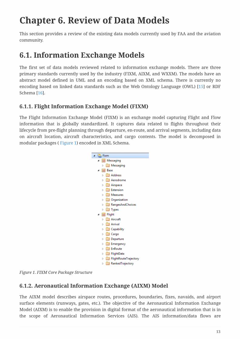
The Flight Information Exchange Model (FIXM) is an exchange model capturing Flight and Flowinformation that is globally standardized. It captures data related to flights throughout theirlifecycle from pre-flight planning through departure, en-route, and arrival segments, including dataon aircraft location, aircraft characteristics, and cargo contents. The model is decomposed inmodular packages ( Figure 1) encoded in XML Schema.
Figure 1. FIXM Core Package Structure
6.1.2. Aeronautical Information Exchange (AIXM) Model
The AIXM model describes airspace routes, procedures, boundaries, fixes, navaids, and airportsurface elements (runways, gates, etc.). The objective of the Aeronautical Information ExchangeModel (AIXM) is to enable the provision in digital format of the aeronautical information that is inthe scope of Aeronautical Information Services (AIS). The AIS information/data flows are
13

increasingly complex and made up of interconnected systems. They involve many actors includingmultiple suppliers and consumers. There is also a growing need in the global Air TrafficManagement (ATM) system for high data quality and for cost efficiency.
6.1.3. Weather Information Exchange Model (WXXM)
The WXXM is designed to enable the management and distribution of weather data in digitalformat (XML). WXXM version 2.0 is based on Geography Markup Language (GML) and is one of theGML Application Schemas. It has been developed by the FAA and the European Organization for theSafety of Air Navigation (EUROCONTROL). WXXM is a member of a family of data models designedfor use in aviation safety, notably AIXM and FIXM.
WXXM models meteorological observations, forecasts, and measurement procedures for weatherfeatures and phenomena with spatial and temporal extent. Independent from governmentalstandardization efforts, the airline industry has been developing Airline Industry Data Model(AIDM).
6.1.4. NASA Air Traffic Management (ATM) Model
The National Aeronautics and Space Administration (NASA) has developed a prototype dataintegration system that demonstrates how ontologies can be used to integrate, query, and searchover various sources of heterogeneous air traffic management (ATM) data, including data fromFAA, National Oceanic and Atmospheric Administration (NOAA), NASA, and other providers. In thisprototype, a common ontology is used to bridge multiple types of aviation data models and enablecross-dataset querying. In general, cross-dataset querying is very challenging due to differing dataformats, nomenclature, and organizational structure. Data can only be combined from multiplesources by expending significant effort to write customized code that integrates selected data on anas-needed, piecemeal basis. To address this problem, NASA is building an integrated data sourcethat obviates this need to write special- purpose, one-off integration code.
As part of this approach, an overarching data model (the NASA ATM Ontology [1:https://data.nasa.gov/ontologies/atmonto/NAS]) has been designed and implemented to serve as abackbone upon which to overlay data from multiple sources. The ontology data model is scopedsufficiently broadly to interconnect data from several different aviation realms, including flight,traffic management, aeronautical information, weather, and carrier operations. The ontology iscurrently populated with instance data corresponding to over 100K flights arriving and departingthe three major airports in the New York Metroplex (KEWR, KJFK, KLGA) during July 2014. Thisdata is encoded in approximately 250M triple statements and incorporates the following sources:flight track data from FAA’s ASDI (Aircraft Situation Display to Industry) data feed; airport weatherfrom the NOAA’s METeorological Aerodrome Reports (METAR) and Terminal Aerodrome Forecasts(TAF) data feeds; information on traffic management initiatives from FAA’s Command Centerwebsite; historical traffic counts and delay statistics from the Department of Transportation (DOT)’sAviation System Performance Metrics (ASPM)database; infrastructure data on US routes, fixes,airways, and sectors used by FAA’s En Route Automation Modernization (ERAM) system; aircraftinformation from FAA’s aircraft registry and from the Commercial Aviation Safety Team(CAST)/International Civil Aviation Organization (ICAO) common aircraft taxonomy; and web-basedinformation on airlines, airport terminals and gates. Of the 250M triples, about 99.5% representspecific flight, weather, or traffic management data. These are dominated overwhelmingly by
14

triples capturing flight track parameters from ASDI – such as altitude, location, and groundspeed –captured at the rate of one per minute of flight. The remaining 0.5% of triples capture mostly staticaeronautical infrastructure information (e.g., data on airspace routes, sectors, and fixes, NASfacilities, airports, aircraft makes and models, airlines, etc.).
The figures below (all extracted from the abovementioned NASA Technical Memo) provide someintuition about how the classes and properties represent the structure, content, and relationshipsfound in ATM data. Only a subset of available figures is shown here; please consult the NASATechnical Memo for additional illustrations.
Figure 2 illustrates the key relationships among selected New York area airspace structure andfacility instances. Sector nas:ZNYsector075 is one of the sectors located in the New York Air RouteTraffic Control Center (ARTCC) instance nas:ZNYcenter. Sector 075 is composed of two stackedhorizontal layers of airspace, each represented by a shear-sided polygon of a certain height (onlyone polygon is depicted in the figure). The ZNY ARTCC has operational agreements with the FAAcommand center and the New York Terminal Radar Approach Control (TRACON) facility, which inturn has agreements with each of the airports in its territory. The ZNY Tier 1 structure contains allARTCCs that directly border the ZNY ARTCC. (Note that only a small subset of instances is illustratedin order to keep the figure uncluttered and readable.)
Figure 2. ATM Ontology- Structure of the NAS
Figure 3 illustrates the basic components of the ontology representation of a flight — in thisillustration, Delta Airlines flight DAL435 on 2014-07-15. The flight is associated with its departureand arrival airports; the aircraft, aircraft type, and operating carrier; and the actual and plannedflight route.
15
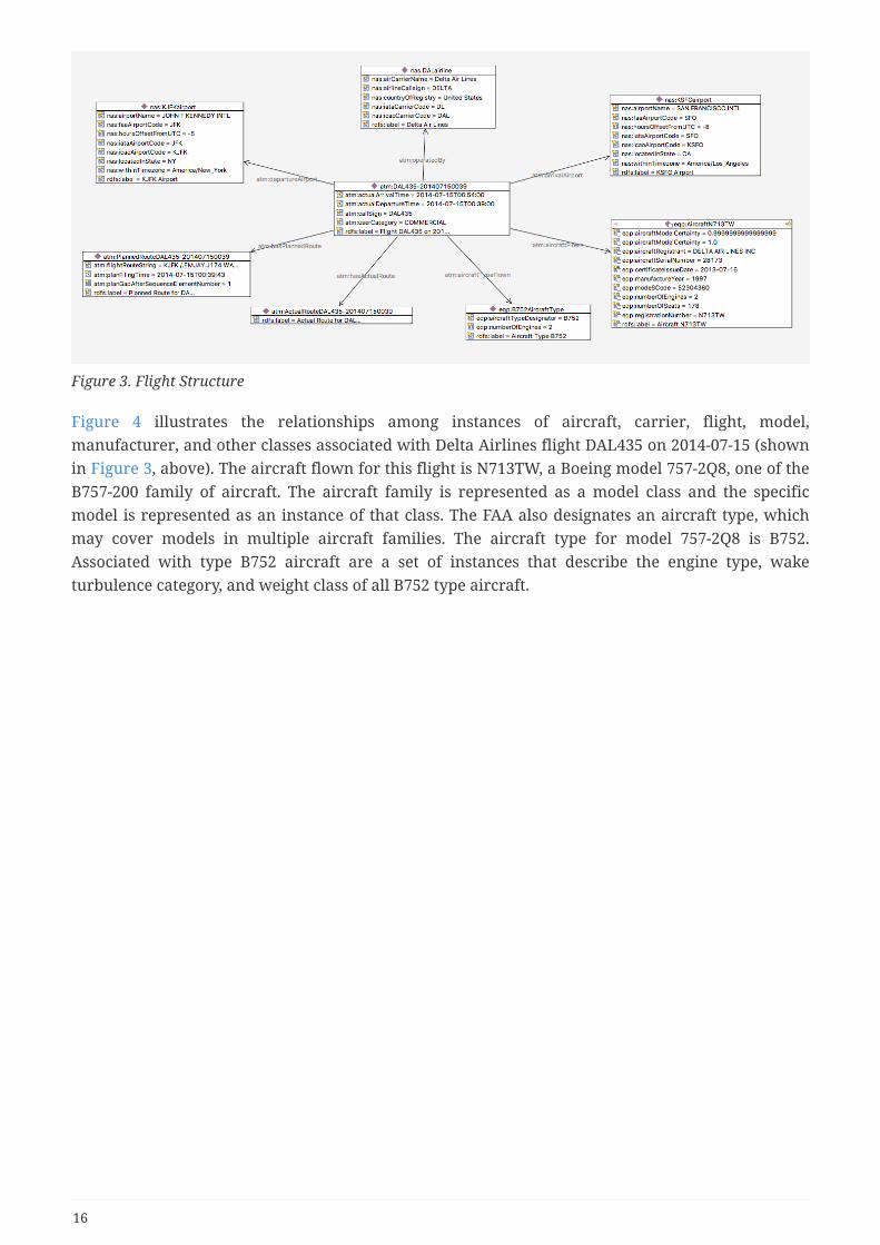
Figure 3. Flight Structure
Figure 4 illustrates the relationships among instances of aircraft, carrier, flight, model,manufacturer, and other classes associated with Delta Airlines flight DAL435 on 2014-07-15 (shownin Figure 3, above). The aircraft flown for this flight is N713TW, a Boeing model 757-2Q8, one of theB757-200 family of aircraft. The aircraft family is represented as a model class and the specificmodel is represented as an instance of that class. The FAA also designates an aircraft type, whichmay cover models in multiple aircraft families. The aircraft type for model 757-2Q8 is B752.Associated with type B752 aircraft are a set of instances that describe the engine type, waketurbulence category, and weight class of all B752 type aircraft.
16
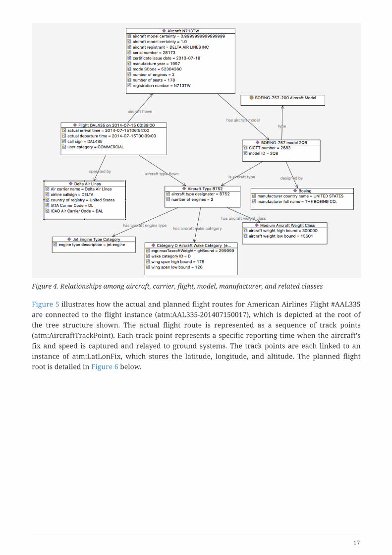
Figure 4. Relationships among aircraft, carrier, flight, model, manufacturer, and related classes
Figure 5 illustrates how the actual and planned flight routes for American Airlines Flight #AAL335are connected to the flight instance (atm:AAL335-201407150017), which is depicted at the root ofthe tree structure shown. The actual flight route is represented as a sequence of track points(atm:AircraftTrackPoint). Each track point represents a specific reporting time when the aircraft’sfix and speed is captured and relayed to ground systems. The track points are each linked to aninstance of atm:LatLonFix, which stores the latitude, longitude, and altitude. The planned flightroot is detailed in Figure 6 below.
17

Figure 5. Structure of an Actual Flight Route (Flight Trajectory)
Figure 6 elaborates on the representation for the flight plan (atm:PlannedRouteAAL335-201407150017) shown at the root of this tree and also in Figure 5. The flight plan includes a flightroute string ‘KLGA./.CFB..RAAKK.Q436.EMMMA.WYNDE5.KORD’, which is a representation of thepath to be flown through the airspace. The flight route string is initially filed by the pilot prior totakeoff and modified as needed en route. The root node in the graph contains this route string as aproperty, but the string is also converted into an explicit sequence of ‘container’ nodes that include(via the property atm:hasNavElement) the major navigational components through which the flightis planned to progress: the originating airport (KLGA); a VOR fix (CFB); a portion of a high-altitudeflight route (Q436); a traverse through a standard terminal arrival route (STAR WYNDE5); and thedestination airport (KORD).
18

Figure 6. Example of Flight Plan
6.2. Service description models
6.2.1. Service Description Conceptual Model (SDCM)
System Wide Information Management (SWIM) is a data distribution framework started by FAAand EUROCONTROL and adopted by ICAO. The goal of the framework is to standardize mechanismsfor delivery of ATM data between producers and consumers using a subscription-based Service-Oriented Architecture (SOA). As part of the SWIM architecture, data providers create services toaccess their data. For the FAA, these services are published in the NAS Services Registry/Repository(NSRR). NSSR is a catalog of all SWIM services and provides documentation on various aspects ofeach service, including its provider, functionality, quality characteristics, interface, andimplementation.
As part of this effort, FAA SWIM Program and the Single European Sky Air Traffic Management(ATM) Research Programme (SESAR) Joint Undertaking (SJU) have developed a conceptual modeldescribing services semantically called Service Description Conceptual Model (SDCM) [4] [17].
SDCM provides a graphical and lexical representation of the properties, structure, andinterrelationships of all service metadata elements, collectively known as a Service Description. The
19
objectives of the SDCM are:
• To define a conceptual model of a Service Description based on consistent application of SOAprinciples;
• To establish adequate and consistent semantics for concepts used in documentation for SOA-based services;
• To advance a common and shared understanding of SOA concepts among internationalpartners;
• To promote a technological means for describing all relevant aspects of a service in a mannersuitable for both human-readable and machine-processable representations.
The SDM adheres to the following design principles:
• It shall be based on widely-used industry service description standards and models (e.g., OWL-S,WSDL, OASIS SOA Reference Model);
• It shall be extensible to allow deriving and adding more elements to address organization-specific tasks;
• It shall be neutral to any organizational governance model (e.g., in SESAR or FAA SWIMprograms);
• It shall be agnostic to the service technological solution (e.g., it shall not be tailored to method,message or resource oriented implementations);
• It shall be vendor neutral (e.g., it shall not support any proprietary implementation of UMLand/or vocabularies).
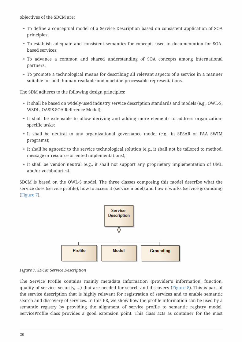
SDCM is based on the OWL-S model. The three classes composing this model describe what theservice does (service profile), how to access it (service model) and how it works (service grounding)(Figure 7).
Figure 7. SDCM Service Description
The Service Profile contains mainly metadata information (provider’s information, function,quality of service, security, …) that are needed for search and discovery (Figure 8). This is part ofthe service description that is highly relevant for registration of services and to enable semanticsearch and discovery of services. In this ER, we show how the profile information can be used by asemantic registry by providing the alignment of service profile to semantic registry model.ServiceProfile class provides a good extension point. This class acts as container for the most
20

relevant metadata, such as service functions and real-world effects, quality of service, securityparameters, service providers and consumers. The service profile class can be enriched withadditional classes, properties and individuals to accommodate the specific needs for search anddiscovery of services in a semantic registry. Individuals of "ServiceProfile" type can contain one ormany properties depicting the concept of "Service function" associated with "real-world effects". Inorder to extend the ontology to provide controlled vocabulary (values) for these concepts, domainexperts need to define taxonomy of business functions and real world effects based on aviationtraffic (management) domain needs.
Figure 8. SDCM Service Profile
The SDCM Model describes to a service requester how to construct an invocation message andinterpret a response message (img_sdcm_model). This part of the model is mostly technical and isused by a software agent to communicate with the service.
21

Figure 9. SDCM Model
The SDCM grounding describes the means by which the service is invoked, including theunderlying technology protocols and network locations of the service (Figure 10). This part is verytechnical and is usually leveraged by software agents to communicate with the service.
22

Figure 10. SDCM Grounding
6.2.2. Web Service Description Ontological Model (WSDOM)
The Web Service Description Ontological Model (WSDOM) [18] can be considered an "RDF"realization of the SDCM conceptual model. WSDOM standardizes information and metadatapertinent to describing SWIM services and facilitates interchange of service data between serviceproviders and the FAA. The intent behind the ontology is to make service definitions clear,unambiguous, and discoverable by both humans and computer systems. WSDOM consists ofontology classes covering the key notions of service profile, service interface, serviceimplementation, stakeholder, and document. WSDOM is patterned after the OWL-S semantic webservices description ontology.
WSDOM was developed before SDCM and was written in OWL. For many people in the industry,OWL ontology was too technical to be understood by a large audience. To address this gap andmake the service description more "readable", the Service Description Conceptual Model wascreated. That said, SDCM 2.0 is more recent than WSDOM 1.0, and therefore better reflects thecurrent NSRR data structure. WSDOM 2.0 is currently being developed and not been aligned yetwith the latest version of SDCM.
The WSDOM ontology was designed based on the OWL-S service ontology and considering the
23

service taxonomies used by FAA. The WSDOM 1.1 release consists of six OWL files and three RDFfiles. The three RDF files provide ontological representation of FAA standard taxonomies.
The structure follows the OWL-S model defining the Service ontology as being the top levelontology with three related classes: ServiceProfile (maps to OWL-S ServiceProfile), ServiceInterface(maps to OWL-S ServiceModel) and ServiceImplementation (maps to OWL-S ServiceGrounding)(Figure 11).
Figure 11. WSDOM Model
The ServiceProfile presents metadata about the service. This information is highly relevant forsearch of services and information. Figure 12 shows the information of the service profile that canbe leveraged in a semantic registry.
Figure 12. WSDOM Profile
ServiceInterface (maps to OWL-S ServiceModel) and ServiceImplementation (maps to OWL-SServiceGrounding) describe how to access the service (its API and endpoints). This information isrelevant when access to the service needs to be automated (Figure 13).
24

Figure 13. WSDOM Interface
6.2.3. SWIM Documentation Controlled Vocabulary (FAA)
FAA has developed a controlled vocabulary (CV), based on the Simple Knowledge OrganizationSystem (SKOS), that provides a single source for terms and definitions used in SWIM-relateddocumentation [19]. SKOS (Simple Knowledge Organization System) is a W3C standardized RDFontology for representing controlled vocabularies, thesauri, and taxonomies. The SWIM CVincludes textual definitions of SWIM-related terms and their connections to broader, narrower, andotherwise related terms within the CV. SWIM documentation and web pages can reference termdefinitions in the CV using resolvable Universal Resource Identifiers (URIs).
Table 1 describes the list of taxonomies currently used by SWIM. These taxonomies were developedduring previous OGC testbeds.
Table 1. Taxonomies currently used by SWIM
Name Description
SWIM Service Product A classification of services based on the type of SWIM dataproduct that they deliver.
Service Availability Status A classification of services based on their current, past, orfuture availability for provisioning.
Service Interface Type A classification of services based on the type oftechnological solution that they deploy.
Flight Phase A classification of services or other artifacts based on the flightphase, or period within a flight, during which the artifacts areused or provide support. See also [1].
US Airways A classification of US Airways based on airway identificationprefixes.
25

Name Description
ICAO Region A classification of geographical regions as defined by theInternational Civil Aviation Organization (ICAO).
US Flight Information Region A classification of the US Flight Information Regions as definedby the International Civil Aviation Organization (ICAO).
Airspace Class A classification of airspaces as defined and applied by the USFederal Aviation Administration (FAA).
The concepts of these taxonomies are encoded directly as skos:Concept, making it difficult todistinguish what category of concepts (ServiceProduct, ICAORegion, etc.) they denote. The nextsection addresses this gap in relation to controlled vocabularies (see also The role of ControlledVocabularies).
26

Chapter 7. Semantic EnablementApproachesThis section introduces the term “Data-Centric Services” to generally describe classic dataprocessing approaches, whereupon the focus is on creating, storing, sharing, and exploiting data.Within the National Airspace System (NAS), this is the world of FIXM, AIXM, WXXM, databases, andcountless data capture, storage, discovery, navigation, visualization, analytics, and exchangeservices. By in large, in this world, aviation data is used to characterize air traffic information,weather information, and infrastructure information.
This section also introduces the term “Semantic-Enabled Services” (a.k.a. ontology-based services orknowledge-enabled services) to generally describe processing approaches that focus on creating,storing, sharing, and exploiting machine-encoded knowledge. This is the world of ontologies andformal taxonomies, graph databases, and ontology-based services. In this world, there are two basicapproaches to knowledge-enabling the aviation enterprise:
1. Convert data to knowledge - structured data can be transformed into explicit knowledge, andthen enriched to provide improved coherence and context.
2. Add a knowledge layer to data - a knowledge layer can be added to structured data, thusenriching the in situ data with improved semantic coherence and context, without the need oftransforming 'physically' the data into knowledge (causing duplication of information). In bothcases, knowledge enablement means the introduction of ontology, data-to-ontology mappings ,and ontology-based services.
The National Airspace System (NAS), SWIM and indeed most IT modernization projects employ“Data-Centric Approaches” to manage and exploit information assets. Normally these efforts startby defining and standardizing logical data models, which in turn drive the implementation ofdictionaries (what to call things), metadata (a means to discover things) and services (how to accessand process things). Data-Centric Approaches tend to restrict research and development efforts tomostly syntactic and schematic considerations that are data-driven. These approaches focus ongaining community consensus about well-defined entities, taxonomies, properties, and relations,towards the goal of establishing common schemata and protocols for interoperability. Resultingimplementations are limited by their syntactic and schematic boundaries. Further, resultingimplementations fall short of providing sufficient semantics (explicit meaning of concepts) andcontext (relevant information that clarifies the meaning, significance and relevance of conceptsand concept patterns, i.e., supplementary information that places concepts in a useful context).
These circumstances can be improved by taking a Semantic-Enabled Approach, which adds amachine-encoded, semantics-based knowledge layer to NAS data and services. Semantics arerequired to take aviation domain interoperability to the next level. Semantics are also key toenabling computer-assisted autonomous operations. A Knowledge-Enabled Approach captures andexploits semantics and associated context, as machine-encoded knowledge, thus contributing to arich, conceptual model that builds upon SWIM logical data model foundations. This approach willhelp ensure that NSG objects and entities are properly interpreted and employed, in a usefulmission context.
Again, Semantic-Enabled Approaches add a machine-encoded knowledge layer to existing
27
environments. This layer captures the conceptual meanings, significance, relevance andrelationships of all relevant information required for use in a target mission domain. The layer alsoencodes business rules that are used by enhanced reasoning services to draw inferences and makesense of mission concepts. Finally, the knowledge layer integrates with an array of analytical andreasoning services to enhance information triage, fusion, situation awareness, and sense making.The layer facilitates a higher level of utility, automation, interoperability, extensibility andflexibility, beyond that which is possible with data-centric approaches. It also dramatically reducesthe cognitive burden on users.
Some notable advantages of this approach are:
1. The knowledge layer provides a more user friendly and mission-relevant unified conceptualview of all pertinent data and services for a target mission domain. Users are able to interactwith familiar, well-understood concepts, rather than deal at the level of fixed data schematawith its commensurate semantic and contextual ambiguities. This allows users to obtainrelevant actionable information more readily, which in turn leads to making better decisionsmore quickly. User productivity and effectiveness increases with the reduction in cognitiveburden.
2. There is substantially more flexibility in accommodating data evolution, variety and veracity. Itis easier to add new data sets, make changes to existing data sets, and accommodate data setdifferences. Changes in information requirements will first affect the “knowledge layer”,reducing effects on databases and software, as only the mapping of the existing data toknowledge representation needs to be changed.
3. Business rules are encoded on top of the knowledge layer, where they can be more easilychanged without changing business applications. (Current approaches require that businesslogic must be wired into business applications… a costly, inflexible approach.)
4. The vastly improved filtering, fusion, analytics and reasoning services provide an enhancedinformation triage mechanism for quickly finding “the needle in the haystack”, locatingpatterns across a complex array of data, and making inferences that are not directly exposed indata (i.e., “determine the haystack from the needles”). User productivity and effectivenessincreases with the increased level of automation.
Table 2 presents the main issues addressed by a Semantic-Enabled Approach, along with itsbenefits.
Data-Centric Issues with Corresponding Semantic-Enabled Approach and Benefits
28

Issues with Data-CentricApproaches
Semantic-Enabled Approach Value Proposition
Data model standardizationrelies upon homogeneousdata description andorganization. This imposesstrict adherence to a standardthat is defined at the syntactic-schematic level, whereupon it’sharder to achieve consensus andless flexible. Modelers strugglebetween producing simplermodels for which it is easier togain consensus, but harder toachieve desired business reality,versus those seeking richermodels that are closer to realitybut have unwanted complexity.
• A semantic-enabledapproach employs astandards-based formal,sharable framework thatprovides a conceptualdomain model toaccommodate variousbusiness needs.Decentralized modelextensions can beaccommodated withoutadversely affecting existinginformation infrastructure.
• Allows decentralizedextensions of the domainmodel
• Accommodatesheterogeneousimplementations of thedomain model (lessensimpact on systems; reducescost)
• Shareable machine-processable model andbusiness rules; reducesrequired code base
Data-centric approachesincrease the chance formultiple interpretations andmisinterpretations of data.Data interpretation requiresknowledge of its semantics (e.g.,meanings, significance, andrelevance) and surroundingcontext. Data-centricapproaches are unable tocapture these semantics andcontext, which are in turnrequired for automated fusion,analytics, and reasoning.
• Semantic-enabledapproaches encode datacharacteristics in ontology.By formalizing the semanticand business rulesunambiguously in adeclarative ontology,software can use off-the-shelf semantic componentsto interpret, infer andvalidate domain data, thusreducing interpretationerrors.
• Increased softwaremaintainability
• Improved datainterpretation and utility
• Actionable information forthe decision maker
29

Issues with Data-CentricApproaches
Semantic-Enabled Approach Value Proposition
Data model implementationshave limited support forbusiness rules, and lackexpressiveness. Data-centricimplementations encodebusiness rules using software ordatabase programminglanguages. Additionalprogramming is necessary toapply business rules when usingthe data. Robust conceptual andcontextual meanings ofinformation may not be capturedin the model. The risk is high forinconsistent conceptualencoding and interpretation ineach implemented system.
• Standards-based knowledgeencoding (OWL, SPARQLRules) captures formalconceptual models andbusiness rules, providingexplicit, unambiguousmeanings for use inautomated systems. Withricher semantic andcontextual expressiveness,automated systems are lesscomplex to design anddevelop. Properinterpretation and use ismore consistent acrossenterprise systems.
• Reduction of software andassociated development cost
• Conceptual models andrules that provide enhancedmeaning, thus reducing theburden on users
• Unambiguousinterpretation of domainmodel; greater consistencyin use
Data-centric implementationsare inflexible when datarequirements change.Whenever business rules andsemantic meaning are encodedin a programming language,changes impact the fulldevelopment life cycle forsoftware and data. When thechange includes a conceptualchange (new/enhanced businessconcept), the fullstandardization process mustalso be executed.
• The semantic-enabledapproach uses an ontologythat contains a flexible,versatile conceptual modelthat can betteraccommodate therequirements of eachstakeholder in the businessdomain. Changes orextensions are integratedand implemented byenhancing the domainontology and updating thesemantic mapping to thedata store. Older conceptsand heterogeneity can stillbe supported by usingdifferent mappings.
• Increased flexibility toaccommodate stakeholderneeds; Decentralized andorganic evolution of thedomain model
• Changes only impactaffected stakeholders, notothers; reduces softwareupdates
• Software adapts to domainmodel as ontology evolves
• The enterprise can betterkeep up with changingenvironment/requirements
30

Issues with Data-CentricApproaches
Semantic-Enabled Approach Value Proposition
Data-centric approachesrequire additional softwaredevelopment (tools) tointegrate across severaldomains. The heterogeneity ofdata schemas and businessmodels in alien domainsrequires additional softwaredevelopment (or tools) tointegrate and make sense of thealien data in the local domain.
• Standards-based knowledgetechnologies provide themeans to exchangeknowledge, schemas/rulesand query knowledge.Knowledge representationsare non-disruptivelylayered on top of existinginformation assets. Theyenhance rather thandisplace existinginformation resources.
• Using semantic-enabledtechnologies, different datasources can be accessed intheir native form, andlinked-fused-reasonedabout on-the-fly for morecreative uses.
• Leverages and enhances“As-Is” enterprise;preserves investments
• Open standards enhanceinteroperability (theknowledge layer is the “lastrung in the interoperabilityladder”)
• Enables use of diverse Weband enterprise data sourcesfor full business context;enhances businessapplications
• Easy to work acrossdifferent domains andanswer more challenging,relevant business questions
Data-centric approachesrequire that data inferencingand validation rules areencoded in software, ordelegated to human-intensivevalidation processes. Reliabledata that is essential for criticalsystems, inferencing, andeffective decision support,requires rules that supportinferencing and validation.
• Semantic-enabledapproaches use a formallanguage (OWL) thatprovides well-definedsemantics in a formcompliant with off-the-shelfsoftware that automatesdata inferencing andvalidation.
• Semantic-enabledapproaches canaccommodate situationswhere information may bemissing or incomplete.
• Employs off-the-shelfsoftware for inferencingand validation
• Reduction of validation andtesting in the developmentprocess
• Uses all available data fromsources, includinginferences, whileaccommodating cases ofmissing/incompleteinformation
31
Issues with Data-CentricApproaches
Semantic-Enabled Approach Value Proposition
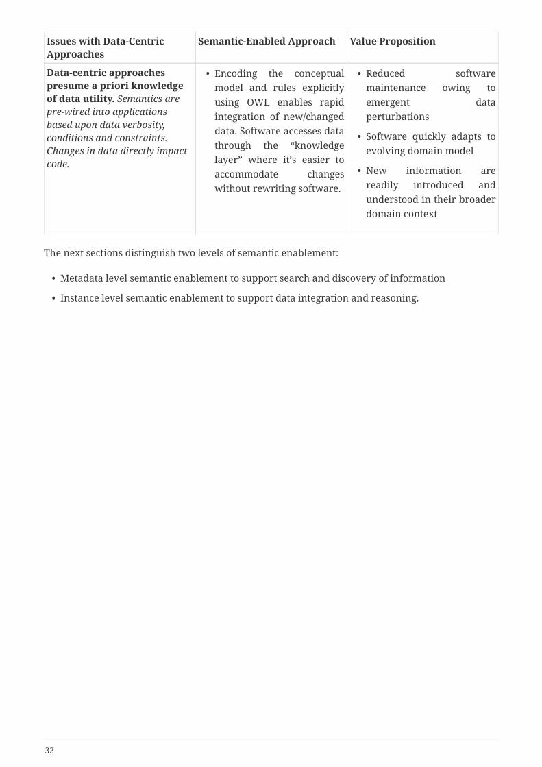
Data-centric approachespresume a priori knowledgeof data utility. Semantics arepre-wired into applicationsbased upon data verbosity,conditions and constraints.Changes in data directly impactcode.
• Encoding the conceptualmodel and rules explicitlyusing OWL enables rapidintegration of new/changeddata. Software accesses datathrough the “knowledgelayer” where it’s easier toaccommodate changeswithout rewriting software.
• Reduced softwaremaintenance owing toemergent dataperturbations
• Software quickly adapts toevolving domain model
• New information arereadily introduced andunderstood in their broaderdomain context
The next sections distinguish two levels of semantic enablement:
• Metadata level semantic enablement to support search and discovery of information
• Instance level semantic enablement to support data integration and reasoning.
32

Chapter 8. Metadata level semanticenablementSemantic metadata plays a central role in facilitating the search, discovery and the assessment ofgeospatial assets (such as datasets, services, portrayal information, schemas, maps, layers), and theintegration of these assets in a specific mission or domain. There are a number of standards,formats and APIs that provide the metadata for these assets, but in order to perform efficientsearch providing relevant results, there is a need to convert this information into a unifiedmachine readable semantic representation. It is this conversion that enables the discovery ofrelevant resources that satisfy the requirement criteria of the end user. As the computingcommunity increases its understanding of the kind of metadata information needed to performbetter and smarter search, the National Airspace System (NAS) needs a model that accommodatesextensions over time without breaking the proposed architecture.
The current SWIM architecture is mostly focused on the description of Services. While the model isbased on OWL-S ontology, it is encoded in XML and validated with XML Schema, which reduces thebenefits of using ontology, reasoning and integration by linking to other domains and vocabularies.Previous testbeds integrated controlled vocabularies in the XML representation but cannot beleveraged by off-the-shelf semantic tools (reasoner, RDF API) to perform inference and linkinginformation between systems. Data are still living in silos and are confined in the scope of XMLdocuments.
RECOMMENDATION: Define an alternative representation of Service description in theservice registry using Linked Data formats such as RDF/XML, Turtle, and JavaScript ObjectNotation for Linked Data (JSON-LD), so as to facilitate the integration of controlledvocabularies described in SKOS and OWL, linkage to other resources such as Datasetdescriptions and reasoning. If possible, make the URL of these resources resolvable through aREST API.
While the SWIM Registry [9] has done an excellent job at describing services [7],[20], they do notaddress the needs of end-users, who are looking for information that answers their questions:Where can I find the flight plan for a given flight? What are the departures time for a given flight ina given airport? Are there any air show events in my area? When issuing a search, the end-user isnot focused on the details of "how" to access the information (which service metadata provides)and "how the data are encoded", but more about finding the "relevant" information that fits theirneeds (topic, spatial, temporal coverages, quality information). At present, the description ofinformation is barely addressed in the service description as it is mostly limited to tags and somecontrolled vocabulary terms, making the search of relevant information very difficult. The currentservice descriptions are not able to answer questions such as: what are the spatial, temporal,topical coverages and quality information of the datasets that services operate on? Typically, end-users are looking for information and once they discover the information, they want to know howto access it, i.e. what are the distributions available (download, service API, web site).
Data and services are the Ying and Yang of Information Systems. The balance needs to be restoredin the current SWIM infrastructure by providing metadata about the information, on which thedifferent services operates on.
33
RECOMMENDATION: Restore the balance of metadata description by providing moremetadata about datasets/information
8.1. Issues with existing metadata standardsTo discover the information needed, enough metadata needs to be given to assess the relevance ofthe information. There are number of metadata standards that are used to describe geospatialdatasets. The most popular ones are ISO 19115 and ISO 19139. Regionally, popular ones include andthe Content Standard for Digital Geospatial Metadata (CSGDM) in the United States and themetadata specification of the Infrastructure for Spatial Information in the European Community(INSPIRE) in Europe. However, these standards are defined in XML using XML Schema forvalidation. While these standards help to provide metadata about datasets and services, they arestill falling short into helping the user to find the relevant information because they are documentcentric and do not enforce proper use of semantic information. They fail to properly leverage theuse of controlled vocabularies using well-grounded terms. The following issues relevant to thecontrolled vocabularies in these standards have been identified during Testbed-12 [OGC 16-059]and are summarized below. The goal of enumerating these issues is to avoid the NAS falling in thesame interoperability traps that other systems using these standards fell in.
8.1.1. Identification of Resources
Issue Identification of Resources
Description There is no consistent way of defining the identifiers for different resources(e.g. organizations, datasets, services, controlled vocabularies, etc.)
Why it is aproblem?
Inability to link information and allow reusability. Resource information(concepts) are duplicated several times in different documents with variationsof the same information. Updating this information is difficult to performacross all repositories. Need authoritative unambiguous references.
Recommendations • Each resource should use a unique URI that is resolvable.
• A policy needs to be put in place to manage the URI schemes of differenttypes of resources.
• The maintenance of the information for each resolvable URI should bedecentralized to the authoritative party for the resource.
Benefits A new policy to define URI Sets for NAS assets would provide a consistentmean to make these trusted assets available for efficient, widespreaddiscovery and re-use. This will encourage reuse and limit duplication.
8.1.2. Resolvable URI
34

Issue Resolvable URI
Description Identifiers used in the metadata document (ex. ISO 19139) are often internal(e.g., a primary key in a store implementation) and not accessible asunambiguous web resources.
Why it is aproblem?
The lack of consistent machine-resolvable URIs impedes interoperability andlimits automation (concepts must be grounded with unambiguous meaningfor services to interpret and respond). Grounded URIs will also help humansbetter understand important concepts.
Recommendations • Make links resolvable and semantically-grounded URIs with the rightinformation to support human and machine exploitation (for controlledvocabularies, licenses, organizations, etc.)
• Make the information accessible for both human consumption (HTML)and machine-understanding (Linked Data).
Benefits Enables the exploration of a “unified knowledge graph” that links anddescribes resources. Allows users to search, discover and navigate through“Concept Space”, whereupon each concept is resolvable to a grounded(unambiguous) resource for consistent human and machine understanding.
8.1.3. Multilingual Support
Issue Multilingual Support
Description Many existing standards (e.g. ISO 19115, CSDGM) do not enable the support oftranslations of human readable text in multiple languages. Language ishandled at document level, not field level.
Why it is aproblem?
Users who do not understand the language of the information producer willnot be able to discover relevant data for their tasks. Air staff and travelers aretypically from different countries.
Recommendations Opt for an implementation that natively provides multilingual support (suchas Linked data) or provide guidelines for how to handle multiple languagesfor example through JavaScript Object Notation (JSON) protocols.
8.1.4. External Resource Descriptions
35

Issue External Resource Descriptions
Description • A number of properties refer to external resources (homepage, landingpage, online resource for contact, page about document, reference tometadata document).
• Standards such as POD model these resources using a simple URL assignedto a property. This prevents for adding additional properties such as title,description, format or role of the document that helps the user tounderstand the meaning of the URL
Why it is aproblem?
External resources modeled as a URL value inhibits the capture of additionalinformation to help the role and meaning of the external (auxiliary) resourcein the context of a given resource
Recommendations • Model external resources as objects when their role is ambiguous.
• If the property referring to a resource URL is unambiguous (homepage),use the URL directly.
8.1.5. Controlled Vocabulary Management
Issue Controlled Vocabulary Management
Description • Controlled vocabularies are not made publicly available or are notresolvable (where is the National Map Theme Thesaurus?)
• Lack unique identifier for controlled vocabulary (e.g., GCMD, GlobalChange Master Directory)
• Lack unique identifier for keyword concepts (e.g., Paris, France vs. Paris,TX)
• Duplication of concepts (keywords) from different taxonomies, e.g.,National Map Theme Thesaurus contains “Elevation” and NGDA PortfolioTheme refers to it as “Elevation Theme”. Are they the same concept andmeaning?.
• Tendency to use alternative spellings for the same concept (e.g., US andUnited States)
Why it is aproblem?
• Can’t perform semantic search
• Lack consistent use of concepts (keywords) across metadata documents
• Ambiguity in the meaning of concepts (lack of grounded concepts)
36

Issue Controlled Vocabulary Management
Recommendations • Define concepts in SKOS encoding with unique identifiers that areresolvable
• Group alternate labels or translations under the same concept
• Provide SKOS mappings to other vocabularies to enable semantic searchacross taxonomies
• Make controlled vocabularies publicly available and uniquely identifiedwith a resolvable URL.
Benefits • Allows reusability of controlled vocabularies
• Less verbose document
• Unambiguous interpretation of key concepts
• Inference enabled by using standard SKOS semantics (semantic search)
• Enables Multilingual search by concept
8.1.6. Keywords Types
Issue Keyword Types
Description The list of keyword types in many standards is limited to a few categories (e.g.discipline, strata, topic, place, temporal in ISO 19115).
Why it is aproblem?
Inability to accommodate new types of concepts such as audience, function,subject, topic, etc..
Recommendations • Provide a mechanism to extend the list of keyword types in standardsusing SKOS controlled vocabularies
• Define the keyword types in a controlled vocabulary to make themuniquely identifiable and resolvable
• Refer to the keyword type by resolvable URL
Benefits • Provides an extensibility mechanism to accommodate other types ofconcepts (Audience, Function, Purpose, etc.).
• Allows reusability of keyword types
8.1.7. Keyword Labeling Inconsistencies
Issue Keyword Labeling Inconsistencies
Description In some instances, multiple labels are encoded as one keyword (e.g., 'list of allUS states' is one keyword).
37

Issue Keyword Labeling Inconsistencies
Why it is aproblem?
While this is fine for doing lexical-based text search, it is not sufficient whensupporting semantic search, where each concept must be grounded to aunique meaning.
Recommendations • Each keyword should refer to one concept only
• In addition to a label, use a URI to refer to a concept
Benefits • Less verbose document
• Enables inference by using standard SKOS semantics
8.1.8. Authority for Controlled Vocabularies
Issue Authority for Controlled Vocabularies
Description The ISO 19139 standard uses the list of topic categories in the standard ISO19115. There is a SKOS encoding available in the European Registry located at:http://inspire.ec.europa.eu/metadata-codelist/TopicCategory.
The mapping to Semantic Registry uses this URI to reference dcat:theme.
Why it is aproblem?
If no authority is responsible of the management of controlled vocabularies,the vocabularies will not be reused and risk to be duplicated.
Recommendations • There is a need for a registry of controlled vocabularies that are reusableacross agencies.
• FAA could host controlled vocabularies encoded in SKOS.
Benefits The taxonomy is maintained by the authority that defines the standard andthus will favor reusability of the vocabularies among information producers.
Without addressing these issues in the metadata standards, interoperability at the semantic levelwill not be achieved. Fortunately, there are ongoing efforts using Linked Data standards tosemantically describe metadata about datasets, that are addressing these gaps (DCAT, Project OpenData, GeoDCAT-AP and OGC SRIM). The US Government has enforced the use of Project Open Datafor all US agencies and the European Union has enforced the use of DCAT to describe metadataabout datasets used by the different EU members. The policies have proven to be successful andhave been adopted rapidly by the different agencies. For example, the European Data Portal isimplementing the DCAT-AP as the common vocabulary for harmonizing descriptions of over258,000 datasets harvested from 67 data portals of 34 countries.
RECOMMENDATION: Use Linked Data standards to describe metadata of the NAS Assets
38
8.2. Relevant ontologiesThis section reviews relevant ontologies to encode metadata for NAS assets.
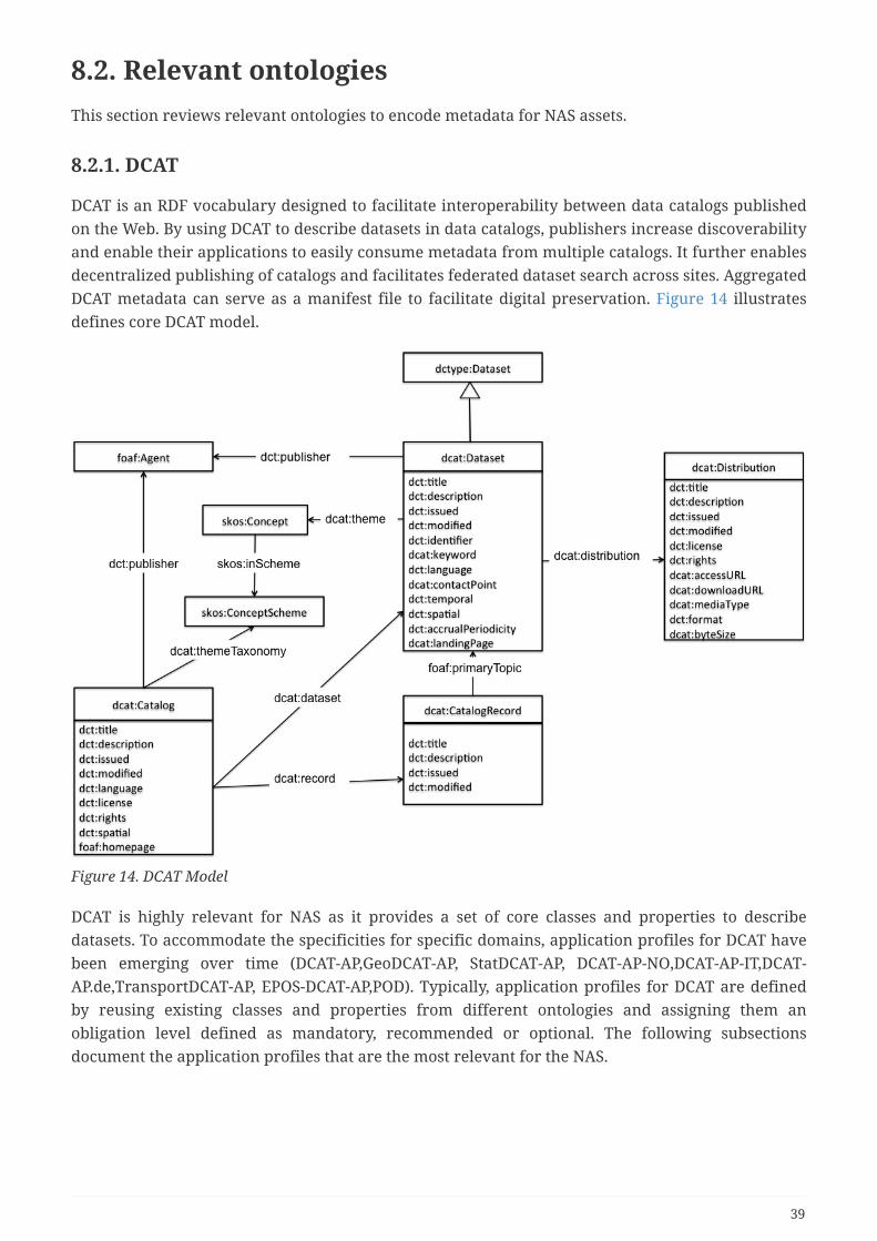
8.2.1. DCAT
DCAT is an RDF vocabulary designed to facilitate interoperability between data catalogs publishedon the Web. By using DCAT to describe datasets in data catalogs, publishers increase discoverabilityand enable their applications to easily consume metadata from multiple catalogs. It further enablesdecentralized publishing of catalogs and facilitates federated dataset search across sites. AggregatedDCAT metadata can serve as a manifest file to facilitate digital preservation. Figure 14 illustratesdefines core DCAT model.
Figure 14. DCAT Model
DCAT is highly relevant for NAS as it provides a set of core classes and properties to describedatasets. To accommodate the specificities for specific domains, application profiles for DCAT havebeen emerging over time (DCAT-AP,GeoDCAT-AP, StatDCAT-AP, DCAT-AP-NO,DCAT-AP-IT,DCAT-AP.de,TransportDCAT-AP, EPOS-DCAT-AP,POD). Typically, application profiles for DCAT are definedby reusing existing classes and properties from different ontologies and assigning them anobligation level defined as mandatory, recommended or optional. The following subsectionsdocument the application profiles that are the most relevant for the NAS.
39

NOTE
At time of this writing, there is a W3C Working group working on a new revision ofDCAT (1.1) that better address some of the gaps identified over time. It will addressbetter the relationships between service and datasets. This work has a lot of overlapwith the OGC SRIM Model and reconciliation between both models will need tooccur once DCAT 1.1 becomes an official W3C standard. The new specification alsoattempts to define best practices for managing DCAT application profiles.
8.2.2. DCAT-AP
The DCAT Application profile for data portals in Europe (DCAT-AP) is a specification based onthe Data Catalogue vocabulary (DCAT [http://www.w3.org/TR/vocab-dcat/]) for describing public sectordatasets in Europe. Its basic use case is to enable cross-data portal search for data sets and to allowpublic sector data to be easily searchable across borders and sectors. This can be achieved by theexchange of descriptions of datasets among data portals.
In February 2015, the ISA² programme [http://ec.europa.eu/isa/isa2/index_en.htm] of the EuropeanCommission has started an activity to revise the DCAT-AP, based on experience gained since itsdevelopment in 2013. The outcome of this effort was the publication of DCAT-AP 1.1.
The European Data Portal [http://europeandataportal.eu/] is implementing the DCAT-AP as the commonvocabulary for harmonizing descriptions of over 258,000 datasets harvested from 67 data portalsfrom 34 countries. The DCAT-AP is used in the Open Data Support [https://joinup.ec.europa.eu/
community/ods/description] service initiated by the European Commission with the purpose ofrealizing the vision of European data portals.
8.2.3. Asset Description Metadata Schema (ADMS)
ADMS is a profile of DCAT that is used to describe semantic assets (or just 'Assets'). These assets aredefined as highly reusable metadata (e.g. xml schemata, generic data models) and reference data(e.g. code lists, taxonomies, dictionaries, vocabularies) that are used for eGovernment systemdevelopment.
The ADMS model is intended to facilitate federation and co-operation. Like DCAT, ADMS has theconcepts of a repository (catalog), assets within the repository that are often conceptual in nature,and accessible realizations of those assets, known as distributions. An asset may have zero ormultiple distributions. As an example, a W3C namespace document can be considered to be aSemantic Asset that is typically available in multiple distributions, one or more machineprocessable versions and one in HTML for human consumption. An asset without any distributionsis effectively a concept with no tangible realization, such as a planned output of a working groupthat has not yet been drafted.
ADMS is an RDF vocabulary with an RDF schema available at its namespacehttp://www.w3.org/ns/adms [http://www.w3.org/ns/adms] . The original ADMS specification publishedby the European Commission [ADMS1 [https://www.w3.org/TR/vocab-adms/#bib-ADMS1]] includes an XMLschema that also defines all of the controlled vocabularies and cardinality constraints associatedwith the original document. The model is shown in Figure 15.
40

Figure 15. ADMS Model
This model is relevant for the SWIM architecture as the current registry contains information aboutschemas and service definitions (such as WSDL document). ADMS provides a set of terms that couldbe used to better describe the metadata information about these type of assets.
8.2.4. Project Open Data (POD)
Project Open Data [21] provides the implementation guide and associated resources for theFederal Executive Order on open data and data management, M-13-13 [https://project-open-data.cio.gov/
policy-memo/] “Managing Information as an Asset,” which includes the standardized metadataschema that all CFO Act agencies are required to use to publish their enterprise data inventories.
The Project Open Data Metadata Schema [https://project-open-data.cio.gov/v1.1/schema/] is a JSON-basedimplementation of the W3C DCAT vocabulary [http://www.w3.org/TR/vocab-dcat/]. This standard iscurrently implemented by multiple data catalog platforms as well as state and local governments.POD is based on the DCAT model but it enforces the encoding in JSON-LD. POD defines a JSON-LDcontext to map the JSON document back to Linked data representation.
The POD Model is shown in Figure 16
41

Figure 16. Project Open Data (POD) Model
Typically, POD documents are published in a Web Accessible Folder (WOF) and harvested bycatalogs such as data.gov. The intent of POD is to lower the bar of complexity needed to representdata information by providing guidelines and recommended metadata. This improves search anddiscovery for datasets within the US government.
Below is an example of a POD dataset published by FAA on data.gov (which can be found at:https://catalog.data.gov/dataset/flight-schedule-monitor)
Sample POD Dataset published by FAA
{ "@type":"dcat:Dataset", "QualityResponsibleAgency":"Federal Aviation Administration", "accessLevel":"non-public", "accrualPeriodicity":"R/P1D",
42

"additionalMetadata":"N/A", "agencyDataSeriesURL":null, "agencyProgramURL":null, "analysisUnit":null, "bibliographicCitation":null, "bureauCode":[ "021:12" ], "category":"Raw data", "categoryDesignation":"Research", "collectionInstrument":null, "collectionMode":"Electronic", "comments":null, "confidentiality":false, "contactPoint":{ "@type":"vcard:Contact", "fn":"Mojdeh Supola", "hasEmail":"mailto:[email protected]" }, "dataQuality":false, "describedBy":null, "description":"The Flight Schedule Monitor (FSM) is the main tool for the trafficmanagement specialist at the FAA David J. Hurley Air Traffic Control System CommandCenter (ATCSCC) to monitor, model, and implement Ground Delay Program (GDP)operations. FAA and airlines use FSM to monitor demand through receipt of FSM demandpictures of airports updated every 5 minutes. FSM constructs if scenarios for bestoptions (i.e., best parameters) prior to making a GDP decision. Modeling may be usedby: (1) the ARTCC Traffic Management Coordinator (TMC) to request ATCSCCimplementation of a GDP in the event of significant congestion or if a demandimbalance is projected at an en route fix, route, or sector; (2) the ATCSCC todetermine Air Route Traffic Control Center (ARTCC) start times, Airport Arrival Rate(AAR), and other parameters for a particular GDP scenario; and (3) the Airlines to seethe effects of canceling or delaying a specific flights under a GDP.", "dictionaryList":null, "guidelineCompliance":false, "identifier":"1736.0", "issued":"2014-11-21", "keyword":[ "flight", "traffic", "route", "airport", "weather", "airspace", "surface" ], "landingPage":null, "language":[ "en-US" ], "license":"https://project-open-data.cio.gov/unknown-license/",
43

"modified":"2015-02-09", "numberOfDatasets":1, "organizationId":null, "organizationName":"Department of Transportation / Federal AviationAdministration", "phone":"202-267-1026", "primaryITInvestmentUII":null, "programCode":[ "021:001" ], "publisher":{ "@type":"org:Organization", "name":"Federal Aviation Administration", "subOrganizationOf":{ "@type":"org:Organization", "name":"Department of Transportation", "subOrganizationOf":{ "@type":"org:Organization", "name":"U.S. Government" } } }, "references":null, "rights":"This data requires review prior to Open Data publication.", "spatial":null, "subagency":"Federal Aviation Administration", "systemOfRecords":"This data requires review prior to Open Data publication.", "theme":[ "Transportation" ], "title":"Flight Schedule Monitor -"}
While POD is a huge step toward enabling search and discovery of datasets and facilitates theintegration with existing tools, it falls short of addressing geospatial aspects of datasets (whichSRIM and GeoDCAT address). It also does not provide good guidance of the use of controlledvocabularies due to the lack of policies and solutions to manage and access controlled vocabularies(a section of this ER is dedicated on this issue). There is also no standard in place to describeservices in detail. It is currently restricted to simple accessURL in dcat:Distribution.
8.2.5. GeoDCAT-AP
GeoDCAT-AP [https://joinup.ec.europa.eu/asset/dcat_application_profile/description#Geo-DCAT-AP] is defined asan extension of DCAT-AP [https://joinup.ec.europa.eu/asset/dcat_application_profile/description#DCAT-AP] fordescribing geospatial datasets, dataset series, and services. It provides an RDF syntax binding forthe union of metadata elements defined in the core profile of ISO 19115:2003 [http://www.iso.org/iso/
catalogue_detail?csnumber=26020] and those defined in the framework of the INSPIRE Directive[http://inspire.ec.europa.eu/]. Its basic use case is to make spatial datasets, data series, and servicessearchable on general data portals, thereby making geospatial information more searchable across
44

borders and sectors. This can be achieved by the exchange of descriptions of datasets among dataportals. GeoDCAT-AP has been submitted to OGC as a candidate for standardization of geospatialmetadata using Linked Data standards.
8.2.6. SRIM
During OGC Testbed-12, a number of metadata specifications were reviewed, including the W3Cstandard DCAT, DCAT-AP, GeoDCAT-AP, ADMS, Project Open Data 1.1, Dublin Core, ISO 19115, andISO 19119 to identify the common and relevant metadata information needed for search anddiscovery, but also to identify the gaps to address the requirements to describe dataset, service,portrayal information, schema and schema mapping, vocabularies and other future asset types. Itquickly emerged that the DCAT standard and its different application profiles were data-centric andinsufficient to describe metadata for portrayal information, schemas and services. The goal was notto define a new standard, but to leverage existing standards to define an application profile of DCATthat could accommodate the schema, service, portrayal and other asset type information needed toenable relevant search and discovery and filling the gaps by introducing additional properties andfields, all while preserving backward compatibility with existing standards.
This analysis resulted in a new application profile of DCAT called the Semantic RegistryInformation Model (SRIM) Core Model [11], referred to later in the document as SRIM Core. SRIMCore is defined as a superset of DCAT and its existing application profiles (DCAT-AP, GeoDCAT-AP,ADMS), and it introduces a superclass of dcat:Dataset called srim:Item. The ontology draws frommultiple well-established standards such as W3C, DCAT, Project Open Data 1.1, DCAT-AP, GeoDCAT-AP, VCard, Dublin Core, and PAV, but also addresses some gaps in the standards, such asdescriptions of web services (for example OGC Web Map Service (WMS), Web Feature Service(WFS)), richer description for geospatial data, additional metadata to model schema, schemamapping, and portrayal information in order to enable better semantic search of resources that fitthe mission of the users. The ontology draws also on the geospatial metadata standard ISO 19115.SRIM enables the integration of different metadata providers (Catalog Service for the Web (CSW),CKAN, POD Web Accessible Folder (WAF), WMS, Web Coverage Service (WCS)) by providing acommon core vocabulary to describe resources (data, services, vocabularies, map, layers, schemas,etc) and accommodate the specificities of each source by leveraging the built-in extensibilitymechanism in OWL. The integration is done through the use of a semantic bridge that maps thesyntactic metadata (JSON, XML based) to a semantic representation based on the SRIM model. TheSRIM Core model has been extended by introducing SRIM application profiles to represent otherkinds of geospatial assets such as schemas and portrayal information (see section for SemanticMediation and Semantic Portrayal Service in Testbed-12 ER 16-056).
The purpose of SRIM Core is to define a common interchange metadata format for geospatialportals. In order to achieve this, SRIM defines a set of classes and properties, grouped intomandatory, recommended, and optional. Such classes and properties correspond to information onregister items and registers that are shared by many data portals, aiding interoperability. AlthoughSRIM is designed to be independent from its actual implementation, RDF and Linked Data are thereference technologies used to perform the modeling and preserve the semantic fidelity of theconceptual model. However, to facilitate a wide adoption, an encoding based on JSON is provided,which could be converted transparently back to a semantic model using a JSON-LD context. TheJSON encoding has been closely aligned with the Project Open Data (POD) metadata schema 1.1standard. However, to accommodate some of the requirements needed by the Semantic Registry
45

Service, the model was extended, and sometimes modified where needed. An application profile ofSRIM has been used for Geoplatform.gov [https://www.geoplatform.gov/], which manages all thegeospatial assets of all the US government agencies. The profile has been extended to managelayers, maps and galleries. The geoplatform.gov provides importer of existing ISO 19115-x/ISO19139 standards to SRIM and object editor to annotate assets with controlled vocabularies.
Figure 17 shows the core model of SRIM. The core mode defines all the properties that are commonfor most assets of any domain. The core model introduces the concept of srim:Item, which is asuperclass of dcat:Dataset. It leverages geospatial extension from GeoDCAT-AP and introducesconcepts of spatial extent. Attributions information are based on PROV-O and Dublin Cores.Versioning information is based on PAV ontology.
Figure 17. Core SRIM Model
Figure 18 shows the SRIM application profile to describe dataset and services. Contrary to DCAT,which uses distribution to model both services and downloadable resources,the SRIM profile makesthe Service as a first class object directly subclass of srim:Item. To accommodate the variety ofservice APIs (using SOAP, REST, OGC services), the model introduces the concept of API Document(srim:APIDocument), which can point to a formal specification of the API such as ISO 19115/19119,Open API (a.k.a. Swagger), WSDL or OWL-S. By introducing this concept, we have the ability todescribe service API in an extensible way. The model is highly relevant for the SWIM registry as itprovides a bridge between the FAA service registry and datasets metadata using Linked dataapproach.
46

Figure 18. SRIM Dataset-Service-Profile
During Testbed-12, a Semantic Registry Service based on the SRIM model was designed andimplemented. The service used a REST API using JSON-LD and HAL format (which provideshypermedia links). The Semantic Registry provides a pluggable harvesting capability demonstratedon CSW and Electronic Business Registry Information Model (ebRIM) catalogs. The semanticregistry was also used to manage schema, schema mapping and portrayal information to supportsemantic mediation services and portrayal services. These different scenarios demonstrated thatthe SRIM model was extensible enough to accommodate a variety of domains, services andapplications. More details can be found in Testbed-12 ER 16-056 and ER for the Task D001 of thisTestbed-14.
47
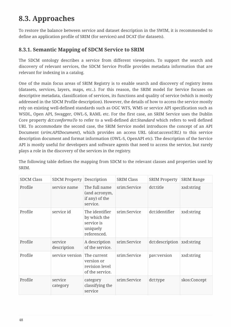
8.3. ApproachesTo restore the balance between service and dataset description in the SWIM, it is recommended todefine an application profile of SRIM (for services) and DCAT (for datasets).
8.3.1. Semantic Mapping of SDCM Service to SRIM
The SDCM ontology describes a service from different viewpoints. To support the search anddiscovery of relevant services, the SDCM Service Profile provides metadata information that arerelevant for indexing in a catalog.
One of the main focus areas of SRIM Registry is to enable search and discovery of registry items(datasets, services, layers, maps, etc..). For this reason, the SRIM model for Service focuses ondescriptive metadata, classification of services, its functions and quality of service (which is mostlyaddressed in the SDCM Profile description). However, the details of how to access the service mostlyrely on existing well-defined standards such as OGC WFS, WMS or service API specification such asWSDL, Open API, Swagger, OWL-S, RAML etc. For the first case, an SRIM Service uses the DublinCore property dct:conformsTo to refer to a well-defined dct:Standard which refers to well definedURI. To accommodate the second case, the SRIM Service model introduces the concept of an APIDocument (srim:APIDocument), which provides an access URL (dcat:accessURL) to this servicedescription document and format information (OWL-S, OpenAPI etc). The description of the ServiceAPI is mostly useful for developers and software agents that need to access the service, but rarelyplays a role in the discovery of the services in the registry.
The following table defines the mapping from SDCM to the relevant classes and properties used bySRIM.
SDCM Class SDCM Property Description SRIM Class SRIM Property SRIM Range
Profile service name The full name(and acronym,if any) of theservice.
srim:Service dct:title xsd:string
Profile service id The identifierby which theservice isuniquelyreferenced.
srim:Service dct:identifier xsd:string
Profile servicedescription
A descriptionof the service.
srim:Service dct:description xsd:string
Profile service version The currentversion orrevision levelof the service.
srim:Service pav:version xsd:string
Profile servicecategory
categoryclassifying theservice
srim:Service dct:type skos:Concept
48

Profile provider provider of theservice
srim:Service dcat:publisher org:Organization
Profile consumer consumer ofthe service
srim:Service dct:audience skos:Concept
SDCM Model model Service model srim:Service srim:apiDocument
srim:APIDocument
SDCMGrounding
grounding ServiceGrounding
srim:Service srim:apiDocument
srim:APIDocument
For future testbeds, an SRIM Service Model should be investigated to identify additional propertiesthat better align with the SDCM model. The results of this effort will be an application profile forSWIM. Harvesting of the services from the current SWIM registry could be done and converted tothe application profile, so services can be searched for and discovered, as well as be linked todatasets and other assets managed by the SRIM registry. The current SWIM taxonomies would beused to classify services and search for services.
8.3.2. Dataset metadata
The current SWIM architecture is mostly focused on describing services but there is no relationshipto the datasets a service operates on. To close this gap, the metadata about datasets should be fullyformalized using GeoDCAT-AP (subset of SRIM Model) vocabulary. SRIM model providesrelationships to link services and datasets using the property srim:operatesOn and its inverseproperty srim:usedBy. An analysis of the gaps between the current SRIM Dataset core profile andthe SWIM datasets should be performed and addressed by defining an application profile specificfor SWIM. The metadata documents should be made available in linked data formats (RDF, JSON-LD, Turtle) in a RESTful way so they can be harvested by a semantic registry to be indexed, to allowsearch and discovery.
8.3.3. SRIM Registry
The SRIM Registry developed during Testbed-12 and 13 provides a service to manage semanticmetadata about the different assets used in SWIM. The service has been used successfully tomanage metadata about datasets, services, map layers, portrayal information, schemas and schemamappings. For future testbeds, a gap analysis should be performed to accommodate the specificitiesof the SWIM data model. The SRIM core model can be extended by defining application profiles thatcapture the specific information about the SWIM services such as Quality-of-Service, Functions, APIspecifications. The use of controlled vocabularies specific for aviation domain could be used forclassifying, enriching, reasoning and searching the assets managed by the registry.
49

Chapter 9. Data Silos Semantic EnablementInformation integration is one the greatest challenges currently faced by the industry. One of thebiggest obstacles is data silos. Most of the data is generated and stored in different systemsthroughout an organization, and these systems are separate, isolated programs. Data silos are aproblem for both simple and complicated analyses:
• When data sources are siloed, it is impossible to conduct a simple enterprise-wide search ofcontent. If you do not know exactly which system has the information you need, or it is storedin multiple systems, you must manually search multiple systems to find the answers you arelooking for, wasting valuable time. If you forget to check a key system, or you don’t find everysilo with relevant data, you will not have all the information you need to make the best possibledecisions.
• Siloed data often contains duplicate information stored in individual siloes. When the samecontent is stored in disparate and unconnected systems, it’s difficult to know which source totrust. Which version is the correct version? How do you choose? What are the consequences ofmaking the wrong choice?
• You cannot gain a complete view of a situation unless you combine information from differentsystems to understand all the factors impacting your business. Only by generating a completeview of the situation can you make the best decisions.
These data-silos are built mostly using a syntactic-based (non-semantic), protocol-centric and oftendocument-centric approach. Information between system cannot be easily interconnected due tothe lack of a common framework to represent semantic links between data. Linked Data standardsprovide a common and unified framework to represent any types of data structures, connect themin unified way (using RDF Model), query and reason automatically using off-the-shelf tools usingLinked Data Standards (e.g. SPARQL engines,DL Reasoners). The following discusses the differentapproaches to semantically-enable data silos to remove the barrier of integration.
9.1. Approach for Semantic-Enablement
9.1.1. Extension of existing RESTful services protocol
It is possible to extend existing OGC services to support Linked Data representation, including if theservices are RESTful. For example, the SensorThings API standard provides a RESTful API to accessobservations and sensor information. It is relatively easy to extend the API by introducing anadditional RDF representation for each resource endpoint without breaking the existing APIs. If theJSON model of the service is compatible with the ontology representing the data model, it ispossible to use JSON-LD by adding a JSON-LD context to existing JSON response. This allows clientsto consume JSON-LD documents and convert the information to RDF representation for furtherprocessing. Providing a SPARQL endpoint of these services will facilitate the query of informationwithout requiring the harvesting of information.
Applicability • Full access to the service and backend store
50
Pros • Facilitate integration with other Linked Data sources
• Easier integration with Semantic Registry
Cons • Requires access to codebase of the service.
• May require RDF mapping techniques or RDF backend.
9.1.2. Semantic mapping
Until today, data integration has been accomplished using a single layer approach by writing a dataproduct translator from one format to another. For example, it is common practice today to useXSLT to transform one XML document to another XML format. The problem with this approach isthat it mixes the structural and semantic transformation together. Further, it does not scale,because it is based on an N-to-N mapping approach, and is error-prone due to reliance on humaninterpretation of data products.
The rules, which carry out the complete transformation process in one shot, have proven to be verycomplex. This causes serious problems in implementing and maintaining the rules oftransformation. These problems arise due to the mixture of several different aspects of the overalltransformation process, such terminology, granularity representation and structural and syntacticalignment. For this reason, any re-use of such rules is practically impossible.
To overcome this bottleneck a multi-layered framework should be used, which separates differentaspects of the transformation process. The approach used in Image Matters Knowledge MappingService (KMS) in Testbed-10 [22] is able to transform a complex programming task into a simpleplug-and-play process where straightforward rule patterns are selected, instantiated, andcombined. KMS uses a methodology for data integration based on a three-layer model, as presentedin the Figure 19. The model contains a Data Product layer, a Data Model layer, and an Ontologylayer.
51
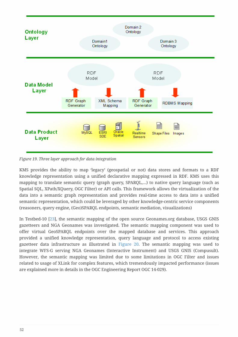
Figure 19. Three layer approach for data integration
KMS provides the ability to map ‘legacy’ (geospatial or not) data stores and formats to a RDFknowledge representation using a unified declarative mapping expressed in RDF. KMS uses thismapping to translate semantic query (graph query, SPARQL,…) to native query language (such asSpatial SQL, XPath/XQuery, OGC Filter) or API calls. This framework allows the virtualization of thedata into a semantic graph representation and provides real-time access to data into a unifiedsemantic representation, which could be leveraged by other knowledge-centric service components(reasoners, query engine, (Geo)SPARQL endpoints, semantic mediation, visualizations)
In Testbed-10 [23], the semantic mapping of the open source Geonames.org database, USGS GNISgazetteers and NGA Geonames was investigated. The semantic mapping component was used tooffer virtual GeoSPARQL endpoints over the mapped database and services. This approachprovided a unified knowledge representation, query language and protocol to access existinggazetteer data infrastructure as illustrated in Figure 20. The semantic mapping was used tointegrate WFS-G serving NGA Geonames (Interactive Instrument) and USGS GNIS (Compusult).However, the semantic mapping was limited due to some limitations in OGC Filter and issuesrelated to usage of XLink for complex features, which tremendously impacted performance (issuesare explained more in details in the OGC Engineering Report OGC 14-029).
52
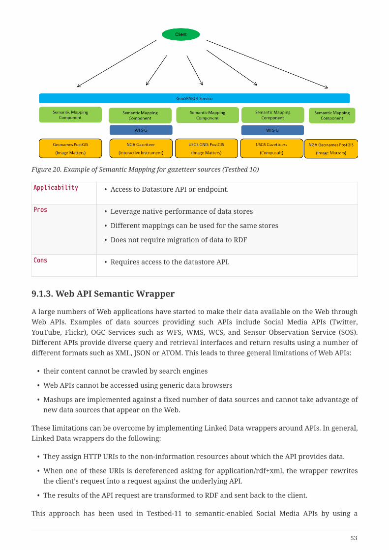
Figure 20. Example of Semantic Mapping for gazetteer sources (Testbed 10)
Applicability • Access to Datastore API or endpoint.
Pros • Leverage native performance of data stores
• Different mappings can be used for the same stores
• Does not require migration of data to RDF
Cons • Requires access to the datastore API.
9.1.3. Web API Semantic Wrapper
A large numbers of Web applications have started to make their data available on the Web throughWeb APIs. Examples of data sources providing such APIs include Social Media APIs (Twitter,YouTube, Flickr), OGC Services such as WFS, WMS, WCS, and Sensor Observation Service (SOS).Different APIs provide diverse query and retrieval interfaces and return results using a number ofdifferent formats such as XML, JSON or ATOM. This leads to three general limitations of Web APIs:
• their content cannot be crawled by search engines
• Web APIs cannot be accessed using generic data browsers
• Mashups are implemented against a fixed number of data sources and cannot take advantage ofnew data sources that appear on the Web.
These limitations can be overcome by implementing Linked Data wrappers around APIs. In general,Linked Data wrappers do the following:
• They assign HTTP URIs to the non-information resources about which the API provides data.
• When one of these URIs is dereferenced asking for application/rdf+xml, the wrapper rewritesthe client’s request into a request against the underlying API.
• The results of the API request are transformed to RDF and sent back to the client.
This approach has been used in Testbed-11 to semantic-enabled Social Media APIs by using a
53

semantic wrapper around APIs. This approach for semantically enabled WFS-G (i.e. Gazetteerprofile of WFS) by transforming GeoSPARQL queries to OGC filter queries on the fly and convert theGML response to Linked Data representation.
Applicability • Service codebase is not accessible but API is well documented.
Pros • Relatively easy to implement
Cons • Requires RDF storage to save results of scraping
• API is not queryable using SPARQL.
9.1.4. RDFa
RDFa (or Resource Description Framework in Attributes) is a W3C Recommendation that adds a setof attribute-level extensions to HTML, XHTML and various XML-based document types forembedding rich metadata within Web documents. The RDF data-model mapping enables its use forembedding RDF subject-predicate-object expressions within XHTML documents. It also enables theextraction of RDF model triples by compliant user agents. There is a wide variety of tools that canbe used to generate or process RDFa data. Google leverages RDFa annotation in web pages to buildits Knowledge Graph. By using RDFa in web pages, they will be displayed in an enhanced format onall major search engines. Facebook’s Open Graph Protocol, which is based on RDFa, is used expressconcepts that are contained in web pages, like people, places, events, movies and recipes. Majorsearch and social companies are supporting indexing RDFa content to improve search experience.
<html><head> ...</head><body> ... <h2 property="http://purl.org/dc/terms/title">Flight Plan Service</h2> <p>Date: <span property="http://purl.org/dc/terms/created">2017-09-10</span></p> ...</body>
It is worth emphasizing that RDFa uses URLs to identify just about everything. This is why, insteadof just using properties like title or created, we use http://purl.org/dc/terms/title and http://purl.org/dc/terms/created. The reason behind this design decision is rooted in data portability, consistency,and information sharing. Using URLs removes the possibility for ambiguities in terminology.Without ensuring that there is no ambiguity, the term "title" might mean "the title of a work", "a jobtitle", or "the deed for real-estate property". When each vocabulary term is a URL, a detailedexplanation for the vocabulary term is just one click away. It allows anything, humans or machines,to follow the link to find out what a particular vocabulary term means. By using a URL to identify aparticular creation time, for example http://purl.org/dc/terms/created, both humans and machinescan understand that the URL unambiguously refers to the "Date of creating the resource", such as aweb page or dataset.
54

Applicability • Mostly HTML resources (possibly XML but not found evidence of usageexcept in SVG)
Pros • Can describe any web page using any ontology
Cons • Annotation are tedious to capture
9.1.5. SAWSDL
The Semantic Annotations for WSDL and XML Schema (SAWSDL) specification [24] defines how toadd semantic annotations to various parts of a WSDL document such as input and output messagestructures, interfaces and operations. The extension attributes defined in this specification fitwithin the WSDL 2.0, WSDL 1.1 and XML Schema extensibility frameworks. For example, thisspecification defines a way to annotate WSDL interfaces and operations with categorizationinformation that can be used to publish a Web service in a registry. The annotations on schematypes can be used during Web service discovery and composition. In addition, SAWSDL defines anannotation mechanism for specifying the data mapping of XML Schema types to and from anontology; such mappings could be used during invocation, particularly when mediation is required.To accomplish semantic annotation, SAWSDL defines extension attributes that can be applied bothto WSDL elements and to XML Schema elements.
The semantic annotations reference a concept in an ontology or a mapping document. Theannotation mechanism is independent of the ontology expression language and this specificationrequires and enforces no particular ontology language. It is also independent of mapping languagesand does not restrict the possible choices of such languages. One of the main motivations forSAWSDL specification is to provide mechanisms using which semantic annotations can be added toWSDL documents so that these semantics can be used to help automate the matching andcomposition of Web services.
SAWSDL has been suggested as a possible solution to integrate semantics within XML schematadescribing geospatial data (OGC 08-167r2). Examples of SAWSDL annotations of ATM service XMLschema are presented in OGC 18-022.
Applicability • web services are using WSDL document to describe the API
• Content of services in XML using XML Schema
Pros • Works well for services adhering to the WSDL and XML Schema
Cons • Does not work with web services that are not based on WSDL (REST APIusing OpenAPI for example).
• Does not work with services using JSON or other formats not based onXML schema.
55
9.1.6. GRDDL
GRDDL is a mechanism for Gleaning Resource Descriptions from Dialects of Languages. TheW3C GRDDL specification introduces markup based on existing standards for declaring that anXML document includes data compatible with the Resource Description Framework (RDF) and forlinking to algorithms (typically represented in XSLT), for extracting this data from the document.The results of the transformations will usually be RDF/XML documents, although other RDFsyntaxes may be used.
The markup includes a namespace-qualified attribute for use in general-purpose XML documentsand a profile-qualified link relationship for use in valid XHTML documents. The GRDDL mechanismalso allows an XML namespace document (or XHTML profile document) to declare that everydocument associated with that namespace (or profile) includes gleanable data and for linking to analgorithm for gleaning the data.
Individual publishers of data using popular vocabularies can also give users their data transformedinto RDF without having to even add any new markup to individual documents. This is done byreferencing GRDDL transformations in a profile document referenced in the head of the HTML.Other XML vocabularies may use their namespace documents for the same purpose. This methodrequires no work from the content author of individual documents but requires that the profiledocument contain a reference to a GRDDL transformation and be accessible to the GRDDL client,and so may require work from the creator and maintainer of the dialect. Yet this is a good use oftime, since once the transformation has been linked to the profile document, all the users of thedialect get the added value of RDF.
Applicability • web services using WSDL document to describe the API
• Content of services in XML using XML Schema
Pros • Works well for HTML pages that are rendered from databases
Cons • Does not work with web services that are not based on WS-* stack (WSDL)(REST API using OpenAPI for example).
• Mapping of XML Schema to RDF seems to be focused only on APImessages. Not sure if applicable for any XML schema.
• Does not work with services using JSON or other formats not based onXML schema.
9.1.7. W3C Annotation
The Web Annotation Working Group has published recommendations for capturing annotations:
• Web Annotation Data Model: This specification describes a structured model and format, inJSON-LD, to enable annotations to be shared and reused across different hardware andsoftware platforms. Common use cases can be modeled in a manner that is simple andconvenient, while at the same time enabling more complex requirements, including linkingarbitrary content to a particular data point or to segments of timed multimedia resources.
56
• Web Annotation Vocabulary: This specifies the set of RDF classes, predicates and namedentities that are used by the Web Annotation Data Model. It also lists recommended terms fromother ontologies that are used in the model, as well as providing the JSON-LD Context andprofile definitions needed to use the Web Annotation JSON serialization in a Linked Datacontext.
• Web Annotation Protocol: The Web Annotation Protocol describes the transport mechanismsfor creating and managing annotations in a method that is consistent with the Web Architectureand REST best practices.
JSON-LD is the serialization format used in the Web Annotation Data Model. HTML canaccommodate this serialization format directly via the use of the HTML <script> element with itstype attribute assigned the media type for a Web Annotation:application/ld+json;profile="http://www.w3.org/ns/anno.jsonld" (see section about Embedded JSON-LD below)
Another approach of embedding annotations into HTML is to use RDFa. The advantage of usingRDFa is that the annotation terms are mixed with the core HTML content, meaning that, forexample, the text in the HTML source can be also re-used as an annotation textual body. In otherwords, a single resource may become both human visible as well as machine-readable. On theother hand, RDFa is an RDF serialization syntax: the RDF vocabulary described in AnnotationVocabulary specification must therefore be used instead of the JSON-LD encoding used in theAnnotation Data Model document.
In OGC 18-022, the web annotation data model is proposed as a solution to associate domainspecific semantic tags with ATM service descriptions as well as whole or parts of the related textdocuments and XML schemata. More information and concrete examples can be found in OGC 18-022.
Applicability • Any web resources
Pros • W3C annotations can work on any document (XML, JSON, Video, Image)
• Annotations are not modifying existing documents.
Cons • Annotation are tedious to capture and needs to be done on a document-basis
9.1.8. Microdata
Microformats are small patterns of HTML to represent commonly published things like people,events, blog posts, reviews and tags in web pages. Microformats are the quickest & simplest way toprovide an API to the information on your website. Microdata is an open-community HTMLspecification used to nest structured data within HTML content. Like RDFa, it uses HTML tagattributes to name the properties you want to expose as structured data. It is typically used in thepage body, but can be used in the head. However the number of microdata implementations islimited (h-card, XFN, h-calendar, h-review, rel-tag, rel-license,..) and format such as RDFa and JSON-LD have gain marketshare due to their extensibility to accommodate any domain.
57

Applicability • HTML resources
Pros • Quickest & simplest way to provide an API to the information on yourwebsite
Cons • Limited on small general domains
9.1.9. Embedded JSON-LD
JSON-LD is a lightweight Linked Data format. It is easy for humans to read and write. It is based onthe already successful JSON format and provides a way to help JSON data interoperate at Web-scale.JSON-LD is an ideal data format for programming environments, REST Web services, andunstructured databases such as CouchDB and MongoDB. A JSON-LD document can be embedded ina <script> tag in the page head or body. The markup is not interleaved with the user-visible text,which makes nested data items easier to express, such as the Dataset, Service description in thecontext of NAS. Also, Google can read JSON-LD data when it is dynamically injected into the page’scontents, such as by JavaScript code or embedded widgets in a content management system.
For example, Google uses structured data that it finds on the web to understand the content of thepage, as well as to gather information about the web and the world in general. For example, here isa JSON-LD structured data snippet that might appear on the contact page of the FAA s corporation,describing their contact information:
<script type="application/ld+json">{ "@context": "http://schema.org", "@type": "Organization", "url": "http://www.faa.gov", "name": "Federal Aviation Agency", "contactPoint": { "@type": "ContactPoint", "telephone": "+1-401-555-1212", "contactType": "Customer service" }}</script>
Google Search also uses structured data to enable special search result features and enhancements.For example, a recipe page with valid structured data is eligible to appear in a graphical searchresult, as shown here:
Google recently recommended the use of JSON-LD as the preferred approach to capture structured
58
data in web pages. Also note that the W3C recommended this technique to embed W3C Annotationin HTML (https://www.w3.org/TR/annotation-html/)
Applicability • Any HTML resources
Pros • Can describe any web page against any ontology.
• Easy to add in HTML file and cleanly separated from HTML content.
Cons • Works only on HTML page.
9.2. Pure RDF approachUsing a pure RDF approach requires the backend to be implemented using an RDF store. RDF storessuch as RDF4J, Blazegraph, AWS Neptune, OntoText GraphDB, AllegroGraph comes with built-inreasoners, SPARQL API support.
Applicability Information can be stored in RDF directly
Pros • Easy to implement
• Leverage reasoning and standard SPARQL query
• Integration with other Linked Data sources is easier.
Cons • Does not leverage existing legacy systems
• Performance may be an issue if not supported by additional indices(spatial index for example).
• Does not easily integrate with web-based clients
59
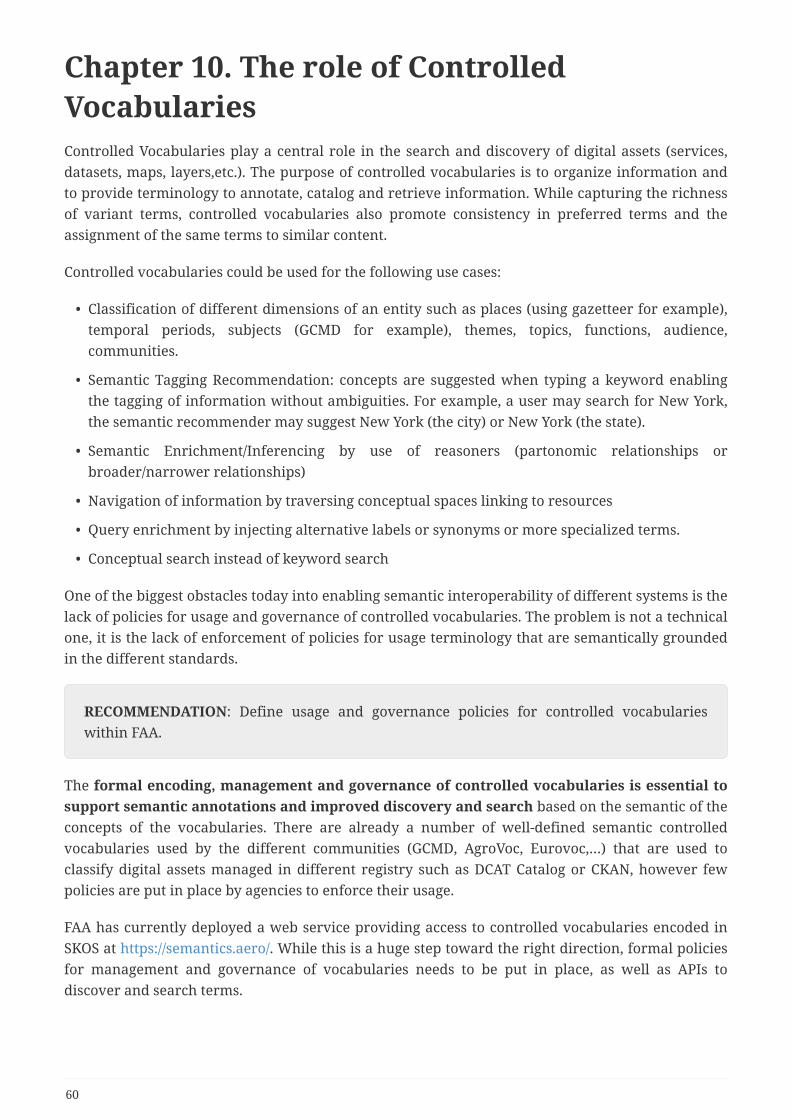
Chapter 10. The role of ControlledVocabulariesControlled Vocabularies play a central role in the search and discovery of digital assets (services,datasets, maps, layers,etc.). The purpose of controlled vocabularies is to organize information andto provide terminology to annotate, catalog and retrieve information. While capturing the richnessof variant terms, controlled vocabularies also promote consistency in preferred terms and theassignment of the same terms to similar content.
Controlled vocabularies could be used for the following use cases:
• Classification of different dimensions of an entity such as places (using gazetteer for example),temporal periods, subjects (GCMD for example), themes, topics, functions, audience,communities.
• Semantic Tagging Recommendation: concepts are suggested when typing a keyword enablingthe tagging of information without ambiguities. For example, a user may search for New York,the semantic recommender may suggest New York (the city) or New York (the state).
• Semantic Enrichment/Inferencing by use of reasoners (partonomic relationships orbroader/narrower relationships)
• Navigation of information by traversing conceptual spaces linking to resources
• Query enrichment by injecting alternative labels or synonyms or more specialized terms.
• Conceptual search instead of keyword search
One of the biggest obstacles today into enabling semantic interoperability of different systems is thelack of policies for usage and governance of controlled vocabularies. The problem is not a technicalone, it is the lack of enforcement of policies for usage terminology that are semantically groundedin the different standards.
RECOMMENDATION: Define usage and governance policies for controlled vocabularieswithin FAA.
The formal encoding, management and governance of controlled vocabularies is essential tosupport semantic annotations and improved discovery and search based on the semantic of theconcepts of the vocabularies. There are already a number of well-defined semantic controlledvocabularies used by the different communities (GCMD, AgroVoc, Eurovoc,…) that are used toclassify digital assets managed in different registry such as DCAT Catalog or CKAN, however fewpolicies are put in place by agencies to enforce their usage.
FAA has currently deployed a web service providing access to controlled vocabularies encoded inSKOS at https://semantics.aero/. While this is a huge step toward the right direction, formal policiesfor management and governance of vocabularies needs to be put in place, as well as APIs todiscover and search terms.
60

RECOMMENDATION: Explore in future testbeds an API for a Vocabulary ManagementService that is needed to manage, index, query vocabularies terms and define best practicesfor governance of the lifecycle of controlled vocabularies.
The following subsections provide more details about the definition of controlled vocabularies,their different classifications, different ways of encoding and the requirements for controlledvocabulary service that can support the different use cases described above.
10.1. Controlled Vocabulary DefinitionThis subsection and the next are adapted from Neiswender [25]. A vocabulary is a set of terms(words, codes, etc.) that are used in a specific community. Vocabularies provide a mechanism forcommunication- be it written, oral or electronic- because the meaning of the terms are known andagreed upon by the community members. When a vocabulary is formally managed, it becomes acontrolled vocabulary. In this case, "managed" means the terms are stored and maintained usingagreed-upon procedures. Procedures should exist for adding terms, modifying terms and, morerarely, deprecating terms from a controlled vocabulary.
A controlled vocabulary is a collection of terms that are:
• Accepted: The term must adhere to community practices.
• Defined: The terms are precisely characterized. Typically, this means the terms have rigorousdefinitions.
• Managed: In general, there will be a body of experts that create and maintain the controlledvocabulary. The controlled vocabulary maintenance will involve periodic review, addition ofnew terms, modification of terms, and occasionally deprecation of terms.
Notice, this definition does not specify a particular scope of usage. Controlled vocabularies could bedeveloped for a local project, a broader community (e.g. GeoINT), or as a part of a widely usedstandard or tool (ISO 19115).
10.2. Vocabulary ClassificationTo many people, the English language contains a well-known vocabulary. There are have manyways of representing the terms in the English language. For example, if we want to figure out whata specific word means we might consult a glossary; if we want to know the origin of the term, wemight consult a dictionary; and if we want to know how the term relates to other terms, we mightconsult a thesaurus. We also need to recognize that the meaning of terms may change through time.Generations use terms in different ways (cool in one generation means a low temperature, whilecool in another is a positive adjective).
To enable formal management, a controlled vocabulary can be organized in several ways. Thereare three broad categories of controlled vocabularies: flat, multi-level and relational.
• Flat controlled vocabularies provide a set of used terms. Some flat controlled vocabularieswill provide additional information about each term.
61
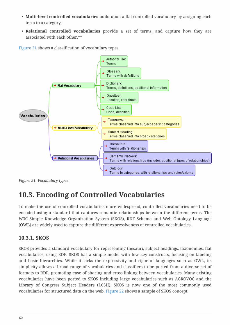
• Multi-level controlled vocabularies build upon a flat controlled vocabulary by assigning eachterm to a category.
• Relational controlled vocabularies provide a set of terms, and capture how they areassociated with each other.**
Figure 21 shows a classification of vocabulary types.
Figure 21. Vocabulary types
10.3. Encoding of Controlled VocabulariesTo make the use of controlled vocabularies more widespread, controlled vocabularies need to beencoded using a standard that captures semantic relationships between the different terms. TheW3C Simple Knowledge Organization System (SKOS), RDF Schema and Web Ontology Language(OWL) are widely used to capture the different expressiveness of controlled vocabularies.
10.3.1. SKOS
SKOS provides a standard vocabulary for representing thesauri, subject headings, taxonomies, flatvocabularies, using RDF. SKOS has a simple model with few key constructs, focusing on labelingand basic hierarchies. While it lacks the expressivity and rigor of languages such as OWL, itssimplicity allows a broad range of vocabularies and classifiers to be ported from a diverse set offormats to RDF, promoting ease of sharing and cross-linking between vocabularies. Many existingvocabularies have been ported to SKOS including large vocabularies such as AGROVOC and theLibrary of Congress Subject Headers (LCSH). SKOS is now one of the most commonly usedvocabularies for structured data on the web. Figure 22 shows a sample of SKOS concept.
62
Figure 22. SKOS Concept Example
10.3.2. Ontology languages
An ontology is a formal unambiguous naming and definition of the types, properties, andinterrelationships of the entities that really or fundamentally exist for a particular domain ofdiscourse (as illustrated below). There are two main standards defined by W3C and used to encodeontologies:
• RDF Schema (RDFS) is the simplest RDF vocabulary description language. It providesconstructs to define class and property hierarchies as well as domain and range of properties.
• Web Ontology language (OWL) is an extension of RDFS and is more expressive. It is based onconstruct from Description Logic and provides ability to provide rich semantic description ofclasses and properties. Figure 23 shows an example of ontology (SIOC Ontology).
63

Figure 23. SIOC Ontology example
10.4. Improvements on existing vocabularies
10.4.1. CodeList, Taxonomy and Thesauri conversion to OWL
The current taxonomies used in SWIM and hosted in semantics.aero are encoded in SKOS. Whilethis is step toward the right direction, there is no ability to distinguish the categories of concepts(ServiceProduct, ICAORegion) without knowing a well-known concept scheme. This is problematic,if different taxonomies for the same concept categories exists. The ISO 19150-2 standard defines therules of conversion of UML CodeList and enumeration to OWL to address this issue. This rule canalso be used for taxonomies and thesauri.
The ISO 19150-2 specification defines the rules of conversion of UML codelist to OWL as:
A CODELIST shall correspond to a Class <OWL>, a ConceptScheme <SKOS>, and a Collection<SKOS>. The Class <OWL> shall be a subclass of skos:Concept. The SKOS concept scheme shallbe related to the Class <OWL> using a dct:isFormatOf property. Each member of the CODELISTshall correspond to an individual whose type is the Class <OWL> corresponding to theCODELIST, and with a skos:inScheme property whose value is the ConceptScheme <SKOS>corresponding to the CODELIST. Additionally, each member of the CODELIST shall also bemember of the Collection <SKOS> using a skos:members declaration. Each of the resourcesshall be annotated with the following:
• a label, using rdfs:label,
• a source for the definition, using rdfs:isDefinedBy for the IRI of the resource.
64

Figure 24 shows the conversion of code list ClassA.
Figure 24. CodeList conversion to OWL
10.4.2. Considerations on Ontology Lifecycle and Code List Conversion
An application schema can evolve, meaning that multiple versions of the schema can be published.An automatically derived ontology can then also have multiple versions. ISO 19150-2 defines rulesfor the conversion of code lists to OWL and SKOS. This section discusses potential issues that canarise when considering multiple versions of an application schema and the derived ontology,specifically in these cases:
• The ontology name changes between subsequent versions of the ontology
• The code lists defined by the application schema are externalized, meaning they are convertedto OWL and SKOS only once; afterwards, the OWL and SKOS representation is managed outsideof the application schema, which subsequently only refers to this representation.
NOTE
If ISO 19150-2 is strictly followed, the ontology name can change if the URIbasechanges or if the names of UML packages are changed. The conversion rulesdescribed in the section on package name and namespaces can also lead to changesin the names of ontologies derived from different versions of the applicationschema namespaces.
65
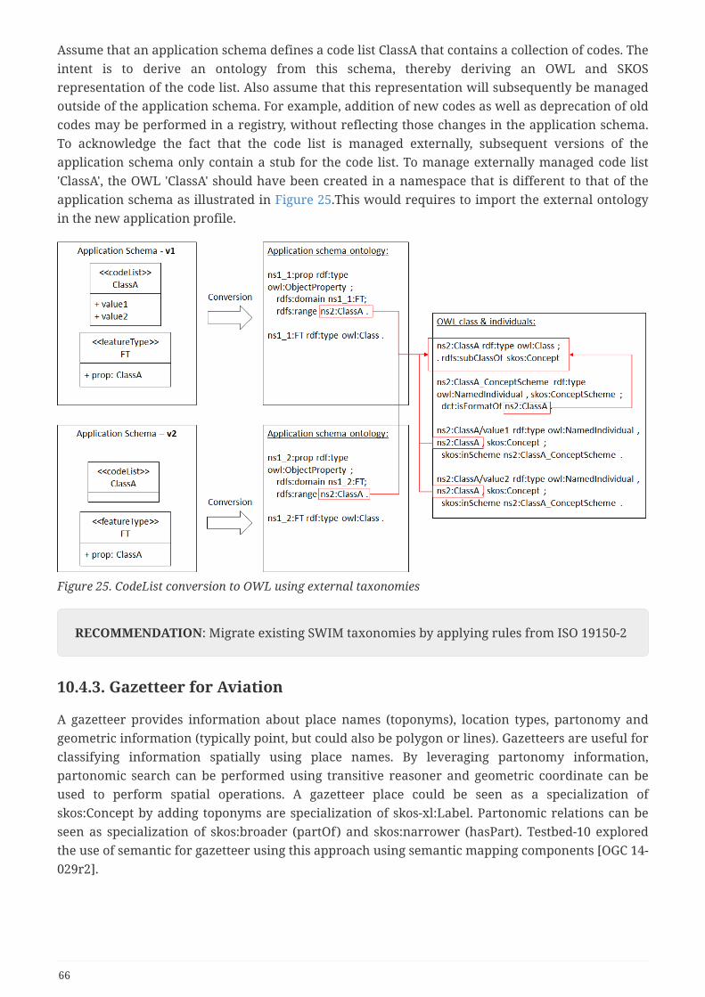
Assume that an application schema defines a code list ClassA that contains a collection of codes. Theintent is to derive an ontology from this schema, thereby deriving an OWL and SKOSrepresentation of the code list. Also assume that this representation will subsequently be managedoutside of the application schema. For example, addition of new codes as well as deprecation of oldcodes may be performed in a registry, without reflecting those changes in the application schema.To acknowledge the fact that the code list is managed externally, subsequent versions of theapplication schema only contain a stub for the code list. To manage externally managed code list'ClassA', the OWL 'ClassA' should have been created in a namespace that is different to that of theapplication schema as illustrated in Figure 25.This would requires to import the external ontologyin the new application profile.
Figure 25. CodeList conversion to OWL using external taxonomies
RECOMMENDATION: Migrate existing SWIM taxonomies by applying rules from ISO 19150-2
10.4.3. Gazetteer for Aviation
A gazetteer provides information about place names (toponyms), location types, partonomy andgeometric information (typically point, but could also be polygon or lines). Gazetteers are useful forclassifying information spatially using place names. By leveraging partonomy information,partonomic search can be performed using transitive reasoner and geometric coordinate can beused to perform spatial operations. A gazetteer place could be seen as a specialization ofskos:Concept by adding toponyms are specialization of skos-xl:Label. Partonomic relations can beseen as specialization of skos:broader (partOf) and skos:narrower (hasPart). Testbed-10 exploredthe use of semantic for gazetteer using this approach using semantic mapping components [OGC 14-029r2].
66
RECOMMENDATION: Deploy a semantic gazetteer service that could be used to tag FAAassets and enable spatial semantic search.
10.4.4. Best practices for domain ontology design
This section describes best practices to design ontologies for aviation data models. NASA ATMontologies is a good example of modular ontologies following these design principles.
Minimal ontological commitment
Modular design of the ontologies should follow the principle of making a minimal ontologicalcommitment to the nature of concepts and of relationships between concepts. As explained byThomas Gruber [26], an ontology should require the minimal ontological commitment sufficient tosupport the intended knowledge sharing activities. An ontology should make as few claims aspossible about the world being modeled, allowing the parties committed to the ontology freedom tospecialize and instantiate the ontology as needed (which is often called ontology applicationprofile).
Opting for such a minimal approach is made dramatically easier by the vocabulary extensionmechanisms offered natively by Semantic Web technology. Applications that require moreconstrained behavior may define compatible extensions to OWL or SKOS. For example, modelersmay coin sub-classes and sub-properties of OWL or SKOS properties, or associate those propertieswith specific formal axioms. By making a minimal ontological commitment, the ontologies can beapplied and reused across multiple Communities of Interests (COIs), thus increasing the rate ofwide-spread adoption.
Modularization of ontologies
Quoting Stuckenschmidt and Klein [27], “ontologies that contain thousands of concepts cannot becreated and maintained by a single person”. Modularization helps designers manage complexity byreducing the size of the design problem [28]. Ideally, designers should design modules of a size thatthey can apprehend, and later either integrate these modules into a final repository or build therelationships among modules that support interoperability. This is a typical application of thedivide-and-conquer principle.
Modularization also provides a way to keep performance of ontology services at an acceptablelevel. Performance concerns may be related to query processing techniques, reasoning engines andontology modeling and visualization tools. Reasoners currently available are performing well onsmall-scale ontologies, with performance degrading rapidly as the size of the ontology increases.Keeping ontologies small is one way to avoid the performance loss, and modularization is a way toreplace an ontology that tends to become oversized by smaller subsets. Modularization fulfills theperformance goal if, whenever a query has to be evaluated or an inference to performed, this canbe done by looking at just few modules, rather than exploring the whole ontology [28].
Reusability of ontologies
Reusability is a well-known goal in software engineering. Reuse is most naturally seen as anessential motivation for approaches aiming at building a broader, more generic repository from
67

existing, more specialized repositories. However, it may also apply to the inverse approachesaiming at splitting an ontology into smaller modules. In this case, the decomposition criterionshould be based on the expected reusability of a module, i.e. how well can a module fill the purposeof various applications. Reusability emphasizes the need for rich mechanisms to describe modules,in a way that maximizes the chances for the modules to be understood, selected and used by otherservices and applications.
Understandability
An obvious prerequisite to the ability to use ontology to understand its content. Whether thecontent is shown in visual or textual format, understanding is easier if the ontology is small (amodule). Small ontologies are undoubtedly preferable if the user is a human being. Size, however isnot the only criterion that influences understandability. The way it is structured contributes toimproving or decreasing understandability.
68

Appendix A: Sample datasetsA.1Airport Dataset Metadata example
The following example describes the metadata about a dataset describing airports, which isserviced by a GEOSPARQL service endpoint and two distribution downloads in RDF/XML and Turtleformat.
69

@prefix : <http://www.imagemattersllc.com/atmonto/datasets#> .@prefix acManuInst: <https://data.nasa.gov/ontologies/atmonto/acManufInst#> .@prefix airlineInst: <https://data.nasa.gov/ontologies/atmonto/airlineInst#> .@prefix dcat: <http://www.w3.org/ns/dcat#> .@prefix dcterms: <http://purl.org/dc/terms/> .@prefix eqp: <https://data.nasa.gov/ontologies/atmonto/equipment#> .@prefix nas: <https://data.nasa.gov/ontologies/atmonto/NAS#> .@prefix owl: <http://www.w3.org/2002/07/owl#> .@prefix rdf: <http://www.w3.org/1999/02/22-rdf-syntax-ns#> .@prefix rdfs: <http://www.w3.org/2000/01/rdf-schema#> .@prefix service-product: <http://semantics.aero/service-product#> .@prefix xsd: <http://www.w3.org/2001/XMLSchema#> .
<https://data.nasa.gov/ontologies/atmonto/airportInst> rdf:type dcat:Dataset ; dcterms:conformsTo <https://data.nasa.gov/ontologies/atmonto/NAS> ; dcterms:description "airports, runways, terminals, gates" ; dcterms:subject nas:Airport, nas:InternationalAirport, nas:CanadianAirport,nas:CONUSairport ; dcterms:title "Airport Instances" ; dct:publisher <http://www.nasa.gov>, dcat:keyword "airports" ; dcat:keyword "gates" ; dcat:keyword "runways" ; dcat:keyword "terminals" ; dcat:theme service-product:infrastructure ; srim:servicedBy :InfrastructureGeoSPARQLService srim:credits "This work was funded by the National Aeronautics and SpaceAdministration under the Aviation Operations and Safety Program."; extent:geographicBoundingBox [ a extent:GeographicBoundingBox; extent:northBoundLatitude 51.29148; extent:southBoundLatitude 49.6959; extent:westBoundLongitude -77.53714; extent:eastBoundLongitude -74.96695 ]; dcat:distribution [ rdf:type dcat:Distribution ; dcterms:title "RDF Distribution of Airport Instances" ; dcat:downloadURL <https://data.nasa.gov/ontologies/atmonto/airportInst.rdf> ; dcat:mediaType "application/rdf+xml" ; ] ; dcat:distribution [ rdf:type dcat:Distribution ; dcterms:title "TTL Distribution of Airport Instances" ; dcat:downloadURL <https://data.nasa.gov/ontologies/atmonto/airportInst.ttl> ; dcat:mediaType "text/turtle" ; ] ;.
70
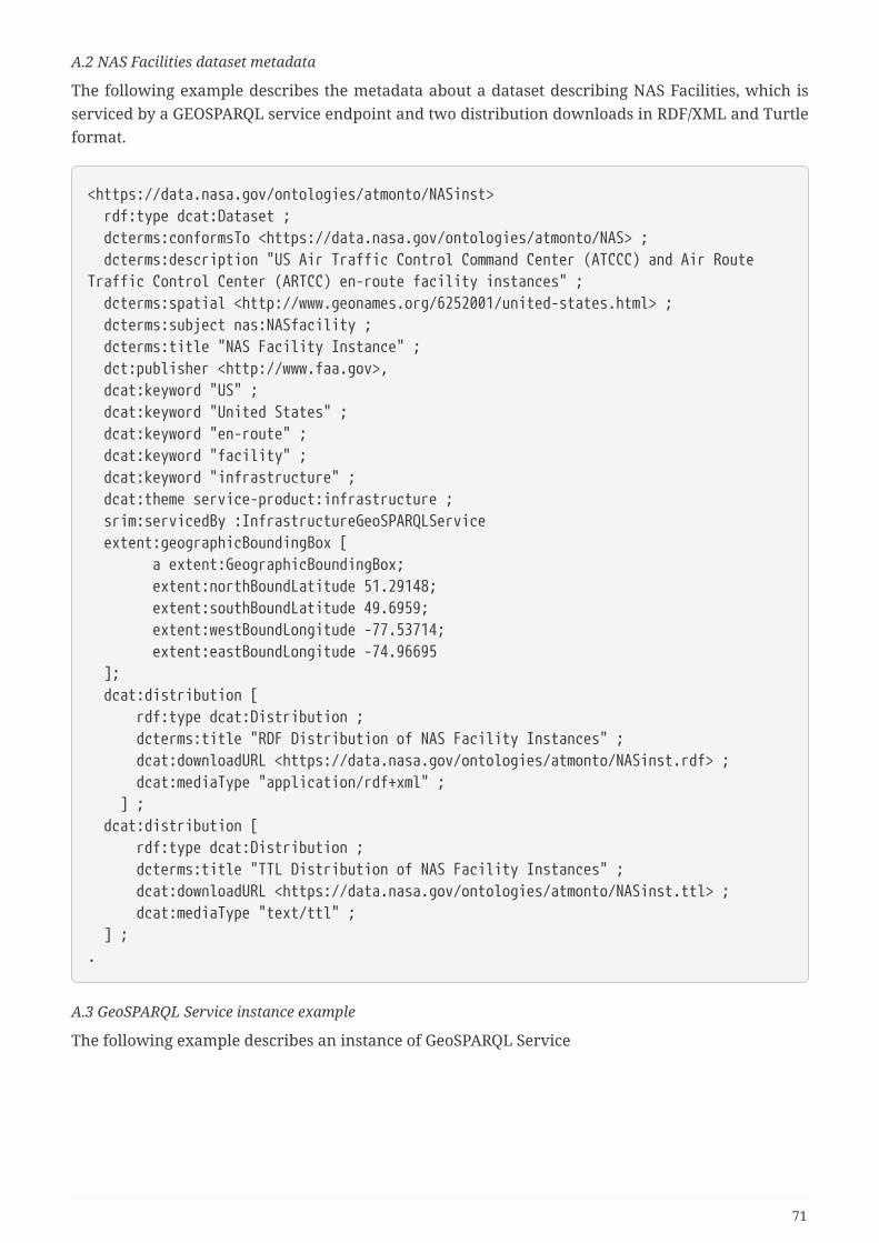
A.2 NAS Facilities dataset metadata
The following example describes the metadata about a dataset describing NAS Facilities, which isserviced by a GEOSPARQL service endpoint and two distribution downloads in RDF/XML and Turtleformat.
<https://data.nasa.gov/ontologies/atmonto/NASinst> rdf:type dcat:Dataset ; dcterms:conformsTo <https://data.nasa.gov/ontologies/atmonto/NAS> ; dcterms:description "US Air Traffic Control Command Center (ATCCC) and Air RouteTraffic Control Center (ARTCC) en-route facility instances" ; dcterms:spatial <http://www.geonames.org/6252001/united-states.html> ; dcterms:subject nas:NASfacility ; dcterms:title "NAS Facility Instance" ; dct:publisher <http://www.faa.gov>, dcat:keyword "US" ; dcat:keyword "United States" ; dcat:keyword "en-route" ; dcat:keyword "facility" ; dcat:keyword "infrastructure" ; dcat:theme service-product:infrastructure ; srim:servicedBy :InfrastructureGeoSPARQLService extent:geographicBoundingBox [ a extent:GeographicBoundingBox; extent:northBoundLatitude 51.29148; extent:southBoundLatitude 49.6959; extent:westBoundLongitude -77.53714; extent:eastBoundLongitude -74.96695 ]; dcat:distribution [ rdf:type dcat:Distribution ; dcterms:title "RDF Distribution of NAS Facility Instances" ; dcat:downloadURL <https://data.nasa.gov/ontologies/atmonto/NASinst.rdf> ; dcat:mediaType "application/rdf+xml" ; ] ; dcat:distribution [ rdf:type dcat:Distribution ; dcterms:title "TTL Distribution of NAS Facility Instances" ; dcat:downloadURL <https://data.nasa.gov/ontologies/atmonto/NASinst.ttl> ; dcat:mediaType "text/ttl" ; ] ;.
A.3 GeoSPARQL Service instance example
The following example describes an instance of GeoSPARQL Service
71
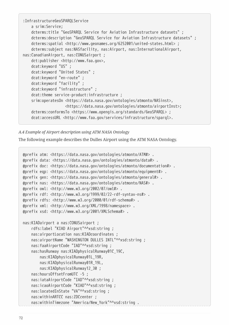
:InfrastructureGeoSPARQLService a srim:Service; dcterms:title "GeoSPARQL Service for Aviation Infrastructure datasets" ; dcterms:description "GeoSPARQL Service for Aviation Infrastructure datasets" ; dcterms:spatial <http://www.geonames.org/6252001/united-states.html> ; dcterms:subject nas:NASfacility, nas:Airport, nas:InternationalAirport,nas:CanadianAirport, nas:CONUSairport ; dct:publisher <http://www.faa.gov>, dcat:keyword "US" ; dcat:keyword "United States" ; dcat:keyword "en-route" ; dcat:keyword "facility" ; dcat:keyword "infrastructure" ; dcat:theme service-product:infrastructure ; srim:operatesOn <https://data.nasa.gov/ontologies/atmonto/NASinst>, <https://data.nasa.gov/ontologies/atmonto/airportInst>; dcterms:conformsTo <https://www.opengis.org/standards/GeoSPARQL> ; dcat:accessURL <http://www.faa.gov/services/infrastructure/sparql>.
A.4 Example of Airport description using ATM NASA Ontology
The following example describes the Dulles Airport using the ATM NASA Ontology.
@prefix atm: <https://data.nasa.gov/ontologies/atmonto/ATM#> .@prefix data: <https://data.nasa.gov/ontologies/atmonto/data#> .@prefix doc: <https://data.nasa.gov/ontologies/atmonto/documentation#> .@prefix eqp: <https://data.nasa.gov/ontologies/atmonto/equipment#> .@prefix gen: <https://data.nasa.gov/ontologies/atmonto/general#> .@prefix nas: <https://data.nasa.gov/ontologies/atmonto/NAS#> .@prefix owl: <http://www.w3.org/2002/07/owl#> .@prefix rdf: <http://www.w3.org/1999/02/22-rdf-syntax-ns#> .@prefix rdfs: <http://www.w3.org/2000/01/rdf-schema#> .@prefix xml: <http://www.w3.org/XML/1998/namespace> .@prefix xsd: <http://www.w3.org/2001/XMLSchema#> .
nas:KIADairport a nas:CONUSairport ; rdfs:label "KIAD Airport"^^xsd:string ; nas:airportLocation nas:KIADcoordinates ; nas:airportName "WASHINGTON DULLES INTL"^^xsd:string ; nas:faaAirportCode "IAD"^^xsd:string ; nas:hasRunway nas:KIADphysicalRunway01C_19C, nas:KIADphysicalRunway01L_19R, nas:KIADphysicalRunway01R_19L, nas:KIADphysicalRunway12_30 ; nas:hoursOffsetFromUTC -5 ; nas:iataAirportCode "IAD"^^xsd:string ; nas:icaoAirportCode "KIAD"^^xsd:string ; nas:locatedInState "VA"^^xsd:string ; nas:withinARTCC nas:ZDCcenter ; nas:withinTimezone "America/New_York"^^xsd:string .
72

nas:KIADphysicalRunway01C_19C a nas:KIADphysicalRunway ; rdfs:label "Airport KIAD Runway 01C/19C"^^xsd:string ; nas:associatedAirport nas:KIADairport ; nas:associatedOpRunway nas:KIADoperationalRunway01C, nas:KIADoperationalRunway19C ; nas:runwayID "01C/19C"^^xsd:string ; nas:runwayLengthInFeet "11500"^^xsd:string ; nas:runwayWidthInFeet "150"^^xsd:string .
nas:KIADphysicalRunway01L_19R a nas:KIADphysicalRunway ; rdfs:label "Airport KIAD Runway 01L/19R"^^xsd:string ; nas:associatedAirport nas:KIADairport ; nas:associatedOpRunway nas:KIADoperationalRunway01L, nas:KIADoperationalRunway19R ; nas:runwayID "01L/19R"^^xsd:string ; nas:runwayLengthInFeet "9400"^^xsd:string ; nas:runwayWidthInFeet "150"^^xsd:string .
nas:KIADphysicalRunway01R_19L a nas:KIADphysicalRunway ; rdfs:label "Airport KIAD Runway 01R/19L"^^xsd:string ; nas:associatedAirport nas:KIADairport ; nas:associatedOpRunway nas:KIADoperationalRunway01R, nas:KIADoperationalRunway19L ; nas:runwayID "01R/19L"^^xsd:string ; nas:runwayLengthInFeet "11500"^^xsd:string ; nas:runwayWidthInFeet "150"^^xsd:string .
nas:KIADphysicalRunway12_30 a nas:KIADphysicalRunway ; rdfs:label "Airport KIAD Runway 12/30"^^xsd:string ; nas:associatedAirport nas:KIADairport ; nas:associatedOpRunway nas:KIADoperationalRunway12, nas:KIADoperationalRunway30 ; nas:runwayID "12/30"^^xsd:string ; nas:runwayLengthInFeet "10501"^^xsd:string ; nas:runwayWidthInFeet "150"^^xsd:string .
nas:KIADcoordinates a gen:PointLocation ; rdfs:label "KIAD coordinates"^^xsd:string ; gen:altitude "313"^^xsd:float ; gen:latitude "38.947444"^^xsd:float ; gen:longitude "-77.459944"^^xsd:float .
nas:KIADoperationalRunway01C a nas:KIADoperationalRunway ; rdfs:label "Airport KIAD Runway 01C"^^xsd:string ; nas:associatedAirport nas:KIADairport ; nas:runwayID "01C"^^xsd:string ; nas:touchdownPoint nas:KIADrunway01Ccoordinates .
nas:KIADoperationalRunway01L a nas:KIADoperationalRunway ;
73

rdfs:label "Airport KIAD Runway 01L"^^xsd:string ; nas:associatedAirport nas:KIADairport ; nas:runwayID "01L"^^xsd:string ; nas:touchdownPoint nas:KIADrunway01Lcoordinates .
nas:KIADoperationalRunway01R a nas:KIADoperationalRunway ; rdfs:label "Airport KIAD Runway 01R"^^xsd:string ; nas:associatedAirport nas:KIADairport ; nas:runwayID "01R"^^xsd:string ; nas:touchdownPoint nas:KIADrunway01Rcoordinates .
nas:KIADoperationalRunway12 a nas:KIADoperationalRunway ; rdfs:label "Airport KIAD Runway 12"^^xsd:string ; nas:associatedAirport nas:KIADairport ; nas:runwayID "12"^^xsd:string ; nas:touchdownPoint nas:KIADrunway12coordinates .
nas:KIADoperationalRunway19C a nas:KIADoperationalRunway ; rdfs:label "Airport KIAD Runway 19C"^^xsd:string ; nas:associatedAirport nas:KIADairport ; nas:runwayID "19C"^^xsd:string ; nas:touchdownPoint nas:KIADrunway19Ccoordinates .
nas:KIADoperationalRunway19L a nas:KIADoperationalRunway ; rdfs:label "Airport KIAD Runway 19L"^^xsd:string ; nas:associatedAirport nas:KIADairport ; nas:runwayID "19L"^^xsd:string ; nas:touchdownPoint nas:KIADrunway19Lcoordinates .
nas:KIADoperationalRunway19R a nas:KIADoperationalRunway ; rdfs:label "Airport KIAD Runway 19R"^^xsd:string ; nas:associatedAirport nas:KIADairport ; nas:runwayID "19R"^^xsd:string ; nas:touchdownPoint nas:KIADrunway19Rcoordinates .
nas:KIADoperationalRunway30 a nas:KIADoperationalRunway ; rdfs:label "Airport KIAD Runway 30"^^xsd:string ; nas:associatedAirport nas:KIADairport ; nas:runwayID "30"^^xsd:string ; nas:touchdownPoint nas:KIADrunway30coordinates .
nas:KIADrunway01Ccoordinates a gen:PointLocation ; rdfs:label "KIAD runway 01C coordinates"^^xsd:string ; gen:altitude "286"^^xsd:float ; gen:latitude "38.939066"^^xsd:float ; gen:longitude "-77.459780"^^xsd:float .
nas:KIADrunway01Lcoordinates a gen:PointLocation ; rdfs:label "KIAD runway 01L coordinates"^^xsd:string ; gen:altitude "286"^^xsd:float ; gen:latitude "38.944967"^^xsd:float ;
74

gen:longitude "-77.474810"^^xsd:float .
nas:KIADrunway01Rcoordinates a gen:PointLocation ; rdfs:label "KIAD runway 01R coordinates"^^xsd:string ; gen:altitude "312"^^xsd:float ; gen:latitude "38.923757"^^xsd:float ; gen:longitude "-77.436451"^^xsd:float .
nas:KIADrunway12coordinates a gen:PointLocation ; rdfs:label "KIAD runway 12 coordinates"^^xsd:string ; gen:altitude "310"^^xsd:float ; gen:latitude "38.943772"^^xsd:float ; gen:longitude "-77.490444"^^xsd:float .
nas:KIADrunway19Ccoordinates a gen:PointLocation ; rdfs:label "KIAD runway 19C coordinates"^^xsd:string ; gen:altitude "269"^^xsd:float ; gen:latitude "38.970639"^^xsd:float ; gen:longitude "-77.459324"^^xsd:float .
nas:KIADrunway19Lcoordinates a gen:PointLocation ; rdfs:label "KIAD runway 19L coordinates"^^xsd:string ; gen:altitude "293"^^xsd:float ; gen:latitude "38.955329"^^xsd:float ; gen:longitude "-77.435979"^^xsd:float .
nas:KIADrunway19Rcoordinates a gen:PointLocation ; rdfs:label "KIAD runway 19R coordinates"^^xsd:string ; gen:altitude "269"^^xsd:float ; gen:latitude "38.970773"^^xsd:float ; gen:longitude "-77.474440"^^xsd:float .
nas:KIADrunway30coordinates a gen:PointLocation ; rdfs:label "KIAD runway 30 coordinates"^^xsd:string ; gen:altitude "288"^^xsd:float ; gen:latitude "38.933610"^^xsd:float ; gen:longitude "-77.455898"^^xsd:float .
A.5 Example of Flight description using ATM NASA Ontology
The following example describes the details of a FLight using the ATM ontology.
75

atm:CPZ5839-201407150054 a atm:Flight ; rdfs:label "Flight CPZ5839 on 2014-07-15 00:54:00"^^xsd:string ; atm:actualArrivalDay nas:Day20140715 ; atm:actualArrivalTime "2014-07-15T04:21:00"^^xsd:dateTime ; atm:actualDepartureDay nas:Day20140715 ; atm:actualDepartureTime "2014-07-15T00:54:00"^^xsd:dateTime ; atm:aircraftTypeFlown eqp:E170AircraftType ; atm:arrivalAirport nas:KIAHairport ; atm:callSign "CPZ5839"^^xsd:string ; atm:departureAirport nas:KLGAairport ; atm:hasActualRoute atm:ActualRouteCPZ5839-201407150054 ; atm:hasPlannedRoute atm:PlannedRouteCPZ5839-201407150054 ; atm:operatedBy nas:CPZairline ; atm:userCategory "COMMERCIAL"^^xsd:string .
A.6 Example of Flight description using ATM NASA Ontology
The following example describes the details of a FLight using the ATM ontology.
atm:CPZ5839-201407150054 a atm:Flight ; rdfs:label "Flight CPZ5839 on 2014-07-15 00:54:00"^^xsd:string ; atm:actualArrivalDay nas:Day20140715 ; atm:actualArrivalTime "2014-07-15T04:21:00"^^xsd:dateTime ; atm:actualDepartureDay nas:Day20140715 ; atm:actualDepartureTime "2014-07-15T00:54:00"^^xsd:dateTime ; atm:aircraftTypeFlown eqp:E170AircraftType ; atm:arrivalAirport nas:KIAHairport ; atm:callSign "CPZ5839"^^xsd:string ; atm:departureAirport nas:KLGAairport ; atm:hasActualRoute atm:ActualRouteCPZ5839-201407150054 ; atm:hasPlannedRoute atm:PlannedRouteCPZ5839-201407150054 ; atm:operatedBy nas:CPZairline ; atm:userCategory "COMMERCIAL"^^xsd:string .
A.6 Example of Hourly Airport Condition using ATM NASA Ontology
The following describes Hourly Airport Condition in JFK Airport in NYC.
data:KJFKairportData20140729000000 a data:AirportData ; rdfs:label "Airport Data for KJFK @00:00:00Z on 20140729"^^xsd:string ; data:airportArrivalRate 44 ; data:airportDepartureRate 42 ; data:arrivalDemand 75 ; data:aspmFlightRules "V"^^xsd:string ; data:dataIntervalEndDay nas:Day20140729 ; data:dataIntervalEndTime "2014-07-29T01:00:00"^^xsd:datetime ; data:dataIntervalStartDay nas:Day20140729 ; data:dataIntervalStartTime "2014-07-29T00:00:00"^^xsd:datetime ; data:departureDemand 70 ;
76

data:edctArrivalHold "449.0"^^xsd:float ; data:edctDepartureHold "0.0"^^xsd:float ; data:etmsArrivals 34 ; data:etmsDepartures 34 ; data:hasASPMmetCondition data:KJFKaspmHourlyMetCond20140729000000 ; data:highWindWITIdaily "104"^^xsd:float ; data:highWindWITIhourly "33"^^xsd:float ; data:lowCeilingWITIdaily "0"^^xsd:float ; data:lowCeilingWITIhourly "0"^^xsd:float ; data:lowVisibilityWITIdaily "0"^^xsd:float ; data:lowVisibilityWITIhourly "0"^^xsd:float ; data:oagArrivalDelay 526 ; data:oagGateDepartureDelay 1464 ; data:scheduledArrivals 33 ; data:scheduledDepartures 41 ; data:totalAirborneDelay "379.0"^^xsd:float .
data:KJFKaspmHourlyMetCond20140729000000 a data:ASPMmeteorologicalCondition ; rdfs:label "ASPM Meteorological Condition for KJFK @00:00:00Z on20140729"^^xsd:string ; data:dataIntervalEndDay nas:Day20140729 ; data:dataIntervalEndTime "2014-07-29T01:00:00"^^xsd:datetime ; data:dataIntervalStartDay nas:Day20140729 ; data:dataIntervalStartTime "2014-07-29T00:00:00"^^xsd:datetime ; data:hasSkyCondition data:KJFKaspmHourlySkyCond20140729000000 ; data:hasSurfaceWindCondition data:KJFKaspmHourlyWindCond20140729000000 ; data:hasVisibilityCondition data:KJFKaspmHourlyVisCond20140729000000 ; data:surfaceTemperature "78.0"^^xsd:float .
data:KJFKaspmHourlySkyCond20140729000000 a data:SkyCondition ; rdfs:label "ASPM Sky Condition for KJFK @00:00:00Z on 20140729"^^xsd:string ; data:ceiling 85 .
data:KJFKaspmHourlyWindCond20140729000000 a data:SurfaceWindCondition ; rdfs:label "ASPM Wind Condition for KJFK @00:00:00Z on 20140729"^^xsd:string ; data:surfaceWindDirectionStatus "fixed" ; data:surfaceWindSpeed "18.0"^^xsd:float ; data:windDirectionFixed "300.0"^^xsd:float .
data:KJFKaspmHourlyVisCond20140729000000 a data:VisibilityCondition ; rdfs:label "ASPM Visibility Condition for KJFK @00:00:00Z on 20140729"^^xsd:string; data:limitedVisibilityDistance "10.0"^^xsd:float .
77

Appendix B: Revision HistoryTable 2. Revision History
Date Editor Release Primaryclausesmodified
Descriptions
May 05, 2018 S. Fellah .1 all initial version
August 08, 2018 S. Fellah .2 all Aviation Modelreview
August 15, 2018 S. Fellah .3 all SemanticEnablementApproaches
August 15, 2018 S. Fellah .4 all ControlledVocabulariessection
Sept 26, 2018 S. Fellah .5 all SRIM Model
Oct 26, 2018 S. Fellah .6 all All
Nov. 23, 2018 S. Fellah .7 all Integrated editsfrom Gobe.
Nov. 26, 2018 S. Fellah .8 all Clean up bibTexand references
78

Appendix C: Bibliography1. EUROCONTROL, Federal Aviation Administration: AAIXM 5.1 Specification, http://aixm.aero/
page/aixm-51-specification.
2. EUROCONTROL, Federal Aviation Administration: WXXM 2.0, http://wxxm.aero/news/wxxm-20.
3. Federal Aviation Administration: FIXM 4.1 Core, https://www.fixm.aero/fixm_410.pl.
4. Kaplun, M., Blomqvist, P., Uri, C., Haggstrom, N.: Service Description Conceptual Model (SDCM)1.0. (2014).
5. Martin, D., Burstein, M., Mcdermott, D., Mcilraith, S., Paolucci, M., Sycara, K., Mcguinness, D.L.,Sirin, E., Srinivasan, N.: OWL-S: Semantic Markup for Web Services - W3C Member Submission22 November 2004. (2004).
6. Chinnici, R., Moreau, J.-J., Ryman, A., Weerawarana, S.: Web services description language (wsdl)version 2.0 part 1: Core language. W3C recommendation. 26, 19 (2007).
7. Balabanh, A.: OGC Testbed-12 Aviation Semantics Engineering Report. OGC 16-039,OpenGeospatial Consortium, http://docs.opengeospatial.org/per/16-039.html (2016).
8. Chen, C.: OGC Testbed-13 Geospatial Taxonomies ER. OGC 17-036,Open Geospatial Consortium,http://docs.opengeospatial.org/per/17-036.html (2018).
9. FAA: NAS Service Registry and Repository, https://nsrr.faa.gov/, (2018).
10. Miles, A., Bechhofer, S.: SKOS simple knowledge organization system reference. W3Crecommendation. 18, W3C (2009).
11. Fellah, S.: OGC Testbed-12 Semantic Portrayal, Registry and Mediation. OGC 16-059,OpenGeospatial Consortium, http://docs.opengeospatial.org/per/16-059.html (2017).
12. Maali, F., Erickson, J., Archer, P.: Data catalog vocabulary (DCAT). W3C Recommendation. 16,(2014).
13. GeoDCAT-AP v1.0, https://joinup.ec.europa.eu/release/geodcat-ap-v10 , (2016).
14. Ciccarese, P., Soiland-Reyes, S., Belhajjame, K., Gray, A.J.G., Goble, C., Clark, T.: PAV ontology:provenance, authoring and versioning. Journal of biomedical semantics. 4, 37 (2013).
15. Group, O.W.L.W., others: OWL 2 Web Ontology Language Document Overview: W3CRecommendation 27 October 2009. W3C recommendation. (2009).
16. Brickley, D.: RDF vocabulary description language 1.0: RDF schema. http://www.w3.org/TR/rdf-schema/. (2004).
17. Sancho, P.F., Kaplun, M., Uri, C., Zhy, W., Pola, T., Schrempf, O.: Service Description ConceptualModel (SDCM), Version 2.0. (2016).
18. Kaplun, M.: FAA Web Service Description Ontological Model (WSDOM) - an Introduction. (2015).
19. FAA: FAA Semantics.aero, https://semantics.aero/ , (2018).
20. FAA: Registry Integration Module, http://swim.aero/rim/, (2018).
21. Project Open Data, https://project-open-data.cio.gov/ , (2016).
22. Fellah, S.: OGC Testbed-11 Implementing Linked Data and Semantically Enabling OGC ServicesEngineering Report . OGC 15-054,Open Geospatial Consortium, https://portal.opengeospatial.org/
79

files/?artifact_id=64405 (2018).
23. Fellah, S.: OGC Testbed 10 Virtual Global Gazetteer Engineering Report . OGC 14-029r2,OpenGeospatial Consortium, https://portal.opengeospatial.org/files/?artifact_id=61108 (2015).
24. Kopeckỳ, J., Vitvar, T., Bournez, C., Farrell, J.: Sawsdl: Semantic annotations for wsdl and xmlschema. IEEE Internet Computing. 60–67 (2007).
25. Neiswender, C.: What is a Controlled Vocabulary? In: In The MMI Guides: Navigating the Worldof Marine Metadata. Marine Metadata Interoperability, http://uop.whoi.edu/techdocs/presentations/MMI_Guides.pdf (2009).
26. Gruber, T.R.: A translation approach to portable ontology specifications. Knowledge acquisition.5, 199–220 (1993).
27. Stuckenschmidt, H., Klein, M.: Structure-based partitioning of large concept hierarchies. In:International semantic web conference. pp. 289–303. Springer (2004).
28. Stuckenschmidt, H., Parent, C., Spaccapietra, S.: Modular ontologies: concepts, theories andtechniques for knowledge modularization. Springer (2009).
80