OFFICE OF THE TAHASILDAR, … · ... for five year w.e.f. 2015-16 to 2019-20 in S.M.C No ......
12
OFFICE OF THE TAHASILDAR, SHEFTAGADA(GANJAM) Ph No. (06822) 255775 e-mail : tah-sherag ada@y aho o.in Letter N". ].g.ru.. / sairat. To The Member SecretarY, SEIAA, Qr. No.-5RF -21 1, Unit -lX, Bhubaneswar- 751 022. Sub:- lssue Environmental clearance of Sekhara Rao, S/o- T. Dasarathi, Ganjam (Odisha). Sir, ln inviting a reference to the subject cited above, lam to say that, the source named Santoshpur Sand Bed of this Tahasil has been granted for long term lease in favour of Sri. T. Chandra Sekhara Rao, S/o- T. Dasarathi, At-Old Police Station, Po- Chatapur, Dist.- Ganjam (Odisha) for five year w.e.f. 2015-16 to 2019-20 in S.M.C No.- 14t15-16 as per Govt Notification No.-1653/ dtd. 16.09.14 of Steel & Mines Department, Odisha. Since the Mining Plan was approved for small amount of extraction of sand (1700 Cum.) in total lease period i.e. from 2015-16 to 2019-20 out of total reserve, so the revised Mining Plan along withapplication in Form No.- l, check list, and Demand Draft for Rs.- 2,OOOI- (Rupees two thousand) vide BD No-206308/Dtd. 01.07.2016 of State Bank of lndia, Berhampur in favour of Chairman SEIAA, Bhubanewar is fonruarded for consideration towards getting Environmental clearance for five year w.e.f. 2016-17to 2O1g-20 so that necessary order for operation of quarry may be issued to the lease holder. This is for favour of your kind information and necessary action. Encl.:- 1. Approved Mining Plan 2. ApPlication in Form No.- | 3. Check list 4. Bank Draft for Rs.- 5,000/- vide BD No-206308/Dtd. 01 ,07.2016 Date: AV tor l2016 long term lease in favour of Sri. T. Chandra At-Old Police Station, Po- Chatapur, Dist.- Yours Memo No.- .. / Date {ahasild t-rcl tg T. Chandra Sekhara Rao, S/o- T. Dasarathi, At-Old Copy to the Sri. T. Chandra Sekhara Rao, S/o- T. Dasarathi, At-Old Poli&crugada (Gm.) Station, Po- Chatapur, Dist.- Ganjam (Odisha) for information & necessary action' , Po- Chatapur, .J4I * Tahasildar, Sheragada Memo No.- .. / Date Copy submitted to the Addl. District Magistrate, Ganjam, Chatrapur / Sub- Collector, Bhanjanagar for kind information. fully, - (:r4l - ' Tahasildar,Sheragada a
-
Upload
duonghuong -
Category
Documents
-
view
213 -
download
0
Transcript of OFFICE OF THE TAHASILDAR, … · ... for five year w.e.f. 2015-16 to 2019-20 in S.M.C No ......
OFFICE OF THE TAHASILDAR, SHEFTAGADA(GANJAM)Ph No. (06822) 255775 e-mail : tah-sherag ada@y aho o.in
Letter N". ].g.ru.. / sairat.To
The Member SecretarY,
SEIAA, Qr. No.-5RF -21 1,
Unit -lX, Bhubaneswar- 751 022.
Sub:- lssue Environmental clearance ofSekhara Rao, S/o- T. Dasarathi,Ganjam (Odisha).
Sir,
ln inviting a reference to the subject cited above, lam to say that, the source
named Santoshpur Sand Bed of this Tahasil has been granted for long term lease in
favour of Sri. T. Chandra Sekhara Rao, S/o- T. Dasarathi, At-Old Police Station, Po-
Chatapur, Dist.- Ganjam (Odisha) for five year w.e.f. 2015-16 to 2019-20 in S.M.C No.-
14t15-16 as per Govt Notification No.-1653/ dtd. 16.09.14 of Steel & Mines
Department, Odisha.Since the Mining Plan was approved for small amount of extraction of sand (1700
Cum.) in total lease period i.e. from 2015-16 to 2019-20 out of total reserve, so the
revised Mining Plan along withapplication in Form No.- l, check list, and Demand Draft
for Rs.- 2,OOOI- (Rupees two thousand) vide BD No-206308/Dtd. 01.07.2016 of State
Bank of lndia, Berhampur in favour of Chairman SEIAA, Bhubanewar is fonruarded for
consideration towards getting Environmental clearance for five year w.e.f. 2016-17to
2O1g-20 so that necessary order for operation of quarry may be issued to the lease
holder.This is for favour of your kind information and necessary action.
Encl.:- 1. Approved Mining Plan2. ApPlication in Form No.- |
3. Check list4. Bank Draft for Rs.- 5,000/-
vide BD No-206308/Dtd. 01 ,07.2016
Date: AV tor l2016
long term lease in favour of Sri. T. ChandraAt-Old Police Station, Po- Chatapur, Dist.-
Yours
Memo No.- .. / Date{ahasild
t-rcl tg
T. Chandra Sekhara Rao, S/o- T. Dasarathi, At-OldCopy to the Sri. T. Chandra Sekhara Rao, S/o- T. Dasarathi, At-Old Poli&crugada (Gm.)
Station, Po- Chatapur, Dist.- Ganjam (Odisha) for information & necessary action', Po- Chatapur,
.J4I *Tahasildar, Sheragada
Memo No.- .. / DateCopy submitted to the Addl. District Magistrate, Ganjam, Chatrapur / Sub-
Collector, Bhanjanagar for kind information.
fully,
- (:r4l -' Tahasildar,Sheragada
a

OFFICE OF THE TAHASILDAR,Ph No. (06822) 25s77s
SHERAGADA(GANJAM)e-mail : tah*sherag ada@yahoo,in
Letter No.*l .s:.... / Sairat.
ToThe Member Secretary,SEIAA, Qr. No.-SRF-2/ 1,Unit -DK, Bhubaneswar- 7SL O22.
Date: .4( ./08l2ot6
Sub:- Proposal for Santoshpur Sand Bed over an area Ac. 19.4OO underK. No.- 4L7, Plot No-45 of Mouza Santoshpur, Tahasil - Sheragada,Dist-Ganjam Environment clearance regarding.
Sir,
With reference to the subject cited above, I am to say that there is no
other Mine is located within 500 Meters from the periphery of Sanothpur Sand
Bed over Plot No.-45 of K.No.-4I7, Area- Ac. 19.400 of Sanothpur Mouza.
This is favour of information & necessary action.
Tahasil@ri

a Annexure- ll
MINOR MINERAL MINING PROJECTgHECK LIST FOR
Date of application
i Scrutiny fees payment details
i Name & aodress of the Applicarrt
Narne of the Mincr Mineral
lirr;;;""d, ;.". "f
th" ri"",
i '/Vhether new / existing Minei
-l__._
t-- -l - rr\(DD No 7- Lo6 g oB
'T' Clrs.^nJrn^O- S e+fr.p-fr_- R^OM '- cha+n--\L^n- , s ist- Gornnsqm..,lo os i'tern
s^'.^-+"^<^i'^z s'"'a €;A ;"
A-o\S-\t 'To JLa\q -JLo
85
No Foz-<:st /4rn4..
No-t -Porr-<;f )-o.1.-a\ .
G avt o*' a A.i:-o"or
So."n*-exlnh^72- S"t^"1A B-(A "
Q.x"q.Jo.6rr .
3[gn-aS-..da^.-
gc1nn=\,e3;tn \ *tZ:- .
hr?
, Lease periodl
_t_
B
i
10ctaJl.
No.
i Area of the lease (hr)l
I a) Forest LandI
I 1l if yel $gls ct forest clearance
;b) Nlon-foreit ranJl
; c) Cwnershin of larrdI
' *octtion of mineL--
-Ij i) Districti/I
i iii;Village iMouzaL
I iv) Khata NoI
L_._..-.,__
I v) Piot No. &. KisamI
I
i
I ItL 'lft c- \n' t^o
ff* -l__Frotn;--L 1**i i-__'--_- -l_____ 1._.
r i l. i h5 i FtYe-;n-'vr) co-oioinates of tne iiib - i-fn \*-if \ , t5-'r; r' ' \q"- 3t it.gs'', Vlj UO-OIUlIlliteS Ol tlie Slte i : I l' \1 )J- \ ' D? To Ir. \1 - tJ- tv J,
, - (=q!,1sdqirQ !,-on.qtlu{el *-L-_|E-?f !uJ-gs1 !o- F -F-1,"
1( t?'o8'i rnvironrnenlf!-ggJfg1lildty (should bernentioned cle"!y_'nj!g4e!gf3)_
Area I I Distance in Kilometer from tl'ie boundarr.'i I i of the lease area
-r- ---1- -i-.--.-I
i Distance from the following infrastructural I I
facilities
Nearest Railway line (with name)
Nearest Naticnal Highway (with name)
Nearest 'State Highway (with narne)
Nearest Major Drstr-ict Road (with name)
Near-rst Arry Other RoaC (with name) l'il.ll--*l
|'^9f- - 35 K"'l'\ *n^a"''- Se-^rc+'aprBpZ'
N'+l -\6- 35 K*'4 3czw"^teul'
S-ts\€- 1+ fg-rnc^l*? -\L\!".lA ' ili*slllclt
fv\'\N BhA^^so$ta'€+"r- € -6 o W4
f\'b.Prt-A - 5K"'- ! 'rF>u"-^ s-.^-ttll\hL
ii) Tahasil
FcL^a^\nJ* g"*,^fu*.-

Nearest Railway bridge I road bridge
Nearest Electric transmission line pole ortower
Nearest Canal or check dam or reservoirsor lake or ponds
Nearest in-take point with name fordrinking water / industrial use
Nearest intake for irrigation
Nearest River Embankment
Nearest Sanctuary / National Park
(along with name of the Sanctuary /National Park)
Other mine
R"*-\ Raiex+-lSo-nte>{,,rt*Of_ _ 1gr ^n - €A4rnL To
t Hp ua4c41 ."t= $.o^^i.
[, o.lzi^".4 ?o*^".t a\ So,^n*o^k0t ("\2
r\Q;i.x"*rrc*1-<rv._r-1rffi\ff&j-t^lr*l*^; \<3+L\'uz\L - 7 o
n/r'L FJ t"t
K-'""4 - Gho&".l^\,^4
sl.No.(i)
s) located within 500 meter from the iher of the lease areaName and address of the EC status
_[ILg
Not--tI lrer€min€:r\€+e4
exi*l\*?iS ho otherrb;+hin gto
Nearest reserve forest (with name) $t^ro"^=o-N4$^>l- fdoeruv e F oz-t*'l-5 S K.o^"5 ,
Nearest Archaeological site(along with the name of theArchaeolooical Site
' I -Rl.s7rr<-To-rZa--\47r4an-t'J <'n'*
Nearest State boundaries 5 *..-r*\*1"- - 3S K^^^,4
Nearest Defense installations
Nearest Densely populated or built-uparea, distance from nearest humanhabitation
(Name of the nearest habitation)
Qut{b^1.- $ ho{orB"^"^rt^,45 KT4
It\ ""ii,rLc'tl- - \1-\<^'14
High tide line Qol"^ltwr- Io::-l ^ )-t 1, K*r4Nearest Areas occupied by sensitiveman-made land uses
(hospitals, educational institutions, placesof worship, community facilities)
H\ ^",siliCqh - \L\<^a,Ah\\*:si,Li cqt 16{tufl- \L\<.{C[.:-^ll-"-,.Tc,,.,r. T-.""-t-( -'l \aa5
Name of mineral Lease area
- Prge 2 ofJ

-a
(,
No.
Other Proposals of the Same Lessee/proponent submitted for ECName and address of themine
Name of mineral Lease area EG status
(i)
(ii)
ilr)
No nlit- rJ rt nt it-
13. Whether the mining plan is approved?(Yes/No)lf so, Name of the competent approvingauthoritv
Y"l - )), D'rl)-e.\"[, Q <o -!*o&B<-rzXo'*-tq9'r -lo
14 M in ing method (Specify whetherexcavator/detonator is used) S e."^i nnCr-eno:---" z-.-\
15 Whether any vegetation exists in thelease area? lf so ,specify the type andquantity (n um ber I area)
NO
Counter signed and recommended forEnvironmental C learance
Certified that the information furnishedabove are true to the best of my
knowledge
<l) Oh"^^.1 *r g*"r,-^ K*.
-
Signature Signature of Applicant
Encl: Documents:
1. Form-l duly filled.2. Pre-feasibility Report (PFR).3. Environment Management Plan (EMP).4, Full scape toposheet (1:50,000 scale) showing all features and depicting lease site.5. Full scape village sheet showing location of the project and other mines within
500 meter.6. Full scape Toposheet showing areas within 10 Km radius from the lease area
including Sanctuary/National Park, if Any.7. Lease permission /sanction order of Competent Authority (Tahasildar).8. Scrutiny fee payment details9. Category of land and conversion document, if requiredl0.Approved mining plan along with approval letter.
t Yahasildar
S'kcroqada (Gm.)
Page 3 of3
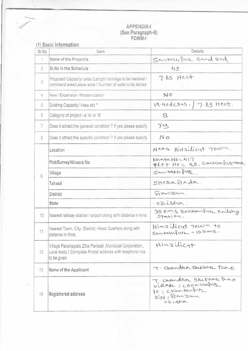
APPE NDIX.I(See Paragraph-6)
FORM.I
Basic Informationsl.No Item oetails
Name of the Projecus llo<+o.vr lvrrr- s.*.d e-{2 Sl.No ln the Schedule LI5
l Prcp0sed Capas ly/ aiea /Lengthl tonnage 1e be hand ed /comrnand area/Lease aTea / Nunrberof wa s to be deilled
'J 85 H.c-.+
:l New / Expansion /lvlodern zalion No
5 Existin! Capacltyi Arca etc . lq'ho,1.t!'5,/ f .aS n.-1.
6 Category of project i.e A'oi' B' B
7 Does ilallractlhe generclcondition ? lfyes please specify Y58 Does anract the specr'c conorlron t J yas please specrfy No
I
Location N.-c--,L Hi r:Ac.{t -To.o-^. -
PloUSurvey/Khasra No
Village 5*14:la f "r1Tahasil SH<-tr,a'rG a'-A{.
0istrict
Slate osi-*ho.
10 Nearest railway station / airport along lviih dislance in kms.3s K-A ge;.r.*Q.,rr- n^l!.o*61
11Nearest Town, Clty ,oistrict, Head Quarters a ong with
dislance in Kms.
111 .^r il cq'f -ro t:r' +oSo-^i.,''{-.1\^'!- - \t-\<.,s'5 ]
12
V lLaOe Panchayats,Z la Parisad ,lVunic pa Corporauon
Localbody ( Comp ete PostalaCdress wlth leephone nos.
l0 be given
F\t *..s Ll.^ c,rf
13 Name ofthe Applicant '\ . <jr,'o.^&a st"dd^6.tr- F6--o
14 Registrered address
f . cr^o.-utn".. s h.YI^l- \lo ou i.,[^9" : ct+ tt ^-tr^\q]L! o -- c r..v4\n4\^t)-1i2.1 ; G ^^s--o\ 1l&'4-

15
Address for Correspondance Do
Name-\' LV\$-.. A[r.. S\^!Y-r^^r- Trao
Designation ( Owner/ Panner/ CE0) t!t:-'a-i-{-,\4 od*rs1Add.ess fi. ri,.l^ +n".\wu. vi^ - d"rstn qlat
lo:D,r+-- 6lca\c* of) '4?.a\ .
Pln Code lcllc)-E.Mail No
Telephone No lq 3? I '7 1, \r c.1
Far.No No
16Details ofAlternative Sites examlned, if any Locantiof oi
ihese sites should be shown on a topo she€t
Village-District.State1 ' '- :\fi\\ '" /:-2, G'i^s*3. o\ (
''2'6-
17 lnlerlinked Projects al Ct
18Where separate applicantion of int€rlinked projenct has
been srbmittedrJo
19 lives,date of submission l.l oti llno.reason do
21
Wherethe pro|josal involes approval/ Clearance urdeI ifyes delails gfhe same and their status to be given .
(a)The Forest (Conservation ) Act. 1980?
(b) The Wildljie (Proteciion ) Act.1972?
(c ) The C.R Z Notificatiof, 1991?
l-,1. o
22whethere lhere is any Govt Oders/Policy relevant/ €lating
to the site?
/!o
23 Forest land involved (Hectares) NO
Vy'hethere thero is any litigaiion pending against lhe project
and /or land in which the project is propose to be sel up ?
(a)Name of the Coul
(b) Case No
(C ) orders/direction ofthe Court, ifany and its relevance
wilh the proposed projoct.
No

Expected Project Cost,
I(ll)Aclivity
Uon tructrof ,operatron 0tdecommtssonng 0l the ploject irlolv auction,whrch !/i
S.No lnlormalion /checkllsl conJirmatlon Yes/No
Detals there of (W1h
apProximate quantles /rales, source oi jnformaton
data.
11
Pennanent or temporary Change ln afd use, land cover or
top00raphy includin! ifcrease in intensity oi land lse (luthresoect to local and !se olanl
6
12 Clearance olextsting land VegetaUon and buidings ? No
13 Creatlon of new land uses? tro1.4 P_e-con!!Jclon.r!est.golior e.g oo e 10-ses so lesr:nq' No
1.5 Cofslruction works? t \t16 Demo tiof vr'o s? NO
1.7Temporary slies used forconstructcn works or hous ng oiconslflrclion workers?
cld
1BAbove ground buldings, skuctures 0r eadhworks lnciuding
lrnearslructures cut and fill or excavations.NO
1.9 Jnde'qro-rd works .nc ud:rq m r'lq o' I-rte -q ? rlo1.10 Reclamaton wo*s? rlo1.11 Dredoinq? tJ01.12 0f{shore struciures? r'-l o
1.13 Production and manufactufl nQ Drocesses? slo1.14 Facillies ior storaqe of qoods and materlal? NO
115Fac llties for keatmert or disposal0fsoild waste or liquid
eflluents?r.l o
116New road , Rail or sea trafflce during construclion or
ooration ?tlo
I I/New raod and rail , air water b0rne 0r other tmrsport
inftastucturc includ ng or alotered iouts and statained ports
airoori etc.^10
118
New road, rail, alr waler borne or olher hansport
infrastmctule inc uding new or a tered routes and slatrons,
pods, airports etc?
r.l u
119Closure or divers on oiexesting transpo( routes or
infrastrucre leadinq to chanqes in trailic rnovement ?
No
124 Ne^/o'diverated lra1sm.ssro1 iTes o' ppelires ? NL1
121h,rpoufdmenl , demming culve ng realgnmenl or othel
changes to the Hydrology orwatercourses or aquifers
NO
122 Stream crossinos?
1.23Abstmction ortransiers olwater from ground oI surface
water?Fio
1.24Chaiges in water in bodles orthe iand surface aftecting
drainaqe or run-off?FiO
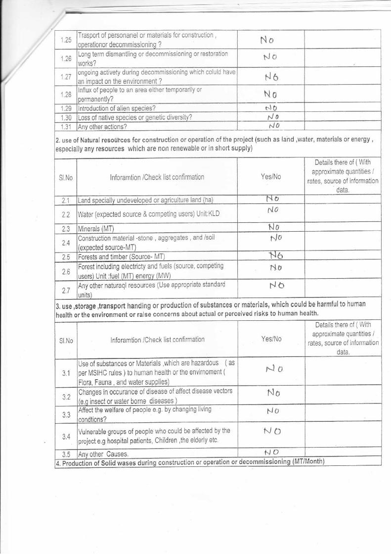
125Traspod ol personanel or mateials for conslmclon,
ooeraliof or decommissioninq ? No
1.26LonS tem dismantling or decomrn ss oning or restoralion
works?No
127onqolng act veiy during decomm ss oning lirhjch coiu d have
an lmoact on the environment ? N6
1.28nllux of people to an area ellher temporarily ar
pemanenlly? No1.29 lntroductlon of alien species? |.lo130 Loss of native soecles or oenelic dive6ity? !o131 1./ 0
2. use of Natural resoulces for construction or operation ofthe project (such as {and ,water, materials or energy,
especially any resources which are non renelYable ol in shod supply)
SNo liloramtion iCheck I si con{irmalion Yesi Na
Deta s there o{ (Wiih
approximate quanlitres /retes, source of nformation
data.
21 Land sDecia ly !ndeveloped or aqrcu t!re land (ha) NO
22 Water (expected source & compeljng usels) Ur 1 KLDa.l,
2.3 l,4iferals 1[{T) NO
24Construct on material-sione , aggregstes , and /soil
{exoected source-MT)
f./ 0
2.5 Forests and timber {Source- IMT) N626
Forest jncluding electicty and lLrels (source, competing
usersl Unit Juel fMl enerov {lUW)
No
27Anyother naturaq resources (Use appropiaie slendard do
3, use,storage,ttansport handing or production ofsubstances 9r malerials, which could be harmfulto human
health ortheenvironmentor€lse concerns about aclualor perceived risks to human health
S.No lnforamt on /Check is1 conllrmation Yes/No
Details there of (Wlth
approxlmate quantit es /rates, source oi iflonnatlon
data
3.1
Us, of s,rbstances or l\lalerials ,which are haTaldoLls (as
per lv'lslHC rules )t0 human lrealth oI the enYrnomeni (
FLora Fauna , and water supplles)
,{o
32Changes in occurance ofdlsease of affect d sease vectors
{e q insector water borne diseases )
No
Affect the weLfare ofpeople e g. bychang ng llv ng
cnndilons?NO
Vu nerable groups ol people who cou d be affected by the
project e.g hosplial paiients, Chlldren ,the elderly etc
NO
AnY olher Causes. NOt Pdi"tion of Solid
",ases dtiri"q construction or operation or decommissioning (MT/Month

Sl No lntoramtion /Check list confinnation Yes/No
Deta ls there of (With
apprcxinate quanlrlies /€tes, source oi nformalion
data
41 Sooil Overburden or rnine wastes t lo42 l\4unicioal waste (dornestic and commercila wastes) NO
43Hazardous wastes (As peT Hazardous waste lvlanagement
Rules)NO
4.4 Olher lndustrial Process wastes NO
45 Sumuls Drcduct ND46 Sewaqe sludoe from effluent treatment. flo4.7 Construction or-demolition wastes tD4.8 Redundanl machinery or equipmenl NO
4.9 Conlaminated soils or other materls Nit4.10 Aqriculturai wastes
4.11 olher soild wastes Nb5. Release or Dollutants or anv hazardous , toxic ornoxious substances to air (Kq/hr)
SI,NO lnforamtion /Check list conlinnation Yes/Nc
Detal s there of (With
approximate quantities /rates, source of infomatjon
data
51Emissions from combustion of fossililels from staiionary or
moblle sourcesNO
52 Em ssion from produclion processes r-, a
5.3Emissjons from malerials handling inclLrding slorage or
lransoortUO
5.4Emissions from construction activities including planl and
:quiomenlr.l,
5.5Dustorodours frcm handiJing of materials including
construction materials .sewaqe and waster./ 0
5.6 Emissions lrom incineration ol wasle NO
5.7Emissions fmm burnlng ofwaste ln open air (e.9/ materia
,construction debris)N6
5.8 Emission from any other sources
6. Generation of Noise and vibration , and Emissions oj Light andHeat
S,NO lnforamtion /Check list conlirmation Yes/No
Details ihere ot (With
approximate quanlrtres /rrlac c.lrmp ni inlnrm2t nn
61From op€ration ofequipment e.g engines, vent lalion plant
,crushers,
62 From industial or similar orocessess NO6.3 Frcm Construction or demolition No64 From blastino or Pilino do65 From Construclion or o0eratronal trafllc NA
From liqhtino or Coolinq svstoms FJA
6.7 From any other sources r-l o

S Risk of accidents during construction or operation ofthe project, with could affect human hearth or the€nvknomenl
T Risks of contanination of rand or water from releases of pollutants in to the ground or in to sewers, surfaceYr'aters groundwater,costal waiers or the sea,
Sl No lnforamtion /Check llst conlimalion
Deta s there of (W thapproxinrate quant ttes /
rates, source olinlomationdata.
71Frcm handling, Storage use or spl lage of hazardousmalerials fo
72From dlscharge sewage or oiher efil!ents to waieror the
land {expected mode and olace ofdischaroelNo
t3 Bydepositron oJ Pollutants emitled to air in to the land 0r into waler
NO
T4 From any other souTces No
7.5ls there a risk of long term build up of pollutants in the
environment lrom these so!rces?ild
SNo lnforamtion lCheck list confirmalion Yes/No
Delails there of ( With
approxirnate quantities /rates, source oi inlormatlon
data.
8.1From exploslons,Splilages,fLres etc.from storage,hafdllnguse or producation of h azard our s ubslances
sl0
82 tom anv oiher sources N6
83Could lhe prcjenct be afiected by ratualdisasters casusig
envim0menta I damage (e g. floods, earthq uakes ,laids ldes
,Cloudburst etc.) ?
rJo
9, Factors which should be cosidered {such as consequeniial development ) which could lead to envirnomentaleffects or the potential fro cumulative impacts with other existing or planned
Sl.No lnioGmtion /Check lisl coniirmatiof Yesi No
Detals lireie of (With
apprcximaie quantities /rales, source oi infornation
data.
91
Lead to devel0pmen t of suppo rting . Liles, ancillary
devel0prnentor development stimulated by the prolect
\l/hlch could have impact on lhe envirnomente.!' Housing development* Extractive industries'supply indust es
'olher
No
9.2Lead to afler"use ofthe site ,lahich could have and intpacl
on lhe envkonmentNA
93 Seta precedent for laiter developmenls NA
94Have cumulalive eflects due to prcxlm ty to other existlng orplanned orolects with sim lar effects
lt.IO

/
(lV)Proposed Terms of Refetence for EIA studies
" here by given undertaking thatthe daia and information given in lhe appllcanton and enclosures are true to the bestof my
konwledge and believe and I am aware that if any part offhe daia and information submitted is found to be false or misleading at
anystage, the prcject rejected and clearence given , ifany to the prciect willbe revoked at our risk and cost
'fl /)- 1 cl-."*.1d1&er lts.*Signatwe of the Applicanl with Nans and Full Addrcss
(Project Ptoponent/ Aulhoized signatory )
ate_
ace
D
P
S llo Areas Name / ldeniliy
Aerlal distance (within 15 km)
proposed projecl locat on
boundary
Areas prolected under lnternatiofa conveniions nalional orlocallegislaiion for their ecological , landscape, culturalorolher related value
NoArcas which are important or sensitve for ecologlca
reasons-wetlands,walercoulses, mountains foreslsN0
Areas used by protected ,jmporiant or sensitive species of
lora or'aJ-a '0 0-eedirg,"e5Lng fordg:ng .€5 nq ,ove'winterinq,mlqratjon.
NO
4 inland ,coslal ,madne or underground watets NAState,national boLrndaries N'
6Routes or fac lit es used by the p!blic for access to
recreat on or oiher tourist.oilq rirn areasr'10
Defense installailons
B Denselv OcOu aled or bu lt-uo area t'to
I Areas occupied by sensitive -man -made land uses(
H0spilals,schools, places workship, c0m ftr unity lacll ties)N.7
10 Areas contalning impodani,hrgh quality or scarcs resoLlrces N6
11
Areas akeady subjected to'pollut on orenvirnomeftal
damage (ihose lvhere exisUng lega envirnomental standels
are excceded)
No
12
Areas susceplib e lo naturalhazard which coLl d cause
prcjectto prcsent envirnomental prcb ems(
eadhquakes,subsidence ,land slides erosi0r ,fl00d ng or
exkeme or adverse climauc conditiofs )
No