OF THE SOUTHERN PART OF THE SAN JUAN … STATES DEPARTMENT OF THE INTERIOR Harold L. Ickes,...
105
UNITED STATES DEPARTMENT OF THE INTERIOR Harold L. Ickes, Secretary GEOLOGICAL SURVEY W. C. Mendenhall, Director Bulletin 860 C GEOLOGY AND FUEL RESOURCES OF THE SOUTHERN PART OF THE SAN JUAN BASIN NEW MEXICO PART 3. THE LA VENTANA-CHACRA MESA COAL FIELD BY CARLE H. DANE UNITED STATES GOVERNMENT PRINTING OFFICE WASHINGTON : 1936 For sule by the Superintendent of Documents, Washington, D. C. ------ Price 40 cents
Transcript of OF THE SOUTHERN PART OF THE SAN JUAN … STATES DEPARTMENT OF THE INTERIOR Harold L. Ickes,...

UNITED STATES DEPARTMENT OF THE INTERIOR Harold L. Ickes, Secretary
GEOLOGICAL SURVEY W. C. Mendenhall, Director
Bulletin 860 C
GEOLOGY AND FUEL RESOURCESOF THE
SOUTHERN PART OF THE SAN JUAN BASIN
NEW MEXICO
PART 3. THE LA VENTANA-CHACRA MESA COAL FIELD
BY
CARLE H. DANE
UNITED STATES
GOVERNMENT PRINTING OFFICE
WASHINGTON : 1936
For sule by the Superintendent of Documents, Washington, D. C. ------ Price 40 cents

NOTE
The Geological Survey in 1928, 1929, 1930, and 1931 reexamined and mapped the coal beds of the Mesaverde formation across the southern part of the San Juan Basin, in New Mexico, from Gallup on the west to Cuba, Grant, and the Rio Puerco on the east and southeast. The geologists have prepared separate reports on the areas for which they were responsible. However, as these areas are adjacent and form a real unit both geographically and geologically, the three reports are issued as parts of a single bulletin covering the southern part of the basin. No edition of the consolidated volume will be published, but the three parts can be bound together if desired,
ii
CONTENTS
Fact Abstract __-_______________________-_---_--_-_----___-__----_---__ 81Introduction_ _ _..__.__.._._____.__________-__--__-___-__---_---- 82
Purpose of the work._._______._____________..._-._._..____.__. 82Location and extent of the area._________________-___-_---.----- 82Earlier investigations.____________________-_.___-_.._..--_.____ 83Field work.._..........._...._._...-_'-.---.-.._--..-'--. 83Acknowledgments. ____________________________________________ 84
Geography ____.____'_.___.______.__._____-__________._.___-___.___ 84Topography. ______.__.___._.__________._...____..__._._______ 84Drainage and water supply___________________________________ 85Climate and vegetation_________-_-_____---_-___---_---_--_---_ 87Settlement and roads.__.---__.-__-_-__---_-_-----_.---_--__--. 87Land surveys.._-_-____-..--._--__--__-_-.._-._-____--_------_ 90
Geology..__.-...._-_--.._.._..___.__.._.....__..__.......... 90General features.__-______-___-__-___-_____________-____._---_ 90Sedimentary rocks._____.__-__--_---___--__-_--____.___-_____- 92
Cretaceous system______-_---___-_--_---__--_--._--_---_ 92Upper Cretaceous series-..-------.------.--.---.------- 92
Dakota (?) sandstone__--_-_------.-_--_--___--_--_ 92Mancos shale._-__--_--__-___-----___-_-__--__--_- 92Mesaverde formation_____-_-_--.-____-.-_-___.___. 93
General character and relations._____.---_--_---- 93Hosta sandstone member._____________________ 94Allison member and Gibson coal member_______ 95Chacra sandstone member__-______-___-._-_-_ 101La Ventana sandstone member.____-_-___-_---_ 108
Lewis shale__________----__-__---__-_-----_.-__- 109Pictured Cliffs sandstone_-___-_-______-___--_____ 112Fruitland formation and Kirtland shale.-_____-___-__ 113Ojo Alamo sandstone.___----__-----_--_-_-________ 116
Tertiary system___._.___--___-__--_--___--_--__-__-__-._ 122Eocene series.----_--___--_-_---_-----------_----__--_ 122
Puerco (?) and Torrejon formations.__---_-________- 122Wasatch formation._-______________--_-__-_-______ 125
Igneous rocks____._.______-.-_-_-----__---_-_.---.--_-___-_- 127Geologic structure._-__________-----_----_---_-_-_-__--_-_-____ 130
Methods of representing structure..---------.--------------- 130Structure of San Juan Basin__--_---__--_-__---_---_--__-- 131Structure of area described in this report.___--__-__--________ 131Age of deformation.--,.--._____-__-______--___..______-___ 134
Coal. ---_-____-_______.______.___-__-___--_--_______-__-______ 135Distribution._-.________.______--_--_-___-_-.-__-.__-_-___.___ 135Character. ___________________________________________________ 137
Physical properties.___.___---_---_--_-_-_-_--_-____-_____- 137Chemical properties.^______-__--_------__-__--__-__--__-__ 138
Utilization.._.--..._..--._--__-__---_--___-_-__-_..-______.._ 142in

IV CONTENTS
Coal Continued. PageTownship descriptions_______-____-_______-_ _____..__-_________ 142
T. 18 N., R. 1 W_____._._._ ___..-..-_.__.. __._-.___ 142"T. 19 N., R. 1 W---__- -- -.------- -_ - -_--_-- 143T. 20 N., R. 1 W.________--__-_-__-__--__-__-___-_-_----- 147T. 18 N., R. 2 W..___.__._.____.__._...__.__._..__.__..__ 147T. 19 N., R. 2 W--___-- -- _--_--_--- -------------- 150T. 18 N., R. 3 W____.__....____.___...__.___._..__....... 151T. 19 N., R. 3 W.__--------------_-- ---_--_------- 153T. 18 N., R. 4 W_....--.---_.-....------------_-----.-- 153T. 19 N., R. 4 W.._. .. ._.._..._._.........._........ 154T. 18 N., R. 5 W-------------.---------_------------------ 154T. 19 N., R. 5 W__:. .-.._- _.-... .--.... __. 155T. 18 N., R. 6 W.._._..._.__...................._... .. . 155T. 19 N., T. 6 W__.._._..._..__......_._.._.............. 156T. 20 N., R. 6 W-.--__._--i--_--.------_-_-.--_--.--_--._ 157T. 18 N., R. 7 W___.__ -_-__ - _--_- 158T. 19 N., R. 7 W__..._.__-._ -. _-.._.__ _ . .... 158T. 20 N., R. 7 W.... _---.-.-.......--.-------------- 158T. 19 N., R. 8 W___.___._--.-,.--.-_......--.---_---_-... 158T. 20 N., R. 8 W___._.----_--_--_-----_-.----_----------- 159T. 21 N., R. 8 W.....-._-----.-_---_--.....-_.-.-_- --- - 159T. 20 N., R. 9 W____. ...................................^ 159T. 21 N., R. 9 W.-____-_------------_---------_---,------ 160
on.. .......................................^.................... leoIndex__._-__-.___----__----,--_-__-------_-------_-_-_-_-_---_- 163
ILLUSTRATIONS
Page PLATE 39. Geologic map of the La Ventana-Chacra Mesa coal field in the
southern part of the San Juan Basin, N. Mex-___.__-__ In pocket40. Index map showing the location of the areas described in this
and related reports____________________________________ 8241. Correlation and thickness of the formations exposed in the La
Ventana-Chacra Mesa coal field.________________________ 9042. A, Mancos shale and overlying Hosta sandstone member of
Mesaverde formation; B, Exposures of the Mesaverde forma tion near La Ventana._________ ______________________ 98
43. A, Banded barren shales of the Allison member of the Mesaverde formation in sec. 11, T. 18 N., R. 2 W.; B, Bedded sandstones of the Chacra sandstone member of the Mesaverde formation resting on the more irregularly bedded shales and sandstones of the Allison member in sec. 29, T. 18 N., R. 4 W_------- 98
44. A, The escarpment of the south front of Chacra Mesa; B, View looking east across Torreones Arroyo from the NW% sec. 15, T. 18 N., R. 4 W___ _---_-_ -_-_--__-_--__-_____-- 98
45. A, Erosional irregularity at the base of a sandstone near the top of the Chacra sandstone member of the Mesaverde forma tion; B, Small fault cutting the top of the Allison member of the Mesaverde formation but not disturbing the basal bed of of the Chacra sandstone member, in the SE% sec. 14, T. 18 N., R. 6 W__-----_------_------------__----_--------_ 98

CONTENTS V
PagePLATE 46. A, Normal fault dropping Pictured Cliffs sandstone and Lewis
shale against the top of the Chacra sandstone member of the Mesaverde formation in the NW^ sec. 6, T. 18 N., R. 6 W.; B, Pictured Cliffs sandstone and Fruitland formation in sec. 6, T. 21 N., R. 9 W...__............................... 114
47. A, View looking southeast from Ojo Alamo sandstone escarp ment in the NW^ sec. 16, T. 20 N., R. 6 W., toward bad lands in the Kirtland shale; B, Escarpment of Ojo Alamo sandstone with Kirtland shale below it near Ojo Aguila__-_ 114
48. A, Banded clay of the Torrejon formation in T. 21 N., R. 5 W.; B, Cliff of conglomerate and sandstone of the Wasatch forma tion in the NW^ sec. 27, T. 21 N., R. 5 W.__._.__.___._. 122
49. Map showing the structure of the New Mexico portion of theSan Juan Basin_______________________________________ 130
50. A, Normal fault dropping sandstone beds of the Mesaverde for mation to the east, as seen from the SE% sec. 36, T. 19 N., R. 2 W.; B, Mesaverde formation in the SE^ sec. 35, T. 21 N., R. 1 W___-____.___-.___.._-..___.._....._......_.._._. 130
51. A, Plug of dark igneous rock in the NEJ4 sec. 29, T. 18 N., R. 4 W.; B, Xenolith of white sandstone and red shale and other smaller xenoliths in dark igneous rock.______.______..._. 130
52. A, Thin dike of dark igneous rock cutting sandstone and shale of the Allison member in the NWX sec. 32, T. 18 N., R. 4 W.; B, Tipple of the Cleary mine of the San Juan Coal & Coke Co., in the SW% sec. 31, T. 19 N., R. 1 W................ 130
53. Columnar sections showing coal beds in the Fruitland andMesaverde formations.._____--_____-__.____--__--___In pocket
54. Columnar sections showing coal beds in the Mesaverde forma tion_____-_-____._-___-_-______.___..____..__..__In pocket
55. Columnar sections showing coal beds in the Gibson coal memberof the Mesaverde formation^._.__.___.__..___._._____In pocket
FIGURE 3. Cross section showing relations of coal beds between localities127 and 129, in the southeastern part of T. 18 N., R. 2 W__ 137


PART 3. THE LA VENTANA-CHACRA MESA COAL FIELD
By CARLE H. DANE
ABSTRACT
This report describes the geology and coal deposits of an area including about 1,000 square miles in southeastern San Juan, northwestern Sandoval, and north eastern McKinley Counties, in northwestern New Mexico. This area lies almost wholly within the Colorado Plateau province, but its eastern edge is near the western foothills of the Nacimiento Mountains, a north-south range, which at this place is the westernmost range of the southern Rocky Mountains. The Continen tal Divide crosses the middle of the area from northeast to southwest. The area mapped ranges in altitude from 6,300 to 7,400 feet above sea level. It exhibits the cuesta and mesa topography, desert-shrub vegetation, and intermittent drainage courses typical of the semiarid.Southwest. Chacra Mesa is the most conspicuous topographic feature in the western half of the area. There is a small resident farming and mining population in the eastern part, centering about the towns of La Ventana and Cuba. These towns are on the Rio Puerco, a perma nent stream in this part of its course. The western part of the area is inhabited by seminomadic Navajo Indians and by a few white families at trading posts.
The exposed rocks are of Upper Cretaceous and Tertiary age. The Dakota (?) sandstone, at the base of the Upper Cretaceous series, and the overlying Mancos shale, of marine origin, crop out only in the eastern part of the area. Above the Mancos shale lies a varied assemblage of partly marine and partly continental beds, which are included in the Mesaverde formation but differentiated into five members the marine Hosta sandstone at the base, the Gibson coal member above it, the Allison member still higher, the marine Chacra sandstone member at the top in the western part of the area, and the marine La Ventana sandstone at the top in the eastern part. The overlying formation, the Lewis shale, is thin where it lies above the Chacra sandstone but increases greatly in thickness eastward by the successive passing of all of the Chacra sandstone and the upper part of the La Ventana sandstone into gray marine shale. Above the Lewis lies the thin Pictured Cliffs sandstone, the highest marine formation of the Upper Cretaceous. The coal-bearing Fruitland formation, the Kirtland shale above it, and the con glomeratic Ojo Alamo sandstone are also included in the Upper Cretaceous series. Above the Ojo Alamo lie rocks of Eocene age the banded drab clay and light- colored sandstone of the Puerco (?) and Torrejon formations, capped by the con glomeratic sandstone of the Wasatch formation.
The area lies in the southeastern part of the San Juan Basin, in which the rocks are gently warped into the form of a great shallow bowl about 100 miles in diam-
81
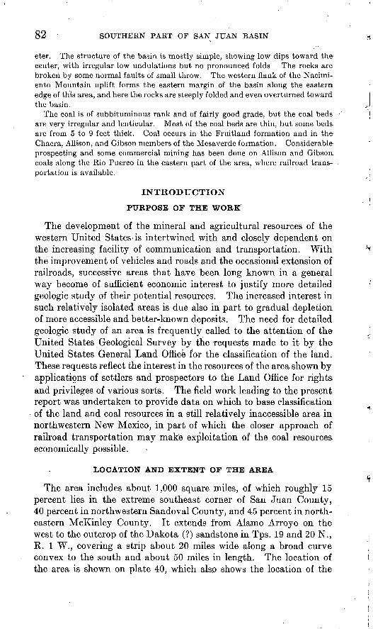
82 SOUTHERN PART OF SAN JUAN BASIN
eter, The structure of the basin is mostly simple, showing low dips toward the center, with irregular low undulations but no pronounced folds The rocks are broken by some normal faults of small throw. The western flank of the Nacimi- ento Mountain uplift forms the eastern margin of the basin along the eastern edge of this area, and here the rocks are steeply folded and even overturned toward the basin.
The coal is of subbituminous rank and of fairly good grade, but the coal beds are very irregular and lenticular. Most of the coal beds are thin, but some beds are from 5 to 9 feet thick. Coal occurs in the Fruitland formation and in the Chacra, Allison, and Gibson members of the Mesaverde formation. Considerable prospecting and some commercial mining has been done on Allison and Gibson. coals along the Rio Puerco in the eastern part of the area, where railroad trans portation is available.
INTRODUCTION
PURPOSE OF THE WORK
The development of the mineral and agricultural resources of the western United States < is intertwined with and closely dependent on the increasing facility of communication and transportation. With the improvement of vehicles and roads and the occasional extension of railroads, successive areas that have been long known in a general way become of sufficient economic interest to justify more detailed geologic study of their potential resources. The increased interest in such relatively isolated areas is due also in part to gradual depletion of more accessible and better-known deposits. The need for detailed geologic study of an area is frequently called to the attention of the United States Geological Survey by the requests made to it by the United States General Land Office for the classification of the land. These requests reflect the interest in the resources of the area shown by applications of settlers and prospectors to the Land Office for rights and privileges of various sorts. The field work leading to the present report was undertaken to provide data on which to base classification of the land and coal resources in a still relatively inaccessible area in northwestern New Mexico, in part of which the closer approach of railroad transportation may make exploitation of the coal resources economically possible.
LOCATION AND EXTENT OF THE AREA
The area includes about 1,000 square miles, of which roughly 15 percent lies in the extreme southeast corner of San Juan County, 40 percent in northwestern Sandoval County, and 45 percent in north eastern McKinley County. It extends from Alamo Arroyo on the west to the outcrop of the Dakota (?) sandstone in Tps. 19 and 20 N., R. 1 W., covering a strip about 20 miles wide along a broad curve convex to the south and about 50 miles in length. The location of the area is shown on plate 40, which also shows the location of the

U. 8. GEOLOGICAL STJEVEY
109
BULLETIN 860 PLATE 40
.CONEJOSP »L A T lA Ml A R/ C
PROFESSIONAL
S A ( N J U A
BULLETIN 860-B
\__ ___ _ oycta \T * \
V A L E N C.I A
INDEX MAP SHOWING THE LOCATION OF THE AREAS DESCRIBED IN THIS AND RELATED REPORTS.
54825-_36 (Face p. 82)
LA VENTANA-CHACRA MESA COAL FIELD 83
partly contiguous Mount Taylor field, to the south, 1 and other areas that have been geologically surveyed.
EARLIER INVESTIGATIONS
The stratigraphy, structure, and coal deposits of parts. of this field and of the surrounding region have been described in reports on several earlier reconnaissance investigations. 2 The area adjoining this field on the northwest has been discussed in detail in papers by Bauer and Reeside,3 which contribute some reconnaissance observa tions on this field. The eastern part of the field has also been de scribed by Renick.4 Numerous other shorter papers, dealing with certain aspects of the geology of the region, are cited at appropriate places in this report.
FIELD WORK
The field work upon which this report is based was done during the months of June to October 1928, by a field party in charge of the writer and including as geologic assistants W. G. Pierce, 0. R. Murphy, and H. R. Joesting. In the absence of a topographic base or other base of satisfactory quality, a base line was measured and control points located by triangulation. The mapping of most of the area was done by plane table and alidade, largely by the method of three-point location but in part by stadia traversing. The portion of the area that lies north of the outcrop of the coal-bearing formations was mapped with less accuracy, partly by long-distance plane-table and alidade intersections and partly by sketching on township plats of the General Land Office. In August 1929 parts of Tps. 19 and 20 N., R. 1 W., were mapped under the writer's general instructions by C. B. Hunt, who was assisted by H. 0. DeBeck. Mr. Hunt revisited this part of the area during the summer of 1931 to obtain additional data. A few additional observations on the Hosta sandstone east of the Rio Puerco were made by the writer and Mr. Hunt in June 1933.
1 Hunt, C. B., Geology and fuel resources of the southern part of the San Juan Basin, N. Mex., pt. 2, The Mount Taylor coal field: U. S. Geol. Survey Bull. 860-B, 1936.
2 Gilbert, G. K., Report on the geology of portions of New Mexico and Arizona: U. S. Geog. and Geol. Surveys W. 100th Mer. Kept., vol. 3, pp. 503-507, 1875. Button, C. E., Mount Taylor and the Xufti Plateau: U. S. Geol. Survey Gth Ann. Kept., pp. 105-198, 1885. Schrader, F. C., The Durango-Gallup coal field of Colorado and New Mexico: U. S. Geol. Survey Bull. 285, pp. 241-258, 1906. Shaler, M. K., A reconnaissance survey of the western part of the Durango-Gallup coal field of Colorado and New Mexico: U. S. Geol. Survey Bull. 316, pp. 376-426, 1907. Gardner, J. H., The coal field between Gallina and Raton Spring, N. Mex., in the San Juan coal region: U. S. Geol. Survey Bull. 341, pp. 335-351, 3909; The coal field between San Mateo and Cuba, N. Mex.: U. S. Geol. Survey Bull. 3S1, pp. 461-473, 1910.
3 Bauer, O. M., and Reeside, J. B., Jr., Coal in the middle and eastern parts of San Juan County, N. Mex.: U. S. Geol. Survey Bull. 716, pp. 155-237,1921. Reeside, J. B., Jr., Upper Cretaceous and Tertiary formations of the western part of the San Juan Basin of Colorado and New Mexico: U. S. Geol. Survey Prof. Paper 134, 1924.
4 Renick, B. C., Geology and ground-water resources of western Sandoval County, N. Mex.: U. S. Geol. Survey Water-Supply Paper 620, 1931.

84 SOUTHERN PART OF SAN JUAN BASIN
ACKNOWLEDGMENTS
The assistance and advice received from many residents ofTthe area in the course of the field work, in particular from Mr. Robert E. Smith, Jr., of the Star Lake trading post; Mr. R. G. Setzer, of the Pueblo Alto trading post; Mr. John Young, of Cuba; and Mr. Hugh Bryan, of Cuba and Albuquerque, are gratefully acknowledged. Hjf^
The late Edward B. Hill, of the topographic branch of the Geo logical Survey, constructed the base map from the writer's triangu- lation sheets and township plats of the General Land Office and as- 'sisted in the further preparation of the map. D. A. Andrews, of the Geological Survey, also assisted in the office work.
Thanks are due to C. E. Dobbin, of the conservation branch of the Geological Survey, who made some observations for the writer in the southwestern part of T. 20 N., R. 9 W., during the mapping in 1931 of an area lying southwest of the La Ventana-Chacra Mesa coal field. As a result of these observations some changes were made in that partof the map.
GEOGRAPHY
TOPOGRAPHY
The area lies in the southeastern part of the Colorado Plateau province and in general is a plateau of relatively low relief. The highest parts of the area reach an altitude of slightly more than 7,400 feet; the lowest parts, somewhat less than 6,300 feet. Over much of the area broad, low slopes dissected only to slight relief extend monotonously for miles, and striking topographic features are absent. The larger drainageways flow through alluvial bottoms a mile or more in width (see pi. 44, B} and only rarely entrench themselves into canyons. In a few places where the general level stands a few hun dred feet above the level of the washes, strips of badland border the alluvial bottoms. Windblown sand deposits cloak many of the interstream divides, and sand drifted into dunes borders some of the washes. The most prominent topographic forms are the southward and southwestward facing escarpments, which trend southeastward in the western part of the area and eastward in the eastern part. The most northerly of these is the line of sandstone cliffs several hundred feet in height which forms the north margin of the country surveyed (pi. 48, B}. From 5 to 8 miles to the south another escarpment follows the same general trend but has a lower cliff, which ranges from 50 to 250 feet in height. It also faces southwest and south (pi. 47, B}. A low slope extends northward from the top of this escarpment for a few miles and the surface then gradually rises toward the higher cliffs beyond. The most striking escarpment of this type is the south- westward-facing cliff (pi. 44, A) which extends continuously south eastward through T: 20 N., R. 9 W., and T. 19'N., R. 8 W., and thence slightly south of eas.t to T. 18 N., R. 4 W., maintaining a height of

LA VENTANA-CHACRA MESA COAL FIELD 85
400 to 500 feet for a distance of 30 miles. From the top of this escarpment the country slopes gently northward for a distance of 4 to 6 miles. The higher part of this slope is Chacra Mesa. Another escarpment 700 to 900 feet in height trends east of north through T. 18 N., R. 2 W., facing east toward the valley of the Rio Puerc'o (pi. 43, A}. To the north, west, and southwest the area mapped adjoins other parts of the Colorado Plateau, of similar topography. From 6 to 8 miles to the east, across the Rio Puerco, lie the Naci- miento Mountains, the westernmost range of the Rocky Mountain system in this region. This range trends north and south, in places with an altitude of more than 9,000 feet. The dark volcanic necks and high lava-capped mesas and plateaus in the vicinity of Mount Taylor produce a more picturesque sky line to the south.
DRAINAGE AND WATER SUPPLY
The Continental Divide crosses the area in a general southwesterly direction. Somewhat more than the western third is drained by various tributaries of the Chaco River into the San Juan River be tween Farmington and Shiprock, thence into the Colorado River and the Pacific Ocean. The remainder is drained by the Rio Puerco and its tributaries into the Rio Grande and thence into the Gulf of Mexico. The Chaco River heads in the SE# T. 22 N., R. 6 W., drains south- westward into the western part of T. 20 N., R. 7 W., receiving from the northeast the tributary drainage of Corral Arroyo and from the east a large arroyo that drains the north slope of Chacra Mesa up to the Continental Divide. The united drainage then flows north of west, receiving from the south tributary drainage of the north slope of Chacra Mesa and from the north the drainage of Cottonwood Arroyo, and, entering the head of Chaco Canyon, leaves the area from the southwest corner of T. 21 N., R. 9 W.
Alamo Arroyo, which forms the northwest boundary of the area, flows southwestward and after joining other arroyos empties into the Chaco River west of the area mapped. The southwest corner of the area below Chacra Mesa is drained by a wash that leads northwest ward into the Chaco. A small area south of Chacra Mesa and east of the Continental Divide is drained by numerous small washes, which lead southward to Chico Arroyo. Almost all of the area east of the Continental Divide is drained by Torreones Arroyo, which heads in the southern part of T. 21 N., R. 5 W., and flows slightly east of south across the area, leaving it from the southeastern part of T. 18 N., R. 4 W. It empties into the larger Chico Arroyo south of the area mapped and thence into the Rio Puerco. From the west Torreones Arroyo receives as.tributaries Vicente Wash and farther north Papers Wash, which drains a part of the north slope of Chacra Mesa. Near its head Torreones Arroyo receives the tributary drainage of Pelon Arroyo from the north, Penistaja Arroyo from the northeast, and sue-

86 SOUTHERN PART OF SAN JUAN BASIN
cessively to the south the south westward-draining San Ysidro Wash, Medio Arroyo, and, south of the area mapped, Piedra Lumbre Arroyo. The Rio Puerco receives only one large tributary from this area, Chijuila Arroyo, which drains part of T. 20 N., R. 2 W., to the southeast. South of Chijuila Arroyo the eastward-draining tribu taries of the Rio Puerco are short washes none of which exceed 3 miles in length. From the east several temporary streams drain into the Rio Puerco from the Nacimiento Mountains. The largest of these is Senorito Arroyo.
The only permanent stream among the drainage channels men tioned is the Rio Puerco, and even in this the flow is frequently only a trickle an inch or so deep and 2 or 3 feet wide. It becomes an in termittent stream near the southern boundary of the area mapped. Of the others, Torreones Arroyo and the Chaco River at times carry running water for several days, or at the most weeks, after storms and may be regarded as intermittent. The larger westward-flowing tributaries of the Rio Puerco are also intermittent. The other drain- ageways have a flow only temporarily, but all may carry large streams after local heavy rains.
Although there is rarely running water at the surface of the washes, in many of them water is 'only a short distance below the surface and can be obtained by digging. If located favorably, protected from stock, and lined with rock or timber, wells alohg such washes provide permanent supplies of water. Such water varies in quality and is often strongly impregnated with mineral salts, but in the larger washes it is often palatable and only moderately alkaline.
Springs and seeps are not numerous but occur where water-bearing sandstones crop out above impervious shales in geologically favorable places. Saydatoh ("water under the rock"), in the SE}£ sec. 19, T. 21 N., R. 7 W.; Ojo Encina, in the southeastern part of T. 20 N., R. 5 W.; Ojo Aguila, in the NK sec. 33, T. 20 N., R. 4 W.; and several springs in a canyon trenching Mesa Piedra Lumbre in the northwest ern part of T. 19 N., R. 2 W., are springs of this type that provide a good flow of excellent water. With the exception of the springs cited, all of which occur at the base of the Ojo Alamo sandstone (seep. 116), and Raton Spring, in T. 19 N., R. 7 W., the springs in the area are small, and their water is likely to be more or less alkaline.
Additional water supply is obtained in this area by the construction of earth dams partly or completely blocking the flow of small drain- ageways and impounding flood waters. Such reservoirs or lakes, although invariably dirty, usually contain good water for stock. Natural tanks such as occur in some parts of the arid West are not known in this area, but there are a few natural temporary water holes of similar type along trenched arroyos, where flood waters are pro tected from rapid evaporation by the shade of the arroyo banks.

LA VENTANA-CHACRA MESA COAL FIELD 87
CLIMATE AND VEGETATION
The climate of the area is characterized by extreme daily and annual range of temperature and variability of precipitation and the semi- aridity consequent upon an average annual rainfall of less than 15 inches. In summer the days are very hot, often well over 100° F., but the nights are usually cool. In winter the nights are very cold, but the days, are often sunny and not disagreeably cold. The char acteristic rain of the summer is the sudden and violent thunderstorm, with local heavy rain and not infrequently hail. Such fortuitous rains may leave certain areas dry for months, while adjoining areas receive considerable precipitation. General rains are exceedingly rare in the summer, but more frequent in the fall and winter. Rain is somewhat more abundant in the eastern part of the area, because of the proximity of the Nacimiento Mountains. Snow is common in winter. The first frost usually occurs early in October. The wind is usually from the southwest and in the spring and early summer may blow persistently for weeks.
The native vegetation is of types adapted to semiarid conditions, although the rainfall is sufficient to support a sparse to moderate growth of short grass over the more level tracts with soil cover. On such tracts sagebrush is a common shrub, and prickly pear and other species of cacti are abundant. Greasewood is mostly restricted to the alluvial flats. Pin on and juniper trees grow on sandstone ridges and mesas that are covered only with shallow and stony soil. These trees clothe the higher mesas with woodland, through which' are scattered sagebrush, other shrubs, and in places, scrub oak. On the higher elevations in the eastern part of the area there are a few yellow pines.
SETTLEMENT AND ROADS
The town of Cuba is just east of the Rio Puerco at the northeast corner of the area mapped. There is only a small resident population, but the town is a supply point for the eastern part of the area, as well as contiguous areas to the north and west, and contains several general stores, two garages, a hotel, a post office, a school, and two churches. In 1930 the population of the census precinct of which Cuba is the center was 841. About 13 miles to the south, on the east bank of the Rio Puerco, is the settlement of La Ventana, where there are two general stores, a hotel, a post office, and a small school. The population of the La Ventana precinct in 1930 was 263. A few miles north of La Ventana is Tilden, which in 1930 was the northern terminus of the Santa Fe, San Juan & Northern Railway, a line that connected with the Santa Fe Northwestern Railway at San Ysidro, about 25 miles to the southeast, which in turn joins the main line of the Atchison, Topeka & Santa Fe Railway 18 miles farther southeast. Cuba and La Ventana are connected by New Mexico State Highway

00 SOUTHERN PART OF SAN JUAN BASIN
44, which runs south through the small settlement of San Ysidro to Bernalillo. Bernalillo is an important trading center on the Atcbison, Topeka & Santa Fe Railway. State Highway 44 is a good graded road and except in wet weather is traversed by automobiles without difficulty. This highway also connects Cuba with Farmington, on the San Juan River, about 100 miles to the northwest. In the eastern townships of the area several homesteaders are engaged in dry farming. In the western part of the area there are few white residents. The Pueblo Alto Trading Co. operates two stores for trade with Navajo Indians. One is in the southeast corner of sec. 19, T. 21 N., R. 7 W., known to the Indians as "Saydatoh", in Spanish known as "Socorro," and of late usually called "Pueblo Alto." The Star Lake store of the same company is in the NE}£ sec. 10, T. 19 N., R. 6 W. This locality is also known by the Spanish name "Estrella." Robert's ranch, in the NW# sec. 28, T. 19 N., R. 6 W., was started during 1928. There are also a few scattered Mexican residents, but most of the western part of the area is inhabited by Navajo Indians, who lead a seminomadic life and depend principally on their flocks of sheep and goats for a livelihood. Some of the Indians also have a few cattle. In addition, they grow small crops of corn and melons in favorable localities by a system of storm flood irrigation. (See pi. 47, B.) The weaving of wool blankets in original designs on hand looms is a well- established industry. A few of the Navajos speak English, and many speak Spanish. They are peaceable and industrious and one of the more progressive Indian tribes.
In prehistoric times the area was occupied in part by pueblo- dwelling Indians. The large ruin known as "Pueblo Pintado", which stands on the south bank of the Chaco River in sec. 10, T. 20 N., R. 8 W., is included in the tracts set aside as the Chaco Canyon National Monument, most of which are located to the west and southwest. Smaller pueblo ruins, some of which were appropriately located for watch towers, are scattered over Chacra Mesa and elsewhere. Broken pottery, spear or arrow heads, corn-grinding stones, and similar evidences of former occupation are abundant.
The area is traversed by numerous roads, some of which are shown on plate 39. These roads are almost altogether unimproved. The Navajos do sufficient work to make gully and wash crossings traversable with wagons, and necessary repairs and construction work on the principal routes are from time to time undertaken by travelers through the region. The propensity of the Navajos for deserting their temporary dwellings and making new roads to other temporary homes as well as to sheep camps, water holes, and wood supplies results in a confusing multiplicity of roads. This; combined with the general sameness of much of the topography and occasional obliteration of marks of recent travel by rain, may puzzle the most experienced desert traveler crossing the country for the first time.

LA VENTANA-CHACEA MESA COAL FIELD 89
In the -western part of the area the main road routes are those traversed to and from Farmington, Gallup, and Albuquerque by the trucks supplying the stores of the Pueblo Alto Trading Co. The road from Farmington by way of Simpson's store and Kimbetoh enters the area in the southwestern part of T. 22 N., R. 8 W., and continues southeastward to Saydatoh, which is about 85 miles by road from Farmington. Farmington is the terminus of a narrow- gage branch line of the Denver & Rio Grande Western Railroad. The road from Farmington to Saydatoh is traversed in dry weather without difficulty except for the crossings of the two forks of the Oallego near Simpson's store and the crossings of Kimbetoh Arroyo, Escavada Wash, and Alamo Arroyo farther southeast. After long dry periods these broad washes are covered with drifted sand.
From Saydatoh several roads radiate to the west into the head of Ohaco Canyon and thence to Pueblo Bonito; to the northeast to Lybrook, on the route of New Mexico State Highway 44 from Cuba to Farmington; to the south and southeast to the Star Lake store; and slightly west of south across the Chaco River and through Mock ingbird Pass across Chacra Mesa toward Thoreau and Gallup.4a Thoreau is a small trading center on the main line of the Atchison, Topeka & Santa Fe Railway about 60 miles southwest of Saydatoh. The road between these two places is rough but traversable by auto mobile except in very wet weather.
From the Star Lake store other roads radiate, one of the most important of which is the road past Ojo Encina across the upper part of Torreones Arroyo. This forks into two principal routes,one to the north past the small store of Francisco Aragon and a homestead district to State Highway 44, and the other to the east past Anglin's ranch and the San Ysidro schoolhouse' to Cuba. The best-traveled road from Star Lake strikes south for about 5 miles and there forks, the south ward road descending a very rough, steep grade down the escarp ment of Chacra Mesa, and the eastward road descendingVicente Canyon, crossing Torreones Arroyo, and thence trending southeast ward through the small Mexican settlement of Cabezon to Albu querque, on the Santa Fe Railway about 100 miles from Star Lake.
South of the escarpment of Chacra Mesa a very rough road leads north of west from the vicinity of the junction of Vicente Wash and Torreones Arroyo. This road, after joining the road o ver Chacra Mesa from the Star Lake store, passes the small White Horse Lake store of Dan Rangel, in the northeastern part of T. 18 N., R. 8 W., and even tually leads to Mrs. Buck's store on the Saydatoh-Thoreau road south of the mapped area. At several places roads lead south from the road below Chacra Mesa to localities where drilling for oil has been done.
<a Since the preparation of this report new roads have bean graded and drained through Mockingbird Pass to Saydatoh and to the Star Lake store. These roads follow routes somewhat different from those shown on plate 39.

90 SOUTHERN PART OF SAN JUAN BASIN
Zambrano's ranch, in the NW# sec. 20, T. 19 N., K. 2 W., is a third center from which roads radiate to the southwest down Medio Arroyo to connect with the Star Lake-Cabezon road; to the south down the upper part of Piedra Lumbre Arroyo and thence south past the Cerros Colorados to Dominguez; and to the northwest to connect with the road from San Ysidro schoolhouse to Cuba. The road to the east from Zambrano's ranch forks into two routes one northeast to Cuba and the other east to the Rio.Puerco and thence south to La Ventana. Another road leads from La Ventana toward Dominguez along the west side of the Rio Puerco.
With few exceptions the roads in their present unimproved state can be traversed by automobiles without difficulty, and the abundance of roads makes it possible to reach most places in the area in this way. The traveler should expect, however, rough and gullied roads; high centers; poor crossings of gullies and washes, where shoveling may be necessary; and occasionally several hours delay in wet weather.
LAND SURVEYS
The land surveys of parts of the area covered in this report were made in recent years, and the steel-post corners are usually easily found. Some stone monuments that mark corners of older surveys were also found, but for some townships authentic corners have not been located. . In compiling the base map great difficulty was experi enced in combining the township plats without developing discrepan cies that would have made the accuracy of the base dubious. Accord ingly, the field triangulation was accepted as the controlling base, and the land survey lines were adjusted to conform to it. As a result the land lines in those parts of the area where few corner locations are shown on plate 39 must be considered provisional.
GEOLOGY
GENERAL FEATURES
The formations that underlie this area consist of stratified deposits of conglomerate, sandstone, shale, and coal. These deposits were originally laid down in a nearly horizontal position in marine, brackish, or fresh water. Subsequent earth movements have elevated the whole area but relatively depressed it with reference to the surround ing areas, so that each rock layer lies in the form of a great shallow basin. (See pi. 49.) This basin-shaped fold, known as the San Juan Basin, lies mostly in northwestern New Mexico but partly in south western Colorado and extends 125 miles from north to south and 100 miles in greatest dimension from east to west. The general level of the land surface cuts across the edges of the slightly tilted strata, so that the older and earlier deposited beds crop out around the margins and successively younger rocks appear toward the interior. On the north, northwest, and east the edges of the basin are sharply de-

XT. S. <3EOI.Or!J-CAI< SURVEY
w.WlOCKmSBIRD RATON SPRING
TORREONES ARROYOLA VENTANA
BULLETIN 860 PLATE 41
E
SENORITO
WASATCH
PUERCO? AMD TORREJO.M FORMATIONS
WRTLA-NID S'HALE ^ ''^}tp37^5JJE^J^^^yp^rr^r?:.^^_.____^
KIRTLAMO ^.HAIC ' ^^^^-xl^: ' ': '. .'. :'::':: :::-'.-'.-::- ' ..... ....«;. . , ... , KIRTLAMO SHALE
ITHICKNESSIM FEET
h 5.5 00
h 5.000
i- 4,500
FRUI TL
LEWIS SWALE>-,v;^ANp3 JONE ;
PICTURED CLIFFS SANDSTONE'
LEWIS SHALE
ALL1SOM MEMBER
EXPLANATION!
MANCOS SHALE
SANDSTONE
L-1,500
K I.OOO
CORRELATION AND THICKNESS OF THE FORMATIONS EXPOSED IN THE LA VENTANA-CHACRA MESA COAL FIELD.54825 36 (Face p. 90))

LA VENTANA-CHACRA MESA COAL FIELD 91
limited by steeply upturned beds, but on the southwest and south there is no definite boundary and the beds dip gently away from the bordering uplifts. In the interior of the basin the rocks lie nearly level. The area mapped includes a strip 20 miles wide on the south side of the basin along the outcrop of some of the coal-bearing and associated formations. To the south in the Mount Taylor volcanic region, the sedimentary rocks have been intruded by great masses of molten rock, much of which has made its way to the surface, as lava flows. Similar but much smaller igneous rock masses appear in one locality in the area described in this report. These were in truded long alter the deposition and consolidation of the stratified rocks.
The formations exposed in the area are all of Upper Cretaceous and Eocene age. Their thickness, character, and relations are summarized in the following table (see also pi. 41):
Generalized section of geologic formations in the La Venlana-Chacra Mesa coal field
Age
Eocene.
Upper Cretaceous.
Formation and member
Wasatch formation.
Torrejon formation.
Puerco (?) formation.
Ojo Alamo sandstone.
Kirtland shale.
Fruitland formation.
Pictured Cliffs sandstone.
Lewis shale-.
Chacra sandstone
g member.
0)g,0<1> o
> Allison meml w member no^
La Ventana sandstone member.
Der and Oibson coal t differentiated.
^H
Hosta sandstone member.
Mancos shale.
Dakota (?) sandstone.
Thickness (feet)
200+ (top not exposed)
630-700
30-100
200-500
0-200
0-80
80-1, 800±
0-360
0-1,250
230-1,800
55?-200=t
2,000
200
Character
Copper-colored and gray sandstone and con glomerate at the base; red and gray clay, buff sandstone, and conglomerate above.
Drab, gray, and black clay, with some red clay, soft white and gray sandstone, and hard copper-colored sandstone.
Drab clay and marl with some red clay and soft white sandstone.
Buff sandstone and conglomerate with minor amounts of gray shale. Contains silicifled logs.
Gray shale, soft white sandstone, and car bonaceous shale.
Gray, brown, and black shale, gray sand stone, hard brown sandstone, and sub- bituminous coal.
Buff and yellow marine sandstone.
Gray shale with marine fossils and buff sand stone.
Buff, gray, and copper-colored sandstone, gray shale, some carbonaceous shale, and subbituminous coal.
Buff marine fossiliferous sandstone and gray shale, including, in the upper part west of Rio Puerco, some white sandstone, car bonaceous shale and coal beds.
Banded barren clay, lenticular sandstone, carbonaceous shale, and subbituminous coal.
Buff marine sandstone interbedded with gray shale.
Gray marine shale.
Sandstone, conglomerate, gray shale, and carbonaceous shale.
Undifferentiated older rocks.
54825 36-

92 SOUTHERN PART OF SAN JUAN BASIN
SEDIMENTARY BOCKS
CRETACEOUS SYSTEM
UPPER CRETACEOUS SERIES
DAKOTA (?) SANDSTONE
The Dakota (?) sandstone, of Upper Cretaceous age, crops out as a narrow hogback ridge extending southward through the eastern part of Tps. 20, 19, and 18 N., R. 1 W., and the Ojo del Espiritu Santo grant. It was not studied by the writer, and the position of the top of the Dakota (?) shown on plate 39 is taken from Renick's mapping of the west flank of the Nacimiento Mountains.5 According to Renick, the Dakota (?) sandstone consists of an upper and a lower member of sandstone with a shale member between. The basal sandstone member is generally conglomeratic, with pebbles of quartz, chert, and quartzite in a matrix of sandstone. The middle shale member consists of black carbonaceous shale and shaly carbonaceous sandstone. In this area it is about 200 feet thick. Below the Dakota (?) lie Jurassic, Triassic, and Carboniferous rocks and the pre-Cambrian granite and metamorphic rocks that form the crest of the Nacimiento Mountains.
MANGOS SHALE
The Mancos shale, which conformably overlies the Dakota (?) sandstone, crops out in a narrow strip west of the Dakota (?) hog back, more widely south of La Ventana Mesa in the Ojo del Espiritu Santo grant, and also along the Rio Puerco in T. 18 N., R. 2 W. It is easily eroded and in this locality, as elsewhere, underlies tracts of relatively low altitude and relief. It consists chiefly of dark-gray shale with abundant selenite flakes in joints and along the bedding planes. There are some buff sandstone beds, thin limestone beds, and calcareous concretionary beds. At the top there are interbedded sandstone and sandy shale which are transitional into the more massive sandstone of the Hosta sandstone member of the Mesaverde formation. (See pi. 42, A.) About 300 feet below the base of the Hosta sandstone there are several thin sandstone beds in a zone about 50 feet thick. Continuous outcrops along the east and north sides of the San Juan Basin connect the Mancos shale of this area with the exposures near the town of Mancos, Colo., from which the formation was named by Cross.6
The Mancos shale at the type locality includes beds equivalent to the entire Colorado group and beds equivalent to the lower part of the Montana group. In the Gallup region the Mancos shale includes only part of the Colorado group (Benton), and the lower part of the
* Renick, B. C., Geology and ground-water resources of western Sandoval County, N. Mex.: U. S. Qeol. Survey Water-Supply Paper 620, pi. 1,1931.
«Cross, Whitman, U. S. Geol. Survey Geol. Atlas, Telluride folio (ne. 57), p. 4, 1899.

LA VENTANA-CHACRA MESA COAL FIELD 93
^overlying Mesaverde formation represents the upper part of the Colorado group (Niobrara). Eastward from the Gallup region the lithologic boundary rises in the time scale by the thinning out of tongues of sandstone into shale, 7 and at Cabezon, in T. 16 N., R. 3 W., Renick 8 collected fossils of Montana age (Telegraph Creek and Eagle) 285 feet below the top of the Mancos, a similar fauna to that which occurs 700 to 1,000 feet below the top of the Mancos near Durango. At the type locality the Mancos shale contains an inverte brate fauna of Montana age only in about the upper 500 feet. 9 It .-appears, therefore, that the Mancos of the area described in this paper is in large part equivalent in age to the Mancos shale of the type locality.
The Mancos shale east of Senorito was measured by Renick and found to be 1,914 feet thick. A stadia measurement by Hunt gave '2,280 feet for the thickness at the.same locality, at which the beds .are nearly vertical. The Catron well, 1 mile south of La Ventana, /starting below the top of the Mancos, passed through 1,790 feet of beds before encountering the underlying Dakota (?) sandstone.
MESAVEKDE FORMATION
GENEEAL CHARACTER AND RELATIONS
The name ."Mesaverde" was applied originally by Holmes 10 to Include the sandstone beds that capped the Mesa Verde in Montezuma 'County, southwestern Colorado. Holmes recognized three divisions of these sandstone beds the "lower escarpment sandstone", "the middle coal group", and the "upper escarpment sandstone." To these divisions Collier u gave the names "Point Lookout sandstone", '"Menefee formation", and "Cliff House sandstone", respectively. These three divisions are not recognizable everywhere but "Mesa verde" as a formation or group name has been applied to sandstone And coal-bearing beds at the same general stratigraphic position in the Upper Cretaceous series over a geographic range including large parts of Arizona, New Mexico, Utah, Colorado, and Wyoming.
The area described in the present report is so placed with respect to the outcrop of the Mesaverde formation that in the western part of the area only the upper portion of the formation is exposed, although .along the Rio Puerco in the eastern part its entire thickness crops out above the Mancos shale. (See pi. 42, B.)
^ Sears, J. D., Hendricks, T. A., and Hunt, 0. B., Deposition and relations of the Mancos shale and Mesaverde formation in southern San Juan Basin, New Mexico: U. S. Qeol. Survey Prof. Paper (in preparation).
s Renick, B. C., Geology and ground-water resources of western Sandoval County, N. Mex.: U. S. Oeol. Survey Water-Supply Paper 620, p. 41, 1931.
« Cross, Whitman, and Spencer, A. C., U, S. Oeol. Survey Oeol. Atlas, La Plata folio (no. 60), p. 5, 1899."> Holmes, W. H., Geological report on the San Juan district, Colorado: U. S. Geol. and Geog. Survey
'Terr. 9th Ann. Kept., for 1875, pi. 35, 1877.» Collier, A. J., Coal south of Mancos, Montezuma County, Colo.: U. S. Qeol. Survey Bull. 691, p. 296,
Q919.

94 SOUTHERN PART OF SAN JUAN BASIN
The lower part of the Mesaverde formation in the vicinity of Gallup, N. Mex., has been divided by Sears 12 into five members the Gallup sandstone member at the base and successively upward the Dilco coal member, the Bartlett barren member, Gibson coal member, and the Allison barren member. As these members are traced eastward, 13 many stratigraphic changes take place. Among these changes is the appearance of the Hosta sandstone member in the midst of the Gibson coal member. This thickens to the north and east. As the Hosta sandstone member is traced northward it is found to be split within a few miles into two distinct sandstones separated by a tongue of marine shale. The two sandstones of the Hosta and the intermediate shale may be traced farther eastward into the Mount Taylor field. 14 In that field and in the area of this report, along Rio Puerco, the upper part of the Hosta sandstone member forms the basal sandstone of the Mesaverde formation. It is probable that the sandy beds 300 feet below the top of the Mancos shale along the Rio Puerco are an attenuated equivalent of the lower part of the Hosta sandstone. In areas where both sandstones of the Hosta are known to be present, it is necessary to differentiate them as the upper part of the Hosta sandstone member and the lower part of the Hosta sandstone member. As only the upper sandstone is recognized and differentiated along the Rio Puerco, in this area it is referred to in this report simply as the "Hosta sandstone member."
HOSTA SANDSTONE MEMBEK
The Hosta sandstone along the Rio Puerco is a thin-bedded to massive buff marine sandstone transitional downward into the gray Mancos shale (see pi. 42, A) but sharply separable from the overlying continental beds. The following section was measured by W. G. Pierce and the writer:
Section in the NW% sec. 86, T. 18 N., R. 2 W.
Mesaverde formation:Gibson coal member: Ft. in.
Shale, sandstone, and coal___._._______________ 4 7Coal and bone.______________________________ 2Sandstone, carbonaceous._____________________ Parting
Hosta sandstone member:Sandstone, soft white, with some layers of gray
shale which carry charcoal fragments _________ 44Sandstone, buff and light gray, makes a ledge with
poorly defined horizontal bedding.___________ 30
"Sears, J. D., Geology and coal resources of the Qallup-Zuni Basin, N. Mex.: U. S. Qeol. Survey Bull. 767, pp. 15-18, 1925.
"Sears, J. D., Geology and fuel resources of the southern part of the San Juan Basin, N. Mex., pt. 1, The coal field eastward from Gallup toward Mount Taylor: U. S. Geol. Survey Bull. 86<KA., pp. 14-19,1934.'
14 Hunt, C. B., Geology and fuel resources of the southern part of the San Juan Basin, N. Mex., pt. 2, The Mount Taylor coal field: U. S. Geol. Survey Bull. 800-B, pp. 48, 49, 1936.

LA VENTANA-CHACRA MESA COAL FIELD 95
Section in the NW% sec. 86, T. 18 N. R., 2 W Continued
Mancos shale: Ft. in.Sandstone, white, cross-bedded, and beds from 1 to 2
feet thick of gray shale and sandy shale.--____--__ 25Shale, gray, alternating in beds 1 to 5 feet thick with
sandstone, soft, yellowish grajr , micaceous, with abundant small plant fragments. Some fine-grained hard gray sandstone._.___-._._._._..-___-_-____ 31 6
Shale, gray.
The thickness of the Hosta is rather indefinite, because of the transitional relations with the underlying Mancos shale. The 56 feet 6 inches of sandstone and shale included with the Mancos shale in the section given above might elsewhere seem to form part of the Hosta sandstone. In the Ojo del Espiritu Santo grant, south of sec. .33, T. 19 N., R. 1 W., Renick l5 measured 145 feet of the Hosta sandstone ("basal sandstone of Mesaverde formation"); and in the NE% sec. 16, T. 19 N., R. 1 W., the Hosta may be somewhat more than 200 feet thick. Only 55 feet of the Hosta sandstone was meas ured at Senorito, but this abnormally small thickness may be due to strike faulting. A thickness of 179 feet 6 inches was measured by Renick 16 in sec. 35, T. 21 N., R. 1 W.
ALLISON MEMBER AND GIBSON COAL MEMBER
The Allison barren member and Gibson coal member of the Mesa verde formation were named by Sears 17 in the vicinity of Gallup,- N. Mex. As described on page 94, the Hosta sandstone appears in the midst of the Gibson coal member northeastward from Gallup, thus dividing the Gibson into two distinct parts. Where both are present it is necessary to refer to them as the upper part and lower part of the Gibson coal member. The upper part of the Gibson coal member extends into T. 18 N., R. 2 W., from the southwest. As it is the only part of the Gibson present in this field it is referred to in this report simply as the "Gibson coal member."
The Allison barren member (pi. 43, A) was defined by Sears as including the continental beds that overlie the Gibson coal member and form the highest exposed part of the Mesaverde formation in the Gallup-Zuni basin. Coal beds occur within the member but are thin and of small lateral extent. The member was said by Sears to be more than 800 feet thick. As the top of the member was not defined it seems a legitimate extension of the term to apply it to all the continental beds above the Gibson coal member and below the marine sandstone members at the top of the Mesaverde formation. This
u Renick, B. C., op. cit., p. 48. is Idem, p. 44.17 Sears, J. D., Geology and coal resources of the Gallup-Zuni Basin, N. Mex.: U. S. Geol. Survey Bull.
767, pp. 17-18, 1925.
96 SOUTHERN PART OF SAN JUAN BASIN
usage includes in the Allison some coal beds in the upper part of the- member (pi. 41), whereas the member was originally defined as barren of coal. However, the coal-bearing part of the member does not have- the stratigraphic continuity or thickness to warrant its separation as a member, and the coal-bearing beds belong genetically to the conti nental type of sediments of which the Allison is composed, not to the- marine sandstones that overlie them. As a convenient and practica ble terminology, therefore, the writer uses the name "Allison member" for all the continental beds of the Mesaverde formation above the Gibson coal member. The Allison member and Gibson coal member are not differentiated on plate 39.
The Gibson coal member crops out above the Hosta sandstone west of the Rio Puerco in Tps. 18 and 19 N., R. 2 W., and T. 19 N., R. 1W., and as a less clearly separable coal-bearing unit above the Hosta sandstone east of the Rio Puerco. West of the Rio Puerco it is a coal- bearing sandstone and shale unit (see pis. 50, A, and 52, B] 250 to 300 feet thick. The lithology of the lower part of the member is illustrated by several graphically plotted sections in plate 55. The lithology and thickness of the continental Mesaverde beds east of the Rio Puerco are described on pages 98-101.
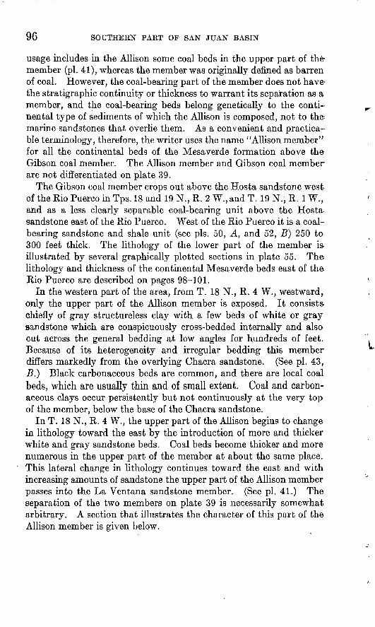
In the western part of the area, from T. 18 N., R. 4 W., westward, only the upper part of the Allison member is exposed. It consists- chiefly of gray structureless clay with a few beds of white or gray sandstone which are conspicuously cross-bedded internally and also cut across the general bedding at low angles for hundreds of feet. Because of its heterogeneity and irregular bedding this member differs markedly from the overlying Chacra sandstone. (See pi. 43, B.} Black carbonaceous beds are common, and there are local coal beds, which are usually thin and of small extent. Coal and carbon aceous clays occur persistently but not continuously at the very top of the member, below the base of the Chacra sandstone.
In T. 18 N., R. 4 W., the upper part of the Allison begins to change in lithology toward the east by the introduction of more and thicker white and gray sandstone beds. Coal beds become thicker and more numerous in the upper part of the member at about the same place. This lateral change in lithology continues toward the east and with increasing amounts of sandstone the upper part of the Allison member passes into the La Ventana sandstone member. (See pi. 41.) The separation of the two members on plate 39 is necessarily somewhat arbitrary. A section that illustrates the character of this part of the Allison member is given below.

LA VENTANA-CHACRA MESA COAL FIELD 97
nttinl section of Allison member of the Mesaverde formation in the Cerros Color ados, in the NE}i sec. 31, T. 18 N., R. 2 W.
[Measured by 0. E. Murphy]
Top of exposure on westernmost butte of the Cerros Colo-rados.
Allison member: Ft. in. Sandstone, hard, red and pink.____________________ 24Ash of burned coal, carbonaceous shale, and bone____ 5Shale and clay, gray_____________________________ 10 6Sandstone, gray-green, calcareous, fine-grained-.-..-- 4 Shale, dark gray, carbonaceous.___________________ 17Coal, subbituminous, dirty.___.________---_--_-_-- 11Shale, carbonaceous, dark gray.__-_.___-___-__-_-- 14 4 Sandstone, gray________________________________ 10Coal, impure, sandy._____________________________ 1 1Shale, dark gray to black, carbonaceous; contains thin-
bedded sandstone lenses as much as 1 foot thick___ 16 Coal, dirty_.__-_-____________-____--_--.____---- 4Shale, sandy, light brown, and sandstone in beds as
much as 3 feet thick ___________________________ 26 4Coal, dirty, lignitic_-__-_-___-_-_-_-_-_---_--_---_ 1 3 Shale, and clay, buff__-__---.______________-___-_- 11Sandstone, coarse-grained, thin-bedded.__----_----- 8 8Shale, gray and brown, with thin-bedded gray sand
stone lenses and dark-brown limonitic concretions. _ 26 8 Coal, dirty_----___-_-----_-____-_-______-_-__--- 1 1Shale, sandy, dark gray to black.__________________ 3 5Coal, sandy_____________________________________ 7Shale, brown, carbonaceous._____-_____-_---____-- 4Sandstone, gray, thin-bedded, medium-grained_____ 1 9Shale, brown, carbonaceous.______________________ 6 4Coal, subbituminous_______-__-__.___.___--______ 1Shale, gray-brown_______.______________________-_ 9Sandstone, dark gray, coarse-grained, massive.______ 5 4Shale, dark gray, and thin-bedded gray sandstone..-. 2 6 Sandstone, gray and buff ________________________ 4 4Shale, brown and sandy shale________-_-___-_-___ 19Coal, subbituminous, dirty._______________________ 1 9Shale, brown, carbonaceous.______________________ 8Coal, subbituminous, sandy, and with clay pockets.... 1 2Shale, dark gray, carbonaceous.___________________ 4Sandstone, buff._________________________________ 6Shale, gray to brown _____________________________ 10 2Sandstone, gray to buff, thin-bedded, medium-grained. 13 8 Shale, carbonaceous, dark gray to black, containing
. coal pockets and lenses, and also reddish-brown limonitic concretions____________________________ 12
Coal, with some bone, and clay partings. (This is at the horizon of the coal underlying the La Ventana sandstone farther north)________________________ 1 6
Shale. 264 4

98 SOUTHERN PART OF SAN JUAN BASIN .
Along the Rio Puerco the Allison member includes 500 to 550 feet of beds consisting almost entirely of banded dark-gray, black, and light-gray shales (see pi. 43, A), which overlie the Gibson coal mem ber. At the top or within 30 feet of the top of the Allison of this locality there is a persistent coal bed, which reaches a measured thickness of as much as 9 feet.
East of the Rio Puerco the thickness of the beds equivalent to the Allison member and Gibson coal member is considerably less than it is west of the Rio Puerco. (See pi. 41.) A section of this portion of the Mesaverde measured up the southwest slope of La Ventana Mesa is less than 670 feet thick, and a section of the same portion on the east side of the mesa in the NW# sec. 35, T. 19 N., R. 1 W., is less than 640 feet thick. The section measured on the southwest slope of La Ventana Mesa follows.
Partial section of Mesaverde formation in NEY* sec. 82, T. 19 N., R. 1 W.
La Ventana sandstone member.Allison member and Gibson coal member: Ft. in.
Concealed; carbonaceous material and slack coal indetritus. ._____-_._._._._____.___-_-___________ 78
Sandstone, in ledges with interbedded sandy shale. _-_ 18 Concealed...---.---.- -----____-_-_-----___--._-- 18Sandstone, soft, white, massive. ___._-_-_-___--____ 12Shale, sandy, with interbedded sandstone. __________ 12Shale, carbonaceous -.__.-_.._ _-___._____-__-____ 8Sandstone, tan... _________________________________ 3Shale, gray, sandy _______________________________ 17Sandstone, tan, bedded; makes ledge. ______________ 2Shale, gray, sandy _______________________________ 5Shale, carbonaceous. _____________________________ 1Shale, gray, sandy _ ______________-_.-_-_----_-_._ 6Concealed ; upper part probably sandstone _ _________ 54Sandstone, ledge-forming---__-__-___--_--___-____- 6Concealed...---. ._._._ --________-__________.._._ 22Sandstone, tan, bedded. __._-____________--_-_-_._ 8Shale, carbonaceous in upper part.. ._-___---_--_--_ 14 Sandstone--- -------- ._-__-__-_._-_._-_-_________ 10Shale, sandy--__----_-----_ -_---------___-------- 11Sandstone, white; weathers tan; fine-grained; some
beds are shaly _ ______--'--__-----_-____________- 43Sandstone and shale, mostly concealed; a bed of car
bonaceous shale 4 feet thick is exposed 32 feet abovethe base of the unit- ___-.._._ _._._._-_...._____ 58
Sandstone, white, coarse-grained; forms prominentledge- _--------_______._._--__-_ ._._.......___ 36
Shale, dark, pure.__-_-___-_______-___ .-------.___ 3Shale, sandy; forms a slope, with a bed of carbonaceous
shale 1 foot thick 20 feet above the base of the unit- 45 Sandstone, light tan to white; makes a ledge ._ _______ 6Shale, sandy---_-____ _-_-___-._-______________-_ 1Shale, gray, carbonaceous _________________________ 2

U. S. GEOLOGICAL SURVEY BULLETIN 860 PLATE 42
A. MANGOS SHALE AND OVERLYING HOSTA SANDSTONE MEMBER OF MESAVERDEFORMATION.
Showing the transitional nature of the contact, sec. 36, T. 18 N., R. 2 W. Photograph by W. G. Pierce.
li. EXPOSURES OF THE MESAVERDE FORMATION NEAR LA VENTANA.Looking northeastward from sec. 36, T. 19 N., R. 2 W. The Nacimiento Mountains are in the back
ground. The basal part of the La Ventana sandstone member caps the ridge at the left and forms the flat top of La Ventana Mesa at the right. Below it lies the Allison member. The prominent sandstone in the slopes at the left is near the top of the Gibson coal member. Relow and to the right of the tipple of the Gleary mine of the San Juan Coal & Coke Co. the Hosta sandstone is exposed.

U. S. GEOLOGICAL SURVEY BULLETIN 860 PLATE 43
A. BANDED BAHKfciS SHALES OF THE ALLISON MEMBER OF THE MESA\ ERDE FORMATION IN SEC. 11, T. 18 N., R. 2 W.
A prospect pit on the coal zone at the top of the Allison is visible near the center at about three-fourths the height of the cliff. Above it lie bedded sandstones and shales in the lower part of the La Ventana sandstone member. The cliff is about 750 feet in height.
B. BEDDED SANDSTONES OF THK CHACRA SANDSTONE MEMBER OF THE MESA- VKRDE FORMATION RESTING ON THE MORE IRREGULARLY BEDDED SHALES AND SANDSTONES OF THE ALLISON MEMBER IN SEC. 29, T. 18 N., R. 4 W.
Note sandstone lens near top of the Allison. Scale given by horse and rider (in circle). Photograph byW. G. Pierce.
IT. S. GEOLOGICAL SUKVKY BULLETIN 860 PLATE 44
,1. THE ESCARPMENT AT THE SOI/HI I'TiOVi ur <.li vi.hA \llw\.
Looking north of east from the Thoreau-Saydatoh road. The sandstone at the top of the cliff is the basal part of the Chacra sandstone member, and below it lies the Allisou member of the Mesaverde formation.
B. VIEW LOOKING EAST ACROSS TORREO.NKS \HROYO FROM THE NWJ4 SEC. 15, T18 N., R. 4 W.
The sandstone at the top of the cliff is an eastward-extending tongue of the upper part of the Chacra sandstone member of the Mesaverde formation. Ilelow it He the bedded gray shales into which the lower part of the Chacra sandstone has changed eastward. The sandstone cropping out from center to right just above the alluvial flat is near the top of the AlHson member.
U. S. GEOLOGICAL SURVEY BULLETIN 860 PLATE 45
A. EROSIONAL IRREGULARITY AT THE BASE OF A SANDSTONE NEAR THE TOP OFTHE CHACHA SANDSTONE MEMBER OF THE MESAVERDE FORMATION.
The eroded bed is carbonaceous shale and bone. Scale by geologic hammer.
B. SMALL FAULT CUTTING THE TOP OF THE ALLISON MEMBER OF THE MESAVERDE FORMATION BUT NOT DISTURBING THE BASAL BED OF THE CHACRA SANDSTONE MEMBER, IN THE SEM SEC. 14, T. 18 N., R. 6 W.
The small fault drops the sandstone on which the man is standing against a carbonaceous zone, which is also exposed below the lower sandstone at the left of the fault. The sandstone at the top of the picture is not disturbed. (See text, p. 103.)

LA VENTANA-GHACRA MESA COAL FIELD 99
Partial section of Mesaverde formation in NE% sec. 35, T. 19 N., R. 1 W. Con.
Allison member and Gibson coal member Continued. Ft- in.Coal____________________________________________ 8Shale, gray, carbonaceous_____________'____________ 1Shale, gray______________.^.___._._______________ 30Shale, sandy, with thin beds of buff sandstone.------ 12Sandstone, gray and tan, bedded--_-_--_--__-_...__ 12Sandstone, shaly, tan___________-___---.__._-_---- 3Shale, carbonaceous.....--._____.____--_____.-.-._ 2Shale, gray______________________________________ 7Sandstone, white, cross-bedded_____________________ 43Shale, carbonaceous.....________ ___._._____._._._ 2Coal________-_____.______________________________ 5Shale, carbonaceous.______________________________ 5Shale, sandy.____________________________________ 4Sandstone, shaly, tan_________.___________________ 2 4Shale, sandy, gray _______ _______-_._-________-__- 13Shale, carbonaceous............... ._--- ____-_-_--_ 11Coal.._-...-__._. ................................ 8Shale, carbonaceous............__-_____-_-___-____ 10Coal (Nance mine horizon)._______________________ 3 2Shale, carbonaceous.....--_..___..--._-____-_-_.__ 2Sandstone and shale; form gentle slope......__.___-_ 27
667 4 Hosta sandstone member: Sandstone, buff and white; forms
a cliff....--.-_..____-_....-_...._..__.._.....-.... 84 Mancos shale.
At the top of the Gibson coal member there is a prominent ledge- forming sandstone or group of sandstones. Though irregular in thickness, it is more or less continuous in the south half of T. 19 N., R. 1 W., and was recognized by Renick and an approximate thick ness of 83 feet given to it in a composite section measured chiefly in sees. 17 and 20 of that township. The beds above it and below the La Ventana sandstone member were measured as 269 feet 11 inches thick, and the beds below it and above the Hosta sandstone member as 328 feet 2 inches 18 a total thickness of 681 feet 1 inch of continental deposits as compared with the thickness of 667 feet 4 inches measured during the writer's field work in sec. 32, T. 19 N., R. 1 W., and 633 feet 8 inches in sec. 35. In sec. 32 the upper shale unit is 305 feet thick, the ledge-forming sandstone unit 137 feet, and the lower coal, shale, and sandstone unit 225 feet 4 inches. In sec. 35 the upper shale unit and the ledge-forming sandstone unit are less clearly separated in the measured section, though evidently present. Together they are 451 feet thick, and the lower coal, shale, and sand stone unit is 182 feet 8 inches thick. In sec. 16 of the same township 156 feet of beds were measured below this prominent ledge-forming
is Renictr, B. C., op. cit., pp. 46-48.

100 SOUTHERN PART OF SAN JUAN BASIN
sandstone, and in sec. 9, 227 feet of beds above it. The ledge-forming sandstone unit extends southwestward across the Rio Puerco and is exposed at the top of the Gibson coal member (pi. 50, A). Although the sandstones are lenticular and occur through a variable thickness of beds, the unit is recognizable throughout T. 18 N., R. 2 W. Renick correlated this sandstone with the basal sandstone of the Mesaverde east of Cuba. The writer, however, correlates the basal sandstone of the Mesaverde east of Cuba with the Hosta sandstone. .What appears to be abrupt thinning of the lower part of the continental beds of the Mesaverde formation northward from T. 19 N., R. 1 W., may be due to strike faulting in the steeply upturned beds along the flank of the Nacimiento Mountain uplift.
Between San Pablo and Senorito, in sec. 14, T. 20 N., R. 1 W., the exposed continental beds between the La Ventana sandstone member and the Hosta sandstone member are probably less than 420 feet thick, as shown by the following hand-leveled section:
Partial section of Mesaverde formation in SYz sec. 14, T. 20 N., R. 1 W.
(Measured by C. B. Hunt]
La Ventana sandstone member.Allison member and Gibson coal member: Ft. in.
Shale, drab._-_-__--_-___________-_______._._.-_- 80Sandstone, white, massive.._._-_._-_---_----_----- 6Shale, drab.-__._._-_-_________---_._-_----__--.- 8Shale, carbonaceous, with two coal beds each 10 inches
thick.________________________________________ 4 4Shale, gray.__.____.-._________________-__-_---__ 2Shale, gray, and shale, carbonaceous, in alternating
beds..._________ ___._._._._______________._._ 12Concealed; probably mostly sandy shale_.____.._.__ 60Sandstone, dark gray.____________._._._._._._._._ 90Shale, sandy....._-_-________-_____-_--__-__-_-_- 75Sandstone--_._._-______-______________---___--_- 4Shale.-.-.-.--.-._.----.----._.-------_--_----.- 12Shale, carbonaceous, with some gray clay___--_-____ 4Coal..-.---_--.-._.-._;-__--___--__-------_---._ 2Shale, carbonaceous._________.__..__- _._._._._._ 1 8Sandstone.--...- ._._.___._ _._._.___-__-__-_.___ 8 Shale, carbonaceous.______________________________ 2Coal. ..__--__-_.-..._.._.__-...-..__---..._.- 1 Shale, carbonaceous__._._._._._._,_______________ 10Clay, gray.___.____.__._._._._._..._.________.__ 5Shale, carbonaceous-_________.__-____._._._._._.- 5 8Coal......_...__._...__...____._.._._..___...__. 1 2Shale, carbonaceous______ ... _..._._.___________ 6Goal.......:...__....._...__..__._._..._ _ _. 1Shale, carbonaceous,... __________________________ 2
flosta sandstone member. 416 8

LA VENTANA-CHACRA MESA COAL FIELD 101
At Senorito the same unit was measured by stadia and found to be 272 feet thick, and in the $% sec. 35, T. 21 N., R. 1 W., less than 240 feet of beds were present in it.
A section measured by Renick, 19 also in the SWK sec. 35, T. 21 N., R. 1 W., gives a thickness of 37 ± feet for the La Ventana sandstone, 347 feet for the continental beds below it, and 179 feet 6 inches for the basal sandstone.
Part of the diminution in the measurements of thickness of the Mesaverde formation northward along the outcrop from La Ventana Mesa is probably due to the effect of strike faults, which are known to be present locally. The thick vertical Mancos shale east of Senorito appears to have a normal thickness which has not been reduced by squeezing, so direct compression has apparently not resulted in thinning. But the thin harder sandstone of the Mesaverde formation, intercalated between two thick shale units, may have been a par ticularly favorable horizon for steep thrust faults along the strike of the beds. Certainly it seems improbable that the northward thinning recorded in the measured sections is due altogether to original strati- graphic thinning.
CHACRA SANDSTONE MEMBER
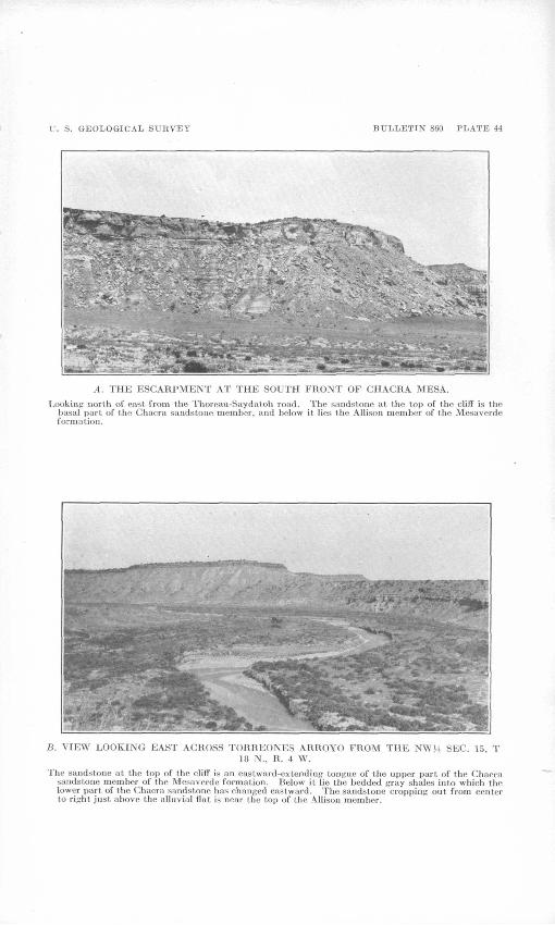
At the top of the Mesaverde formation in the western part of the area lies a thick-bedded buff marine sandstone 300 to 360 feet thick. This sandstone was regarded by Reeside 20 as the Cliff House sand stone, although he recognized that the Point Lookout sandstone and the Cliff House sandstone were really "aggregates of successively overlapping beds which as a whole, with reference to a given chron ologic plane, change their positions in the stratigraphic column from place to place."
In view of the repeated demonstration in recent years that member units within the Mesaverde cannot be safely correlated without con tinuous stratigraphic tracing, the writer proposes to apply the name "Chacra sandstone" to this unit within the area mapped. The name is derived from Chacra Mesa, in the southwestward-facing escarp ment of which the member is well exposed (pi. 44, A). The slope of the top of the mesa to the north and northeast is largely the dip slope of this sandstone. The name has been previously used by Keyes 21 for what appears to be the same unit. The fact that the Chacra is overlain by a minimum of 80 feet of Lewis shale, as con trasted with 475 feet of Lewis shale above the beds called "Cliff House sandstone" on the San Juan River and 1,710 feet of Lewis above the beds called "Cliff House sandstone" in the Red Mesa quadrangle, La
' Renick, B. C., op. cit., pp. 43, 44.'° Reeside, J. B., Jr., Upper Cretaceous and Tertiary formations of the western part of the San Juan
Basin of Colorado and New Mexico: U. S. Oeol. Survey Prof. Paper 134, pp. 14, 16,1924. « Keyes, C. R., Foundation of exact geologic correlation: Iowa Acad. Sci. Proc., vol. 22, pp. 257, 261,1910,
102 SOUTHERN PART OF SAN JUAN BASIN
Plata County, Colo.,22 increases the probability that the Chacra grades laterally into shale toward the northwest, though the possi bility that the Chacra is essentially continuous lithologically with the Cliff House of the type locality cannot be excluded until the inter vening area has been studied.
The member is largely massive and thick-bedded sandstone, gray, white, buff, and copper-colored. The sandstone is cross-bedded extensively and at moderately high angles, but this cross-bedding is scarcely evident in a general view, in which the bedding is conspicu ously horizontal and parallel, showing alternations of sandstone beds 2 to 50 feet thick, which make ledges, with intervening gray shale and shaly sandstone units, which weather into short slopes and benches. The marine deposition of the sandstone is indicated chiefly by limon- itic and clay casts of Halymeriitcs major Lesquereux, the nubbly-sur faced branching tubules of which are extremly abundant in many beds. Calcite shells of marine invertebrates are widely distributed but not common and usually not well preserved. Brown thin- bedded shales with much fragmentary plant material are interbedded with some of the softer shale and sandstones. Black carbonaceous shales and subbituminous coal are minor constituents.
From the middle of T. 18 N., R. 5 W., eastward there is a rapid change in the lithology of the Chacra sandstone. The massive ledgy sandstones become thin-bedded and shaly and then merge into interbedded sandy shale and shaly sandstone. In the eastern part of T. 18 N., R. 4 W., the member consists almost entirely of sandy shale, which weathers down into a steep slope capped by a yellow-buff sandstone about 50 feet thick (pi. 44, B}. This sand stone and the sandy shale below it merge with the overlying Lewis shale (see .pi. 41.) in the northwestern part of T. 18 N., R. 3 W. With the disappearance of the Chacra sandstone to the east, Chacra, Mesa breaks down in the vicinity of Torreones Arroyo.
The full thickness of the Chacra is determinable with certainty in the face of Chacra Mesa only where the overlying Lewis shale has not been stripped back from the dip slope of the sandstone. Where the Lewis shale has been stripped back from the escarp ment front some of the upper sandstone beds of the Chacra may have been eroded. A thickness of 340 feet was measured in the western part of T. 20 N., R. 9 W., and although this was measured to the top of the cliff and not to the base of the Lewis shale, it is. believed to include the entire thickness of the Chacra sandstone. The Chacra is known to be 360 feet thick in T. 18 N., R. 6 W.,, probably including at the top some additional sandstone beds which
" Reeside, J. B., Jr., op. cit., pi. 2.

LA VENTANA-CHACKA MESA COAL FIELD 103
are equivalent to the basal part of the Lewis shale farther west. (See pi. 41.) It thins slightly toward the east, probably by merg ing of part of the topmost sandstone into the Lewis shale, and in T. 18 N., R. 4 W., is 310 feet thick.
In the southeastern part of T. 19 N., R. 8 W., and the south western part of T. 19 N., R. 7 W., the Chacra sandstone contains several zones of carbonaceous shale, in which there are coal beds of much greater thickness and continuity than have been observed elsewhere in the sandstone. In view of the lateral changes from marine sandstone to continental beds observed elsewhere, it seems quite likely that the appearance of this coal in the Chacra sand stone represents the beginning of a change of the marine Chacra sandstone to continental beds toward the southwest, where they have been now removed by erosion.
At most places the contact between the Chacra sandstone and the underlying continental beds is sharp and has some slight irregu larity, with a relief of a few inches to a few feet, the basal sand stone of the Chacra in places cutting through the uppermost beds of the underlying Allison member. That there is no unconformity between the two members, however, is shown by the lensing out of basal sandstone beds of the Chacra into beds of Allison lithology with a resulting shift of the stratigraphic position of the contact. This has been observed at several places, most strikingly in sec. 31, T. 19 N., R. 7 W., where the basal sandstone of the Chacra merges southeastward with continental beds, reducing the thick ness of the Chacra by about 40 feet. Locally the relations are so transitional that the precise location of the contact is uncertain.
In the SE% sec. 14, T. 18 N., R. 6 W., there are some unusual rela tions at the contact. The carbonaceous zone that lies just below the base of the Chacra sandstone is dropped a distance of about 15 feet (pi. 45, B] by a small fault. On the downthrown side, however, the carbonaceous zone is overlain by buff bedded sandstone identical in appearance with the overlying marine sandstone beds, which lie unbroken and undisturbed across the fault. In view of the transition at this contact observed elsewhere, the small fault at this place probably occurred shortly after the deposition of the sandstone bed that is now preserved only on the downthrown side of the fault, having been removed by erosion or subaqueous scour from the up- thrown side before the next overlying and undisturbed sandstone bed was deposited.
To illustrate the lithology of the member more fully, several measured sections of it are given below.

104 SOUTHERN PART OF SAN JUAN BASIN
Section of Chacra sandstone member of Mesaverde formation in the SEyi sec. 80,T. 19 N., R. 7 W.
[Measured by C. H. Dane] Lewis shale.Chacra sandstone member: Ft. in.
Sandstone, yellow, thin-bedded, shaly...___________ 10Sandstone, light buff, massive.___________________ . 50Sandstone, thin-bedded, and shale, gray, poorly
exposed______________________________________ 7Sandstone, light buff, cross-bedded._______________ 8Clay, gray, poorly exposed._--.______-_____-____- 5 6Shale, light brown, with numerous plant fragments.. 15 Coal, subbituminous, with much red resin, in part
somewhat bony.______________________________ 2 7Shale, light brown, carbonaceous __________________ 3 5Coal, earthy_--_________._______________________ 5Shale, light brown, carbonaceous, with numerous
plant fragments (this unit with the preceding 5 units makes a bench)________________________ 4 7
Sandstone, brown and buff.______________________ 6Shale, black, coaly.-_____-.--___--_________-__-_ 8Shale, light brown, with plant fragments.__________ 2Sandstone, buff, fine-grained to medium-grained, with
hard brown ferruginous concretions; contains Haly- menites major throughout (this unit with the pre ceding 3 units makes a ledge)_____________ ______ 107
Coal, earthy impure.____________________ ________ 3Sandstone, black, carbonaceous, argillaceous._______ 8Sandstone, brown, irregularly cemented, with harder
dark-brown, more calcareous lenses.---__-----___ 6Shale, brown, carbonaceous, poorly exposed-------- 6Coal, soft, impure, shaly___._.___._.___________'__ 1Shale, brown, with plant fragments (this unit and the
preceding 5 units make a bench).-___.__.__...__ 1Sandstone, white, locally brownish buff, cross-bedded. 55
292Sharp contact. Local erosional irregularity. Although
the contact is sharp at the place of the section, it varies in stratigraphic position from place to place, and a regu larly bedded sandstone unit which at one place may be part of the Chacra sandstone member may lens out into beds of the lithology of the Allison member.
Allison member:Clay, carbonaceous, hard, brown.__.__ ____________Coal, subbituminous; disappears within 50 feet along
the outcrop in one direction, concealed in the other.____-__._.___-___-_-________-_________.
Clay and shale, brown, with plant imprints and thin stringers of coal...______________ ._._____._____ 5
Coal and brown clay in irregular interlensing thin -beds_______________________________________
Shale, brown, carbonaceous, with a few irregularstreaks and stringers of coal fa inch thick._._ __ ._ 1
Clay and shale, brown.
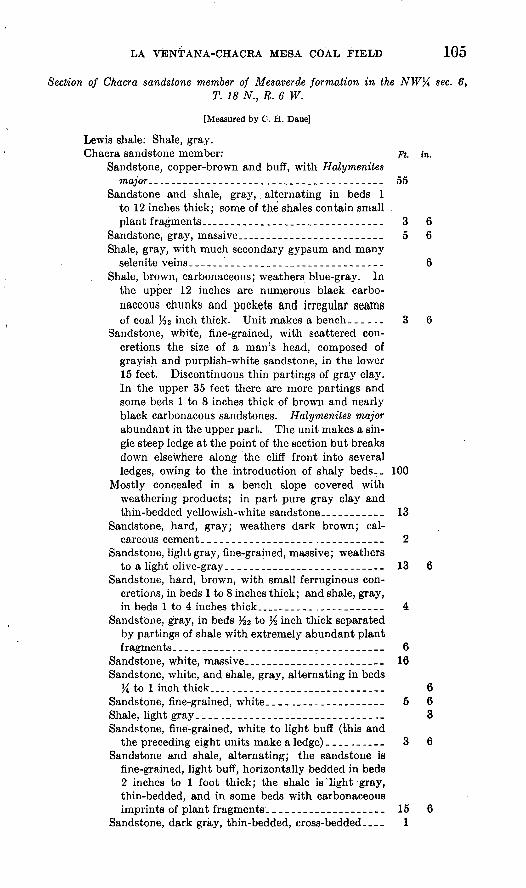
LA VENl'ANA-CHACRA MESA COAL FIELD 105
Section of Chacra sandstone member of Mesaverde formation in the NW1/* sec. 6,T. 18 N., R. 6 W.
[Measured by C. H. Dane]
Lewis shale: Shale, gray.Chacra sandstone member: Ft. in.
Sandstone, copper-brown and buff, with Halymenites major.................... ._.____._.._._._.___ 55
Sandstone and shale, gray, alternating in beds 1 to 12 inches thick; some of the shales contain small . plant fragments.._____________________________ 3 6
Sandstone, gray, massive..._____-_-___---_-____-- 5 6Shale, gray, with much secondary gypsum and many
selenite veins_____-_______________-____--_____ 6Shale, brown, carbonaceous; weathers blue-gray. In
the upper 12 inches are numerous black carbo naceous chunks and pockets and irregular seamsof coal l/32 inch thick. Unit makes a bench____ ._ 3 6
Sandstone, white, fine-grained, with scattered con cretions the size of a man's head, composed of grayish and purplish-white sandstone, in the lower 15 feet. Discontinuous thin partings of gray clay. In the upper 35 feet there are more partings and some beds 1 to 8 inches thick of brown and nearly black carbonacous sandstones. Halymenites major abundant in the upper part. The unit makes a sin gle steep ledge at the point of the section but breaks down elsewhere along the cliff front into several ledges, owing to the introduction of shaly beds.. 100
Mostly concealed in a bench slope covered with weathering products; in part pure gray clay and thin-bedded yellowish-white sandstone...-------- 13
Sandstone, hard, gray; weathers dark brown; cal careous cement-_--__----_____________________ 2
Sandstone, light gray, fine-grained, massive; weathersto a light olive-gray.__________________________ 13 6
Sandstone, hard, brown, with small ferruginous con cretions, in beds 1 to 8 inches thick; and shale, gray, in beds 1 to 4 inches thick..._______ ._.___-_____ 4
Sandstone, gray, in beds %i to % inch thick separated by partings of shale with extremely abundant plant fragments._--___----___.___-____________----_ 6
Sandstone, white, massive..________-____-__-__-__ 16Sandstone, white, and shale, gray, alternating in beds
Yi to 1 inch thick....____________ ...___________ 6Sandstone, fine-grained, white____._-___-______--_ 5 6Shale, light gray________________________________ 3Sandstone, fine-grained, white to light buff (this and
the preceding eight units make a ledge) __-_._.-__ 3 6Sandstone and shale, alternating; the sandstone is
fine-grained, light buff, horizontally bedded in beds 2 inches to 1 foot thick; the shale is'light gray, thin-bedded, and in some beds with carbonaceous imprints of plant fragments.___________________ 15 6
Sandstone, dark gray, thin-bedded, cross-bedded.___ 1

106 SOUTHERN PART OF SAN JUAN BASIN
Section of Chacra sandstone member of Mesaverde formation in the NW% sec. 6, T. 18 N., R. 6 W. Continued.
Chacra sandstone member Continued. Ft. in. Shale, light gray, pure, thin-bedded (this and the pre
ceding two units make a bench)_________________ 4 6Sandstone, dark-gray fracture; weathers brown; cal
careous crystalline cement, with very abundant Halymenites major of small diameter_--___-_____ 1
Sandstone, buff to gray, in irregular massive beds and lenses; bedding irregularly horizontal, in places con torted, cross-bedded at angles of 5° or less. Unit includes some greenish-white sandstone and beds of gray:-and greenish clay 6 inches to 1 foot thick. A few of the clay beds contain carbonaceous plant fragments. Halymenites major is abundant through out -...-.. ________________________________ 66
Sandstone, brown to buff, massive_____________-___ 4Sandstone, gray, fine-grained, extremely calcareous, in
places with gray concretionary limestone beds. Unit includes minor amounts of hard brown and white sandstone and some soft white shaly sand stone. _______________________________________ 2
Sandstone, gray and white, cross-bedded_______-___ 5Sandstone, gray, fine-grained, extremely calcareous. 2 Sandstone, buff and gray, massive, with numerous
Halymenites major (this and the preceding five units make a ledge)______________________________ 27 6
Slight erosional irregularity. 360 9 Allison member: Clay, carbonaceous, brown, with much
plant fragment material.
Section of Chacra sandstone member of Mesaverde formation in the SEl/4 sec. 9,T. 18N.,R.4W.
[Measured by C. H. Dane]
Lewis shale not exposed, but the section includes practi cally the total thickness of the Chacra sandstone member.
Chacra sandstone member: Ft. in. Sandstone, buff, massive, and sandstone, thin-bedded,
cross-bedded; top is dip slope_______--_-----____ 18 8Sandstone, brown, fine-grained, in beds 6 inches to 4
feet thick, with interbedded layers of shale andsandy shale. The sandstone with Halymenites
:. major, .large Inoceramus sp., and other indefinite; .'fossil prints-____---_--.--___:_-_--_-^_____---_- 27 6i' Shale, gray, and sandstone, gray shaly--__----_-Li_- 46 6
Limestone concretionary bed, light tawny where ' weathered but gray on fresh fracture____________ 1 6
Shale, gray, and sandstone, gray, shaly____-_._._-_ 7Sandstone, thin-bedded, cross-bedded______________ 1 6Shale, gray,; .and sandstone, gray, shaly; poorly ex
posed , __--__--_'_-_--_--_--______---_-__-__-- 39 6Sandstone,. brown, crossTbedded, with many Haly-
' menites wojfor_______.___._l___________________ 3
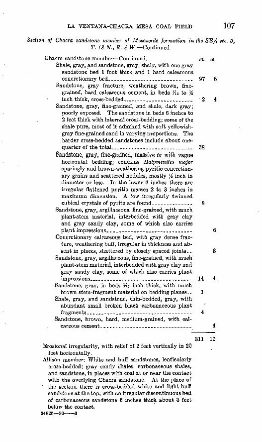
LA VENTANA-CHACRA MESA COAL FIELD 107
Section of Chacra sandstone member of Mesaverde formation in the SE% sec. 9, T. 18 N., R. 4 W Continued.
Chacra sandstone member Continued. m. in.Shale, gray, and sandstone, gray, shaly, with one gray
sandstone bed 1 foot thick and 1 hard calcareous concretionary bed.__._____.-._________.____.._ 97 6
Sandstone, gray fracture, weathering brown, fine grained, hard calcareous cement, in beds Ho to % inch thick, cross-bedded___.-_____._____.____ 2 4
Sandstone, gray, fine-grained, and shale, dark gray; poorly exposed. The sandstone in beds 6 inches to 2 feet thick with internal cross-bedding; some of the shale pure, most of it admixed with soft yellowish- gray fine-grained sand in varying proportions. The harder cross-bedded sandstones include about one- quarter of the total__-___----___.______._____ 38
Sandstone, gray, fine-grained, massive or with vaguehorizontal bedding; contains Halymenites major sparingly and brown-weathering pyritic concretion ary grains and scattered nodules, mostly % inch in diameter or less. In -the lower 6 inches there are irregular flattened pyritic masses 2 to 3 inches in maximum dimension. A few irregularly twinned cubical crystals of pyrite are found_---___-____.- 8
Sandstone, gray, argillaceous, fine-grained, with much plant-stem material, ihterbedded with gray clay and gray sandy clay, some of which also carries plant impressions________________.____________ 6
Concretionary calcareous bed, with gray dense frac ture, weathering buff, irregular in thickness and ab sent in places, shattered by closely spaced joints.. 8
Sandstone, gray, argillaceous, fine-grained, with much plant-stem material, interbedded with gray clay and gray sandy clay, some of which also carries plant impressions___--____-_-_---_-___---__-__--_- 14 4
Sandstone, gray, in beds %2 inch thick, with much brown stem-fragment material on bedding planes _. 1
Shale, gray, and sandstone, thin-bedded, gray, with abundant small broken black carbonaceous plant ' fragments._____-.____-----_---__-_-----_-_-_- 4
Sandstone, brown, hard, medium-grained, with cal careous cement.______________________________ 4
311 10Erosional irregularity, with relief of 2 feet vertically in 20
feet horizontally.Allison member: White and buff sandstones, lenticularly
cross-bedded; gray sandy shales, carbonaceous shales, and sandstone, in places with coal at or near the contact with the overlying Chacra sandstone. At the place of the section there is cross-bedded white and light-buff sandstone at the top, with an irregular discontinuous bed of carbonaceous sandstone 6 inches thick about 3 feet below the contact.
64825 36 3

108 SOUTHERN PART OF SAN JUAN BASIN
LA VENTANA SANDSTONE MEMBER
As pointed out on page 102, the Chacra sandstone member grades laterally into Lewis shale in the northwestern part of T. 18 N., R. 3 W., and the Lewis shale accordingly becomes considerably thicker. (See pi. 41.) The beds below the Chacra sandstone also undergo a change toward the east, from non-coal-bearing clay and sand through an intermediate coal, shale, and sandstone zone into a stratigraphic unit consisting largely of marine sandstone. This marine sandstone unit is here named the La Ventana sandstone member, from the town of La Ventana, on the Rio Puerco, near which the member crops out, and perhaps more appropriately from the exposure of its basal part on the top of La Ventana Mesa, east of Rio Puerco, on the south edge of T. 19 N., R. 1 W. It fonns the top of the Mesaverde formation in the region immediately east and west of the Rio Puerco. In T. 18 N., R. 2 W., and the southeastern part of T. 19 N., R. 2 W., the lower 250 feet of the member crops out as a cliff at the top of a high escarpment that faces somewhat south of east toward the Rio Puerco. (See pi. 43, A.) This lower part of the member consists of buff sandstone and gray shale, almost wholly of marine origin. It is sharply separable from the underlying continental banded gray and black shales. Above the top of the cliff the buff sandstone grades upward in the western part of T. 18 N., R. 2 W., into partly marine, partly continental white, gray, and buff sandstone with interbedded carbonaceous shale and discontinuous coal beds. This upper part of the member is estimated to be about 650 feet thick in T. 18 N., R. 2 W., thus making the total thickness of the member about 900 feet. To the southwest the marine sandstone beds of the lower part of the La Ventana sandstone grade laterally into sandstone, shale, and coal beds in the southwestern part of T. 18 N., R. 4 W., in the Cerros Colorados, as shown in the measured section given on page 97. To the north along the valley of the Rio Puerco the upper part of the La Ventana sandstone grades into buff sandstone with much inter- bedded gray shale and ultimately into shale, which forms the lower part of the Lewis. (See pi. 41.)
The thickness of the La Ventana sandstone in sees. 8, 16, and 17, T. 19 N., R. 1 W., is 1,256 feet.23 In this locality the La Ventana is in considerable part marine shale and in the upper part probably more than half shale.
The La Ventana sandstone diminishes in thickness rapidly north ward by intertonguing with and merging into the overlying Lewis shale, and a stadia measurement of it just west of Senorito shows only 308 feet. Even this thickness includes a more shaly upper portion that might almost equally well be included in the Lewis shale.
« Renick, B. 0., op. cit., p. 45.

LA VENTANA-CHACRA MESA COAL FIELD 109
In the SJ£ sec. 14, T. 20 N., R. 1 W., where the beds are overturned and dip eastward, the La Ventana sandstone member is locally miss ing, possibly owing to steep thrust faulting along the strike. Whether this explanation is correct or not, it seems almost certain that the sandstone member at the top of the Mesaverde at Senorito and farther north is the thin northward extension of the lower part of the La Ventana sandstone.
LEWIS SHALE
The Lewis shale as mapped in the western part of this area would probably not have been differentiated as a separate mappable unit had it not been previously traced southward 21 into the area from the type locality near the former Army post of Fort Lewis, in sec. 3, T. 34 N., R. 11 W., La Plata County, Colo. At the type locality it is described by Cross 26 as a "body of more or less sandy shales and clays with occasional thin layers of impure limestones." In the western part of this area the Lewis shale is a gray calcareous sandy shale, containing buff sandstone beds from 1 to 5 feet thick. There- are a few thin calcareous concretionary beds. Marine fossils are present but are not common. In this western portion of the area, erosion has stripped the Lewis shale back from the dip slope of the Chacra sandstone on Chacra Mesa, and the Lewis crops out in a narrow shale valley occupied by the Chaco River and its tributaries. In T. 19 N., R. 7 W., the Lewis is locally preserved on the slope of Chacra Mesa. From that point eastward to T. 18 N., R. 5 W., it forms a thin veneer over the Chacra sandstone, and the contact between the Lewis and Chacra is in many places at the top of the front escarpment of Chacra Mesa. In this area the Lewis is notably more sandy, including beds of thick-bedded or massive sandstone as much as 20 feet thick. In these beds Halymenites major is in places abundant. East of T. 18 N., R. 5 W., the Lewis shale is progressively less sandy eastward.
Calcareous concretions a few inches to several feet in diameter are common in the more shaly beds. Some of these are blue gray, dense, and hard in the interior, but most of them are yellowish gray and shattered into innumerable, small, splintery, fragments.
The contact with the underlying Chacra sandstone is transitional. In some places the transition is abrupt; in others it is so gradual that the contact is arbitrarily chosen. The separation is made altogether on lithologic differences, and east of Torreones Arroyo the contact, as mapped, is dropped over 300 feet stratigraphically to include the shaly beds equivalent to the Chacra sandstone farther west. (See pi. 41.) Along the Rio Puerco the La Ventana sandstone merges into the-
.«* Reeside, J. B., Jr., Upper Cretaceous and Tertiary formations of the western part of the San Juan Baslnr Colorado and New Mexico: U. S. Qeol. Survey Prof. Paper 134, p. 17,1924.
i» Cross, Whitman, and Spencer, A. 0.. U. S. Oeol. Survey Qeol. Atlas, La Plata folio (no. 60), p. 4,1899

110 SOUTHERN PART OF SAN JUAN BASIN
Lewis shale by a decrease in number and thickness of sandstone beds and a corresponding increase in number and thickness of shale beds. This change takes place gradually, and the boundary shown on plate 39 is a line of separation between differences in gross lithology. This line follows roughly a stratigraphic horizon northeastward to a point somewhat east of the Rio Puerco, but thence northeastward it trans gresses downward across stratigraphic horizons.
A few collections of fossils from the Lewis shale were determined for the writer by J. B. Reeside, Jr. The largest collection represented an upper Pierre fauna from a calcareous sandstone near the base of the shale into which the Chacra sandstone grades eastward. The fossils were collected in sec. 4, T. 18 N., R. 3 W., on the northwest side of Medio Arroyo, Sandoval County. The list follows:
Inoceramus sagensis Owen.Ostrea gillulyi Reeside.Liopistha (Cymella) montanensis Henderson.Cardium (Ethmocardium) whitei Dall.Thetis circularis (Meek and Hayden).Spironema? sp.Aporrhais meeki Whitfield.Pyrifusus (Neptunella) newberryi Meek and Hayden.Pyropsis sp.Volutoderma? sp.Anisomyon borealis Morton.Baculites ovatus Say var. haresi Reeside.Placenticeras intercalare Meek.
Near the base of the Lewis shale 3 miles south of Star Lake store, in the SW# sec. 22, T. 19 N., R. 6 W., McKinley County, the follow ing Pierre species were collected:
Ostrea gillulyi Reeside.Cardium (Ethmocardium) whitei Dall. Gyrodes depressus Meek. Lamna sp.
Ostrea gillulyi Reeside was also collected near the base of the Lewis in the SW% sec. 30, T. 19 N., R. 2 W., Sandoval County.
A representative Pierre fauna was collected by Renick 26 from a thin limestone bed in the Lewis about 200 feet above the sandstone mapped by him as the top of the Mesaverde in sec. 5, T. 19 N., R. 1 W.
The thickness of the Lewis shale is 1,700 feet 27 near the type local ity, and diminishes southward along the west side of the San Juan Basin to the lowest known thickness of 76 feet at Coal Creek. South west of Saydatoh it has a thickness of about 150 feet, and slightly more than 80 feet was measured in the NW^ sec. 6, T. 18 N., R. 6 W. (See pi. 46, A.) A short distance east of Torreones Arroyo, where the Chacra sandstone is still separated from it, the thickness is estimated
» Renick, B. O., op. cit., p. 50. « Reeside, J. B., Jr., op. cit., p. 17.

LA VENTANA-CHACRA MESA COAL FIELD 111
to be 170 feet. South of Mesa Piedra Lumbre its thickness is esti mated to be from 550 to 600 feet. The maximum thickness of Lewis along the Puerco Valley is uncertain. Renick 28 measured 1,256 feet of Mesaverde equivalent to Lewis farther north, and this added to the 550 feet of Lewis south of Mesa Piedra Lumbre would give a total thickness of about 1,800 feet. On the other hand, Renick gives about 1,660 feet as the thickness of the Lewis from the Mesaverde hi sec. 2 to the base of the Puerco (?) in sec. 4, T. 20 N., R. 1 W. As this figure probably includes the Kirtland shale and some of the Ojo Alamo sandstone the thickness of the Lewis proper would be about 1,400 feet.
Section of Lewis shale in NW% sec. 6, T. 18 N., R. 6 W.
{Measured by W. O. Pierce]
Pictured Cliffs sandstone: Ft. in. Sandstone, yellow, soft, fine-grained, with thin shale
beds__-_____--______-_._-_-_._._--__---__-__Shale, drab_._.._____ ....................... 4Sandstone, gray, hard, calcareous; weathers reddish
brown; contains abundant small specimens of Haly- menites major; shows probable ripple marks...----- 1 4
Conformable contact. ' Lewis shale:
Shale, gray, with several shaly sandstone beds from 6 inches to 2 feet thick______________.____________ 17
Sandstone, gray, hard, thin-bedded___-_____-___-_ 6Shale, gray, sandy__._-_._-__--__-____-___-.__-_ 4 6Sandstone, thin-bedded-____----.--___--____-___-_ 9Shale, light gray_____________________._ 22Sandstone, buff, massive, with Halymenites major, thin-
bedded and calcareous in the upper part._.___.___ 14 Shale, gray, sandy._____________________________ 9Sandstone, thin-bedded; weathers brown ____________ 1 3Shale, thin-bedded, dark with slight olive-green tinge. 10 2 Sandstone, shaly, containing pellets of shale and some
gypsum -__--__--_____-__ .- 1Shale, sandy; weathers dark purple-tinged gray____ 10Sandstone, almost unconsolidated, and shale with some
thin hard sandstone beds 1 inch or less thick. _____ 1 8
Thickness of Lewis shale. _________ __________ 82 8Conformable contact.Chacra sandstone member of Mesaverde formation:
Sandstone, thin-bedded, soft, friable, weathering brown, alternating with more massive beds 2 to 3 feet thick..__-__-____-___.___________..___ 9 6
Sandstone, massive.
w Kenick, B. C., op. cit., p. 45.

112 SOUTHERN PART OF SAN JUAN BASIN
PICTURED CLIFFS SANDSTONE
Conformably overlying the Lewis shale is a buff cross-bedded sandstone of marine origin. This is the Pictured Cliffs sandstone, first named by Holmes 29 from the exposures north of the San Juan River 1 mile west of Fruitland, N. Mex. Reeside 30 has traced this sandstone from a locality north of Pagosa Junction, Colo., around the west and south sides of the basin as far as the head of the Chaco River. The writer has mapped the sandstone east from this locality nearly to the Rio Puerco, but it is not present east of the Rio Puerco in the area mapped. It has not been recognized outside of the San. Juan Basin.
The Pictured Cliffs sandstone in the area mapped is almost every where distinctly yellow in tone as contrasted with the gray, buff, or copper color of the sandstones of the underlying formations. It is mostly fine-grained and rather soft and friable, with cross-bedding prevalent. In places there are thin-bedded hard slabby calcareous sandstones which weather dark brown, and also irregular calcareous concretions. Shaly beds are distinctly uncommon, but thin layers of gray shale are in some places interbedded with sandstone in the lower part of the formation. Fossil shells of marine invertebrates are widely though sparsely distributed, but the casts and imprints of Halymenites major are in places abundant and may be found after some search in almost every exposure. The sandstone is compara tively more resistant that the overlying and underlying beds and in many places crops out as a low scarp (pi. 46, B). It is in most places abruptly transitional into both the shale below and the overlying Fruitland formation, but the upper transition is hi places so gradual that the contact can be only arbitrarily placed at the highest point .at which marine fossils can be found.
From the Pictured Cliffs sandstone in the NE% sec. 18, T. 19 N., R. 2 W., about 1 mile north of Zambrano's ranch, the following small fossil collection was made. This was determined by J. B. Reeside, Jr., as a Montana fauna.
Cardium (Ethmocardium) white! Dall. Corbula sp. Buccinum? sp.
Tellina scitula Meek and Hayden was collected from the Pictured liffs sandstone in the NE# sec. 17, T. 19 N., R. 3 W., Sandoval 'County.
The Pictured Cliffs is somewhat less than 100 feet thick in the western part of the area and decreases to about 40 feet near Torreones Arroyo. The thickness increases slightly again toward the east,
*> Holmes, W. H., Geological report on the San Juan district, Colorado: U. S. Qeol. and Qeog. Survey Terr. 9th Ann. Kept., for 1875, pi. 35, p. 248,1877.
8° Reeside, J. B., Jr., Upper Cretaceous and Tertiary formations of the western part of the San Juan Basin of Colorado and New Mexico: U. S. Geol. Survey Prof. Paper 1934, p. 18,1924.

LA VENTANA-CHACRA MESA COAL FIELD 113
but the formation again thins and is not present east of the Rio Puerco near Cuba.
Section of Pictured Cliffs sandstone in sees. 7 and 18, T. 19 N., R. 2 W.
Fruitland formation: Dark-gray shale at the'base. Pictured Cliffs sandstone: . Feet
Sandstone, soft, light buff and white, with abundant flakes of mica.__________________________________ 15 ±
Sandstone, light buff, massive, fine-grained, with Halymenites major, with purplish-brown concre tionary sandstone beds and purplish-brown concre tions 1 to 2 feet in diameter. _______._._._._._..__ 25
Shale, dark gray, with some plant-fragment impres sions, and sandstone, buff, massive, fine-grained, with small pelecypod imprints.________________________ 5
Lewis shale. ' 45±
FRUITIAWD FORMATION AND KIETIAND SHALE
The Fruitland formation, which conformably overlies the Pictured Cliffs sandstone, is a highly variable formation of fresh and brackish water origin consisting of beds of sandstone, shale, and coal. The formation was named by Bauer 31 from the settlement of Fruitland, N. Mex., on the San Juan River, and was mapped southward to Alamo Arroyo by Bauer and Reeside.32 Though extremely variable in details and very irregularly bedded, the formation includes at all exposures the same sort of rocks gray-white soft sandstone, harder brown calcareous sandstone, gray shale and clay, brown and black carbonaceous clay and shale, and subbituminous coal. The coal is generally thicker and more abundant in the lower part of the forma tion. The Fruitland formation grades continuously upward into the Kirtland shale and differs from it only by having a higher content of coal and sandstone, particularly indurated brown sandstone. The separation of the two formations is altogether an arbitrary one, and in the mapping the line between the two was drawn at the top of the stratigraphically highest brown sandstone. This arbitrary separa tion has resulted in the drawing of the boundary plane at different stratigraphic positions at different places. Variations in thickness of the Fruitland formation and Kirtland shale individually are accord ingly not significant.
The type locality of the Kirtland shale is at the settlement of Kirtland,33 on the San Juan River above Fruitland. The formation
«' Bauer, C. M., Stratigraphy of a part of the Chaco Elver Valley: U. S. Geol. Survey Prof. Paper 98, p. 274, 1916.
« Bauer, C. M., and Keeside, J. B., Jr., Coal in the middle and eastern parts of San Juan County, N. Mex: U. S. Geol. Survey Bull. 716, p. 167,1921.
M Bauer, 0. M., op. cit., p. 274.

114 SOUTHERN PART OF SAN JUAN BASIN
is there divisible into three groups of beds forming distinct members, all of fresh-water origin. The upper and lower members consist of gray shale and soft gray and yellow sandstone. The middle member contains many beds of soft gray and hard brown sandstone. This was named the "Farmington sandstone member" by Bauer.33
The Kirtland shale in the area mapped by the writer consists mainly of gray shale with some brown and black carbonaceous shale. In the upper part soft gray and white sandstone is present in many places. The shaly parts of the formation contain much silicified wood. Gypsum is present as sheets in joint planes and as crystals of selenite. Concretions of calcite and siderite are common. In places the soft shales have been eroded into extensive stretches of badland topography (pl.47,4).
An examination of the correlated columnar sections given by Reeside 34 shows that the Kirtland and Fruitland together are several hundred feet thinner at the San Juan River than farther north at the New Mexico-Colorado State boundary. This thinning has reduced the upper shale member of the Kirtland from 475 to 80 feet and the Fruitland from 530 to 241 feet, the middle and lower members of the Kirtland retaining roughly the same thickness. At Escavada Wash, near the southeast corner of San Juan County, the thickness of the two formations is 930 feet, as compared with 1,051 feet on the San Juan River, with a maximum thickness in the intervening area of 1,417 feet. The Farmington sandstone member of the Kirtland diminishes from 459 feet at the San Juan River to 20 feet at a section 9 miles west of Escavada Wash and is not present at Escavada Wash. The lower shale member has thickened at the expense of the Farm ington sandstone member at the more southerly localities. The upper shale member varies slightly about a mean thickness of 30 to50 feet. In the area on the south side of the San Juan Basin mapped by the writer the combined thickness of the Kirtland shale and Fruitland formation continues to diminish toward the east. (See pi. 41.) A conservative estimate of the thickness at Saydatoh and the Chaco River gives 180 feet for the Fruitland formation and 500 feet for the Kirtland shale, a total of 680 feet, as compared with the thickness of 590 feet given by Reeside as adapted from unpublished data by L. A. Gillett.35 This represents a diminution of 250 feet from the thickness at Escavada Wash, 10 miles farther west. In T. 20 N., R. 6 W., about 3 miles northwest of the Continental Divide and about 9 miles southeast of the Saydatoh section, the combined thickness is estimated to be slightly less than 600 feet. At Torreones Arroyo, about 10 miles southeast of the section measured in T. 20 N.,
« Bauer, C. M., op. cit. p. 274.'4 Reeside, J. B., Jr., Upper Cretaceous and Tertiary formations of the western part of the San Juan
Bssin, Colorado and New Mexico: U. S. Qeol. Survey Prof. Paper 134, pi. 2, 1924. M Reeside, J. B., Jr., op. cit., pi. 2.

tJ. S. GEOLOGICAL SURVEY BULLETIN 860 PLATE 46
A. NORMAL FAULT IN THE NW}4 SEC. 6, T. 18 N., R. 6 W.
Drops the topmost sandstone of the Chacra sandstone member from the sky line at the right to the lower middle of the picture at the left, a throw of 140 feet. The Lewis shale and the overlying Pic tured Cliffs sandstone are exposed at the left of the fault. Looking east.
B. PICTURED CLIFFS SANDSTONE (AT IIIK I.KI-T FollKKIiol M> AM) RIGHT MIDDLE), WITH SHALY BEDS OF THE FRUITLAIND FORMATION OVERLYING THE SANDSTONE IN SEC. 6, T. 21 N., R. 9 W.
Photograph by \V. G. Pierce.

U. S. GEOLOGICAL SURVEY BULLETIN 860 PLATE
A. VIEW LOOKING SOUTHEAST FROM OJO ALAMO SANDSTONE ESCARPMENT IN THE NWJ4 SEC. 16, T. 20 N., R. 6 W., TOWARD BADLANDS IN THE KIRTLAND SHALE.
Ojo Alamo sandstone exposed at the upper right. Photograph by H. R. Joesting.
B. ESCARPMENT OF OJO ALAMO SANDSTONE WITH KIHTLAND SHALK UK LOW IT NEAR OJO AGUILA, IN SEC. 311, T. 20 N., R. 4 \V.
Navajo Indian hogati and cornfield in foreground. Photograph by O. H. Murphy.
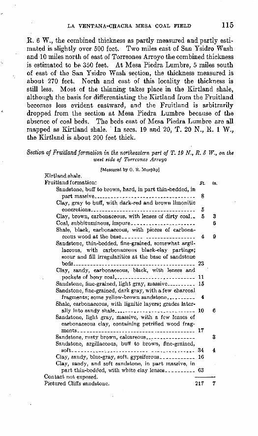
LA VENTANA-CHACRA MESA COAL FIELD 115
R. 6 W., the combined thickness as partly measured and partly esti mated is slightly over 500 feet. Two miles east of San Ysidro Wash and 10 miles north of east of Torreones Arroyo the combined thickness is estimated to be 350 feet. At Mesa Piedra Lumbre, 5 miles south of east of the San Ysidro Wash section, the thickness measured is about 270 feet. North and east of this locality the thickness is still less. Most of the thinning takes place in the Kirtland shale, although the basis for differentiating the Kirtland from the Fruitland becomes less evident eastward, and the Fruitland is arbitrarily dropped from the section at Mesa Piedra Lumbre because of the absence of coal beds. The beds east of Mesa Piedra Lumbre are all mapped as Kirtland shale. ' In sees. 19 and 20, T. 20 N., R. 1 W., the Kirtland is about 200 feet thick.
Section of Fruitland formation in the northeastern part of T. 19 N., R. 5 W., on the west side of Torreones Arroyo
[Measured by 0. R. Murphy] Kirtland shale.Fruitland formation: Ft. in.
Sandstone, buff to brown, hard, in part thin-bedded, in part massive____-_-.-_-_---_.--_----_----__- 8
Clay, gray to buff, with dark-red and brown limonitic concretions____________________________________ 5
Clay, brown, carbonaceous, with lenses of dirty coal.. 5 3 Coal, subbituminous, impure._____________________ 6Shale, black, carbonaceous, with pieces of carbona
ceous wood at the base. ____-- .__--_.__________ 4 9Sandstone, thin-bedded, fine-grained, somewhat argil
laceous, with carbonaceous black-clay partings; scour and fill irregularities at the base of sandstone beds..________________________. 23
Clay, sandy, carbonaceous, black, with lenses and pockets of bony coal__________________________ 11
Sandstone, fine-grained, light gray, massive._________ 15Sandstone, fine-grained, dark gray, with a few charcoal
fragments; some yellow-brown sandstone._________ 4Shale, carbonaceous, with lignitic layers; grades later
ally into sandy shale__-_-_______._________._.___ 10 6Sandstone, light gray, massive, with a few lenses of
carbonaceous clay, containing petrified wood frag ments. _________________________ ..__--___--__- 17
Sandstone, rusty brown, calcareous___._-_-__----_ 3Sandstone, argillaceous, buff to brown, fine-grained,
soft-------__-___--_-_---.---_ -._._.-.-.-__.- 34 4Clay, sandy, blue-gray, soft, gypsiferous. ___________ 16Clay, sandy, and soft sandstone, in part massive, in
part thin-bedded, with white clay lenses-_________ 63Contact not exposed. Pictured Cliffs sandstone. 217 7

116 SOUTHERN PART OF SAN JUAN BASIN
Section of Kirtland shale in the SE^ sec. 7, T. 19 N., R. 2 W.
[Measured by C. H. Dane]
Ojo Alamo sandstone: Coarse buff sandstone and grit. Erosional irregularity.Kirtland shale: Feet
Shale, gray, with some light-buff and gray sandstone __---_ 50 Sandstone, white, fine-grained, with subordinate gray
shale; ledge forming.... ____________________________ 38Clay, dark gray, with silicified logs as much as 2 feet in
diameter. ________________________________________ 17Clay, sandy, yellow, containing many brown plant frag
ments -____-__---____-__-________--_-____________ 5Sandstone, white, fine-grained, soft __-_--__---____-_____ 11Sandstone, buff, soft, cross-bedded; subrounded quartz
grains 0.01 to 0.03 inch in diameter, with some irregular harder beds. _____________________________________ 22
(In the zone equivalent to this unit and the underlying 43% feet in the steep exposures along the face of the cliff, there are irregular brown sandstone }enses 2 to 6 feet thick and 50 to 200 feet long at varying strati- graphic positions.)
Sandstone, purple, hard, calcareous, medium-grained. _ _ _ _ l/zClay, sandy, white and light gray ___________ _________ 1Clay, slightly sandy, yellow-gray__-.__-__-_-__ ._-___ ._ 11 Shale, sandy, dark gray, and sandstone, shaly, light gray ._ 25 Shale, dark gray, in part carbonaceous, and a lesser amount
of gray sandstone. ________________________________ 6Sandstone, gray, in beds. 2 to 4 inches thick separated by
lenses and stringers of coal half an inch to 3 inches thick. 2 Sandstone and shale, gray _ _ ._._._--________________ 3Shale, brown, carbonaceous_-_-____-_-----_-----_____- ' 1Shale and sandstone, gray _ _________________________ 3Shale, brown, carbonaceous___--__--_-------___------- 1Sandstone, white, gray, and light yellow, soft, and shale,
gray ; unit makes steep slopes and cliffs ________________ 71Shale, dark gray, pure_____--__-__-__. _______________ 1
Contact obscured, transitional (?).Pictured Cliffs sandstone: Sandstone, soft, gray, white, and
yellow-gray, with marine fossils.
OJO ALAMO SANDSTONE
The uppermost formation on which data were gathered in some detail is the Ojo Alamo sandstone. The name "Ojo Alamo" was first applied by Brown 36 to a shale containing dinosaur remains cropping out below a conglomerate on Ojo Alamo Arroyo, near Ojo Alamo, N. Mex.
Later Sinclair and Granger 37 at the same locality applied the name to include not only the shales of Brown but also the overlying con-
»a Brown, Barnum, The Cretaceous Ojo Alamo beds of New Mexico, with description of the new dinosaur genus Kritosaurus: Am. Mus. Nat. History Bull., vol. 28, pp. 267-274, 1910.
»' Sinclair, W. J., and Granger, Walter, Paleocene deposits of San Juan Basin, N.Mex.: Am. Mus. Nat. History Bull., vol. 33, pp. 300-304, 1914.

LA VENTANA-CHACKA MESA COAL FIELD 117
glomerate, which they described as "a coarse cross-bedded conglomer atic yellow-brown sandstone, containing, toward its top, many large silicified logs lying prone and often invested in a capsule of indurated sand." In Brown's original Ojo Alamo beds they also recognized a lower conglomerate which varies from "a pebbly sandstone to a coarse conglomerate", 6 to 8 feet thick and 58 feet at a maximum below the overlying conglomerate. Bauer,38 after a careful study of the same locality, reached the conclusion that the lower conglomerate could be traced laterally to points where the shale between it and the upper con glomerate is absent and that therefore the shale intervening here and there is not a definite unit. Accordingly he redefined the Ojo Alamo sandstone to include these conglomeratic beds and the shale between them, using Kirtland shale for the shale below the lower conglomerate. Reeside 39 used the name as redefined by Bauer and states that "it extends as the cap rock of a continuous ridge from Pinon Mesa, a few miles north of San Juan River, around the west and south sides of the San Juan Basin." The formation has been mapped by the writer from Alamo Arroyo, in T. 22 N., R. 8 W., eastward to the Rio Puerco in T. 20 N., R. 2 W., and thence northward along the east margin of the San Juan Basin to the southern part of T. 21 N., R. 1 W. Over most of this area it had not previously been examined in detail. It dips successively to the northeast, north, and northwest at low angles around the south edge of its outcrop, as it outlines the regional structure of the basin. Its outcrop produ'ces over most of its length a. typical cuesta ridge with a low escarpment facing south (pi. 47) and with northward dip slopes. The escarpment is interrupted by the broad valleys of generally southwestward-draining washes Alamo, Cottonwood, Corral, and Torreones Afroyos, Chaco River, San Ysidro Wash, and other unnamed drainageways.
In composition the Ojo Alamo sandstone is largely a coarse-grained cross-bedded buff and yellow sandstone with some interbedded gray and yellow shale and sandy clay. In places the sandstone is white or gray and more rarely of a purple tone, due probably to a manganif- erous matrix between the grains. Although described originally as a. conglomeratic sandstone and conglomerate, conglomerate is rare over most of its outcrop on the south side of the basin, and in many sections even sporadic pebbles are not easily found, although grit-sized grains are almost everywhere present. The pebbles are well-rounded silici fied pebbles of various shades of gray, with more rarely dull red or yellow pebbles. They range from half an inch to 2 inches in diam eter. Limonitic concretions half an inch to 6 inches in diameter are
as Bauer, C. M., Stratigraphy of a part of the Chaco River Valley: U. S. Qeol. Survey Prof. Paper 98, pp. 275, 276,1916..
»»Reeside, J. B., Jr., Upper Cretaceous and Tertiary formations of the western part of the San Juan Basin of Colorado and New Mexico: U. S. Qeol. Survey Prof. Paper 134, pp. 28-32,1924.

118 SOUTHERN PART OF SAN JUAN BASIN
common, and limonitic beds half an inch to 2 niches thick occur, hi most places just above the contact with the underlying Kirtland shale or just above shale beds within the formation. The sandstone beds range from a few inches to several feet in thickness. Local erosional unconformities at the base of sandstone or grit lenses within the forma tion have at many places cut down through underlying beds and have a local relief of 1 to 2 feet. Dark carbonaceous clay streaks a few inches thick occur in a few places. Silicified logs as much as 3 feet in diameter are common on the weathered surfaces of the top of the sandstone and locally are embedded in the sandstone. Toward the east, particularly east of San Ysidro Wash, there is an increase in average size of grain, and beds of grit and conglomerate make up a large part of the total thickness. Pebbles as much as 4 inches in diameter have been found. The gram composition in this part of the area includes chiefly subangular and angular grains of clear quartz and silicified or cherty grams. Dull red and dark grams occur, and feldspar is an abundant constituent. A small proportion of the grains are well rounded and subrounded.
The sandstone beds of the Ojo Alamo rest nearly everywhere upon erosional irregularities cut in the surface of the underlying Kirtland shale. These erosional irregularities may have a relief of 2 or 3 feet vertically in 50 feet horizontally. Reeside 40 regarded the lower con tact of the Ojo Alamo sandstone as an erosional unconformity. Previously Bauer 41 had described the contact as one of apparent conformity. Sinclair and Granger ** still earlier described both the upper "conglomeratic sandstone with fossil logs" and the "lower con glomerate" as resting "disconformably" on shales below. However, they state that "the disconformity between these clays and the heavy sandstone member above [upper conglomeratic sandstone] is no greaterthan usually occurs * * * between sandstone channel fillings and the clays hi which they are cut," and presumably they regarded the disconformity at the base of the lower conglomerate (which Bauer included in the Ojo Alamo) as having only the same degree of significance.
At the base of sandstone beds within the formation there are ero sional irregularities nearly as great as the irregularities of the base of the lowest sandstone beds in it. The deposition of such coarse mate rial as makes up the formation requires currents of sufficient velocity to effect channeling and scour of the indicated magnitude, and in fact it is difficult to conceive of the deposition of such material without the cutting of erosional irregularities hi underlying soft material. Such
*° Reeside, J. B., Jr., op. cit., p. 30.« Bauer, C. M., Stratigraphy of a part of the Chaco River Valley: U. S. Geol. Survey Prof. Paper 98, pp.
276-276, 1916.4> Sinclair, W. J., and Granger, Walter, Paleocene deposits of San Juan Basin, N. Mex.: Am. Mus. Nat.
History Bull., vol. 33, pp. 300-304, 1914.

LA VENTANA-CHACRA MESA COAL FIELD 119
irregularities of themselves do not imply a long interval of time be tween the deposition of the Ojo Alamo sandstone and that of the underlying Kirtland shale. Furthermore, in many places in the area between Alamo Arroyo and the Rio Puerco the base of the Ojo Alamo sandstone is not at the same stratigraphic position at points a few hundred feet apart. The sandstone lens that lies at the base of the for mation at a given locality thins out and disappears entirely along the outcrop, and concomitantly the thin parting of shale above it thickens and at the place of disappearance of the sandstone merges with the Kirtland shale below, no line of demarcation being visible. The base of the Ojo Alamo sandstone is then to all appearances at the base of a higher sandstone bed. In many places also the upper part of the Kirtland shale is very sandy; in several places it contains beds of sandstone 5 to 10 feet thick that are lithologically similar to or iden tical with the finer-grained sandstone phases of the Ojo Alamo, and at a few places the upper 50 feet or more of the Kirtland is a white or gray fine-grained cross-bedded sandstone that can be separated from the overlying sandstone only on the basis of continuous tracing of the stratigraphic position of the contact elsewhere. Although the observed local details of the lower contact of the Ojo Alamo at many places show a sudden change in conditions of deposition, the evidence at other places shows that this sudden change did not occur every where at the same time, and at still other places there was apparently a transitional change in sedimentation.
One of the reasons which led Reeside 43 to believe in the existence of a notable hiatus between the pre-Ojo Alamo deposits and the Ojo Alamo sandstone was the reported existence of an overlap and angular discordance near Arroyo Medio.44 This was described by Gardner 4S as "the unconformity at the base of the Puerco formation * * * at the point 11 miles southwest of Nacimiento [now known as Cuba] where the 'Laramie' sandstone, shale, and accompanying coal beds appear from beneath the Puerco, striking nearly at right angles with it." Reeside,46 realizing that Gardner had not differentiated the sandstone now known to be Ojo Alamo, interpreted the earlier state ment to mean that the Ojo Alamo and overlying beds rest on the Fruitland and older formations with a difference in strike of nearly 90° and overlap them.
More detailed study of this locality has shown that the reported overlap of the older formations does not exist and that the Kirtland
« Reeside, J. B., Jr., Upper Cretaceous and Tertiary formations of the western part of the Snn Juan Basin of Colorado and New Mexico: U. S. Geol. Survey Prof. Paper 134, p. 30, 1924.
44 The wash shown on Gardner's map as "Arroyo de en Medio," near which the angular discordance la- reported, is a tributary of Torreones Arroyo, known at present only by the name "San Ysidro Wash." Arroyo Medio empties into Torreones Arroyo about 7 miles farther south.
44 Gardner, J. H., The Puerco and Torrejon formations of the Nacimiento group: Jour. Geology, vol, 18, p. 721,1910.
4» Reeside, J. B., Jr., op. cit., p. 30.

120 SOUTHERN PART OF SAN JUAN BASIN
shale continues to crop out to a point east of the Rio Puerco. That there is discordance in strike of the Ojo Alamo and the underlying formations is also exceedingly doubtful. The deceptive appearance of discordance is due to an anticlinal nose with an axis plunging at a low angle to the northwest. On the west limb of this anticline the out crop of the Pictured Cliffs sandstone below the Kirtland and Fruit- land formations swings hi toward the escarpment of the Ojo Alamo sandstone and for a distance of about 3 miles approaches it almost at right angles. Although the width of outcrop of the Kirtland and Fruitland is narrowed from roughly 4 miles to 1 mile, allowing for the increased dip on the anticlinal limb, there appears to be room for the thickness of formation to be expected. Altitudes along the base of the sandstone and close examination show that the strike and dip of the Ojo Alamo and the Pictured Cliffs sandstone where they approach each other most closely are apparently concordant.
There is a gradual thinning of the underlying formations to the south and southeast in this area beneath the Ojo Alamo sandstone, ;and some differentiable units disappear hi the same direction. In the region of the San Juan River near and west of Farmington the formations recognized below the Ojo Alamo sandstone are, successively downward, the McDermott formation, the Kirtland shale with the included Farmington sandstone member, and the Fruitland formation. The McDermott formation 47 is composed of sandstone, shale, and conglomerate, usually of purple color and containing much andesitic debris. It is 30 to 50 feet thick in the region south of the San Juan River and may be traced to a locality some miles southeast of Ojo Alamo, beyond which it is not found. The contact with the under lying Kirtland shale is described as conformable at many places, though locally it seems to be unconformable. The contact with theoverlying Ojo Alamo sandstone is described 48 as one of erosional unconformity, although "angular discordance has not been noted anywhere, and at some localities, owing perhaps to a reworking of McDermott materials, it is difficult to determine logically a plane of- division between the two formations." However, "southward from Ojo Alamo, the Ojo Alamo sandstone very clearly transgresses across the McDermott formation, and the evidence of erosion before Ojo Alamo time is plain."
The southeastward and eastward thinning of the Kirtland forma tion has been described on page 114. The thinning and disappearance of the" Farmington sandstone member within the Kirtland shale in this direction seems to the writer to suggest that the diminution in thickness of the Kirtland shale southeastward is the result of a lesser
47 Reeside, J. B., Jr., Upper Cretaceous and Tertiary formations of the western part of the San Juan Basin of Colorado and New Mexico: TJ. S. Qeol. Survey Prof. Paper 134, pp. 24-25.1924.
«Idem, p. 26.

LA VENTANA-CHACKA MESA COAL FIELD 121
amount of deposition toward the southeast. Actual thinning to the east of beds within the Kirtland shale has been observed at Mesa Piedra Lumbre, and no angular truncation of the Kirtland shale by the overlying Ojo Alamo sandstone was seen. It seems possible to the writer that the thinning of the McDermott formation to the south may also be explainable as depositional rather than due to uncon formity at the base of the.Ojo Alamo. Such depositional thinning might be interpreted to indicate a lapse of the time required for the deposition of the McDermott, where the Ojo Alamo rests directly on the Kirtland. In the writer's opinion, however, there is no unim peachable stratigraphic evidence of an important hiatus between the Kirtland and Ojo Alamo, and in view of the evidence of transitional relations between the two formations it seems likely that deposition was essentially continuous in most localities and that the southeast ward thinning of the Kirtland is not due to erosional truncation by the Ojo Alamo. Nevertheless, there must have been a relatively sudden change in conditions of sedimentation to cause the deposition of the larger quantities of coarser clastic material of the Ojo Alamo over the area of the present San Juan Basin.
The paleontologic evidence 49 tends very strongly to support the view that there is no hiatus between the Ojo Alamo sandstone and the underlying Kirtland shale and that the Ojo Alamo sandstone should be classified as Cretaceous.
The thickness of the Ojo Alamo is variable, owing largely to the fact that the base is irregular and not everywhere at the same strati- graphic position. The greatest thickness known to the writer is about 170 feet just west of San Ysidro Wash. In Mesa Piedra Lumbre the thickness exposed in the south escarpment ranges from 50 to 100 feet, and the total thickness may be somewhat more than 100 feet. West of Torreones Arroyb in the region of the Continental Divide and nearly to the Pueblo Alto store the formation appears to be thin, in some places only 30 or 40 feet in all. At the Pueblo Alto store and westward the thickness.ranges from 50 to 100 feet. It is more than 80 feet in sec. 18, T. 20 N., K. 1 W., and more than 90 feet in sec. 19 of the same township but probably is not much more than 100 feet. Part of the variation in thickness may be due to irregu larities in the upper contact.
a Brown, Baxnum, The Cretaceous Ojo Alamo beds of New Mexico, with description of the new dinosaur genus Krilosaurua: Am. Mus. Nat. History Bull., vol. 28, pp. 267-268, 1910. Oilmore, C. W., Vertebrate faunas of the Ojo Alamo, Kirtland, and Fruitland formations: U. S. Oeol. Survey Prof. Paper 98, pp. 279-308,1916. Sinclair, W. J., and Granger, Walter, Paleocene deposits of San Juan Basin, N. Mex.: Am. Mus. Nat. History Bull., vol. 33, pp. 300-304, 1914. Qilmore, C. W., Keptilian faunas of the Torrejon, Puerco, and underlying Upper Cretaceous formations of San Juan County, N. Mex.: U. S. Qeol. Survey Prof. Paper 119,1919; On the Keptilia of the Kirtland formation of New Mexico with descriptions of new species of fossil turtles: U. S. Nat. Mus. Proc., vol. 83, p. 187,1935.

122 SOUTHERN PART OF SAN JUAN BASIN
TERTIARY SYSTEM
EOCENE SERIES
PUERCO (?) AND TORREJON FORMATIONS
In the course of the plane-table mapping of the Upper Cretaceous formations a reconnaissance map was made of the area to the north underlain by the Puerco (?) and Torrejon formations of Tertiary age.
The beds of the Puerco (?) and Torrejon formations are largely banded clays and sandy clays of dull colors (pi. 48, A). Viewed from a distance this banding of sedimentary beds of different colors appears to be regular and parallel in layers a foot to a few feet in thickness. In detail, however, the bedding is extremely irregular and variable: lenticular sandstones of buff, gray, and brownish colors appear and disappear at various places hi the section, and beds of clay merge by increasing sandiness into beds of soft white, highly cross-bedded sand. Individual beds can rarely be followed for more than a few hundred yards (pi. 48, B). The sandstones hi places show purple tones and manganiferous dendritic growths. Some of the beds of sandy clay and fine-grained sandstone contain pellets and rounded lumps of red sandy clay as much as % inch hi diameter. Beds of variegated and mottled clay are thin and constitute a relatively small portion of the total thickness, but are conspicuous because of their bright colors. Brown, gray, light gray-green, and grayish red with violet and purple are common. Bright-red and wine-red clays seem to be relatively more common in the higher part of the section as exposed along the south side of the basin, but it is unlikely that this difference extends farther west. Gray clay with plant impressions and carbonaceous material and darker-gray carbonaceous beds 1 to 2 feet thick occur, particu larly in the lower part of the section. Concretionary masses and crystalline aggregates of calcite are concentrated along some bedding planes.
The Puerco (?) and Torrejon formations are so similar hi lithology that no separation between them has been effected on this basis, although the faunas are so different that vertebrate paleontologists believe that they are separated by an important hiatus. 50 The stratigraphic position of this hiatus has not been discovered.
The history of the names "Puerco" and "Torrejon" has been traced in detail by Gardner 61 and Bauer 52 and summarized by Reeside.53
« Matthew, W. D., Fossil vertebrates and the Cretaceous-Tertiaiy problem: Am. Jour. Sci., 5th ser., vol. 2, p. 220, 1921.
« Gardner, J. H., The Puerco and Torrejon formations of the Nacimiento group: Jour. Geology, vol. 18, pp. 702-713, 1910.
" Bauer, C. M., Stratigraphy ol a part of the Chaco River Valley: U. S. Geol. Survey Prof. Paper 98, pp. 276-277.1916.
" Reeside, J. B., Jr., Upper Cretaceous and Tertiary formations of the western part of the San Juan Basin: U. S. Geol. Survey Prof. Paper 134, p. 35, 1924.

U. S. GEOLOGICAL SURVEY BULLETIN 860 PLATE 48
A. BANDED CLAY OF THE TORREJON FORMATION IN T. 21 N., R. 5 W.
Showing rain gullying and the development of sinkhole-like pits along drainage channels. Photographby H. D. Miser.
B. CLIFF OF CONGLOMERATE AND SANDSTONE OF THE WASATCH FORMATION IN THE NWJ4 SEC. 27, T. 21 N., R. 5 W., WITH BANDED CLAYS OF THE TORREJON FOR MATION BELOW.
At the right are sandstone lenses in the upper part of the Torrejon formation.

LA VENTANA-CHACKA MESA COAL FIELD 123
The name "Puerco" was applied by Cope 64 to the series of beds on the Rio Puerco which are supposed by the writer to include both the Puerco and the overlying Torrejon formations. Although Cope col lected no fossils from these beds at the type locality, numerous vertebrate fossils were subsequently collected for him in the region west of the Rio Puerco from what he believed to be the equivalent of his Puerco beds. These he described as the Puerco fauna. Wortman 55 later separated the beds into two stratigraphic units, each with a distinct vertebrate fauna. For the beds yielding the younger fossils he proposed the name "Torrejon",66 and retained the name "Puerco" for the lower beds. His designation has been since generally accepted. Gardner 67 proposed the name "Nacimiento" (from the town of that name, which is now known as Cuba) as a group name to include the two formations, but this name has not been widely used.
The Puerco formation as defined by its fauna is now known only for a distance of 35 miles along its outcrop from the head of the West Fork of Gallego Arroyo to Escavada Wash. As it is defined only by its fauna and as the fauna has not yet been found east of Escavada Wash, it is not definitely known to be present in the area shown on plate 39. The writer 58 has elsewhere shown that the thickness of the beds below the Wasatch on Torreones Arroyo and along the Rio Puerco is sufficient to make it possible that the Puerco formation is present along the Rio Puerco.
An estimate, based on known contact altitudes and locations and a minimum allowance for dip of 1 foot in 100 feet, gives a thickness, believed to be conservative, of 700 feet for the combined Puerco (?) and Torrejon formations. This accords well with the incomplete section of 570 feet of Puerco and Torrejon measured at the head of Ojo Alamo Arroyo by Bauer and Reeside.69 The following section was measured in the steeply sloping front of Cuba Mesa:
« Cope, E. D., Report on the geology of that part of northwestern New Mexico examined during the field season of 1874: Chief Eng. Ann. Kept, for 1875, pt. 2, appendix Q 1, pp. 1008-1017, 1875.
»» Wortman, J. L., in Osborn, H F., and Earle, Charles, Fossil mammals of the Puerco beds, collection of 1392: Am. Mus. Nat. History Bull., vol. 7, p. a, 1895.
«» Wortman, J. L., in Matthew, W. D., A revision of the Puerco fauna: Am. Mus. Nat. History Bull., vol. 9, p 260, 1897.
« Gardner, J. H., The Puerco and Torrejon formations of the Nacimiento group: Jour. Geology, vol 18, p. 713, 1910.
«s Done, C. H., Notes on the Puerco and Torrejon formations, San Juan Basin, N. Mex.: Washington Acad. Sci. Jour., vol. 22, pp. 406-411, 1932.
" Reeside, J. B., Jr., Upper Cretaceous and Tertiary formations of the western part of the San Juan Basin of Colorado and New Mexico: U. S. Geol. Survey Prof. Paper 134, pp. 67-68, 1924.
54825 36
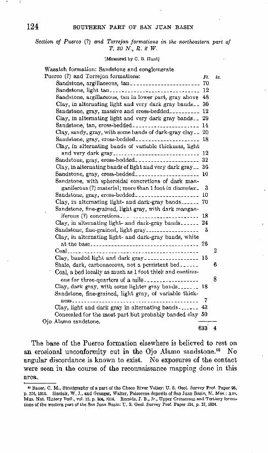
124 SOUTHERN PART OF SAN JUAN BASIN
Section of Puerco (?) and Torrejon formations in the northeastern part ofT. 20 N., R. 2 W.
[Measured by C. B. Hunt]
Wasatch formation: Sandstone and conglomerate. Puerco (?) and Torrejon formations: Ft. in.
Sandstone, argillaceous, tan________________________ 70Sandstone, light tan______________________________ 12Sandstone, argillaceous, tan in lower part, gray above 48 Clay, in alternating light and very dark gray bands __ 30 Sandstone, gray, massive and cross-bedded._________ 12Clay, in alternating light and very dark gray bands __ 29 Sandstone, tan, cross-bedded-_____________________ 14Clay, sandy, gray, with some bands of dark-gray clay__ 20 Sandstone, gray, cross-bedded-____________________ 18Clay, in alternating bands of variable thickness, light
and very dark gray_.___________________________ 12Sandstone, gray, cross-bedded.____________________ 32Clay, in alternating bands of light and very dark gray _ _ 36 Sandstone, gray, cross-bedded.____________________ 10Sandstone, with spheroidal concretions of dark man-
ganiferous (?) material; more than 1 foot in diameter. 3 Sandstone, gray, cross-bedded.____________________ 10Clay, in alternating light- and dark-gray bands______ 70Sandstone, fine-grained, light gray, with dark mangan-
iferous (?) concretions__.________________________ 18Clay, in alternating light- and dark-gray bands. _____ 24Sandstone, fine-grained, light gray._-________--__--_ 5Clay, in alternating light- and dark-gray bands, white
at the base-_-___-_______--_--__--_--___------- 26Coal...__________________________ 2 Clay, banded light and dark gray__________________ 15Shale, dark, carbonaceous, not a persistent bed______ 6Coal, a bed locally as much as 1 foot thick and continu
ous for three-quarters of a mile._______._-___---- 8Clay, dark gray, with some lighter gray bands_______ 18Sandstone, fine-grained, light gray, of variable thick
ness __________________________________________ 7Clay, light and dark gray in alternating bands.____ 43Concealed for the most part but probably banded clay 50
Ojo Alamo sandstone. 633 4
The base of the Puerco formation elsewhere is believed to rest on an erosional unconformity cut in the Ojo Alamo sandstone.60 No angular discordance is known to exist. No exposures of the contact were seen in the course of the reconnaissance mapping done in this area.
60 Bauer, C. M., Stratigraphy of a part of the Chaco River Valley: U. 8. Qeol. Survey Prof. Paper 98, p. 276,1916. Sinclair, W. J., and Granger, Walter, Paleocene deposits of San Juan Basin, N. Mex.: Am. Mus. Nat. History Bull., vol. 33, p. 304,1914. Eeeside, J. B., Jr., Upper Cretaceous and Tertiary forma tions of the western part of the San Juan Basin: U. S. Qeol. Survey Prof. Paper 134, p. 37,1924.

LA VENTANA-CHACRA MESA COAL FIELD 125
WASATCH FORMATION
North of the belt of country underlain by the dull clays of the Puerco (?) and Torrejon formations rises the line of southward-facing cliffs made by the sandstones of the Wasatch formation (pi. 48, B], The line of cliffs was mapped principally by long-distance plane-table intersection and was examined in detail only at the head of Torreones Arroyo. The basal 150 to 200 feet of the Wasatch consists almost wholly of sandstone and conglomerate. To the resistance of this part of the formation is due the development of an almost continuous cliff. Above the basal sandstone lie variegated gray and red clays with a few beds of copper-colored sandstone. The base of the formation rests on an erosional irregularity which may represent an unconform ity, but there is reason to believe that this irregularity does not occur at the same stratigraphic position everywhere. Elsewhere there is apparently a complete transition from Torrejon to Wasatch lithology.
Section of the upper part of the Torrejon formation and the lower part of the Wasatch formation in the central part of T. 21 N., R. 5 W.
[Measured by C. H. Dane]
Wasatch formation: Ft. in. Concealed by detritus to top of cliff, from which are
seen to the north variegated and gray shales, partly concealed, and buff and copper-colored sandstone ledges, partly covered by wind-blown sand._______ 14
Sandstone, white, hard, coarse-grained, cross-bedded, with some grit. Contains pellets and chunks of light-gray sandy clay, Me to % inch in maximum dimension, and irregular concretions 1 to 3 feet long and 1 foot thick of hard purple-gray sandstone flat tened parallel to the bedding.___________________ 19
Sandstone, white, soft, poorly exposed-...__________ 11Shale, dark gray; clay, sandy, light gray; and shale,
brown, carbonaceous-___--___-___--_______-____ 12Grit, gray, poorly cemented-__-_-._---___-_-_-_.__ 2 Sandstone, soft, with many streaks of black soft car
bonaceous material__-___-_--_-_-_-__---________ 10Sandstone, buff and copper-red, with some grit______ 11Shale, gray, sandy; grades laterally to sandstone
within 400 feet in each direction_________________ 20Sandstone and grit, weathering into buff and copper-
red ledges 2 to 20 feet thick, separated by beds of conglomerate 1 to 3 feet thick, which contain so many clay pellets and chunks that they weather down like clay beds and make slopes. The sand stone grades along the strike to conglomerate with pieces of gray shale as much as a foot long. The under surfaces of individual beds are very irregular. Gray clay pellets are scattered through the sand stone. There are some chert-pebble conglomerates in this unit and more grit beds, but most of it is medium to coarse-grained sandstone______________ 50

126 SOUTHERN PART OF SAN JUAN BASIN
Section of the upper part of the Torrejon formation and the lower part of the Wasatch formation in the central part of T. 21 N., R. 5 W Continued
Wasatch formation Continued. Ft. in. Conglomerate and sandstone. The conglomerate con
tains chunks of carbonized wood and pieces of gray shale from 1 inch to 2 feet long and half an inch to 2 inches thick. There are a few pebbles of orange-red clay and a few of granitic igneous rock. Most of the pebbles are purple and gray quartzite; light-gray, dark-gray, and brown chert; pink, yellow, and white quartz; white sandstone; and hard dark-gray shale. These pebbles reach 2 inches in maximum diameter. 20
Erosional irregularity with a relief of 1 foot vertically within less than 1 foot horizontally. This irregularity is continuous along the face of the cliff for at least 500 feet and possibly more and is accepted as the base of the Wasatch. The 8 lithologic units below it, however, dif fer in lithology only slightly from the beds above. As these 8 lower beds appear to be transitional along the outcrop into softer sandstones and shales, they are placed in the Torregon. It appears likely that the Wasatch-Torrejon contact may vary in stratigraphic position from place to place if lithology alone is consid- dered. The irregularity chosen as the base of the Wa satch may possibly represent an erosional unconformity, but there is no evidence for such an unconformity at this place.
Torrejon formation:Sandstone, white, medium-grained, with scattered
grit grains and small pebbles and flakes and chunks of gray clay from #e to % inch in length. Cross- bedded at angles of 10° to 15°. It is soft and weathers into rounded surfaces __ .. 15 6
Clay, sandy, yellowish gray___-_____--_-__-------- 6 6Sandstone and grit with scattered chert pebbles._____ 3Grit, subangular-grained, with many chunks of gray
shale and a few pebbles of gray quartzite % to % inch in diameter._-______--_-__-_---__-_-_-_--_---- 8
Sandstone, white, fine-grained, with scattered grit grains and black carbonaceous pockets half an inch to 1 inch long________..._._._._._____-___.__ 2
Conglomerate. In the lower 3 inches it is mostly gray shale containing rounded quartz and chert pebbles. The upper part contains little shale, and the pebbles are of hard banded gray and white sandstone, white crystalline quartz, purplish and gray quartzite, and soft gray sandstone. The maximum diameter of the pebbles is about 1}_ inches________._____________ 1 2
Sandstone, yellowish white, fine-grained, with pellets and streaks of light-gray and dark-gray clay in the lower 4 inches.________ _______ ._._._.__________ 4
Sandstone, argillaceous, white, soft, poorly exposed_ 15 6 Clay, sandy, gray_.__ -_._.. 11

LA VENTANA-CHACRA MESA COAL FIELD 127
Section of the upper part of the Torrejon formation and the lower part of the Wasatch formation in the central part of T. 21 N., R. 5 W Continued
Torrejon formation Continued. Ft. in. Sandstone, argillaceous, white, fine-grained _-__.-____ 12Clay, dark gray---_____-_-___--___-_--_-_____.___ 2Shale, dark brown..._____.____.________.._.._____ ' 5Sandstone, calcareous, light gray, hard._____________ 6Shale, brown, carbonaceous, thin-bedded, with numer
ous black plant fragments. There are many scat tered subrounded quartz grains 0.01 inch or less in diameter._____________________________________ 6
Clay, dark gray, poorly exposed....-.---.-.._..._._ 8Sandstone, argillaceous, yellow gray, very fine grained- 6 Clay, dark gray; weathers to a slope; surface strewn
with crystalline spherical aggregates of calcite half an inch to 1/4 inches in diameter___-_____________ 26
Clay, sandy, yellow gray, poorly exposed__.__ ._._.__ 5 Clay, sandy, and gray clay, poorly exposed________ 10Clay, red, poorly exposed, variable in thickness._____ 3Clay, sandy, and sandstone, argillaceous.
IGNEOUS BOCKS
In the NEji sec. 29, T. 18 N., R 4 W., four small masses of dark igneous rock rise as low knolls above the level of the sloping wash- covered floor of a minor amphitheater at the head of a group of small dry gully tributaries of Torreones Arroyo. They are roughly alined in a north-northeasterly direction, and a thin dike hi the NW% sec. 32, T. 18 N., R. 4 W., falls into the same line (pi. 52, A). This direc tion conforms in general with the trend of the dikes in that part of the Mount Taylor field east of Mount Taylor and Mesa Chivato.81 The largest of the igneous masses in the Chacra Mesa-La Ventana coal field is an agglomerate plug that rises to a height of about 50 feet (pi. 51, A). The lower third of this height is partly concealed by a roughly conical accumulation of weathered debris about 100 feet in diameter at the base. The agglomerate is exposed nearly to the base of the west side, and on the northeast a white sandstone bed abuts against the plug. The sandstone is soft, apparently not meta morphosed, and only slightly jointed.
The plug consists for the most part of agglomerate or breccia, composed chiefly of rounded grains and pieces of basic rock with an admixture of grains of sedimentary rocks as well as isolated rounded larger pieces more than a foot across. The agglomerate weathers to a rusty-brown color. Some of the rock is highly vesicular, individual vesicles half an inch in length having been observed. Some of the vesicles contain small masses composed of radiating needles of ara-
i Hunt, C. B., Structure and igneous geology of the Mount Taylor volcanic field, N. Mex.: U. S. Qeol. Survey Prof. Paper (in preparation).

128 SOUTHERN PART OF SAN JUAN BASIN
gonite. The rock is interlaced by dikes and stringers of a black- weathering dense igneous rock, some of which contains small pheno- crysts of feldspar. Most of the xenoliths, which are more than half an inch in diameter, are of sandstone of several lands, gray or white and mostly fine-grained. The largest xenolith noted is more than 1 foot in maximum dimension. It is chiefly fine-grained white sand stone, with a few flakes and stringerlike beds of red clay, but includes at the base a layer of dark-red clay about an inch thick (pi. 51 ,B). There are many xenoliths of greenish-gray and gray sandy clay. One xenolith of conglomeratic type was seen. This was a coarse gray sandstone, in part almost a grit, with some pebbles of gray clay and two pebbles of reddish-gray calcareous sandstone. In this grit was found a chunk of red platy crystalline calcite 1 % inches across and a few other pebbles of reddish-gray calcareous sandstone. One small xenolith less than half an inch in length consists of petrified wood. R. W. Brown reports that the specimen shows clearly the vessels characteristic of dicotyledonous woods. As, so far as he knows, no undoubted dicotyledons have been reported from the Morrison for mation, it appears that the wood fragment is not older than Dakota and may have been derived from some horizon in the Mesaverde. Rocks similar to most of the xenoliths described above have not been observed by the writer in the underlying beds of the Mesaverde formation, nor in the Mancos shale or Dakota (?) sandstone. If they represent rocks of the Morrison formation or older beds they have been transported upward through a stratigraphic thickness of at least 3,500 feet.
A thin section of the dense intrusive material shows that the rock is an augite andesite, the principal phenocryst constituent of which is a plagioclase feldspar (calcic andesine, or sodic labradorite). Augite isthe principal ferromagnesian mineral, but there are several olivine phenocrysts. The groundmass is cryptocrystalline but has abundant very small feldspar laths. Scattered through the section are several rounded grains of quartz, which are probably foreign inclusions derived from sedimentary rocks penetrated by the magma. The thin section also shows a darker finer-grained patch, which is probably a fragment of andesite that solidified elsewhere, was broken off, and was transported as an inclusion into its present position.
The thin section of the agglomerate or breccia examined is greatly altered. It consists largely of rounded fragments of previously solidified andesite in a groundmass that consisted originally of highly vesicular glass but is now wholly altered to chloritic material. There are scattered grams of quartz and microcline, which are almost cer tainly derived from the breakup of sedimentary rocks through which the plug rose. Some included calcite may have been similarly derived

LA VENTANA-CHACRA MESA COAL FIELD 129
from calcareous sediments, but some of the calcite has the crystal form of olivine and was formed by the alteration of that mineral. Some of it also has probably replaced augite.
The small igneous mass about 300 feet northeast of the agglomerate plug consists of vesicular dark igneous rock shot through a zone about 10 feet wide in stringers and lenses. Horizontally bedded sandstone is apparently continuous around this intrusion on the northeast side, but 100 feet farther north a "dike zone" about 4 feet wide, trending in a northeasterly direction, cuts through the sandstone. This "dike zone" is mostly soft, much-jointed sandstone abundantly streaked with subparallel stringers and lenses of vesicular igneous rock. The zone cuts a coal bed of poor quality and cokes it for a width of an inch away from the contact but apparently slightly hardens the coal for 1 foot from the contact. Above the coal bed the sandstone at the edges of the "dike zone" is darkened to a gray color for a few inches away from the contact, probably by the addition of carbonaceous material. About 150 feet southwest of the larger agglomerate plug is a smaller igneous mass, mostly a dark dense dike rock but in part a breccia of rounded grains and chunks of basic igneous rock with only a few xenolithic inclusions of sandstone. The fourth mass of the group is a dike of dense igneous rock a few feet wide. It is traceable for about 50 feet along the strike. No extrusive material was observed associated with any of the masses.
Some of the vesicular rock is definitely intrusive, and the vesicular nature of the groundmass of the agglomerate is therefore not indica tive of its origin as an extrusive rock. The plug may have reached the surface at some point higher than the present exposures, but any evidence of such extrusion has of course been destroyed by erosion. From the small size and discontinuity of the dike and dikelike masses and from the nature of the "dike zone", which consists of thin stringers of igneous rock through sandstone, it seems likely that the exposures now visible are near or at the upper limit reached by the intrusion.
The igneous rocks described above conform in lithology and mode of occurrence to the necks and volcanic rocks of the Mount Taylor region, 62 and they are to be considered the northernmost exposures of the igneous rocks of that region. Mount Taylor and its associated necks of the Rio Puerco Valley have most recently been described by Hunt. 63
M Dutton, O. E., Mount Taylor and the Zufii Plateau: U. S. Qeol. Survey 6th Ann. Kept., pp. 105- 198,1885. Johnson, D. W., Volcanic necks of the Mount Taylor region, New Mexico: Qeol. Soc. America Bull., vol. 18, pp. 303-324, 1907.
63 Hunt, C. B., Geology and fuel resources of the southern part of the San Juan Basin, N. Mex., pt. 2, The Mount Taylor coal field: U. S. Qeol. Survey Bull. 860-B, pp. 36-66, 1936; Structure and igneous geology of the Mount Taylor volcanic field, N. Mex.: U. S. Qeol. Survey Prof. Paper (in preparation).
130 SOUTHERN PART OF SAN JUAN BASIN
GEOLOGIC STRUCTURE
METHODS OF REPRESENTING STRUCTURE
The beds of sedimentary rock making up the succession of forma tions were originally deposited in an approximately horizontal posi tion. Subsequent earth movements have tilted, warped, or folded them and broken them along surfaces of dislocation called "faults", with a resulting displacement of originally continuous beds. Their present attitude, called the "geologic structure", is not to be con fused with the irregularities of the land surface on which the beds crop out. The structure is indicated partly by dip and strike sym bols. These show the strike, or direction in which there is no in clination of the bed, and the dip, or direction of maximum inclina tion. The amount of the dip is expressed in degrees. The dips in this field are for the most part low, and the structure is most vividly portrayed by the structure-contour map (pi. 39). Structure con tours are lines on a selected bed that connect all points of equal altitude on that bed. As the formations exposed in the area, with the exception of the uppermost rocks, are conformable or lie parallel with one another, the structure of all the beds is represented by lines drawn at a single horizon. The key horizon chosen is the base of the Hosta sandstone member of the Mesaverde formation, which is exposed at the surface in the Rio Puerco Valley. The contours are drawn at intervals of 100 feet, the figures representing heights above mean sea level. Where the contours are widely spaced the inclina tion of the beds is low; where they are more closely spaced the in clination of the beds is correspondingly steeper. In part the spacing and position of the contours were determined by observations of the dip of beds at the surface. In larger part the location of the con tours is based upon altitudes taken at known stratigraphic horizons and the intervals to the key horizon beneath, these intervals being determined from measured thicknesses of the several formations.
In the eastern parts of Tps. 19 and 20 N., R. 1 W., the dips of the beds are so steep that the depiction of the structure by contours would be very difficult even with more data on altitude of strati- graphic horizons than have been obtained. The structure of this part of the area is therefore shown only by dip and strike symbols.
For several reasons the contour map is not an accurate repre sentation of the structure. As the altitudes were taken largely on formation contacts higher than the key horizon, the stratigraphic interval to that horizon had to be subtracted from the altitude determined, to ascertain the altitude on the key horizon. But as for the most part the formations crop out in comparatively narrow belts along the strike of the beds, information on the variations in the stratigraphic intervals across the strike is not available. In the extreme eastern part of the area, where these variations are exposed

U. S. GEOLOGICAL SURVEY BULLETIN 860 PLATE 49
37> L IDS' O
(Information not sufficient
for contouring middle
part of basin.)
MAP SHOWING STRUCTURE OF THE NEW MEXICO PORTION OF THE SAN JUAN BASIN.Contours adjustcci to the lop of the Dalton sandstone member of the Mcsaverde formation.
54825 36 (Face p. 130)

U. S. GEOLOGICAL SURVEY BULLETIN 860 PLATE 50
A. NORMAL FAULT DROPPING SANDSTONE BEDS OF THE MESAVERDE FORMATION TO THE EAST, AS SEEN FROM THE SEJ4 SEC. 36, T. 19 N., R. 2 W.
Looking east of north. The uppermost, more distant sandstone is the basal part of the La Ventana sandstone member. The lower sandstones He at the top of the Gibson coal member.
B. MESAVERDE FORMATION IN THE SEJ4 SEC. 35, T. 21 N., R. 1 W.
View toward the south. The middle member of the Mesaverde is on the east (left) and extends west beyond the horseback rider; the upper sandstone member occupies the hill at the extreme right- The beds here are almost vertical. Photograph by B. C. Renick.

TJ. S. GEOLOGICAL SURVEY BULLETIN 860 PLATE 51
A. PLUG OF DARK IGNEOUS HOCK IN THE NKi4 SEC. 29, T. 18 N., R. 4 W.
Intruded through the shales and sandstones of the Allison member of the Mesaverde formation. Pho tograph by W. G. Pierce.
B. XENOLITH OF WHITE SANDSTONE AND BED SHALE AND SMALLER XENOLITHSIN THE PLUG OF BASIC AGGLOMERATE IN THE NEJ4 SEC. 29, T. 18 N., R. 4 W.
Scale by geologic hammer.
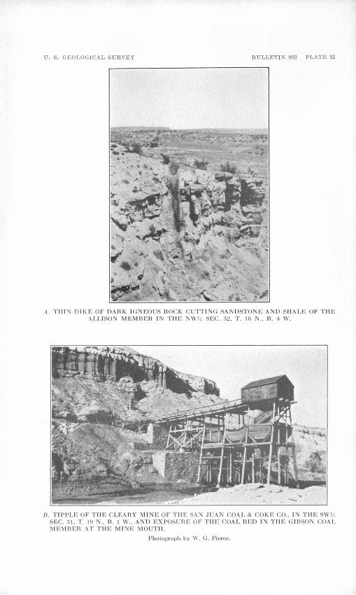
U. S. GEOLOGICAL SURVEY BULLETIN 860 PLATE 52
A. THIN DIKE OF DARK IGNEOUS ROCK CUTTING SANDSTONE AND SHALE OF THE ALLISON MEMBER IN THE NW}4 SEC. 32, T. 18 N., R. 4 W.
B. TIPPLE OF THE CLEARY MINE OF THE SAN JUAN COAL & COKE CO., IN THE SWJ4 SEC. SI, T. 19 N., R. 1 W., AND EXPOSURE OF THE COAL BED IN THE GIBSON COAL MEMBER AT THE MINE MOUTH.
Photograph by W. G. Pierce.

LA VENTANA-CHACEA MESA COAL FIELD 131
from south to north, there is a northward thinning of the Allison member and the Gibson coal member. Similar variations are proba bly present elsewhere but cannot be evaluated. Also the thicknesses of the formations were not determined with the accuracy desirable, because the beds are poorly exposed and for the most part crop out over wide areas where vertical sections cannot be measured.
Farther west, according to Dobbin,64 the stratigraphic interval from the base of the Chacra sandstone to the base of the Hosta sandstone is 2,300 feet, but near the Rio Puerco and in the eastern part of the area contoured on plate 39 the same interval is estimated by the writer to be 1,800 feet. In the construction of the contour map this interval was assumed to be 2,100 feet along the western edge of the area, diminishing to 1,800 feet in T. 18 N., R. 4 W.
The traces of the faults as shown on the contoured horizon are projected vertically from their position on the surface, the inclination of the fault surfaces being neglected.
STRUCTURE OF SAN JUAN BASEST
The area described in the present report lies in the southeastern part of the San Juan Basin, in which the beds have been broadly warped into the shape of a shallow bowl. The outline and shape of the basin and the location of this area with reference to the basin are shown in plate 49. In the central part of the basin the beds are nearly horizontal, but toward the margins and the surrounding moun tain uplifts they are tilted up to varying degrees. The uplifts on the north, east, and west sides of the basin have turned up the adjacent strata rather steeply, but toward the south the beds rise gently toward the Zuni Mountain uplift. On each side of this uplift, however, large synclinal depressions extend southward as extensions of the San Juan Basin. In a general way the area of this report may be regarded as lying across the northern and more shallow portion of the broad syncline that extends southward on the east side of the Zuni Mountains.
STRUCTURE OF AREA DESCRIBED IN THIS REPORT
The eastern margin of the San Juan Basin in this field is formed by the steeply dipping flank of the Nacimiento Mountain uplift. Renick 6S has shown that this uplift is bordered on the west by a major zone of faulting, locally complex but forming an overthrust. This has a maximum stratigraphic displacement of 3,500 feet and a movement westward of older rocks over younger rocks to a distance of at least 1 mile in T. 23 N., R. 1 W. This thrust passes through
M Dobbin, C. E., Geology of the Ilospah-Seven Lakes-Stony Butte region (unpublished manuscript). M Renick, B. C., Geology and ground-water resources of western Sandoval County, N. Mex.: U. S.
Geol. Survey Water-Supply Paper 620, pp. 71-74,1931.
132 SOUTHEEN PART OF SAN JUAN BASIN
the eastern tier of sections of Tps. 19 and 20 N., R. 1 W. Renick believes that the overthriistwas initiated as a fault with the upthrow on the east, but as compressive forces were operating within the earth's crust a horizontal component of force as well as the vertical component was present. Therefore, when the pre-Cambrian granite and the relatively small amount of overlying sedimentary rocks caught with it on the upthrown side of the fault were uplifted so that they came into contact with the soft Cenozoic, Mesozoic, and Paleozoic shales and sandstones, the pre-Cambrian mass on the east side of the fault was rigid and the younger sedimentary rocks on the west side were incompetent and relatively much more easily deformed. The pressure resulting from the compressive stresses within the crust was no doubt released in the direction of least resistance that is, toward the sedimentary rocks on the west and the granite moved westward over the sedimentary rocks.
In the northern part of T. 20 N., R. 1 W., the Dakota (?), Mancos, and Mesaverde formations dip steeply or are overturned toward the east (pi. 50, B} in response to the same compressive stress that pro duced the Sierra Nacimiento overthrust. The compression has appar ently been so severe that thrusting along the bedding planes within the Mesaverde has locally eliminated parts of the formation. The La Ventana sandstone is believed to be missing in part of sec. 14, T. 20 N., R. 1 W., for this reason, and the Hosta sandstone is perhaps absent in the southern part of sec. 35, T. 21 N., R. 1 W., because of similar thrusting. The mapping was not sufficiently detailed to indicate these probable faults on plate 39. Westward the dip of the beds diminishes rapidly, and in the western part of T. 20 N., R. 1 W., it is westward and northwestward at low angles.
In the southernmost part of T. 20 N., R. 1 W., and in T. 19 W., R. 1 W., the dip of the Dakota (?) sandstone is steep toward the west, and there are no overturned dips. In the southwestern part of T. 19 N., R. 1 W., the beds are warped into a shallow syncline plunging northwestward, although to the northwest the dip is regularly north westward at a considerably steeper angle. An anticline, called by Renick 66 the "La Ventana anticline", plunges northwestward in the northwestern part of the Ojo del Espiritu Santo grant but also merges into a regular but steeper northwest dip in the southeast quarter of T. 19 N., R. 2 W., although a broader anticlinal warping is shown by the contours in the eastern part of T. 18 N., R. 2 W. Four faults trending northeastward, principally in the southwestern part of T. 19 N., R. 1 W., are apparently the result of tensional stresses that devel oped where the La Ventana anticline and the shallow syncline north east of it merge with the steeper northwestward-dipping rocks. The maximum throw of each of these faults is more than 50 feet, but no throw as much as 100 feet was found. The most westerly of the faults
" Renick, B. C., op. cit., p. 75.

LA VENTANA-CHACRA MESA COAL FIELD 133
drops the beds to the southeast (pi. 50, A], but the other three drop the beds to the northwest.
The regional northwesterly dip west of the Bio Puerco grades into a broad anticlinal nose, which plunges northwestward through the northeastern part of T. 19 N., R. 3 W. West of this anticline is a broad structural terrace, with the rocks dipping very gently north ward in T. 19 N., R. 4 W., but more steeply northward in T. 18 N., R. 4 W. In the western part of T. 18 N., R. 4 W., a narrow anticline plunges northward. It is cut by two faults, which intersect in the NW% sec. 19. The intersection is not exposed, but there is good out crop evidence of the faults on each side of the intersection. No offset was found, because of cover, and hence the relative ages are not known. The northeastward-trending fault has a maximum throw of 120 feet. The northwestward-trending fault has a throw of at least 90 feet and dips 70°-75° N.
West and northwest of T. 18 N., R. 4 N., the beds dip north-north eastward with but little variation. They are, however, broken by nearly twenty faults of small throw, almost all of which drop the beds to the north. The largest of these faults extends for more than 5 miles in a direction somewhat north of east through the northeastern part of T. 18 N., R. 7 W., into the southwestern part of T. 19 N., R. 6 W. The greatest known throw is 140 feet, down to the north, in the NW% sec. 6, T. 18 N., R. 6 W. The fault surface dips 52°-68° N. This fault drops the Pictured Cliffs sandstone against the Chacra sand stone member of the Mesaverde formation (pi. 46, A). The sand stone is slickensided and brecciated in a zone locally as much as 5 feet wide, but in most places the zone is narrower. Another fault of note worthy displacement extends for a known distance of 4 miles in a northwesterly direction from the NW% sec. 35, T. 18 N., R. 5 W. (unsurveyed), into sec. 24, T. 18 N., R. 6 W., displacing the Chacra and Allison members of the Mesaverde formation. This fault has a throw of 83 feet, down to the north, in the SE^ sec. 19, T. 18 N., R. 5 W. (unsurveyed), and the fault surface dips 53° N. In the SW% sec. 27, T. 18 N., R. 5 W. (unsurveyed), the throw is 115 feet.
In T. 19 N., Rs. 7 and 8 W., the curve of the structure contours convex to the north represents the northward termination of the Hospah anticline,67 which gradually merges with the regional north eastward dip.
In T. 20 N., R. 9 W., the Chacra and Allison members of the Mesa verde formation are broken by two faults, in the vicinity of which the beds are irregularly folded. The largest fault enters the township from the west and extends somewhat north of east for 4 miles. For most of its length this fault crosses the heterogeneous beds of the
« U. S. Geol. Survey, Preliminary map showing geologic structure of the southern part of the San Juan Basin. N. Mex., 1933.

134 SOUTHERN PART OF SAN JUAN BASIN
Allison member and is not readily traceable, but the throw is appar ently as much as 200 feet down to the north. In the north-central part of sec. 22 this fault is joined at an acute angle by a fault trending N. 60° E. The southwestward extension of the latter fault into sec. 31 as shown on the map is uncertain, for its trace crosses the Allison member.
In sec. 21, T. 21 N., R. 8 W., there is a short anticline trending east, with dips of 3° to the north of the axis and 5° to the south of it, close to a normal fault that drops the beds to the north. This anti clinal fold is in the soft beds of the Kirtland and Fruitland formations, and the evidence obtained was insufficient to warrant representing it as a closed fold. The fault south of the anticline, which extends for more than 2 miles in a general east-west direction, has a throw of about 50 feet, and the fault surface dips 62° N.
AGE OF DEFORMATION
Most of the faults are clearly associated with folds and are evidently the reflection of local strains induced during the yielding by folding. There are two fairly well defined systems of faults one in the western part of the area, having a more or less east-west trend, and another in the eastern part, having a trend somewhat east of north. The fault intersection in sec. 19, T. 18 N., R. 4 W., is not exposed, and the throw of the faults that intersect is so small that no offset was ob served. The evidence of relative age of the faults which such off setting might furnish is also lacking in the more abundantly faulted area to the south studied by Hunt,68 although his maps show more clearly a nearly east-west system of faults and another system of faults trending somewhat east of north, only the latter set breaking the rocks to the east of Mount Taylor.
Within the area studied there is little direct evidence of the age of deformation. The youngest beds present, those of the Wasatch formation, appear to have been deformed, although the nature of the exposures is such that it cannot be said whether the more acute folding in the Cretaceous beds than hi the Tertiary beds is the result of some disturbance that preceded the deposition of the Tertiary or whether it is the result of gradual increase of folding toward the mar gins of the basin. Gardner 69 considered that the Wasatch truncated the upturned outcrop of all older formations and rested almost hori zontally against the crystalline rocks of the Nacimiento Mountains between Gallina and Nacimiento [Cuba]. Renick's more detailed work, however, shows that the Wasatch, like the underlying forma
ts Hunt, C. B., Structure and igneous geology of the Mount Taylor volcanic field, N. Mex.: U. S. Geol. Survey Prof. Paper (in preparation).
" Gardner, J. H., The Puerco and Torrejon formations of the Nacimiento group: Jour. Geology, vol. 18, pp. 720-721, 1910.

LA VENTANA-CHACRA MESA COAL FIELD 135
tions, dips westward at a high angle.70 Although there is apparently some reason to believe that there -is a stratigraphic hiatus between the Torrejon and Wasatch formations in the southern part of San Juan Basin,71 the writer has observed no angular discordance between them. There was certainly, however, regional uplift and deforma tion of the San Juan Mountain region during the transition between the Cretaceous and Tertiary, and the general outlines of the San Juan Basin may have been established during this time. Reeside 72 con cludes that the folds that now delimit the north and west sides of the basin probably began to form after the deposition of the McDermott formation (which was later than the Kirtland shale and preceded the Ojo Alamo sandstone), though the movement continued at later times. There is no direct evidence that the southeast side of the basin began to develop at this time, although it seems inherently probable. The principal deformation that produced the eastern margin of the basin and the major structure of the Nacimiento Mountains occurred after the Wasatch formation had been deposited. Renick 73 states that this deformation affected the Santa Fe formation, regarded as of Miocene and Pliocene age, but not the late Tertiary basalt and rhyolite. Hunt,74 however, has shown that most of the deformation of the Cretaceous beds in the block-faulted portion of the Rio Puerco Valley occurred before the deposition of the Santa Fe, and that the movement ceased shortly after the lowest beds of that formation were laid down.
COAL
DISTRIBUTION
Thin coal beds of small lateral extent occur in the Kirtland shale and the Puerco (?) formation. Coal of present or possible future economic value occurs in the Fruitland formation and in various members of the Mesaverde formation.
The coal beds of the Fruitland formation are found at several horizons but chiefly in the lower or middle part of the formation. It has been shown that the coal beds in the Fruitland decrease in extent, number, and thickness from the San Juan River southward,75 and this decrease continues southeastward and eastward in the area
'» Renick, B. C., Geology and ground-water resources of western Sandoval County, N. Mex.: U. 8. Geol. Survey Water-Supply Paper 620, p. 55, 1931.
" Reeside, J. B., Jr., Upper Cretaceous and Tertiary formations of the western part of the San Juan Basin of Colorado and New Mexico: U. S. Geol. Survey Prof. Paper 134, p. 53, 1924.
" Idem, p. 52.» Renick, B. O., op. cit., p. 77.?4 Hunt, C. B., Structure and igneous geology of the Mount Taylor volcanic field, N. Mex.: U. S. Geol.
Survey Prof. Paper (in preparation).« Bauer, C. M., and Reeside, J. B., Jr., Coal in middle and eastern parts of San Juan County, N. Mex.:
U. S. Geol. Survey Bull. 716, p. 177, 1921.

136 SOUTHERN PART OF SAN JUAN BASIN
covered by the present report. In the eastern part of the area the Fruitland contains little coal. In the western part the coal beds of the Fruitland are lenticular and are variable in purity and thickness. Most of them are thin, but locally coal beds of considerable thickness are present. Their value may, however, be diminished by numerous partings or by the presence of a large admixture of incombustible material, which would reduce the heating value and increase the ash content. The coal beds of the Mesaverde formation are found in the Chacra sandstone, at several horizons in the thick assemblage of beds somewhat arbitrarily included in the AUison member, and in the Gibson coal member. The Chacra sandstone lies at the top of the Mesaverde in the western and south-central parts of the area and is largely of marine origin. In a small portion of its outcrop, however, along the frontal cliff of Chacra Mesa in T..19 N., Rs. 7 and 8 W., there are several coal beds. Immediately beneath the Chacra sandstone, at the top of the Allison member of the western portion of the area, there is a persistent zone of carbonaceous shale in which there are local coal beds. In T. 18 N., Rs. 2, 3, and 4 W., coal beds are found at several horizons within the Allison. At a lower horizon still, just below the La Ventana sandstone member and at the top of the beds assigned to the Allison member along the Rio Puerco, the thickest and most persistent coal bed of the region crops out. (See pi. 43, A.) There are also several coal beds, some of considerable thickness, within the Gibson coal member of the Mesa verde formation. The distribution of coal beds in the several forma tions is shown approximately in plate 41. In general, the coal of the Mesaverde is lenticular, but some beds are of sufficient extent, thickness, and purity to make them suitable for mining.
The coal beds of both the Fruitland and Mesaverde formations have been burned hi many places, with the formation of ash, clinker, or baked red shale or pink sandstone. The burning haw locally been extensive but in most places is not believed to have penetrated deeply under cover. Burning of the coal was observed to be in progress hi 1928 in Fruitland coal in sec. 11, T. 19 N., R. 6 W., and in Mesaverde coal in sec. 31, T. 18 N., R. 4 W.
All the coal beds are highly lenticular, and many beds extend for less than 1,000 feet along the outcrop (fig. 3). This lenticularity in part represents the original limits of the swampy depressions in which the coal-forming material accumulated. In part, it is the result of trenching by streams, in the channels of which sand was subsequently deposited (pi. 45, A). Both these types of termination of coal beds are illustrated by figure 3, which also illustrates the rise of a coal bed in the stratigraphic section. As a result of similar stratigraphic variation, the intervals between coal beds vary from place to place. Such variation may be due to irregular warping dur-

LA VENTANA-CHACRA MESA COAL FIELD 137
ing deposition. In part also it may be due to the differential compac tion of the varied types of sediments in which the coals are embedded.
Because of the excessive lenticularity of the coal, no attempt has been made to estimate either the total quantity of coal beneath the surface or the amount available as a minable reserve. If such an estimate were to be made it would have to take into consideration the relation of the coal beds to the stratigraphic variations in the Mesaverde formation. For example, the bed of coal beneath the La Ventana sandstone along the Rio Puerco diminishes in thickness southward along the outcrop and is of small value in the southwestern part of T. 18 N., R. 2 W., where the La Ventana sandstone has merged laterally with continental beds assigned to the AUison forma tion. The presumption is that the coal bed may be expected to be of valuable thickness only beneath the La Ventana sandstone and its extension under cover in a northwesterly direction for an unknown
EXPLANATION
Coal Bony Carbonaceous Shale coal shale
Sandy Sandston^. shale
FIGURE 3. Cross section showing relations of coal beds between localities 127 and 129, In the southeasternpart of T. 18 N., R. 2 W.
distance. Similarly, the coals in the upper part of the Allison in T. 18 N., Rs. 2, 3, and 4 W., may be expected to extend northwestward or northward in a strip of about the same width as shown on the outcrop. The discontinuous coal at the base of the Chacra sandstone along the frontal escarpment of Chacra Mesa appears to lens out northeastward beneath the Chacra sandstone. This fact and the distribution of the coal within the Chacra sandstone in T. 19 N., Rs. 7 and 8 W., suggests that these coal beds may not extend far under cover to the northeast. No valuable coal beds were observed in the Chacra sandstone north of the frontal escarpment.
CHARACTER
PHYSICAL, PROPERTIES
The coals of the Mesaverde and Fruitland formations are similar hi character. Both are hard black sub-bituminous coal of fairly good grade, although some beds have a high ash content. The coal contains in many places an abundance of woody charcoal fragments and locally also many small irregular clear reddish-yellow lumps and grains

138 SOUTHERN PART OF SAN JUAN BASIN
of fossil resin. The coal is brittle and breaks readily along joint planes, but when carefully handled a good recovery of lump coal may be obtained. From March 1928 to March 1929 the production of the Cleary mine of the San Juan Coal & Coke Co. ran about 38 percent lump coal, 40 percent nut coal, and 22 percent slack. Subbituminous coal, owing to its high moisture content, breaks down or "slacks" on exposure to weather, with a resultant diminution in heating value. This is a conspicuous feature of the coal of this area, and the deteriora tion of the coal on exposure to weather may be gaged by comparing analyses 96547 and A46367, which were made on somewhat weathered coal, with the analyses of coal samples cut from a freshly exposed mine face at some distance underground. However, the coal stocks fairly well when protected from exposure. The coal that has been mined has been shipped in open cars. In general, the coal is a satisfactory steaming coal. Its coking properties are not known, but attempts to coke the similar coal of the Gallup district have not met with success. 78
CHEMICAL PROPERTIES
The accompanying table shows 12 analyses of coal from this area and 3 analyses of other coals for comparison. With the exception of analysis 2464, these were made at the Pittsburgh laboratory of the United States Bureau of Mines. All the samples were obtained by the regulation method prescribed by the Geological Survey and the Bureau of Mines, which involves "selecting a representative face of the bed to be sampled; cleaning the face, making a cut across it from roof to floor, and rejecting or including impurities according as these are included or excluded in mining operations; reducing the gross sample, by crushing and quartering, to about 4 pounds; and immedi ately sealing the sample in an airtight container for shipment to the laboratory." 77
The proximate analysis, which is given for all the samples, indi cates the percentages of moisture, volatile matter (gases), fixed carbon, ash, and sulphur and the heating efficiency in British thermal units. The ultimate analysis, which shows the percentages of the actual elements composing the coal, is a more complex and expensive process and has not been made for all the samples.
The analyses are given in three forms, A, B, and C. Form A repre sents the sample as it comes from the mine; in a general way this shows the condition of the coal as it reaches the consumer. Form B is obtained by computation and represents the coal after all moisture has been theoretically eliminated. Form C is also computed and rep resents the coal after both moisture and ash have been theoretically removed.
» Sears, J. D., Geology and coal resources of the Oallup-Zuni Basin, N.Mex.: U. S. Qeol. Survey Bull. 767, p. 34,1926.
» U. S. Bur. Mines Bull. 22, p. 8,1913.

Ana
lyse
s of
coa
l fro
m t
he L
a V
enla
na-C
hacr
a M
esa
and
othe
r fi
elds
Sour
ce
Do.
.
0
base
of
C
hacr
a sa
nd
ston
e m
embe
r).
Do...
Alli
son
mem
ber
of M
esa-
ve
rde
form
atio
n (b
elow
base
of
L
a V
enta
nasa
ndst
one
mem
ber)
.
Do
.
Do..
.. ..
. ..
.
Do..- ..
... .
.. ..
..
Min
e
Pro
spec
t dr
ift,
near
por
ta
l.
.do..
.
d
o.-
Sam
pler
and
dat
e of
sa
mpl
ing
1905
C.
M.
Bau
er,
19
15
....
..d
o- ..
.
C.
C.
Mat
her,
19
26
C.
C.
Mat
her,
193
1
C.
C.
Mat
her,
' 19
30
...
Loc
atio
n
<D Of
sw.
NW
.
NE
.
SE
.
SE
.
SE
.
SE
.
a X 03
4 11 14 19 35 35 35 35
o. JS a 0 9Q 19 >! 18 19 19 19 19
a 15 6 5 2 2 2 2
o (3 0
.0 03
A23
141
2300
4
A45
560
A46
367
A23
139
A75
538
A64
268
« o a >> a < A
K.
2 1
4 S
5.1
3 4
5 2
CO "3 p CO o E 0 A B 0 A B C A B O A B C A
B 0 A B C A B r, A B 0
Pro
xim
ate
anal
ysis
D 9 9
11
9,
....
14 4
13
fi
--._
14.8
Ifi
3
....
18
3
20 0
a! 15 «
<s 38.4
49
7
4S
1
40.0
45.1
48.2
34.8
40.7
44.6
36.2
41.9
45.9
33.9
39
.845
.1
32.6
38.9
42.6
33.9
41
544
.1
32.5
40.7
45.5
a o £1 1 8 5 41.5
Afi
ft
43 0
48:4
51.8
43 3
50.5
55.4
42.6
49.3
54.1
41.4
48
.654
.9
43 8
52.4
57.4
43 0
52 6
5.5 9
42 f
i53
. 254
.5
Ult
imat
e an
alys
is
a < 10.2
11.3 5.8
6.5
7.5
8.8
7.6
8.8
.. 9.9
11.6
----
-- 7.3
8.7
----
-- 4.8
5.9
4.9
6.1
o. 3
03
0.64 .71
.80
.5 .5 .6 1 54
1 80
1.97 1
11.
31.
4
1.2
1.4
1.6
1,3
1.5
1.6 ,7 ,9 1,0 .7 .8 9
a to
o a H 5.9
5.3
5.6
----
-
49
3.9
4.3
5.5
4.5
5.1
5.9
4.9
5.4
fi 4
5.3
a 43
O 64.2
72.3
77.3
53.1
61.5
67.4
52.8
62
.070
.2
60.0
71.7
78.5
58.6
73.2
S? o I* * 1.3
1.4
1.5
1 3
1.5
1.7
1.1
1.3
1.4
1 1
1.3
1.4
1 1
1.4
uo
;>. 0 22.3
14.0
15.0
32.0
23.0
25.2
29.5
19
.221
.7
24.4
11.9
13.1
28.3
13.2
I9)
O
C3 *
*
t£S3
is B
w -11,
300
14, 1
40
11,3
6012
,800
13,6
90
10,2
2011
,940
13, 0
90
8,66
010
, 030
10, 9
90
8,91
0 10
, 460
11,8
40
10, 4
3012
,460
13,6
50
10,6
3013
,000
13,8
20
10,2
4012
,790
13.6
60
CO
C
O
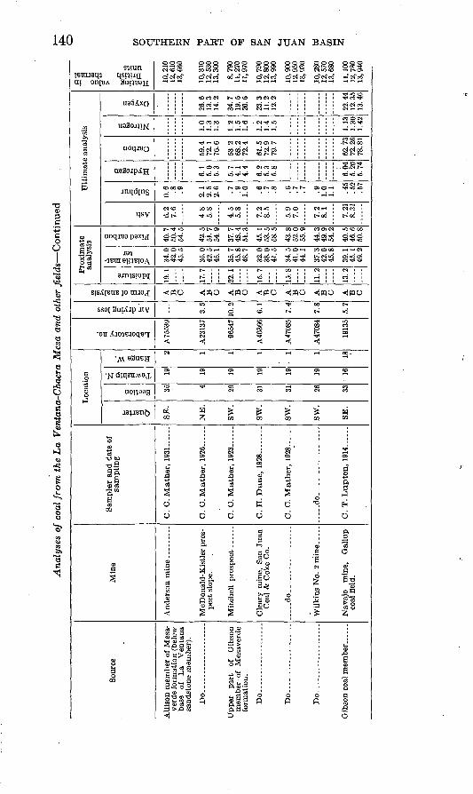
Gibson coal member _ ..
Navajo mine, Gallup coal field.
O
C
OpCO
F
a0
1Jl
to3.3t>
3
d >o 0 111 o 1111 0 « II"1 ? g-^g-D
SZV ! gS-S-B PoE i §^g|
I2- i 1*11* ST ' ^ » ~ CD
§ if 'i !l ^* 2- w o
op ^ J? (S"^ ° * WCD Q3 *§ S*
^'s1 r ^ S : ?o p p p o td P Pts1 i t t^ ^§ 0 § g o p p p + 0 ci- c^-3* <» KJ* d* D " CD CD 1 t_^ H i"t
H- ^
§ * § I
(M CD CO CO CD ^
Anderson mine ... -....
C. C. Mather, 1931 -
CDW
8 8 S 82 g -g
5 £ co co CD co
00 ** K4 I-. 1-. W
t-» >fr. >fr. »fr. CD to
CO
to
A.75539
Cn M M OS O CO t-j 00 *u H1 to en i
aw> ow> au> ow> ow> owo ow>>1 l CO
i ' bO
lfr.lfr.CO CO en COto<- p->
g£o-
00 O Cn
i' <*-*i CO tO
Cn Cn tfr. -J to en
cncnenMtOO"*»ov>&
<I M Cspo to toOObO~J(-* CJ> CO
feow
co to to
'1~* ' ' C^ iiCfl iifcO i i -<|
to iiOo i ! <i .Ik- 11^1
rf^rf^CO ^.^-CO rf^CCOO rf*.^CO rf*. rf*. CO Cn bO M i& i 4^. h- 00 60 00 Cn Cn Cn to Cn
OOOW i O Cn OiOO *JOO*q (- tn O
Sfefc SSS SSft 2£3 S2-febococo coooo eneni- co,fr.-a covien
00 M <! Cn i 00 ~4 i Cn tfr. i en tfr.f bO O CO i Cn to i OOCn I 0000
ft-' >-* bOtO tO
i-oco -i-!c» oo-jo> OCD-J rocnh-
1
]i
CnCnCA .tfr.(fr-Cn cnenen00 CO bO ifr.l-'-J COO*-'
I i cotoi-'tooocoaibocoi i ^3COCn »fr.bObO Ol-1>fr'
; ;
] ]
Cn ifr- to ' ClCntO CO CO O
»-») 'tO bO*-'CO h-t-«bObo >-' co o co »fr. tfr- co oito to co 01 en M tocoo
' ?°
J> bO ffr.
inoO
gss Cn *-^l
-JOJ
a> to
oco oo en
1
i
i!
CObOl-'
lisCOtOO COtOO CObOO l h-OO CObOO
§ii in §§i §i§ inCO bOO
5oo
J
COo
§
oas
Sampler and date of sampling
Quarter
Section
Township N.
Range W.
Location
Laboratory no.
Air drying loss
Form of analysis
Moisture
Volatile mat ter
Fixed carbon
Ash
Sulphur
Hydrogen
Carbon
Nitrogen
Oxygen
Proximate analysis
Ultimate analysis
Heating value in British thermal units
p§
a5>-
O o
Nisva Nvnf NVS ,10 JLKVJ

LA VENTANA-CHACKA MESA COAL FIELD 141
2464. Section: 78 Coal, 2+ feet; shale, 6 in.; coal,* 2 ft. 1 in.; shale and bone, 7 in.; coal,* 4 ft. 6 in.; shale, 2 in.; coal, 6 in.; shale, 1 in.; coal, 5 in.; shale, 1 in.; coal, 1 ft. 2 in.; bone, 3 in.; coal,* 3 ft. 6 in.; shale, 1 in.; coal,* 2 ft.; shale.
A23141. Section: Sandy shale, 1 ft. 3 in.; coal with shale beds and partings, 6 ft. 8 in.; sandstone and shale.
23004. Section: Sandstone; bone, 2 in.; coal,* 2 ft. 8 in.; bone, sandy, 6 in.; coal,* 1 ft. 7 in.; shale, carbonaceous, 2 ft. 6 in.; coal, impure, 2 ft. 4 in.; shale.
A45560. Section (graphic section 47): Shale and sandstone, 1 ft. 10 in.; cal careous sandstone with lenticular streaks of coal, 10 in.; coal,* 2 ft. 3 in.; bone and dirty coal, 1 ft.; shale.
A46367. Sample collected about 50 feet from portal of prospect drift, from weathered coal. Section (graphic section 145): Sandstone; dirty coal,* 2 ft.; coal,* 5 ft. 8 in.; carbonaceous shale.
A23139. Sample collected from face of slope, 200 feet from mine mouth. Section: Coal,* 7 ft. 1 in.; parting; coal, 2 ft.
A75538. Sample collected from face of main slope, 700 feet from mine mouth. Section: Dirty and bony coal, 2 ft.; coal,* 5 ft. 2 in.
A64268. Sample collected from face of main level, 1,000 feet from portal. Section: Dirty and bony coal, 3 ft.; coal,* 4 ft. 6/4 in.
A75539. Sample collected from face of first level, 1,500 feet from mine mouth. Section: Dirty and bony coal, 1 ft. 6 in.; coal,* 5 ft. 11 in.
A23137. Sample collected from face of slope, 170 feet from mine mouth. Section: Coal, 8 in.; parting; coal,* 6 ft. 7 in.; parting; coal, 2 ft.
96547. Sample collected from face of prospect drift, 50 feet from opening. Section: Coal, 1 ft. 4 in., shale; 1 ft. 1 in.; coal, 3 in.; bone, 2 in.; coal, 1 in.; shale, 2 in.; coal,* 2 ft. 1 in.
A46366. Sample collected from face of "second north", 68 feet from first east entry ("second north" turned from first east entry 65 feet from main slope). Section (graphic section 149): Coal,* 3 ft. 5 in.; shale parting,* at place of section very thin, usually present, in places as much as 4 in. thick; coal,* 1 ft. 1 in.; parting,* % in. (this is present only in places and is rarely more than % in. thick); coal,* 1 ft. 7 in.
A47085. Sample collected from face of room 3 off first west entry. Section: coal,* 2 ft. 8X2 in.; bone, 2)4 in.; coal,* 2 ft. 9}£ in.
A47084. Sample collected from face of slope, 175 feet from opening. Section: Coal,* 4 ft.; bony coal, 3 in.
19135. This is a composite of samples 19133 and 19134.79
Such analyses as have been made of the coal of the Gibson coal member indicate that it is on the whole slightly lower in heating value than the coal of the Gallup field, of which analysis 19135 is believed to be fairly representative. Sample 96547, which has a considerably lower heating value, is probably weathered, and the analysis is of interest because it shows the effect of weathering in diminishing the value of the coal. The analyses of the coal at the top of the Allison member (below the base of the La Ventana sandstone) along the Rio Puerco show little difference when compared among themselves or with the coal of the Gibson coal member. Analysis A46367 again
78 All coal sections are given as measured from roof to floor. The asterisk (*) indicates that the bed so marked was included in the sample.
" Soars, J. D., Geology and coal resources of the Oallup-Zuni Basin, N. Mex.: U. S. Oeol. Survey Bull. 767, p. 40, 1925.

. 142 SOUTHERN PAKT OF SAN JUAN BASIN
illustrates the effect of weathering in diminishing the quality of the coal. In the western part of the area no suitable samples could be obtained, because of the absence of mines or active prospecting. Analysis 23004, of coal from the Pueblo Bonito mine, about 14 miles west of the area mapped for this report, accordingly represents more fairly the quality of the coal of the upper part of the Allison member (below the base of the Chacra sandstone) than analysis A45560, which was made from an outcrop sample.
UTILIZATION
Exploitation of the coal has been confined to the extreme eastern part of the area along the Rio Puerco, where the northern terminus of the Santa Fe, San Juan & Northern Railway afforded the oppor tunity of reaching a market with the coal. In general, the largest deposits and best coal occur in the area now served by or near to railroad transportation. Details of the prospecting and mining operations in this area are given in the reports on coal by townships. In this part of the area there are considerable reserves of coal which will be more extensively utilized in the not distant future. The coal of the upper part of the Allison member somewhat farther west is of good quality, adequate thickness, and sufficient in quantity to warrant the belief that at some time mining it will be found economi cally profitable. It appears improbable that the coal in the western half of the area will be found valuable, for it is on the whole of lower quality. Some beds in the Fruitland formation may find local use, but owing to the barren nature of the region such local use will probably never be large.
TOWNSHIP DESCRIPTIONST. 18 N., B. 1 W. (FRACTIONAL)
Immediately below the La Ventana sandstone is a carbonaceous zone which at most places- carries a single thick coal bed. This zone crops out in the NE% sec. 3 and the NW 1/^ sec. 2, T. 18 N., R. 1 W., but owing to weathering and con cealment by talus not much is known about the thickness or continuity of the coal. A bed 3/2 feet thick is reported in the SW>4 sec. 35, T. 19 N., R. 1 W., about 20 feet below the base of the La Ventana sandstone, but in the NEJ4 sec. 3, T. 18 N., R. 1 W., only carbonaceous shale is reported at this horizon.
There is some coal in the lower part of the Mesaverde in sees. 2, 3, and 4, and immediately south of this in the Ojo del Espiritu Santo grant. In the SEJ4 sec. 33, T. 19 N., R. 1 W., a bed of coal 3 feet 9 inches thick has been prospected. In the northern part of the Ojo del Espiritu Santo grant, south of sec. 3, T. 18 N., R. 1 W., there are two beds in the lower part of the Mesaverde (165),80 one of them 3 feet 9 inches thick.
8" Numbers in parentheses refer to localities at which coal sections were measured. The localities are shown on plate 39, and the coal sections with corresponding numbers are shown on plates 53 to 55.

LA VENTANA-CHACRA MESA COAL FIELD 143
T. 19 N., R. 1 W.
Coal is present at two principal horizons in T. 19 N., R. 1 W. At the top of the Allison member, immediately below the La Ventana sandstone, is a carbo naceous zone, which at most places carries a single thick coal bed. In the lower part of the Mesaverde the Gibson coal member carries several coal beds at most places, some of which have minable thickness and continuity.
The coal bed at the top of the Allison extends northeastward and northward across the township from the SW% sec. 30 to the north line of sec. 4. It also crops out beneath the capping sandstone cliff of La Ventana Mesa in two irregular areas, principally in sees. 28 and 34.
In the SW% sec. 30 a prospect pit shows one bed 5 feet 6 inches thick at this horizon and several thinner beds below it (141). At locality 142, in the eastern part of the section, the true thickness of the coal is probably not exposed, because of burning and slump, for 200 feet north of that locality a bed with a minimum thickness of 2 feet 7 inches was observed. Some prospect pits have also been dug in the NE% sec. 30, but the coal is burned at the outcrop almost
throughout sec. 30.Some prospecting has been done 011 a leasing permit formerly held by the
Sandoval Coal Co. on sec. 19, T. 19 N., R. 1 W. The following information on the work done by this company was obtained by J. J. Bourquin and C. C. Mather, of the mineral-leasing division of the United States Geological Survey. The work consisted of five prospect drifts in the SE% sec. 19.- These were directed westward from openings east of the fault that crosses the eastern part of sec. 19, and some of them reached the fault. The prospect drift near the south line of the section was driven 120 feet. The following section within this drift was measured by Messrs. Bourquin and Mather:
Roof, sandy shale. Ft. in.Coal, very dirty_____---__---_-_____________-________ 1 10Coal, containing many irregular dirt bands. _____________ 3 11
-_.__________________________________________ 3
About 50 feet north a second drift was run 48 feet in ash and sand rock, and 350 feet farther north a short drift was run in ash and shale. At 600 feet to the northeast a drift was driven about 125 feet on weathered and burnt coal, and 250 feet north of this another drift was driven 75 feet. At the face of this open ing there was 4 feet 8 inches of dirty coal. Two prospect holes were also drilled in the SEX sec. 19 and two others in the NEJ4 sec. 19. At the Hoyemine, in the NE% sec. 19, a two-compartment shaft 8}_ by 16 feet and 75 feet deep was sunk, and subsequently a slope 360 feet long on a course N. 10° W. was driven on the pitch of the coal bed, which is about 6° NW. The coal bed was from 5 to 5}^ feet thick. It is reported that about 650 tons of coal was produced from this slope.
In the SW% sec. 20 there are several thin beds of coal at the top of the Allison (150), and the horizon extends northeastward to the northeast corner of sec. 20. In the SE% sec. 17 some prospecting has been done on a permit issued to S. M. Weil. The coal is partly burned, and prospecting has not been sufficient to dis close fully the nature of the coal, but there appears to have been a bed of dirty coal about 5 feet thick. In the SWJ4 sec. 16 there is a bed of coal 5 feet thick at this horizon and also a number of thinner beds (151). At locality 152, in the NWX sec. 16, there is a coal bed 5 feet 6 inches thick and two overlying beds 2 feet and 3 feet thick.
In the SE%NWJ4 see. 9 there is a bed of coal 1 foot 6 inches thick, the top of which is 3 feet below the base of the La Ventana sandstone. Near the north line

144 SOUTHERN PART OF SAN JUAN BASIN
of sec. 9 there are several coal beds at this horizon, the thickest measuring 3 feet 8 inches (153).
In the NEXNWJ4 sec. 9, a short distance south of locality 153, the prospect pit of M. B. Kaseman has been driven 40 feet on a bed of coal 3 feet 9 inches thick at the face. This coal bed is just below the base of the La Ventana sand stone. In the SE%NEX sec. 8 a hole drilled to prospect this bed, which at the surface dips about 10° W., was'logged as follows by John James:
Depth (feet)
Soil and shale.__________________--_-_------_-__-________ 40Brown clay and shale.-___.__-____--_-_---..-_____________ 51Blue sandstone (hard)___________________________________ 63Black and blue clay and shale_____________________________ 96Gray sandstone.________________________________________ 125
Do. ...._____.._.._..___.-.... -_.__.._____.._____ 137Coal._____-__-___-____________-_---__-_-_-_____________ 145Clay and black shale_-__--_----_----_----------_-----___ 150Black shale and coaL_-___-_---__---------_______________ 159Soft white sandstone.____-_-----_---__-__--_--__-.______ 172Black shale and coaL-.__-__---____-_-___________________ 177Soft white sandstone_ __^________________________________ 182Black-blue shale and white sandstone.--------_____________ 194Sandstone...___________________________________________ 200
Hole bails 2 l/2 to 3 gallons a minute and raised in hole to 108 feet. Very poor water; tastes strong of epsom salts.
In sec. 4, T. 19 N., R. 1 W., and also in sec. 33, T. 20 N., R. 1 W., some pros pecting has been done on a coal prospecting permit issued to J. M. McDonald and subsequently assigned as a lease unit to R. A. Kistler. In the NW^NE}! sec. 4 a prospect slope was driven in 1926, which was 170 feet long in June. The dip is 12° W., and at the face a section measured by C. C. Mather showed 9 feet of coal. Near the opening the bed was measured as 6 feet 1 inch thick "(155). This slope was subsequently lengthened to 205 feet, and two others in the NEJ4 sec. 4, 12 feet and 74 feet long, were driven south and north of it, respectively. Two short slopes were also driven in the SE}$ sec. 33, T. 20 N., R. 1 W. From south to north the five slopes mentioned were reported to show 8.7, 9.3, 7.5, 5.9, and 4.0 feet of coal. No prospecting or development work has been done since 1926. At the location of the southernmost of these pits (154) 5 feet 4 inches of coal was measured by the writer.
The coal at the top of the Allison crops out below the La Ventana sandstone in the two areas where that sandstone forms the cap rock of La Ventana Mesa. Owing to weathering and concealment by talus, not much is known about the thickness or continuity of the coal. A bed 3% feet thick is reported in the SW% sec. 35, about 20 feet below the base of the La Ventana sandstone, but in the NE% sec. 3, T. 18 N., R. 1 W., only carbonaceous shale is reported at this hori zon. In the NE/4 sec. 32 there is probably a coal bed of considerable thickness, to judge by the quantity of slack coal in the talus below the La Ventana sand stone.
Coal beds occur at several horizons within the Gibson coal member, which crops out in sees. 29 to 33 and also in a strip extending northwestward and north ward from sec. 35 to sec. 3. The approximate stratigraphic position of the thick est coal bed in sec. 31, with reference to coals of the Gibson coal member in Tps. 18 and 19 N., R. 2 W., is shown in the correlation diagram of these coals (pi. 55). On this bed the Cleary mine of the San Juan Coal & Coke Co. (pi. 52, B) was opened in the NWJ4SWJ4 sec. 31, T. 19 N., R. 1 W. Prospected and developed
LA VENTANA-CHACRA MESA COAL FIELD 145
in 1925, 1926, and 1927, with an output of 500 tons of coal, it produced about 10,500 tons of coal in 1928, 18,000 tons in 1929, and 22,000 tons in 1930. In 1931, owing to adverse economic causes, the production was only 8,000 tons. The mine was inspected in May 1929 by J. J. Bourquin and C. C. Mather, and the following notes are abstracted from their report in the files of the United States Geological Survey.
The main slope was driven N. 20° W. down the dip, which is about 3° NW. At the time of the inspection the main slope had been 'driven about 1,065 feet. At the face there was 6 feet of coal with sandstone roof and shale floor. The first east entry was turned to the right off the main slope about 340 feet in from the main portal and had been driven 525 feet in May 1929. The second east entry was turned off the main slope 950 feet in from the main portal in May 1929. The second west entry had also been turned, about opposite the second east entry.
The first west entry, turned to the left off the main slope about 380 feet in from the main portal, was driven 175 feet N.'80° W. and 350 feet N. 28° W. At the face of the first west back entry Bourquin and Mather measured the followingsection:
Sandstone roof. . ft. in. Coal....___..._._.__._....___.____.__._...__________ 2 7Shale .____.__...__..__..____.__.__.......__..___. ftCoal_____.___._.__......._____......._..__.______.._ 3 9Shale floor.
At the face of room 7 off the first west entry the section was as follows:
Sandstone roof. pt. in. Goal......__._.-._...---....__._...___....__......._ 3 1X2Shale.- ......_......_......__...._..._......_.... ftCo&\............................................... 3 8Shale floor.
Some of the rooms off the first east entry and also the faces of the first east entry and back entry have encountered the fault that trends south westward through the central part of sec. 31 on the outcrop.
Rope haulage was used, and the surface equipment included a boiler and hoist and a tipple, dump, and screens. The tipple discharged to a spur track which bridged the Rio Puerco and connected with the Sante Fe, San Juan & Northern Railway at La Ventana.
The Gibson coal member crops out across the NE^ sec. 32 and in the NW%NE% (163) carries a coal bed about 3 feet thick, which is 110 feet above the base of the Hosta sandstone.
The Nance mine of the White Ash Coal Mining Co. on this bed, in the NE% sec. 32, was developed from an opening 500 feet north and 500 feet east from the south east corner of the NEJ4 sec. 32. Near the opening 3 feet 9 inches of coal was measured (164). The entries were driven on a N. 45° E. course at a slope of about 1°. On the face of the entry when it was 85 feet long, J. D. Northrop, of the United States Geological Survey, measured the following section:
Sandstone roof. pt. in.Coal.. _..._"._......._............ ...__...._._. .. 2Bone.---__-__--.-..--___.___........_.._.._...__. IftCoal__.-_-__----_-_._- ______'___________.._...._.. 3 \ft
The entries were about 650 feet long in November 1930. At that time about 60 tons a day was being produced. The mine was equipped with a tipple on a spur

146 SOUTHERN PART OF SAN JUAN BASIN
to the Santa Fe, San Juan & Northern Railway. A section measured at the face of the main entry by C. C. Mather was as follows:
Sandstone roof. pt. j«. Coal.___.___.._______.___:_________.____.____..._. 1 10Sandstone parting, irregular________________________ %Coal__-_--_-_-_--_.___-_._________________________ 2 9^Shale floor.
The mine produced about 3,200 tons of coal between October 1929 and July 1930. Some coal beds of the Gibson coal member also crop out in the southwestern
part of sec. 33. In the SWJ4SEJ4 sec. 33 a prospect pit 8 feet wide, 4 feet high, and 30 feet long was driven on a coal bed in the Gibson coal member. C. C. Mather measured the following section at the face of the drift:
Sandstone roof. pt. in. Coal.-..___._._.__--_..--__-._--. --..--.-..--..- _ 3 Rock____ __ __._ :-__ _ ____ __ 1Coal---------.-----.--.----------------------------- 3 6Sandy shale floor.
Coal of the Gibson coal member crops out in the W}_ sec. 35, but no sections were measured. Some development work has been done in the SE% sec. 27 and the SWJ4 sec. 26 by the Wilkins Coal Co., on a coal bed in the Gibson coal member. In July 1926 two short prospect drifts (not shown on pi. 39) were driven. One in the NE#SE# sec. 27 had been driven S. 65° W. for 75 feet, and at the face C. C. Mather measured the following section:
Shale roof. Coal....______ __----_-_---_-_---_---_-_------------Shale.. -------.---__---_----_-------------------Coal._--_--_--___--__-____----_----_--__---_----.-- 2^"Mothercoal"- - - _ - 2^ Coal-_ ___ __ -- __- - 3 7Shale floor.
Another in the NW^SWK sec. 26 had been driven 125 fe.et S. 45° W., and C. C. Mather measured the following section at the face:
Shale roof. Ft. in.Coal -_- __- _ _ _____ __ __- 2Shale..--._-_--...___-_..__---.___-.__---__----__.- 1Coal. __--___-____.___._--_-_-_._-____---_--_ 3"Mother coal"..__ .___.._... ..__...___.____..___ 2X2Coal. - _ __ 3 8)4 Shale floor.
At the portal of this opening a coal bed 3 feet 6 inches thick was measured (167).In September 1927 a pair of main entries or slopes known as the "Wilkins
No. 1" had been driven, from an entrance 1,230 feet S. 1° E. of the west quarter corner of sec. 26, 550 feet S. 45° W., down the dip of the coal bed, and a cross entry 100 feet long turned to the left at the bottom of the slope. The dip of the bed was 6°30'.
In 1928 the Wilkins No. 2 opening, in the SW^SW^ sec.-26, was driven 175 feet S. 75° W., on the dip of the coal. The coal bed near the portal was 3 feet 7 inches thick (166). The dip was 18° at the opening but flattened to 4° at the face of the slope. The coal was 4 feet thick in the face and overlain by a goo'd sandstone roof.
So far as known, no further development work has been done since 1928.

LA VENTANA-CHACRA MESA COAL FIELD 147
. In the NW% sec. 27 there are two coal beds, each more than 2 feet thick (168), of which the lower is about 125 feet above the base of the Hosta sandstone. There is also some coal in the Gibson coal member, near the north line of sec. 16 (169).
T.'SON., R. 1 W.
In T. 20 N., R. 1 W., the principal coal horizon occurs at the top of the middle part (Allison member and Gibson coal member undifferentiated) of the Mesaverde formation. In the NE% sec. 33 the San Miguel mine was opened on this horizon to supply coal to a smelter which operated in conjunction with the San Miguel metal mine, a few miles to the east. The mine was operated from 1917 to 1921 and produced a few hundred tons of coal. C. C. Mather reports that the coal runs 8 feet 6 inches thick and dips 10° W. The upper 2 feet 6 inches of coal is streaked with resin and is of poor quality. At the mine portal the coal bed is more than 6 feet thick (156). Two prospecting pits have also been driven in the southern part of sec. 33 on a prospecting permit issued to J. M. McDonald and subsequently assigned as a lease unit to R. A. Kistler. From south to north these were reported to show 5.9 and 4.0 feet of coal. In the SWM sec. 26 there is a coalbed 2 feet 3 inches thick at the same horizon and a bed 1 foot 1 inch thick some what lower (157). There is a considerable thickness of coal at the same horizon in sec. 23 (158). In the NW% sec. 11 there is no coal at this horizon (160), but near the south line of sec. 35, T. 21 N., R. 1 W., there is a bed 3 feet 10 inches 'thick (162).
In the southern part of the township coal in the lower part of the middle portion of the Mesaverde was not found. In sec. 14 there are several thin beds in the lower part of the middle member (170). In sec. 11 there is a bed 4 feet 8 inches thick (159), and near the southwest corner of sec. 2 there is a coal bed 2 feet thick (161).
T. 18N.,R. 2W.
In T. 18 N., R. 2 W., coal occurs at several horizons within the Allison member of the Mesaverde formation and also within the Gibson coal member, which directly overlies the Hosta sandstone, the basal unit of the Mesaverde formation of this area. The coals of the Gibson coal member, although irregular, lenticular, and channeled, possess some continuity as zones, as is illustrated on plate 55, which shows the correlation of the coal sections measured in this member in and immediately adjacent to T. 18 N., R. 2 W. The rapid lateral variation of the coal beds is sufficiently shown by those sections which are closely spaced to render it more than probable that adequately detailed study would modify or invalidate some of the correlations shown in the diagram.
For convenience in description, several of the beds in the Gibson coal member have been lettered. Bed V immediately overlies the Hosta sandstone or is sepa rated from it'only by a few inches of shale. This bed is shown on the map, and the sections of the diagram have been plotted to it as a horizon. Bed T is also shown on the map, as it is the highest continuous coal of considerable thickness in the Gibson coal member, but in sec. 1, where bed T and the next overlying, bed are thin, the line as shown on the map is the outcrop of bed R.
These beds were measured at locality 148, near the north line of sec. 1. Supple mentary observations to the north and east gave thicknesses of coal V of 12, 16, and 19 inches; of coal U of 6 to 12 inches; and of the coal bed next above bed U of 3 to 4 inches. These coals apparently, therefore, diminish toward the north east from locality 148. Bed S was not seen at locality 148 but may be present at the place indicated on the columnar section (pi. 55), as a bed less than 1 foot thick. Two prospect pits have been opened on bed R at locality 148. One of these, which is 15 feet in from the outcrop, takes out to'the bottom of the coal
148 SOUTHERN PAKT OF SAN JUA.N BASIN
bed, which is 1 foot 7 inches thick. This lower bed in this pit has a sandstone roof, which is a local lens, for elsewhere the roof of this bed is shale.
At locality 146, a few hundred feet south of locality 148, only beds Q, R, S, and T were measured.
At locality 140, also in the N]4 sec. 1, the coal was measured in a small untim- bered prospect tunnel about 20 feet long. The tunnel is 5 feet high and uses as a roof the overlying bed of sandstone, 1 foot 8 inches thick.
At locality 139, in the southwest corner of sec. 1, beds R, S, T, U, and V were measured. The section is comparable to that at localities 146 and 148, with which it may be correlated. Bed T is poorly exposed but contains at least 3 feet of coal. A local bed higher stratigraphically than beds shown in this section contains 2 feet 1 inch of coal in the SE/4 sec. 2.
At locality 138, in the NEJ4 sec. 11, beds U and V were measured. The over lying interval up to bed T was not completely measured. Bed T in this section is burned, and its thickness is not known. Near the center of sec. 11 beds S and T were measured and also the interval down to the measured thickness of bed V (137).
At locality 136, in the SE% sec. 14, beds U and V are present and also a bed of bony coal about 10 feet above bed U. This bony coal is apparently correlative with a coal bed present in all sections measured to the south. The higher part of the section at locality 136 shows a zone of four coal beds somewhat below the expectable position of bed T. It is possible that these beds may represent bed T,' but, as shown in the diagram, they are tentatively correlated as having the approximate position of coal beds below bed T in the sections at localities 125 and 129. At locality 135, in the SEJ4 sec. 14, beds U and V occur somewhat north of the more complete section measured at locality 136.
At locality 134, in the east-central part of sec. 23, the coal section measured includes beds V and T. Bed U is apparently not present, but the bed next above the position of bed U has a total thickness of 2 feet. A small prospect pit has been opened on the lower of the two beds correlated with bed T. The upper one is locally burned.
In the SE% sec. 23 a small prospect pit exposes a section of bed T (132B). About 30 feet above bed T is a coal bed only 2 inches thick. This thickens toward the south and near the south line of sec. 23 is 1 foot 3 inches thick. On the other
hand, the coal bed 1 foot 1 inch thick shown at the top of this section is believed to die out before reaching the south line of sec. 23. There is an unusually thick development of bed T near the south line of sec. 23 (132A), which is also shown at locality 132, in the NE% sec. 26. Less than a quarter of a mile to the south east, in the western part of sec. 25, bed T includes only thin beds of bony coal (131). Bed V was measured at locality 133, in the NWX sec. 25, and at locality 130, in the central western part of sec. 25.
A section measured principally in the SE% sec. 26 includes beds V and T and a considerable thickness of rocks overlying bed T (129). Between beds V and T are four coal beds, the lowest at the position of bed U. At locality 125, in the
NW% sec. 36, all these four beds are present, as well as the underlying bed V. Bed T was measured in the NE% sec. 35 (126 and 127), in the southeast corner of sec. 26 (128), and near the center of sec. 35 (123). At locality 122, in the western part of sec. 35, bed T and several overlying beds were measured; at locality 120 only coal T. South of sec. 34, in the adjoining township to the south, there are two coal beds, one of which is probably at about the horizon of bed T (120A). In the southern part of sec. 35 bed V and one bed about 15 feet stratigraphically above it are exposed (121 and 124).
In general, the coals in the Gibson coal member inT. 18 N., R.2W., are not likely to be of immediate economic value, because of their irregularity and dis-

LA VENTANA-CHACKA MESA COAL FIELD 149
continuity and because of the presence of partings where the coal is locally thick. Nevertheless, the coal is abundant enough to constitute a considerable reserve of coal, which will probably be exploited eventually. The probable value of the coal is enhanced by the fact that there are from four to seven coal beds within a stratigraphic thickness of 150 feet. As the beds dip westward under cover on a slope that rises steeply toward the west, the distance to which they can be exploited will be determined by the distance to which they can be profitably mined from openings along the outcrop.
Just beneath the La Ventana sandstone and at the top of the Allison member in the eastern part of T. 18 N., R. 2 W., is a persistent zone of coal, locally called the "upper coal" or "upper seam." This extends from sec. 2 southward and southwestward across the township to sec. 31. It has been more extensively prospected than the other coal beds of the township, but no commercial pro duction has been attempted.
In the northern part of sec. 2 a small prospect tunnel extends N. 80° W. on a dip of 10° W. The tunnel is 35 feet long, 8 feet wide, and 7 feet high. The 6-foot coal bed seems to be without partiDgs (118). The sandstone roof hasheld up without timber but has broken along large fractures. The floor is brown shale. There is another smaller prospect near the north line of the section. Near the center of the section the coal is 4 feet 6 inches thick, underlain by 4 inches of bone and a carbonaceous-shale floor (117). Above the coal is a sandy shale, 30 feet thick, which lies below the basal bed of the La Ventana sandstone. In the NEJ4SWJ4 sec. 2 there are two small prospect pits. These were not examined, but the northern pit is reported to expose a bed 5 feet 7 inches thick. The southern pit exposes only ash, and the outcrop is burned for some distance to the southwest. There is a natural exposure in the southwest corner of sec. 2 (116).
In the northwest corner of the SWJ4 sec. 11 a prospect tunnel about 25 feet long has been opened on a bed 6 feet 1 inch thick (115). The shale parting 22 inches above the base is locally half an incti thick but is discontinuous. The floor and the roof are brown carbonaceous shale. The top of the coal is 40 feet below the base of the La Ventana sandstone. In the SE% sec. 10 another pros pect pit exposes 3 feet 1 inch of bony coal at the base, with a discontinuous parting of shale, which is locally as much as 1 inch thick (114). Above is 5 feet of coal, the top of which is 20 feet below the base of the La Ventana sandstone. The opening takes out only the top 20 inches of the impure coal at the base. The shale roof is not good and is supported by closely spaced poles. Between localities 114 and 115 the coal is mostly burned along the outcrop. The appear ance of the burns suggests that the coal occurs irregularly at horizons from 10 to 50 feet below the base of the La Ventana sandstone. In the SW}4 sec. 11, a prospect tunnel about 20 feet deep opens a coal bed 3 feet 10 inches thick and the beds below it down .to a 5-inch bed of bone and coaly sandstone (113). The beds below this were measured 60 feet southwest of the entrance to the prospect. The top of the prospect tunnel is about 16 feet below the base of the La Ventana sandstone. In the northwest corner" of sec. 14 there is a prospect tunnel more than 100 feet long, with track laid. The roof is badly caved. The opening exposes 3 feet 8 inches of coal with 1 foot 2 inches of dirty coal below it. About 1,000 feet to the south along the cliff the talus has been cut away to expose the coal (112). Farther south, but still in the NW% sec. 14, a prospect tunnel about 20 feet long has been driven into the cliff (111). The prospect'took out the coal from the base of a bed of dirty coal 2 feet 1 inch thick up to a 6-inch bed of brown shale, bone, and coaly shale that overlies the principal coal, which is 3 feet 9 inches thick.

150 SOUTHERN PART OF SAN JUAN BASIN
In the eastern part of sec. 22 there are two beds (110), one of which is 4 feet l.inch thick, with its top 28 feet below the base of the La Ventana sandstone. The coal is burned both north and south of the place where the section was measured. In the northern part of sec. 27 there are three coal beds (109), of which the lowest is 4 feet 6 inches thick. The coal is partly burned in the north ern part of sec. 27. In the western part of sec. 22 there is a bed of coal 3 feet thick (108).
In the SEJ4 sec. 21 a prospect tunnel about 40 feet long has been driven west ward on a slope of about 5°. This takes out all of a coal bed which is 4 feet 2 inches thick (107), with a carbonaceous shale floor and a sandy shale roof. The prospect is timbered. The coal at this place, at locality 109, and at other places along this horizon contains locally 10 percent or more of charcoal frag ments. Near the north line of sec. 28 there are only two thin beds of bony coal (106). In the NE% sec. 33 there are also two beds, one of which is 2 feet 11 inches thick (105). In the SW% sec. 28 there are two coal beds, one of which is 4 feet thick (104). A prospect pit has been opened in the NW% sec. 33, where there are two coal beds, one of them 2 feet 11 inches thick. Westward the coal at this horizon is thinner and still less regular. This is shown at locality 100, in the SW% sec. 30; at locality 101, near the center of sec. 31; and by the lowest coal bed at locality 102, in the eastern part of sec. 31. The Cerros Colorados ("red hills"), in the northern part of sees. 31 and 32 and the southern part of sees. 28 and 29, receive their names from the prevailirg red hue of mesas and buttes encircled by burned coal beds and clinker. The stratigraphic section is shown by the section at locality 102, given on page 97. These rocks are the westward equivalent of the lower part of the La Ventana sandstone, which toward the west breaks up into a sandstone, shale, and coal unit which is mapped as part of the Allison member.
Tracing and correlating coal in this part of the Allison is difficult, because of the variability, lenticularity, and discontinuity of the coal; because of the cross- bedding and lenticularity of the associated sandstone; and because of the fact that exposures, though plentiful, are incomplete and interrupted by the alluvial floors of small arroyos. The highest coal stratigraphically was measured at locality 95, in the SE% sec. 6. In the NEJ4 sec. 9 a somewhat lower bed was measured (98). A coal bed exposed in the SEJ4 sec. 9 (97) and in the NWJ4 sec. 16 (96) is known to thin out and disappear 1,500 feet southwest of locality 96.Three coal beds, one of which is 3 feet 10 inches thick, are exposed in the SW% sec. 16 (99). Coal burns are prominent in sees. 7, 17, and 18, but no measurements of coal were obtained.
T. 19 N., R. 2 W.
Coal crops out at three widely separated horizons within the Mesaverde formation in T. 19 N., R. 2 W. The coal of the Gibson coal member crops out in the SEJ4 sec. 36 but dips northwestward and thus underlies a larger area. A section of the lower part of the Gibson coal member (148), measured near the north line of sec. 1, T. 18 N., R. 2 W., shows several coal beds that extend north ward into sec. 36, T. 19 N., R. 2 W. A section in the SE^ sec. 36 (137) is corre lated with the upper part of the section at locality 148, as shown in plate 55.
At the base of the La Ventana sandstone member is a higher coal zone, which extends northeastward through sees. 35, 36, and 25. Near the south line of sec. 35 a small prospect pit'exposes 7 feet of coal (119). In the NWJ4SEJ4 sec. 35 a slightly thicker bed is exposed at the mouth of a prospect tunnel (145). Pro specting in sec. 35 and also in sec. 2, T. 18 N., R. 2 W., at the same horizon, was begun in 1925 by C. P. Anderson, who in 1929 acquired lease rights on sees. 34 and 35, the SW% sec. 26, and the SE% sec. 27, T. 19 N., R. 2 W., and sec. 3 and

LA VENTANA-CHACRA MESA COAL FIELD 151
the W}_ sec. 2, T. 18 N., R. 2 W. Active development was started by the Carbon Coal Co. in October 1929. From July 19, 1929, to July 31, 1930, about 3,500 tons of coal was produced. From that date to July 31, 1931, about 5,000 tons was produced, but in the next year the output was only 225 tons, because of the lack of a market. The mine consists of a slope and subordinate workings ex tending about 1,500 feet S. 15° W. from a portal in the NW^SE^ sec. 35. The tipple at the mine mouth discharges to the company's spur track, which connects with the Santa Fe Northwestern Railway at La Ventana. In 1932 the lessee applied for relinquishment of the lease on the W}4 sec. 3, T. 18 N., R. 2 W., and the W/2 sec. 34 and SE}4 sec. 27, T. 19 N., R. 2 W.
In sec. 31, T. 19 N., R. 2 W., and extending slightly into sec. 30, there is a coal bed at the top of that part of the Allison member which underlies the Lewis shale. The coal at this horizon was measured at localities 143 and 144. At locality 143 the coal is overlain by 20 feet of white to buff sandstone, thin-bedded and massive, and at locality 144 by 8 feet of shale and sandstone.
The Kirtland and Fruitland formations in T. 19 N., R. 2 W., are not known tocontain classifiable coal.
T. 18 N., R. 3 W.
The Allison member contains many coal beds in T. 18 N., R. 3 W. Tracing and correlating these beds is difficult because of their variability, lenticularity, and discontinuity; because of the cross-bedding and lenticularity of the associated sandstone beds; and because of the fact that exposures, though plentiful, are, incomplete and interrupted by the alluvial floors of many small arroyos. Four principal zones that carry coal were distinguished. The highest of these zones stratigraphically is near the top of the Allison member and is exposed in the NWJ4 sec. 3 and also extends from the NW}4 sec. 11 to the northeast corner of sec. 2. In the NWJ4 sec. 3 there is a coal bed 1 foot 9 inches thick (71), which extends only a short distance southwest of the place where the section was measured. In the NWJ4 sec. 11 there are two coal beds, one of which is 2 feet thick (69). The shale shown at the top of the section is overlain by a massive to cross-bedded buff sandstone 21 feet 6 inches thick. The coal below it extends northeastward across sec. 2. Near the center of the section there is a coal bed 1 foot 2 inches thick (70). Near the center of the south line of sec. 36, T. 19 N., R. 3 W., there is also coal at this horizon (94). The buff thin-bedded and cross- bedded sandstone above it at this place is 34 feet 6 inches thick and at this place, as at locality 69, was mapped as the top of the Allison member.
Somewhat lower in the Allison there are scattered exposures of coal, which appear to fall at least roughly into a general zone extending northeastward from, sec. 15 to sec. 12. In the SWJ4 sec. 15 the following section was measured:
Shale. Ft. in. Coal................................................ 1Shale, carbonaceous.'._________________________________ 16Coal._----------_------._____-__-________________. 11Shale.
This coal crops out for a distance of about 1,500 feet. Near the center of sec. 10 coal is exposed for about 1,000 feet (72). In sees. 11, 12, 13, arid 14, coal at this horizon crops out more extensively. In the southern part of sec. 11 (73) and in sec. 12 (76 and 77) slightly higher beds are exposed. The coal beds are all not only lenticular and discontinuous but thin, the thickest bed measured being 1 foot 5 inches thick.
The most persistent coal zone of the township extends in a general easterly direction from sees. 19 and 30 to sees. 13 and 24. It lies from 50 to 100 feet

152 SOUTHERN PART OF SAN JUAN BASIN
lower stratigraphically than the zone just described. Small burns in the NWK sec. 19 (on the north side of Medio Arroyo) and the SWK sec. 18 indicate the continuation into this township from T. 18 N., R. 4 W., of the bed 100 to 150 feet below the base of the Chacra sandstone. Although not exposed northeast ward along the north side of Medio Arroyo, this bed is believed to extend up the arroyo, crossing it and being exposed in the W}£ sec. 16, where it contains 3 feet 4 inches of coal (79). It is exposed south of Medio Arroyo from the southwest corner of sec. 17 and the southeast corner of sec. 18 southward across sec. 19. In the NEK sec. 19 there is a coal bed 2 feet 4 inches thick (87). About 1,000 feet to the southwest there are three coal beds at this horizon, one of which is 3 feet 9 inches thick (88). This coal crops out along the west side of a small mesa and is probably in places under more than 150 feet of cover 500 to 1,000 feet back from the outcrop. The coal diminishes southward, for in the northern part of sec. 30, 1,300 feet south of the north quarter corner, there is only one coal bed, which is 1 foot thick, at this horizon, and 400 feet farther east the coal lenses out. An isolated exposure near the quarter corner of sees. 20 and 29, however, has a coal bed 1 foot 9 inches thick (78) at about the same horizon, and from the SWK sec. 21 eastward the outcrop of the zone may be followed continuously. In the SWK sec. 21 there are three beds (80), one of which is 3 feet 9 inches thick and the others less than 1 foot. Near the quarter corner of sees. 21 and 22 a coal bed 1 foot 7 inches thick was measured, and there is also coal at this horizon in the NWK sec. 22 (81). In the NWK sec. 23 there is a bed 1 foot 6 inches thick (82). The coal in sees. 21 and 22 crops out along the north face of a sand stone-capped ridge or broken mesa, and 500 feet or less back from the outcrop it may be beneath 100 to 150 of cover. The coal at this horizon is mapped through the southern part of sec. 14 (extending into the NEK sec. 23) and into the SWK sec. 13, but no sections were measured, and the coal-is largely burned. In sees. 23 and 24 two coal zones are mapped which are slightly lower than the one just described. The higher of these, in the NEK sec. 23, has a bed 3 feet thick (85). At 800 feet to the northwest this bed is 1 foot 4 inches thick and has, as at locality 85, a shale floor and a shale and sandstone roof. In sec. 24, near the north quarter corner, there are coal beds 2 feet 2 inches and 3 feet thick separated by 10 feet 6 inches of shale and sandstone (86). The slightly lower zone that crops out in the northeastern part of sec. 23 has at locality 83 a bed of coal 2 feet 4 inches thick. About 800 feet to the southwest, however, onlya carbonaceous sandy shale of the same thickness is present. In the NWKSEK sec. 23 there is a coal bed 1 foot 2 inches thick at this horizon (84).
In sees. 19, 30, and 29 a coal zone crops out that is believed to be at the horizon on which sections were measured at localities 67 and 68, in T. 18 N., R. 4 W. A coal bed 1 foot 7 inches thick at this horizon was measured near the west line of sec. 30, T. 18 N., R. 3 W. (89). In the NEK sec. 25, T. 18 N., R. 4 W., a coal bed 1 foot 5 inches thick was measured at this horizon.
At localities 90, 91, and 92 there are discontinuous beds lower in the Allison member. There is only 8 inches of coal 100 feet west of locality 90. At locality 92 there is a bed 2 feet 7 inches thick, but within 300 feet to the south there is no coal, and within 400 feet to the north the bed is only 1 foot thick.
A coal zone extends into sec. 25 from the adjoining township on the east, where it is continouusly exposed across the township and carries thick coal beds. In this township, however, it is thin. Only 1 foot of coal was measured in the NEK sec. 25 (93), and a few hundred feet east of the east line of the section .there is a bed 1 foot 3 inches thick and another only 10 inches thick (100).

LA VENTANA-CHACRA MESA COAL FIELD 153
T. 19 N., R. 3 W.
So far as known there is no coal in the Fruitland formation in T. 19 N., R. 3 W., although a small burn or clinker is exposed on the line between sees. 3 and 4. A coal zone, however, occurs near the top of the Allison member of the Mesaverde formation. This crops out in sec. 36 (94). There is also coal at the same horizon in the W% sec. 31, T. 19 N., R. 2 W. (143), and in the E# sec. 2, T. 18 N., R. 3.W. (70). At locality.94 the coal zone is overlain by 34 feet 6 inches of white to buff thin-bedded and massive sandstone. At locality 143 the coal is overlain by 20 feet of similar sandstone. In the NWJ4 sec. 3, T. 18 N., R. 3 W., a coal bed crops out near the top of the Allison member for a short distance. This bed has 1 foot 9 inches of coal (71) overlain by 6 feet of shale, which in turn is overlain by white massive and bedded sandstone with some brown sandstone lenses. The sandstone is more than 10 feet thick. This coal bed does not extend into sec. 34, T. 19 N., R. 3 W., on the outcrop but may underlie some of the township.
T. 18 N., R. 4 W.
Coal occurs at four principal horizons within the Allison member of the Mesa verde formation in T. 18 N., R. 4 W. The highest of these is at the top of the Allison, immediately beneath the Chacra sandstone. The coal at this horizon is thin and markedly discontinuous. In the NE>4 sec. 31 there is 5 inches of bone above 8 inches of coal, with 5 feet of carbonaceous shale above the bone and below the base of the Chacra sandstone (54). At 800 feet southwest of this locality there is 1 foot 2 inches of coal in this bed, but in the SE}4 sec. 30 the coal bed is only 8 inches thick and was not mapped. There is 1 foot 7 inches (55) and 1 foot 6 inches of coal (56) at this horizon in the east-central part of sec. 30, but the coal apparently does not extend into the NW% sec. 29. In the SWJ4 sec. 20 there is only a 6-inch coal bed on the east side of the Chacra sandstone outcrop. On the west side an ash bed 3 inches thick overlies 4 inches of coal and shale. Near the center of sec.20 there is a bed of coal 1 foot 1 inch thick (57), which is 17 feet below the base of the Chacra sandstone. In the SW% sec. 19 dirty coal crops out for a short distance (53). This lies 2 feet 6 inches below the base of the Chacra sandstone. A small burn in the SE% sec. 17 occurs at this horizon, but no coal is exposed.
Between 100 and 150 feet below the base of the Chacra sandstone, a coal zone in the Allisoh formation crops out continuously across the township from sec. 31 to sec. 24. At 80 feet lower in sec. 31 and 90 feet lower in sec. 32 is a coal-bearing zone that crops out continuously as far east as sec. 23. At 65 feet below this, a still lower coal zone has some coal which is mapped in sees. 32, 23, and 26. The lines of coal outcrop on the map represent these continuous coal zones, but individual coal beds are lenticular and disappear within comparatively short distances, other higher or lower beds appearing in the section.
The highest of these three coal zones crops out across sec. 31 but contains little coal. In the SW}^ of this section it contains a coal bed 9 inches thick over lain by^6 inches of thinly laminated coal and shale. In the NW/4 sec. 32 only one coal bed 8 inches thick was observed at this horizon, but encircling the small butte near the center of that section is a coal bed which is 1 foot 6 inches thick (58). In the southwest corner of sec. 21 there are four coal beds at this horizon (59), one of which is 10 inches thick. In the N\V% sec. 22 this coal zone encircles a small butte (60). At this locality there are two coal beds, one of which is 1 foot 11 inches thick. This zone also encircles a very small area in the SW% sec. 23, where there is the thickest coal measured at this horizon within the township (61). Over a considerable area in sees. 23 and 24 the coal at this horizon is nearly all burned.
154 SOUTHERN PART OP SAN JUAN BASIN
In the SWX sec. 31 the coal zone 80 feet below the one previously described was measured at locality 62. In the SEX sec. 36, T. 18 N., R. 5 W., the same coal bed is only 12 inches thick, and near the west line of sec. 31, T. 18 N., R. 4 W., the coal at this horizon was burning in 1928. Near the center of sec. 31 there is 1 foot 6 inches of coal (63), and near the west line of sec. 32 there is a bed 1 foot 4 inches thick. At this horizon in sec. 32 there are three beds, one of which is 1 foot 7 inches thick (64) , and 900 feet southeast of that place there is one bed 1 foot 4 inches thick. Near the center of sec. 32 there is 1 foot 4 inches of coal at the same horizon (65). In sec. 29, near the center of the east line, there is a bed 3 feet 7 inches thick which contains a 3-inch parting near the middle (66), and in the NWtf sec. 28 there are three beds (67). In the NEK sec. 28 there are also three beds (68), the lowest of whif-h is mapped separately, because it crops out farther south and east than the upper coals of the horizon. This lower coal has less than 20 feet of cover over the separately mapped portion of its outcrop. In sees. 22 and 23 coal at this horizon is partly burned and where observed is thin. Coal believed to be at this horizon crops out in the northern part of sec. 25, but it is partly burned. In the NEJ4 sec. 25 a bed 1 foot 5 inches thick was measured1, and near the west line of sec. 30, T. 18 N., R. 3 W., there is a bed 1 foot 7 inches thick (89) .
The lowest coal observed in the Allison in T. 18 N., R. 4 W., occurs 65 feet below the horizon just described. This coal is recognizable in sees. 22, 23, and 26 but is not shown on the map. It is partly burned and is not known to be of value. Near the center of sec. 32 a coal bed at this horizon is 1 foot 1 inch thick but extends for less than 1,000 feet along the outcrop. In the SE% sec. 36 there is some burned coal at about this- horizon.
T. 19 N., R. 4= W.
A coal bed near the top of the Fruitland formation extends through parts of sees. 7 and 8, T. 19 N., R. 4 W. This is near or at the same horizon as a bed in T. 19 N., R. 5 W., in the upper part of the Fruitland (16 and 17). In the SE% sec. 7, T. 19 N., R. 4 W., there is a coal bed more than 3 feet thick, but the coal is of poor quality and contains scattered lenses and streaks of sandy shale as much as one-tenth of an inch in thickness (19). A prospect tunnel 4^ feet wide and 60 feet long has been driven on this bed near the southeast corner of sec. 7. The face shows 6 feet of coal with a roof of grayish-brown clay shale and a floor of carbonaceous shale. A bed (20) somewhat lower in the Fruitland formation is exposed for a short distance in the northern part of sec. 18. In the eastern part of sec. 9 coal is exposed for a short distance at a horizon near that of the bed at locality 19. There is more than 6 feet of impure coal here (21) , but 300 feet north of the place of section the coal lenses out into brown carbonaceous shale. In the SEX sec. 11 a coal bed crops out for a short distance. At this place the following section was measured:
Sandstone. Ft. in. Coal, impure. ________________________________________ 3 5Sandstone... ___. __________!_________'_______ __'________ 6Coal, impure _________________________________________ 1Shale, sandy.
T. 18 N., R. 5 W.
Coal at the top of the Allison member of the Mesaverde formation is exposed in sees. 19, 20, 29, and 30, T. 18 N., R. 5 W (not surveyed). A small amount of coal in sec. 33 (52) and a thin bed in the northwest corner of sec. 34 also occur at this horizon. In tl- e SW% sec. 30 there is a bed of coal 3 feet 8 inches thick (51) about 15 feet below the base of the Chacra sandstone; and at the same horizon in

LA VENTANA-CHACRA MESA COAL FIELD 155
the NWX sec. 30 there is a coal bed 2 feet 4 inches thick. In the NEJ4 sec. 30 a bed of coal 3 feet 2 inches thick (49) occurs almost immediately below the Chacra sandstone. Near the north line of sec. 19 there is a coal bed 2 feet 3 inches thick (47), also immediately beneath the base of the Chacra sandstone. About 900 feet to the south is a thinner bed at the same horizon (48), and 700 feet west of locality 47 there is a bed of coal 1 foot 6 inches thick. The vari ability of the coal at this horizon is shown by two measurements in sec. 19, near the center of the east line of the-section. One of these shows 9 inches of coal, a 3-inch shale bed, and 5 inches of coal below. The other, only 50 feet south of this, has a 9-inch bed at the top, partly of bone and shale, 4 inches of shale, and a bed of coal below that which is 2 'feet 9 inches thick (50). Both of these sec tions are immediately beneath the base of the Chacra sandstone. In the NWJ4 sec. 29 the coal at this horizon is burned extensively.
In the SW'X sec. 30 there are two beds of coal in the upper part of the Allison but a considerable interval below the top. These beds are each 9 inches thick, but they are separated by 6 feet of shale. Elsewhere no coal was observed in the Allison below its upper contact except in the easternmost part of sec. 36, intowhich two coal zones extend from the east, where they are extensively exposed in T. 18 N., R. 4 W. The upper of these zones is somewhat more than 100 feet below the base of the Chacra sandstone, and the lower zone is 80 or 90 feet below the upper. The lower zone has a coal bed 12 inches thick near the east line of sec. 36, but no sections were measured of coal in the upper zone, wh ch is thinner in t'\e western part of T. 18 N., R. 4 W. The only coal observed in the Chacra sandstone in T. 18 N., R. 5 W., was in sec. 24 near the center of the south line of the section, where 11 or 12 inches of poor coal is exposed for a short distance.
T. 19 N., R. 5 W.
OOP! at three horizons in the Fruitland formation was mapped in T. 19 N., R. 5 W. In sec. 2 a bed in the upper part of the formation is exposed for a short distance along the head of a small dry arroyo. The bed is 3 feet 6 inches thick, somewhat impure but without partings, with addit'onal dirty coal below it, sep arated by a 4-inch shale parting (13).
The most continuous coal zone is somewhat lower in the Fruitland. It enters th: NY^ % sec. 7 from the adjoining township on the west and extends almost aero s the township to Torreones Arroyo. The coal at this horizon was measured in the NW% sec. 7 (14) and near the center of sec. 9 (15). In the NWJ4 sec. 10 it is thin and impure (16). In the eastern part of sec. 10 the coal is partly burned, but in the SW% sec. 11 it is in places 2 feet thick. In the northeast corner of sec. 15 and in sees. 14 and 13 the coal is burned along the outcrop. In the northeast corner of sec. 15, at locality 17, the true thickness of the coal is probably not shown because of burning. The dirty coal shown as 1 foot thick in this section and the 2-inch bed above it are in part ash and clinker, and presumably the original bed was much thicker.
A still lower coal zone is mapped in sees. 7, 8, and 9. In the NW^ sec. 7 coal at this horizon (18) is 30 to 40 feet below the coal at locality 14.
T. 18 N., R. 6 W.
In T. 18 N., R. 6 W., coal was found at the top of the Allison member of the Mesaverde formation, but there is apparently no coal at this horizon in the western part of the township. In the NEJ4 sec. 15 two thin beds separated by brown shale are present just below the base of the Chacra sandstone (44). In the SW% sec. 11 there is 1 foot of coal immediately below the base of the Chacra sandstone (45), and in the SEX sec. 11 there are several coal beds at the same horizon, one of which is 1 foot 3 inches thick (46). Where there is a coal bed im-
54825 36 6

156 SOUTHERN PART OF SAN JUAN BASIN
mediately below the base of the Chacra sandstone, channel irregularities at the base of the sandstone cut into the top of the coal or at places cut it out altogether. This is shown in sec. 11 and in the NW% sec. 24, where there may be a bed of coal as much as 12 inches thick locally but not extending for more than 15 feet because of erosion at the top. Also in the NW% sec. 24 the uppermost beds of the Allison have been disturbed by local movements before the deposition of the over lying Chacra sandstone.
There is a rather prominent carbonaceous bed 68 feet below the top of the Chacra sandstone in sec. 6, but for the most part this consists only of carbonaceous sandstone or shale with stringers of coal less than half an inch thick.
T. 19 N., R. 6 W.
Two coal zones in the Fruitland formation were mapped in T. 19 N., R. 6 W. The lower one is only a few feet above the base of the formation. In the NE% sec. 4 the following section is exposed at locality 10: Ft in
Sandstone, hard__-_----___-_____.____-_----_-__-_ 1- 2Sandstone, soft; changes laterally to dark shale.._______ 15Coal...____-___-_--_----__-__-_______---__.._- 8Bone and shale.____________________________________ 3Coal-_____-_---_---_-_---_-___-_-__-------------- 9Bony parting._____________________________________ 2Coal __-_-___-___-_-_--_-_-________-----_-______ 1 1Bone ______ _______________________________________ 5Coal ___________-_-____-----_- -__ . __--_ 1Bone._______..-----.---.:...-.--__-_-----_.-_ 3Shale and sandstone, tan____________________________ 1Coal _________ --__---------_--__---_-_-----_-___ 1 6+
This coal zone is probably the same as that which crops out in sees. 29 and 30, T. 20 N., R. 6 W., and certainly .continues to the southeast. The hard sandstone bed above the coal is traceable to the southeast also. . In the northwest corner of sec. 11 the following section (11) was measured: in
Sandstone, hard, light-colored, cross-bedded.__________ 1^-2Shale, gray, compact.___-_.____________---_-_______ 4 4Shale, brown, paper-bedded, with a few streaks of coal. _. 12Shale, brown, sandy, thin-bedded, with large obovate
calcareous concretions____________________________ 1 3Coal, with thin streaks of shale______________________ 1 4Sandstone, hard.____--_---_-______-___-----____-__ 3Coal ___---_--_-_-_-----_-_-_---__--___-_-______ 2 2Sandy parting.____________________________________ %Coal________._______________________.____________ 2 7.Sandstone_ ______________________________________ 1
Two beds of coal are exposed in small areas higher than this bed and the over lying hard brown sandstone, but they are burned and were burning in 1928.
In the northwest corner of sec. 13 the bed measured in the two previous sec tions was at least 2 feet 7 inches thick but not completely exposed. In the NEJ4 sec. 13, two burned coal beds are present at the same horizon. The continuity and thickness of these beds may make them of value, but they have many partings which may greatly reduce their useful thickness. At the outcrop the cover may be 20 feet or less, but a short distance back from the outcrop the cover is in many places more than 50 feet.
A higher coal zone near the top of the Fruitland formation crosses sees. 2 and 1 and the northeast corner of sec. 12. In sec. 2 and most of sec. 1, however, this
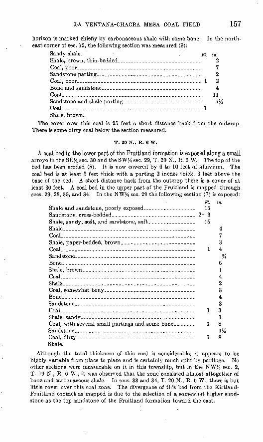
LA VENTANA-CHACRA MESA COAL FIELD 157
horizon is marked chiefly by carbonaceous shale with some bone. In the north east corner of sec. 12, the following section was measured (9):
Sandy shale. . pt. in. Shale, brown, thin-bedded. __________________________ 2Coal, poor_______________________________________ 7Sandstone parting..__ .............................. 2Coal, poor________.._.________-_.___._-.-___._.__ 1 2Bone and sandstone________________________________ 4Coal..._.____._.__.____._.._._._.__..__..._._.___._ 11Sandstone and shale parting____.-_._____-_-___-___- \%Coal. ______________________________________________ 1Shale, brown.
The cover over this coal is 25 feet a short distance back from the outcrop. There is some dirty coal below the section measured.
T. 20 N., R. 6 W.
A coal bed in the lower part of the Fruitland formation is exposed along a small arroyo in the SEJ4 sec. 30 and the SW% sec. 29, T. 20 N., R. 6 W. The top of the bed has been eroded (8). It is now covered by 6 to 10 feet of alluvium. The coal bed is at least 5 feet thick with a parting 2 inches thick, 3 feet above the base of the bed. A short distance back from the outcrop there is a cover of at least 30 feet. A coal bed in the upper part of the Fruitland is mapped through sees. 29, 28, 33, and 34. In the NW% sec. 29 the following section (7) is exposed:
Ft. in. Shale and sandstone, poorly exposed____-_--_-_---__ 15Sandstone, cross-bedded_____--_-----_----_-_---_--_ 2- 3Shale, sandy, soft, and sandstone, soft.___.____.._-_--_ 15Shale -__ - -- 4Coal.________-__-___--_-----______-_-___--_---__ 7Shale, paper-bedded, brown.____----____-______-___- 3Coal... ........................................... 1 4Sandstone._ ___-___-_______---____-_________-_----_ %Bone._______-____--___--_---__--_---_-___--_----_ 6Shale, brown-____--_-_-___-_-___-___-_-__-_-_-_-_- 1Coal.___.__..-._-_._._______.___---___-____-_-__.. 4Shale - -- 2Coal, somewhat bony_____-___-__---__-______-_-_-._ 3Bone.__________-_-__--_________--__-_-____._-_-__ 4Sandstone.________________________________________ 3CoaL__--_______-_-_-_--__---_-_-___-______---_-_- 1 3Shale, sandy ____________________________________ 1Coal, with several small partings and some bone_______ 1 8Sandstone._ _____.____-_____-__-___________-___---_ \%Coal, dirty_-_-_-__-______-____--____________._____ 1 8Shale.
Although the total thickness of this coal is considerable, it appears to be highly variable from place to place and is certainly much split by partings. No other sections were measurable on it in this township, but in the NW% sec. 2, T. 19 N., R. 6 W., it was observed that the zone consisted almost altogether of bone and carbonaceous shale. In sees. 33 and 34, T. 20 N., R. 6 W., there is but little cover over this coal zone. The divergence of tliis bed from the Kirtland- Fruitland contact as mapped is due to the selection of a somewhat higher sand stone as the top sandstone of the Fruitland formation toward the east.
158 SOUTHERN PART OF SAN JUAN BASIN
T. 18 N., R. 7 W.
Neither the Allison nor the Chacra member of the Mesaverde formation is known to contain large amounts of coal in T. 18 'N., R. 7 W. In the E% sec. 1 there is a bed of subbituminous coal 1 foot 3 inches thick at the top of the Allison (43). The overlying basal bed of the Chacra sandstone rests on an irregu lar channeled surface cut in this coal bed, the relief of the surface being probably less than 1 foot. There is a rather prominent carbonaceous bed 68 feet below the top of the Chacra sandstone in sec. 1, but for the most-part this consists only of carbonaceous sandstone or shale with stringers of coal less than half an inch thick. A burned coal bed in the lower part of the Chacra encircles the small butte in the NWJ4 sec. 9, but its thickness is not known.
T. 19 N., R. 7 W.
Both the Allison and Chacra members of the Mesaverde formation contain coal in T. 19 N., R. 7 W., but coal beds crop out only in sees. 30 and 31. The lowest coal bed (40), in the center of sec. 31, is 1 foot 8 inches thick and is regarded as the top of the Allison.. This coal bed ranges from 1 foot 8 inches in thickness to the vanishing point northward to the west line of the township. At locality 39, near the east line of sec. 25, T. 19 N., R. 8 W., there are four coal beds below the base of the Chacra sandstone, of which only one is more than 1 foot thick. The basal sandstones of the Chacra lens out southward from the center of sec. 31 into a shale and coal zone (41 and 42). At locality 42, on the south line of sec. 31, T. 19 N., R. 7 W., a coal bed 4 feet 2 inches thick is shown. In the northeast corner of sec. 18, T. 19 N., R. 7 W., 8 inches of unmapped coal is exposed im mediately beneath the Chacra sandstone in a small canyon. No other coal was observed in this canyon.
At 75 feet below the top of the Chacra sandstone and about 200 feet above its base in sees. 30 and 31 a zone of shale and carbonaceous shale about 30 feet thick carries considerable coal (37 and 38). The 2 foot 7 inch bed at locality 38 is in part slightly bony and carries much red resin but has no definite partings. At the same general horizon in the NW% sec. 30 the coal is dirty and earthy (34 and 36).
T. 20 N., R. 7 W.
Coal beds were observed and mapped at three localities within the Fruitlandformation in T. 20 N., R. 7 W. In the southern part of sec. 8 a bed of coal in the lower part of the Fruitland crops out. This is 3 feet 6 inches thick (6) in the southwestern part of the section. A short distance below this are two beds, each 12 inches thick, and a lower one 6 inches thick. The coal appears to thin out toward the east. There is at least 20 feet of cover over the coal a short dis tance back from the outcrop. In the NEJ4 sec. 16 and the NW% sec. 15 a bed about 6 feet thick is composed of dirty coal with bone partings. This bed may be a continuation of that exposed in sec. 8. In sees. 14 and 23 a coal bed, partly burned and clinkered, is exposed. This is exposed at one place as a bed of coal 6 feet thick with three partings between 1 and 2 inches thick. In the northwest corner of sec. 22 a bed of coal 6 inches thick was observed.
T. 19 N., R. 8 W.
Both the Allison and Chacra members of the Mesaverde formation contain coal beds in T. 19 N., R. 8 W. So far as known the coal beds of appreciable continuity or thickness in the Allison member are confined to the upper 50 feet. The coal bed and burn mapped almost continuously along the front of Chacra Mesa represents this zone, in which coal beds are numerous, although individual coal beds are neither thick nor continuous. In the southeast corner of sec. 6 no

LA VENTANA-CHACRA MESA COAL FIELD 159
coal bed thicker than 8 inches was observed (35A). In the NW% sec. 8, how ever, a coal bed 2 feet 6 inches thick is shown 34 feet 4 inches below the base of the Chacra sandstone (35B). The barren zone above this coal bed thins west ward, and the thin coal beds in the lower part of the section at locality 35A are probably equivalent to it and produce the burns shown in sec. 6. In the SE}4 sec. 25 there are four thin coal beds at the top of the Allison, one of which is 1 foot 1 inch thick (39). Over most of the remainder of this township the coal beds at this horizon are burned. In the NE% sec. 14 coal at the top of the Allison is exposed at the head of a small canyon trenching Chacra Mesa (28). A similar exposure in the NW% sec. 13 shows two beds of lesser thickness (29). Although the Allison-Chacra contact is extensively concealed by alluvium in these canyons, exposures are adequate to show that the coal beds at the top of the Allison at the localities cited rapidly change northward to brown shale. Only the upper 15 feet of the Allison is exposed in these canyons. As no coal was observed in the canyon of Mocking Bird Pass in sees. 4, 5, 8, and 9, it appears probable that the coal zone at the top of the Allison is changing to shale northeastward from the front of Chacra Mesa.
Coal occurs in the Chacra sandstone in the thin shale zones that separate the thick massive sandstones. The lowest of these shale and coal zones is present above a basal 55-foot sandstone in a stratigraphic section of Chacra sandstone measured in sec. 16, T. 19 N., R. 8 W. At this place there is only a 6-inch coal bed at the top of 6 feet of carbonaceous shale. This zone was mapped from this place to the east line of the township along the front of Chacra Mesa, but no sections were measured on it, and presumably it does not carry coal beds of im portant thickness or continuity. In sees. 24 and 25 the highest sandstone of the Chacra, which is here about 75 feet thick, is underlain by a zone of shale, car bonaceous shale, and coal (30, 31, 32, and 33). A zone of shale and carbonaceous shale midway in the Chacra sandstone also carries some coal in the SW% sec. 24.
T. 20 N., R. 8 W.
In T. 20 N., R. 8 W., coal is found at the top of the Allison member only in the SWX sec. 31. This coal is burned except near the west line of the section. Just across the west line there are several thin coal beds at this horizon in sec. 31, T. 20 N., R. 9 W. (27). No coal was mapped in the Fruitland formation in T. 20 N., R. 8 W., but coal is present in this formation in the adjoining townships to the north and east and may be present, though concealed, in this township.
T. 21 N., R. 8 W.
A coal bed of the Fruitland formation is exposed in sees. 28, 27, and 34, T. 21 N., R. 8 W. This bed is burned in some places and weathered in others. Near the center of sec. 34 there is 1 foot 11 inches of coal in this bed (5). Half a mile east and north of the outcrop the cover over this bed is from 75 to 100 feet in thickness. No coal of value was observed in the Kirtland shale, but in the SEX sec. 15 there is 2 feet 6 inches of dirty coal and bone (4).
T. 20 N., R. 9 W.
Over most of the southeastern part of T. 20 N., R. 9 W., coal at the top of the Allison member is burned. Near the west line of sec. 22 there are several coal beds, one of them 1 foot 6 inches thick (25). At the same horizon in the NE}4 sec. 22 there are three beds, one 2 feet thick and two thin beds (26). In the S l/2 sec. 16 there are two beds, one 4 feet thick and another 2 feet thick (24). A bed of coal 5 feet 7 inches thick occurs in the NW% sec. 7, but the middle part of the bed is bony and contains a parting (22). About 3,000 feet northwest of locality 22, in the NE# sec. 12, T. 20 N., R. 10 W. (not shown on the map), an upper

160 SOUTHEEN PART OF SAN JUAN BASIN
bed 1 foot 3 inches thick and a lower bed 3 feet thick are separated by 7 inches of shale and sandstone. This coal is at the same horizon as the bed at locality 22. Some coal is also exposed at the top of the Allison around the butte in sec. 29. In the NWX sec. 29 a stratigraphic section of the Chacra sandstone (23) shows several thin coal beds in the Chacra sandstone. No coal was observed at the top of the Allison in the northwestern part of T. 20 N., R. 9 W. This accords with a similar northward or northeastward change at this horizon from a coal- bearing to a barren zone in T. 19 N., R. 8 W.
T. 21 N., R. 9 W.
Coal in T. 21 N., R. 9 W., is found at two horizons in the Fruitland formation. In sees. 3 and 4 a coal bed is exposed in the upper part of the Fruitland about 60 feet below the Fruitland-Kirtland contact. This bed has a thickness of about 7 feet in the SW% sec. 3 (2). In the SE}4 sec. 4 the bed is more than 5 feet thick, with a single parting (1). The same bed was mapped by Reeside in 1916. He gives four coal sections also measured in the SE% sec. 4, each about 7 feet thick but all split by partings. 81 This bed consists of discontinuous lenses which merge into carbonaceous shale. Near the north line of sec. 9 there is only a 6-inch coal bed in 5 feet of shale at this horizon, and no coal was mapped at this horizon farther east in the township.
The coal in the lower part of the Fruitland is partly burned and nowhere well exposed. The horizon is exposed in sees. 8, 9, 16, and 15, but the coal is not meas urable. There appear to be two small beds. In sec. 8 the coal is extensively clinkered and locally reduced to a bed of ash. Clinker at the same horizon is prominent in the NW% sec. 5. This coal apparently does not extend southeast of sec. 15, but coal near the base of the Fruitland formation also crops out in theSWj4 sec. 24, where the following section was measured (3):
Ft. in. Sandstone, hard, brown, cross-bedded, variable----------- 1±Sandstone, clayey, soft, light-colored-____________________ 3 6Shale, brown-___._-_..__-_____._..__-_.______________-- 1 4Shale, black__________________________________________ 4Peaty layer with clay and carbonized wood.____________ 3
. Coal, dirty, with some small stringers of brown shale.___-. 2 8 Shale, sandy, brown.._____..___.____--__---_.--------- 3
. Sandstone, white.______________________________________ 2Shale, brown.._______________________________________ 3Shale, gray or drab.
The cover above the coal at this horizon may be 25 feet or less but increases northward owing to the southwestward slope of the surface and the northeastward dip of the coal.
Although elsewhere coal is present at the top of the Allison member of the Mesaverde formation, none was observed in T. 21 N., R. 9 W.
OIL
Drilling for oil in the southern part of the San Juan Basin has been carried on intermittently for many years, and oil has been encountered in beds of the Mesaverde formation and Dakota (?) sandstone at several localities, though no substantial fields have been discovered. Within the limits of the Chacra Mesa-La Ventana coal field there are
!l Bauer, C. M., and Reeside, J. B., Jr., Coal in the middle and eastern parts of San Juan County, N. Mex.: U. S. Oeol. Survey Bull. 716, pi. 34,1921

LA VENTANA-CHACRA MESA COAL FIELD 161
no anticlines that have large structural closure, and little drilling has been done. In recent years two shallow producing wells have been drilled in sec. 29, T. 20 N., R. 9 W., on a small anticline between two faults (pi. 39).
In the NWJiNEM sec. 29 the well of Stacey Webber and others (Bennett & Lingenfelter) No. 1 Santa Fe (2), 82 drilled in 1933, was completed in 1934 as a producer of 5 barrels a day of oil of A. P. I. gravity 42.8° from a depth of 475 to 498 feet. The Bennett & Lingenfelter No. 1 Santa Fe (1), in the NEtfNE#NW% sec. 29, was completed in 1935 and estimated as capable of producing 25 to 40 barrels of oil daily from a depth of 518 feet. Late in 1935 in the northeast corner of the NW%NE% sec. 29 (3), Forth & Hickerson (formerly the Lark Drilling Co.) were drilling below 200 feet. In the SW% sec. 21 a well (4) of the Cooperative Producers & Refiners Co. was temporarily shut down at a depth of 540 feet in October 1935, and the McCoy-Stow well (5), in the NW^NW^NEJi sec. 33, was also temporarily shut down at a depth of less than 600 feet. The Montrose Oil & Gas Co. well No. 1 State (6), in the northeast corner of sec. 28, was abandoned at a depth of 600 feet. In the northeast corner of sec. 2, T. 19 N., R. 9 W., Seward and others were drilling No. 1 State (7) at 250 feet early in December 1935. The small production that has been obtained has come from the upper part of the Allison member of the Mesaverde formation.
SJ Numbers in parentheses refer to the geologic map (pi. 39).


INDEX
Page Abstracts of reports___.....__ 1-2,31-32,81-82Acknowledgments for aid __ __ 4,36,84 Agua Salada grant, geology of.... __ 73Alamosa fault, features of.-.. . . 64 Allison member of Mesaverde formation,
dike in..................... 127, pi. 52occurrence, character, and thickness of_ 19,
95-101 relations of..-....-. 96-99, pis. 43,44,45,51,52sections of......___. .._.. -._ 97,98-99
Alum, deposit of.______.______.. 75 Ambrosia anticline, drilling for oil on........ 79
features of............................... 58-59Antonio Sedillo grant, occurrence of coal beds
on...--........-.......-.--..... 76
Bartlett barren member of Mesaverde forma tion, character and thickness of............................. 17, pi. 7
Bartolom6 Fernandez grant, coal beds on__ 70 Bennett & Lingenfelter, well of . -.-.__ 161 Bernabfe Montano grant, occurrence of coal
on............................... 77Black Diamond coal bed, occurrence of_.. 24
thickness of_-_..___________ 16Boone mine, analysis of sample of coal from.. 74
Cebolleta grant, coal beds on. _ ..... 73Chacra sandstone member of Mesaverde
formation, occurrence, character, and thickness of._.____. 101-103
relation of, to Allison member... 103, pis. 43-46 sections of______-________ 104-107
Cleary mine, tipple of..........._____ pi. 52Cliff House sandstone, correlation of. 45,93,101-102 Climate................................... 7,37,87Coal, chemical analyses of.__.._ 29,74,138-142
physical properties of ------- 27-28,137-138utilization of........--.-...........-...- 23,142
Coal beds, burning of.____________ 23 distribution of-..._._.______. 135-137 general features of..._________ 22-23 previous studies of...,_________ 3,34,83 thickness of classifiable.._____...... 22
Coal mining, development of____ __ 23 Continental Oil Co., drilling by............. 80Cooper, H. M., chemical analyses of samples
of coal by..._....._.......... 29,74Cooperative Producers & Refiners Co., well
of ............................. 161Cretaceous system, rocks of__ 11-19,39-50,92-121 Cubero grant, occurrence of coal on .... 75
Dakota(?) sandstone, correlation of....._ 9,11 occurrence, character, and thickness of 39-40,
92, pi. 7possibilities of petroleum in . ..... 78 section of._......._ ....... .... 10,13
PageDalton sandstone member of Mesaverde
formation, character and thick ness of.______ 16-17, 47-48, pis. 8,9
structure contours on ..._ pi. 1 (in pocket) Dane, Carle H., The La Ventana-Chacra
Mesa coal field...... 81-101, pis. 39-55Dilco coal member of Mesaverde formation,
character and thickness of. 47, pis. 7,26 coal beds in, mapping of outcrops of..... 23coal beds in, occurrence, character, and
thickness of_____ ______ 16,24-25, 66, pis. 11,12, 28 (all in pocket)
Drainage, features of................----. 6-7,36-37Drilling, results of, on minor folds in Mount
Taylor coal field.............._ 80Dysart, S., drilling by.....---.-...----..-.-- 79
Eastern Navajo Indian Agency, analysis of sample of coal from mine of, at Crown Point..---.......--..... 29
Eocene series, rocks of.____....--- .. 122-127Erosion forms, views of, in pre-Dakota(?)
rocks near Navajo Church....... pi. 3Eruptions, age of..............___..._. 54
Faults, age of.---------.-....-----.--.---..-. 62-63features of ................ 132-134, pis. 46,50
Felipe Tafoya grant, coal beds on.... __ 70drilling for oil on...._____.....___ 79
Field work, details of........-.....--..-- 3-4,35,83Folds, age of...-.--..-...----...-.....-...--. 62-63Forth & Hickerson, drilling by........--..-- 161Fruitland formation, coal in, sections of-...- pi. 53
(in pocket)occurrence, character, and thickness of. 113-115 section of. ...... _ .. 115
Oallup, coal field eastward from, geologicmap of..._......... pi. 1 (in pocket)
coal field eastward from, structure of.. 21-22, pi. 1 (in pocket)
hogback northeast of, lower members ofMesaverde formation in......... pi. 7
Qallup sandstone member of Mesaverde rOfmation, character and thick ness of............... 15-16,46-47, pi. 7
coal in, mapping of outcrops of- _____ 23 columnar sections of......._. pis. 11, 12
(both in pocket)occurrence and thickness of_ ___ 24
possibilities of petroleum in_......_. 78relations of Mulatto tongue of Mancos
shale with.........__.. ...' 44, pi. 26Qarcia fault, features of-._____-__... 64 Geologic maps of southern part of .San Juan
Basin... pis. 1,18,19, 39 (all in pocket) Oibson coal member of Mesaverde formation,
coal beds in, character of_ 66, pi. 52
163

164 INDEX
PageOibson coal member of Mesaverde formation,
coal beds in, columnar sections of.... pis. 13-17, 29-38, 55 (all in pocket)
coal beds in, difficulty of mapping 23 occurrence, character, and thickness of.. 17-18,
25-27, 48,49-50,95-101, pis. 7-9, 50 section of . 98-99
Gravel deposits, occurrence and character of.. 51
Hogback Mountain, structure of.. 20-21 Hogback Oil Co., drilling by................ 80Hosta sandstone member of Mesaverde
formation, character, thickness, and relations of......_.'.._-- 18-19,
48-49, 94-95, pis. 8,9, 42 section of....__ ..___ 94-95surface features of .....____ 5-6
Hunt, Charles B., The Mount Taylor coal
field 31-80, pis. 18-38Ignacio Chaves grant, coal beds on__. .. 71
drilling for oil on.._________ 79Igneous rocks, occurrence and character of.- 52-55,
127-129, pi. 51Index maps showing location of areas de
scribed. ..--.'-... ........ pis. 2, 20,40
Jenkins Oil Co., drilling by........_....... 80Johnswood Oil Corporation, drilling by ... 80Jose well, features of-_.._____..__.. 80Jurassic system, rocks of___________ 39
Kirtland shale, occurrence, character, andthickness of. ---------- 113-116, pi. 47
section of----_---------______.. 116Kit Carson's Cave, view of- ___ pi. 3
Lagunitas grant, geology of_______. 73 view on.-.--.-....-.-. .........---... pi. 22
Land forms...--- .-- - -.---.._ 5-6,30,84-85 Land surveys -_-------.------.---- - 90La Ventana-Chacra Mesa coal field, drainage
and water supply of.______ 85-87 formations exposed in...... ...... 91, pi. 41geologic map of..------..---. pi. 39 (in pocket)location and area of . ______ 82-83 purpose of work in. _._____.... 82structure of.__.__._______.. 131-134 surface features of____-.-....._..... 84-85
La Ventana sandstone member, occurrence,character, and thickness of..._.. 1 OS-
109, pi. 50 Leonard well, features of.. ..-.-.........-- 80Lewis shale, fossils of________..___ HO
occurrence, character, and thickness of- 109-111 section of.________________ 111
Mancos shale, age and correlation of-__.-.. 13 contact of, with Hosta sandstone, member
of Mesaverde formation___ 94, pi. 42 fault in.-------.-....-..-----.--...-..--, pi. 24intertonguing of, with Mesaverde for
mation............... 13-14,44-45, pi. 21inclusion of coal beds in, in earlier map
ping.__.____...__.___ 14occurrence, character, and thickness of--. 12,
40-44,92-93, pis. 7-9
PageMancos shale, possibilities of petroleum in .. 78
relation of, to Morrison formation. 39, pis. 23,26 section of....__.__....___ 41surface features of__-___--_ 5
Marland Oil Co., drilling by.._______ 79 Marquez, anticline east of, drilling on. 80 McCoy-Stow well, location and depth of- 161 McCroden well, features of_______.... 80McElmo formation, correlation of- -. __... 9
section of_._________. ___._ 10 view of..-._.-.--_-----__.._.. pi. 7
Menefee formation, correlation of..___._ 45,93 Mesa Chivato, lava flows of....._...___ 53Mesa Prieta, relation of flows of, to those of
Mesa Chivato._-...-.__...- 53-54 Mesaverde formation, Chacra sandstone
member of____ 101-107, pis. 43,44,45 coal beds of, columnar sections of _ pis. 11-17,
53-55 (all in pocket) contact of Hosta sandstone member of,
with Mancos shale.__--.... 94, pi. 42fault in.................................. pi. 8intertonguing of, with Mancos shale. 13-14,
44-45, pi. 21occurrence and character of.__-------- 14-15,
45-50, 93-94, pis. 7-9,42-45, 50-52possibilities of petroleum in. _____.. 78sections of______________ 94-95,97-100suiface features of.__..-.____...-- 5-6
Midwest Refining Co., drilling by__-.-... 79Miguel Creek dome, drilling for oil on___.. 79
features of._._____________ 58traces of oil in sandstone of...-_...... 78
Milholland well, features of. _-----....-. 79Morrison formation, correlation of----------- 9
occurrence and character of-.--.._----- 39possibilities of petroleum in.__ ....-. 78relation of Mancos shale to..... ..--. pi. 23
Mount Taylor, features of domes south of,with regard to drilling... ....- 80
igneous rocks of_____________ 52-53 syncline under........................... 57
Mount Taylor coal field, faults in. .. 60-62,63-64 folds in..--..-.-....---..----....-.--. 59-60, 65
drilling for oil on..._________ 79-80 general features of..________ 33 geologic maps of___... pis. 18,19 (in pocket) location and area of.___________ 32-33 possibility of petroleum in. _ -. 78 structure of ..___._-... 57-66
Mulatto tongue of Mancos shale, relations of. 14,44-45, pis. 8, 26
Myers coal bed, correlation of. ------ ____ 24
Nacimiento uplift, effects of-._ 20 Navajo Church, section of pre-Dakota (?)
rocks near.____..... 8-11, pis. 3-6Navajo sandstone, correlation of......... 9
section of. ._.._-----_------- . 10New Mexico Royalty Co., drilling by.------- 79Nutria monocline, character of_______ 21,22
Ohio Oil Co., drilling by..._________ 80 Ojito fault, features of-...- ....-.-.-... 63, pi. 25Ojo Alamo sandstone, definition of------- 116-117
occurrence and character of-...-. 117-118, pi. 47

INDEX 165
PasoOjo Alamo sandstone, relations of... 118-121
thickness of__.__..___._.... 121Ojo Escondido fault, features of-- ..-_ 63, pi. 26
Paramount Oil Co., drilling by_______ 80 Petroleum, occurrence of....____ 78-80,160-161Pictured Cliffs sandstone, fossils of...___ 112
occurrence, character, and thickness of... 112-113, pi. 46
Pierce well, features of._......__..._... 79Point Lookout sandstone, correlation of.. 45,93,101 Prairie Oil & Gas Co., drilling by....___ 79Pro-Dakota (?) rocks near Navajo Church,
section of__.______ 8-11, pis. 3-6 Puerco (?) formation, occurrence, character,
and thickness of............... 122-124section of.............____._____ 124
Quaternary deposits, character of.__ 19-20,51-52
Renick, B. C., quoted....................... 132Reservoir fault, features of._....__...... 64Richards coal bed, correlation of..___.... 24Rio Puerco Valley, volcanic necks in..___ 54 Roads................................ 7-8,38,88-90
San Fernando fault, features of.-------_.. 64San Ignacio monocline, features of._.. 64, pi. 23 San Jose Valley, recent flows in___..... 54-55San Juan.Basin, structure of._........ 20-21,131San Mateo dome, features of._.___..... 58
drilling for oil on....--....-....._..... 79San Pedro Mountain uplift, effects of...__ 20 Santa Fe formation, occurrence and character
of .-. . ... 50Satan tongue of Mancos shale, relations
of........................... 14,45, pi. 9Schleuter well, features of.___.._.... 79Scope of report......._.._......._... 2-3Sears, Julian D., The coal field from Gallup
eastward toward Mount Taylor, with a measured section of pre- Dakota (?) rocks near Navajo Church..._--. 1-29, pis. 1-17
Settlement......................... 7,37-38,87-88Seward and others, drilling by______... 161 Stratigraphy................... 8-20,38-55,90-127
previous studies of... ______.. 3,33-35,83 Structure, maps showing.... pis. 1 (in pocket), 10,
18 (in pocket), 19 (in pocket), 27,49 methods of representing...__.. 20,55,130-131 previous studies of... __.___.. 3,33-35,83 regional features of ....... 20-21,56-57,131
Suwanee fault, features of.... .. .... 63
Tertiary system, deposits of.__._ 50-51,122-127 Thatcher(?) coal bed,' occurrence of_____ 24 Todilto formation, correlation of _-.....-. 9
section of___.________..._.. 11 Tohatchi Indian School, analysis of sample
of coal from mine of _........ 29Torrejon formation, occurrence, character,
and thickness of____ 122-124, pi. 48 sections of......................... 124,126-127
Township descriptions:Tps. 9, 10, and 11, R. 1 W............... 77Tps. 9 and 10 N., R. 2 W................ 76T. 9 N., R. 3 W_ ... 76
Township .descriptions Continued. T. 10 N., R. 3 W................T. 10 N., Rs. 4 and 5 W.........T. 10 N., R. 6 W-. ..... T. ION., R. 7 W................T. 10 N., R. 8 W................T. 10 N., R. 9 W................T. UN., R. 2 W................T. 11 N., R. 3 W................T. 11 N., Rs. 4 and 5 W.........T. 11 N., R. 6 W... . ......T. UN., K. 7 W................
........... 76
.... 73
........... 75
........... 75
..... - 75
..... 74
..... . 76.... .- 76. .... 73,.... . 70..... . 75
T. 11 N., R. 8 W........................ 74-75T. 11 N., R. 9 W..........-... i 73-74T. 12 N., R. 1 W........................ 77Tps. 12 and 13 N., R. 2 W... .... 76T. 12 N., Rs. 4 and 5 W_._.. .. 73 T. 12 N., R. 7 W........................ 75T. 12 N., R. 8 W........................ 74T. 12 N., R. 9 W.... .............. 73T. 13 N., R. 1 W...... 77T. 13 N., R. 8 W........................ 69T. 13 N., R. 9 W........................ 08T. 14 N., R. 1 E ..................... 77T. 14 N., R. 1 W.... ............... 77Tps. 14 and 15 N., R. 2 W 77Tps. 14 and 15 N., Rs. 3 and 4 W.. - 72-73 T. 14 N., R. 8 W... ....... 69T. 14 N., R. 9 W........................ 68T. 14 N., R. 10 W....................... 67T. 15 N., R. 1 E.... .. 77T. 15 N., R. 1 W........................ 77T. 15 N., R. 6 W......................... 70T. 15 N., R. 7 W.................. 70T. 15 N., R. 8 W........................ 69-70T. 15 N., R. 9 W........................ 68T. 15 N., R. 10 W....................... 67T. 16 N., R. 3 W........................ 72T. 16 N., R. 4 W........................ 71-72T. 16 N., R. 5 W........................ 71T. 16 N., R. 6 W........................ 71T. 16 N., R. 7 W.......................... 70T. 16 N., R. 8 W......................., 70T. 16 N., R. 9 W........................ 68-69T. 16 N., R. 10 W...... , . 67T. 17 N., R. 2 W........................ 72T. 17 N., R. 3 W...... ...- ....... 72T. 17 N., R. 4 W........................ 72T. 17 N., Rs. 5 and 6 W................. 71T. 17 N., Rs. 7 and 8 W................. 67-68T. 17N.,R. 9 W........................ 69T. 17 N., R. 10 W. ... . ...... 67T. 18 N., R. 1 W (fractional)... 142 T. 18 N., R. 2 W......._._.. ... 147-150T. 18 N., R. 3 W...................... 151-152T. 18 N., R. 4 W........ ....... 153-154T. 18 N., R. 5 W...................... 154-155T. 18 N., R. 6 W...................... 155-156T. 18 N., R. 7 W........................ 158T. 18 N., Rs. 9 and 10 W.'............... 67-68T. 19 N., R. 1 W...................... 143-147T. 19 N., R. 2 W.. ................. 150-151T. 19 N., R. 3 W...... .......... 153T. 19 N., R. 4 W........................ 15T. 19 N., R. 5 W........................ 15T. 19 N., R. 6 W...................... 156-157T. 19 N., R. 7 W........................ 158T. 19 N., R. 8 W..-.................... 158-15 9

166 INDEX
PageTownship descriptions Continued.
T. 20 N., R. 1 W.. ................... 147T. 20 N., R. 6 W..-. ................. 157T. 20 N., R. 7 W........................ 158T. 20 N., R. 8 W........................ 159T. 20 N., R. 9 W...................... 159-160
' T. 21 N.,R. 8 W........................ 159T. 21 N., R. 9 W........................ 160
Tres Hermanos sandstone, occurrence of .... 40,41
United States Bureau of Mines, chemicalanalyses by..--.-.-..-.---.... 139-140
Page Vegetation...... ... ..... 7,37,87
Walker dome, drilling for oil on .......... 79features of._ . . 59
Walker Dome Oil Co., drilling by........... 80Wasatch formation, occurrence and charac
ter of.........- ......... 125, pi. 48section of._________.____-. 125-126
Wingate sandstone, occurrence of........ 8-9, pi. 6section of____..-.-.-..-.--...--..-..- 11
Zuni Mountains uplift, features of. Zuni sandstones, correlation of.....
21
;:«9
ttfc
fefit