OF` mu mEsh L I C ZS) Ou B M
26
&1,/;2 q/16 7 7LtFI 3t7,) Page 1 of 1 OF` mu" mEsh L I C ZS) Ou" B M I S S 10 N As of: October 19, 2009 Received: October 18, 2009 Status: Pending-Post Tracking No. 80a44998 Comments Due: October 30, 2009 Submission Type: Web Docket: NRC-2009-0257 Notice of Public Workshop on a Potential Rulemaking for Safe Disposal of Unique Waste Streams Including Significant Quantities of Depleted Uranium Comment On: NRC-2009-0257-0001 Public Workshop: Potential Rulemaking for Safe Disposal of Unique Waste Streams Including Significant Quantities of Depleted Uranium Document: NRC-2009-0257-DRAFT-0005 Comment on FR Doc # N/A Submitter Information Name: phillip barr Organization: private citizen General Comment i dont think the andrews county texas nuclear waste dump should be used for disposal of any kind of nuclear or hazardous waste. because of the earthquake history and sinkhole history the area has. and its over the aquifer as well All information below has been placed in public domain Attachments -'U NRC-2009-0257-DRAFT-0005.1: Comment on FR Doc # N/A NRC-2009-0257-DRAFT-0005.2: Comment on FR Doc # N/A -Ti A cb . T,(rraMj Cb.cu) oP.,y n.. 10/1t90PP) https://fdms.erulemaking.net/fdms-web-agency/component/submitterlnfoCoverPage?Call=Print&Printld... 10/19/2009
Transcript of OF` mu mEsh L I C ZS) Ou B M

&1,/;2 q/16
7 7LtFI 3t7,)
Page 1 of 1
OF` mu" mEsh L I C ZS) Ou" B M I S S 10 NAs of: October 19, 2009Received: October 18, 2009Status: Pending-PostTracking No. 80a44998Comments Due: October 30, 2009Submission Type: Web
Docket: NRC-2009-0257Notice of Public Workshop on a Potential Rulemaking for Safe Disposal of Unique Waste Streams IncludingSignificant Quantities of Depleted Uranium
Comment On: NRC-2009-0257-0001Public Workshop: Potential Rulemaking for Safe Disposal of Unique Waste Streams Including SignificantQuantities of Depleted Uranium
Document: NRC-2009-0257-DRAFT-0005Comment on FR Doc # N/A
Submitter InformationName: phillip barrOrganization: private citizen
General Commenti dont think the andrews county texas nuclear waste dump should be used for disposal of any kind of nuclear orhazardous waste.because of the earthquake history and sinkhole history the area has. and its over the aquifer as well
All information below has been placed in public domain
Attachments -'U
NRC-2009-0257-DRAFT-0005.1: Comment on FR Doc # N/A
NRC-2009-0257-DRAFT-0005.2: Comment on FR Doc # N/A
-Ti
A cb . T,(rraMj Cb.cu)oP.,y n.. 10/1t90PP)
https://fdms.erulemaking.net/fdms-web-agency/component/submitterlnfoCoverPage?Call=Print&Printld... 10/19/2009

----- Original Message -----From: pharb2(@msn.comTo: David.levenstein(@em.doe.qov ; Gilrein.Stephen)epamail.epa.govCc: JEFF BINGAMAN ; presidentcmessages.whitehouse.gov; jackson.lisac)epa.gov; Brozowski.George(ýepamail.epa.goy; Miller.Gary(Thepamail.epa.gov ; Scott.Burnellýnrc.gov ; Starfield.Lawrence~cepamail.epa.gov [email protected] James Park ; [email protected] ; breen.barrycepa.govSent: Thursday, August 20, 2009 6:18 PMSubject: consolidated comment on storage safety at andrews county Texas waste site nbl
Its my belief that the geology at the Andrews county TX waste site area is not stableenough for a nuclear/pcb/Mercury storage site.1. I submit these news reports on the sinkhole activity in the area..Sinkholes north and south of the nuclear waste site at Andrews county Texas and thewaste site area itself has an earthquake history that's on record.2. Earthquake study 12a,12b, 12w-a on record.
The state of Texas and federal government's safety analysis on the andrews county dumpis hypothetical at best because :
The State of Texas and the Nrc, EPA and Doe can not guarantee there will not be anotherearthquake at the Andrews county Texas waste site which would endanger the aquiferwhich is under the site as determined by the epa:
News quote "But David Barry, spokesperson for the Environmental Protection Agency forRegion 6 says, "Yes, the facility does sit above the Ogallala aquifer. It sits on the southernend of the aquifer."
The state of Texas, EPA,NRC,DOE also cannot guarantee that in an area with sinkholes,one would not form under the waste site.
High winds and sandstorms blowing toxic particles offsite and over Eunice and Hobbs.There is no way to prevent this and at no time has any government agency demonstratedto the public how to do so.
I believe for the Federal Government and the State of Texas to open up a waste dump foranything toxic at the andrews county nuclear waste site with this sinkhole andearthquake history is highly irresponsible and a disaster waiting to happen.
Phillip BarrLea county, New Mexico

Yoakum county north of the sitehttp://www. newswest9. com/GIobal/story.asp?S = 10811930Giant Sinkhole Opens Near Denver City
Posted: July 29, 2009 11:43 AM MDT
DENVER CITY - Investigators from the Texas Railroad Commission spent Tuesday trying to figure out why land at a DenverCity oil company caved-in.
The sinkhole appeared just on the edge of Denver City on the Oxy site. Officials tell us no one was hurt and no water or powerlines were damaged.
The hole drops 50 feet and is 60 feet around.
Winkler county south of the site
http://www. kwes.com/Global/story.asp?S= 7936458or www.kwes.com/Global/story.asp?S=7936458Wink Sink Study Needs Funding
by Victor LopezNewsWest 9
WINKLER CO.-Local oil and gas producer, John Bellbelieves, "We need to be cautious about where it is andthe understanding on how much area it could affect."
Whether you call it, the Kermit Crater or the Wink Sink,residents say it's all the same place.
W . W r_-It measures approximately 300 feet across. Now, itappears to be multiplying. And the newest member of the
U family is getting bigger.
According to Bell, "There is a new sink hole that is six orseven times larger than this one, that has occurred in thelast three years."
The area around what is being called "Wink Sink 2", is stillvery unstable. And it's the size of a 15 acre lake.

77 Random cracks in and around the sink holes are creating-concern for safety and well being in Winkler County.
That's why John Bell is asking for support for "The WinkSink Study", or as he calls it, a large scale science project,
"Right now, anything we're doing is personal theories. Wew: * have to come up with some science. This is just a big
j- science project to help us understand, how do we deal withit, and what do we to avoid somebody having acatastrophe that we don't see, and get somebody hurt orkilled."
Phase one of the study calls for about $730 thousanddollars in funding, 200 thousand of which has already beenraised. Leaving a balance of about 1/2 a million dollarsleft to collect.
Dr. Bob Trentham, Director of CEED, at UTPB, tellsNewsWest 9, The money will help provide some pretty hightech study tools, "We are going to be using several state ofthe art techniques, various types of radar and arial photos."
Since the new cracks and sags are popping up pretty much all over, the images thesestudy tools will provide, will be invaluable.
Trentham says, "We need to know where these are going to potentially develop inthe future so that we can help both the oil companies and the public service people toknow where the areas with lowest risks and the highest risks are."
The growing threat of these cracks not only affects Winkler County, but other parts ofthe Permian Basin and even New Mexico.
Bell added, "This thing is large enough in scope, it extends past Monahans on downtowards Imperial. We know that this is going to get bigger than we are. There is oneat Jal, between Jal and Eunice, New Mexico."
Thus increasing the urgency of the study.
From: <[email protected]>To: <[email protected]. gov>,<Gilrein.Step [email protected]>
Cc: "JEFF BINGAMAN" <senator [email protected]>,

<[email protected]>,<jackson. Iisa @epa. gov>,< Brozowski.Georq e@epamail .epa .gov>,< Miller.Gary@epamail. epa.gov>,<Scott. [email protected]>,<Starfield. [email protected]>,<The. Secreta ry@ hg. doe. cov >,"James Park" <James. [email protected]>,<[email protected]>,<[email protected]>
Subject: consolidated comment on storage safety at andrews county Texas waste sitenblDate: Thu, 20 Aug 2009 18:18:50 -0600MIME-Version: 1.0Content-Type: multipart/mixed;boundary="---- . NextPart_000_00A7_01CA21C3.37DF2270"
X-Priority: 3X-MSMail-Priority: NormalX-Mailer: MSN 9X-SEAL-VirusCheck: FullCleanX-MimeOLE: Produced By MSN MimeOLE V9.60.0053.2200Seal-Send-Time: Thu, 20 Aug 2009 18:18:50 -0600

WHMAT STARTS JUMEk CEA14GES THI WODALD
[H If UNIVERSITY OF TEXAS At' AJS r IN
EARTHQUAKE SEISMOLOGY
Chapter 12 of, State of Texas Hazards Analysis, by the Governor's Division of Emergency Management, Department of Public Safety,Austin, Texas, 1998.
Introduction: Earthquakes in Texas
,n earthquake is a motion or trembling that occurs when there is a sudden breaking or shifting of rock material beneath theaarth's surface. This breaking or shifting produces elastic waves which travel at the speed of sound in rock. These waves mayDe felt or produce damage far away from the epicenter-the point on the earth's surface above where the breaking or shifting3ctually occurred.
:or Texans, three essential facts about earthquakes are important to remember. First, earthquakes do occur in Texas (see:igure 12A). Within the twentieth century there have been more than 100 earthquakes large enough to be felt; their
_picenters occur in 40 of Texas's 257 counties. Four of these earthquakes have had magnitudes between 5 and 6, making:hem large enough to be felt over a wide area and produce significant damage near their epicenters.
3econd, in four regions within Texas there have been historical earthquakes which indicate potential earthquake hazard:Figure 12B). Two regions, near El Paso and in the Panhandle, should expect earthquakes with magnitudes of about 5.5-6.0 to)ccur every 50-100 years, and even larger earthquakes are possible. In northeastern Texas the greatest hazard is from veryarge earthquakes (magnitude 7 or above) which might occur outside of Texas, particularly in Oklahoma or Missouri-rennessee. In south-central Texas the hazard is generally low, but residents should be aware that small earthquakes can)ccur there, including some which are triggered by oil or gas production. Elsewhere in Texas, earthquakes are exceedingly

-are. However, the hazard level is not zero anywhere in Texas; small earthquakes are possible almost anywhere, and all-egions face possible ill effects from very large, distant earthquakes
rhird, while Texas does face some earthquake hazard, this hazard is very small in comparison to that in many other states,ncluding California, Missouri, Montana, South Carolina, and Washington (Figure 12C). In most parts of Texas earthquakeiazard is also small compared to the hazard attributable from other natural phenomena, such as hurricanes, tornadoes, and'loods. Thus there is no need for Texas to enact sweeping changes in construction practices, or take other drastic measures to-nitigate earthquake hazard.
-lowever, Texans need to begin learning about earthquakes. Over the past 70 years Texas has changed from a sparsely•opulated state with an economy dominated by agriculture to an economically diverse state with various large, technicalnanufacturing industries centered in a few densely populated urban regions. For reasons of safety, economy, and (in some:ases) law, Texans need to consider earthquake hazard when designing or siting various structures which are essential for,roviding medical or emergency management services, which house sensitive manufacturing processes, or which storeiazardous wastes.
1974-197001L 8
1 ( 193666 1971
Amarllo dr 19,{- 01952
1951 1098.78
II 1925 193019M92
178,79,82 195 1997 1957
Figure 1 2A Locations of earthquakes and a% 19S2 D 13131103
earthquake sequences that have occurred in 11976.77 019e.Texas, or that were felt by Texas residents. E' S 01 ,''c 191
19)23 01975 928gNumbers are the year of occurrence. (See a I 0314.3 19lZ 1984larger version of this figure.) I 7I6.. •2 bn f•887

106 101
Figure 12B Map indicating probable causes ofeartthquakes occurring in Texas. Solid lines show the fourregions of Texas where historical earthquake activityindicates there is earthquake hazard. Light lines are countyboundaries.
PwAk Acedwolmi MW. W&t 10% Prambabi of M wie.r In Yom
obec NEHRP B-C bmm~wy
Figure 1 2C Earthquake hazard map for thecontinental United States as prepared by the U.S. Geological Survey. In the central and easternU. S., the regions expecting the highestaccelerations all correspond to the sites of knownhistorical earthquakes. These include: Montana,1959; West Texas, 1931; Oklahoma, 1952;Missouri-Tennessee, 1811-1812; and SouthCarolina, 1886. In many places such as Texas,the absence of detailed historical informationmeans that earthquake hazard may be higherthan indicated in this figure.
.1Qw 40'
U.S. Gfodq~84rW"Roomn se~wsio wam lmapiIn Poj
Earthquake Magnitude, Intensity, and Damage
lhe nature and geographical extent of earthquake hazard depends strongly on the quake's size or magnitude. Because r2arthquakes are rare, people are often confused about how risk depends on magnitude. Imagine that you were about to-eturn from a vacation, and someone told you that animals had infested your property. Naturally, you would ask whether:hese animal were mice, armadillos, or cattle, because each might cause a different kind and amount of damage. Similarly, if/our neighborhood has an earthquake, the kind and amount of damage depends on the earthquake's size. A quake withnagnitude 3 may do no more than startle people and rattle dishes within a one-square-mile region. However, a magnitude 7

Nould be felt by people over the entire state of Texas, and could do significant damage to buildings, bridges, and dams over a-onsiderable region.
3cientists determine an earthquake's magnitude by measuring the amplitude of ground motion as recorded on a seismograph,and then correcting the measurement to account for the effects of distance from the epicenter. The magnitude scale is apower of ten' scale; thus if a magnitude 3.8 caused ground motion of 1/10 inch at a particular location, a 4.8 at the same_picenter would cause ground motion of 1 inch, and a 5.8 would cause ground motion of 10 inches. This means that-nagnitude 3 and magnitude 7 earthquakes are enormously different with respect to their ground motion and the size of and;lip on the faults that produce them.
3cientists use the Modified Mercalli intensity (MMI) to describe how strong the motion is at a particular location. The MMI is aiumber between one and twelve, expressed as a Roman numeral such as MMI IV or MMI IX so that the number won't be:onfused with magnitude (see Figures 12D and 12E). While each earthquake has only one magnitude, it has many differentntensities, since earthquake damage becomes less severe as one moves away from the epicenter. Usually, most of theiamage done by an earthquake occurs in the regions nearest the epicenter which have the highest intensities. While intensitylepends strongly on factors such as soil properties, in most cases earthquakes with larger magnitudes have higher maximumntensities (see Figure 12F).
3ecause damaging earthquakes are rare in Texas, it is tempting to ignore them. A more responsible approach is to be3elective about mitigation efforts, focusing attention on structures or areas where potential hazard is greatest. The argument.or earthquake mitigation is analogous to the argument for having seatbelts and airbags in automobiles-although any oneJriver is unlikely to have an accident in any given day or year, over a person's lifetime there is a significant chance of having a;erious accident. Even in West Texas and the Panhandle, at any particular place damaging earthquakes probably occur only)nce per century, or less. However, with a little prior planning it is possible to ensure that their damage is minimal.
Earthquake felt intensity - the Modified Mercalli Intensity ScaleMMI What people feel, or what damage occurs.
Not felt except by a very few people under specialconditions. Detected mostly by instruments.
Felt by a few people, especially those on the upper floorsof buildings. Suspended objects may swing.
Felt noticeably indoors. Standing automobiles may rockslightly.
Felt by many people indoors, by a few outdoors. At night,IV. some people are awakened. Dishes, windows, and doors
rattle.
Felt by nearly everyone. Many people are awakened.V. Some dishes and windows are broken. Unstable objects
are overturned.
Felt by everyone. Many people become frightened andVI. run outdoors. Some heavy furniture is moved. Some
plaster falls.
Most people are alarmed and run outside. Damage isVII. negligible in buildings of good construction, considerable
in buildings of poor construction.
Damage is slight in specially designed structures,VIII. considerable in ordinary buildings, great in poorly built
structures. Heavy furniture is overturned.
Damage is considerable in specially designed buildings.IX. Buildings shift from their foundations and partly collapse.
Underground pipes are broken.
Some well-built wooden structures are destroyed. MostX. masonry structuresare destroyed. The ground is badly
cracked. Considerable landslides occur on steep slopes.

Xl. Few, if any, masonry structures remain standing. Railsare bent. Broad fissures appear in the ground.
XII. Virtually total destruction. Waves are seen on the groundsurface. Objects are thrown into the air.
104 100
Figure 12D Felt area and Modified Mercalli Intensitiesexperienced by Texans from the magnitude 6.0 Valentine,Texas, earthquake of 16 August, 1931. Dashed lines arecounty boundaries; small square in south-central Texasindicates region mapped in next figure.
29.0
Figure 1 2E: Felt area and Modified MercallliIntensities experienced by Texans from the magnitude 4.3Fashing, Texas, earthquake of 9 April 1993. Dashed linesare county boundaries; shaded regions indicate major oil(dark shading) and gas (light shading) fields. Note how thissmall earthquake is felt over a much smaller area than the1931 magnitude 6.0 Valentine earthquake.
2B5,

Figure 12FRelationship Between Earthquake Magnitude and Maximum Observed Modified
Mercalli Intensity (MMI).Magnitude Maximum MMI
3.0
3.5
4.0
4.5
5.0
5.5
6.0
Ill-IV
IV-V
VIVI
V-Vl
VI
VI-Vll
VIIINote that the table values are only approximate, as there is great variation for individual Texas earthquakes.
Approximate Relationship Between Earthquake's Magnitude and the Diameterof and Slip Along the Fault that Produces It.
Magnitude
8
7
.6
5
4
3
2
1
Fault Diameter
45 miles
15 miles
4.5 miles
1.5 miles
800 yards
800 feet
240 feet
80 feet
Fault Slip
20 feet
7 feet
2 feet
8 inches
2.5 inches
1 inch
.25 inch
.1 inch
The Cause of Earthquakes
Just as changes in temperature or moisture content can produce cracks in the ground, various ongoing natural processes ")roduce stresses that occasionally cause the underlying rock material to break or shift in an earthquake. Rock material is-nost likely to break where it is highly stressed or where it has broken before, as along a preexisting fault. Earthquakes arehnost common along very large, well-developed faults (such as the San Andreas Fault in California) which divide the Earth intoiuge, country-sized, relatively stable regions, called tectonic plates. The majority of the world's earthquakes, such as most-eported in Mexico, California, Alaska, and Japan, occur along plate boundaries.
-lowever, not all earthquakes occur at plate boundaries; in regions like Texas many also occur far away from plate boundary
raults. Sometimes these 'plate interior' earthquakes are quite large; for example, in 1811-1812 three earthquakes with
-nagnitude above 8 occurred near the Missouri-Tennessee boundary (see Figure 12G). These quakes were as large as anyiistoric earthquakes that have occurred in California, or anywhere else in the U. S. outside of Alaska. While Texans haven't2xperienced such large quakes in historic times, smaller quakes do occur naturally along faults in several regions of Texas.
Nhile all earthquakes occur on faults, not all faults have earthquakes. A fault is simply a fracture in rock material accompanied)y displacement along the two sides of the fracture. If the displacement occurs slowly enough, no earthquake waves aregenerated. And, often the displacement may have occurred millions of years ago, so that the fault remains but there is no:resent earthquake threat. Finally, many faults go undiscovered because they lie far beneath the surface, covered by soil. It isio accident that fault maps show the most faults in regions where bedrock is exposed at the surface (see Figure 12H).
-inally, some human activities are known to cause or trigger earthquakes. These include the injection of fluids into the earth:or waste disposal or petroleum production, and the filling of deep lakes or reservoirs. In Texas, there have been earthquakes

associated with oil and gas production at a number of fields. These include the Wortham field in Freestone County, the Easttexas and Longview fields in Upshur and Gregg Counties, the Cogdell field in Scurry and Kent Counties, and the Fashing andlourdanton fields in Atascosa County. None of these quakes have been very damaging or very large; the largest hadnagnitude 4.7. And, usually petroleum production does not cause earthquakes; in Texas there are more than two thousand oiland gas fields but only about five seem to have generated earthquakes. Nevertheless, wherever there is considerableDetroleum production, and especially when there is fluid injection to enhance recovery of to dispose of waste, people should:e aware that induced earthquakes are possible.
35
Figure 1 2G Estimated felt area and Modified Mercalli Intensities for themagnitude 8 Missouri-Tennessee earthquakes of 1811-1812. In much of Texasthere is greater earthquake hazard from rare, distant earthquakes such as thesethan from any quakes with epicenters within Texas.
~35
3030
Figure 1 2H. (Click on image to see full-size version.)
Assessing Earthquake Hazard

In any particular region, the level of earthquake hazard depends on many different factors. These include the size,ocation, and frequency of earthquakes that may occur, as well as the population density, the topography, and the 4U.iature of manmade improvements. In very steep, mountainous areas earthquakes might trigger landslides, for example. And,3 nuclear power plant or waste disposal site might pose more potential hazard than a feed lot. For any particular earthquake:he expected intensity also depends on the type of construction and the thickness and type of soil.
\Jevertheless, for any region the most important factor affecting scientific hazard estimation is the historical record of2arthquake activity; regions which have had large earthquakes in the past will probably experience them again. Althoughiazard estimates also include information about mapped faults, in practice this information isn't very influential since many<nown faults are not seismically active, and since many damaging earthquakes have occurred on unmapped, unknown faults.
rhus, it is no accident that the regions of highest hazard in United States Geological Survey's (USGS) hazard analysis:orrespond to the locations of known, large, historical earthquakes. In the central U. S., the USGS assesses the greatestiazard in the Missouri-Tennessee area, where three earthquakes with magnitude of 8 or greater occurred in 1811 and 1812.Jnfortunately, the very rarity of large earthquakes makes hazard analysis an inexact science. In the twentieth century, theargest earthquake in the Missouri-Tennessee area only had a magnitude of about 5.5. If quakes like the 1811-1812 eventsiad occurred in Texas a few hundred years ago, would scientists know that such large and damaging earthquakes were)ossible here? Almost certainly not.
In Texas the regions at greatest risk are in West Texas, where earthquakes of magnitude about 6 occurred in 1931 and 1995,3nd in the Panhandle, where at least six earthquakes with magnitude above 4 have occurred since 1900. Clearly, suchearthquakes will occur again. Unfortunately, what we cannot know is whether larger quakes--like the Missouri-Tennesseequakes of 1811-1812--might possibly occur there. Geologically, some features of the Panhandle are similar to the Missouri-Fennessee area. Fortunately, large continental quakes are extraordinarily rare (occurring less often than once per 500 years in3ny particular place), so for many Texans there is little reason to make special preparations for them. But, Texans should be3ware that they are remotely possible.
Nhy is there concern about Texas earthquakes, given that historical events have done little damage? One reason is that the
:requency of small and large earthquakes are related in a predictable way-a rule of thumb called the Gutenberg-Richter
-elation states that for every 1000 magnitude 4 earthquakes there will be approximately 100 magnitude 5 events, 10nagnitude 6 event, and one magnitude 7 event. Thus, the occurrence of two earthquakes with magnitude near 6 in the-wentieth century suggests that a magnitude 7 may occur every few hundred years or so. Like many other rules of thumb, the,redictions of the Gutenberg-Richter relation aren't always correct. For example, transportation experts use rules of thumb to)redict the number of auto fatalities during a holiday weekend; these may be incorrect because of the influence ofinpredictable factors such as weather, safety campaigns, etc. Similarly, the predictions of the Gutenberg-Richter relation may:e incorrect because of factors that scientists don't understand or didn't consider. Yet, the record indicates that magnitude 6quakes do happen in Texas, and suggests that larger earthquakes are possible. These could be especially serious if they)ccurred near a major population center.
-inally, there is some risk to Texans from earthquakes that may occur outside of Texas. If the 1811-1812 Missouri-Tennesseeearthquakes were to occur today, in the Dallas-Fort Worth area they would probably damage some structures that weren'tJesigned to withstand earthquakes. There is also possible hazard to Texans in the Panhandle from earthquakes which may)ccur in Oklahoma.
:ertain earthquake-related phenomena which affect some parts of the U. S. do not pose a hazard for Texans. These include:
" Liquefaction: For large buildings constructed on certain poorly consolidated soils, strong earthquake tremors can cause the soil to 'liquefy', producingsevere damage to large and apparently well-build structures. This is most common for structures built on landfill in lake or ocean regions. In Texas, theregions along the Gulf Coast where this conceivably might occur are not subject to strong earthquake tremors.
" Tsunamis: Tsunamis are tidal waves generated when undersea earthquakes displace the sea surface or when extraordinarily large landslides dump largevolumes of material into the ocean. There is no historic record of any such events doing significant damage along the Gulf Coast.
* Volcanoes: Volcanic eruptions may produce ash falls over regions extending hundreds of miles from the eruption site. However, no active or dormantvolcanoes occur near Texas, and Mexican volcanoes are too far away to be hazardous to Texans.
Where is the Hazard Greatest?
lhere is an old saying among seismologists: "Earthquakes don't kill people, buildings kill people." This is because the i-nost serious damage caused by nearby earthquakes often comes when heavy, unreinforced structures collapse. Adobe3nd unreinforced masonry can be particularly dangerous, even in earthquakes with magnitudes as small as 5 or less. OrdinaryNood-frame dwellings are surprisingly earthquake-resistant; in such structures the most serious damage often results from

:he collapse of chimneys.
In the twentieth century hundreds of man-made lakes and reservoirs have been constructed in Texas; in some cases these)ose a special hazard, particularly if there are population centers downstream. Large very distant earthquakes sometimesiave surprising low-frequency effects. Seismic waves from the 1964 Alaskan earthquake, with a magnitude of 9.2, caused3loshing in canals and rivers in Texas which damaged boats and docks. Earthen or earth-filled dams are of special concern3ince intense shaking or sloshing could cause dam failure.
Monitoring Earthquakes as a Mitigation Strategy
It is important to remember that our knowledge of both past and present seismic activity in Texas is inc6mplete. Unlikestates along the east and west coast, much of Texas is sparsely populated and/or was only settled about a century ago.,nd, even today Texas has only a few continuously recording seismograph stations (see Figure 12-I). This means that weiave a much poorer knowledge of the earthquake hazard in Texas than in most other states. With the population of Texasexpanding rapidly, the potential for injury to people and damage to structures increases proportionately. To be effective,attempts to assess potential risk must be based on long-term monitoring of seismic activity, so for accurate assessments we-nust take steps today to ensure that adequate monitoring is performed.
Dver the past twenty years, there has been a revolution is the technology to monitor earthquakes. In the past, seismographs-ecorded on paper or film, and were designed specifically to measure earthquake waves from events of a particular size in a)articular, narrow frequency band. The equipment at these 'narrowband' stations had to be selected to be optimum formneasuring signals either from small nearby earthquakes (e.g., magnitude 3.5 earthquakes occurring within a few hundred<m) or from large distant earthquakes (e.g., a magnitude 7.0 earthquake in Japan). Nowadays, so-called 'broadband' stations-ecord digital information over a broad range of frequencies, and thus obtain information about both nearby and distant2arthquakes. These broadband stations are advantageous because the data is useful both for regional hazard analysis as well-or research by scientists throughout the world. For a state like Texas, a broadband network is desirable because it is useful.or hazard assessment within Texas and for scientific researchers outside of Texas; over the long term this means that part of:he support to run the network may come from science organizations outside of Texas.
Dresently, Texas has only two modern, broadband seismograph stations, one near Houston, and one in Brewster County inNest Texas (see Figure 121). In addition, there are several narrowband stations in operation near El Paso. To properly monitorTexas earthquakes with magnitude of 3.5 and greater will require about ten additional stations. Currently variousDrganizations within Texas-including university scientists, emergency management personnel, and people concerned with dam3afety-have begun to work towards making such a network a reality; however, at present its future is still uncertain.
.4.~ ~ 11W -OW~ .0 4W ~
Stt
Figure 121 Nominal monitoring capability for magnitude 3.5 events for . 1k
for existing stations (dark shading and proposed stations (light shading).,9 8 *Click on map to see full-size figure.

Regional Hazard Assessment
West Texas (Largest City - El Paso) I:ounties Affected (22): Andrews, Brewster, Crane, Culberson, Dawson, Ector, El Paso, Gaines, Hudspeth, Jeff Davis, Kent,_oving, Martin, Midland, Pecos, Presidio, Reeves, Scurry, Terrell, Upton, Ward, Winkler.
-lazard Level: Within this region several earthquakes with magnitudes 5 to 6 will probably occur each century. Moreover, theiistorical earthquake record and regional geology suggest that even larger earthquakes are possible, with a probability of)erhaps once per 500 years. In most of this region population density is low and earthquakes only pose a significant hazard:or poorly built or very sensitive structures. However, an earthquake with magnitude of 5.5 or greater that occurred close to El•aso would cause personal injury and significant economic losses. Also, people who live, work, or plan to build in hilly or-nountainous places should be aware that historical earthquakes have produced landslides in various parts of this region.
Justification: Historical earthquakes have produced Modified Mercalli Intensities of VI and higher throughout this region.
Significant Historic Earthquakes Affecting West Texas
" There have been three historic earthquakes which have each been felt over all or a significant part of West Texas." The first, which occurred on 16 August 1931 and was centered near Valentine, had a magnitude of 6.0. Even though many buildings in Valentine were
constructed of adobe and brick and thus damaged severely, few were injured, probably because most people were sleeping outdoors because of the heat.* The second, which occurred on 2 January.1992 along the Texas-New Mexico border near Andrews and Hobbs, had a magnitude of 4.6 (see Figure 12W-
A)." The third, which occurred on 14 April 1995 near Alpine, had a magnitude of 5.7. Both the 1931 and the 1995 earthquake produced landslides in
mountainous areas. The amount of injury and damage from the 1931 and 1995 earthquakes was relatively small, mostly because of the relatively lowpopulation density in West Texas.
" In addition, earthquakes with magnitudes between 3 and 4.7 were felt by El Paso residents in 1889, 1923, 1936, 1937, 1969, and 1972. Finally, amagnitude 4.6 earthquake, probably induced by oil production, occurred in Scurry County near Snyder, Texas, in 1978.
Nhy is there such concern about earthquake hazard in West Texas? The occurrence of two magnitude 6 earthquakes in the:wentieth century suggests that a magnitude 7 may occur every few hundred years or so. And, the record indicates thatiiagnitude 6 quakes are likely to happen within the lifetime of ordinary citizens.
106 106 104- 103 102 101
Figure 1 2W-A Areas in West Texas which experienced Modified 32 32Mercalli Intensities of IV or V (light gray) and VI (dark gray) during theearthquakes of 16 June 1978 (near Snyder in Scurry County - curved lineindicates intensity V region for this quake), 2 January 1992 (near AndrewsCounty - New Mexico border) or 14 April 1995 (near Alpine in Brewster 31 r1County). Also, almost the entire area shown experienced intensities of VI .
during the earthquake of 16 August 1931.
29 21 29g
..... .....

Figure I 2P-A Areas in the Panhandle which experiencedModified Mercalli Intensities of V (light gray) and VI (dark gray)during the earthquakes of 1925 and 1936 (near Borger, inHutchison County), 1948 (near Dalhart, in Dallam County), 1952(in Oklahoma), or 1974 (near Perryton, in Ochiltree County -
curved line indicates intensity V region for this quake).
, Iil ..... ........ ....
Mitigation Strategy
" Architects and planners should be informed that damaging earthquakes can affect structures in the Panhandle. Sensitive structures-including dams,towers, very tall buildings, bridges, and highway overpasses-should be constructed with the possibility of earthquakes in mind. Institutions such ashospitals, schools, public meeting places, emergency management organizations, etc. should not be housed in poorly constructed, unreinforced masonrystructures.
" Public officials and educators should inform Panhandle residents that earthquakes can and do occur in this region. Citizens should be encouraged to planfor earthquakes; this includes taking steps at home and in the office to mitigate possible injury caused by falling objects such as bookcases or chimneys.
" Citizens should be aware that it is possible that some Panhandle earthquakes are induced by petroleum production.
rable of Texas Panhandle Earthquakes of Magnitude 3 or Greater
Regional Hazard Assessment
Northeast Texas (Largest Cities - Dallas-Fort Worth) I
-ounties Affected (41): Anderson, Bowie, Camp, Cass, Cherokee, Collin, Cooke, Dallas, Delta, Denton, Fannin, Franklin,--reestone, Grayson, Gregg, Harrison, Henderson, Hopkins, Hunt, Kaufman, Lamar, Limestone, Marion, Montague, Morris,NJacogdoches, Panola, Rains, Red River, Rockwall, Rusk, Sabine, San Augustine, Shelby, Smith, Tarrant, Titus, Upshur, VanZandt, Wood, Wise
-lazard Level: This region is at risk from very large, distant earthquakes which might occur in Missouri-Tennessee orDklahoma; the earthquakes that pose such a hazard are rare, probably occurring only once per 500 years or less. Such distant2arthquakes would be most likely to damage large buildings or poorly reinforced masonry structures. Earthquakes withepicenters within this region are rare and small (see Figure 12N-A); several earthquakes with magnitudes 3 to 4.5 will)robably occur each century. These pose little or no risk unless their epicenters are extremely close to poorly built or very3ensitive structures.
Justification: Throughout this region the 1811-1812 Missouri-Tennessee earthquakes, although distant, probably produced

Vlodified Mercalli Intensities of VI and higher.
Significant Historic Earthquakes Affecting Northeast Texas
Fhroughout most of this region, the most intense shaking experienced over the past two centuries originated from severalearthquakes with magnitude about 8 which occurred in Missouri-Tennessee in 1811-1812, or an earthquake with magnitude3.6 which occurred in eastern Oklahoma in 1882. Although such distant earthquakes are unlikely to produce severe damage:hey can cause failure in very large structures, or structures which are designed with absolutely no earthquake-resistant:eatures.
3mall earthquakes with epicenters in this region occasionally do occur-some of natural origin and some apparently induced by)etroleum production. These include:
" A magnitude 4.0 earthquake with an epicenter near Mexia, probably induced by oil production, that occurred on 9 April 1932." A magnitude 4.2 earthquake centered in Lamar County north of Paris that occurred on 12 April 1934." A magnitude 3.0 earthquake that occurred in Gregg County near Gladewater on 19 March 1957. This quake may have been induced by petroleum
production in the East Texas Field." A series of earthquakes in 1964 with magnitudes of 4.0 and higher near Hemphill-Pineland in Sabine County.
98 94
34
Figure 1 2N-A: Felt areas of representative historicalearthquakes in northeastern Texas. Shaded regions indicateareas of intensity V and above for earthquakes of 1932(Limestone County), 1934 (northern Lamar County), 1957 (GreggCounty), and 1964 (Sabine County). Thick lines indicateestimated boundaries of Modified Mercalli Intensities for the 1811-1812 Missouri-Tennessee earthquakes.
32
94
" A magnitude 3.3 earthquake centered near Jacksonville in Cherokee County, which occurred on 6 November 1981." A magnitude 3.3 earthquake in Cooke and Denton County near Pilot Point an Valley View; this occurred on 18 September 1985.* A magnitude 3.4 earthquake centered near Commerce in Hunt County; this occurred on 31 May 1997.
-vents of these magnitudes seldom produce damage further than about a few miles from the epicenter.
Mitigation Strategy
" Architects and planners should be informed that distant earthquakes can affect large and sensitive structures in the northeastern Texas. Sensitivestructures-including dams, towers, very tall buildings, bridges, and highway overpasses-should be constructed with the possibility of earthquakes in mind.
" Residents should understand that small earthquakes occasionally do occur in this region, including some induced by petroleum production. They should beinformed that the principal hazard is from rare, distant, but very large earthquakes occurring outside of Texas.

rable of Northeast Texas Earthquakes of Magnitude 3 or Greater
Regional Hazard Assessment
South-Central Texas (Largest City - San Antonio)
:ounties Included (19): Atascosa, Bastrop, Bexar, Brazos, Burleson, Caldwell, Comal, Gaudelupe, Grimes, Hayes, Jim Wells,<ames, Lavaca, Lee, Live Oak, Travis, Waller, Washington, Wilson
-lazard Level: Earthquakes with epicenters within this region are rare and small; perhaps 10-20 earthquakes with magnitudesDetween 3 and 4.5 will occur each century. A significant fraction of these earthquakes are induced by human activities,iotably petroleum production. These events pose little or no risk unless their foci are extremely close to poorly built or very3ensitive structures.
lustification: Many small earthquakes, some of natural origin and others induced by man's activities, have occurred in these-ounties.
Significant Historic or Induced Earthquakes Affecting This Region
3mall earthquakes with epicenters in this region occasionally do occur-some of natural origin and some apparently induced byDetroleum production (see Figure 12S-A). These include:
" A magnitude 3.9 earthquake centered in Travis County south of Austin which occurred on 9 October 1902. This earthquake is clearly of natural origin." A magnitude 4.2 earthquake near Fashing in Atascosa County on 9 April 1993. This earthquake is one of several in this region which may have been
induced by petroleum production." A magnitude 3.8 earthquake near Alice in Jim Wells County which occurred on 24 March 1997. This earthquake may have been induced by petroleum
production.
Mitigation Strategy
* Residents of this region should understand that small natural earthquakes occasionally do occur in this region. However, the most numerous earthquakesare small events associated with petroleum production in some, but not all fields. These small earthquakes pose a hazard only in the immediate vicinity oftheir epicenter; the occurrence of significantly larger earthquakes is unlikely.
Figure 1 2S-A: Felt areas of representative historicalearthquakes in South-Central Texas. Shaded regions indicateareas of intensity IV and above for earthquakes of 1887 (BastropCounty), 1902 (Travis County), 1910 (Waller County), 1993(Atascosa County), and 1997 (Jim Wells County).
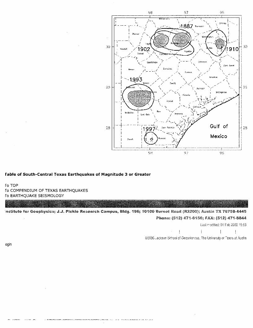
I I -• ..
L'.s Oak *
2 1997. ..... ' Gulf of19 7 '-, 2 ,a." ac -.t/1
Mexico
rable of South-Central Texas Earthquakes of Magnitude 3 or Greater
To TOPFo COMPENDIUM OF TEXAS EARTHQUAKESre EARTHQUAKE SEISMOLOGY
nstitute for Geophysics; J.J. Pickle Research Campus, Bldg. 196; 10100 Burnet Rad (R 2200; A•tn TX 78758-4445
Phone, (512) 471-6156; FAX- (512) 471-8844
Last rrdified: 01 Feb 2002 15:53
@2006 Jackson Scooý of Geosriences, The University of Texas at Austin

----- Original Message -----From: pharb2@,msn.comTo: presidentomessages.whitehouse.gov ; jackson.lisa~cepa.gov ; Roger Vaughan The.Secretarvyhq.doe.gov ; radmat~tceq.state.tx.us ; Robert Beleckis ; greg.abbottaoag.state.tx.us ; rick.perry(agovernor.state.tx.us; inspector.general(ausdoi.qov ; LGloyste(otceq.state.tx.us ; Jackie Hardee ; auqurson.shirley(@epa.govCc: SJABLONScatceq.state.tx.us ; Gilrein.Stephendepamail.epa.gov ; CKuharicctceg.state.tx.us ; PShaver(@tceq.state.tx.us;SSimmons(tceq.state.tx.us ; GSmithDtceq.state.tx.us ; HWeger~tceq.state.tx.us ; Datelinetýnbcuni.com ; Jessica. FarrarR house.state.tx.us ; 60mccbsnews.com ; David.levenstein em.doe.gov ; Kelly.Hancock(chouse.state.tx.us ; Jim.Dunnamrhouse.state.tx.usSent: Thursday, August 20, 2009 7:09 PMSubject: consolidated comment on storage safety at andrews county Texas waste site nb2
Articles where EPA official says ogallala aquifer is under the Andrews county Texas, Waste site.Since the EPA says the water is under the site, nothing toxic should be stored over the aquifer,with the area of the waste site having a history of sinkholes and earthquakes.
regardsPhillip Barrnm
ps forwarded to Eunice new mexico to some worried citizens
<<Back
4/27/09NewsChannel 11 Investigates: Toxic Waste Coming to West Texas, Part 1
Posted: April 27, 2009 04:21 PM MDT
LUBBOCK, TX (KCBD) - It is the biggest clean-up effort in thenation, and contaminants from New York's Hudson River willsoon make their way to West Texas to be buried forgood. The toxic substance could come through Lubbock byrailroad, but the bigger concern is your water supply.NewsChannel 11's Nicole Pesecky is investigating what hasbecome a state-wide controversy.
More than a million pounds of PCB's, or poly chlorinatedbiphenyls, will be dumped in a landfill in Andrews, Texas. Thecarcinogen is linked to thyroid disease, learning, memory and

______________________immune system disorders. For the last 30 years, high levels4 ~ of PCB's were found in fish from the Hudson causing New
York to ban their consumption.
SIt's critical to keep PCBDs ouofw atrsure.l together,butdurngour investigation we found out, the landfill in
Adrews is sitting on top of the Ogallala aquifer, which iswhere many West Texas cities get their water includingLubbock.
"It's really a foolish idea to want to ship all these massiveamounts of waste 2,000 miles to West Texas," said Dr. Neil
~, Carmen, the clean air director for the Lone Star Chapter ofthe Sierra Club. Carmen is not the only one who believes
K ~ ~ these contaminates are going to the wrong place - it is a- highly disputed topic.
General Electric is responsible for cleaning up 1.3 millionpounds of PCB's from the Hudson after they were dumpedback in the 1950's, and GE is forking over $750 million to do
~ ~ it. In the long run, Carmen says Lubbock will be paying the.. price. "The Ogallala aquifer and other water formations are
Tjust a matter of feet away," says Carmen.
Linda Beach, Vice President and G. M. of Waste ControlSpecialists (WCS) in Andrews, disagrees. She claims there is
~ at least 500 feet between the dump and the aquifer, andS that's if there's even a water source there at all. "The aquifer
~ below it is not really the QAG aquifer that everyone is familiarwith - it's some water that is too salty to use for irrigation and
is not drinkable," Linda explains.
Andrews City Manager Glen Hackler is convinced the aquifer is not under this landfill. "Thecommunity of Andrews did independent studies verified that the Ogallala aquifer does notextend into remote western regions of the county," Hackler says. But David Barry,spokesperson for the Environmental Protection Agency for Region 6 says, "Yes, the facilitydoes sit above the Ogallala aquifer. It sits on the southern end of the aquifer."
We checked it out for ourselves, and it does cover part of the Andrews dump. So what arethe chances of this toxic substance getting into Lubbock and other West Texas watersources? "In my opinion there's no chance," Beach states.
Waste specialists say the red bed clay is 100 times more resistant than concrete, so theodds of water draining into the aquifer are very slim. Carmen says clay is not leak proof, andit will inevitably become a problem. "It's just a bad idea to leave for future generations todeal with," Carmen says.
Even the citizens of Andrews are skeptical about what the future holds. "It will probably beafter my lifetime, but I think it will eventually affect the water if they're not careful,"explains one concerned Andrews resident. "If it's gonna bring jobs, great. If they're gonna

hurt our land then they need to find another way to do it," says another.
So why is Andrews so enthusiastic about getting dumped on? "They put a lot into our schoolsystem. They put a lot into the community. WCS is good for Andrews," says this Andrewsresident.
"I think over time there's going to be tens of millions of dollars of economic impact to benefitour community," says Hackler. He's confident this project won't taint their city or anynearby, "We don't in any way feel like this is a danger to our water supply."
One man who spent four years investigating the WCS site says the danger is definitely there."All of our time has been wasted. We've all been played for suckers. We've all been pointlessimpediments to a process that resulted in issuing this license from the first day," he says.
Coming up Tuesday night in Part 2 of our investigation, we will hear from a former employeefor the Texas Commission on Environmental Quality. He says, after 16 years, he quit his jobafter permits were granted to Waste Control Specialists against his recommendation
<<Back
4/28/09NewsChannel 11 Investigates: Toxic Waste Coming to West Texas, Part 2
Posted: April 28, 2009 07:20 PM MDT
S ~i~•> LUBBOCK, TX (KCBD) - NewsChannel 11 told you Monday~Yabout a historical cleanup involving General Electric shipping
millions of pounds of toxic waste from the Hudson River andburying it in West Texas. Tuesday we hear from a formeremployee of Texas Commission on Environmental Quality. Heclaims he quit his job after permits were granted to thelandfill against his recommendation.
Glen Lewis says he threw in the towel after TCEQ grantedthese permits allowing hazardous waste to be buried at thelandfill site in Andrews, Texas. He says his reasoning is thatthose toxic substances will inevitably contaminate the aquifersitting underneath that dump, which is one way Lubbock getsits water.

Lewis has been with TCEQ for 16 years. He spent nearly fourof those years investigating the Waste Control Specialists sitein Andrews, Texas for approval of certain toxic wastes. Lewissays, "I resigned my position there, mainly because ofdecisions made regarding the application submitted by WCSfor disposal of low level radioactive waste at a site in AndrewsCounty."
Lewis wasn't the only TCEQ employee who strongly feltthe WCS site was the wrong place for these contaminates. "There were two other peoplewho quit specifically because of this," Lewis says.
The permit was just granted to WCS on January 28th, 2009. "All of our time has beenwasted. We've all been played for suckers, we've all been pointless impediments to aprocess that resulted in issuing this license from the first day," Lewis explains.
During Lewis' review with TCEQ, he found that the landfill site is threatened by dump waterdraining into two water tables. One of those, the Ogallala aquifer which is water Lubbockdrinks. "It may be as close as 14 feet from the bottom of the proposed trench. We foundthat those were unacceptable margins and were not the hundreds of feet of impermeablered bed clay that the applicant originally claimed," Lewis says.
That is what WCS still claims. "At least 500 feet of red bed clay on the bottom of the landfillbetween the nearest potential aquifer," Linda Beach, the Vice President with WSC says.
So why would TCEQ and the Environmental Protection Agency grant these permits to beginwith? Lewis chalks it up to inexperience. Neither organization has ever had to get rid of 1.3million pounds of toxic waste and transport it to one location. "Nobody has really dealt withthis. We can't look into a crystal ball and say that this site is absolutely going to performsatisfactory for 50,000 years," Lewis explains.
Rod Baltzer, president of WCS, says Lewis is wrong - the landfill is not over the Ogallala. "Idon't think they've got the latest information, and they don't understand what the facts are,"says Baltzer.
Jim Conkwright with the High Plains Underground Water District says he didn't know at firstif the aquifer extends under the landfill, but did some checking and says, "It depends onyour definition of the aquifer," he continues to say, "Some say it is and some say it isn't."
WCS says according to maps by the Texas Water Development board in 2006, its disposalsite does not sit above the Ogallala aquifer. WCS states that after Lewis left the agency,hundreds of additional wells were drilled to determine the subsurface properties at the site.The company has had several consultants analyzing the ground water results. Also,according to the company, as a result of meetings with TCEQ, they agreed to install longterm monitoring of the water at the site. Its analysis says the water at the site is puddledand not connected to the aquifer.
Wednesday night, we'll have more from the president of WCS, and why he says the Ogallalaaquifer is not under his site.
<<Back
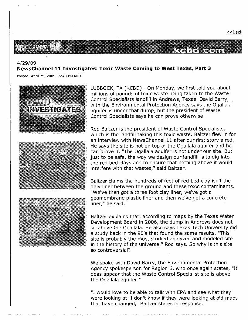
4/29/09NewsChannel 11 Investigates: Toxic Waste Coming to West Texas, Part 3
Posted: April 29, 2009 05:48 PM MDT
LUBBOCK, TX (KCBD) - On Monday, we first told you aboutmillions of pounds of toxic waste being taken to the WasteControl Specialists landfill in Andrews, Texas. David Barry,with the Environmental Protection Agency says the Ogallala
VES, T1GATE" I aquifer is under that dump, but the president of Wastei Control Specialists says he can prove otherwise.
Rod Baltzer is the president of Waste Control Specialists,which is the landfill taking this toxic waste. Baltzer flew in foran interview with NewsChannel 11 after our first story aired.
Si. He says the site is not on top of the Ogallala aquifer and hecan prove it. "The Ogallala aquifer is not under our site. Butjust to be safe, the way we design our landfill is to dig intothe red bed clays and to ensure that nothing above it wouldinterfere with that wastes," said Baltzer.
Baltzer claims the hundreds of feet of red bed clay isn't theonly liner between the ground and these toxic contaminants."We've then got a three foot clay liner, we've got ageomembrane plastic liner and then we've got a concrete
Sliner, he said.
Baltzer explains that, according to maps by the Texas WaterDevelopment Board in 2006, the dump in Andrews does notsit above the Ogallala. He also says Texas Tech University dida study back in the 90's that found the same results. "Thissite is probably the most studied analyzed and modeled sitein the history of the universe," Rod says. So why is this siteso controversial?
We spoke with David Barry, the Environmental ProtectionAgency spokesperson for Region 6, who once again states, "Itdoes appear that the Waste Control Specialist site is abovethe Ogallala aquifer."
"I would love to be able to talk with EPA and see what theywere looking at. I don't know if they were looking at old mapsthat have changed," Baltzer states in response.

Jim Conkwright with the High Plains Underground WaterDistrict did some checking and says, "It depends on yourdefinition of the aquifer. Some say it is and some say it isn't."
Glen Hackler, the city manager of Andrews, says they profitfrom WCS. "I think over time there's going to be tens of
1 millions of dollars of economic impact to benefit our..........._ community," Hackler explains.
So we know the possible economic benefit for Andrews, but it's still unknown howmuch WCS will profit from this waste. Rod Baltzer says WCS is required to have financialinsurance. They're insured for over $8 million.
WCS issued a statement saying, "State and federal governments have determined on8 separate occasions that the WCS facility does not pose a threat to the drinking water ofany person, city or entity in the Permian Basin or the South Plains, including Lubbock."
From: <[email protected]>To: <[email protected]>,<jackson. lisa@epa .qov>,"Roger Vaughan" <[email protected]>,<The. [email protected]>,<[email protected]. us>,"Robert Beleckis" <[email protected]>,<[email protected]>,< rick. [email protected]. us>,<[email protected]>,<[email protected]. us>,"Jackie Hardee" <[email protected]>,<[email protected]>
Cc: <[email protected]>,<[email protected]>,<[email protected]>,< PShaver@tceq .state.tx. us >,<SSimmons@tceq .state.tx.us>,<[email protected]>,< HWeqer@tceq .state.tx. us>,<[email protected]>,<Jessica. Farrar@ house. state.tx. us>,<[email protected]>,<David. levenstei n@em. doe. qov >,< Kelly. Hancock@ house. state.tx. us>,<[email protected]>
Subject: consolidated comment on storage safety at andrews county Texas waste site nb2

Date: Thu, 20 Aug 2009 19:09:16 -0600MIME-Version: 1.0Content-Type: multipart/related;type = "multipart/alternative";boundary=" .... =_NextPart_000_01AE_01CA21C9.B66F6FE0"
X-Priority: 3X-MSMaiI-Priority: NormalX-Mailer: MSN 9X-MimeOLE: Produced By MSN MimeOLE V9.60.0053.2200Seal-Send-Time: Thu, 20 Aug 2009 19:09:16 -0600


![Mr Zs Presentation[1]](https://static.fdocuments.us/doc/165x107/55953f2d1a28ab266d8b4577/mr-zs-presentation1-55954b95c36c2.jpg)