of Annual Reports and other Compliance Documents for Municipal Separate Storm Sewer System (MS4)...
75
Submittal of Annual Reports and other Compliance Documents for Municipal Separate Storm Sewer System (MS4) Permits NOTE: Missing or incomplete fields are highlighted at the bottom of each page. You may save, close and return to your draft permit as often as necessary to complete your application. After 120 days your draft is deleted. Required Attachments and Supplemental Information Please complete the contents of each tab to submit your MS4 permit compliance document. The information included in this checklist is necessary for a complete submittal. A complete and detailed submittal will help us review about your MS4 permit document. To help us make a decision in the shortest amount of time possible, the following information must be submitted: Review related web site and instructions for Municipal storm water permit eReporting [Exit Form] Attach the following items as appropriate using the attachments tab above Construction Site Pollution Control Annual Report Summary Illicit Discharge Detection and Elimination Annual Report Summary Leaf and Yard Waste Management Municipal Cooperation Attachment Municipal Facility Inspections Pollution Prevention Annual Report Summary Post-Construction Storm Water Management Annual Report Summary Public Education and Outreach Annual Report Summary Public Involvement and Participation Annual Report Summary Storm Water Consortium/Group Report Storm Sewer Map Annual Report Attachment Storm Water Quality Management Annual Report Attachment TMDL Attachment Winter Road Maintenance Other Annual Report Attachment Complete all required forms and upload required attachments Sign and Submit form Reporting Information Submittal Type: Annual Report Project Name: Town of Rib Mountain 2017 MS4 Annual Report County: Marathon Municipality: Rib Mountain, Town Facility Number: 31053 Reporting Year: 2017 Annual Report
Transcript of of Annual Reports and other Compliance Documents for Municipal Separate Storm Sewer System (MS4)...
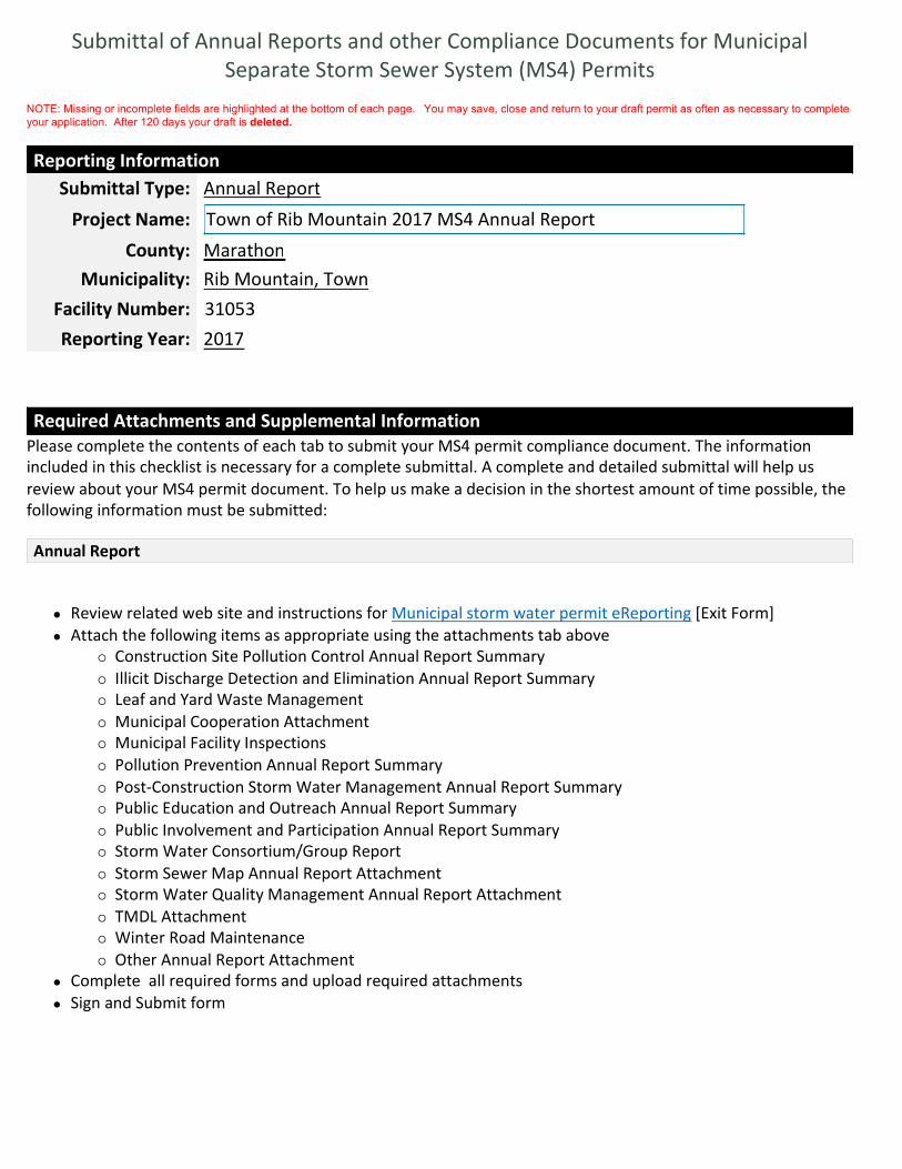
Submittal of Annual Reports and other Compliance Documents for Municipal
Separate Storm Sewer System (MS4) Permits
NOTE: Missing or incomplete fields are highlighted at the bottom of each page. You may save, close and return to your draft permit as often as necessary to complete
your application. After 120 days your draft is deleted.
Required Attachments and Supplemental Information
Please complete the contents of each tab to submit your MS4 permit compliance document. The information
included in this checklist is necessary for a complete submittal. A complete and detailed submittal will help us
review about your MS4 permit document. To help us make a decision in the shortest amount of time possible, the
following information must be submitted:
� Review related web site and instructions for Municipal storm water permit eReporting [Exit Form]
� Attach the following items as appropriate using the attachments tab above
� Construction Site Pollution Control Annual Report Summary
� Illicit Discharge Detection and Elimination Annual Report Summary
� Leaf and Yard Waste Management
� Municipal Cooperation Attachment
� Municipal Facility Inspections
� Pollution Prevention Annual Report Summary
� Post-Construction Storm Water Management Annual Report Summary
� Public Education and Outreach Annual Report Summary
� Public Involvement and Participation Annual Report Summary
� Storm Water Consortium/Group Report
� Storm Sewer Map Annual Report Attachment
� Storm Water Quality Management Annual Report Attachment
� TMDL Attachment
� Winter Road Maintenance
� Other Annual Report Attachment
� Complete all required forms and upload required attachments
� Sign and Submit form
Reporting Information
Submittal Type: Annual Report
Project Name: Town of Rib Mountain 2017 MS4 Annual Report
County: Marathon
Municipality: Rib Mountain, Town
Facility Number: 31053
Reporting Year: 2017
Annual Report

Form 3400-224 (09/17)
Note: Compliance items must be submitted using the Attachments tab.
Municipal Contact Information- Complete
Notice: Pursuant to s. NR 216.07(8), Wis. Adm. Code, an owner or operator of a Municipal Separate Storm Sewer System (MS4) is
required to submit an annual report to the Department of Natural Resources (Department) by March 31 of each year to report on
activities for the previous calendar year (“reporting year”). This form is being provided by the Department for the user’s convenience for
reporting on activities undertaken in each reporting year of the permit term. Personal information collected will be used for
administrative purposes and may be provided to the extent required by Wisconsin’s Open Records Law [ss. 19.31-19.39, Wis. Stats.].
Municipality Information
Name of Municipality Rib Mountain, Town
Facility ID # or (FIN): 31053
Updated Information: Check to update mailing address information
Mailing Address: 3700 North Mountain Rd.
Mailing Address 2:
City: Wausau
State: Wisconsin
Zip Code: xxxxx or xxxxx-xxxx54401
Does the municipality rely on another government entity to satisfy some of the permit requirements?
Yes No Unsure
Has there been any changes to the municipality’s participation in group efforts towards permit compliances (i.e.,
the municipality has added or dropped consortium membership)?
Yes No Unsure
Primary Municipal Contact Person (Authorized Representative for MS4 Permit)
Select to create new primary contact
First Name: Scott
Last Name: Turner
Select to update current contact information
Title:
Mailing Address: 3700 North Mountain Road
Mailing Address 2:
City: Wausau
State: WI
Zip Code: xxxxx or xxxxx-xxxx54401
Phone Number: Ext: xxx-xxx-xxxx715-848-5123
Email: [email protected]
Additional Contacts Information (Optional)

Individual with responsibility for:
(Check all that apply)
I&E Program
IDDE Program
IDDE Response Procedure Manual
Municipal-wide Water Quality Plan
Ordinances
Pollution Prevention Program
Post-Construction Program
Winter roadway maintenance
First Name:
Last Name:
Title:
Mailing Address:
Mailing Address 2:
City:
State:
Zip Code: xxxxx or xxxxx-xxxx
Phone Number: Ext: xxx-xxx-xxxx
Email:

Form 3400-224 (09/17)
Minimum Control Measures- Section 1 :
a. Complete the following information on Public Education and Outreach Activities related to storm
water. Select the Mechanism that best describes how the topic message was conveyed to your
population. Use the Add Activity to add multiple Mechanisms. For Quantity, choose the range for the
number of Mechanisms chosen (i.e., number of workshops, events). Quantity and Estimated People
reached are both optional.
Topic: Detection and elimination of illicit discharges
Topic: Management of materials that may cause storm water pollution from automobiles, pet waste,
household hazardous waste and household practices
Topic: Beneficial onsite reuse of leaves and grass clippings/proper use of lawn and garden fertilizers
and pesticides
Topic: Management of stream banks and shorelines by riparian landowners to minimize erosion and
restore and enhance the ecological value of waterways
Topic: Infiltration of residential storm water runoff from rooftop downspouts, driveways and
sidewalks
Topic: Inform and where appropriate educate those responsible for the design, installation, and
maintenance of construction site erosion control practices and storm water management facilities on
how to design, install and maintain the practices
Topic: Identify businesses and activities that may pose a storm water contamination concern, and
Complete
1. Public Education and Outreach
Mechanism Quantity(optional)
Est. People Reached (optional)
Regional Effort?(optional)
Did not focus on this topic this reporting
year
Select... Yes No
Active distribution of print media
(mailings, newsletters, etc)
1 - 9 7000 Yes No
Passive print media (brochures at front
desk, posters, etc.)
1 - 9 200 Yes No
Active distribution of print media
(mailings, newsletters, etc)
1 - 9 7000 Yes No
Did not focus on this topic this reporting
year
Select... Yes No
Active distribution of print media
(mailings, newsletters)
1 - 9 7000 Yes No
Mechanism Quantity(optional)
Est. People Reached (optional)
Regional Effort?(optional)
Direct one-on-one communication Select... Yes No

where appropriate, educate specific audiences on methods of storm water pollution prevention
Topic: Promote environmentally sensitive land development designs by developers and designers,
including green infrastructure and low impact development
Topic: Other (describe):
b. Any other Public Education and Outreach program information for inclusion in the Annual Report
may be added here or attached on the attachments page.
Form 3400-224 (09/17)
Minimum Control Measures - Section 2 :
a. Describe how the municipality has kept the following local officials and municipal staff apprised of
the municipal storm water discharge permit programs and its requirements.
Elected Officials
Municipal Officials
Appropriate Staff
Direct one-on-one communication Select... Yes No
Did not focus on this topic this reporting
year
Select... Yes No
Select... Select... Yes No
The Town works with other permitted communities in the North Central Wisconsin
Storm water Coalition (NCWSC). In addition, the Town has featured storm water
educational information in the Town newsletter. Information regarding storm water
is featured in all pertinent Town newsletter publishings. The Town will continue to
educate the public as well as work with the NCWSC. The NCWSC had the “Rubber
Ducky Commercial” played during movie previews at Marcus Cedar Cr in Rothschild,
WI
Complete
2. Public Involvement and Participation
The annual MS4 report has been submitted to the Town Board for review. All
meetings are publicly noticed. The report is also posted on the Town's website:
www.townofribmountain.org under the Public Works Department's section.
Staff reports to the Town Board officials and provides updates on storm water
actives.
Department heads also hold weekly meetings and discuss upcoming construction
projects or other issues that may include storm water activities. Key staff receive
email notifications of WDNR proposed changes and events.
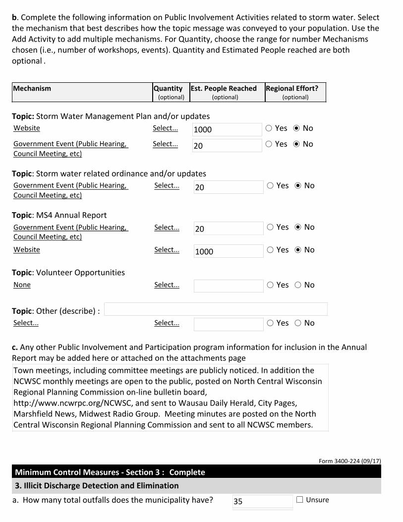
b. Complete the following information on Public Involvement Activities related to storm water. Select
the mechanism that best describes how the topic message was conveyed to your population. Use the
Add Activity to add multiple mechanisms. For Quantity, choose the range for number Mechanisms
chosen (i.e., number of workshops, events). Quantity and Estimated People reached are both
optional .
Topic: Storm Water Management Plan and/or updates
Topic: Storm water related ordinance and/or updates
Topic: MS4 Annual Report
Topic: Volunteer Opportunities
Topic: Other (describe) :
c. Any other Public Involvement and Participation program information for inclusion in the Annual
Report may be added here or attached on the attachments page
Form 3400-224 (09/17)
Minimum Control Measures - Section 3 :
Mechanism Quantity(optional)
Est. People Reached(optional)
Regional Effort?(optional)
Website Select... 1000 Yes No
Government Event (Public Hearing,
Council Meeting, etc)
Select... 20 Yes No
Government Event (Public Hearing,
Council Meeting, etc)
Select... 20 Yes No
Government Event (Public Hearing,
Council Meeting, etc)
Select... 20 Yes No
Website Select... 1000 Yes No
None Select... Yes No
Select... Select... Yes No
Town meetings, including committee meetings are publicly noticed. In addition the
NCWSC monthly meetings are open to the public, posted on North Central Wisconsin
Regional Planning Commission on-line bulletin board,
http://www.ncwrpc.org/NCWSC, and sent to Wausau Daily Herald, City Pages,
Marshfield News, Midwest Radio Group. Meeting minutes are posted on the North
Central Wisconsin Regional Planning Commission and sent to all NCWSC members.
Complete
3. Illicit Discharge Detection and Elimination
a. How many total outfalls does the municipality have? 35 Unsure
Form 3400-224 (09/17)
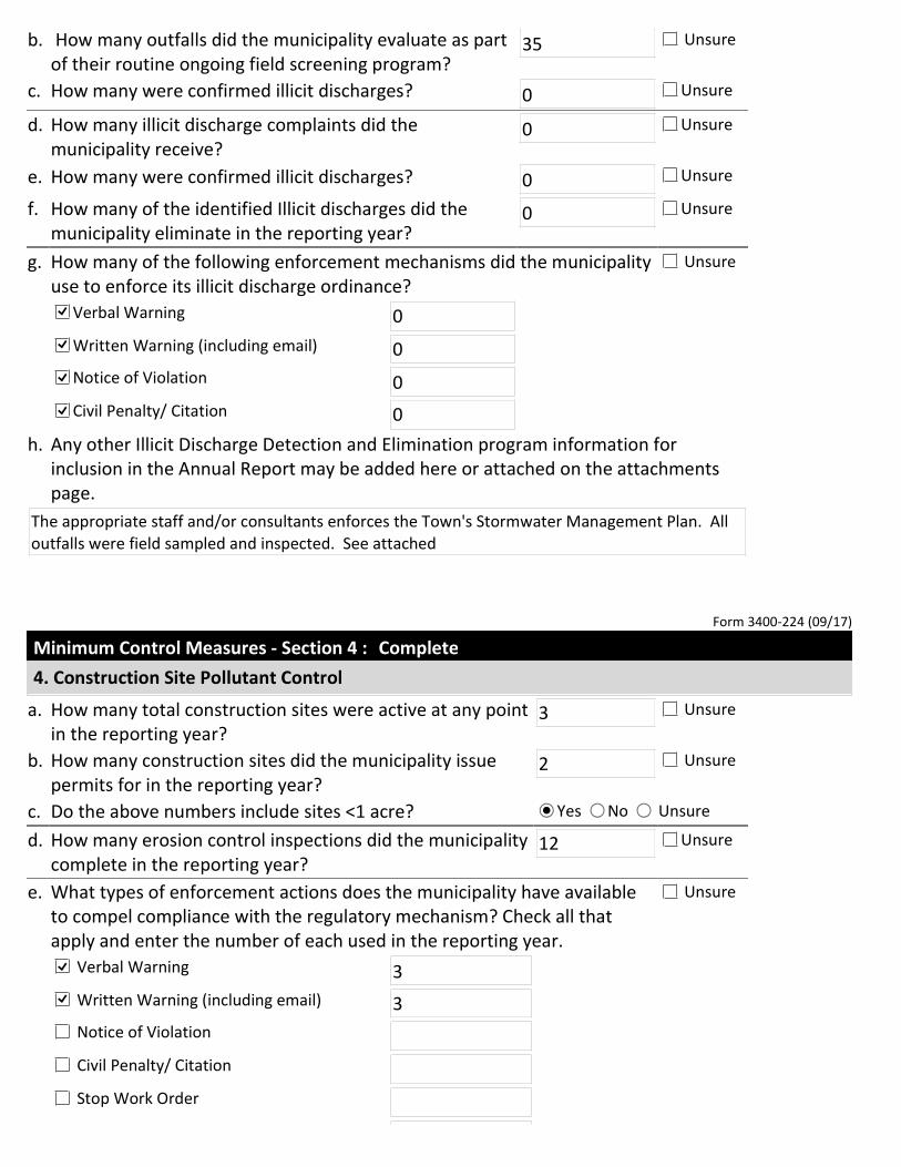
Minimum Control Measures - Section 4 :
b. How many outfalls did the municipality evaluate as part
of their routine ongoing field screening program?35 Unsure
c. How many were confirmed illicit discharges? 0 Unsure
d. How many illicit discharge complaints did the
municipality receive?0 Unsure
e. How many were confirmed illicit discharges? 0 Unsure
f. How many of the identified Illicit discharges did the
municipality eliminate in the reporting year?0 Unsure
g. How many of the following enforcement mechanisms did the municipality
use to enforce its illicit discharge ordinance?
Unsure
Verbal Warning 0
Written Warning (including email) 0
Notice of Violation 0
Civil Penalty/ Citation 0
h. Any other Illicit Discharge Detection and Elimination program information for
inclusion in the Annual Report may be added here or attached on the attachments
page.
The appropriate staff and/or consultants enforces the Town's Stormwater Management Plan. All
outfalls were field sampled and inspected. See attached
Complete
4. Construction Site Pollutant Control
a. How many total construction sites were active at any point
in the reporting year?3 Unsure
b. How many construction sites did the municipality issue
permits for in the reporting year?2 Unsure
c. Do the above numbers include sites <1 acre? Yes No Unsure
d. How many erosion control inspections did the municipality
complete in the reporting year?12 Unsure
e. What types of enforcement actions does the municipality have available
to compel compliance with the regulatory mechanism? Check all that
apply and enter the number of each used in the reporting year.
Unsure
Verbal Warning 3
Written Warning (including email) 3
Notice of Violation
Civil Penalty/ Citation
Stop Work Order
Form 3400-224 (09/17)
Minimum Control Measures - Section 5 :
Form 3400-224 (09/17)
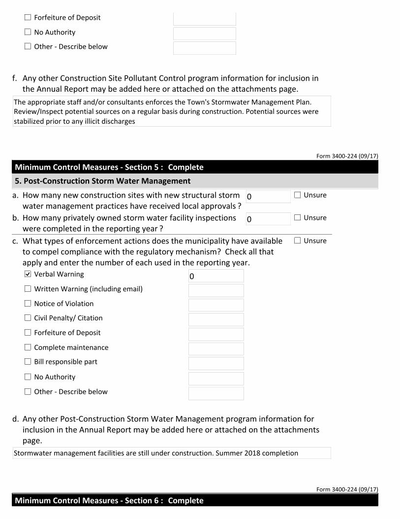
Forfeiture of Deposit
No Authority
Other - Describe below
f. Any other Construction Site Pollutant Control program information for inclusion in
the Annual Report may be added here or attached on the attachments page.
The appropriate staff and/or consultants enforces the Town's Stormwater Management Plan.
Review/Inspect potential sources on a regular basis during construction. Potential sources were
stabilized prior to any illicit discharges
Complete
5. Post-Construction Storm Water Management
a. How many new construction sites with new structural storm
water management practices have received local approvals ?0 Unsure
b. How many privately owned storm water facility inspections
were completed in the reporting year ?0 Unsure
c. What types of enforcement actions does the municipality have available
to compel compliance with the regulatory mechanism? Check all that
apply and enter the number of each used in the reporting year.
Unsure
Verbal Warning 0
Written Warning (including email)
Notice of Violation
Civil Penalty/ Citation
Forfeiture of Deposit
Complete maintenance
Bill responsible part
No Authority
Other - Describe below
d. Any other Post-Construction Storm Water Management program information for
inclusion in the Annual Report may be added here or attached on the attachments
page.
Stormwater management facilities are still under construction. Summer 2018 completion
Minimum Control Measures - Section 6 : Complete

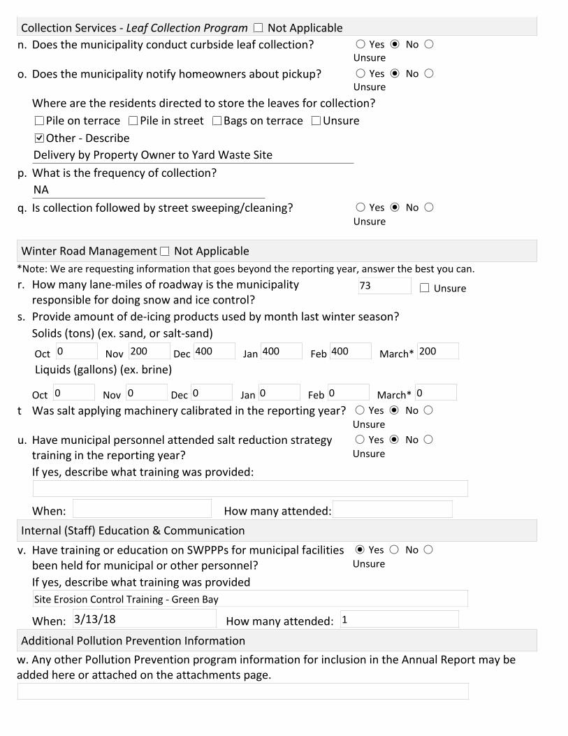
6. Pollution Prevention
Storm Water Management Facility Inspections (ponds, biofilters, etc.) Not Applicable
a. Enter the total number of municipally owned or operated
structural storm water facilities ?9 Unsure
b. How many new municipally owned storm water facilities were
installed in the reporting year ?0 Unsure
c. How many municipally owned storm water devices were inspected
in the reporting year?0 Unsure
d. How many of these facilities required maintenance?
If so, attach report on attachments page.0 Unsure
Public Works Yards & Other Municipally Owned Properties (SWPPP Plan Review) Not Applicable
e. How many inspections of municipal properties been conducted in
the reporting year?2 Unsure
f. Have amendments to the SWPPPs been made? Yes No Unsure
Collection Services - Street Sweeping / Cleaning Program Not Applicable
g. Did the municipality conduct street sweeping/cleaning during the reporting year?
Yes No Unsure
h. If known, how many tons of material was removed? 400 Unsure
i. If street cleaning is identified as a storm water best management practice in the
pollutant loading analysis, was street cleaning completed at the assumed frequency?
Yes
No - Explain
Not Applicable
Unsure
Collection Services - Catch Basin Sump Cleaning Program Not Applicable
j. Did the municipality conduct catch basin sump cleaning during the reporting year?
Yes No Unsure
k. How many catch basin sumps were cleaned in the reporting year? 20 Unsure
l. If known, how many tons of material was removed? Unsure
m. If catch basin sump cleaning is identified as a storm water best management
practice in the pollutant loading analysis, was cleaning completed at the assumed
frequency?
Yes
No - Explain
Not Applicable
Unsure
*Note: We are requesting information that goes beyond the reporting year, answer the best you can.
w. Any other Pollution Prevention program information for inclusion in the Annual Report may be
added here or attached on the attachments page.
Collection Services - Leaf Collection Program Not Applicable
n. Does the municipality conduct curbside leaf collection? Yes No
Unsure
o. Does the municipality notify homeowners about pickup? Yes No
Unsure
Where are the residents directed to store the leaves for collection?
Pile on terrace Pile in street Bags on terrace Unsure
Other - Describe
Delivery by Property Owner to Yard Waste Site
p. What is the frequency of collection?
NA
q. Is collection followed by street sweeping/cleaning? Yes No
Unsure
Winter Road Management Not Applicable
r. How many lane-miles of roadway is the municipality
responsible for doing snow and ice control?Unsure73
s. Provide amount of de-icing products used by month last winter season?
Solids (tons) (ex. sand, or salt-sand)
Oct Nov Dec Jan Feb March* 0 200 400 400 400 200
Liquids (gallons) (ex. brine)
Oct Nov Dec Jan Feb March* 0 0 0 0 0 0
t Was salt applying machinery calibrated in the reporting year? Yes No
Unsure
u. Have municipal personnel attended salt reduction strategy
training in the reporting year?
Yes No
Unsure
If yes, describe what training was provided:
When: How many attended:
Internal (Staff) Education & Communication
v. Have training or education on SWPPPs for municipal facilities
been held for municipal or other personnel?
Yes No
Unsure
If yes, describe what training was provided
Site Erosion Control Training - Green Bay
When: How many attended: 3/13/18 1
Additional Pollution Prevention Information
Form 3400-224 (09/17)
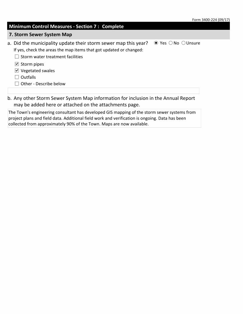
Minimum Control Measures - Section 7 : Complete
7. Storm Sewer System Map
a. Did the municipality update their storm sewer map this year? Yes No Unsure
If yes, check the areas the map items that got updated or changed:
Storm water treatment facilities
Storm pipes
Vegetated swales
Outfalls
Other - Describe below
b. Any other Storm Sewer System Map information for inclusion in the Annual Report
may be added here or attached on the attachments page.
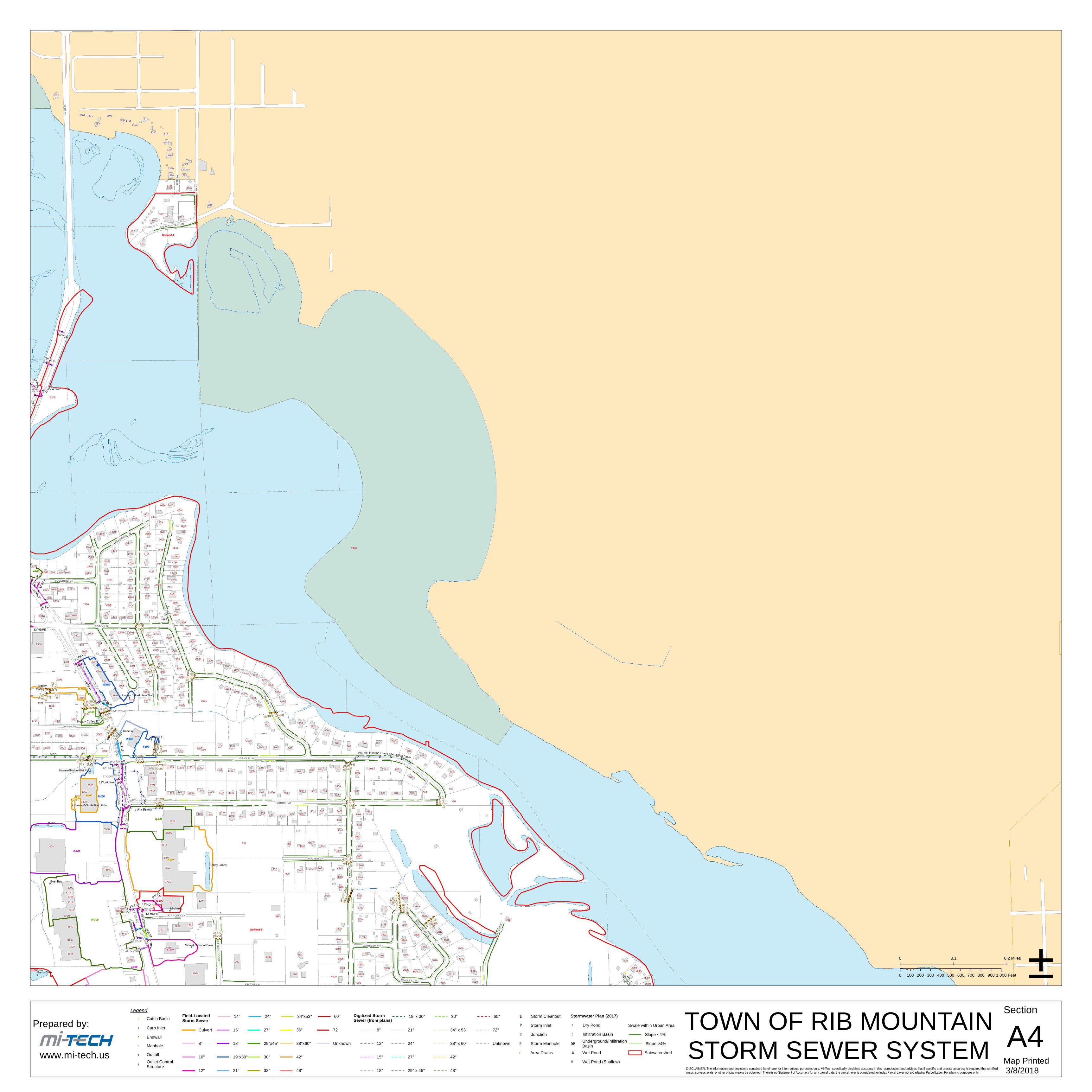
The Town's engineering consultant has developed GIS mapping of the storm sewer systems from
project plans and field data. Additional field work and verification is ongoing. Data has been
collected from approximately 90% of the Town. Maps are now available.

Form 3400-224 (09/17)
Final Evaluation -
Fiscal Analysis
Complete the fiscal analysis table provided below. For municipalities that do not break out funding
into permit program elements, please enter the monetary amount to your best estimate of what
funding may be going towards these programs.
Element: Public Education and Outreach
Element: Public Involvement and Participation
Element: Illicit Discharge Detection and Elimination
Element: Construction Site Pollutant Control
Element: Post-Construction Storm Water Management
Element: Pollution Prevention
Element: Storm Water Quality Management
Element: Storm Sewer System Map
Other (describe)
Water Quality
a: Were there any known water quality improvements or degradation in the receiving waters to
which the municipality’s storm sewer system directly discharges to?
Complete
Annual
Expenditure
Reporting Year
Budget
Reporting Year
Budget
Upcoming Year
Source of Funds
2500 2500 3000 General revenue fund
500 0 0 Other
1000 0 0 Other
1000 0 0 Other
1000 0 0 Other
500 0 0 Other
2700 2700 0 Grants
5000 5000 5000 General revenue fund
Select...

Yes No Unsure If Yes, explain below:
b: Have any of the receiving waters that the municipality discharges to been added to the impaired
waters list during the reporting year?
Yes No Unsure
c: Has the municipality evaluated their storm water practices to reduce the pollutants of concern?
Yes No Unsure
Additional Information
Based on the municipality’s storm water program evaluation in Part II, describe any proposed
changes to the municipality’s storm water program.
Rookery Park - Lake Wausau Association - weed removal

Form 3400-224 (09/17)
Requests for Assistance on Improving Permit Programs
Would municipality like the Department to contact them about providing more information on
developing or improving any of the Municipal Separate Storm Sewer Permit programs?
Please select all that apply:
Public Education and Outreach
Public Involvement
Illicit Discharge Detection and Elimination
Post-Construction Storm Water Management
Storm Water Quality Management
Storm Sewer System Map
Construction Site Pollutant Control
Pollution Prevention
Water Quality Concerns
Compliance Schedule Items Due
MS4 Program Evaluation

Required Attachments and Supplemental Information
Upload Required Attachments (15 MB per file limit) - Help reduce file size and trouble shoot file uploads
*Required Item
Note: To replace an existing file, use the 'Click here to attach file ' link or press the to delete an item.
Attach Documents
(To remove additional items, use your cursor to hover over the attachment section. When the drop down arrow appears, select remove
item)
Any other MS4 program information for inclusion in the Annual Report may be attached on here. Use
the Add Additional Attachments to add multiple documents.
AR_IDDEFIN
File AttachmentIDDEOutfallMontoring140802_tech_memoSummary.pdf
AR_SWMapFIN
File AttachmentTownofRibMtn36X36StormSystemMaps_Mar2018.pdf
AR_PPFIN
File AttachmentTownofRibMountainPollutionPreventionPlanPublicWorksFacilityMar
ch2018.pdf
AR_PPFIN
File AttachmentTownofRibMountainPollutionPreventionPlanYardWasteSiteMarch20
18.pdf

Steps to Complete the signature process
1. Read and Accept the Terms and Conditions
2. Press the Submit and Send to the DNR button
NOTE: For security purposes all email correspondence will be sent to the address you used when
registering your WAMS ID. This may be a different email than that provided in the application. For
information on your WAMS account click HERE .
Terms and Conditions
Certification: I hereby certify that I am an authorized representative of the municipality covered
under Rib Mountain, Town MS4 Permit for which this annual report or other compliance document
is being submitted, and that the information contained in this submittal and all attachments were
gathered and prepared under my direction or supervision. Based on my inquiry of the person or
persons under my direction or supervision involved in the preparation of this document, to the best
of my knowledge, the information is true, accurate, and complete. I further certify that the
municipality’s governing body or delegated representatives have reviewed or been apprised of the
contents of this annual report. I understand that Wisconsin law provides severe penalties for
submitting false information.
Signee (must check current role prior to accepting terms and conditions)
Authorized municipal contact using WAMS ID.
Delegation of Signature Authority ( Form 3500-123 ) for agent signing on the behalf of the
authorized municipal contact.
Agent seeking to share this item with authorized municipal contact (authorized municipal
contact must get WAMS id and complete signature).
After providing the final authorized signature, the system will send an email to the authorized party and any agents. This email will
include a copy to the final read only version of this application.
Do not close your work until you SAVE.
Sign and Submit Your Application
Authorized Signature.
I accept the above
terms and conditions.
Signed by : i:0#.f|wamsmembership|tturner1969 on 2018-03-23T13:02:05
You have already signed and submitted this application to the DNR. Please contact
the Wisconsin DNR for assistance.

#*
#*
#*!(
")
#*
#*
#*
#*
#*#*#*
#*
#*
#*
!(!(
XW
XW
")
")
!(
")")
#*")
#*
#*
#*
#*
#*
#*
#*
#*
#*
#*
!(
#*
!(
!(
")
!(
")!(
")
!(!(
")
!(XW
#*
#*
Group A
GroupB
B-120
B-180B-190
U-100D-120
R-100
S-100
Y-100
¬«29
£¤51
£¤51
£¤51
£¤51
£¤51
£¤51
£¤51
§̈¦39
§̈¦39
CLOV
ER R
D
SPRINGCIR
BIGPINE
LN
BIG PINE
LNN LAKESHORE DR
SUNRISECT
BLUEBERRYCT
HILL
CRES
TLN
S 17THAV
AZALEALN
TULIP
CT
SAGE LN
BLUEJAYLN
WARBLERWAY
BLAC
KBER
RYSO
UTH
SAI NTFRAN CISWAY
WAXWIN
GRD
STRA
WFLO
WER
CIR
LOGA
NBER
RYCT
CAME
LLIA
ST
BAY P ARKC
T
BLUEBIRD LN
SMOKETREELN
FERN LN
S12T
HAV
GOOSE LN
HARD
WOOD
LN
RAVE
N AV
BLUEBIRD
LN
MINT
LN
S13T
HAV
MACA
W AV
FALC
ON AV
PEPPERMINTLN
NIGHTINGALELN
STONECROPRD
BOBW
HITE
RD
REDTAIL LN
MOCKINGBIRD LN
PLOVER LN
PEAC
OCK A
V
MACA
W AV
PHEA
S ANT
AVAZALEA
CT
CLOV
ER R
D LIBER
TY
AV
BLUEJAY LN
KILDEER LN
FLAMINGO LN
ROOK
ERY V
IEWDR
OSPRE Y
DR
SUNFLOWER LN
QUAIL
AV MARTIN AV
STARLING LN
LOTUS LN
LUPINE RD
PARTRIDGE WAY
VERB
ENA
AV
WINDFLOWER LN
REDWING WAY
SAND
PIPER
AV
BROOKFIELD LN
CANVASBACK LN
FIRETH ORNR D
BLAZ
ING
STAR
ST
MOONLITE AV
PRIM
ROSE
LN
PANSY LN
DAHLIA LN
CRAN
EDR
CARN
ATIO
NAV
VIOLE
T LN
FALC
ON AV
FALCON WAY
ARROWOOD LN
PHEA
SANT
AV
PART
RIDG
E AV
FLAMEFLOWER RD
WOOD
DUCK
LN
G OL D
E NR O
DCT
QUAIL
AV
NUTH
ATCH
LN
WREN ST
RAVE
N AV
OWL LN
SUNBIRD LN
WISTERIA LN
US 51 SOUTHOFF RAMP
BLUEJAY LN
KILDEER LN
WINT
ERGR
EEN
RD
MOUNTAIN LN
PRIM
ROSE
AV
US51NORTHOFF RAMP
STRAWBERRYLN
BEGONIA ST
MEADOWLARK LN
FERN LN
BLACKBERRY
DR
US51 NORTHOFF RAMP
JUNIPER LN
PEPPERBUSH LN
RED MAPLE RD
IVY LN
MARIGOLD RD
CHICKADEE LN
BUTT
ERCU
P RD
PINE SISKINLN
PHLOX LN
US 51 SOUTH ON RAMP
IRIS LN
KINGBIRDAV
US 51 SOUTH ON RAMP
BUTTERNUT RD
ELDERBERRY RD
BOULDER RI D GE
ORCH
IDLN
TULIP LN
BLUEBIRD LN
IRIS LN
PINTAIL LN
E LAKESHORE DR
INDIGO
DR
DOVE
AV
PETUNIA RD
KINGFISHER LN
DEER TAILLN
DAFFODIL LN
COUNTRYLN
SKYLARK LN
WINT
ERGR
EEN
RD
CROCUS RD
CARD
INAL
AV
KINGL
ET
CIR
ORIOLE LN
US 51 NORTH ON RAMP
HERO
N AV
FALC
ON AV
MART
IN AV
THUNDERBIRD LN
HOLLIBUSH LN
BUCKTHORN CT
TEALAV
LARKSPUR LN
MOSIN
EE TO
WER
RD
SNOWFLAKE LN
FLAX LN
GROU
SE LN
SUNRISE DR
TULIP LN
STARFLOWER LN
STARFLOWERDR
BLUE
GILL
AV
MALLARD LN
SUNRISE LN
RAINBOW LN
BELLFLOWER ST
EAGL
E AV
BOBO
LINK A
V
SOUTH MOUNTAIN RD
WOOD
BINE L
N
RIB M
OUNT
AIN D
R
BUTT
ERCU
PRD
MAGN
OLIA
AV
SNOW
BIRD A
V
BLUEB E LLLN
WOODSMOKE RD
BLUEBELLDR
SWALLOW LN
RIB M
OUNT
AIN W
AY
CLOVERLAND LN
PARROT LN
MORNING GLORY LN
DOGWOOD RD ROSE
AV
R EDW
ING
RD
FERN LN FERN LN
PART
RIDG
E AV
DAISY RD DAISY RD
BLUEBERRY LN
WHIPPOORWILL RD
BLACKBERRY DRBLACKBERRY DR
LILACAV
ORIOLE LN
LAUR
ELRD
SWAN
AV
JONQUIL LN JONQUIL LN
LILY LN LILY LN
US 51 NORTH ON RAMP
US 51 NORTH ON RAMP
I-39 SO
UTH ON RAM
P
AZAL
EARD
ASTER RD
ASTER RD
TRILLIUMLN
GOLDENROD RD GOLDENROD RD
LAKESHORE DR
ROBIN LN ROBIN LN ROBIN LN
FOXGLOVE RD FOXGLOVE RD
STATE 29 EAST ON RAMPSTATE 29 EAST ON RAMP
PARK RD
PARK RD
PARKRD
PARK RD
THOR
NAPP
LE R
DTH
ORNA
PPLE
RD
RIB
MOUN
TAIN
DR
RIBMO
UNTA
INDR
RIBMOUNTAIN
DR
HUMMINGBIRDRD
HUMMINGBIRDRD
HUMMINGBIRDRD
HUMM
INGBIR
D RD
NORTH MOUNTAIN RD NORTH MOUNTAIN RD NORTH MOUNTAIN RD NORTH MOUNTAIN RD
BITTE
RSWE
ET R
DBIT
TERS
WEET
RD
BITTE
RSWE
ETRD
SOUTH MOUNTAIN RD SOUTH MOUNTAIN RD SOUTH MOUNTAIN RD SOUTH MOUNTAIN RD SOUTH MOUNTAIN RD
RED BUD RD
RED
BUD
RDRE
D BU
D RD
RED
BUD
RD
GOLD
ENROD CIR
GOLDENROD CIR
PARK RD
PARK RD
A1 A2 A3 A4
B1 B2 B3 B4
C1 C2 C3 C4
D1 D2 D3 D4
P-100
ZZ-100
L-100
NoPond-1
NoPond-2
NoPond-3
NoPond-6
K-100
N-100
NoPond-5
NoPond-4
I-100
M-100
Q-100
H-100
O-100
S-100
X-100
Z-100
G-100
W-100
T-100
E-100
D-100
D-110
D-130
D-140 V-100
C-100
F-100
C-110
B-110
B-100B-100
B-140B-130
B-170
B-150B-160
B-200 B-210
YY-100
A-100
A-120
A-130
A-110
A-150
A-140
A-160
A-180
A-170
J-100
Group D
Group C
Map Printed: 3/8/2018DISCLAIMER: The information and depictions contained herein are for informational purposes only; Mi-Tech specifically disclaims accuracy in this reproduction and advises that if specific and precise accuracy is required that certifiedmaps, surveys, plats, or other official means be obtained. There is no Statement of Accurracy for any parcel data; the parcel layer is considered an Index Parcel Layer not a Cadastral Parcel Layer. For planing purposes only.
Prepared by:
www.mi-tech.usTOWN OF RIB MOUNTAIN
STORM SEWER SYSTEM - KEY MAP ±
0 1,000 2,000 3,000 4,000 5,000 Feet
0 0.1 0.2 0.3 0.4 0.5 0.6 0.7 0.8 0.9 1 Miles
1 2 3 4+ + +
A
B
C
D
++
++ +
++
A
B
C
D
++
++
+
1 2 3 4+ + ++ +
Street IndexRAINBOW LNRASPBERRY LNRAVEN AVRED BUD RDRED MAPLE RDREDTAIL LNREDWING RDREDWING WAYRIB MOUNTAIN DRRIB MOUNTAIN WAYROBIN LNROOKERY VIEW DRROSE AVS 12TH AVS 13TH AVS 17TH AVS 28TH AVSAGE LNSAINT FRANCIS WAYSANDPIPER AVSKYLARK LNSMOKETREE LNSNOWBIRD AVSNOWDROP LNSNOWFLAKE LNSOUTH MOUNTAIN RDSPEARMINT LNSPRING CIRSPRINGBROOK DRSTARFLOWER DRSTARFLOWER LNSTARLING LNSTARLITE AVSTATE 29 EAST ON RAMPSTATE 29 WEST ON RAMPSTATE HIGHWAY 29STONECROP RDSTRAWBERRY LNSTRAWFLOWER CIRSUNBIRD LNSUNFLOWER LNSUNRISE CTSUNRISE DRSUNRISE LNSWALLOW LNSWAN AVTEAL AVTHORNAPPLE RDTHUNDERBIRD LNTRILLIUM LNTULIP CTTULIP LNUS 51US 51 NORTH OFF RAMPUS 51 NORTH ON RAMPUS 51 SOUTH OFF RAMPUS 51 SOUTH ON RAMPVERBENA AVVIOLET LNWARBLER WAYWAXWING RDWHIPPOORWILL RDWINDFLOWER LNWINTERGREEN RDWISTERIA LNWOODBINE LNWOODDUCK LNWOODSMOKE RDWREN ST
B4, C4C2A3B1, C1, D1-2D3B4A1A1A3, B3-4A2A2-3A3B4, C4A3A3A3A3C3A2A2A2-3C3A2C4B3B1-4C2A2A1-2C3C3B3-4C4B4, C4A3C4D3B3C2A2-3B4C4C4C4A2-3A4, B4A3A1, B1A2-3B3, C3-4B4B3-4A3, B3-4, C4A3, B4A3, B3-4, C4A3, B3A3, B3-4C3, D3B3B4A1A1D3C4, D4C3C3B4C2A3
ARROWOOD CTARROWOOD LNASTER RDAZALEA CTAZALEA LNAZALEA RDBANEBERRY CTBAY PARK CTBEGONIA STBELLFLOWER STBIG PINE LNBITTERSWEET RDBLACKBERRY CTBLACKBERRY DRBLACKBERRY SOUTHBLAZING STAR STBLEEDING HEART STBLUEBELL DRBLUEBELL LNBLUEBELL RDBLUEBERRY CTBLUEBERRY LNBLUEBIRD LNBLUEGILL AVBLUEJAY LNBOBOLINK AVBOBWHITE RDBOULDER RIDGEBROADBILL LNBROOKFIELD LNBUCKTHORN CTBUFFLEHEAD AVBUTTERCUP RDBUTTERNUT RDCAMELLIA STCANARY AVCANVASBACK LNCARDINAL AVCARNATION AVCHICKADEE LNCLOVER RDCLOVERLAND LNCOUNTRY LNCRANE DRCROCUS RDDAFFODIL LNDAHLIA LNDAISY RDDEER TAIL LNDOGWOOD RDDOVE AVDUSTY MILLER RDE BITTERSWEET CTE LAKESHORE DRE RIB MOUNTAIN DREAGLE AVELDERBERRY RDFALCON AVFALCON WAYFAWN RDFERN LNFIRETHORN RDFLAMEFLOWER RDFLAMINGO LNFLAX LNFORGET ME NOT LNFOXGLOVE RDGOLDENROD CIRGOLDENROD CTGOLDENROD RDGOOSE LNGROUSE LNHARDWOOD LNHERON AVHILLCREST LNHOLLIBUSH LNHUMMINGBIRD RDI-39I-39 SOUTH ON RAMPINDIGO DRIRIS LNIVY LNJONQUIL LNJUNIPER LNKILDEER LNKINGBIRD AVKINGFISHER LNKINGLET CIRLAKESHORE DRLARKSPUR LNLAUREL RDLIBERTY AVLILAC AVLILY LNLOGANBERRY CTLOTUS LNLUPINE RDMACAW AVMAGNOLIA AVMALLARD LNMANDARIN LNMARIGOLD RDMARTIN AVMEADOW CIRMEADOWLARK LNMERGANSER WAYMINT LNMOCKINGBIRD LNMOONLITE AVMORNING GLORY LNMOSINEE TOWER RDMOUNTAIN CTMOUNTAIN LNMOUNTAINBERRY CTN LAKESHORE DRNIGHTINGALE LNNORTH MOUNTAIN RDNUTHATCH LNORCHID CIRORCHID CTORCHID LNORIOLE LNOSPREY DROWL LNPANSY LNPARAMOUNT DRPARK RDPARROT LNPARTRIDGE AVPARTRIDGE WAYPEACOCK AVPEPPERBUSH LNPEPPERMINT LNPETUNIA RDPHEASANT AVPHLOX LNPINE SISKIN LNPINTAIL LNPLOVER LNPRIMROSE AVPRIMROSE LNQUAIL AV
D3D3D3-4C4C4C4, D4C3B4B3B2, B3B4, C4B3, C3, D3C2C1-2C2B3B3C3C3C3C2C2A3B4A2-3A3A2A2A2C3-4C3A2C4, D4B1B3A3A2A3C4A3C3B3-4B4A2B1B3B4B1B3B2, C2A3C4D3C4A3-4A3B1A2A2D2B3-4C3C3A3B3-4B4, C4C3-4C3C2C2-3A3A2B1A3A1C3-4A3, B3B4, C4, D4C4B4B3-4B3-4B3-4C3A2-3A3, B3B3B4B4, C4C4B2, C2C4B4B3-4C2B4D3A2B3, C3A3A2D3A3B4A3A2B3A2C4B3-4C3A2A2C2B4A3A1-3A1-2C3C3C3A3-4A2A2, A3B3-4C4B2-3A3-4A3A3A2C1C2D3A3B4B4A3-4A4B3D3A3

>>
>>
>>>
>>>>>>
>>
>>>
>>
>>
>>>
>>
>>
>>
>>>
>>
>>>>>
>>
>>
>>
>>
>>
>>>
>>>>>
1500
16001601
1701
1800
1901
2008
2001
58002005 5900
2101
2201
2104 2105
5400 2201
2202 22042204 2202
220522012300
2300 23002301
23022304 23052200 2400
230523042404 23012400
2400 24012403
24026200 2402660648022400 2405 2405 490224046704 53025304 24046706 6702 5708
50017111 5905 51035201 5105 4801480555052502 6709 590125017101 67112501 49014913530268056205 5404 5306 530454022508 55032507 250449095102 4905
5609520155012602 53055401 53075403 5303 51072605
26032606
270027026906
2700
69006800 60056404 6001
74016303
63056705
3007
3000
3009
3301
3507
3500
3901
3900
5705
5711
2703
5700
5805
2209
5600
5605
6711
2003
2002
NORTH MOUNTAIN RD
SPRINGBROOK DR
WHIPPOORWILL RD
HILL
CRES
T LN
WAXWING RD
THOR
NAPP
LE R
D
GROU
SE L
N
REDW
ING
RD
REDWING WAY
CRAN
EDRNU
THATC
H LN
24''CMP
[Good]
24''CMP[Poor]
12''CMP
[Digout]
48''CMP[Good]
30''H
DPE
[Goo
d]
''Unknown[Good]
18''RCP[Digout]
34''H
DPE
[Goo
d]
24''HDPE[Good]
38''HDPE[Good]
48''CMP[Good]
60''HDPE[Good]
18''CMP[Digout]
18''CMP[Good]
15''HDPE
[Good]
24''CMP[Poor]
30''CMP
[Poor]
18''RCP[Digout]
60''HDPE[Good]
15''C
MP[G
ood]
36''HDPE[Good]
30''CMP[Good]
48''HDPE[Good]
18''CMP[Digout]
48''HDPE[Digout]
Map Printed 3/8/2018
A1Section
±0 1,000100 200 300 400 500 600 700 800 900 Feet
0 0.20.1 Miles
Prepared by:
www.mi-tech.usDISCLAIMER: The information and depictions contained herein are for informational purposes only; Mi-Tech specifically disclaims accuracy in this reproduction and advises that if specific and precise accuracy is required that certifiedmaps, surveys, plats, or other official means be obtained. There is no Statement of Accurracy for any parcel data; the parcel layer is considered an Index Parcel Layer not a Cadastral Parcel Layer. For planing purposes only.
TOWN OF RIB MOUNTAINSTORM SEWER SYSTEM
!.
")
#*
!
!5
")
Legend
Unknown8" 18" 29"x45" 38"x60" 12" 24" 38" x 60" Unknown
Culvert 15" 27" 36" 72" 8" 21" 34" x 53" 72"
14" 24" 34"x53" 60" 19' x 30" 30" 60"
10" 19"x30" 30" 42" 15" 27" 42"
12" 21" 32" 48" 18" 29" x 45" 48"
Field-LocatedStorm Sewer
Digitized StormSewer (from plans)Catch Basin
Curb InletEndwallManholeOutfallOutlet ControlStructure
Slope <4%Slope >4%Subwatershed
"?B Storm Inlet!!2 Junction
"/ Area Drains
$1 Storm Cleanout
!!2 Storm Manhole
Stormwater Plan (2017)
Underground/InfiltrationBasin
Swale within Urban AreaDry PondInfiltration Basin
Wet PondWet Pond (Shallow)
XW
")
!(
#*
#*

> > > > > > > >>> >
>> >> > >> > > > >> > > >> > > >
>
>>
>
>>
>>>
>>>
>>
>> > >
>>
>>
>>>>>
>>
>>>>
>>>
>>>
>>
>>
>>
>>>
>>
>>
>>
>>>
>> >>
>>>>> >>
>> >>>>
>>>
>>
>>
>>
>>>
>>
>>>> >>>
>>
>> >>>
>>>
>> >>
>>>
>>
>>
>>
>>
>>
>>>
>>
>>>> >>>>
>>>>
>
>>
>>>
>
> >>>
>>
>
>>>
>
>>
>
>>>
>>>
>
>
>>
>
>> > > >>>
>>
> >>
>>
>>
>>
>
> >> >
>>
> > >> > >> > > > > > > > > >>> > > >
>
>>
>>
> >> > > > >
>>>>
>>>> >
>
>>
>
> > > >>>>
>
> >
>>
>
> >
>>
>
>>
>
> > >
>
> > >>
>> > > >
>
3300
1601
31061608
2702
35003502 3406 3202
2805310734091701 17021700
170117061707
1800 18021801
180318041804 1803 1806
34083410 33083310 32103302 3208
180532073301 320133073407 19021902
4000 1903 19031903 19041904
190719061905 19051906 1906 1906 19053601
20012001 2002 200220012002 2002
20032004 200420032003 2004 2004 20053702 3604 3602 32023208330233083704 3502 34023408
5800
21013403 3401 33092100 3503 32092101 3409 33053705 3407 3301 21024508 4002
21022102 2103 21043410 330634023406 330434082104 2105 210532084500 2104
45044604 4602 4506210622022104 320422012105 2200 33073401 3303330534053407 220022042202 22035400 31062201 22044304 29004603 4501 22034601 450546072202 22062204 2205 34002204 320833082300 31022202 320231013402340634082301
22062205 2305 23002201 23012301 230343022300 23024507 23022300 23002301 23022303 23052303 34053407 320333092303 2302 330334012302 33052304 230423042304 2305 23072400 42022305 23052304 2401 24002401 34003408 34022306 340623062400 4100 2401
2400 24012401 3006320024022403 37002402 2403 2407 3106 30022402 3409 3403 31103405 31023407 3401 29044802 29062405 2405 45042404 4508 440446082405 4902240453025304 24045708
3203 31113607 34034009 2907290925004206 3405 30074208 2503 30034300 35024304 43025001 28053402 33023308 3208330051035201 3304 32005105 4707 2807480148055505 2901 2803250549014913 26005302 25022509 27052507 2905 2701260126005404 5306 53045402 26002602 25112601 37035503 2601 320733032504 3401 3305 33013407 32053405 34032504 25134909 26025102 4905 260226045609 26042603 26032600 26035201 30125501 30064200 300830102605 260253055401 53075403 5303 2606 26045107 340434082606 34062605 26063402 3306 320433023304 3206 290029022904 260426074201 2610 260626082608 26092607 2606
3303 320534072611 3207 270234012702 3305 33012701 3403 27023405 27012610 2700 26132609 2700 2705 270227042704 30102701 3012 300427042703 27032700 27042707 2706270333043408 3406 3404 3306 3206 270633023402 32042702 27062702 27052704 27062705 28022707 28022801 28012700 2802 28042709 2803 28033407 3403 34014302 340527084204 3305 28044306 33034300 4200 3207 320533012711
2802 2803 2806280427002805 2806
28082906300834062802 2806340828064201 280433043306 3302 32063404 320443014307 4305 4205 29024203
28014302 29064306 29074204 2907 29074308 4202 290629064200
29092909 29082908 2908 2909410042052904 2905 300130004203 4201 3001 3000 30013000
29043000
30033004 30043003 30034000300840053002 30053201 30053004 30053002 310031003006 40014003 3100
300131013006 31024001 31013104 310231013100 31024005 3102310331033103 31043104 31042901 3104
31053105 3009 3106310631053105 31063101 31064100310729063006 3107 2900
41404180 32023109
3208 32042903 29013005 2905 2805 28033101 3001 32064203 4185 30034201
2613
2616
2613
2706
2705
5705
5711
3816
4125
3200
3108
3300
4135
4004
420042083204
4103
5700
4149
2902
4404
4105
5600
3007 3005
300230043006
3002
2703 3011 3009 3007 3005
3006
30103012
3009
3008
3605
5605
4200
3802
4501
2704
3702370437063708
38023804
3814
1801
4000
4204
4207
3205
3004
3200
2301
3900
3850
3706
4002
30043002
4010
39163918
2800
281128102820
ROBIN LN
PART
RIDG
E AV
SPRINGBROOK DR
QUAI
L AV
SKYLARK LN
CHICKADEELN
NORTH MOUNTAIN RD
MOUNTAIN LN
OWL LN
REDWING WAY
BUFF
LEHE
AD A
V
RAVE
N AV
HILL
CRES
T LN
FALC
ON A
V
THUNDERBIRD LN
FALC
ON A
V
BROADBILL LN
SWALLOW LN
MANDARIN LN
BLUEJAY LN
PARTRIDGE WAY
PARK RD
PARKRD
MACA
W AV
GROU
SE L
N
FALC
ONAV
BOBW
HITE
RD
PEAC
OCK
AV
MACA
W A
V
PHEA
S ANT
AV
BLUEJAY LN
KILDEER LN
OSPREY DR
MERG
ANSE
R WA
Y
SAND
PIPE
R AV
RAVE
N AV
CRAN
EDR
FALCON WAY
PHEA
SANT
AV
QUAI
L AV
NUTH
ATCH LN
SUNBIRD LN
BLUEJAY LN
KILDEER LN
SNOW
BIRD
AV
BOULDER RIDGE
C-100
NoPond-5
ZZ-100
12'' C
ONC
12'' CONC
12'' C
ONC
12'' C
ONC
24'' C
ONC38x60'' CONC
21'' CONC
30'' C
ONC
30'' C
ONC
38x60'' CONC
38x60'' CONC
12"U
nkno
wnUNK38"x60"RCP
29"x45"RCP32"HDPE
48"RCP
24"R
CP
21"RCP
12"RCP12"HDPE
12"R
CP
12"U
nkno
wn
12"RCP
15"HDPE
12"RCP
15"CMP
24"
21"CMP
12"
24"RCP
15"
UNK
24"
21"R
CP
24"U
nkno
wn27"R
CP
UNK
12"
UNK
18"
21"HDPE
UNK
18"UNK
UNK
30"RCP
UNK
20''R
CP[G
ood]
12''C
MP[D
igout]
15''CMP[Good]
''CMP[Good]
30''HDPE[Good]
12''CMP
[Digout]
24''CMP[Good]
12''C
MP[D
igout]
24''HDPE[Good]
12''HD
PE[Go
od]
12''C
MP[D
igout]12
''CMP
[Goo
d]
12''C
MP[D
igout]
18''C
MP[G
ood]
12''HDPE[Good]
40''HDPE[Good]
''CMP[Digout]12
''CMP
[Digo
ut]
12''C
MP[G
ood]
12''C
MP[D
igout]
''Unknown[Good]
14''CMP[Digout]
18''RCP[Digout]
12''C
MP[D
igout]
24''CMP[Good]
18''RCP[Digout] 18''RCP
[Digout]
18''C
MP[D
igout]
48''CMP[Good]
12''CMP[Digout]
18''CMP[Good]
15''HDPE[Digout]
22''CMP[Digout]
15''H
DPE
[Goo
d]
22''C
MP[D
igout]
24''CMP[Poor]
30''CMP
[Poor]
12''CMP[Digout]
18''H
DPE
[Goo
d]
12''CMP[Good]
18''RCP[Digout]
15''H
DPE
[Goo
d]
18''CMP[Digout]
18''HPDE[Good]
24''HDPE
[Good]
30''HDPE[Good]
24''CMP[Good]
14''CMP
[Good]
18''RCP[Good]
36''HDPE[Good]
15''HDPE [G
ood]
16''H
DPE [
Good
]
D-100
D-110
Map Printed 3/8/2018
A2Section
±0 1,000100 200 300 400 500 600 700 800 900 Feet
0 0.20.1 Miles
Prepared by:
www.mi-tech.usDISCLAIMER: The information and depictions contained herein are for informational purposes only; Mi-Tech specifically disclaims accuracy in this reproduction and advises that if specific and precise accuracy is required that certifiedmaps, surveys, plats, or other official means be obtained. There is no Statement of Accurracy for any parcel data; the parcel layer is considered an Index Parcel Layer not a Cadastral Parcel Layer. For planing purposes only.
TOWN OF RIB MOUNTAINSTORM SEWER SYSTEM
!.
")
#*
!
!5
")
Legend
Unknown8" 18" 29"x45" 38"x60" 12" 24" 38" x 60" Unknown
Culvert 15" 27" 36" 72" 8" 21" 34" x 53" 72"
14" 24" 34"x53" 60" 19' x 30" 30" 60"
10" 19"x30" 30" 42" 15" 27" 42"
12" 21" 32" 48" 18" 29" x 45" 48"
Field-LocatedStorm Sewer
Digitized StormSewer (from plans)Catch Basin
Curb InletEndwallManholeOutfallOutlet ControlStructure
Slope <4%Slope >4%Subwatershed
"?B Storm Inlet!!2 Junction
"/ Area Drains
$1 Storm Cleanout
!!2 Storm Manhole
Stormwater Plan (2017)
Underground/InfiltrationBasin
Swale within Urban AreaDry PondInfiltration Basin
Wet PondWet Pond (Shallow)
XW
")
!(
#*
#*

#*
#*
#*
#*
#*
#*
#*
!(
#*
#*
#*
!(
!(
"
!(
!(
!(
"
"
!(
"
XW !(
#*
#*
>
>>
>
> >>
> >>
>
>
>>>
>
> >
> >
>>
>>
>>
> >
>>
>
>
>
>
> > > >>
>
>
>>
>>>>>> > > > > > > >>> >
>> >> > >> > > > >> > > >> > > >
> > >>> >> >
>
> >> > > > > >>> >
>>>
>
>>
>
>>
>>>
>>>
>>
>>
>>
>>
>
> >
>
>
>
>> >>>>>
>
>
>>
>>>
>>>>>>>>>>>>>>>
>>>
> > >> >>
>>> >
>> >
> >
>> >>>
> > > > > > > > > >>
>>
>>
>>>>>
>>>
>>>
>
>> >>> >>
>>> >>> >>>
>>
>>>>>
>>> >>> >>
>>>>>>
>>>>> >>>>>>>>>>>
>>> >>
>> > >>
>>>>>>
>> > > >>> > >>>> > > >> >>
>>
>>
> >>
>> >>>>> > >>> >>
>>> >>> >>
>>
>>
>> >>>
>> >>
>>
>> >>>>>
> >> >>
>>> >>
>>
>> >>
>>
>>
>>
>>> >>>
>>
>>>
>> >>
>>>> >>>>
>>>>
> >>
>
> >
>>
>
> >>>
>
>
>>>
> >
> > > >>
>>>>
> > >>> > >
>> >
>
>
>
>
> >>>>>>>>>
>>>>
> >>>
>
> >> >>
>>
>>>>
> > > > > > > >> > >
>
>>
>
> > >>
>>
>>
> > > > > > >>
>>>
>
>>
>
> >>
>>>
>
>
>>
>
>> >
>>
>>
>>> >>
>>
>>
>>
>
> >> >
> > >
> >
>>
>>
>
>>
>>
> >
>
>
>> >> > > > > > > >>> > > >
>> > > >> > > > >
>>>>
> >> > >>
>
> >>> >
>>
>
>
>>>
> > > > >> > > > >> >> > > >
>>
>>
>>
> >>
> >
>
> >>>
>
>
>
>> >>
>>>
>>
>
>>
>>
>>
>
>
>> >>
>
>
>
>>>
>
>>
>>>>>>
>>> >>>
>>>>>>
>>>
>
>>
> >> >>
> > > >>>
>
>
>>
>
> > > >
>> > > >
>> >
>
>>>>
>>
> >
>
> >
>>
>
>>
>>
>
>
>>>
>>
> >
> > >>
>> > > >
>
>>> >
>> >
>>
>>
>
>>
1320
1607 1601 150113151407 1405
1507 1401
1313 1310
1312
13141316
132133001320 1323
13251324
1330 1352
31061608
2702 20435003502 3406 1083202 110 112
104
1022805310734091701 17021700101
170117061707
1800 18021801
180318041804 1803 1806
34083410 33083310 32103302 3208
180532073301 320133073407 19021902
1903 19031903 19041904
190719061905 19051906 1906 1906 19053601
20012001 2002 200220012002 2002 1906200420032004 200420032003 2004 2004 2005
3702 3604 3602 3202 21043208330233083704 3502 34023408
21013403 3401 33092100 3503 32092101 3409 230533053705 3407 18013301 190721012102 2205
21022102 2103 21043410 330634023406 33043408 17012104 2105 210532082104
200321062202 3204 220022012200 33073401 3303330534053407 2200 220822042203 31062204 2900
2203230222062205 3400 320833082300 3102 32023101340234063408
2300 23042301 23032302 2802
230223052303 34053407 32033309 33033401 33052304 2304
23072401 2400 34003408 34023406
240130063200
3700 2407 3106 30023409 3403 31103405 31023407 3401 29042906
3203 31113607 3403 2907 180729093405 3007 2404190130033502 28053402 33023308 320833003304 3200 28072901 2803 140227052905 2701 14042601 250514082600 25043703 3207 26013303 26073401 3305 33013407 32053405 3403 2602 2605
1410 260326042602 1808 26011902 14122603 19063012 300630083010 2603 2607260626022604 140734043408 3406 26063402 3306 320433023304 26033206 2900 260229022904 26112604 260814092605 1901 18091905 1903 270519072606 270220032409 26132606 270418072007
3303 270532053407 27013207 2707270234012702 3305 27043301 2701 27023403 27023405 2701 2702 2706 27032705 2702 25082703 2101 2705 27092707 27061906 1904 19022704 1608 1606 1602160418062504 27052704 1506250230103012 30042704260627042707 2603270527062703 2711270833043408 3406 3404 3306 3206 27063302 27093402 28003204
2706 27082801 28012802 27111905 1901 280118051807 150128022801 18031903 1801 2801 28022802 2801 16011605 160328012802 2804 28012803 26072803 28033407 28053403 3401 28033405 28043305 280328043303 3207 32053301
2802 2805 28052803 2806 28002804 28031506 2805 28062805 2806 2805 2006 280528082807 2110290630083406 170628063408 28092806 21062804 260833043306 1602 28073302 32063404 20042606 20023204 1906 281020082102 280719082104 1904 14021406180426132902 17101802 14041902 130417081806 1302
280928112801
19051907 1405 14031901 18031805 130317051903 290120012906 20032907 2902 29012907 2907 2901290129062906 2901 29022107 29052904 29032904 29032904 290029092909 2908 29032908 2908 29032909 29072905 29052909 29052906 2906 290629052905
29063001 27013000 29073001 29083000 30013000 3002 2907 290929083001 29083001 120029043001 1108300130023001 1106300230023003 3003 300430063004 3003 300330043003 11043003 3010 300530043003 11023004 3004 10103006300530053201 3005 30073005 3006 10083005 31003100 30063100 30073006 1006310230062602 3007 110331013101 30103102 3009 11013101 3100 10043102 31013101 10053102 310431003102 3102 3012 3103 10033103 3100 100231013103 310426093103 26033103 2607 2605 2601 17023104 3103 31043104 31063103 100131053104 3104 1606310431063105 31073106310631063105 31053105 31063106 3108 3109 170626102612 2608 260226042606 16023109 1708 1704 160432023201 9063107 9072906 9023006 3107 2900
3108 80632043201 32023202 17012607 2605 15032609 2603 15053203 1705 170326013109 3203 160116033204 320432063203 100632053204 804 7043206 19043206 1102 8022903 29013005 2905 2805 1902 1004 10022803 160416061702 90515061706 17041804 170832053205 19063101 1602 1302260426063001 26083206 13042612 2610 32063003
1803180519011903 33012407 33022403 130113033301 12033301 33022607 7032609 9072605 10012611 110533002613 2603 2601 11032201 903 33013304 330533033303330333043303 3304 340133062612 33053307 34033306 33062614 3305 33062608 2606 3305
33072604 120234052610 9043304 33111100 80490212003350 1000100211042616 11021300 90810041308 70233083401 80234023401 33093400
340434043403901 805 3402 70326052613 2611 1105 10052607 90512032603 34031201 1001 90711032609 3406 110134053406
34063501
3502350235013500 33113503
3503 908 9063403 904 804 3505360035063550 3505 35063602 3601
360136023600 360336043604 805901907 9033603 9053604
3606 360526002702 2602270027042706 34262604 24043605
360837003704
3702 37053708120424032503 37122703 2701 25012601 25052705
3707380437162603 3720 3801 38012605
12033800 38001301
381270638023802 3806
3900 38043908 705
3909 38062401 39073901
39043903 39033900 4000
4001
2501
2604
2104
2600
3816
3806
3704
3201
1104
3100 3104
3300
3500
3707
3808
3845
3880
2205
2001
3504
3007 3005
300230043006
3002
2703 3011 3009 3007 3005
3006
30103012
3009
3008
2901
2209
22102208
3101
27052703
2400
2510
2205
2204
2200
2301
2108 21002104
20092005 2001
2000 1207 1205
2308
3650
2907
3001
3101
3109
902
901 805
2305
23022209
2405
2704
3702370437063708
38023804
3814
37033705
39093911
2804
2709
1328
2303 2301
2400
2406
2807
21002000
20042008
1801
10031005
1003 903
1305
2200
3103
3004
3200
2906
3203
904
900
3140
1806
2301
2501
31243120
3651
3701
3601
3575
3555
3525
1304
30043002
1605
12041206
3808
4010
39163918
39063904
39023900
38103812
39073905
39013903
380538073803
38013709
3707
26092607
2800
1701
18091915
3813381538173819
40204022
4026402840324034
2008
2201
WOO
DDUC
K LN
BLUEBIRD LN
12TH
AV
QUAI
L AV
SKYLARK LN
MALLARD LN
ORIOLE LN
CHICKADEE LN
28TH
AV
US51
US 51 SOUTHON RAMP
OWL LN
RIB MOUNTAIN DR
US 51
STAT
E29
WES T
ONRA
M
TEALAV
WREN ST
WARBLER WAY
CANA
RY AV
13TH
AV
PARROT LN
CARD
INAL
AV
RIB MOUNTAIN DR
17TH AV
THUNDERBIRD LN
FALC
ON A
V
EAGL
E AV
FALC
ON A
V
NORTH MOUNTAIN RD
SWALLOW LN
MART
IN A
V
BLUEBIRD LN
SWAN
AV
BLUEJAY LN
PARTRIDGE WAY
MEADOWLARK LN
MART
IN A
VGOOSE LN
BLUEBIRDLN
HUMMINGBIRDRD
MACA
W A
V
FALC
ONAV
REDTAIL LN
PLOVER LN
PEAC
OCK
AV
MACA
W A
V
PHEA
S ANT
AV
BLUEJAY LN
KILDEER LN
FLAMINGO LN
ROOK
ERY V
IEWDR
OSPREY DR
HERO
N AV
STARLING LN
FALCON WAY
PHEA
SANT
AV
QUAI
L AV
US51 SOU TH
OFFRAMP
RAVE
N AV
SUNBIRD LN
BLUEJAY LN
KILDEER LN
US 51 NORTH ON RAMP
SNOW
BIRD
AV
US 51 SOUTHON RAMP
PINTAIL LN
KINGFISHER LN
C-100
S-100
X-100
NoPond-3
K-100
NoPond-5
Sams Club
Nicolet National Bank
FREEDOM GROUP LLC
Michaels
Best Buy
Hobby Lobby
Kohls
Barnes&Noble Rain Gdn.
Ulta Beauty
HWY 51/29 Pd. FBarnes&Noble Wet Pd.
Covantage Regional Os.Szmanda Dental
Covantage SE Os.
Biloife W.Biloife E.
Biggby Coffey W.
BiggbyCoffey E.
Honey Baked Ham Mall
Howard Johnsons
Radant Ins. Agency
HWY 51/29 Pd. D
HWY 51/29 Pd. E
8'' CL
AY
8'' CONC
21'' C
ONC
18'' CONC
12'' CONC
12'' CONC
12'' CONC
48'' CONC
12'' C
ONC
12'' CONC
12'' CONC
12'' C
ONC 48'' CONC
15'' CONC
12'' CONC
48'' CONC
12'' CONC
24'' C
ONC
15'' CONC
48'' CONC
12'' CONC
12'' CONC
30'' CONC
21'' CONC
24'' CONC
27'' CONC
18'' C
ONC
38x60'' CONC
21'' CONC
12'' UNK
48'' CONC12'' CONC
12'' CONC18'' CONC
48'' CONC60'' CONC
30'' CONC
30'' C
ONC
24'' CONC15'' CONC
30'' C
ONC
38x60'' CONC
38x60'' CONC
15'' CONC
72'' CONC
12"RCP
15"RCP
18"
18"RCP
12"RCP
12"Unknown
UnknownRCP
12"RCP
12"RCP
12"RC
P
12"U
nkno
wn
12"RCP
UNK
24"RCP
12"RCP
12"Unknown
18"RCP12"RCP
12"U
nkno
wn
18"
UNK38"x60"RCP
15"R
CP
12"RCP48"RCP
24"R
CP
12"HDPE
12"
21"RCP
12"RCP
15"RCP
18"
12"RCP12"
12"RCP
15"RCP
12"PV
C
8"PVC
12"RCP
12"PVC
15"RCP
UNK Storm Drain
24"
12"RCP
12"RCP
12"RCP
UNK est. location / can't open catch basin
UNK
15"RCP
12"P V C
12"R
CP
12"PVC
18"HDPE
12"U
nkno
wn
12"RCP
12"RCP
18"RC
P
12"HDPE 12" HDPE
12"CMP
12"RCP12
"RCP
15"CMP
UNK
18"
12"
24"
18"UnknownRCP
12"R
CP
UNK
12"
12"H
DPE
15"RCP
15"RCP
12"HDPE
18"RCP
UNK
24"RCP
15"RCP
15"
12"HDPE
14"PVC
UNK
12"RC
P
24"
48"RCP
UNK
8"PVC
30"RCP
UNK
15"RCP
15"Unknown
21"RCP
21"R
CP
UNK
24"U
nkno
wn
UNK
18"H
DPE
12"HDPE
27"R
CP
UNK
18"U
nkno
wn
15"RCP
12"
15"
18"
12"HDPE
21"RCP
15"RCP
18"RCP
15"H
DPE
UNK
18"
UNK est. location / can't open catch basin
24"RCP
12"P
VC
UNK
30"RCP
18"RCP
20''R
CP[G
ood]
8''HDPE
[Good]
12''HDPE[Good]
15''HDPE[Good]
17x13''CMP[Digout]
12''C
MP[D
igout]
15''CMP[Good]
''CMP[Good]
10''HDPE[Good]
30''HDPE[Good]
24''CMP[Good]
12''C
MP[D
igout]
24''HDPE[Good]
12''C
MP[D
igout]
12''H
DPE
[Goo
d]
12''C
MP[D
igout]
18''C
MP[G
ood]
18''HDPE[Good]
''CMP[Digout]12
''CMP
[Digo
ut]
24''CMP[Digout]
12''C
MP[D
igout]
18''CMP[Good]
14''CMP[Digout]
24''H
DPE
[Digo
ut]
24''HDPE[Good]
12''C
MP[D
igout]
24''C
MP[G
ood]
15''H
DPE
[Goo
d]
21''C
MP[D
igout]
72''P
VC[Po
or]
12''CMP[Digout]
19x2
8''CMP
[Goo
d]
18''CMP
[Digout]
15''HDPE[Digout]
12''H
DPE
[Goo
d]
22''CMP[Digout]
22''C
MP[D
igout]
16''H
DPE
[Goo
d]
18''H
DPE
[Good
]
12''CMP[Digout]
15''CMP[Good]
12''CMP[Good]
15N to 18S''Unknown[Digout]
12''CMP[Good]17
x13''C
MP[D
igout]
36''HDPE[Good]
35 x 24''RCP[Good]
36''RCP[Good]
24''CMP
[Good]
42x29''CMP[Digout]
15''RCP[Good]
15''H
DPE
[Goo
d]
10''HDPE[Good]
12''H
DPE
[Goo
d]
10''HDPE[Good]
12''C
MP[G
ood]
36''RCP[Good]
30''HDPE[Good]
48''HDPE
[Good]
48''HDPE
[Good]
24''CMP[Good]
12''U
nkno
wn[G
ood]
18''RCP[Good]
23x14''RCP
[Good]
15''CMP[Good]
12''CMP[Good]
36''HDPE[Good]
24''CMP [Poor
]
66''RCP [Good]
16''H
DPE [
Good
]
24''HDPE[Good]
12''H
DPE [
Good
]
'' [Good]
42''RCP[Good]
23x124''RCP[Digout]
''RCP[Good
]
23x14''RCP[Digout]
''RCP[Good
]
12''H
DPE
[Goo
d]
48x2
7''CMP
[Digo
ut]
44''RCP[Good]
24''HDPE [Digout]
P-100
ZZ-100
L-100
N-100
NoPond-4
M-100
Q-100
Y-100
O-100
S-100
Z-100
R-100
T-100
W-100
D-100
D-110
D-130D-120
D-140
V-100
C-110
U-100
YY-100
J-100
Map Printed 3/8/2018
A3Section
±0 1,000100 200 300 400 500 600 700 800 900 Feet
0 0.20.1 Miles
Prepared by:
www.mi-tech.usDISCLAIMER: The information and depictions contained herein are for informational purposes only; Mi-Tech specifically disclaims accuracy in this reproduction and advises that if specific and precise accuracy is required that certifiedmaps, surveys, plats, or other official means be obtained. There is no Statement of Accurracy for any parcel data; the parcel layer is considered an Index Parcel Layer not a Cadastral Parcel Layer. For planing purposes only.
TOWN OF RIB MOUNTAINSTORM SEWER SYSTEM
!.
")
#*
!
!5
")
Legend
Unknown8" 18" 29"x45" 38"x60" 12" 24" 38" x 60" Unknown
Culvert 15" 27" 36" 72" 8" 21" 34" x 53" 72"
14" 24" 34"x53" 60" 19' x 30" 30" 60"
10" 19"x30" 30" 42" 15" 27" 42"
12" 21" 32" 48" 18" 29" x 45" 48"
Field-LocatedStorm Sewer
Digitized StormSewer (from plans)Catch Basin
Curb InletEndwallManholeOutfallOutlet ControlStructure
Slope <4%Slope >4%Subwatershed
"?B Storm Inlet!!2 Junction
"/ Area Drains
$1 Storm Cleanout
!!2 Storm Manhole
Stormwater Plan (2017)
Underground/InfiltrationBasin
Swale within Urban AreaDry PondInfiltration Basin
Wet PondWet Pond (Shallow)
XW
")
!(
#*
#*
#*
#*
#*
#*
#*
#*
!(
#*
#*
!(
!(
"
"
!(
!(
>
>>
>
> >>
> >>
>
>
>>>
>
> >
> >
>>
>>
>>
> >
>>
>
>
>
>
>
> >
>> > >>
>>> >
>>>
> >> >> > > >>>>
>>
>>>
>> >>>
> >
>>> >>> >> >>>
> > >>>>
> >>
>>>>>
>>>>>>
>> > > >>>> >>>> > > >> >>
>>
>>
>> >>
>>>>
> > >
> >
>
>
>> >
>> >
>
> >>>>>>>
>>>>
>>
>
> >>>
>
> >> >
>>>>
> > > > > > > >> > > >
>
>>
>
> > >>
>>
>>
> > > > > >>> >>
>>
>>
>>> >>
> >
>
>
> > >
>
> >>>
>
>
> >
>
>> >> >>
>>>
>
>
>>
>
>
>
>>> >
>>
>
>>
>>
>
>>
1320
1607 1601 150113151407 1405
1507 1401
1313 1310
1312
13141316
13211320 1323
13251324
1330 1352
204
108 110 112104
102
101
2404
14021404 25051408 2504
26011410 2603260426011412
260726061407
26032602 26112608140927052702 26132704
2705 270127072704 27022706 2703
27092707 27061608 1606 16021604 27051506
2711270827092708 271128011501 2801 28022801 16011605 1603
280128052803 280428032805 28031506 2805 2806
280528091602 28072810 2807 14021406 1404 1304 1302
28092811
1405 1403 1303 29012901290129012902
29052904 29032904 29032900 29032907290529052906 2906 29062905
290729082907 290929082908 12002904 1108300130023001 11063002 3004 1104300530043003 11023004 1010300630073006 10083006100631023006
11033101 11013100 1004100531043103 10033100 100231011702 3106 10011606
16021704 1604 906907 902806
1701 150315051703 160116031006 606804 702704
1102 8021004 1002160416061702 90515061602 130213043206 602506
504130113033301 1203 3302 603703907 60110011105 1103 903 50233013305
5093401
3403 3306 50012023405 904 33111100 80490212003350 503100010021104 11021300 9081004 606 604 6021308 702802
4983400
901 805 3402 7031105 1005 9051203 34031201 1001 9071103 11013406
35013502
3503
908 906 904 804 350536003506
3601
36033604805901907 903905
3606 3605
360837003704
3702 37053708 380312043712
380537073804 370337163720 38073801 3801
1203 3701 380938043800 38001301 38113812 380670638023806 39013805
3900 3808 390538043908 705 38097033909 39093806 3810 39013907
39013911 39033904 3900 3905 3905390839093903 3903 39134000 3907
39104001 3915 3909
3201
1104
3100 3104
3300
3500
3707
3808
3845
3880
2205
3611
2705
2400
38001207 1205
3650
2907
3001
3101
3109
902
901 805
2709
1328
2400
2406
2807
10031005
1003 903
1305
904
900
3801
3140
2501
31243120
3651
3701
3601
3575
3555
3525
1304
1605
12041206
WOO
DDUC
K LN
KINGLET CIR
BLUEBIRD LN
MLLRD.LN
12TH
AV
LAKESHOR.
DR
RIB MOUNTAIN DR
WREN ST
TEALAV
ROBIN LN
13TH
AV
17TH AV
ORIOLE LN
SWAN
AV
WARBLER WAY
REDTAIL LN
BLUE
GILL
AV
PLOVER LN
BLUEBIRD LN
STARLING LN
PARROT LN
PINE SISKIN LN
PINTAIL LN
S-100
X-100
Y-100
K-100Sams Club
Nicolet National Bank
Michaels
Best Buy
Hobby Lobby
Kohls
Barnes&Noble Rain Gdn.Ulta Beauty
Barnes&Noble Wet Pd.
Biloife W.Biloife E.
BiggbyCoffey W.
Biggby Coffey E.
Honey Baked Ham Mall
8'' CONC
12'' CONC
15'' CONC
12'' CONC
15'' CONC
12'' CONC
30'' CONC
24'' CONC
18'' C
ONC
12'' CONC18'' CONC
24'' CONC15'' CONC
15'' CONC
15"RCP
18"RCP
12"RCP
12"Unknown
12"RCP
12"RCP
12"Unknown
12"U
nkno
wn
12"HDPE
12"HDPE
12"PVC
12"R
CP
15"RCP
12" P VC
12"
12"R
CP
15"RCP
18"RCP
15"RCP
14"PVC
UNK
UNK
8"PVC
30"RCP
15"RCP
15"Unknown
24"RCP
UNK
12"HDPE
18"U
nkno
wn
15"RCP
15"
18"RCP
24"RCP
UNK est. location / can't open catch basin
12''HDPE[Good]
17x13''CMP[Digout]
12''H
DPE
[Goo
d]
18''HDPE[Good]
15''CMP[Digout]
15''H
DPE
[Goo
d]
18''CMP
[Digout]
12''H
DPE
[Goo
d]
24''HDPE[Good]
15''CMP[Good]
35 x 24''RCP[Good]
36''RCP[Good]
48''HDPE
[Good]
48''HDPE
[Good]
15''CMP[Good]
12''CMP[Good]
66''RCP [Good]'' [Good]
42''RCP[Good]
''RCP[Good
]
''RCP[Good
]
12''H
DPE
[Goo
d]
48x2
7''CMP
[Digo
ut]
15''HDPE
[Good]
44''RCP[Good]
15''HDPE[Good]
P-100
L-100
NoPond-3
N-100
NoPond-4
M-100
Q-100
O-100
S-100 R-100
T-100
W-100
V-100
U-100
J-100
Map Printed 3/8/2018
A4Section
±0 1,000100 200 300 400 500 600 700 800 900 Feet
0 0.20.1 Miles
Prepared by:
www.mi-tech.usDISCLAIMER: The information and depictions contained herein are for informational purposes only; Mi-Tech specifically disclaims accuracy in this reproduction and advises that if specific and precise accuracy is required that certifiedmaps, surveys, plats, or other official means be obtained. There is no Statement of Accurracy for any parcel data; the parcel layer is considered an Index Parcel Layer not a Cadastral Parcel Layer. For planing purposes only.
TOWN OF RIB MOUNTAINSTORM SEWER SYSTEM
!.
")
#*
!
!5
")
Legend
Unknown8" 18" 29"x45" 38"x60" 12" 24" 38" x 60" Unknown
Culvert 15" 27" 36" 72" 8" 21" 34" x 53" 72"
14" 24" 34"x53" 60" 19' x 30" 30" 60"
10" 19"x30" 30" 42" 15" 27" 42"
12" 21" 32" 48" 18" 29" x 45" 48"
Field-LocatedStorm Sewer
Digitized StormSewer (from plans)Catch Basin
Curb InletEndwallManholeOutfallOutlet ControlStructure
Slope <4%Slope >4%Subwatershed
"?B Storm Inlet!!2 Junction
"/ Area Drains
$1 Storm Cleanout
!!2 Storm Manhole
Stormwater Plan (2017)
Underground/InfiltrationBasin
Swale within Urban AreaDry PondInfiltration Basin
Wet PondWet Pond (Shallow)
XW
")
!(
#*
#*
>>
>>>
>>
>> >> >>
>>>
>>
>> >>>>
>>
3301
3507
3500
3901
3900
6200 5800
4300
4405
4406
4407
63056701
45046501
4804
680169057105 71016909
7109
70067002 6904 68027104
5304
6905 6801700771056909
7203
7204 7102 53016802690469087300
7105
54007303
5505
56015600
5609
57055704
5501
6200
5908
690073006406 6000
4803
6507
5801
5501
6709 6703
7000
5600
70016221
5921
6033
5309
5308
5306
6500
6301
5804
SOUTH MOUNTAIN RD
CROCUS RD
HARD
WOO
DL N
HARD
WOO
DL N
THOR
NAPP
LE R
D
DOGWOOD RD
RED
BUD
RD
BUTTERNUT RD
ELDERBERRY RD
DAISY RD
15''H
DPE
[Goo
d]
24''H
DPE
[Goo
d]
15''H
DPE
[Goo
d] 12''C
MP[D
igout]
12''C
MP[G
ood]
15''H
DPE
[Poor]
15''C
MP[D
igout]
36''HDPE[Good]
30''H
DPE
[Good
]
12''C
MP[D
igout]
48''HDPE[Good]
Map Printed 3/8/2018
B1Section
±0 1,000100 200 300 400 500 600 700 800 900 Feet
0 0.20.1 Miles
Prepared by:
www.mi-tech.usDISCLAIMER: The information and depictions contained herein are for informational purposes only; Mi-Tech specifically disclaims accuracy in this reproduction and advises that if specific and precise accuracy is required that certifiedmaps, surveys, plats, or other official means be obtained. There is no Statement of Accurracy for any parcel data; the parcel layer is considered an Index Parcel Layer not a Cadastral Parcel Layer. For planing purposes only.
TOWN OF RIB MOUNTAINSTORM SEWER SYSTEM
!.
")
#*
!
!5
")
Legend
Unknown8" 18" 29"x45" 38"x60" 12" 24" 38" x 60" Unknown
Culvert 15" 27" 36" 72" 8" 21" 34" x 53" 72"
14" 24" 34"x53" 60" 19' x 30" 30" 60"
10" 19"x30" 30" 42" 15" 27" 42"
12" 21" 32" 48" 18" 29" x 45" 48"
Field-LocatedStorm Sewer
Digitized StormSewer (from plans)Catch Basin
Curb InletEndwallManholeOutfallOutlet ControlStructure
Slope <4%Slope >4%Subwatershed
"?B Storm Inlet!!2 Junction
"/ Area Drains
$1 Storm Cleanout
!!2 Storm Manhole
Stormwater Plan (2017)
Underground/InfiltrationBasin
Swale within Urban AreaDry PondInfiltration Basin
Wet PondWet Pond (Shallow)
XW
")
!(
#*
#*

#*
#*
>> >
>
>>
> > >>>
>>>>
>>>>
>>>>
> >>
>
>>>>>
>>
>>
>>
>>>
>> >>
>> >>
>> >>>
>>
>>>
>>>> >>>>> >>
>>>
>> >> >>
>>
>>>
>> >>
>>
>>>>
>
>
> >>>
>
>
2706
2705
4500
3800
3510
3502
300230043104 3000 280029002902 280431003102 2904
5000 50013103
50035002
5004 5005
50075006
51015100
5102 5103
3101 51053005
30033001
290953042907
2905 280029032901
2803
5400
5400
5505
5506
56015600
5609
57055704
41083400
3604
4106 4000
2804
3309 3305480333033605
310540014101 6200
4305580134033503
5501
32013301
6401
3816
6300
5600
3500
4699
6221
3508
4650
4200
4406
5921
6033
5309
51015100
5006 5007
50055004
5003
5001
3702370437063708
38023804
3814
5308
5306
5000
5002
5004
5006
2801
5005
5007
5101
5103
5105
5201
5200
5102
5100
2902
5003
4010
39163918
44054701
41454147
41514153
41504152
3308
5804
SOUTH MOUNTAIN RD
IRISLN
LILYLN
FERNLN
BEGONIAST
CHICKADEELN
PARK RD
BELLFLOWER ST
BITT
ERSW
EET
RD
CAME
LLIA
ST
DAISY RD
DOGWOOD RD
BLEE
DING
HEA
RT S
T
LAUR
EL R
D
BLAZ
ING
STAR
ST
PARK RD
PARK RD
A-150
C-100
D-100
S. Mtn. Elem. School
15'' C
ONC
15'' CONC
15'' C
ONC
15'' CONC
12'' C
ONC
12'' C
ONC
12'' CONC
12'' CONC
12'' C
ONC
12'' CONC
15'' CONC
12'' CONC
12'' CONC
24''CMP
[Good]
30''H
DPE
[Good
]
24''H
DPE
[Goo
d]
12''H
DPE
[Goo
d]
24''H
DPE
[Goo
d]
24''H
DPE
[Goo
d]
24''H
DPE
[Goo
d]
36''HDPE[Good]
48''HDPE[Good]
24''CMP[Good]
18''CMP[Good]
10''HDPE[Good]
12''HDPE[Good]
NoPond-6
D-110
A-100
A-170
A-180
Map Printed 3/8/2018
B2Section
±0 1,000100 200 300 400 500 600 700 800 900 Feet
0 0.20.1 Miles
Prepared by:
www.mi-tech.usDISCLAIMER: The information and depictions contained herein are for informational purposes only; Mi-Tech specifically disclaims accuracy in this reproduction and advises that if specific and precise accuracy is required that certifiedmaps, surveys, plats, or other official means be obtained. There is no Statement of Accurracy for any parcel data; the parcel layer is considered an Index Parcel Layer not a Cadastral Parcel Layer. For planing purposes only.
TOWN OF RIB MOUNTAINSTORM SEWER SYSTEM
!.
")
#*
!
!5
")
Legend
Unknown8" 18" 29"x45" 38"x60" 12" 24" 38" x 60" Unknown
Culvert 15" 27" 36" 72" 8" 21" 34" x 53" 72"
14" 24" 34"x53" 60" 19' x 30" 30" 60"
10" 19"x30" 30" 42" 15" 27" 42"
12" 21" 32" 48" 18" 29" x 45" 48"
Field-LocatedStorm Sewer
Digitized StormSewer (from plans)Catch Basin
Curb InletEndwallManholeOutfallOutlet ControlStructure
Slope <4%Slope >4%Subwatershed
"?B Storm Inlet!!2 Junction
"/ Area Drains
$1 Storm Cleanout
!!2 Storm Manhole
Stormwater Plan (2017)
Underground/InfiltrationBasin
Swale within Urban AreaDry PondInfiltration Basin
Wet PondWet Pond (Shallow)
XW
")
!(
#*
#*
"
!(
#*
#*
#*
#*
#*
#*
#*
#*
XW
XW
#*
"
!(!(
"
!(
""
#*
"
#*
#*
#*
#*
#*
#*
#*
#*
>
>
>>
>>
>>> >
>> >>>
>>
>>
>
>
>
>
>>>
>
> > >
>
>
>>
>
>>
>
> >>
> >>
>
>
>>>
> > > > > >> >
>
>>
>>
>
>>
>
>>
>>>
>>
>>>
>
> >> >
>>
> > > >>>
> >> >>
>>
>
>
>
>>
>>
>>
>
>> >
>
>>
> > >>>
>>>>
>>>>
>>>>
> >>
>
>>>>>
>> >>>>
>>>>
>>>>
>> >>>
> >>>
> >> >>> >
> >>> >> > > >
>
>
> > >>>>
>>
>>
>
>>>>>
>>>
>> >>
>
>
>
> > >
> >> >>
>
>>>>
>
>
>
>>
>
>>
>
>>
>
>
>
>
>
>>
> > >
>
>
>
>>
>
>
>>
>>>
>>
>>> >>>>>
>>
>>
>>> >>>>
>>>
>>> >> >>
>>
>>>>>
>> >>
>>>>
>>>
>>>
>> >>
>>>>> >>>>>
> > >>> >>> >>>>> >> >>> >>> >>> >>
>>
>>
>>>
>>
>>> >> >>>>> >> >>
>>> >>
>>>> > > > >>>>>
>>> >> >>
>>>
>> >>>
> >>
>>> >> >>
>> >>>
>>
>>>
> >>>
>>>> >>>> >>>
>>
>> > > > > > > > > > > > > > > > >
>> > > > > > > > > > > > > > > > > >>>>>
>> >>>>>>>> >>
>>
>> >>> >>
>>
>>>
>>
>>>>>>>> > > >>>> > > >>
>>>
>>>
>>
>>
>>> >>
>>
>> >>>
>> >>
>>>
>> >>>
>>> > > > > >>
>> >>
>>>>> >> >> >>>>>
>>>
>>>> >>
>>>>>>>>>
>>
>>>
>>> >
>>>
> >>>> >> >>
>>
>> > > > > > > > > >>
>
>>
>
> >> > > > > > > > > > > >>>
> >
> > > >
>>
>
>>
>>
>>
> > >
> >
>>
> > >
>>
>
> > >
>
>
>>>> >>
>>>> >>>
>>
> > >>
> >
> >>
>
>>>>
>>
>
> > > > >
>
> >
>
> >
>>>>
>>
>
>>
> > >
>
> >>
> >>>>
>>
>>>
>
>>
>>>
>>>>
>>
>>>
>
>>>
>> >> > >
>>
>>
>> >
> >>
>
>>>
>
>
>>
>>>
> >
> > > >>
>>
>> > >>
> > >
>> >
> >>>
>
> >
> >>>>>>>>> >
>
>>>>
3502350235013500 33113503
3503 908 9063403 904 804 3505360035063550 3505 35063602 3601
360136023600 360336043604 805901907 9033603 9053604
3606 360526002702 2602270027042706 34262604 24043605
360837003704
3702 37053708120424032503 37122703 2701 25012601 25052705
3707380437162603 3720 3801 38012605
12033800 38001301
381270638023802 3806
3900 38043908 705
3909 38062401 39073901
39043903 39033900 4000
4001
100140034005 4004
3800 9082170 1206 100011064007 1204 7064006 4000 80211003510
35024100 9031001
4150707
42014203
4201
42054207900
4300 43014301
43054307
43094311
44014400 4405 4403
4320 440744084412 44091500
4411
44134440 4415
7054502 45034508 805 8034605450515014504 921 4507
46014603
46054602 46074510
4650 460946114604
470347014703801180418061900 47054707470016042005
470518001807 150218092001
2000 18051907150716011705 1603 15051703 1701 480419041905
4711 9061501 8069081900 150415061802 16021708 17061804 1702 1604 48061901
1805300230043104 3000 280029002902 9032804 8051001 905 8033100 801 7013102 8071809 49012904 703
2400906 80411004905 5000 10065000 9105001 90210021004 904 806 802
3103 5100230250035002
70110011003 907 905 9019035004 22105005 5004 80310051007 801 725
220650075006
51015100 5102 51035103 90851045102 5103 5105
10041008 1006 9103101 2104 1002 904 9025105 510730053003
210230015201 9032909 9072100 1003 100152072907 2002 52022905 520328002903 52112006
52102901910 904906 520510042803 1002 5206908
530253015207
909 907 530190527002702 2408 53012704 2606 2404 530221022506 2104 1806 12002504 20042206 5309130820022304 17041906 19022204 1802 160617021708 53051904 17061804 1604 1502 1408 13021306 53051001
530790854012703 9041805 9102605 9022701 90613032607 12112603 12091905 120320052103 2001 130118012609 2403 12072307 16052601 17072405 2401 22012205 160321052503 1701 16011903 1803 150519015400 5403
54052704 2608 200421062702 2606 2604 540522022500 2404 21042208 160619062402 16042206 1902 18041806 18021904 1708 1706 12061702 1304 5410 5507 54075409
24092609 55012401 55012501 20055501 2605 1705 17011805 16052607 1905 55032503 1603 15052603 14032105 1901 13032209 2103 130514011801 55012205 2201 5502 55012001
550555195503200655102104250026022606 1804 180226042608 200222042502 17041906 19042200 18065505 24085506 2404 5504 550516061902 550755051702 1604 12041504 55061404 12061402 1304 55071302 55051306
5601 56015601210724092413 24052503 22072401 1703 56032305 2103 1605 140517011905 170520012609 1305 13031505 12071403 1401 1301 110318052205 2005 12051901 56021903 56035602 560556052109
2307 560756065601 56055605 5609560656055604 1404 1402 13041306 1208 12061302 5611570125045701 57015703 10022406 570510042402 230827022704 2608 2506 1505 57031503 57031403 1401 1303 1301 1207 12055701 5702 1000
1001 57075704 5705 1404 1402 1304 1208 12061302 5706 5705 580110032500 10052701 26052703 2607 5706 1007
10092502 120714035802 5801 13011303 12051401 5802 10025802 10045803 1006
100058065805 10011304 13022601 1208 5806 58051404 12065804 13063400 5805 26102606 59002702 5901 1003
1005100710095902 1403 1305 1301 1207 1205 590259025903
2613 59051406 59041404 5906 9001304 10005905 2607 1302 1208 1206 10081100 9045906
59083604 1405 13051403 1303 1301 12051207 11031407 1007 1001 9019039051101 1003600224022612 26062610261414061504 1304 60062804 9009021004110011041206 90412081404 1306 10001102
3309 33053303 1401 120313031305140722113605 110111031207 10031503 1409 61021307 61011507 9013105
6200 6106180115046201 1500 1408 10001406 110211046108 11001404 12061208
3403 62053503 6205 1710 1702 17001706 1704 1405 1205 12011207 100311011103
3201 172063013301 63041701 12041210 12021206 1005105011041715 1003
1730 62026403 1811
1740
2503
5200
11014500
4502450445084512
54065410
4601
4160
4120
3816
3806
4002
5901
1801
1803
21062208
2606 2604
2505
6300
3704
2101
2160
4180
3500
3707
3808
3845
3880
4001
3504
5904
2202
2406
472047244728
4800
45304524
4340
4260
4600
22102208
4702
1695
3500
2200
5005
5404
5405
2190 21402130
4220
4280
4300
4185
4215
4245
4225
4195
42654285
2205
2204
2200
2301
2108 21002104
20092005 2001
2000
2601
6206
1207 1205
3650
4802
3508
6109
51015100
5006 5007
50055004
5003
5001
902
5406
2207
6201
6203
4202
2150
2305
23022209
2180
2405
3702370437063708
38023804
3814
37033705
39093911
1100
2703 27011803
1800
2602
10081006
905
909
904
900
4002
4101410541134121
5201
450145034505
4509
5000
5002
5004
5006
2801
5005
5007
5101
5103
5105
5201
5200
5102
5100
1555
3651
3701
3601
3575
3555
2206
2202
22072205
47094711
2902
13011203
1201
5003
3808
4010
39163918
39063904
39023900
38103812
39073905
39013903
380538073803
38013709
3707
26092607
6209
6215
6219
4325
5400
4611
4701
4345
4490
6210
6214
6218
44044406
44164424
802
4611
4160
3813381538173819
40204022
4026402840324034
41004102
41304132 4103
410541094111
411541174121
41234127
41294133
413541394141
41444146
41454147
41514153
41504152
6101
4700
2008
2201
3308 BEGONIAST
UNNAMED
ROSE
AV
CHICKADEE LN
ORCHID LN
RIB
MOUN
TAIN
DR
COUNTRY LN
RIBMOUNTAIN
DR
LILY LN
BELLFLOWER ST
TULIPLN
MORNING GLORYLN
ORCHID CT
IRIS LN
PHLOX LN
BITT
ERSW
EET
RD
CLOVERLAND LN
WARBLER WAY
MEADOW CIR
VIOL
ET L
N
FERN LN
SWAN
AV
IVY LN
SOUTH MOUNTAIN RD
JONQUIL LN
KINGBIRD AV
FERN LN
TULIP CT
LILACAV
WOO
DDUC
K LN
BROOKFIELD LN
STRAWBERRY LN
FLAX LN
PARK RD
SOUTH MOUNTAIN RD
HOLLIBUSH LN
CAME
LLIA
ST
FERN LN
MINT LN
BOBO
LINK
AV
IRIS LN
REDTAIL LN
PLOVER LN
BLEE
DING
HEA
RT S
T
STARLING LN
LOTUS LN
MAGN
OLIA
AV
BLAZ
ING
STAR
ST
PANSY LN
DAHLIA LN
US 51
US 51 NORTH ON RAMP
US 51
US 51 SOUTHON RAMP
KINGFISHER LN
DEER TAIL
LN
DAFFODIL LN
SNOWFLAKE LN
TULIP
LN
STATE29 EAST
ONRAMP
B-120
B-190
D-100
R-100
Q-100
Magnolia Custom Homes
Doepke Rec. Area
Lily Ln. Pd.
S. Mtn. Elem. School
Bone & Joint W.
Bone & Joint C.Bone & Joint E.
HWY 51/29 Pd. G
HWY 51/29 Pd. H
Texas Roadhouse Ug. S.
TexasRoadhouse Ug. N.
Kwik Trip
Dicks W.
Dicks C. Dicks E.
Kourek Wausau Imports
PandaExpress W. Panda
Express E.
Walmart
AT&TGoodwill
Sams Club
Nicolet National Bank
FREEDOM GROUP LLC
Michaels
Best Buy
Hobby Lobby
12'' CONC
12'' C
ONC
12'' CONC
12'' CONC
15'' C
ONC
15'' CONC
15'' CONC
15'' CONC
15'' C
ONC
15'' CONC
12'' CONC
15'' C
ONC
12'' CONC
12'' HDPE
12'' HDPE
15'' CONC
12'' C
ONC
12'' CONC
12'' C
ONC
12'' CONC
12'' CONC
12'' CONC
12'' CONC
12'' C
ONC
12'' C
ONC
12'' C
ONC
12'' CONC
12'' C
ONC
18'' CONC
12'' CONC
15'' CONC
18'' C
ONC
12'' CONC
12'' CONC
18'' CONC
24'' H
DPE
12'' U
NK
24'' CONC
12'' U
NK 12'' UNK
24'' CONC
15'' CONC
15'' CONC
12'' CONC
12'' CONC
15'' HDPE
12'' CONC
15'' CONC
15'' HDPE
27'' CONC
42'' HDPE
15'' HDPE15'' CONC
15'' CONC
42'' C
ONC
15'' HDPE
15'' CONC
12'' HDPE
21'' CONC
30'' CONC
12'' CONC
21'' CONC
24'' CONC
18'' CONC
18'' C
ONC
18'' CONC
30'' CONC
12'' CONC
30'' CONC
12'' C
ONC
24'' CONC
12'' HDPE
18'' HDPE
21'' CONC
12'' HDPE
30'' C
ONC
21'' CONC
15'' C
ONC
18'' C
ONC
18'' CONC
18'' CONC
15'' HDPE
18'' H
DPE
24'' C
ONC
24'' CONC
34x53'' CONC
30'' HDPE
24'' C
ONC
18'' CONC
21'' CONC
12'' CONC
34x53'' CONC
18'' CONC
21'' UNK
12'' CONC
12'' CONC
24'' HDPE
24'' UNK
15"RCP
18"RCP
12"RCP
UNK
12"RCP
18"HDPE
12"RCP Stub - est. length
19"x30"RCP
18"RCP
15"R
CP
12"HDPE
12"HDPE
34"x53"
24"HDPE
19"x30"RCP
24"Unknown
12"RCP
UNK12"PVC
12"PVC
15"RCP
UnknownPVC 3"
12"HDPE
12"PVC
18"HDPE
24"RCP
12"HDPE
30"HDPE
30"CMP Excellent Condition
15"Unknown
UNK
12"PVC42"HDPE
12"Unknown
UNK
12"PVC
15"RCP
18"RCP
12"HDPE
42"
24"RCP Not complete - need to figure out starting point
12"RCP
42"R
CP
18"RCP
18"HDPE
8"PVC
30"RCP
42"RCP
34"x53"RCP
36"RCP
12"HDPE
12"CMP Drain
UNK
Drain
15"RCP
18"RCP
42"RCP
24"RCP
UNK Drain
UNK Drain
12"P
VC
29"x45"
34"x5
3"
24''H
DPE
[Goo
d]
3''PVC[Good]
12''HDPE[Good]
12''HDPE[Good]
24''CMP
[Good]
15''HDPE[Good]
12''C
MP[Po
or]
15''CMP[Poor]
18''CMP
[Digout]
18''CMP
[Digout]
15''CMP[Good]
30''H
DPE
[Good
]
18''CMP[Digout]
24''H
DPE
[Goo
d]
12''H
DPE
[Goo
d]
15''HDPE[Good]
18''CMP[Poor]
24''HDPE
[Good]
12''CMP[Digout]
12''CMP[Good]
12''C
MP[G
ood]
15''CMP[Digout]
24''HDPE[Good]
15''HDPE[Good]
6''PVC[Good]
''CMP
[Goo
d]
24''CMP
[Good]
18''H
DPE
[Goo
d]
12''C
MP[G
ood]
30''CMP
[Good]
18''H
DPE
[Goo
d]
24''H
DPE
[Goo
d]
24''H
DPE
[Goo
d]
24''H
DPE
[Goo
d]
12''CMP[Digout]
''CMP
[Poo
r]
18''CMP
[Digout]
15''HDPE
[Good]
12''C
MP[Po
or]
15''C
MP[D
igout]
18''H
DPE
[Goo
d]
24''C
MP[D
igout]
48''H
DPE
[Goo
d]
24''C
MP[D
igout]
18''CMP[Poor]
15''HDPE[Good]
15"''CMP[Digout]
48''H
DPE
[Goo
d]
18''C
MP[D
igout]
48''H
DPE
[Goo
d]
15''H
DPE
[Goo
d]
24''CMP[Poor]
15''CMP[Good]
18''CMP
[Good]
28''CMP[Digout]
12''HDPE[Good]
24''CMP[Good]
48''HDPE
[Good]
35x24''CMP[Good]
21''C
MP[D
igout]
24''C
MP[G
ood]
30''H
DPE
[Goo
d]
42''CMP[Good]
21''CMP[Digout]
24''C
MP[D
igout]
18''CMP[Good]
15''C
MP[G
ood]
18''C
MP[D
igout]
12''C
MP[G
ood]
15''RCP[Good]
10''HD
PE[Go
od]
18''CMP
[Good] 42 x 29''CMP
[Good]
24''CMP[Digout]
24''CMP[Good]
35 x 24''RCP
[Good]
48''RCP[Good]
12''RCP[Good]
10''HDPE[Good]
24''HDPE[Good]
15''CM
P[Di
gout]
12''C
MP[G
ood]
15''CMP[Poor]
36''RCP[Good]
30''HDPE[Good]
15''HDPE[Good]38
''HDP
E[G
ood]
18''HDPE[Good]
15''H
DPE
[Goo
d]
48''HDPE[Good]
36''CMP[Good]
12''HDPE[Good]
23x14''RCP
[Good]
30''HDPE
[Good]
18''CMP
[Digout]
15''R
CP [G
ood]
30''RCP [Good]
14''RCP
[Digout]
12''HDPE[Good]
18''C
MP[Po
or]
24''HDPE[Good]
57 x 38''RCP[Good]
57 x 38''RCP[Good]
23x124''RCP[Digout]
23x14''RCP[Digout]
48x2
7''CMP
[Digo
ut]
42 x 29''RCP [Good]
18''RCP
[Good]
30''RCP[Good]
36''RCP [Good]36''RCP [Good]
P-100
L-100
NoPond-3
NoPond-6
K-100
N-100
I-100
M-100
H-100
O-100
G-100
E-100
D-110
C-100
F-100
C-110
B-110
B-100
B-100
B-140
B-130
B-160
B-150
B-200
B-170
B-180
B-210
A-100
A-150
A-140
A-160
A-170
A-180
J-100
Map Printed 3/8/2018
B3Section
±0 1,000100 200 300 400 500 600 700 800 900 Feet
0 0.20.1 Miles
Prepared by:
www.mi-tech.usDISCLAIMER: The information and depictions contained herein are for informational purposes only; Mi-Tech specifically disclaims accuracy in this reproduction and advises that if specific and precise accuracy is required that certifiedmaps, surveys, plats, or other official means be obtained. There is no Statement of Accurracy for any parcel data; the parcel layer is considered an Index Parcel Layer not a Cadastral Parcel Layer. For planing purposes only.
TOWN OF RIB MOUNTAINSTORM SEWER SYSTEM
!.
")
#*
!
!5
")
Legend
Unknown8" 18" 29"x45" 38"x60" 12" 24" 38" x 60" Unknown
Culvert 15" 27" 36" 72" 8" 21" 34" x 53" 72"
14" 24" 34"x53" 60" 19' x 30" 30" 60"
10" 19"x30" 30" 42" 15" 27" 42"
12" 21" 32" 48" 18" 29" x 45" 48"
Field-LocatedStorm Sewer
Digitized StormSewer (from plans)Catch Basin
Curb InletEndwallManholeOutfallOutlet ControlStructure
Slope <4%Slope >4%Subwatershed
"?B Storm Inlet!!2 Junction
"/ Area Drains
$1 Storm Cleanout
!!2 Storm Manhole
Stormwater Plan (2017)
Underground/InfiltrationBasin
Swale within Urban AreaDry PondInfiltration Basin
Wet PondWet Pond (Shallow)
XW
")
!(
#*
#*

#*
#*
#*
#*
#*
XW
XW
#*
"
!(!(
!(
"
""
#*
"
#*
#*
#*
#*
#*
#*
#*
>
>
>>
>>
>>> >
>> >>>
>>
>>
>
>
>
>
>>>
>
> > >
>
>
>>
>
>>
>
> >>
> >>>
>
>>>
> > > > > >> >
>
>>
>>
> > > >>>
> >> >>
>>
>
>
>
>>
>>
>>
>
>
>
> > >>>>
>>
>>
>
>>>>>
>>>
>> >>
>
>
>
> > >
> >> >>
>
>>>>
>
>
>
>>
>
>>
>
>>
>
>
>
>
>
>>
> > >
>
>
>>
>
>>
>>
>>>
>>
>>>
>>> >>
>>>
>>
>>
>>>>>
>>> >>> >> >
>>>>
>> >> >>
>>>>>
>> >>> >>>>
>>>>> >>>>
>>> >> >>> >>
>>
>>>
>> >>
>>>> > > > > >>> >
>>>
>> >>>
>> >>
>> >>
>> > > > > > > > > > > > > > > >>
>> > > > > > > > > > > > > > > >>
>>>>>>>>> > >>
>>
>>>>>
>>>>>>> > > > >>> > > >>>>>
>>>
>>>
>>
>>>
>>
>>
>>
>>> >>
>> >>>
>>
>>> >> >>>
>>>>
>> > > > >
>>>
>>> >>
>>
>> >> >> >> >>> >>
>>>
>>> >
>> >
> >
>> > > >>>>
>> > >>
>>
>>
>
> > >
> >
> > > > > > > > >>>
> >
> > > >
>>
>
>>
>>
>>
> > >
> >
>>
> > >
> > >
>
>
>>>> >>
>>>> >>>
>>
> > >>
>>
>
>
>
> >
> >>
>
>>>>
>> > > > >> >
>>
> >
>>>>
>>
>
>
>>
> >
>
> >>
>
>>> >>> >
>>>
>
>
>>>
>>
>>>>
>>
>>>
>
>>>
>> >> > >>>>
>
>
>>
>> >
> >>>
>>> >
>> >
>
>
> >>>>>>>
>>>>
3502
3503
908 906 904 804 350536003506
3601
36033604805901907 903905
3606 3605
360837003704
3702 37053708 380312043712
380537073804 370337163720 38073801 3801
1203 3701 380938043800 38001301 38113812 380670638023806 39013805
3900 3808 390538043908 705 38097033909 39093806 3810 39013907
39013911 39033904 3900 3905 3905390839093903 3903 39134000 3907
39104001 3915 39093902 3908 4000 39111001 40004003 40014005 4004 4002
4004 40039081206 100011064007 1204 606608 4003 404 4005706 5004002 4084000 802 704 7021100 4007
40113003024100 4105407501903 507605607 41064100703 3011001 4109701 41074150 4111304 409707 4107 4200
4110 3034111 4113411042024111 3064200 3054201 42014200
420142044203 4203 3074201 4202 420242034205 4206 42033094207900 420442054204 4205 311 4208 42054300 43014301 43014300 4300 4301 4302 4207
43054303 430143044307
4313 4306 430643094303440243154311
4305440144014400 4405 43074403
43084407 4404 440144084412 44091500 4403
4411 508 440550060070044134440 44074415 408
40444084501705 45027014502 4503805 8034605
45051501 4505921 4507
46004601 4601 4004603
460246054602 46034607 4605
46044650 460946114604 4609
4703 460847014703 4701801
470047054703470747001604
4706 4705470515024800
4707
4801150716011603 15051703 1701 4804
4711 9061501 48038069081504150616021702 1604 4806 4805
4901903 8051001 905 803 801 7018074901 703
4907
906 80411004905 5000 1006 910 90210021004 904 806 8027245100
70110011003 907 905 901903 5004 80310051007 801 725
5102 51035103 9085104
510510041008 1006 9101002 904 902 5107
5201 9039071003 100152075202
52035211
910 904906 52051004 1002 520690853025301
5207
909 907 5301905530153021200 530913081704 16061702 53051706 1604 1502 1408 13021306 53051001
53079085401 904910 9029061303 12111209 12031301 120512071605 16031701 1601 15055403
540554051606 16041706 12061702 12041304 5410 5507 54075409
55011705 1701 1605 55031603 1505 1403 130313051401 55015502 5501
5505551955031704 5504 55051606 550755051702 1604 12041504 55061404 12061402 1304 55071302 55051306
5601 56015601
1703 56031605 14051701 1305 13031505 12071403 1401 1301 110312055602 56035602 5605560556075606
56055605 5609560656055604 1404 1402 13041306 1208 12061302 56115701
57015703 1002 570510041505 57031503 57031403 1401 1303 1301 1207 12055701 5702 10001001 5707
5704 5705 1404 1402 1304 1208 12061302 5706 5705 5801100310055706 10071009 5805
120714035802 5801 13011303 12051401 5802 10025802 10045803 1006 58095813100058065805 10011304 1302 1208 5806 58051404 12065804 1306
59005901 1003100510075902 1403 1305 1301 1207 1205 590159025902
59035909
59051406 5904 60011404 5906 9001304 10001302 1208 1206 10081100 90459066003
4164145908
4101405 13051403 1303 1301 12051207 11031407 1007 1001 901 4049039051101 10036002
40214061504 220 2043021304 1182026006 120900 2189021004110011041206 904 21612081404 1306 10001102 206210 208212
116219 217 201 121 1151401 1203130313051407 205110111031207 10031503 1409 11461021307 610261011507 207901 213403 209211215610460136009 6015 11211362016106
15041500 1408 10001406 110211046108 11001404 12061208
6202620060066008 610662006010 61026100 6110 620962026206 62046108 6203
1702 1700 62131706 1704 1405 1205 12011207 100311011103 214 6206208 6205204212 210
702 8026301630363041701 12041210 12021206 100510501104 211 63021715 10032076202 601
63042031811 6402
5200
11014500
4502450445084512
54065410
4601
5901
6206
508
6207
3500
3707
3808
3845
3880
4001
5904
806
901
903801703701611
602 728706704610606
705
472047244728
4800
453045244520
3611
4600
4702
1695
5005
5405
38001207 1205
3650
4802
902
4104
5406
5106201
6203
1100
10081006
905
909
904
900
4002
410141094117
3801
4103
5201
45014503
45094511
1555
3651
3701
3601
3575
3555
47094711
13011203
1201
5905
5400
4611
4701
4490
44044406
44164424
802
4611
4160
411
4700
LAKESHORE DR
STAR
LITE
AVORCHIDCT
SUNRISELN
UNNAMED
ROSE
AV
UNNAMED
RIB
MOUN
TAIN
DR
COUNTRY LN
RIBMOUNTAIN
DR
LILY LN
TULIPLN
IRIS LN
BIG
PINE
LN
PHLOX LN
LIBER
TY AV
BIG
PINE
LN
MEADOW CIR
FERN LN
RAINBOW LN
LAKESHORE DR
SWAN
AV
LAKESHORE DR
FORG
ETME
N OT
LN
BLUEGILLAV
IVY LN
SOUTH MOUNTAIN RD
JONQUIL LN
SOUTH MOUNTAIN RD
HUMM
INGB
IRD
RD
TULIP CT
LILACAV
WOO
DDUC
K LN
BROOKFIELD LN
KING
LET
CIR
WARBLER WAY
MORNING GLORYLN
FLAX LN
HOLLIBUSH LN
FERN LN
BAY P
ARK C
T
FERN LN
ORCHID LN
REDTAIL LN
PLOVER LN
STARLING LN
LOTUS LN
DAFFODIL LN
MOONLITE AV
PANSY LN
DAHLIA LN
TULIP LN
US 51
PINE SISKIN LN
INDIG
ODR
US 51
STATE29 EAST
ONRAMP
US 51 NORTH ON RAMP
B-110
B-120
B-190
R-100
Q-100
Bone & Joint W.
Bone & Joint C.Bone & Joint E.
HWY 51/29 Pd. G
HWY 51/29 Pd. H
Texas Roadhouse Ug. S.
TexasRoadhouse
Ug. N.
Kwik Trip
Dicks W.
Dicks E.Dicks C.
Dunkin Donuts
Kourek Wausau Imports
Panda Express E.Panda Express W.
Walmart
AT&TGoodwill
Sams Club
Nicolet National Bank
Michaels
Best Buy
Hobby Lobby
15'' CONC
12'' CONC
12'' CONC
18'' CONC
15'' CONC
12'' CONC
12'' CONC
18'' CONC
12'' CONC
12'' CONC
12'' CONC
12'' U
NK
24'' CONC
12'' U
NK
12'' U
NK
24'' CONC
15'' CONC
12'' CONC
15'' HDPE
12'' CONC
15'' CONC
12'' CONC
15'' HDPE15'' CONC
42'' CONC
12'' CONC
15'' HDPE
15'' CONC
21'' CONC
12'' CONC
24'' CONC
18'' CONC
18'' C
ONC
30'' CONC
12'' CONC
30'' CONC
12'' C
ONC
24'' CONC
12'' HDPE
27'' CONC
12'' HDPE
29x45'' CONC
30'' C
ONC
21'' CONC
15'' C
ONC
18'' C
ONC
18'' CONC
18'' CONC
15'' HDPE
24'' C
ONC
24'' CONC
34x53'' CONC
24'' C
ONC
18'' CONC
12'' CONC
34x53'' CONC
21'' UNK
24'' UNK
15"RCP
18"RCP12"RCP
UNK
12"RCP
18"HDPE
19"x30"RCP
12"HDPE
34"x53"
24"HDPE
19"x30"RCP
24"Unknown
12"RCP
12"HDPE
UnknownPVC 3"
12"HDPE
24"RCP
30"HDPE
30"CMP Excellent Condition
15"Unknown
10"PVC
UNK
12"PVC
42"HDPE
12"UnknownUNK
12"PVC
15"RCP
18"RCP
12"HDPE
42"
24"RCP Not complete - need to figure out starting point
12"RCP
42"R
CP
18"RCP
18"HDPE
8"PVC
30"RCP
42"RCP
34"x53"RCP
36"RCP
12"HDPE
12"CMP Drain
UNK
Drain
18"RCP
42"RCP
24"RCP
UNK Drain
UNK Drain
29"x45"
34"x5
3"
24''H
DPE
[Goo
d]
12''HDPE[Good]
12''HDPE[Good]
8''HDPE[Digout]
12''C
MP[Po
or]
15''CMP[Poor]
18''CMP
[Digout]
18''CMP
[Digout]
15''CMP[Good]
18''CMP[Poor]
18''CMP[Digout]
18''CMP[Poor]
15''HDPE
[Digout]
15''CMP[Digout]
12''C
MP[G
ood]
15''CMP[Digout]
6''PVC[Good]
''CMP
[Goo
d]
24''CMP
[Good]
30''HDPE[Good]
12''C
MP[G
ood]
30''CMP
[Good]
12''CMP[Digout]
24''C
MP[G
ood]
''CMP
[Poo
r]
18''CMP
[Digout]
15''HDPE
[Good]
12''C
MP[Po
or]
15''C
MP[D
igout]
18''H
DPE
[Goo
d]
24''C
MP[D
igout]
24''C
MP[D
igout]
18''CMP[Poor]15"''CMP[Digout]
18''C
MP[D
igout]
24''CMP[Poor]
15''CMP[Good]
12''CMP
[Poor]
12''HDPE[Good]
35x24''CMP[Good]
21''C
MP[D
igout]
24''C
MP[G
ood]
30''H
DPE
[Goo
d]
42''CMP[Good]
21''CMP[Digout]
24''C
MP[D
igout]
Unknown''CMP[Good]
18''C
MP[D
igout]
10''HD
PE[Go
od]
15''HDPE[Digout]
42 x 29''CMP[Good]
24''CMP[Digout]
15''CMP[Digout]
35 x 24''RCP
[Good]
48''RCP[Good]
12''RCP[Good]
15''CM
P[Di
gout]
15''CMP[Poor]
36''RCP[Good]
30''HDPE[Good]
18''HDPE[Good]
15''H
DPE
[Goo
d]
36''CMP[Good]
18''CMP[Good]
18''HDPE
[Good]
15''R
CP [G
ood]
30''RCP [Good]
14''RCP
[Digout]
12''HDPE[Good]
18''C
MP[Po
or]
57 x 38''RCP[Good]
57 x 38''RCP[Good]
48x2
7''CMP
[Digo
ut]
15''HDPE
[Good]
15''HDPE[Good]
42 x 29''RCP [Good]
18''RCP
[Good]
30''RCP[Good]
36''RCP [Good]36''RCP [Good]
P-100
L-100
NoPond-3
K-100
N-100
I-100
M-100
H-100
O-100
G-100
E-100
F-100
B-140
B-100
B-100
B-130
B-160
B-150
B-200
B-170
B-180
B-210
A-100
J-100
Map Printed 3/8/2018
B4Section
±0 1,000100 200 300 400 500 600 700 800 900 Feet
0 0.20.1 Miles
Prepared by:
www.mi-tech.usDISCLAIMER: The information and depictions contained herein are for informational purposes only; Mi-Tech specifically disclaims accuracy in this reproduction and advises that if specific and precise accuracy is required that certifiedmaps, surveys, plats, or other official means be obtained. There is no Statement of Accurracy for any parcel data; the parcel layer is considered an Index Parcel Layer not a Cadastral Parcel Layer. For planing purposes only.
TOWN OF RIB MOUNTAINSTORM SEWER SYSTEM
!.
")
#*
!
!5
")
Legend
Unknown8" 18" 29"x45" 38"x60" 12" 24" 38" x 60" Unknown
Culvert 15" 27" 36" 72" 8" 21" 34" x 53" 72"
14" 24" 34"x53" 60" 19' x 30" 30" 60"
10" 19"x30" 30" 42" 15" 27" 42"
12" 21" 32" 48" 18" 29" x 45" 48"
Field-LocatedStorm Sewer
Digitized StormSewer (from plans)Catch Basin
Curb InletEndwallManholeOutfallOutlet ControlStructure
Slope <4%Slope >4%Subwatershed
"?B Storm Inlet!!2 Junction
"/ Area Drains
$1 Storm Cleanout
!!2 Storm Manhole
Stormwater Plan (2017)
Underground/InfiltrationBasin
Swale within Urban AreaDry PondInfiltration Basin
Wet PondWet Pond (Shallow)
XW
")
!(
#*
#*
>> >>
>>
>>
>>
>>>
>>
>>>
>>>
>>
5908
690073006406 6000
4803
6507
5801
5501
6709 6703
6604
6608
6804
700551005504 7000510253005404 5000 7010
701151035301 50055900
710171004910
71057100 7110
5602 7201 71035901
5801 490172005705 7203
72024801
56015407
7300
75097508
7601
7705
5600
8704
6811
7402
7000
5401
6607
70016221
7500
60336500
6510
6301
RED
BUD
RD
SOUTH MOUNTAIN RD
BLACKBERRY DR
BLAC
KBER
RY SO
UTH
LOGA
NBER
RY C
T
DOGWOOD RD
THOR
NAPP
LE R
D
PEPPERBUSH LN
12''H
DPE
[Digo
ut]
12''H
DPE
[Digo
ut]
18''CMP[Digout]
15''HDPE[Good]
30''HD
PE[Good
]
36''HDPE[Good]
36''HDPE
[Good]
24''HDPE[Good]
48''HDPE[Good]
15''HDPE[Good]
Map Printed 3/8/2018
C1Section
±0 1,000100 200 300 400 500 600 700 800 900 Feet
0 0.20.1 Miles
Prepared by:
www.mi-tech.usDISCLAIMER: The information and depictions contained herein are for informational purposes only; Mi-Tech specifically disclaims accuracy in this reproduction and advises that if specific and precise accuracy is required that certifiedmaps, surveys, plats, or other official means be obtained. There is no Statement of Accurracy for any parcel data; the parcel layer is considered an Index Parcel Layer not a Cadastral Parcel Layer. For planing purposes only.
TOWN OF RIB MOUNTAINSTORM SEWER SYSTEM
!.
")
#*
!
!5
")
Legend
Unknown8" 18" 29"x45" 38"x60" 12" 24" 38" x 60" Unknown
Culvert 15" 27" 36" 72" 8" 21" 34" x 53" 72"
14" 24" 34"x53" 60" 19' x 30" 30" 60"
10" 19"x30" 30" 42" 15" 27" 42"
12" 21" 32" 48" 18" 29" x 45" 48"
Field-LocatedStorm Sewer
Digitized StormSewer (from plans)Catch Basin
Curb InletEndwallManholeOutfallOutlet ControlStructure
Slope <4%Slope >4%Subwatershed
"?B Storm Inlet!!2 Junction
"/ Area Drains
$1 Storm Cleanout
!!2 Storm Manhole
Stormwater Plan (2017)
Underground/InfiltrationBasin
Swale within Urban AreaDry PondInfiltration Basin
Wet PondWet Pond (Shallow)
XW
")
!(
#*
#*

>>
>>
>>>>
>>
>> >> >>
>>> >>
>> >>>
>>
>> >>
>>>>>
>>>>>>
>>>
>>
>>
>>> >> >> >> >>> >> >>
>>>
>> >>
>>
>>>
>>
>>
>>>
3604
4106 4000
2804
3309 3305480333033605
310540014101 6200
4305580134033503
5501
32013301
6401
6400
68556600
66046600
6700
6708
680867856755 6775 7000
6810
69004508 690668306770 6780 682067606750 690868006902 6802 68507005 6910700269055100 7001450670005504 470670005102 690453005404 4204 70005000 4502 4306 43027010 43044503 4300 7003
70027000 7001700445017010 69027011 700551035301 70045005
5900 4309 4301 7003 69034209 700371007011 7009 70044505 4500 710071017100 69017008 71014910440071017105 71014503 7200 7101 71007100 710171007110
45015602 7201 7103 4405 7109 7107 7201711071004708 440372015801 7200 72024901
72005705 720372007202 7203 300072047202 35007203 720372014801 3600
720332005601 7202 72065407
73007300 7301
7301350335054205 3601 3403730435017303730673047304 7303
7303 32057400
7401 7304
7405 74017401
7403740774107408 74037509 7404
7501 7501 32017404 74087500
7505 75037504
76017601
7601
76057604 7603 76057606 7610 76027600
7601 76037608
7705
5600
7808
8608
6300
7200
69056909
6901
6905
4602
7401
7404
7408
7615
740374127414
73007302
3407
5401
6891
6221
3107
6705
4510
7107
7506
7600
7700
6601
6300
4406
6033
3603
7400
7400
2902
44054701
7011
7101
6880
SOUTH MOUNTAIN RD
FXGLV.RD
GOLDENROD RD
STRFLW.LN
BLAC
KBER
RY CT
LAUR
ELRD
BLUEBERRY LN
BLUEBERRY CT
MOUNTAINBERRYCT
RASP
BERR
Y LN
BLAC
KBER
RY SO
UTH
STRA
WFL
OWER
CIR
BLACKBERRY DRLOGA
NBER
RY C
T
SPEARMINT LN
BLACKBERRY DR
DOGWOODRD
GOLD
ENRO
D CT
BUCKTHORN CT
NoPond-1
18''C
MP[D
igout]
18''H
DPE
[Goo
d]15''CMP[Digout]
18''C
MP[D
igout]
18''CMP[Good]
18''CMP[Digout]
12''H
DPE
[Digo
ut]
15''H
DPE
[Digo
ut]
18''HDPE[Good]
18''CMP[Good]
18''CMP[Digout]
30''H
DPE
[Goo
d]
18''CMP[Digout]
18''CMP[Digout]
15''HDPE[Good]
15''H
DPE
[Good
]
18''CMP[Digout]
30''HD
PE[Good
]
12''C
MP[D
igout]
12''CMP[Digout]
18''C
MP[G
ood]
36''HDPE[Good]
18''CMP[Digout]
33''H
DPE
[Goo
d]
24''C
MP[G
ood]
36''HDPE
[Good]
18''CMP[Poor]
26''R
CP[D
igout]
12''HDPE[Good]
126''C
MP[G
ood]
18''CMP
[Good]
12''HDPE[Digout]
126''C
MP[G
ood]
18''CMP[Good]
12''RCP[Good]
18''CMP[Good]
A-100
A-150
Map Printed 3/8/2018
C2Section
±0 1,000100 200 300 400 500 600 700 800 900 Feet
0 0.20.1 Miles
Prepared by:
www.mi-tech.usDISCLAIMER: The information and depictions contained herein are for informational purposes only; Mi-Tech specifically disclaims accuracy in this reproduction and advises that if specific and precise accuracy is required that certifiedmaps, surveys, plats, or other official means be obtained. There is no Statement of Accurracy for any parcel data; the parcel layer is considered an Index Parcel Layer not a Cadastral Parcel Layer. For planing purposes only.
TOWN OF RIB MOUNTAINSTORM SEWER SYSTEM
!.
")
#*
!
!5
")
Legend
Unknown8" 18" 29"x45" 38"x60" 12" 24" 38" x 60" Unknown
Culvert 15" 27" 36" 72" 8" 21" 34" x 53" 72"
14" 24" 34"x53" 60" 19' x 30" 30" 60"
10" 19"x30" 30" 42" 15" 27" 42"
12" 21" 32" 48" 18" 29" x 45" 48"
Field-LocatedStorm Sewer
Digitized StormSewer (from plans)Catch Basin
Curb InletEndwallManholeOutfallOutlet ControlStructure
Slope <4%Slope >4%Subwatershed
"?B Storm Inlet!!2 Junction
"/ Area Drains
$1 Storm Cleanout
!!2 Storm Manhole
Stormwater Plan (2017)
Underground/InfiltrationBasin
Swale within Urban AreaDry PondInfiltration Basin
Wet PondWet Pond (Shallow)
XW
")
!(
#*
#*
#*
#*
#*
!(
"
#*>>>>
>>>>
>>>>>>>>>>>>
> >>
>>>>
>> >>
>
> >>
>>
>>
>>>>>
>>
>>
>>>
>> >>>
>> >>>
>>>>>>
>>
>>
>>>
>>
>>
>>
>>>
>>
>>>>>
>>>>>>
>>>
>>>
>> >>>
>> >>
>> >>> >>
>>
>>
>>>
>>
>>>>
>>>
>>> >>
>>> >>
>>> >> >>
>> >> >>
>>
>>
>>>>
>>>
>>>
>>
>>>
>>
>>>>> >> >>>>
>
>>
>>>
>>>
>>
>>
>>>
>>
>>>
>>>
>>>>
>>>
>> >> >>
>>
>>>
>
59002702 5901 1003100510075902 1403 1305 1301 1207 1205 59025902
5903
2613 59051406 59041404 5906 9001304 10005905 2607 1302 1208 1206 10081100 9045906
59083604 1405 13051403 1303 1301 12051207 11031407 1007 1001 9019039051101 1003600224022612 26062610261414061504 1304 60062804 9009021004110011041206 90412081404 1306 10001102
3309 33053303 1401 120313031305140722113605 110111031207 10031503 1409 61021307 61011507 9013105
6200 6106180115046201 1500 1408 10001406 110211046108 11001404 12061208
3403 62053503 6205 1710 1702 17001706 1704 1405 1205 12011207 100311011103
3201 1720630163033301 63041701 12041210 12021206 1005105011041715 1003
1730 62026403 1811
1740 1735 1115 1111 11071201 100712036204 100918091803 110111031775 18071790
62066400
1902 63001900 1802 17041804 17021800 1700 16041904
190518011803 17051805 1703 16031701 1605 160119011903
6600
66046506
6600
6606
6608
67026708
6801
68046808
70006810
6806
69066908 6902
1700 6903691070026905 7001 69007000 1750
16001604700370027001 70007004
70057003 70057003 690370037100 70107004
700169017101
2600
7200 7101 7100 71017101 6905
71007107 71017201 7102 1600
7201 18107200 7202
710371507203 30007204 35007203 72013600 230672033200 20022006210422027206
240525017301 2201350335053601 2609 250734037304 21053501730373062003
7303 32052303 18057400
730416017401 7401
7401
7502740374107408 7403
740473017508
7501 3201 7408
7503 7503 7407 7403 767576017602
760177007601 7601
770175007604
7605 740077017603 7600
77037700
77037702
78017703 7700
7704 7707 7800
18007800
77042300
78047801 78037806
2304 79002201
7803 780778002502 2301 7808
2600 79017808 23057804 79018100 80002401 79022405
80002501
7806
80047805
80088003800580077808 8002 8008
81048102
1408
8104
8205
8206
8202
8304
830583108306
910
24081104
10021508
2409 24052503 85011303 85022305 8012301 2201 1103
2005
84048406
860586048700 860487012300 86062200
870487068608 8704
8703
5901
7704
8001
8009
8001
8000
8001
1801
7509
6950
7025
7100
6950
1900
7140
7175
6901
1611
1710
1825
17251775 1675 1605
1850 1800
7301
6300
7200
69056909
74127414
7602
7606
2005
7705
73007302
3407
8504
5904
24062408
1695
2200
1101
701
6701
6609
66016600
6604
6800
26002506 2502
2601
2507 2503
6501
6401
6405
6400
6504
6500
2710 2706 2702 2604 25082504 2402
250325072603260727012705
2601
6206
6304
6607
2709
6109
2608
2608
2605
6605
6705
6801
3107
7050
1809
7075
17091801
1601
1800
17001610
70001601
7203
8002
7700
1300
2200
1801
1700
1505
7007
7600
6201
6203
3603
7400
8510
1555
2902
7506
6209
6215
6301
6219
7400
1901
901
6210
6214
6218
6222
6305
6101
FOXGLOVE RD
ROSE
AV
STRAWBERRY LN
BITT
ERSW
EET
RD
GOLDENROD RD
CLOV
ER R
D
ORCHID CIR
WIN
TERG
REEN
RD
LAKESHORE DR
JUNIPER LN
GOLDENROD CIR
BLUEBERRY CT
ORCHID CT
RIB
MOUN
TAIN
DR
SOUTH MOUNTAIN RD
COUN
TRY L
N
MAGN
OLIA
AV
WISTERIA LN
SAGE LN
HUMMING
BIRD
RD
BROOKFIELD LN
BLUE
BERR
Y LN
BLUEBELL LN
STRA
WFL
OWER
CIR
FLAX LN
BUTT
ERCU
PRD
SOUTH MOUNTAIN RD
HOLLIBUSH LN
STARFLOWER LN
SMOKETREE LN
BANEBERRY CT
US 51
LUPINE RD
VERB
ENA A
V
US 51
BLUE
BELL
RD
PANSY LN
FLAMEFLOWER RD
GOLD
ENRO
D CT
WOOD
BINE
LN
BLU E
BELL
DR
STATE29 EAST
ONRAMP
BUCKTHORN CT
MOS I
NEE
TOW
ERRD
STARFLOWER DR
BUTT
ERCU
P RD
GOLDENROD CIR
GOLDENROD CIR
NoPond-2
NoPond-3
Flameflower Road Pd.
Magnolia Subdivision
Trillium Ln. Pd.
Magnolia Custom Homes
Trim Crafters
Doepke Rec. Area
18'' C
ONC
18'' C
ONC
24'' CONC
24'' CONC
12'' CONC
24'' CONC
24'' C
ONC
24'' CONC
24'' CONC24'' CONC
UNK
12''CMP[Poor]
3''PVC[Good]
18''CMP[Digout]
12''HDPE
[Good]
18''C
MP[D
igout]
48''HDPE[Good]
12''C
MP[Po
or]
24''CMP
[Digout]
30''HDPE[Good]
18''H
DPE
[Goo
d]
15''CMP[Poor]
18''CMP[Good]
12''CMP[Digout]
24''HDPE[Good]
30''H
DPE
[Goo
d]
28''HDPE[Good]
24''CMP[Good]
15''C
MP[G
ood]
15''C
MP[D
igout]
18''CMP[Digout]
30''HDPE[Good]
12''CMP[Good]
24''HDPE[Good]
12''CMP[Digout]
12''CMP[Good]
12''C
MP[D
igout]
18''HDPE[Digout]15''CMP
[Good]
18''CMP[Good]
''CMP
[Goo
d]
18''CMP[Digout]
15''HDPE
[Good]
18''C
MP[G
ood]
12''CMP[Digout]
18''C
MP[Po
or]
18''C
MP[G
ood]
''CMP
[Goo
d]
''CMP
[Poor]
18''CMP[Digout]
15''HDPE
[Good]
12''C
MP[Po
or]
32''HDPE[Good]
18''HDPE
[Good]
18''HDPE[Good]
18''CMP[Good]
18''CMP
[Good]
36''CMP[Good]
24''C
MP[G
ood]
30''CMP
[Digout]
18''CMP[Poor]
26''R
CP[D
igout]
18''CMP
[Digout]
20''RCP[Digout]
18''HDPE
[Good]
30''HDPE[Good]
30''HDPE
[Good]
24''H
DPE
[Goo
d]
126''C
MP[G
ood]
18''CMP
[Good]
126''C
MP[G
ood]
30''HDPE[Good]
18''CMP[Good]
24''HDPE
[Good]
30''HDPE
[Good]
''HDPE
[Good]
48''RCP[Digout]
18''CMP[Good]
24''R
CP[D
igout]
48''RCP[Good]
18''CMP
[Digout]
36''CMP[Poor]
8''HDPE
[Good]
15''H
DPE
[Goo
d]
18''HDPE[Digout]
30''CMP[Good]
18''CMP [Poor]
24''RCP [Good]
30''RCP [Good]
14''RCP
[Digout]
18''C
MP[Po
or]48
''RCP
[Digo
ut]
48''R
CP[D
igout]
NoPond-1
A-100
A-120
A-130
A-110
A-150
A-140
A-160
Map Printed 3/8/2018
C3Section
±0 1,000100 200 300 400 500 600 700 800 900 Feet
0 0.20.1 Miles
Prepared by:
www.mi-tech.usDISCLAIMER: The information and depictions contained herein are for informational purposes only; Mi-Tech specifically disclaims accuracy in this reproduction and advises that if specific and precise accuracy is required that certifiedmaps, surveys, plats, or other official means be obtained. There is no Statement of Accurracy for any parcel data; the parcel layer is considered an Index Parcel Layer not a Cadastral Parcel Layer. For planing purposes only.
TOWN OF RIB MOUNTAINSTORM SEWER SYSTEM
!.
")
#*
!
!5
")
Legend
Unknown8" 18" 29"x45" 38"x60" 12" 24" 38" x 60" Unknown
Culvert 15" 27" 36" 72" 8" 21" 34" x 53" 72"
14" 24" 34"x53" 60" 19' x 30" 30" 60"
10" 19"x30" 30" 42" 15" 27" 42"
12" 21" 32" 48" 18" 29" x 45" 48"
Field-LocatedStorm Sewer
Digitized StormSewer (from plans)Catch Basin
Curb InletEndwallManholeOutfallOutlet ControlStructure
Slope <4%Slope >4%Subwatershed
"?B Storm Inlet!!2 Junction
"/ Area Drains
$1 Storm Cleanout
!!2 Storm Manhole
Stormwater Plan (2017)
Underground/InfiltrationBasin
Swale within Urban AreaDry PondInfiltration Basin
Wet PondWet Pond (Shallow)
XW
")
!(
#*
#*
#*
#*
>>>>
>>>>
>> >>
>>>>
>>>>
>>>>>>>>>>>>
> >>
>>>>
>> >>
>
> >>
>>
>> >>>
>>
>>> >>>
>>
> > >>
>> >>>>
>>
>>
>>>>> >>
>>
>>>
>>
>>>
>>
>>>
>>
>>
>>>>>>> >>
>>>
>>
>>
>>>>
>>
>>>>
>>
>>
>>>>
>>>
>>>
>>>>>
>>
>>
>>
>>>
>>>
>>>
>>
>>
>>>>>
>>>> >>>
>>
>>>>>
>>>
>>>
>> >> >>
>>>
>>
>
>>>
59005901 10031005100710095902 1403 1305 1301 1207 1205 590159025902
59035909
59051406 5904 60011404 5906 9001304 10001302 1208 1206 10081100 90459066003
4164145908
4101405 13051403 1303 1301 12051207 11031407 1007 1001 901 4049039051101 10036002
40214061504 220 2043021304 1182026006 120900 2189021004110011041206 904 21612081404 1306 10001102 206210 208212
116219 217 201 121 1151401 1203130313051407 205110111031207 10031503 1409 11461021307 610261011507 207901 213403 209211215610460136009 6015 11211362016106
15041500 1408 10001406 110211046108 11001404 12061208
6202620060066008 610662006010 61026100 6110 620962026206 62046108 6203
1702 1700 62131706 1704 1405 1205 12011207 100311011103 214 6206208 6205204212 210
702 8026301630363041701 12041210 12021206 100510501104 211 63021715 10032076202 601
63042031811 64021115 1111 1107 6306110511131201 100712036204 100918091803 1101
908640618076206
91280463001702 1700 1604
1703 16031701 1605 1601
6506
1166600 118120 1141221246606
126 1121196608 121128 117
11068011301272006702
1292026803
204 2016804 6802206
200 6805208 118128130 1206806 210300
6800302207
121 119201209 6902133 69011316902 3013061700 6903
124206306 302 210300 128308 202 1161600 1221604 118120
119125
70017007
7101 71016905
71001600 7103 115
7105
7201
1601
7301
7503
76757601
75077701
208300 206
7703
7801 77037703 77047800
770577057706
770777087804 7803
7806 7711
77137808
7807 79037901
79057902
8000
7907
800580047903
8008
81038002 8008
8107
81048102 8109
14088103
8104
8205 8201 8201
83018206
8202
8304
830583108306
910
84011104
10021508
85011303 8502801
1103
84048406
8607
8604 861186048701 86008606
8704 861387068704
8703
5901
6206
508
6207
7704
8001
8000
8001
6901
1611
1710
1725 1675 1605
7301
8504
5904
806
901
905
907
911
913
903801703701611
6408
602 728706704610606
705
6407
706702612608
6404
8205
8301
8305
1695
1101
701
201203205209211301305307
8206
1709
1601
17001610
1601
7203
8002
7700
1300
1700
1505
510
7007
6201
6203
7107
710 802
8510
7703
651
605
7200
1555
5905
901
411
204
ROSE
AV
SUNRISE DR
WOO
DBIN
E LN
LAKESHORE DR
GOLDENROD RD
DUSTYMILLER RD
CLOV
ER R
D
STATE HIGHWAY 29
ORCHID CT
WIN
TERG
REEN
RD
BIG
PINE
LN
BIG
PINE
LN
BANEBERRYCT
TRILLIUM LN
RAINBOW LN
FORG
ETME
N OT
LN
GOLDENROD CIR
SUNR
ISE
CT
RIB
MOUN
TAIN
DR
SOUTH MOUNTAIN RD
LIBER
TY AV
COUN
TRY L
N
SOUTH MOUNTAIN RD
AZALEA LN
SNOWDROP LN
HUMMING
BIRD
RD
BROOKFIELD LN
AZAL
EARD
CARN
ATIO
NAV
FLAX LN
HOLLIBUSH LN
LARKSPUR LN
STAR
LITE
AV
FLAMEFLOWER RD
WISTERIA LN
ORCHID LN
AZALEA CT
SUNRISE LN
PARAMOUNT DR
WOO
DBIN
ELN
BUTT
ERCU
P RD
PANSY LN
MOONLITE AV
STATE HIGHWAY 29
MOS I
NEE
TOW
ERRD
BUTT
ERCU
P RD
I-39
STATE 29 EAST ON RAM
I-39
US 51 NORTH ON RAMP
I-39 SOUTH
ON RAMP
STATE 29 EAST ON RAMP
US 51
GOLDENROD CIR
GOLDENROD CIR
NoPond-1
NoPond-3
HWY 51/29 Pd. I
Trillium Ln. Pd.
24'' CONC
18'' C
ONC
18'' C
ONC
24'' CONC
24'' CONC
24'' CONC
24'' CONC
12'' CONC
24'' CONC
24'' C
ONC
24'' CONC
24'' CONC24'' CONC
24"H
DPE
UnknownPVC 6"
12''CMP[Poor]
24''CMP[Good]
18''CMP[Digout]
12''HDPE
[Good]
12''C
MP[Po
or]
30''HDPE[Good]
18''CMP[Digout]
24''CMP[Digout]
15''CMP[Poor]
18''CMP[Poor]
28''HDPE[Good]
24''CMP[Good]
15''C
MP[G
ood]
15''C
MP[D
igout]
30''HDPE[Good]
18''HDPE[Digout]
''CMP
[Goo
d]
15''HDPE
[Good]
18''CMP[Good]
18''CMP[Poor]
24''C
MP[G
ood]
15''HDPE
[Good]
12''C
MP[Po
or]
18''HDPE
[Good]
36''CMP[Good]
30''CMP
[Digout]
12''CMP
[Poor]
20''RCP[Digout]
30''HDPE[Good]
24''CMP[Poor]
18''CMP[Good]
30''HDPE[Good]
24''HDPE
[Good]
Unknown''CMP[Good]
42''CMP[Good]
''HDPE
[Good]48''HDPE[Good]
48''RCP[Digout]48''RCP[Good]
15''H
DPE
[Goo
d]
18''CMP
[Good]
18''HDPE[Digout]
18''CMP[Good]
18''HDPE
[Good]
24''RCP [Good]
18''C
MP[Di
gout]
14''RCP
[Digout]
48''CMP[Poor]36''CMP [Good]
18''C
MP[Po
or]
36''CMP
[Good]
62''RCP
[Good]62''RCP
[Good]
48''R
CP[D
igout]
NoPond-2
A-100
A-120
A-110
Map Printed 3/8/2018
C4Section
±0 1,000100 200 300 400 500 600 700 800 900 Feet
0 0.20.1 Miles
Prepared by:
www.mi-tech.usDISCLAIMER: The information and depictions contained herein are for informational purposes only; Mi-Tech specifically disclaims accuracy in this reproduction and advises that if specific and precise accuracy is required that certifiedmaps, surveys, plats, or other official means be obtained. There is no Statement of Accurracy for any parcel data; the parcel layer is considered an Index Parcel Layer not a Cadastral Parcel Layer. For planing purposes only.
TOWN OF RIB MOUNTAINSTORM SEWER SYSTEM
!.
")
#*
!
!5
")
Legend
Unknown8" 18" 29"x45" 38"x60" 12" 24" 38" x 60" Unknown
Culvert 15" 27" 36" 72" 8" 21" 34" x 53" 72"
14" 24" 34"x53" 60" 19' x 30" 30" 60"
10" 19"x30" 30" 42" 15" 27" 42"
12" 21" 32" 48" 18" 29" x 45" 48"
Field-LocatedStorm Sewer
Digitized StormSewer (from plans)Catch Basin
Curb InletEndwallManholeOutfallOutlet ControlStructure
Slope <4%Slope >4%Subwatershed
"?B Storm Inlet!!2 Junction
"/ Area Drains
$1 Storm Cleanout
!!2 Storm Manhole
Stormwater Plan (2017)
Underground/InfiltrationBasin
Swale within Urban AreaDry PondInfiltration Basin
Wet PondWet Pond (Shallow)
XW
")
!(
#*
#*
8704
RED BUD RD
Map Printed 3/8/2018
D1Section
±0 1,000100 200 300 400 500 600 700 800 900 Feet
0 0.20.1 Miles
Prepared by:
www.mi-tech.usDISCLAIMER: The information and depictions contained herein are for informational purposes only; Mi-Tech specifically disclaims accuracy in this reproduction and advises that if specific and precise accuracy is required that certifiedmaps, surveys, plats, or other official means be obtained. There is no Statement of Accurracy for any parcel data; the parcel layer is considered an Index Parcel Layer not a Cadastral Parcel Layer. For planing purposes only.
TOWN OF RIB MOUNTAINSTORM SEWER SYSTEM
!.
")
#*
!
!5
")
Legend
Unknown8" 18" 29"x45" 38"x60" 12" 24" 38" x 60" Unknown
Culvert 15" 27" 36" 72" 8" 21" 34" x 53" 72"
14" 24" 34"x53" 60" 19' x 30" 30" 60"
10" 19"x30" 30" 42" 15" 27" 42"
12" 21" 32" 48" 18" 29" x 45" 48"
Field-LocatedStorm Sewer
Digitized StormSewer (from plans)Catch Basin
Curb InletEndwallManholeOutfallOutlet ControlStructure
Slope <4%Slope >4%Subwatershed
"?B Storm Inlet!!2 Junction
"/ Area Drains
$1 Storm Cleanout
!!2 Storm Manhole
Stormwater Plan (2017)
Underground/InfiltrationBasin
Swale within Urban AreaDry PondInfiltration Basin
Wet PondWet Pond (Shallow)
XW
")
!(
#*
#*
>>
>>>>>>
>>>>
8608
9008
9104
9400
10002
10104
10106
10408 10407
10600
31023000 106022900
3100107023101
2907 2905
280428052807
10804280628032808 2809 2804
28182808 2806 2804 28022810
2822
28122816
FXGLV.RD
PETUNIARD
REDMAPLE
RD
FAW
N RD
BITT
ERSW
EET
RD
ARRO
WOO
D CT
ARROWOOD LN
WINDFLOWER LN
RED BUD RD
24''R
CP[G
ood]
24''H
DPE
[Goo
d]
15''CMP[Good]
24''R
CP[D
igout]
18''C
MP[D
igout]
Map Printed 3/8/2018
D2Section
±0 1,000100 200 300 400 500 600 700 800 900 Feet
0 0.20.1 Miles
Prepared by:
www.mi-tech.usDISCLAIMER: The information and depictions contained herein are for informational purposes only; Mi-Tech specifically disclaims accuracy in this reproduction and advises that if specific and precise accuracy is required that certifiedmaps, surveys, plats, or other official means be obtained. There is no Statement of Accurracy for any parcel data; the parcel layer is considered an Index Parcel Layer not a Cadastral Parcel Layer. For planing purposes only.
TOWN OF RIB MOUNTAINSTORM SEWER SYSTEM
!.
")
#*
!
!5
")
Legend
Unknown8" 18" 29"x45" 38"x60" 12" 24" 38" x 60" Unknown
Culvert 15" 27" 36" 72" 8" 21" 34" x 53" 72"
14" 24" 34"x53" 60" 19' x 30" 30" 60"
10" 19"x30" 30" 42" 15" 27" 42"
12" 21" 32" 48" 18" 29" x 45" 48"
Field-LocatedStorm Sewer
Digitized StormSewer (from plans)Catch Basin
Curb InletEndwallManholeOutfallOutlet ControlStructure
Slope <4%Slope >4%Subwatershed
"?B Storm Inlet!!2 Junction
"/ Area Drains
$1 Storm Cleanout
!!2 Storm Manhole
Stormwater Plan (2017)
Underground/InfiltrationBasin
Swale within Urban AreaDry PondInfiltration Basin
Wet PondWet Pond (Shallow)
XW
")
!(
#*
#*

>>
>>>>>>
>>
>> >>
>>>
> >>
>>
>>> >>
>>
>>
>>>
>> >>>
>>
>>
>> >
>>>>>>8304
830583108306
910
24081104
10021508
2409 24052503 85011303 85022305 8012301 2201 1103
2005
84048406
860586048700 860487012300 86062200
870487068608 8704
87038705
8706
8805 2201 20058803
8808
22028903
21008902
26062608 89042604 2508 2504 2502 89002201
24052605 2507 2505 25012603
9008 24029007 2606 2604 2404 91012508 2504 2408
250126019104 9105 24032505 2401 9201
9109 2608 24022604 25022602 24042508
2409250926032607 2403 9205
9400
1800
9407
19059901
10002
21002702
250424062500 2002
2208
20052701 250310104 20012601
2607
220710106
2203
10307
10408 10407
10600
3102 106513000 106022900
3100107023101
2907 2905
280428052807
10804280628032808 2809 2804 10801
28182808 2806 27862804 28022810 277627782822 2780 27742782
27572756
8504
1300
2204
2200
1910
1900
2101
2201
1205
1400
8807
2200
1801
1700
1505
2784
28122816
8510
2500
2550
2600
2650
2700
FOXGLOVE RD
BITT
ERSW
EET
RD
I-39
I-39
BITTE
RSWE
ET CT
ARRO
WOO
D CT
PETUNIA RD
PRIM
ROSE
LN
ARROWOOD LN
STONECROP RD
WIN
TERG
REEN
RD
BUTT
ERCU
P RD
LUPINE RD
VERB
ENA A
V
WINDFLOWER LN
BUTT
ERCU
P RD
WIN
TERG
REEN
RD
ASTE
R RD
RED MAPLE RD
MARIGOLD RD
12''CMP[Poor]
18''C
MP[D
igout]
48''HDPE[Good]
30''HDPE[Good]
28''HDPE[Good]
24''R
CP[G
ood] 30''CMP
[Good]
30''HDPE[Good]
12''CMP[Good]
''CMP
[Goo
d]
24''H
DPE
[Goo
d]
32''HDPE[Good]
36''CMP[Good]
24''C
MP[Po
or]
15''CMP[Good]
30''HDPE[Good]
24''R
CP[D
igout]
30''HDPE
[Good]
''HDPE
[Good]
24''RCP [Good]
18''C
MP[D
igout]
24''CMP [Poor]
Map Printed 3/8/2018
D3Section
±0 1,000100 200 300 400 500 600 700 800 900 Feet
0 0.20.1 Miles
Prepared by:
www.mi-tech.usDISCLAIMER: The information and depictions contained herein are for informational purposes only; Mi-Tech specifically disclaims accuracy in this reproduction and advises that if specific and precise accuracy is required that certifiedmaps, surveys, plats, or other official means be obtained. There is no Statement of Accurracy for any parcel data; the parcel layer is considered an Index Parcel Layer not a Cadastral Parcel Layer. For planing purposes only.
TOWN OF RIB MOUNTAINSTORM SEWER SYSTEM
!.
")
#*
!
!5
")
Legend
Unknown8" 18" 29"x45" 38"x60" 12" 24" 38" x 60" Unknown
Culvert 15" 27" 36" 72" 8" 21" 34" x 53" 72"
14" 24" 34"x53" 60" 19' x 30" 30" 60"
10" 19"x30" 30" 42" 15" 27" 42"
12" 21" 32" 48" 18" 29" x 45" 48"
Field-LocatedStorm Sewer
Digitized StormSewer (from plans)Catch Basin
Curb InletEndwallManholeOutfallOutlet ControlStructure
Slope <4%Slope >4%Subwatershed
"?B Storm Inlet!!2 Junction
"/ Area Drains
$1 Storm Cleanout
!!2 Storm Manhole
Stormwater Plan (2017)
Underground/InfiltrationBasin
Swale within Urban AreaDry PondInfiltration Basin
Wet PondWet Pond (Shallow)
XW
")
!(
#*
#*
> >>
>> >>>
>>
>>>
>>
>>
> > >>
>>>
>> >>>>
>>
8304
830583108306
910
84011104
10021508
85011303 8502801
1103
84048406
8607
8604 861186048701 86008606
8704 861387068704
8703
8706
8801
8803
8806
8900
8900
1800
8504
8305
1300
1205
1400
1700
1505
8510
I-39
I-39
AZAL
EARD
WIN
TERG
REEN
RD
BUTT
ERCU
P RD
WIN
TERG
REEN
RD
BUTT
ERCU
P RD
ASTER RD
12''CMP[Poor]
24''CMP[Good]
30''HDPE[Good]
28''HDPE[Good]
30''HDPE[Good]
36''CMP[Good]
30''HDPE[Good]
''HDPE
[Good]
48''HDPE[Good]
24''RCP [Good]
24''CMP [Poor]
36''CMP
[Good]
Map Printed 3/8/2018
D4Section
±0 1,000100 200 300 400 500 600 700 800 900 Feet
0 0.20.1 Miles
Prepared by:
www.mi-tech.usDISCLAIMER: The information and depictions contained herein are for informational purposes only; Mi-Tech specifically disclaims accuracy in this reproduction and advises that if specific and precise accuracy is required that certifiedmaps, surveys, plats, or other official means be obtained. There is no Statement of Accurracy for any parcel data; the parcel layer is considered an Index Parcel Layer not a Cadastral Parcel Layer. For planing purposes only.
TOWN OF RIB MOUNTAINSTORM SEWER SYSTEM
!.
")
#*
!
!5
")
Legend
Unknown8" 18" 29"x45" 38"x60" 12" 24" 38" x 60" Unknown
Culvert 15" 27" 36" 72" 8" 21" 34" x 53" 72"
14" 24" 34"x53" 60" 19' x 30" 30" 60"
10" 19"x30" 30" 42" 15" 27" 42"
12" 21" 32" 48" 18" 29" x 45" 48"
Field-LocatedStorm Sewer
Digitized StormSewer (from plans)Catch Basin
Curb InletEndwallManholeOutfallOutlet ControlStructure
Slope <4%Slope >4%Subwatershed
"?B Storm Inlet!!2 Junction
"/ Area Drains
$1 Storm Cleanout
!!2 Storm Manhole
Stormwater Plan (2017)
Underground/InfiltrationBasin
Swale within Urban AreaDry PondInfiltration Basin
Wet PondWet Pond (Shallow)
XW
")
!(
#*
#*

Town of Rib Mountain Marathon County, Wisconsin
Stormwater Pollution Prevention Plan
Public Works Facility Prepared by: Scott Turner, PE Street & Park Superintendent March 2018

2 of 8
Introduction This document has been prepared for the Town of Rib Mountain WPDES permit issued by the Wisconsin Department of Natural Resources under permit WI-S050075-2. This report addresses the requirements of section 2.6.7 of the permit document and has been developed in an outline format which follows this section. 2.6.7.1 Location and contact information
The Town of Rib Mountain operates a Public Works facility with vehicle, equipment, and material storage. The Public Works Building is located at 2001 Goose Ln. Scott Turner, Street & Park Superintendent, is responsible for the facilities. His contact information is below: Scott Turner, PE Street & Park Superintendent 3700 North Mountain Rd Wausau, WI 54402 Office: 715-848-5123 Cell: 715-573-0733 [email protected] The following public works staff are frequently working at the site: Pat Krautkramer Foreman Office: 715-848-5123 Dave Falasky Mechanic Office: 715-848-5123 Randy Sauter Operator/Yard Waste Site Operations Office: 715-848-5123

3 of 8
2.6.7.2 Facility Map(s)
See attached maps for details pertaining to major onsite activities, drainage patterns, and receiving waters, and connections to the Towns Municipal Separate Storm Sewer System. The Public Works site is approximately 4.1 acres in size. The site consists of the Public Works equipment and vehicle storage building, salt/sand building, and exterior material storage. On-Site Activities
The Public Works site serves as the Town’s only public works facility. The Town’s vehicles and heavy equipment are stored and maintained in the main building. Cold storage of non-liquid supplies and equipment is located on the north overhang area. Covered storage for salt/sand is also located on site. Except when staff are on site, the main building remains closed and locked. There is no exterior storage of any type of liquid. Bulk liquids and petroleum products are stored in the facilities oil room or approved storage cabinet. Drainage Patterns and Receiving Waters
The Public Works site generally drains to the north. Receiving waters include the Wisconsin Department of Transportation Stormwater Management Pond (HWY51/29 Pond E) to the northwest and wetlands to the northeast. Pavement flowlines and culverts direct runoff to these locations. Potential sources of stormwater contamination include runoff from the salt/sand storage building, and materials storage area including the street sweepings stock pile. 2.6.7.3 Good housekeeping activities and best management practices
Exterior Storage/Operations
Salt and sand stockpiles are contained within a covered building located to the west side of the site. Salt/sand is loaded and offloaded from trucks using a rubber tired loader. Any spilled material is shoveled or swept by mechanical equipment and disposed of within the existing storage facility. Cold storage of materials including traffic control signage, lumber, steal, miscellaneous supplies, and various heavy equipment are contained in an overhang on the north side of the main building. Culvert pipes and landscaping supplies are exposed to the elements in organized areas. The Town maintains all material stockpiles in conical piles which are reshaped when sufficient materials are removed to minimize the footprint of each pile. Drainage is maintained principally as sheet flows which serves to minimize the transport of sediment from the site to surrounding receiving waters. The street sweepings stockpiled is covered

4 of 8
with tarps to prevent/reduce potentially contaminated runoff. Grass filter strips are also located prior to receiving waters. Interior Storage/Operations
Asphalt cold patch is stored in a dedicated bunker inside the main Public Works Building. All bulk petroleum liquids are located in the oil room with the required containment measures. Wash bays and trench grates include sumps that are cleaned on a regular basis. All wash bays and interior floor drains connect to the Town’s sanitary sewer system. 2.6.7.4 Recommendations
Staff conducts visual inspections on a regular basis. Housekeeping items are addressed depending the degree of importance. Several items shall be addressed during future inspections: • Inspections to address potential contamination (i.e. erosion of stockpiles materials).
Records of all inspections, observations, and compliance records, as applicable, should be kept by the Town of Rib Mountain Public Works facility for a minimum of five years.
• The health of vegetation around the site perimeter should continue to be assessed and improved if necessary. If possible, a minimum 20 ft. wide buffer of healthy vegetation should be maintained around the site’s perimeter (and wider where space allows). Vehicle traffic and storage of materials should not be allowed within the buffer. Mowing of the buffer area should be undertaken two or three times per year with a cutting height of no less than 6-inches. Where a grassed buffer is not feasible, consider adding a silt fence.
2.6.7.5 Information on inspections to identify and address potential contamination
Public works staff should regularly inspect any area where material storage is exposed to stormwater and assess how well stormwater BMPs are operating. Formal and documented inspections should be done seasonally, while informal inspections should be done by all public works staff any time they are on site. Corrective actions undertaken at any time to address site erosion or potential spills must be documented at the time the activity occurs. It is further recommended that additional inspections be performed as appropriate after major events; for example, greater than 1 inch of precipitation in 24 hours, or and incident that causes contaminant (erosion) release. 2.6.7.6 Employee training
There is currently not training unique to the Public Works facility. All Public Services personnel, which currently includes 5 full time and 7 seasonal employees, are trained with all applicable safety requirements. Refresher training is conducted three times per year.
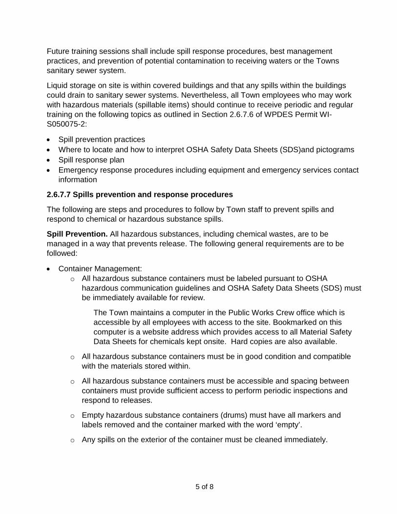
5 of 8
Future training sessions shall include spill response procedures, best management practices, and prevention of potential contamination to receiving waters or the Towns sanitary sewer system. Liquid storage on site is within covered buildings and that any spills within the buildings could drain to sanitary sewer systems. Nevertheless, all Town employees who may work with hazardous materials (spillable items) should continue to receive periodic and regular training on the following topics as outlined in Section 2.6.7.6 of WPDES Permit WI-S050075-2: • Spill prevention practices • Where to locate and how to interpret OSHA Safety Data Sheets (SDS)and pictograms • Spill response plan • Emergency response procedures including equipment and emergency services contact
information 2.6.7.7 Spills prevention and response procedures
The following are steps and procedures to follow by Town staff to prevent spills and respond to chemical or hazardous substance spills. Spill Prevention. All hazardous substances, including chemical wastes, are to be managed in a way that prevents release. The following general requirements are to be followed: • Container Management:
o All hazardous substance containers must be labeled pursuant to OSHA hazardous communication guidelines and OSHA Safety Data Sheets (SDS) must be immediately available for review.
The Town maintains a computer in the Public Works Crew office which is accessible by all employees with access to the site. Bookmarked on this computer is a website address which provides access to all Material Safety Data Sheets for chemicals kept onsite. Hard copies are also available.
o All hazardous substance containers must be in good condition and compatible with the materials stored within.
o All hazardous substance containers must be accessible and spacing between containers must provide sufficient access to perform periodic inspections and respond to releases.
o Empty hazardous substance containers (drums) must have all markers and labels removed and the container marked with the word ‘empty’.
o Any spills on the exterior of the container must be cleaned immediately.
6 of 8
o Flammable materials stored or dispensed from drums or totes must be grounded to prevent static spark.
o Waste drums should not be overfilled. Four inches (4”) of headspace must remain to allow for expansion.
• Good Housekeeping: o All hazardous substances must be stored inside buildings or under cover. o Store hazardous substances not used daily in cabinets, or in designated areas. o All chemicals that are transferred from larger to smaller containers must be
transferred by use of a funnel or spigot. o All hazardous substance containers should be closed while not in use. o Use drip pans or other collection devices to contain drips or leaks from
dispensing containers or equipment. o Implement preventative maintenance activities to reduce the potential for release
from equipment. o Immediately clean up and properly manage all small spills or leaks. o Periodically inspect equipment and hazardous substance storage areas to
ensure leaks or spills are not occurring. o Use signage to identity hazardous substance storage or waste collection areas. o Keep all work areas and hazardous substance storage areas clean and in good
general condition • Secondary containment:
o Store all bulk chemicals (>55 gallons) within appropriate secondary containment, or any sized chemical if there is a potential for release to the environment.
o Secondary containment should be checked periodically, and any spills identified in secondary containment must be immediately cleaned up and removed.
• Marking/labeling: o Ensure all hazardous substances, including chemical wastes, are properly
marked and labeled in accordance with all federal, state and local regulations. o Ensure that hazardous substances transferred to small containers are marked
with the chemicals name (example- “Isopropyl Alcohol”) and hazard (example- “Flammable”).
• Hazardous Substance Inventory o An inventory must be maintained for all stored hazardous substances <55
gallons, and/or list of locations where non-bulk hazardous substances are stored
7 of 8
(i.e. flammable lockers - shop floor). Materials manufactured, stored, used and/or generated as a chemical waste in quantities >55 gallons should also be inventoried. Inventories should be maintained similar to the example shown below.
• Spill Response Equipment o Spill response equipment must be maintained and located in areas where spills
are likely to occur. Spill kits should provide adequate response capabilities to manage any anticipated spill or release. The following general requirements are to be followed which include:
o Stock spill clean-up kits that are compatible with the hazardous substances stored on site.
o Locate spill kits in areas where spills are likely to occur (loading docks, chemical storage areas, locations where hazardous substance are being transferred).
o Spill kits should be sized to manage an anticipated release (spill equal to the largest container).
o Emergency response equipment should be inspected periodically to ensure that the spill kit is complete
Spill Response Plan
• In the event of a hazardous substance spill or release, immediately review and follow applicable OSHA SDS guidelines. If doing so does not violate those guidelines, take the following measures to keep the spill from entering sewer or storm drains, spreading off-site, or affecting human health. In all cases caution and common sense must be maintained with the primary goal being to prevent and/or limit personal injury.
• Stop, contain, and clean up the chemical spill if: o The spilled chemical and its hazardous properties have been identified. o The spill is small and easily contained. o Responder is aware of the chemicals’ hazardous properties.
• If a spill or release cannot be controlled or injuries have occurred due to the release, the following procedures should be implemented:
o Call for help or alert others of the release. o Evacuate immediate area, and provide care to the injured- Call 911. o If potential fire or explosion hazards exist, initiate evacuation procedures-
Call 911.
8 of 8
o Respond defensively to any uncontrolled spills: Use appropriate personal protective equipment when responding to
any spill. Attempt to shut off the source of the release (if safe to do so). Eliminate sources of ignition (if safe to do so). Protect drains by use of adsorbent, booms or drain covers (if safe
to do so). Notify onsite emergency contact(s). Notify other trained staff and assist with the spill response and
cleanup activities. Coordinate response activities with local emergency personnel (fire
department). Be prepared to provide information to fire department, EMT,
hospital or physician. Notify appropriate agency if a release has entered the environment.
Refer to Notification and Reporting section for reporting thresholds. Evacuation Procedures
In the event of a hazardous substance release that has the potential for fire, explosion or other human health hazards the following procedures will be implemented:
• Facility staff will be notified of evacuation by one or more of the following method(s): o Verbal, Portable Radio, Alarm, Other
• Notification to emergency services will be performed- Call 911. • Facility staff will follow predetermined evacuation routes and assemble at designated
areas. Evacuation maps must be displayed throughout the facility and/or exits clearly labeled.
• Individuals responsible for coordinating evacuations must confirm if the business has been completely evacuated.
• Facility staff will be made familiar with evacuation procedures during new employee orientation, and annual trainings thereafter.
• Designated emergency response contacts will coordinate all activities with outside emergency personnel.
Facility Map
Include emergency exits routes, fire alarms, fire extinguishers, spill response equipment and first aid stations (eye wash, first aid kits, etc.).
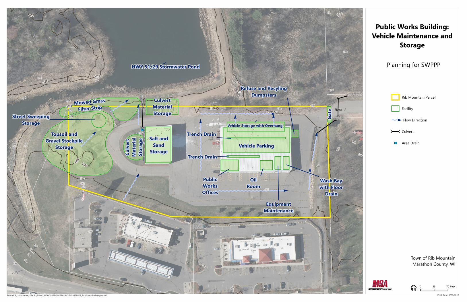
,
,
,
,
,,
,
,
"J
Salt andSand
Storage
PublicWorksOffices
OilRoom
EquipmentMaintenance
Wash Baywith Floor
Drain
Trench DrainVehicle Parking
Trench Drain
CulvertMaterialStorage
Topsoil andGravel Stockpile
Storage
Culve
rtM
ateria
lSto
rage
Gate
Mowed GrassFilter Strip
Vehicle Storage with Overhang
Refuse and RecylingDumpsters
Street SweepingStorage
HWY 51/29 Stormwater Pond
Goose Ln
1188
11861184
1182
1174
1172
1166
1176
1168
11941192
1188
1168
1168
1178
1168
11681166
1166
1164
1166
1188
1188
1188
1188
1174
1172
1166
1166
1196
1168
1168
1166
1180
1170
1190
1170
1170
1180
1170118
0
1170
1170
Public Works Building:Vehicle Maintenance and
Storage
Rib Mountain Parcel
Facility
Flow Direction
,
, Culvert
"J Area Drain
0 35 70 Feet
Printed By: aconverse, File: P:\9400s\9450s\9459\09459023\GIS\09459023_PublicWorksGarage.mxd Print Date: 3/20/2018
Planning for SWPPP
Town of Rib MountainMarathon County, WI

Town of Rib Mountain Marathon County, Wisconsin
Stormwater Pollution Prevention Plan
Yard Waste Site Prepared by: Scott Turner, PE Street & Park Superintendent March 2018

2 of 8
Introduction This document has been prepared for the Town of Rib Mountain WPDES permit issued by the Wisconsin Department of Natural Resources under permit WI-S050075-2. This report addresses the requirements of section 2.6.7 of the permit document and has been developed in an outline format which follows this section. 2.6.7.1 Location and contact information
The Town of Rib Mountain operates a Yard Waste Site located at 6507 South Mountain Rd (CTH N) Scott Turner, Street & Park Superintendent, is responsible for the facility. His contact information is below: Scott Turner, PE Street & Park Superintendent 3700 North Mountain Rd Wausau, WI 54402 Office: 715-848-5123 Cell: 715-573-0733 [email protected] The following public works staff are frequently working at the site: Pat Krautkramer Foreman Office: 715-848-5123 Dave Falasky Mechanic Office: 715-848-5123 Randy Sauter Operator/Yard Waste Site Operations Office: 715-848-5123
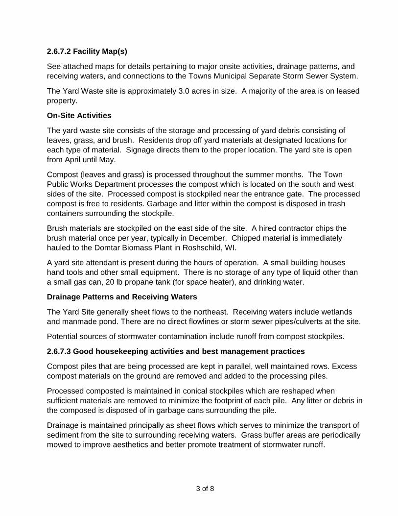
3 of 8
2.6.7.2 Facility Map(s)
See attached maps for details pertaining to major onsite activities, drainage patterns, and receiving waters, and connections to the Towns Municipal Separate Storm Sewer System. The Yard Waste site is approximately 3.0 acres in size. A majority of the area is on leased property. On-Site Activities
The yard waste site consists of the storage and processing of yard debris consisting of leaves, grass, and brush. Residents drop off yard materials at designated locations for each type of material. Signage directs them to the proper location. The yard site is open from April until May. Compost (leaves and grass) is processed throughout the summer months. The Town Public Works Department processes the compost which is located on the south and west sides of the site. Processed compost is stockpiled near the entrance gate. The processed compost is free to residents. Garbage and litter within the compost is disposed in trash containers surrounding the stockpile. Brush materials are stockpiled on the east side of the site. A hired contractor chips the brush material once per year, typically in December. Chipped material is immediately hauled to the Domtar Biomass Plant in Roshschild, WI. A yard site attendant is present during the hours of operation. A small building houses hand tools and other small equipment. There is no storage of any type of liquid other than a small gas can, 20 lb propane tank (for space heater), and drinking water. Drainage Patterns and Receiving Waters
The Yard Site generally sheet flows to the northeast. Receiving waters include wetlands and manmade pond. There are no direct flowlines or storm sewer pipes/culverts at the site. Potential sources of stormwater contamination include runoff from compost stockpiles. 2.6.7.3 Good housekeeping activities and best management practices
Compost piles that are being processed are kept in parallel, well maintained rows. Excess compost materials on the ground are removed and added to the processing piles. Processed composted is maintained in conical stockpiles which are reshaped when sufficient materials are removed to minimize the footprint of each pile. Any litter or debris in the composed is disposed of in garbage cans surrounding the pile. Drainage is maintained principally as sheet flows which serves to minimize the transport of sediment from the site to surrounding receiving waters. Grass buffer areas are periodically mowed to improve aesthetics and better promote treatment of stormwater runoff.

4 of 8
2.6.7.4 Recommendations
Staff conducts visual inspections on a regular basis. Housekeeping items are addressed depending the degree of importance. Several items shall be addressed during future inspections: • Inspections to address potential contamination (i.e. erosion of stockpiles materials).
Records of all inspections, observations, and compliance records, as applicable, should be kept by the Town of Rib Mountain Public Works department for a minimum of five years.
• The health of vegetation around the site perimeter should continue to be assessed and improved if necessary. If possible, a minimum 20 ft. wide buffer of healthy vegetation should be maintained around the site’s perimeter (and wider where space allows). Vehicle traffic and storage of materials should not be allowed within the buffer. Mowing of the buffer area should be undertaken two or three times per year with a cutting height of no less than 6-inches. Where a grassed buffer is not feasible, consider adding a silt fence.
2.6.7.5 Information on inspections to identify and address potential contamination
Yard waste site staff should regularly inspect any area where material storage is exposed to stormwater and assess how well stormwater BMPs are operating. Formal and documented inspections should be done seasonally, while informal inspections should be done by all public works staff any time they are on site. Corrective actions undertaken at any time to address site erosion or potential spills must be documented at the time the activity occurs. It is further recommended that additional inspections be performed as appropriate after major events; for example, greater than 1 inch of precipitation in 24 hours, or and incident that causes contaminant (erosion) release. 2.6.7.6 Employee training
There is currently not training unique to the Yard Water Site. The seasonal staff consisting of two employees, are trained with all applicable safety requirements. Refresher training is conducted annually/ Future training sessions shall include, best management practices, and prevention of potential contamination to receiving waters. 2.6.7.7 Spills prevention and response procedures
The following are steps and procedures to follow by Town staff to prevent spills and respond to chemical or hazardous substance spills. Spill Prevention. All hazardous substances, including chemical wastes, are to be managed in a way that prevents release. The following general requirements are to be followed:
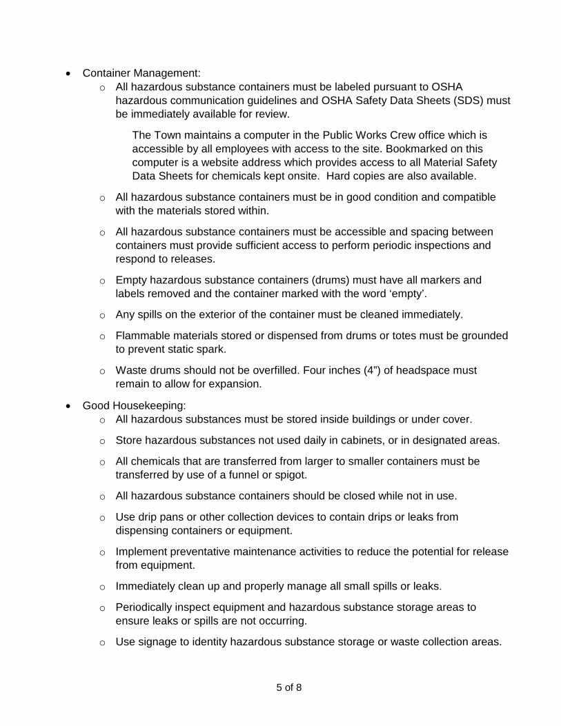
5 of 8
• Container Management: o All hazardous substance containers must be labeled pursuant to OSHA
hazardous communication guidelines and OSHA Safety Data Sheets (SDS) must be immediately available for review.
The Town maintains a computer in the Public Works Crew office which is accessible by all employees with access to the site. Bookmarked on this computer is a website address which provides access to all Material Safety Data Sheets for chemicals kept onsite. Hard copies are also available.
o All hazardous substance containers must be in good condition and compatible with the materials stored within.
o All hazardous substance containers must be accessible and spacing between containers must provide sufficient access to perform periodic inspections and respond to releases.
o Empty hazardous substance containers (drums) must have all markers and labels removed and the container marked with the word ‘empty’.
o Any spills on the exterior of the container must be cleaned immediately. o Flammable materials stored or dispensed from drums or totes must be grounded
to prevent static spark. o Waste drums should not be overfilled. Four inches (4”) of headspace must
remain to allow for expansion. • Good Housekeeping:
o All hazardous substances must be stored inside buildings or under cover. o Store hazardous substances not used daily in cabinets, or in designated areas. o All chemicals that are transferred from larger to smaller containers must be
transferred by use of a funnel or spigot. o All hazardous substance containers should be closed while not in use. o Use drip pans or other collection devices to contain drips or leaks from
dispensing containers or equipment. o Implement preventative maintenance activities to reduce the potential for release
from equipment. o Immediately clean up and properly manage all small spills or leaks. o Periodically inspect equipment and hazardous substance storage areas to
ensure leaks or spills are not occurring. o Use signage to identity hazardous substance storage or waste collection areas.
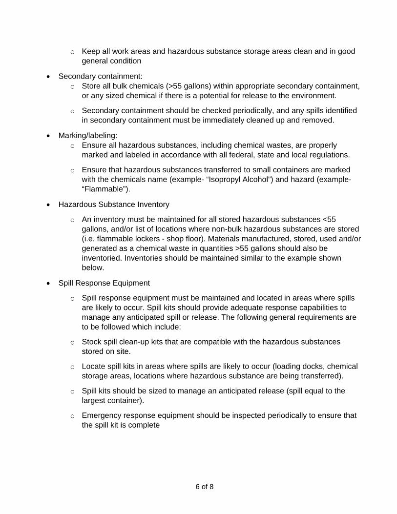
6 of 8
o Keep all work areas and hazardous substance storage areas clean and in good general condition
• Secondary containment: o Store all bulk chemicals (>55 gallons) within appropriate secondary containment,
or any sized chemical if there is a potential for release to the environment. o Secondary containment should be checked periodically, and any spills identified
in secondary containment must be immediately cleaned up and removed. • Marking/labeling:
o Ensure all hazardous substances, including chemical wastes, are properly marked and labeled in accordance with all federal, state and local regulations.
o Ensure that hazardous substances transferred to small containers are marked with the chemicals name (example- “Isopropyl Alcohol”) and hazard (example- “Flammable”).
• Hazardous Substance Inventory o An inventory must be maintained for all stored hazardous substances <55
gallons, and/or list of locations where non-bulk hazardous substances are stored (i.e. flammable lockers - shop floor). Materials manufactured, stored, used and/or generated as a chemical waste in quantities >55 gallons should also be inventoried. Inventories should be maintained similar to the example shown below.
• Spill Response Equipment o Spill response equipment must be maintained and located in areas where spills
are likely to occur. Spill kits should provide adequate response capabilities to manage any anticipated spill or release. The following general requirements are to be followed which include:
o Stock spill clean-up kits that are compatible with the hazardous substances stored on site.
o Locate spill kits in areas where spills are likely to occur (loading docks, chemical storage areas, locations where hazardous substance are being transferred).
o Spill kits should be sized to manage an anticipated release (spill equal to the largest container).
o Emergency response equipment should be inspected periodically to ensure that the spill kit is complete

7 of 8
Spill Response Plan
• In the event of a hazardous substance spill or release, immediately review and follow applicable OSHA SDS guidelines. If doing so does not violate those guidelines, take the following measures to keep the spill from entering sewer or storm drains, spreading off-site, or affecting human health. In all cases caution and common sense must be maintained with the primary goal being to prevent and/or limit personal injury.
• Stop, contain, and clean up the chemical spill if: o The spilled chemical and its hazardous properties have been identified. o The spill is small and easily contained. o Responder is aware of the chemicals’ hazardous properties.
• If a spill or release cannot be controlled or injuries have occurred due to the release, the following procedures should be implemented:
o Call for help or alert others of the release. o Evacuate immediate area, and provide care to the injured- Call 911. o If potential fire or explosion hazards exist, initiate evacuation procedures-
Call 911. o Respond defensively to any uncontrolled spills:
Use appropriate personal protective equipment when responding to any spill.
Attempt to shut off the source of the release (if safe to do so). Eliminate sources of ignition (if safe to do so). Protect drains by use of adsorbent, booms or drain covers (if safe
to do so). Notify onsite emergency contact(s). Notify other trained staff and assist with the spill response and
cleanup activities. Coordinate response activities with local emergency personnel (fire
department). Be prepared to provide information to fire department, EMT,
hospital or physician. Notify appropriate agency if a release has entered the environment.
Refer to Notification and Reporting section for reporting thresholds.

8 of 8
Evacuation Procedures
In the event of a hazardous substance release that has the potential for fire, explosion or other human health hazards the following procedures will be implemented:
• Facility staff will be notified of evacuation by one or more of the following method(s): o Verbal, Portable Radio, Alarm, Other
• Notification to emergency services will be performed- Call 911. • Facility staff will follow predetermined evacuation routes and assemble at designated
areas. Evacuation maps must be displayed throughout the facility and/or exits clearly labeled.
• Individuals responsible for coordinating evacuations must confirm if the business has been completely evacuated.
• Facility staff will be made familiar with evacuation procedures during new employee orientation, and annual trainings thereafter.
• Designated emergency response contacts will coordinate all activities with outside emergency personnel.
Facility Map
Include emergency exits routes, fire alarms, fire extinguishers, spill response equipment and first aid stations (eye wash, first aid kits, etc.).

Gate
Gate
Restroom Facility(Portable Toilet)
ProcessedCompost
Compost
Processing
CompostProcessing
CompostProcessing
Yard SiteAttendantBuilding
BrushStorage andProcessing
Wooded Area
CTN Ditch
Grassed Vegetative Buffer
Grassed VegetativeBuffer
Garbage Cans
ßßN S Mountain Rd
1304
1298
12941292
1286
12761284
1282
1306
1302
1288
13081306
13041302
1298
1296
1294
1292
1284
1272
13081306
1304
1316
13021314
1306
1308
1304
12841278
1282
1268
12781272
1268
12661264
1302
1298
1276
12721264
13061304
1304
1298
1302
1298
1298
1294
12881286
12861284
1286
1284
1286128
4
1304
1302
1304
1302
1296
1294
1278
1308
1296
1278
1272
1308
1298
1312
1286
1276
1274
1272
1262
1306
1274
1306
1294
1292
1288
1318
1304
1298
1296
1298
1288
1278
1274
1304
1302
1302
1302
1298
1298 1296
1296
1296
1296
1296
1294
12961292
1284
1284
1278
1278
1276
1274
1268
1266
1268
1266
1266
1268
1262
1262
1278
1278
1310
12701280
1300
1300
1310
1310
1300
1280
1270
1270
1270
1300
1300
1290
1280
1290
1290
1280
1310
1310
1300
1300
1290
1290
1290
1280
1280
1270
1270
1260
1260
Yard Waste SitePlanning for SWPPP
Rib Mountain Parcel
Leased Area
Facility
Flow Direction
Town of Rib MountainMarathon County, WI
0 50 100 Feet
Printed By: aconverse, File: P:\9400s\9450s\9459\09459023\GIS\09459023_YardWasteSite.mxd Print Date: 3/20/2018
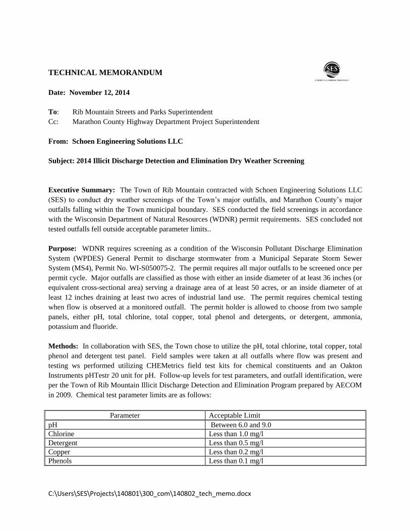
C:\Users\SES\Projects\140801\300_com\140802_tech_memo.docx
TECHNICAL MEMORANDUM
Date: November 12, 2014
To: Rib Mountain Streets and Parks Superintendent
Cc: Marathon County Highway Department Project Superintendent
From: Schoen Engineering Solutions LLC
Subject: 2014 Illicit Discharge Detection and Elimination Dry Weather Screening
Executive Summary: The Town of Rib Mountain contracted with Schoen Engineering Solutions LLC
(SES) to conduct dry weather screenings of the Town’s major outfalls, and Marathon County’s major
outfalls falling within the Town municipal boundary. SES conducted the field screenings in accordance
with the Wisconsin Department of Natural Resources (WDNR) permit requirements. SES concluded not
tested outfalls fell outside acceptable parameter limits..
Purpose: WDNR requires screening as a condition of the Wisconsin Pollutant Discharge Elimination
System (WPDES) General Permit to discharge stormwater from a Municipal Separate Storm Sewer
System (MS4), Permit No. WI-S050075-2. The permit requires all major outfalls to be screened once per
permit cycle. Major outfalls are classified as those with either an inside diameter of at least 36 inches (or
equivalent cross-sectional area) serving a drainage area of at least 50 acres, or an inside diameter of at
least 12 inches draining at least two acres of industrial land use. The permit requires chemical testing
when flow is observed at a monitored outfall. The permit holder is allowed to choose from two sample
panels, either pH, total chlorine, total copper, total phenol and detergents, or detergent, ammonia,
potassium and fluoride.
Methods: In collaboration with SES, the Town chose to utilize the pH, total chlorine, total copper, total
phenol and detergent test panel. Field samples were taken at all outfalls where flow was present and
testing ws performed utilizing CHEMetrics field test kits for chemical constituents and an Oakton
Instruments pHTestr 20 unit for pH. Follow-up levels for test parameters, and outfall identification, were
per the Town of Rib Mountain Illicit Discharge Detection and Elimination Program prepared by AECOM
in 2009. Chemical test parameter limits are as follows:
Parameter Acceptable Limit
pH Between 6.0 and 9.0
Chlorine Less than 1.0 mg/l
Detergent Less than 0.5 mg/l
Copper Less than 0.2 mg/l
Phenols Less than 0.1 mg/l
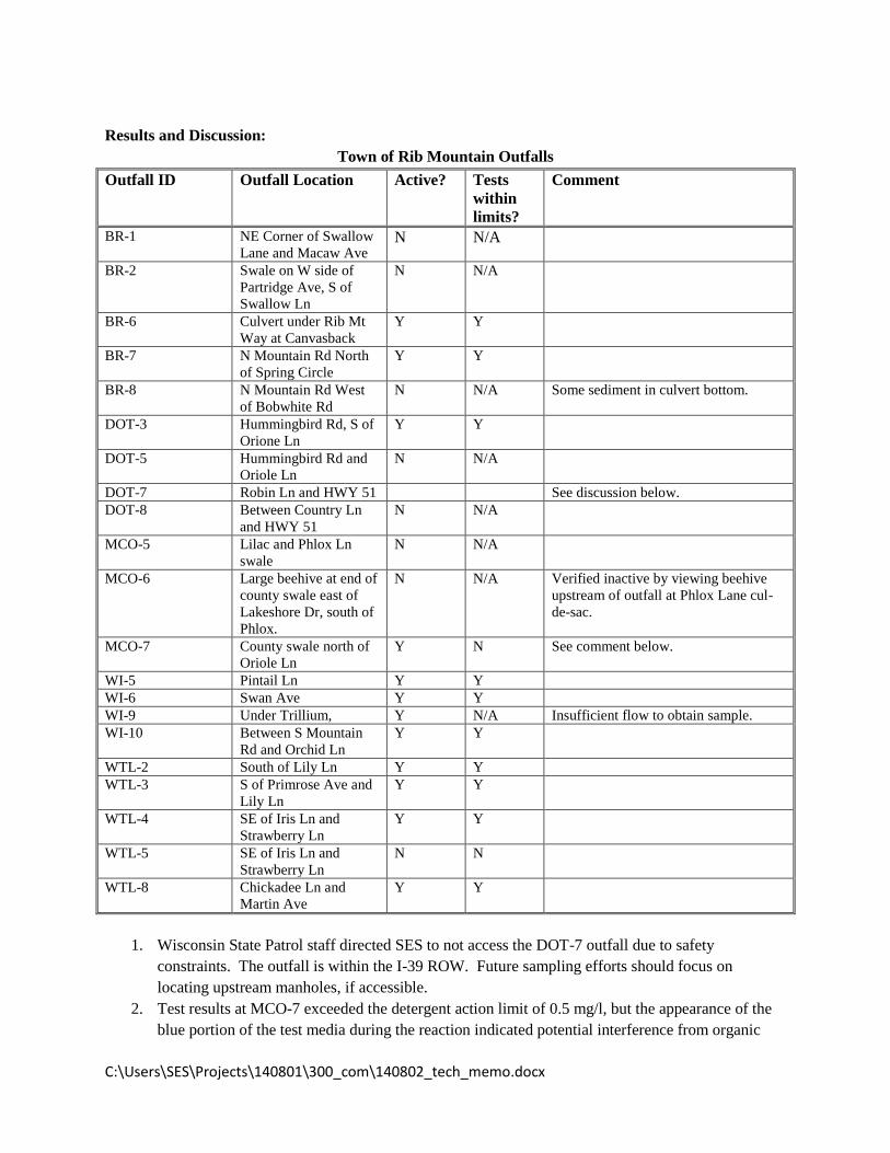
C:\Users\SES\Projects\140801\300_com\140802_tech_memo.docx
Results and Discussion:
Town of Rib Mountain Outfalls
Outfall ID Outfall Location Active? Tests
within
limits?
Comment
BR-1 NE Corner of Swallow
Lane and Macaw Ave N N/A
BR-2 Swale on W side of
Partridge Ave, S of
Swallow Ln
N N/A
BR-6 Culvert under Rib Mt
Way at Canvasback
Y Y
BR-7 N Mountain Rd North
of Spring Circle
Y Y
BR-8 N Mountain Rd West
of Bobwhite Rd
N N/A Some sediment in culvert bottom.
DOT-3 Hummingbird Rd, S of
Orione Ln
Y Y
DOT-5 Hummingbird Rd and
Oriole Ln
N N/A
DOT-7 Robin Ln and HWY 51 See discussion below.
DOT-8 Between Country Ln
and HWY 51
N N/A
MCO-5 Lilac and Phlox Ln
swale
N N/A
MCO-6 Large beehive at end of
county swale east of
Lakeshore Dr, south of
Phlox.
N N/A Verified inactive by viewing beehive
upstream of outfall at Phlox Lane cul-
de-sac.
MCO-7 County swale north of
Oriole Ln
Y N See comment below.
WI-5 Pintail Ln Y Y
WI-6 Swan Ave Y Y
WI-9 Under Trillium, Y N/A Insufficient flow to obtain sample.
WI-10 Between S Mountain
Rd and Orchid Ln
Y Y
WTL-2 South of Lily Ln Y Y
WTL-3 S of Primrose Ave and
Lily Ln
Y Y
WTL-4 SE of Iris Ln and
Strawberry Ln
Y Y
WTL-5 SE of Iris Ln and
Strawberry Ln
N N
WTL-8 Chickadee Ln and
Martin Ave
Y Y
1. Wisconsin State Patrol staff directed SES to not access the DOT-7 outfall due to safety
constraints. The outfall is within the I-39 ROW. Future sampling efforts should focus on
locating upstream manholes, if accessible.
2. Test results at MCO-7 exceeded the detergent action limit of 0.5 mg/l, but the appearance of the
blue portion of the test media during the reaction indicated potential interference from organic
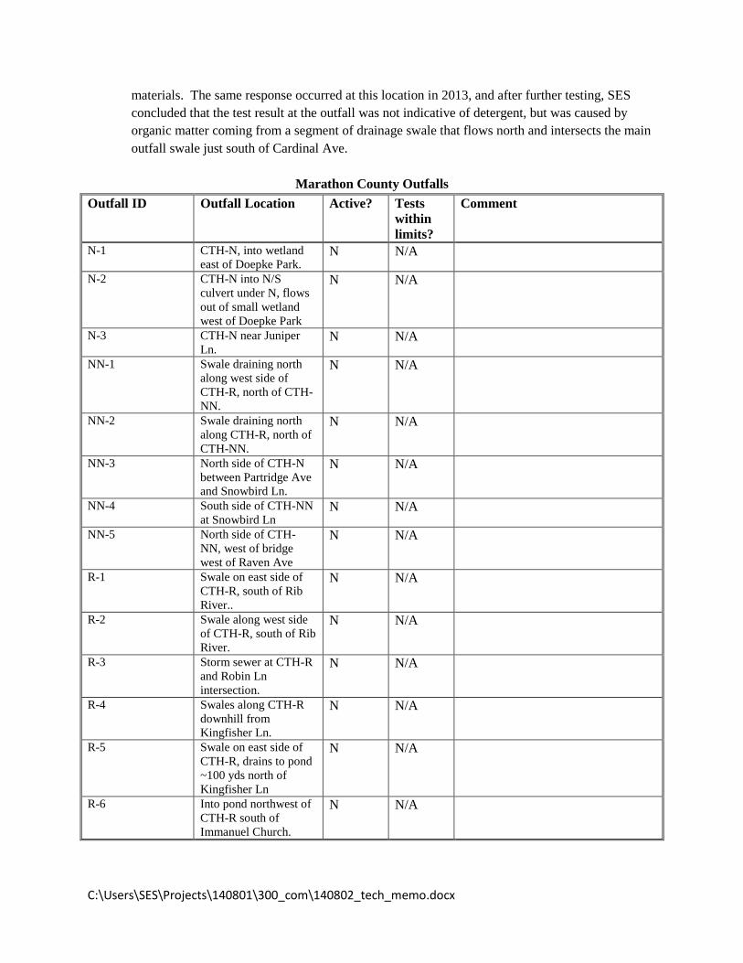
C:\Users\SES\Projects\140801\300_com\140802_tech_memo.docx
materials. The same response occurred at this location in 2013, and after further testing, SES
concluded that the test result at the outfall was not indicative of detergent, but was caused by
organic matter coming from a segment of drainage swale that flows north and intersects the main
outfall swale just south of Cardinal Ave.
Marathon County Outfalls
Outfall ID Outfall Location Active? Tests
within
limits?
Comment
N-1 CTH-N, into wetland
east of Doepke Park. N N/A
N-2 CTH-N into N/S
culvert under N, flows
out of small wetland
west of Doepke Park
N N/A
N-3 CTH-N near Juniper
Ln. N N/A
NN-1 Swale draining north
along west side of
CTH-R, north of CTH-
NN.
N N/A
NN-2 Swale draining north
along CTH-R, north of
CTH-NN.
N N/A
NN-3 North side of CTH-N
between Partridge Ave
and Snowbird Ln.
N N/A
NN-4 South side of CTH-NN
at Snowbird Ln N N/A
NN-5 North side of CTH-
NN, west of bridge
west of Raven Ave
N N/A
R-1 Swale on east side of
CTH-R, south of Rib
River..
N N/A
R-2 Swale along west side
of CTH-R, south of Rib
River.
N N/A
R-3 Storm sewer at CTH-R
and Robin Ln
intersection.
N N/A
R-4 Swales along CTH-R
downhill from
Kingfisher Ln.
N N/A
R-5 Swale on east side of
CTH-R, drains to pond
~100 yds north of
Kingfisher Ln
N N/A
R-6 Into pond northwest of
CTH-R south of
Immanuel Church.
N N/A

C:\Users\SES\Projects\140801\300_com\140802_tech_memo.docx
Conclusions and Recommendations:
MCO-5 and WTL-3 might not meet WDNR criteria for a major outfall, and therefore could potentially be
removed from the IDDE program. SES recommends the Town consider utilizing Marathon Counties
LiDAR derived contours to review existing drainage basin delineations as part of the update to the
Stormwater Management Plan the Town will be performing under a WDNR grant. Major outfalls are
those with a diameter of 36 inches draining a watershed of at least 50 acres, or a diameter of at least 12
inches draining 2 acres of industrial area.
None of the County outfalls appear to meet criteria for a major outfall. The basin delineations prepared
for the County by AECOM were developed as part of a pollution load analysis, and were not intended for
identifying IDDE outfalls. SES discussed the County outfalls with Brad Johnson, the regional WDNR
stormwater management specialist, who agreed that the County outfalls should all be removed from the
IDDE program.
Attachments:
Field documents.

!.
!.
!.!.
NORTH MOUNTAIN
GR
OU
SE
RIB
MO
UN
TAIN
UN
NA
MED
CR
AN
E
NUTHATCH
MOUNTAIN
CANVASBACK
SAN
DPI
PER
BU
FFLE
HEA
D
BO
BW
HIT
E
MER
GA
NSE
R
MOCKINGBIRD
BOULDER RIDGE
MANDARIN
SAINT FRANCIS SPR
ING
UN
NA
MED
BR-7BR-8
BR-6
BR-3
BR-5
BR-4
DOT-7
NONE
BR-7
BR-8
BR-6
Town of Rib Mountain
3700 North Mountain RdWausau, WI 54401
C:\Users\SES\Projects\131002\700_gis\IDDE_map_insert.mxd
IDDE Outfall Locations
Project No. 131002 Figure No.1 October 2013
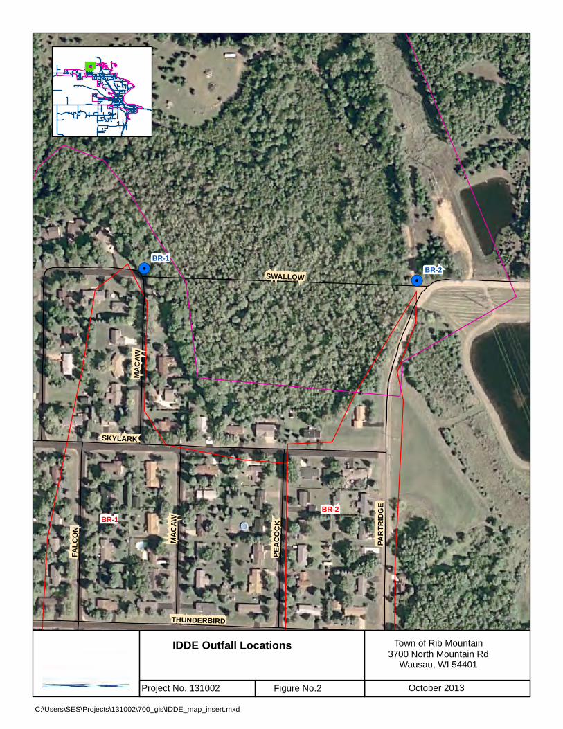
!.!.
!.
SWALLOW
SKYLARK
PAR
TRID
GE
THUNDERBIRD
FALC
ON
MA
CAW
PEA
CO
CK
MA
CAW
BR-1BR-2
BR-2BR-1
Town of Rib Mountain
3700 North Mountain RdWausau, WI 54401
C:\Users\SES\Projects\131002\700_gis\IDDE_map_insert.mxd
IDDE Outfall Locations
Project No. 131002 Figure No.2 October 2013

!.
!.
!.ORIOLE
SWA
N
RIB MO
UNTAIN
US 51
PARROTTEAL
ROBIN
DO
VE
HER
ON
CLOVERLAND
BLU
EGIL
L
PINTAIL
WREN
CA
RD
INA
L
KIN
GLE
T
HUMM
INGBIRD
BLUEBIRD
WO
OD
DU
CK
STARLING
PLOVER
REDTAILLAKESHORE
GOOSE
BAY
PARK
PINE SISKIN
WARBLERUS 51
BLUEBIRD
WI-5.0
WI-6.0
MCO-7.0
WI-7.1
MCO-7.1
WI-7.0
WI-6.1
MCO-7.3
WI-7.1
MCO-7.4
MCO-7.2
MCO-5.2
MCO-7.5
WI-6.0
DOT-2.1
NONE
WI-6.2
MCO-5.1
DOT-2.0
WI-6
WI-5
MCO-7
Town of Rib Mountain
3700 North Mountain RdWausau, WI 54401
C:\Users\SES\Projects\131002\700_gis\IDDE_map_insert.mxd
IDDE Outfall Locations
Project No. 131002 Figure No.2 October 2013

!. !.
!.
!.
!.
!.
!.
!.
!.
!.
US 51
ROBIN
HUMM
INGBIRD
EAG
LE
RIB
MO
UNTA
IN
NORTH MOUNTAIN
BO
BO
LIN
K
MALLARD
MA
RTI
N
ORIOLE
QU
AIL
WREN
CA
RD
INA
L
DO
VERAV
EN BLUEBIRD
PARTRIDGE
PHEA
SAN
T
US 51 SOUTH O
N
MEADOWLARK
GOOSE
US 51 N
OR
TH O
N
US
51 S
OU
TH O
FF
FLAMINGO
US 51 N
OR
TH O
FF
KILDEER
BLUEJAY
ROOK
ERY
VIEW
CA
NA
RYUS 51
BLUEBIRD
MA
RTI
N
ORIOLE
RAV
EN
BLUEBIRD
PHEA
SAN
T
QU
AIL
BLUEJAY
DOT-5
DOT-7
MCO-7.1
MCO-7.0
DOT-4
DOT-11
WI-3
WI-5.0
WI-11
CLOSED
MCO-7.2
DOT-1
DOT-3
NONE
NONE
NONE
DOT-6
MCO-7.5
NONE
NONEMCO-7
DOT-5
DOT-3
DOT-7
DOT-11
Town of Rib Mountain
3700 North Mountain RdWausau, WI 54401
C:\Users\SES\Projects\131002\700_gis\IDDE_map_insert.mxd
IDDE Outfall Locations
Project No. 131002 Figure No.2 October 2013

!.
!.
!.
!.
!.
!.
!.
!.
US 51
ROBINHUM
MING
BIRD
EAG
LE
BO
BO
LIN
K MA
RTI
N
ORIOLE
QU
AIL
CA
RD
INA
L
SNOWFLAKE
NORTH MOUNTAIN
RAV
ENK
ING
BIR
D
CHICKADEE
KINGFIS
HER
BLUEBIRDPH
EASA
NT
WRENUS 51 SO
UTH ON
MEADOWLARK
RIB MOUNTAIN
FLAMINGO
DEER TAIL
NIGHTINGALE
BLUEJAY
PARTRIDGE
CA
NA
RY
RAV
EN
US 51
BLUEBIRD
BLUEBIRD
MA
RTI
N
ORIOLE
PHEA
SAN
T
DOT-5
DOT-7
MCO-7.0
MCO-7.1
WTL-8
DOT-3
DOT-4
WTL-7
DOT-2.1
WI-3
DOT-2.0
CLOSED
DOT-1
DOT-6
MCO-7.4
NONE
NONE
MCO-7.2
DOT-11
NONE
NONE
MCO-7.3
NONE
WI-5.0
WI-7.1
WTL-8
DOT-5
DOT-3
DOT-7
Town of Rib Mountain
3700 North Mountain RdWausau, WI 54401
C:\Users\SES\Projects\131002\700_gis\IDDE_map_insert.mxd
IDDE Outfall Locations
Project No. 131002 Figure No.2 October 2013
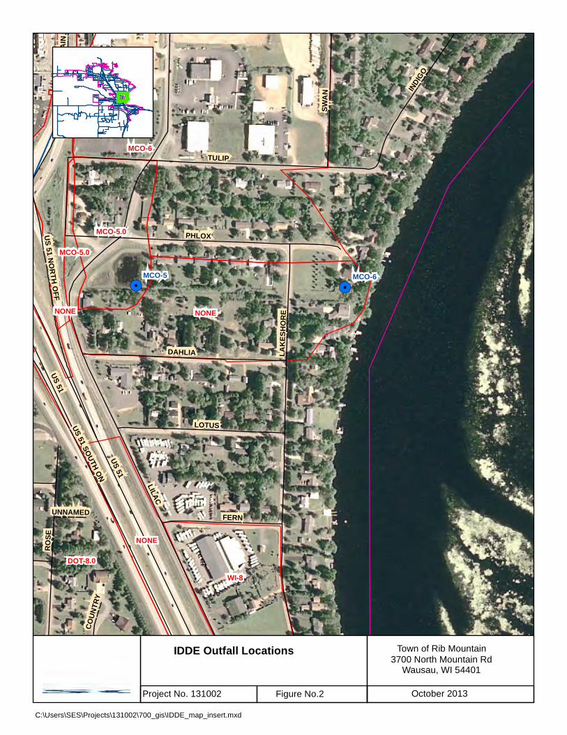
!.
!.!.
!.
LILAC
US 51
TULIP
PHLOX
LAK
ESH
OR
E
RO
SE
DAHLIA
LOTUS
INDI
GO
SWA
N
FERNU
S 51 NO
RTH
OFF
US 51 SOUTH O
N
RIB
MO
UN
TAIN
CO
UN
TRY
UNNAMEDUS 51
MCO-6
NONE
DOT-8.0
WI-8
NONE
MCO-5.0
NONE
MCO-5.0
MCO-5.1
MCO-6MCO-5
Town of Rib Mountain
3700 North Mountain RdWausau, WI 54401
C:\Users\SES\Projects\131002\700_gis\IDDE_map_insert.mxd
IDDE Outfall Locations
Project No. 131002 Figure No.2 October 2013
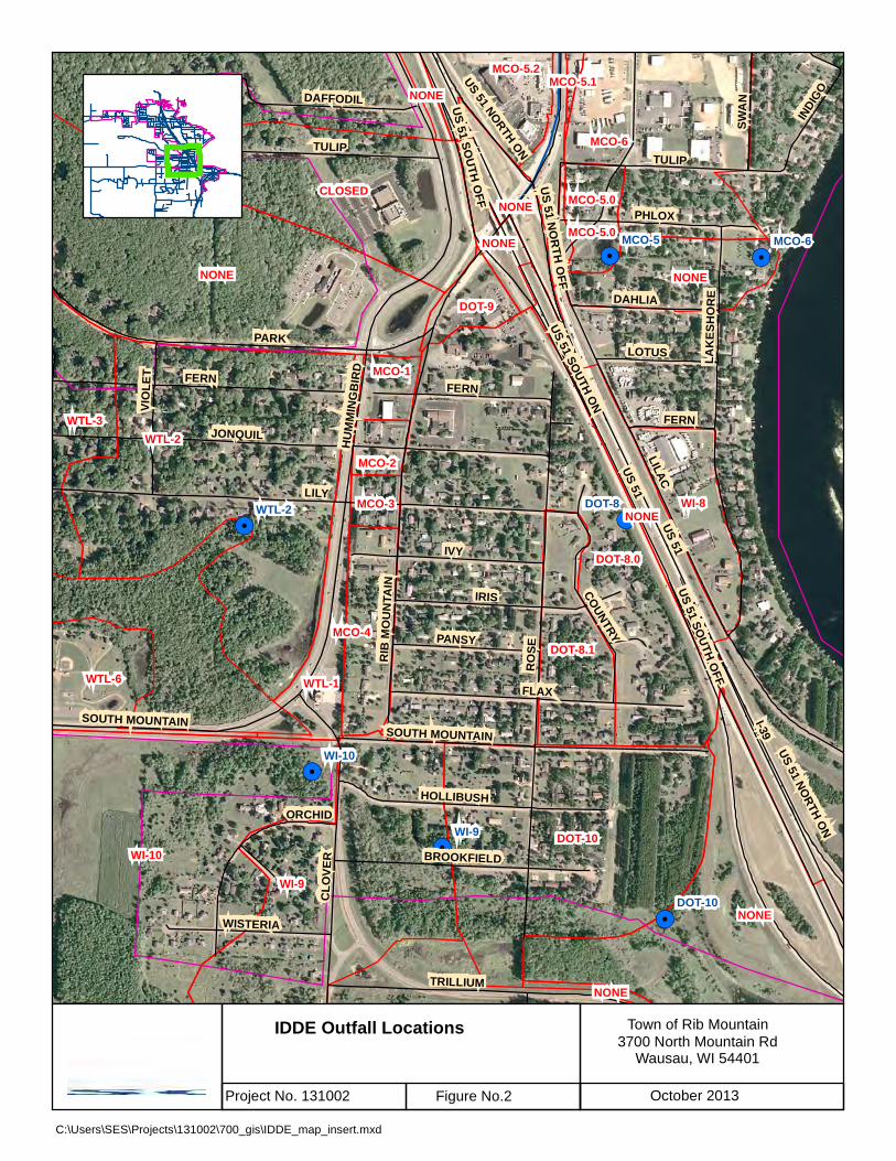
!.
!.
!.
!.
!.
!.!.
!.
!.
!.US 51LILY
LILAC
RO
SE
I-39
PARK
JONQUIL
FLAX
IRIS
IVY
FERNR
IB M
OU
NTA
IN
HU
MM
ING
BIR
D LAK
ESH
OR
E
TULIP
CLO
VER
TRILLIUM
PHLOXUS 51 SO
UTH OFF
HOLLIBUSH
COUNTRY
DAFFODIL
SOUTH MOUNTAIN
US 51 NORTH ON
PANSY
VIO
LET
BROOKFIELD
DAHLIA
SWA
N
LOTUS
WISTERIA
INDI
GO
US 51 SOUTH O
N
ORCHID
US 51 N
OR
TH O
FF
US 51
US 51 SO
UTH
OFF
TULIP
FERN
FERN
SOUTH MOUNTAIN
US 51 NORTH ON
DOT-8.0
WI-10
WTL-2
WI-9
NONE
DOT-10
NONE
MCO-6
CLOSED
WI-8
NONE
WTL-3
DOT-8.1
WTL-6 WTL-1
MCO-5.2
NONE
DOT-9
MCO-5.0
MCO-1
MCO-2
MCO-3NONE
MCO-4
NONE
NONE
NONE
MCO-5.0
MCO-5.1
WI-9
MCO-6
WTL-2
WI-10
DOT-8
MCO-5
DOT-10
Town of Rib Mountain
3700 North Mountain RdWausau, WI 54401
C:\Users\SES\Projects\131002\700_gis\IDDE_map_insert.mxd
IDDE Outfall Locations
Project No. 131002 Figure No.2 October 2013

!.
!.
!.
!.
!.!.
!.
!.
LILY
FERN
IRIS
JONQUIL
SOUTH MOUNTAIN
PRIM
RO
SE
STRAWBERRY
MA
GN
OLI
A
WTL-5
WTL-3
WTL-4.0
WTL-6
WTL-4.1
WI-10
WTL-2
WTL-5
WTL-4
WTL-3
Town of Rib Mountain
3700 North Mountain RdWausau, WI 54401
C:\Users\SES\Projects\131002\700_gis\IDDE_map_insert.mxd
IDDE Outfall Locations
Project No. 131002 Figure No.2 October 2013
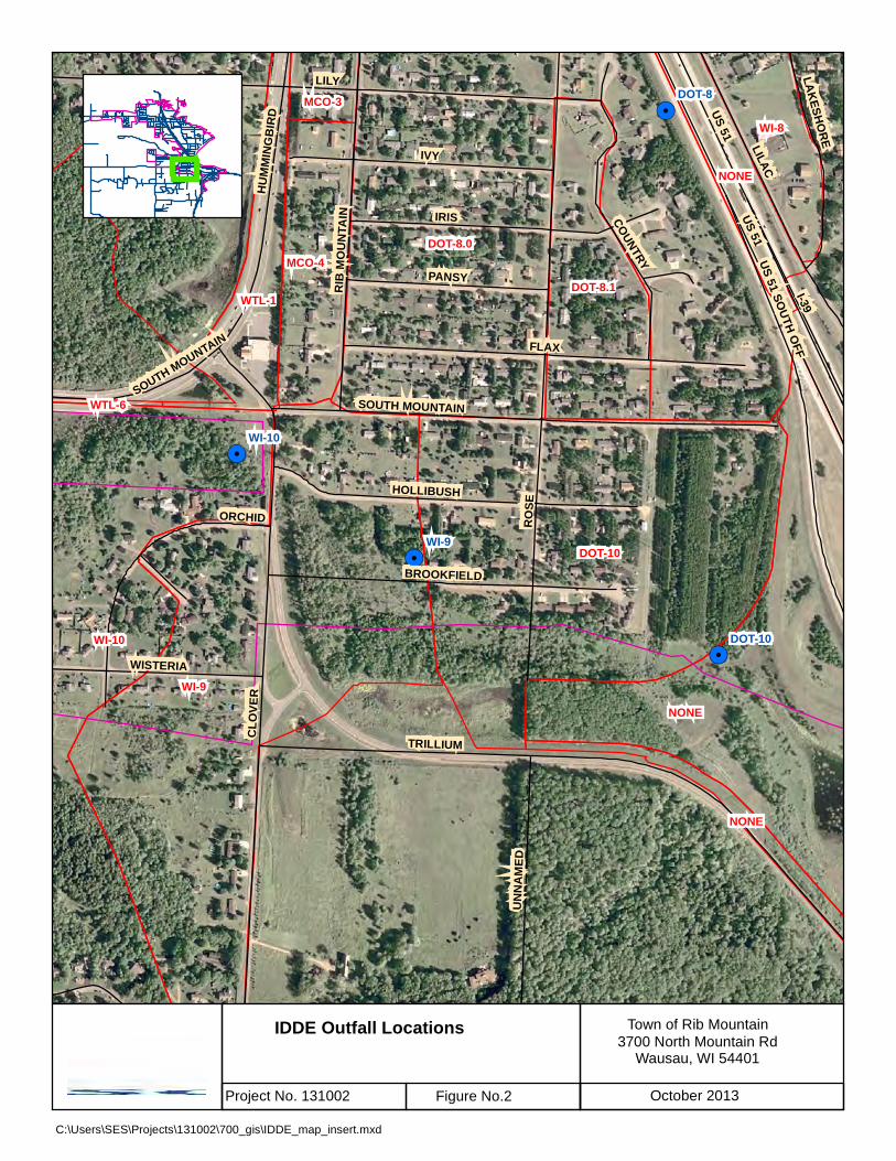
!.
!.
!.
!.
!.
!.
!.
LILY
RO
SE
CLO
VER
US 51
FLAX
IRIS
IVY
TRILLIUM
I-39
LILAC
HOLLIBUSH
COUNTRY
SOUTH MOUNTAIN
PANSY
BROOKFIELD
US 51 SOUTH O
FF
RIB
MO
UN
TAIN
UN
NA
MED
LAK
ESHO
RE
WISTERIA
HU
MM
ING
BIR
D
ORCHID
US 51
SOUTH MOUNTAIN
WI-9
DOT-8.0
DOT-10
WI-10
NONE
WTL-2
DOT-8.1
MCO-4
WI-8
WTL-1
MCO-3
NONE
NONE
WTL-6
WI-9
WTL-2
WI-10
DOT-8
DOT-10
Town of Rib Mountain
3700 North Mountain RdWausau, WI 54401
C:\Users\SES\Projects\131002\700_gis\IDDE_map_insert.mxd
IDDE Outfall Locations
Project No. 131002 Figure No.2 October 2013
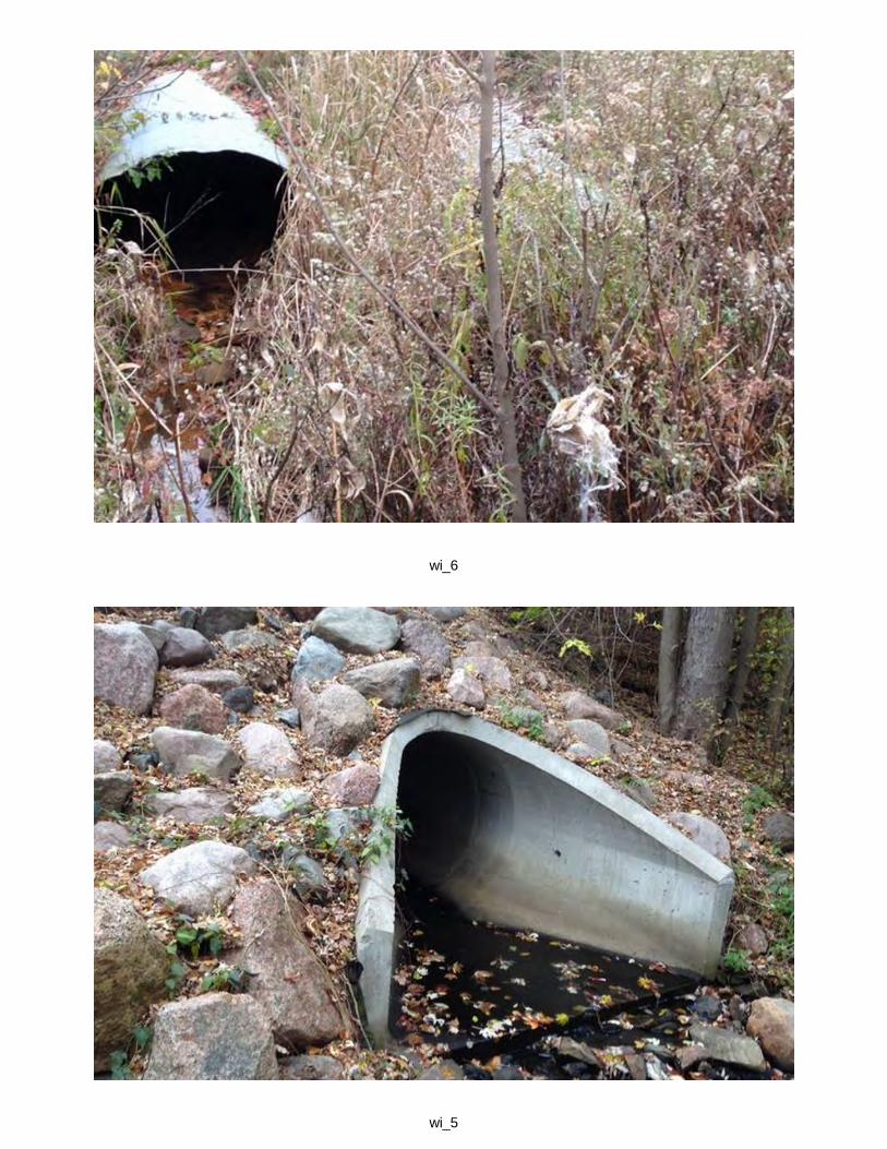
wi_6
wi_5

dot_5dot_11_old

dot_11br_1

br_2br_6
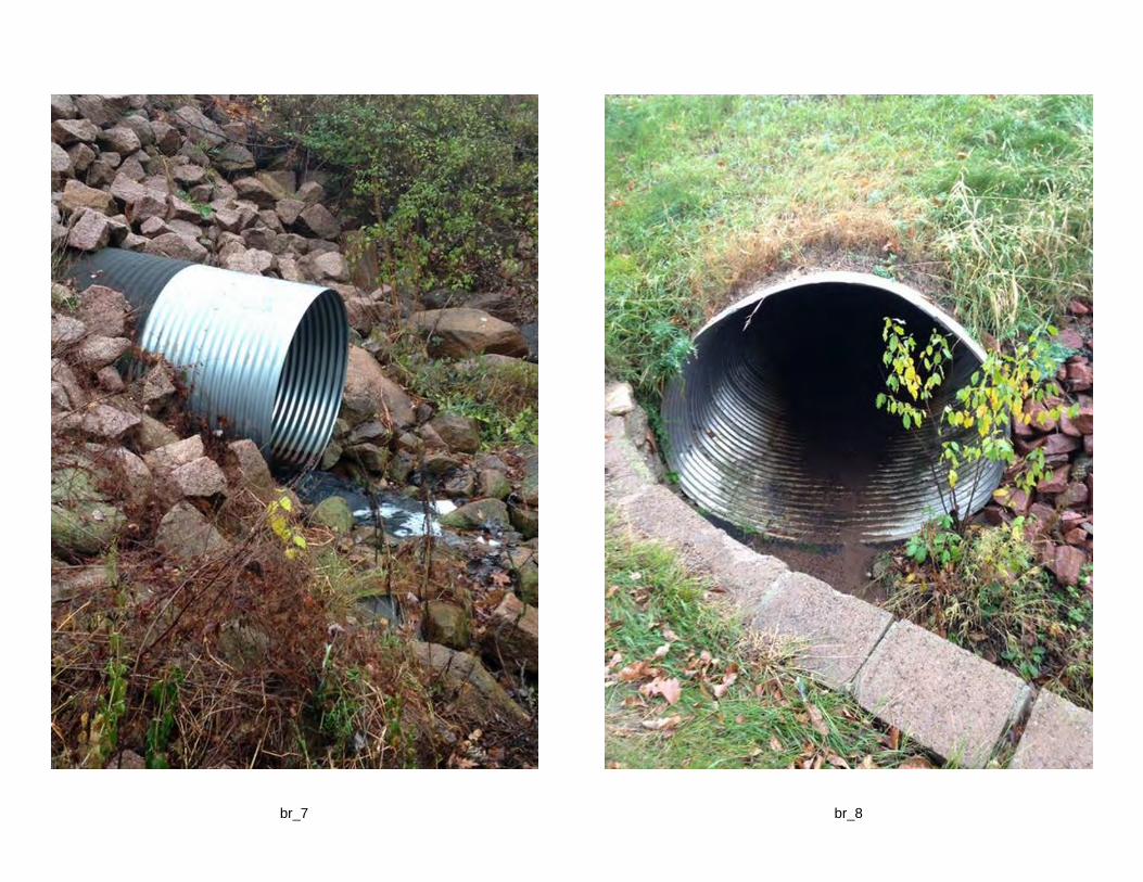
br_8br_7
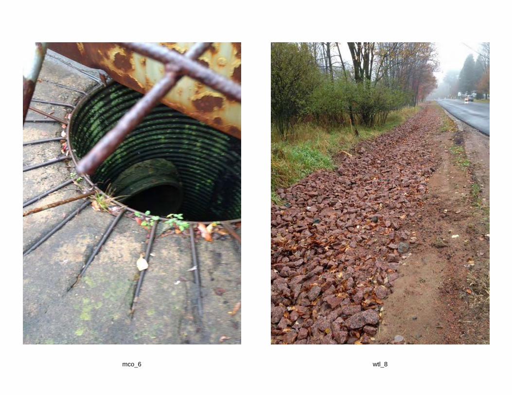
wtl_8mco_6
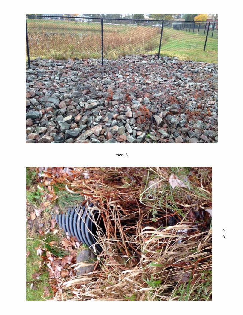
mco_5
wtl_2
dot_8wi_9

wi_10dot_3
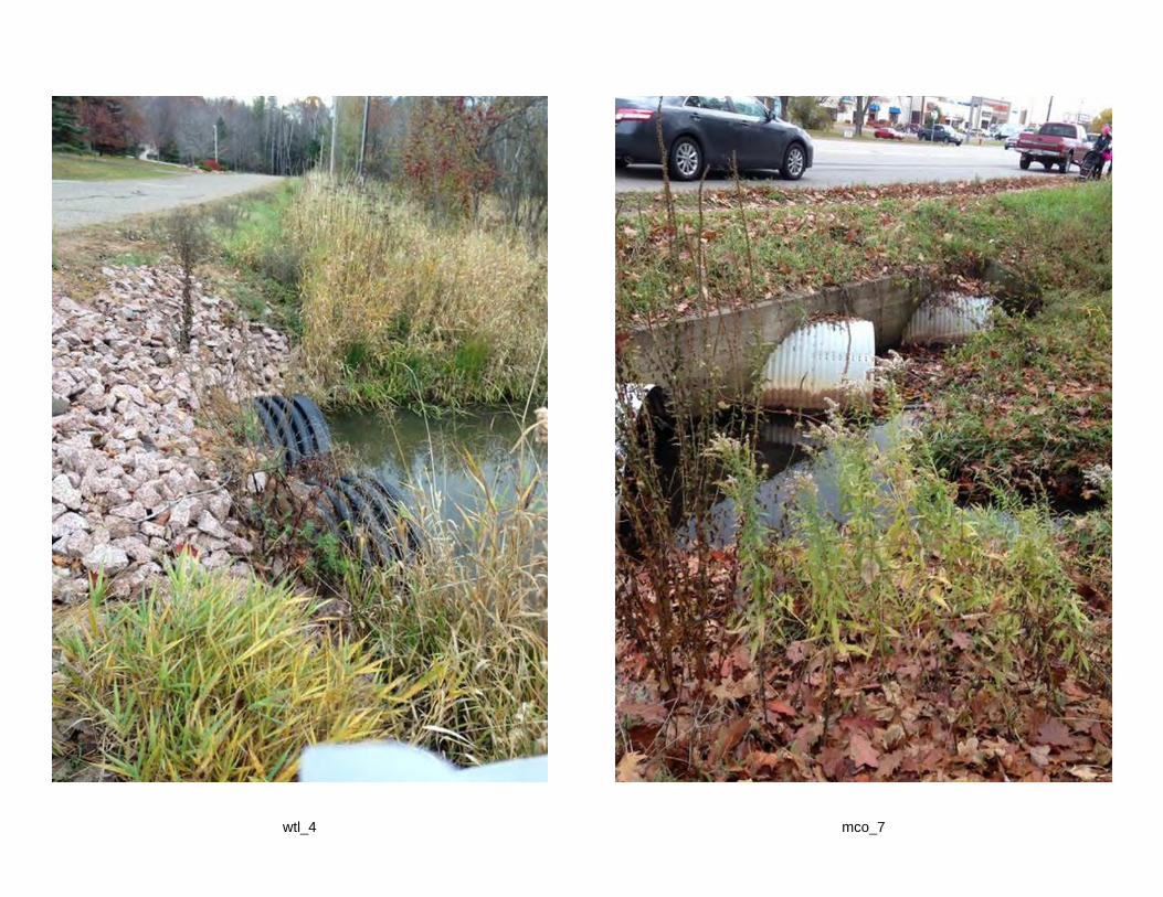
mco_7wtl_4
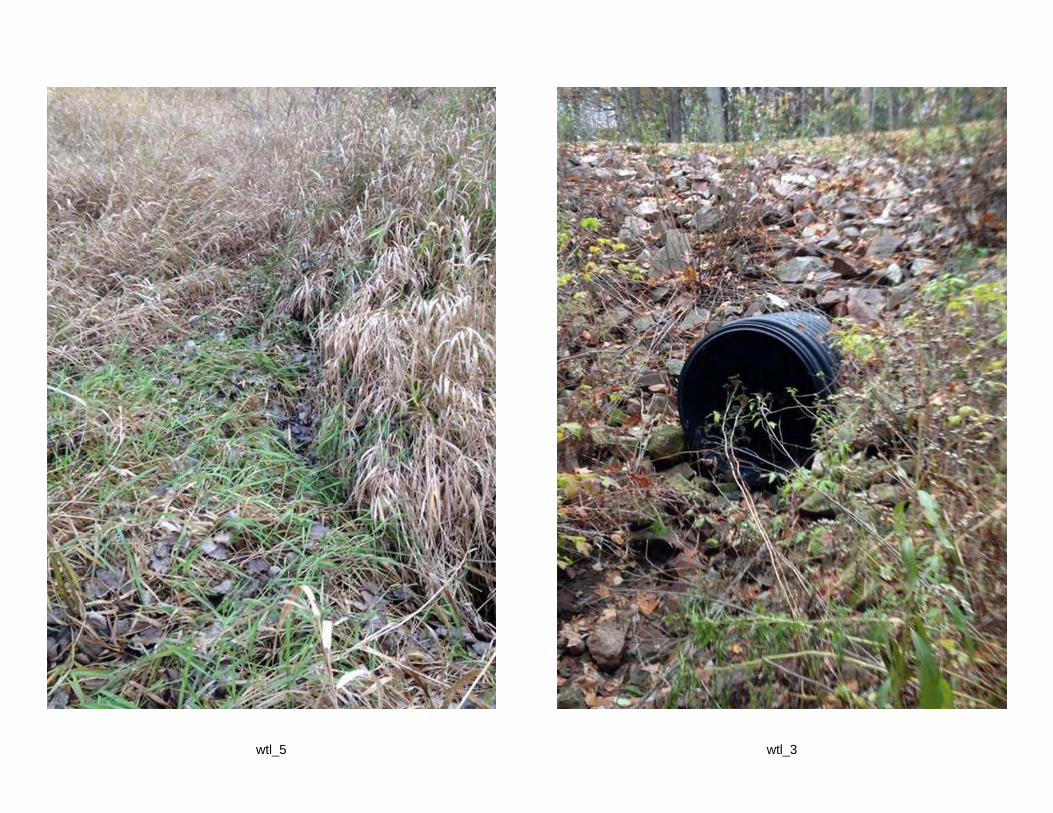
wtl_3wtl_5