OE9580Teddy's Falls Waterpower Project DescriptionMarch2012Teddy’s Falls Waterpower - Project...
43
OEL-HYDROSYS TEDDY’S FALLS WATERPOWER PROJECT PROJECT DESCRIPTION CANADIAN ENVIRONMENTAL ASSESSMENT ACT CLASS ENVIRONMENTAL ASSESSMENT FOR WATERPOWER PROJECTS PREPARED FOR: WENDIGO POWER PARTNERSHIP INC. 9094 CAVANAGH ROAD ASHTON, ONTARIO K0A 1B0 PREPARED BY: OEL-HYDROSYS INC. 3108 CARP ROAD, BOX 430 OTTAWA, ONTARIO K0A 1L0 MARCH 2012
Transcript of OE9580Teddy's Falls Waterpower Project DescriptionMarch2012Teddy’s Falls Waterpower - Project...

OEL-H
YD
RO
SYS
TEDDY’S FALLS WATERPOWER PROJECT
PROJECT DESCRIPTION
CANADIAN ENVIRONMENTAL ASSESSMENT ACT
CLASS ENVIRONMENTAL ASSESSMENT
FOR WATERPOWER PROJECTS
PREPARED FOR:
WENDIGO POWER PARTNERSHIP INC.
9094 CAVANAGH ROAD
ASHTON, ONTARIO K0A 1B0
PREPARED BY:
OEL-HYDROSYS INC.
3108 CARP ROAD, BOX 430
OTTAWA, ONTARIO K0A 1L0
MARCH 2012

TEDDY’S FALLS WATERPOWER PROJECT
PROJECT DESCRIPTION
CANADIAN ENVIRONMENTAL ASSESSMENT ACT
CLASS ENVIRONMENTAL ASSESSMENT FOR WATERPOWER PROJECTS
Prepared for:
WENDIGO POWER PARTNERSHIP INC.
9094 Cavanagh Road Ashton, Ontario K0A 1B0
Prepared by:
OEL-HYDROSYS INC. 3108 Carp Road, Box 430 Ottawa, Ontario K0A 1L0
File No. OE9580
March 2012
Ref: OE9580 Teddy’s Falls Waterpower Project Description March2012

Teddy’s Falls Waterpower - Project Description
Page i
TABLE OF CONTENTS
1. INTRODUCTION ............................................................................................................ 1
1.1. Distribution .................................................................................................................. 2
1.2. Contact Information ..................................................................................................... 3
2. PROJECT INFORMATION ............................................................................................... 4
2.1. Project Area .................................................................................................................. 4
2.2. Project Location............................................................................................................ 4
2.3. Project Overview and Components .............................................................................. 6
2.4. Ancillary Components .................................................................................................. 7
2.5. Installed Capacity and Annual Energy Output ............................................................... 9
2.6. Additional Requirements .............................................................................................. 9
3. PROJECT AREA INFORMATION ................................................................................... 10
3.1. Physical Environment................................................................................................... 10
3.2. Biological Environment ................................................................................................. 11
3.3. Social and Cultural Environment .................................................................................. 12
3.4. First Nation and Aboriginal Traditional Activities and Cultural Heritage Values ............ 15
4. PROJECT ACTIVITIES AND PROTENTIAL ENVIRONMENTAL EFFECTS ........................ 15
4.1. Planning Phase ............................................................................................................. 16
4.2. Construction Phase ...................................................................................................... 17
4.3. Operational Phase ....................................................................................................... 18
4.4. Decommissioning Phase ............................................................................................... 19
5. CONSULTATION ........................................................................................................... 19
6. REGULATORY AUTHORIZATIONS AND APPROVALS ..................................................20
6.1. Federal ....................................................................................................................... 20
6.2. Provincial ................................................................................................................... 20
6.3. Municipal and Other ................................................................................................... 21
7. PROPOSED PROJECT SCHEDULE .................................................................................. 21
8. CONCLUSION ............................................................................................................... 23

Teddy’s Falls Waterpower - Project Description
Page ii
LIST OF FIGURES
Figure 1: Site Location Map
Figure 2: Conceptual Site Plan
LIST OF APPENDICES
Appendix A: Supplemental Design Information
Appendix B: Summary of Community Information Event
Appendix C: Potential Effects Identification Matrix
Appendix D: Natural Resources Canada Explosives Act Questionnaire

Teddy’s Falls Waterpower - Project Description
Page 1
1. INTRODUCTION
In order to develop the waterpower potential of the Larder River below Wendigo Lake, the Wendigo Power Partnership Inc. (herein referred to as WPP, or the proponent) initiated plans for the development of a hydroelectric waterpower facility on the Larder River at Teddy’s Falls in April 2009 with the submission of a Plan of Development (POD) to the Ministry of Natural Resources (MNR). The POD originally referred to the proposed development as the “Flume Line Project,” owing to the presence of the Flume Line Tunnel dating to 1915, a 2.9 m tunnel and a wood stave penstock constructed to connect Wendigo Bay to connect to the lower Larder River. Applicant of Record was subsequently awarded to the proponent by MNR in September 2009. WPP subsequently renamed the proposed development the Teddy’s Falls Waterpower Project owing to the key role of Teddy’s Falls in the proposed hydroelectric development. WPP is currently wholly owned by the MoCreebec Council of the Cree First Nation.
The project site is located on the Larder River, approximately 13 km northeast of Englehart, Ontario; a site location map is presented as Figure 1. Numerous studies investigating the hydroelectric potential of the Larder River below Wendigo Lake have been completed over the years, including an engineering investigation completed by the Ministry of Natural Resources in 2004, and an engineering feasibility and environmental analysis investigation completed by M.M. Dillon Limited in 1989. Key findings from these earlier investigations are referenced within this document.
This project description provides a conceptual overview of the project components, general information on the project’s setting and relevant background information. The project description and the environmental assessment planning for the undertaking are designed to meet the requirements of both a federal screening under the Canadian Environmental Assessment Act (CEAA) and the Class Environmental Assessment for Waterpower Projects (Class EA) (October 2008, revised March 2011).
The Class EA applies to waterpower projects to which the environmental screening process prescribed under Ontario Regulation 116/01 – Electricity Projects (2001), or as amended under the Ontario Environmental Assessment Act currently applies. It includes waterpower projects that are listed under Category B of the Electricity Projects Regulation, namely new waterpower projects that have a nameplate capacity of less than 200 MW. The Class EA was developed to ensure that projects are planned in an environmentally responsible manner and in a timely fashion. The Class EA is designed to facilitate coordination with other relevant federal and provincial requirements to help ensure effective and efficient public and agency involvement. It also incorporates a best practices approach in terms of public involvement, Aboriginal and First Nation community engagement, and project design.
This project description is also intended to assist federal decision-makers to determine whether the undertaking triggers the CEAA. This document should enable a federal agency to decide

Teddy’s Falls Waterpower - Project Description
Page 2
whether it will be a Responsible Authority (RA) under the CEAA or whether it may be able to provide technical expertise and knowledge as an expert department.
The information presented herein will assist all levels of government, First Nations and Aboriginal groups, interested local and regional groups and the general public to understand the nature of the waterpower project, the environment surrounding the project site and the anticipated environmental effects associated with the undertaking.
1.1. Distribution
The project description will be circulated to the following potential interested parties:
Ministry of Natural Resources Ministry of the Environment Ontario Parks Ministry of Northern Development and Mines Ministry of Energy Ministry of Aboriginal Affairs Canadian Environmental Assessment Agency Ontario Waterpower Association Town of Englehart Town of Earlton Marter Local Roads Board Villages of Tomstown and Hillardton Township of Evanturel Beaverhouse Aboriginal Community Matachewan First Nation Timiskaming First Nation Wahgoshig First Nation Other interested parties, as identified to the proponent
The Canadian Environmental Assessment Agency will circulate the Project Description to the following;
Fisheries and Oceans Canada Transport Canada Environment Canada Natural Resources Canada Canadian Transportation Agency other federal departments as deemed necessary by the CEA Agency

Teddy’s Falls Waterpower - Project Description
Page 3
A project EA coordination meeting was held in December 2009 to discuss the project, identify agency roles and responsibilities and potential permitting and approval requirements; discuss known project-specific environmental values and data/ information gaps; and to discuss public, First Nation and Aboriginal consultation strategies. A Notice of Commencement for the proposed undertaking was issued on January 12, 2011 as the Flume Line Small Hydro Project.
In order to target the many seasonal residents in the vicinity of the project area, a preliminary project information event was held on August 24, 2011. Members of the EA project team introduced the project and presented natural habitat information collected during the field investigations completed to date. The event allowed participants to ask question, share information, and request to be added to the project mailing list.
1.2. Contact Information
The Wendigo Power Partnership will be solely responsible for the development and operation of the proposed electricity generation project; WPP is a for profit business. Project contact information is provided below:
Project Executive Director
Bill Touzel, C.A. WESA Group Inc. 3108 Carp Road, P.O. Box 430 Ottawa, ON K0A 1L0 613 839-3053, ext. 241 [email protected]
The following parties may be contacted for specific comments or inquiries for the proposed undertaking:
Environmental Assessment Consultant
Mr. Kai Markvorsen Environmental Approvals Project Manager OEL-HydroSys Inc. Box 430 Carp Ottawa, Ontario K0A 1L0 (613) 839-1453 ext. 248 (613) 839-5376 fax [email protected]
Teddy’s Falls Waterpower - Project Description
Page 4
Biological Consultant
Kristy Beatty, Biologist, Project Manager Ontario Resource Management Group Inc. P.O. Box 1234 Pembroke, Ontario K8A 6Y6 (613) 638-0203, 613-639-8585 (mobile) [email protected]
2. PROJECT INFORMATION
2.1. Project Area
The project area encompasses Wendigo Lake and a section of the Larder River downstream of Wendigo, to just below Teddy’s Falls. The project area is located approximately 13 km northeast of the town of Englehart. The majority of the area falls within the Marter Township (unorganized) though Wendigo Lake is situated on the boundary between the Marter and Bayly Townships.
2.2. Project Location
The approximate project location relative to Highway 11 and the nearest town, Englehart, Ontario is shown on Figure 1.
Legal Description
The proposed project site is located on Lots 1, 2 and 3, Concession 3, Marter Township in the District of Temiskaming.
Geographic Coordinates
47°52'37.88" N 79°45'44.12" W
UTM Coordinates
17T 592550.58m E 5303386.08m N

79°20'0"W
79°20'0"W
79°25'0"W
79°25'0"W
79°30'0"W
79°30'0"W
79°35'0"W
79°35'0"W
79°40'0"W
79°40'0"W
79°45'0"W
79°45'0"W
79°50'0"W
79°50'0"W
79°55'0"W
79°55'0"W
80°0'0"W
80°0'0"W
80°5'0"W
80°5'0"W
80°10'0"W
80°10'0"W
48°5'0"N
48°5'0"N
48°0'0"N
48°0'0"N
47°55'0"N
47°55'0"N
47°50'0"N
47°50'0"N
47°45'0"N
47°45'0"N
47°40'0"N
47°40'0"N
47°35'0"N
47°35'0"N
LEGEND
PROJECT No. KB6852-00-01DESIGNGISCHECKREVIEW
FIGURE 1JFDJFD
27/04/2009
KB OE7492_fF:VER1
Site Location
Proposed Profile Elevation
2.5 0 2.5 5 7.51.25
Kilometres
1:250000
Larder RiverPROJECT
TITLESite Location
REFERENCE-Produced by WESA Geomatics
LOCATIONLat Long
Intake 47.877189 -79.762255Pipeline-Penstock
Start 47.877043 -79.762487End 47.869747 -79.785547
Powerhouse 47.869901 -79.785701
Northing (UTM) Easting (UTM)Intake 5303391 592548Pipeline-Penstock
Start 5303375 592531End 5302537 590819
Powerhouse 5302554 590808

Teddy’s Falls Waterpower - Project Description
Page 6
2.3. Project Overview and Components
In 1915-1916, a 2.9 m wide and 225 m long tunnel (Flume Line) was blasted from the south end of Wendigo Lake as part of an early 20th Century attempt to develop hydroelectric generation at the site. The tunnel was reportedly abandoned and plugged with concrete in 1953. The Teddy’s Falls project would essentially redevelop the Flume Line initiative, incorporating recommendations made during earlier investigations into the hydroelectric potential of the Larder River below Wendigo Lake undertaken by both private industry and the Ministry of Natural Resources.
The proposed development would utilize the natural head between Wendigo Lake and Teddy’s Falls towards the sustainable generation of electricity through waterpower under the provincial Green Energy and Green Economy Act initiative. A Feed-in Tariff (FIT) contract was awarded to the proponent by the Ontario Power Authority, facility commissioning date is set for Spring 2015. The project would also reduce greenhouse gas emissions by approximately 14,000 tonnes per year.
A conceptual plan for the layout of the facility and ancillary components is presented in Figure 2.
Conveyance Structure
The abandoned Flume Line tunnel (originating at Wendigo Bay) route will be reinstated, requiring the construction of a buried low-pressure pipeline, presently conceptualized to be 2.5 m diameter and a short section of penstock (to connect to the powerhouse) measuring a total length of approximately 2.2 km. An engineered intake to the pipeline would be constructed in Wendigo Bay, and would be equipped with a trashrack. A bulkhead gate at the intake is presently proposed for maintenance purposes. The pipeline will be routed to avoid wetland habitat by following the existing recreational trails, where possible.
Powerhouse
A powerhouse would be constructed at the base of Teddy’s Falls (south bank) to house the turbine and generation equipment. The powerhouse will be constructed of mass concrete with a steel structure installed above the high water elevation level. A new transformer will be located adjacent to the powerhouse.
Tailrace
A tailrace canal would be excavated below the powerhouse to return water to the Larder River downstream of Teddy’s Falls.

Teddy’s Falls Waterpower - Project Description
Page 7
Water Control Structure
The construction of an overflow weir at the outlet of Wendigo Lake above Wendigo Falls is proposed to enhance the waterpower generation capacity. The weir will stabilise water levels above the existing summer level while remaining below the established high water elevation. The weir will be engineered for the provision of a varying minimum flow to maintain the ecological function of the Larder River downstream to Teddy’s Falls.
2.4. Ancillary Components
Access Road
An existing 1 km private access road on Lot 3, Concession 3, Marter Twp. will be upgraded to provide access to the powerhouse.
An existing recreational trail (former logging road) on Crown land will be used for access for the penstock construction. It is anticipated that some upgrades will be required to the recreational trail to facilitate the mobilization of equipment.
Interconnection Power Line Route Location
An 8 km length of power line will and associated 15-20 m right of way (ROW) will be required to connect the facility to the electrical supply grid. The connection will be made via a point of common coupling located north of Teddy’s Falls and west of Wendigo Lake at Marter. From there the 44kV line will travel due west to Jackpine Road where it will connect with Kirkland Lake Feeder M62. The Connection Impact Assessment for this line was approved by Hydro One, guaranteeing adequate transmission capacity for this project.

Point of Common Coupling
Flume Line Tunnel
Low-Pressure Pipeline
PenstockPowerhouse
Tran
smiss
ion
Line
Submerged Intake
Wendigo Bay
Wendigo Lake
Weir
Teddy's Falls
HIGHWAY 624
CONCESSION 3 CHAMBERLAIN
590500
590500
592000
592000
5302
000
5302
000
5303
200
5303
200
5304
400
5304
400
PROJECT
TITLE
PROJECT No.DESIGN
GIS
CHECK
REVIEW
FIGURE 2RP
KC
15/03/2012
15/03/2012JFD
Note: MNR & Geobase Data ServicesNAD83, UTM17
OTeddy's Falls
Waterpower Project
0 100 200 300 40050
Meters
JFD
15/03/2012
15/03/2012
DISCLAIMER:This map should not be relied on as a precise indicator of routes or locationsnor as a guide to navigat ion. The Ontario Ministry of Natural Resources (OMNR) shall not be liable in any way for the use of, or reliance upon, this map or any information on this map.REFERENCE:-The base data is known to be the best available information providedthrough the Ontario Geospatial Exchange and by Ontario Ministry ofNatural Resources, Ontario Ministry of the Environment, Conservat ionOntario and local Municipalities.-Produced by WESA Geomatics under license with the Ontario Ministry of Natural Resources, Copyright (c) Queen's Printer 2010.
1:12,000
SITE LOCATION
OE-9580
LegendWeir
Low Presure Pipeline
Penstock
Transmission LineLocal Street
Arterial Roads
Water Area, Permanent
Patent Land
Provincial Park
Wetland Area, Permanent

Teddy’s Falls Waterpower - Project Description
Page 9
2.5. Installed Capacity and Annual Energy Output
A preliminary analysis of the site was undertaken using RETScreen® International software. The results of the analysis indicate that a project can be developed that has the following key parameters:
Design Gross Head: 43 m Installed Capacity: 2.7 to 3.3 MW Average Annual Energy: 12.7 GWh
An elevation profile for the project, from the intake located in Appendix A.
A proposed minimum flow value for the Larder River downstream of the weir to maintain the ecological function and preserve the aesthetics of the waterway extending to Teddy’s Falls will be examined as part of the environmental assessment. Preliminary investigations suggest that the historical low flow value may be sufficient year round as the minimum flow required for the by-pass section of the river. However, the determination of the minimum flow will be confirmed during the course of the EA with regulatory authorities, including the Ministry of Natural Resources and Fisheries and Oceans Canada. The details regarding the operation of this project will be determined and evaluated during the environmental assessment, and through consultation with regulators and other interested parties.
2.6. Additional Requirements
Resource/Materials Requirements
The project involves the generation of hydroelectricity through sustainable use of waterpower utilizing natural flows and head of the Larder River between the Wendigo Bay and Teddy’s Falls.
Waste Disposal
An amount of construction related waste materials as well as excavated bedrock and soil will be produced at the site during construction. These materials can be deposited at the local municipal landfill (subject to capacity) as regular waste. Bedrock and soil could be used on site for infill as required.
Waste generated over the operational stage of the project typically includes small volumes of waste lubricates, filters, replacement parts (electrical, metal, equipment). This waste stream is characterized as non hazardous and would be deposited at the local municipal landfill.
Waste construction materials would be produced should the project be decommissioned; facility decommissioning would be subject to then applicable legislation and guidelines for non hazardous waste management.

Teddy’s Falls Waterpower - Project Description
Page 10
3. PROJECT AREA INFORMATION
3.1. Physical Environment
Estimated Drainage Area
The drainage area above the project’s intake on Wendigo Lake was recently estimated at approximately 572 km2 but previously estimated as approximately 735 km2 (Ontario’s Water Power Sites, MNR, 1985 for Site 2JC6). Given the discrepancy, OEL-HydroSys undertook a verification of the project’s drainage area using up to date 1:50,000 scale topographic data and determined it to be 748.5 km2.
Potentially Affected Bodies of Water
The project will be operated as a run-of-river installation and will have a minimal effect on Wendigo Lake and will have no effect on the Larder River downstream of the outfall of the proposed plant. The installation of an overflow weir at the outlet of Wendigo Lake above Wendigo Falls is proposed to stabilise lake water levels above the presently experienced summer level but below the known high water elevation. Plant output will be controlled by a standard water-level controller and SCADA system. Water levels within Larder River Provincial Park located further upstream of the project site will not be affected in any way.
Flows in the Larder River will be adjusted to maintain the approved minimum flow for the portion of the Larder River between the weir and Teddy’s Falls. WPP recognizes that this approach may require an adaptive management strategy to sustain ecological function of the waterway. The physical components of the development, in particular the overflow weir at the outlet of Wendigo Lake, will be engineered to facilitate the provision of the approved minimum flow regime.
Surface Water Quality
The sealing of the Flume Line in 1953 resulted in the eventual eutrophication of the Wendigo Bay resulting in impaired water quality in Wendigo Bay. The proposed development presents a potential positive effect in Wendigo Bay by providing continual “flushing” of the system through the drawing of water to the hydroelectric generating system resulting in improved water quality.
This same conclusion was presented in an engineering feasibility and environmental analysis conducted by an engineering consulting firm in 1989. The study concluded that cottagers around Wendigo Lake would benefit from re-opening the Flume Line tunnel which would lead to improved circulation and oxygenation of water in Wendigo Bay. In response to some concerns raised by MNR as to the effect the flushing of stagnant bay water on the downstream water regime, a preliminary surface water and sediment quality investigation was completed in 2011. The results of that investigation have been submitted to the Ministry of Environment and the
Teddy’s Falls Waterpower - Project Description
Page 11
Ministry of Natural Resources and are presently under review by these agencies. The potential for the project to alter surface water quality will be examined as part of the environmental assessment process.
3.2. Biological Environment
A desktop environmental database review was completed to identify known terrestrial and aquatic environmental features in the study area. Information was collected from the Kirkland Lake District Office of the Ministry of Natural Resources, Fisheries and Oceans Canada, the Natural Heritage Information Database and the Environment Canada Species at Risk website as well as existing reports.
An assessment of the terrestrial and aquatic habitats within the project area was initiated by the EA project team in 2011 to characterize existing habitats, conduct presence/absence surveys for potential for species and their habitats located in the study area and to assist in project planning. The proponent and the consulting team held a meeting with MNR staff at the project site on March 16, 2011 to discuss the proposed undertaking and its potential effects as well as to begin to scope the biological assessment for the 2011 field season.
As part of the EA project team Ontario Resource Management Group (ORMG) initiated field investigations in the project area in June 2011 to characterize the aquatic and terrestrial habitat and to complete field data collection exercises during key timing events. The results of the 2011 baseline sampling are presented in ORMGs “2011 Environmental Characteristics Report – Teddy’s Falls Hydroelectric Generating Station, Larder River, Bayly Township.” The report is presently under review by MNR and DFO; a summary of the information contained in the document is presented below.
Aquatic Habitat and Species
Aquatic habitats were assessed throughout the project area through extensive field surveys and photographic interpretation. Aquatic habitats were surveyed from Wendigo Lake and along the Blanche River between Wendigo Falls and Teddy’s Falls. Additionally, several streams which outlet into the Blanche between Wendigo Lake and Teddy’s Falls were also surveyed.
Fish species that are known to be present in Wendigo Lake and the Larder River downstream include walleye, smallmouth bass, northern pike, and lake trout have been identified by the MNR below Teddy’s Falls. The species composition of the lower Larder River is influenced by that of the downstream Blanche River and Lake Timiskaming. Teddy’s Falls presents an impassable barrier to upstream fish migration. Above Teddy’s Falls, the bed of the Larder River is comprised of bedrock substrate, making it poor invertebrate habitat.

Teddy’s Falls Waterpower - Project Description
Page 12
The requirements specifically related to aquatic species, fisheries habitat and navigable waters are federally mandated by Fisheries and Oceans Canada under the Fisheries Act. Additional information relating to fish and fish habitat is presented in Section 4.0 of this project description.
Terrestrial Habitat and Species
Terrestrial surveys were carried out in habitats with the potential to be affected within the project area. Aerial photo interpretation and consultation with MNR officials were also taken into account when identifying areas of local ecological significance. The survey focused on four main terrestrial survey zones: Larder River Provincial Park, Wendigo Lake Shoreline, Pipeline, and terrestrial habitat surrounding the Bypass Area. Habitat types within these areas ranged from boreal forest and lowland forests, wetlands, swamps and human-influenced lands. Among the tree species present in the area are balsam poplar, white birch, jack pine, black spruce, northern white cedar and balsam fir.
Species at Risk
Consultation with MNR staff and the background information review identified nineteen Species at Risk (SAR) which have the potential to be present within the project’s zone of influence. Of these, the Canada Warbler (Wilsonia Canadensis) and the Olive Sided Flycatcher (Contopus cooperi) were confirmed to be present within the project area.
Lake sturgeon (Acipenser fulvescens) have been confirmed within the Blanche River system downstream of Teddy’s Falls but were not observed during 2011 field assessments. Further investigation will determine whether active spawning areas exist in the vicinity of Teddy’s Falls.
ANSI, Provincially Significant Wetlands, other Value Issues
No areas of natural and scientific interest (ANSI) or provincially significant wetlands have been identified within the project area. The proposed project area itself does not fall within a provincial park, but the Larder River Provincial Park is located upstream of Wendigo Lake. The values protected by this park must be not negatively impacted by the development. The flow of water through the Larder River will be influenced only by natural conditions and the operation of existing (and proposed) upstream water control structures.
3.3. Social and Cultural Environment
Understanding the relationship between the socio-cultural-economic environment and the natural environment is critical to the successful development of the proposed project. The benefits and costs associated with the project throughout its life cycle of the project will be examined. Consultation with local municipal governments and boards, First Nations and Aboriginal groups, landowners, recreational users that accesses the area surrounding the proposed project site will
Teddy’s Falls Waterpower - Project Description
Page 13
aid in the identification of potential concerns. Resolution to these issues or concerns may then be addressed through the planning, design and operational phases of the project.
Land Tenure
Components of the proposed development would be constructed on both Crown land and private land. An access agreement has been secured between the private landowner and WPP.
Cottage Community
There is an established seasonal community on Wendigo Lake. The proposed project is a run-of-river development which will not affect upstream or downstream water levels or natural flow regimes beyond the zone of influence. Residents and landowners in the immediate vicinity of the project area will be consulted during the course of the environmental planning process. An initial meeting with the local community was held on August 24, 2011. A summary of this meeting can be found in Appendix B.
Local Communities
The project is located approximately 13 km from Englehart, Ontario. During the environmental assessment, the socio-economic impact on the local and regional economy will be examined. Public consultation events in support of the proposed development will be advertised in local media and notices will be forwarded to local governments and service boards. A project mailing list developed subsequent to the August 24, 2011 information event with local landowners will also be used to provide project updates and meeting notifications.
Tourism and Recreational Use
Wendigo Lake forms part of a traditional canoe route. As the proposed project is a run-of-river development, without any manipulation of upstream or downstream water levels or natural flow regimes, the project will not have any impact on the various uses of Wendigo Lake upstream of the project or the Larder River downstream of the project. The project will have an impact on the portion of the Larder River between the weir located at the outlet of Wendigo Lake and Teddy’s Falls; minimum flow value in that portion of the river will be established during the environmental planning process, addressing aquatic ecosystem issues as well as aesthetic and recreational use concerns. Approvals for the undertaking may be required under the Fisheries Act and the Navigable Waters Protection Act.
There is an access point to the Larder River Provincial Park on the southwest shore of Wendigo Lake, with additional access located further upstream. The canoe route does not extend to the Larder River below Wendigo Lake since the presence of multiple falls and rapids restrict paddling activity. However the presence of a former portage at Wendigo Falls and perhaps further downstream was noted by landowners at the August 24, 2011 meeting. Further investigation into

Teddy’s Falls Waterpower - Project Description
Page 14
whether recreational paddlers are using the waterway will be undertaken during the environmental assessment.
There are a number of recreational trails traversing Crown land in the project area. The operation phase of the project is not expected to negatively impact existing land uses. Where the construction of the pipeline intercepts recreational access, an alternate route will be provided and the trail will be re-established post-construction.
We do not anticipate that the project will adversely affect tourism or general recreational use of the area. Although, limited restrictions on access and use in the immediate area of civil works related to the project may be necessary to ensure public health and safety and the security of assets.
Trapping, Baitfish Harvesting, and Bear Management Agreement Activities
The proposed development area falls within a registered trap line and adjacent to another. WPP does not anticipate that the ongoing operation of the project will adversely impact trapping activities in the project area. It is possible that construction activities may cause a short term impact, and mitigation measures will be implemented specifically to alleviate any negative impacts. The trapper(s) will be individually notified of the potential project, every effort will be made by WPP to work cooperatively with any potentially affected parties.
While baitfish harvesting does occur in the townships of Marter and Bayly, and we are not aware of baitfish harvesting occurring in the area directly affected by the project (i.e. the reach of the Larder River between the proposed intake and the powerhouse). Additional investigation will be completed during the Class EA and appropriate mitigation measures and/or minimum flow requirements will be taken into consideration in developing construction and operation parameters for the project.
It is not anticipated that any particular aspect of the project would adversely impact bear habitat (or the habitat of any other terrestrial species). Should any such effects be identified through the course of the planning process, appropriate mitigation measures will be presented in the environmental assessment report.
Dams/Control Structures
Several water control structures exist on the Upper Larder River above Wendigo Lake. The Larder Lake Dam is located at Larder River, approximately 4 km downstream from Larder Lake. In proximity to the Larder Lake Dam is the Upper Raven Dam. The Lower Raven Dam is located near the inlet to Corset Lake. These three water control structures are owned by the MNR. Additionally, there are two overflow weirs upstream of the Lower Raven Dam, within the boundary of the Larder River Provincial Park. Only the Larder Lake Dam is operated.

Teddy’s Falls Waterpower - Project Description
Page 15
The proposed project would be a run of river development, there would be no impacts to the upstream water control infrastructure.
Water Management Plan
No water management plan presently exists for the Larder River. WPP would be pleased to participate in the establishment of such a plan in conjunction with MNR and other interested parties. The ecosystem in and around a river adapts to the naturally occurring variations of flow and other physical parameters of the river’s water. The dam operating plan that will be developed for this project will address the natural flow regime, and use it as a guide to determining the conditions that must be maintained in the river at various times of the year. This necessitates deriving an understanding of the magnitude, timing, frequency, rate of change and duration of naturally occurring flows, and mimicking these to the greatest extent possible within the facility operating plan. The dam operating plan will be subject to regulatory approval under the jurisdiction of the MNR.
3.4. First Nation and Aboriginal Traditional Activities and Cultural Heritage Values
The Site Description Package (SDP) issued by the Ministry of Natural Resources listed the Beaverhouse Aboriginal Community, the Matachewan First Nation as Identified Aboriginal Communities. Additionally, the Timiskaming First Nation was determined by MNR to be a Local Aboriginal Community. Subsequent discussion with the MNR’s Resource Liaison Specialist determined that that the Wahgoshig First Nation may also be a potentially affected local Aboriginal community.
Fundamental to the Class EA and federal planning process are examinations of impacts or potential impacts related to Aboriginal, heritage and cultural issues. Information gaps exist in the study area with respect to these issues. A primary purpose of the environmental assessment will be to work towards filling in these gaps through archaeological investigation, and through the engagement of the aboriginal communities. An engagement plan will be developed by WPP, hopefully this is possible through consultation with the involved aboriginal communities, and submitted to the agencies and these communities for final recommendations before it is undertaken.
4. PROJECT ACTIVITIES AND PROTENTIAL ENVIRONMENTAL EFFECTS
Wendigo Power Partnership is a socially and environmentally responsible proponent of waterpower. Throughout the investigations into site specific and regionally important conditions that may be impacted by the development of the Teddy’s Falls Waterpower Project, WPP is committed to making any necessary modifications to mitigate potential environmental impacts. The proponent will involve all provincial and federal government agencies and interested

Teddy’s Falls Waterpower - Project Description
Page 16
aboriginal communities in the decision making processes as determined through the Waterpower Class Environmental Assessment, CEAA environmental assessment requirements and the MNR water management planning processes. The plans and strategies, for dealing with site features that may experience a potential impact from the project as well as any pertinent information gaps are summarized below. A preliminary potential effects identification matrix has been completed for the undertaking as it is understood at this stage of the planning process (Appendix C). This matrix will be revisited as a guideline during the planning process and will ultimately form part of the impact assessment portion of the Environmental Report.
4.1. Planning Phase
The objective of the planning phase of the project is to minimize impacts and maximize benefits. Accordingly, to inform project design, support the evaluation of potential project effects and to address stakeholder concerns the following investigations have been undertaken:
A preliminary surface water investigation was completed in 2011 through a sampling program conducted in the spring, summer and fall in both Wendigo Bay and the downstream section Larder River. The results of the investigation are presently under review by the MNR and MOE. If required, the surface water quality investigation may be extended into the 2012 season.
Detailed field investigations were completed through the 2011 in the project area to determine the existing habitat conditions, provide additional community descriptions, and determine what changes in habitat can be expected through the proposed undertaking. By combining scientific literature, available fisheries data, potential species occurrence data, Species at Risk information and information gathered from regulators with field investigation gathered through varied methodologies, a sound understanding of the habitat and its potential to sustain healthy populations as well as mitigating against potential project effects on the habitat is being developed.
A hydrologic investigation was initiated in 2011, and including acoustic doppler current profiling (ADCP) of key sections of the Larder River. Hydrological data will continue to be collected through 2012.
Additional terrestrial and aquatic investigations, as required, will continue through 2012. A second project information meeting will be held in Englehart in mid 2012, and
scheduled so as to allow for the participation of seasonal residents on Wendigo Lake, and continue to will seek information on access, aesthetics, recreation, tourism values and other land use in the project area.
Stage 1 and 2 archaeological assessments of the project area will be will be completed, and subject to regulatory review by the Ministry of Tourism, Culture and Sport.
The proponent will work towards engaging the Identified and Local Aboriginal Communities to attempt to gain an understanding of cultural, and Aboriginal and First Nation values and traditional activities in the project area.

Teddy’s Falls Waterpower - Project Description
Page 17
Reporting
The results of all field investigations, regulatory agency consultation, public and Aboriginal consultation initiatives will be presented in one comprehensive document to satisfy the requirements of the Class EA for Waterpower and a federal screening under the CEAA. This Environmental Report will include an evaluation of the potential impacts to the natural and socio-economic environment as well as proposed avoidance and mitigation measures.
Key parties will be provided with a draft Environmental Report for comment prior to the release of the formal document.
4.2. Construction Phase
During the construction phase, several activities have the potential of causing negative impacts on the environment. This list may be expanded and refined as the project design progresses and required mitigation measures are determined.
The following steps are proposed to be undertaken in approximate order:
1. Access and staging area clearing (clearing of vegetation and grading); 2. Weir construction (excavation, trenching and dewatering); 3. Powerhouse construction - excavation and/or cleaning of bedrock (required method is yet
to be determined – i.e. the need for blasting); 4. Water intake construction (set-up of cofferdam and sediment control measures, blasting
and/or clearing of bedrock); and 5. Pipeline and penstock construction (excavation, trenching, filling and compacting)
The potential impacts identified to date associated with the construction phase activities are:
Decrease in surface water quality Sedimentation from cleared shorelines Re-suspension of sediments during in-water activities Loss of aquatic and terrestrial vegetation Impact to Species at Risk Potential impacts to SAR (Lake sturgeon habitat is identified downstream from Teddy’s
Falls) Alteration, disruption and/or destruction of fish habitat Change to fish habitat through alterations to the shoreline and riverbed in order to gain
access to work area and for construction of weir Disruption to local wildlife and bird populations Accidents or equipment malfunctions Potential for releases to the environment of products from construction equipment

Teddy’s Falls Waterpower - Project Description
Page 18
Impacts to the public Increased noise from equipment and construction activities Recreational access disruptions Increased dust levels Change in aesthetics of the project site
The terrestrial and aquatic habitats may be impacted by the construction of the hydroelectric facility during the construction, operation and decommissioning phases. Several of these potential impacts may be reduced or eliminated through the use of mitigation measures and scheduling of in-water work. The required mitigation measures will be determined through the environmental assessment of the undertaking in consultation with key parties.
Through the application of appropriate mitigation strategies, the goal is that water quality will not be negatively affected by any phase of the project (construction, operation, decommissioning). During construction, strict attention to detail will be applied in ensuring that all work that could potentially impact water quality in the area is conducted in accordance with best management practices, and that any mitigation measures identified in the environmental planning studies are strictly adhered to.
If blasting is determined to be required, explosives will be managed by a qualified blasting contractor. If required, a blasting plan will be developed for this phase of the project. No temporary factory will be required at or near the site and the project will not require a change of location of an existing factory. A magazine to store explosives will not be required at or near the project site. A completed Natural Resources Canada Explosives Questionnaire can be found in Appendix D. Should blasting in or near water be required, Fisheries and Oceans Canada’s Guidelines for the Use of Explosives in or near Canadian Fisheries Waters (1998) will be followed.
4.3. Operational Phase
The potential impacts identified to date associated with these activities are:
potential to produce short term effects to downstream surface water quality when water from Wendigo Bay is first flushed through
decrease in surface water quality during maintenance alteration, disruption and/or destruction of fish habitat through:
o loss of fish habitat through change in area and timeline in which minimum flows are experienced
o alteration of fish habitat due to the increased velocity of the newly constructed tailrace
o possible fish mortality from turbine operation disruption to wildlife and birds

Teddy’s Falls Waterpower - Project Description
Page 19
increase in noise from powerhouse operation effects to the public improvement to water quality at Wendigo Bay as the continual movement of water will
change a stagnant system to circulatory one improvements to existing spring flooding experienced by Wendigo Lake cottagers by
creating a new water evacuation (in comparison to the single natural lake outlet, which is often subject to ice and debris jams during spring flooding)
changes to the aesthetics at the powerhouse/weir location accidents or malfunctions potential for emergency shutdown of facility owing to power outage
4.4. Decommissioning Phase
At the end of the life cycle of the facility the removal of equipment will be required to decommission the site in an environmentally sound manner.
The potential impacts identified to date associated with these activities are:
decrease in surface water quality sedimentation release from build up along water control structures removal of aquatic and/or terrestrial vegetation disruption to local wildlife and birds alteration, disruption and/or destruction of fish habitat changes to fish habitat through alterations to the shoreline and/or riverbed during the
removal of the weir and/or tailrace change in the flow regime increased noise pollution accidents or malfunctions spills from project equipment during decommissioning activities.
5. CONSULTATION
Subsequent to the distribution of this Project Description to the regulatory agencies identified in Section 1.0, this Project Description will be released to the following parties to initiate the public consultation process:
Town of Englehart Town of Earlton Marter Local Roads Board for distribution to local cottagers Villages of Tomstown and Hillardton Township of Evanturel

Teddy’s Falls Waterpower - Project Description
Page 20
Other interested or affected parties that may be identified to the proponent subsequent to the release of the Project Description
Copies of this document will also be provided to:
Beaverhouse Aboriginal Community Matachewan First Nation Timiskaming First Nation Wahgoshig First Nation
The project team will continue to work with the seasonal residents and other members of the public, First Nation and Aboriginal communities throughout the planning process. The proponent and the project team will work closely with regulators, the noted aboriginal communities, the local non-aboriginal communities, cottagers and municipal governments through public meetings and information sessions as well as focus group meetings.
6. REGULATORY AUTHORIZATIONS AND APPROVALS
6.1. Federal
It is anticipated that the potential impacts to fish or fish habitat resulting from construction of a new waterpower facility, and/or changes in water regime project will trigger the requirement for a Screening level assessment under the Canadian Environmental Assessment Act as a result of the regulatory approvals under the Fisheries Act and the Navigable Waters Protection Act that may be required. Other federal agencies may also express an interest in this project.
A completed copy of the Natural Resources Canada Explosives Questionnaire can be found in Appendix D.
No federal funds will be applied to the proposed undertaking.
6.2. Provincial
The project will be subject to the Lakes and Rivers Improvement Act (LRIA - Section 14 and 23), the Public Lands Act and the Endangered Species Act (ESA), under the jurisdiction of the Ontario Ministry of Natural Resources. The proposed undertaking would be operated as a run-of-river installation, levels in Wendigo Lake will be maintained within predefined acceptable limits as established during the approval stage of the project.
A Permit to Take Water approval will be required under the Ontario Water Resources Act during the construction program, and the operation phase of the undertaking. A Sewage Works (Section 32) Approval to handle de-watering water during construction may also be required

Teddy’s Falls Waterpower - Project Description
Page 21
under the Environmental Protection Act. Other approvals under the Environmental Protection Act will apply for measures that ensure the protection of the environment during all lifecycle phases of the project (i.e. Environmental Compliance Approval for noise.)
A Stage 1 archaeological assessment of the project area is underway. A Stage 2 archaeological investigation will be completed during 2012. Both Stage 1 and 2 assessments will be subject to review under the Ontario Heritage Act.
6.3. Municipal and Other
Building permits may be required from the Marter local services board or a neighbouring municipality. Electrical technical and safety requirements will be a requirement from both Hydro One Inc. and the Ontario Energy Board will be required.
7. PROPOSED PROJECT SCHEDULE
The preliminary project schedule proposes approximately two years from date of issue of this Project Description to the initiation of construction of the preferred alternative. This schedule will be continuously refined and revised as the project moves forward.
The proposed schedule for the completion the project is presented below.

Teddy’s Falls Waterpower - Project Description
Page 22
Task Proposed Timeline
EA Consultation Meeting December 4, 2009
(completed)
Notice of Commencement January 12, 2011
(completed)
Preliminary technical planning meeting January 20, 2011
(completed) Natural and physical environmental studies (aquatic and terrestrial habitat and species, baseline surface water quality)
Launched early June 2011 (ongoing)
Focus group meeting with Wendigo Cottagers Association to discuss project alternatives and preliminary field findings
August 24, 2011 (completed)
Submit Project Description to all parties March 2012
Submit Existing conditions reports to regulators March/April 2012
EA coordination meeting with identified key government agencies and regulators to determine outstanding data collection requirements
April 2012
Commencement and completion of 2012 environmental investigations
Spring and Summer 2012
Consultation with First Nations to identify issues or concerns Begin in Spring and
Summer 2012 and ongoing Public Information Centre, and additional stakeholder meetings as required
July/August 2012
Prepare and submit DRAFT ER to interested parties for review. September, 2012
Issue Notice of Completion and begin 30 day Formal review period October, 2012
Resolve any remaining identified issues/disputes, if any October, 2012
Issue Statement of Completion November, 2012
Submit permit applications December 2012-January
2013
Construction Phase Summer 2013
Commissioning of facility First half of 2015
Operation Phase Spring 2015 and onwards
Teddy’s Falls Waterpower - Project Description
Page 23
8. CONCLUSION
We trust that this general information provides an adequate overview of the project and will enable all interested participants to understand, evaluate and provide input and expertise to the planning process for the proposed undertaking.
Wendigo Power Partnership Inc. looks forward to working with federal and provincial agencies and other concerned parties towards designing a sustainably sound waterpower project.
Please do not hesitate to contact the project consulting team or the proponent if you have any questions or require additional information.

Appendix A
Supplemental Design Information

crussell
Rectangle
dlalonde
Typewritten Text
dlalonde
Typewritten Text
dlalonde
Typewritten Text
dlalonde
Typewritten Text
APPENDIX: A

LEGEND
PROJECT No. KB6852-00-01DESIGNGISCHECKREVIEW
FIGURE 3JFDJFD
27/04/2009
KB OE7492_fF:VER1
P r o f i le - P r o p o s e d P r o f i le
D i s ta n c e fr o m o r i g i n2 ,0 0 01 ,8 0 01 ,6 0 01 ,4 0 01 ,2 0 01 ,0 0 08 0 06 0 04 0 02 0 00
Ele
va
tio
n (m
as
l)
2 2 82 2 62 2 42 2 22 2 02 1 82 1 62 1 42 1 22 1 02 0 82 0 62 0 42 0 22 0 01 9 81 9 61 9 41 9 21 9 01 8 81 8 61 8 41 8 2
Intake
Tunnel
Low-PressurePipeline
Penstock
Powerhouse
75 0 75 150 22537.5
Metres
1:10000
Larder RiverPROJECT
TITLEProposed Profile
REFERENCE-Produced by WESA Geomatics
LOCATIONLat Long
Intake 47.877189 -79.762255Pipeline-Penstock
Start 47.877043 -79.762487End 47.869747 -79.785547
Powerhouse 47.869901 -79.785701
Northing (UTM) Easting (UTM)Intake 5303391 592548Pipeline-Penstock
Start 5303375 592531End 5302537 590819
Powerhouse 5302554 590808
crussell
Rectangle
crussell
Typewritten Text
dlalonde
Typewritten Text
APPENDIX: A

Appendix B
Summary of Community Information Event

Summary of discussions: Wendigo Lake Cottagers Information Sharing Meeting
Issue General Concerns and Comments Raised Response and Actions
Fluctuations in water levels once weir is
constructed
What impact will weir create in the spring? Presently
high spring water levels are overtopping roads and
reaching some cottages.
Facility would operate as a run of river system (water in = water out), the lake will not be used as a
reservoir. There will be no fluctuations in the water level once established other than what is naturally
occurring during seasonal fluctuations. There will be a control feature in the weir to allow for the
passage of significant flow events.
We have to see where the water level is going to be.
Stakes will be placed on a selection of landowner’s properties, which will be chosen for location,
interest, and elevation – ten landowners volunteered their properties, and boathouse will also be staked.
This is anticipated to be completed in early September 2011.
How much does level fluctuate now
during June-August approx. 3 feet
We have the summer lake level now.
Cottagers were asked whether they
would like to see the existing summer
level raised.
Response was divided.
High water mark will absolutely not be raised, there could be an opportunity to set low water mark to
sustain present summer levels. Establishing acceptable water levels will be determined in consultation
with MNR, DFO, cottagers.
Proposed project upstream at Larder
Lake Dam
Concerned about the impacts of this project and the
proposed Larder Lake project on Wendigo Lake levels.
Comment from participant that attempts to have
meaningful dialogue with Xeneca have been unsuccessful.
Comment that in the past there used to be regular
meetings to discuss water levels but this has not
happened for several years.
What happens upstream will have an effect on the Teddy's Falls project, we have not yet entered into
discussions, but this will be a necessary step. Our firm is involved with Xeneca, and this should facilitate
dialogue to discuss the upstream operation of a generating station at Larder Lake Dam and how this will
affect the operation of the Teddy's Falls project. *additional note, Dam operating plan must be detailed
in the environmental assessment, and these are subject to regulatory approval. There may be future
requirements under the Lakes and Rivers Improvement Act to establish a water management plan for the
Larder River if both projects receive regulatory approval.
Is there another phase to be proposed, or is what you are
presenting the only anticipated development?
There is no additional phase to this undertaking, once the proposed civil works are constructed (if
approved), the project would be complete. Regulators would not allow for any additions to weir
without a separate environmental assessment. We have never been involved with a case where the
height of a water control structure was raised.
Riparian land ownership
Many residents took advantage of an opportunity to
purchase land 'below the high water mark,' and are
deeded to the water.
Understanding land ownership in Wendigo Bay is necessary, the land registry office and MNR will be
consulted for clarification.
FinancialPrevious developers had promised revenue sharing…is
there such an opportunity here?
This is a matter for discussion with the proponent (MoCreebec Council of the Cree First Nation) which
we will bring to their attention. There is likely some opportunity for discussions for such things as road
upgrades and maintenance agreements, or possibly financial contributions to the cottagers' association. It
was confirmed by attendees that the road is presently maintained year round.
Civil works details
The proposed alternative is essentially to follow what
was initially started as the Flume Line. Presently thinking
pipeline would have an 8 foot diameter, able to carry a
flow of approx. 9m3
/sec.
What about the existing road used to access residences?Road would have to be upgraded to allow for construction equipment…and again the opportunity
exists to discuss ongoing maintenance.
If the intake is extended into the bay, more area will be
impacted (mapping at meeting indicates intake location
extends into bay).
The location of the intake will be dependant on depth of bay, and subject to regulatory approval.
Comments were provided that Wendigo Bay is relatively shallow for some distance.
What would construction phase involve?Pipeline would be delivered in pieces, and never more than can be laid, so there won't be a lot of
construction traffic moving in and out every day.
If there is a rupture in the pipeline, will there be an
emergency shut-off?
Design of the project is very preliminary at this stage, it is presently thought that the intake would be
manually operated, and equipped with a gate. In the event of a rupture, locally based operator would
be dispatched to close the gate. It is anticipated that 2-3 part time local operators would be required, in
order to ensure that there is always someone on call.
Public safety
Concerns expressed for the safety of children who swim
in Wendigo Bay. Lots of children also around the boat
launch near the former Flume Line intake.
Intake will be designed for slow water velocity, and there will also be a trash rack (large screen) to
prevent debris from entering pipe. There will also most likely be a requirement to install signage, a
safety boom and/or other warning devices to clearly identify a public exclusion area at the intake.
Snowmobiling and ice fishing in the Bay…what will
happen to the ice thickness.
The safety features will be installed year round. The impact of the flow on ice thickness will be assessed
as part of the environmental assessment, and addressed in the engineering design of the intake. All
seasonal recreational activities will be assessed and facility design will have to include provisions for
public safety.
Environmental Water quality has reportedly degraded in Wendigo Bay
since the sealing of the Flume Line in the mid 50s.
Surface water and sediment samples have been collected in Bay and downstream during 2010 field
season. There is the potential that the project could improve water quality in the Bay by increasing
dissolved oxygen and changing a system that is presently static to one that is in motion.
How will fish spawning be impacted in the bypass reach?
Biology studies were launched in 2010, and will continue in 2011 to determine what flow values will be needed
to sustain fish spawning and populations, and ecological function of the Lower Larder River. Legislation protects
these values as well.
There are speckled trout below Wendigo Falls. ORMG will follow up with meeting attendee for investigation.
How will the project affect the waterfalls?
Aesthetics of falls should not be significantly changed by the project as the is a requirement to maintain
ecological flow through the Lower Larder River from the outlet of Wendigo Lake to the base of Teddy's Falls.
Mr. Schaffner (adjacent landowner to Flume Line)
expressed concerns regarding aesthetics on his property.
He does not want to see a large concrete structure built.
Most of intake should be below water, we're not anticipating any requirements for large civil works at intake.
Further discussion with neighbouring landowners will be had as the environmental assessment moves forward.
Recreational There are residents who paddle the Lower Larder River.The recreational use of the waterway will need to be assessed during the environmental assessment and
addressed in the project design.
Logistics
Several Wendigo Lake landowners do not live in the area, will
require sufficient notice of future meetings.
Planning for future public meetings (at least 1, possibly 2) will take seasonal residents into consideration.
We will use the information returned to us to compile a list of residents that we can contact
electronically and via post to provide updates and meeting notices.
August 24, 2011, Englehart Rebekkah Lodge

Appendix C
Potential Effects Identification Matrix

Unk H- L- Nil L+ H+ Unk H- L- Nil L+ H+ Unk H- L- Nil L+ H+
Air quality X X X
Construction and decommissioning will include the use of heavy equipment and machinery which will result in dust, noise and exhaust. During operation the facility will generate electricity without greenhouse gas emissions
Surface water quality X X X
Impairment of the surface water quality as a result of construction activities in and around water (dust, fuels, lubricants), spills, erosion and local turbidity increases will be mitigated according to construction management and sediment erosion control plans. Opening the intake in Wendigo Bay may result in a "flushing" effect which would improve water quality in the bay, however, may also impact water regime downstairs. Baseline sampling required.
Ground water quality X X XRequires analysis of MOE well records for project area.
Species at Risk (SAR) and their habitat X X X
Three SAR have been identified with the potential to be affected by the project Canada Warbler (Wilsonia Canadensis) and the Olive Sided Flycatcher (Contopus cooperi) were confirmed to be present within the project area and Lake sturgeon (Acipenser fulvescens) have been confirmed within the Blanche River system downstream of Teddy’s Falls but were not observed during 2011 field assessments. 2012 field investigations will refine understanding of SAR within the projects zone of influence.
Significant earth or life science features X X X
No areas of natural and scientific interest (ANSI) or provincially significant wetlands have been identified within the project area. The proposed project area itself does not fall within a provincial park, but the Larder River Provincial Park is located upstream of Wendigo Lake.
Land subject to natural or human made hazards X X XAdditional background research and consultation required to determine if any hazard lands exists within the projects zone of influence.
Terrestrial wildlife (numbers, diversity, distribution) X X X
Results of 2011 aquatic and terrestrial field investigations will be discussed with regulators and 2012 field investigations scoped to address any identified data gaps.
Natural vegetation and habitat linkages X X X
Results of 2011 aquatic and terrestrial field investigations will be discussed with regulators and 2012 field investigations scoped to address any identified data gaps.
Soils and sediment quality X X XSurficial geology will be researched. Baseline aquatic sediment investigation carried out in 2011.
Significant natural heritage features and areas X X X
No areas of natural and scientific interest (ANSI) or provincially significant wetlands have been identified within the project area. Results of 2011 aquatic and terrestrial field investigations will be discussed with regulators and 2012 field investigations scoped to address any identified data gaps.
Potential Level of EffectCriteria
General Environmental Considerations
CommentsPotential Level of Effect
Construction Operation DecommissioningPotential Level of Effect

Unk H- L- Nil L+ H+ Unk H- L- Nil L+ H+ Unk H- L- Nil L+ H+
Potential Level of EffectCriteria Comments
Potential Level of EffectConstruction Operation Decommissioning
Potential Level of Effect
Shoreline dependant species X X X
Results of 2011 aquatic and terrestrial field investigations will be discussed with regulators and 2012 field investigations scoped to address any identified data gaps.
Wetland dependant species X X X
Results of 2011 aquatic and terrestrial field investigations will be discussed with regulators and 2012 field investigations scoped to address any identified data gaps.
Fish habitat X X X
Results of 2011 aquatic and terrestrial field investigations will be discussed with regulators and 2012 field investigations scoped to address any identified data gaps.
Fish migration X X X
Results of 2011 aquatic and terrestrial field investigations will be discussed with regulators and 2012 field investigations scoped to address any identified data gaps.
Fisheries X X X
Results of 2011 aquatic and terrestrial field investigations will be discussed with regulators and 2012 field investigations scoped to address any identified data gaps.
Erosion and sedimentation X X X
Erosion may occur as a result of construction or decommissioning activities. Erosion and sedimentation strategies to be developed. No Impact is anticipated during facility operation.
Fish injury or mortality (impingement and entrainment)
X X X
2011 and 2012 aquatic assessment will inform engineering design of intake and tailrace as well as turbine selection in order to ensure that juvenile fish will be able to avoid entrainment/impingement.
Water levels, flows and movement (surface or groundwater)
X X X
Flows will be directed though the intake and tailrace altering flows at the site, The determination of the minimum flow below the weir on the Larder River will be confirmed during the course of the EA with regulatory authorities, including the Ministry of Natural Resources and Fisheries and Oceans Canada. Water levels on Wendigo Lake will be stabilised at a level determined through consultation with riparian landowners and other key stakeholders.
Drainage, flooding and drought patterns X X X
It is expected that the creation of an additional outlet will result in improvements to existing spring flooding control on Wendigo Lake in comparison to the single natural lake outlet, which is often subject to ice and debris jams during spring flooding
Water temperature X X X
No impact anticipated given conceptual facility design (buried penstock, etc). Minor temperature increase possible under low flow conditions if flows are directed thought power house.
Aquatic and Riparian Ecosystem Considerations
Unk H- L- Nil L+ H+ Unk H- L- Nil L+ H+ Unk H- L- Nil L+ H+
Potential Level of EffectCriteria Comments
Potential Level of EffectConstruction Operation Decommissioning
Potential Level of Effect
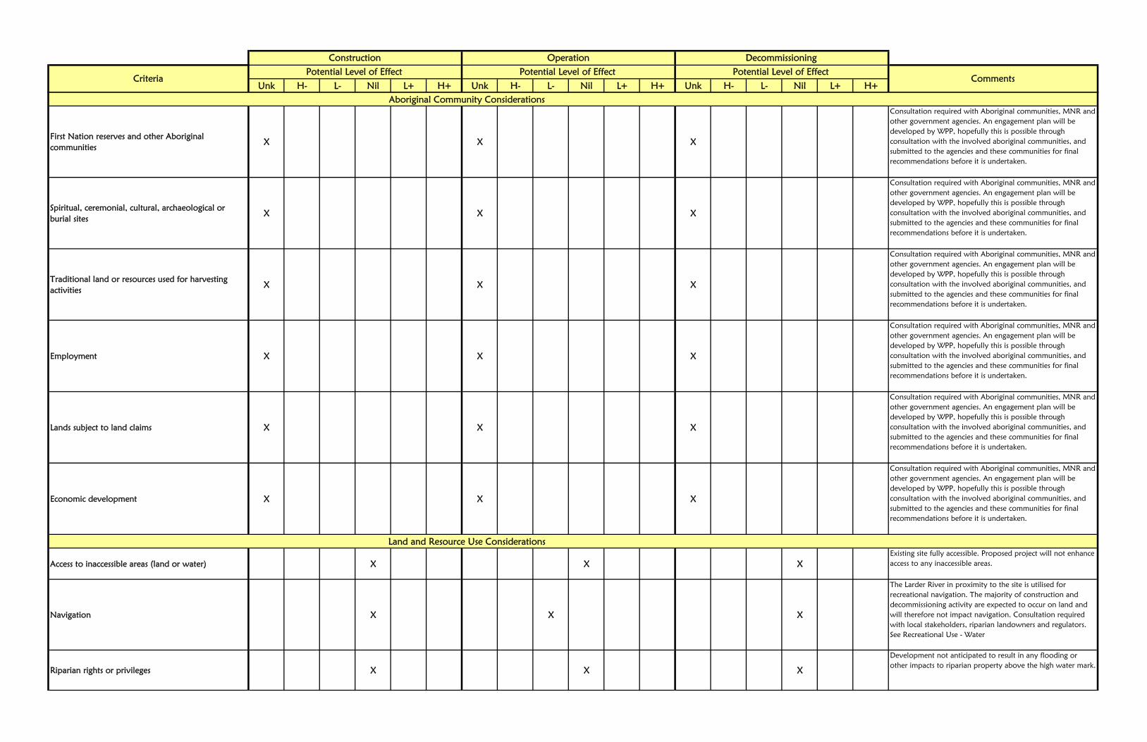
First Nation reserves and other Aboriginal communities
X X X
Consultation required with Aboriginal communities, MNR and other government agencies. An engagement plan will be developed by WPP, hopefully this is possible through consultation with the involved aboriginal communities, and submitted to the agencies and these communities for final recommendations before it is undertaken.
Spiritual, ceremonial, cultural, archaeological or burial sites
X X X
Consultation required with Aboriginal communities, MNR and other government agencies. An engagement plan will be developed by WPP, hopefully this is possible through consultation with the involved aboriginal communities, and submitted to the agencies and these communities for final recommendations before it is undertaken.
Traditional land or resources used for harvesting activities
X X X
Consultation required with Aboriginal communities, MNR and other government agencies. An engagement plan will be developed by WPP, hopefully this is possible through consultation with the involved aboriginal communities, and submitted to the agencies and these communities for final recommendations before it is undertaken.
Employment X X X
Consultation required with Aboriginal communities, MNR and other government agencies. An engagement plan will be developed by WPP, hopefully this is possible through consultation with the involved aboriginal communities, and submitted to the agencies and these communities for final recommendations before it is undertaken.
Lands subject to land claims X X X
Consultation required with Aboriginal communities, MNR and other government agencies. An engagement plan will be developed by WPP, hopefully this is possible through consultation with the involved aboriginal communities, and submitted to the agencies and these communities for final recommendations before it is undertaken.
Economic development X X X
Consultation required with Aboriginal communities, MNR and other government agencies. An engagement plan will be developed by WPP, hopefully this is possible through consultation with the involved aboriginal communities, and submitted to the agencies and these communities for final recommendations before it is undertaken.
Access to inaccessible areas (land or water) X X XExisting site fully accessible. Proposed project will not enhance access to any inaccessible areas.
Navigation X X X
The Larder River in proximity to the site is utilised for recreational navigation. The majority of construction and decommissioning activity are expected to occur on land and will therefore not impact navigation. Consultation required with local stakeholders, riparian landowners and regulators. See Recreational Use - Water
Riparian rights or privileges X X X
Development not anticipated to result in any flooding or other impacts to riparian property above the high water mark.
Aboriginal Community Considerations
Land and Resource Use Considerations

Unk H- L- Nil L+ H+ Unk H- L- Nil L+ H+ Unk H- L- Nil L+ H+
Potential Level of EffectCriteria Comments
Potential Level of EffectConstruction Operation Decommissioning
Potential Level of Effect
Recreational Use - Land X X X
There are a number of recreational trails traversing Crown land in the project area. The operation phase of the project is not expected to negatively impact existing land uses. Where the construction of the pipeline intercepts recreational access, an alternate route will be provided and the trail will be re-established post-construction.
Recreational Use - Water X X X
Wendigo Lake forms part of a traditional canoe route. The project will have an impact on the portion of the Larder River between Wendigo Lake and Teddy’s Falls; minimum residual flow levels in that portion of the river will be established during the environmental planning process addressing aesthetic and recreational use concerns. As the proposed project is a run-of-river development, without any manipulation of upstream or downstream water levels or natural flow regimes, the project will not have any impact on the various uses of Wendigo Lake upstream of the project or the Larder River downstream of the project.
Angling and hunting opportunities X X X
No Impacts anticipated. Additional consultation with riparian landowners, stakeholders and the MNR required to determine potential for project related impacts angling and hunting opportunities.
Trapping activities X X X
The proposed development area falls within a registered trap line and adjacent to another. WPP does not anticipate that the ongoing operation of the project will adversely impact trapping activities in the project area. It is possible that construction activities may cause a short term impact, and mitigation measures will be implemented specifically to alleviate any negative impacts. The trapper(s) will be individually notified of the potential project, every effort will be made by WPP to work cooperatively with any potentially affected parties via the MNR.
Baitfish harvesting activities X X X
While baitfish harvesting does occur in the townships of Marter and Bayly, and we are not aware of baitfish harvesting occurring in the area directly affected by the project (i.e. the reach of the Larder River between the proposed intake and the powerhouse). Additional investigation will be completed during the Class EA and appropriate mitigation measures and/or minimum flow requirements will be taken into consideration in developing construction and operation parameters for the project.
Views or aesthetics X X X
A second project information meeting will be held in Englehart in mid 2012, and scheduled so as to allow for the participation of seasonal residents on Wendigo Lake, and continue to will seek information on access, aesthetics, recreation, tourism values and other land use in the project area.
An existing land or resource management plan X X XConsultation with MNR required.

Unk H- L- Nil L+ H+ Unk H- L- Nil L+ H+ Unk H- L- Nil L+ H+
Potential Level of EffectCriteria Comments
Potential Level of EffectConstruction Operation Decommissioning
Potential Level of Effect
An existing water management plan X X X
Consultation with MNR required. No water management plan presently exists for the Larder River. WPP would be pleased to participate in the establishment of such a plan in conjunction with MNR and other interested parties.
Protected areas X X X
Water levels within Larder River Provincial Park located further upstream of the project site will not be affected in any way.
Archaeological sites X X X
Stage 1 and 2 archaeological assessments of the project area will be will be completed, and subject to review by the Ministry of Tourism, Culture and Sport.
Buildings or structures X X X
Stage 1 and 2 archaeological assessments of the project area will be will be completed, and subject to review by the Ministry of Tourism, Culture and Sport.
Cultural heritage landscapes X X X
Stage 1 and 2 archaeological assessments of the project area will be will be completed, and subject to review by the Ministry of Tourism, Culture and Sport.
The location of people, businesses, institutions or public facilities
X X X
No anticipated impact due to small operating footprint of facility, proposed operating regime and rural land usage in proximity to the site.
Community character, enjoyment of property or local amenities
X X X
Consultation with local community required. Most likely small negative impact as a result of increased traffic during construction and decommissioning.
Employment X X X
Facility expected to provide employment primarily related to construction works as well as operation and maintenance requirements.
Public health and/or safety X X X
Excavation and construction activities will incorporate health and safety planning measures. Operational facility will require public safety measures planning and safety measures.
Local, regional or provincial economies X X X
Facility will provide 2.7-3.3 MW of electricity to Ontario grid, and provide some direct and indirect employment.
Tourism values X X X
We do not anticipate that the project will adversely affect tourism use of the area. Although, limited restrictions on access and use in the immediate area of civil works related to the project may be necessary to ensure public health and safety and the security of assets. Consultation with local stakeholders will be required to understand what tourism activities exist and how operations will affect them.
Cultural Heritage Resources Considerations
Social and Economic Considerations

Unk H- L- Nil L+ H+ Unk H- L- Nil L+ H+ Unk H- L- Nil L+ H+
Potential Level of EffectCriteria Comments
Potential Level of EffectConstruction Operation Decommissioning
Potential Level of Effect
Water supply X X X
Project will not impact water levels on Wendigo Lake or below Teddy's Falls where surface water intakes may be located. Investigation of MOE well records for project area will be required to determine potential for impacts to groundwater intakes.
Aesthetic image of the surrounding area X X X
Consultation required with local community and riparian landowners. Plan to accept input on design of powerhouse to conform with local aesthetic values.
Reliability X X XWill provide electricity to the Ontario grid. Black start capability may be considered.
Security X X XNo issues anticipated.
Electricity flow patterns X X XElectricity generated will flow directly to the Ontario electrical grid for distribution.
Energy/Electricity Considerations

Appendix D
Natural Resources Canada Explosives Act Questionnaire
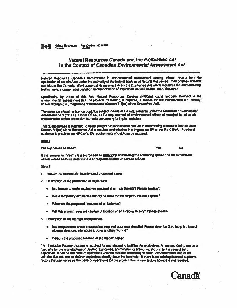

Step 1
Will explosives be used?
Use of explosives is expected for excavation associated with the construction of the powerhouse,
penstock and low pressure pipeline.
Step 2
Identify the project title, location and proponent name.
The project is the Teddy’s Falls Waterpower Project
The approximate project location relative to Highway 11 and the nearest town, Englehart, Ontario
is shown on attached figure.
The proposed project site is located on Lots 1, 2 and 3, Concession 3, Marter Township in the
District of Temiskaming.
Geographic Coordinates
47°52'37.88" N 79°45'44.12" W
UTM Coordinates
17T 592550.58m E 5303386.08m N
Description of the production of explosives
No factory for the production of explosives will be required on site.
Description of the storage of explosives
No magazine for the storage of explosives will be required on site.

79°20'0"W
79°20'0"W
79°25'0"W
79°25'0"W
79°30'0"W
79°30'0"W
79°35'0"W
79°35'0"W
79°40'0"W
79°40'0"W
79°45'0"W
79°45'0"W
79°50'0"W
79°50'0"W
79°55'0"W
79°55'0"W
80°0'0"W
80°0'0"W
80°5'0"W
80°5'0"W
80°10'0"W
80°10'0"W
48°5'0"N
48°5'0"N
48°0'0"N
48°0'0"N
47°55'0"N
47°55'0"N
47°50'0"N
47°50'0"N
47°45'0"N
47°45'0"N
47°40'0"N
47°40'0"N
47°35'0"N
47°35'0"N
LEGEND
PROJECT No. KB6852-00-01DESIGNGISCHECKREVIEW
FIGURE 1JFDJFD
27/04/2009
KB OE7492_fF:VER1
Site Location
Proposed Profile Elevation
2.5 0 2.5 5 7.51.25
Kilometres
1:250000
Larder RiverPROJECT
TITLESite Location
REFERENCE-Produced by WESA Geomatics
LOCATIONLat Long
Intake 47.877189 -79.762255Pipeline-Penstock
Start 47.877043 -79.762487End 47.869747 -79.785547
Powerhouse 47.869901 -79.785701
Northing (UTM) Easting (UTM)Intake 5303391 592548Pipeline-Penstock
Start 5303375 592531End 5302537 590819
Powerhouse 5302554 590808