ODRA RIVER case study Andrzej Dunajski, Karolina Królikowska, Maciej Sieczka CAVES.
17
ODRA RIVER ODRA RIVER case study case study Andrzej Dunajski, Karolina Andrzej Dunajski, Karolina Królikowska, Królikowska, Maciej Sieczka Maciej Sieczka CAVES CAVES
-
date post
20-Dec-2015 -
Category
Documents
-
view
222 -
download
1
Transcript of ODRA RIVER case study Andrzej Dunajski, Karolina Królikowska, Maciej Sieczka CAVES.

ODRA RIVER ODRA RIVER case studycase study
Andrzej Dunajski, Karolina Królikowska, Andrzej Dunajski, Karolina Królikowska, Maciej SieczkaMaciej Sieczka
CAVESCAVES

Evidence collected so far• Quantitative data from Central Statistical
Office
• Spatial information from maps
• Qualitative information from stakeholders and experts including:
- policy relevant issues
- main tendencies in land use change
- main relationships among key stakeholders
- first decision rules

Quantitative data from Central Statistical Office
Thematic scope
• demography
• labor issues
• administration
• land use issues (forestry and agriculture)

Quantitative data from Central Statistical Office
Data sources
- yearly collected data from local administration
- data from National Population and Housing Census
- data from National Agricultural Census

Quantitative data from Central Statistical Office
Data format
- time series in Excell spreadsheets
- data integrated with vector maps of communes in the GIS database for spatial analysis and visualization
- 35 thematic maps of analyzed phenomena were created, for example:

Unemployment spatial pattern

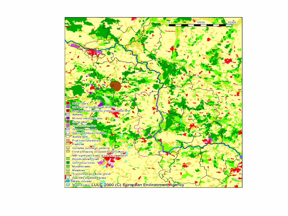
Spatial information from maps
LULC maps from the Corine Land Cover 2000(CLC 2000) provided by the European SpaceAgency were integrated into GIS.
Current LULC was analyzed based on CLC 2000as an addition to Central Statistical Office’s LULCData.

Spatial information from maps
1:25000 topo maps are being digitized in the
area of Prochowice commune for initial
LULC analysis within the period from 1930's
till early 1990's in this area.

Spatial information from maps
Land ownership along Kwiatkowicki
and Rogowski Channels based on the
land evidence maps were received
From local administration.

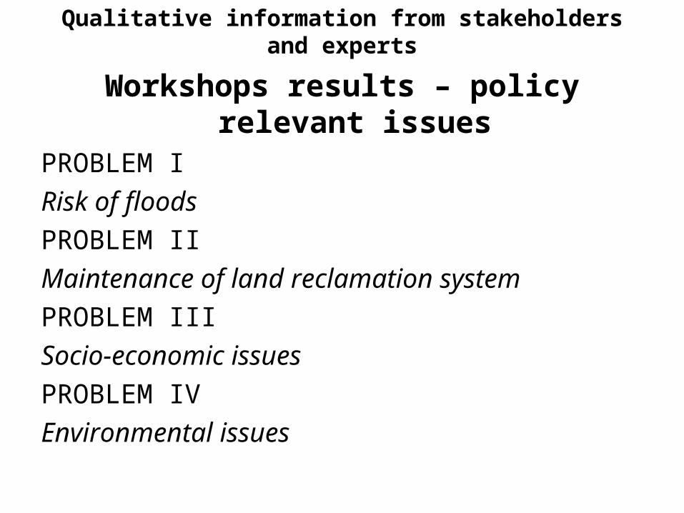
Qualitative information from stakeholders and experts
Workshops results – policy relevant issues
PROBLEM I
Risk of floods
PROBLEM II
Maintenance of land reclamation system
PROBLEM III
Socio-economic issues
PROBLEM IV
Environmental issues

Qualitative information from stakeholders and experts
Main tendencies in land use changeaccording to interviews with experts
• transformation of pastures and meadows into arable land
• land abandonment• integration of land• reforestation• urbanization

Qualitative information from stakeholders and experts
STAKEHOLDERS people: FarmersOther land owners State farms ex-workers
institutions:
state land owners
local government
institutions connected with water management
institutions connected with nature conservation
NGO’s


Qualitative information from stakeholders and experts
Decision rules
1. Rational choice based on the knowledge of
purchase/sale prices
2. Imitate a successful neighbour
3. Passive waiting – THEY (local administration,
state government) should do it.
4. Follow the leader (eg. Dziewin)

Question for modeling teams
What kind of more detailed evidence is necessary for the modeling teams and what kind of knowledge representation and data format is expected from us?