ODFW AQUATIC INVENTORIES PROJECT STREAM REPORT · beaver slide creek (tioga basin) 2011 summer 1 0...
18
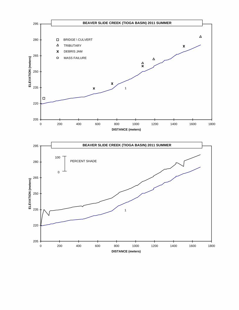
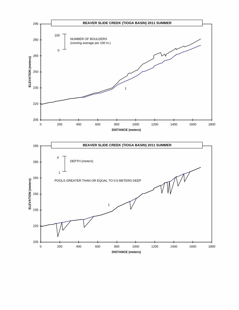
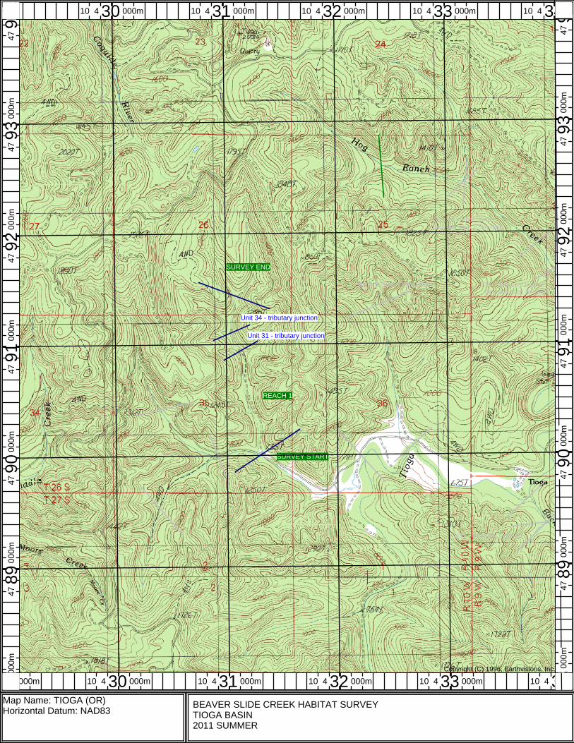
ODFW AQUATIC INVENTORIES PROJECT STREAM REPORT STREAM: Beaver Slide Creek LLID: 1238459432593 BASIN: Tioga Creek HUC NUMBER: 17100304 SURVEY DATES: September 21-22, 2011 ECOREGION: Coast Range Sedimentary USGS MAP: Tioga WATERSHED AREA: 2.9km 2 FIRST ORDER TRIBUTARIES: 1 STREAM ORDER: 1 SURVEY CREW: Andrew Walch and Travis Neal REPORT PREPARED BY: Peggy Kavanagh REACH DESCRIPTION: (T26S-R10W-S35SE) – 1681 meters – The Beaver Slide Creek habitat survey began at West Fork Tioga Creek and ended at a tributary junction. The stream channel was constrained by high terraces in a broad valley. The average valley width index was 4.2 (range: 1.0-9.0). The average gradient was 3.3 percent. The land uses were large timber (30-50cm dbh) and second-growth timber (15-30cm dbh). The stream habitat was a mix of scour pool (20%), riffle (33%), and rapid (32%). The substrate was primarily fine sediment (27%), gravel (28%), and cobble (31%). Twelve percent of the reach length had actively eroding banks. Wood volume was 14.9m 3 /100m. The trees found most frequently in the riparian zone were hardwoods 3-50cm dbh. Total number of trees per 100m 2 : 1.9 conifers and 7.7 hardwoods (based on 3 riparian transects). COMMENTS: Fish were observed until the end of the survey. The last fish was noted at unit 54 (1681m). A fish presence / absence survey was not conducted. Log fish habitat structures were present. A red-legged frog and coho were observed by the crew. A large debris jam was noted at unit 51 (1508m).
Transcript of ODFW AQUATIC INVENTORIES PROJECT STREAM REPORT · beaver slide creek (tioga basin) 2011 summer 1 0...

ODFW AQUATIC INVENTORIES PROJECT
STREAM REPORT STREAM: Beaver Slide Creek LLID: 1238459432593 BASIN: Tioga Creek HUC NUMBER: 17100304 SURVEY DATES: September 21-22, 2011 ECOREGION: Coast Range Sedimentary USGS MAP: Tioga WATERSHED AREA: 2.9km2 FIRST ORDER TRIBUTARIES: 1 STREAM ORDER: 1 SURVEY CREW: Andrew Walch and Travis Neal REPORT PREPARED BY: Peggy Kavanagh REACH DESCRIPTION: (T26S-R10W-S35SE) – 1681 meters – The Beaver Slide Creek habitat survey began at West Fork
Tioga Creek and ended at a tributary junction. The stream channel was constrained by high terraces in a broad valley. The average valley width index was 4.2 (range: 1.0-9.0). The average gradient was 3.3 percent. The land uses were large timber (30-50cm dbh) and second-growth timber (15-30cm dbh). The stream habitat was a mix of scour pool (20%), riffle (33%), and rapid (32%). The substrate was primarily fine sediment (27%), gravel (28%), and cobble (31%). Twelve percent of the reach length had actively eroding banks. Wood volume was 14.9m3/100m. The trees found most frequently in the riparian zone were hardwoods 3-50cm dbh. Total number of trees per 100m2: 1.9 conifers and 7.7 hardwoods (based on 3 riparian transects).
COMMENTS: Fish were observed until the end of the survey. The last fish was noted at unit 54 (1681m). A fish
presence / absence survey was not conducted. Log fish habitat structures were present. A red-legged frog and coho were observed by the crew.
A large debris jam was noted at unit 51 (1508m).
205
220
235
250
265
280
295
0 200 400 600 800 1000 1200 1400 1600 1800
DISTANCE (meters)
ELEV
ATI
ON
(met
ers)
BRIDGE \ CULVERT
TRIBUTARY
DEBRIS JAM
MASS FAILURE
BEAVER SLIDE CREEK (TIOGA BASIN) 2011 SUMMER
1
205
220
235
250
265
280
295
0 200 400 600 800 1000 1200 1400 1600 1800
DISTANCE (meters)
ELEV
ATI
ON
(met
ers)
BEAVER SLIDE CREEK (TIOGA BASIN) 2011 SUMMER
1
0
100PERCENT SHADE

205
220
235
250
265
280
295
0 200 400 600 800 1000 1200 1400 1600 1800
DISTANCE (meters)
ELEV
ATI
ON
(met
ers)
BEAVER SLIDE CREEK (TIOGA BASIN) 2011 SUMMER
1
0
100PERCENT SILT AND ORGANICS
205
220
235
250
265
280
295
0 200 400 600 800 1000 1200 1400 1600 1800
DISTANCE (meters)
ELEV
ATI
ON
(met
ers)
BEAVER SLIDE CREEK (TIOGA BASIN) 2011 SUMMER
1
0
100PERCENT SILT, ORGANICS, AND SAND

205
220
235
250
265
280
295
0 200 400 600 800 1000 1200 1400 1600 1800
DISTANCE (meters)
ELEV
ATI
ON
(met
ers)
BEAVER SLIDE CREEK (TIOGA BASIN) 2011 SUMMER
1
0
100PERCENT GRAVEL
205
220
235
250
265
280
295
0 200 400 600 800 1000 1200 1400 1600 1800
DISTANCE (meters)
ELEV
ATI
ON
(met
ers)
BEAVER SLIDE CREEK (TIOGA BASIN) 2011 SUMMER
1
0
100PERCENT BEDROCK
205
220
235
250
265
280
295
0 200 400 600 800 1000 1200 1400 1600 1800
DISTANCE (meters)
ELEV
ATI
ON
(met
ers)
BEAVER SLIDE CREEK (TIOGA BASIN) 2011 SUMMER
1
0
100NUMBER OF BOULDERS (running average per 100 m.)
205
220
235
250
265
280
295
0 200 400 600 800 1000 1200 1400 1600 1800
DISTANCE (meters)
ELEV
ATI
ON
(met
ers)
BEAVER SLIDE CREEK (TIOGA BASIN) 2011 SUMMER
1
1
0
POOLS GREATER THAN OR EQUAL TO 0.5 METERS DEEP
DEPTH (meters)

205
220
235
250
265
280
295
0 200 400 600 800 1000 1200 1400 1600 1800
DISTANCE (meters)
ELEV
ATI
ON
(met
ers)
BEAVER SLIDE CREEK (TIOGA BASIN) 2011 SUMMER
1
0
100PIECES OF LARGE WOOD
205
220
235
250
265
280
295
0 200 400 600 800 1000 1200 1400 1600 1800
DISTANCE (meters)
ELEV
ATI
ON
(met
ers)
BEAVER SLIDE CREEK (TIOGA BASIN) 2011 SUMMER
1
0
100VOLUME OF LARGE WOOD (cubic meters)

205
220
235
250
265
280
295
0 200 400 600 800 1000 1200 1400 1600 1800
DISTANCE (meters)
ELEV
ATI
ON
(met
ers)
BEAVER SLIDE CREEK (TIOGA BASIN) 2011 SUMMER
1
0
1KEYPIECE OF LARGE WOOD

OREGON DEPARTMENT OF FISH AND WILDLIFEHABITAT INVENTORY Survey Date: 9/21/2011Report Date: 1/9/2012
BEAVER SLIDE CREEK
REACH 1 REACH 1T26S-R10W-S35SEValley and Channel Summary
Narrow Valley Floor Broad Valley Floor Valley Characteristics (Percent Reach Length)
Steep V-shapeModerate V-shapeOpen V-shape
Constraining TerracesMultiple TerracesWide Floodplain
Valley Width Index
Channel Morphology (Percent Reach Length)
Hillslope
Constrained Unconstrained
BedrockTerraceAlt. Terrace/HillLanduse
Single ChannelMultiple ChannelBraided Channel
Channel Characteristics
Type Length (m) Area (m2) Dry Units
PrimarySecondary
Channel Dimensions (m)Wetted Active Floodprone First Terrace
Width:Depth:
Width:Height:
W:D ratio: Entrenchment (ACW:FPW ratio):Stream Flow Type:Average Unit Gradient:
Habitat Units/100m (total channel length):
0%0%
0%0%
100%
0%0%0%
0%0%0%
100%0%0%
4.2 VWI Range: 1 - 9
46 5511
1,681 3,407
2.20.24
4.60.4
6.00.7
7.31.2
13.3 1.3LF3.3%
3.2
Riparian, Bank, and Wood SummaryPrimary Secondary
Land Use:Riparian Vegetation:
LTS
STD15
Bank Condition and Shade
Bank Status Percent Reach Length Shade (% of 180)
Reach avg:Undercut Banks:
Large Wood DebrisTotal Total / 100m primary channel
All pieces (>=3m x 0.15m):Volume (m ):Key pieces (>=12m x 0.60m):
332251
3
19.714.9
0.2
12% 78%Actively Eroding:
13.5 13.5Water temperature (°C): -
46Range: 100 -
3
6n = 3n =
( 4.2 - 8.8( 0.6 - 0.9
( 5.9 - 10( 1.1 - 1.3
))
))
3.3Habitat Units/100m (primary channel length):
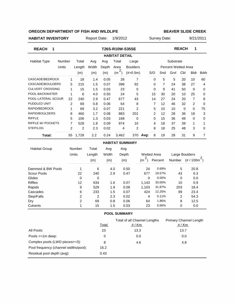
REACH 1 REACH 1T26S-R10W-S35SEHABITAT DETAIL
Habitat Type Number Total Avg Total Large Substrate
Percent Wetted Area Units Length Width
Avg
Depth Area Boulders (m) (m) (m) (m )2 (#>0.5m) S/O Snd Grvl Cbl Bldr Bdrk
OREGON DEPARTMENT OF FISH AND WILDLIFE
HABITAT INVENTORY Survey Date: 9/21/2011Report Date: 1/9/2012
BEAVER SLIDE CREEK
1CASCADE/BEDROCK 18 1.4 0.05 26 7 0 5 5 20 10 605CASCADE/BOULDERS 215 1.5 0.07 398 92 0 7 24 38 27 41CULVERT CROSSING 15 1.5 0.03 23 0 0 9 41 50 0 01POOL-BACKWATER 6 4.0 0.50 24 5 15 30 20 10 25 0
22POOL-LATERAL SCOUR 240 2.9 0.47 677 43 14 27 24 20 7 82PUDDLED UNIT 69 0.8 0.06 64 8 7 12 46 32 2 01RAPID/BEDROCK 69 3.2 0.07 221 2 5 10 10 0 0 758RAPID/BOULDERS 460 1.7 0.08 883 201 2 12 28 36 18 35RIFFLE 106 1.3 0.03 168 0 0 15 36 49 0 07RIFFLE W/ POCKETS 528 1.8 0.09 974 10 4 18 37 39 1 12STEP/LOG 2 2.3 0.02 4 2 8 18 25 48 3 0
HABITAT SUMMARY
POOL SUMMARY
55 1,728 2.2 0.24 3,462 370 8 19 28 31 9 7Total:
Habitat Group Number Total Avg
Wetted Area Large Boulders Units Length Width
Avg
Depth
Number (m) (m) (m) )2
(# / 100mPercent
Scour PoolsGlidesRifflesRapidsCascadesStep/FallsDry
Dammed & BW Pools 246 4.0 0.501 0.69%677240 2.9 0.4722 19.57%
000 0.00%1,143634 1.6 0.0712 33.00%1,103529 1.9 0.089 31.87%
424233 1.5 0.076 12.25%42 2.3 0.022 0.11%
Culverts6469 0.8 0.062 1.86%2315 1.5 0.031 0.66%
543
010
20399
280
20.8
0.00.9
23.454.312.5
0.0
Total Total of all Channel Lengths
All Pools:
Pools >=1m deep:Complex pools (LWD pieces>=3):
Pool frequency (channel widths/pool):
23
Residual pool depth (avg):
13.3
0.43
16.2
0
8
0.0
4.6
(m )2
18.4
6.3
Avg:
13.7
0.0
4.8
# / Km Primary Channel Length
# / Km
Number Total Avg Total Large Substrate Percent Wetted Area Units Length Width
AvgDepth Area Boulders
(m) (m) (m) (m )2
(#>0.5m)S/O Snd Grvl Cbl Bldr Bdrk
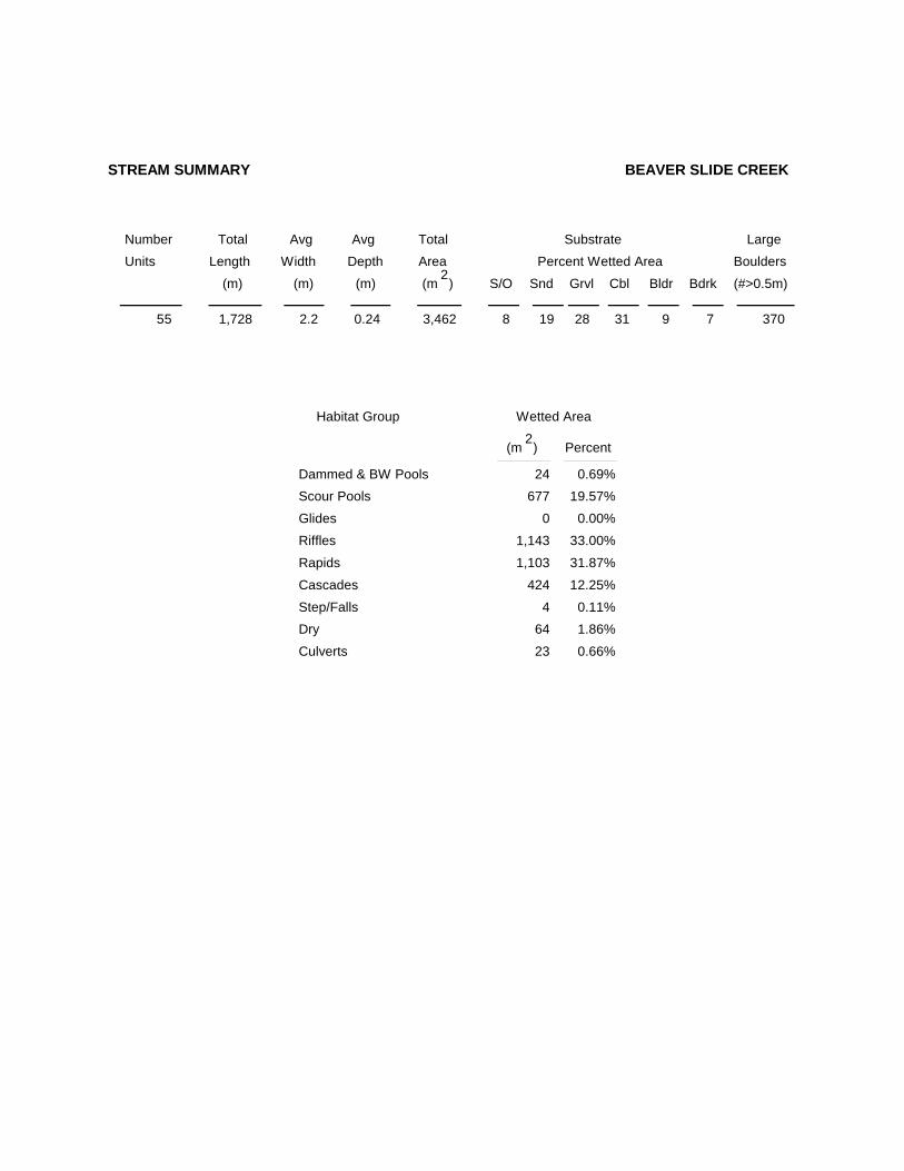
STREAM SUMMARY BEAVER SLIDE CREEK
Scour Pools
Glides
Riffles
Rapids
Cascades
Step/FallsDry
Dammed & BW Pools
Culverts
Wetted Area
Percent
24 0.69%677 19.57%
0 0.00%
1,143 33.00%
1,103 31.87%
424 12.25%
4 0.11%64 1.86%
23 0.66%
Habitat Group
(m )2
55 1,728 2.2 0.24 3,462 3708 19 28 31 9 7

BEAVER SLIDE CREEK 2011 HABITAT DISTRIBUTION
0
200
400
600
800
1000
1200
1400
DAM POOL SCOURPOOL
GLIDE RIFFLE RAPID CASCADE STEP/FALL DRY
WET
TED
AR
EA (m
^2)

Summary of Riparian Zone (0-30m) transects
Total hardwoods/1000Total conifers/1000 ftTotal conifers >20" dbh/1000 ftTotal conifers >35" dbh/1000 ft
Average number of trees in a 5-meter wide band
Canopy closure and ground cover
Predominant landform in each zone
Zone 1 Zone 2 Zone 3 Zones 1-30-10 meters 10 - 20 meters 20 - 30 meters 0-30 meters
Conifer Hardwood Conifer Hardwood Conifer Hardwood Conifer HardwoodDiameterclass (cm)
3-15cm15-30cm30-50cm50-90cm>90cm
Total/100m2
Zone 1 Zone 2 Zone 30-10 meters 10 - 20 meters 20 - 30 meters
Zone 1 Zone 2 Zone 30-10 meters 10 - 20 meters 20 - 30 meters
Canopy closureShrub coverGrass/forb cover
HillslopeHigh terraceLow terraceFloodplainWetland/meadowStream channelRoadbed/RailroadRiprap
Surface slope (%)
3
1402345102
0
0.30.00.00.0
0.3
0.0
2.72.03.00.3
8.0
0.0
0.00.70.30.00.0
3.30.72.30.30.7
0.30.32.01.70.0
2.72.31.71.00.0
0.71.02.31.7
1.9
0.0
8.75.07.01.7
7.7
0.7
697743
633648
693441
6733000000
6733000000
6733000000
26 31 27
1.0 7.3 4.3 7.7
(%) (%)(%)
(%) (%)(%)
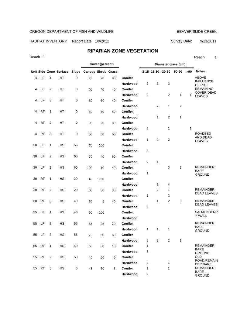
RIPARIAN ZONE VEGETATION SUMMARYREACH 1 REACH 1
OREGON DEPARTMENT OF FISH AND WILDLIFE
HABITAT INVENTORY Report Date:
BEAVER SLIDE CREEK
1/9/2012 Survey Date: 9/21/2011

Summary of Riparian Zone (0-30m) for all reaches transects
Total hardwoods/1000Total conifers/1000 ftTotal conifers >20" dbh/1000 ftTotal conifers >35" dbh/1000 ft
3
1402345102
0
Zones 1-30-30 meters
Conifer Hardwood
0.71.02.31.70.0
8.75.07.01.70.7
Diameterclass (cm)
3-15cm15-30cm30-50cm50-90cm>90cm
Average number of trees in a 5-m wide band
OREGON DEPARTMENT OF FISH AND WILDLIFE
HABITAT INVENTORY - RIPARIAN SURVEY
BEAVER SLIDE CREEK
9/21/2011
Summary of riparian zone (0-100 feet) extrapolated to 1,000 feet along stream
9/21/2011Survey Date:1/9/2012
Reach 1 1
HABITAT INVENTORY
BEAVER SLIDE CREEK
Report Date:
RIPARIAN ZONE VEGETATIONReach
OREGON DEPARTMENT OF FISH AND WILDLIFE
Slope Canopy ShrubSurfaceZoneSideUnit
Cover (percent)
Grass 3-15 15-30 30-50 50-90 >90
Diameter class (cm)
Notes
4 LF 1 HT 0 75 20 80
2 3 3
ABOVE INFLUENCE OF RD +
Conifer
Hardwood4 LF 2 HT 0 60 40 40
2 2 1 1
REMAINING COVER DEAD LEAVES
Conifer
Hardwood4 LF 3 HT 0 60 60 40
2 1 2
Conifer
Hardwood4 RT 1 HT 0 80 60 40
1 2 1
Conifer
Hardwood4 RT 2 HT 0 90 20 80
2 1 1
Conifer
Hardwood4 RT 3 HT 0 60 30 60
1 2 2
ROADBED AND DEAD LEAVES
Conifer
Hardwood30 LF 1 HS 55 70 100
3
Conifer
Hardwood30 LF 2 HS 60 70 40 60
2 1
Conifer
Hardwood30 LF 3 HS 60 100 10 40 3 2
1
REMAINDER BARE GROUND
Conifer
Hardwood30 RT 1 HS 20 40 100
2 4
Conifer
Hardwood30 RT 2 HS 20 60 30 30 2 1
1 2
REMAINDER DEAD LEAVES
Conifer
Hardwood30 RT 3 HS 40 80 5 40 1 2 3
2
REMAINDER DEAD LEAVES
Conifer
Hardwood55 LF 1 HS 40 90 100 SALMONBERR
Y WALLConifer
Hardwood55 LF 2 HS 55 55 25 70
1 1 1
REMAINDER BARE GROUND
Conifer
Hardwood55 LF 3 HS 55 70 30 60
2 3 2 1
Conifer
Hardwood55 RT 1 HS 40 60 80 10 1
3
REMAINDER BARE GROUND
Conifer
Hardwood55 RT 2 HS 50 40 60 5
2 1
OLD ROAD,REMAINDER BARE
Conifer
Hardwood55 RT 3 HS 6 45 70 5 1 1
2
REMAINDER BARE GROUND
Conifer
Hardwood
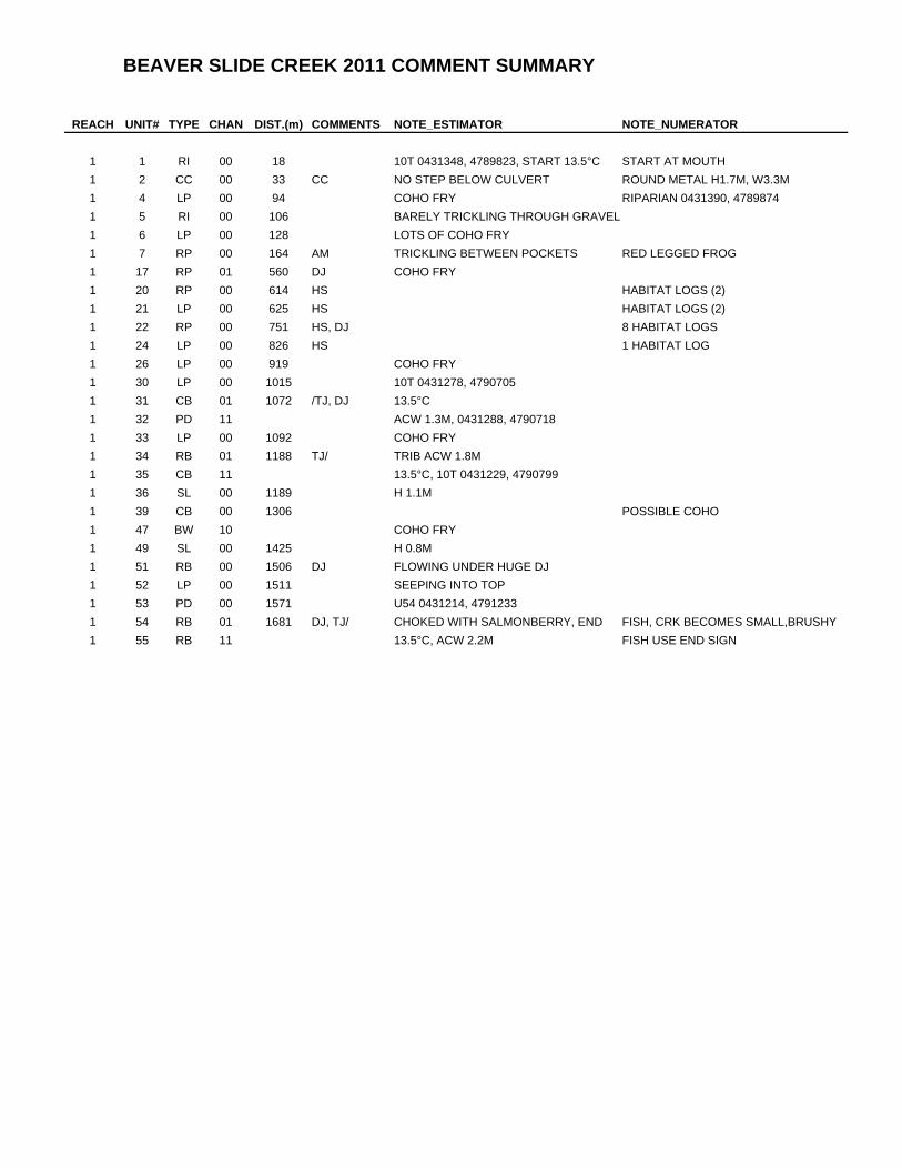
BEAVER SLIDE CREEK 2011 COMMENT SUMMARY
REACH UNIT# TYPE CHAN DIST.(m) COMMENTS NOTE_ESTIMATOR NOTE_NUMERATOR
1 1 RI 00 18 10T 0431348, 4789823, START 13.5°C START AT MOUTH1 2 CC 00 33 CC NO STEP BELOW CULVERT ROUND METAL H1.7M, W3.3M1 4 LP 00 94 COHO FRY RIPARIAN 0431390, 47898741 5 RI 00 106 BARELY TRICKLING THROUGH GRAVEL1 6 LP 00 128 LOTS OF COHO FRY1 7 RP 00 164 AM TRICKLING BETWEEN POCKETS RED LEGGED FROG1 17 RP 01 560 DJ COHO FRY1 20 RP 00 614 HS HABITAT LOGS (2)1 21 LP 00 625 HS HABITAT LOGS (2)1 22 RP 00 751 HS, DJ 8 HABITAT LOGS1 24 LP 00 826 HS 1 HABITAT LOG1 26 LP 00 919 COHO FRY1 30 LP 00 1015 10T 0431278, 47907051 31 CB 01 1072 /TJ, DJ 13.5°C1 32 PD 11 ACW 1.3M, 0431288, 47907181 33 LP 00 1092 COHO FRY1 34 RB 01 1188 TJ/ TRIB ACW 1.8M1 35 CB 11 13.5°C, 10T 0431229, 47907991 36 SL 00 1189 H 1.1M1 39 CB 00 1306 POSSIBLE COHO1 47 BW 10 COHO FRY1 49 SL 00 1425 H 0.8M1 51 RB 00 1506 DJ FLOWING UNDER HUGE DJ1 52 LP 00 1511 SEEPING INTO TOP1 53 PD 00 1571 U54 0431214, 47912331 54 RB 01 1681 DJ, TJ/ CHOKED WITH SALMONBERRY, END FISH, CRK BECOMES SMALL,BRUSHY1 55 RB 11 13.5°C, ACW 2.2M FISH USE END SIGN

Reach 1 - Unit 2 - A culvert crossing and surveyor Reach 1 - Unit 10 - Looking upwnstream at a pool.
Reach 1 - Unit 1 - An upstream view of the habitat survey start.
Reach 1 - Unit 20 - A view looking upstream Reach 1 - Unit 30 - A view of the riparian vegetation
Reach 1 - Unit 30 - Looking upstream at the habitat and streamside Reach 1 - Unit 40 - A downstream view of the scour pool.vegetation.
Beaver Slide Creek (Tioga Basin) 2011 Summer Habitat Survey Photographs

Reach 1 - Unit 50 - An upstream view of the stream habitat and Reach 1 - Unit 50 - The right riparian zone had conifer and hardwood vegetation. trees on a hillslope.
Reach 1 - Unit 80 - Looking downstream
Reach 1 - Unit 50 - Another view of the stream channel and itsinfluences. and habitat.
Reach 1 - Unit 51 - A debris jam; the stream flowed under the jam.
Reach 1 - Unit 54 - Looking upstream at the rapid at the survey end.
Beaver Slide Creek (Tioga Basin) 2011 Summer Habitat Survey Photographs
Unit 31 - tributary junction
END TIOGA TRIBUTARY U35 - potential barrierbedrock step 6m high
U167 - potential barrierbedrock step 5.5m high
SURVEY START
REACH 1
SURVEY END
U31 - tributary junction
Unit 34 - tributary junction
Copyright (C) 1996, Earthvisions, Inc.
10 4 30 000m 10 4 31 000m 10 4 32 000m 10 4 33 000m 10 4 34
000m 10 4 30 000m 10 4 31 000m 10 4 32 000m 10 4 33 000m 10 4 3 8 00
0m47
89
000m
47 9
0 00
0m47
91
000m
47 9
2 00
0m47
93
000m
47 9
000m
47 8
9 00
0m47
90
000m
47 9
1 00
0m47
92
000m
47 9
3 00
0m47
9
BEAVER SLIDE CREEK HABITAT SURVEYTIOGA BASIN2011 SUMMER
Map Name: TIOGA (OR)Horizontal Datum: NAD83