OCUMENTS OCAL -11 • .,- ( (lqn
52
OCUMENTS OCAL ""-11 • .,- ( (lqn by : ,,'ell)s.Thompson Be Runyan, Inc.
Transcript of OCUMENTS OCAL -11 • .,- ( (lqn
OCUMENTS OCAL
""-11 • .,- ( (lqn
~.$!.".d by
:,,'ell)s.Thompson Be Runyan, Inc.
BIBLIOGRAPHIC DATA SHEET
4. l "k .,ud S .. o~'tk
II. Report No. I LGR-72-13-02
Wallowa Lake Basin Comprehensive Plan
3. Recipi ent' " AC(·~·s,;i "" :>., ...
5. Kepon Vate
M'!L 1973 Wallowa Lake Basin Comprehensive Plan/Technical
Supplement ••
7. A,noort s ) Stevens, Thompson & Runyan, Inc. Enrrineers/Planners
9. PerformIng Organlzallon Name anJ Addre""
Stevens, Thompson & Runyan, Inc. 5505 S. E. Milwaukie Ave. Portland, Oregon 97202
12. Sponsorin,o: Or,o:anization Name and Address
Department of Housing & Urban Development
8. Performin& Organizallon Re p\:.
No. P-863.001 10. Pro)ect / Ta s kJ " ork L:nll :\0 .
11. Contract/Grant No.
CPA-OR-10-16-1006
13. Type of Repor~ & Period Covered
701 program administered by Executive Dept., State of Oregon, 240 Cottage St. S. E., Salem, Oregon 14.
Final 1973-
97310 15. Supplemem:IlY Nnees
Prepared in cooperation with the Wallowa County Court, Wallowa County Planning Commission, and Citizen Advisory Committees.
16. Abstracts
(See back of page)
17. Key \\-ords and Document Analysis. 170. Descriptors
The Wallowa Lake Basin Comprehensive Plan elements: (1) Land Use Plan Element, (2) (3) Zoning Ordinance Review.
18. """,lability Statement Limited Supply.
Write: Wallowa County Courthouse, Enterprise, oregon9782
•
consists of three basic work Community Facilities, and
19. Security Class (ThIS
Re)fNt~ ! ILV. ~ecurity ...... "ss (This
Page UNCLASSIFIED
21. ;\0. of Page"
53 22. Price
unknown THIS FORM MAY BE REPRODUCED
Abstract
The Wallowa Lake Basin Comprehensive Plan contains a Land Use Plan for long- range development and environmental protection of natural and scenic amenities in the basin area. The Land Use Plan also outlines ser vice areas for provision of public water and sewerage facilities. These services are necessary to public health and safety as well as in preserving the high water quality of Wallowa Lake . The Public Facilities portion of the Plan includes preliminary designs for water and sewer showing general location and type of facilities necessary and cost esti mates. Limited development will continue on the south, west, and north side of the lake. A sewer collection system will serve these areas and will connect to the City of Joseph 9 s system. A separate water system will serve the south and west portion of the lake while an improved Joseph water system will serve the north shore area . In light of the Land Use Plan, recommendations for updating the County Zoning Ordinance have also been suggested.
=
1920
Portland Seanle Solu Spoklne
Stevens. ThoIllpson & Runyan. Inc.
Engineers I Planners
5$0$ s.£. MILWAUKIe AVE. • BOX 02201 • PORTLAND, ORE. 07202 • TelEPHONE (~J 23HI121
P-863.001 May 30, 1973
Board of County Commissioners Wallowa County Courthouse Enterprise, Oregon 97828
Gentlemen:
Pursuant to our agreement of June 1972, we have completed the planning and engineering studies necessary for the development of the Wallowa Lake Basin Comprehensive Plan. The outcome of these studies, namely the Land Use Plan and Community Facilities Plan, is presented in two publications. The general discussion of the Comprehensive Plan was published in a form which would allow easy dissemination to the public. This technical supplement was compiled for use by County Officials and contains additional data and explanation, especially in the area of proposed water and sewerage facilities.
We appreciate having had the opportunity to be of service to the Board and to the citizens of Wallowa County.
TRH, jb
Respectfully submitted,
STEVENS, THOMPSON & RUNYAN, INC.
~/~ Thomas R. Hawkins, AlP Senior Planner
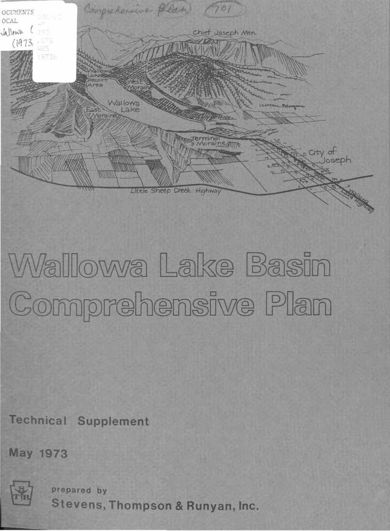
WALLOWA LAKE BASIN
COMPREHENSIVE PLAN
TECHNICAL SUPPLEMENT
MAY, 1973
The preparation of this report was financed in part through a comprehensive planning grant from the Department of Housing and Urban Development.
Prepared by STEVENS , THOMPSON & RUNYAN, INC .
Engineers/Planners 5505 S.E. Milwaukie Avenue
Portland, Oregon 97202
•
TABLE OF CONTENTS
INTRODUCTION
Study Background Scope of the Study Study Area
PLANNING PROCESS
Data Collection and Analysis Alternative Proposals Proposed Plan
ZONING ORDINANCE REVIEW
Purpose Modifications Recommendations
WATER AND SEWERAGE FACILITIES
Introduction Wallowa Lake Study Area Preliminary Design Factors Water Supply and Distribution Sewage Collection and Treatment Administrative Authority Recommendations
APPENDIX
Citizen Responses Acknowledgments
Page
1
1 1 2
3
3 4 6
9
9 9
• 12
13
13 13 15 15 22 28 29
INTRODUCTION
STUDY BACKGROUND
The study to develop a Land Use Plan and a Water andSewerage Plan for the Wallowa Lake Basin was authorizedby the Board of County Commissioners of Wallowa Countyin June 1972. Initiation of the study came as a resultof local concern over the potential pollution of WallowaLake from additional development and increased recreational use of the lake basin area.
Funding for the study was secured through the "701"Comprehensive Planning Program as administered throughthe State of Oregon. In addition, Wallowa Countyparticipated by providing a one-third matching sharethrough related services performed by County personnel.
This technical supplement is intended to supply additional data which was not possible to present in theprimary publication of the Comprehensive Plan, sincethat presentation was designed for the purpose of generalpublic distribution. Specifically, this supplement provides a more detailed analysis of the proposed water andsewerage facilities which are of paramount concern toCounty Officials.
SCOPE OF THE STUDY
The basic overall goal of the study was to provide anenvironmental protection plan for the Wallowa Lake Basin.More specifically, this meant the formulation of a development plan for the lake basin while, at the same time,providing proper safeguards to protect the environment,namely the water quality of the lake and the natural,scenic amenities of the area. This was facilitatedthrough three general tasks:
1. Development of a Land Use Plan;
2. Development of a Water and Sewerage FacilitiesPlan; and
3. Review of existing zoning policies as theywould be affected by the Land Use Plan.
1UNIVLo\sliY OF OREGOR LIBRARY
1:!.l1':."'1,j' I"\c::"ot'· .l;.IJl.~c.••c, \X\ ..lJ ,I
The specific objectives under each of these tasks couldbe s~arized as follows:
Land Use Plan
1. Determine suitable development areas;
2. Specify desired land uses; and
3. Determine appropriate density levels.
Water and Sewerage Facilities Plan
1. Develop service areas based on the Land UsePlan;
2. Identify appropriate water sources;
3. Provide an overall plan showing storage facilities and major transmission lines;
4. Provide an overall plan for sewage collectionillustrating major collection elements andappropriate treatment facilities; and
5. Prepare cost estimates for both water andsewerage facilities.
Zoning Ordinance Review
1. Review of the existing ordinance making generalrecommendations as to possible changes whichwould adequately relate the Ordinance to theLand Use Plan.
STUDY AREA
The study area can generally be defined as the WallowaLake Basin, the City of Joseph, and their environswithin an approximate two-mile range. The boundaryfor this area, which is shown on the land use map inthe main pUblication, was chosen somewhat arbitrarily;however, it was the intention to include enough areaoutside the immediate lake drainage basin in order torelate proposed land uses within the lake basin to thoseof the surrounding area.
2
(,
(1
PLANNING PROCESS
DATA COLLECTION AND ANALYSIS
Actual work on the study was initiated with a jointmeeting of the Board of County Commissioners, CountyPlanning Commission, and the Lake Public Works Committee.At this time, the basic objectives of the program wereoutlined and a time schedule was established.
Data collection first began on the local level in WallowaCounty and concluded with a survey of state and federalagencies. The basic objectives of this investigationwere to collect, for later analysis, all data and/orstudies relating to the study area and to advise agenciesand offices of the nature of the study so they mightprovide input into the planning process if they sodesired. The following comprises a list of agenciesand offices contacted:
County WatermasterCounty Health OfficerCounty SurveyorCounty AgentCity of JosephState Parks DepartmentState Water Resources BoardState Engineer's OfficeState Health DepartmentFish and Game DepartmentDepartment of Environmental QualityDepartment of Geology and Mineral ResourcesU.S. Geological SurveyFederal Forest ServiceUSDA Soil Conservation Service
In addition to this investigation, a "windshield" landuse survey of the study area was conducted with the aidof the County Surveyor. This task was performed inorder to establish existing development types, densities,and trends.
Existing land use along with various data collected wasanalyzed in terms of development suitability. Wherepossible, this data was either quantified and/or mapped.The result of this analysis was the formulation oftwo alternative land use proposals. These proposals
3
were presented through a preliminary publication tocitize~s and County Officials in order to generatediscussion, interest, and greater participation in theplanning process.
ALTERNATIVE PROPOSALS
Although both proposals were viable alternatives in thateach would accommodate future land use needs, they weresignificantly different in their direction. It wasfelt that the differences in the two plans would alsohelp generate more public response; therefore, the citizens of the area were asked to respond with their ideasand preferences. Essentially, the public was beingasked to decide how much development was appropriatefor the area and where it should be allowed to occur.
Both alternatives, although different in terms of longrange development patterns, have basic similarities,since the development suitabilities within the lakebasinwere limited. These similarities were as follows:
1. The City of Joseph would expand primarily tothe north and east.
2. More residential use would be encouraged in thenorth shore area. This area would also beprovided with water and sewer service.
3. Wallowa Lake would be protected against pollutionfrom subsurface sewage disposal.
4. Portions of the east moraine would be protectedfrom development by the creation of a special"open space" zone.
5. The productive agricultural area within thestudy would be placed in an agriculture zoneto protect farming interests from encroachmentof incompatible land uses.
6. The south lake resort area would be enc.ouragedto expand to accommodate a peak population ofapproximately 2,500 persons. This could beachieved by increasing the number of permanentresidences and vacation units. This would produce a density of five persons per acre which islow enough to retain the natural character of
4
()
'I
(.1
the area, yet it is an adequate density to economically support public water and sewer systems.
Alternative A
Essentially, this alternative recognized the emergingdevelopment trend on the west moraine. Presently, thereare about 30 homes scattered along this moraine of whichall but three or four are vacation cabins. This planwould have promoted additional development in this areacreating an overall density of seven to eight personsper acre at peak usage.
Although the topography of the area is not particularlyconducive to development, it was possible to continuebuilding in a linear fashion following the existing road.This would provide a row of dwellings above and below theroad where terrain allows. Development based on theexisting subdivision pattern would accommodate over 200homes or between 700-80,0 persons. The west moraine,unlike the east moraine, contains a great deal of naturalfoliage. Although development of this scale could notbe totally concealed, the abundance of trees would certainly help to soften the visual effect.
This plan would certainly provide more access to thelake, but it would at the same time significantly increasethe use of the lake for various boating activities. Thepublic was asked to carefully evaluate this additionalpopulation and subsequent lake usage.
Alternative B
If Alternative A were to be called a development orientedplan for the lake area, then Alternative B could havebeen termed environmentally oriented, since this alternative precluded the allocation of additional lands fordevelopment within the immediate lake area. Instead,the plan favored creating a new recreation developmentat the base of Mt. Howard on the far eastern slope ofthe east moraine.-
As in Alternative A, the south lake resort area and thenorth shore area would have been encouraged to develop.However, limitations would have been placed on furtherdevelopment on the west moraine. Like the east moraine,
5
it would have been placed in an open space classification, thus maintaining the natural character of thelake almost as it is today.
The new proposed recreation area would have beendeveloped in an area which has suitable slope, soils,and natural vegetation. There is a sizable amount ofland which could sustain a greater amount of development than proposed in Alternative A for the west moraine.This development could have occurred without infringingon productive agricultural land or on the scenic area ofthe east moraine.
In addition, this area could have been oriented towardthe skiing potential on the east side of Mt. Howard.As such, it could have provided facilities, such ascondominiums and convention accommodation, which thesouth lake area does not contain. In this manner, thetwo areas could have provided complementary facilitiesrather than competing facilities. This area would havebeen envisioned as a planned development utilizing thenatural environment to create an aesthetic setting.
PROPOSED PLAN
Considerable response, both verbal and written, wasreceived concerning these proposals. Most of the responsecarne during various public meetings, although some replieswere received on an individual basis. The end result wasthe development of a third alternative which seemed to bestsatisfy the desires of the public and of County Officials.
Essentially, Alternative A best met the desires of thecommunity with some modification. The modification wasthe provision for two rural residential areas outside ofthe lake basin area. However, these areas were to havea ten-acre minimum lot size, so public water and seweragefacilities would not be necessary.
Rationale for this plan was primarily based on the localfeeling that the west moraine, although not the mostsuitable development area, was for all practical purposesalready committed to development. Besides the existinghomes and cabins along the moraine, the area on bothsides of the road has already been subdivided and muchof it sold for recreational home sites. Furthermore, theproposed sewage collection system could provide eventual
('
service to this area. With these factors in mind, itwas generally felt that development should be allowedto continue but only along the road where the terrainis somewhat favorable for construction.
The request to add the areas for rural residential useresulted from the develpment idea expressed in Alternative B. Rather than committing additional areas todevelopment densities requiring pUblic utilities, it wasfelt that the low density situation would be a preferablesituation. This would facilitate several functions.First, there would be designated areas for persons wishinglarge acreage home sites or recreational sites. Second,the scenic portions of the moraines could be left in theirnatural condition. Third, it also protects the primeagricultural areas from encroaching and/or "leap frog"development. Lastly, and perhaps most important, thisproposal facilitates a compromise between the speculativeinterests wishing to fully develop the moraines and theconservationist interests who seek permanent preservation of all the moraine areas. Therefore, the planproposes rural residential use for the areas of gentleslope above the prime agricultural lands while well belowthe scenic areas of the mountains and moraines.
A further rationale for the ten-acre minimum lot sizewas to add future flexibility. The Land Use Plan mustbe continually updated to reflect current policies andconditions. If at some distant point in the future, itis desirable to increase the density of these ruralresidential areas, it will be much easier and less costlyto subdivide ten-acre parcels of land than smaller lots.It would also be easier to then provide public utilitiesto the areas as well.
In any case, it is the purpose of the Land Use Plan toprovide a rational and economical guide for future development and for the future allocation of land for varioususes. In order to initiate a rational land use program,it is recommended that the County execute the followingactions:
1. The County should adopt this plan as the officialLand Use Plan for the Wallowa Lake Basin area.
2. The County should update its zoning ordinance toreflect the plan.
7
8
3. The County should establish a service districtto facilitate construction, maintenance andmanagement of public water and sewerage facilities in the lake basin area.
4. The County should seek federal assistance tooffset costs for the construction of thesefacilities.
5. The County should retain a competent engineeringfirm to provide engineering services and construction drawings for these systems.
IJ
ZONING ORDINANCE REVIEW
PURPOSE
This is intended to be a brief review of the CountyZoning Ordinance as it relates or would be affectedby the proposed Land Use Plan. General suggestionswill be put forth concerning recommended modificationsof the Ordinance in order to relate it to the plan.This relation is very critical, since zoning is merelyone means of implementing the Land Use Plan. Furthermore, the courts have held that zoning must be basedon a comprehensive plan, otherwise zoning is invalidbecause it would be arbitrary and capricious.
MODIFICATIONS
Implementation of the Wallowa Lake Basin ComprehensivePlan would require changes in two basic areas. First,additional zones would be required; and, second, thezoning map would need alteration, so boundaries willconform to the Land Use Plan.
Obviously, the first need will be to add additionalzones to cover the open space and rural residentialclassifications. In addition, modifications of otherzones will be suggested.
The open space classification will need to be a highlyrestrictive zone concerning any type of development.No commercial, industrial, or residential uses would beallowed. Even road construction and access should bestrictly regulated. In essence, the intent of the zonewould be to protect and maintain the natural state ofthe land. However, some flexibility should be allowedfor certain uses. For example, should the east moraineat some time in the future become a state park, provisions must be included to allow minimal construction,such as roads, display structures, rest rooms, picnicgrounds, hiking trails, etc. In protecting the moraineareas, it would not be the intent to prohibit the publicfrom enjoying their use, but rather, that control shouldbe exercised so that any kind of construction or modification of the landscape would not detract from the naturalqualities of these areas.
9
The rural residential areas of the Land Use Plan willalso require the addition of another zone. This zonewould be similar in nature tofue existing agriculturalzones except that a minimum ten.... acre lot size would bespecified. Again, the intent of this zone is to encourage either recreational or residential use on largeparcels of land at a density which will not requirepublic water and sewerage facilities. Agriculturaloperations would also be acceptable in this zone.
Other suggested alterations concern the existing agricultural zones and the C-2 zone. The C-2 zone constitutesthe most import.ant modification. Under the conditionsof this zone, both commercial and residential activitiesare permitted. This zone currently comprises the entiresouth lake area. Therefore, commercial enterprises canbe located anywhere in that area. In effect, there ispresently no control over locations of commercial usesin the south lake area. However, the Land Use Plan callsfor specific commercial lands in this area in order tobetter integrate residential uses with commercial uses.
The proposal is, therefore, to establish a resort residential zone while limiting the C-2 zone to specifyingcommercial uses. The resort residential areas designatedon the Land Use Plan are also the areas which will haveeventual water and sewerage facilities. As a result,it will be necessary to reduce the lot size requirementssomewhat, so these systems can be economically supported.A minimum size requirement should probably be about onehalf acre. In any case, the separation of residentialand commercial uses in the resort areas will facilitatebetter implementation of the Land Use Plan as well asproviding more rational control over commercial development in the south lake area.
Some modifications in the agricultural zones are alsosuggested; however, these are less critical, at leastfor the immediate future. The first suggestion wouldbe to consider increasing the minimum lot size. If theCounty is serious about protecting good agriculturallands, the current two-acre minimum is wholly inadequate.Most agricultural zones have from twenty to fifty-acreminimums. The reason is to maintain large parcels ofland which can be farmed economically and efficiently.Successful farmers understand this fact and know thatthe subdivision of lands into small parcels along withencroaching development is one of the most serious
10
I)
41
threats to farm operations. Not only does this producehigher taxes, but it also begins.to limit the efficiencyof agriculture operations and, therefore, economic returnsalso decline.
A second reason for suggesting large lot sizes is interms of services, primarily water and sewer services.Rural planning today is trying to cope with the problemscreated by the use of subsurface sewage i.disposal, namelythe septic tank and drain field. One means of preventinghealth problems is to control densities. This was donein the lake basin area. Essentially, the goal is toprovide public water and sewerage facilities in areaswhere it is desirable to have densities capable ofsupporting these systems. A general rule of thumb isthat sewer systems are economically feasible up to onehalf acre lots. When lot sizes get larger than this,the costs become prohibitive to the homeowner.
Where it is not desirable to have one-half acre lots orsmaller, it is wise to require large lot sizes. In thismanner, each homeowner would provide his own well andseptic tank and drain field. The large lot size willthen help to insure proper disposal without contaminatinggroundwater supplies. This was the rationale for theten-acre minimum in the rural residential areas. Byavoiding health hazard situations, the County will notneed to build water and sewage systems in these areas.Unfortunately, the one and two-acre minimums in theagricultural zones are in between - too large to economically provide services and quite possibly too smallfor continued operation of wells and drain fields.
It was also noted that the A-I zone covers the timberand recreation areas of the County. It is, therefore,suggested that consideration be given to creating atimber zone which could be tailored to forest management and recreation.
One further suggestion is in order, although not relatedto Land Use Plan. Article II of the Ordinance is entitled"Licensing of Entertainment Assemblies". This sectiondeals with licensing of specific business operations andnot with land use regulation. In short, it does notbelong in the zoning ordinance and should be deleted andcovered under a separate ordinance.
11
RECOMMENDATIONS
It is recommended that the County take the followingactions:
1. The County should delete Article II, "Licensingof Entertainment Assemblies" from the zoningordinance.
2. After adoption of the Wallowa Lake Basin Comprehensive Plan, the County should seekprofessional planning assistance in amendingthe zoning ordinance to reflect the following:
a. A rural residential zone;
b. An open space zone;
c. A resort residential zone;
d. A timber zone;
e. Modification of the C-2 zone; and
f. Modification of the agricultural zones.
3. The County should amend the zoning map for theWallowa Lake Basin to conform with the Land UsePlan.
12
t)
WATER AND SEWERAGE FACILITIES
INTRODUCTION
Society has come to depend more and more upon adequatewater supply to meet the daily needs of man and servehis amenities and conveniences. The so-called need hasmore than doubled during the last several years to thepoint where, to serve all our modern conveniences, weeach use at least 100 gallons of water per day. Development and distribution of this quantity of water is butone side of the picture, for once used the water mustbe treated before it can be placed back into the environment without undue affect. The study area surroundingWallowa Lake is unique in that large quantities of waterare available for development and use. This is allwater of a high degree of purity. It is subject atpresent only to the natural contamination of turbidityand wild animals. However, the affect from man's penetration of these remote areas of source is becomingmore evident. The very nature of the area, the watersupply, and the recreational nature of the Wallowa'smakes the use of the water supply and it ultimate treatment and return to the environment a paramount problem.
WALLOWA LAKE STUDY AREA
The study of the land use in the area of concern hasshown that future development around Wallowa Lakeshould be directed to the area of present use anddevelopment. From the standpoint of providing utilityservices, such as community water supply and wastecollection and disposal, this is a rational recommendation. To spread the service area would be costly. Themost economical means of serving these utility needsis, of course, to concentrate all development into onearea and avoid the strip development that often followsa highway. Due to the steepness of the terrain aroundWallowa Lake, this would limit development to the Cityof Joseph, the north shore of the lake contiguous tothe city, and the developed area at the south shore ofthe lake. The east moraine would remain undevelopedentirely, and the west moraine would maintain a statusquo with limited use for vacation homes.
13
Area outside the Wallowa Lake Drainage Basin has limitedpotential for future development and would seem to standas a separate entity in terms of providing the communityutilities. Due to the physical separation of thisdevelopable area from the present concentration andthe topography which tends to provide isolation, itwould seem that these areas should be reserved for lowdensity residential tracts where private utility services would be provided by each individual owner.Concentrations resulting from a commercial-recreationalcomplex would require appropriate: facilities to adequatelyhandle the water supply needs and, specifically, thedisposal of the generated water-carried waste products.
This study is concerned with providing services, bothwater and sewer, to the present areas of need whichappear to be the location of the future development.This, of course, can be controlled and directed to anextent by the location of adequate community facilitiesand through planning and zoning. Basically, threeareas of development have been considered, and plansfor services have been centered around these.
Area No. 1 is the north shore of the lake. This lieson the terminal moraine between the lake and the Cityof Joseph where limited residential developmentpresently exists. Developable area was assumed tobe in the order of 40 acres, and total developmentwould contain a population equivalent of 200 people.The area is contiguous to the City of Joseph andshould, therefore, look to the city for community services. This might require annexation.
Area No. 2 is comprised of a narrow strip developmentalong the west shore of the lake. At present, thereare some 225 residential lots plotted with a potentialfor about 100 more. It was, therefore, calculated that,if this area were allowed to develop to its ultimatepotential, approximately 800 people would requirecommunity services. Since this would constitute a stripdevelopment, it did not appear to be the most economicarea to be served. However, as the design evolved,service could possibly be provided despite the restrictive economics of strip development. This will bediscussed in more detail later.
14
Area No. 3 comprises all the developable land on thedelta at the south end of the lake. This is a diversecommunity composed of some full-time residents, parttime residents, commercial development, and parks andcampgrounds. It is thought that most of the futuredevelopment of the study area would take place here.A total peak population of 2,500 people was calculatedfor this area.
PRELIMINARY DESIGN FACTORS
In developing criteria for the preliminary design ofboth utility services, it was decided that using anaverage use rate of 110 gallons per equivalent personper day would be reasonable for the water supply requirements, while 100 gallons per equivalent person per dayshould be used for the sewage flows. The area isoriented toward catering to people seeking the recreational opportunities afforded by the mountains andlakes; thus, the population is transient rather thanpermanent. Only a few residences are occupied on ayear-round basis. Recreation is, at present, orientedto summer use but could be turned into a year-roundfacility with development of winter oriented sports.In either sense, it is thought that use rates will benearly average, for irrigation of residential plotswill not be one of the prime requirements.
WATER SUPPLY AND DISTRIBUTION
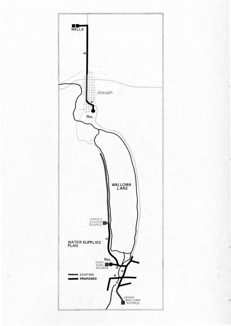
In a recent study, the Public Health Engineering Sectionof the State Division of Health investigated sevensmall water systems in the viciriity of Wallowa Lake.All but one of these is located in the south shore area.The Harris water system serves the west moraine area.Other information shows a single service in the northshore area, while the City of Joseph proper is servedby a municipal water supply taken from Wallowa Lake.Nearly all of these supplies utilize surface watersources without benefit of treatment (chlorination) andhave, therefore, been under scrutiny by the State HealthDivision for a number of years. The general water treat- J
ment guidelines of the Health Division are outlined inExhibit No. 1 attached. In order to obtain sanction asa water supply, surface streams must be diverted at anadvantageous location above the point of human ·influenceand must receive appropriate treatment such that ultimatechlorination will be effective.
15
There has been continuous reference, in all reports, ofthe need for a consolidated supply system which canserve all the entities in the south shore area. Thiswas the basic proposal of "A Comprehensive Water andSewer Study for Wallowa County, Oregon", a reportprepared by Ronald M. Blakely in March 1970. It wasthe proposal here to serve the city and the south shorearea separately with individual systems. A later reportprepared for the City of Joseph in August 1971, byGarth B. Harlan, proposed individual service for thecity by the development of wells and by upgrading ofdistribution of storage. Treatment of the WallowaLake source was considered too costly.
The basis of planning here has also been centered onmaintaining two separate systems due, principally, tothe fact that several miles separate the two points ofconcentrated use, the City of Joseph and the south shorearea. Cost estimates will illustrate these aspects.
Although water is abundant when the resource of the lakeproper is considered, the usable sources become limitedwhen the Division of Health guidelines and the simplicity of system operation and cost are considered. Withthis consideration of simplicity and least cost ofoperation in mind, the order of significance of sourcedevelopment would be as follows:
1. Development of springs.
2. Development of wells, assuming that groundwateris available.
3. Developing an infiltration gallery along a majorstream bed.
4. Treatment of water from a stream or from thelake.
5. A combination of these sources.
Development of one or more springs would constitute thesimplest form of water supply. Proper regulation andcontrol of the area in the vicinity of the springs wouldinsure good quality water. It would probably notrequire chlorination treatment. A well, too, would fitinto this category but would probably require moreoperation and cost for pumping. Infiltration galleriesare a simple form of source development when they can
16
be properly located and controlled and where adequatenatural gravels exist. In this instance, chlorinationwould be an absolute requirement.
A treatment plant utilizing a stream or the lake as awater source would be the most expensive facility fromboth the first cost standpoint and from the operationalpoint of view. Filtration, chlorination, and probablypumping would be a necessity.
In any instance, it will be necessary to provide adequatestorage and distribution facilities. This is a differentproblem from the source development and is an equalquantity in all cases. The available information seemsto indicate that, for the most part, the existing watersystems are in a state of deterioration or inadequate toserve future requirements. Therefore, the plans proposed will incorporate facilities for a maximum of threedays of storage in a covered reservoir along withadequate distribution mains. The localized systemsshould be used where possible for distribution to theusers.
Very limited information was found concerning thequantities of water available from the presently developed spring water sources. Local individuals expressedopinions that adequate source is available. This isaccepted at face value, but alternate sources of supply,such as wells, have been considered to supplement thesprings until these prove adequate for peak demands.
The basis of this plan consists of a cost estimate fordeveloping springs for water supply, constructing storageand distribution systems to serve the south shore area(Area No.3), and the west moraine (Area No.2). Thiscost and the cost of separately serving the City ofJoseph with a scheme slightly revised from the Harlanreport proposal is compared with an estimate of servinga regional area with a consolidated system. The consolidated system would depend upon the springs in thesouth shore area along with supplemental sources forsupply.
Area No.1, contiguous to the city, will be served inthis comparison. However, without constructing aregional system, service to the area from the City ofJoseph will be a greater cost.
17
...WELLS
WALLOWALAKE
HARRISSYSTEMSOURCE
WATER SUPPLIESPLAN
- EXISTING_ PROPOSED
The Health Division report indicated that the Harrissystem, serving the west moraine, was reasonably newand extended to nearly all the area of present need.It was, therefore, concluded that use of this existingsystem was plausible for a number of years and did notjustify a transmission system to the City of Josephwhich could simultaneously serve this area. Theexisting line extends for some two miles along the road,and consists of 6", 4", and 2" steel and PVC pipe. Anadequate source of supply is the only requirementnecessary to insure adequate service to this area (AreaNo.2) for some time. This area could be tied in withthe south shore system.
Proposed Water System Cost Estimates
Cost estimates of the various systems have been madefor comparative purposes. The south shore area and thewest moraine service a:~eas are computed separately fromthe individual service for the City of Joseph. It mustbe remembered that there is a degree of uncertainty inthat spring flows are unknown. If adequate supply canbe developed from these springs, the well will beunnecessary.
The discussion of the well to serve the south shore areaalso has some uncertainty associated with it, since nowells presently exist in the area. To get an idea ofthe success which might be attained in drilling forgroundwater, contact was made with a staff member of theState Engineer's Office who indicated that properconditions prevail for such development. Further studyis required to verify these aspects before final designcould proceed.
The system proposed which would serve Areas No. 2 and 3was estimated as follows:
1. Spring Development2. Well and Pump3. Storage (800,000 gallons)4. Transmission and Distribution
Mains (16,000 feet)TOTAL CONSTRUCTION COSTAdministration and Contingencies
at 25%TOTAL COST
$ 12,00021,00065,000
201,000$299,000
75,000$374,000
19
Local interest was expressed in determining the cost oftotal consolidation of the study area of this report withthe City of Joseph. Initially, it was assumed that therecommendation of the Harlan report for the City ofJoseph was basically sound. The cost estimates wereupdated to reflect 1973 prices. The locations of thewells were changed to an area north of town away fromthe terminal moraine. Again, contact with a staffmember of the State Engineer's Office indicated thatthis area had great potential and existing well logsprovided evidence of this potential. The estimate ofcost of this aspect alone was as follows:
1. Wells and Pumps (2)"2. Storage (700,000 gallons)3. Transmission Line (7,500 feet)4. Upgrade System (per Harlan report)
TOTAL CONSTRUCTION COSTAdministration and Contingencies
at 25%TOTAL COST
$ 42,00058,000
105,00070,000
$275,000
69,000$344,000
In addition to serving the city proper, considerationshould be given to serving the contiguous area, AreaNo.1. It has been estimated that it will requireabout 9,500 feet of 4" and 6" pipe to distribute waterhere. Additionally, it would appear that a boosterpump would be required at the proposed reservoir tomaintain distribution pressures. If this area wereserved by the regional system, the cost would be somewhat less, because part of the distribution systemwould be served by the regional transmission line. Thecost estimate for these two options is as follows:
,',
30,500$152,500
of Josephfeet) $114,000
8,000$122,000
No. 1 - Service by the CityDistribution System (9,500Booster Pump StationTOTAL CONSTRUCTION COSTAdministration and Contingencies
at 25%TOTAL COST
Option1.2.
14,000$ 70,000
Option1.2.
No .. 2 - Service by the Regional SystemDistribution System (4,000 feet) $ 48,000Booster Pump Station 8,000TOTAL CONSTRUCTION COST $ 56,000Administration and Contingencies
at 25%TOTAL COST
./
20II
The comparison of these two separate programs was madewith a consolidated system which would depend upondevelopment of the springs in the south shore area anda reported large spring on the west moraine. Contactwith local individuals indicated that the latter springwas large, and the flow was apparently not seasonallyaffected. It was, therefore, assumed without benefitof flow measurement that an adequate quantity of watercould be developed from these multiple sources. On thisbasis, a consolidated system was estimated. The systemwas composed of re-estimating the upgrading of theJoseph system, constructing reservoirs in Joseph andat the south shore area, connecting the two areas witha transmission line, constructing distribution mainsin the south shore and north shore areas and developingthe water source. These costs were as follows:
1. Joseph System Upgrade (perHarlan report) $ 67,000
2. Joseph Reservoir (700,000 gallons) 58,0003. Transmission Line (23,000 feet) 324,0004. South Shore Reservoir (800,000
gallons) 65,0005. South Shore Distribution System
(16,000 feet) 201,0006. Water Source Development 31,0007. Area No.1 Distribution System
(4,000 feet) 70,000TOTAL CONSTRUCTION COST $ 816,000Administration and Contingencies
at 25% 204,000TOTAL COST $1,020,000
This cost must then be compared with the total costof separate service to the two areas of concentrationwhich is as follows:
1. Separate Water Supply forJoseph $344,000
2. Service to Area No. 1 byJoseph 152,500
3 . Separate Water Supply to theSouth Shore Area 374,000
TOTAL CONSTRUCTION COST $870,500
From this comparison, it can be seen that separateindividual sources and services will be the leastcostly of the alternatives proposed. A saving ofapproximately $149,500 will be realized by this program,yet all the areas concerned will be ad~quately served.
21
SEWAGE COLLECTION AND TREATMENT
The choice of solutions for providing sewage utilitiesto the planning area is limited. At present, theuniversal method in use is to carry the waste from itsorigin to a central collecting point with once usedwater. After the sewage is centrally collected, thesolids are removed from the flows for separate treatment, and the water, containing dissolved and colloidalwaste, is treated generally by biologic means beforedischarge back into the environment. These flows areusually in the order of 100 gallons per equivalentperson per day. Depending upon the integrity of thecollection system, this quantity may be increasedduring periods of wet weather when extraneous flowsenter through defects in the collection system. Asmentioned, the general method of treatment takes theform of some type of biologic system. Specializedsituations often find other methods employed. Physicalchemical processes are becoming more important incertain uses. Such a system was brought to the attention of one of the members of the community. Thephysical-chemical treatment method could be used torecirculate effluents back for specific reuse in aclosed system. Another method sometimes used forultimate disposal is effluent irrigation. All suchmethods have specific use and may not be totallysatisfactory in all situations.
Specific conditions found in the study area are ratherunique and so limit the range of solution to be investigated. Terrain around the basin is very steep and,therefore, rules out the irrigation of effluents.Runoff would result without desired percolation. Thismethod of disposal relies upon the great treatmentcapacity of the soil; and, therefore, percolation isa must. It is somewhat akin to the present subsurfacedisposal methods in use.
The elevations of the surrounding mountains virtuallyprohibit pumping the effluent to an adjacent area fortreatment and disposal, except for along the lake inthe direction of natural drainage. The treatment andrecirculation method mentioned above would have itsgreatest potential in serving an area of concentrateduse such as the State Park. It would have less appealfor adaptation to a community such as the south shorearea. This stems from the fact that a dual systemwould be required, one to achieve the conventional
22
collection and the other to return the treated effluentsfor reuse. In addition, there is need to constantlybleed concentrated wastes from the system for ultimatedisposal.
Finally, the obvious conclusion of treatment and discharge into the lake proper must be considered. WallowaLake is considered to be water of very high purity.Tests run by the State Division of Health and theDepartment of Environmental Quality show little affecton the lake resulting from man's recreational uses.Chemical tests show that the lake is not receivingappreciable amounts of sewage effluent through groundwater return from the shore based activities or theseptic tank drain fields. At least for the most part,these are below detectable levels. The monitoringof the bacterial levels again showed little influencefrom the shore based activities. It is thought thatthese do show an affect from water based activities;however, no trend could be detected from the fivesampling runs made on the lake over a period of fiveyears. Analysis of the biota from the lake agains bstantiates these findings. A game commission reportwritten in 1967 shows that fish production in the lakeis finite, due to the limiting factor of the food chain.This would normally be enhanced if the nutrientsassociated with sewage contamination were present. Theconclusion reached to explain this aspect is that thesoils provide adequate treatment for the present quantities of waste discharged. It may also be enhancedby the fact that seasonal discharges allow the soil torest and recuperate. However, the balance is delicateand may be near the point of saturation where additionaldevelopment will have a direct affect on the lake.
All of these factors support the conclusion that thelake is of very high quality and it is, therefore,difficult with good conscience to consider a treatmentsystem which would discharge to this body of water.It is generally impractical to achieve 100% efficiencyin the treatment of sewage wastes. Since there is alwayssome residual in treated waste effluent, treatment withdischarge to the lake was not considered. There is nojustification in degrading the geologic phenomenon thatgives the area the significance which it enjoys. Inaddition, the City of Joseph has a sewage collectionand treatment system which is so situated that it couldbe used and expanded to accommodate the additional loading
23
which would result from providing these services to theplanning area. This system is a form of biologic treatment with ultimate disposal achieved by seepage intothe ground.
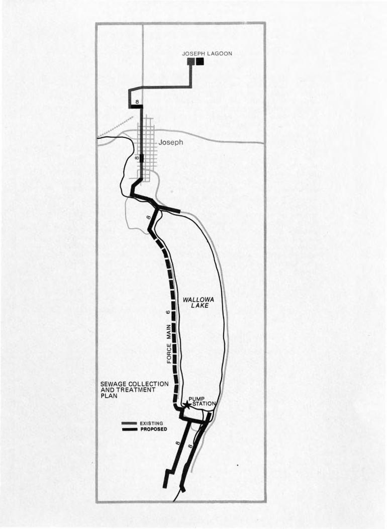
Proposed System
Considering all aspects; such as the physical location,separation of the areas to be used, the need to keep alleffluents from the lake, and the seasonal nature ofuse; the following system is proposed for solution tothe sewage disposal problems of the Wallowa Lake studyarea. A conventional collection system would be constructed on the south shore area. It will be of thehighest quality construction so a "bottle tight" systemresults. It is most important that no more flow thanis absolutely necessary be collected; therefore, allsources of groundwater infiltration must be excluded.In addition, all footing and roof drains from individualhomes must be excluded. It must not only be a fact ofordinance but must also be policed by adequate inspectionat the time of construction.
The collection is to be centralized at one point, suchthat all the south shore would be served by a gravitysystem. At this location a flow equalization basin andpump station will be constructed. The objective of theflow equalization basin would be to allow a continuouspumping rate, so the facilities downstream would notneed to be sized to accommodate peak flow periods. Thepump station would contain two pumps which would meetthe high head requirements of the long force main andyet be capable of handl~ng the solids associated withthe raw sewage. Grinders would also be required aheadof the pumps.
The force main would be constructed along the west sideof the lake, probably on the existing road where construction and later maintenance would be facilitated.This line would traverse all of Area No.2; however,it would not directly be of service to this area. Inorder to use this pressure main, it would be necessarythat small localized improvement areas be formed.Collection systems and small pumping stations could beconstructed should the need arise for service to localareas long the route of this force main. The smallerpumping stations could, in turn, pump into the force
24
II
1o
JOSEPH LAGOON•
ttlttttJoseph
WALLOWALAKE
SEWAGE COLLECTIONAND TREATMENTPLAN
- EXISTING_ PROPOSED
main. These stations would cost about $15,000 each f plusthe cost of the collection system as required. Extensiveservice on this basis has not been considered a highpriority item. The density will not be as great in thisstrip development as it is anticipated to be in the southshore area, even though it is estimated that 800 peoplecould inhabit the west moraine. The method of use andoccupancy will probably forestall a need for alterationof the present pattern of service.
The force main would terminate in a gravity system whichserves Area No.1, the north shore area. This gravitysystem would, in turn, be tied into the existing gravitysystem in the City of Joseph. By equalizing the pumpingrate on a daily basis, the existing gravity system inthe City of Joseph could be used with only minor replacement of 750 feet of sewer line in existing main "A". Inorder to accommodate this new loading, the Joseph treatment lagoons would need to be expanded. The presentmethod of treatment and ultimate disposal would appearto be adequate, so expansion would consist of the sametype of treatment. This lagoon is a very advantageoussystem and is very flexible in being able to adjust tothe weekly and seasonal fluctuations of loading whichwould result.
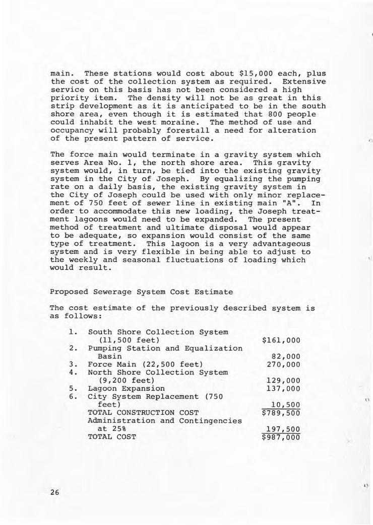
Proposed Sewerage System Cost Estimate
The cost estimate of the previously described system isas follows:
I,
26
1. South Shore Collection System(11,500 feet)
2. Pumping Station and EqualizationBasin
3. Force Main (22,500 feet)4. North Shore Collection System
(9,200 feet)5. Lagoon Expansion6. City System Replacement (750
feet)TOTAL CONSTRUCTION COSTAdministration and Contingencies
at 25%TOTAL COST
$161,000
82,000270,000
129,000137,000
10,500$789,500
197,500$987,000
\'
I,
The obvious d~fect in this plan is that the indicatedcost does not include service for any of the westmoraine. The transmission line will be in place andready for use if and when local clusters of housingbecome concentrated enough to afford a small pumpingstation and collection system. This would appear tobe the proper alternative at this stage, for the expenseof the collection system can be deferred until neededin the future at which time additional capacity willbe required in the treatment facility as well.
In order to compare this proposed system with a programwhich would incorporate similar features but wouldoffer immediate service to the west moraine area, thefollowing program was estimated. A similar system ofcollection is to serve both the north shore and thesouth shore areas. The primary difference would be inthe means of transporting the sewage along the west sideof the lake. Instead of a single pump station and forcemain, the proposal would be to use a series of threepump stations which would relay the sewage to thegravity system at the north shore. Gravity systemscould extend both directions from the intermediate pumpstations to serve the west moraine area. In order toserve the additional population, it will also be necessary to increase the capacity of the lagoon. This isalso reflected in the cost estimate. The cost of thisproposed alternative is as follows:
1.
2.
3.
4.
5.6.
South Shore Collection System(11,500 feet)
South Shore Pumping StationEqualization Basin
West Moraine Service Areaa. Pump Station (2)b. Force Main (11,000 feet)c. Gravity Sewer (13,000 feet)North Shore Gravity System
(9,200 feet)Joseph System ReplacementLagoon ExpansionTOTAL CONSTRUCTION COSTAdministration and Contingencies
at 25%TOTAL COST
$ 161,000
82,000
50,000132,000182,000
129,00010,500
168,000$ 914,500
228,000$1,142,500
27
It appears that the gravity system through the city willhandle the additional flow from the west moraine withthe minimal line replacement. However, it is stillimportant to recognize the absolute necessity for building a system which will exclude all sources of extraneousflow. If this is not accomplished, it will be necessaryto recognize that the force mains, pump stations, andthe existing gravity system through the City of Josephwill need to be increased in carrying capacity foreither system.
ADMINISTRATIVE AUTHORITY
One of the first major steps which will need to be takenis the formation of an administrative body having theauthority to represent those areas requiring publicservices. This body will have authority to performvarious duties such as purchase and condemnation of land,enter into contracts, adopt ordinances, carry legal actionsuch as suing and being sued in court, establish userates, determine tax levies and assessments, issue bonds,employ personnel, apply for grants and construct, andmaintain sewerage and water supply facilities.
By state statute, two alternative means are availablefor providing administrative authority. First, theindividual concerns may be governed by districtsformed under ORS 264 for Water Districts and ORS 450for Sanitary Districts. In both instances, a separateboard is elected by the people. In practicality, thiscould be a matter of both districts having identicalboundaries with possibly a single set of directorsserving on both boards. The second means of providingthis administrative authority would be through uheformation of a County Service District under ORS 451.In this instance, the County Commissioners act as theboard of directors but are aided by local representativesin the decision making process.
II
\,
Districts formed under ORS 264 and 450specific authority dealing with eithersupply and distribution or sanitation.case, authority exists for maintenancesolid waste disposal facilities also.
have restrictive,matters of water
In the latterand operation of
\,
Formation in accordance to County Service Districts lawORS 451 gives sweeping authority to include maintenanceand operation of sewage collection and treatment
28
facilities, maintenance and operation of wholesale watersupply facility, drainage works, street lighting, andsolid waste facilities. It is to be noted that thedrawback here is that the operation of water distributionfacilities would still be a function of localized bodiesfor the County is not authorized to enter this aspect.
Although at this stage it is not considered practical,it should be mentioned that the formation of a citywould also cover all of these administrative concerns.
In all cases, one of these forms of governing authoritybest fits the needs of the local community. In manyrespects, the County Service District can give the bestchance for administrative continuity with the drawbackthat additional legal bodies will have to be formed todistribute the water supply. This is a matter that mustbe resolved locally. In any case, this decision mustbe made early in the chain of events for it must be submitted to the people affected for voter approval.
RECOMMENDATIONS
From the foregoing preliminary discussion, the point hasbeen made that the study area in the vicinity of WallowaLake, Oregon, has need for community water and sewerageutility services. At the present time, adequate watersupply to serve all the area is a high priority item.The State Health Division has, in effect, issued anultimatum to this effect. Of a lesser immediate con-cern is the need for sewerage collection and treatment.This lesser concern stems from the nature of use, thesoil type in the area, and the concentration of the uses.There is at present little affect on the lake resultingfrom the shore based facilities. However, the point hasbeen made that this balance is critical and could possiblybe tipped with additional development. There is needfor community sewage facilities if development is toproceed. Preliminary plans have been discussed and costestimates made. From these preliminary plans, thefollowing recommendations are offered.
1. There is need for the formation of an administrative body to coordinate and oversee theconstruction and later operation of water andsewerage utilities. It is recommended that theadvantages of the formation of specific service
29
30
districts be compared with those of the CountyService District. Once the type of governingbody is decided upon and boundaries established,this must be submitted to a vote of the people.
2. The costs of these utility services are disproportionately high, therefore, immediately uponforming the administrative body a plan ofattack must .be established. Financing methodsmust be adopted, application must be made formaximum state and federal aid to assist in offsetting construction costs. Also, a priorityschedule must be adopted for it would appearfrom the total cost that staggering constructionwill be required.
3. It is recommended that the water supply in thelake planning area be held separately from theprogram for the City of Joseph. The lake areashould develop the spring sources to the maximumextent and then supplement by developing othersources. A well has been suggested, but feasibility can only be determined with future .investigation. Other supplemental sources areavailable if the well is not feasible. This willnecessitate that the City of Joseph proceed onthe program such as proposed in the Harlan reportand that the north shore area be annexed by thecity and served in this manner.
4. Due to space limitation and the necessity to keepall effluent out of the lake, it is recommendedthat all sewage be pumped out of the lake basinproper. The existing Joseph system can be usedand expanded to provide an adequate treatmentfacility. Due to the estimated cost and theapparent lack of immediate need for the sewerageutility in the west moraine area, it is recommended that the single pump station and forcemain be constructed with future construction ofindividual collection systems and pump stationsalong the west moraine where need arises. Thiswill also necessitate future addition to theJoseph treatment system.
\,
5. In the construction of both water and sewersystems, it will be necessary to provide thebest construction possible. It is recommendedthat the adoption of ordinances restrictingconstruction and use of the system be one ofthe first acts of the administrative body. Duringthe construction phase, adequate inspection mustbe provided.
31
EXHIBIT NO. 1
COMMUNITY WATER SUPPLYWATER TREATMENT GUIDELINES
State Health DivisionJanuary 1972
Revised April 1972
OBJECT: The following is intended to give a generaloutline of water treatment requirements fordifferent types of raw water quality. Waterquality at all times must meet the biological,chemical and physical (including radiological)standards of the Division of Public Health.In order to meet these requirements at alltimes, the following water treatment must beprovided.
CHLORINATION: Chlorination treatment means a 0.2 ppmfree chlorine residual in the distribution system after 30 minutes contacttime or 2.0 ppm combined chlorineresidual in the distribution systemafter 30 minutes contact time. (Chlorination must be proportional to flowwhere service is direct to the distribution system and flow will fluctuate.)
('
Type I:
Type II:
32
Relatively clear and clean upland, flowingstreams.
Treatment required is either an infiltration gallery plus chlorination, asdefined above, or filtration pluschlorination. Where the infiltrationgallery cannot be built "in the dry"or where the applied water will plugthe infiltration gallery frequently, thenfiltration must be provided.
Flowing streams which are periodicallyturbid or deep impoundments with gooddepth-of-withdrawal selection, exposedto contact by humans and pollution islimited to ground seepage but the waterdoes not receive any direct treatedsewage effluent.
Type III:
Type IV:
Treatment required is either coagulation,flocculation and sedimentation pluschlorination as defined above, or filtration plus chlorination.
Water over which there is little qualitycontrol such as: Impoundments with afixed level of withdrawal; shallow pondssubject to access by small animals andwhich support aquatic growth; or waterswhich have received treated sewageeffluent.
Treatment required is coagulation;flocculation, sedimentation and filtra~tion plus chlorination as defined above.
Waters which are either clean and clearor which are produced from treatmentrecommended above (or well waters) whichrequire additional chemical treatmentsuch as:
a. iron removal
b. taste and odor removal
c. H2S removal
d. pH adjustment
e. fluoridation adjustment
f. nitrate removal
g. other objectionablechemical compounds
Treatment required must be in accordancewith the latest recommended AWWA treatment process and must at all times, meetthe biological, chemical and physical(including radiological) standards of theDivision of Public Health.
33

CITIZEN RESPONSES
In addition to discussion at public meetings and numerousverbal responses to the preliminary land use proposals,several citizens took time to set down their ideas andreactions in writing. These are included as a reminderof the variety of opinions expressed as well as maintaining a record of the ideas put forth.
December 19, 1972
Mr. Joe Mc LarenWallowa County Planning Commission
I strongly recommend planned development at the lake.
I believe the time has come to think about a mobile home court.This should not be at the,south end of the lake, as I don't seethe room for it.
In order to develop the south end of the lake to any great extent,a combined water system is a must - even more so than sewage.
I am also very much in favor of developing any portion of theLak~ whether it be North, South, East or West, as long as thatproperty lends itself to any type of building recommended bythe Planning Commission.
In order to install a sewage disposal and an approved water system,there must be development on property to increase the a$SeSsillentvalue to make it possible to finance any type of system.
I believe the present members of the Planning Commission have aObetter insight on the needs of the County, and their decisionssetting up districting shoul~ be accepted.
(;-;-~/ ;6A~,~De /~gn/Committee Chairman
I)
I}
In respc,nse '~o the public hearing COllductod in the Court HouselX:cGc:bcr 13, 1972, Sh:.t8~~:mts fOi" or ~L;<~inst th", pzooposals cubLlit~el; by EngineerinG Firr~s ln Portland.
Th:1.s opinion is from an illdiviuu8.1 rather than frDm '~;1e Courtappointed klke CO~!:1it'~ee of wilich I'rur. a ~ember •
. I f.eel it is i.r~perativc that f01'I','ard r.lOvc·,£mt be r.i2.de on the constructior. of a IJC\'!::lr end v;J."tcr line. Until inor.:- idsus or su,',:{;:",rr~io!1s
fac'~s and figurc~s ore subnittDd I caruioi; cO::"'P1it ".:.~y 2.pproval jcoeithor pl,m sv:;,'·:ected. r.~y reasons for favor'inc; 2. r;cwcr "nd strictZOnill1: cO;1trols are as follows I
1. "Thin[;s" will not st2.Y as is,
2. The county needs employnent in the tourist industry :mel\':allol'la L;!.l.e can provide this, if dc-vcloIl,"-cnt continuc.slmder Cl080 zoninG reGulations and if a se';:cr s~'stC!:n isinstalled.
3., without a sewer and perimps wntor me.in~; no 1,::::i tm:",te\ developer or persons can do anything of cO;1qucncc. 'l'he
risk is too e,Teo.t that the State licalt~l Bo:>.rd viould cut,you off at the pockets before ;you eot st:.'.r~t:c or worse
the miudle of an expen!3ive building pi'ogrz,'". !.:odern,I' year aro\ln~ fncili tics in the n'.lmber to T:lake ita pQying
propos!tion \'.'ould pollute the il2.:~e in a short time. A
I. Most of the existinG water systens h:l.vC :l.lr0ady boon toldto chlorinate b:7 the Board of Health. Fix up now or S:1utdown and th~y are 100]:1n:::; r:.t long ran;;e plan::: now beingstudied for th~ long r2nge a!1S'I:er for.' water and fire pro";ection. At present there is no actual fire protectionbecause of the old inadequate ~ater souceces and distrll'ution SYStC~lS. It malces sense to put in both water andswage at the ca~e tirr.e and save so~e costs.
5. Some kind of density of population or control is needed.The county mU:Jt lceep the lake as a desirable attract!.lonrather than an uncontrolled glob of people livin~ near themount~in3 with a body of polluted wat0r in the middle.Too many cattle in a p:l.sture is no different than too Manypeople in a given area. We dont need another L,ke Oswegoonly )20 miles from Fortland city limits.
6. Without zoning control on typeroad nets, sewa~e, vmter, etc.proble~ rather than an asset.control future e~pan~ion otherzonln& and building COd3S.
of buildings, location ofwe will only have a cour~ty
There is no other way tothfu"1 strict and enforced
Developers that propose r-:f\:>,lc en the East al'ld West sida ofthe moraine offar nothin~ tE:O farj bul; proble,"s, Their onlyconcern ~s to sell lots for as much as they can get andput in as little as porlsible to rna~e the lot£ legnl and forsale. Example. H:J.rris logged hell out out of the lot sitesthen put in the miniu,"!l for \',atur ( \','s'lich does not now pa:=sstate requiren:ents) and a couple ugly 100Icing losgin~ raE'.dsfor access. The first road went thru the middle of thelake side lots therefore the reason why of more spur roads.
JOD <lonG 1n a correct manner. Th8re is a stronr; desIre to selllots and E'.s many as the local c i th.ena \'iill stD;-:d still forund prob2.uly do the 2.bsolt\te l!li..b$,l to cot by in the "laY ofwa'tf:r , seY/age, ro~(ds and in corpOl'Z~tion 7C'nin.r. thru theiro;-:n ~alescontracts, To develop on n l::rco 9c8.1e \"o\.lld reo~d.r02.!!,ol'nts of capital th"t probn1:ly co~lcl flOt .be afforded at thist1m3 bece.uso Iota wOl!lcl not brhlf, enol~';11 on the r.;arl~e:J. Thedeveloper hac: got to make mon€<y or. l£>:'\Vc it in CC'W pCJ.sture,There are hundreds of so cS.lled develof..;:"ents in tha PacificNortlw;cst that should have been left in cow p.e.st'..lre, A pointmany county officals and developers would both aGree aft'2rthil16s ttrned sour in the courts, county, and with State Officals.
Had many plans of development been laid out with honest intentions in mind and had the ideus been r.one over with localofficals there wouldn't be so me-By strict dcvelo~;T,ent lawsput into law as in the p~st yenr.
Onc pro1'csl3ional developer ( all ari) so called professional)told me last sum:;:er th~re is no way the morraine can be roacedfor development in most places without II,akin17, the whold hillside loole like an open pit copper mine. Costs on this hll:lGfor Bewer and water and fire protedtiol1 and roads that wouldstay on the mountain- you wouldn't believe. On the otherhand- no planning , zoning, or rules and our troubles nowwill look like childs play ten years fro::l now.Never to my knowled~e have developers offered anything inthe way 01' iu.provin~ the landscape for their benefit and the
vcounty. Example,,~ Offer to bury utuii ty lines, provide hiddcenwell constructed roads, offer to build thier ~n Ecwer syst€@,clean up logging slash, zone their own land and offer theirown building code, offer to build some facilities for theirown buyers like marine docking, s~immine floats, etc.
8. There has to be a happy ~edium for development for thelake basin. There should be a limit for growth~' do we want30,000 people or would W3 like to see perh~ps twice what thereis now). There is room for development for private homesgenerally where they are now- with some strict enviromentalcontrols set up through codes and zoning. I hope we haveenough sence to cater to people that want zoning rather thando everything possible to get around it. Lots around the areaare not unlimited. so 1'" us appeal to the buyer that Isconcerned of having his property values kept up. PersonallyI wouldn't buy a lot where anything goes. Spend $S.OO~ fora lot and $20, 000 for a building and I sure as hell wouldn(~want a mink farm ten feet from my property line and a nonworkin? septic._tank besides. The world is full of these kindpeople\look in any city) but there is only one Wallowa Lakearea in existance.
9. The area needs a comm~rcial skction generally where itis now. There are too many jobs to be afforded to have thewhole area go to private cabins and a state park. Again thereshould be zoning that covers signs, height of buildings,burry of utilities. etc. There are hundreds of similiar areasthat have been faced with the satrie'problemsand the ones thatl4 did a good job Ban be named ori'-Qnf! hand. Most end up looking like srip city America and all lri'PQQr taste. ~ost peoplein business accept zoning as a fact o~ bu~iness and complyif' that is the law. -
10. Most'accommodations at the lake a~9 outmoded amd wornout. Very little in rental cabins or acco~~odations havebeen built in twenty years. I feel that any;ski develop.ment is years in the future, and. most prof'e~ionals that haveno ~oc~l axe ,to grind f~e~ t~e.same,waf. ~hls does n?t meanA." tf.n:t ~f ...z<l -+~_...<..<.~ z~ I, Uv.>-'-'\.. I '""t.<.~~ •U ~-<.. eRe·~ ~ -d.v; - d.. ~... -<-YI 't/w~.., M ch~/...c: (~
a few cabins a year- not knowing from one year to the nextwhen the state will blow the whistle or when some attorneywill file suite against the couty because he couldn't get a bbuilding permit. Nothing of any conquence.will be doneon the co~~ercial line because there isn't a sewer line,and the water systems will be under constant barrage to getfixed up, and Joseph citizens will be angry most of the timebecause their vmter soucce gets worse and worse, and on andon and on. Instead lets examine the costs of a sewer andwater line, lets put in some zoning and enforce it, lets letit be kno~TI to developers where the county stands and expectthey do a good job or end up doing nothing, and lets us tryto encourage a boost in the local tourist base and emplo~nont
by looking forward. I hope in ten years to be able to sayit was in 1973 that the county started to move in the rightdirection at' Wallowa Lake. I~c is a beautiful area that hasmade a comprise with man and is a credit to Wallowa COWlty.The only other course is long silence- an~ a shake of thehead.
Duane'Wiggins
Wallowa !.ake
\,'
Dec. 19, 1972
\AJallovTa County Planning CommissionWallowaCounty Court HouseEnterprise, Oregon
Subject: Sewer system for Wallowa Lake and Area
Dear Sirs:
In planning the sewer system for the Wallowa Lake area, it seemsthat the only logical way to go is to install the system dovm thewest side at this time, keeping in mind that the face of Mt. Josephwill most likely be developed one way or the other sometime in thefuture, also consideration should be given to any development upHurricane Creek.
The development that will most likey take place on the east side ofthe lake should be included in any future planning as far as the sewage
. -plant itself is concerned, but as far as getting the sewage to theplant should be at the develmpers expense, therefore not burdening thetax payers.
In this day and age, with the present population growth this countrYis experiencing, pla nning twenty five years ahead is not to beconsidered lightly.
With reference to the first paragraph, considering there are alreadyseventy odd homes on the west morrain, and the Mt. Joseph area partlydeveloped, there is no other choice, but to insta11 the sewer systemon the west side.
As a citizen of Wallowa County, I am very interested in the future ofour county, and I am fully convinced that with proper planning, thecounty will be as desireable to everyone in the future, as it is today.
''dl!(ountain cJfou~E,II
DESIGNERS & BUILDERS OF FINE RECREATIONAL HOMES
Ted WinchelP. O. Box 426Joseph~ Oregon 97846503·432·5501
Wallowa County Planning CommissionWallowa County Court HouseEnterprise, Oregon
Re~ Wallowa Lake Basin Land study
Dear Sirs:
I would like to express my appreciation for the opportunityto express my ideas and views.
Plan A and Plan B, as I understand, are alternative solutions tothe problem of the lake and adjacent environment preservationand utilization. I am happy that there is progress being madeand sincerely wish to support these activities in any way I can.
I do not believe that Plans A and B are alternatives. I feel thatthey represent requirements or needs that each in itself mustbe dealt with in the near future.
Advocating the development of the back side of Mt. Howard wouldnot, I believe, relieve the development pressure on the west orthe east side of the lake. I think that t ~ potential developmentof the Mt. Howard area has a great deal of I it. The Lake basinand Mt. Howard are two distinctly different r creational potentials,one possibly complimenting the other but certainly not replacingthe other. A winter sports area would be a significant additionto the area economy and stature •.
Continued West Morraine development as it was currently beingcarried out will certainly achieve the most undesired results.
One of the greatest environmental felonies in an area such as thelake shore, is an unplanned high structure denisity. Continuedconstruction of sub-standard disposal systems will in time alsofoul the environment. However important the proposed sewer systemfor the west moraine might seem, I believe that zoning andbuilding codes are the first concern. There are very few lakeshore building sites adequat for disposal systems or sewer lineaccess. The probable high cost of the west side sewer is due to theclose proximity of these sites to the lake. Also this private
.property along the lake is violating a right that an environmentalorganization could make an issue of. Also, why should all otherwould be users of a sewer system be made to share the higher costnecessary to service those relative few ttiat crowd the lake shore.There remains considerable land along the road suitable for building that can accomodate code disposal systems or easy sewer access(down the present road bed). Some of this land requ~res extensive.excavation and foundation. However I don't think this is asignificant draw back.
''o1Jlountain dlOU:iE II
DESIGNERS & BUILDERS OF FINE RECREATIONAL HOMES
Ted WinchelP. O. Box 426Joseph, Oregon 97846503·432·5501
I believe that a sewer system should eventually come down the WestMoraine, but I don't 'believe the lake is in any danger from thepresent west side seasonal occupancy. I think the immediate dangerto the west side is the absence of building codes and abritary lotsizing. Quite a bit more development could take place and not endanger "the lake at all. Adequate building sites away Trom the shore andstrict codes can insure symbiontic development of housing withinthe natural environment. Adequate in this reference means largerot sizes than is presently plott9d. Another seemingly significantoint is the potential development of multi-dwe11ing structure$
(condominium). These structures are advantageous economically,physically and politically. They tend to decrease over all structuredenisity on a per capita basis, and they are a good investment in
.this area of inadequate housing, and they ostensibly provide greaterpublic access! to the lake. Again with proper zoning and codes thesestructures could utilize disposal systems without harmful side effects.I believe that the West Moraine, under good management could developinto a good recreational and residential area and be in a betterposition to support a full sewer system in the near future.
I)
I suggest that you consider relieving a great deal of the pollutionproblem by adopting that portion of Plan A that implements a sewersystem down the East Moraine. I also suggest that in that planyou provide for a future sister or joint. system for the West Moraineand enact the above mentioned zoning and building codes to providefor continued development. Then ata time when the development cansupport the extended sewer system, it can more readily be implemented.
/
December 1), 1972
. vJa110wa County Planning COclll11issionEnterprise, Oregon 97828
Gentlemen:
The fo11o\'-'-ing COlTL"11ents are submitted for your information' on theHallowa. L3.ke Basin Sturiy as prepared by Stevens, Tho:npson andRunyan, Inc., as requested.
/
Wallo>,ra County has been stu.died and re-studied man.y ti:-e,es in thepast few years Hith the end result being the sa:-:;e in nearly everyinstance. It is evident that the agricultural resources andforest products industry are limited and that recreation andtourism \vill be the influential factor for the economy and development in the near future. It was ,dth this thought in mind thatthe recormnendation was tn.3.de to the Hallovra County Court in 196)for the fornation of a County Planning COTllr'lission.
Since the formation of the Planning Co%~ission and the preparationof zoning ordinances and land use data, developVlant has been permitted to proceed on a very informal basis throughout the countywi thout proper regard to long range planning, Vms discouragingthe more discriminate type of recre?.tiona1 developme'1t. The Vl2.l10HaLa~e area is one of the most heavily used recreation centers inthe sb.te and pressure for this type of activity is expected toincrease.
As a property owner for some of the most choice ~~creational acreage in Oregon if not the Un~ted States, I am particularly concE;rnedas to future plans and development in the area. We have prepareda "Plan of Development" for the east moraine utilizing the mostmodern concepts for highest and best usage for this acreage. NodevelopMent has been accomplisher'! to this time and it is the consensus of opinion that assurance on the part of the buyer wouldbe necessary to conform with our naster plan prior to release ofany parcel. Ha,d tve desired to disregard the future of the area,many opportunit1.es t.;ere available to dispose of parcels rangingfrom a few acres to several hundred acres in size.
In the review of the Wallowa Lake Easin Study, I support the recommendation of regulated development, however I disagree with thesuggested land use proposals. The open space propos~l for a portionof the east moraine is ridiculo~s. I have discussed regulated typedevelopment for the barren slope with many local residents aDdmany non-residents, and all agree that the environ~ental qualities'Nould on}y be enhanced 1dth speci al planning for this particularacreage ann not to leave it in its natural state. .
Also, the reference to the moraines as being CO:Tlposed of highlyunsta'0le ,,~aterj.;:l is questionable and very pro1Jably unfounded.Hy experience "td.th soils and foundat~on jnvestigations "Jave provenunstable Y'lf'.terials to be associated Hi th soils subject to verticaland hori ?,ontal movement as the tva ter' content increases, soilssusceptible of 10hT shear and/or materials th,d ~'~ill not support.loads of CO!llputed design weights •
Furth.er, I do n0t agree Hi 1:..h the sug?estion for developme!1t onthe 1-Test moraine to continue in a linear fashion. Th:ts type ofdevelop~.~?nt, grid method, adds !1othi~s to the .?esthetics c!''''.dparUcular care should '-1e exercise-3 in planning utilizin~ themost p:r-ofessional ~lar,ners.
Conclusions ~nM Reco~~endations:
A county planning engineer should ce acquired to coordinatethe planning and development throughout the county, t~lile
at the same time disse:"linating projected plans ldth COrrL'T:issioners and land OEners and encouraging selected outside interests.
Proposed and existing developments should be revielvod andserious attempt be mode to negotiate satisfactory relationships thus encouraging future investments.
It is obvious that development around the Lake must be curtailed until such time as water and sewage facilities are providedor provision made at the time of development.
Prior to any land use designations, publ~c hearings held toavoid violation of civil rights.
This area can be developed jnto a nationally and inter-nationallyknown tourist attraction with foresight and. imaginative planning,with0ut altering t.he characteristic legend of Chief Joseph or the"Little Sl.ntzerland of A.m.erica" atmosphere, and at the sametime vitalizing t~e local economy so essential for survivaL
Sincerely,
~.)
WRllowa DD.sin Co:..mi t t ee
Comments conc8l'ning the \Vallow Lake 'Ga:3in Dtudy.
1. The 701 funcli:(i.g for this study ,7aS G:C2.11tcd Ior the ruX""pose..ofpreserving 0llen s)ace for cle·:'n air while developinc;clea."1 vratol' and 'S'ect:age syste i;ls.Steve:'!s TilOmpson and Runyan Inc have meC;. '~:ae terr;ls
of tbis Gr2.llt.
2. llowevel' the county Court .:mel Lake Basin GOLn:ti ttee excepotedthis GrcUlt for the pUl'I)oseof detel'lJlinipG the cost end feeBi bli tyof a clean wc.ter a.."ld sm/er' system for li19.ximum developementof tDe Loke Basin.
3.The Lend use ProIJ9sal resulting fron this dudy C.re inconflict with ma:ih'mTI1 develo~)cment of the Basin.
Recowendations to W.L.B. Com~uttee
1 0 That the Land use Propos3~ be rejected.
2. That S.T.-and R inc. sumit to us a nlan for a seYler syster!lcaperD/Q-le of h'mld~ing full developeme;t of lake basin.
Recomeridl3.tions to the ple.:.(ming commision.
r. That a qualified planner be hired for the cOu"'1ty for the ( A _ \
purpose of develo11ing the Lake BaBin to its Hightes Pobntial \~as tourist attractmon, for the overall economy of the county. .
Edythe CrMe
.,
ACKNOWLEDGMENTS
WALLOWA COUNTY
County CommissionersClaude HallBill DeGr'offtClifford Johnson
wallowa County Planning CommissionJoe McClaram, Chairman
Lake Public Works CommitteeDuane Wiggins, Chairman
Public Affairs CommitteeEdythe Crane, Chairman
Economic Development CoordinatorJohn Beck
County PlannerGeorge Gillette
County SurveyorVerne Russell
Soil Conservation ServiceDon Baldwin
ACKNOWLEDGMENTS
STEVENS, THOMPSON & RUNYAN, INC.PROJECT STAFF
Project DirectorGilbert Meigs, P.E.
Project ManagerThomas Hawkins, AlP
PlanningDennis Petrequin, Project Planner
EngineeringJoe Jensen, P.E., Project Engineer
GraphicsE. Jean WilliamsonGary K. LarkinsChris BarnhartSheryl Cowan
PrintingJudy BillingsMoore Lithograph, Inc.
,.
..\