Oceanus - bhl-china.orgbhl-china.org/bhldatas/pdfs/o/oceanusv2901wood.pdf · Oceanus ISSN0029-8182...
104
Oceanus THE ARCTIC OCEAN Volume 29 Number 1, Spring 1986
Transcript of Oceanus - bhl-china.orgbhl-china.org/bhldatas/pdfs/o/oceanusv2901wood.pdf · Oceanus ISSN0029-8182...

Oceanus
THEARCTICOCEAN
Volume 29 Number 1, Spring 1986

ISSN 0029-8182OceanusThe International Magazine of Marine Science and PolicyVolume 29, Number 1, Spring 1986
Paul R. Ryan, Editor
Frank L. Lowenstein, Assistant Editor
Eleanore D. Scavotto, Editorial Assistant
Kristen Kaliski, Winter Intern
Editorial Advisory Board1930
Henry Charnock, Professor of Physical Oceanography, University of Southampton, England
Edward D. Goldberg, Professor of Chemistry, Scripps Institution of Oceanography
Cotthilf Hempel, Director of the Alfred Wegener Institute for Polar Research, West Germany
Charles D. Hollister, Dean of Graduate Studies, Woods Hole Oceanographic Institution
)ohn Imbrie, Henry L. Doherty Professor of Oceanography, Brown University
John A. Knauss, Provost for Marine Affairs, University of Rhode Island
Arthur E. Maxwell, Director of the Institute for Geophysics, University of Texas
Timothy R. Parsons, Professor, Institute of Oceanography, University of British Columbia, Canada
Allan R. Robinson, Gordon McKay Professor of Geophysical Fluid Dynamics, Harvard University
David A. Ross, Chairman, Department ot Geology and Geophysics, and Sea Grant Coordinator
Woods Hole Oceanographic Institution
Published by Woods Hole Oceanographic Institution
Guy W. Nichols, Chairman, Board of Trustees
Paul M. Eye, President of the Corporation
James S. Coles, President of the Associate**
John H. Steele, Director of the Institution
The views expressed in Oceanus are those of the authors and do not
necessarily reflect those of the Woods Hole Oceanographic Institution.
Permission to photocopy for
internal or personal use or the
internal or personal use of specific
c licnts is granted by Oceanus
magazine to libraries and other
users registered with the
Copyright Clearance Center
(CCC), provided that the base
fee of $2.00 per copy of the
article, plus .05 per page is paid
directly to CCC, 21 CongressStreet, Salem, MA 01970.
Special requests should be
addressed to Oceanus
magazine.ISSN 0029-8182/83 $2.00 + .05
Editorial correspondence: Oceanus magazine, Woods Hole Oceanographic Institution,
Woods Hole, Massachusetts 02543. Telephone (617) 548-1400, ext. 2386.
Subscription correspondence, U.S. and Canada: All orders should be addressed to Oceanus
Subscriber Service Center, P.O. Box 641 9, Syracuse, N.Y. 13217. Individual subscription rate: $20 a
year; Libraries and institutions, $45. Current copy price, $5.00 25% discount on current copyorders for 5 or more; 40% discount to bookstores and newsstands. Please make checks payable to
Woods Hole Oceanographic Institution.
Subscribers outside the U.S. and Canada, please write: Oceanus, Cambridge University Press, the
Edinburgh Building, Shaftesbury Rd., Cambridge CB2 2RU, England. Individual subscription rate
19 a year; Libraries and Institutions, 35. Make checks payable to Cambridge University Press.
When sending change of address, please include mailing label. Claims for missing numbers from
the U.S. and Canada will be honored within 3 months of publication; overseas, 5 months.

Give
Gift
of the
Sea1930
comeaboard
yourselfnow!
Oceanus Domestic Subscription Order Form: U.S. & Canada*Please make checks payable to Woods Hole Oceanographic Institution.
The International Magazineof Marine Science and Policy
Published by Woods Hole
Oceanographic Institution
Please enter my subscription to OCEANUS for
Individual:
III one year at $20.00 D payment enclosed.
D two years at $35.00 (we request prepayment)D three years at $50.00 D bill meLibrary or Institution:
Oone year at $45.00
Please send MY Subscription to: Please send a GIFT Subscription to:
Name (please print) Name (please print)
Street address Street address
City State Zip
*Foreign subscribers please use form inserted at last
page.
9/85
City
Donor's Name
Address
State Zip
/ -/
Data can result in improved models for
forecasting environmental conditions.
66 MIZEX East: Past Operations, Future Plans
by Dean A. Horn and G. Leonard lohnsonNew marginal ice zone experiments planned for
1987 and 1989.
73 Arctic Offshore Petroleum Technologiesby lames W. Curlin, Peter Johnson,William Westermeyer, and Candice Stevens
Pinched oil companies are reducing exploration
budgets; larger federal role may be needed.
Woods Hole OceanographicInstitution. Oceanus (ISSN
0029-8182) is published in
March, June, September, andDecember by the WoodsHole OceanographicInstitution, 93 Water Street,
Woods Hole, Massachusetts02543. Second-class postagepaid at Falmouth,
Massachusetts; Windsor,Ontario; and additional
mailing points.

HAS THE SUBSCRIPTION COUPON BEEN DETACHED?
If someone else has
made use of the
coupon attached to
this card, you can still
subscribe. Just send a
check--$20 for one
year (four issues), $35for two, $50 for three
-to this address:
Woods Hole
OceanographicInstitution
Woods Hole, Mass.
02543
Please make checks
payable to WoodsHole OceanographicInstitution
N30
OceanusWoods Hole Oceanographic Institution
Woods Hole, Mass. 02543
Woods Hole, Massachusetts 02543. Telephone (61 7) 548-1400, ext. 2386.
Subscription correspondence, U.S. and Canada: All orders should be addressed to
Subscriber Service Center, P.O. Box 6419, Syracuse, N.Y. 1321 7. Individual subscription rate: $20 a
year; Libraries and institutions, $45. Current copy price, $5.00 25% discount on current copyorders for 5 or more; 40% discount to bookstores and newsstands. Please make checks payable to
Woods Hole Oceanographic Institution.
Subscribers outside the U.S. and Canada, please write: Oceanus, Cambridge University Press, the
Edinburgh Building, Shattesbury Rd., Cambridge CB2 2RU, England. Individual subscription rate
19 a year; Libraries and Institutions, 35. Make checks payable to Cambridge University Press.
When sending change of address, please include mailing label. Claims for missing numbers from
the U.S. and Canada will be honored within 3 months of publication; overseas, 5 months.

2 Introduction
by lames H. Zumberge
9 The Age of the Arctic
by Oran R. YoungThe Far North is becoming increasingly importantto U.S. and Soviet security.
18 Glaciology A Primer on Ice
by Norbert Untersteiner
A discussion of the dynamics of ice and how it
forms.
24 Sea Ice and Oceanographic Conditions
by Thomas NewburyWhat we know about oceanographic conditions
under ice during winter.
31 Arctic Ocean Pollution
by Vera Alexander
Marine ecosystems face increasing stress from
development pressures.
36 Arctic Marine Ecosystems
by Maxwell I. DunbarA look at why the region has a low diversity of
species.
41 The Arctic's Role in Climate
fay D. lames Baker
The interaction of air, sea, and ice affects the
global energy balance.
47 Arctic Icebreakers U.S., Canadian, Soviet
fay Lawson W. BrighamA review of icebreaker operations and U.S. fleet
needs.
59 Remote Sensing of the Arctic Seas
fay Wilford F. Weeks and Frank D. CarseyData can result in improved models for
forecasting environmental conditions.
66 MIZEX East: Past Operations, Future Plans
by Dean A. Horn and C. Leonard lohnsonNew marginal ice zone experiments planned for
1987 and 1989.
73 Arctic Offshore Petroleum Technologies
by lames W. Curlin, Peter Johnson,William Westermeyer, and Candice Stevens
Pinched oil companies are reducing exploration
budgets; larger federal role may be needed.
Soviets Shelve Plan
78 on Diverting Rivers
in Arctic Regions
fay Paul R. RyanClimate in Northern
Hemisphere could have
been affected.
Bowhead Estimates
81 Revised Upward;Hunt Issues Ease
fay Tina Berger
Population figures for
Western Arctic estimated at
more than 4,000.
ft r Judith M. Capuzzo:Educating the Guessers
by Frank Lowenstein
From New Hampshire to
New Bedford in pursuit of
science and policy.
89
First Argo Science
Test Yields
UnexpectedData on Ridge
fay Sarah A. Little
Crest surface features are
more complex than
previously thought.
Letters
91
Book Reviews94
Cover: See page 90.
Copyright 1986 by the
Woods Hole OceanographicInstitution. Oceanus (ISSN
0029-8182) is published in
March, June, September, andDecember by the WoodsHole OceanographicInstitution, 93 Water Street,
Woods Hole, Massachusetts
02543. Second-class postage
paid at Falmouth,
Massachusetts; Windsor,
Ontario; and additional
mailing points.

"^3B 9
U.S. explorer Robert E. Peary, considered the discoverer of the North Pole. After several expeditions in Greenland and the Arctic,
Peary reached the Pole in April 1909. His claim of discovery was challenged by fellow American Frederick Cook, who reported
reaching the Pole the previous April. (Photo courtesy ofSpringer/Bettmann Film Archive)

Introduction
by James H. Zumberge
I he Arctic Ocean has tantalized explorers,beckoned scientists, and lured adventurers for
centuries. The major attraction of the Arctic Basin a
hundred years ago was that it contained the NorthPole of the planet Earth. In the late 19th and early20th centuries, men struggled to be the first humansto set foot on the unique geographic point. Since
1909, when Robert E. Peary and Matthew Hensonreached that goal by dogsled, others have achievedit by almost every means conceivable. Richard E.
Byrd and Floyd Bennett flew over the Pole in an
airplane in 1926, and Umberto Mobile and RoaldAmundson flew across the Pole in the dirigible,
Norge, in the same year.In 1937, the Russians, under the leadership of
Otto Schmidt and Ivan Papanin, landed at the Polein an airplane, and, in 1958, the U.S.S. Nautilus, anuclear submarine, conquered the Pole on a cruisebeneath the ice. The Soviet nuclear-poweredicebreaker, the Arktika, now the Leonid Brezhnev,was the first surface ship to reach the Pole, a feat
accomplished in August, 1977.
Today, a travel agency in Seattle, Washington,can arrange for anyone who can pay the price to belanded at the North Pole in a Twin Otter aircraft!
The Arctic in general and the Arctic Ocean in
particular have remained areas of considerablescientific interest since the first International PolarYear 1883 when the scientific world first singledout the polar regions as areas of international
scientific value.
Scientists and explorers from all countries
bordering on the Arctic Ocean have advanced the
knowledge and understanding of this perennially ice-
covered sea and its bordering lands during the 19thand 20th centuries. However, the impetus has
changed somewhat from the mere satisfying ofscientific curiosity to the emergence of the ArcticBasin as a theater of military operations for theworld's two superpowers (see page 9). In addition,there is the strong desire on the part of some to
wrest mineral resources from the Basin's icy grasp.Intertwined with the latter, the indigenous peoplesof the Arctic Rim feel their traditional culture and
hunting grounds are threatened by the intrusion of
foreigners.
U.S. Interests
The research interests of the United States in theArctic range from those related to national security,resource exploitation, and basic science to
protection of the environment and preservation of
the cultural heritage of indigenous populations.Activities in these and other areas of scientific
interest have been funded by various federal
agencies. Total government funding for arctic
research in fiscal year 1985 was about $80 million.
An additional unknown amount is spent by the oil
industry in Alaska on environmental and other
matters related to lease sales. A listing of these
industry-sponsored research projects is maintained
by the Lease Planning and Research Committee of
the Alaska Oil and Gas Association. Descriptions ofnew projects are published in Alaskan Update, a
publication of the Alaska Oil and Gas Association.
Collectively, these proprietary studies must increasethe total by many millions more. The $80 million
government expenditure is probably understatedbecause some federal activities in the Arctic are not
regarded by the sponsoring agencies as research,and not all the logistics costs are accounted for in the
$80 million total.
The only overall policy that guides U.S.
interests in the Arctic is National Security DecisionDirective (NSDD) 90, which was issued by thePresident of the United States in 1983. NSDD 90establishes a broad arctic policy in four major areas.
This policy is intended
1) to protect essential security interests, which interests
shall include the preservation of the principles of
freedom of the seas and superjacent airspace;

2) to support sound and rational development in the
Arctic with minimal adverse effects on the environment;
3) to promote scientific research in those fields that
contribute to knowledge of the arctic environment, or
scientific research that is arctic specific;
4) to promote mutually beneficial international
cooperation to achieve the aforementioned goals.
NSDD 90 is actually a more recent version of
two previous executive directives on U.S. arctic
policy. The first of these, the National Security
Decision Memorandum (NSDM) 144 of 1971, in
addition to articulating broad policy guidelines
similar to those in NSDD 90, also established the
Interagency Arctic Policy Group (IAPG).
The second memorandum, NSDM 202,
released in 1973, confirmed the earlier statement
and reaffirmed the Administration's desire for the
United States to pursue cooperative programs with
other Arctic Rim countries in such areas as scientific
research, resource development, and environmental
protection. (Excellent discussions on U.S. arctic
policy can be found in Westermeyer (1984) and
Weller (1984). Both sources have been used freely in
this article.)
Thus, in the period 1971-1983, three
presidential statements spoke to U.S. arctic policy
and created the IAPG, which was supposed to guidethe implementation of the policy and coordinate the
programs of the various federal agencies engaged in
arctic research. The IAPG and the Interagency Arctic
Coordinating Committee established at the requestof the Department of State were unable to develop a
comprehensive and coordinated arctic research
program for the United States because there was no
legally binding requirement to do so. Hence, the
federal agencies, such as the Department of Interior,
National Science Foundation, Department of
Defense, and Department of Energy, continued to
go to Congress with budget requests to supportresearch programs that legitimately fell within their
missions.
Because NSDD 90 was not an effective
instrument for a coordinated approach to arctic
research, the Congress passed the Arctic Research
and Policy Act of 1984. The bill, introduced by U.S.
Senator Frank Murkowski, Republican of Alaska, and
cosponsored by Senator Ted Stevens, Republican of
Alaska, and the late Senator Henry Jackson,
Democrat of Washington, became law when it was
signed by President Reagan on July 31, 1984.
This act creates two bodies the Arctic
Research Commission (ARC) and the InteragencyArctic Research Policy Committee (IARPC). Thesetwo bodies have separate but related responsibilities.
In simplest terms, the Commission is charged with
recommending a national arctic research policy, andthe Committee has the responsibility of developing a
comprehensive research plan to implement the
policy. The act also requires the development of a
single, unified multi-agency budget for arctic
research. Ideally, this budget process should providefor a better coordinated research program that
avoids duplication in programs of two or more
agencies or gaps that have not been addressed byany agency.
The act does not provide for increased
congressional appropriations. When an earlier
version of the act was introduced in the Senate in
1982, it had a provision for a $25 million fundingbase that was supposed to have been in addition to
funds appropriated for the various agencies. That
provision did not prevail in the 1984 act and, giventhe budget climate in Washington that is likely to
prevail for the next several years, the probability of
an increase in non-defense arctic research is verylow. Funding for new starts will most likely have to
be carved from the existing total rather than beingviewed as an add-on.
The prospect of level spending for arctic
research for the remainder of the 1980s and beyondmakes the need for a coherent research plan evenmore cogent. Priorities will have to be set not onlywithin disciplines but also between disciplines. This
difficult but necessary task will fall to the
Commission.The Commissioners were appointed by the
President of the United States in early 1985 andsworn in at public ceremonies in Anchorage andFairbanks on 1 March 1985. The act specifies the
composition of the six Commissioners as follows: the
Director of the National Science Foundation is
automatically ex-officio; of the remaining five
Presidential appointees, three must come from
academic institutions, one is to be a representative
of industry, and one must be an indigenousinhabitant of the Arctic. The leadership of the IARPC
is lodged in the Division of Polar Programs of the
National Science Foundation.
These guidelines led to the following
appointments: Oliver Leavitt, a resident of Barrow,
Alaska, is the native Alaskan Commissioner; Elmer E.
Rasmuson of Anchorage, Alaska, is the
representative of industry; and Juan G. Roederer of
Fairbanks, Alaska, A. Lincoln Washburn of Seattle,
and this author (Los Angeles) are the three
representatives from academia. I am the Chairman
and Roederer is Vice-Chairman. The Commission's
office is in Los Angeles, and a branch office is now
operational in Anchorage. The Executive Director is
W. Timothy Hushen, who, for several years, has
been the Executive Secretary of the Polar Research
Board of the National Academy of Sciences in
Washington, D.C.
The act defines the Arctic as ". . . all United
States and foreign territory north of the Arctic Circle
and all United States territory north and west of the
boundary formed by the Porcupine, Yukon, and
Kuskokwim Rivers; all contiguous seas, including the
Arctic Ocean, and the Beaufort, Bering, and Chukchi
Seas; and the Aleutian chain."
Those familiar with the Arctic will recognize
that if this definition is followed rigorously, the
southern fourth of Greenland would be excluded,
and a large part of Siberia (mean air temperature in
January about -44 degrees Celsius) would not be
included. While there are a number of definitions of
the Arctic, in almost any one other than a purely
latitudinal definition, it is clear that the southern
boundary of the Arctic will be south of the Arctic

ea of Okhotsk
Mieadan
Siberian
Sea,
Neu> Siberian
Islands
Tuktoyaktuk
Beaufort Sea
CANADAVElizabeth Arctic
Ocean
rrjbvawarct \\Sca
*&&* *$ <*
-.iMain ~ GREENLAND/Labrador Sea
Islandsr
Norweguin~5~ca
Circumsolar ArcticArctic Circle
Treeline
LENINGRAD%/
Novgorod
Circle in some sectors and to the north in others.
With respect to the seas in the north polar
regions, however, the act is very explicit. In addition
to the Arctic Ocean itself, the term, ". . . all
contiguous seas . . . ," includes not only the
specifically identified Beaufort, Bering, and Chukchi
Seas, but also, by inference, the Barents, Greenland,and Norwegian Seas, as well as Baffin Bay, the Davis
and Denmark Straits, and at least the northern part of
the Labrador Sea in the North Atlantic.
Dedicated Vessel Needed
There are many issues related to the marine sciencesthat the Commission will have to deal with. Anexhaustive list is succinctly presented in "NationalIssues and Research Priorities in the Arctic," a 1985
publication of the Polar Research Board. Thesections on Physical and Chemical Oceanography,Marine Life Sciences, and Arctic Engineering shouldbe read by all those with a serious interest in
research in the arctic marine environment. Amongthe research needs cited in that document are theneeds for an ice-strengthened research platform,
engineering studies related to offshore platforms in
the Arctic Basin, marine transportation of crude oil in
ice-infested waters, the fate of crude oil spills in packice, and the impact of exploration for, and
exploitation of, offshore crude oil on the habits of
the bowhead whale. This is by no means an
exhaustive list, nor are the various issues listed here
in order of priority, but from the public testimony
presented to the Arctic Research Commission byinterested parties in Alaska (Barrow, Fairbanks, and
Anchorage) in June 1985, it is clear that these issues
are among those that are of more than passingconcern or academic interest to those who are
concerned about research in the Arctic Basin and
adjoining seas.
Although it is impossible to say at this writingwhat level of priority will be given by the Arctic
Research Commission to the acquisition of an ice-
strengthened research vessel, it seems apparent to
this writer that one can hardly argue for an increased
level of U.S. research in arctic waters, either appliedor basic, without considering the need for a
dedicated research platform flying the American flag.
U.S. Coast Guard icebreakers have been used for
scientific purposes in both the Southern Ocean andthe Arctic Ocean for several decades (see page 47).
But icebreakers are designed primarily to break ice.
Their basic mission is a logistical support function
and not scientific research. One should be quick to
acknowledge, however, that when called on to
function as research platforms, the icebreakers of the

Alaskan native fishes for cod in the Chukchi Sea. (Photo by
Phyllis McCutcheon, Photo Researchers)
U.S. Coast Guard and their crews have respondedwithin the limits of their ability and equipment.Serious and sustained marine research by U.S.
scientists in polar seas, however, will not materialize
unless a dedicated research vessel is made available.
Offshore Oil and Gas DevelopmentArctic oil exploration has moved offshore into the
Beaufort, Chukchi, and Bering Seas. The Beaufort
Sea presents a problem for year-round drilling in ice-
covered waters deeper than 20 meters. Whereasartificial islands are cost effective in shallow waters,
they are not practical in deeper waters. For obvious
reasons, cost effectiveness is increased when a
drilling platform can be used 12 months a year, andmoved from one site to another. Artificial islands, or
some variation thereof, provide reasonable
protection of the drill rig and related equipmentfrom the ice pack, which is in constant motion. Drill
ships, such as the ones used in deeper waters off the
McKenzie Delta, can operate only during the
summer when the pack ice has dissipated.The newest technology in drilling rigs for
arctic offshore operations is based on the concept of
relocatable structures or mobile drilling units
(MODU) that rest on the seafloor while in operation,but can be floated to a new location. One MODU is
already in use in the Beaufort Sea about 20kilometers off the coast of Alaska in 15 meters of
water. Built by Global Marine, this Concrete Island
Drilling System (CIDS) is a prototype that supporteda successful drilling program for Exxon in 1984 andwill be on a new site in 1985.
For drilling in deeper water in ice-covered
seas, the Ocean Drilling and Exploration Companyhas designed a conical monopod of steel capable of
operating year-round in water up to 60 meters deep.These new generation platforms are designed with
the benefit of extensive research on models undersimulated ice conditions. The high costs of drilling in
arctic waters is now regarded as a major factor in
determining the economics of exploration.Whereas the huge exploration and
developmental costs of bringing in the Prudhoe and
Kuparuk fields of the Alaska Coastal Plain were offset
by the enormous reserves involved, future offshore
discoveries are unlikely to be of the same size.
Hence, exploratory drilling costs are much moresensitive in current operations than they were in the
past.
The Mukluk dry hole in Harrison Bay off
Arctic Alaska is estimated to have cost $140 million,
and is a dramatic example of the capital intensive
nature of the oil industry. Certainly any cost
reduction measures derived from research in all
fields related to arctic offshore operations will bewelcomed by the oil industry. For a good summaryof industrial research and development in newplatforms for drilling in the pack ice off the Arctic
Coast of Alaska, the reader is directed to the specialedition of the O/7 and Gas journal dedicated to this
subject which is listed in the references at the end of
this article.
Once oil is discovered in producible
quantities in offshore arctic reservoirs, it must be
transported to market. Whether this is accomplishedby tanker or pipeline will depend not only on the
economics of one or the other method, but also onthe environmental reliability of each. The voyage of
the Manhattan in 1969 from Philadelphia to Barrowvia the Northwest Passage proved that tanker traffic
is a viable means of moving arctic-produced crudeto market, at least during the summer months.
Indeed, the major impediment to tanker traffic
through the Canadian archipelago may be political
rather than physical. On September 10, 1985,sixteen years after the Manhattan's epic voyage,another ship, Imperial Bedford, delivered 100,000barrels of crude oil from Panarctic Oils, Ltd., in the
Canadian Arctic Island to a refinery in Montreal. The
voyage of 5,400 kilometers took three weeks, and is
the first of additional shipments planned for the next
several years. As marine transport of oil increases,
the forecasting of weather and ice movement will becrucial to safe passage of these tankers along the
coastal regions of both Canada and Alaska. There is
still room for considerable research in these areas for
which a variety of images from polar-orbitingsatellites will play increasingly important roles.
Transportation by pipeline traversing
permafrost terrains is an accomplished fact in the
1,300-kilometer pipeline from Prudhoe Bay to
Valdez, Alaska. Pipelines on the seafloor of the Arctic
Ocean are a different matter, however. Pressure
ridge keels in sea ice are known to gouge the
seafloor, and any pipeline laid on it must be buried
below the depth of expected gouging. Research onthe distribution, depth, frequency, and occurrence
of the gouges is crucial to the design of undersea
pipelines not only to prevent their rupture, but also
to keep their costs reasonable. The cost of over
design (for example, burying a pipeline 5 meters
when 3 would suffice) could more than pay for
research on the frequency and occurrence of
gouges.Another problem encountered with buried

The arctic ice cover is constantly shifting in response to winds, waves, and currents. Understanding the movements of the ice, as
well as other aspects of arctic oceanography, must be a high priority. Above, an opening, known as a lead, in the ice cover some50 kilometers off Point Mclntyre, Alaska. (Photo by I.C. LaBelle, Arctic Environmental Information and Data Center).
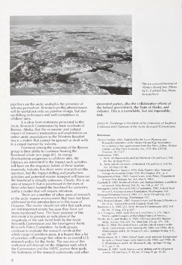
The ice-covered horizon of
Alaska's Bering Sea. (Photo
by G. Carleton Ray, Photo
Researchers)
pipelines on the arctic seabed is the presence of
sub-sea permafrost. Research on this phenomenonwill be useful not only on pipeline design, but also
on drilling techniques and well completion in
offshore sites.
It is clear from testimony presented to the
Arctic Research Commission by Inuit residents of
Barrow, Alaska, that the economic and cultural
impact of resource exploration and exploitation on
native arctic populations in the Western Beaufort
Sea is a matter that cannot be ignored or dealt with
in a casual manner by industry.
Foremost among the concerns of the Barrow
group is their ability to continue hunting the
Bowhead whale (see page 81). As energy
development progresses to offshore sites, the
Eskimos are interested in the impact such activities
will have on the migratory habits of these marine
mammals. Industry has done some research on this
question, but the impact drilling and productionactivities and potential marine transport will have onthe bowhead is virtually unknown. Clearly, this is an
area of research that is paramount in the eyes of
those who have hunted the bowhead for centuries,
and is a matter that will require attention.
There are a number of other areas of research
in the arctic marine environment that have not beenaddressed in this introduction or in this issue of
Oceanus. The reader should not infer that such areas
are not important simply because they have not
been mentioned here. The basic purpose of this
statement is to provide an indication of the
magnitude of the task faced both by the Arctic
Research Commission and the Interagency Arctic
Research Policy Committee. As both groupscontinue to evaluate the research needs in the
whole range of problem areas, it is hoped that a list
of priorities will emerge that relate to an overall U.S.
research policy for the Arctic. The success of this
endeavor will depend on the diligence with whichthe Commission and the IARPC pursue their goals,
the testimony of the research community and other
interested parties, plus the collaborative efforts of
the federal government, the State of Alaska, and
industry. This is a formidable, but not impossible,task.
lames H. Zumberge is President of the University of Southern
California and Chairman of the Arctic Research Commission.
References
Alaskan Update. 1985. Published by the Lease Planning and
Research Committee of the Alaska Oil and Gas Association.
Subscription is free upon request from Ray Piper, Editor, Alaskan
Update, c/o Ray Piper Company, Inc., P.O. Box 270718,
Houston, TX 77277.
Anonymous, 1985.
a. Arctic oil shipment headed for Montreal. Oil and Gas /., Vol.
83, No. 36 (Sept 9): 62.
b. Arctic islands oil arrives at Montreal. Oil and Gas /., Vol. 83,
No. 38 (Sept 23): 46.
Central Intelligence Agency. 1978. Polar Regions Atlas. National
Foreign Assessment Center, CIA, Washington, D.C., p. 4.
Department of State. 1983. United States Arctic Policy, Departmentof State Press Release No. 161, May 9, 1983.
Gambell, R. 1983. Bowhead whales and Alaskan Eskimos: a problemof survival. Polar Record, Vol. 21, No. 134, p. 467-73.
Interagency Arctic Research Policy Committee. 1985. Federal Arctic
Research, National Science Foundation, Washington, D.C.
National Petroleum Council. 1981. U.S. Arctic Oil and Gas, U.S.
Department of Energy, Washington, D.C.
Polar Research Board. 1985. National Issues and Research Priorities in
the Arctic. National Research Council, Wash. D.C.
Roederer, J. G. 1985. U.S. Arctic Research Commission. EOS, Vol.
66, No. 35 (Aug. 27): p. 617.
U. S. Congress. 1984. Arctic Research and Policy. S. 373, Title I,
Ninety-eighth Congress of the United States of America.
Weeks, W. F., and Weller, G. 1984. Offshore oil in the Alaskan
Arctic. Science, Vol. 225, No. 4660 (July 27): pp. 371 -378.
Weller, G. 1984. The United States and the role of science in the
Arctic. United States Arctic Interests the /980s and /990s, W. E.
Westermeyer and K. M. Shusterich, eds., Springer-Verlag, N.Y.,
pp. 158-177.
Westermeyer, W. E. 1984. United States arctic interests: background
for policy. United States Arctic Interests the 1980s and 1990s, W.
E. Westermeyer and K. M. Shusterich, eds., Springer-Verlag,
N.Y., pp. 1-18.
Williams, R. 1985. North America arctic drilling and development
activity. Oi/ and Gas /., V. 83, no. 31 (Aug 5): pp. 55-85.
8

by Oran R. Young
C^uietly, and almost unbeknownst to the
general public, the Arctic has emerged duringthe 1980s as a strategic arena of vital
significance to both of the superpowers. As
Nuclear-powered submarine USS Queenfish at the North
Pole. (Photo by Charles L Wright, courtesy of U.S. Navy)

EDITOR'S NOTE: This article is adapted with
permission from the Winter 1985-86 issue of
Foreign Policy magazine, published by the CarnegieEndowment for International Peace. It contains
added material not in the Foreign Policy article.
recently as 1981, political scientist Lincoln
Bloomfield of the Massachusetts Institute of
Technology could present a comparatively benignview of the Arctic, arguing that the region was free of
major international conflicts. Thus, he suggested, the
Arctic might make an attractive laboratory for certain
kinds of international cooperation. Today, however,the Arctic is rapidly becoming a focus for defense
and development issues that touch on the core
interests of each of the superpowers. Although this
change has intensified the need for cooperative
arrangements in the region, it has greatly
complicated this task as well.
Two trends are largely responsible for the
Arctic's dramatic transformation. Recent
developments in military technology are rapidly
turning the Arctic into one of the world's most active
and important areas of military operations; the Arctic
is no longer merely a frozen wasteland over whichballistic missiles would fly in wartime. The Far North
also is rapidly industrializing and therefore becomingcritically important to U.S. and Soviet security. And
The world is entering the age of
the Arctic, an era in which those
concerned with international
peace and security will urgentlyneed to know much more aboutthe region.
some planners are questioning the security of the
Arctic's key industrial installations for example, the
Prudhoe Bay oil complex and the trans-Alaska oil
pipeline rather than only thinking about the use of
the Arctic as a battlefield or site for military bases.
It is hardly an exaggeration to say that the
world is entering the age of the Arctic, an era in
which those concerned with international peace and
security will urgently need to know much moreabout the region. The Arctic has always possessed a
certain inherent strategic significance. It is hard to
ignore that the United States and the Soviet Unionare immediate neighbors in the Arctic (westernAlaska and eastern Siberia are only 57 miles apart at
the Bering Strait), that the shortest route betweenthe two superpowers is across the North Pole, andthat both superpowers front directly on the Arctic
Basin. (The Soviet Union alone controls about half of
the arctic littoral.) The Arctic's strategic significancestems in part from more specific factors like the
Greenland-lceland-United Kingdom (CIUK) Gap.This gap, consisting of the Denmark Strait and the
Norwegian Sea, represents the main outlet to the
open ocean for vessels of the Soviet Northern Fleet
based on the Kola Peninsula, and therefore is a front
line of NATO defenses.
Technology and Military Strategy
Technology has played a major role in the increasing
importance of the Arctic, too. With the increased
vulnerability of land-based missiles, submarine-
launched ballistic missiles (SLBMs) have loomed
larger and larger in superpower strategic calculations.
At the same time, recent improvements in the
capabilities of ballistic missile nuclear submarines
(SSBNs), as well as in SLBM range and accuracy,have enhanced dramatically the attractions of the
Arctic Ocean as a theater for seaborne strategic-
weapons deployment. Already, Soviet SS-N-8 andSS-N-18 missiles mounted on Delta-class submarines
can reach virtually every major military target in
North America and Western Europe without leavingarctic patrol stations. Similarly, American Trident
submarines carrying C-4 missiles can attack military
targets throughout the Soviet Union from arctic
waters.
The latest generations of SSBNs, the Soviet
Typhoon-class submarine and the American Ohio-class submarine, are even more effective. The
Typhoon is designed specifically for operations in
ice-covered waters, but any modern SSBN can
perform its mission in the Arctic Basin. There are
numerous points under the polar ice pack where all
modern submarines can break through to the surface
to fire their missiles. The ice pack is also frequently
interrupted by large stretches of open water. Thenewest SSBNs are or soon will be equipped with the
most advanced operational missiles, such as the 6-9-
warhead Soviet SS-N-20, the even newer SS-NX-23,and the American Trident II (also known as the D-5),
with 8-10 warheads (see Oceanus, Vol. 28, No. 2, for
an analysis of the Trident capability). These missiles
each have a range of more than 5,000 miles and are
nearly as accurate as land-based missiles. Further,
Arctic-based SSBNs are peculiarly difficult to detect,
much less to track closely. The ambient noise
generated by arctic ice reduces dramatically the
effectiveness of acoustic monitoring methods such
as sonar devices, while the opaqueness of the ice
prevents most visual monitoring.Moscow has moved vigorously to exploit
these military attractions of arctic waters. Well over
one-half of all Soviet SSBNs are stationed with the
Northern Fleet at Severomorsk on the Kola
Peninsula. These submarines actively roam the Arctic
Basin, constituting a virtually invulnerable strategic
force capable of launching increasingly accurate
missiles against Western targets without making anyeffort to evade NATO defenses along the GIUK Gapor even to leave their arctic haven. These vessels can
also travel between Severomorsk in the EuropeanArctic and Petropavlovsk Kamchatskiy in the
northern Pacific largely under cover of arctic ice.
The United States does not have an arctic
base comparable to Severomorsk. Yet American
missile submarines based in Bangor, Washington, are
fully capable of operating in arctic waters for
extended periods. The United States also is rapidly
expanding its fleet of Ohio-class submarines and is
fitting these vessels with Trident II missiles. Althoughthe details are classified, private conversations with
high-ranking Pentagon officials indicate that
10

American SSBNs are increasingly active in the Arctic
and that the United States is not far behind the
Soviet Union in this realm. As Soviet antisubmarine
warfare capabilities increase and American SSBNsseek the greater security of arctic waters, the Far
North is likely to become the world's most importantbase for seaborne strategic-delivery systems.
The region also provides new possibilities for
highly accurate air-launched cruise missiles (ALCMs).
Already, long-range sea-launched cruise missiles with
2,000-mile ranges are carried by submarines able to
prowl the Arctic. The potential for deploying long-
range ALCMs suitable for stand-off attacks initiated
from the Arctic is even more important. The UnitedStates already has equipped five squadrons of B-52Gbombers (that is, 98 aircraft) with a total of 1,150
long-range cruise missiles andplans
to add 600 moreALCMs to its inventory. Work is also proceeding onthe Advanced Cruise Missile, of which as many as
1,500 air-launched models may be deployed.Although somewhat behind the United States in this
field, the Soviet Union apparently is deploying long-
range ALCMs on Backfire and Bear-H bombers. Bythe end of the decade, each superpower is expectedto have a substantial force of long-range ALCMsmounted on the latest generations of high-endurance bombers, notably the 4,600-mile-rangeAmerican B-1 B and Moscow's 4,500-mile-range
Blackjack-A.Such ALCM deployment again puts the
military spotlight on the Arctic. The great circle route
across the North Pole remains the shortest pathwaybetween North America and the Soviet Union. Long-
range ALCMs launched from high-endurancebombers operating over the Arctic will be able to
reach virtually any important military target in NorthAmerica and Western Europe as well as the Soviet
Union. Both superpowers will thus be able to initiate
stand-off nuclear strikes against enemy targets from
comparatively safe launch sites. They may also beable to implement policies that can avoid or
minimize the political complications arising from
basing ground-launched cruise missiles on their
allies' soil. Additionally, the Arctic itself is an ideal
environment for cruise-missile-equipped bombers.Its vastness and sparse population permit militaryactivities to be carried out largely unnoticed. Arctic
ionospheric irregularities also can interfere with the
use of over-the-horizon-backscatter (OTH-B) radars
designed to track high-endurance bombers.Not surprisingly, these developments in
offensive systems have greatly heightened interest in
Arctic-based defenses. Conventional naval vessels
confront major difficulties in patrolling ice-filled
arctic waters. And the Arctic's pack ice and marginalice zones provide a shield for SSBNs from satellites
and aerial surveillance and from acoustic devices
stationed on the seabed. Only nuclear-poweredattack submarines seem up to the job, and despitethe great expense, both Washington and Moscowalready seem to be assigning many of these vessels
to monitor their missile-packed counterparts.ALCM deployment has already stimulated
renewed interest in arctic air defenses. In North
America, the 30-year-old DEW (Distant Early
Warning) line, which was allowed to become
obsolete, is now being modernized. The improvedversion, known as the North Warning System, will
include, upon completion in 1992, at least 52 sites
strung along the 70th parallel, equipped with both
microwave radars and OTH-B radars.
Two additional factors round out this pictureof the Arctic as a major strategic theater. Arctic skies
are filled with natural phenomena, such as the
aurora borealis and electromagnetic storms, that are
capable of jamming communications and defense
systems. These conditions can help protect Arctic-
based retaliatory forces like bomber-carried ALCMsor SLBMs. But atmospheric disturbances can also
interfere with cruise missile (but not ballistic missile)
guidance systems, as well as with communicationswith nuclear missile submarines. To the extent that
military use of the Arctic continues to grow, military
planners will have to redouble their efforts to solve
the region's unique communication, command, andcontrol problems.
Finally, the construction and protection of
vitally important industrial facilities have added yet
With U.S. and Soviet dependenceon secure supplies of energy andother arctic raw materials virtuallycertain to increase, efforts to
defend these industrial
installations undoubtedly will
expand as well.
another dimension to the militarization of the Arctic.
The Prudhoe Bay and Kuparuk oil fields on the
North Slope of Alaska, for example, currentlyaccount for approximately 19 percent of U.S. oil
production and 1 1 percent of U.S. oil consumption.Both the oil fields and the trans-Alaska pipeline
system used to move the oil to southern markets are
highly vulnerable targets, as are the burgeoningindustrial installations in Siberia. The Urengoy natural
gas field, slated to become a critical factor in the
Soviet energy equation, and the Soviet Siberian gas
pipeline, which runs 2,750 miles from northwestern
Siberia to the Czech border, would be obvious
targets in any effort to disrupt the Soviet economy.With U.S. and Soviet dependence on secure
supplies of energy and other arctic raw materials
virtually certain to increase, efforts to defend these
industrial installations undoubtedly will expand as
well.
Foreign Policy and the Arctic
Barring highly improbable achievements in the realm
of strategic defense, the Arctic's growing strategic
significance will hardly facilitate proposals to use the
region as a laboratory for superpower cooperation.The fact that the Arctic's significance is only nowbecoming fully apparent will greatly complicate armscontrol efforts. Both Moscow and Washingtonundoubtedly will want to explore the region's full
military potential before considering any restrictions
on strategic weapons and other hardware. Thus,
11

prospects currently are not bright for declaring the
Arctic a nuclear-free zone, as often urged by groupslike the Inuit Circumpolar Conference, a
transnational organization of indigenous arctic
peoples.The growing military role of the Arctic can
also only heighten sensibilities regarding
jurisdictional issues in the region. This is true of
peripheral disputes such as the U.S.-Canadian and
Soviet-Norwegian disagreements over the Beaufort
Sea and Barents Sea boundaries, respectively, as well
as of controversies directly involving the
superpowers, such as demarcating the maritime
boundary in the Chukchi Sea, which was left
unspecified in 1867, when the United States boughtAlaska from Russia. No one can rule out the
possibility of international cooperation amongvarious arctic rim states in specific functional areas
for example, environmental protection or scientific
research. But the region can no longer be seen as a
promising, Antarctica-like laboratory for superpowercollaboration by virtue of its remoteness and relative
insignificance.
What ultimately drives arctic
industrialization, however, is the
promise of secure access.
The militarization of the Arctic also carries
more specific political implications for each
superpower. The major U.S. concerns center onrelations with northern allies such as Canada,Denmark, Greenland, Iceland, and Norway, and
Washington is currently making a concerted effort to
accelerate arctic security cooperation. In early 1985,the United States and Iceland agreed to build twonew radar stations on the island to monitor Soviet
sea and air traffic in the Arctic. In addition, Americanofficials have worked hard to maintain Norway'scommitment, however ambivalent, to NATO, as well
as to establish good relations with the Home Rule
government in Greenland, the political systemestablished in 1979 in recognition of the island's
growing autonomy from Denmark. At the same time,the triumph of Canadian Prime Minister Brian
Mulroney's Progressive Conservative party in 1984has substantially helped U.S.-Canadian ventures. TheNorth Warning System is a fully cooperative venture,and the two countries collaborated on the NorthAmerican Air Defense Master Plan within the context
of the reorganized and expanded North American
Aerospace Defense Command (NORAD).Yet the Arctic's militarization may also greatly
increase friction between the United States and its
northern allies, especially Canada. Washington put
heavy pressure on Ottawa to accept the testing overnorthern Canada of ALCMs without nuclear
armaments, and former Prime Minister Pierre
Trudeau's eventual concurrence triggered an
outpouring of protest by the Canadian public.Canadian tempers are also flaring over the fact that
U.S. icebreakers and nuclear submarines are actively
plying the waters of the Canadian arctic archipelago,
including the waters of the Northwest Passage, the
sea route between Europe and the Far East. As partof its general unwillingness to acknowledgeCanadian sovereignty over these waters, Washingtondoes not seek explicit permission for transits bythese vessels. The recent voyage through the
Northwest Passage of the U.S. icebreaker Polar Sea
has motivated Canadian policymakers to consider
submitting Canada's claims to sovereignty in the
Arctic to the World Court. In addition, manyCanadians fear that the new U.S.-Canadian air-
defense system might commit Canada to accept the
stationing of U.S. weapons on Canadian territory.
More generally, influential Canadians often
fret about any prospect of increased American
military activity in the Arctic. Although eachindividual initiative may take the form of a
cooperative U.S.-Canadian venture, Canada lacks
the military capabilities to participate as an equal
partner in such arrangements.The Soviet Union borders on about half of the
Arctic Basin and is undoubtedly the Arctic's leading
power. Thus the Soviets can move confidently into
the age of the Arctic without any concern aboutrelations with northern allies. Objectively, the
expansion of Arctic Basin military operations as such
must reduce, from Moscow's vantage, the strategic
importance of the GIUK Gap. The Soviets are
reaching a point where they will not need to move
strategic-delivery vehicles through the passage in
order to hit European and North American targets.
At the same time, the Arctic's burgeoningmilitary-strategic importance will inevitably heightenSoviet sensitivities regarding regional jurisdictional
issues. Moscow will perceive increased incentives to
claim the Barents, Kara, Laptev, and East Siberian
Seas as internal waters or closed seas in order to
secure access to the central Arctic Basin for Soviet
submarines, to maximize cover for submarines in the
marginal ice zones along Siberia, and to protectindustrial installations along the northern coasts of
Siberia. The Soviets undoubtedly will do whatever
they can to promote the idea that the Arctic Basin is
fundamentally a Soviet lake.
Arctic Industrialization
The Arctic's natural wealth is immense and has
already given developers plenty of incentive, despite
high production and delivery costs stemming from
harsh natural conditions and huge distances. What
ultimately drives arctic industrialization, however, is
the promise of secure access. No price or supply
manipulations like those of the Organization of
Petroleum Exporting Countries (OPEC) are goingto disrupt supplies of arctic raw materials.
Industrialization not only adds greatly to the strategic
significance of the Arctic, but also contributes to the
region's militarization, as planners become moreconcerned about defending these facilities.
Although the image of a "great arctic energyrush" may be premature, the exploitation of
hydrocarbons has clearly fueled arctic
industrialization. Estimates suggest that the Arctic's
12

potentially recoverable reserves of crude oil rangebetween 100 and 200 billion barrels and that its
potentially recoverable natural gas deposits mayapproach 2,000 trillion cubic feet. By comparison,OPEC's proven reserves of crude oil approach 440billion barrels, while U.S. gas potential (excludingAlaska) is estimated at 492 trillion cubic feet of
natural gas.The Prudhoe Bay field on Alaska's North
Slope alone, discovered only in 1968, originally
contained an estimated 9-10 billion barrels of
recoverable oil and 26 trillion cubic feet of
recoverable natural gas. It is the largest single field
ever discovered in the United States. Today, 1.6-1.7
million barrels of oil are produced daily at Prudhoe
Bay and the adjoining Kuparuk field and are shippedto southern markets through the Alaska pipeline.Some estimates put additional recoverable reserves
of oil in the North American Arctic at 50 billion or
more barrels. The region's recoverable reserves of
natural gas amount to more than 300 trillion cubic
feet, though lack of a transportation system has so far
prevented commercial exploitation.While the oil reserves of the Soviet Arctic are
probably not as large as those of the North American
Arctic, western Siberia's natural gas reserves mayamount to 500 trillion cubic feet. The Urengoy field
alone has reserves of 212 trillion cubic feet;
production from this field was scheduled to reach 9
trillion cubic feet in 1985. The rapid development of
this gigantic gas field, combined with preparations to
extract natural gas from the lower Ob River basin,
undoubtedly explains much of the inaccuracy of
Western predictions during the late 1970s that the
Soviet Union would become a net energy importerin the 1980s.
The Arctic's energy potential is hardlyconfined to oil and natural gas. Northern Alaska's
coal reserves may approach 4 trillion tons equalingthe total of the entire lower 48 states. Some analystsbelieve that Siberia contains as much as 7 trillion
tons of coal.
Recently, the Far North also has become a
site for large-scale hydroelectric power production.In Canada's Quebec province, the James BayProject, initiated during the 1970s, has begun to
come on line. Phase 1 is designed to provide 10,300
megawatts of power, and phase 2 will add another
3,400-5,000 megawatts. By the year 2000, the
energy equivalent of 25 to 30 nuclear power plantswill flow southward from the project's generators.The political renaissance of Robert Bourassa, the
father of the James Bay Project, ensures that the
theme of "power from the North" will continue to be
politically potent in Canada for years. Powerful
interest groups are pressing to construct several
dams on the Watana-Devil Canyon segment of
Alaska's Susitna River to spur the industrialization of
the Anchorage-Fairbanks corridor, through whichthe state's main railroad runs. Many of the northern
rivers of Scandinavia have already been dammed to
generate hydroelectric power, and at least eight large
hydroelectric power stations are currently operatingin Siberia.
The nonfuel mineral reserves of the Arctic
constitute yet another stimulus for industrialization.
The iron ore deposits of Scandinavia and of the Kola
Peninsula in the Soviet Union have been mined for
some time. The lure of minerals like gold, copper,and tin has helped stimulate the Soviet drive to
industrialize central and eastern Siberia. Alaska's Red
Dog deposit, 180 miles north of Nome, contains an
estimated 85 million tons of ore, consisting of morethan 1 7 percent zinc, 5 percent lead, and 2.4 ouncesof silver per ton. This world-class lode has an in-the-
ground value of more than $1 1 billion at 1983 prices.
Not surprisingly, all of this industrial activity
has produced a dramatic expansion of northern
transportation systems. The Alaska pipeline,
constructed at a cost of $8-$9 billion in 1974 dollars,
carries approximately 1 .7 million barrels of oil daily
from Prudhoe Bay to Valdez, an ice-free port morethan 800 miles to the south. The Soviet Siberian gas
pipeline, an $18 billion project, is now becomingoperational. Today, governments, businesses, andcitizens in the north face the task of comparingrelative merits of alternative pipeline systems
designed to transport natural gas from northern
Alaska and the Canadian Arctic to southern markets.
The actual and potentialenvironmental hazards of
industrial development in the Far
North are severe.
Arctic waters may become another vital
transportation network. The Soviet Union is currentlyable to keep the Northern Sea Route, a commercial
artery stretching some 1,700 miles along the Soviet
Arctic coast, open up to 1 50 days a year with the aid
of the world's largest fleet of nuclear-powered ice-
breakers (see page 47). There is serious interest
among some oil companies in opening up all or partof the Northwest Passage to the shipping of natural
resources from the Arctic, despite intimidating
engineering challenges and environmental hazards.
The passage is also several thousand miles shorter
than alternative routes between Europe and Japan,
including the one through the Panama Canal. Yet
both pipelines and shipping are easily disrupted andtherefore worrisome to military planners.
Rapid industrialization inevitably generatesunintended side effects that give rise to major policy
issues, and arctic development is no exception. Theactual and potential environmental hazards of
industrial development in the Far North are severe,
partly because arctic development must generally
proceed on a mammoth scale to be commerciallyviable, and partly because certain key arctic
ecosystems are so fragile (see page 36).
Additionally, recent research has
demonstrated the importance of the Arctic to the
entire global physical system. As Lisle A. Rose, then a
polar affairs specialist for the State Department,wrote in the June 1982 issue of Arctic, the region's"'heat budget' created by the interaction of ocean,
sea ice, and atmosphere" is a major determinant of
climatic change. Thus consequences of arctic
industrialization could spread far beyond the pole.
During the 1970s, concerns expressed by
13

environmentalists led to major revisions in the
original plans for the Prudhoe Bay complex and the
Alaska pipeline system. Many more such battles
between industrial and environmental interests are
sure to be fought.In sharp contrast to the Antarctic, the Arctic is
a homeland as well as a frontier. Its indigenous
peoples have legitimate claims, rooted in rights of
use and occupancy, to large segments of the polar
region and its natural resources. Although most of
the Arctic is nominally included in the public
The native peoples of the Arctic
are few, but development is still
destined to generate a steadystream of controversies .
domains of the rim states, unresolved claims of
various indigenous groups cast a long shadow over
legal titles in the region and greatly concern potential
developers. The desire to extract the oil of Prudhoe
Bay undoubtedly spurred the passage in the United
States of the Alaska Native Claims Settlement Act of
1 971 . The central feature of this act is that it
extinguishes all remaining aboriginal claims to title in
Alaska in exchange for a land and cash settlement.
Similar deals may be necessary throughout the
Arctic.
But rapid industrialization also posesnumerous threats to the cultural integrity of
indigenous communities scattered throughout the
circumpolar north. Further, these peoples are
quickly grasping the importance of protecting their
cultures. Paradoxically, the industrialization processitself is giving them the wherewithal to resist threats
to their ways of life, and larger publics to the south
are beginning to take an interest in the welfare of
these peoples. The native peoples of the Arctic are
few, but arctic development is still destined to
generate a steady stream of controversies concerningtheir place in a world full of advanced industrial
societies.
Yet, while conflicts over the use of arctic
resources will become both more common andmore severe, neither the legislative nor the adversary
processes typically employed to settle disputes in
modern societies are well suited to handle such
problems. The relevant interest groups are anythingbut equal in terms of influence in legislative arenas,and adversary processes regularly bog down in
repetitious lawsuits that fail to settle the underlyingissues at stake. The creation of an Arctic Resources
Council might help in dealing with this problem. The
Council, a private-sector organization, would
promote the use of alternative techniques of dispute
resolution, such as mediation and problem solving,in settling Arctic resource conflicts.
Arctic industrialization also accentuates the
region's international character, partly because the
discovery of vital natural resources has intensified
jurisdictional conflicts. So long as the Arctic was a
distant region of interest only to a handful of
explorers, scientists, and native peoples, there was
no pressing reason to clarify fuzzy international
boundaries. Today, however, the delineation of the
mineral-rich geologic structures forming the Navarin
Basin in the central Bering Sea has heightened Soviet
and American sensitivities about demarcating the
Bering seabed. The discovery of hydrocarbons has
intensified the U.S.-Canadian disagreement
regarding their common maritime boundary in the
Beaufort Sea. A similar controversy has emergedbetween Norway and the Soviet Union in the
Barents Sea. The status of the continental shelf
surrounding the Svalbard archipelago has become a
contentious issue between Norway and several of
the other parties, including the Soviet Union, to the
Svalbard Convention of 1920, an international
agreement providing for open access to the islands'
natural resources while awarding sovereignty to
Norway.Yet powerful incentives for international
cooperation in certain functional areas have
emerged as well. Arctic haze and water pollutioncannot be controlled without a coordinated effort bythe arctic rim states. A compelling case can be madefor establishing cooperative regimes to deal with
arctic shipping and for protecting the Far North's
marine mammals. Crowing military concerns will
hamper attempts to include both the United States
and the Soviet Union in such arrangements. But
significant progress has been made recently onseveral fronts.
The protective regime for polar bears,
negotiated by Canada, Denmark, Norway, the Soviet
Union, and the United States in 1973, has workedwell and may be followed by similar arrangementsfor other migratory mammals, such as caribou, fairly
soon. The agreement providing for joint decision
making and coordinated monitoring for the Baffin
Bay-Davis Strait area, which Canada and Denmark/Greenland signed in 1983, constitutes an important
step toward handling responsibly the effects of
industrial development in the eastern segment of the
North American Arctic. Recently, prominent
Strategic stabilization and armscontrol issues must head anypolicy agenda.
Canadians and Americans from both the private and
the public sectors have suggested the creation of a
similar U.S.-Canadian regime for the Beaufort Sea
area. Moreover, in 1977, the indigenous peoples of
the Arctic formed the Inuit Circumpolar Conference,a transnational organization recognized formally bythe United Nations as a nongovernmental
organization and dedicated to a cooperative search
for arrangements to protect the region's natural and
social systems.
The Arctic Policy Agenda
Strategic stabilization and arms control issues must
head any arctic policy agenda. Is the region's
militarization strategically stabilizing, enhancing the
credibility of deterrence policies based on the idea
14

of mutual assured destruction? Or is this trend a
destabilizing factor, either because it extends the
strategic arms race into a largely unknown and
potentially volatile arena or because it adds to the
incentives of the superpowers to abandon existinglimitations on strategic-delivery vehicles? For reasons
outlined earlier, the establishment of an arctic
nuclear-free zone at this time will go nowhere. Yetmore modest arms control initiatives might work.Two examples are, first, a ban on permanentdeployment of nuclear weapons in the Arctic and onthe use of nuclear devices for nonmilitary purposesin the region, and second, limits or rules for testingcruise missiles or other strategic-delivery vehicles in
the Arctic, for minimizing the danger of incidents
involving nuclear submarines, and for restricting the
use of the Arctic for military exercises involving low-
flying combat aircraft. Arrangements along these
lines could prove mutually beneficial by limiting the
region's militarization or by stabilizing the arctic
military balance without interfering with either
superpower's strategic freedom of action.
Almost equally important is developing a set
of industrial policies for the Arctic. Specifically, are
the national interests of the western arctic states in
the resources of this region so great that political
rather than commercial considerations should largely
govern their development? Should governments rush
to develop arctic energy resources, or should they
keep these resources in reserve while moreconvenient supplies are exploited and moreadvanced technologies to deal with arctic conditions
are perfected? Should the American and Canadian
governments directly or indirectly subsidize the
construction of arctic industrial facilities for
example, the proposed Arctic Natural Gas
Transportation System where such projects are
politically desirable but commercially risky? Should
Washington continue to ban nearly all exports of
Alaskan crude oil to Japan and other foreignconsumers? What would constitute a proper balancebetween arctic industrialization and the protection of
key arctic ecosystems? Are the indigenous peoples of
the Arctic entitled to a major voice in decisions
concerning the region's industrialization?
A third range of arctic policy issues arises from
linkages between militarization and industrialization.
Does the emergence of the Arctic as a major militarytheater make it more or less attractive to resource
developers? Will the regular use of the Northwest
Passage by nuclear-powered submarines affect plansto use the waterway as a commercial shipping route?
Will the efforts of military planners to solve arctic
transportation and communication problems yieldvaluable nonmilitary spin-offs? Conversely, is the
growing militarization of the Arctic likely to interfere
with research needed to make arctic industrial
operations both feasible and efficient? Clearly, the
Far North's militarization and industrialization are
closely related and need to be carefully coordinated.
Tradeoffs are inevitable.
Two broader sets of concerns should figure
prominently in discussion of these arctic policyissues. First, the Arctic, unlike most of the rest of the
world's land, is owned outright by governments. Andits marine areas are subject to their exclusive
authority. The military use of this sparsely populated
region is obviously subject to the control of public-sector decision makers. Moreover, the Arctic's
natural resources are ultimately more significant in
political terms than because of their commercialattractions. The governments of several arctic rim
states also acknowledge an obligation to protect the
welfare of indigenous peoples, as well as a broad
public interest in safeguarding the Far North's
principal ecosystems. Thus, the future of the Arctic
will be shaped far more by public policies than bythe free play of market forces or other private-sectorconsiderations. Additionally, international
cooperation in handling environmental issues and
managing increasingly complex transportation
systems must be important arctic policy priorities.
Second, both the Soviet Union and the
United States badly need a group of more broadlytrained arctic experts. The Soviet Union has longbeen recognized as a world leader in arctic science,
especially in atmospheric sciences, physical
oceanography, glaciology, and arctic engineering.Moscow's leading agency is the Arctic and Antarctic
Scientific Research Institute. Overall, more than
20,000 Soviet scientists are thought to engage in
some form of arctic research. In 1984, the Soviet
Union and Canada agreed to promote arctic
The Arctic's natural resources are
ultimately more significant in
political terms than because of
their commercial attractions.
scientific cooperation and exchanges. There is,
unfortunately, no comparable U.S.-Soviet
agreement, though cooperation sometimes occurs
on specific projects.The American effort to foster arctic scientific
research is more fragmented but nonetheless
substantial. Despite a definite bias toward the
Antarctic, both the Division of Polar Programs of the
National Science Foundation (NSF) and the Polar
Research Board of the National Academy of
Sciences regularly sponsor arctic research in the
physical sciences. The Arctic Science Program of the
Pentagon's Office of Naval Research funds arctic
research of potential interest to military planners.The Outer Continental Shelf Environmental
Assessment Program, administered by the National
Oceanic and Atmospheric Administration, and
Congress's Office of Technology Assessment are
researching hydrocarbon development in the Arctic.
These governmental initiatives have also resulted in
the establishment of several university-based centers
to conduct arctic research in the natural sciences
notably, the Geophysical Institute at the Universityof Alaska at Fairbanks, the Institute of Arctic and
Alpine Research at the University of Colorado, andthe Institute of Polar Studies at Ohio State
University.The Arctic Research and Policy Act of 1984
15

established two new federal entities to coordinate
arctic research: the five-member Arctic Research
Commission (ARC), composed of private citizens
appointed by the president, and the InteragencyArctic Research Policy Committee, chaired by the
NSF representative. Despite some promising
initiatives, it remains to be seen whether these
changes will greatly improve U.S. performance in
arctic science.
At the same time, Moscow and Washingtonhave done nothing to address their growing need for
more broadly based arctic experts. The United
States, for example, has no established programsuitable for those desiring a systematic
The federal government and the
State of Alaska have repeatedlyfound themselves on oppositesides of litigation over offshore oil
and gas development and wildlife
management in the Arctic.
understanding of arctic issues. The Division of Polar
Programs funds no research at all on arctic military,
political, and socioeconomic developments. Nomore than a handful of American scholars take an
active interest in the political economy of arctic
Alaska or in Greenland's politics. And practically no
one closely follows major events in the Soviet Arctic.
The absence of a group of Soviet experts in
these fields may well stem from general ideological
limitations on the work of Soviet social scientists.
Moreover, social research on the Soviet North would
probably bring out embarrassing information
regarding the treatment of political exiles and the
administration of indigenous peoples. The lack of
American arctic expertise probably results from the
widespread tendency to dismiss the region as a
remote, unimportant wasteland. But this view is now
dangerously outdated.
Major policymaking improvements are
required as well. The Soviet Union, for example,
clearly has problems handling arctic affairs in a
coordinated fashion, as indicated by the engineeringfailures afflicting construction of the Siberian gas
pipeline and the near loss of dozens of ships to the
Arctic ice during late summer and fall 1983.
Recent U.S. Initiatives
Room for improvement exists in Washington, too.
The basic mechanism for handling arctic policyissues in the United States is the Interagency Arctic
Policy Group (IAPG), established under the
provisions of National Security Decision
Memorandum 144 of 1971 and reaffirmed under the
terms of National Security Decision Directive 90 of
1983. The IAPG is responsible for developing and
overseeing the implementation of American arctic
policy as well as for coordinating American arctic
activities and programs. Chaired by a representativeof the Department of State (usually the assistant
secretary for Oceans and International
Environmental and Scientific Affairs), the groupincludes representatives from a number of agenciesbut ultimately reports to the National SecurityCouncil in the Executive Office of the President.
Unfortunately, this mechanism has severe
limitations as an arrangement for handling arctic
policy issues. The IAPG has experienced frequent
periods of dormancy (it seldom met during the Ford
and Carter Administrations), failing to meet evenwhen major arctic policy issues have surfaced. Moreoften than not, the group has become active onlywhen its members have perceived some threat to
their turf, such as the newly created Arctic Research
Commission. Member agencies whose concerns are
primarily domestic are suspicious of the role of the
State Department as lead agency in the IAPG andare reluctant to accept the group as an authoritative
forum for reconciling arctic conflicts.
To illustrate, the Department of the Interior
and the Commerce Department do not accept the
comparatively conciliatory views of the State
Department regarding issues like jurisdiction over
the Navarin Basin in the central Bering Sea and the
regulation of foreign fishing vessels throughout the
Bering Sea. The IAPG also has failed to establish anyeffective procedure for coordinating federal andstate concerns regarding arctic issues. As a result, the
federal government and the State of Alaska have
repeatedly found themselves on opposite sides of
litigation over offshore oil and gas development and
wildlife management in the Arctic.
Even less effort has gone into devising a
suitable method for integrating the legitimateconcerns of the native peoples of the Arctic into the
policymaking process. The result is that native
organizations and the federal government confront
each other in court again and again in cases relating
There are no established
procedures for regular, high-levelconsultations between the United
States and its northern allies or
neighbors regarding newlyemerging arctic issues.
to the socioeconomic impacts of oil and gas
development, the use of arctic animals for
subsistence purposes, and native claims to marine
areas in the Arctic, despite the acknowledgedobligation of the federal government to protect the
welfare of native peoples.
Additionally, there are no established
procedures for regular, high-level consultations
between the United States and its northern allies or
neighbors regarding newly emerging arctic issues.
Adding to all these problems is the fact that
little has been done to provide the IAPG with a
sophisticated conception of the Arctic as a well-
defined and distinctive region of the world.
Consequently, American policymaking for the Arctic
16

A Soviet arctic research station. (Photo courtesy of Novosti)
does not flow from any profound understanding of
the interactions among the physical, biological, and
human systems of the region.It is not surprising, therefore, that Congress
often ignores the existence of the IAPG in its
dealings with the Arctic. The Arctic Research and
Policy Act of 1984, which purports to establish a
comprehensive policy dealing with national research
needs and objectives in the Arctic, makes noreference to the IAPG. As a result, the relationshipbetween the Arctic Research Commission and the
IAPG is unclear, and friction between the two
organizations has already emerged. Understandable
though this may be, it is hardly a sign of the
existence of an effective policymaking apparatus for
arctic issues.
It is tempting to look to the Arctic Research
and Policy Act for a new approach to arctic
policymaking. Whatever its role in providing a
stimulus for arctic science, however, the act has little
to offer as a basis for formulating arctic policy more
generally. The principles it sets forth pertain only to
arctic research policy, and the organizations it
establishes (that is, the Arctic Research Commissionand the Interagency Arctic Research Policy
Committee) have mandates extending only to arctic
science. The provisions of the act do nothing to
replace or even to limit the authority of the IAPG. As
the preceding discussion suggests, moreover, the act
fails to address the problem of coordinating the work
of the Commission and the Research Policy
Committee with the activities of the IAPG, an entity
which retains its original mandate to oversee
American arctic activities and programs. What this
suggests is the need for a high-level Council onArctic Policy created by an act of Congress, located
in the Executive Office of the President, and chaired
by a distinguished person appointed specially to fill
this role. It is time for U.S. arctic policy to come out
of the deep freeze.
Oran R. Young, a political scientist, is Director of the Center
for Northern Studies in Wolcott, Vermont.
Recommended Reading
Bloomfield, Lincoln P. 1981. The Arctic: last unmanaged frontier, In
Foreign Affairs, Vol. 60, 87-105.
Bourassa, Robert. 1985. Power from the North, Scarborough:
Prentice-Hall Canada.
Critchley, W. Harriet. 1984. Polar deployment of Soviet submarines,
In International lournal, Vol. 39, 828-865.
Purver, Ron. 1984. Security and arms control at the poles,
International lournal, Vol. 39, 888-910.
Rose, Lisle A. 1982. Recent trends in U.S. arctic affairs, In Arctic, Vol.
35,241-242.
Theutenberg, Bo Johnson. 1984. The Evolution of the Law of the Sea,
Dublin: Tycooly International Publishing. 26.
Westermeyer, William E., and Kurt M. Shushterich eds. 1984. United
States Arctic Interests: The 1 980s and 1 990s. New York: Springer-
Verlag.
Wren, Christopher S. 1985. Weinberger remark adds fuel to Canada
debate, In The New York Times. 19 March 1985, A12.
17

Glaciology
A Primer On Ice
by Norbert Untersteiner
/\ quick glance at a satellite photo of the Arctic
Ocean reveals its most distinguishing feature ice.
In the central Arctic, ice forming on open water in
the fall may be 2 meters thick by the following
spring, and may not melt during the summer. Sea
ice is a composite of pure ice, brine pockets, and
gas bubbles. Varying in extent seasonally, this ice
cover affects arctic climate, ocean circulation, andmarine biology, and also impacts virtually everyhuman use of the region. Understanding the
properties of this unique ocean surface is therefore
of utmost importance.
Ice Formation and Physics
When sea ice begins to form, it is a loosely boundmixture of small plates and spine-like crystals; this
stage is called frazil ice. Each crystal is virtually
pure ice, as the crystal structure accommodates
very few atoms other than hydrogen and oxygen.
Thus, as seawater freezes, the dissolved solids are
excluded from the ice crystals and enrich the
concentration of the remaining brine. As the frazil
ice becomes more densely packed, some brine is
trapped within the ice. If freezing continues, the
advancing bottom surface of the ice attains a
deeply corrugated pattern. Occasionally these
corrugations are closed off by ice crystals, thus
trapping small pockets of brine within the ice.
Gases dissolved in the seawater (roughly equivalentto air in composition) are also excluded from the
ice crystals, and form bubbles within the ice.
Many of the fascinating and peculiar
properties of sea ice depend on this compositestructure. For example, thermodynamic principles
In picture above, new thin ice is growing where two old
ice floes have separated. (Photo courtesy of author)
18

dictate that the freezing point of salty water
decreases as the salt concentration increases. This
principle is employed by public works departmentsacross the country each time it snows. In normal
seawater, salt concentrations are about 35 parts per
thousand, and the freezing point of the mixture is
1.9 degrees Celsius.
Thermodynamics also dictates that at any
given ambient temperature, brine must be at its
freezing point when in contact with ice. For brine
pockets trapped within sea ice, this means that
either additional freezing or melting will occur as
temperatures change. For example, if the
temperature drops, ice forms on the walls of the
brine pockets, making them smaller and increasing
the concentration of the enclosed brine. If the
temperature rises, the salty brine will begin to
dissolve the surrounding ice, thus diluting itself.
The amount of heat added, or taken from, a
volume of sea ice when it changes temperatureconsists of two parts: one to change the actual
temperature of ice and brine, and the other to
accomplish the change-of-phase (freezing or
thawing) within the brine pockets. Per unit volume,the latter is about 150 times greater than the
former.
Thus, the warming of sea ice is accompaniedby an expansion of brine pockets; the warmer a
piece of sea ice gets, the larger the fraction of its
volume that is occupied by brine. When a sheet of
fresh water ice melts, it thins until it disappears. Sea
ice, however, simply becomes more and more
1 mm
Frazil ice, showing spine-like crystals. (From Weeks and
Ackley, 1 982. The growth, structure, and properties of sea
ice. CREEL Monograph No. 82-1)
THIN SECTIONHorizotal Vertical
Brine DrainageChannels
The thin sections, progressingfrom surface to bottom, showhow the crystals are small
where they grow rapidly and
grow larger where the growthrate decreases. The bottom
right frame shows the deeply
corrugated water/ice interface.
(After Schwarz and Weeks.
1977. Engineering propertiesof sea ice. Journal of
Glaciology. 19:499-530.)
SnowInfiltratedSnow IceInitial Skim
TransitionZone
ColumnarZone
Skeleton
t LayerTI cm
/Water
19

,
Two converging ice floes have crumbled at their edges and have formed a pressure ridge about 1 to 4 meters high. An ice
camp is visible in the background. (Photo courtesy of the author)
porous, until it disintegrates into a mass of
individual ice crystals.
This interaction between brine pockets andice crystals has many implications:
A thick layer of sea ice will disintegrate first at the
surface, where heating is most intense. The resulting
loose, granular surface layer has many reflecting
surfaces, which reflect more sunlight than would a solid
layer of ice. This retards the melting of the rest of the
ice.
When sea ice becomes porous enough that brine
pockets become interconnected (as may happen each
summer), the nearly pure water generated by melting of
ice crystals at the surface will tend to flush the brine
from deeper layers. This mechanism probably accountsfor the observation that the older the ice, the lower the
salinity.
When a sheet of sea ice is warm and a large fraction of
its volume is brine, it will take longer to cool than a
comparable sheet of fresh water ice, because of the
large amount of heat given off as the brine pockets cooland refreeze. This heat must be released to the
surrounding environment for instance, by infrared
radiation loss at the surface before rapid cooling of
the whole ice sheet can occur.
The variation in the volume of brine within sea ice
affects the thermal conductivity of the ice, its strengthand other mechanical properties, and its radiative
properties important for remote sensing efforts. Theradiative properties will affect the radiation received bya sensor in space or on an aircraft, and hence must beconsidered in interpreting such remote sensing data in
terms of the physical condition of the ice (temperature,thickness, roughness, etc.).
Unlike the brine pockets, the gas bubbles in
the ice do not change much over time or withvariations in temperature. They do, however, act as
internal reflecting surfaces, and as such affect the
way in which the ice scatters and absorbs radiation.
Growth, Melting, and RegrowthOn open water in the central Arctic, ice begins to
form at the end of summer (early September). By-the following spring the ice cover may be twometers thick. About 30 to 40 centimeters of snowwill fall on top of the ice during the autumn, until
the air becomes so cold that it cannot carry
significant amounts of moisture and precipitation
nearly ceases. As temperatures rise during May andJune, another 5 to 10 centimeters of snow fall.
Melting commences in late May or early
June, and will typically remove the entire snowcover and an average of 40 centimeters of ice.
After the snow has melted, many shallow pondsform on the surface of the ice sheet. As the
summer progresses they become smaller and
deeper, the ponds reflect less solar radiation than
the surrounding ice, and so tend to become"windows" for heating the ice and even the
seawater beneath it.
In mid-September, freeze-up begins. As the
ice cools, the ponds solidify, and when the entire
ice sheet has solidified, new ice begins to accrete
onto the bottom of the sheet. Under today'sclimatic conditions, more ice forms during the
second winter than was removed by melting and
evaporation during the previous summer. Hence,the ice sheet tends to thicken. This thickening
20

progresses most rapidly during the first years of the
ice sheet's existence, and tapers off later, because
of another phenomenon: as the ice thickens, it
takes longer to cool in the fall, and hence ice
accretion begins later and progresses more slowly
during the fall and winter.
Thus the ice sheet approaches an
equilibrium thickness, at which summer melting
equals winter accretion. Except for cyclical seasonal
changes, the ice has reached a steady state, with
the oldest ice at the surface, new ice forming at the
bottom, and a flux of ice in the upward direction
because the oldest ice melts off each summer.The equilibrium thickness is controlled by
the exchange of heat between atmosphere, ice,
and ocean. In the Arctic Basin, this equilibriumthickness is between 3 and 4 meters. The physics
of this interaction is well understood, and can be
simulated by thermodynamic models. Such models
also are of some use in extrapolating growth and
melt rates that may have prevailed under different
climatic conditions.
Unfortunately, the picture just presented is
like a black-and-white snapshot of a colorful
scene part of the true situation is missing: exceptin protected bays and fjords, the undisturbed
growth of ice described previously never occurs.
Winds and currents crack, break up, warp, and
otherwise disturb the ice; and even small changesin climatic conditions can drastically alter the
distribution of the ice in arctic regions.
Ice Distribution
Sea ice is but a thin skin of frozen water covering
the polar oceans. Being thin, it represents a minute
fraction of the total amount of heat gained and lost
by the Earth's surface in the course of a year;
consequently, it is not surprising that the presenceor absence of sea ice can be brought about by very
small changes in the global heat exchange. In this
context, it is useful to recall that the arctic sea ice
cover at its maximum extent has an area 40 times
greater than that of all the mountain glaciers in the
world (excluding the ice sheets of Antarctica and
Greenland), but its volume is five times smaller.
This large surface-to-volume ratio results in a rapid
response to climatic changes (see page 41).
The distribution of land and ocean in the
Arctic controls sea ice distribution. At the end of
summer (August) the sea ice cover recedes to the
Arctic Basin proper, leaving wide bands either of
open water or of water with low ice concentration
along the coasts of Eurasia and Alaska. At the time
of maximum extent in March, the ice nearly
doubles its extent and covers all the arctic marginal
seas (15 million square kilometers or 10 percent of
the Northern Hemisphere's ocean surface).
Especially in the Atlantic sector, the distribution
shows a strong zonal asymmetry. To the east, the
ice is restricted to the Barents Sea at about 75
degrees North by the warm waters of the Gulf
Stream, while in the west, ice regularly appears in
the Gulf of St. Lawrence at 45 degrees North, a
Map at right depicts the
extent of the Arctic ice cover.
USUALLY BECOMES ICE FREEFOR SEVERAL MONTHS
21

latitude corresponding to that of Venice and the
swimming beaches of the northern Adriatic.
The tongue of sea ice reaching south into
the Greenland Sea is a prominent feature
throughout the year. Only about half that ice is of
local origin. The other half is carried into the
Greenland Sea by the East Greenland Current. This
ice constitutes a large fraction of the seasonal ice
production of the Arctic Basin; the exact fraction,
however, is not known.
Ice Movement
Even in the central Arctic, sea ice is always moving,driven by winds and ocean currents. These two
phenomena take place in the continuous and well-
mixed media of the atmosphere and ocean, and
hence variations in their characteristics may take
place on scales of hundreds or thousands of
kilometers; even oceanic or atmospheric "fronts"
typically measure kilometers across. Sea ice,
however, is not a continuum, but an ensemble of
rigid pieces that crack, shift, and ridge, or raft, in
discrete, localized events. Thus, forces acting over
hundreds or thousands of kilometers produce ice
effects on scales measured in meters. The crucial
mechanical failures may take place on an even
smaller scale.
By geophysical standards, a large body of
knowledge exists about the characteristics of sea
ice as a function of temperature, salinity, and
crystallographic structure. This knowledge is
regularly used in such engineering endeavors as
calculating the ice resistance encountered by ships
or designing oil drilling platforms for ice-covered
waters. But no method has yet been found to
relate this knowledge of the large-scale response of
an ensemble of sea ice pieces to small-scale ice
mechanics.
Such difficulties have not deterred scientists
from devising theories of ice dynamics; these haveinvolved some law that relates stress and strain in
ice and so can describe the cumulative effect of a
multitude of small-scale events caused by large-scale phenomena (such as winds and currents).
Thus, the ice has been described as isotropic
viscous, anisotropic viscous, incompressible,
plastic, elastic-plastic, and viscous-plastic. Somemodels based on one of these various assumptionshave met with considerable success; meaning that,
to the limited extent that we know the forces
affecting sea ice, an ice velocity field can be
computed that bears strong resemblance to the
observed one (see diagram below). But finding anice rheology that "works" is not synonymous with
understanding it; the mechanics involved in ice
deformation remain a challenging and difficult
problem.
The Marginal Ice Zone
Nowhere are ice dynamics more complex than in
the marginal ice zone (MIZ) (see page 66). This
region extends from the ice/open water boundaryabout 100 kilometers into the ice and 100kilometers out over the ocean. In most areas, the
MIZ moves seasonally, in the extreme case bymore than 2,000 kilometers; in other areas, it is
essentially stationary. But everywhere the zone is
characterized by a complex and rapidly changinginterplay between atmosphere, ice, and ocean on a
multitude of temporal and spatial scales. ImportantMIZ phenomena include ocean fronts and eddies,
rapid local changes of the surface roughness of
both ice and ocean (and therefore of wind andwater stress on the ice), vertical movement in the
ocean, local winds and atmospheric circulation
/Average ice drift velocity in
the Arctic Basin, as observed
during several years byautomatic buoys. The long-
term average ice drift is 1 to 2
kilometers a day. On any
given single day, the ice
travels typically 6 to 8
kilometers. (From Colony and
Jhorndike, 1984)
22

Table 1. Automated observations of sea-ice conditions by satellites and data buoys.
Parameter Current Frequency of Observation Status
Ice extent
Ice concentration
Ice drift
Ceostrophic wind
Air temperatureIce temperatureIce thickness
Ocean mixed-layer temperatureOcean mixed-layer salinity
Vertical flux of heat
Daily
Daily
Several times daily
Daily, several times daily possible
Several times daily
Daily
Experimental
Daily
Experimental
Experimental
Reliable
Some problems with satellite image interpretation
remain
Reliable
Reliable
Reliable, except in summer
Reliable, but few applications yet
Potentially reliable
Reliable, but few applications yet
Sensors need improvementUnder development
patterns caused by strong surface temperature
gradients, deep ocean convection caused by sea
ice formation, differential ice drift depending onfloe size, and ice break-up by waves and swells
from the open ocean.Because of this complex interaction between
ice, atmosphere, and ocean, the MIZ is extremelysensitive to small changes in temperature, winds,and other climatic phenomena. While there is no
question that trends of climatic change must have
produced changes in the ice cover of the Arctic
Basin, such changes have not been conclusivelydocumented. But large and systematic changeshave been recorded in the MIZ, expecially in the
Greenland Sea. Partially, such changes are well-
documented because the MIZ has long been of
commercial maritime interest, but even more
importantly, the MIZ is more sensitive than other
sea ice regions to climatic change. There is little
doubt that understanding air/sea/ice interaction in
the marginal ice zone will be the key to
understanding the interplay between global climate
and sea ice.
Keeping Watch Over Ice
Further understanding of sea-ice dynamics will
depend on improved observations of the ice. Mostof our present knowledge about the properties of
sea ice and its interactions with the atmosphereand ocean is derived from observations taken from
ships and drifting ice stations. While these havebeen extremely useful, they lack the synoptic viewover large areas necessary for understanding both
the large-scale interplay between the atmosphereand ocean in high latitudes, and the behavior of
sea ice as the intervening medium.Since the early 1970s, satellites have
routinely provided pictures of global sea ice cover
(see page 59). This breakthrough was followed bythe successful use of automatic data buoys, a
technology that grew out of and depended on the
development of satellite navigation and data
transmission devices, and microelectronic
techniques for storing, preprocessing, and
transmitting the data obtained by on-site sensors.
Thus more and more data is being gathered byautomatic sensors in the Arctic and satellites in
space. Ships and ice camps are still required for
many kinds of specialized observations, but duringthe last decade the acquisition of the basic data has
become roughly an order of magnitude less costly,
and roughly an order of magnitude more data are
now being collected. The most important data andthe state of the art in their collection are shown in
Table 1.
These observations, combined with
information from specialized research projects will
increase our understanding of arctic sea ice an
understanding vital to a multitude of national
concerns about the Arctic.
Norbert Untersteiner is Professor of Atmospheric Sciences
and Geophysics at the University of Washington, and also
Scientific Director of the Polar Science Center there.
Suggested Readings
Colony, R., and A. S. Thorndike. 1984. An estimate of the meanfield of arctic sea ice motion. /. Geophys. Res., 89-C: 10623-10629.
Dornonin, Yu. P., and D. E. Kheisin. 1975. Morskoi Led.
Gidrometeoizdat, Leningrad. English translation by AmerindPubl. Co., New Delhi. Washington, D.C.: National Science
Foundation.
Gierloff-Emden, C. H. 1982. Das Eis des Meeres. Berlin and NewYork: Walter de Cruyter.
Hibler, W. D. 1980. Sea ice growth, drift, and decay. In Dynamicsof Snow and Ice Masses. S. C. Colbeck, ed. New York:
Academic Press, p. 141-209.
Pritchard, R. S., ed. 1980. Sea Ice Processes and Models. Seattle
and London: University of Washington Press.
Untersteiner, N. 1964. Calculations of temperature and heat
budget of sea ice in the Central Arctic. /. Geophys. Res., 69:
4755-4766.
Weeks, W. F., and S. F. Ackley. 1982. The growth, structure, and
properties of sea ice. Hanover, N.H.: U.S. Army CREEL,
Monograph No. 82-1.
Zakrzewski, W. 1983. Lody na morzach. Gdansk, Poland:
Wydawnictwo Morski.
Zubov, N. N. 1943. L'dy Arktiki. Moskva: Izdatel'stvo
Glavsevmorputi. Translation by U.S. Navy OceanographicOffice and American Meteorologic Society, U.S. NavyElectronics Laboratory, San Diego.
23

Sea Ice
and
OceanographicConditions by Thomas Newbury
I he coastal waters of the Beaufort Sea are lockedunder ice for three-fourths of the year. Historically,
only Alaskan natives, whalers, and occasional
explorers ventured out onto the surface of the ice orfound much of value in the chilling waters beneath;and so these waters remained unknown, at least in
winter. During the last three decades, the Naval
24

ELSON LAGOON
HARRISON BAY
SIMPSON LAGOON
STKFANSSON SOUND CAMDEN BAY
PR UDHOE BA Y
NAVAGAPAK LAGOON
- -- ^ .,.-* -" *
DEMARCATION
" - . ' _ -*<=- '
"'
a .' ,,^
Scale 1:5,000,000
Above, landfast ice (slightly darker shading) along the Alaskan
portion of the Beaufort Sea coast. Right, bottomfast ice is
found in less than 2 meters of water, floating landfast ice in 2
to 15 meters of water, and grounded and mobile pack ice in
deeper water. (Right-hand diagram adapted from U.S. ArmyCold Regions Research and Engineering Laboratory)
Petroleum Reserve in Alaska* was explored, oil wasdiscovered near Prudhoe Bay, and then exploration
began in earnest offshore in the U.S. and Canadian
portions of the Beaufort Sea. The coast of the
Beaufort Sea rapidly became the focus of
international research, and the need for continuedresearch prompted the recent passage of the Arctic
Research and Policy Act (see page 2). Private
industries and government agencies have begunexploratory research on this unknown marine realm,
attempting to understand the severe conditions that
continually challenge those involved in year-roundoil exploration and extraction.
Oceanographers have begun to examine the
coastal waters of the Beaufort Sea during winter. The
* A large area on the Alaskan North Slope originally set
aside to provide petroleum for Navy operations in the
event of war.
BOTTOM- FLOATINGFAST ICE LANDFAST ICE GROUNDED ICE ZONE
research has focused on the shallow bays andcoastal lagoons where oil drilling appears to be most
practicable.
Consolidation of Coastal Ice
Freeze-up initiates the changes that each fall turn the
coastal waters of the Beaufort Sea from a typical
(albeit cold) marine environment to a realm of
unique phenomena. Freeze-up begins when the
dense, broken layer of ice that forms in the fall starts
to solidify, and can take several months. The exact
timing of freeze-up is difficult to predict. Don
Ljungblad of the Naval Ocean Systems Center, whohas flown almost daily along the Alaskan coast
observing the fall bowhead whale migration throughthe area, reports that the ice cover generallysolidifies by mid-October, but sometimes solidifies
as early as September. Some years it may remain
broken until December. The timing of freeze-up has
25

dramatic effects on industrial operations and mayhave large climatic effects as well. Formation of an
unbroken ice sheet signals that winter has
consolidated its hold.
During freeze-up, a long thin band of ice
begins to fringe the Beaufort Sea, adhering to the
frozen shore. Along the 600-kilometer Alaskan
border of the Beaufort, the "landfast" ice ranges in
width from only 15 kilometers near Barrow and
Kaktovik to 60 kilometers near Harrison Bay. The
zone of landfast ice is wedged between the shore
and the multi-year pack ice that forms a permanent,
rotating mantle on the outer Beaufort Sea and Arctic
Ocean. On the outer edge of the landfast ice-
generally in 15-20 meters of water huge chunks of
ice are upended and jammed against the sea bottom
by movements of the pack ice. This grounded ice
zone, or stamukhi zone, stabilizes and protects the
outer edge of the relatively thin, flat landfast ice from
grinding by the pack ice. Adjacent to shore, landfast
ice freezes solid from the surface to the bottom. This
"bottomfast" landfast ice marks the inner edge of the
zone of floating landfast ice. Underneath the floating
landfast ice is a long ribbon of water, more or less
isolated from the waters under the pack ice.
A Ribbon of Under-lee Water
The water under the landfast ice undergoes a variety
of changes during freeze-up. To begin with, water
trapped beneath the landfast ice grows gradually
more saline. Dissolved salts are excluded from the
seawater during the freezing process (see page 18)
and become increasingly concentrated in the
underlying unfrozen seawater. In Stefansson Sound,
for example, salinity was at 32 parts per thousand in
November (equivalent to the salinity of open water
in the Beaufort Sea) and had a freezing point of -1 .7
degrees Celsius, as calculated by Brian Matthews
from the University of Alaska; by December, whenanother 30 centimeters of ice had formed, the
salinity had risen to 33.2 parts per thousand and the
freezing point had dropped to -1.85 degreesCelsius.
Changes in under-ice salinities and
temperature during freeze-up lead to two
particularly interesting phenomena: development of
frazil ice and formation of stalactites. The frigid
temperatures of the under-ice water cause ice
crystals to form on objects in the water column;these crystals are known as frazil ice. On several
occasions, ice crystals that had formed on current
meter blades stopped the meters; once, ice crystals
on a current meter tripod created sufficient
buoyancy to lift the tripod 2 meters off the seafloor
and tip it over, ice crystals accumulating on particles
of sediment on the ocean floor provide a mechanism
by which the particles may float up and become
incorporated into the overriding ice cover.
Stalactites form where very cold dense brines,
excluded during freezing, drain downward from the
undersurface of the ice sheet. These brines mayhave salinities of 65 parts per
thousand and freezing
points of -4 degrees Celsius. As they drain
downward, into seawater that is very near its
freezing point, the surrounding molecules of
seawater are cooled and freeze together to form
hanging tubular stalactites. The stalactites may growto 25 centimeters in diameter and several meters in
length. They commonly form under ice that froze
rapidly the previous fall, incorporating some brine.
During the long winter, the ice slowly releases the
trapped brines, allowing the stalactites to form.
Brine Circulation
Circulation patterns in the waters beneath the
landfast ice change dramatically during and after
freeze-up. With formation of an extensive ice cover
in the fall, coastal waters are insulated from wind,the main driving force of coastal circulation duringsummer. As a result, current velocities under the ice
decline from summer velocities of 10 centimeters a
second to mean velocities of a tenth of a centimeter
per second in January.With the effects of wind removed, other
forces control the circulation patterns underneath
the landfast ice. Occasionally, for example, the water
under the ice surges along the coast in either
direction at speeds of 4 centimeters per second.
These surges may be related to tides, which in the
Beaufort Sea are controlled primarily by
climatological and meteorological forces rather than
by the more familiar gravitational pull of the moonand sun. Meteorological tides caused by local, low
pressure storms can have 10 times the force of
regular "lunar" tides; changes in air pressure over the
ice probably account for surges of water trappedunderneath the landfast ice cover.
Variations in salinity also affect under-ice
circulation. Highly saline brine draining from ice as it
freezes is denser than surrounding seawater. As a
result, brine sinks to the seafloor and then flows
down the slope of the continental shelf into offshore
areas. Knut Aagaard at the University of Washingtonhas found traces of this cold saline water across the
continental shelf and down to the subsurface
halocline layer in the Arctic Ocean. A
complementary onshore flow of relatively light
seawater may occur just below the ice.
In the middle of Stefansson Sound, the
offshore flow of hypersaline brine continues until
late winter when freezing slows, cutting the flow of
brine to a point where it no longer moves bottom
drifters used to detect seafloor movements of water.
Where the offshore drainage of brines is
restricted, as in topographic depressions or behind
underwater barriers, local salinities may eventually
rise to very high levels. Salinities rose to 70 parts per
thousand in a small basin within Prudhoe Bay and to
182 parts per thousand behind a gravel bar in Elson
Lagoon. Development of high local salinities suggests
that natural drainage of seawater is very poor in
some areas, and hence, that dispersion of water-
borne contaminants from these relatively stagnant
areas would be very slow, a condition that causes
concern among some biologists interested in the
organisms living in these areas.
Nutrient Regeneration in Calmed Waters
Circulation patterns naturally have important effects
on the movements of nutrients. The onshore-
26

offshore water movements described previously are
believed to transport phosphate-rich offshore waters
into phosphate-deficient coastal areas. Two other
mid-winter factors also raise nutrient levels in under-
ice waters: the freeze-induced concentration of
solutes (including nutrients and gases) in the
underlying water, and regeneration of nutrients bymicrobial activity. These processes lead to a rise in
the concentration of nitrogen in the form of nitrate
and nitrite from less than 0.1 micrograms per liter in
early November to about twice that concentration
by the end of the next four, dark months.Like other physical factors, the turbidity of
offshore waters changes dramatically during andafter freeze-up. Fall storms sometimes mix largeamounts of sediments into the water, so coastal
waters often are very turbid during freeze-up. Peter
Barnes of the U.S. Geological Survey, and ThomasOsterkamp and Joan Gosink at the University of
Alaska have hypothesized that rapidly freezing ice
may incorporate much of the suspended sediments.
After freeze-up, ice protects the underlyingwater from storms. Sediments gradually settle out of
the calmed waters. Occasional turbid layers of waterare observed, probably caused by storm-inducedwater surges, or possibly by ice crystals resuspendingparticles of sediment. By mid-winter, light
transmissivity through these cleared waters,
however, equals that of air.
Biological Energy
Despite the dramatic changes in salinity,
temperatures, circulation, turbidity, and nutrients,
biological activity continues under landfast ice
throughout fall and winter. But another physicalfactor has an overriding effect on the activity of
organisms under the ice cover: the darkness of
winter. For three months, there is no direct sunlight,and for five months, from November until March,
chlorophyll is barely detectable in phytoplankton.With the cessation of photosynthesis, and hence
primary food production, other sources of biological
energy increase in importance. Animals living underthe landfast ice rely on three sources of energy: fat,
other organisms, and detritus.
Fat is stored by many animals during the
summer months. Such reservoirs of energy include
the familiar layers of blubber developed by seals andwhales, as well as the energy-rich fat globules within
the bodies of arctic invertebrates.
Another, temporary source of winter food is
under-ice organisms populations of which are
generally at annual highs as winter begins, havinggrown rapidly during summer and early fall. As a
result, animal foods are relatively abundant, andsince they have been storing fat especially rich,
during at least the beginning of winter.
The third source of food that sustains
organisms through the long dark winters is dead
organic matter, or detritus. Much detritus is available
in nearshore areas, primarily from the discharge of
rivers and from the erosion of coastal peat banks. In
fact, Don Schell's research at the University of Alaskashows that more than half the total yearly input of
organic carbon to nearshore areas may come from
detritus. The importance of organic carbon derived
from peat led Schell to describe this as an ecosystemwith a "fossil fuel subsidy." Much of the detritus is
added to coastal waters during fall storms. As winter
locks up the rivers and ocean surface with ice,
coastal erosion ceases, and the winter's supply of
land-derived detritus is limited to what has beensealed into the ice-covered waters.
Life Under Ice
The variety of organisms managing to overwinter onthese limited sources of energy is surprisinglydiverse. Bacteria are the simplest of these, andconstitute the main consumers of detritus. The
enzymes present in bacteria indicate a seasonal shift
to detrital food resources during winter, andbacterial activity is greatest where concentrations of
detritus are greatest, namely in sediments near
coastlines and especially near river deltas. Even in
these relatively rich areas, however, bacterial
A shrimp-like amphipod grazing among the loose ice crystals
on the bottom surface of the ice. This area is crucial to the
under-ice ecosystem in spring. The amphipod is about 3
centimeters long. (Photo by Ken Dun (on, University of
Alaska)
27

metabolic activity drops during winter; activity in
January may be only a tenth of the high levels of
activity measured in August.The epibenthic invertebrates also depend
partially on detritus. Among the epibenthicinvertebrates found under floating landfast ice are
numerous small, shrimp-like crustaceans, includingseveral types of amphipods (for example, Gammarus
setosa, and Onisimus litoralis), the mysid Mysis
litoralis, and the isopod Saduria entomon. However,most of the detrital carbon epibenthic invertebrates
assimilate comes to them indirectly through their
consumption of bacteria, which is partly why carbon
from dead organic matter is transferred very
inefficiently through the food web.Two adaptations allow these epibenthic
invertebrates to survive the harsh winter conditions
beneath the coastal ice. To begin with, these
creatures are mobile. As a result, they can escape
being frozen into the thickening ice cover in shallow
areas where it reaches the ocean floor. They also can
avoid the ice keels that commonly gouge a meterinto the seafloor in the stamukhi zone. In addition,
these invertebrates can tolerate wide ranges in both
salinities and temperatures.Another group of organisms that consumes
some detritus is the benthic infauna.* Although the
biomass of these organisms appears to be roughly
equal to the biomass of epibenthic invertebrates,
their overall contribution to the under-ice food webis apparently lower than that of.the epibenthicinvertebrates because fewer organisms consumeinfauna. In addition, seafloor disturbances, such as
gouging ice keels and pools of cold brine, mayreduce the productivity of the infauna; this may, in
part, explain their relative unimportance in the
under-ice food web.
Kelp and Larger Animals
One special group of benthic organisms deservesmention. Kelp live in a few isolated areas under the
*Organisms living on or in soft sediments, such as mud.
Kelp beds are found in few
areas under the ice, but
where found they support a
unique under-ice
community. A small spongeis visible among the kelp at
upper center. (Photo byKen Dunton, University of
Alaska)
landfast ice with associated assemblages of
organisms on the otherwise featureless seafloor of
muddy sand. The largest and densest kelp
community in the Alaskan Beaufort Sea is distributed
over several square kilometers in Stefansson Sound.
Other kelp communities are in Camden Bay,
Navagapak Lagoon, and Demarcation Bay.
Kelp is not photosynthetically active duringwinter; activity appears to be limited to tissue
translocation along the 2-meter fronds. But animals
associated with the kelp do remain active. Duringunder-ice dives, polyps of the soft coral Gersemia
rubiformis were usually seen in open feeding
position. Also, a rare snailfish, Liparis spp., was alwaysobserved near or resting on kelp fronds.
The distribution of the kelp communities is
restricted by several factors. As mentioned already,
in shallow areas ice freezes to the ocean bottom,
precluding the survival of attached organisms. In
areas deeper than 15 meters, upended pieces of ice
regularly scour the bottom. In nearshore areas
around deltas, sediments carried to the sea by rivers
bury attached organisms, as do sediments from
rapidly eroding shorelines. Finally, few areas providea solid substrate to which sessile organisms like kelpcan attach. Kelp in Stefansson Sound, for example,are attached to pebbles from an old, eroded glacial
deposit.The upper levels of the under-ice food web
are occupied by fishes and seals. Fishes primarilyconsume the epibenthic fauna. Both fishes and
invertebrates, in turn, provide food for ringed seals
(Phoca hispida, or Natchiq to Alaskan natives). In
these upper trophic levels, the organisms feed and
reproduce actively during the long winter.
A Seasonal Nadir
Activity in the under-ice food web slows down, in
general, by late winter. The under-ice food supplyand metabolic activity appear to reach a "nadir." As
mentioned earlier, bacterial activity in January is 10
times slower than in August. Gut fullness observed in
epibenthic invertebrates and fishes decreases
steadily through fall and into early spring, and the
28

An under-ice coral, showing the polyps in open feeding position. (Photo by Ken Dunton, University of Alaska)
overall biomass of the epibenthic invertebrates
decreases similarly. By April, when under-ice
photosynthesis has resumed, measurements of
microbiological activity indicate that rates increase
ten-fold even though water temperatures are still
very cold.
Spring differs biologically from fall and winter
primarily in the availability of sufficient light to make
photosynthesis possible under the floating landfast
ice, which is 2-meters thick by this time of year.After mid-May, direct sunlight lasts 24 hours a day.
Light that penetrates into the ice warms it slightly
and prevents additional freezing after May. Theamount of light penetrating all the way through the
ice, and so available for alga in the water underneaththe ice, equals only one two-hundredth of the
surface illumination. It may be reduced further bysnow on top of the ice and by sediments
incorporated into the ice from fall storms. Even small
amounts of sediments in the ice may block light
transmission completely, and hence preclude
springtime alga photosynthesis and growth under the
ice. Maximum springtime under-ice primary
productivity, therefore, often takes place beneaththe outer zone of floating landfast ice, where the ice
is not as thick as the pack ice and is generally clear
and covered with little snow.Under clear ice small alga, such as diatoms,
begin growing in February and by late March form a
yellow-brown layer, primarily in the lowest 30centimeters of ice. This sympagic (with ice) growth is
relatively small; total sympagic algal production* is
estimated to average only about one-twentieth of
the total primary production of the nearshore zone.
However, the production is probably very importantto consumers because it occurs early in the springwhen food supplies are short.
Sympagic production supports a temporaryfood web on the undersurface of the ice. Small
benthic copepods feed on diatoms, ciliate
protozoans, and nematodes; epibenthic amphipodsgraze the undersurface of the ice, feeding on
copepods and diatoms; fishes feed on amphipods, as
well as on copepods; and ringed seals eat the fishes
and large invertebrates. The importance of the
sympagic community as a temporary food web is
indicated by the observations of Andrew Carey andhis students at Oregon State University that during
May, epibenthic amphipods are two orders of
magnitude more abundant near the undersurface of
the ice than they are near the sea bottom.
A Long and Dynamic Break-Up
Break-up of the ice cover begins in late spring, and
generally takes about two-and-a-half months. First,
river ice melts in late May (quite predictably), andwithin two weeks the rivers send half of their total
annual discharge running out both under and over
*Sympagic algal production refers to the amount of energy
and nutrients stored by plants associated with the ice cover.
29

the sea ice still clinging to shore. All of the
overflowing meltwaters eventually pour down
through cracks in the floating landfast ice, although
they may travel as far as 10 kilometers from shore
before disappearing through fissures in the ice. The
transport of silt across the ice by the meltwaters
perhaps accounts for the build-up of small deltas at
the mouths of most arctic rivers.
The break-up process creates much turbidity
in the water under the ice. Where overflow waters
surge down through cracks in the ice, they
resuspend large amounts of seafloor sediments, and
in the process excavate depressions in the ocean
floor. The depressions are called "strudel holes" byErk Reimnitz of the U.S. Geological Survey. Strudel
holes may be as deep as 8 meters and tens of meters
in diameter. By late spring sediments from these
strudel holes combined with the silt in river melt
water have created high turbidities in the water
under floating landfast ice.
Beyond the strudel holes, the relatively warm,fresh meltwaters rapidly flow outward just below the
ice, riding on the denser saline waters theyencounter. Fresh under-ice meltwater may flow 1 7
kilometers offshore, across the whole landfast ice
zone. This flow dramaticallly reverses the slow
winter circulation pattern described earlier.
During May and June, the increasing sunlight
melts the snow cover on the ice and the sea ice
gradually softens. In addition, rising meltwaters workthe bottomfast ice loose from the substrate, and the
ice is then moved about by wind and by the
increasingly strong water currents.
Fresh run-off waters also flush out the
hypersaline waters that have collected in lagoons
overwinter, sometimes quite rapidly. Brian
Matthews and William Stringer of the University of
Alaska found that salinities in Simpson Lagoondropped from 43 parts per thousand to parts perthousand in one hour on June 7, 1981, and seawater
salinity of 32 parts per thousand was finally restored
by early July. Salinity changes of this magnitude must
create quite a stress on resident organisms, and are
perhaps another reason that mobile, epibenthic
organisms able to tolerate a wide range of salinities
are so abundant in coastal areas.
Break-up brings other changes in the
biological conditions under the landfast ice. As
openings in the ice cover develop, algal productionshifts from the under-ice surface to the water
column. Nutrients become depleted to their lowest
annual level. Primary production increases
substantially; the total amount of primary productionthat occurs before the ice has disappeared may beas much as a third of the total annual production for
coastal waters. Increases in primary production are
accompanied by recolonization of nearshore areas
left exposed by the release of bottomfast ice. Manysmall mysids, amphipods, and other epibenthicfauna move in under the newly floated ice during
June. At the same time, as river channels open,anadromous fish that have overwintered in the
deltas migrate out to sea beneath the floating sheet
of ice. Many waterfowl and seaducks fly offshore to
openings in the ice to feed on the growing
populations of epibenthic invertebrates and
migrating fish.
The final break-up and melting of Beaufort
Sea coastal ice, and therefore the seasonal
disappearance of the habitat beneath the landfast
ice, may occur during early July, but in some years it
may not occur at all. The time of break-up varies
greatly, and is determined primarily by ice
temperature and wind stress.
Usually, however, summer warmth melts the
ice along the coast of the Alaskan Beaufort Sea, anda short but vital period of growth renews the
populations of marine organisms. Then, a few short
weeks or months later, the coastal ice sheet beginsto form again, and to isolate the long, thin ribbon of
under-ice water.
Thomas Newbury is an oceanographer with the U.S.
Department of the Interior's Alaska Outer Continental Shelf
Region.
The views presented in this article are those of the author
and not necessarily those of the U.S. Department of
Interior.
References
Aagaard, K., L. K. Coachman, and E. C. Carmack. 1981. On the
halocline of the Arctic Ocean. Deep-Sea Res. 28(6A) 529-545.
Atlas, R. M., and R. P. Griffiths. 1 984. Bacterial populations of the
Beaufort Sea. In The Alaskan Beaufort Sea: Ecosystems and
Environment. Barnes, Schell, and Reimnitz, eds. Academic Press.
Kern, ). C., and A. G. Carey, )r. 1983. The faunal assemblage
inhabiting seasonal sea ice in the nearshore Arctic Ocean with
emphasis on copepods. Mar. Ecol. Prog. Ser. 10: 159-167.
Matthews, ). B., and W. ). Stringer. 1984. Spring breakup and
flushing of an arctic lagoon estuary, journal of Geophysical
Research 89 (C2): 2073-2079.
Reimnitz, E., L. Toimil, and P. Barnes. 1978. Arctic continental shelf
morphology related to sea-ice zonation, Beaufort Sea, Alaska.
Mar. Ceo/. 28: 179-210.
Schell, D. M. 1983. Carbon-13 and carbon-14 abundances in
Alaskan aquatic organisms: delayed production from peat in
arctic food webs. Science 219: 1068-1071.
Special Student Rate!
We remind you that students at all levels can
enter or renew subscriptions at the rate of
$15 for one year, a saving of $5. This special
rate is available through application to:
Oceanus, Woods Hole OceanographicInstitution, Woods Hole, Mass. 02543.
30

iIff
Oil tankers carrying Alaskan crude to refineries in the lower 48 states could cause substantial pollution if an accident occurred.
(Photo courtesy ofARCO).
Arctic Ocean Pollutionby Vera Alexander
For centuries, the oceans have been the final
resting place for many waste materials created byman. The huge volume and powerful currents of ouroceans have usually diluted such wastes sufficientlyto avoid harmful consequences; indeed, manyassumed this was a basic fact of nature. For example,Hugo Grotius, a 17th century Dutch lawyer, arguedthat the seas were unspoilable in promoting his
notion that they should be regarded as the
communal property of all peoples. But in recent
years, this longstanding assumption about the oceansand waste has been put aside; technology and
population have grown to the point where even the
oceans feel their impact.
Huge tankers, which transport a variety of
materials across large expanses of ocean, are each
capable of causing significant local contamination.
Chronic release of not-easily-biodegradablematerials such as insecticides, debris, and heavymetals turn rivers, shores, ships, and even the
atmosphere into potential sources of oceanic
pollution. The amount of such materials in the
oceans is growing daily.
There are few people who have chosen to
live in the harsh arctic climate, and the arctic seas lie
far from heavy industrial activity. Consequently,there has been little concern about pollution of
arctic waters until very recently. But the
interconnection of the world's atmosphere andoceans means that even long-distance effects can be
significant. Consider, for example, the distance of
the Arctic Ocean from tropical and sub-tropical
areas; but organo-chlorinated compounds that are
used extensively at these lower latitudes are
appearing in the fat of polar animals, including manymarine animals. Heavy metals also can disperse over
long distances, and may be concentrated by some
species. Moreover, the progressing development of
arctic resources is likely to increase pollution from
local sources.
A Working Definition
Anyone who wishes to examine pollution must knowwhat is meant by the term. In this article, I have
adopted two definitions, one based on biological
criteria, and the other based on human perspectives.A pollutant may be defined as "any substance addedto the environment in amounts sufficient to cause
biological effects." Alternatively, and more
pragmatically, it may be defined as "any substance
which interferes with a generally-accepted water
use." A variety of substances have been identified as
pollutants or potential pollutants. Some of these are
described in Table 1.
31

Table 1. Major pollutants, their sources and impacts on arctic
marine areas.
Pollutant

exploration, and drilling when whales are present.The Beaufort Sea coast includes barrier
islands, lagoons, and river deltas. It is difficult to
project the effects of oil development on these
ecosystems, in part because of our inadequateknowledge of the structure and dynamics of these
systems. Oil is a natural contaminant in this region,since natural oil seeps occur. Active populations of
oil-degrading bacteria are present in these waters.
Still, the impacts of a major oil spill would be severe,
because ice-associated habitats are crucial links in
the arctic marine ecosystems, and are often
considered particularly vulnerable.
It is difficult to remove oil from ice-covered
seas, and recovery is likely to be slow. Oil spills
spread as a slick, and in open water are dispersed bywaves and can be emulsified into a "chocolate
mousse" of oil and water (see Oceanus, 28 [3]:2-12).
Ultimately, most oil attaches to sediment and sinks,
although some also evaporates.The situation in ice-covered waters is
somewhat different. Depending on the time of year,
oil could remain in contact with the ice for an
extended period. Oil can penetrate into the ice
sheet up to 5 to 10 centimeters when brine drainagechannels are open (see page 18). Paradoxically, this
occurs in spring, at the same time that important
biological activity takes place in this lower portion of
the ice in the growth of "ice algae," a populationdominated by diatoms. As the primary early springfood available to juvenile arctic cod, amphipods,copepods and other animals, this community is of
key importance to the arctic marine ecosystem.Hitherto, there has not been a serious oil spill
in the Beaufort Sea. Meanwhile, a great deal of workhas been done on environmental assessment of the
potential effects of oil spills. A Canadian experiment,BIOS (Baffin Island Oil Spill), involved an integrated,
multidisciplinary study of a 30,000-liter intentional
spill. Immediate effects were found in benthic
amphipods, burrowing clams, polychaete worms andsea urchins, but long-term impacts appearedminimal. The high vulnerability of the sea-ice
community was confirmed, with the oil
accumulating on the ice/water interface. Naturally,this is not a problem during the ice-free summermonths.
Oil exploration is extending into the BeringSea. Oil platforms, sub-sea pipelines to St. MatthewsIsland, and ice-strengthened shuttle oil tankers will
be likely features soon in the Navarin basin.
Potentially vulnerable to oil spills are extremely large
breeding colonies of seabirds (kittiwakes, murres,and crested and least auklets), as well as oldsquaws,puffins, and marine mammals (including bowheadwhales) which use the ice-free area to the south of
Baffin Island in winter. Diving birds are particularly
vulnerable, and effects can include thermal
problems as the result of oiling of plumage, toxic
effects from ingesting oil, and effects on eggs, chicks,and reproductive success.
In general, offshore oil production has not
been a major source of oil pollution. Only the mostsevere blowouts cause damage. Oil spills are a veryrare occurrence, although a certain number can be
I
Many seals, such as this one, become entangled in fishing
nets and eventually are killed by this source of pollution.
(Photo courtesy of National Marine Fisheries Service).
expected over the 15 to 25 year lifetime of an oil
field.
Chronic contamination is also a consideration.
Chronic sources include routine discharges of oil-
contaminated waters, drilling fluids, and other
operational discharges, as well as small petroleumspills. Severe contamination from these sources has
not been found near currently producing wells. In
British North Sea fields, significant hydrocarboncontamination has been found only close to
platforms, where oil-based drilling muds are
discharged.In fact, the largest source of oil pollution
worldwide is through river input, primarily from
rivers with industries on their banks. Another source
of worldwide importance is discharges from ships.
There is only limited navigation in the U.S. Arctic,
and in any event, oil pollution from ships has
decreased. Information about the Soviet Union,which undertakes more arctic marine transportationthan other nations do, is scarce.
Oil development also requires construction of
roads, pads, and pipelines in coastal and nearshore
areas. For example, Shell Oil Company's Seal Island
project, a gravel island constructed beyond the
North Slope's barrier islands, required the
construction of five miles of snow and ice roads onthe tundra and another six miles of offshore ice
roads. Located in 41 feet of water, the island took
more than 700,000 cubic yards of gravel to
construct. Sources of this gravel include inland,
coastal, and offshore deposits. Arctic coastlines are
unstable and subject to erosion, and the effects of
removing gravel for such projects can be significant,
although most gravel used for construction is from
33

Aerosols form the "Arctic Haze," an atmospheric contamina-
tion transported as shown from industrialized areas. (After
Rahn and McCaffrey).
onshore. Even more serious is the interference of
along-shore water movement by causeways.
Mining
The Soviet Union has by far the most active arctic
mining operations, although little of the industry is
coastal and therefore likely to impact the arctic
marine environment. Tin, gold, and lead are minednear the coast. It is difficult to assess whether or not
significant quantities of pollutants are released
directly, or indirectly, into the Arctic Ocean bySoviet operations. Heavy metals, in general, are
often carried down river from mining operations andindustrial processes.
Two major high latitude coastal miningactivities for which information is available are coal
mining on Svalbard Island and lead/zinc mining in
western Greenland at Maarmorilik (the Black AngelMine). Tailings from this mine, located 500kilometers north of the Arctic Circle, are dischargedinto Agfardlikavsa Fjord at the rate of 468,000 tons
per year. The lead and zinc which remain in the
tailings occur as insoluble sulfides and should causeno problem. However, a larger amount of metalsthan expected are released while the tailings are
suspended in the water. Seaweeds and mussels bothshowed increased metal content as a consequenceof this disposal. This potentially serious pollution
problem was countered by removing more of the
metals from the ore and also by decreasing the
solubility of the tailings. Consequently, the metalcontent of the fjord is decreasing. Fairly rapid
recovery can be expected when the mining ceases,
assuming that the tailings in the fjord remainundisturbed. Another lead/zinc mine is located at
the north end of Baffin Island (Nanasivuk Mine). This
mine has been in operation since the mid-1970s,and also has dumped tailings into a fjord.
Apart from such local situations, it turns out
that relatively high concentrations of zinc, cadmium,copper, and aluminum are found in the surface
waters of the central Arctic Ocean. Although not at
"pollution" levels, their source is not understood.
Input by rivers is a possible answer, but this cannotbe confirmed because we lack information on theconcentrations of these elements in river waters. TheArctic Ocean is fed by very large rivers and the
contribution of contaminants by the Soviet Union's
rivers is a major unknown. A 300-fold increase in
lead content over that in ancient arctic and antarctic
ice has been attributed to industrial sources.
Transportation in this case is almost certainly byatmospheric processes. Metal pollution is thus
becoming a serious global problem.
Plastic Pollution
A large amount of plastic trash is accumulating in the
world oceans, much of it derived from marine
transportation. Polyethylene and polypropyleneindustrial pellets are found in densities as great as
1,000 to 4,000 per square kilometer on the surface
of the North Atlantic, South Atlantic, and Pacific
Oceans. This material is not readily broken down,and tends to accumulate.
Some seabirds injest large quantities of this
material, and although this problem has not
extended to the Arctic Ocean, it is becoming evidentin the Bering Sea. The impact of such pellets onseabirds is not clear. Fishing gear, especially nets
(often lost from boats and "ghost-fishing"), can kill
seals. Other materials, such as metal straps from
packing crates, also can cause damage. There is
already a 6 percent a year decrease in the northern
fur seal population. Apparently, the young are
frequently found ensnared in fishing gear the loss
amounts to thousands of seals per year, perhaps as
many as 30,000. The subarctic seas are noted for
their abundant seabird and marine mammalpopulations, and this accumulating material is likely
to be an increasing hazard.
Long Distance Transport
Even though the arctic coast has limited industrial
activity, industrially-produced contaminants,
transported over long distances by atmosphericprocesses, apparently do reach the far north. Highconcentrations of mercury and cadmium have beenfound in tissues from seals and fish in Greenland;and in the case of mercury, the resulting exposurelevel of some of the human population is sufficiently
high to produce subclinical effects. Mercuryconcentrations tend to be highest in fetuses andnewborn children.
The blood lead content of Greenlanders is
surprisingly high, comparable to that found in
Western European industrial cities, and the same is
true for selenium, especially in western districts.
One possible explanation is that this
contamination is the result of long distance transportof airborne particles. This is likely, since the so-called
"Arctic Haze" has become a common phenomenonin the atmosphere of arctic Alaska. This atmosphericcontamination, in the form of aerosols, is of
continental origin and pollution-derived. It is
markedly intensified in the winter. Identified sources
34

include the Far East countries, Europe, Siberia, andNorth America. Atmospheric sulfate has been found
at concentrations of 1 to 3 micrograms per cubic
meter in Barrow, Alaska; this level is at least 10 times
higher than normal background levels in such
unpopulated regions. These materials, in addition to
direct fallout, also accumulate in the Arctic Ocean
through land drainage and river transport.Marine processes also can transport
pollutants. For example, agrochemicals andchlorinated pesticides are carried from northern
European coastal areas into the Barents Sea, and
probably into the Arctic Ocean. Eutrophication
resulting from runoff from agricultural lands is a
serious problem along the North Sea coast of
Denmark, and it is likely that some of this input is
also moving northward toward the high latitude seas.
The Baltic
The Baltic Sea, a cold water sea which is partly ice-
covered in winter, is one of the world's most
severely polluted seas. Industry is a primary cause
(petroleum, paper, and pulp), with significant
contributions from agricultural fertilizers and
polychlorinatedbiphenyls (PCBs). The severity of the
problem results from very low rates of water
exchange between the Baltic and other seas.
Consequently, bird populations have decreased as
the result of eggshell thinning. The grey seal
population also has decreased because of reduced
reproductive capacity caused by PCBs accumulatedin Baltic herring, their primary food. Many Baltic
pollutants persist for a long time.
Epilogue
The Arctic is often identified as particularlyvulnerable to the effects of pollution and disturbance
connected with large-scale development. Hitherto,
however, the most visible effects have been from
pollutants transported over vast distances, primarily
through the atmosphere. These are difficult to
assess. The purely local effects of new developmentare subject to scrutiny and control. They are less
likely to cause long-term impacts.
Inevitably, development will take place, and
problems will surface, but the question of whether
arctic marine ecosystems are particularly vulnerable
because of climatic extremes and slow turnover of
biomass has not yet been answered.
Vera Alexander is Director of the Institute of Marine Science
at the University of Alaska, Fairbanks.
Recommended Readings
Barry T. W. 1970. Likely effects of oil in the Canadian Arctic. Marine
Pollution Bulletin. 1(5): 73-74.
Bohn, A. 1975. Arsenic in marine organisms from West Greenland.Marine Pollution Bulletin. 6: 87-89.
Day, R. H. 1980. The occurrence and characteristics of plastic
pollution in Alaska's marine birds. M.S. Thesis, University of
Alaska.
Fraker, M. A. 1984. Balaena mysticetus: Whales, Oil, and Whaling In
The Arctic. Anchorage, Alaska: Sohio Alaska Petroleum Co. andB.P. Alaska Exploration Inc.
Major river inputs to the arctic ocean.
U.S.S.R.
(discharge rates >30 cubic kilometers per year)
Severnaya-Dvina 110
Pechora 1 30
Ob 395
Yenisei 550
Lena 490
Yana 30
Indigirka 60
Kolyma 120
Alaska & Canada
(discharge rates >10 cubic kilometers per year)
Yukon 200
Kobuk 20
Colville 12
Mackenzie 240
Furness, R. W. 1985. Plastic particle pollution: accumulation by
Procellarioform seabirds at Scottish colonies. Marine Pollution
Bulletin. 16(3): 103-106.
Hansen, J. C, R. B. Christensen, H. Allermand, K. Alborge, and R.
Rasmussen. 1984. Concentration of mercury, selenium and lead
in blood samples from mothers and their newborn babies in four
Creenlandic hunting districts. Meddelelser om Gronland, Man &
Society 6.
Moore, R. M. 1981. Oceanographic distribution of zinc, cadmium,
copper, and aluminum in waters of the central Arctic. Geochim.
Cosmochim. Ac/a, 45: 2475-2482.
Ng, A., and C. Patterson. 1981. Natural concentrations of lead in
ancient arctic and antarctic ice. Ceochim. Cosmochim. Acta, 45:
2109-2121.
Percy, ). A., and P. G. Wells. 1983. Effects of petroleum in polar
marine environments. Marine Technology Society journal, 18(3).
Rahn, K. A., and R. ). McCaffrey. 1980. On the origin and transport
of the winter arctic aerosol. Ann. N.Y. Acad. Sci. 338: 486-503.
Rey, L. (ed.). 1983. Arctic Energy Resources. Proceedings of the
Comite Arctique Conference on Arctic Energy Resources, Oslo,
Norway, September 22-24, 1982. New York: Elsevier.
35

Arctic
Figure 1. Marine Arctic and Subarctic regions. The shaded
area is the Subarctic as defined in this article.
36

Marine
Ecosystemsby M. ]. Dunbar
I he Antarctic Ocean is among the more
biologically productive areas of the world's oceanswhile the Arctic ranks among the poorest yet eachis as cold as the other. The key to this difference in
productivity resides in the oceanographic structure
of the water column in these oceans which either
encourages or discourages the return of plant
nutrients (phosphates, nitrates, silicates) to the sunlit
layer at the top. It is this factor that makes it essential
to begin by defining the Arctic Ocean.
Po/ynyas are a favorite
watering spa for polarbears. (Photo by Dan
Curavich, Photo
Researchers)
37

The Arctic Circle, of course, has nothing to dowith the matter. This is especially true of the sea, in
which warm and cold currents penetrate north andsouth for great distances. Historically, the terms
Arctic Ocean or Northern Ocean, have been used in
a somewhat loose geographic sense, usually
including regions such as the Bering Sea, the Barents
Sea, Baffin Bay, and the Greenland and NorwegianSeas, in addition to the central Polar Basin itself. This
satisfied the need of the navigator and the casual
geographer; there was a general similarity over the
whole area in terms of weather, ice cover and, until
the Polar Basin was explored, a similarity betweenthe larger fauna. The work of oceanographers and
fishery scientists in the north gradually made it
necessary to be more precise. It became clear that
there were important differences between the Polar
Basin, or Arctic Ocean proper, and the peripheral
seas, and even between the several seas.
The two most significant differences are ice
cover and vertical stability of the water column. Mostof the Central Basin is ice-covered throughout the
year. It is estimated that some 75 percent of the total
area is covered by old, multi-year smooth ice; about10 percent with "hummocky" or rafted ice; about 8to 17 percent with first-year ice; and less than 1
percent is open water. These numbers are
approximate, and vary slightly from year to year. The
melting and re-formation of the ice, daily and
seasonally, have a thermostatic effect for example,the temperature of the water immediately below the
ice remains almost constant. Animal life in the upper50 to 75 meters of the water column is largely
dependent on diatoms and other plant cells endemicto the ice itself.
The upper 200 meters of the central Arctic
Basin in the strict sense is termed "Arctic water." It
Table 1. Primary phytoplankton production estimates fromdifferent geographic regions, compiled from various sources.
Numbers are grams carbon per square meter per year.
Arctic OceanDumbell Bay, Ellesmere Is.
Off Cornwallis Is.
Beaufort Sea
Northeast Chukchi Sea
Frobisher Bay
Bering Sea (shelf)
Bering Sea (oceanic)
Lancaster Sound"Subarctic Pacific"
Gulf of Alaska
Barents Sea
Davis Strait
West Greenland, three locations
West Greenland (Disko Bay)
)ones SoundCult of Finland
Akkeshi Bay (Oyashio Current)Sendai Bay, )apan
Suruga and Sagami Bays, JapanSeto Inland Sea, JapanSt. Margaret's Bay, Nova Scotia
Gulf of St. Lawrence (main Gulf)
Gaspe Current, G. of St. LawrenceLower St. Lawrence EstuaryStrait of GeorgiaOff New York
0.6-5
9-12
15,329-18
18,2841, 70
250
75
74
35-10048
25
50
29, 95, 9836
20,3530-40
295
100
90
127
190
212
385
509 (?)
120
100-160
flows out of the Arctic Ocean in approximately equalamounts by two main routes: through the ArcticIslands of Canada and down the East Greenlandcoast. The Arctic Marine Zone is the area in which"Arctic water" is unmixed with water of another
origin. Atlantic and Pacific waters eventually mix withthis water and also penetrate the Arctic Ocean at
depths below 200 meters. Areas in which mixturesof arctic and non-arctic (Atlantic or Pacific) wateroccur are defined as the "Marine Subarctic." Further
southward, where the presence of arctic water is nolonger discernible, is termed the Boreal or
Temperate zone.There are good biological reasons as well as
hydrographic reasons for this zonal differentiation.
Subarctic water is not vertically stable and the
production of life can be very high. Figure 1 showsthe Arctic-Subarctic zonation, and Table 1 gives a
comparative summary of marine productivity on the
global scale. The global map of biological productionin the sea is largely the map of vertical stability-
instability. Some of the most important fisheries are
developed in the Subarctic, notably the Atlantic cod,
salmon, redfish, and capelin.
Biological Significance of Ice
Not long ago the Arctic Ocean was considered to berather dull, uniform, and of little scientific interest.
This view has changed significantly in the last decadeor two with recognition that the permanent ice cover
(which itself is not uniform), the marginal zone of
broken and temporary ice, the polynyas (areas moreor less ice-free in winter) and the ice edge, constitute
different habitats and conditions for life, and are
different in physical behavior. The marginal ice zonehas been the subject of intense study in the
Greenland Sea and the Bering Sea since 1983, with
the realization of the Marginal Ice Zone Experiment(MIZEX) [see Oceanus, Vol. 26, No. 2, p. 55], the
culmination of much preliminary work. In fact,
attention has been focused on ice-edge phenomenafor many years.
Navigators in the past have remarked on the
sudden increase in life that appears as soon as the
ice edge is approached; birds, seals, and whales tend
to concentrate in this region. It was suspected that
there must be upwelling along the ice edge. In 1979,wind-driven upwelling was demonstrated on a large
scale in the Greenland Sea. Upwelling also has beenindicated in the North Water, the large polynya in
Smith Sound and northern Baffin Bay. The team that
has been studying this region by airborne methods,based at McGill University in Canada and at the ETHInstitute in Zurich, Switzerland, has recorded sea-
surface temperatures in winter well above the
freezing point, clear indication of the advection of
heat from below. Plans are now in progress to studythis polynya from shipboard, something that has not
yet been done.But upwelling is not the only mechanism
required to produce phytoplankton blooms. It is also
necessary, after the upwelling process, to establish a
stable upper layer to contain the phytoplanktonthat is, to prevent it sinking out of the euphotic zone
(the surface to 80 meters or more). This process also
is accomplished by the marginal ice zone, following
38

' Polynya
Shore lead
TOO ?00 300 400 500km
HELL GATECARDIGAN
FURY AHCCLA STRAIT
POtYNYA
NORTHWEST TERRITORIES
Figure 2. Polynyas (dark areas) in the Canadian North. (From Canadian Wildlife Service, Occasional Paper No. 45, 1981)
on the rapid melting of the ice in spring. As the edgeof the ice recedes, this condition of high productioncontinues over an increasing area.
Polynyas constitute a special case, both
physically and biologically, and their great ecological
importance is only beginning to be recognized. Theyprovide winter refuges and feeding areas for walrus,certain seals, and polar bears. Whales do not use
them, except by accident; they migrate out of the
winter ice-covered regions. Polynyas provide openwater for seabirds on migration. Probably their
greatest significance lies in upwelling. The upwellingfunction is manifested not only in wind-driven
upwelling, but also in a vertical exchange mechanismthat is not yet fully understood.
This mechanism seems to have been first
suggested by Russian researchers. The thesis is as
follows: 1) polynyas are caused by winds for the
most part, but they also are ice factories, the ice
being constantly blown downwind; 2) the constant
ice formation, which leaches out salt to the water
below, causes high salinity at the surface; 3) the
result is sinking, with vertical exchange of water
between the surface and depth; 4) this vertical
exchange in regions where there is an underlying
layer of Atlantic (or Pacific) water, reaches down to
the warm water, bringing heat to the surface. Similar
thermohaline convection is postulated for antarctic
polynyas.This mechanism may be the explanation for
39

the surprising biological fertility of Lancaster Sound,which lies downstream from the North Water (see
Table 1). The North Water, and other large polynyas,
may function as winter "nutrient pumps," influencingmarine areas well beyond their own limits. Figure 2
shows the distribution of polynyas. This Lancaster
Sound measurement is broken down as 1 1 gramscarbon per square meter per year from the ice algae,
25 grams carbon from the spring phytoplanktonbloom, and 38 grams carbon phytoplankton later in
the season. The measurement of primary productionin the ocean is still "in its infancy," and probably
gives us numbers that are far too low. Nevertheless,the general geographic pattern shown is reasonablyreliable. The study of the production of attached
algae (seaweeds) in northern waters has been
neglected. The production of benthic diatoms also
has not been given close enough attention.
The literature on the ice biota system that is,
the special ecosystem or subsystem based on plant
growth within the ice is now very large. I woulddraw attention to two recent papers by Mel'nikov.
Both papers are concerned entirely with the ice of
the Central Polar Basin, and demonstrate howimportant the ice system is in the total biological
production of the Arctic Ocean.Mel'nikov distinguishes between an endemic
flora, consisting of Chlorophyta and Cyanophyta,which leaches downward through the ice from the
snow above; and a non-endemic flora (dominated bydiatoms), which develops at the bottom of the ice
and is planktonic in origin. As the ice thickens in the
fall, the diatoms are carried into the body of the ice.
Dying within the ice, they form a source of energyfor the development of the endemic, or year-round,flora, so that the energy path is upward in the ice
column. The associated fauna, mainly amphipod and
copepod planktonic Crustacea, also are partly
permanent and partly seasonal.
Ecosystem Evolution
Ecosystems have evolutionary or developmentalhistories. Global cooling, which began in Miocene-Pliocene times (11 to 12 million years ago), musthave put gradual constraints on the high-latitude
ecosystems of both land and sea. The onset of the
Pleistocene glaciation (about 2 million years ago) was
undoubtedly a shock. The ice-edge events and
processes during the glaciation must have been
extremely active, if only because the temperaturegradient between Arctic, Pacific, and Atlantic waters
probably was very steep. We have little information
on how or in what volume the Atlantic water
penetrated into the Arctic Ocean at that time, but
clearly during interglacial periods, of which the
present Holocene time is the most recent, the
situation would have been similar to what it is today.The influence of Atlantic water in the Arctic
Ocean, where it forms a layer roughly between 200to 900 meters, and the fact that it is much greater in
terms of volume than is the Pacific influence, haveled to the conclusion that the Arctic Ocean is
nothing more than an extension of the Atlantic. In
fact, it is very much its own entity.Shifts in faunal distribution are with us all the
time, mainly the result of climatic changes analogous
to events in the more distant past. During the last
century, there have been dramatic changes, for
example, in the fauna of the Subarctic-Atlantic
region, including Baffin Bay, the Greenland Sea,
Iceland, and the Norwegian and Barents Seas. In
economic terms, these have manifested themselvesin the rise and fall of cod fisheries in Greenlandwaters and in the Svalbard area, the appearance of
Atlantic salmon in very large numbers in Davis Strait
from the 1950s onward (and their apparent retreat in
the last three years), and in fluctuations in the
capelin and herring fisheries. In fact, there have beenoscillations in whole marine regional ecosystems.The current extremely interesting changes in
atmospheric carbon dioxide content should befollowed with close attention, but this applies also to
climatic changes dependent on natural cycles rather
than on human activities. The natural forces seem at
present to be pushing these subarctic waters towardcooler rather than warmer conditions.
Finally, there is the matter of the "fragile
Arctic." This phrase seems to have been coined not
by scientists but by politicians and the media. It is a
catchy phrase and has been widely adopted, givingrise to public misconceptions. I can see little reason
to believe that arctic ecosystems are any more or
any less vulnerable to human disturbance than other
ecosystems, land or sea. A really fragile system exists
not in the north, but in the tropical rain forest.
However, arctic systems are usually simpler than
others, involving lower diversity of species, so that
extinction of a given link in the food web might beconsidered serious. On the other hand, the numbersof individuals within species are larger. Moreover,the same ecosystem extends over very large
geographic areas, as on the tundra or in the sea, so
that damage in one region can be repaired by
immigration from adjacent regions. In fact, arctic
systems appear to be just as tough as others. Small
lakes, permafrost, and the subarctic forest are
examples of terrestrial systems that have to betreated with care and understanding. The marine
system though, does not show special cause for
concern. It is part of the world ocean.
M. /. Dunbar is a biologist at the Institute of Oceanography,McCill University, Canada
Suggested Readings
Rey, L, ed. 1982. The Arctic Ocean. 433 pp. London and
Basingstoke: Macmillan Press Ltd.
Dunbar, M. J. 1968. Ecological Development in Polar regions. 1 19 pp.
Englewood Cliffs, N.J.: Prentice-Hall.
Engelhardt, F. R., ed. 1985. Petroleum Effects in the Arctic Ocean. 281
pp. New York and London: Elsevier Applied Science Publishers.
Mel'nikov, I. A. 1980. The ecosystem of arctic pack ice. In Biol.
Jsentral'nogoArkticheskogo Basseina. Translated by DepartmentSecretary of State of Canada. Fisheries and Oceans Canada,Arctic Biological Station, Ste. Anne de Bellevue, P. Q. 1983.
40

*
Satellite view o( the coast of Greenland (upper left) shows how ice, clouds, and sea currents affect the climate. Note the fast ice
attached to land and the floe ice which breaks up as the current pushes it down from the solid ice (upper right). (Photo courtesy
of the Office of Naval Research.)
The Arctic's
Role in Climate
by D. James Baker
I he polar regions play a special role in climate.
Interactions of ice with the atmosphere and oceandetermine polar climate, and the ice itself is a
sensitive indicator of climate change. Moreover, the
ice contains a unique and undisturbed record of past
climate, a record that helps us put our own climate
in perspective. Figure 1 shows the processes
responsible for air/sea/ice interaction in the polar
regions. In this article, I address two major climate
effects: the role of the Arctic in the global energybalance, and the feedback mechanisms involved in
41

lead
processes
air stress
keel stirring
Figure 7. Air/sea/ice interaction. (From P. Lemke, in press, 1986)
maintaining that balance. An example is the effect of
increasing CO 2 in the atmosphere on polar climate.
The Global Energy Balance
Warmth from the sun is the energy that makes the
Earth habitable; but that warmth is not distributed
uniformly. Because of the spherical shape of the
Earth, most of the sun's radiation is received directlyat near-normal incidence in the tropical regions; little
is received in the polar regions because the Earth
curves away from the direct rays. Moreover, moreradiation is reflected from the polar regions by ice
and persistent cloudiness. The outgoing radiation
from the Earth, on the other hand, varies much less
with latitude than the incoming. In the tropics, the
clouds and water vapor that are the principalradiators are at a high, cold altitude; in the polar
regions, the radiating water vapor is at a lower,
relatively warmer altitude. The net result is nearlyuniform radiation from the Earth with latitude. Since
the polar regions radiate nearly as much as, but
receive less radiation than, the tropics, there must bea net transport of heat into these regions.
This poleward transport of heat is carried bythe circulation of the atmosphere and the oceans.
The circulation is driven by sunlight absorbed by the
ocean, which in turn heats the atmosphere frombelow. The subsequent convection drives the whole
system of atmospheric circulation with its trade
winds, jet streams, and storms. The atmosphericcirculation in turn drives the ocean circulation bywind stress at the surface: hence, the broad
equatorial currents that flow to the west in the
direction of the trade winds, but which are deflected
to the north or south in each hemisphere by thecontinents to form the Gulf Stream, the Kuroshio,and other major warm western boundary currents.
The ocean is also driven directly by the
heating and cooling at its surface, a process that is
most effective in the polar regions, since coolingcauses sinking, which in turn leads to deep, coldcurrents. The warm, northward-flowing Gulf Streamand Kuroshio are important means of polewardoceanic heat transport, but another is the cold,
southward-flowing deep waters that are formed in
the seas bounding the Arctic Ocean. The cold,
dense water that is formed in the Greenland Sea andthat flows out to the North Atlantic from the
Denmark Strait and over the Scotland-Faroe Ridge is
thus a significant element in the global heat balance.
Figure 2 shows some of these processes at work.
The net effect of the atmospheric and oceanic
circulation is to carry heat poleward, thus cooling the
tropics and warming the polar regions. At latitude 25
degrees North, the atmosphere and the ocean carryabout the same amount of heat poleward, whereasat 60 degrees North, because of continental barriers
to the ocean, the atmosphere carries most of the
heat. The over-all system can be viewed as a heat
engine that receives heat at a high temperature and
rejects it at a slightly lower temperature. The workdone maintains the circulation against dissipation.
With the stage set globally, let us look at the
special role of the Arctic in climate. Net heat loss
through radiation leads to the formation of glaciersand the Greenland ice cap; the seasonal formation of
snow; multi-year ice in the Arctic Ocean itself; andsea ice around the edges of the Arctic Ocean, Bering
Sea, and Greenland Sea. The interactions of this
snow and ice with the atmosphere and ocean are
the primary factors determining climate and climate
change in the Arctic.
Feedback Mechanisms
The interaction of processes that can lead to
amplification or diminution of a particular effect is
called feedback. Warming leading to further
warming is called positive climatic feedback;
warming leading to subsequent cooling is called
negative climatic feedback. The physical processesinvolved in arctic climate dynamics can lead to either
positive or negative feedback, depending on which
process dominates. There are many such processesand linkages among processes.
Because of the high reflectivity of sea ice, anywarming process that leads to melting reduces the
amount of energy reflected and thus increases the
amount of energy absorbed by the Arctic Ocean.
42

B.
2000-
Figure 2. Circulation andwater mass structure in the
Arctic Ocean and nearbyseas. (From K. Aagaard, ]. H.
Swift, and E. C. Carmack,
1985.)
Q.
LU
Q4000-
Thus the ocean will become warmer, and potentially
more ice would melt. This is a positive feedback
system. Model calculations show that the sea-ice
feedback amplifies the sensitivity of climate to small
temperature changes by about 25 percent. Such a
situation occurs every year, when winter turns to
summer. The increased warming melts the seasonal
sea ice, and more and more warmth is absorbed bythe ocean.
Could the Arctic completely melt in summer,and if so, would the ice remain melted in winter?
This question has been asked many times, but westill do not know the answer. We do know that the
arctic ice has been an extremely stable climate
feature. Geological evidence supports the existence
of an ice cover back to at least several million years
ago. It is possible that the Arctic was open earlier,
but we do not have direct evidence for this.
Model results have shown that a warming of
the atmosphere of about 8 degrees Celsius duringthe summer would be sufficient to melt all the ice.
Other models have shown that even if the ice
completely melted in summer, there is such a strong
cooling in winter that a year-round open Arctic
could not exist. The problem is that all of these
models are relatively crude, not including changes in
cloud cover, ice dynamics, open leads, or
oceanographic effects. For example, the relative
amounts of heat carried poleward by the
atmosphere and the ocean must be known before
the feedback effects can be fully understood.
Although the ice does not disappear duringthe arctic summer, it does melt back. There is a lag
between the time of maximum heating or coolingand the ice extent. Figure 3, taken from a 25-year
average (1953-1977) of arctic sea ice, shows that the
maximum ice area occurs in late February or early
March, and the minimum in late August or early
September. This lag, about two months, is the result
of the natural response time of the ice and the heat
stored in the ocean below. An analogous effect
occurs with polar snow. The advancing snow line
closely follows the decreasing radiation at the end of
summer, but lags behind the increase in spring as a
result of the thermal inertia of the snow.
Because of the relatively large amount of
snow cover in arctic regions, a small change of
sunlight at high latitudes in the late summer can
produce a relatively large change in reflected
radiation and hence temperature. For this reason, it
is believed that the Milankovich effect that relates
ice ages to changes in the orbit of the earth onmillennial time scales operates more effectively on
J F M A M J J A S
MONTHO N D
Figure 3. The normal seasonal cycle of arctic sea ice extent.
(From I. E. Walsh and C. M. Johnson, 1979.)
43
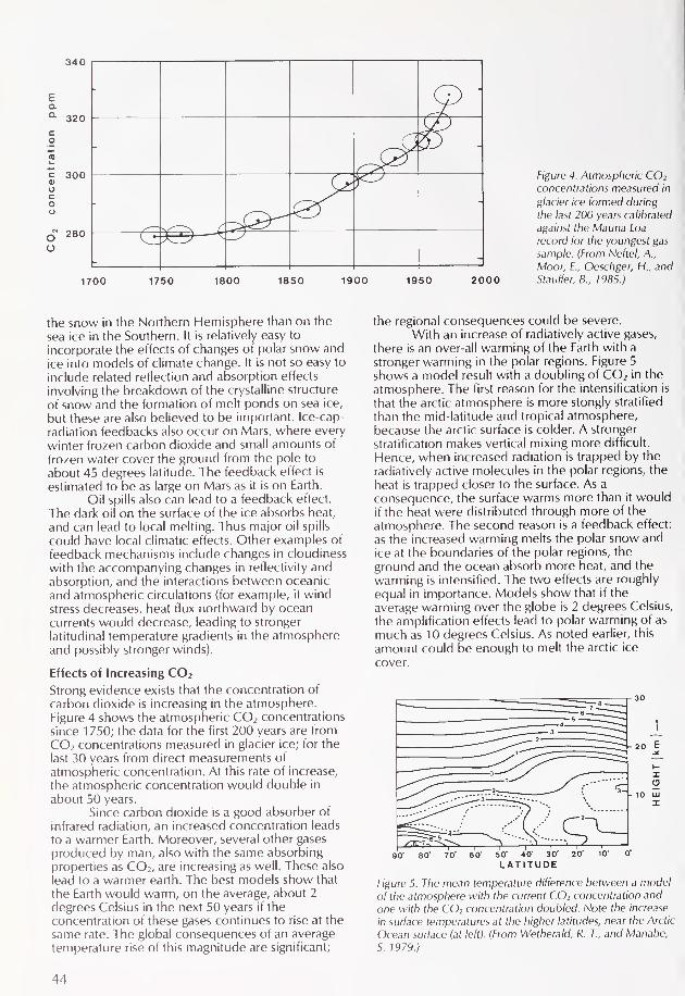
340
O
1700 1750 1800 1850 1900 1950 2000
Figure 4. Atmospheric CO2
concentrations measured in
glacier ice formed duringthe last 200 years calibrated
against the Mauna Loa
record for the youngest gas
sample. (From Neftel, A.,
Moor, E., Oeschger, H., and
Stauffer,B., 1985.)
the snow in the Northern Hemisphere than on the
sea ice in the Southern. It is relatively easy to
incorporate the effects of changes of polar snow and
ice into models of climate change. It is not so easy to
include related reflection and absorption effects
involving the breakdown of the crystalline structure
of snow and the formation of melt ponds on sea ice,
but these are also believed to be important. Ice-cap-
radiation feedbacks also occur on Mars, where everywinter frozen carbon dioxide and small amounts of
frozen water cover the ground from the pole to
about 45 degrees latitude. The feedback effect is
estimated to be as large on Mars as it is on Earth.
Oil spills also can lead to a feedback effect.
The dark oil on the surface of the ice absorbs heat,
and can lead to local melting. Thus major oil spills
could have local climatic effects. Other examples of
feedback mechanisms include changes in cloudiness
with the accompanying changes in reflectivity and
absorption, and the interactions between oceanic
and atmospheric circulations (for example, if windstress decreases, heat flux northward by ocean
currents would decrease, leading to strongerlatitudinal temperature gradients in the atmosphereand possibly stronger winds).
Effects of Increasing CO 2
Strong evidence exists that the concentration of
carbon dioxide is increasing in the atmosphere.
Figure 4 shows the atmospheric CO 2 concentrations
since 1 750; the data for the first 200 years are from
CO 2 concentrations measured in glacier ice; for the
last 30 years from direct measurements of
atmospheric concentration. At this rate of increase,
the atmospheric concentration would double in
about 50 years.Since carbon dioxide is a good absorber of
infrared radiation, an increased concentration leads
to a warmer Earth. Moreover, several other gases
produced by man, also with the same absorbing
properties as CO 2 ,are increasing as well. These also
lead to a warmer earth. The best models show that
the Earth would warm, on the average, about 2
degrees Celsius in the next 50 years if the
concentration of these gases continues to rise at the
same rate. The global consequences of an average
temperature rise of this magnitude are significant;
the regional consequences could be severe.
With an increase of radiatively active gases,
there is an over-all warming of the Earth with a
stronger warming in the polar regions. Figure 5
shows a model result with a doubling of CO 2 in the
atmosphere. The first reason for the intensification is
that the arctic atmosphere is more stongly stratified
than the mid-latitude and tropical atmosphere,because the arctic surface is colder. A strongerstratification makes vertical mixing more difficult.
Hence, when increased radiation is trapped by the
radiatively active molecules in the polar regions, the
heat is trapped closer to the surface. As a
consequence, the surface warms more than it wouldif the heat were distributed through more of the
atmosphere. The second reason is a feedback effect:
as the increased warming melts the polar snow and
ice at the boundaries of the polar regions, the
ground and the ocean absorb more heat, and the
warming is intensified. The two effects are roughly
equal in importance. Models show that if the
average warming over the globe is 2 degrees Celsius,
the amplification effects lead to polar warming of as
much as 10 degrees Celsius. As noted earlier, this
amount could be enough to melt the arctic ice
cover.
80' 70' 60' 50" 40' 30'
LATITUDE
Figure 5. The mean temperature difference between a model
of the atmosphere with the current CO2 concentration and
one with the CO2 concentration doubled. Note the increase
in surface temperatures at the higher latitudes, near the Arctic
Ocean surface (at left). (From Wetherald, R. T., and Manabe,
5. 1979.)
44

The Bering Strait runs in between the Soviet Union (upper left) and Alaska, connecting the Chukchi Sea with the Ber
climate of these polar regions is affected by air/sea/ice interactions. (Photo courtesy of NOAA/Navy joint Ice Center)
ng Sea. The
The warming could be detected throughmeasurements of the changing sea-ice extent, but
other techniques are possible. For example, it has
been suggested that lake freeze-up and break-uprecords in arctic regions could be used as a
temperature indicator for detecting climate change.
Changes in glacier motion, that is, the so-called
"surges" or fast-moving ice streams on Iceland or
Greenland, could also be used.
Water vapor, consisting of molecules that
have many degrees of freedom and are goodabsorbers of heat, also creates a feedback effect in
the polar atmosphere. As the temperature increases
globally, the warmer air will be able to evaporatemore water at mid-latitudes. As relatively more moist
air is carried to the polar regions, it absorbs more
radiation, thus decreasing the net radiation loss. Thusthe temperature increase leads to an additional
temperature increase.
This large warming could lead to the meltingof the sea ice in the Arctic Basin. If that occurred, the
Arctic Basin would then appear dark rather than
white to incoming radiation. The darker water
surface would be a good absorber of heat, leading to
even further warming and thus loss of all of the ice.
However, at the same time, the increased water
temperature leads to increased evaporation andhence the possibility of increased cloudiness in the
region. The increased cloudiness would in turn be a
better reflector of radiation, and thus cooling, since
less heat would reach the surface. Clearly, both
positive and negative feedbacks are present in the
arctic climate system.The oceans near the Arctic also affect the
cycle of CO2 : the formation of cold, dense water in
the Greenland/lceland/Norwegian Seas regiontransfers the gas and its compounds from the surface
to the deeper waters and sediments. The formation
of North Atlantic deep water is believed to be an
important mode of transport of carbon from surface
waters, since there is a net transfer of CO 2 from the
atmosphere to the ocean in the Norwegian and
Greenland Seas. This buffering of atmosphericincreases of CO 2 is a significant climatic effect in
polar regions, but we still do not have an adequate
understanding of the processes and rates involved.
The way in which such problems can be
resolved is through modeling: identification of
processes, and use of basic physical laws to
determine their consequences. Our models are not
45

yet sophisticated enough to predict whether positiveor negative feedbacks will dominate as radiatively
active gases increase in the atmosphere. However,with new measurements that define the processes,
and with new, more powerful computers, we have
the tools to find out how such problems can indeed
be solved.
Climate Processes Study Programs
There have been many scientific programs in the
past decades aimed at understanding the role of the
polar regions in climate. Notable among these in the
late 1970s were the Polar Sub-Program and the
POLEX experiment sponsored by the Global
Atmospheric Research Program (CARP). These
provided calibration and ground truth for satellite
measurements in polar regions for the CARP Global
Weather Experiment and carried out modelingstudies and experiments with data buoy arrays in the
Arctic to improve models of pack ice dynamics and
air/sea/ice interaction. More recently, the
International Marginal Ice Zone Experiment (MIZEX)
has studied processes near the ice edge in the
Greenland and Bering Seas (see page 66). Continuing
buoy measurements in a number of different areas
have been carried on by a number of countries.
New satellite techniques for imaging ice floes and
measuring the total ice cover have demonstrated
that we can now collect long-term data sets that will
be invaluable for understanding arctic climate
processes.
Building on these and other studies, the Arctic
Ocean Sciences Board, an intergovernmental group,has sponsored the planning of a Greenland Sea
Project to more fully understand the regional
mechanisms of air/sea/ice interaction, and to tie
seasonal and interannual sea-ice variations to the
large-scale dynamics of the atmosphere and ocean in
the Greenland Sea region.The Greenland Sea is particularly good for
such studies because the signals are large, there is a
good existing data base, logistic accessibility is good,and there is much international interest. Majorelements of the program will include data buoys in
the ice, acoustic tomography in the ocean (see
Oceanus, Vol. 25, No. 2, p. 12), hydrography and
chemistry, surface and deep floats, and heavy use of
satellite measurements. Major contributions are
expected to come from the United States, France,
West Germany, Norway, Canada, Denmark, and
Iceland. The Greenland Sea project is expected to
start in 1987 and continue for at least 5 years.
New satellite programs will provide data for
the Greenland Sea Project and others, such as
MIZEX. These programs, sponsored by the United
States, the European Space Agency, and Canada, will
provide imaging radars, passive microwavemeasurements for total ice and snow cover, andcloud measurements in the polar regions.
D. lames Baker is President of loint OceanographicInstitutions, Inc., in Washington, D.C., and Co-Chairman of
the Science Planning Group for the Greenland Sea Project of
the Intergovernmental Arctic Ocean Sciences Board.
Selected Readings
Aafaard, K., ). H. Swift, and E. C. Carmack. 1985. /. Geophysical
Research, 90: 4833-4846.
Carbon Dioxide Assessment Committee, National Research Council.
1983. Changing Climate. National Academy Press, Washington,D.C.
Committee on the Role of the Polar Regions in Climatic Change,Polar Research Board, National Research Council. 1983. The
Polar Regions and Climatic Change. National Academy Press.
Imbrie, ). 1978. Geological perspectives on our changing climate.
Oceanus, 21:65-70.
Kukla, C. J. 1978. Recent changes in snow and ice. In Climate
Change. \. Gibben, ed. pp. 1 14-129. Cambridge, England:
Cambridge University Press.
Lemke, P. 1985. Stochastic description of air/sea/ice interaction.
Geophysics of Ice. Publisher not known.
Lohmann, G. P. 1978. Response of the deep sea to ice ages.
Oceanus, 21: 58-64.
Neftel, A., E. Moor, H. Oeschger, and B. Stauffer. 1985. The increase
of atmospheric CO2 in the last two centuries. Evidence from
polar ice cores. Nature, Vol. 315, pp. 95
Stewart, R. W. 1978. The role of sea ice in climate. Oceanus, 21: 47-
57.
Walsh, |. E., and C. M. Johnson. 1979. An analysis of arctic sea ice
fluctuations. I. Phys. Oceanography, 9: 580-591.
Wetherald, R. T., and S. Manabe. 1 979. Sensitivity studies of climate
involving changes in CO2 concentration. Man's Impact on
Climate. New York, NY: Elsevier, pp. 57-64.
WMO-ICSU Joint Organizing Committee. 1976. The Physical Basis
of Climate and Climate Modelling. CARP Publications Series No.
16, Geneva.
WMO-ICSU Joint Organizing Committee. 1978. The Polar Sub-
Programme. CARP Publications Series No. 19, Geneva, 47 pp.
KETCHAMTRAPSfor the
Since 1975
OCEANOGRAPHICCOMMUNITY
Buoyed Deployment and
Recovery Systems
Custom AquacultureGrowout Trays
Specialized Trap Design(any species and depth for
conventional or submersible
recovery)
Design Problems
enthusiastically discussed
and solutions found
Discount Rope Warehouse(miles in stock)
DAILY UPSP.O. Box N-1128, 111 Myrtle Street
New Bedford, MA 02746
At Exit 14, I 195, East Bound
(617) 997-4787
46

Arctic Icebreakers:
Soviet icebreaker Dikson,
showing broken ice in its
wake. (Courtesy of author)
U.S., Canadian, and Soviet
by Lawson W. Brigham

lew Americans have ever seen a polar icebreaker.
These sturdy vessels operate at latitudes far removed
from the temperate regions where most of the
United States lies. But the United States is an Arctic
nation, thanks to Alaska. And, as many articles in this
issue make clear, the United States has a number of
vital national security concerns in the Arctic.
Addressing many of these concerns will require an
increasing U.S. presence in the Arctic, and will result
in a steady increase in the volume of marine
transportation through the Arctic. In turn, these
changes in arctic politics and transportation imply a
continuing need for polar icebreakers.
For other Arctic-rim nations, the need is even
clearer. The Soviet Union has employed a vast
armada of icebreaking vessels along the Northern
Sea Route in its concerted effort to develop its
northern lands. This route connects Soviet European
ports to ports on the Pacific coast via the arctic
waters of the Soviet Union. The infrastructure
developed to support this marine transportation
system including ice forecasting, remote sensing,
pilotage and port development is an
unprecedented polar achievement.
In the Canadian Arctic, commercial
icebreaking vessels of a unique design are assisting in
hvdrocarborn exploration in the Beaufort Sea. ACanadian icebreaking cargo vessel, the M/V Arctic,
has plied to northern mines for seven years, and
Canadian Coast Guard icebreakers work both
resupplying arctic communities and supportingcommercial traffic through ice-covered waters.
Canada also faces jurisdictional disputes that maygive impetus to the development of further
icebreaking capabilities.
All in all, icebreakers already are of vital
importance in the Arctic, and their importance is
likely to grow along with the region's population and
economic development. Steady improvements in
icebreaking technology and capability allow
operations in arctic seas once deemed physically
impenetrable, and a host of research vessels from
many nations now operate in the marginal ice zones
of the Arctic.
Soviet Arctic Operations
The Soviet Union operates 16 of the world's 34 polar
icebreakers active in the Arctic Ocean. Four of these
ships are nuclear powered (the fourth, Ross/ya,
became operational in late 1985). The remaining
ships* were built by the Finnish shipbuilder Wartsila
from 1959 to 1981 with diesel electric propulsion
plants. The Soviet Navy and KGB Maritime Border
Guard operate small polar icebreakers. In addition,
two classes of river icebreakers with 3.3 and 2.5
meter drafts are specifically designed for the shallow
rivers and estuaries of the north. The 14 ships of the
SA-1 5 or Noril'sk class of icebreaking cargo vessel
also represent a credible icebreaking capability in
*3 Ermak class (36,000 horsepower and a crew of 1 50), 5
Moskva class (22,000 horsepower and a crew of 145), and 4
Kapitan Sorokin class (22,000 horsepower and a crew of 85-
92).
NAVY
BORDERGUARD
SALVAGE
RIVER
LARGEHARBOR
ICEBREAKERCARGO(SA-1 5)
ESTIMATED 1985
FLEET SIZE:
84 SHIPS
4 8 12 1
NUMBER OF ICEBREAKING VESSELS
Soviet icebreaking fleet.
their own right; they can break continuous level ice
up to 1 meter thick.
The Northern Sea Route can be defined as
the system of marine routes from the Barents and
Kara Seas to the Bering Strait in the east. Majoricebreaking operations occur in the Kara Sea where
ice-strengthened freighters make port calls along the
Yamal Peninsula, and in the Ob and Yeniseyestuaries. During the past seven years, year-round
traffic to the city of Dudinka on the Yenisey River
has been accomplished except for periods of
breakup when river ice is flushed out during the late
spring. Freighters and icebreakers homeported in the
Pacific annually resupply communities in the eastern
regions of Siberia. Most of the freighters deliver food,
fuel, manufactured goods and heavy equipment.
Returning they usually carry timber and minerals
(copper and nickel). The largest nuclear and diesel-
electric icebreakers escort convoys across the route
and often are required to "tow" vessels in their V-
shaped stern notches.
River icebreakers move tug and barge trains
inland from the coast. A new nuclear-poweredLASH* ship under construction, the Sevmorput, will
carry 74 barges or more than 1,300 containers, and
will be virtually independent of port facilities a
critical feature for work in Siberia. Two new nuclear,
shallow-draft icebreakers of the Taymyr class to be
built by Wartsila will add to the endurance and
capability of Soviet icebreakers in continental shelf
areas.
This marine transportation system requiresextensive technical support. Continuous
hydrographic surveys, a modern aids to navigation
system, and a host of polar weather and ice
information stations provide information necessaryfor piloting and navigation. Short (hourly, daily), long-
range (seasonal, 5-8 months) and ultra long-range
(climatic, decades) ice forecasts are published. In
* LASH stands for Lighter Aboard Ship, in this case referring
to flat-bottomed barges known as lighters. Materials
transported to ports by barges can be loaded aboard a
LASH ship while still in the same barges, and, at the
destination, can be unloaded and once again transported
by barge.
48

Soviet Icebreakers
The Arktika, since renamedthe Leonid Brezhnevbecame the only surface
vessel to reach the NorthPole in August, 7977. This
nuclear-powered vessel andher sister ships are the
world's most powerfulicebreakers. (Courtesy of
author)
*
A Soviet SA-15 class cargo vessel, capable of continuously
breaking 1 meter ice without additional icebreaker support.
(Photo courtesy of Wartsila)
Above, an icebreaker of the Kapitan Sorokin class. Theseshallow draft ships are designed for shallow areas along the
continental shelf, where deep-draft icebreakers cannot
operate. Below, an artist's rendering of a new nuclear-
powered, shallow draft icebreaker being built for the Soviet
Union by the Finnish shipbuilder Wartsila. It will be amongthe world's most capable icebreakers. (Photo and painting
courtesy of Wartsila)
Profile of the Sevmorput, the world's first nuclear-powered,
icebreaking LASH vessel. When launched in 1 986 it will be
capable of carrying 74 barges or more than 1,300 containers,
while breaking 1 meter of level ice. After being lifted from the
ship by a gantry system the barges will be pushed by tugs
along the shallow rivers and estuaries of the Soviet far north.
(Courtesy of author)
49

Soviet Arctic Marine Transportation Research
Soviet arctic research in marine transportation
has been extensive during the past three decades.
The development of an experimental ice tank for
ship research in 1955 and a nuclear-poweredsurface vessel (the icebreaker Lenin) in 1959,
both the first of their kind, and the construction
and use of the world's most powerful polaricebreakers top the list of Soviet achievements. In
addition, the Soviets have set up a complex ice
forecasting service, undertaken expansive port
development in extreme environments, and
produced specialized icebreakers to service the
shallow shelves and rivers of Siberia. Additionally,
they have established year-round navigationacross the Kara Sea to Dudinka, a city on the
Yenisey River.
Soviet research also has emphasized
exploration of potential sea routes across the
Arctic Basin. The nuclear-powered icebreakers
Arktika and Sibir each conducted a highlysuccessful experimental voyage in the 1970s. In
August 1977, the Arktika made a 14 day trip from
Murmansk to the North Pole and back, becomingthe first surface vessel to reach that destination.
The ship first sailed eastward, across the Barents
and Kara Seas, to the Laptev Sea, from which it
headed to the Pole, before returning to
Murmansk. Although slowed at times to 2 knots,
the ship was never stopped by ice. It averaged11.5 knots during the 3,852 nautical mile
journey.The following year, the Sibir escorted the
freighter Kapitan Myshevskiy across an Arctic
Basin route north of the island groups off the
Soviet coast. This high latitude voyage from
Murmansk to the Chukchi Sea took place duringlate May and early lune, a time when winter ice
conditions still prevail in the Arctic.
A variety of organizations conduct arctic
navigation research in the Soviet Union.
Leningrad's Arctic and Antarctic Research
Institute has more than 500 polar researchers
today. Established in 1920, it is considered the
leader of Soviet arctic research. At least nine
other institutions in Leningrad contribute to arctic
marine transportation research, making that city
the homebase for such endeavors.
The State Scientific Research Institute for
the Design and Planning of Sea Transportation,and the State University are leading centers for
arctic transportation research in Moscow. Studies
are also conducted at universities and institutes
throughout the country, including sites in Gorki,
Novorossiysk, Odessa, Murmansk, Vladivostok,
Baku, Sochi, and Riga. LWB
September 1983 the Soviets launched a Kosmos-
1 500 satellite with a side-looking radar that can
provide imagery covering 450 kilometer swaths of
the earth's surface. These radar images have
improved Soviet ice navigation; they reportedlyshow multi-year ice edge locations, open water, and
various forms of first-year ice.
Despite this intensive operational support,
however, in October 1983 a 50-ship Soviet convoywas trapped in difficult ice in the eastern Arctic.
Northerly winds brought a drop in temperatures,aided ice formation along the shore two weeks early,
and forced multi-year ice into the region. The early
freeze-up and persistent northerly winds caused a
shipping crisis that required an unprecedentedicebreaking rescue operation. More than 3,000Soviet mariners aboard icebreakers and the
merchant vessels were involved. Thirteen Soviet
icebreakers including three nuclear ships (Lenin,
Leonid Brezhnev and Sibir, were required to extract
the convoy, which was attempting to deliver fuel,
building materials, and food supplies to eastern
Siberian ports. One freighter, Nina Sagaydak, wascrushed and sunk by the ice, without loss of life. Asecond ship was badly holed and more than 30 shipssuffered damage during the operation. It was not
until late November 1983 that the crisis wasresolved. This unusual struggle received wide
coverage in the Soviet and Western press, and pointsout the difficulties of working in the Arctic despite
the high level of sophistication of Soviet operationsand the arctic experience of Soviet mariners.
Canadian Arctic Operations
In the Canadian Beaufort Sea, commercial
operations in support of exploration and
development of energy resources have given rise to
the evolution of unique icebreakers that are
primarily offshore support vessels. Two ships are
operated by Canmar Marine Drilling, Ltd. (Kigoriak
and Robert Lemur) and four are owned by BeauDril
of Gulf Canada Resources, Inc. (Terry Fox, Kavlik,
Miscaroo and Ikaluk). Fully automated systems allow
for small crews 16 to 20 people. Both fleets were
designed in Canada and all have direct-drive diesel
machinery. Canmar's Kigoriak, the first of the ships,
was delivered in 1979. Each of the ships reportedlycan make steady progress while icebreaking in 1
meter of level ice. Figure 4 shows a typical mission
profile of these unique, working icebreakers.
The Canadian Coast Guard provides direct
support (ice escort) to commercial shipping duringthe summer. A fleet of six polar icebreakers* and
several smaller sub-arctic icebreakers are deployednorth of the Arctic Circle. Early in the 1985 ice
season, the majority of icebreaking operations took
*Louis S. St. Laurent, lohn A. MacDonald, Pierre Radisson, Sir
John Franklin, Des Groseilliers, and Norman McLeod Rogers
(crew sizes range from 57 to 80).
50

Canadian Icebreakers
The commercial icebreaker Ikaluk tows a drilling unit through ice off Deadhorse, Alaska, on its way to the Canadian Beaufort
Sea. (Photo courtesy of Gulf Canada Resources, Inc.)
The Robert Lemeur has water jets to lubricate the hull and
improve icebreaking efficiency. This ship is used primarily for
support of oil drilling operations in the Canadian Arctic.
(Photo courtesy of Canadian Marine Drilling)
The Canadian Coast Guard icebreaker John A. MacDonald,
only seemingly stuck in the ice. (Photo courtesy of Canadian
Coast Guard Northern)
51

place in Hudson Strait and Lancaster Sound. Otherduties for the polar icebreakers included support to
aids to navigation (seasonal reactivation), resupply of
federal outposts, survey work and scientific research,
ice escort of hydrographic vessels, and assist to small
tankers refueling communities. Since the early 1970s,
following the voyages of the tanker Manhattan
through the Northwest Passage, the Canadian Coast
Guard has had designed several large polaricebreakers capable of operating year-round in mostareas of the Canadian north. The initial Polar 7
icebreaker design (capable of continuously breaking7 feet of level ice) evolved into a nuclear-poweredPolar 10 design, which was finally downgraded to the
present non-nuclear Polar 8 design. If this ship is
built it will be the world's largest and most powerfulicebreaker (100,000 horsepower versus 75,000 for
the Soviet Arktika class). Such a ship with a crew of
116, would allow Canada to exercise year-round
sovereignty and jurisdiction in most areas of the
Canadian archipelago. It would also supportcommercial shipping in the Canadian Arctic duringthe winter season between November and June. The
August 1985 transit of the Northwest Passage by the
U.S. Coast Guard icebreaker Polar Sea has givenrenewed impetus to the building of this massive
ship.
For the past seven years, a Canadian
icebreaking cargo ship, the M/V Arctic (209-meter
length and 29,000 tons), has plied the CanadianArctic. A joint federal-industry consortium operatesthe vessel, principally to the Polaris and Nanisivik
metal mines. Operational only during the summermonths, the M/V Arctic has made runs from theArctic to European ports. Improvements to the
icebreaking bow have recently been approved, andit is hoped the navigation season of the ship can beextended to make it more economic in the miningtrade.
120 90 E
ISO
Key to Areas of U.S.
Icebreaker Operations :
Winter Science
Summer Science
SP Summer Resupply
Kr Set
^7T$...,..^V*.*iVsHVvsK/"nV7;^-''**r. .
-2***VFranz Josel Land^if
Ext Siberian
\ // Minimum Extent ol Sea Ice
ss
LINDBLAD EXPLORER (1984)
30
150
120
Map of pioneering voyages and regularly traveled routes in the Arctic.
52

Definitions of Ships Operating on Ice-covered Waters
Ice Strengthened Vessel able to operate in
very open pack ice (less than 3/70 concentration)and first-year ice less than 50 centimeters thick;
ship structurally strengthened around the
waterline with a conventional or non-icebreakingbow form; safe navigation possible only underescort by an icebreaker.
Ice-capable Ves.se/ able to operate in first-
year pack ice up to 8/10 concentration and 1
meter thick; ship structurally strengthened aroundthe waterline, has an icebreaking bow and has
more horsepower than required for transit
through ice-free waters; usually designed with
adequate power to break continuously 30centimeters of first-year level ice.
Polar Research Vessel An ice-capable vessel
specifically designed for and dedicated to
research; areas of operations include the marginalice zone and unconsolidated pack ice of the
summer melt season; most ships can
continuously break up to 50 centimeters of first-
year level ice.
Polar Icebreaker Vessel designed specificallyto operate independently in the polar regions in
both first-year and multi-year ice; ship structurally
strengthened throughout, has an icebreakingbow and has greatly increased horsepower and
displacement for continuous icebreaking in 10/10concentration; polar icebreakers can
continuously break a range of ice thicknesses
between 7 and 2.5 meters; the estimated worldfleet in 1985 is 34 ships.
Subarctic Icebreaker Vessel designed for
icebreaking operations on seasonally ice-covered
coastal seas and lakes; ship structurally
strengthened around the waterline, has an
icebreaking bow and can operate in areas of first-
year ice up to 7.5 meters thick; areas of
operations include the Great Lakes, Baltic Sea,
and coastal regions of Canada, Alaska, and the
USSR.
Polar Research Icebreaker Vessel that
incorporates the ice capabilities of a polaricebreaker and the science capabilities of a polarresearch vessel; has extensive facilities to supportoceanographic, meteorological and ice research
in the Arctic and Antarctic; capable of
continuously breaking a minimum of 1 meterlevel ice; West Germany's Polarstern is the sole
example.
U.S. Arctic Operations
The U.S. polar icebreaker fleet is operated by theCoast Guard (Table 1). Since 1967, there has been anet loss of three ships to the fleet, but the Polar class
icebreakers have significantly more icebreakingcapability than the Wind class ships they replaced.Note should be taken of the length of service of
Glacier, Westwind, and Northwind. The two Wind-class ships served during World War II in polarwaters and are the world's oldest polar icebreakersin continuous service. Glacier was completed in
1955 for the Navy and was immediately sent southto Antarctica to serve as Admiral Byrd's flagship. Thedesign is essentially a scaled-up version of the Windclass vessels with greatly expanded space for
scientific work. For thirty years Glacier has faithfullyconducted a myriad of scientific and icebreakingoperations at both ends of the globe.
Table 1. Current United States polar icebreaker fleet.'
Polar Star and Polar Sea, the world's most
powerful non-nuclear polar icebreakers, have
recently confined their arctic operations to the
Bering, Chukchi, and Beaufort Seas. Marine
transportation studies and oceanographic research
conducted primarily for the Department of Defense
(Navy)* have occupied most deployments. However,in early summer 1985 Polar Sea ventured into the
Atlantic via the Panama Canal to the west coast of
Greenland for ice escort duties. On 1 August the
ship departed Thule, Greenland, enroute the
Northwest Passage on a transit that would end in
Prudhoe Bay, Alaska, on 12 August.On reaching Alaskan waters, Polar Sea
immediately ventured into the Beaufort Sea for
defense-related oceanographic research. The
political and legal issues of the transit were unique*Primarily physical oceanography and acoustical surveys.

and complex. Canada has claimed sovereignty over
all the waters that separate the arctic islands
including the route of the Polar Sea throughLancaster and Viscount Melville Sounds. The United
States has consistently insisted that the Northwest
Passage is an international strait through which shipsof any country have the right to pass unchallengedand unrestricted. Although the fundamentaldifferences between Canada and the U.S. remain
unresolved, bilateral talks on the subject are
continuing.The annual resupply of Greenland bases
Thule and Sondrestrom air bases and the Dye-4radar site at Kulusuk on Greenland's east coast-
have required icebreaker support since 1954. Sealift
of dry cargo and fuel is accomplished by Military
Sealift Command and Canadian merchant vessels.
Although they are ice-strengthened, theseships
require icebreaker escort through the sea ice in
Northern Baffin Bay and along Greenland's east
coast. Except for 1 985, Wind-class icebreakers have
conducted this operation and have also
conducted extensive oceanographic surveys alongGreenland's northwest coast (Baffin Bay, Smith
Sound, Nares Strait and Kane Basin). In recent years
the ships have deployed in the Greenland and
Norwegian Seas for lengthy oceanographic surveys.
Winter science operations have been conducted in
the Bering and Chukchi Seas by both Wind and Polar
class vessels. Glacier has deployed occasionally to
the Alaskan Arctic for marine geological and
ecological investigations.
National Need for a Polar Fleet
The U.S. polar icebreaker fleet, operated jointly in
the past by the Coast Guard and Navy and today
solely by the Coast Guard, has played an
instrumental role in building and supporting our
national presence in both polar regions.The primary tasks of the fleet are to conduct a
wide variety of national strategic and scientific
missions in polar marine environments. First, the
fleet represents an instrument by which policy-
makers can promote essential U.S. security interests
and provide a credible and influential maritime
presence in the Arctic and Antarctic. This "active andinfluential" role by icebreakers in the Arctic is best
exemplified by the voyage of the Soviet Union's
Arktika to the North Pole in 1977. Although other
forms of polar presence are possible, the multi-
mission Coast Guard polar icebreakers can providethe President with flexibility, operational reach, and
staying power in the polar regions, particularly if an
urgent need arises. Other polar operations of a
strategic nature are conducting Antarctic Treaty
inspections, projection of U.S. presence into
international polar waters, conduct of defense-
related research, responding to foreign shipintrusions into Alaskan waters, and providing supportto military operations.
Ice escort and logistic support have been
primary missions since the fleet's inception duringWorld War II. More than 45 percent of the fleets'
time has involved these two, key missions. The
resupply of McMurdo Station in Antarctica, of Thule
and Sondrestrom air bases along Greenland's west
coast, and of the desolate East Greenland radar site
in Kulusuk require polar icebreaker escort of ice-
strengthened ships. These operations have beencoordinated by the Military Sealift Command.Icebreakers have been involved in cable-laying
operations in Baffin Bay, ice escort of the research
vessel Clomar Challenger in polar waters, and
resupply efforts throughout the American and
Canadian Arctic. They also have been used
extensively as bases of operation in support of
submersibles, ice islands, and aids to navigation
projects.A fourth primary mission that has accounted
for almost half the polar icebreaker employmentdays in both the Arctic and Antarctic is support to
scientific operations as a platform for observation.
Marine science investigations have covered the full
spectrum of disciplines. Many of the Arctic
oceanographic cruises during the 1960s and 1970s
aboard polar icebreakers gathered the only
bathymetric and acoustical data bases for these
regions, especially in the Greenland, Barents, and
Kara Seas.
Another research-related mission has beenthe use of polar icebreakers as sensor platforms for
instruments that measure engineering parametersassociated with icebreaking. Marine transportation
tests in Alaskan waters, full-scale icebreaking tests,
and various acoustic systems studies have advanced
the design ofpolar
vessels. This research is
conducted primarily in anticipation of the need for a
polar transportation capability in the next century.
Such a polar transportation system around Alaska's
coastline would also require an increased federal
presence in the form of icebreakers to conduct the
statutory missions of the Coast Guard. Offshore
development of the Alaskan Arctic would lead to
requirements for enhanced Coast Guard response in
environmental protection, marine safety, search and
rescue, and enforcement of laws and treaties all on
ice-covered waters.
Polar Icebreaker Requirements Study
In 1983-84 an interagency committee in Washington
attempted to assess future U.S. requirements for
polar icebreakers. The study group included
representatives of the Coast Guard, Marad, DOD,NSF, NOAA, OMB and OST*. The study was to
assess the national need for a polar icebreaker fleet,
recommend a fleet size to meet all requirements to
the year 2000, and to develop financing options for
the construction and operation of the fleet.
Comprehensive analyses were performed on the
status of the present fleet and alternatives to a
federal polar icebreaker fleet. A survey of users wasconducted to ascertain peacetime and wartime
requirements. After nearly a year of discussion and
debate an interagency report entitled United States
* Marad: Maritime Administration; DOD: Department of
Defense represented by the Oceanographer of the Navy;
NSF: National Science Foundation; NOAA: National
Oceanic & Atmospheric Administration; OMB: Office of
Management & Budget; OST: Office of the Secretary of
Transportation.
54

U.S. Icebreakers
The U.S. icebreakers Polar
Star and Polar Sea are the
most powerful Western
icebreakers. Shown at right
is the Polar Sea. Above,nofe the hull configurationot an icebreaker. (Photo
and drawing courtesy of
U.S. Coast Guard)
All three classes of U.S.
icebreakers, together for a
moment off Antarctica the
Glacier (top), Northwind
(middle), and Polar Sea.
(Photo courtesy of U.S.
Coast Guard)
55

Polar Icebreaker Requirements Study was publishedin July 1984. Several of the principal findings are:
The polar icebreaker fleet is essential to the
national interest.
The fleet should be operated by the Coast
Guard.
Capital costs of replacement icebreakers
should be funded by a single agency, the Coast
Guard.
Improvements in the present fleet are
necessary, specifically in capability to supportscience.
A fleet of 4 ships should be maintained; the
Coast Guard recommended a fifth ship remain in
reserve for emergencies or possible increases in
difficult-to-forecast, long-term polar
requirements.
Work should be started immediately on the
design of a new polar icebreaker; design of the
new icebreakers should enhance science supportwhile retaining essential escort and logistical
capabilities.
The Coast Guard should design upcoming
replacements with an icebreaking capability
between the present Wind and Polar class
vessels.
Soon after completion of the study two
Congressional Acts contained language that
emphasized the polar icebreaker fleet. The Arctic
Research and Policy Act of 1984 called for the Office
of Management and Budget to facilitate planning for
the procurement and operation of polar icebreakers
for arctic research. In addition, Congress, in the
Coast Guard's Authorization Act of 1984, has
mandated that the Secretary of Transportation
prepare design and construction plans for the
purchase of at "least two new polar icebreakingvessels." Thus, the stage has been set for
replacement of America's aging polar icebreaker
fleet.
Required Capabilities
While it is premature to discuss specificcharacteristics prior to any budget decisions,
important capabilities for the new U.S. icebreakers
are readily apparent. New polar icebreakers must bemulti-mission in design and be capable of operating
independently in both polar regions.* The ability to
operate effectively during Arctic and Antarctic polarwinters will be a significant design feature since
* Nuclear power for polar icebreakers has been proven bythe USSR to be safe, reliable, and highly effective. The keyto nuclear power is that it provides virtually unlimited
endurance in the Arctic Ocean a region where refueling
ports are few and far between. Both the high cost and the
extensive infrastructure (training and maintenance) requiredto support a nuclear ship would probably scuttle any U.S.
Coast Guard plan to acquire such a ship. However, it is
quite clear that a nuclear-powered polar icebreaker is the
most effective surface platform for polar operations.
scientific operations in the coming decades are likely
to be conducted in those extreme seasons. The ships
must possess an icebreaking capability to penetratethe continental shelves of Antarctica and operate in
the northerly reaches of the Beaufort and Greenland
Seas. Enhanced remote sensing imagery will be
mandatory for improved ice navigation, particularly
for increased operations that are likely to occur in
multi-year ice. The receipt, processing, and display
of real-time satellite and aircraft ice imagery will be
critical to future scientific investigations, as well as
other missions.
There is no doubt that the new U.S.
icebreakers must be designed with greatly enhanced
scientific capabilities. In fact, the new design should
approach that of a polar research icebreaker a ship
similar in science capability to West Germany'sPolarstern, but with increased icebreaking capability.
Examples of potential science support features of the
replacement polar icebreakers include:
Ability to conduct hydrographic and
bathymetric (broad beam) surveys in all seasons.
Extensive cold storage and cold rooms.
Quotes from Three
Documents ConcerningU.S. Polar Icebreakers
The Office of Management and Budget shall seek
to facilitate planning for the design, procurement,maintenance, deployment, and operations of
icebreakers needed to provide a platform for
arctic research by allocating all funds necessary to
support icebreaking operations, except for
recurring incremental costs associated with
specific projects, to the Coast Guard.
from Section 1 10.(b.), Arctic Research and
Policy Act of 1984
Work should be started immediately on the
design of a new polar icebreaker. . . . The designof the new icebreakers should enhance research
support, while retaining essential escort and
logistic support capabilities.
from Recommendation 2, U.S. Polar
Icebreaker Requirements Study, July 1984
The Secretary of the department in which the
Coast Guard is operating shall prepare design andconstruction plans for the purchase of at least 2
new polar icebreaking vessels to be operational
by the conclusion of fiscal year 7990 . . . the
Secretary shall consult with other interested
Federal agencies for the purpose of ensuring that
all appropriate military, scientific, economic, andenvironmental interests are taken into account.
from Sec. 6.(b), Coast Guard Authorization Actof 1984
56

Marine Transportation Research in the Alaskan Arctic
.J/nce 7979, a program jointly sponsored byboth the government and industry has beenconducted to assess the operational feasibility of
year-round marine transportation in offshoreAlaska. The main objectives of these
"trafficability" studies have been to:
Define the ice and environmentalconditions which would affect year-roundmarine activities in the Bering, Chukchi,and Beaufort Seas.
Evaluate the performance of powerfulicebreakers by measuring hull ice loads
(continuous and ramming icebreaking),
steering gear loads and structural
vibrations. The data will be used to
improve design criteria for polar ships andoffshore structures.
Assess ship piloting and ice navigationabilities and the maneuverability of largevessels in ice.
Demonstrate the operational feasibilityof commercial icebreaking ships alongarctic marine routes.
Joint sponsorship and cost-sharing haveenabled the expensive program to operate.
Among the government participants are the CoastGuard, the National Research Council, and the
Maritime Administration. The Alaska Oil and Gas
Association, U.S. shipyards, the State of Alaskaand Transport Canada also have contributed.
Ten scientific voyages to the Bering,
Chukchi, and Beaufort Seas during the last seven
years have been conducted aboard the world's
most powerful non-nuclear icebreakers, the Polar
Star and the Polar Sea. Initial results indicate that
the Polar class vessels can operate year-round in
the Bering Sea. Winter operations in the ChukchiSea appear possible at this time. Winter transits
into the Beaufort Sea, however, do not seemfeasible without refueling en route.
Ice navigation through the use of remote
sensing ice imagery and ice piloting skills have
proven to be vital to the success of any Alaskanmarine system. Zones of environmental severityalso have been identified for each of the Alaskanseas by using ice imagery and the extensive field
data gathered on ice floes, pressure ridges, andrafted ice features.
More than 1,400 sets of data on the
impact of both first- and multi-year ice on the
hull of the Polar class icebreakers have beencollected. These, along with other data, have
helped develop analytic models predicting the
performance of ice-transiting ships in level ice
and pressure ridges. The success at defining the
significant requirements of an arctic marine
transportation system is the result of the multi-
year nature of the program. LWB
State of the art computer systems for onboard
processing of data and the capability to transmit
large amounts of data to home base.
Heavy lift capability to handle mooredinstrument arrays and other large packages.
Coring and dredging capability.
Ability to conduct acoustic surveys and tow
arrays.
Specialized labs in vans (containers) that are
compatible with the UNOLS* fleet.
Temperature controlled wet and dry labs with
uncontaminated seawater.
Precision navigation (Global Positioning
System) and satellite communications.
Easy access to the ice surface by scientists andequipment.
Full monitoring of the ship's operations byvideo and ship's data displayed throughout all
scientific spaces.
Independent electronics lab for repair of
computer and scientific equipment.*
University National Oceanographic Laboratory System:This consortium of oceanographic research organizations
manages the deployment of U.S. Oceanographic researchvessels.
The Future
The tempo of icebreaker operations throughout the
Arctic Basin probably will continue to increase well
into the next century. Offshore exploration and
development of the Soviet and North AmericanArctic will increase the importance of polaricebreakers to marine transportation, offshore
operations, and scientific research.
The Soviet Union will continue its heavyinvestment in the marine transportation systemestablished along the northern sea route.
Development of nuclear-powered, shallow-draft
icebreakers of the Taymyr class and the nuclearLASH ship Sevmorput provide glimpses of the Soviet
effort. There is little doubt that there is a trend
toward icebreaking cargo ships operatingindependent of icebreaker escort in the western partof the Soviet Arctic. However, polar icebreakers will
continue the practice of convoying in an attemptduring the next two decades to establish an
effective, year-round navigation season across theentire length of the Soviet north. Commensuratewith this effort will be a continued investment in
remote sensing of ice conditions and extensive
scientific research aimed at both the economic and
strategic polar interests of the Soviet Union. A wide
variety of Soviet icebreaking vessels, particularly
57

those designed for geophysical and oceanographicwork, will participate in this effort, concentratingtheir operations on the continental shelf.
In Canada, the federal government will in all
likelihood proceed with the construction of the
world's most powerful icebreaker, the massive Polar
8. Such a ship will be designed to "guard" Canadian
Arctic sovereignty and will be expected to operate
year-round in all but the most difficult ice regions of
the Canadian north. Additional Radisson class
icebreakers will be added to replace aging Canadian
Coast Guard ships used during seasonal resupplyefforts and for support of Arctic commercial vessels.
Canada's Arctic shipping experience with an
improved M/V Arctic that can extend the navigationseason could make Arctic mining more competitivein international markets. Steady, but slow, offshore
development in the Canadian Arctic is expected and
will result in the continued operation of icebreakers
and supply vessels uniquely designed for the
Beaufort Sea. The result of this activity is that
icebreaker operations during the coming decadeswill reach an all-time high. With the launch in 1991
of Canada's Radarsat spacecraft carrying a synthetic
aperature radar, real-time ice imagery will be
available for ice navigation in Canada's ice-covered
waters.
For the United States the future of polar
icebreakers is just as clear. The justification for a
replacement fleet is linked less to the commercial
development of arctic resources, than to a broad
spectrum of strategic, scientific, and logistic
requirements for a viable, modern fleet. The federal
government also will have an increased responsibility
to safeguard the public interest in the face of
resource development in offshore Alaska. These
future responsibilities lend additional impetus to the
replacement of the polar fleet. As designs for the
new ships advance, the Coast Guard must articulate
the appropriate operational and support capabilities
to meet the nation's needs in both polar regions.
Neither the Coast Guard, Department of
Transportation, nor icebreaker user agencies can
afford to view these ships parochially as anythingless than national assets used for a multitude of
functions.
It is interesting to note that more than 30
years ago the U.S. maintained the world's sole multi-
mission polar icebreaker fleet. Then as now the fleet
operated globally and supported such diverse
activities as the establishment of Greenland air
bases, the construction of DEW (Distant Early
Letter Writers
The editor welcomes letters that comment on articles
in this issue or that discuss other matters of importanceto the marine community.
Early responses to articles have the best chance of
being published. Please be concise and have yourletter double-spaced for easier reading and editing.
Warning) Line sites across the North American
Arctic, Admiral Byrd's and subsequent Antarctic
expeditions, and scientific operations in polar seas
where vessels had never sailed. In the budget battles
that lie ahead, it will be important to reflect on this
historic role and to measure the importance of the
fleet to the future of U.S. polar science and polaraffairs of state.
Commander Lawson W. Brigham is assigned to the Office of
Operations at U.S. Coast Guard Headquarters, Washington,D.C. He was a member of the U.S. Polar Icebreaker
Requirements Study Croup in 1 983-84.
The views expressed are solely those of the author and donot necessarily reflect the positions of the U.S. Coast Guardor the Department of Transportation.
Suggested Readings
Armstrong, T. 1978. Icebreaker voyage to the North Pole, 1977.
Polar Record, 19(1 18): 67-68.
Armstrong, T., C. Rogers and C. Rowley. 1978. The CircumpolarNorth. Cambridge, England: Cambridge University Press.
Barr, W. and E. Wilson. 1 985. The shipping crisis in the Soviet
Eastern Arctic at the close of the 1983 navigation season. Arctic,
38(1): 1-17.
Brigham, L. 1985. New developments in Soviet nuclear Arctic ships.
U.S. Naval Institute Proceedings, December: 131-133.
Brigham, L. and R. Voelker. 1985. Ice navigation studies in the
Alaskan Arctic using Polar class icebreakers. Proceedings of the
Oceans' 85 Conference. MTS and IEEE: Washington, D.C.
Butler, W. 1978. Northeast Arctic Passage. Alphen aan den Rijn, TheNetherlands: Sijthoff & Noordhoft International Publishers.
Canadian Arctic Resources Committee. 1979. Marine Transportation
and High Arctic Development: Policy Framework and Priorities.
Conference Proceedings. Ottawa, Canada.
Cerwick, B. ed. 1985. Arctic Ocean Engineering for the 21st Century.
First Spilhaus Symposium Proceedings. Marine Technology
Society: Washington, D.C.
Pharand, D. 1984. The Northwest Passage: Arctic Straits. Dordrecht,
The Netherlands: Martinus Nijhoff Publishers.
Rey, L. ed. 1983. Arctic Energy Resources. Amsterdam, The
Netherlands: Elsevier Science Publishers.
U.S. Coast Guard, Department of Transportation. 1984. United States
Polar Icebreaker Requirements Study. Interagency Report.
Washington, D.C.
Torn and Battered?
Sending Oceanus through the mail without a
protective wrapping means that some copies are
in less than perfect shape by the time theyreach their destinations. If your copy arrives
damaged, however, we will be glad to replaceit. Simply send the cover and mailing label from
the damaged issue to Oceanus, Woods Hole
Oceanographic Institution, Woods Hole, Mass.
02543, and we will send you a new, wrappedcopy right away. Wrapping all the magazineswould increase distribution costs considerably,but we are committed to making sure that our
subscribers get a copy of each issue in goodcondition.
58

^80'-
JOO,0000000
,00000000-,0000000oooo
PERENNIAL ICE
90W
Remote
Sensingof the
Arctic Seas
SEASONAL ICE
Figure 1 . Approximate maximum and minimum extent of sea
ice in the northern hemisphere. The circles indicate the
receiving areas for the 3 proposed Northern Hemisphere SARstations. The inner and outer circles give the coverages
expected from SAR satellites to be launched by the European
Space Agency and the Canadian Centre for Remote Sensing,
respectively.
by W. F. Weeks and F. D. Carsey
What characteristics of the ice-covered seas of the
Arctic would we like to observe? It would not behard to make a long list. For starters, we would needto know where the ice is, its velocity, the ice type, its
thickness, its properties and where the thin ice areas
and open leads are located. Because the ice is
pushed by the winds and currents, we also will have
to know these characteristics as well as the air
temperature, the surface radiation balance, the snow
59

cover and the ocean heat flux factors that
influence the rate that ice grows or decays.We also would like to understand the
complex feedback mechanisms that occur as a result
of interactions between the atmosphere, the ice, and
the ocean. Sounds like a tall order? It is! Particularly
when you consider that in the Northern Hemispherealone, during the period of a maximum ice extent,
sea ice covers a region two times the area of the
contiguous United States (Figure 1). Included are
locations as far south as the Yellow and Okhotsk
Seas and the Gulf of St. Lawrence. Even during times
of minimum ice extent in the late summer, the total
ice-covered area shrinks only by half. During this
period, however, the ice is confined to regions that
are more conventionally considered as Arctic (that is,
the Arctic Ocean, the East Greenland Sea, and the
Canadian Archipelago).Not only is our area of interest very large but
the conditions we wish to observe change rapidly
with individual ice floes drifting as much as several
kilometers a day. This means that frequent,
systematic observations are necessary. Observations
made at coastal stations are commonly not
representative of conditions offshore, and long-term
manned surface observations within the ice pack are
almost non-existent. The only "continual" manned
presences in the whole Arctic Ocean are the one to
two Soviet drifting stations. The situation is tailor-
made for satellite-based remote sensing. Remote-
sensing instruments placed on satellites in polar or
near-polar orbits can view the arctic seas at frequentintervals and send their observations back to Earth.
If satellite-based remote sensing can
contribute to documenting the behavior of the arctic
seas, the observational data base will spur the
development of improved models for forecasting
environmental conditions in this important, but
neglected region. These models also can then be
utilized to examine interactions between the arctic
seas and the rest of the World Ocean. To attempt to
unravel the complex, interconnected processes
occurring in the arctic seas without an adequateobservational base that covers the whole region is a
hopeless task.
There are, however, problems that must be
kept in mind. For one, those parts of the arctic seas
near the pole experience a prolonged period of
darkness during the winter months. In addition,
many areas of interest are often shrouded in fog and
cloud. This is particularly true of regions in the
marginal ice zone (MIZ), near the edge of the packice where air/sea/ice interactions are intense.
Therefore, to be most useful, satellite sensors should
provide information both in the dark and throughclouds. These combined constraints limit possiblesensors to those that operate in the microwave
portion of the electromagnetic spectrum with
frequencies roughly ranging from 100 megahertz to
100 gigahertz (wave lengths varying from a fewmillimeters to just over 1 meter). Sensors operatingin this frequency range are of two basically different
types: those that passively observe the natural
microwave emission from the Earth's surface andthose that transmit bursts of microwaves and
measure the time of travel of the waves to and from
the Earth's surface, as well as the nature of the
return. These sensors obtain data sets that are quitedifferent in character.
Passive Microwave Sensors
Passive microwave sensors measure the brightness
temperature (TB ) of the Earth's surface with a
resolution that increases as wavelength decreases.
For representative modern systems, surface
resolutions are quite coarse, varying from 1 2.5 to1 00
kilometers; hardly adequate for resolving typical sea
ice features. Each of the individual TB values, which
are commonly combined to produce a map-like
image of the Earth's surface, represents an average of
the brightness temperatures of ice areas of different
thicknesses and types plus that of any open water
areas (leads) that exist within that resolution element.
The term brightness temperature is a bit
misleading in that it is not a real temperature but is
instead given by the product of the emissivity (e) of
the material (sort of a material "constant") times its
physical surface temperature: TB= T S . As the value
of t for open water is approximately 0.5 as
contrasted with values of 0.8 to 0.95 for different ice
types, there is a striking TB difference between the
ice-free ocean and consolidated pack ice
(differences of more than 100 degrees Kelvin are
common).Therefore, useful maps of the boundaries of
the pack ice and of ice concentration (the percent of
the sea surface covered by ice) can be preparedfrom data collected by a single frequency passivemicrowave system (Figure 2) for cases where onlyone ice type is present. Unfortunately examples of
arctic regions with only one ice type present are
uncommon. However, this situation does apply to
the ice remaining in the Arctic Basin at the end of
summer. The passive microwave record (1973-76)for this region has been analyzed (Figure 3) and
provides estimates of the mean emissivity and meanice concentration.
In agreement with aircraft observations, the
heaviest ice is located in a broad band north of
Greenland and the Canadian Archipelago. The
average volume of ice surviving the summer is
estimated to be 16 x 10 3 cubic kilometers. Currently
deployed passive systems, as well as proposed future
systems, operate at 4 to 5 frequencies; so it is
possible to utilize such systems to estimate the
percentages of open water plus that of more than
one ice type. Current studies are focused on
discriminating multi-year from first-year ice.
Although developing and verifying such estimation
algorithms might appear to be straightforward, this is
far from the case, particularly if estimation errors of a
few percent are to be achieved so that the results
will be useful in testing model simulations of packice behavior.
Active Microwave Sensors
Of the several types of active microwave sensors,
imaging radar is particularly well suited for sea ice
studies. Synthetic aperture radar (SAR) systems
designed for space deployment take advantage of
60

65
60
155
170' 165
Figure 2. Ice concentration contours for the Bering Sea on 19 February 1983 based on passive microwave data from the sensor
on Nimbus-7 satellite. (MIZEXWest Study Croup, 1983).
the orbital motion of the satellite to store andcombine information from a number of pulses alongthe track to synthesize high resolution (20 to 30
meters) observations as if they were obtained via the
use of a very large antenna. Data processing is
complex and data rates are so high that it is not
presently practical to store SAR data onboard the
satellite for playback while over a receiving station.
Therefore to receive SAR imagery of the Arctic,
receiving stations must be located within line-of-sight
of the satellite while it is over the Arctic. Present
Soviet radar satellites (Kosmos-1500) avoid these
problems by using real aperture radar systems; the
price paid for this convenience is a loss of resolution
from 30 meters to 1 kilometer.
SAR images (Figure 4) contain a wealth of
information and allow one to track the movement of
individual pressure ridges, leads, and floes under all
weather conditions. In addition, surface winddirections can be derived from the orientation of
slush streamers, the nature of the ice edge can beexamined in great detail, and multiyear and first-year
ice can be differentiated. In the open ocean, SAR
provides information on swell direction and oninternal and surface waves. The interpretation of the
imagery from sea ice is generally straightforward with
the major factor contributing to the strength of the
return being the surface roughness. Therefore,
ridges, rubble, and waves give strong returns, while
flat ice and calm seas give low returns. In most cases,
it is the combination of the strength of the return
and its areal pattern that allows for unambiguousinterpretations (see Oceanus, Vol. 24, No. 3).
Other Sensors
Although we have stressed microwave systemsbecause of their all-weather capabilities and the
synergistic nature of their very different observations,
the arctic capabilities of other satellite sensor
systems also should be noted. For instance, visual
and thermal infrared systems provide important
meteorological information plus, weather permitting,
occasional glimpses of the ice with associated
surface temperature measurements. Theseobservations serve as useful aids in interpreting
microwave images. Also useful are ocean color
imagers which detect variations in the concentration
of chlorophyll in surface waters near the ice edge;and scatterometers which provide estimates of wind
speed and direction over the open ocean. Laser
profilers have been used successfully from aircraft to
study the surface roughness of the ice and oceanwave characteristics, but have not to date been
deployed in space.What is missing? Capabilities for ice
observations are excellent (Table 1). The most
significant gap is the lack of an ability to remotelydetermine sea ice thickness with good spatial
resolution. There appears little chance of a satellite
system obtaining such measurements.
61

DAYS292-2941974
DAYS259-2611974
MEANEMISSIVITY1973-197619.35 GHz MEAN
AREACONCENTRATION1973-1976
Figure 3. Single channel microwave brightness data from Nimbus 5 at 19.35 GHz analyzed over the summer-fall transition. The
upper figures show the measured brightness temperatures in mid-September and late October. The high brightness of the new
ice is clearly shown in the Laptev, East Siberia, and Beaufort Seas. The lower figures show the observed mean fall emissivity and
the mean areal concentration at seasonal-extent minimum. This same data set showed the extent of ice-covered seas at
minimum extent to have very little change in total area, but to occupy different parts of the basin in different years.
Among meteorological parameters, the majordata gap results from the ice interferring with existing
techniques for estimating wind velocity. In openwater, data gaps result from the inability of the
electromagnetic radiation at typical remote sensingfrequencies to penetrate significant distances into
the water column. This problem is made even more
difficult by the presence of ice. In order to obtain at
least some of this missing information, remote
sensing will clearly have to be supplemented bysurface observations.
Future Deployments of Sensors
To discuss future instrument deployments in detail
62

Table 1. Environmental observations required for the arctic seas;
plus satellite-borne remote sensing systems capable of providing
such information.
Parameter
Remote Sensing
System Comments
ICE
Extent
Concentration
Type
VelocityThickness
Roughness
Temperature
Properties
Snow cover
ATMOSPHEREClouds
Winds
OCEANChlorophyll
Waves
Temperature
Salinity
Currents
passive /i-wave,
radar
passive jt-wave,
radar
radar, passive n-
waveradar
radar, passive n-
wavelaser profiler*,
radar
IR
radar + IR
radar, passive M-
wave
visual + IR
scanners
scatterometer,
passive t>-
wave
ocean color
imagerradar
IR
noneradar-altimeter
indirect information from
ice type* not flown to date
indirect from ice type and
temperature
only from ice-free areas
only from ice-free areas
open ocean and thin ice
areas onlysurface temperature only
only from ice-free areas
requires combining a cascade of acronyms with
extensive crystal ball gazing. Showing our erudition
by flashing all this past the reader would
undoubtedly result in both confusion and sleep. Theoverall result, however, can be summarized rather
simply. As Table 2 shows, if the proposed sensor
deployments of NASA, NOAA, the Navy, the
European Space Agency (ESA), the Canadian Centre
for Remote Sensing (CCRS) and the Japanese SpaceAgency (NASDA) go reasonably close to schedule,we can expect at least one low-resolution visible andinfrared sensor, a high-resolution visible sensor, anda passive microwave sensor to be operational fromthe present through the forseeable future.
Most important, starting in 1990 there will be3 SAR satellites launched; one by ESA, one byNASDA, and one by CCRS. This last satellite, called
Radarsat, is the "Cadillac" of the set, and is, at long-
last, a satellite system designed with ice studies as a
primary focus. The lack of a radar altimeter for a few
years after 1992 would not appear to be a
particularly pressing problem in the polar regions, in
that this system is primarily useful in profiling the
large glacial ice sheets entities which are not givento overnight changes.
The most important fact revealed by Table 2
is that from 1990 on both passive microwave andSAR systems will be operating simultaneously overthe Arctic. In addition, three SAR receiving and data
processing stations will provide arctic coverage.These are located in Fairbanks, Alaska; Ottawa,Canada; and Kiruna, Sweden (Figure 1). With the
exception of a small "hole" off the central Siberian
Coast, the coverage of the Arctic Seas will be
complete, particularly since a SAR receiving station
also will be located somewhere in Japan.
Although the times of deployment shown in
Table 2 only extend until 1995, it is quite probablethat most sensors operating at that time will continue
to be effective until 1998 when the NASA Earth
Observing System (EOS) [that is, the polar-orbiting
component of the Space Station] is expected to
become operational. The proposed EOS remote
sensing package is varied and powerful and includes
multifrequency SAR, passive microwave systems,radar and laser altimeters, a high and a moderateresolution imaging spectrometer, a scatterometer,
and an atmosphere sounding package. Clearly EOSwill expand environmental observations over the
arctic seas. Also included as part of this program is a
data system that will greatly facilitate access, transfer,
and analysis of the observations by scientists
throughout the world.
Data Buoys
As mentioned earlier, certain critical environmental
measurements cannot be obtained through satellite-
based remote sensing because the presence of ice
interferes with certain surface observations and also
prevents observation of the underlying ocean.
Fortunately, several important missing observations
can be obtained by autonomous data buoy packages
deployed on the ice, drifting in the ocean, or
moored on the seafloor. For instance, since 1979 the
Arctic Data Buoy Program has systematicallycollected observations on atmospheric surface
pressure (used to calculate surface winds),
temperature, and ice motion.
At present, work is underway to increase the
capability of such monitoring systems via the
development of so-called "smart" buoys that can
accommodate a wide variety of sensors. Further
measurements may include direct surface wind
velocity observations, upper ocean temperaturesand salinities, oceanic heat fluxes, ice and snow
thicknesses, and short wave radiation. Also under
development are bottom moored buoys that provideinformation on the mean thickness of the sea ice
passing over the buoy. By 1990, development and
testing of such systems should be completed androutine operations well underway. By the mid-1990swe also expect to see the deployment of SOFAR(SOund Fixing And Ranging) drifting buoys that
Table 2. Times of deployment of at least one of a given type of
sensor for the years 1986 to 1995.
Type of sensor 86 87 88 89 90 91 92 93 94 95
Low resolution visible
and IR
High resolution visible
Ocean color imagerRadar altimeter
Scatterometer
Passive microwave
Synthetic apertureradar
63

S.W. BEAUFORT SEA ICE MARGINSEASAT SAR
100km
OCT 5, 1978REV 1438 N
OCT 8, 1978REV 1481
RELATIVE TRANSLATIONVECTORS
Figure 4. Seasat SAR images of the southwest Beaufort Sea in the fall of 1978. Shown at left and center are two images of the
same area taken 3 days apart; at right is the plot of the drift tracks of about 700 features common to both images. A few
arrowheads are drawn on the drift tracks to indicate the sense of the motion. In the SAR images, dark areas are new ice; light
areas are open water; grey areas textured with lacy white lines are old floes, the lines being ridges and fractures; and the area
with (ringed appearance in the center image contains ice herded by the wind. The drift tracks clearly show an anti-cyclonic eddy
adjacent to and possibly being driven by eastward and northward tending coastal jets. The longest tracks represent an ice speed
of about 25 centimeters per second.
freefloat at various depths in the ocean andcommunicate data back to master stations designedas components of smart buoys. In such systems, the
smart buoys serve both as reference locations
required to establish the positions of the SOFARfloats and as data transfer systems that pass the
information on to satellite data relay stations. Withsuch systems, environmental observations made in
the remotest part of the central Arctic Ocean can
appear on the computer screen in a scientist's homeoffice within minutes after the field observation is
completed.
Exciting Horizons
The next 15 years may be the most exciting period in
history for scientists interested in the geophysics of
the arctic seas. The satellite and buoy systems wehave described are not pie-in-the sky. They either
are functioning or are in advanced stages of
development. They are not cheap, but neither is the
prospect of establishing the 30-manned, drifting
stations that would be required to providereasonable coverage of just the Arctic Ocean.
In addition, rapid advances are being made in
formulating fully coupled air/ice/ocean models that
incorporate processes operating on a wide variety of
time and space scales. As part of these
developments, we anticipate the formulation of
models that will directly incorporate the satellite and
buoy data in a continuing process of resetting
current ice/air/ocean conditions and evaluating past
forecasts. When this is accomplished, we can more
fully investigate the role of the Arctic in affecting
world climate.
Willy Weeks and Frank Carsey are geophysicists specializing
in polar oceanography and glaciology at the U.S. Army Cold
Regions Research and Engineering Laboratory in Hanover,
New Hampshire, and the let Propulsion Laboratory of the
California Institute of Technology in Pasadena, California,
respectively.
Suggested Readings
Carsey, F. D. 1982. Arctic sea ice distribution at end of summer1973-1976 from satellite microwave data, journal of GeophysicalResearch 87(C8): 5809-35.
EOS. 1984. Earth Observing System: Science and Mission
Requirements Working Croup Report, Vol. 1, NASA Tech.
Memorandum 86129, Coddard Space Flight Center.
MIZEX West Study Group. 1983. MIZEX west: Bering Sea
marginal ice zone experiment. EOS 64: 578-9.
Swift, C. T., and D. ). Cavalieri. 1985. Passive microwave remote
sensing for sea ice research. EOS 66(49): 1210-1212.
Untersteiner, N., and A. S. Thorndike. 1982. The arctic data buoy
program. Polar Record 2 1(1 31): 127-135.
Weeks, W. F. 1981. Sea ice: the potential of remote sensing.
Oceanus 24(3): 39-48.
Weeks, W. F., and D. J. Baker. 1986. Satellite-borne remote sensing
and large-scale programs for the arctic seas in the 1990s. In
Marine Living Systems of the Far North, Sixth Conference of the
Comite Arctique International, University of Alaska, Fairbanks.
64

Icebreaking Tankers, Cargo Subs, and Hovercraft
Ivluch of arctic development is driven by the search
for and exploitation of fossil fuels. A key issue of this
modern day gold rush has been how to get these fuels
from the Arctic to the regions where they would beused. Consequently, transportation is already a majorarctic issue, and as other arctic resources are
exploited, it is likely to increase in importance.
Petroleum: The Start
Virtually every proposal for transporting oil out of the
Arctic has run into opposition on environmental
grounds. In addition, most conventional means of
transport are either infeasible or require extensive
modification because of harsh climatic conditions in
these northern regions.Surface shipping in the Arctic is subject to
interruption by unexpected ice conditions, and is not
generally viable on a year-round basis. The Soviet
Union has invested considerable energy in developinga year-round transportation system along its northern
shore, without complete success (see page 47).
Icebreaking oil tankers, which would be essential for
regular service to North America's northern shore, are
of untried design, and ice breaking consumes large
quantities of fuel, raising operating costs. In addition,
native peoples oppose surface shipping through the
Arctic. They fear that Icebreaking tankers might affect
their subsistence livelihood by scaring off marine
mammals; preventing effective native travel over the
sea ice in winter, thus reducing their access to
subsistence food resources; or harming the marine
environment in the event of an accidental spill.
Given the enormous financial investment
involved in developing an arctic oil field, a reliable
delivery system is crucial, and the combination of
technical and economic uncertainty with political
opposition from Alaskan natives has thus far deterred
use of ice-breaking tankers. Instead, the Trans-Alaska
Pipeline System (TAPS) has been the focus of oil
transport efforts; it has operated effectively for 8 years.
(For more information on these issues, see "The
transportation of arctic energy resources" by William
E. Westermeyer. 7984. In United States Arctic
Interests. New York: Springer-Verlag.)
Future Oil and Gas Transport
Two trends in the exploitation of arctic hydrocarbons
may affect future transport decisions: the spread of oil
production to new regions and the potential
exploitation of arctic natural gas reserves. As new oil
producing areas are brought on line, either the TAPSnetwork must be extended or other means of
transporting the oil must be found. Extending the
pipeline system is highly capital intensive, requiringassurance of a large quantity of recoverable oil before
it becomes worthwhile. In contrast, a system of
Icebreaking tankers could be incrementally increased
as new oil fields are developed. Consequently, interest
in tanker transport has increased.
With respect to natural gas, the issues are evenmore confusing. Officially, the United States supportsthe development of a privately financed pipeline from
Prudhoe Bay, through Canada, to the United States.
But one recent estimate placed construction costs for
the pipeline at $43 billion, and private industry has
thus far not been able to come up with the funding.An alternative is a pipeline across Alaska to the Kenai
Peninsula, where the gas would be converted to liquidnatural gas (LNG) and shipped by conventional LNGtankers. Other proposals have called for convertingthe natural gas to LNG on the North Slope and
shipping it via Icebreaking LNG tankers.
Still more unusual are proposals to convert the
natural gas to either LNG or methanol and ship it to
Europe under the arctic ice cap via enormous nuclear
or conventionally powered submarine tankers. Suchtankers would be immune to ice hazards and capableof year-round operation in all weather conditions. In
addition, they would cause few disruptions to arctic
ecosystems, as they would travel through the
productive coastal zone for only a limited period of
time before moving under the permanent ice cap.
They also would not disrupt the surface ice. At presentsuch ships do not exist, and their development wouldhave to include the training of crews and the
development of underwater port facilities. There are
interesting policy issues connected with the potentialuse of submarine tankers, as well; effective stepswould have to be taken to assure that U.S. and Soviet
military submarines did not interfere with the tanker
traffic and vice versa.
Two types of vehicles have tremendous
promise to meet arctic transportation needs: the
archimedean screw tractor (AST) and air cushion
vehicles (ACV). The AST is an amphibious vehicle
capable of breaking its way through thin ice, and
pulling itself up onto thicker ice when encountered. It
is under development. Hovercraft, as ACVs are
commonly known, are in use in many parts of the
world; because they can operate over land, openwater, ice, or any mixture of the three, they are ideally
suited to the changing conditions of the Arctic. The
Soviet Union has 40 ACVs in operation, ferrying cargobetween shore and ships along the arctic sea route.
FLL
65

MIZEX East:
Past
Operations
and
Future
Plans
by Dean A. Horn
and G. Leonard Johnson
I he marginal ice zones (MIZ) of the Arctic andAntarctic vary annually over an area of about 25
million square kilometers, or 7 percent of the world's
ocean area. Each year, the edge of the arctic ice field
migrates north and south up to 375 nautical miles.
The processes and enormous energy interchangethat control the location and behavior of the MIZ are
of fundamental importance to meteorologists,
biologists, and oceanographers. Understanding the
processes that determine the MIZ is also importantto ocean transport, naval operations, andenvironmental and living resource management. For
example, sea-ice movement is a major factor in
almost all aspects of arctic offshore minerals
development. The dynamic nature of pack-ice mustbe taken into account in the location of oil
exploration rigs and production platforms, logistics,
transportation and construction methods.
Scientifically, the marginal ice zone was
basically unknown except for limited data bases
which were usually concentrated in one discipline.
The Office of Naval Research (ONR), realizing the
importance of the area, took the initiative several
years ago in organizing a concerted international
environmental science program to address MIZprocesses. After a number of scientific meetings and
workshops to determine the primary scientific
questions and how they should best be addressed,the overall scientific issue was defined as follows: the
air/sea/ice processes in the marginal ice zone form a
coupled system. However, there is no satisfactory
understanding of the individual processesthemselves or how they interrelate.
The scientific meetings and workshops also
evolved an ad hoc international organization of arctic
scientists, the Marginal Ice Zone Experiment (MIZEX)
66

Science Group. This group became the corporate
body for planning, coordinating, and managingMIZEX East. A MIZEX Science Plan was prepared bythe Croup, reviewed by the appropriate science
oversight authority of each participating nation (for
example, the National Academy of Sciences in the
United States), and published to guide the efforts of
MIZEX participants.
Subsequently, three large-scale field
investigations were launched. The Bering Sea effort
The cyclonic eddy above was photographed on 5 July 1984.
The center of the eddy was located at approximately 78
degrees 40 minutes North, 02 degrees 00 minutes West.
Remote sensing instruments as well as in situ observations
indicated this eddy had a lifetime of approximately 30 days.
The diameter of the eddy is 30 to 40 kilometers. Buoys
deployed within the eddy indicated a counter-clockwise
orbital velocity of 0.5 meters per second. (Photo by R. A.
Shuchman at 23,000 feet, courtesy of the Office of Naval
Research)
67

GREENLAND SEA
80N 20E
SPITSBERGEN
WEST SPITSBERGEN
CURRENT
NORWEGIAN-ATLANTIC
CURRENT
70 N 20 W 20 E
Figure 1 . MIZEX East research
area.
(MIZEX West) was conducted from 5 to 27 February1983 and two MIZEX East field programs (9 June to 8
August 1 983 and 1 8 May to 30 July 1 984) were
carried out in the northern Greenland Sea. This
article focuses primarily on MIZEX East '84 and the
planned Winter MIZEX East operations in March and
April of 1987 and 1989.
MIZEX East 1984
The 1984 Marginal Ice Zone Experiment wasconducted in the Fram Strait area betweenGreenland and Spitsbergen in midsummer duringthe period of greatest ice retreat (Figure 1). Theculmination of more than 4 years of planning and a
continuation of summer MIZEX '83, this 1984international arctic research program utilized the
resources and expertise of 1 1 nations and was
supported by several U.S. agencies. MIZEX '84 wasthe largest coordinated arctic experiment yetconducted in the marginal ice zone and had the
unique feature of an ad hoc organization established
by the scientists themselves without anyintergovernmental agreements, memoranda, or
treaties.
The MIZEX '84 experiment utilized 7 ships, 8
remote sensing/meteorological aircraft and 4
helicopters, supporting a multidisciplinary team of
208 scientists and technicians, plus ship and aircraft
crews. Scientists, equipment, and support came from
Canada, Denmark, West Germany, Finland, France,
Ireland, Norway, Sweden, Switzerland, Britain andthe United States. Figure 2 summarizes this
participation. Figure 3 presents an overview
summarizing the MIZEX '84 experiment. Initial
results from MIZEX '84 have been published as
Volume 5 of the MIZEX Bulletin and are available
from U.S. Army Cold Regions Research and
Engineering Laboratory (CRREL), Hanover, NH03755-1290, as CRREL Special Report 84-29.
Oceanographic Highlights
The region of Fram Strait is environmentally active
because the relatively warm Atlantic water enters the
Arctic to the west of Svalbard and cold, ice-choked
arctic water exits the strait to the east of Greenland,
resulting in a pronounced frontal and current systemcalled the East Greenland Polar Front. Thetremendous interchange of energy between these
cold and warm waters makes the area an extremely
important one meteorologically, and is thought to
contribute to the formation of ocean eddies in the
region. The associated shear and frontal structures
make this an extremely active area characterized by
complex oceanographic and atmospheric structures.
Some features of Atlantic currents in the Fram Strait,
below the ice, during this summer '84 season weredefined. Specifically, four features appeared related
to the branching of the northward Atlantic current
toward the southward East Greenland current. Thesewere:
1) the northward Atlantic current flowing
along the continental slope west of Yermak plateauand entering the Arctic Basin,
2) the strong topographic features aboveYermak plateau,
3) the recirculation of Atlantic waters west of
the Yermak plateau along the continental slope andin the deepest part of the Straits, and
4) the southward flowing Atlantic current
trapped in the East Greenland current.
Hundreds of conductivity, temperature,
depth (CTD) stations were obtained by the various
ships, with the shallower ones concentrated on large
(mesoscale) eddies. These eddies, in turn, maycontribute to the formation of atmospheric high and
low pressure cells, and so may affect global weather
patterns. The eddies also bring nutrients into the
surface waters and so help make the ice edge one of
the most productive ocean areas.
The CTD stations were used to study the size,
movement, current speed, and energy content of
such eddies. Tracking of 20 to 50 kilometer scale
eddies along the ice edge south of 79 degrees North
was carried out in coordination with the R/V
Kvitbjorn. Location of eddies by aircraft and satellite
remote sensing in near real time enabled guidance of
the ship toward the eddy features. One fairly typical
eddy was detected with a center at approximately79 degrees 50 minutes North and 6 degrees 30
minutes East. The diameter of the eddy was about
20 to 25 kilometers. It was first tracked for 4 dayswith CTD sections taken in a "star" pattern throughthe eddy center and revealed almost no propagation.At the same time, the ice edge, initially located just
north of the eddy center, moved northward about
60 kilometers. A second tracking period 7 days later
turned up no sign of the eddy, suggesting a decaytime of about 10 days. Second, a "stationary" deep
68

Figure 2. MIZEX '84 field
operations May 18 to luly30.
SHIPS:
USNS LYNCH (NRL)
HU SVERDRUP (NDRE)
MV POLARQUEEN* (PSC)
MV KVITBJORN (PSC)
MS HAKON MOSBY (U. BERGEN)
FS POLARSTERN* (A.W.I.)
FS VALDIVIA (U. HAMB.)
2 HELICOPTERS ON EACH SHIP
AIRCRAFT:
CCRS CV 580 (CANADA)
CNESB-17 (FRANCE)
NASA CV 990 (USA)
NOAA P-3 (USA)
NRL P-3 (USA)
GREENLAND ICE PATROL (DENMARK)
RNAF P-3 (NORWAY)
DFVLR FALCON (GERMANY)
MIZEX PERSONNEL (FROM 10 NATIONS):
MAY 18

ICE EDGE (VARIABLE)
POLARQUEEN DRIFT
KVITBJORN ACOUSTIC DRIFT
SYNOPTIC OCEANOGRAPHY
MINI DRIFT
O XI SYNOPTIC METEOROLOGY PROGRAM
X. . . LARGE SCALE OCEANOGRAPHY
D MESOSCALE, ICE EDGE AND
ICE EDDY PROGRAMS
+ CURRENT METER MOORING
e ACOUSTIC SOURCE
10W 10E
Figure 3. MIZEX '84 program overview.
entered the transition to melting stage, free water
content measurements in the snow and loose upperlayers of the ice were included in the program. The
crystal geometry and density of the loose granular
layers were also obtained.
Active and passive microwave observations
were able to distinguish ice types when the surface
was dry, but when the snow was wet, no clear
discrimination between multi-year and first-year was
possible. The synthetic aperture radar instrument
(SAR) demonstrated a potential for estimating total
ice concentration, but more work is needed on the
algorithm. If remote sensing techniques can be
improved sufficiently to be practical, they could
greatly improve our observation abilities.
Meteorology
There was an extensive meteorological programconnected with MIZEX '84 (Figure 3). A dedicated
meteorological research plane equipped with
highly sensitive instruments to measure pressure, air-
flow angle, temperature, and humidity provided a
high-resolution representation of the turbulent state
of the atmosphere. In addition, upward anddownward radiative fluxes were measured. Adownward-looking radiometer and a radio-altimeter
monitored the thermal properties and the roughnessof the partly ice-covered ocean surface. Theinstrumentation was further extended by the use of
cloud physics probes and of an aerosol/cloud water
sampling device developed by the University of
Stockholm. Additional meteorological data were
acquired from surface vessels. The following wereobserved to determine, among other things, thebasic processes that lead to the formation and
dissipation of arctic stratus clouds: 1 ) turbulent fluxes
of momentum, sensible and latent heat as a function
of height as well as their mean values, 2)
microphysical cloud properties, such as drop size
distribution and liquid water content, 3) radiative
cloud properties (reflectivity, transmissivity, and
absorptivity), and 4) physico-chemical and optical
properties of atmospheric aerosol.
Acoustics
The acoustics program for MIZEX '84 consisted of
multiple sound sources and both horizontal andvertical hydrophone arrays to determine the effect of
the marginal ice zone on signal propagation,
coherence, reverberation, and ambient noise. Anautonomous, moored, acoustic source was installed
to assess the stability of surface reflected acoustic
paths for tomographic application (see Oceanus, Vol.
25, No. 2). The source transmitted a signal similar to
the type used during several earlier tomographyexperiments. Minor adjustments were made in
signalling parameters to account for Doppler shifts
caused by the ocean surface. The signal wasreceived by hydrophones suspended through the
ice.
It was determined that ambient noise levels in
the 6,000 hertz range can be attributed to thermal
stress when ice drifts into warmer water; the lower
frequency 5 to 100 hertz noise is primarily the result
of ice "quakes" as the ice breaks in response to windand current stress.
Winter MIZEX
The planned Winter MIZEX East in 1987 and 1989 is
a natural sequence to the earlier MIZ measurement
70

10E

and surface gravity wave interaction; and provideambient noise data.
The third phase will culminate in a field
experiment in the Fram Strait marginal ice zone in
March and April 1989. This experiment, muchbroader in scope than the 1987 experiment, will
include an ice camp located approximately 100kilometers to 150 kilometers from the ice edge. Thelocation of the ice camp relative to the ice edge will
be determined based upon the ice/wave interaction
studies of the 1987 experiment over the course of
the ice camp's 45-day lifetime. Acoustic receiving
arrays and acoustic data acquisition systems as well
as a meteorological station will be located at the ice
camp. The tentative camp location will be west of
the Yermak plateau to provide deep water in
excess of 1,000 meters 1o minimize effects of
bottom interaction for acoustic propagation and
tomography. Figure 4 presents an overview of the
proposed winter MIZEX '89 experiment.A central idea behind the 1989 ice camp
deployment is the distinct probability that much of
the acoustics and ice dynamics at the camp-including ambient noise, acoustic scattering from the
ice, and spatial and temporal coherence of acoustic
signals (from shots deployed north of the camp)will exhibit characteristics initially associated with
deep Arctic conditions changing to conditions
common to the marginal ice zone as the camp drifts
from its initial location deep in the pack ice throughthe marginal ice zone to the ice edge.
Two helicopters will operate from the ice
camp for remote acoustic and oceanographic data
collection. An ice-strengthened ship with helicoptersand two open ocean ships are planned for this
experiment. The ice ship and one open ocean shipwill be primarily dedicated to oceanography,meteorology, and ice/wave programs, while the
other ship will tow an array and/or acoustic
source(s). Fixed bottom moored acoustic sources
and receivers will be deployed in the Greenland Seaand in the Fram Strait area. These sources andreceivers will be part of both the Greenland Sea
Project's long-term ocean acoustic tomographyprogram as well as the MIZ '87/'89 program. Thesesources and receivers will be deployed in the springof 1988 and recovered in the spring after MIZEX1989.
With the experience gained from 1987, a
major emphasis of the 1 989 experiment will be to
identify ice-ocean eddies, other large-scale
oceanographic phenomena, and internal waves in
real time using remote sensing. Then scientists will
conduct intensive oceanographic measurements and
simultaneously position the ship-deployed acoustic
sources and snip/helicopter-deployed acoustic
receivers to obtain the desired propagation andambient noise geometry with respect to the eddyand ice fields.
The F.S. Polarstern at an ice and oceanographic station
during MIZEX '84 program. (Photo courtesy of the Office of
Naval Research)
Data ManagementAll MIZEX data so as to be readily
available and most useful to the scientific
community are being placed in the National
Snow and Ice Data Center (NSIDC) in Boulder,
CO (303-492-51 71 ) so that they can be readily
available to the scientific community.The majority of MIZEX West and MIZEX
'83 data are in the form of reports and tapes
readily accessible. MIZEX '84 data and reportsare being added to the data bank as soon as
they are received by NSIDC. An index
(inventory) of the MIZEX holdings at NSIDC is
available, on-line, on Telemail's MIZEX Bulletin
Board.
References
Johannessen, O. M., W. D. Hibler, III, P. Wadhams, W. ). Campbell,K. Hasselman, and I. Dyer, eds. 1983. MIZEX, a program lor
mesoscale air/ice/ocean interaction experiments in the Arctic
marginal ice zone. II. A plan for a summer marginal ice zone
experiment in the Fram Strait/Greenland Sea: 1984. U.S. ArmyCold Regions Research and Engineering Laboratory, Hanover,
N.H.
Johannessen, O. M., and D. A. Horn, eds. 1984. MIZEX 84 summer
experiment PI preliminary reports. MIZEX Bulletin V, U.S. ArmyCold Regions Research and Engineering Laboratory, Hanover,
N.H.
Milhalevsky, P., ed. 1985. Winter MIZEX 1987/1988, Preliminary
Science Plan. Unpublished draft MIZEX planning meeting,Massachusetts Institute of Technology.
Dean A. Horn is Executive Officer of the MIZEX Program in
the Office of Naval Research, Arlington, Virginia. C. Leonard
lohnson is Program Manager of Arctic Sciences in the Office
of Naval Research.
72

An artificial ice island with drilling >
offshore in the Beaufort Sea. (Photo
courtesy American Petroleum Institute)
Arctic
Offshore
Petroleum
Technologies
by James W. Curlin,Peter Johnson,William Westermeyer,and Candice Stevens*
one technological challenge is more difficult
than drilling for oil in the Arctic drilling for oil
beneath the ocean in the Arctic. The expense of
exploring and developing arctic petroleum offshore
is much greater than the cost of producing oil in the
shallow waters of the Gulf of Mexico, off southern
California, or even in the onshore Arctic.
Skeptics persistently doubt the ability of the
offshore industry to safely explore for and developoil and gas fields under harsh ocean conditions.
However, it should be remembered that some said it
could not be done in the North Sea, with its howlingwinds and high seas. Others swore that routine
drilling in water over a mile deep using risers and
dynamically positioned drill ships would not work.
* Other members of the Office of Technology Assessment
Project team include Daniel Kevin, Cheryl Dybas, and NanHarllee.
73

Many still maintain that arctic conditions sea ice,
permafrost, changeable weather conditions,
remoteness, long periods of winter darkness, and
exposure to bitter cold are too risky. To set the
record clear, Congress directed the CongressionalOffice of Technology Assessment (OTA) to assess
the status of offshore oil and gas technologies for
arctic and deepwater operations.*The OTA found that the offshore industry is
technologically prepared to explore the frontier
regions at a pace consistent with national goals and
industry objectives. Conclusions about production
systems were less certain, because few frontier
wildcat wells have proven to be commercially
developable. However, industry experience suggests
that no significant barriers prevent modifying
production systems for deployment in the Arctic.
The OTA's report cautioned Congress about
oil spill cleanup in broken ice and rough waters.
However, possible shortcomings in cleanup
strategies and technologies are offset by the
industry's outstanding spill-avoidance record and the
excellent technologies available to monitor and shut
down wells in the event of an emergency.
Offshore Drilling Technology
Drilling technology has come a long way from the
cable tool used to drill Colonel Edwin Drake's
Pennsylvania well in 1859, an event which ushered
in the oil era. A new technology the rotary drill-
used in the Spindletop well in Beaumont, Texas, in
1901, led to events that changed the future and set
the stage for petroleum-based transportation
systems. The rotary drill was first used to bore under
water in Caddo Lake, Louisiana, in 1911; the first
truly offshore well was drilled by Mobil in the Gulf of
Mexico in 1945; and the first well drilled out of sight
of land was in 1947. Since then, offshore oil and gas
technologies gradually have been modified for use in
ever deeper waters and harsher environments.
But during the 40 years of offshore drilling,
changes in the industry have not been as
revolutionary as some believe. Advances have
generally resulted from extending and adapting
proven technologies rather than developing radically
new engineering concepts. Despite its reputation for
bravado and daring, the offshore oil industry is
extremely conservative and cautious about
innovation and technology. Advances in computers,
microprocessors, downhole sensors, navigation
systems, ship-positioning systems, advanced
materials, and diving technology now allow the
industry to drill and produce oil from below the
ocean more precisely and safely. But the Oil Patch**
has proceeded slowly and cautiously in moving this
space-aged technology offshore.
*Oil and Gas Technologies for the Arctic and Deepwater,
(Washington, DC: U.S. Congress, Office of Technology
Assessment, OTA-0-270, May 1985), 219 pp.
** The collective group of petroleum industries are often
referred to as the Oil Patch.
Oil Exploration in the Arctic
The industry felt its way seaward with similar caution
in the Arctic. Alaskan operators have had the
advantage of Canadian Arctic experience gainedfrom exploring the Canadian Beaufort Sea beginningin 1960. Exploration there has accelerated since
1980 under Canada's National Energy Plan, which
aims at rapid exploration of offshore areas.
In the southern region of the Bering Sea,
wind, waves, currents, unstable seafloors and seismic
activity are more hazardous than ice. Conditions are
more like the storm-prone North Sea than the Arctic,
and engineers have relied on European experiencefor design and operation.
Oil activity in the Alaskan Arctic began in
1968 when the discovery of the giant 12 billion
barrel onshore Prudhoe Bay oil field led to the
construction of the Trans-Alaskan Pipeline System(TAPS) in 1977. Petroleum companies then ventured
into the Beaufort and Bering Seas, and are now
poised for a try in the even more hostile Chukchi
Sea.
The offshore industry used conventional land
rigs positioned on natural islands when it drilled the
first well from a pier in Santa Barbara, California, in
1897; ever since then, the industry has used similar,
arctic-adapted rigs in arctic waters, starting with the
first wells in 1974. Later, in 1977, similar land rigs
were placed on artificial islands gravel or ice-
constructed near shore in shallow water (less than 60
feet). For deeper, ice-prone waters, refloatable
concrete gravity structures concrete island drilling
structures (CIDS) are now being used in the
Alaskan & Canadian Beaufort Sea. In the Bering Sea,
where exploration began in 1982, sea ice is muchless a problem, and the summer drilling season's ice-
free conditions allow the use of conventional
semisubmersibles or jackup rigs, similar to those
developed for temperate regions.
Costs
Even if arctic offshore technology does not look
much different than its warm-water cousins, the
price tag for a chance at the brass ring is a lot higher;
economics rather than technology limits arctic
petroleum development. Exploration and productionat the arctic frontier may cost 10 to 100 times more
than comparable operations in the mature Gulf of
Mexico. The average cost of drilling exploratory and
appraisal wells in the near-shore Gulf of Mexico is
about $5 or $6 million per well. The average cost for
arctic exploratory wells is estimated to be $50 to $60million each, although costs vary significantly within
the region. Sohio's single Mukluk exploration well in
the Beaufort Sea reportedly cost $140 million by the
time it was abandoned in 1984. A total exploration
program in the Gulf of Mexico may cost $80 million,
while a comparable program in the Navarin Basin
will likely cost more than $800 million.
Field development costs also run much higher
in the Arctic. A 50 million barrel field in the Gulf of
Mexico costs $100 to $200 million to develop. The
development of a commercial arctic field which
must contain one or two billion barrels of oil to pay
74

Steel and concretestructures
Jacket structures
Different types of arctic oil production structures used (or offshore development.
Concrete or
steel towers
its way may range from $6 billion in the Beaufort
Sea to more than $10 billion in the Navarin Basin.
Other expenses, such as operating and
transportation costs are also much higher in the
Arctic because it is remote and lacks transportation
systems. After taxes, and allowing for a 10 percent
profit, the estimated breakeven price per barrel of oil
from the near-shore Gulf of Mexico ranges from $17to $27, compared to an estimated minimum of $28to $32 for the Arctic (averaging over $30 for most
arctic areas). If profit is the goal, today's* $18.00 to
$20.00 world price for oil will not allow much profit
from new arctic oil.
To make the picture even gloomier, arctic
natural gas is not likely to be economically
competitive for a long time. In the parlance of
drawpoker players, the industry is "betting on the
come" when prices stiffen and the current oil glut is
gone in the 1990s.
Because of higher costs, longer lead-times to
production, and lower profit margins in the Arctic,
only very large fields can offset costs and still yield
an adequate return. Whereas a 500 million barrel
field may be considered a giant in the 48 contiguous
states, it could go unproduced in parts of the Arctic
because revenues would not cover developmentcosts. Companies must, therefore, set their sights for
* As of late January, 1986.
arctic "elephants" those fields containing billions of
barrels of oil. Unfortunately, exploration history has
shown that few of those are likely to exist.
Too Few Elephant Fields
So far, the results of Alaskan arctic offshore
exploration have been disappointing. Only two
commercial discoveries have been made Sohio-
Exxon's 350 million barrel Endicott field, and Shell's
300 million barrel Seal Island discovery both in
nearshore areas adjacent to Prudhoe Bay. If both
fields were not close to the onshore transportation
and service facilities of the North Slope, they
probably would be considered submarginal
economically. Elsewhere, in the Norton and Navarin
Basins, the few exploratory wells drilled thus far have
been non-producers. As yet, there are no producingwells in the U.S. arctic outer continental shelf (OCS).
Once considered to be the most promisingfuture source of petroleum among U.S. offshore
provinces, expectations for the Alaskan Arctic have
recently been lowered by the Department of the
Interior. In 1981, the U.S. Geological Surveyestimated that the Alaskan OCS might contain 45
percent of the nation's offshore oil or about 12.2
billion barrels of economically recoverable oil. Given
the unsuccessful exploration record so far, it is now
expected to account for 27 percent of total offshore
75

water depthin
feet
North Seacondeep300-500
Bering Seamonotower300-600
Norton Soundconcrete island
45-90
Beaufortcone50-200
Different types of oil rig structures are used depending on the depth of the water.
resources, or about 3.3 billion barrels a reduction
of 73 percent from the 1981 estimate.
The offshore industry once thought that the
Beaufort Sea held the best prospects for large
discoveries, but when Mukluk and nearby Antares
wells failed to find oil on what was expected to be
the largest and most productive geological structure
in the area, resource estimates have been
downgraded from 7.8 billion barrels in 1981 to less
than a billion barrels in 1985. The Navarin Basin,
where exploration has just begun, is now considered
the best prospect with an estimated 1.3 billion
barrels of economically recoverable oil. Estimates of
economically recoverable petroleum are subject to
extremely large errors and uncertainties at best
they are "guesstimates" so until there is
considerably more exploration in the Alaskan Arctic,
we will not know its true potential.
There's A Will: Is There A Way?The future for Alaskan arctic offshore oil and gas is
unclear. Even though exploration results thus far
have been disappointing, the Alaskan Arctic still
holds more promise for large discoveries than other
frontier OCS regions such as the Atlantic, northern
Pacific, and Gulf of Alaska. With characteristic
optimism, the offshore industry continues to be
enthusiastic about the Arctic.
But current economic turmoil in the
petroleum industry mergers, takeovers, and
buyouts is leading to major restructuring in the
heretofore stable industry. Simultaneously, world oil
prices have tumbled to their lowest level since 1973,and they may slide even lower before 1990. Theseforces have combined to affect the debt and earningratios of even the largest companies. Some of the
most aggressive companies are reducing their
exploration budgets in response to the economic
pinch. How this will affect the pace of offshore
exploration in the high-stakes Arctic is uncertain. It is
important to Americans that the industry continue a
healthy and robust arctic exploration program to
prove or disprove the existence of major energyresources there.
In planning its energy future, the United
States has tacitly assumed that immense quantities of
oil and gas lie beneath the OCS. Thus far, there is
little evidence that the OCS holds the potential weonce thought it did. Outside of the proven
producing areas of the Gulf of Mexico and southern
California, no new major fields have beendiscovered offshore. Even if a couple of new"elephant-size" discoveries were made in the Arctic,
their impact on future U.S. energy supplies, while
important, would be small compared to anticipatedneeds. The Department of Energy projects that the
U.S needs to discover and produce 2.9 billion barrels
of oil each year to offset that now being consumedfrom proven reserves.
Currently, after 30 years of exploration and
production, only 4.6 billion barrels of oil are
estimated to be discovered and recoverable in all of
the OCS (6.4 billion barrels have already been
pumped); this is only 1.6 times more than that whichmust be discovered each year from here on just to
keep the ledger even. Providing the pace of
exploration continues in the Arctic, we should knowa great deal more about the oil and gas potential of
that region as highly promising areas are drilled
during the next 5 years. If by the early 1990s we
The trans-Alaska pipeline in winter. (Photo courtesy American
Petroleum Institute)
76

The largest man-made gravel island ever built in U.S. waters. Called Mukluk, it is located 65 m/7es northwest of Prudhoe Bay in
the Beaufort Sea. (Photo courtesy American Petroleum Institute)
have not discovered something akin to the Prudhoe
Bay field in the nation's last major offshore frontier-
the Arctic the United States will have to reappraiseits energy policy regarding liquid fuels. At that time,
the federal government may need to assume moreof the financial risk of costly offshore exploration as
the industry starts the second round of explorationfor outer continental shelf oil and gas.
lames Curlin is currently a Senior Associate at the
Congressional Office of Technology Assessment (OTA). Hedirected the OTA study, Oil and Gas Technologies for the
Arctic and Deepwater. Peter Johnson is a Senior Associate
with the Congressional Office of Technology Assessment.
William Westermeyer is a Staff Analyst with the
Congressional Office of Technology Assessment and was co-
editor of United States Arctic Interests: The 1980s and 1990s.
Candice Stevens is currently associated with the Organizationfor Economic Cooperation and Development (OfCD) in
Paris, France. She previously was Senior Analyst with the
Congressional Office of Technology Assessment.
Suggested Readings
Conant, Melvin A. 1983. The Call of the Arctic. Oceanus, Vol. 25,
no. 3, pp. 51-57.
Dyer, Ira, and Chryssostomos Chryssostomidis, eds. 1983. A/rt/c
Technology and Policy. New York: Hemisphere Publishing Corp.
Cerwick, Ben C, ed. 1985. Arctic Ocean Engineering for the 2 1st
Century. Proceedings of the First Spilhaus Symposium,
Washington, D.C.: Marine Technology Society.
Committee on Assessment of Arctic Ocean Engineering Support
Capability, Marine Board, National Academy of Sciences. 1984.
U.S. Capability to Support Ocean Engineering in the Arctic.
Washington, D.C.: National Academy Press.
National Petroleum Council. 1981. U.S. Arctic Oil and Gas.
Washington, D.C.: National Petroleum Council.
Westermeyer, William E., and Kurt M. Shusterich, eds. 1984. United
States Arctic Interests: The 1980s and 1990s. New York: Springer-
Verlag.
U.S. Department of Interior/Minerals Management Service. 1985.
Arctic Summary Report. Washington, D.C.: OCS Information
Report MMS 85-0022.
CIA. 1978. Polar Regions Atlas. Washington, D.C.: Central
Intelligence Agency.Arctic Engineering Issue. 1984. Marine Technology Society lournal.
Washington, D.C.: Marine Technology Society.
77

Soviets Shelve Plan
on Diverting Rivers
in Arctic RegionsA Soviet official announced in
Moscow on March 4th of this year
that the Soviet Union was postponinga plan to divert water from rivers in
European Russia that flow into the
Arctic Ocean."At present, we can manage
without the switching of water from
the northern rivers," Leonard Vid,
Deputy Chief of the State Planning
Committee (Gosplan), told a news
conference. Vid's comments came in
the wake of a Communist Party
Congress and were reported byReuters News Agency and The Los
Angeles Times.
The water diversion plan had
been included in the November draft
of the Soviet five-year plan for 1986-
90. The Los Angeles Times
characterized Vid's statement as "at
least a temporary victory for Soviet
writers concerned with the
environment, who have mounted an
unusual campaign against the river
projects in the state-run media" in
recent months.
The postponement follows
the shelving of a more ambitious plan
to divert water from Siberia to
Central Asia. This project was not
included in the draft of the new five-
year plan.
Critics of both projects,
according to The Los Angeles Times,
argued that diversions of water from
rivers flowing into the Arctic Ocean
might change weather patterns not
only in the Soviet Union but around
the world. In addition, the critics held
that the projects would inundate
some ancient Russian towns, and
affect fishing, rainfall patterns, and
river navigation.The projects basically broke
down into two parts: by the year
2000, it was planned that some 20
cubic kilometers of water per yearwould be diverted southward from
the European north region; another
27 cubic kilometers of water was
planned to be diverted from western
Siberia into Kazakhstan and Central
Asia shortly after the year 2000.
However, the status and time frame
for this project is presently unclear.
During the first half of the next
century, diversions could increase to
around 60 cubic kilometers in each
region, or a total of 120 kilometers a
year (the annual flow of the
Mississippi River as recorded at the
mouth is 600 cubic kilometers).
During the last decade,concerns have been expressed byresearchers in the West that Soviet
river diversions, by altering the Arctic
ice cover, could possibly affect the
climate of the Northern Hemisphere.The argument put forward is that
freshwater inflow to the Arctic Oceanhas a significant influence on ice
conditions and that changes in that
discharge could affect the ice cover
which in turn influences atmospheric
pressure and circulation patterns over
the entire Northern Hemisphere.
Opinion among investigators
both within and outside the Soviet
Union is divided as to whether
diversions, assuming they have
detectable effects, would increase or
decrease the ice cover and lead to
arctic cooling or warming.Most researchers are
confident that the relatively small
European diversion projects plannedto operate before the end of the
century will have little effect on
ocean circulation or sea ice
distribution. They are less sure about
the larger-scale diversions planned
for the 2 1 st century that will affect
the Kara and Barents seas. They also
point out that modeling studies
undertaken in the late 1970s on
ocean circulation and sea ice
distribution in the Arctic have
limitations.
The October 1984 plenary
meeting of the Central Committee of
the Communist Party confirmed the
Soviet government's intention to
proceed with the diversions of its
rivers. The Council of Ministers, the
highest governmental organization,
and the Central Committee of the
Communist Party adopted a joint
resolution on land reclamation
through river diversions covering the
years 1986 through 2000. News of
the European phase of the project
has received a great deal of attention
in the Soviet press and wasmentioned in November of 1985 as
part of the next five-year draft plan.
The Siberian part of the water
redistribution project also has
received widespread publicity in the
press up to September of 1985,
when all mention of this phase of the
project disappeared from the media.
Eighty-four percent of the
Soviet Union's river flow enters the
Arctic and Pacific oceans. The rest
crosses the country's southern and
western portions, most of which have
arid or semiarid climates. These latter
lands are inhabited by about 75
percent of the population, account
for 80 percent of economic activity,
and contain more than 80 percent of
the nation's cropland, including all of
its more fertile regions. They also
have become increasingly reliant on
irrigation as a means of increasing
and stabilizing harvests.
The European first-phase
78

ARCTIC OCEAN
Norwegian Sea
Region where the Soviet Union was planning to divert some rivers. Arrows indicate routes of planned flow.
construction, which reportedly was
already under way with the
construction of roads, concrete
batching plants, and workers'
quarters, was scheduled to be
transporting 5.8 cubic kilometers of
water a year into the Volga basin by1995. The cost of initial first-phase
facilities has been estimated at 600million rubles in 1982 prices (roughly$800 million). Second-phase costs
have been estimated at 1.8 billion
rubles, bringing the total price tag in
European facilities to 2.4 billion
rubles (more than $3 billion).
The primary purpose of the
first-phase European diversion was to
enhance water supplies in the
drainage basins of the Caspian andAzov Seas, where water resources
are believed inadequate to
simultaneously meet the needs of
irrigation, hydroelectricity,
transportation, and fishery
requirements in the future.
The Siberian Diversions
Construction on the Siberian river
diversions was planned to begin as
early as 1988 if approved by the
Council of Ministers this year. Watertransfers were scheduled to begin
during the latter half of the next
decade, although all facilities wouldnot be completed. However, there
was no mention of Siberian transfer
projects in the guidelines for the new
five-year plans (1986-1990).The Siberian diversions also
were planned in two phases. Phase
one would take 27.2 cubic kilometers
annually from the Ob' and its
tributary, Irtysh, and send it
southward. The transfer route wouldstretch from the confluence of the
Ob' and Irtysh rivers in the central
part of the west Siberian Plain to the
Syrdar'ya River in Central Asia a
distance of 2,544 kilometers.
Capital cost of the first-phase
of the Siberian diversion wasestimated at nearly 14 billion rubles
(about $17 billion). However, this is
only for construction of the route
from the Ob' to the Amudar'ya.Another 18 billion rubles ($23 billion)
would be necessary for irrigation and
for other facilities to use the water.
Many Soviet water
management specialists consider the
79

Table 1. Characteristics of Soviet River diversion projects.
Project Source of diversion
Average annual
Average flow reduction Average annual
annual at diversion south flow
diversion (km3) point (%) reduction (%)
Reservoir area
(km2) Status
EUROPEAN PROJECTS
FIRST
PHASEFirst
stage
Second
stage
SECONDPHASE
ONEGABAYRESERVOIR
a. Lakes Lacha & Vozhe 1.8
b. Lake Kubena & upper 4.0
Sukhona River
First stage total 5.8
a. Lake Onega 3.5
b. Upper Pechora River 9.8
Second stage toal 13.3
First phase total 19.1
a. Lower Sukhona & Malaya 10.2 (14.2)'
Northern Dvina rivers
b. Lake Onega 3.6 (7.1)5
Second phase total 1 3.8
First and second phase total 32.9
Rivers influent to Onega Bay 27.6
52.9 1
42.6
19.93
51.0
(59.2)s
(9.0)5
69.0
11.51
3.62
4.54
7.5
(13.0)5
(9.0)5
69.0
European diversions total 60.5
27
67
94
7
2,170
2,177
2,271
230 Implementation possible in first
decade of next century,none230
2,501
unknown Implementation possible in first
half of next century.
2,501
FIRST a. Irtysh River at Tobol'sk 17.0
PHASE b. Ob' River at Belogor'ye 10.2
First phase total 27.2
SECOND Mainly Ob' River at 32.8
PHASE Belogor'ye (with possible
compensation from Yenisey
River)
SIBERIAN PROJECTS
25.4
8.5
unknown7.1
Possible implementation duringthe first half of the next
century.
Siberian diversions total 60.0 18.86
15.7* unknown
NOTES: 'Onega River;2Northern Dvina River;
3Svir' River;
4Neva River; 'Includes earlier stages and phases of diversion; 'Excludes effect of
compensation from Yenisey River. Source: Micklin.
rapid implementation of Siberian
transfers to be imperative because of
what is widely viewed as a worseningwater supply situation in Kazakhstan
and Central Asia.
The Soviet river diversion
project would have environmental,
economic, and sociocultural impacts
ranging from the Arctic Seas of the
USSR to the country's southernmost
regions. More than 120 Soviet
institutions, including the Academyof Sciences, the State Committee for
Hydrometeorology andEnvironmental Control, and various
government ministries, have beeninvolved in researching the river
diversion project.
The research by Soviet
scientists on the possible effects of
planned diversions reportedly has
been careful and detailed, makinguse of systems analysis and numerical
models, with their associated
computer algorithms. Nevertheless,one Western expert feels "these
projects are of such scope and
complexity and represent such a
profound interference in the natural
environment that no matter howcarefully planned, implemented, and
operated they may be, significant
impacts including those difficult to
foresee are unavoidable."
Soviet researchers for years
have been aware of the potential of
river diversions to alter the arctic ice
balance. They have concluded that
diversions of up to 60 cubic
kilometers annually from the Ob' and
Yenisey rivers (both flowing into the
Kara Sea) would amount to a
reduction of less than 2 percent of
freshwater discharge to the Arctic
Ocean and thus would not have any
perceptible Arctic-wide effects.
Independent research in the West
supports these conclusions. Indeed, a
sophisticated effort at modeling the
changes in arctic ocean circulation
and ice extent owing to diversions byAlbert Semtner of the National
Center for Atmospheric Research
(NCAR) showed little effect evenfrom large fresh water inflow
reductions. Nevertheless, Soviet, as
well as some Western researchers,
continue to believe that the larger
diversions being considered for these
rivers in the next century could
possibly trigger measurable changes.
Preliminary calculations byresearchers at the Arctic andAntarctic Institute in Leningradindicate that a 1 percent reduction of
inflow to the Kara Sea could result in
a 1.5 percent increase in the summerextent of ice in the sea. "Thus,"
according to a Western expert, "a 25
cubic kilometers diversion (2 percent
of the 1,350 cubic kilometers
estimated to enter the Kara Sea on an
average annual basis) could result in
a 3 percent greater ice cover. A 60
cubic kilometer diversion (more than
a 4 percent decrease in inflow) could
lead to a 6 percent growth. Largerdiversions might have an even
greater effect."
What is clear from talks with
Western researchers who follow the
Soviet project to divert its rivers is
that past studies on the potential
effects of these changes on climate
are limited in scope and relatively
primitive in concept. They state that
considerably more research is
needed on the subject before not
after we find our climate may have
been altered by large-scale water
transfer projects.
Paul R. Ryan,
Editor, Oceanus
Selected Readings
Cattle, Howard. 1985. Diverting Soviet rivers:
some possible repercussions for the Arctic
oceans. Polar Record, Vol. 22 (140):
485-98.
Micklin, Philip P. 1985. The vast diversion of
Soviet rivers. Environment, Vol. 27, No. 2
(March).
Semtner, Albert ). Jr. 1984. The climatic
response of the Arctic Ocean to Soviet
river diversions. Climatic Change, No. 6:
109-150.
80

Bowhead Estimates
Revised Upward;
Hunt Issues Easelor the past 10 years, the hunting of
the bowhead whale, Ba/aena
mysticetus, by the Alaskan Eskimo for
subsistence purposes, has been a
subject of national and international
controversy. On one side, the
Eskimos are fighting for the right to
continue hunting an animal deeplyassociated with their culture. In direct
conflict with this is the belief of the
Scientific Committee of the
International Whaling Commission
(IWC) that the size of the bowheadwhale population is critically low.
The Eskimos of northern
Alaska began hunting the bowheadwhale more than 2,000 years ago. As
do today's Eskimos, the primitive
Eskimos whaled during an eight-
week spring hunt when the bowhead
passed by on their annual migrationfrom the northern Bering Sea to their
summer feeding grounds in the
eastern Beaufort Sea.
Traditionally, bowheadwhales were hunted from skiffs
called umiaks, which were covered
with sealskin or walrus hides. Thebowheads were struck with harpoonsto which a series of floats wereattached. The floats were vital; theynot only impeded the whale's
swimming, but also indicated the
direction in which the whale was
moving and the points at the surface
where the whale would reappear.The whale was then chased,
exhausted, and killed with lances.
John R. Bockstoce, curator of
ethnology at the New Bedford
Whaling Museum in Massachusetts,
has estimated that prior to the
influence of Yankee whalers, Eskimos
were capable of taking 45 to 60bowhead whales annually (from a
stock size estimated at 18,000).
During this time, the Eskimos
used the entire whale for food, tools,
weapons, utensils or toys. Because
the bowhead whale fulfilled all these
needs, Eskimo culture evolved
elaborate cultural and religious
customs associated with it. As
daylight returned in late winter, the
activities surrounding the hunt
began. They included cleaning and
repairing the harpoons, lances, and
sealskin floats, and covering the boats
with new walrus skins. New clothes
had to be made, since, for religious
reasons, the crew could not
approach the whales in clothing
previously used in hunting.In early spring, prior to the
hunt, the crew would go into
isolation for four days of intensive
religious preparations to ensure a
safe and successful expedition.
Amulets or religious charms were
placed in the boats to aid and protect
the crew during the whale hunt.
When a whale was finally killed,
towed to the ice edge, and pulled
ashore, an elaborate ritual in which a
formal greeting was bestowed on the
bowhead was performed. The whale
was then cut up by the entire
community and distributed among all
the villagers. At the end of the spring
whaling season, a religious and social
festival was held that lasted for days.
The same customs are followed
today.
Early Commercial Whaling
For centuries the bowhead whales
and the Alaskan Eskimos existed as
co-inhabitants of a presumably stable
ecosystem. It was not until the
advent of the Yankee whaler in 1848
that this stable ecosystem was altered
drastically. Yankee whalers first took
the bowheads in 1843 off the
Kamchatka Peninsula in the BeringSea (Figure 1), but it was not until
1848 that a Yankee whaler, CaptainThomas Roys, discovered the
Western Arctic Stock, a large
population of bowhead whales in the
Bering Strait.
Out of what are considered
the five distinct populations of
bowhead whales that had onceroamed the northern waters, the
Western Arctic Stock was the onlyone that had not been decimated bycommercial whalers, and remains the
largest stock today. Therefore, newsof the new, rich whaling grounds
spread quickly; by 1852, more than
200 whaleships operated in the
general area of the Bering Strait.
From 1850 to 1854 about
1,500 whales were taken. Oil and
baleen were the main productsutilized from the whales.
Commercially, whale oil was used for
illumination; lubrication; tanning
leather; and manufacturing soap,
paint, and varnish. Baleen was used
to make such products as watch
springs, corset stays, skirt hoops,
combs, and furniture. The demandfor whale oil and baleen was so highthat by 1880 the baleen and blubber
of one large bowhead whale wereworth more than $10,000.
During 1885, hoping to
increase their catch, commercial
whalers established shore based
stations all along the northern coast
of Alaska to hunt the bowhead in
Eskimo fashion during the spring
migration. It was during this time that
many natives adopted new hunting
equipment from the Yankee whaler-such as the darting gun and the
shoulder gun. The darting gun wasmounted on the harpoon shaft and
fired a small bomb into the whale the
moment it was struck; the shoulder
gun fired a similar bomb from a
distance and aided in killing a
wounded whale. Both guns, whenused correctly, were quite effective
in aiding in the killing and capture of
the whale. Thus, they greatly
minimized the number of "struck but
lost" whales.
In its first few years, shore-
based whaling prospered with a four-
fold increase in the number of
whaling crews. Consequently, the
number of whales killed increased
proportionately. However, the large
catches were short lived. By 1915,
the commercial hunt had endedbecause of the decline in the
bowhead whale population and the
collapse of the whalebone market.
81

Two v/'evvs of Alaskan Eskimos hauling bowhead whales out of the water. The bowhead is central to the indigenous culture.
(Larger photo by C.D. Evans, Arctic Environmental Information and Data Center; inset photo by W.M. Marquette, National
Marine Mammal Laboratory)
Subsistence Hunting
After commercial whaling, the
Alaskan Eskimo subsequentlyreturned to subsistence hunting. This
time, however, they were harvestinga severely depleted population. This
subsistence hunting has continued
up to the present. Up until the 1970s,
catch levels hovered at between 10
and 15 whales per year; most whales
struck were also caught.In the 1970s, the situation
changed abruptly when the numberof subsistence crews increased
dramatically, nearly doubling in size.
The increase was the result of
whaling being reinstated in three
communities where it had lapsed,
and the fact that the number of
crews participating in the hunt had
grown in communities where there
has been a continuous whaling
history.
The dramatic expansion in
the number of crews resulted in a
significant increase in whale harvests.
Between 1973 and 1977,
respectively, a total of 47, 51, 43, 91,
and 1 1 1 whales were struck or killed.
Since 1973, there has been a drastic
increase in the amount of struck but
lost whales; whales that had been
struck by darting or shoulder gunsbut were never captured. It is
unknown how many of these whales
may have been injured seriously
enough to die.
Three factors that could
explain the increase in whaling effort
and catch between the years of
1970-1977 are economic, ecological,
and cultural in nature. Growth in the
number of whaling crews seems to
have coincided with a period of
economic expansion in the North
Slope region of Alaska. The increased
access to cash allowed moreindividuals to finance their own crew.
One could also purchase modern
equipment, such as outboard motors
for the boats and motor sleds for
onshore transportation, which made
whaling much easier and therefore,
more accessible. However, there
have been other times when a
dramatic growth in cash accessibility
did not result in such an increase in
the number of whaling crews. This
indicates that while economic factors
may play a role, other non-economic
factors appear to be of equal or
greater significance.
Edward Mitchell and William
M. Marquette have reported that the
Eskimos are convinced that bowheadwhale populations have increased
over the last 15 years. In the Eskimos'
view, expansion of the whaling effort,
along with increased catch, indicate a
thriving bowhead population.There also has been an
increased interest in the revitalization
of native traditions during the last 1 5
years. There has been a focus on the
importance of subsistence activities,
particularly that of the bowheadhunt, as a way of expressingcommitment to a particular and
meaningful cultural identity.
Ban on Hunting
Trends of high landings, losses, and
improper whaling techniquesalarmed the Scientific Committee of
the IWC. Concerned about the
recorded high landings in 1976, the
IWC passed a resolution
recommending, ". . . that contracting
82

governments as early as possible take
all feasible steps to limit expansion of
the fishery and to reduce the loss
rate of struck whales." Althoughothers hunted the bowhead whale,
such as the Inuit in Canada and
Siberian natives in the Soviet Union,
the resolution was primarily aimed
toward the United States.
In 1977, the Scientific
Committee of the IWCrecommended that the IWC rescind
an exemption that had, since 1931
permitted aboriginals to take
bowheads, and they recommended a
zero catch of the bowhead in Alaska.
These proposals were based on the
following premises: 1) the current
population of the bowhead was
estimated to be somewhere between600 and 1 ,800 individuals; 2) this wasless than 10 percent of the estimated
initial population size; 3) the Eskimo
harvest had increased appreciably in
the last few years, primarily as a
result of an increase in hunting
efforts; and 4) the harvest risks for the
species were unacceptably high. In
June 1 977, the IWC called tor a
moratorium on the hunting of all
bowhead whales along with the
nullification of the aboriginal
exemption clause of 1 93 1 .
The decision surprisedAlaskan Eskimos. Their first reactions
were shock and anger. Stressing the
importance of the bowhead to the
Eskimo culture, many stated that theywould continue to hunt, regardless of
what the IWC had to say.
The IWC action placed the
U.S. government in an awkwardsituation. Since the early 1970s, the
United States had strived for whale
conservation and strict limitation of
commercial whaling around the
world until whale stocks recovered. It
also promoted a greater worldwide
recognition of human, particularly
minority, rights. Any actions
hindering the Eskimo whale hunt putthese two policies in direct conflict.
Under the WhalingConvention Act, which committedthe United States to participation in
the IWC, the U.S. government could
within 90 days object formally to the
IWC's ruling. If the U.S. governmentobjected, they would then have the
legal right not to adhere to the ban.
However, this course of action wouldhave put the U.S.'s commitment to
protect the whales in question, and
could have seriously affected
worldwide whale conservation
programs.
By October 1977, it became
apparent that the United States
would not file a formal objection to
the IWC ruling, not wanting to
jeopardize its hard-won gains in
fostering international conservation
measures for the whales.
In Barrow, in late August
1977, the Alaskan Eskimo whalers
decided to take matters into their
own hands, with the formation of the
Alaskan Eskimo Whaling Commission
(AEWC). The AEWC was made up of
70 whaling captains from all the
whaling communities. Its first majoraction was to deny the IWCjurisdiction over subsistence whalingactivities. Stating that a zero quotawas not acceptable, they beganefforts to overturn the moratorium.
The AEWC's struggle to
overturn the moratorium was a
difficult one. It was not until a special
meeting of the IWC in December
1977, that the United States was
given an opportunity to reopen the
issue of the bowhead whale hunt.
Eskimo participation was obtained in
developing a management proposalfor submission to the IWC. This plan
allowed a limited hunt with quotason numbers struck, as well as landed,
and promised to increase significantly
the level of research undertaken. TheIWC's Scientific Committee reviewed
the U.S. proposal and reiterated its
findings that on biological groundsthe hunt should not occur. The
Scientific Committee also
recognized, however, that the IWCmight wish to consider subsistence or
cultural needs which were beyond
the expertise of the Scientific
Committee.
Quota Replaces Ban
The IWC did consider these other
aspects and finally agreed to removethe ban and allow a take in 1978 of
12 whales landed or 18 whales
struck, whichever came first. This
quota was lower than the Eskimos
had hoped for. At a meeting in
Barrow in January of 1978, the AEWCvoted to abide by the quota,
provided that 1) the AEWC be
invited to participate in formation of
IWC regulations, both locally and at
the international level, 2) the federal
government undertake research onmethods to reduce the loss of struck
whales and on alternate food
sources, and 3) Washington commititself to negotiate for restoration of
the subsistence harvest. The IWCand the U.S. government agreed to
meet these conditions.
The IWC now had to deal
with a very big problem that they had
previously avoided. The accuracy of
the bowhead whale populationestimates that the Scientific
Committee had used in developingits recommended moratorium on the
Eskimo hunt was in question.Most bowhead field studies
had been limited to observations on
migrating whales during the Eskimo
harvest. The assumptions that had
been made, in these studies, werethat all whales migrate past the
'MAXIMUM EXTENTOF ICE
. Pnbilof Is
The spring migration route of the Western Arctic stock of the bowhead whale.
83

observation points during this fixed
time period, and that all passingwhales were then seen by the
observers. There is mountingevidence, however, that manywhales migrate offshore out of sight
of observers. More comprehensiveresearch efforts are now providingwhat some consider more accurate
information.
In July of 1978, at the IWCmeeting, the United States putforward specific proposals for future
action, including a catch limit of 30
whales a year, coupled with
continued research. Based on a
higher, but still low, populationestimate of 2,260 whales off the
Alaskan coast, the IWC rejected this
proposal and voted instead to grant
the Eskimos a limit of 18 whales
landed or 27 whales struck.
The Eskimos were not
satisfied with this decision and
walked out of the meeting, informingthe IWC that the commission's
decision would not affect their hunt
of the bowhead whale. The AEWCinstead adopted a management planof its own.
The Technical Committee
At the same time, the IWC began to
realize that their decision-makinghad depended solely on the
recommendations of the Scientific
Committee. The commission
recognized that other factors had to
be considered, such as nutritional,
cultural, economic, political, and
technical goals. Therefore, the IWCcreated a special working group of
the Technical Committee, ". . . to
examine the entire aboriginal whaling
problem and develop proposals for a
regime for the aboriginal bowheadhunt in Alaska and, if appropriate, a
regime or regimes for other
aboriginal hunts." The working groupwas given one year to collect data,
which was then to be submitted at
the IWC's annual meeting on July
1979.
The overall conclusions of the
Technical Committee were: 1) on
biological grounds, no Bering Sea
bowhead whales should be hunted if
the population is to have the best
chances of recovery; 2) there are a
number of alternate sea mammal andother wildlife resources (for example,seals, walruses, birds, and fish)
available to replace the bowheadwhale in the lives of the northern
Alaskan Eskimos; 3) assuming the
replacement with foods of equivalentnutritional value, the diet of the
Eskimos would not be adverselyaffected by the removal of the
bowhead whale; and 4) changewould certainly have a significant
impact on the culture of these
whaling communities.
With the election of the
Reagan Administration in 1980 the
U.S. government and Eskimo whalers
began to work at settling their
differences. As a result, at the 1980
annual meeting of the IWC, the
United States presented two reports.
One report contained data from the
U.S. research program up to June1980. The other discussed the
historical, cultural, and nutritional
aspects of the bowhead fishery.
The first report was carefully
examined by a special subcommitteeof the Scientific Committee. Thecommittee noted with concern that
the 1980 quota had been exceeded
by five animals. The 1980 census
results were considered to be far
more reliable than those of 1979
because of better observer coverage
during the main migration period.
However, many scientists still believe
that the best census results weretaken in 1978. The 1980 estimate was
1,643 whales with a range of 1,483-
1,786.
The second report wassubmitted to the Technical
Committee. It attempted to quantifythe needs of the Eskimos in terms of
whales landed based on the
historical, cultural, and nutritional
aspects of the bowhead fishery. It
stated that the cultural need had the
greatest significance to the
community. It proposed a catch limit
of 18 whales landed or 26 whales
struck. This proposal was defeated.
After much discussion, a final catch
limit for the three years (1981 -1983)of 45 whales landed and 65 whales
struck, provided that in any one yearthe number of whales landed should
not exceed 17. This proposal was
adopted.
A Satisfactory Resolution
In 1 984, the size of the Western
Arctic Stock of bowheads wasestimated to be 3,871 animals. As a
result of this higher estimate, the
strike limit for 1984 and 1985 was set
at 43, with a maximum of 27 strikes
permitted in either year.
Currently, the bowheadwhale population in the Western
Arctic, is estimated to be 4,41 7
animals. This higher estimate has
been derived primarily from the 1978
data base, since many scientists
believe that the 1978 census was the
best. However, Mary Nerini, a
biologist at the National Marine
Mammal Laboratory in Seattle,
Washington, believes that the
statistical methods used to analyzethe data have become so refined that
the census estimate truly reflects the
bowhead whale population in the
Western Arctic. Based on these
findings, the U.S. delegation to the
IWC, at the July 1985 meeting,
sought a quota of 35 strikes for the
1986 season. From these strikes, it
was hoped that 26 whales could be
landed, a goal based on the
increasing success of Eskimo hunters
in landing what they strike. However,both the Scientific Committee andthe Technical Committee of the IWCmaintained that the population is still
very low and that the quota should
remain unchanged from that of the
last year. After a long, heated debate,an agreement emerged which gavethe Eskimos a quota of 26 strikes per
year for 1985, 1986, and 1987,
provided that no more than 32 strikes
occur in any one year and that
unused strikes could be carried over
from one year to the next. As of
December 15, 1985, information that
is now being used by the United
States to prepare for negotiationswith the AEWC and IWC have beenmade available to the public for
comment.To ensure the continued
existence of the bowhead whale andthe cultural survival of the Alaskan
Eskimo, the combined efforts of the
Eskimos, U.S. government and IWCare essential and must bemaintained. Just as the scientific
community and legislators must learn
to understand the full importance of
the bowhead hunt to the Alaskan
Eskimo, so too must the Eskimo
begin to appreciate the positions of
scientists and lawmakers. For without
the complete cooperation of each of
these three groups, the ultimate goalof survival for both the bowheadwhale and Eskimo culture can never
be realized.
Tina Berger,Marine Biological Laboratory,
Woods Hole, Mass.
Acknowledgments:
Special thanks to Susan Peterson for
her encouragement and support.
84

Judith McDowell Capuzzo
Educating the Guessers
M,lost oceanographers steer
clear of the controversies that
surround polluted waters,
by Frank Lowenstein
preferring the clear horizons of
the open ocean. But Judith
McDowell Capuzzo finds the
1
effects of pollution on organisms
fascinating. She also is interested
in the complex public-policy
85

issues that accompany such
problems. Thus, when the
harbor of New Bedford,
Massachusetts, was closed to
fishing and shellfishing in 1979
because of high levels of
polychlorinated biphenyls
(PCBs), Capuzzo dived right in.
Since the 1940s
approximately 2 million poundsof these toxic chemicals have
entered the harbor from leakylandfills and unregulatedindustrial discharges. Most of the
PCBs are now found in the
sediment on the bottom of the
harbor, and one plan to get rid of
them would involve removingthe top foot or two of sediment
and transporting it to a disposal
site, somewhere. Naturally, the
question of who is responsiblefor the pollution and hence,who should pay for cleaning it
up has generated manylawsuits. The situation is further
complicated by the other
pollutants in the harbor:
petroleum compounds from
shipping and urban runoff, heavymetals from industrial operations,and sewage pollution from the
city itself.
Meanwhile, Capuzzo, an
Associate Scientist in the Biology
Department at the Woods Hole
Oceanographic Institution
(WHOI), finds the harbor a
rewarding site for studyingmarine pollution, and the results
of her several research projectsaround the harbor may influence
both future policy decisions andthe outcome of the presentlawsuits. One of Capuzzo'sparticular interests has been the
effects of pollution at levels
lower than those that causemassive die-offs of fish and other
organisms. "I'd like to see morerational decisions being madebefore an area has deteriorated,
rather than after the fact," she
explains.Last December, this writer
accompanied two of Capuzzo'sresearch assistants to Tin CanIsland on the shore of NewBedford Harbor in order to get a
first hand sense of Capuzzo'sresearch techniques. It was a
cold but sunny day when wepulled into the somewhat
incongruous entrance to the
research site a graveyard. After
driving through the cemetery,
we bounced through some low,
ragged dunes, to a brownishbeach littered with tires, glass,
pipe, and various unidentifiable
bits of trash. Looking across the
smooth, sunny water to the NewBedford side, Dale Leavitt, oneof Capuzzo's two research
assistants, mused, "Forty years
ago, they used to swim on this
beach." Then he turned back to
the plastic fish box that held his
research equipment.Within a few minutes, he
was shoving clams down into the
cold, sandy mud. Occasionallyhe turned and rinsed his hands in
the water trapped by a nearbytire when the tide receded. Afew steps away, Bruce Lancaster,
Capuzzo's other research
assistant, used a clam rake to
pick up chunks of mud, then
washed them through a screen.
For Capuzzo, howorganisms adapt or
why some are moresensitive than others
is what seems truly
interesting.
In other circumstances, he mighthave been panning for gold, but
actually, he is searching for
evidence of the effects of
pollution. After washing awaythe mud, he carefully picked
through the glass and deadshellfish that remained, lookingfor living specimens of Myaarenaria, the soft shell clam. By
comparing the growth rates of
clams from Tin Can Island with
those of clams from unpollutedsites, Leavitt and Lancaster hopeeventually to gain some insights
into the effects of the pollutionon the clams. So they come out
each month to check on their
clams. This is field biology at
perhaps its least glamorous,
although Leavitt is careful to
point out that at times it gets
worse: in February, for example,
they often must break throughthe ice to get at the clams.
Capuzzo herself only
occasionally finds the time to
accompany her assistants,
tending instead to pursue her
research in the quiet andsomewhat warmer spaces of her
office and laboratory at WHOI.Like much of Capuzzo's
research, Leavitt and Lancaster's
work on Tin Can Island verges onthe realm of public policy. This is
a position that most scientists
would rather avoid, but Capuzzoregards them as an important
aspect of her work.
"One thing that
policymakers always criticize
scientists for," explains Capuzzo,"is, 'You always tell us we needmore information.' And we do!
But if a decision is going to bemade by a politician, I think that
science has a responsibility to
society to at least ensure that the
best educated guess be made."This commitment to ensuring
good public policy involves
taking on a variety of tasks not
relished by many scientists.
Besides running an active
lab, Capuzzo serves on the GEEP
(Group of Experts on the Effects
of Pollutants) panel of the
International OceanographicCommission of UNESCO, the
National Academy of Sciences
(NAS) Ocean Studies Board, andthe Commonwealth of
Massachusetts Marine Fisheries
Advisory Commission. She also
has chaired panels on biologicaleffects of pollutants at two NASworkshops. More directly, muchof her research has looked at the
effects of pollutants on the
physiology of marine organisms.In a sense Capuzzo bridges whatoften seems an insurmountable
gap in science, the distinction
between applied and basic
research.
On the Fringe
Even as a graduate student at the
University of New Hampshire,
Capuzzo's willingness to look at
the implications of her research
separated her from other
graduate students. While there,
she worked under John Sasner, a
comparative physiologist, from
whom she learned to combine
laboratory and field work to get a
broad view of the problems she
was working on. It was there that
she developed her commitmentto applying "the fundamental
rigor of basic research to
addressing applied problems,"which has repeatedly created
problems for her, as scientists are
86

sometimes as eager to draw lines
as anyone else.
"Applied people wouldlook at me as applied," she
recalls, "but they're interested in
the numbers that you generate."
Taking oil pollution as an
example, Capuzzo explains,
"They wouldn't necessarily beinterested in the fundamental
mechanisms, or how you wentabout designing an experimentto provide you with a basic
understanding of how organisms
adapt, in addition to how they
respond to oil." For Capuzzo, onthe other hand, how organisms
adapt or why some are moresensitive than others is whatseems truly interesting. This
emphasis threw her back into
the arena of basic research, but
she still didn't quite fit in.
"If I was only looking at
development rates of early life
history stages, that would be
fine, but to add on the impact of
oil ... ." Her voice tails off into a
shrug, encompassing the
opposition that met her interest
in applied problems both at
graduate school and after she
came to WHOI in 1975. "At
many places along the way,people would advise me, 'Well,
maybe you shouldn't pursue that
area.' But I was dedicated to
understanding toxicologicalmechanisms and thought that I
could make an impact. Mygreatest struggle of the past 12 or
1 5 years was to continue doingthat and keep convincing peoplethat everything else I was doingwas important basic research,and the applied aspects of mywork were just another
component of basic research."
This blend of basic and
applied research has provensuccessful for Capuzzo, bringingher tenure at WHOI in 1984,and the respect of many of her
colleagues. As John Farrington, a
senior scientist in WHOI'sChemistry Department andDirector of the Coastal Research
Center, puts it, "I think one of
her most outstanding attributes is
to undertake research that she
thinks is important, despitecomments by some colleagueswho are more comfortable with
'basic' research."
Capuzzo herself is careful
to note that she does a
"She is one of the
more dedicated
people working in
education within the
biological
oceanographydepartment/'
significant amount of
straightforward basic research as
well, including work on nutrition
of early life stages of marineinvertebrates and fishes, and onthe reproductive cycles of
marine animals. In addition,
Capuzzo must deal with the
administrative responsibilities of
running an active lab. AsLancaster notes, "Just getting
money and such is pretty much a
full time job."
Eight Days a WeekTo fit in administering her lab,
participating in public policy, and
doing her own research,
Capuzzo often ends up working20 hour days. "I do a lot of thingsin a day," she notes, "but I'm
very energetic. I guess I won't
always be, and so I feel that at
this stage in my life, anyway, I
can put a lot of energy into these
things I think are important."As a result of her large
output of work and her political
visibility, Capuzzo's recognitionas a scientist already exceeds
that of most researchers of
comparable age. "There's no
question," explains Farrington,"that she's highly respected
nationally and internationally for
her work on aquatic marine
organisms." At one recent
meeting, Capuzzo recalls beingtold by a scientist whom she had
not previously met, "You know,
Judy, I thought you were goingto be about 50 years old."
The 38-year-old Capuzzo,whose usually tousled, red hair
makes her look considerably
younger, does admit to "being a
real workaholic at times. I hopethat through my efforts now,
policy decisions would be better
over the next five years. Maybein 10 years I'll be working onbetter housing for the elderly or
new pharmaceuticals from
marine species or something like
that."
Over the last five years,
Capuzzo has gradually taken onmore and more responsibilitiesoutside of her research, which
recently have brought her
recognition outside of science. In
its September 1985 issue, NewEngland Monthly included
Capuzzo as one of its 59 Local
Heroes for her work in
studying "the effects of humanson marine life . . . and how those
effects can be minimized or
prevented."
Early Roots
Capuzzo attributes her original
interest in marine science in
large part to her mother,Catherine Sullivan McDowell.
"My mom trained as a zoologist.
She went to the University of
New Hampshire, and she
studied on the Isles of Shoals.
They had a marine lab there in
the late '30s. She always talked
about how neat it was to be out
there; fishermen would come onshore with their short lobsters
and you would buy them for 10
cents apiece and cook them over
a fire in the evening."
The University of
Rhode Island
Graduate
Program in
Marine AffairsM.M.A./M.A.M.A.
Areas of Concentration:
Marine Policy/Ocean Law
Coastal ManagementMaritime Transportation
Fisheries Law/Management
For Information, Contact:
Marine Affairs ProgramWashburnHall
University of Rhode Island
Kingston, R.I. 02881401-792-2596
87

Although Capuzzo'smother did not pursue this
interest in marine biology
professionally (she became a
schoolteacher in rural NewHampshire), Capuzzo recalls that
her mother "always maintained
an interest. Not really a scientific
interest, but a love of nature. She
stayed in New Hampshire,married my dad [Joseph F.
McDowell, a New Yorker whogrew up in the Bronx], and lived
in the house she grew up in. Andwe always went to the oceanto the New Hampshire shore-in the summertime, and I spentthese long days walking up anddown the beaches. We'd sit
around the beach and she'd talk
about her days on the Isles of
Shoals. It always inspired me and
excited me." Capuzzo nowenjoys sharing this sameenthusiasm for the sea with a
younger generation of nephewsand friends.
Capuzzo grew up in NewHampshire with her parents, her
younger sister (Cathy McDowell),and her older brother (Joseph
McDowell). Cathy is nowAssistant Director of the
American Cancer Society in the
Worcester area. Joseph is a
lawyer, and like their parents helives in New Hampshire.Capuzzo's father, now retired,
was formerly a commercial artist
working in advertising, and it is
to him that Capuzzo traces manyof her creative interests.
Among these she counts
knitting, gardening, and weaving.To pursue these interests
Capuzzo maintains a
greenhouse, where she grows a
variety of plants in order to havesome in bloom for most of the
year. She also owns three small
looms and one larger loom. "I
really wanted to be a fashion
designer," she muses. But, she
notes with a wistful shake of her
head, "I'm not that talented. I'd
be a pauper. But I really wantedto do something artistic." In high
school, she was shy, retiring and
good at science and math. It wasthese talents that she eventuallychose to follow.
Nowadays, Capuzzoreleases her creativity into her
science, designing what are
generally seen as elegant
experiments. Still, she worries
"that people will only rememberme as a scientist." She hesitates
for a moment and then
continues, "I mean I like beingremembered as a scientist, but I
like having other interests as
well."
Students and the Future
Along with politics and research,
Capuzzo also has a reputationfor taking a great interest in
students. "She is one of the morededicated people working in
education within the biological
oceanography department,"explains Farrington. Capuzzo'sresearch assistant Dale Leavitt
puts it a little differently: "Judy
picks up a lot of waywardstudents; she's a soft touch. If
anybody's got a problem they
usually end up on her doorstep."As for Capuzzo herself, she likes
working with students, be theyinterns, undergraduates, or
graduate students. Until this year
"She's a role modelfor both men andwomen in the realm
of public policy and
applied problems/'
she taught oceanography at
Bridgewater State College, andshe advises and supervises the
work of many graduate students
and interns at WHOI. Capuzzoexplains, "It's neat to see them
grasp onto a problem and take it
to completion and sit back and
think, 'Wow! I really did
something.'"
According to Patricia
Biesiot, one of Capuzzo'sadvisees in the Massachusetts
Institute of Technology/WHOIjoint graduate program in
oceanography, Capuzzo'senthusiasm really helps. "She just
thinks you can do it, andbecause she thinks you can, youcan," Biesiot explains. "She
doesn't seem like a really
dynamic person; she's low-keyedand quiet. But she's really sharp.I don't think I could ever
emulate her, but I've tried to bea better scientist because of her."
When Biesiot first arrived
at WHOI in 1980, it was the
summer of WHOI's 50th
anniversary year and a special
graduation ceremony for joint
program students was underway."Judy was in the procession,"Biesiot recalls, "wearing a capand gown, holding a staff, her
hair flying in the wind." In these
somewhat intimidatingcircumstances Biesiot
approached Capuzzo, who hadbeen assigned as her initial
adviser and was met with
perhaps unexpected friendliness:
"She said, 'Oh! my new student!'
and then she took me aroundand introduced me to everyone."
Over time, Capuzzobecame something of a role
model for Biesiot. "She's the onlytenured woman scientist at
WHOI," Biesiot explains. "There
just aren't very many womenwho are in that position. She's a
role model for both men andwomen in the realms of public
policy and applied problems, but
especially for women." Capuzzotalks often to both high school
and college audiences aboutwomen in science, according to
Biesiot.
In addition to her workwith students, her involvement in
public policy, and her presentresearch, Capuzzo looks forward
to future possibilities. One of the
many topics that she is interested
in investigating is the role of
natural toxins in ecological
relationships. In a sense, such
research is an extension of
Capuzzo's earlier work on man-made toxins and marine
ecosystems. The natural toxins
she will be looking at are
produced and stored by both
animals and plants to deter other
animals from eating them. Suchinteractions are well-
documented in terrestrial
ecosystems, but there has beenlittle research on marine
counterparts. Natural marine
toxins, Capuzzo believes, mighthave uses as drugs or pesticides,and in any case would shed newlight on the structure of marine
ecosystems. Capuzzo is also
working on mariculture, and
hopes to look at detailed
biochemical aspects of molting in
crustaceans.
As Biesiot sees it, "Judy's a
perfect example of that old
saying, 'If you want something to
get done, get a busy person to
do it.'"
88

First Argo Scientific Test
Yields Unexpected Ridge Data
by Sarah A. Little
/\ multi-institutional, international collection of
scientists recently returned from the first scientific
field trials of the Argo televiewer system which was
designed and built for surveying the seafloor. The
specific objectives of the ArgoRise cruise to the East
Pacific Rise off Mexico were to investigate the
volcanism, tectonics, and the hydrothermal activityof the active spreading ridge axis between the Pacific
and Cocos plates. Included on the expedition were a
number of observers (Bill Schwab [U.S. Geological
Survey], Helge Trygg-Anderson [Norway], and Chris
Williams [U.S. Navy]), who wished to learn aboutthe capabilities of the Argo system and test its
scientific potential. In addition, the uniquecapabilities of real-time data transmission allowedseveral other experiments to be conducted, such as
a temperature survey, acoustic detection of
hydrothermal vents, and a biological assessment of
hydrothermal vent fauna both along and across the
spreading ridge axis. Argo is the unmannedsubmersible system that discovered the Titanic, (see
Oceanus, Vol. 28, No. 4) in September of 1985, in its
first checkout trial.
The main geologic impetus of the ArgoRiseproject was to test and develop geophysical modelswhich predict physical characteristics, such as
hydrothermal circulation, tectonic faulting, and
magmatic activity from surface morphology and
topography at Mid-Ocean Ridges. In particular, thescientists (Robert Ballard [Woods Hole
Oceanographic Institution], Jean Francheteau
[Institute de Physique du Globe (IPG)], RogerHekinian [Institut Francais de Recherche Pour
I'Exploitation des Mers], Jean-Louis Cheminee [IPG],and Haraldur Sigurdsson [University of RhodeIsland]) sought to support or refute the hypothesisthat axial topographic highs are formed over sites of
recent magma injections and, as a result, are the sites
of copious surface-fed fluid lavas (Ballard and others,
1979), few open fissures or faults, and high levels of
hydrothermal heat flow. Conversely, axial
topographic lows should be characterized by tubefed pillow lavas, much faulting and fissuring, andlittle or no hydrothermal activity.
The cruise plan called for starting the seafloor
survey at the site of a discontinuity in the ridge axis:
a ridge offset located at 12 degrees North, and then
travelling south toward the Clipperton fracture zoneat 10 degrees North. Four sites, each approximately10 to 15 kilometers long, were chosen for detailed
geologic mapping, which required putting in
acoustic transponder nets for accurate positioning of
both the ship and the Argo sled. In between these
sites, global positioning satellites were used to locate
the ship while the position of the sled was estimated.
The four sites studied were: the two ridgeterminations at the ridge offset, the southern axial
topographic high, and an area of very fresh lava
flows south of the axial high (previously exploredwith the Acoustically Navigated GeophysicalUnderwater Survey [ANGUS] still camera system).
Unexpectedly, the freshest lava flows and the most
hydrothermal activity were found south of the axial
high rather than right on it. This indicates that the
center of magmatic activity may be migrating south
and, in any case, the physical processes governing
ridge crest surface features are more complex than
previously thought.The subset of experiments conducted on this
expedition the temperature, sound and biology
surveys were smoothly integrated into the Argooperations and all three yielded useful information.
The temperature survey of the axial valley will allow
us to calculate the heat flux from a spreading ridge
segment and compare the activity of this section of
the East Pacific Rise with other well-studied areas.
The acoustic experiment, designed to determinewhether or not the hydrothermal vents producedetectable sound, resulted in more than 200 hours
of continuous recording of various deep oceansounds. It is hoped that in the future the vent sound
signal can be monitored for a long period of time
(months to years) and used to understand the
presently unknown life cycles of hydrothermal vents.
The equipment for sound detection operatedflawlessly and a number of anomalous signals were
recorded, although the final conclusions on vent
sound will have to wait until all the data are
89

assimilated. The biology survey, conducted by CindyVan Dover (Marine Biological Laboratory), wasundertaken to study the distribution of vent fauna
and to determine the dispersal mechanism of the
animals and their larvae. Several low-altitude passeswere made across and along the ridge to facilitate
the identification of the various animals.
The components of the Argo system for this
cruise included three black and white video cameras
(downward looking, wide angle; downward looking
zoom; and forward looking), an operator-controlledcolor still camera (with film developed onboard the
ship), two side-scan and one forward-looking sonar
(for collision avoidance), a temperature probe, and a
hydrophone.
DeploymentThe procedure for a deployment began with a
checklist to ensure that all electronic systems were
operational. The Argo sled was then lowered to the
bottom on a coaxial conducting cable which
transmitted power down to the cameras, and video
images back up to the laboratory van, which housed
the monitoring equipment. The cable passed from
the winch through a heave compensating device
which reduced the effect of the ocean waves on the
vertical motion of the Argo sled. For a typical
lowering it took about 1.5 hours to reach the
bottom. Once the seafloor was sighted, the driver of
the ship proceeded along the axial valley, at a speedof 0.5 knots or less, according to the directions of the
scientists. Geologic formations were then mappedonto the navigation chart as they appeared on the
video screen. This map was then used to identify
areas to which to return for more detailed
investigation from minutes to hours later.
The first deployment resulted in more than 70
hours of continuous bottom viewing and data
recording. Subsequent to this, the zoom lens failed
to operate but this was the only serious casualty of
the entire cruise. In all, Argo had to be pulled onboard 5 times during the 10 days on station, due in
part to electronic problems and in part to transiting
and transponder emplacement, but the total
operating time was greater than 80 percent of the
allotted surveying time.
The continuous video monitoring capabilities
of Argo provided extremely interesting and useful
scientific coverage of the seafloor on the axis of the
East Pacific Rise. It allowed us to see the different
morphologies and lava types in contact with oneanother and therefore gave a more complete pictureof the processes occurring at the spreading center.
The downward looking, wide-angle camera on Argo
gave an image area of 100 to 1,000 square meters,
depending on the sled height above bottom (usually
from 3 to 10 meters). The images were quite clear
and small features could be discerned with the zoomlens. These capabilities made the geologic and
biologic mapping straightforward and sufficiently
detailed for scientists interested in small-scale
processes on the seafloor.
However, it turned out to be difficult to see
the black smokers characteristic of active
hydrothermal vent sites for two reasons. First, the
black smoke against a black background was difficult
to pick out using only a black and white video
image. Second, the smokers came into the field of
view about the same time that the rising smokeobscured the camera's view. The turbidity of the
water near vents also forced us to lower the cameraand reduce the area of the seafloor that could be
seen. The forward-looking camera alleviated some of
these problems, but it did not give the detailed plan
view that is necessary to map the geologic features
of the ocean bottom.
Another difficulty occurred because duringthis cruise the positioning was done by hand, that is,
by controlling the ship from the laboratory van while
watching a monitor showing continually updated
navigational information. This method was
somewhat cumbersome, and although it was
possible to return the Argo sled to the same spot on
the seafloor, wind, waves, and currents coupled with
human fallibility often made this a time-consumingtask.
These shortcomings of the system had been
foreseen, and future improvements planned for Argoinclude a fiber optic cable to permit color video
transmission and a computer-operated dynamic
positioning system which would allow precise
movements of the Argo sled. With these
improvements, the system will be quite powerfuland with the added capability of taking geological,
chemical, and biological samples with Jason (a
smaller robotic vehicle to be remotely operated from
Argo), it will rival the capabilities of mannedsubmersibles in these respects in addition to beingable to use time at sea much more efficiently.
5arah Little is a doctoral candidate in the WHOI/MIJ joint
program in oceanography. She conducted the acoustic
experiments on the ArgoRise expedition.
Cover Credits
Front Cover: Iceberg; Fred Bruemmer, Arctic World.
Polar bears; Thor Larsen, National Science Foundation.
Svalbard coastline; Mitchell Taylor, National Science
Foundation. Two Inuit hunters; John Reeves, Arctic
World. Beluga whales; Fred Bruemmer, Arctic World.
Walruses on sea ice; Mitchell Taylor, National Science
Foundation.
Back Cover: Trans-Alaskan Pipeline, courtesy of the
American Petroleum Institute.
90
To the Editor:
The undersigned are collecting data on:
a) References in the literature to the role (howeverlimited or extensive) of chance in the advance of science,
engineering, and technology.
b) Personal experiences of serendipity unrecorded,or incompletely referred to in published papers.
We would be grateful for any well-documented
information which readers can supply. Please send such
material to the last-named.
Patrick |. HannanCode 6180
Naval Research Laboratory
Washington, DC 20375-5000
John F. Christman
Loyola UniversityNew Orleans
Rustum Roy202 Materials Research Laboratory
Pennsylvania State University
University Park, PA 16802
To the Editor:
It was gratifying to see "Lord of the Californian," mydefense of Captain Stanley Lord of the 5. S. Californian, in
the pages of Oceanus (Vol. 28, No. 4). This article was
originally published in the U. S. Naval Institute Proceedings.I believe my points were made clear in that article and it
would only be redundant to enumerate any of the
additional information in Captain Lord's favor that has
surfaced since the original writing. However, I would like to
relate what turned my mind in Captain Lord's direction
compelling me to retract what I had previously written
about him in the Proceedings.It was while standing on deck of the S. 5. Brasil,
where I was serving as an engineering officer, that it finally
dawned on me that Captain Lord was correct in his
contention that the Titanic lay nearly 20 miles away from
the Californian while she was sinking and not the 5 to 8
miles claimed by his accusers. This occurred when a large
jet aircraft flew over the ship emitting the long white vaportrail associated with high flying aircraft. Obviously the planewas at an altitude of some 40,000 feet or about seven
nautical miles. It was then that I asked myself: "If the
distance between that plane and me was about the samedistance Lord Mersey and Senator Smith claimed was the
distance between the two ships during the sinking, then:
How come no one on the Californian recognized the Titanic
lit up like a Christmas tree? How come no one on the
Californian saw the Jitanic's powerful blinker light flashingfor help? How come no one on the Titanic saw the
Californian's powerful blinker light asking a ship stoppedabout four miles away for identification?"
The same issue of Oceanus carried Eugene Seder's
article, "Gill, the Donkeyman's Tale," an expose of the
affidavit Ernest Gill, the Californian'^, donkeyman, sold to a
Boston newspaper. It was this affidavit, and this affidavit
alone, that brought forth the condemnation of Captain Lord
which continues to this day.
Gill's story began when, having been trapped all
night in a heavy icepack, the Californian got under wayshortly after daybreak. She had received word of the
Titanic's plight about three hours after the sinking and
immediately headed for the distress position. When wordof the sinking plus the fact that rockets had been observed
from the bridge during the night made their waythroughout the ship, rumors spread like wildfire. The
seafaring man has never been known to spoil a good story
with the truth and by the time the ship reached Boston, Gill
was telling a story created from hearsay and imagination
which, by then, he most probably believed himself. Whatthe newspaper thought of Gill's sensational story is of no
consequence. What is highly significant however is that the
newspaper required the story to be in affidavit form before
publishing it and paying Gill $500.
In preparing the affidavit Gill's problem was to
produce a plausible reason for his being on the open deck
in freezing temperature where he allegedly watched the
Titanic's rockets. Here the affidavit read: "I turned in, but
could not sleep. In half an hour I turned out, thinking to
smoke a cigarette. Because of the cargo I could not smoke'tween decks, so I went on deck again." He had crossed the
open deck at midnight en route to his quarters in the
fo'c'sle from the engine room. It was then that he allegedly
saw the Titanic at a distance of 10 miles running at full
speed. (No one else saw this ship.)
Any seafaring person, from apprentice to captain,
knows that when smoking is prohibited because of
dangerous cargoes, the quarters (where Gill was in bed) are
the last and usually the only place where smoking would be
permitted. At the same time the open deck where Gill
allegedly went to smoke is without exception the very first
place to be declared "off limits" for smoking because of
dangerous cargoes. A live spark finding its way down a
ventilator shaft into the cargo could spell instant disaster.
As a result of the publishing of this affidavit Gill,
Captain Lord, and Cyril Evans, the Californian'^, Marconi
operator, were summoned to Washington to testify before
Senator Smith's committee investigating the disaster. At the
hearings Senator Smith read the affidavit aloud to Gill
asking him if it were the truth. Under oath Gill replied, "Yes
sir; that is correct." Gill's time spent on the witness stand at
both the British and American investigations was short
lived. Nevertheless, from his affidavit and testimony we find
that, dressed in his linens (underwear), he remained on the
open deck for more than 1 5 minutes smoking cigarettes as
he watched rockets being fired by the Titanic, which he
could no longer see! Captain John ). Knapp, USN, the
Navy's chief hydrographer, served as Senator Smith's
nautical adviser throughout the investigation. Why he
permitted Gill's perjury to remain unchallenged will alwaysremain a mystery.
The following is taken from Captain Rostron's
testimony at the congressional investigation telling the
conditions in the area while the Carpathia was picking upthe Titanic's survivors.
"I also saw icebergs all around me. There were
about 20 icebergs that would be anywhere from about 150
to 200 feet high and numerous smaller bergs; also
numerous were what we call 'growlers'. You would not call
91

them bergs. They were anywhere from 10 to 12 feet high
and 10 to 15 feet long above the water."
At Lord Mersey's investigation Captain Rostron said:
"I sent a junior officer to the top of the wheelhouse, and
told him to count the icebergs 1 50 to 200 feet high: I
sampled out one or two and told him to count the icebergs
of about that size. He counted 25 large ones, 150 to 200
feet high, and stopped counting the smaller ones; there
were dozens and dozens all over the place; and about two
or three miles from the Titanic's wreckage we saw a hugeice field extending as far as we could see N.W. to S.E."
With all this information available how could
Senator Smith and Lord Mersey include the following in
their summations?
A2?Chart No 2
TITANICICE BARRIER -NEARBY SHIPS
Titanic struck ice at 10 07 Titanic sent COD at 10 25p m Apr 14,19/2
Ship's Times Reduced to New York Time
Prepared In Hydrogrophlc Office
84Opm till 32Sam Apr IS
;\J CALIFORNIAN as given in testimony
{^Hypothetical position of
,i* Californian&
CAR PA THIA1045pm
This is a copy of one of the three plots of the disaster area prepared by
Captain John /. Knapp, USN, for Senator Smith's congressional investi-
gation. The three are contained with the full text of the testimony
published after the inquiry. They were prepared from the ice reports
submitted by several of the ships in the area at the time of the disaster.
The dots represent heavy pack ice and growlers. The triangles represent
icebergs.
Senator Smith:
"I call attention to the fact that from the chart (see
plot) you can readily see the position of the Californian, and
that to the eastward there is no ice, to the southward of her
there is no ice, and to the northward there is no ice; this
ship was not surrounded by ice. She was against the ice in
her westward course, and was in exactly the same situation
as the Titanic before the impact."
Lord Mersey:"The ice by which the Californian was surrounded
was loose ice extending for a distance of not more than twoor three miles in the direction of the Titanic. The night wasclear and the sea was smooth. When she first saw the
rockets the Californian could have pushed through the ice
to the open water without serious risk and so have come to
the assistance of the Titanic. Had she done so she mighthave saved many if not all the lives that were lost."
The condemnation of Captain Lord petered out at
the start of World War I in 1914. It remained more or less
dormant for nearly fifty years when in 1959 it was again
emphatically mentioned by Walter Lord in his best seller, ANight to Remember. Time and again the myth has been
expanded by authors who still find the subject fascinating
and it has become difficult to separate fact from fancy. This
was demonstrated by Dr. Ballard who discovered the
T/tan/c's remains at his National Geographic pressconference in Washington and in Oceanus, where he is
quoted as saying, "We had to assume that the data from
the Californian had either been altered, collected poorly, or
something we could not believe it."
John C. Carrothers
Deep River, Connecticut
To the Editor:
I have read the Titanic issue of Oceanus with greatinterest and enjoyment. I would, however, like to call
your attention to the fact that the QE // is not the largest
passenger (pax) vessel currently in operation. This
distinction must unquestionably go to the Norway.The popular measurement is length, and at 1,035
feet Norway is 72 feet longer than Qf //. It is interesting to
note that there have only been four pax vessels
constructed over 1,000 feet. The first, and many feel the
grandest of these ships, was Normandie. She was 1,028feet long and made her maiden voyage in 1935. She wasfollowed in 1 936 by the Queen Mary at 1 ,01 7 feet, and in
1940 by the Queen Elizabeth at 1,031 feet. In 1962 the
France made her first crossing, thus becoming the longestvessel by 4 feet. Now renamed Norway she is operated
principally, but not exclusively, in the Caribbean by the
Norwegian Caribbean Line.
I think a more realistic judge of size would be
Displacement Tonnage, but here I have not been able to
find complete figures. The various books I have
compared do not agree, and the tonnage quotedfrequently has no designation which makes the figures
meaningless. But at 72 feet longer and only 5 feet less
beam I would guess Norway's Displacement Tonnage is
greater than that of QE II.
I have been able to compare the Gross Tonnageof the two vessels. Since they are in the same service I
think G.T. is a fair method of comparison. QE // measures
65,863 G.T., while Norway is 70,202 G.T.
I remember an evening of exploring Norway'sinterior. On one of the lower pax accommodation decks I
found a unique passageway in that it had no jogs or turns.
This allowed me to see from one end to the other, andbecause of the vessel's sheer the white jacketed steward
standing at the far end was cut off at the chest by the
overhead. I paced off the length: it was 250 yards long!
Courtenay Barber, III
Relief Mate, R/V ATLANTIS II,
Woods Hole Oceanographic Institution
Woods Hole, Massachusetts
Editor's Note: Right you are. We got caught betweenconversions.
To the Editor:
The caption of the photograph on page 10 of the Winter
1984/85 issue of Oceanus incorrectly identifies the vessel
involved with the platform collision as a fishing vessel. It is
of course an oilfield supply boat, owned and operated at
the time by State Boat Company.The fact that the vessel in question is an oilfield
boat instead of a fishing vessel does not change or diminish
the fact that accidents can occur. However, the implication
that platforms and drilling vessels are a hazard to navigation,
an allegation often put forth by opponents of offshore oil
development, is erroneous. The U.S. Coast Guard identifies
92

platforms and rigs as aids to navigation. While freak
accidents can happen in any industry they are no more
prevalent in the offshore oil industry than in any other
ocean oriented endeavor.
The accident pictured was not a case of a hazard to
navigation but instead a lack of navigation . . . the operatorfell asleep at the helm and no injuries occurred.
Finally, I am frankly surprised that an ocean-use
oriented magazine staff did not recognize the difference
between the two types of vessels or at least do enoughresearch to get the facts rather than make assumptions.
The offshore oil industry has enough dragons to slay
and myths to dispell without respected publications addingto the wealth of misinformation already afoot.
Carroll Hill
Vice President
Richill Marine, Inc.
Ventura, Calif.
EDITOR'S NOTE: The vessel was incorrectly identified.
Oceanus regrets the error.
To the Editor:
A scientist at the Woods Hole Oceanographic Institution
involved in Arctic Research questioned a reference in myarticle in the Oceans and National Security issue (Vol. 28,
No. 2) to Russians in and near Svalbard (page 65): "Any
possibility, however remote, of a Soviet presence in these
lands including Svalbard is unthinkable."
My wording was misleading. There is, of course, a
sizeable Russian population already there, ostensibly mainlyin mining. I intended to make clear that an increased Soviet
presence in Svalbard relating to defense would (or should)
be unthinkable.
Melvin A. Conant,
President,
Conant and Associates, Ltd.,
Great Falls, Virginia
To the Editor:
This is to commend Oceanus for Sara Ellis's "Concerns"
article on the whaling issue [Vol. 28, No. 3]. It is timely and
informative, but it also contains some importantinaccuracies which have been the subject of muchcontroversy within the International Whaling Commission
(IWC). I would not like to detract from her otherwise goodarticle by discussing details because of space constraints in
attempting to elaborate on complex issues and their
implications.
The central point that must be addressed here is the
precedent of the negotiation of a bilateral agreementbetween the United States and Japan, two IWC members,on matters that have been examined, discussed, voted
upon, and adopted by the IWC. The agreement sets a mostunfortunate precedent because it allows the U.S.
government, which has followed one policy within the
international forum, to contradict its policy and underminethe legal and orderly operation of the forum itself. The issue
is particularly serious when the negotiations involved the
'acceptance' of catch quotas which were not approved bythe IWC, which have no scientific basis, and which permitthe killing of sperm whales (a species regarded by U.S.
domestic law and international law the CITES
Convention as an endangered species). The bilateral
agreement has been challenged in U.S. courts by a numberof conservationist organizations. The courts have ruled in
two instances that the Administration does not have
discretionary power in applying existing and pertinent laws
and thus must sanction the Japanese whalers who have
diminished the effectiveness of the management decisions
adopted by the IWC. The case has been taken to the
Supreme Court and a final decision is expected before
March.
Finally, it is most difficult to understand how a
government that has explicitly sought the end of
commercial whaling for over a decade, is now a partner of
the Japanese whaling industry in challenging the legislative
branch by not applying (or applying selectively) pertinentlaws. Such ambiguous policy permits the continuation of
commercial whaling (despite the phase-out period included
in the IWC 1982 decision for a pause in commercial
whaling).
Furthermore, the bilateral agreements disregard andundermine the views of the majority of IWC membernations and the decisions they adopt (with U.S. support and
leadership) within the IWC. It is now clear that inertia in
using the most important leverage available to force the
compliance with IWC decisions opens the door for other
governments like the Philippines, Iceland, and South Korea
to continue commercial whaling disregarding international
law; others will probably follow.
The effective protection of whales has not beenachieved despite enormous efforts by many people,
organizations, and governments. If the future remains
uncertain for whales, what hope is there for other
endangered species, ourselves, the biosphere?
Francisco |. Palacio
Comissioner for Saint Lucia
International Whaling Commission
Miami, Florida
To the Editor:
The memories of the sinking of the Titanic have been with
me most of my life. My father, author Jacques Futrelle, was
among the victims. My mother, May Futrelle, also an
author, survived to live out, from time to time, the sheer
terror of the experience. My father was 37. My motherlived to be 90.
It is my earnest prayer that the Titanic be allowed to
remain where she lies. It seems only honorable and
respectful to leave the ship and its victims in their final
resting place as was God's will.
I fail to see any valid reason for raising the liner
other than personal exploitation for those undertaking the
task.
Why not let those who died so gallantly lie
undisturbed in their eternal slumber.
I have always thought of the Titanic as my father's
grave. For years my mother tossed flowers on the Atlantic
on the anniversary of the disaster, honoring my father andall those who died with him.
The Titanic at rest is a memorial in itself. Please, let
her be.
Virginia F. RaymondScituate, Massachusetts
93

The Arctic World by Fred Bruemmer (principal writer and
photographer). 1985. Sierra Club Books, San Francisco, CA.
Published in Canada by Key Porter Books, Toronto. 256 pp.
$39.95.
The majesty of a lone polar bear; the lore of caribou
hunters and reindeer herders; the misadventures of
explorers; and the integration of modern culture with a
traditionally nomadic lifestyle: these stories and more are
told through a fascinating kaleidoscope of pictorial essays
and narration. The 130 color and 100 black-and-white
photographs leave the reader marvelling at the space and
beauty of a land few will actually visit. The reader can easily
become spellbound by the pictures, and may be drawn
through the book by the desire to see if the next pictures
are as magnificent as the preceding ones.
Once the reader pulls away from the photography,he will be greeted by well-written text. The authors,
including an anthropologist, a botanist, an archaeologist,
and a 20-year arctic expert, all write in clear, enjoyable
prose that not only makes their specialty interesting, but
also blends in with the overall narrative tone of the book.
The history of this region, both in terms of exploration and
archaeology, the features of this unique environment, and
the ways man, flora, and fauna have adapted to the severe
cold thus come alive in the presentation.
The discovery of the Arctic is chronicled throughanecdotes of explorers from the Soviet Union, Britain, the
Netherlands, and other nations. These adventurers came
searching for the Northwest Passage, the North Pole, and
riches fur, ivory, and minerals. Quotations from these
adventurers enliven the first part of this historical narration,
adding local color and allowing the reader to share each
explorer's sense of wonder about this frigid environment.
Illustrations of actual expeditions turn the reader's
imagination back to the centuries when this region was still
an uncharted region on the map, into which no one had
safely ventured.
As good as it is, this book does have at least one
fault. After several chapters on early exploration, a later
review chapter entitled polar exploration seems repetitious.
And perhaps the book could have explored the once self-
sufficient lifestyles of native arctic dwellers, with their
dogsleds, tents, igloos, and strong family ties, or profiled the
rapidly disappearing traditions of the older generations. The
intimate photographs of people at work, in celebration, and
with families left this reader hungry for more details about
these people.A section on the early Paleoeskimos explains the
archaeology from the last European ice age 25,000 to
1 2,000 years ago up until the Little Ice Age of the 1 600s.
This informative silhouette of the cultures of these ancient
tribes fosters an aura of mystery surrounding both past and
present arctic life. This reader, her curiosity raised, was
unfortunately left wondering how to complete the picture
of life between the 1600s and today.This book will appeal to a variety of readers from
the serious arctic fanatic to the casual coffee-table reader.
Experts will enjoy the light but accurate treatment of the
Arctic; and coffee-table readers will eagerly return again
and again to this largely picture book. The real point of this
book is the exquisite photographs landscapes of the sea
and mountains; abstract shapes of ice and snow; and the
daily activities of both man and animals. The photographsare a permanent testimony to a changing world, a world no
longer isolated or safe from modernization.
Eleanore Scavotto
Editorial Assistant, Oceanus
Outlaws of the Ocean by G. O. W. Muller and Freda Adler.
1985. Hearst Marine Books, New York, NY. 362 pp. $17.95
Professors Mueller and Adler have performed a very
complete and timely documentation of a wide range of
unlawful activity taking place on the world's waterways.From drug smuggling to piracy, from terrorism to main
insurance fraud, the authors have gathered a veritable
treasure trove of source material. The book is written in an
easy going, accessible manner, which should appeal to the
serious scholar and the armchair oceanfarer alike.
As an introduction to the individual issues
discussed, this book is invaluable. It is less useful, however,
if the reader seeks to understand why each problem
94

persists and what, if anything, can be done to stop the
various outlaws of the ocean. For example, in response to
the enormous problem of ship scuttling and other marine
insurance frauds, the authors recite, without detail, the
current notion of a computerized, universal registry of
shipping and maritime transactions. Sounds good. What
they failed to mention is that incredible resistance to this
idea by the international banking and other sectors which
fear the additional responsibilities and liabilities that would
be placed upon them under the registry proposal. Similarly,
in response to the growing problem of piracy and maritime
violence, the authors call for an "international marine
patrol." Sounds sensible. Yet the overwhelming majority of
violent maritime attacks on cargo and people occur in the
territorial waters of sovereign states, which are loathe to all
infringement on their jurisdiction.
In sympathy to the authors, it must be admitted that
putting a cap on mushrooming international criminality on
the oceans or elsewhere is a daunting task that will require
rethinking long-cherished principles of sovereignty and
jurisdiction. And it will be another decade before concrete
steps are taken by nations to inhibit the outlaws of the
ocean.
Dean E. Cycon,Fellow,
Marine Policy and Ocean Management Center,
Woods Hole Oceanographic Institution
Books Received
Biology
Advances in Marine Biology:Volume 22, ]. H. S. Blaxter,
Frederick S. Russell, and Maurice
Yonge, eds. 1985. Academic Press,
Inc., Orlando, FL. 259 pp. + xi.
$57.00.
Scientific articles covering reef
corals, sea anemones, bivalve
molluscs, and barnacles detail field
and laboratory observations anddiscuss experimental results. Theserious marine biologist interested
in one of the above topics will find
this book informative.
Environment/Ecology
Algae as Ecological Indicators, L.
Elliot Shubert, ed. 1984. Academic
Press, Inc., Orlando, FL. 434 pp. +xii. $65.00.
Algae are an important link in the
food chain and are thus essential to
environmental stability. This book
provides an integrated account of
the research involved in studies on
algae as ecological indicators (algal
assays) in a variety of experimentalsituations: freshwater, marine, andterrestrial ecosystems; pollution
monitors; and industrial
applications. For the serious
ecologist.
Cetacean Behavior: Mechanismsand Functions, Louis M. Herman,ed. 1980. John Wiley and Sons, Inc.
New York, NY. 463 pp. + xi.
$42.50.
Cetaceans whales, porpoises, and
particularly dolphins are studied in
this review intended for a wide
readership. Experts examine sensorymechanisms namely audition andvision communication's
relationship to ecological and social
conditions, cetacean schools,
behavior training, and cognitivecharacteristics in captivity.
Key Environments: Antarctica, W.N. Bonner and D. W. H. Walton,eds. 1985. Pergamon Press,
Elmsford, NY. 381 pp. + x. $23.50.
tHQQEDDffiHIHBE
ANTARCTICA
Foreword by HRH The Duke of Edinburgh
Published in collaboration with the
International Union for the
Conservation of Nature, this bookdetails the unique features of the
Antarctic its physical geology,terrestrial and marine habitats, and
its flora and fauna in a style
appropriate for both scientists and
lay readers. Scientists describe whatis currently known about the
antarctic ecosystem, a harsh
environment where the sea covers
more than twice the area of land.
The goal of the book is to providereaders with backgroundinformation useful when developingconservation strategies.
The Physiological Ecology of
Seaweeds by Christopher S. Lobban,Paul |. Harrison, and Mary Jo
Duncan. 1985. CambridgeUniversity Press, New York, NY.
242 pp. $44.50.
Discusses physical, chemical, and
biological factors that affect the
growth and distribution of
seaweeds red, brown, and greenmarine algae. Intended for
advanced undergraduate and
graduate courses, the textbook
stresses the ways in which seaweedreacts to light and photosynthesis,
temperature, salinity, water motion,
nutrients, pollution and other
environmental elements.
The Nordic Seas, Burton G. Hurdle,
ed. 1986. Springer-Verlag, NewYork, NY. 777 pp. + xiii. $69.50.
A scientific description of the
environment of the Norwegian,
Greenland, and western Barents
Seas an area collectively called the
Nordic Seas. The present status of
research and knowledge on the
atmosphere, the sea, and the seafloor
is discussed in articles ranging from
bathymetry to climatology to plate
tectonics. More than 250 illustrations,
95

tables, and charts help explain the
unique physical properties to
scientists, engineers, and anyone else
intrigued by these northern seas.
General Reading
Arctic Dreams: Imagination andDesire in a Northern Landscape by
Barry Lopez. 1986. Charles Scribner's
and Sons, New York, NY. 464 pp. +xxix. $22.95.
This factual narration of the Arctic-
its land, animals, and explorers-
expresses the author's sense of aweand harmony with both the actual
and metaphorical presence of the
region. The Arctic is a story of
"ageless conversation, not only
among ourselves. . . , but a
conversation held with the
land," "a land where airplanestrack icebergs the size of Cleveland
and polar bears fly down out of the
stars." Three themes lie at the heart
ot this first-person narrative: 1) the
influence of the arctic landscape onour imagination; 2) how a desire to
put a landscape to use shapes our
evaluation of it; and, 3) what happensto our sense of wealth whenconfronted by an unknown
landscape.
Arctic Ocean Engineering for the
21st Century, Ben C. Gerwick, ed.
1985. Marine Technology Society,
Washington, D.C. 234 pp. $30.00.
The proceedings of the First Spilhaus
Symposium, held in Williamsburg,
Virginia, October 1984. The volumehas five parts: the introduction covers
work systems, oil and gas,
environmental considerations,
transportation, scientific research,
minerals, sea-ice management, and
materials; the Arctic perspectivessection comprises technical
presentations made by speakers at
the symposium; the workshopreports summarize discussions and
conclusions; the plenary papers are
further technical works, including a
scenario for the 21st century on oil;
and the appendices provide further
symposium information.
European Vision and the SouthPacific by Bernard Smith. 1985. Yale
University Press, New Haven, CT.
370 pp. + xiii. $45.00.
The European explorers of the late
18th and early 19th centuries, upondiscovering the previously unknownlands of the Pacific, revised both
SEA-BIRD: THE SOURCEFOR SENSORS. *!,,*:, .
"
|
Conductivity - Unique design permits free-flow, pumped, or in-line use.
Temperature - Pressure protected, 50 millisecond response time.
Pressure - Frequency output using Paroscientific transducers.
Microstructure - Thresholds at theoretical noise limits.
Oxygen - New 'Plenum' configuration permits pumped or in-line use.
SEA-BIRD: THE SOURCEFOR SYSTEMS.
CTD & Multichannel Counter Based Data Acquisition Systems Feature:
High data rate single wire telemetry,Modular system components for versatility & ease of support,
Abundant power to support auxiliary sensors,
Flexible & convenient computer interfacing andSoftware for acquisition, control, & display.
SEA-BIRD: THE SOURCE.THE SOLUTION.
Sea-Bird Electronics, Inc.(V*gggggg,. Precision Oceanographic Instruments and Systems1405 132nd Ave. NE, Bellevue, WA 98005, USAPhone:206-462-8212 Telex: 292915 SBEIUR
Lease: Coastal Leasing, Inc.
617-497-1122
their perceptions of evolution andtheir techniques of painting. ThePacific's evolutionary evidence
pitted science against religion (the
Biblical theory of creation). The
Europeans combined art andscience to accurately record what
they saw, landscapes as well as
natives, in visual documentation of
the land and sea. This fully revised
and richly illustrated book will
delight scientists, artists, historians,
and anyone else intrigued by the
Pacific.
Islands of the West: From Baja to
Vancouver, photographs by Frans
Lanting and text by Page Stegner.1985. Sierra Club Books, San
Francisco, CA. 144 pp. $35.00.
The 74 color and 22 black-and-
white photographs of the islands off
the Pacific Coast of North Americaare carefully woven together with a
firsthand, personal narration of the
growth, people, and moods of the
islands. This book takes the reader
on a tour of this beautiful area
through pictures and anecdoteswhich convey both the untamedand the exploited spirit of the westcoast.
Research awardsare being offered in
benthic ecology
atmospheric environmentsair pollution ecologysurface & subsurface aquiferswater supply oceanography
and a variety of other specializations
The National Research Council in coop-eration with selected federal laborator-
ies will offer approximately 350 awardsin 1986 for independent scientific re-
search Recipients will be free to work on
problems of their own choice as guest
investigators at the participating federal
laboratories Many of the 25 programsare open to experienced senior scient-
ists as well as to recent PhD's Stipends
begin at $26.350 for recent graduatesand are appropriately higher for seniors
Relocation reimbursement and funds for
professional travel on tenure are avail-
able, and a health insurance program is
ottered
For further information and applicationmaterials please write to
Associateship Programs (JH608/O-3)National Research Council
2101 Constitution Avenue. N WWashington. D C 20418
Deadlines for application are
Apr. 15 and Aug. 15.
96

Give
Gift
of the
Sea1930
comeaboard
yourselfnow!
OceanusThe International Magazineof Marine Science and Policy
Published by Woods Hole
Oceanographic Institution
Foreign Subscription Order Form: Outside U.S. & Canada
Please make cheques payable to Cambridge University Press
D one year at 19.00
Library or Institution:
D one year at 35.00
D payment enclosed.
(we require prepayment)
Please send MY Subscription to: Please send a GIFT Subscription to:
Name (please print) Name (please print)
Street address Street address
City State Zip
*U.S. and Canadian subscribers please use form inserted at
front of issue.
City
Donor's Name.
Address
State Zip
9/85
voi. ^b:4, winter iyj/4Offshore Oil and Gas,
Vol. 26:3, Fall 1983
Summer Issue,1983. Vol. 26:2 CO2 , mussel watch, warm-core rings, MIZEX, the U.S. EEZ.
Summer Issue,1982, Vol. 25:2 Coastal resource management, acoustic tomography, aqua-
culture, radioactive waste
Summer Issue,1981, Vol. 24:2 Aquatic plants, seabirds, oil and gas, oceanography and
archaeology, and more.
energy,Vol. 22:4. Winter 1979/80.
Ocean/Continent Boundaries,Vol. 22:3, Fall 1979.
The Deep Sea,Vol. 21:1, Winter 1978.
Summer Issue,
1977, Vol. 20:3 The 200-mile limit, the Galapagos rift discovery, nitrogen
fixation, shark senses.
Sound in the Sea,Vol. 20:2, Spring 1977.
Issues not listed here, including those published prior to 1977, are out of print. Oceanographic Institution. Foreign orders must be accompanied by a check
They are available on microfilm through University Microfilm International, payable to Oceanus for 3.50 per issue (or equivalent) Send orders to:
300 North Zeeb Road, Ann Arbor, Ml 48106Oceanus back issues
Subscriber Service CenterBack issues cost $4.00 each, with a discount of 25 percent on orders of five ormore Orders must be prepaid; please make checks payable to Woods Hole
P.O. Box 6419
Syracuse, NY 13217

If someone else has
made use of the
coupon attached to
this card, you can still
subscribe. Just send a
cheque--19 for one
year (four issues)- -to
this address:
Please make chequespayable to CambridgeUniversity Press
1930
Cambridge University Press
The Edinburgh Building
Shaftesbury Road
Cambridge CB22RUEngland
OceanusCambridge University Press
The Edinburgh Building
Shaftesbury Road
Cambridge CB2 2RU
England
Modular system components for versatility & ease of support,Abundant power to support auxiliary sensors,
Flexible & convenient computer interfacing and
Software for acquisition, control, & display.
SEA-BIRD: THE SOURCE.THE SOLUTION.
Sea-Bird Electronics, Inc.(Vj^tgtgrtg/g, Precision Oceanographic Instruments and Systems1405 132nd Ave. NE, Bellevue, WA 98005. USAPhone: 206-462-8212 Telex: 292915 SBEI UR
Lease: Coastal Leasing, Inc.
617-497-1122
ft
ptuuiems ui meir own cnoice as guest
investigators at the participating federal
laboratories Many of the 25 programsare open to experienced senior scient-
ists as well as to recent PhD's Stipends
begin at $26,350 for recent graduatesand are appropriately higher for seniors
Relocation reimbursement and funds for
professional travel on tenure are avail-
able, and a health insurance program is
offered
For further information and applicationmaterials please write to
Associateship Programs (JH608/O-3)National Research Council
2101 Constitution Avenue, N WWashington, DC 20418
Deadlines lor application are
Apr. 15 and Aug. 15.
96

OceanusThe Titanic:
Lost and Found
Vol. 28:4, Winter 1985/86The most comprehensiveaccount available of the Ti-
tanic' s loss in 1912 and re-
cent discovery. Includes a
detailed account of how the
ship was found, a profile of
discoverer Robert Ballard,
details of the Argo systemused to find the ship, as well
as articles containing manynew historical details of the
wreck.
Beaches,
Bioluminescence,Pollution, andReefs
Vol. 28:3, Fall 1985 Arti-
cles deal with topics of greatcurrent interest, such as lat-
est scientific perspectives onoil pollution, threats to the
beaches of the U.S. East
Coast, the strangely lit world
of the deep ocean, and the
unique ecosystems of Aus-
tralia's Great Barrier Reef.
The Oceans andNational Security
Vol. 28:2, Summer 1985-The U.S. Navy's effective-
ness relies on proper use of
strategy, technology, andmarine science. This issue
looks at all these areas: fromdetails of specific weaponssystems, to the proper role
of the U.S. Navy, to the im-
portance of marine science
research. Additional articles
examine the Soviet Navyand the U.S. Coast Guard.
Marine
Archaeology
Vol. 28:1, Spring 1985 De-
tails of a rapidly expanding
discipline with strong ties
to oceanography. Articles
deal with basic principles of
marine archaeology, life on
the continental shelves dur-
ing the last ice age, some
specific sites, Polynesian
navigation, legal aspects, At-
lantis and catastrophe the-
ory, and more.
o o o
The Exclusive Economic Zone,Vol. 27:4, Winter 1984/85 Options for the U.S. EEZ.
Deep-Sea Hot Springs and Cold Seeps,Vol. 27:3, Fall 1984 A full report on vent science.
El Nino,Vol. 27:2, Summer 1984 An atmospheric phenomenon analyzed.
Industry and the Oceans,Vol. 27:1. Spring 1984
Oceanography in China,Vol. 26:4, Winter 1983/84
Offshore Oil and Gas,Vol. 26 ?. Fall 1983
Summer Issue,
1983, Vol 26:2 CO 2 , mussel watch, warm-core rings, MIZEX, the U.S. EEZ.
Summer Issue,
1982, Vol. 25:2 Coastal resource management, acoustic tomography, aqua-
culture, radioactive waste.
Summer Issue,
1981, Vol. 24:2 Aquatic plants, seabirds, oil and gas, oceanography and
archaeology, and more
The Oceans as Waste Space,Vol. 24:1, Spring 1981.
Senses of the Sea,Vol. 23:3, Fall 1980,
Summer Issue,
1980, Vol 23:2 Plankton, El Nino and African fisheries, hot springs, Georges
Bank, and more.
A Decade of Big Ocean Science,Vol. 23:1. Spring 1980.
Ocean Energy,Vol. 22:4, Winter 1979/80.
Ocean/Continent Boundaries,Vol. 22:3, Fall 1979.
The Deep Sea,Vol. 21:1. Winter 1978.
Summer Issue,
1977, Vol. 20:3 The 200-mile limit, the Galapagos rift discovery, nitrogen
fixation, shark senses.
Sound in the Sea,Vol 20:2, Spring 1977.
Issues not listed here, including those published prior to 1977, are out of print.
They are available on microfilm through University Microfilm International,
300 North Zeeb Road, Ann Arbor, Ml 48106
Back issues cost $4.00 each, with a discount of 25 percent on orders of five or
more. Orders must be prepaid; please make checks payable to Woods Hole
Oceanographic Institution Foreign orders must be accompanied by a check
payable to Oceanus for 3.50 per issue (or equivalent) Send orders to:
Oceanus back issues
Subscriber Service CenterP.O. Box 6419
Syracuse, NY 13217