OCEAN PREDICTION AND THE BASIN: SCIENTIFIC ISSUES AND ... · BASIN: SCIENTIFIC ISSUES AND TECHNICAL...
6
FEATURE OCEAN PREDICTION AND THE BASIN: SCIENTIFIC ISSUES AND TECHNICAL CHALLENGES ATLANTIC By J. Dana Thompson, Tamara L. Townsend, A. Wallcraft and W.J. Schmitz, Jr. "Prediction is hard, especially about the future." Nils Bohr The Gulf Stream System has been a central focus for oceanography since the time of Ben Franklin and packet ships. THE ATLANTIC is the best observed and most studied of the ocean basins. The Gulf Stream Sys- tem has been a central focus for oceanography since the time of Ben Franklin and packet ships. In the North Atlantic, ocean science has been vig- orously pressed to improve observations and basic understanding for the practical benefits of com- merce and strategic concerns. Demands for ocean "nowcasts" (the current state of the ocean) and forecasts on time scales from the mesoscale (10s ofkm, days to weeks) to the basin and global scale (1,000s of km, months to decades) originate from an extraordinarily diverse community, including scientists planning and undertaking field pro- grams, designers of new observing systems, mili- tary strategists, commercial interests, protectors of the environment, and those concerned with re- gional climate prediction and global change. In the Navy Ocean Modeling and Prediction (NOMP) Program the Atlantic has served as the first test bed for research and development of lim- ited-area ocean-forecast capabilities and their transition to an operational system (initially in the Gulf Stream from Cape Hatteras to the Grand Banks). This area has historically been of high priority for naval operations. Sponsored research by the Office of Naval Research (ONR), the Na- tional Science Foundation (NSF), other govern- ment agencies, and the international community J.D. Thompson, T.L. Townsend, Ocean Sensing and Pre- diction Division, Naval Research Laboratory, Stennis Space Center, MS 39529-5004, USA. A. Wallcraft, Planning Systems Incorporated, Slidell, LA 70458, USA. W.J. Schmitz, Woods Hole Oceanographic Institution, Woods Hole, MA 02543, USA. have focused on the Gulf Stream and Northwest Atlantic for several decades [e.g., The Mid-Ocean Dynamics Experiment (MODE, POLYMODE), The Regional Energetics Experiment (REX), The Synoptic Ocean Prediction Program (SYNOP) ]. As a consequence, the basic scientific understand- ing and data bases are relatively good (by ocean- ographic standards) for that portion of the Atlantic basin. (Compared with the atmosphere, however, the data availability is quite poor.) Nevertheless, the task of developing skillful, validated mesoscale ocean predictions, even in this limited-domain, is a stunningly difficult task. The lack of a synoptic observing network similar to that in the atmo- sphere is a major obstacle to success. The essential elements for successful ocean prediction are described in various portions of this special issue and have been succinctly discussed by Hurlburt (1984) and in the Proceedings of the Ocean Prediction Workshop (1986). Table 1 in- dicates the various classes of ocean response to atmospheric forcing and provides a convenient nomenclature for the present discussion. We are attempting to forecast for all classes on the basin scale, but the primary emphasis is on Class II: mesoscale instabilities not directly forced by sur- face wind and heat fluxes. Three essential require- ments for successful predictions are l) adequate input data for initial and boundary conditions, as well as for validation; 2) adequate computational capability for analysis, assimilation, and predic- tion; and 3) properly designed and tested ocean models and assimilation schemes consistent with the available data. A whole series of basic scientific and technical questions arise in undertaking ocean prediction 36 OCEANOGRAPHY-VoL 5, No. 1-1992
Transcript of OCEAN PREDICTION AND THE BASIN: SCIENTIFIC ISSUES AND ... · BASIN: SCIENTIFIC ISSUES AND TECHNICAL...

F E A T U R E
OCEAN PREDICTION AND THE BASIN: SCIENTIFIC ISSUES AND TECHNICAL CHALLENGES
ATLANTIC
By J. Dana Thompson, Tamara L. Townsend, A. Wallcraft and W.J. Schmitz, Jr.
"Prediction is hard, especially about the future." Nils Bohr
The Gulf Stream
System has been a
central focus for
oceanography since
the time of Ben
Franklin and packet
ships.
T H E ATLANTIC is the best observed and most studied of the ocean basins. The Gulf Stream Sys- tem has been a central focus for oceanography since the time of Ben Franklin and packet ships. In the North Atlantic, ocean science has been vig- orously pressed to improve observations and basic understanding for the practical benefits of com- merce and strategic concerns. Demands for ocean "nowcasts" (the current state of the ocean) and forecasts on time scales from the mesoscale (10s ofkm, days to weeks) to the basin and global scale (1,000s of km, months to decades) originate from an extraordinarily diverse community, including scientists planning and undertaking field pro- grams, designers of new observing systems, mili- tary strategists, commercial interests, protectors of the environment, and those concerned with re- gional climate prediction and global change.
In the Navy Ocean Modeling and Prediction (NOMP) Program the Atlantic has served as the first test bed for research and development of lim- ited-area ocean-forecast capabilities and their transition to an operational system (initially in the Gulf Stream from Cape Hatteras to the Grand Banks). This area has historically been of high priority for naval operations. Sponsored research by the Office of Naval Research (ONR), the Na- tional Science Foundation (NSF), other govern- ment agencies, and the international community
J.D. Thompson, T.L. Townsend, Ocean Sensing and Pre- diction Division, Naval Research Laboratory, Stennis Space Center, MS 39529-5004, USA. A. Wallcraft, Planning Systems Incorporated, Slidell, LA 70458, USA. W.J. Schmitz, Woods Hole Oceanographic Institution, Woods Hole, MA 02543, USA.
have focused on the Gulf Stream and Northwest Atlantic for several decades [e.g., The Mid-Ocean Dynamics Experiment (MODE, POLYMODE), The Regional Energetics Experiment (REX), The Synoptic Ocean Prediction Program (SYNOP) ]. As a consequence, the basic scientific understand- ing and data bases are relatively good (by ocean- ographic standards) for that portion of the Atlantic basin. (Compared with the atmosphere, however, the data availability is quite poor.) Nevertheless, the task of developing skillful, validated mesoscale ocean predictions, even in this limited-domain, is a stunningly difficult task. The lack of a synoptic observing network similar to that in the atmo- sphere is a major obstacle to success.
The essential elements for successful ocean prediction are described in various portions of this special issue and have been succinctly discussed by Hurlburt (1984) and in the Proceedings of the Ocean Prediction Workshop (1986). Table 1 in- dicates the various classes of ocean response to atmospheric forcing and provides a convenient nomenclature for the present discussion. We are attempting to forecast for all classes on the basin scale, but the primary emphasis is on Class II: mesoscale instabilities not directly forced by sur- face wind and heat fluxes. Three essential require- ments for successful predictions are l) adequate input data for initial and boundary conditions, as well as for validation; 2) adequate computational capability for analysis, assimilation, and predic- tion; and 3) properly designed and tested ocean models and assimilation schemes consistent with the available data.
A whole series of basic scientific and technical questions arise in undertaking ocean prediction
36 OCEANOGRAPHY-VoL 5, No. 1-1992

Table 1 Classes of oceanic response to atmospheric forcing*
CLASS EXAMPLE IMPLICATIONS
1. STRONG, RAPID (LESS THAN A WEEK), AND DIRECT
2. SLOW (WEEKS TO MONTHS) AND INDIRECT
3. SLOW (WEEKS TO YEARS) AND DIRECT
UPPER MIXED LAYER, SURFACE WAVES, UPWELLING (BOTH COASTAL AND EQUATORIAL PROCESSES), STORM SURGES
MESOSCALE EDDIES, MEANDERING CURRENTS, FRONTAL LOCATIONS, FEATURES RELATED TO FLOW INSTABILITIES ON THE MESOSCALE
EL NINO; MUCH OF THE TROPICAL OCEAN CIRCULATION; GYRES; PAJTERNS ASSOCIATED WITH GEOMETRIC CONSTRAINTS (MEDITERRANEAN CIRCULATION)
FORECASTS ARE SHORT RANGE; LIMITED BY ATMOSPHERIC PREDICTIVE SKILL; LESS SENSITIVE TO ERRORS IN INITIAL STATE; MORE SENSITIVE TO ERRORS IN FORCING
FORECAST MAY HAVE RANGE OF MONTH OR MORE; MORE SENSITIVE TO INITIAL STATE; LESS SENSITIVE TO ERRORS IN FORCING; STATISTICS MAY BE PREDICTED VIA SIMULATION; REQUIRES OPERATIONAL OCEANOGRAPHIC DATA; ALTIMETER DATA PROMISING
LONG RANGE FORECAST POSSIBLE; SENSITIVE ONLY TO ERRORS IN FORCING ON LONG TIME SCALE; "NOWCASTING" AND FORECASTING FEASIBLE USING OCEAN MODELS WITH SPARSE OCEAN DATA
* Adapted from Hurlburt, 1984.
for the North Atlantic. Because the available op- erational data, particularly below the surface, is so sparse (even for the "well-observed" Atlantic), the demands on our prediction models and as- similation schemes are far greater than for the at- mospheric equivalent. Although ocean simulation is now a widely recognized tool for understanding nonlinear, time-dependent ocean dynamics, pro- ceeding to models for ocean prediction is a major qualitative leap. We must still determine if our best simulation models are also our best ocean prediction models.
Simulation studies and at least rudimentary prediction systems have been developed for each class of forcing. In Class I, the global Ther- modynamic Oceanographic Prediction System (TOPS) mixed-layer forecast model was developed at the Naval Ocean Research and Development Activity (NORDA) in the early 1980s, drawing on university and in-house research, and has been operational at , Heet Numerical Oceanography Center (FNOC) for several years (Clancy and Pol- lack, 1983; Rosmond, 1992, this issue). In Class III, models are now being used for El Nino pre- diction with some apparent forecast skill (i.e., forecast capability) (Barnett et aL, 1988). A Class II capability is now emerging, as we show below.
Limited-Area Gulf Stream Models For Class II problems, the first limited-area
Gulf Stream prediction models are now opera- tional and have shown some forecast skill superior to persistence (no change) at 1 and 2 weeks (Fox et aL, 1991 and 1992, this issue; Robinson, 1992, this issue). Figure 1 shows a simulated Gulf Stream in a limited-area i~ ° horizontal-resolution two- layer model. The model design is basically as de- scribed by Thompson and Schmitz (1989). Ele- ments of this simulation are specified constant inflow transport, a radiation condition on the en- tire eastern boundary, bottom topography, and mean wind forcing. The model is run to statistical equilibrium. Thompson and Schmitz (1989) demonstrate that a realistic mean Gulf Stream path can be obtained in this model only if the Deep Western Boundary Current is included as an additional source of potential vorticity. With- out it, the Gulf Stream "overshoots," hugging the coast and separating near 40 ° N. This problem of overshoot has been seen in a number of eddy- resolving ocean models and is presently the subject of substantial research (Cessi, 1990; Ezer and Mellor, 1992). Although there are numerous al- ternative explanations (buoyancy and momentum forcing, model resolution, model formulation, to-
W e must still
determine if our best
simulation models are
also our best ocean
prediction models.
OCEANOGRAPHY.Vol. 5, No. 1.1992 37

pographic and coastal processes) hypothesized as important in the separation process, much is still unexplained. Thermodine ventilation to the north of the Gulf Stream is likely to be a critical element of the dynamics (Huang, 1991).
F R E E S U R F A C E D E V I A T I O N
4 5 N
DF = 10.0 CM N. A T I . A N T I C 6 1 ~ '3~1:2: l . J
D A T E = 3 3 6 / 0 0 0 9
-1
4 0 N
35N
3 0 N { g . I I [ ! l ! ! ! I ~ l I ! ! i I 7 5 W 7 0 W 6 5 W
M I N = - 7 1 . 5 1 1
- I N F - 7 0 - 6 0 - 5 0 - 4 0 - 3 0 - 2 0 - 1 0 0 10
I i i ! i ! ! i , 6 0 W 5 5 W
MAX = 4 0 . 3 4 0
2 0 3 0 4 0 5 0 I N F
, ~ - ~ I
50W 4 5 W
Fig. 1: Sea-surface height (cm) snapshot at year 10 from the Naval Research Laboratory Limited-Area Model of the Gulf Stream. The model has two layers, with bottom topography, constant inflow (50 SV) and includes a Deep Western Boundary Current (20 Sv). (1Sv = 50 × 10 ~ m ~ see-9.
i::i:. -~" "~' " r. .... "':::-: ,=- ~=-- • - -----" '~ '~-~ ¢:::::!=
50~..,.:..: ...... ::.: ..... ::'"':-~.~'~" . / - i ~ ' - ~ ~ dl~P o ~<c.: ................ ::::::::::::::::::::::::::::::::::: e l f ~ , ,., ............ f:=2::=L.~-.: : : : : : : : : : : : : : : : : : : : : : : : : : : (~ ._£ ' r -~ p,,.~/ ~ ~ :::: : : : . : : , ' :~ ,i "-~
• ~oN... --,-~-..., ~ ~ ............. ~ .................
~0~- . . . . ".'~ "::" , - ~ \ ================================
BQ' ~.--
1 0 S ' -
2 0 S . . . . . . 80W 6 0 W 4 0 W 2 0 W 0 M1N = - , 5 2 . 8 1 9 MAX = 7 0 . 8 4 6
- I N F - 5 0 - 4 0 - 3 0 - 2 0 - 1 0 0 1 0 2 0 3 0 4 0 5 0 6 0 I N F
Fig. 2: Sea-surface height (cm) snapshot of the basin-scale North Atlantic model at ~ ° horizontal resolution in year 17, forced by Hellerman-Rosenstein (1983) monthly mean wind climatology. This is one of the first eddy-resolving basin-scale models with realistic geometry run on the new Navy Cray YMP at the Naval Oceanographic Office.
Our work has shown that a realistic model cli- matology, including the mean path of the Gulf Stream and recirculation, is an essential compo- nent of the forecast system. Using model statistics to relate surface fields to subsurface fields, we ob- tain a dynamically consistent initial state using surface information from infrared data, altimeter data, and "feature models" (Hurlburt et al., 1990; Fox et al., 1991). This initial state is critical for forecasting the Gulf Stream evolution on time scales of days to weeks. Large initial imbalances, particularly at depth, can excite internal and ex- ternal gravity waves as well as topographic Rossby waves. These wave motions can swamp the true field and destroy a forecast over the time scale of interest.
Basin-Scale Models Although the limited-area modelling work is
shown to be feasible and skillful in the Gulf Stream, it is clear that for longer time scales, wider coverage, and with a variety of assimilation schemes expansion of the model to basin and global scales is necessary. In the past decade, idealized basin-scale eddy-resolving models have become sufficiently realistic and the data suffi- ciently extensive so that modelers and observa- tionalists have begun to compare their respective results, particularly in the Gulf Stream System (Schmitz and Holland, 1986). Limits on com- putational resources and data sources require simplification and intelligent model design to maintain a feasible, cost-effective eddy-resolving capability. Recently, physically comprehensive basin-scale models of the North Atlantic nearly able to resolve eddies have been developed for the World Ocean Circulation Experiment (WOCE) in the Community Modeling Experiment (CME) for multiyear simulations in ocean climate studies (Bryan, 1990). Several other Atlantic basin-scale or global models also have been developed but are not yet truly eddy-resolving (Semtner and Chervin, 1988; Bleck and Smith, 1990).
Figure 2 shows a snapshot of sea-surface height from the Navy's basin-scale eddy-resolving model of the North Atlantic. This two-layer primitive- equation model is a descendent of the semi-im- plicit layered formulation of Hurlburt and Thompson (1980), where the model equations have been vertically integrated through each layer. Laplacian friction and a quadratic bottom stress are included. This version has closed boundaries and bottom topography and was driven by the monthly wind stress climatology of Hellerman and Rosenstein (1983) to statistical equilibrium at 1 o horizontal resolution and then interpolated to ~ o and the integrations continued. Computa- tions were performed on the Navy's new Primary Ocean Prediction System (POPS-I) at the Naval Oceanographic Office, Stennis Space Center, Mississippi. The heart of POPS is a 128 million-
3 8 O C E A N O G R A P H Y . V o l . 5, No . 1-1992
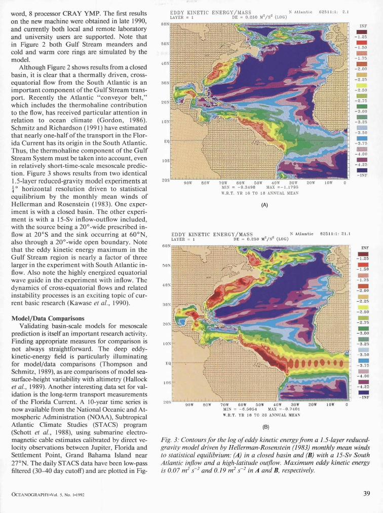
50>
word, 8 processor CRAY YMP. The first results on the new machine were obtained in late 1990, and currently both local and remote laboratory and university users are supported. Note that in Figure 2 both Gulf Stream meanders and cold and warm core rings are simulated by the model.
Although Figure 2 shows results from a closed basin, it is clear that a thermally driven, cross- equatorial flow from the South Atlantic is an important component of the Gulf Stream trans- port. Recently the Atlantic "conveyor belt," which includes the thermohaline contribution to the flow, has received particular attention in relation to ocean climate (Gordon, 1986). Schmitz and Richardson ( 1991) have estimated that nearly one-half of the transport in the Flor- ida Current has its origin in the South Atlantic. Thus, the thermohaline component of the Gul f Stream System must be taken into account, even in relatively short-time-scale mesoscale predic- tion. Figure 3 shows results from two identical 1.5-layer reduced-gravity model experiments at ~o horizontal resolution driven to statistical equilibrium by the monthly mean winds of Hellerman and Rosenstein (1983). One exper- iment is with a closed basin. The other experi- ment is with a 15-Sv inflow-outflow included, with the source being a 20°-wide prescribed in- flow at 20°S and the sink occurring at 60°N, also through a 20°-wide open boundary. Note that the eddy kinetic energy maximum in the Gulf Stream region is nearly a factor of three larger in the experiment with South Atlantic in- flow. Also note the highly energized equatorial wave guide in the experiment with inflow. The dynamics of cross-equatorial flows and related instability processes is an exciting topic of cur- rent basic research (Kawase et al., 1990).
Model/Data Comparisons Validating basin-scale models for mesoscale
prediction is itself an important research activity. Finding appropriate measures for comparison is not always straightforward. The deep eddy- kinetic-energy field is particularly illuminating for model/data comparisons (Thompson and Schmitz, 1989), as are comparisons of model sea- surface-height variability with altimetry (Hallock et al., 1989). Another interesting data set for val- idation is the long-term transport measurements of the Florida Current. A 10-year time series is now available from the National Oceanic and At- mospheric Administration (NOAA), Subtropical Atlantic Climate Studies (STACS) program (Schott et al., 1988), using submarine electro- magnetic cable estimates calibrated by direct ve- locity observations between Jupiter, Florida and Settlement Point, Grand Bahama Island near 27°N. The daily STACS data have been low-pass filtered (30-40 day cutoff) and are plotted in Fig-
E D D Y K I N E T I C E N E R G Y / M A S S LAYER = 1 DE = 0 . 2 5 0 M Z / S 2 (LOG)
6 0 b
4 0 3
2 0 ?
3 0 ?
107
10~
N A t l a n t i c 6 2 5 1 1 : 1 : 2.1
2 0 5 .qOW 80W 70W 60W 501Y 40W 30W '2(IW 1 fill
MIN = - 9 . 3 4 9 8 MAX = - 1 . 1 7 9 5
W.R.T. YR 16 T 0 18 ANNUAL MEAN
(A)
1NF
1 - 1 , 2 5
I - I . 5 0
i m - 1 . 7 5
1 - 2 . 0 0
- 2 . 2 5
- 2 . 5 0
- 2 . 7 5
1 - 3 . 0 0
1 - 3 . 2 5
- 3 , 5 0
1 - 3 . 7 5
- 4 . 0 0
1 -.I . 25
I -INF
c
E D D Y K I N E T I C ENERGY/MASS N A t l a n t i c 0 2 5 1 1 : 1 : 2 1 . 1 LAYER = I DE = 0.250 MZ/S 2 (LOG)
c - ' - INF
1 - 1 . 2 5
1 - 1 . 5 0
1 - 1 . 7 5
1 - 2 . 0 0
- 2 . 2 5
9OW 80W 70W 60W 50W 40W 30W MIN = - 6 . 5 0 5 4 MAX = - 0 . 7 4 0 1
W.R.T. YR 18 TO 20 ANNUAL MEAN
- 2 . 5 0
1 - 2 . 7 5
1 - 3 . 0 0
1 - 3 . 2 5
- 3 . 5 0
20W 10W 0
I -3.76
II - 4 . 0 0
1 - 4 . 2 5
1 - I N F
(B)
Fig. 3: Contours for the log o f eddy kinetic energy from a 1.5-1ayer reduced- gravity model driven by Hellerman-Rosenstein (1983) monthly mean winds to statistical equilibrium: (A) in a closed basin and (B) with a 15-Sv South Atlantic inflow and a high-latitude outflow. Max imum eddy kinetic energy is 0.07 m 2 s -2 and 0.19 m 2 s -2 in A and B, respectively.
~ E A N ~ R A P H Y - V o l . 5, No. 1-1992 39

4 5 -
2 5
4 0 -
~ 3 5 -
..~
0
III
O b s e r v e d F r o m C a b l e D a t a
- - M o d e l C y c l e A - - M o d e l C y c l e B
M o d e l s e t - u p s A a n d B a r e ident ica l e x c e p t for init ial s ta t e a n o m a l i e s
F l o r i d a S t r a i t s T r a n s p o r t 1 9 8 2 - 1 9 8 9
O b s e r v e d a n d S i m u l a t e d
2 0
J A N 8 2 " j A N 8 3 " j A N S ~ I " j A N 8 5 " j A N 8 6 " J A N 8 7 J A N 8 8
¢A)
F l o r i d a S t r a i t s T r a n s p o r t M e a n A n n u a l C y c l e O v e r 1 9 8 2 - 1 9 8 9
J A N 8 9 J A N g 0
4
3 .
eL
t_ @
• 4 1 .
..~ o
~ - 1 .
0 e~
~I _'~- 11 L
- - O b s e r v e d F r o m C a b l e D a t a M o d e l - E C M W F / H R ( A ) M o d e l - E C M W F / i i R ( B )
. . 4 -
J a n F eb M a r A p t M a y J u n Jul A u g S e p O c t N o v D e c J a n
(B) Fig. 4." (A) Calibrated cable-estimated volume transport of the Florida Current from the Subtropical Atlantic Climate Studies Program (STACS) at 27°N (courtesy Jimmy Larsen, NOAA, Pacific Marine Environmental Laboratory, Seattle) versus model-determined transport for two different 8-year cycles of the same European Centre for Medium-Range Weather Forecasts wind forc- ing. Observations and model data were low-pass filtered (30-40 day cutoff) and plotted daily. (B) The annual cycle of transport from the STACS data and from the two model cycles.
ure 4A. Note the mean transport is near 32.5 Sv and the maximum transport occurs on the summer.
Earlier models have shown the summertime transport maximum observed in the STACS Pro- gram. For example, Anderson and Corry (1985) used a non-eddy-resolving two-layer basin-scale model driven by monthly mean wind anomalies from Hellerman and Rosenstein (1983). Rhodes and Heburn (1986) used a global, coarse-grid re- duced-gravity model driven by FNOC operational wind fields. However, both models failed to ac- count for the large amplitude of the annual cycle of transport and the magnitude of the mean transport.
In Figure 4A, we also have plotted transports from a three-layer, finite-depth model driven to equilibrium by the monthly mean climatological winds (Hellerman and Rosenstein, 1983) for 70 years and then run for more than two 8-year cycles of winds having the annual mean from Hellerman and Rosenstein (1983), but anomalies about the mean from the European Centre for Medium- Range Weather Forecasts (ECMWF) operational winds. This is one of the few long time series from an operational center that has a reasonably con- sistent wind field from year to year. Constant South Atlantic inflow was specified from estimates of Schmitz and Richardson (1991) and high-lat- itude water-mass formation was parameterized via entrainment/detrainment and a source-sink flow. We have plotted two wind cycles to show the in- terannual differences in transport from the model due to differences in initial state and nonlinear processes, including influences of Loop Current eddy shedding in the Gulf of Mexico. Two im- portant results from this experiment are clear: I) The mean transport of the model current is nearly identical to that observed. The South Atlantic in- flow comprises about 13 Sv of this total. 2) The amplitude of the fluctuations in transport are comparable to those observed, including the summertime maximum and the rapid decrease in transport in the fall. The annual cycle, as shown in Figure 4B, also is reproduced well by the model. These results give us some confidence in both the model and the forcing functions.
Finally, although we are rapidly pushing toward an eddy-resolving basin-scale prediction capability in NOMP, we should note that a global, non-eddy- resolving model driven by FNOC Navy Opera- tional Global Atmospheric Prediction System (NOGAPS) winds is running on a daily basis un- der an operational evaluation program. Figure 5 is a snapshot of the sea-surface height for 25 Jan- uary 1992 from this ~° , reduced-gravity model. It is clearly only a preliminary version of the model we hope will eventually be running on a routine basis with data-assimilation and eddy-resolving capability. However, as discussed in the article by Hurlburt et al., (1992, this issue), we are rapidly approaching the day when this capability will be realized.
40 O C E A N O G R A P H Y - V o l . 5, No. 1-1992

Acknowledgements This work was supported by the Navy Ocean
Modeling and Prediction Program (Bob Peloquin, Program Manager), under the Global Ocean Pre- diction System project (Program elements 62435N and 63207N), the Naval Research Lab- oratory's Global Eddy-Resolving Ocean Model basic research program, and the Office of Naval Research Accelerated Research Initiative entitled "Ocean Dynamics from GEOSAT." Discussions with Harley Hurlburt and George Maul have been especially useful.
References Anderson, D.L.T. and R.A. Corry, 1985: Seasonal transport
variations in the Florida Straits. A model study. J. Phys. Oceanogr., 15, 773-786.
Barnett, T.P., N. Graham, M. Cane, S. Febriak, S. Dolan, J. O'Brien and D. Legler, 1988: Prediction of the El Nino of 1986-1987. Science, 241, 192-196.
Block, R. and L. T. Smith, 1990: A wind-driven isopycnie co- ordinate model of the North and Equatorial Atlantic Ocean. Part I: Model development and supporting ex- periments. J. Geophys. Res., 95, 3273-3285.
Bryan, F., 1990: Review of the first experiments in the WOCE Community Modelling Effort. AGU Fall Meeting. San Francisco. Dec. 5, 1990. Amer. Geophys. Union Trans- actions, 71, 1386.
Cessi, P., 1990: Recirculation and separation of boundary cur- rents. J. Mar. Res., 48, 1-35.
Clancy, R.M. and K.D. Pollak, 1983: A real-time synoptic ocean thermal analysis/forecast system. Progress in Oceanography, 12, 383-424.
Ezer, T. and G.L. Mellor, 1992: A numerical study of the vari- ability and separation of the Gulf Stream included by surface atmospheric forcing and lateral boundary flows. J. Phys. Oceanogr., 22.
Fox, D.N., M.R. Carnes. and J.L. Mitchell, 1991: Forecast system evaluations using satellite-derived fields. J. At- mos.. and Oceanic Technology, In press.
Fox, D.N., M.R. Carnes and J.L. Mitchell, 1992: Characterizing major frontal systems: a nowcast/forecast system for the northwest Atlantic. Oceanography, 5, 49-54.
Gordon, A.L. 1986: lnterocean exchange of thermohaline wa- ter. J. Ueophys. Res., 91, 5037-5046.
Halloek, Z.R., J.L. Mitchell. and J.D. Thompson, 1989: Sea surface topographic variability near the New England Seamounts: an intercomparison among in situ obser- vations, numerical simulations, and GEOSAT altimetry from the Regional Energetics Experiments. J. Geophys. Res., 94, 8021-8028.
Hellerman, S. and M. Rosenstein, 1983: Normal monthly wind stress over the world ocean with error estimates. J. Phys. Oceanogr. 13, 1093-1104.
H uang, R.X., 1991: The three-dimensional structure of wind- driven gyres: ventilation and subduction. U.S. National Report to IUGG--1987-1990. In: Contributions in Oceanography. M.A. Shea, ed., American Geophysical Union, Washington, DC, 590-609.
Hurlburt, H.E., 1984: The potential for ocean prediction and the role of altimeter data. Marine Geodesy, 8, 17-66.
Hurlburt, H.E., D.N. Fox and E.J. Metzger, 1990: Statistical inference of weakly correlated subthermocline fields from satellite altimeter data. J. Geophys. Res.. 95. 11375-11409.
Hurlburt, H.E. and J. Dana Thompson, 1980: A numerical study of Loop Current intrustions and eddy shedding. J. Phys. Oceanogr., 10, 1611-1651.
Hurlburt, H.E., A.J. Wallcratt, Z. Sirkes and E.J. Metzger, 1992: Modeling of the global and Pacific Oceans: on the path
t30W 60W .lOW ;.' 0 '~ t) MIN = - 5 1 . 6 0 2 MAX = 5 4 . 7 5 0
- I N F - 4 5 - 3 5 - 2 5 - 1 5 - 5 5 15 2 5 3 5 .1550 I N F
Fig. 5: Sea-surface height (cm) from a global non-eddy-resolving reduced- gravity ocean model driven by operational Fleet Numerical Oceanography Center winds. Map is for 25 January 1992.
to eddy-resolving ocean prediction. Oceanography, 5, 9-18.
Kawase, M., L.M. Rothstein and S. Springer, 1990: Encounter of the deep western boundary current with the equator:. time-asymptotic behavior. EOS, 71, 187(abstract).
Ocean Prediction Workshop Proceedings, 1986: A Status and Prospectus Report on the Scientific Basis and Navy's Needs: Institute for Naval Oceanography Report. W. Simmons, ed., Stennis Space Center, MS, 494 pp.
Rhodes, R.C. and G.W. Heburn, 1986: Numerical simulation of wind-forced seasonal and interannual transport vari- ability through the Florida Straits. Proceedings--Ocean Prediction Workshop. W. Simmons, ed., Institute for Naval Oceanography, Stennis Space Center, MS, 485- 486.
Robinson, A.R., 1992: Shipboard prediction with a regional forecast model. Oceanography, 5, 42--48.
Rosmond, T., 1992: A prototype fully coupled ocean-atmo- sphere prediction system. Oceanography, 5, 25-30.
Sehmitz, W.J., Jr. and P.L. Richardson, 1991: On the sources of the Florida Current. Deep-Sea Res., 38, $379-$409.
Schmitz, W.J., Jr. and W.R. Holland, 1986: Observed and modelled mesoscale variability near the Gulf Stream and Kuroshio Extension. J. Geophys. Res., 91, 9624- 9638.
Sehott, F.A., T.N. Lee. and R. Zantop, 1988: Variability of structure and transport of the Florida Current in the period range of days to seasonal. J. Phys. Oceanogr., 18, 1209-1230.
Semtner, A.J. Jr. and R.M. Chervin, 1988: A simulation of the global ocean circulation with resolved eddies. J. Geophys. Res., 93, 15502-15522.
Thompson, J.D. and W.J. Schmitz Jr., 1989: A limited-area model of the Gulf Stream: design, initial experiments, and model-data intercomparison. J. Phys. Oceanogr., 19, 792-814. 17
OCEANOGRAPHY-Vol. 5, No. 1,1992 41