NZTA_Northern Corridor Newsletter (Web)_F (1)
6
NEW TRAVEL PLANS TAKE SHAPE ON THE NORTH SHORE PROJECT NEWSLETTER August 2015 The NZ Transport Agency has announced the latest design plans for a strategic motorway connection and new range of travel options on the North Shore. The direct motorway-to-motorway connection planned between the Northern Motorway (SH1) and an upgraded Upper Harbour Highway (SH18) will provide the northern-most link in the Western Ring Route, opening up access to Auckland International Airport, West Auckland, Manukau and beyond (see map overleaf). The new direct connection will provide an alternative route to SH1 for travel through the region, offering a different option for people wishing to avoid the central city. It will also help to provide a strategic route for freight to and from Northland. The Northern Corridor Improvements project also aims to better manage the pressure on local road links in Albany, the North Harbour industrial area and other new housing areas being built further north and north-west. As part of the project, the Transport Agency is working with Auckland Transport on plans to extend the highly successful Northern Busway from Constellation Bus Station through to Albany Bus Station. Over 5km of new walking and cycling paths are also proposed.
-
Upload
george-wood -
Category
Documents
-
view
216 -
download
0
Transcript of NZTA_Northern Corridor Newsletter (Web)_F (1)
8/20/2019 NZTA_Northern Corridor Newsletter (Web)_F (1)
http://slidepdf.com/reader/full/nztanorthern-corridor-newsletter-webf-1 1/5
NEW TRAVEL
PLANS TAKE
SHAPE ON THE
NORTH SHORE
PROJECT NEWSLETTER August 2015
The NZ Transport Agency has announced the latest design plans for a strategic
motorway connection and new range of travel options on the North Shore.
The direct motorway-to-motorway connection
planned between the Northern Motorway (SH1)
and an upgraded Upper Harbour Highway (SH18)
will provide the northern-most link in the Western
Ring Route, opening up access to Auckland
International Airport, West Auckland, Manukau
and beyond (see map overleaf).
The new direct connection will provide an
alternative route to SH1 for travel through the
region, offering a different option for people
wishing to avoid the central city. It will also help
to provide a strategic route for freight to and
from Northland.
The Northern Corridor Improvements project also
aims to better manage the pressure on local road
links in Albany, the North Harbour industrial area
and other new housing areas being built further
north and north-west.
As part of the project, the Transport Agency is
working with Auckland Transport on plans to
extend the highly successful Northern Busway
from Constellation Bus Station through to Albany
Bus Station.
Over 5km of new walking and cycling paths are
also proposed.

8/20/2019 NZTA_Northern Corridor Newsletter (Web)_F (1)
http://slidepdf.com/reader/full/nztanorthern-corridor-newsletter-webf-1 2/5
PAULMATTHEWSRD
Albany Metropolitan
Centre
UPPER HARBOUR HIGHWAY
A L B A
N Y E X P R E S S W
A Y N O R T H E R N M O T O R W A Y
Massey
University
Rosedale
Wastewater
Treatment Pond
CITY CENTRE
WHANGAREI
HOBSONVILLE,WESTERN RING ROUTE,AUCKLAND AIRPORT
Rosedale
Closed Landfill
A L B A N Y H W Y
GREVILLERD
ROSEDALERD
M C C L Y M O N T S R D
T A W A D R
CONSTELLATIONDR
N O R T H E R N B U S W
A Y
UNDERPASS
C A R I B B E A N D R
U N S W O R T H D R
NB: Lower Unsworth Driveone-way entry closed for
safety and compliance withmotorway standards
(see story on opposite page)
NB: Areafuture-proofed
for potentialsouth-west
ramps
Intersection
Local roads
Current motorway
Recommended new motorway lanes
Potential link still under investigation
Recommended busway
Potential link still under investigation
Walking and cycling path
Potential path still
under investigation
KEY
E L L I OT R O S E A VE
KEY ELEMENTS
• New direct We st-bound (SH18) and North-bound (SH1)
motorway-to-motorway connection
• Additional 3rd and 4th Northern Motorway (SH1) lanes between
Greville Rd and Constellation Dr
• Extension of dedicated Northern Busway from Constellation Bus
Station to Albany Bus Station, carrying buses in both directions
• Shared walking and cycle path on the Eastern side of the Northern
Motorway (SH1) between the bus stations. Further walking and cycling
connections on the South side of Upper Harbour Highway (SH18)
• Modified entry to Paul Matthews Rd, local road access retained.
Walking and cycling access added to crossing of the highway
• Upper Harbour Highway (SH18) upgraded to full motorway status,
and separated from the local roads
• Potential for onramp direct from Albany Expressway (SH17) to
help remove more traffic from the Greville Rd interchange.
ALBANY BUSSTATION
CONSTELLATIONSTATION
Local road connectionsto Upper Harbour
Highway still underinvestigation
(see story onopposite page)
NORTHERN CORRIDOR –LATEST DESIGN OPTION– JULY 2015
HOW WE GOTHERE
Since 2014 the Transport Agency has been
working with Auckland Council, Auckland
Transport, local board members, iwi and
businesses to develop a range of options
for the Northern Corridor’s new motorway
connection, Upper Harbour Highway
upgrade, the Busway extension and new
walking/cycle paths. We also sought
community feedback at a series of open day
events in November 2014.
Since then, we’ve been working through
the results of this consultation and a more
detailed geotechnical, traffic and safety
analysis. This process has resulted in the
latest design options presented here. Overall,
this design has the smallest ‘’footprint’’ or
physical impact on the area compared to the
other concepts, and is the most cost-effective– both of which were key feedback themes
we received from the community.
CHANGES WE’VE MADE AS
A RESULT OF FEEDBACK AND
ANALYSIS INCLUDE:
• More lanes on the Northern Motorway
in both directions to address safety,
weaving and congestion
• A bridge, instead of an underpass, for
the new westbound connection to
Upper Harbour Highway (SH18)
• A decision to retain the northbound
onramp at Greville Rd
• Plans to extend the Busway on the
eastern side of the Northern Motorway
• A proposal to include over 5kms of
new walking and cycle paths.
WE’RE STILL INVESTIGATING:
• The potential for a new onramp straightfrom Albany Expressway (SH17) onto SH1
to help remove further traffic from the
Greville Rd interchange
• With Auckland Transport, how the
Busway extension will cross over the
motorway and link into Albany Bus Station
• The exact alignment of Paul Matthews Rd
and the new intersection/s at Caribbean
Dr, as well as whether a bridge from
Unsworth Dr over to Omega Pl (either a
low speed local road or pedestrian bridge)
would be useful for the local community
when the current one-way entry at
Unsworth Dr has to close
• All other detailed design aspects including
bridge plans, landscaping and urban
design for the Busway, walking and
cycle paths.
Upon completion of the WesternRing Route, interregional trafficwill have two high quality, high
capacity routes for north-southtravel. The Northern Corridor
Improvements project is key tothe plan.

8/20/2019 NZTA_Northern Corridor Newsletter (Web)_F (1)
http://slidepdf.com/reader/full/nztanorthern-corridor-newsletter-webf-1 3/5
LOCAL ROAD CHANGES AT
UPPER HARBOUR HIGHWAY
A central part of the Northern Corridor
Improvements project involves upgrading
Upper Harbour Highway and separating local
road users from motorway traffic. At the
moment, both types of traffic share the same
stretch of highway, changing between 50kph
and 80kph speeds and negotiating three sets
of lights. We are proposing to connect the
two motorways with a bridge and upgrade
Upper Harbour Highway to full motorway
status. This means high speed traffic will not
have to leave the motorway and local traffic
will instead use the local roads.
To comply with motorway and onramp
safety and design standards when we make
this change, we will need to make changes
to some of the local roads that connect to
Upper Harbour Highway. These are:
• Caribbean Dr – intersection
changes required
• Paul Matthews Rd – intersection and
road alignment changes required
• Unsworth Dr – the one-way offramp
from Upper Harbour Highway would need
to close. To mitigate this, a new overbridge
to Omega Pl is being considered.
There are still multiple options for how
these changes might look. All of the options
are based on variations of two main base
options, illustrated in the graphic pictured
here. Some of the multiple variations are
based on feedback the community gave us
last time we held a public consultation. We
are liaising with property owners to choose
the most workable option.
We want your feedback on these options for
changes at Caribbean Dr, Paul Matthews Rd,
and Unsworth Dr/Omega Pl. What would they
mean for you?
Upper HarbourHighway
O n R a m p
Caribbean Dr
New Paul Matthews Rd
NEW PAUL MATTHEWS RDBRIDGE
Unsworth Dr
E xistingPaul Matthews Rd
AlbanyHighway
O ff Ra m p
O ff R a m
p
O ff R a m
p O n R a
m p
O n R
a m p
O ff R a m p
O n R a m p Omega Pl
UNDERPASS
NEW LOW SPEED BRIDGE OR
FOOT BRIDGEBEING INVESTIGATED
EXISTING
OFF RAMP CLOSED
BASE OPTION –
Bridge & Underpass
Unsworth Dr
NEW LOW
SPEED BRIDGE OR
FOOT BRIDGEBEING INVESTIGATED
New Paul Matthews Rd
UNDERPASS
WITH DIFFERENT
INTERSECTION
OPTIONS
O n R a m p
Caribbean Dr
ExistingPaul Matthews Rd
AlbanyHighway
O ff R a m pOmega Pl
O ff R a m p
O n R a m p
Upper HarbourHighway O
ff R a m p
O ff R a m
p O n R a
m p
O n R
a m p
EXISTING
OFF RAMP CLOSED
BASE OPTION –Underpass & Intersections
NEW WALKING AND
CYCLING PATHS
In our last round of public consultation,
you told us you would be interested in new
walking and cycling paths between the bus
stations, schools, sports facilities and other
major destinations in the area. You also said
you were interested in paths heading towards
Greenhithe and the Harbour Bridge, and better
connecting across Upper Harbour Highway.
In response we are now proposing a newshared path between the bus stations
following the Busway extension, and multiple
options and crossings for paths along Upper
Harbour Highway, that link up to the new
paths being built along Albany Highway.
We are also working closely with Auckland
Transport to ensure our paths link with other
existing and future paths in the area. A map
showing how all these proposed new routes
link into each other is on our website at
www.nzta.govt.nz/auckland-northern-corridor.
This proposal supports a wider $200 million
cycle programme by the Transport Agency,
Auckland Transport and Auckland Council
over the next three years.
We want to know your thoughts on these
paths: what are the important aspects
for us to consider?
NEXT STEPS:
WE’D LIKE YOUR INPUT
In September 2015 the NZ Transport Agency will be seeking thecommunity’s feedback on these latest design plans at a series of events.Feedback can also be sent to us using our online ‘Have your say’ form atwww.nzta.govt.nz/auckland-northern-corridor. We particularlywould like your input on the aspects below:
Find out how to give
us your views on
these key aspects by
18 September 2015
overleaf, either in
person or online.
8/20/2019 NZTA_Northern Corridor Newsletter (Web)_F (1)
http://slidepdf.com/reader/full/nztanorthern-corridor-newsletter-webf-1 4/5
GIVE US YOUR FEEDBACK
During September 2015 we are seeking feedback on theselatest design plans. Your views are important as they will beconsidered in refining the designs. There are a number of waysto give your feedback:
• In person, at one of our events:
- Westfield Albany – Sat 5 Sept and Sun 6 Sept,centre court location, all day
- Local businesses’ coffee drop in session – Tues 8 Sept,7.30-8.30am, Café Noir, 7A Triton Drive, Rosedale
- Local businesses’ coffee drop in session – Weds 9 Sept,7.30-8.30am, North Shore Cosmopolitan Club, 65 PaulMatthews Road, Albany
- Unsworth Heights community event – Fri 11 Sept,2pm-6pm, Meadowood Community Centre,55 Meadowood Drive.
- North Harbour Business Association Expo –Thurs 17 Sept, QBE Stadium (stand 80)
- Anytime between 9–4pm Monday to Friday at our office:drop in or make an appointment. We’re at 33A ApolloDrive, Rosedale.
• Or by calling us, emailing us or filling out our‘Have your say’ form on our website:
- www.nzta.govt.nz/auckland-northern-corridor
- Email [email protected]
- Phone: 0800 NCI PROJECT.
Your feedback needs to be received by Friday 18 September. In2016 we will come back to you to share the final design, and our
project team will start to work on urban design aspects, seekplanning approvals and lodge resource consents. This may takeup to two years. Construction is therefore planned from 2018,and will be completed within three years.
TO KEEP UPDATED – JOIN OUR EMAIL LIST: To receive regular e-updates just email us [email protected] with ‘Please subscribe me’in the subject line.
NEXT STEPS:
WE’D LIKE YOUR INPUT
In September 2015 the NZ Transport Agency will beseeking the community’s feedback on these latestdesign plans at a series of events. Feedback can alsobe sent to us using our online ‘Have your say’ form atwww.nzta.govt.nz/auckland-northern-corridor.We particularly would like your input on the
aspects below:
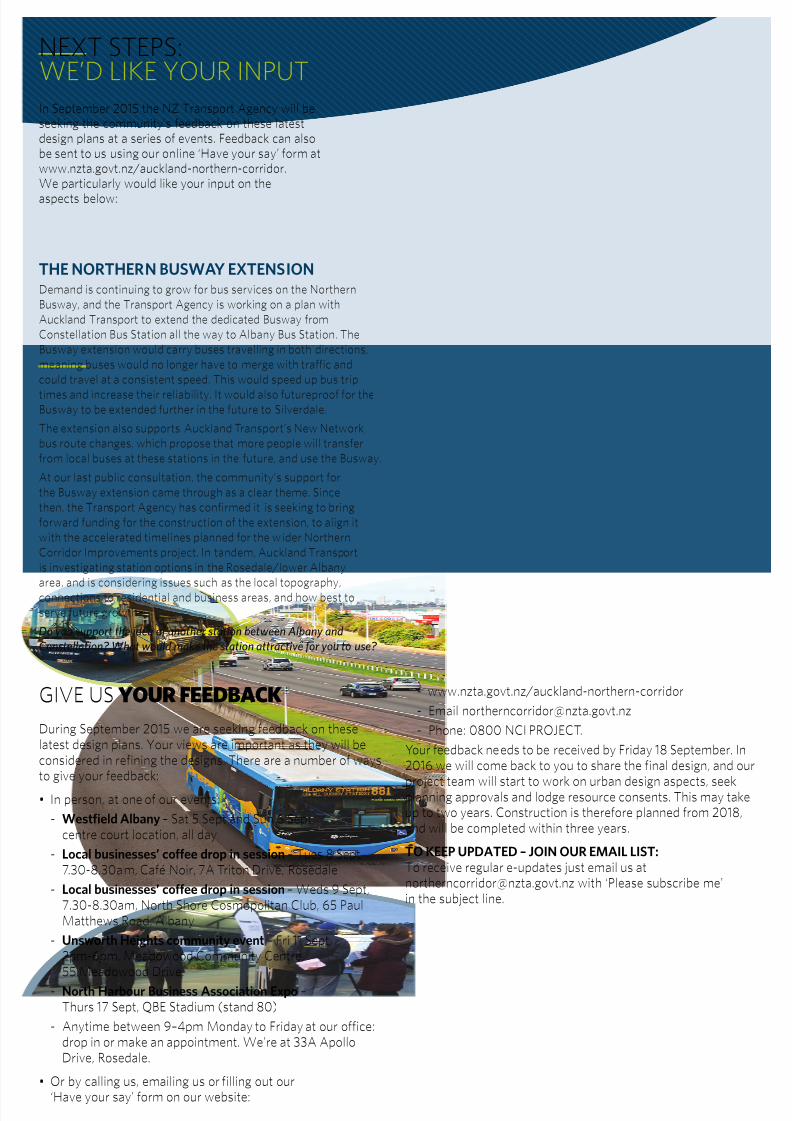
THE NORTHERN BUSWAY EXTENSION
Demand is continuing to grow for bus services on the Northern
Busway, and the Transport Agency is working on a plan with
Auckland Transport to extend the dedicated Busway from
Constellation Bus Station all the way to Albany Bus Station. The
Busway extension would carry buses travelling in both directions,
meaning buses would no longer have to merge with traffic and
could travel at a consistent speed. This would speed up bus trip
times and increase their reliability. It would also futureproof for theBusway to be extended further in the future to Silverdale.
The extension also supports Auckland Transport’s New Network
bus route changes, which propose that more people will transfer
from local buses at these stations in the future, and use the Busway.
At our last public consultation, the community’s support for
the Busway extension came through as a clear theme. Since
then, the Transport Agency has confirmed it is seeking to bring
forward funding for the construction of the extension, to align it
with the accelerated timelines planned for the wider Northern
Corridor Improvements project. In tandem, Auckland Transport
is investigating station options in the Rosedale/lower Albany
area, and is considering issues such as the local topography,
connections to residential and business areas, and how best to
serve future growth.
Do you support the idea of another station between Albany and
Constellation? What would make the station attractive for you to use?
8/20/2019 NZTA_Northern Corridor Newsletter (Web)_F (1)
http://slidepdf.com/reader/full/nztanorthern-corridor-newsletter-webf-1 5/5
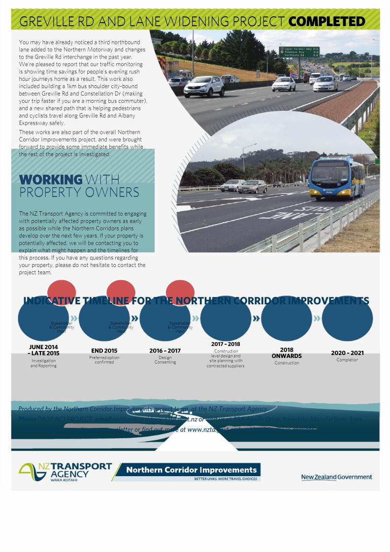
INDICATIVE TIMELINE FOR THE NORTHERN CORRIDOR IMPROVEMENTS
GREVILLE RD AND LANE WIDENING PROJECT COMPLETED
JUNE 2014
– LATE 2015
Investigationand Reporting
END 2015
Preferred optionconfirmed
2017 – 2018
Constructionlevel design and
site planning withcontracted suppliers
2016 – 2017
DesignConsenting
2018
ONWARDS
Construction
2020 – 2021
Completion
Stakeholder& Community
input
Stakeholder& Community
input
Stakeholder& Community
input
Produced by the Northern Corridor Improvements project team, at the NZ Transport Agency.
Phone 0800 NCI PROJECT, email [email protected] or visit us at 33A Apollo Drive, Rosedale, Mon-Fri 9am-4pm.
Have your say, sign up to our e-newsletter or find out more at www.nzta.govt.nz/auckland-northern-corridor
WORKING WITH
PROPERTY OWNERSThe NZ Transport Agency is committed to engaging
with potentially affected property owners as early
as possible while the Northern Corridors plans
develop over the next few years. If your property is
potentially affected, we will be contacting you to
explain what might happen and the timelines for
this process. If you have any questions regarding
your property, please do not hesitate to contact the
project team.
You may have already noticed a third northbound
lane added to the Northern Motorway and changes
to the Greville Rd interchange in the past year.
We’re pleased to report that our traffic monitoring
is showing time savings for people’s evening rush
hour journeys home as a result. This work also
included building a 1km bus shoulder city-bound
between Greville Rd and Constellation Dr (making
your trip faster if you are a morning bus commuter),
and a new shared path that is helping pedestrians
and cyclists travel along Greville Rd and Albany
Expressway safely.
These works are also part of the overall Northern
Corridor Improvements project, and were brought
forward to provide some immediate benefits while
the rest of the project is investigated.