NWT land information related to Aboriginal groups land information related to Aboriginal groups...
1
NWT land information related to Aboriginal groups TETLIT GWICH'IN ABORIGINAL OWNED LANDS NACHO NYAK DUN ABORIGINAL OWNED LAND Dehcho asserted territory Deepwater L. Watershed Arctic Red River spawning ground James Creek & Vittrekwa River Rat River, Husky River, Black Mountain Travaillant Lake, Mackenzie and Tree River Thelon Game Sanctuary Kaska Dena Council asserted territory Acho Dene Koe First Nation asserted territory Dehcho asserted territory Akaitcho asserted territory Chief Drygeese asserted territory Dene Tha' asserted territory K'atlodeeche First Nation asserted territory Akaitcho asserted territory Ka'a'gee Tu Banks Island No. 2 Banks Island No. 1 Kendall Island Anderson River Delta Cape Parry Queen Maud Gulf Ezôdzìtì Kelly Lake Pingo Canadian Landmark Mackenzie Bison Wildlife Sanctuary Ts'udenilineTu'eyeta Sambaa K'e Buffalo Lake,River andTrails Gwich'in Territorial Park Tl'oondih Kwets’oòtl’àà Shúhtagot’ine Néné Tuktut Nogait National Park Aulavik National Park Thaidene Nene Proposed National Park (2012) Thaidene Nene Proposed National Park (1997) Saoyú (Grizzly Bear Mountain) Æehdacho (Scented Grass Hills) Wood Buffalo National Park Nááts'ihch'oh Proposed NationalPark Ivvavik National Park Nahanni NationalPark Reserve Aklavik Colville Lake Detah Edzo Enterprise Fort Good Hope Fort Liard Fort McPherson Fort Providence Fort Resolution Fort Simpson Fort Smith Hay River Inuvik Jean Marie River Kakisa Nahanni Butte Norman Wells Paulatuk Sachs Harbour Yellowknife/N'dilo Trout Lake Tuktoyaktuk Wrigley Behchokö Whatì Wekweètì Gamètì Åutselk'e Délîne Tsiigehtchic Tulita Ulukhaktok Edéhzhíe Åue Túé Sûlái Tåîchô-Akaitcho Territory Dene First Nations Overlap Agreement Tåîchô Dehcho Overlap Agreement Tarium Niryutait Tarium Niryutait Tarium Niryutait Husky Lakes and Liverpool Bay Husky Lake Jericho Diavik Ekati Gahcho Kué Snap Lake NWT Métis Nation Dehcho Tåîchô/Akaitcho/NWT Métis Nation Tåîchô/Akaitcho/NWT Métis Nation Akaitcho/NWT Métis Nation Akaitcho/NWT Métis/AD/MD Akaitcho/NWT Métis Nation/AD Tåîchô/Akaitcho Dehcho/Akaitcho Akaitcho Akaitcho Sahtu/Akaitcho Dehcho/NWT Métis Nation Tåîchô Dehcho/Acho Dene Koe Dehcho/Akaitcho/NWT Métis Nation Mountain River Extention Whitefish River Aubrey Dunedelatue Johnny Hoe River (Teh Kaicho Dé) Edannla 94°0'0"W 96°0'0"W 98°0'0"W 100°0'0"W 102°0'0"W 104°0'0"W 104°0'0"W 106°0'0"W 106°0'0"W 108°0'0"W 108°0'0"W 110°0'0"W 110°0'0"W 112°0'0"W 112°0'0"W 114°0'0"W 114°0'0"W 116°0'0"W 116°0'0"W 118°0'0"W 118°0'0"W 120°0'0"W 120°0'0"W 122°0'0"W 122°0'0"W 124°0'0"W 124°0'0"W 126°0'0"W 126°0'0"W 128°0'0"W 128°0'0"W 130°0'0"W 132°0'0"W 134°0'0"W 136°0'0"W 138°0'0"W 140°0'0"W 142°0'0"W 73°0'0"N 72°0'0"N 71°0'0"N 71°0'0"N 70°0'0"N 70°0'0"N 69°0'0"N 69°0'0"N 68°0'0"N 68°0'0"N 67°0'0"N 67°0'0"N 66°0'0"N 66°0'0"N 65°0'0"N 65°0'0"N 64°0'0"N 64°0'0"N 63°0'0"N 63°0'0"N 62°0'0"N 62°0'0"N 61°0'0"N 61°0'0"N 60°0'0"N 60°0'0"N 59°0'0"N 59°0'0"N 58°0'0"N SCALE: 1:2,000,000 PROJECTION: Lambert Conformal Conic DATUM: NAD 83 Great Bear Lake Great Slave Lake BRITISH COLUMBIA ALBERTA NUNAVUT YUKON INUVIALUIT SETTLEMENT REGION SAHTU SETTLEMENT AREA GWICH'IN SETTLEMENT AREA WEK’ÈEZHÌI RESOURCE MANAGEMENT AREA (TÅÎCHÔ) SOUTH SLAVE AREA DEHCHO AREA This map may be used and reproduced for educational and informational purposes only. Any use for commercial purposes is prohibited and all rights are reserved. Kaska Dena Council asserted territory Nacho Nyak Dun AssertedTerritory Amundsen Gulf Coronation Gulf Nunavut NWT Nunavut NWT NWT 0 40 80 20 Km. Beaufort Sea NWT Yukon Treaty 8 Treaty 11 Treaty 8 Treaty 11 N ahan ni But t e Prim a ry U s e A rea Tr out L a ke P r i m a ry U s e A re a Great Slave Lake NWTMN Dehcho/ NWTMN Dehcho/Akaitcho NWTMN Tåîchô/ Akaitcho Tåîchô/NWTMN Dehcho/ Akaitcho Hay River K'atlodeeche FN Dehcho/ NWTMN Treaty 8 Treaty 11 Môwhì Gogha Dè Nîïtåèè Chief Drygeese asserted territory Wek'èezhìi Settled Land Claim Akaitcho/NWTMN NWTMN Akaitcho asserted territory Tåîchô Dehcho Akaitcho Mackenzie Bison Wildlife Sanctuary Wood Buffalo National Park Katlodeeche FN asserted territory Tåîchô Dehcho Overlap Agreement Tåîchô-Akaitcho Territory Dene FN Overlap Agreement Edéhzhíe Ka'a'gee Tu Buffalo Lake, River and Trails Dene Tha' Asserted Territory Dehcho asserted territory Kwets’oòtl’àà Hidden Lake Detah Edzo Enterprise Fort Providence Fort Resolution Hay River Kakisa Yellowknife (including N'dilo) Behchokö Whatì Treaty 10 Treaty 10 Definitions Interim Measures Agreement (IMA) : An agreement that clarifies how the Government of Canada and the Government of the Northwest Territories will work with an Aboriginal group during land and resource negotiations on matters such as parks, forest management, land use permits, disposals of lands, water licenses, tourism, etc. Interim Land Withdrawal : An agreement by the parties to temporarily ensure certain areas of land are protected from new land sales, leases or certain other new land rights that could interfere with the ability of the parties to negotiate. Treaty 11 Treaty 8 Produced by: Information Management Group AANDC NT-Region Date: March 1, 2012 LEGEND treaty and land claim areas This map includes: boundaries established by settled comprehensive land claims; areas under land, resources and/or self-government negotiations; areas asserted by Aboriginal people as traditional territories; and other land information. Publication of this map does not imply that the Aboriginal group, the Government of the Northwest Territories or the Government of Canada have agreed to any boundaries or areas shown except where legally established. This map is intended for general information only. It is neither a technical reference tool, nor a legal document. Aboriginal Affairs and Northern Develop- ment Canada (AANDC) will not be held liable for any errors or inaccuracies. To identify the specific location of any site with respect to any boundary, or to determine the consultation or other requirements that may exist in an area, please contact the Aboriginal and Territorial Relations Directorate in Yellowknife at (867) 669-2602. NUNAVUT SASKATCHEWAN Community All-weather Road Winter Road Diamond Mine Limited Use Road Aboriginal title lands for settled land claims (1)(2) Surface rights only Surface and subsurface rights Canol Trail asserted territories Salt River First Nation (Fort Smith area) K'atlodeeche First Nation (Hay River area) Reserve Lands (2) protected area land withdrawals (12) Land withdrawals for negotiations (1)(3)(4) parks and protected areas established areas (10)(11)(13) proposed national parks and park reserves (11) Protected Areas Strategy candidate areas (12) proposed conservation zones (4)(16) areas of interim measures (overlaps colour coded) Dehcho First Nations [DFN] (3) DFN/Akaitcho Dene First Nations [ADFN] DFN/Acho Dene Koe First Nation (7) ADFN/NWTMN/ Athabasca Denesuline (9) ADFN/NWTMN/ Athabasca Denesuline/Manitoba Denesuline (8) ADFN (3) ADFN/NWTMN DFN/ADFN/NWTMN DFN/Northwest Territory Métis Nation [NWTMN] Note: The North Slave Métis Alliance asserts that it represents a separate Aboriginal group and asserts rights over most of the Northwest Territories. Canada is reviewing these assertions to determine the status of the organization. The Northwest Territory Métis Nation may also assert rights in areas adjacent to the IMA boundary. NWTMN (3) Sahtu settlement area/ADFN Môwhì Gogha Dè Nîïtåèè (3) (2003 Tåîchô Agreement, Historic Treaties 8 & 11 Nacho Nyak Dun First Nation asserted territory (14) Acho Dene Koe First Nation asserted territory (7) Dehcho First Nations asserted territory (3) Dene Tha' First Nation asserted territory (5) K'atlodeeche First Nation asserted territory (3) Kaska Dena Council asserted territory (6) Akaitcho Dene First Nations asserted territory (3) Chief Drygeese asserted territory (15) Salt River First Nation Tåîchô/ADFN Tåîchô/ADFN/NWTMN Tåîchô/NWTMN Yellowknives Dene First Nation Tåîchô* (2) *Wek’èezhìi Resource Management Area land claim settlement areas for Inuvialuit, Gwich'in, Sahtu Dene and Métis and /Northwest Territory Métis Nation Tåîchô illustrative version) Kitikmeot NU AOL marine protected area © Her Majesty the Queen in Right of Canada, represented by the Minister of Aboriginal Affairs and Northern Development, 2012 QS-Y372-000-EE-A1 Catalogue R3-160/2012E ISBN 978-1-100-16631-5 Tåîchô/Akaitcho and Tåîchô/Dehcho Overlap Agreement areas Primary Use area (3) Treaties & Agreements Historic Treaties No . 8 - 1899/1900 No. 11 - 1921/1922 Modern Treaties Inuvialuit Final Agreement , July 25,1984 Gwich'in Comprehensive Land Claim Agreement, December 22 , 1992 Sahtu Dene and Metis Comprehensive Land Claim Agreement ,June 23, 1994 Tłîchô Agreement , August 4, 2005 Salt River Treaty Settlement Agreement , March 26, 2002 Interim Measures Agreement & Interim Land Withdrawals (for ongoing negotiation processes) Akaitcho Dene First Nations Interim Measures Agreement, June 28, 2001 Interim Land Withdrawal, 2007 - present Dehcho First Nations Interim Measures Agreement, May 23, 2001 Interim Land Withdrawal, 2003 - present Northwest Territory Métis Nation Interim Measures Agreement, June 22, 2002 Athabasca Denesuline Interim Measures Agreeme nt, September 25, 2003 Manitoba Denesuline Interim Measures Agreement, August 5, 2004 Framework Agreements (for ongoing negotiation processes) Acho Dene Koe First Nation, Framework Agreement, September 18, 2008 First Nation of Nacho Nyak Dun , Framework Agreement under consider ation by P arties Litigation Settlement Agreement Dene Tha’ First Nation , July 23, 2007 Aboriginal Overlap Agreements The Tł îchô First Nation and Akaitcho Territory Dene First Nations Agreement on overlapping interests in lands and resources, November 18, 2002 Th e Tł îchô First Nation and Dehcho First Nations Boundary/Overlap Agreement, October 31, 2002 Sources 1. Information Management Group, Aboriginal Affairs and Northern Development Canada, NT -Region, Jan. 19, 2006. 2. National Framework Canada Lands Administrative Boundaries, Legal Surveys Division, Geomatics Canada, Natural Resources Canada, Sept., 2006. 3. Comprehensive Claims Branch, Aboriginal Affairs and Northern Development Canada. 4. Dehcho First Nations Interim Land Withdrawal, 2011–1274 Draft Community Plan : Ndéh Ts’edîîchá: Dehcho Ndéh T'áh Ats'et'î K'eh Eghálats'ênda, Nov., 2005. 5. Dene Tha’ First Nation, 1993. 6. Kaska Nation (Kaska De na Council, La ird First Nation and Ross River Dena Council). 7. Acho Dene Koe First Nation (ADK), 2005. 8. Manitoba Dene Sayisi Dene First Nation/Northlands Dene First Nation, 1993. 9. Prince Albert Tribal Council Study, Chipewyan – Denesuline Bands, 1980. 10. Gwich’in Land Use Plan, Gwich’in Land and Water Board, Nov., 2002. 11. Parks Canada, Boundary for: Nahanni Greater Ecosystem, East Arm (AOI) Parks Canada Agency 2009. 12. Protected Areas Strategy, NWT Centre for Geomatics, and the Government of the Northwest Territories, 1997. 13. Area Protected through Tłîch ô Agreement ( Ezôdzìtì ): Aboriginal Affairs and Northern De velopment Canada, Comprehensive Claims Branch - Dene/Metis Land Selection Office, 2003. 14. Nacho Nyak Dun asserted territory, Nacho Nyak Dun First Nation, Mayo, and Yukon. 15. Chief Drygeese asserted territory, Yellowknifes Dene First Nation, 2002. 16. Sahtu Land Use Planning Board, Proposed Final Zoning –Interim Draft, July, 2011.
Transcript of NWT land information related to Aboriginal groups land information related to Aboriginal groups...
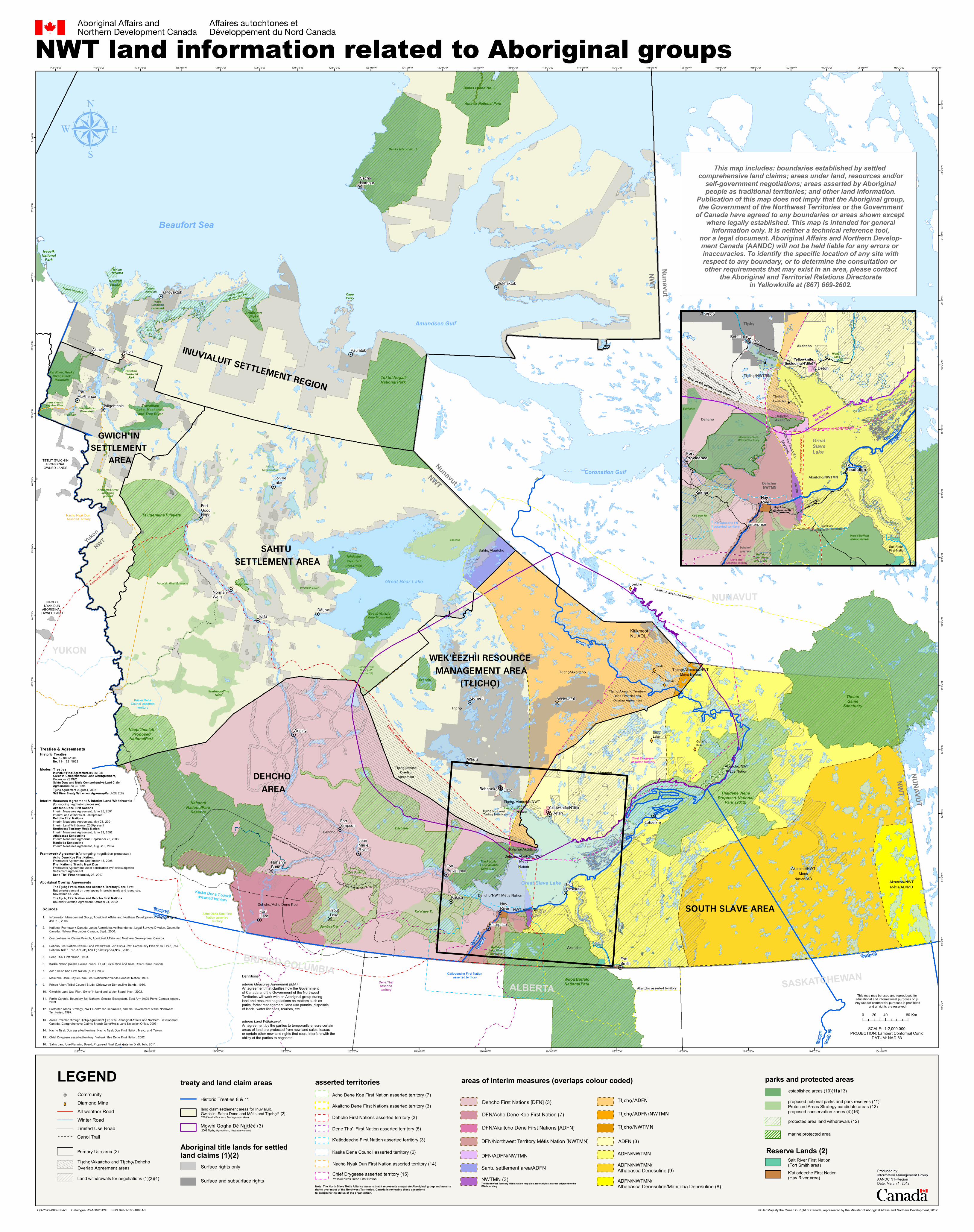
NWT land information related to Aboriginal groups
TETLIT GWICH'INABORIGINAL
OWNED LANDS
NACHONYAK DUN
ABORIGINAL OWNED LAND
Dehcho asserted territory
Deepwater L.Watershed
Arctic Red Riverspawning
ground
James Creek &Vittrekwa River
Rat River, HuskyRiver, Black
Mountain
TravaillantLake, Mackenzieand Tree River
ThelonGame
SanctuaryKaska Dena
Council assertedterritory
Acho Dene Koe FirstNation asserted
territory
Dehch
o ass
erted
territ
ory
Akaitcho asserted territory
Chief Drygeese asserted territory
Dene Tha'assertedterritory
K'atlodeeche First Nation asserted territory
Akaitcho asserted territory
Ka'a'gee Tu
Banks Island No. 2
Banks Island No. 1
KendallIsland
Anderson River Delta
Cape Parry
Queen Maud Gulf
Ezôdzìtì
Kelly Lake
Pingo Canadian Landmark
MackenzieBison Wildlife
Sanctuary
Ts'ude niline Tu'eyeta
Sambaa K'e
BuffaloLake, Riverand Trails
Gwich'in Territorial
Park
Tl'oondih
Kwets’oòtl’àà
Shuhtagot’ine Nene
Tuktut NogaitNational Park
Aulavik National Park
Thaidene NeneProposed National
Park (2012)
Thaidene Nene Proposed
National Park (1997)
Saoyú (GrizzlyBear Mountain)
Æehdacho(Scented
Grass Hills)
Wood BuffaloNational Park
Nááts'ihch'ohProposed
National Park
IvvavikNational
Park
NahanniNational Park
Reserve
Aklavik
ColvilleLake
Detah
Edzo
Enterprise
FortGoodHope
FortLiard
FortMcPherson
FortProvidence
FortResolution
FortSimpson
FortSmith
HayRiver
Inuvik
JeanMarieRiver
Kakisa
NahanniButte
NormanWells
Paulatuk
SachsHarbour
Yellowknife/N'dilo
TroutLake
Tuktoyaktuk
Wrigley
Behchokö
Whatì
WekweètìGamètì
Åutsel k'e
Délîne
Tsiigehtchic
Tulita
Ulukhaktok
Edéhzhíe
Åue Túé Sûlái
Tåîchô-Akaitcho Territory Dene First Nations Overlap Agreement
Tåîchô DehchoOverlap
Agreement
Tarium Niryutait
Tarium NiryutaitTarium Niryutait
Husky Lakes
and Liverpool Bay
HuskyLake
Jericho
Diavik
Ekati
GahchoKué
SnapLake
NWT Métis Nation
Dehcho
Tåîchô/Akaitcho/NWTMétis Nation
Tåîchô/Akaitcho/NWTMétisNation
Akaitcho/NWTMétis Nation
Akaitcho/NWTMétis/AD/MD
Akaitcho/NWTMétis
Nation/AD
Tåîchô/Akaitcho
Dehcho/Akaitcho
Akaitcho
Akaitcho
Sahtu/Akaitcho
Dehcho/NWT Métis Nation
Tåîchô
Dehcho/Acho Dene Koe
Dehcho/Akaitcho/NWTMétisNation
Mountain River ExtentionWhitefish River
AubreyDunedelatue
Johnny HoeRiver (TehKaicho Dé)
Edannla
94°0'0"W96°0'0"W98°0'0"W100°0'0"W102°0'0"W
104°0'0"W
104°0'0"W
106°0'0"W
106°0'0"W
108°0'0"W
108°0'0"W
110°0'0"W
110°0'0"W
112°0'0"W
112°0'0"W
114°0'0"W
114°0'0"W
116°0'0"W
116°0'0"W
118°0'0"W
118°0'0"W
120°0'0"W
120°0'0"W
122°0'0"W
122°0'0"W
124°0'0"W
124°0'0"W
126°0'0"W
126°0'0"W
128°0'0"W
128°0'0"W130°0'0"W132°0'0"W134°0'0"W136°0'0"W138°0'0"W140°0'0"W142°0'0"W
73°0
'0"N
72°0
'0"N
71°0
'0"N
71°0
'0"N
70°0
'0"N
70°0
'0"N
69°0
'0"N
69°0
'0"N
68°0
'0"N
68°0
'0"N
67°0
'0"N
67°0
'0"N
66°0
'0"N
66°0
'0"N65
°0'0"
N
65°0
'0"N64
°0'0"
N
64°0
'0"N
63°0
'0"N
63°0
'0"N
62°0
'0"N
62°0
'0"N
61°0
'0"N
61°0
'0"N
60°0
'0"N
60°0
'0"N
59°0
'0"N
59°0
'0"N
58°0
'0"N
SCALE: 1:2,000,000PROJECTION: Lambert Conformal Conic
DATUM: NAD 83
Great Bear Lake
Great Slave Lake
BRITISH COLUMBIAALBERTA
NUNAVUT
YUKON
INUVIALUIT SETTLEMENT REGION
SAHTU SETTLEMENT AREA
GWICH'IN SETTLEMENT
AREA
WEK’ÈEZHÌI RESOURCE MANAGEMENT AREA
(TÅÎCHÔ)
SOUTH SLAVE AREA
DEHCHO AREA
This map may be used and reproduced for educational and informational purposes only. Any use for commercial purposes is prohibited
and all rights are reserved.
Kaska Dena Councilasserted territory
Nacho Nyak Dun AssertedTerritory
Amundsen Gulf
Coronation Gulf
NunavutNWT
NunavutNWT
NWT
0 40 8020 Km.
Beaufort Sea
NWTYukon
Treaty
8
Treaty
11
Treaty
8
Treaty 11
Nahanni Butte Primary Use Area
Trout Lake Primary Use Area
Great Slave Lake
NWTMN
Dehcho/ NWTMN
Dehcho/Akaitcho
NWTM
N
Tåîchô/ Akaitcho
Tåîchô/NWTMN
Dehcho/Akaitcho
Hay River K'atlodeeche FN
Dehcho/ NWTMN
Treaty
8Treaty
11
Môwhì Gogha
Dè Nîïtåèè
Chief Drygeese asserted territory
Hay River Dene No. 1
Wek'èezhìi Settled Land Claim
ALBERTA
Akaitcho/NWTMN
NWTMNAkaitcho asserted territory
Tåîchô
Dehcho
Akaitcho
Mackenzie Bison Wildlife Sanctuary
Wood BuffaloNational Park
Katlodeeche FN asserted territory
Tåîchô Dehcho Overlap Agreement
Tåîchô-Akaitcho Territory
Dene FN Overlap Agreement
Edéhzhíe
Ka'a'gee Tu
BuffaloLake, Riverand TrailsDene Tha'
Asserted Territory
Dehcho asserted territory
Kwets’oòtl’ààHidden Lake
Detah
Edzo
Enterprise
FortProvidence
FortResolution
HayRiver
Kakisa
Yellowknife (including N'dilo)
Behchokö
Whatì
Treaty
10
Treaty 10
DefinitionsInterim Measures Agreement (IMA) :An agreement that clarifies how the Governmentof Canada and the Government of the Northwest Territories will work with an Aboriginal group during land and resource negotiations on matters such as parks, forest management, land use permits, disposals of lands, water licenses, tourism, etc.
Interim Land Withdrawal :An agreement by the parties to temporarily ensure certain areas of land are protected from new land sales, leases or certain other new land rights that could interfere with the ability of the parties to negotiate.
Treaty 11Treaty 8
Produced by:Information Management GroupAANDC NT-RegionDate: March 1, 2012
LEGEND treaty and land claim areas
This map includes: boundaries established by settled comprehensive land claims; areas under land, resources and/or
self-government negotiations; areas asserted by Aboriginalpeople as traditional territories; and other land information.
Publication of this map does not imply that the Aboriginal group,the Government of the Northwest Territories or the Government
of Canada have agreed to any boundaries or areas shown except where legally established. This map is intended for general
information only. It is neither a technical reference tool,nor a legal document. Aboriginal Affairs and Northern Develop-ment Canada (AANDC) will not be held liable for any errors or inaccuracies. To identify the specific location of any site withrespect to any boundary, or to determine the consultation or other requirements that may exist in an area, please contact
the Aboriginal and Territorial Relations Directoratein Yellowknife at (867) 669-2602.
NUNAVUT
SASKATCHEWAN
Community
All-weather Road Winter Road
Diamond Mine
Limited Use Road
Aboriginal title lands for settledland claims (1)(2)
Surface rights only
Surface and subsurface rights
Canol Trail
asserted territories
Salt River First Nation (Fort Smith area)K'atlodeeche First Nation (Hay River area)
Reserve Lands (2)
protected area land withdrawals (12)
Land withdrawals for negotiations (1)(3)(4)
parks and protected areas established areas (10)(11)(13)
proposed national parks and park reserves (11) Protected Areas Strategy candidate areas (12)proposed conservation zones (4)(16)
areas of interim measures (overlaps colour coded)
Dehcho First Nations [DFN] (3)
DFN/Akaitcho Dene First Nations [ADFN]
DFN/Acho Dene Koe First Nation (7)
ADFN/NWTMN/Athabasca Denesuline (9)ADFN/NWTMN/Athabasca Denesuline/Manitoba Denesuline (8)
ADFN (3)
ADFN/NWTMNDFN/ADFN/NWTMN
DFN/Northwest Territory Métis Nation [NWTMN]
Note: The North Slave Métis Alliance asserts that it represents a separate Aboriginal group and assertsrights over most of the Northwest Territories. Canada is reviewing these assertionsto determine the status of the organization.
The Northwest Territory Métis Nation may also assert rights in areas adjacent to theIMA boundary.
NWTMN (3)Sahtu settlement area/ADFN
Môwhì Gogha Dè Nîïtåèè (3)(2003 Tåîchô Agreement,
Historic Treaties 8 & 11
Nacho Nyak Dun First Nation asserted territory (14)
Acho Dene Koe First Nation asserted territory (7)
Dehcho First Nations asserted territory (3)
Dene Tha' First Nation asserted territory (5)
K'atlodeeche First Nation asserted territory (3)
Kaska Dena Council asserted territory (6)
Akaitcho Dene First Nations asserted territory (3)
Chief Drygeese asserted territory (15)
Salt River First Nation
Tåîchô/ADFN
Tåîchô/ADFN/NWTMN
Tåîchô/NWTMN
Yellowknives Dene First Nation
Tåîchô* (2)*Wek’èezhìi Resource Management Area
land claim settlement areas for Inuvialuit,Gwich'in, Sahtu Dene and Métis and
/Northwest Territory Métis NationTåîchô
illustrative version)
Kitikmeot NU AOL
marine protected area
© Her Majesty the Queen in Right of Canada, represented by the Minister of Aboriginal Affairs and Northern Development, 2012QS-Y372-000-EE-A1 Catalogue R3-160/2012E ISBN 978-1-100-16631-5
Tåîchô/Akaitcho and Tåîchô/Dehcho Overlap Agreement areas
Primary Use area (3)
Treaties & Agreements Historic Treaties
No. 8 - 1899/1900 No. 11 - 1921/1922
Modern Treaties Inuvialuit Final Agreement, July 25,1984 Gwich'in Comprehensive Land Claim Agreement, December 22, 1992 Sahtu Dene and Metis Comprehensive Land Claim Agreement,June 23, 1994 Tłîchô Agreement, August 4, 2005 Salt River Treaty Settlement Agreement, March 26, 2002
Interim Measures Agreement & Interim Land Withdrawals
(for ongoing negotiation processes) Akaitcho Dene First Nations Interim Measures Agreement, June 28, 2001 Interim Land Withdrawal, 2007- present Dehcho First Nations Interim Measures Agreement, May 23, 2001 Interim Land Withdrawal, 2003 - present Northwest Territory Métis Nation Interim Measures Agreement, June 22, 2002 Athabasca Denesuline Interim Measures Agreement, September 25, 2003 Manitoba Denesuline Interim Measures Agreement, August 5, 2004
Framework Agreements (for ongoing negotiation processes) Acho Dene Koe First Nation, Framework Agreement, September 18, 2008 First Nation of Nacho Nyak Dun, Framework Agreement under consideration by P arties Litigation Settlement Agreement Dene Tha’ First Nation, July 23, 2007
Aborig inal Overlap Agreements The Tłîchô First Nation and Akaitcho Territory Dene First Nations Agreement on overlapping interests in l ands and resources, November 18, 2002 The Tłîchô First Nation and Dehcho First Nations Boundary/Overlap Agreement, October 31, 2002
Sources
1. Information Management Group, Aboriginal Affairs and Northern Development Canada, NT-Region,
Jan. 19, 2006.
2. National Framework Canada Lands Administrative Boundaries, Legal Surveys Division, Geomatics Canada, Natural Resources Canada, Sept., 2006.
3. Comprehensive Claims Branch, Aboriginal A ffairs and Northern Development Canada.
4. Dehcho First Nations Interim Land Withdrawal, 2011–1274 Draft Community Plan: Ndéh Ts’edîîchá:
Dehcho Ndéh T'áh Ats'et'î K'eh Eghálats'ênda, Nov., 2005.
5. Dene Tha’ First Nation, 1993.
6. Kaska Nation (Kaska Dena Council, La ird First Nation and Ross River Dena Council).
7. Acho Dene Koe First Nation (ADK), 2005.
8. Manitoba Dene Sayisi Dene First Nation/Northlands Dene First Nation, 1993.
9. Prince Albert Tribal Council Study, Chipewyan – Denesuline Bands, 1980.
10. Gwich’in Land Use Plan, Gwich’in Land and Water Board, Nov., 2002.
11. Parks Canada, Boundary for: Nahanni Grea ter Ecosystem, East Arm (AOI) Parks Canada Agency, 2009.
12. Protected Areas Strategy, NWT Centre for Geomatics, and the Government of the Northwest
Territories, 1997.
13. Area P rotected through Tłîchô Agreement (Ezôdzìtì): Aboriginal Affairs and Northern Development Canada, Comprehensive Claims Branch - Dene/Metis Land S election Office, 2003.
14. Nacho Nyak Dun asserted territory, Nacho Nyak Dun First Nation, Mayo, and Yukon.
15. Chief Drygeese asserted territory, Yellowknifes Dene First Nation, 2002.
16. Sahtu Land Use Planning Board, Proposed Final Zoning–Interim Draft, July, 2011.