NV Assessment
23
FIVE YEAR AMBIENT AIR MONITORING NETWORK ASSESSMENT 2015 STATE OF NEVADA DIVISION OF ENVIRONMENTAL PROTECTION BUREAU OF AIR QUALITY PLANNING Contact: Daren Winkelman Ambient Monitoring Program Bureau of Air Quality Planning 901 South Stewart Street, Suite 4001 Carson City, Nevada 89701 (775) 687-9342 or (775) 687-6396 fax E-mail: [email protected]
Transcript of NV Assessment

FIVE YEAR AMBIENT AIR MONITORING
NETWORK ASSESSMENT 2015
STATE OF NEVADA DIVISION OF ENVIRONMENTAL PROTECTION
BUREAU OF AIR QUALITY PLANNING Contact: Daren Winkelman Ambient Monitoring Program Bureau of Air Quality Planning 901 South Stewart Street, Suite 4001 Carson City, Nevada 89701 (775) 687-9342 or (775) 687-6396 fax E-mail: [email protected]

i
TABLE OF CONTENTS I. INTRODUCTION .....................................................................................................................1 II. BACKGROUND .......................................................................................................................2
NEVADA PHYSIOGRAPHY .......................................................................................................2 POPULATION AND DEMOGRAPHIC TRENDS ...........................................................................3 EMISSION SOURCES ................................................................................................................4 MONITORING REQUIREMENTS ..............................................................................................4 MONITORING NETWORK HISTORY ........................................................................................8
III. 2010-2015 MONITORING SITES AND AIR QUALITY TRENDS ............................... 11
MONITORING PURPOSE ........................................................................................................11 2010-2015 MONITORING SITES AND AIR QUALITY TRENDS ..............................................11
Trends in Particulate Matter as PM10 .................................................................................12 Trends in Particulate Matter as PM2.5 ................................................................................13 Trends in Ozone .................................................................................................................14 Carbon Monoxide ..............................................................................................................15 Lead....................................................................................................................................15 Nitrogen Dioxide ...............................................................................................................16 Sulfur Dioxide ....................................................................................................................16
IV. CURRENT MONITORING NETWORK EVALUATION ..............................................17
MULTIPLE AGENCY AND STAKEHOLDER INPUT .................................................................17 FUTURE NEEDS AND AVAILABLE RESOURCES ....................................................................17
V. WORK CITED ....................................................................................................................... 19

ii
LIST OF FIGURES Figure 1. Nevada Population 2002-2013 ...................................................................................... 4 Figure 2: Map of NDEP’s Ambient Air Monitoring Network ................................................... 9 Figure 3. Annual Average PM10 Concentration for NDEP Monitoring Sites ........................ 13 Figure 4. Design Values for NDEPs Ozone Monitoring Sites for the Past Five Years .......... 15
LIST OF TABLES Table 1: Nevada’s Top 10 Counties Ranked by Population ...................................................... 3 Table 3: State and National Air Quality Standards ................................................................... 6 Table 2: Ambient Air Monitoring Data Availability ................................................................ 10 Table 4: NDEP’s Ambient Monitoring Network ...................................................................... 11

iii
ACRONYMS AND ABBREVIATIONS °C Degrees Celsius °F Degrees Fahrenheit 15 Rural Counties Carson City, Churchill, Douglas, Elko, Esmeralda, Eureka,
Humboldt, Lander, Lincoln, Lyon, Mineral, Nye, Pershing, Storey, and White Pine
amsl Above Mean Sea Level BAQP Bureau of Air Quality Planning CAA Clean Air Act CBSA Core Based Statistical Area CFR Code of Federal Regulations CO Carbon Monoxide EPA United States Environmental Protection Agency IMPROVE Interagency Monitoring of Protected Visual Environments MOU Memorandum of Understanding NAAQS National Ambient Air Quality Standards NAC Nevada Administrative Code NCORE National Core Monitoring Station NDEP Nevada Division of Environmental Protection NO2 Nitrogen Dioxide O3 Ozone Pb Lead PM2.5 Particulate Matter less than 2.5 micrometers PM10 Particulate Matter less than 10 micrometers SLAMS State and Local Air Monitoring Station SO2 Sulfur Dioxide SPMS Special Purpose Monitoring Station SIPs State Implementation Plans TSP Total Suspended Particles

1
NDEP AMBIENT AIR MONITORING NETWORK 2010 ASSESSMENT
I. INTRODUCTION The monitoring program of the Nevada Division of Environmental Protection’s Bureau of Air Quality Planning (NDEP-BAQP) operates an ambient air quality monitoring network of gaseous and particulate pollutant monitors. The NDEP-BAQP’s jurisdiction for ambient air monitoring consists of Nevada’s 15 rural counties; that is all Nevada counties other than Washoe and Clark. The United States Environmental Protection Agency (EPA) finalized an amendment to the ambient air monitoring regulations on October 17, 2006. As part of this amendment, the EPA added the following requirement for states, or where applicable, local monitoring agencies, to conduct a network assessment once every five years [40 Code of Federal Regulations (CFR) 58.10(e)]. “(e) The State, or where applicable local, agency shall perform and submit to the EPA Regional Administrator an assessment of the air quality surveillance system every 5 years to determine, at a minimum, if the network meets the monitoring objectives defined in appendix D to this part, whether new sites are needed, whether existing sites are no longer needed and can be terminated, and whether new technologies are appropriate for incorporation into the ambient air monitoring network. The network assessment must consider the ability of existing and proposed sites to support air quality characterization for areas with relatively high populations of susceptible individuals (e.g., children with asthma), and, for any sites that are being proposed for discontinuance, the effect on data users other than the agency itself, such as nearby States and Tribes or health effects studies. For PM2.5, the assessment also must identify needed changes to population-oriented sites. The State, or where applicable local, agency must submit a copy of this 5-year assessment, along with a revised annual network plan, to the Regional Administrator. The first assessment is due July 1, 2010.” The NDEP-BAQP is submitting this assessment of its monitoring program in order to:
• evaluate its overall efficiency and effectiveness in relation to the budget; • determine if the current configuration is meeting community needs while not creating
redundancies, and; • assess the need for additional monitoring.
In doing so, NDEP-BAQP is trying to meet the goal of the National Ambient Air Monitoring Strategy to achieve, with limited resources, the best scientific value and protection of public and environmental health and welfare.

2
II. BACKGROUND The following factors were evaluated and considered in the overall design of NDEP’s air quality monitoring network: topography, climate, population, demographic trends, major emission sources, and air monitoring requirements. Each of these elements is described below, followed by a brief history of Nevada’s air quality monitoring network. NEVADA PHYSIOGRAPHY The total area of Nevada is 110,552 square miles, with land comprising 109,894 square miles and inland water covering 658 square miles. Almost all of Nevada lies within the Great Basin, an area characterized by isolated mountain ranges separated by arid basins. Nevada is the most mountainous U.S. State, with over 150 named mountain ranges; these ranges generally trend northeast to southwest, are up to 75 miles long and 15 miles wide, and can rise to elevations of 7,000–10,000 feet above mean sea level (amsl). The predominant mountain ranges are the Schell Creek, Ruby, Toiyabe, and Carson Ranges. Over 30 of Nevada's mountain peaks exceed 11,000 feet amsl. Nevada's highest point is Boundary Peak, at an elevation of 13,140 feet amsl. Nevada has a number of large lakes and several large saline marshes known as sinks. The largest lake is Pyramid Lake, with an area of 188 square miles. Nevada shares Lake Tahoe with California, and Lake Mead, created by Hoover Dam on the Colorado River, with Arizona. Nevada is the driest state in the country, made up of mostly desert and semi-arid climatic regions. Daytime summer temperatures may rise as high as 115 degrees Fahrenheit (°F) (46 degrees Celsius (°C)) and nighttime winter temperatures may drop as low as −10°F (−23.3°C). The winter season in the southern part of the state tends to be mild and of short duration. Most parts of Nevada receive scarce precipitation during the year. Most rain falls on the lee side (east and northeast slopes) of the Sierra Nevada Range. The average annual rainfall per year is approximately seven inches; however, the wettest areas can receive up to 40 inches. Snowfall is abundant in the mountains, exceeding 60 inches per year on the highest peaks.

3
POPULATION AND DEMOGRAPHIC TRENDS Table 1 shows the 10 most populated counties in Nevada (including Carson City, which is a consolidated municipality), according to the United States Census Bureau, along with their respective populations by rank, area in square miles, population density, and largest city. Table 1: Nevada’s Top 10 Counties Ranked by Population
Rank County Population
Within County Limits
Land Area in Square Miles
Population Density per Square Mile
Largest City/Town
1 Clark 2,069,981 7,891.4 262 Las Vegas 2 Washoe 440,078 6,302.3 70 Reno 3 Carson City 54,061 144.6 374 Carson City 4 Lyon 51,789 2,001.1 26 Fernley 5 Douglas 47,536 709.7 67 Gardnerville 6 Elko 52,766 17,169.8 3 Elko 7 Nye 42,282 18,181.9 2 Pahrump 8 Churchill 23,989 4,930.4 5 Fallon 9 Humboldt 17,279 9,640.7 2 Winnemucca 10 White Pine 10,034 8,875.6 1 Ely
Source: United States Census Bureau, 2015. In the metropolitan areas of Reno and Las Vegas, the Washoe County District Health Department, Air Quality Management Division and the Clark County Department of Air Quality and Environmental Management operate and maintain their respective monitoring networks separate from the NDEP-BAQP. Nevada had the largest population increase in the nation over the last two decades. Between 1990 and 2012 the statewide population increased 125 percent, reaching 2.7 million. By 2014, the state’s estimated population increased to 2,839,099, which is a 70 percent increase from the 2000 population of 1,998,257. The 2014 population for Clark County, which includes Las Vegas, was estimated at 2,069,681, and Washoe County, which includes Reno, had a population estimated at 440,078 (United States Census Bureau, 2015). Based on United States Census Bureau values, residents living in NDEP’s jurisdiction total approximately 330,000. Figure 1 shows the Nevada’s population change between 2002 and 2013.

4
Figure 1. Nevada Population 2002-2013
0
500000
1000000
1500000
2000000
2500000
3000000
2002 2003 2004 2005 2006 2007 2008 2009 2010 2011 2012 2013
Pers
ons
15 Rural Counties Washoe County Clark County Nevada
Source: United States Census Bureau, 2015 EMISSION SOURCES Air pollution within Nevada comes from a variety of sources. These include stationary sources, such as factories, power plants, manufacturing, smelters and other industrial sources; smaller sources, such as dry cleaners and degreasing operations; mobile sources, such as cars, trucks, buses, trains and planes; and natural sources, such as windblown dust and wildfires. Many of these sources are controlled through reasonable, fair and consistent implementation of state and federal air quality rules and regulations by the Bureau of Air Pollution Control. The authority to implement air pollution control requirements has been established in Nevada Revised Statutes (NRS) 445B.100 through 445B.825, and NRS 486A.010 through 486A.180. MONITORING REQUIREMENTS In 1970 the Congress of the United States created the EPA and promulgated the Clean Air Act (CAA). Title I of the CAA established the National Ambient Air Quality Standards (NAAQS) to protect public health. The NAAQS published by the EPA in 40 CFR Part 50 define the levels of air quality necessary to protect human health and welfare. An area is considered to be in nonattainment for a pollutant if it has violated the NAAQS for that pollutant. The NAAQS were developed for six criteria pollutants: total suspended particulate matter (TSP), ozone (O3), carbon monoxide (CO), lead (Pb), nitrogen dioxide (NO2), and sulfur dioxide (SO2). Subsequent revisions to the particulate matter standard resulted in two new standards: particulate matter less than 10 micrometers in diameter (PM10) and fine particulate matter, or particulate matter 2.5

5
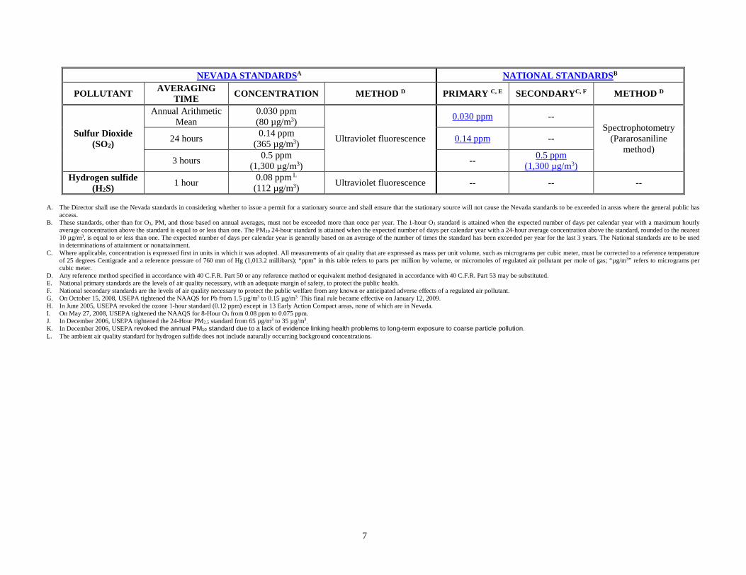
micrometers and smaller in diameter (PM2.5). The first revision (1987) reduced the size particulate matter that was considered harmful to humans, measuring for PM10. That standard was later revised (1997) to separate PM10 sized particles into two size fractions: coarse and fine. The coarse particulate matter fraction represents particles between 10 and 2.5 micrometers and the fine fraction includes PM2.5. Threshold limits established under the NAAQS to protect health are known as primary standards. The primary health standards are set to protect the most sensitive of the human population, including those people with existing respiratory or other chronic health conditions, children, and the elderly. Secondary standards established under the NAAQS are set to protect the public welfare and the environment. The EPA is required to review and revise the NAAQS based on the assessment of national air quality trends and on current (and ongoing) health studies. Recently the EPA has strengthened the NAAQS for particulate matter, CO, Pb, NO2, and SO2, and is currently revising the NAAQS for ozone. In addition to the NAAQS, NDEP adopted similar air quality standards to address air quality permitting needs. These state air quality standards can be found in Nevada Administrative Code (NAC) 445B.22097. The primary pollutants of concern in Nevada are PM10, PM2.5, and O3. Table 3 presents the Nevada State Standards and the NAAQS, including the most recent updates.

6
Table 3: State and National Air Quality Standards NEVADA STANDARDSA NATIONAL STANDARDSB
POLLUTANT AVERAGING TIME CONCENTRATION METHOD D PRIMARY C, E SECONDARYC, F METHOD D
CO at any elevation 1 hour 35 ppm
(40,500 µg/m3) Nondispersive infrared
photometry
35 ppm (40 mg/m3)
-- Nondispersive infrared photometry
CO < 5,000' AMSL 8 hours
9.0 ppm (10,500 µg/m3) 9 ppm
(10 mg/m3) CO ≥ 5,000' AMSL
6.0 ppm (7,000 µg/m3)
Lead (Pb)
Rolling 3-Month Average -- -- 0.15 µg/m3 G Same as Primary
High volume sampling, acid extraction, and
atomic absorption spectrometry
Quarterly Arithmetic Mean 1.5 µg/m3
High volume sampling, acid extraction, and atomic absorption
spectrometry
-- -- --
Nitrogen dioxide (NO2)
Annual Arithmetic Mean
0.053 ppm (100 µg/m3)
Gas phase chemiluminescence
0.053 ppm (100 µg/m3) Same as Primary Gas phase
chemiluminescence
O3
1 hour
0.12 ppm (235 µg/m3)
Chemiluminescence
-- H Same as Primary
Chemiluminescence O3
Lake Tahoe Basin, #90
0.10 ppm (195 µg/m3) -- --
O3 8 hours -- -- 0.075 ppm I Same as Primary
PM2.5 Annual Arithmetic
Mean -- -- 12.0 µg/m3
Same as Primary Low volume PM2.5 sampling 24 hours 35 µg/m3 J
PM10 Annual Arithmetic
Mean 50 µg/m3 High volume PM10 sampling
-- K
Same as Primary High volume PM10 sampling 24 hours 150 µg/m3 150 µg/m3
7
NEVADA STANDARDSA NATIONAL STANDARDSB
POLLUTANT AVERAGING TIME CONCENTRATION METHOD D PRIMARY C, E SECONDARYC, F METHOD D
Sulfur Dioxide (SO2)
Annual Arithmetic Mean
0.030 ppm (80 µg/m3)
Ultraviolet fluorescence
0.030 ppm -- Spectrophotometry
(Pararosaniline method)
24 hours 0.14 ppm (365 µg/m3) 0.14 ppm --
3 hours 0.5 ppm (1,300 µg/m3) -- 0.5 ppm
(1,300 µg/m3) Hydrogen sulfide
(H2S) 1 hour 0.08 ppm L
(112 µg/m3) Ultraviolet fluorescence -- -- --
A. The Director shall use the Nevada standards in considering whether to issue a permit for a stationary source and shall ensure that the stationary source will not cause the Nevada standards to be exceeded in areas where the general public has
access. B. These standards, other than for O3, PM, and those based on annual averages, must not be exceeded more than once per year. The 1-hour O3 standard is attained when the expected number of days per calendar year with a maximum hourly
average concentration above the standard is equal to or less than one. The PM10 24-hour standard is attained when the expected number of days per calendar year with a 24-hour average concentration above the standard, rounded to the nearest 10 µg/m3, is equal to or less than one. The expected number of days per calendar year is generally based on an average of the number of times the standard has been exceeded per year for the last 3 years. The National standards are to be used in determinations of attainment or nonattainment.
C. Where applicable, concentration is expressed first in units in which it was adopted. All measurements of air quality that are expressed as mass per unit volume, such as micrograms per cubic meter, must be corrected to a reference temperature of 25 degrees Centigrade and a reference pressure of 760 mm of Hg (1,013.2 millibars); “ppm” in this table refers to parts per million by volume, or micromoles of regulated air pollutant per mole of gas; “µg/m3” refers to micrograms per cubic meter.
D. Any reference method specified in accordance with 40 C.F.R. Part 50 or any reference method or equivalent method designated in accordance with 40 C.F.R. Part 53 may be substituted. E. National primary standards are the levels of air quality necessary, with an adequate margin of safety, to protect the public health. F. National secondary standards are the levels of air quality necessary to protect the public welfare from any known or anticipated adverse effects of a regulated air pollutant. G. On October 15, 2008, USEPA tightened the NAAQS for Pb from 1.5 µg/m3 to 0.15 µg/m3
. This final rule became effective on January 12, 2009. H. In June 2005, USEPA revoked the ozone 1-hour standard (0.12 ppm) except in 13 Early Action Compact areas, none of which are in Nevada. I. On May 27, 2008, USEPA tightened the NAAQS for 8-Hour O3 from 0.08 ppm to 0.075 ppm. J. In December 2006, USEPA tightened the 24-Hour PM2.5 standard from 65 µg/m3 to 35 µg/m3
. K. In December 2006, USEPA revoked the annual PM10 standard due to a lack of evidence linking health problems to long-term exposure to coarse particle pollution. L. The ambient air quality standard for hydrogen sulfide does not include naturally occurring background concentrations.

8
MONITORING NETWORK HISTORY Nevada has three jurisdictions which manage their own air programs by designation through the Nevada State Legislature. The Nevada Department of Conservation and Natural Resources, NDEP-BAQP is responsible for air quality surveillance in all areas of the state other than Clark and Washoe Counties. NDEP-BAQP’s jurisdiction is approximately 87 percent of Nevada’s entire land area. Clark and Washoe Counties operate separate monitoring networks and publish independent annual monitoring reports. In addition to these three major monitoring networks, air quality monitoring is being conducted through the Interagency Monitoring of Protected Visual Environments (IMPROVE) network by federal land management agencies. There are two IMPROVE sites in Nevada, one at Great Basin National Park, along the eastern border of the state, and the other at Jarbidge Wilderness Area in northeastern Nevada. There are also several federally recognized tribes that conduct air monitoring within Nevada. Major tribes in Nevada are the Washoe, Northern Paiute, Southern Paiute, and Western Shoshone. In 1990, tribal landholdings totaled 1,147,088 acres (Bureau of Indian Affairs, 1990). Air quality monitoring is conducted by NDEP-BAQP for the purposes of meeting federal monitoring requirements and for state informational and planning purposes. These two goals are met through State and Local Air Monitoring Stations (SLAMS) and Special Purpose Monitoring Stations (SPMS). There are currently eleven ambient air quality monitoring stations in Nevada under the jurisdiction of NDEP-BAQP. SLAMS sites are federally required, long-term air quality monitoring stations. SPMS sites are typically established to determine the air quality in a smaller, localized area or to monitor on a temporary basis. These sites typically operate for six to 24 months, and are generally used to measure air quality in areas not previously monitored. They may also be established to monitor the effects of a specific air pollution source or group of sources on the surrounding air quality. Figure 2 displays the locations of NDEP-BAQP maintained monitors throughout the state of Nevada.

9
Figure 2: Map of NDEP’s Ambient Air Monitoring Network
10
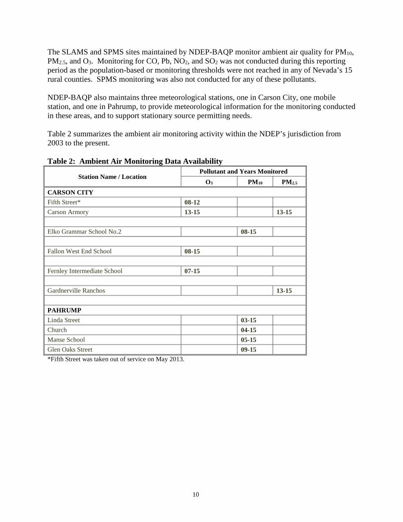
The SLAMS and SPMS sites maintained by NDEP-BAQP monitor ambient air quality for PM10, PM2.5, and O3. Monitoring for CO, Pb, NO2, and SO2 was not conducted during this reporting period as the population-based or monitoring thresholds were not reached in any of Nevada’s 15 rural counties. SPMS monitoring was also not conducted for any of these pollutants. NDEP-BAQP also maintains three meteorological stations, one in Carson City, one mobile station, and one in Pahrump, to provide meteorological information for the monitoring conducted in these areas, and to support stationary source permitting needs. Table 2 summarizes the ambient air monitoring activity within the NDEP’s jurisdiction from 2003 to the present. Table 2: Ambient Air Monitoring Data Availability
Station Name / Location Pollutant and Years Monitored
O3 PM10 PM2.5
CARSON CITY Fifth Street* 08-12 Carson Armory 13-15 13-15 Elko Grammar School No.2 08-15 Fallon West End School 08-15 Fernley Intermediate School 07-15 Gardnerville Ranchos 13-15 PAHRUMP Linda Street 03-15 Church 04-15 Manse School 05-15 Glen Oaks Street 09-15 *Fifth Street was taken out of service on May 2013.

11
III. 2010-2015 MONITORING SITES AND AIR QUALITY TRENDS MONITORING PURPOSE The data from the NDEP-BAQP ambient air monitoring network is used for a variety of purposes. Different programs within NDEP’s Bureau of Air Quality Planning and Bureau of Air Pollution Control use the data for their specific goals and needs. Planning uses the data for comparison with the NAAQS, attainment determinations, baseline for modeling, to project possible non-attainment areas, requisite outreach to those areas’ communities, and development of the State Implementation Plans (SIPs). The goal of NDEP-BAQP in developing the SIPs is to determine current and projected concentrations of ambient air contaminants within the state, and to develop and implement measures by which the ambient air quality standards will be achieved and maintained. The permitting programs within NDEP use the monitoring data for background pollutant concentrations, to appropriately determine if construction of a source or modification will contribute to a violation of the applicable standards. In addition, the EPA, surrounding states, and the Western Regional Air Partnership use the monitoring data for their comparison and modeling purposes. 2010-2015 MONITORING SITES AND AIR QUALITY TRENDS The NDEP-BAQP ambient air quality monitoring network is represented by eleven different monitors located at nine different locations within Nevada’s 15 rural counties. The eleven different monitors include ten SLAMS and one SPMS. NDEP-BAQP has made a consistent effort to place and maintain monitors in areas within its jurisdiction that have the highest population density and therefore appropriately provide data for the greatest number of people that could be affected by pollutants in any given area. Carson City and the communities of Fernley, Fallon, Gardnerville, Elko, and Pahrump all have forms of ambient air quality monitoring. Table 4 shows the locations and types of monitors currently operated by NDEP. Table 4: NDEP’s Ambient Monitoring Network Location Ozone PM10 PM2.5 Elko 1 (SLAMS) Fallon 1 (SLAMS) Fernley 1 (SLAMS) Carson City Armory 1 (SLAMS) 2 (SLAMS) Pahrump-Church Site 1 (SLAMS) Pahrump-Manse Elementary 1 (SLAMS) Pahrump-Glen Oaks 1 (SLAMS) Pahrump-Linda Street 1 (SLAMS) Gardnerville Ranchos 1 (SPMS)
Total 3 5 3 SLAMS – State and Local Air Monitoring Station SPMS – Special Purpose Monitor Station
12
Trends in Particulate Matter as PM10 NDEP-BAQP maintains five PM10 SLAMS monitors; four of these are in the community of Pahrump, and one is in Elko. Most current and planned development within Pahrump Valley is located within the Town of Pahrump, which is located in Pahrump Regional Planning District of Nye County in southern Nevada. The Town of Pahrump is approximately 60 miles west of Las Vegas and 60 miles east of Death Valley. Population growth in the past has resulted in intensive development in Pahrump. Large parcels of land were cleared of vegetation, subdivided, and prepared for housing construction. Dirt and gravel roads were constructed. Many of the planned housing developments never materialized and the lots are now disturbed, vacant areas. Several control measures were put into practice to control fugitive dust from unpaved roads. Nye County has implemented a paving/chip sealing program for the past several years. Other control measures include the reduction of vehicle speed on unpaved roads, prohibition of the construction of new unpaved roads, requirements for stabilization of disturbed lots, employment of best management practices for construction sites, and site-specific mitigation for special events. Citizen complaints in the late 1990's led to the installation of an ambient PM10 monitor in the downtown area. The NDEP-BAQP has been monitoring the concentration of PM10 in the Town of Pahrump since January 2001. NDEP-BAQP has four monitors in the valley, one station monitors the background concentration (Linda), a second station is located at the wastewater treatment plant (Glen Oaks), a third is located near a dry lakebed (Church), and the fourth is located near the Manse School (Manse). As previously noted, the Pahrump area has been designated as unclassifiable/attainment for PM10. The EPA, State of Nevada, Pahrump Town Board, and Nye County have agreed to use a memorandum of understanding (MOU) to address this classification. The MOU was signed in September 2003, and gave the cooperative agencies until 2009 to develop adequate control strategies. As a result of pollutant control strategies implemented in Pahrump, the PM10 levels in the area have been declining. However, several exceptional wind events have occurred in Pahrump causing exceedances of the NAAQS. Currently NDEP-BAQP is in the process of submitting exceptional event packages requesting that EPA exclude data related to these exceedances. Excluding the aforementioned exceptional events, the area is in attainment for PM10. Due to the geography of the area, the arid climate, and the propensity for high winds, this area must be continuously monitored. Monitoring is also necessary to determine the efficacy of the control measures instituted by Nye County for dust suppression. The PM10 monitor for Elko is located at a local elementary school. Currently NDEP-BAQP is in the process of preparing an exceptional event package for the Elko site in response to elevated PM10 values caused by an exceptionally high wind event. The exceptional event package will include a request that EPA exclude data related to this exceedance.

13
Annual average PM10 concentrations for all five monitoring sites are shown in Figure 3. The annual average PM10 concentrations at the Linda and Glen Oaks sites have decreased over the past five years. The annual average PM10 concentration at the Elko, Manse, and Church sites have increased over the same time period, although the increase was slight for both Elko and Manse. Figure 3. Annual Average PM10 Concentration for NDEP Monitoring Sites
Trends in Particulate Matter as PM2.5
EPA first issued standards for TSP in 1971 and revised them in 1987 (for PM10 only), 1997 (for PM10 and PM2.5), 2006, and 2012. Three PM2.5 monitors are maintained within NDEP-BAQP’s network. Two of these are located in Carson City, and one is in Gardnerville. The two collocated PM2.5 monitors at the Carson City Armory site were installed on April 1, 2013. The decision to implement a PM2.5 network was based on the tightening of the PM2.5 NAAQS and the population density of Carson City and Gardnerville. Although Carson City and Gardnerville do not meet the CFR requirement for siting a PM2.5 network, the NDEP believes it is important to monitor these areas to assess possible public health issues. Based on data obtained from monitoring sites in Carson City and Gardnerville, a valid design value will be established, and the NDEP-BAQP will evaluate the program to determine if increased PM2.5 monitoring is needed within these areas. Both the Gardnerville and the Carson City Armory federal equivalence method PM2.5 monitoring sites were installed in April 2013. As such, historical data is not available for either site. In order to establish a baseline, existing data for both sites was compared to data from Washoe

14
County federal reference method PM2.5 monitoring sites approximately 30 miles to the north, and the data are similar. Annual average PM2.5 concentrations at both sites decreased from 2013 to 2014. Trends in Ozone NDEP-BAQP oversees and maintains three SLAMS monitors within its jurisdiction for the purpose of measuring ozone. Ground-level ozone (O3) concentrations are typically affected by the quantity of pre-cursor gases (NOx and VOCs), temperature, and amount of sunlight available during the summer. NDEP’s ozone monitors include Carson City, Fernley, and Fallon. In April 2013 the ozone monitor located at the Carson City Maintenance yard was relocated to a comparable vacant lot approximately 2.5 miles to the west. This move was necessitated by the city of Carson City re-purposing use of this location. Based on the weight of the evidence and pursuant to 40 CFR 58.14(c)(6), EPA approved the NDEP’s relocation of the SLAMS ozone monitoring at 3300 East 5th Street to 2601 South Carson Street in Carson City. Data collected from the new site is being compared to the old site to determine representativeness. Current ozone monitoring has demonstrated the ozone levels to be in compliance with the NAAQS standards at all three sites maintained by NDEP-BAQP. In October 2015, the EPA will set a new federal standard for ozone. The new proposed standard will be within the range of 65 to 70 parts per billion. Based on this range there would be a potential for non-attainment for all NDEP ozone sites. Figure 4 shows the design values at each of NDEP-BAQP’s three ozone sites for the past five years (2008-2010 through 2012-2014). Also shown are trend lines for each site. There has been a decrease in the ozone concentration at the Fallon site, a slight increase in ozone concentration at the Fernley site, and the ozone concentration at the Carson City site has remained relatively constant over the past five years. Note that the Carson City site includes data from both the 5th Street site as well as the Armory site.

15
Figure 4. Design Values for NDEPs Ozone Monitoring Sites for the Past Five Years
Carbon Monoxide The NDEP-BAQP discontinued CO monitoring at Stateline (located at Harvey’s Resort and Hotel on Hwy 50) in June 2012. The NDEP-BAQP concluded that 33 years of clean data (less than 80 percent of the NAAQS and most recently, 34 percent), with an on-going downward trend, provided sufficient evidence of continued attainment. Lead As a result of the elimination of Pb from gasoline, Pb concentrations in the ambient air are generally so low in Nevada’s 15 rural counties (within the NDEP-BAQP’s jurisdiction) that monitoring for Pb is not necessary. In addition, the revised monitoring requirements for the Pb NAAQS now require Pb monitoring near sources such as industrial facilities that emit one-half ton or more of Pb per year and at National Core Monitoring (NCORE) sites in Core Based Statistical Areas (CBSA) with populations greater than 500,000. 75 FR 81126 (Dec. 27, 2010). In Nevada’s 15 rural counties, there are no sources that emit one-half ton or more of Pb per year and no CBSA’s with populations greater than 500,000. NDEP discontinued monitoring for Pb in 1990.

16
Nitrogen Dioxide While natural background emissions of NO2 compounds are known to exist, research has shown the levels to be many times lower than those found around metropolitan and industrialized areas. None of Nevada’s 15 rural counties represent an area likely to produce NO2. The NDEP-BAQP does not currently monitor for NO2. The decision to discontinue monitoring for NO2 takes into account the 2010 NO2 NAAQS final rule, which included:
• Near-road monitoring component: none required in NDEP-BAQP jurisdiction. • Area-wide monitoring component: none required in NDEP-BAQP jurisdiction.
Sulfur Dioxide The NDEP-BAQP does not currently monitor for SO2. Our review takes into account the 2010 proposed SO2 NAAQS rule:
• Monitors in CBSAs based on population and emissions: none required in NDEP-BAQP jurisdiction.
• Monitors based on state’s contribution to national emissions: satisfied by existing NCORE sites in Clark and Washoe Counties.

17
IV. CURRENT MONITORING NETWORK EVALUATION The population and demographic changes in Nevada will need to be closely watched in order to determine any necessary monitoring network changes. To help determine any necessary changes to the monitoring network, the NDEP-BAQP has developed ambient monitoring guidelines. These guidelines also ensure that ambient air quality data collected are of the highest quality and conform to federal requirements for quality assurance listed under 40 CFR 58. Due to the new proposed regulations, there may be a need for additional ozone monitors in rural areas of Nevada in order to monitor secondary standards. The previous description of population, current monitoring network, and current air quality are factors that NDEP-BAQP considers in evaluating monitoring needs. The ambient air monitoring standards in 40 CFR Part 50 are being met within the current monitoring network. NDEP-BAQP will continue to evaluate current and proposed regulations in order to determine the need for any future monitoring network changes. The Air Quality Monitoring program acquired an updated data acquisition system in 2011. The newer data acquisition system has allowed for better and more timely analysis of monitoring data. As a part of the new data acquisition system, near real time monitoring data is accessible on the NDEP-BAQP website. Data is presented in “near real-time” (hourly) of the monitors stationed throughout the state. This addition to the air monitoring program will aid in assessing future monitoring network needs. At this time (pending any new standards), NDEP-BAQP is not anticipating any changes to its ambient air monitoring network with respect to quantity of monitors. The monitors that are active for various pollutants are all considered high priority due to the areas and populations served. In part due to the new NAAQS requirements, NDEP-BAQP believes that decreasing the number of monitoring locations would be detrimental to air quality surveillance within the state. MULTIPLE AGENCY AND STAKEHOLDER INPUT NDEP-BAQP has initiated quarterly conference calls/meetings with EPA to discuss various issues relating to Nevada air quality. These meetings are critical to understanding our obligations and requirements within the monitoring program. NDEP-BAQP meets with Clark County and Washoe County, as needed, to discuss critical issues. NDEP-BAQP is a partner with many air quality organizations, including Western States Air Resources Council and the National Association of Clean Air Agencies, which helps to strengthen our air monitoring assessments. NDEP-BAQP also has several internal stakeholders who use our data for modeling purposes. Since they use our data on a regular basis, ensuring we meet their needs is a high priority. Communication between all interested stakeholders has not identified the need for any changes in the current monitoring network. Comments are also solicited for our Annual Network Plan and if changes are suggested, they are taken into consideration and implemented when necessary and as budget constraints allow. FUTURE NEEDS AND AVAILABLE RESOURCES NDEP-BAQP’s Air Monitoring and Quality Assurance Program has a small staff to cover a

18
large state. Four full time permanent positions are dedicated to BAQP’s air monitoring efforts. The ever expanding requirements, which translate into additional work for site operators and data analysts, and the desire both by the public and EPA to have immediate access to near real time quality data online pose challenges which significantly impact the limited workforce. Also, level budgeting for the last couple of years has resulted in significant fiscal constraints for the state’s air monitoring program. Due to its large jurisdictional area, Nevada poses unique challenges for monitoring that impact the costs of what would be considered routine site operations. While site operators are usually responsible for multiple sites, these sites can be many hundreds of miles apart. This means that these sites either have to be managed remotely or that frequent travel is required. NDEP-BAQP’s site operators spend significant time traveling and often we are limited by the number of staff we can send out to the various sampling sites. However, NDEP-BAQP is committed to saving staff time and resources by investing in additional, and enhancing existing, telemetry and automated sampling systems. A fully functioning data acquisition system was purchased to create a more robust data management and quality assurance program. NDEP-BAQP received additional funding for new instrumentation and site start-ups in recent years, but the long term burden of operating the sites will continue to be an issue in regards to increased funding. Many of the gaseous and PM instruments in use are fairly new but additional capital funding will be needed over the next couple of years to ensure quality data. Current Clean Air Act 105 and 103 grant funding, including the state match for the 105 grant received by the program, must continue to ensure adequate public health protection. Any cuts to the grant allocations may lead to a significant downsizing of the program including staff reductions. Staff reductions will severely impact monitoring activities, especially as monitoring sites are spread throughout the state and cannot be serviced by one single operator. In the future, NDEP-BAQP will continue to determine how to address all of the challenges created by new and existing regulations with limited resources. Public awareness of the effects of air quality is growing throughout the state and during the next five years, we anticipate an increased public awareness from all communities across the State. NDEP-BAQP will find it difficult to balance the needs of our communities with the cost of the monitoring program. It will be difficult to add more monitoring sites, expand the number of pollutant and meteorological parameters monitored at each site, when, at the same time, we are trying to meet our current obligations. With limited resources we will find it challenging to meet these increasing demands and we will need to make difficult choices in how to best use our resources. However, working with USEPA and with our other partners, we will develop the mechanisms to ensure we meet all of our air monitoring goals and objectives.

19
V. WORK CITED Bureau of Indian Affairs, 1990. Acreage of Indian Lands by State.
http://www.fs.fed.us/people/tribal/tribexd.pdf accessed 26 May 2015 United States Census Bureau, 2015. http://quickfacts.census.gov/qfd/states/32000.html.
Accessed May 2015.