NUNEATON AND BEDWORTH BOROUGH PLAN 2011 2031 …
17
Gables House Kenilworth Road Leamington Spa Warwickshire CV32 6JX United Kingdom Tel +44 (0) 1926 439 000 amecfw.com Amec Foster Wheeler Environment & Infrastructure UK Limited Registered office: Booths Park, Chelford Road, Knutsford, Cheshire WA16 8QZ Registered in England. No. 2190074 9 th March 2017 Ref – 37974/P005 Planning Policy and Economic Development Nuneaton and Bedworth Borough Council Town Hall Coton Road Nuneaton CV11 5AA Dear Sir or Madam NUNEATON AND BEDWORTH BOROUGH PLAN 2011 – 2031 PUBLICATION (2017) CONSULTATION Amec Foster Wheeler Environment & Infrastructure UK Ltd (Amec Foster Wheeler) is instructed by Warwickshire County Council (WCC), as land owner, to submit representations to the above Plan. These representations are submitted to Nuneaton and Bedworth Borough Council (the Council) specifically in respect of WCC’s land interests in the Borough at Top Farm, Weddington and land off Eastboro Way, Attleborough. WCC’s representations to the Borough Plan are set out below, and on the individual response forms attached to this letter. General comment WCCs land at Top Farm is included in the Nuneaton and Bedworth Borough Plan 2011 – 2031 Publication (2017) Plan under proposed strategic site allocation HSG1 - North of Nuneaton. WCC supports in principle the allocation of the land to the north of Nuneaton for a total of 3,330 dwellings. However, it is considered that some amendments to the Borough Plan are needed for it to be found sound and in compliance with the National Planning Policy Framework (NPPF). Land off Eastboro Way, Nuneaton is also identified within the Plan as a draft allocation under policy HSG10 and is also supported. Duty to Cooperate Paragraph 47 of the NPPF states that to boost significantly the supply of housing, Local Planning Authorities should “…ensure that their Local Plan meets the full, objectively assessed needs for market and affordable housing in the housing market area.” Paragraph 156 goes on to set out strategic priorities which Local Planning Authorities should include in their Local Plans, including strategic policies to deliver homes and jobs needed in the area, while Paragraph 178 of the NPPF states that “…public bodies have a duty to cooperate on planning 3.0028
Transcript of NUNEATON AND BEDWORTH BOROUGH PLAN 2011 2031 …
Gables House Kenilworth Road Leamington Spa Warwickshire CV32 6JX United Kingdom Tel +44 (0) 1926 439 000 amecfw.com
Amec Foster Wheeler Environment & Infrastructure UK Limited Registered office: Booths Park, Chelford Road, Knutsford, Cheshire WA16 8QZ Registered in England. No. 2190074
9th March 2017 Ref – 37974/P005
Planning Policy and Economic Development Nuneaton and Bedworth Borough Council Town Hall Coton Road Nuneaton CV11 5AA
Dear Sir or Madam
NUNEATON AND BEDWORTH BOROUGH PLAN 2011 – 2031 PUBLICATION (2017)
CONSULTATION
Amec Foster Wheeler Environment & Infrastructure UK Ltd (Amec Foster Wheeler) is
instructed by Warwickshire County Council (WCC), as land owner, to submit representations
to the above Plan. These representations are submitted to Nuneaton and Bedworth Borough
Council (the Council) specifically in respect of WCC’s land interests in the Borough at Top
Farm, Weddington and land off Eastboro Way, Attleborough.
WCC’s representations to the Borough Plan are set out below, and on the individual response
forms attached to this letter.
General comment
WCCs land at Top Farm is included in the Nuneaton and Bedworth Borough Plan 2011 – 2031
Publication (2017) Plan under proposed strategic site allocation HSG1 - North of Nuneaton.
WCC supports in principle the allocation of the land to the north of Nuneaton for a total of 3,330
dwellings. However, it is considered that some amendments to the Borough Plan are needed
for it to be found sound and in compliance with the National Planning Policy Framework
(NPPF). Land off Eastboro Way, Nuneaton is also identified within the Plan as a draft allocation
under policy HSG10 and is also supported.
Duty to Cooperate
Paragraph 47 of the NPPF states that to boost significantly the supply of housing, Local
Planning Authorities should “…ensure that their Local Plan meets the full, objectively assessed
needs for market and affordable housing in the housing market area.” Paragraph 156 goes on
to set out strategic priorities which Local Planning Authorities should include in their Local
Plans, including strategic policies to deliver homes and jobs needed in the area, while
Paragraph 178 of the NPPF states that “…public bodies have a duty to cooperate on planning
3.0028

Continued…
Page 2 of 17
issues that cross administrative boundaries, particularly those which relate to the strategic
priorities set out in paragraph 156.”
The authorities in the Coventry and Warwickshire HMA, including the Council, have been
working collaboratively to establish what the housing needs are for the whole HMA and to this
effect, published a Memorandum of Understanding (MOU) on 29 September 2015. The MOU
sets out the housing need for the whole HMA, namely 88,160 dwellings over the period 2011-
2031, equating to 4,408 dwellings per annum. The MOU also proposed what proportion of
Coventry’s unmet housing needs each authority in the HMA would be required to
accommodate so that the full objectively assessed needs of the whole HMA would be met.
The work undertaken collaboratively by the HMA authorities indicated that Nuneaton and
Bedworth would need to deliver 14,060 dwellings within the Council’s authority area to meet
their own housing needs (10,040 dwellings) but also a portion of the unmet needs of Coventry
City, equating to some 4,020 dwellings. At that time, the Council were unable to sign up to the
MOU as they did not believe that they had the evidence available to demonstrate that the
proposed levels of growth could be accommodated. All the other Warwickshire authorities in
the HMA did sign the MOU and agreed to meeting their apportionment of Coventry’s unmet
needs.
Since consulting on the previous Submission Draft version of the Borough Plan in December
2015, further work has been undertaken to assess what, if any, additional capacity the Council
has to accommodate any of the unmet housing needs of Coventry City. Paragraph 5.20 of the
current Publication Draft Borough Plan (2017) confirms that the Borough can only
accommodate 2,330 dwellings of the 4,020 that were to be delivered in Nuneaton and
Bedworth as set out in the MOU. This leaves a shortfall of 1,690 dwellings that are required
to be meet Coventry’s needs that are not currently being planned for.
Notwithstanding that the Council are not proposing to meet in full their share of Coventry’s
unmet housing need as set out in the MOU, we consider that the Council has worked
proactively with its neighbours to arrive at a position where it considers it can do all it can to
meet Coventry’s unmet need. Having decided not to sign the MOU in September 2015, the
Council have undertaken further work to establish what proportion of Coventry’s unmet needs
they can accommodate. The PPG reminds us that the duty to cooperate is not a duty to agree
and that every effort should be made to secure the necessary cooperation on strategic cross
boundary matters before they submit their Local Plans for examination (ID: 9-003-20140306).
We therefore consider that the Council has discharged its legal responsibilities under the duty
to cooperate and that the Plan is legally compliant. We address the quantum of housing that
is proposed in our comments on the soundness of the Plan as we believe that more housing
can be delivered on site HSG1 than is indicated in the Plan and that further land for housing
could be made available to meet the unmet needs of Coventry and therefore enable the full
objectively needs of the whole HMA to be met.
Policy DS4 – Overall Development Needs
Paragraph 47 of the NPPF states that to boost significantly the supply of housing, Local
Planning Authorities should “…ensure that their Local Plan meets the full, objectively assessed
needs for market and affordable housing in the housing market area.” To this end, the Council
is proposing a housing requirement of 13,374 dwellings to be delivered in the Borough over
the Plan Period. This figure is based on the work undertaken by the Coventry and Warwickshire

Continued…
Page 3 of 17
HMA authorities in producing a Joint Strategic Housing Market Assessment, initially in 2013
and then in an update in 2015. The Objectively Assessed Housing Need (OAN) for Nuneaton
and Bedworth is agreed as 10,040 dwellings over the period 2011 – 2031. The Council state
in paragraph 5.19 of the Plan that:
“The allocated strategic sites along with sites in the urban area address the need that
has not been met by completions since 2011 and commitments from existing
permissions.”
The Council then go on to state in paragraph 5.20 that they acknowledge the need to meet
some of Coventry’s unmet housing need, which the MOU had identified as 4,020 dwellings
that they were being asked to accommodate. The Council confirm that following the updated
work that has been undertaken, it is possible that the Borough could accommodate 2,330 of
the proposed 4,040 dwellings. The table below summarises the key components of housing
need that the Plan is looking to meet.
Component of Need Number of Dwellings
a OAN for Nuneaton and Bedworth 10,040
b Shortfall in completions since 2011 1,004
c Amount of housing proposed in the Plan to meet
Coventry’s unmet needs
2,330
d Housing Requirement currently proposed in the
Plan (a+b+c)
13,374
e MOU amount of Coventry’s unmet need to be
accommodated by N&B
4,020
f Shortfall against what is needed and what is being
provided (e-c)
1,690
g Revised Housing Requirement sought to meet
full OAN of Borough and HMA (d + f)
15,064
The table above confirms that there is a shortfall of 1,690 dwellings against what is needed
and is being proposed by the Council to meet the full OAN of the Borough but also the wider
HMA. We contend that they have underestimated the potential capacity of draft allocation
HSG1 – North of Nuneaton and as a result the scale of development that can be
accommodated within the Plan period.
The attached plan (Drawing 35378-Lea135) highlights those parcels of land within draft
allocation HSG1 that the Council have granted planning permission for to date: these have the
potential to provide 1,355 dwellings. It also shows that there are currently two planning
applications lodged with the Council seeking permission for a further 1,343 dwellings that are
yet to be determined. Together with our Client’s land at Top Farm (Site 10) that is actively
being promoted (and which could deliver up to 1,700 dwellings), there is therefore the capacity
for a total of 4,398 dwellings, to be delivered, which is considerably in excess of the 3,331
dwelling capacity that the Council have identified for the site. Utilising the site (HSG1) to its full
extent could potentially enable up to an additional 1,000 dwellings to be provided.

Continued…
Page 4 of 17
In addition, we have previously commented on the omission of the land immediately to north
of the draft allocation between its northern boundary and the A5. The boundary as currently
proposed is not logical and in our view it would make more sense to extend the allocation right
up to the A5, thereby forming a coherent and strong new urban edge to Nuneaton.
Furthermore, the land in question has been submitted by the owner as part of the Council’s
Call for Sites, SHLAA site NUN337, and is assessed as having a capacity of 972 dwellings.
However, it is understood that this site is considered to be in a “highly sensitive landscape”
setting and because of this and its proximity to the A5, with some constraints arising from
vehicular noise and air pollution, it has been rejected by the Council as a suitable site for
inclusion within the Local Plan.
Whilst our Client is not actively promoting this site for inclusion within the Plan, nor do they
have any commercial or financial interest in the site, we believe that there would be merit in
including it as part of the HSG1 allocation, not least because of the potential it would bring to
deliver up to a further 1,000 dwellings to the overall supply of housing.
This SHLAA site, and the additional capacity that we consider exists within the draft allocation,
could enable the Council to provide sufficient land for housing to meet all of its share of
Coventry’s unmet housing needs. It should also be noted that the land to the north of HSG1
is not located in the Green Belt and would not necessitate additional land being removed from
it in order to facilitate development.
Given this context we struggle to understand the rationale for not allocating land between
HSG1 and the A5 (i.e. SHLAA site NUN337) for development. Whilst we accept that the
planning system has an important role to play in, amongst other things, helping to protect and
enhance valued landscapes (NPPF, para 109), the weight of importance which has been
placed on landscape in the emerging Nuneaton and Bedworth Local Plan, appears at odds
with the National Planning Policy Framework.
Instead of identifying what, if any, landscapes within the Borough are truly “valued” and,
therefore, worthy of special protection, it is our considered view that the Landscape Character
Assessment/ Land Use Designations Study prepared by TEP, has, amongst other things,
recommended safeguarding farmland from development based on what appears to be a
simple assertion that existing views of countryside on the edges of Nuneaton need to be
protected. It would also appear that these recommendations have been made without full
consideration, and weight, being given to an overriding need to focus new housing in
sustainable locations (beyond the Green Belt in the first instance) which are best able to make
use of existing infrastructure and that planned as part of proposed urban extensions.
With specific regard to land to the north of the town we note that TEP has recommended that
a farmland buffer is retained between proposed development at HSG1 and the A5 so as to
create “a pleasant setting” to Nuneaton for those travelling along the A5 and to “retain views
towards Mount Judd from the A5 and parts of the public right of way” (TEP, ‘Land Use
Designations (LUD) Study: Stage 1 (Vol. 3) - Site Analysis and Selection’, 2012). Having read
the landscape evidence prepared to inform the Publication Draft Borough Plan, and with
specific reference to land adjacent to the A5, we fundamentally disagree with TEPs findings
and recommendations.
From a landscape perspective, farmland between the northern fringe of Nuneaton and the A5
does not warrant special protection nor should a large portion of this land be kept free from
development so that it can serve as a “farmland buffer”. Although future development in this
Continued…
Page 5 of 17
area will need to be sensitively planned we consider that all the land between the existing built-
up edge of Nuneaton and the A5 should be allocated for development and that this
development should sit within a strategic landscape / Green Infrastructure framework. In doing
so, due regard can be given to TEPs work and steps taken to ensure that new development
north of Nuneaton is appropriately screened.
Given that the A5 lies on land which, topographically, is higher than land which has been
allocated for development north of Nuneaton, the quickest and most effective way to mitigate
the visual impact of new development in this area would be through some minor ground re-
profiling and strategic screen planting within a GI network close to the trunk road i.e. within the
foreground of views. Instead, following advice from TEP, no mitigation is proposed within the
strip of open farmland between the road and proposed new development; this “buffer” is
therefore physical rather than visual. The visual mitigation, we are led to believe, will be
achieved through new tree planting within site HSG1 along its northern edge. However, due
to the change in ground levels and the distance between the A5 and the northern boundary to
site HSG1, we believe that this proposed mitigation measure would be much less effective.
Visual receptors on the A5 would most likely be able to see above much of the screen planting,
Furthermore, in light of a pressing need to deliver housing to meet existing and forecast
demand, we question why the extent of a strategic site allocation has been shaped by spurious
landscape considerations. Mount Judd in not a natural landscape feature but is in fact formed
by spoil from an adjacent quarry. Protecting views of this from the A5 should not override
allocating land which can deliver housing and can make a positive contribution to securing a
sustainable urban extension to Nuneaton. Whether or not the A5 is dualled at this location, we
consider that air quality and noise issues associated the road could be addressed by
incorporating requisite offsets in site design, use of common mitigation measures (e.g. acoustic
fencing, bunds) and strategic landscape planting.
In summary, we consider that the Plan is currently unsound as it is not “positively prepared”,
“justified” or “effective”.
The Plan is not positively prepared because the Council has failed to bring forward a strategy
which seeks to meet its full apportionment of Coventry’s unmet housing needs, when we
consider that there is further capacity within the HSG1 allocation plus other suitable SHLAA
sites that could meet this need.
We do not consider the Plan is justified as the Council has not objectively assessed all potential
supply opportunities to meet the unmet needs of Coventry. We refer specifically to the land
immediately to the north of draft allocation HSG1 which could be incorporated in the allocation
to provide additional capacity without impacting on greenbelt land.
In proposing a “farmland buffer” adjacent to the A5, and a landscape buffer along the northern
boundary of HSG1, we also consider that the Council is not planning effectively to meet
housing needs within the HMA and is unnecessarily constraining housing yield on a key
allocated site. By simply establishing a strategic landscape buffer close to the A5, we consider
there is scope to both visually improve/ soften the existing urban edge of Nuneaton and deliver
more housing than is currently planned for in the Borough Local Plan.
Finally, whilst some of Coventry’s unmet need will be accommodated, there are still currently
1,690 dwellings that are not accounted for. This is contrary to paragraph 47 of the NPPF that
states the full objectively assessed housing needs of the HMA should be met in full.
Consequently, the Plan is not considered to be consistent with national policy.

Continued…
Page 6 of 17
In order to make the Plan sound, we consider that the Council should increase the number of
dwellings that it is proposing to deliver in the period 2011 – 2031 from 13,374 to 15,064
dwellings. Further changes to the extent and specific capacity of draft allocation HSG1 is
detailed in our response to Policy DS5 and HSG1 below.
Policy DS5 – Residential Allocations
We support in principle draft allocations HSG1 and HSG10. However, in light of our comments
above regarding the quantum of housing proposed within the Borough Plan, if the housing
requirement is increased to 15,064 dwellings, there will be a corresponding requirement to find
suitable sites to accommodate these additional dwellings.
As we set out in our response to Policy DS4, and again with reference to the attached Plan -
35378-Lea135, we consider that the Council has significantly under estimated the available
capacity of draft allocation HSG1. Taking into consideration planning permissions that have
been granted, along with the two current planning applications and our Client’s site that is
actively being promoted through the Local Plan the total capacity of HSG1 could, in our view,
be 4,394 dwellings. The total capacity of the site should be increased to this amount.
Clearly, if the capacity of HSG1 was increased to 4,398 dwellings, thereby adding a further
1,063 dwellings to the overall supply, this would still not be sufficient to meet all of Coventry’s
unmet housing needs as per the apportionment set out the in MOU. A shortfall of 627 dwellings
would still remain and an additional site or sites would be required if the Council is to meet all
of its share of Coventry’s unmet housing needs. One option, as we have described above, is
to extend the area of land allocated for development under draft allocation HSG1 to include
land to the north, between it and the A5, which has been put forward by the landowner as part
of the call for sites and has previously been considered as part of the SHLAA process. There
is clearly an intention and desire of the landowner to realise development on their site and as
such the site should be considered available and achievable. Furthermore, directing more
development to a major urban extension is entirely appropriate as new residents would be able
to make use of the new social and physical infrastructure that is planned as part of the
development, thereby resulting in a new and sustainable community.
We therefore consider that the Plan as currently drafted is unsound because it has not been
positively prepared as it does not identify sufficient land for housing to meet the unmet housing
needs of Coventry as per the apportionment set out in the MOU with other local planning
authorities in the HMA. As such, the Plan is not effective as it would not result in joint working
on cross-boundary strategic priorities. Consequently, the Plan is not considered to be
consistent with national policy.
To make the Plan sound and address our concerns we suggest that the proposed capacity of
draft allocation HSG1 is increased to 4,394 dwellings. We also contend that an additional site
or sites should be allocated and state above that that the land to the north of draft allocation
HSG1 (SHLAA reference NUN337) would be suitable and could provide sufficient land for
housing for the Council to meet its portion of Coventry’s unmet housing need.

Continued…
Page 7 of 17
Policy DS7 - Green Belt
We offer no comment on any of the sites that the Council is proposing to remove from the
Green Belt in Policy DS7. However, we question why the Council has resorted to releasing
land from the Green Belt without first exhausting all other suitably located, and available, non-
Green Belt land. Planning practice guidance on undertaking strategic land availability
assessments states that unmet housing need in a particular area is unlikely to meet the “very
special circumstances” test, as presented in the NPPF, to justify green belt development1.
Furthermore, in the Housing White Paper (February 2017) the Government has proposed that
the NPPF is amended so that it is more explicit in requiring local planning authorities to only
amend Green Belt boundaries when all other reasonable options for meeting housing need
have first been examined.
As set out in representations to Policy DS4 and DS5, we consider that the land to the north of
draft allocation HSG1 (SHLAA site NUN337) would be suitable for development and that the
draft allocation should be extended to include it. In our view, this site has the potential to
deliver new housing within the Plan Period without necessitating land to be removed from the
Green Belt to do so. As such, site NUN337 should have been considered more positively for
inclusion within the Plan before land was proposed to be removed from the Green Belt.
Guidance in the NPPF states at paragraph 83 that, once established, Green Belt boundaries
should only be altered in exceptional circumstances through the preparation or review of the
Local Plan. The Framework further states at paragraph 87 that inappropriate development is,
by definition, harmful to the Green Belt and should not be approved except in very special
circumstances. Finally, paragraph 88 states that when considering any planning application,
local planning authorities should ensure that substantial weight is given to any harm to the
Green Belt, and goes on to state that ‘very special circumstances’ will not exist unless the
potential harm to the Green Belt by reason of inappropriateness, and any other harm, is clearly
outweighed by other considerations.
It is our view that the Council have not set out the exceptional and /or very special
circumstances to release land from the Green Belt when other suitable non-Green Belt land is
available for development. Consequently, we do not consider that the Plan is sound as it is
not justified nor does it accord with national planning policy.
Policy SA1 – Development Principles on Strategic Sites
In principle, we do not disagree with the requirement to have regard to the various development
principles that are identified within Policy SA1 and accept that when bringing forward
development proposals on strategic sites these matters are considered through the planning
application process. However, as worded, we object to the stated requirements under
Development Principles 1, 2, and 9 as we feel that they either unnecessarily onerous and/or
too inflexible.
Specifically, with regard to Development Principle 1, the policy requirement should be for
‘important’ landscape features to retained and incorporated where practicable in development
schemes. Similarly, whilst we do not disagree with the principle of retaining and enhancing
existing internal hedgerow trees, hedgerows and specimen trees, this should not be an un-
1 Planning Practice Guidance, Housing and economic land availability assessment, Methodology – Stage 5: Final evidence base, 6 March 2014

Continued…
Page 8 of 17
qualified requirement as it is under Development Principle 2. There will be instances where
retention of existing internal hedgerow trees etc. on a site is not feasible and/or practicable,
therefore there should be some flexibility in this requirement as there is under Development
Principle 7 for Public Rights of Way.
In relation to Development Principle 9, we disagree that sites should be planned around ridge
and furrow if present on site. Ridge and furrow is not particularly unique in archaeological
terms and, if left in situ, it could severely impact on the comprehensive planning of strategic
sites. Furthermore, retention of large areas of ridge and furrow is not conducive to the delivery
of quality public open space as an integral component of a SUE. Assessment and recording
of its presence in our view would be sufficient. Development Principle 9 should be deleted from
the policy.
Finally, the requirement that a viability assessment is submitted with an application if the
applicant does not meet any of the development principles under Policy SA1 is excessive and
totally unnecessary. An applicant cannot be expected to commission an independent viability
assessment to support the case for not retaining say a landscape feature or hedgerow on a
given site. Such matters are normally addressed through the EIA process and /or in pre
discussions with statutory consultees and officers of the Council who will be in receipt of the
application. A viability assessment is not an appropriate tool for the purpose stated.
As worded we therefore consider that Policy SA1 is unsound as it is not positively prepared, is
overly restrictive and places undue requirements on developers who wish to bring forward
strategic sites. As such, we suggest the following to address our concerns:
- Change the wording of “Proposals on all strategic sites will meet the following
requirements.” to “Proposals on all strategic sites will have regard to the following.”
- Point 2 – include a reference to state “where it is practical and feasible to do so”
- Point 9 to be deleted.
- Delete the final paragraph and the need for an independent viability assessment.
Policy HSG1 – North of Nuneaton
As stated above, we are generally supportive of the draft allocation as our Client’s land at Top
Farm is included within the allocation. However, we have a number of concerns over the
content of the policy and some of the stated developer requirements which leads us to question
its soundness and deliverability.
We set out below our comments with reference to the Key Development Principles numbering
in the policy.
1. The policy refers to the provision of 3,331 dwellings. As already stated in our response
to policies DS4 and DS5 there are a number of changes that we believe should be made
in respect of the quantum of development and housing requirement to be included in the
Plan. If these changes are incorporated, then a corresponding change would be required
to the site specific dwelling provision figure to reflect this.
2–18 Each of these ‘Key Development Principles’ set out what infrastructure and
corresponding developer contributions the Council is seeking to be provided within
development across this strategic site allocation. We refer again to the attached Plan
- 35378-Lea135 that highlights that the Council has already granted planning
permission on 8 sites within the draft allocation. As such, any developer contributions
Continued…
Page 9 of 17
as identified in the Policy should have been sought from the respective developers
before the grant of planning permission. However, we have reservations whether this
has actually occurred. With specific regard to education provision, we are not aware
that, to date, any contributions have been sought from any of the applicants who have
brought land forward within HSG1 to provide a new secondary school. In the absence
of such contributions, the requirement to provide the land and funds necessary to
deliver a new secondary school would lie solely with our Client, despite the fact that
such a facility would not be necessary to just serve needs arising from proposed
development on Land at Top Farm.
Planning obligations under Section 106 of the Town and Country Planning Act 1990
(as amended), are a mechanism which make a development proposal acceptable in
planning terms, that would not otherwise be acceptable and should be focused on site
specific mitigation of the impact of development. Furthermore, planning obligations
should only be sought where they meet statutory tests set out in regulation 122 of the
Community Infrastructure Levy Regulations 2010 (as amended), namely that they are
necessary to make the development acceptable in planning terms; directly related to
the development; and fairly and reasonably related in scale and kind to the
development.
Under the circumstances, and having regard to the regulations, we question the
soundness of the policy. We also believe that the infrastructure burden for HSG1 would
fall on those remaining land parcels which do not yet benefit from planning permission,
and disproportionally on land in the County Council’s ownership, thereby calling into
question the economic viability of proposed development.
Having specific regard to Key Development Principles #3 we note the supporting text
to the policy states at paragraph 6.37 that a district centre will be provided in the east
of the allocation, whilst a local centre will be provided in the west. Our Client’s emerging
proposals for their site, which have been discussed with Officers as part of our pre-
application discussions, include the provision of a district centre on the site. We are
therefore slightly perplexed as to the Council’s reasoning for this change in stated
preference for the location of the two centres as we see a benefit of locating the district
centre in close proximity to another hub of activity, namely the secondary school which
has been proposed on the County Council’s site. The planning application recently
submitted on Callendar Farm (Ref: 034615) on the eastern part of the site proposes a
“Mixed use local centre including retail development and community buildings (A1 to
A5 D1 and D2 use classes” totalling up to a maximum of 2,250 sqm (gross).
19. Under ‘Form of Development’, Policy HSG1 states that land above 90m AOD should be
retained for unspecified “appropriate open space treatment”. Although no explanation is
provided in the Plan why land above this height is not suitable for development, we assume
it has been included under this policy in response to recommendations made by TEP in
their landscape evidence. Elsewhere in these representations we have argued that TEPs
advice in this area is flawed and that landscape has been afforded undue weight by the
Council over other important considerations, not least delivery of housing.
Land north of Nuneaton does not represent a distinctive landscape worthy of special
protection, nor, do we believe, can a sound or rationale case be made for preventing
development above 90m AOD so that view of ‘Mount Judd’ can be protected for those

Continued…
Page 10 of 17
using the A5. A sensitive edge to an expanded Nuneaton can be readily established by,
amongst other things, strategic landscape planting close to the A5 rather than restricting
development in the way the Council is proposing to do through this and other policies in
the Plan.
With specific regard to our Client’s land interests at Top Farm we also want to highlight that
due to a combination of factors our emerging proposals include development at levels
greater than 90m AOD, namely the all-through school and district centre, with a small
amount of residential development also included on land falling within this height. The
location of these land uses has been carefully selected and have been chosen based on
the following factors:
Based on information received from the Local Education Authority, the secondary school
on site is required to be available by 2021 / 2022 and therefore needs to be brought
forward within an early phase of development. Identifying a suitable area of land located
immediately off Higham Lane was therefore seen as a key requirement for the successful
delivery of the school. With the southern part of the site judged by the Local Education
Authority as being too close to the existing Higham High School, a location towards the
northern part of the site was chosen.
To maximise accessibility to the school for existing and future residents in north
Nuneaton and the wider area, the logical location was off Higham Land and/or the
proposed “northern distributor road”. If the school was located further south it would lead
to additional car based school trips on Higham Lane on account of traffic from the eastern
part of HSG1 using this road.
The District Centre is proposed to be located adjacent to Higham Lane and off the
“northern distributor road” to achieve good accessibility for the whole of the strategic site
allocation and encourage patronage from passing traffic on Higham Lane which will help
ensure the retail uses are viable from an early stage of the development.
We are perplexed why a restriction on development above 90m AOD within HSG1 has
been applied in this the Publication version of the Local Plan, particularly since this was
not included in previous versions. Clearly, if all the land that sits above 90m AOD were
retained as open space then, as shown on the attached extract from our emerging
masterplan for Land at Top Farm, this would result in the loss of developable land and
coverage, undermining the delivery of new housing and supporting facilities. Given these
considerations, and the fact that our draft Illustrative Masterplan has also been shared with
Officers at the Council and detailed comments received in return, with no reference to such
a restriction, we strongly object to bullet #19 (‘Form of Development’) under Policy HSG1.
21. We object to the Council’s requirement that the site’s northern boundary should include
local informal public open space and be appropriately landscaped (Form of Development
#21). In response to Policy DS4 we set our thoughts on the Council’s landscape evidence
prepared by TEP and wish to reiterate that the Council’s stance appears to be that the
HSG1 site should be landscaped along its northern boundary to create a pleasant setting
of the town for those travelling along the A5. In our view, this makes no sense given that
the A5 is intended to serve as a corridor of movement and commands an elevated position
over land covered by the HSG1. A more effective landscape buffer would be achieved if
said landscaping was delivered adjacent to the A5. To deliver landscaping in this location
the most logical step would be to move the northern boundary of HSG1 up to the A5. This
Continued…
Page 11 of 17
action would have the added benefit of ensuring that more housing can be delivered on
non-Green Belt land in a sustainable location.
23. With regard to bullet #23, we do not object to the principle of focussing lower density
development towards the north edge of HSG1, but do not consider that it is necessary to
also restrict development to no more than 1 storey in these areas. If the currently proposed
northern boundary to HSG1 is retained, a sensitive edge of development could be delivered
through well-planned and designed dwellings up to 2.5 storeys. If HSG1 is extended up to
the A5 then, in conjunction with appropriate strategic landscape screen planting, 3 storey
development would probably be acceptable from a visual perspective.
24. Although we support this Form of Development criterion, it appears to be at odds with
density assumptions stated at para 6.30.
25. This Form of Development criterion is illogical for Policy HSG1. Under HSG1 over 3,000
dwellings, new roads and supporting infrastructure is proposed as part of a major urban
extension to Nuneaton. We therefore fail to comprehend how a “visual presence of historic
farmsteads” could be retained from the urban edge. Under development proposals for Land
at Top Farm it is not proposed that any of the existing farm buildings would be retained, nor
is a buffer of fields proposed to preserve their existing isolated character. None of the farm
buildings at Top Farm are Listed or are of architectural merit. Their retention is therefore
not justified, it would be contrary to making best use of land for development and would
further significantly reduce how many dwellings could be delivered on this strategically
important site.
26. We do not consider that the requirement set out under bullet #26 represents a Form of
Development criterion and therefore should be deleted. Making a record of existing
buildings that might be lost as a result of development is something which can be
conditioned.
27. The requirement that “green spaces should reflect the irregular field patterns and
boundaries” is a rather obscure Form of Development criterion and should either be
reworded or deleted
31. We object to the Council’s proposal that the gap between the northern boundary of the site
and the A5 should be retained as fields with a landscape buffer along the northern
boundary. Our comments above to policies DS4 and DS5 set out our position that this
area of land is needed and should be included in the overall allocation of HSG1 as it would
not only deliver more housing, but would allow a sensible new urban edge to be formed
with the boundary of the A5. A new landscape buffer could be created alongside the A5,
rather than on the zig zagged alignment of the current allocation which simply follows
landownership boundaries. The alignment of the northern boundary does not lend itself to
a coherent landscaping scheme nor is it conducive to planning for and delivering a sensible
development layout.
The policy attempts to set out what the Council is looking to deliver on the site in terms of uses and infrastructure and goes so far as identifying contributions that they will seek from developers in order to fund these. However, we are concerned about the number of planning permissions that have already been granted within the site and whether or not, a
Continued…
Page 12 of 17
comprehensive approach has been undertaken by the Council in seeking the requisite contributions from the applicants. If not, we are concerned that when our Client’s land comes forward for development, they may be unduly burdened with delivering infrastructure that is not wholly required by the site itself but by the wider development. Clearly, if this is the case, any such requests may not be compliant with the CIL regulations and could therefore jeopardise the delivery of the site.
We do not currently consider that the policy is sound in that it is not positively prepared as there are significant question marks over the scale of new infrastructure and how and who will be responsible for its delivery. Consequently, we do not consider it is effective as some of the infrastructure and requirements that are identified in the policy may not be deliverable.
To make the Plan sound we recommend a number of changes, which are set out below:
Update the number of dwellings to be delivered in the draft allocation to 4,394
Clarify the position in respect of provision of new infrastructure by highlighting what infrastructure was required to be delivered by all sites in the allocation and, now that some sites already benefit from planning permission, what is required from those remaining sites that do not yet have planning permission.
Clarify locations of local and district centres
Delete the requirement that no open space should be located on land within HSG1 above 90m AOD (Principle #19)
Revise bullet #21 so that a landscape buffer is required along A5 boundary rather than along the northern boundary of HSG1
Delete reference to single storey properties and state that dwellings up to 2.5 storeys would be acceptable (bullet #23)
Delete bullet #25
Delete bullet #27
Amend bullet #31 to refer to a new landscaping scheme along the A5 rather than along the northern boundary of HSG1.
Policy HSG10 – Attleborough Fields
We support the inclusion of draft allocation HSG10 in the plan. The site is owned by Warwickshire County Council and the Council recently resolved to grant outline planning permission for up to 360 dwellings at the site (Application Ref. 033926). The resolution to grant planning permission confirms that the site is suitable for residential development and will contribute to the Council’s five year supply of housing land.
Policy H1 - Range and Mix of Housing
We generally support the policy as drafted as housing mix should be driven in part by the up to date assessment in the SHMA, although we caution that in doing so the SHMA must be regularly updated. In addition to the SHMA, housing mix is also dictated by the local housing market and we consider that the policy should allow flexibility to respond to this. Guidance in paragraph 50 of the NPPF refers to the need to have regard to market trends.
Continued…
Page 13 of 17
Despite generally endorsing this policy we consider that it cannot be regarded as sound as it is not effective and not consistent with national policy. To make the policy sound we seek the introduction of a reference to having regard to market trends when looking at the mix of new dwellings within a development.
Policy HS1 - Ensuring the Delivery of Infrastructure of the Plan
In order to successfully deliver the identified level of growth across the Borough, new development must be supported by improvements to existing infrastructure, and where necessary, creation of new infrastructure. Therefore the identification of required infrastructure schemes is a fundamental part of the plan making process and an essential element in ensuring that the Local Plan is robust and deliverable.
The importance of infrastructure planning is rightfully acknowledged in the Publication version of the Local Plan. Policy HS1 (Ensuring the Delivery of Infrastructure of the Plan) states that new development will be required to provide infrastructure appropriate to the scale and context of a given site in order to mitigate any impacts of the development and address the needs associated with the development. To ensure infrastructure provision keeps pace with new development, the Policy further states that new and/or upgraded infrastructure should be suitably phased with the associated development. Planning proposals are also to have regard to the Council’s Infrastructure Delivery Plan (IDP) which identifies the key infrastructure requirements associated with the Borough.
As a ‘live’ document we recognise that the IDP may continue to be updated over the coming weeks before it is finalised and submitted to the Planning Inspectorate alongside the Borough Plan, and that following submission, the final version of the IDP will still be subject to review and updates.
However, we would have expected that the IDPs content would have been more refined for this the ‘Publication’ stage and, as a consequence, we have a number of key concerns relating to its detailed content and costings, and the significant gap in infrastructure funding which it identifies.
The Local Plan and IDP cover the 20 year period 2011-2031, and together should set out the key infrastructure requirements necessary to deliver planned growth sustainably, along with information on costs, funding and phasing. Although some of this information is provided, there is an absence of:
detail on phasing/ timescale for delivery e.g. short, medium or long term;
clear justification for the infrastructure in question;
recognition of the importance of named infrastructure to the successful delivery of the Local Plan; and
detail of the risks to infrastructure delivery. In addition to the above, the IDP also fails to highlight and provide details of where required infrastructure is justified and funded, in whole or part, by already consented development. Given that within site allocation HSG1 in particular there has already been a large number of schemes consented, this information should be readily available and would provide transparency and clarity to the IDP. The lack of transparency leads us to conclude that our client is going to be over burdened with providing for and funding infrastructure which is intended to mitigate the impact of development across the whole of HSG1; a burden which will call in to question the viability of proposed development.
Continued…
Page 14 of 17
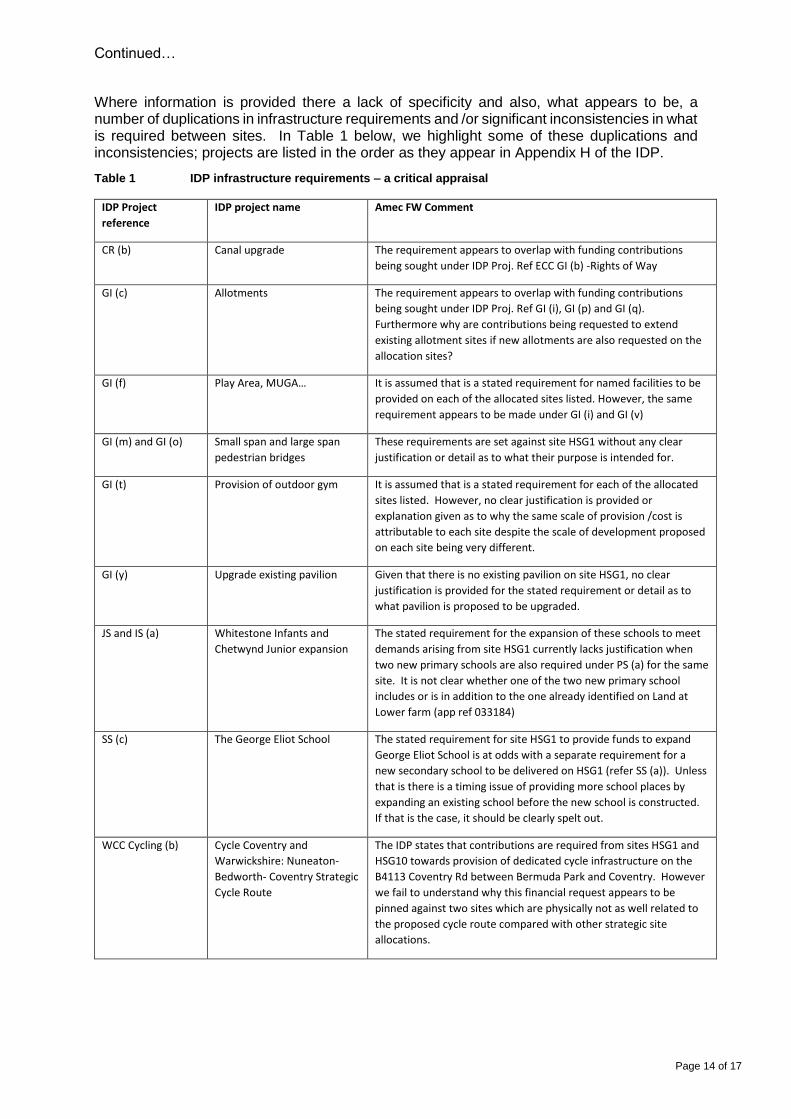
Where information is provided there a lack of specificity and also, what appears to be, a number of duplications in infrastructure requirements and /or significant inconsistencies in what is required between sites. In Table 1 below, we highlight some of these duplications and inconsistencies; projects are listed in the order as they appear in Appendix H of the IDP.
Table 1 IDP infrastructure requirements – a critical appraisal
IDP Project
reference
IDP project name Amec FW Comment
CR (b) Canal upgrade The requirement appears to overlap with funding contributions
being sought under IDP Proj. Ref ECC GI (b) -Rights of Way
GI (c) Allotments The requirement appears to overlap with funding contributions
being sought under IDP Proj. Ref GI (i), GI (p) and GI (q).
Furthermore why are contributions being requested to extend
existing allotment sites if new allotments are also requested on the
allocation sites?
GI (f) Play Area, MUGA… It is assumed that is a stated requirement for named facilities to be
provided on each of the allocated sites listed. However, the same
requirement appears to be made under GI (i) and GI (v)
GI (m) and GI (o) Small span and large span
pedestrian bridges
These requirements are set against site HSG1 without any clear
justification or detail as to what their purpose is intended for.
GI (t) Provision of outdoor gym It is assumed that is a stated requirement for each of the allocated
sites listed. However, no clear justification is provided or
explanation given as to why the same scale of provision /cost is
attributable to each site despite the scale of development proposed
on each site being very different.
GI (y) Upgrade existing pavilion Given that there is no existing pavilion on site HSG1, no clear
justification is provided for the stated requirement or detail as to
what pavilion is proposed to be upgraded.
JS and IS (a) Whitestone Infants and
Chetwynd Junior expansion
The stated requirement for the expansion of these schools to meet
demands arising from site HSG1 currently lacks justification when
two new primary schools are also required under PS (a) for the same
site. It is not clear whether one of the two new primary school
includes or is in addition to the one already identified on Land at
Lower farm (app ref 033184)
SS (c) The George Eliot School The stated requirement for site HSG1 to provide funds to expand
George Eliot School is at odds with a separate requirement for a
new secondary school to be delivered on HSG1 (refer SS (a)). Unless
that is there is a timing issue of providing more school places by
expanding an existing school before the new school is constructed.
If that is the case, it should be clearly spelt out.
WCC Cycling (b) Cycle Coventry and
Warwickshire: Nuneaton-
Bedworth- Coventry Strategic
Cycle Route
The IDP states that contributions are required from sites HSG1 and
HSG10 towards provision of dedicated cycle infrastructure on the
B4113 Coventry Rd between Bermuda Park and Coventry. However
we fail to understand why this financial request appears to be
pinned against two sites which are physically not as well related to
the proposed cycle route compared with other strategic site
allocations.

Continued…
Page 15 of 17
WCC Cycling (i) A5 Corridor Cycle
Improvements
It is unclear why contributions appear to be required towards the
named infrastructure improvements from HSG1, HSG10 and HSG11,
but not HSG9?
GI (w) and GI (x) Provision of tarmacadum
footway and crushed stone
footway
No clear justification is provided for the stated requirement or detail
on where new footways are to be provided.
P (a) and P (b) Additional personnel
required to serve the
proposed additional housing
growth
Effectively the same requirement appear to be made under each IDP
Proj. Ref. However, one states that the requirement is for 2 police
officers and 1 police staff, and the other 4 police officers and 4
police staff. It is not clear which, if any, is correct.
SS (a) Secondary school expansion The scheme details provided are vague. The IDP states that a new
secondary school is needed on HSG1 but provides no details on
when this school is needed by or its size. Given the importance of
this piece of infrastructure, the land take requirements and cost of
construction, the lack of such detail is a major omission.
Furthermore, what, if any contributions, have been secured towards
the new school from other recently consented residential
development?
Given our concerns relating to the IDPs detailed content and, in particular, a lack of detail on phasing and transparency as to what contributions have already been secured from approved schemes towards named pieces of infrastructure, we do not believe that is possible for the Borough Council or any other party to confirm whether or not proposals in the Plan are financially viable. A viability assessment is a key element of evidence relating to the delivery of a Local Plan, including the delivery of infrastructure. This is acknowledged in Section 3 of the IDP (Methodology). However, although the proposed methodology in the Preferred Options IDP (2013) followed best practice guidance from the Planning Advisory Service, in the Submission version of the IDP the Borough Council has chosen not to follow ‘Step 5’ which advises conducting viability testing. The NPPF places considerable emphasis upon viability and ensuring that the cumulative impact of proposals and policies 'should not put implementation of the plan at serious risk, and should facilitate development through the economic cycle'. At Paragraph 173, the Framework states that:
“ ...To ensure viability, the costs of any requirements likely to be applied to
development, such as requirements for affordable housing, standards, infrastructure contributions or other requirements should, when taking account of the normal cost of development and mitigation, provide competitive returns to a willing land owner and willing developer to enable the development to be deliverable…”.
And goes on to state at paragraph 177 that:
“…It is equally important to ensure that there is a reasonable prospect that planned
infrastructure is deliverable in a timely fashion. To facilitate this, it is important that local planning authorities understand district-wide development costs at the time Local Plans are drawn up. For this reason, infrastructure and development policies should be planned at the same time, in the Local Plan..”
Continued…
Page 16 of 17
Finally we note that one of the objectives of the Local Plan is ensuring that all new development and investment contributes to a significant improvement in infrastructure and facilities that serve the Borough including “A northern distributor road” (Objective 5 (d). However, this is the only time in the Plan we can find reference to this road; there is no reference to it in the IDP. A proposed northern distributor road running through the largest strategic site allocation (HSG1) has been included in previous versions of the Local Plan and included on proposals maps. Its absence therefore in this, the Submission version, is rather perplexing. In the context of the IDP we do not consider that the Borough Council has objectively assessed the need for new or improved infrastructure to support proposed development and therefore the Plan is judged not to have been ‘positively prepared’ in this regard. In the absence of a robust and credible evidence base on infrastructure requirements, its funding and delivery, the plan is also considered to be neither ‘justified’ or ‘effective’. To be found sound, we consider that the Council needs to provide much more detail in the IDP on infrastructure requirements, risks to infrastructure delivery and the potential need for contingency actions which are adequate for the purposes of the Local Plan.
Policy HS5 - Health
We object to the requirement to submit a Health Impact Assessment (HIA) with planning applications. Clearly, if the development requires an EIA then the application would be accompanied by an HIA as part of the process when the new regulations come into force and consequently the requirement to submit one is covered by other regulations.
We do not consider that the policy is justified and recommend that those parts that relate to HIAs are deleted.
Policy HS6 - Sport and Exercise
The Policy states that on strategic sites, where suitable new facilities are required they should be provided at no cost and the land they sit on also be provided free of charge. However, with the exception of sites that are in one land ownership, what is required under Policy HS6 does not work effectively on sites in multiple ownerships unless there is a formal collaboration agreement in place and/or a clear mechanism for contributions to be pooled to cover the cost of the infrastructure and to compensate individual landowners for loss of receipts where they provide the land upon which the new facility or infrastructure lies.
Having regard to the fact that the Council has already granted planning permission for a number of developments within the draft HSG1 allocation, without securing contributions to help fund some of the allocation-wide facilities and infrastructure, the financial burden of delivering much of this will fall disproportionally on our Client.
Policy HS6 states that when it is considered unviable to deliver facilities and infrastructure on a site, applicants may not have to if they are able to provide evidence to demonstrate this. However the need for and burden of presenting a viability case should not fall on an applicant simply because a Local Plan has not be appropriately prepared. We therefore consider that the plan is unsound as it is not effective in collecting suitable financial contributions required to fund and deliver key facilities and infrastructure.