NOAA ATOVS Sounding Software for the International Direct Broadcast Community
Upload
janice-thompsonCategory
view
217download
1
Numerical Weather Prediction Division
The usage of the ATOVS data in the Korea The usage of the ATOVS data in the Korea Meteorological Administration (KMA)Meteorological Administration (KMA)
Sang-Won Joo
Korea Meteorological Administration
• Feb. 1999 : TOVS data assimilation in the Global model (1DVAR)
• Nov. 2001 : AOTVS(HIRS+AMSU-A) assimilation in the Global Model (1DVAR)
History of the satellite sounding assimilation in KMA
Numerical Weather Prediction Division
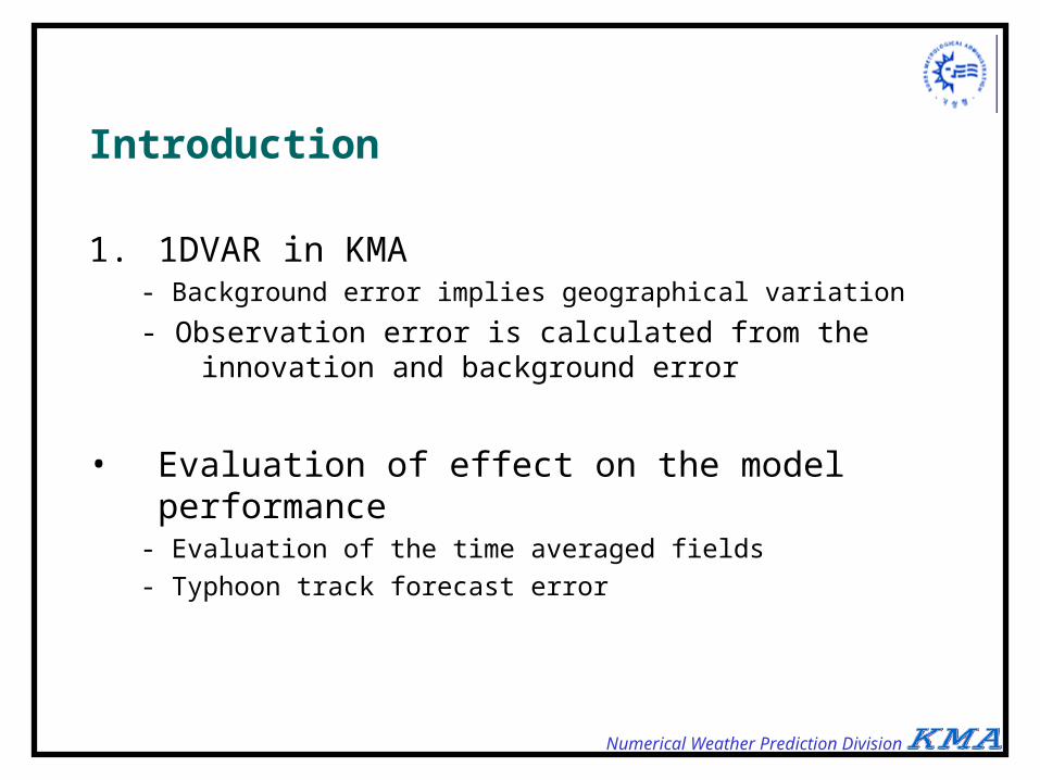
Introduction 1. 1DVAR in KMA
- Background error implies geographical variation
- Observation error is calculated from the innovation and background error
• Evaluation of effect on the model performance- Evaluation of the time averaged fields
- Typhoon track forecast error

Numerical Weather Prediction Division
Distribution of Background Error
TTB-BTB [K]
-8 -6 -4 -2 0 2 4 6 8
Fre
qu
en
cy
0
20
40
60
80
NHTRSH
Inhomogeneous background error
Numerical Weather Prediction Division
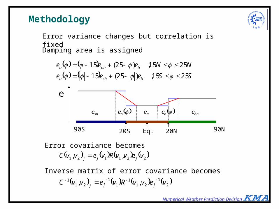
Methodology
SSeee
NNeee
trshb
trnhb
2515,)25(15
2515,)25(15
221121 ,, vevvRvevvC jjj
21
211
11
211 ,, vevvRvevvC jjj
Error variance changes but correlation is fixed
Damping area is assigned
Eq. 20N20S90S 90N
e
be betre nheshe
Error covariance becomes
Inverse matrix of error covariance becomes

Numerical Weather Prediction Division
Observation error Statistical Method for observation error
Assumption
1. Tangent linear approximation
2. No correlation between background error and RTM error
3. Biases are well removed
Derivation
xxHxHxxHxH ttttb HH 1st assumption
yxxHyyxxHxHyxH tttttob HH)(
TTTTobob yyxxFyxHyxH HH 2nd assumption
22y
Tx
TTxxEF HHHH
TTobob yxHyxH HBHR 3rd assumption
RTM error

Numerical Weather Prediction Division
Meaning of the resulting equation
TTobob yxHyxH HBHR
• Square of innovation
• First estimates of Derber and Wu (1999)
• Background error in radiance space
• Observation error
• RTM error and instrument error
• Innovation is the sum of observation error and background error if there is no correlation
• The resulting equation says the above statement in radiance space.

Numerical Weather Prediction Division
Feedback of observation error
RR
OBSERVATIONOBSERVATION
BACKGROUNDBACKGROUND
BB
1DVAR1DVAR
MODELMODELINNOVATIONINNOVATION
ANALYSISANALYSIS
• Relationship exists between observation error and NWP analysis through B
• Improvement of background error can readily affect the observation error
• The error ratio (eigenvlaue) is changed automatically
Benefits of our method
Numerical Weather Prediction Division
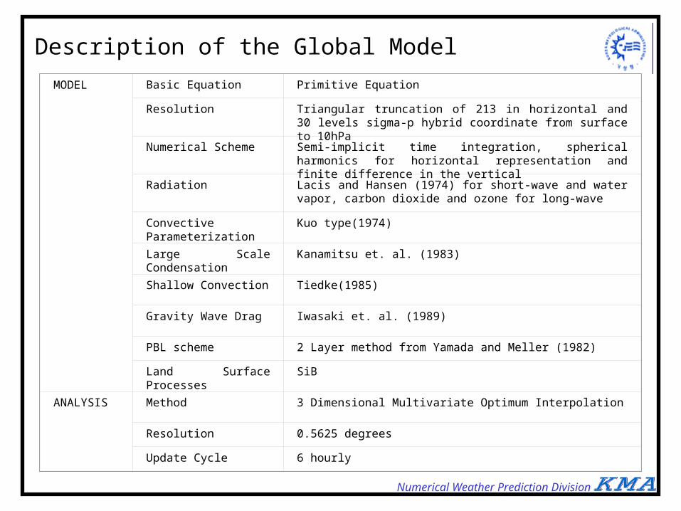
MODEL Basic Equation Primitive Equation
Resolution Triangular truncation of 213 in horizontal and 30 levels sigma-p hybrid coordinate from surface to 10hPa
Numerical Scheme Semi-implicit time integration, spherical harmonics for horizontal representation and finite difference in the vertical
Radiation Lacis and Hansen (1974) for short-wave and water vapor, carbon dioxide and ozone for long-wave
Convective Parameterization
Kuo type(1974)
Large Scale Condensation Kanamitsu et. al. (1983)
Shallow Convection Tiedke(1985)
Gravity Wave Drag Iwasaki et. al. (1989)
PBL scheme 2 Layer method from Yamada and Meller (1982)
Land Surface Processes SiB
ANALYSIS Method 3 Dimensional Multivariate Optimum Interpolation
Resolution 0.5625 degrees
Update Cycle 6 hourly
Description of the Global Model

Numerical Weather Prediction Division
Observation (ATOVS TBB Data=OTB)
CHANNEL CHANNEL CHANNEL CHANNEL CHANNEL
HIRS1 HIRS6 HIRS12 AMSU5 HIRS10
HIRS2 HIRS7 HIRS13 AMSU6 HIRS11
HIRS3 HIRS8 HIRS14 AMSU7 HIRS12
HIRS4 HIRS10 HIRS15 HIRS8 AMSU13
HIRS5 HIRS11 AMSU4 HIRS9 AMSU14
Background (Profile=BPR)
Variable Level Source Element
Temperature [K] Surface – 10 hPa 6 hour forecast from GDAPS 1-16
Temperature [K] 10 hPa – 0.4 hPa NESDIS retrieval 17-20
Specific Humidity [g/ g] Surface – 300 hPa 6 hour forecast from GDAPS 21-27
Skin Temperature Surface NOAA weekly SST analysis 28
Pressure [hPa] Sea Level 6 hour forecast from GDAPS 29
U [m/ s] Surface 6 hour forecast from GDAPS 30
V [m/ s] Surface 6 hour forecast from GDAPS 31
CTP [hPa] NESDIS retrieval 32
Cloudness NESDIS retrieval 33
Numerical Weather Prediction Division
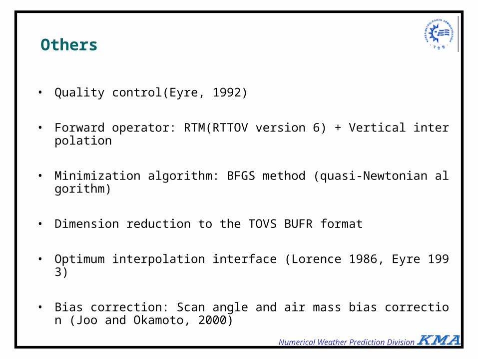
Others
• Quality control(Eyre, 1992)
• Forward operator: RTM(RTTOV version 6) + Vertical interpolation
• Minimization algorithm: BFGS method (quasi-Newtonian algorithm)
• Dimension reduction to the TOVS BUFR format
• Optimum interpolation interface (Lorence 1986, Eyre 1993)
• Bias correction: Scan angle and air mass bias correction (Joo and Okamoto, 2000)

Numerical Weather Prediction Division
Flowchart
Background(B), Analysis(A)
Observation(O),
Profile(PR)Brightness Temperature(TB)
PREFIX: SURFIX:
Departure(D)
no
ADJOINTADJOINT
MINIMIZATION
BIAS C.BIAS C.DTB
DTB_B
J & J
APR
BPR
APR
RTMRTM
BIAS C.BIAS C.
OTB ATB
OTB_B
- DPR
-
yes1st
Background Error
Observation Error
Radiance Space
Physical Space
BFGSBFGS
Numerical Weather Prediction Division
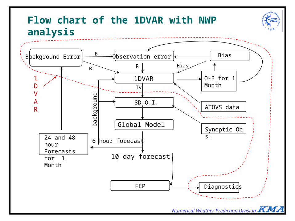
Flow chart of the 1DVAR with NWP analysis
Background Error Bias
1DVAR
3D O.I.
Global Model
10 day forecast
6 hour forecast
FEP
back
grou
nd
24 and 48 hour Forecasts for 1 Month
B
ATOVS data
Synoptic Obs.
O-B for 1 Month
Observation error
Diagnostics
R BiasB
Tv
1DVAR
Numerical Weather Prediction Division
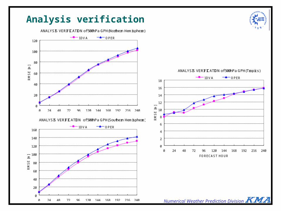
Analysis verification (September 2001)

Numerical Weather Prediction Division
Observation verification(Sep. 2001)
Numerical Weather Prediction Division
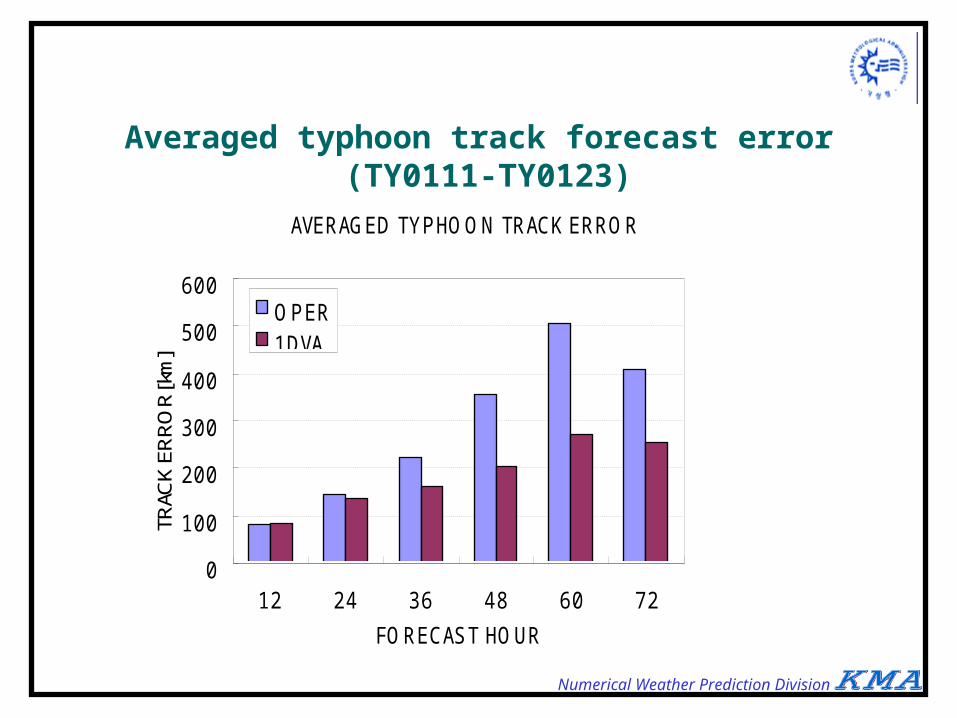
Averaged typhoon track forecast error (TY0111-TY0123)
AVERAGED TYPHOON TRACK ERROR
0
100
200
300
400
500
600
12 24 36 48 60 72
FORECAST HOUR
TRAC
K ER
RO
R[k
m]
OPER1DVA

Numerical Weather Prediction Division
Summary
• The 1DVAR is developed in KMA to assimilate the ATOVS data
• The statistics shows positive effect mostly and also in ASIA
• Typhoon track is well predicted with the 1DVAR and it is mainly caused by the better specification of the Pacific High
• The 1DVAR is in operation from 1 November, 2001

Numerical Weather Prediction Division
Future Plans
• Improvement of the bias correction scheme
• Utilization of the ATOVS data over the land
• Improvement of cloud detection scheme
• Implementation of the 1DVAR in the regional model

Numerical Weather Prediction Division
Verification with RAOB
• Poor performance near surface and tropopause
• Large improvement in the S.H.
• We need more improvement in the N.H. and Tropics.

Numerical Weather Prediction Division
ATOVS InformationCNTL (NB)
-8
0
8
-8 0 8
(OTB-BTB) [K](T
TB-B
TB)
[K]
• The 2nd and 4th quadrants data mislead the analysis.
• There are many data in the 2nd quadrant.
• Observation should be in the same direction as RAOB from background
(T-B) X (O-B) > 0
B.G.(B) Obs(O)Anal(A)
True Value(T)
1 2
O-B
Right Information
T-BWrong
Information