NUMERICAL AND ANALYTICAL MODELS OF ...with these faults. The reservoir hydrocarbon column heights...
121
The Pennsylvania State University The Graduate School Graduate Program in Petroleum and Natural Gas Engineering NUMERICAL AND ANALYTICAL MODELS OF SECONDARY MIGRATION IN FAULTS: DYNAMIC CONTROLS ON HYDROCARBON COLUMN HEIGHT A Thesis in Petroleum and Natural Gas Engineering by James Paul Ashbaugh Submitted in Partial Fulfillment of the Requirements for the Degree of Master of Science December 1997
Transcript of NUMERICAL AND ANALYTICAL MODELS OF ...with these faults. The reservoir hydrocarbon column heights...

The Pennsylvania State University
The Graduate School
Graduate Program in Petroleum and Natural Gas Engineering
NUMERICAL AND ANALYTICAL MODELS OF SECONDARY MIGRATION
IN FAULTS: DYNAMIC CONTROLS ON HYDROCARBON COLUMN HEIGHT
A Thesis in
Petroleum and Natural Gas Engineering
by
James Paul Ashbaugh
Submitted in Partial Fulfillment of the Requirements
for the Degree of
Master of Science
December 1997

i
ABSTRACT
Multi-phase flow modeling has the potential to illuminate the processes by which
hydrocarbons are emplaced during secondary migration. An analytical and numerical
model of multi-phase flow is presented to describe the relationship between secondary
migration through fault zones and the concurrent charging of reservoirs in juxtaposition
with these faults. The reservoir hydrocarbon column heights that result from this process
are controlled by the petrophysical properties of the fault zone, the flux of water and
hydrocarbons in the fault zone, and the geometry of the reservoir. At steady state, the
capillary pressure between the fluid phases must be equal in the fault zone and the
reservoir. This capillary pressure determines the hydrocarbon column height in the
reservoir.
Key results of the modeling are: 1) For a given oil flux, the presence of a
dynamic water phase in the fault zone will decrease the oil column height in the
reservoir. The amount of decrease will be directly dependent on the water potential
gradient in the fault. 2) Three phase oil and gas column heights are a dynamic function
of charge rate. 3) Given similar petrophysical fault properties with depth, the reservoir
charge rate is controlled by fault zone anisotropy.

i
TABLE OF CONTENTS
LIST OF FIGURES .....................................................................................................vi
LIST OF TABLES.......................................................................................................xi
ACKNOWLEDGMENTS ...........................................................................................xii
NOMENCLATURE ....................................................................................................xiii
Chapter 1 INTRODUCTION.....................................................................................1
Chapter 2 GEO-PRESSURED TWO-PHASE SYSTEMS........................................4
Model Objectives..................................................................................................4 Model Constraints.................................................................................................4 Analytical Model Development............................................................................6 Numerical Model Development ...........................................................................9
Chapter 3 OIL AND GAS DISTRIBUTIONS IN STACKED PAY RESULTING FROM THREE-PHASE MIGRATION IN FAULTS..........................................22
Model Objectives..................................................................................................22 Model Constraints.................................................................................................22 Analytical Model Development............................................................................24 Numerical Model Development ...........................................................................28 Numerical Model Results .....................................................................................29
Run 5: Anticlinal Model................................................................................30 Run 6: Fault Seal Model................................................................................33
Implications of 3-Phase Fault Seal Model............................................................36
BIBLIOGRAPHY........................................................................................................62

ii
Appendix A GEO-PRESSURE ANALYTICAL EXAMPLE...................................64
Appendix B 3-PHASE PVT DATA ..........................................................................68
Appendix C EXAMPLE OF 3-PHASE ANALYTICAL SOLUTION FOR HYDROCARBON COLUMN HEIGHT .............................................................74
Appendix D FAULT-ZONE GEOMETRY AND ANISOTROPY EFFECTS IN 2-PHASE SYSTEMS ...........................................................................................89

i
LIST OF FIGURES
Figure 2-1: Schematic diagram of a geo-pressured fault/reservoir system with a constant oil phase pressure at the top of the fault, and a constant water phase pressure and constant oil flow rate at the bottom of the fault...............................12
Figure 2-2: Fault-zone water pressure gradient geo-pressure model created by setting constant pressure boundaries at the top and bottom of the fault...............13
Figure 2-3: Oil-water capillary pressure verses water saturation using Thomeer's relationship (Jorden and Campbell, 1984) and input parameters given in Table 2-1...............................................................................................................14
Figure 2-4: Oil-water capillary pressure versus water saturation using EPR data for the fault zone and Thomeer’s relationship (Jorden and Campbell, 1984) with input parameters given in Table 2-1 for the sand. ........................................15
Figure 2-5: Fault-zone oil-water relative permeability using a Swirr of 0.6.................16
Figure 2-6: Reservoir sand oil-water relative permeability using a Swirr of 0.2. .........17
Figure 2-7: Oil column height versus water phase pressure gradient calculated from equations (2-11) and (2-13) .........................................................................18
Figure 2-8: Geo-pressure simulation grid structure with a no flow boundary at the end of the upper sand and a large aquifer connected to the lower sand. ..............19
Figure 2-9: Oil saturation in the lower sand at 1 million years for a hydrostatic system and a system with a 0.8 psi/ft water phase pressure gradient in the fault, EPR capillary pressure model. ....................................................................20
Figure 2-10: Comparison of fault-zone capillary pressure using Thomeer's equation and EPR data for geo-pressure and hydrostatic systems .......................21

ii
Figure 3-1: 3-Phase migration schematic. Po = oil phase pressure and Pb = bubble point pressure. Below the bubble point pressure, a discrete gas phase is present. ..............................................................................................................37
Figure 3-2: Oil-gas capillary pressure scaled by multiplying the oil-water capillary pressure, Figure 2-4, by the ratio the oil-gas interfacial tension (5 dynes/cm) to the oil-water interfacial tension (20 dynes/cm). .............................38
Figure 3-3: Reservoir sand 2-phase oil-gas relative permeability at irreducible water saturation (Swirr), both kro and krg assumed to be the same as kro from the 2-phase oil-water relative permeability, Figure 2-6. ......................................39
Figure 3-4: Fault zone 2-phase oil-gas relative permeability at irreducible water saturation (Swirr). ...................................................................................................40
Figure 3-5: Reservoir sand 3-phase oil-gas relative permeability, Modified Stone I Model (Aziz and Settari, 1979). .........................................................................41
Figure 3-6: Fault zone 3-phase oil-gas relative permeability, Modified Stone I Model (Aziz and Settari, 1979). ...........................................................................42
Figure 3-7: Fluid pressure in the reservoir sand vs. depth schematic for a 3-phase hydrostatic system. ...............................................................................................43
Figure 3-8: Anticlinal structure geometry (Run 5) where hydrocarbons are trapped by the anticline. The fault is 60 feet wide and the sand is 50 feet thick (see Table 3-1). ............................................................................................44
Figure 3-9: Fault seal geometry (Run 6) where hydrocarbons are trapped by capillary pressure. The fault is 60 feet wide and the sand is 50 feet thick (see Table 3-1)..............................................................................................................45
Figure 3-10: Hydrocarbon in Place versus Time in the Upper Sand (Run 5: Anticlinal Model). ................................................................................................46
Figure 3-11: Hydrocarbon in Place versus Time in the Middle Sand (Run 5: Anticlinal Model). ................................................................................................47
Figure 3-12: Hydrocarbon in Place versus Time in the Lower Sand (Run 5: Anticlinal Model). ................................................................................................48

iii
Figure 3-13: Hydrocarbon Saturation at 1 Million Years (Run 5: Anticlinal Model). Where T is the time of the simulation, kf is the fault zone permeability, ks is the reservoir sand permeability, Qo is the oil charge rate, Qg is the gas charge rate and GOR is the ratio of injected gas to oil....................49
Figure 3-14: Hydrocarbon Saturation at 4 Million Years (Run 5: Anticlinal Model). Where T is the time of the simulation, kf is the fault zone permeability, ks is the reservoir sand permeability, Qo is the oil charge rate, Qg is the gas charge rate and GOR is the ratio of injected gas to oil....................50
Figure 3-15: Hydrocarbon Saturation at 7 Million Years (Run 5: Anticlinal Model). Where T is the time of the simulation, kf is the fault zone permeability, ks is the reservoir sand permeability, Qo is the oil charge rate, Qg is the gas charge rate and GOR is the ratio of injected gas to oil....................51
Figure 3-16: Hydrocarbon Saturation at 10 Million Years (Run 5: Anticlinal Model). Where T is the time of the simulation, kf is the fault zone permeability, ks is the reservoir sand permeability, Qo is the oil charge rate, Qg is the gas charge rate and GOR is the ratio of injected gas to oil....................52
Figure 3-17: Hydrocarbons in Place versus Time in the Upper Sand (Run 6: Fault Seal Model)...........................................................................................................53
Figure 3-18: Hydrocarbons in Place versus Time in the Middle Sand (Run 6: Fault Seal Model). ................................................................................................54
Figure 3-19: Hydrocarbons in Place versus Time in the Lower Sand (Run 6: Fault Seal Model)...........................................................................................................55
Figure 3-20: Hydrocarbon Saturation at 2 Million Years (Run 6: Fault Seal Model). Where T is the time of the simulation, kf is the fault zone permeability, ks is the reservoir sand permeability, Qo is the oil charge rate, Qg is the gas charge rate and GOR is the ratio of injected gas to oil....................56
Figure 3-21: Hydrocarbon Saturation at 4 Million Years (Run 6: Fault Seal Model). Where T is the time of the simulation, kf is the fault zone permeability, ks is the reservoir sand permeability, Qo is the oil charge rate, Qg is the gas charge rate and GOR is the ratio of injected gas to oil....................57
Figure 3-22: Hydrocarbon Saturation at 10 Million Years (Run 6: Fault Seal Model). Where T is the time of the simulation, kf is the fault zone permeability, ks is the reservoir sand permeability, Qo is the oil charge rate, Qg is the gas charge rate and GOR is the ratio of injected gas to oil....................58

iv
Figure 3-23: Hydrocarbon Saturation at 15 Million Years (Run 6: Fault Seal Model). Where T is the time of the simulation, kf is the fault zone permeability, ks is the reservoir sand permeability, Qo is the oil charge rate, Qg is the gas charge rate and GOR is the ratio of injected gas to oil....................59
Figure 3-24: Hydrocarbon Saturation at 20 Million Years (Run 6: Fault Seal Model). Where T is the time of the simulation, kf is the fault zone permeability, ks is the reservoir sand permeability, Qo is the oil charge rate, Qg is the gas charge rate and GOR is the ratio of injected gas to oil....................60
Figure 3-25: Fault zone gas saturation at various times (Run 6). As gas migrates up the fault, a shift in the saturation curve to the left, decrease in gas saturation, indicates that gas is charging the sand and a shift to the right, increase in gas saturation, indicates that the sand is expelling gas. .....................61
Figure A-1: Expanded oil relative permeability in the fault zone. ..............................66
Figure A-2: Expanded capillary pressure in the fault zone. ........................................67
Figure B-1: Solution Gas-Oil Ratio (Rso) versus Pressure for a 35o API oil and 0.8 specific gravity gas at 300o F (Vazquez and Beggs, 1980) ............................69
Figure B-2: Oil Formation Volume Factor (Bo) versus Pressure for a 35o API oil and 0.8 specific gravity gas at 300o F (Vazquez and Beggs, 1980) .....................70
Figure B-3: Gas Formation Volume Factor (Bg) versus Pressure for a 0.8 specific gravity gas at 300o F (McCain, 1973)...................................................................71
Figure B-4: Oil Viscosity (µo) versus Pressure for a 35o API oil and 0.8 specific gravity gas at 300o F (Vazquez and Beggs, 1980)................................................72
Figure B-5: Gas Viscosity (µg) versus Pressure for a 0.8 specific gravity gas at 300o F (Lee, et al., 1966) ......................................................................................73
Figure C-1: Oil Formation Volume Factor versus Pressure........................................78
Figure C-2: Gas Formation Volume Factor versus Pressure.......................................79
Figure C-3: Solution Gas-Oil Ratio versus Pressure...................................................80
Figure C-4: Oil Viscosity versus Pressure ..................................................................81
Figure C-5: Gas Viscosity versus Pressure .................................................................82
Figure C-6: Oil Density versus Pressure .....................................................................83

v
Figure C-7: Gas Density versus Pressure ....................................................................84
Figure C-8: 2-Phase Oil-Gas Relative Permeability versus Liquid Saturation...........85
Figure C-9: 3-Phase Oil Relative Permeability versus Water and Gas Saturation .....86
Figure C-10: Oil-Water Capillary Pressure versus Water Saturation .........................87
Figure C-11: Oil-Gas Capillary Pressure versus Liquid Saturation............................88
Figure D-1: Fault/reservoir flow schematic depicting oil charging the fault Qi, oil charging the sand Qc and oil bypassing the sand Qb at pseudo steady-state conditions..............................................................................................................99
Figure D-2: Fault/reservoir cumulative flow for Run A2 showing pseudo steady-state (1 to 5 million years) and steady-state (t > 5.5 million years) time periods...................................................................................................................100
Figure D-3: Schematic of the sand-smear model geometry showing the low permeability core and high permeability damaged zone. .....................................101
Figure D-4: Schematic of the shale-smear model geometry showing the high permeability core and low permeability sheath. ...................................................102
Figure D-5: Typical model grid geometry and boundary conditions for sand-smear and shale-smear models. ............................................................................103
Figure D-6: Oil saturation at 1 million years for sand-smear model with source on footwall side of fault and potential reservoir sands on hangingwall side. As kv/kh increases, horizontal flow through the fault decreases, and oil saturation is skewed to the footwall (source) side of the fault. .............................................104
Figure D-7: Fault zone oil saturation in the shale-smear model. Oil saturation in the high permeability core is twice that of the sheath ..........................................105
i
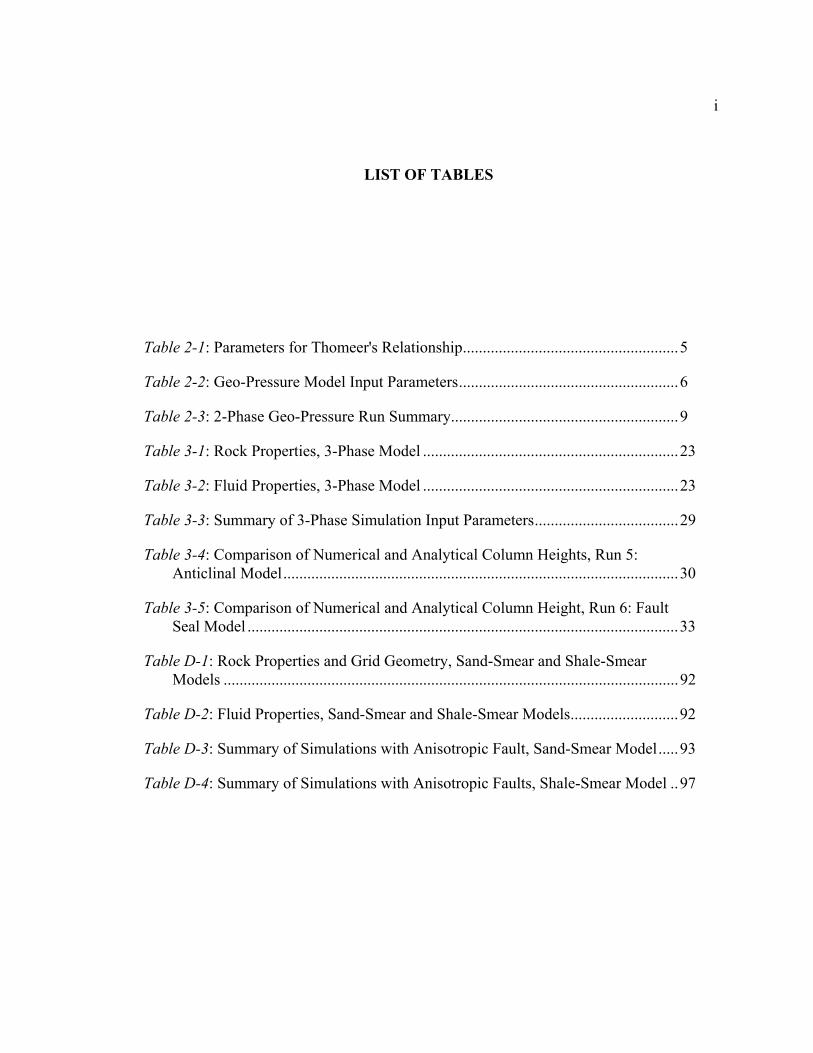
LIST OF TABLES
Table 2-1: Parameters for Thomeer's Relationship......................................................5
Table 2-2: Geo-Pressure Model Input Parameters.......................................................6
Table 2-3: 2-Phase Geo-Pressure Run Summary.........................................................9
Table 3-1: Rock Properties, 3-Phase Model ................................................................23
Table 3-2: Fluid Properties, 3-Phase Model ................................................................23
Table 3-3: Summary of 3-Phase Simulation Input Parameters....................................29
Table 3-4: Comparison of Numerical and Analytical Column Heights, Run 5: Anticlinal Model...................................................................................................30
Table 3-5: Comparison of Numerical and Analytical Column Height, Run 6: Fault Seal Model ............................................................................................................33
Table D-1: Rock Properties and Grid Geometry, Sand-Smear and Shale-Smear Models ..................................................................................................................92
Table D-2: Fluid Properties, Sand-Smear and Shale-Smear Models...........................92
Table D-3: Summary of Simulations with Anisotropic Fault, Sand-Smear Model.....93
Table D-4: Summary of Simulations with Anisotropic Faults, Shale-Smear Model ..97

i
ACKNOWLEDGMENTS
I would like thank Exxon Production Research Company for their support of this
research and the efforts Exxon’s Trap, Charge, and Retention Section in providing
guidance and support.
I thank Dr. Turgay Ertekin for his technical assistance in the area of numerical
modeling. I thank Dr. Peter Flemings for providing input to the project from a
geologist’s perspective and for reviewing this document.
I thank Dr. Paul Hicks, Jr. who provided guidance and support in all aspects of
this research. I am particularly appreciative of the thorough review and input provided
by Dr. Hicks during every step of the research project.
Most of all I wish to thank my wife for all of her support and encouragement.

ii
NOMENCLATURE
A - Cross-sectional area of the fault [L2]
Bg - Gas formation volume factor [L3 at reservoir conditions/L3 at standard conditions]
Bo - Oil formation volume factor [L3 at reservoir conditions/L3 at standard conditions]
g - Gravitational acceleration [L/T2]
k - Intrinsic permeability [L2]
krg - Gas phase relative permeability as a function of Sg [dimensionless]
kro - Oil phase relative permeability as a function of Sg and Sw [dimensionless]
krw - Water phase relative permeability as a function of Sw [dimensionless]
Pg - Gas phase pressure [M/LT2]
Po - Oil phase pressure [M/LT2]
Pw - Water phase pressure [M/LT2]
Qg - Gas flow rate [L3/T at standard conditions]
Qo - Oil flow rate [L3/T at standard conditions]
Rso - Solution oil-gas ratio [L3 gas at standard conditions/L3 oil at standard conditions]
Sg - Gas phase saturation [L3/L3]
So - Oil phase saturation [L3/L3]
Sw - Water phase saturation [L3/L3]
Swirr - Irreducible water phase saturation [L3/L3]

iii
z - Vertical distance from a fixed datum [L]
Φo - Oil phase potential [M/LT2]
µg - Gas phase viscosity [M/LT]
µo - Oil phase viscosity [M/LT]
µw - Water phase viscosity [M/LT]
ρg - Gas phase density [M/L3]
ρo - Oil phase density [M/L3]
ρw - Water phase density [M/L3]
θ - Angle from vertical
Subscripts: g - gas
o - oil
w - water

Chapter 1
INTRODUCTION
Fault zones have been considered to be pathways for secondary hydrocarbon
migration, seals which trap hydrocarbons migrating up-structure through reservoir sands,
and combined conduit-barrier systems (Hippler, 1993; Schowalter, 1979; Antonellini and
Aydin, 1994; Caine et al., 1996.). Hippler (1993) supports the concept that hydrocarbons
migrate through brecciated fault zones on the basis of hydrocarbon staining of the fault
zone. Others propose that crushing of the rock in the fault zone significantly reduces the
porosity and permeability of the fault thus causing the fault zone to act as a seal (Bouvier
et al., 1989; Antonellini and Aydin, 1994). Studies by Antonellini and Aydin (1994)
showed fault zone reductions in permeability of three orders of magnitude and in porosity
of one order of magnitude. Caine et al. (1996) proposed a system whereby the fault is
evaluated as two regions; a damaged region where little displacement has occurred but
where the permeability has been enhanced by fractures and a core zone where most of the
displacement has occurred and the rock has been pulverized. In Cain et al.’s model the
fault can act as a conduit, a barrier or a combination conduit-barrier.
Showalter (1979) proposed that hydrocarbon column height in reservoirs in
juxtaposition to the fault zone could be calculated using the capillary properties of the
sealing material (fault zone). This theory was supported by Pittman (1981) who
proposed that the deformation and crushing of rocks in and around the fault zone results

2
in lower permeability and porosity than in the surrounding unaffected rock. The result
is an increase in the capillary entry pressure, the minimum pressure necessary for
hydrocarbons to infiltrate the fault zone. In this “capillary entry pressure” model,
hydrocarbon column height in the reservoir sand is a static function of the capillary entry
pressure.
Bennett (1996) presented a conceptual model whereby the fault zone acts as a
conduit, charging reservoirs in juxtaposition with the fault and due to differences in
petrophysical properties, as a seal to trap hydrocarbons in the reservoir sand. He then
developed a steady-state analytic model for hydrostatic systems, which demonstrated that
steady-state hydrocarbon column height in reservoirs in juxtaposition with the fault is a
not only a function of the capillary properties of the fault, but a dynamic function of the
oil flux in the fault. A numerical reservoir simulator was then used to study transient
effects, the effects of vertical variations in fault properties, and the effects of reservoir
geometry on hydrocarbon column height. All cases examined were 2-phase (oil-water)
systems where there was no water flux in the fault zone and the fault zone was isotropic.
For such systems, Bennett (1996) concluded that:
1) Hydrocarbon column height is a dynamic function of charge rate and not a static
function of capillary-entry pressure as is often assumed.
2) Faults can serve both as migration pathways and as seals.
3) Hydrocarbons can charge along faults and then backfill adjacent sands.
4) Under-filled structures may result from lateral pinch-out or truncation of reservoirs
and the inability of hydrocarbons to displace the water already present.
5) Given similar petrophysical fault properties with depth and no permeability
anisotropy, deeper sands will fill sequentially before shallower sands.

3
We expanded on Bennett’s work in three areas. First, in Chapter 2 we consider
the effect of flow of water and oil in order to simulate secondary migration. We show
that for a given oil flux through the fault, oil column height in juxtaposed reservoir sands
decreases as fault zone water flux increases. In Chapter 2, we develop a steady-state
analytical model which demonstrates that steady-state hydrocarbon column height is a
function of not only hydrocarbon charge history, but also water flux through the fault
zone. We then use a numerical model to evaluate the effect of the fault-zone capillary
pressure relationship and reservoir boundary conditions on hydrocarbon column height.
Second, in Chapter 3 we extend the two-phase model to consider three-phase
(gas, oil, water) systems. We develop a steady-state analytical model which predicts
steady-state hydrocarbon (oil and gas) column height. We then investigate the effect of
reservoir geometry and hydrocarbon charging on transient hydrocarbon column height
with a numerical. We show with that one of the two migrating hydrocarbon phases will
generally overcharge the sand and then be flushed from the reservoir by the other phase
until the predicted steady-state condition is acheived.
Finally, we used the 2-phase (oil-water) numerical model to show that fault-zone
permeability anisotropy can cause potential reservoirs to be charged slowly or completely
bypassed by hydrocarbons migrating through the fault zone.
In all cases numerical modeling was completed using the Eclipse 100 numerical
reservoir simulation software by GeoQuest®.

Chapter 2
GEO-PRESSURED TWO-PHASE SYSTEMS
Model Objectives
Fault zones which act as migration pathways for hydrocarbons often act as
conduits for water being forced from sediments as they are compacted by overburden.
The purpose of this modeling effort was to investigate the effect of water flux in the fault
zone upon hydrocarbon column height in the reservoir sands. In this model we evaluate,
both analytically and numerically, the effect water migration through the fault has upon
the oil flux equation and consequently oil column height.
Model Constraints
We consider the system (Figure Chapter 1-1) where a sand is in juxtaposition
with a fault. Oil is migrating up the fault at a constant flux (Qo) and constant pressure
conditions are specified at the top of the fault for the oil phase (Po) and at the bottom of
the fault for the water phase (Pw). The constant pressure boundaries of the fault are used
to establish a water-phase pressure gradient within the fault (Figure Chapter 1-2).

2
Two sets of capillary pressure data were used for the fault zone in the geo-
pressure modeling. The first data set was generated using Thomeer’s relationship
(Jorden and Campbell, 1984):
PcP
GSS
do
wirre= −
−
loglog
1
(Chapter 1-1)
where Pc is the capillary pressure, Pd is the capillary entry pressure, G is the pore
geometry factor, Swirr is the irreducible water saturation, and So is the oil saturation.
Table Chapter 1-1 lists the parameters used to generate capillary pressure curves (Figure
Chapter 1-3) for the fault zone and reservoir sand. The capillary pressure curves were
modified from Thomeer’s equation in the 0.99 to 1.00 Sw range to allow Pcow to go to
zero at an Sw of 1.0. The parameters used in Thomeer’s equation generated a capillary
pressure for which at high water saturation, capillary pressure slowly decreased with
increasing water saturation. This relationship provides a capillary pressure versus oil
saturation (So) for a typical hydrocarbon reservoir. A second data set, provided by Exxon
Production Research (EPR), was derived by conducting laboratory experiments on core
from a fault zone (Figure Chapter 1-4). The same reservoir capillary pressure curve,
which was determined using Thomeer’s equation, was used in both cases.
Table Chapter 1-1: Parameters for Thomeer's Relationship
Variable Fault Reservoir Pd 10.0 psi 5.0 psi G 0.1 0.5
Swirr 0.3 0.2

3
The oil-water relative permeability curves for the fault zone and sand are given in
Figure Chapter 1-5 and Figure Chapter 1-6, respectively.
Table Chapter 1-2 presents model input data used in all analytical and numerical
geo-pressure models.
Table Chapter 1-2: Geo-Pressure Model Input Parameters
Parameter Value Units Qo/A 2.95x10⁻⁷ STB/day/ft2 µo 0.352 cp ρo 53 lb/ft3 ρw 67 lb/ft3 kf 0.017 millidarcies θ 5o
Analytical Model Development
We start with the one-dimensional steady-state incompressible flow equation for a
system which is governed by Darcy’s Law (Chapter 1-2) :
( )QA
kkro o
oo f= ∇Φ
µ
(Chapter 1-2)
Note that the oil formation factor (Bo) is not included in this development because due to
the incompressible assumption it is taken to be 1.
The oil-phase potential (Φo) is defined as:

4
Φo o oP gz= − ρ (Chapter 1-3)
and we define oil-water capillary pressure (Pcow) for a water-wet system as:
P P Pcow o w= − (Chapte
r 1-4) We now substitute equation (Chapter 1-4) into equation (Chapter 1-3) and write Φo as:
Φo w cow oP P gz= −+ ρ (Chapte
r 1-5) and the gradient of Φo along the length of the fault becomes:
( )∇Φ = −
+o f
w cowo
dPdz
dPdz
gρ θcos (Chapte
r 1-6)
For an incompressible system and constant Qo, So in the fault zone is constant. Therefore
Pcow is constant and dP
dzcow
is 0. Then equation (Chapter 1-6) becomes:
( )∇Φ = −
o f
wo
dPdz
gρ θcos (Chapte
r 1-7)
By substituting equation (Chapter 1-7) into equation (Chapter 1-2) , we have a general
one-dimensional incompressible flow equation for the fault zone.
QA
kkr dPdz
go o
o
wo= −
µ
ρ θcos (Chapte
r 1-8)
Note that in a hydrostatic system dPdz
gw
w= ρ and equation (Chapter 1-8) reduces to:

5
( )QA
kkrg
o o
ow o= −
µρ ρ cosθ
(Chapter 1-9)
This was the approach used by Bennett (1996). By solving equation (Chapter 1-8) for kro we can use the Sw-kro relationship to
determine Sw, which then can be used in the Sw-Pcow relationship to determine Pcow. Then
assuming that the sand is hydrostatic, the oil column height can be calculated as,
( )hP
go
cow
w o=
− ⋅ρ ρ (Chapte
r 1-10)
Using the input parameters (Table Chapter 1-2), equations above and the two sets
of fault zone capillary pressure data (Figure Chapter 1-3 and Figure Chapter 1-4), we
calculate the oil column height versus water-phase pressure gradient (Figure Chapter 1-
7). Figure Chapter 1-7 illustrates two major points: 1) a dynamic water phase in the fault
zone decreases oil column height and 2) knowledge of the fault zone oil-water capillary
pressure relationship is important in predicting steady-state oil column height.
All equations have been presented in a form independent of units. A complete
example of the steady-state analytical solution, with equations given in field units, is
given in Appendix A.

6
Numerical Model Development
A series of four simulation runs were completed using a system with a 60 foot
wide fault with two 50 foot thick sands attached to the hanging wall of the fault. The two
sands were used to evaluate the effect of different boundary conditions at the end of the
sands on steady-state column height. The lower sand was connected to a large aquifer,
while the upper sand terminated at a no-flow boundary (see Figure Chapter 1-8). A
summary of the input parameters used in the 4 runs is given in Table Chapter 1-3.
Table Chapter 1-3: 2-Phase Geo-Pressure Run Summary Run
Water Phase Gradient
Capillary Pressure Data
Numerical Oil Column Height (ft)
Analytical Oil Column Height (ft)
1 geo-pressure 0.8 psi/ft
Thomeer Upper sand 140 Lower sand 160
Both sands 166
2 hydrostatic Thomeer Upper sand 140 Lower sand 160
Both sands 168
3 geo-pressure 0.8 psi/ft
EPR Upper sand 140 Lower sand 185
Both sands 329
4 hydrostatic EPR Upper sand 140 Lower sand 340
Both sands 669
The analytical and numerical results for Runs 1 and 2, which use capillary
pressure data generated using Thomeer’s relationship (Figure Chapter 1-3), are in
excellent agreement for the lower sand which is attached to a large aquifer. A small
decrease in column height is seen in the upper sand due to trapped (or perched) water
increasing the water phase pressure in the sand and thereby not allowing additional oil to
flow into the sand. Both the analytical and numerical results show little effect on column
height due to water-phase pressure gradient in the fault.

7
The results for Runs 3 and 4, which use the EPR capillary pressure data, show a
decrease in the numerical column height versus the analytical column height, in both the
sands due to trapped water increasing the water phase pressure in the sand. The lower
sand is connected to a large aquifer, allowing more oil to charge the sand, but the aquifer
is not large enough or compressible enough to prevent the water pressure in the sand
from increasing and limiting column height. Figure Chapter 1-9 shows the difference in
oil column height for Run 3 (geo-pressure) and Run 4 (hydrostatic) at 1 million years.
Both the analytical and numerical results (Table Chapter 1-3) show a significant effect
on column height due to water-phase pressure gradient in the fault.
The numerical model demonstrates again the importance of knowing the fault-
zone oil-water capillary pressure relationship. The water saturation in the fault zone is a
function of the water pressure gradient dPdz
w
and oil flux
QA
o
in the fault. The
capillary pressure in the fault and at the fault/sand interface is a function of water
saturation (Sw). Figure Chapter 1-10 is a blow-up of the fault-zone capillary pressure
curves over the fault-zone water saturation range used in Runs 1 through 4. Two
significant observations can be seen in Figure Chapter 1-10. First, the analytical column
heights are larger in Runs 3 and 4 because the capillary pressures are much higher than
those for Runs 1 and 2. Second, in Runs 3 and 4 there is a larger difference in the geo-
pressure and hydrostatic column heights because of the larger slope,dPdS
cow
w
, in the EPR
capillary pressure curve. Therefore, for the same change in Sw, we have significant
differences in the change in Pcow and consequently very different column heights.

8
Hydrocarbon column height in the sand is dependent on the fault-zone water pressure
gradient, oil flux, and capillary pressure curve magnitude and slope.
The numerical model also illustrates the importance of the boundary conditions in
the sand as can be seen in the difference in column height between the upper and lower
sands in both the geo-pressure and hydrostatic simulations.

Boundary Conditions:1) No Flow2) Constant Pressure
Po
P , Qw o Figure Chapter 1-1: Schematic diagram of a geo-pressured fault/reservoir system with a constant oil phase pressure at the top of the fault, and a constant water phase pressure and constant oil flow rate at the bottom of the fault.

10
D
epth
Fault Zone Water Pressure
Geopressure0.8 psi/ft
Hydrostatic0.465 psi/ft
Figure Chapter 1-2: Fault-zone water pressure gradient geo-pressure model created by setting constant pressure boundaries at the top and bottom of the fault.

1
10
100
1000
10000
0 0.1 0.2 0.3 0.4 0.5 0.6 0.7 0.8 0.9 1
Water Saturation (Sw)
Cap
illar
y Pr
essu
re (P
cow
) - p
si
Sand
Fault
Figure Chapter 1-3: Oil-water capillary pressure verses water saturation using Thomeer's relationship (Jorden and Campbell, 1984) and input parameters given in Table 2-1.

1
10
100
1000
10000
0 0.1 0.2 0.3 0.4 0.5 0.6 0.7 0.8 0.9 1
Water Saturation (Sw)
Cap
illar
y Pr
essu
re (P
cow
) - p
si
Sand Fault
Figure Chapter 1-4: Oil-water capillary pressure versus water saturation using EPR data for the fault zone and Thomeer’s relationship (Jorden and Campbell, 1984) with input parameters given in Table 2-1 for the sand.

13
0
0.1
0.2
0.3
0.4
0.5
0.6
0.7
0.8
0.9
1
0 0.1 0.2 0.3 0.4 0.5 0.6 0.7 0.8 0.9 1
Water Saturation (Sw)
Rel
ativ
e Pe
rmea
bilit
y (k
r)
krwkro
Sw irr
Figure Chapter 1-5: Fault-zone oil-water relative permeability using a Swirr of 0.6.

14
0
0.1
0.2
0.3
0.4
0.5
0.6
0.7
0.8
0.9
1
0 0.1 0.2 0.3 0.4 0.5 0.6 0.7 0.8 0.9 1
Water Saturation (Sw)
Rel
ativ
e Pe
rmea
bilit
y (k
r)
kro
Sw irr
krw
Figure Chapter 1-6: Reservoir sand oil-water relative permeability using a Swirr of 0.2.

15
0
50
100
150
200
250
300
350
400
450
500
550
600
650
700
750
0.4 0.45 0.5 0.55 0.6 0.65 0.7 0.75 0.8 0.85 0.9 0.95 1
Water Phase Pressure Gradient - psi/ft
Oil
Col
umn
Hei
ght A
bove
Fre
e W
ater
Lev
el- f
t EPR Fault Zone Data
Thomeer's Relationship
dP/dz hydrostatic
Figure Chapter 1-7: Oil column height versus water phase pressure gradient calculated from equations (Chapter 1-8) and (Chapter 1-10)

02000
10000
18000
4000 8000 12000
Fault
Reservoir
Aquifer
Dep
th -
Feet
Figure Chapter 1-8: Geo-pressure simulation grid structure with a no flow boundary at the end of the upper sand and a large aquifer connected to the lower sand.

Oil Saturation
Hydrostatic - 0.465 psi/ft Geopressure - 0.8 psi/ft
Run 4 Run 3
Dep
th -
Feet
Figure Chapter 1-9: Oil saturation in the lower sand at 1 million years for a hydrostatic system and a system with a 0.8 psi/ft water phase pressure gradient in the fault, EPR capillary pressure model.

18
1
10
100
1000
0.9 0.91 0.92 0.93 0.94 0.95 0.96 0.97 0.98 0.99 1
Sw
Cap
illar
y Pr
essu
re -
psi
Thomeer'sRelationshipEPR data
Hydrostatic Geo-pressure
Figure Chapter 1-10: Comparison of fault-zone capillary pressure using Thomeer's equation and EPR data for geo-pressure and hydrostatic systems

19

Chapter 3
OIL AND GAS DISTRIBUTIONS IN STACKED PAY RESULTING FROM THREE-PHASE MIGRATION IN FAULTS
MODEL OBJECTIVES
This work expands on the previous two-phase work in Chapter 2, and Bennett,
1996. We consider 3-phase systems where both oil and gas are migrating through the
fault. The first task was to develop a 3-phase, steady-state analytical model which
describes oil and gas saturations in the fault, and oil and gas column heights in the
reservoir sands based on the fault-seal (capillary pressure) model. The second task was
to develop a numerical model and compare fault saturations and hydrocarbon column
heights in the reservoir to the analytical model results. Two sealing mechanisms (fault
seal and anticlinal seal) were then evaluated with the numerical model.
MODEL CONSTRAINTS
The problem we consider from both an analytical and numerical perspective is
illustrated in Figure 3-1. A fault is charged from below with both oil and gas. Pressure
at the point of injection, the bottom of the fault, may be above the bubble point pressure.
At pressures above the bubble point oil and gas migrate as a single phase and charge

2
sands in the proportions at which they are injected and in a manner similar to the
previous 2-phase models. When the oil phase pressure drops below the bubble point
pressure, gas begins being exolved from the oil. As a result the oil and gas migrate and
charge adjacent sands as discrete phases.
The physical properties summarized in Table 3-1 and Table 3-2 are used for all 3-
phase models. PVT data used for all 3-phase modeling was derived using correlations
presented by Beggs and Robinson (1975) and Vasquez and Beggs (1980) for the oil
phase and by McCain (1973) and Lee, et al. (1966) for the gas phase. Both the analytical
and numerical models are isothermal and a temperature of 300oF was used to generate the
PVT data. Graphs of all PVT data are included as Appendix B.
Table 3-1: Rock Properties, 3-Phase Model
Rock Property
Permeability
(horizontal)
Permeability (vertical)
Porosity Thickness
Width
Angle
Fault 0.017 md 0.017 md 15 % 60 ft 120 ft 10o Anticline 5o Fault Seal
Reservoir 1.0 md 1.0 md 20 % 50 ft 120 ft variable Table 3-2: Fluid Properties, 3-Phase Model
Fluid Properties (at standard conditions)
Water Oil Gas
Density 67.0 lb/ft3 53.05 lb/ft3 0.06109 lb/ft3 Viscosity 1.084 cp 0.8951 cp 0.0138 cp
Figure 3-2 presents the fault zone and reservoir sand oil-gas capillary pressure
data used for all 3-phase models. These were scaled from the oil-water capillary pressure
data (EPR) using the Levertt-J function (Amyx et al., 1960). Two-phase oil-water

3
capillary pressure (EPR) and oil-water relative permeability as a function of water
saturation are the same as those used in the 2-phase models (see Figures 2-4, 2-5, and 2-
6). Two-phase oil-gas relative permeability as a function of gas saturation at connate
water saturation (the water phase is present at irreducible saturation) are shown in Figure
3-3 and Figure 3-4 for the reservoir and fault, respectively. Three-phase oil relative
permeability as a function of water saturation and gas saturation are calculated using the
Modified Stone I Model (Aziz and Settari, 1979). The resulting 3-phase oil relative
permeability for the reservoir and fault are show in Figure 3-5 and Figure 3-6,
respectively.
ANALYTICAL MODEL DEVELOPMENT.
We begin by considering steady-state flow within a hydrostatic fault. For the oil
phase, the flux is driven by gravity and is proportional to the relative and intrinsic
permeability and the potential gradient as in equation (3-1):
( )Q
Ak kr g
Bo o w o
o o=
⋅ ⋅ − ⋅ ⋅
⋅
ρ ρµ
cosθ
(3-1)
This is the same as equation 1-12 except for the addition of the oil formation volume
factor (Bo) term which accounts for the oil compressibility and mass transfer effects.
The gas flux can be expressed as the sum of the free gas flux and solution gas flux as in
equation (3-2) :

4
( ) ( )QA
k kr gB
Rs k kr gB
g g w g
g g
o o w o
o o=
⋅ ⋅ − ⋅ ⋅⋅
+⋅ ⋅ ⋅ − ⋅ ⋅
⋅ρ ρ θ
µρ ρ
µcos cosθ
(3-2)
We now consider the case of Figure 3-1 and calculate the fault zone oil and gas
saturations. Unlike the incompressible systems investigated in the 2-phase modeling
where saturations in the fault are constant, the oil and gas properties in equations (3-1)
and (3-2) are a function of pressure and consequently the phase saturations are a function
of pressure. Therefore, equation (3-1) and equation (3-2) must be solved for a specific
depth within the fault. Because many of the values in equations (3-1) and (3-2) are
functions of pressure, the equations must be solved iteratively. The following paragraphs
describe the steps to complete one iteration. One of two procedures is used depending on
whether the fluids are above (P>Pb) or below (P<Pb) the bubble point pressure. When the
fluid pressures are above the bubble point only two phases (oil and water) are present and
when the pressure drops below the bubble point, gas has come out of solution and three
phases (oil, gas, and water) are present. The solution procedure for each case is outlined
below and a detailed example for when the system pressure is below the bubble point (3-
phase) is included as Appendix C.
First we will determine oil saturation (So) for a system at a depth below the
bubble point. Below the bubble point the problem is similar to the two-phase case. First
we must estimate an oil phase pressure (Po) corresponding to the depth. A good first
approximation would be the water phase pressure (Pw) which is hydrostatic. Then from
the PVT tables in Appendix B, we determine values for Bo, µo, and ρo. Given Qo, A, k,
and ρw, we can use equation (3-1) to calculate kro. We next refer to the 2-phase oil-water

5
relative permeability curve to determine Sw. We then refer to the oil-water capillary
pressure curve to determine the oil-water capillary pressure (Pcow). The new oil phase
pressure is P P Po w c= + ow . We then repeat the process until Po no longer changes. Since
the oil phase properties are weak functions of pressure when the pressure is above the
bubble point, only a few iterations are needed for convergence.
We next consider the case of a depth above the bubble point (P<Pb). The solution
becomes more complicated for 3-phase flow for two reasons: 1) the oil parameters, Bo,
µo, and ρo in equation (3-1) are now strong functions of pressure and 2) kro is no longer a
function only of Sw but a function of both Sw and Sg (see Figure 3-6). First we must
estimate oil phase (Po) and gas phase (Pg) pressures corresponding to the depth. A good
first approximation for each would be the water phase pressure which is hydrostatic.
Then from the PVT tables in Appendix B, we determine values for Bo, µo, ρo, Bg, µg, and
ρg. Given Qo, A, k, and ρw, we can use equation (3-1) to calculate kro. Then given Qg,
we can use equation (3-2) to calculate krg. We next refer to the 2-phase oil-gas relative
permeability curve (Figure 3-4) to determine Sg. In Figure 3-6 we follow a constant Sg
line to the appropriate kro curve and determine Sw. Then, So=1-Sw-Sg. We then refer to
the oil-water capillary pressure curve to determine the oil-water capillary pressure and to
the oil-gas capillary pressure curve to determine the oil-gas capillary pressure (Pcog). The
new guesses for the oil and gas phase pressures are P P Po w cow= + and
P P P Pg w cow c= + + og , respectively. We repeat the process until Po and Pg no longer
change. Since the oil and gas phase properties are strong functions of pressure when the
pressure is below the bubble point, several iterations may be needed for convergence. A

6
numerical example of this case is included as Appendix C. The oil and gas rates used in
the example are much higher than those used in the numerical modeling. The rates used
in the example were chosen to improve clarity of the graphical presentation.
The assertion that P P P Pg w cow cog= + + is predicated on the assumption that there
is a continuous oil phase present. Blunt et al. (1995) demonstrate that even in 3-phase
gas-oil-water systems where very little oil is present, the oil often forms a thin film
between the gas and water phases. Furthermore, Blunt et al. (1995) present a means,
based on the interfacial tensions between the three phases, for predicting the presence of
this oil film.
Since we have continuous water, oil, and gas phases across the fault-reservoir
interface, at steady-state conditions, Pw, Po, and Pg within the reservoir and fault are in
equilibrium at the fault-reservoir interface. By calculating the steady-state values for Pw,
Po, and Pg in the fault at the sand face, hydrocarbon column heights in the adjoining sand
can be determined. Figure 3-7 depicts the pressure distribution in a static
hydrocarbon/water column where the pressure gradient is a function of fluid density and
column height can be determined as follows in equations (3-3) and (3-4)
hP
ggas oil
cow
w o+ =
− ⋅( )ρ ρ
(3-3)
hP
ggas
cog
o g=
− ⋅( )ρ ρ
(3-4)
7
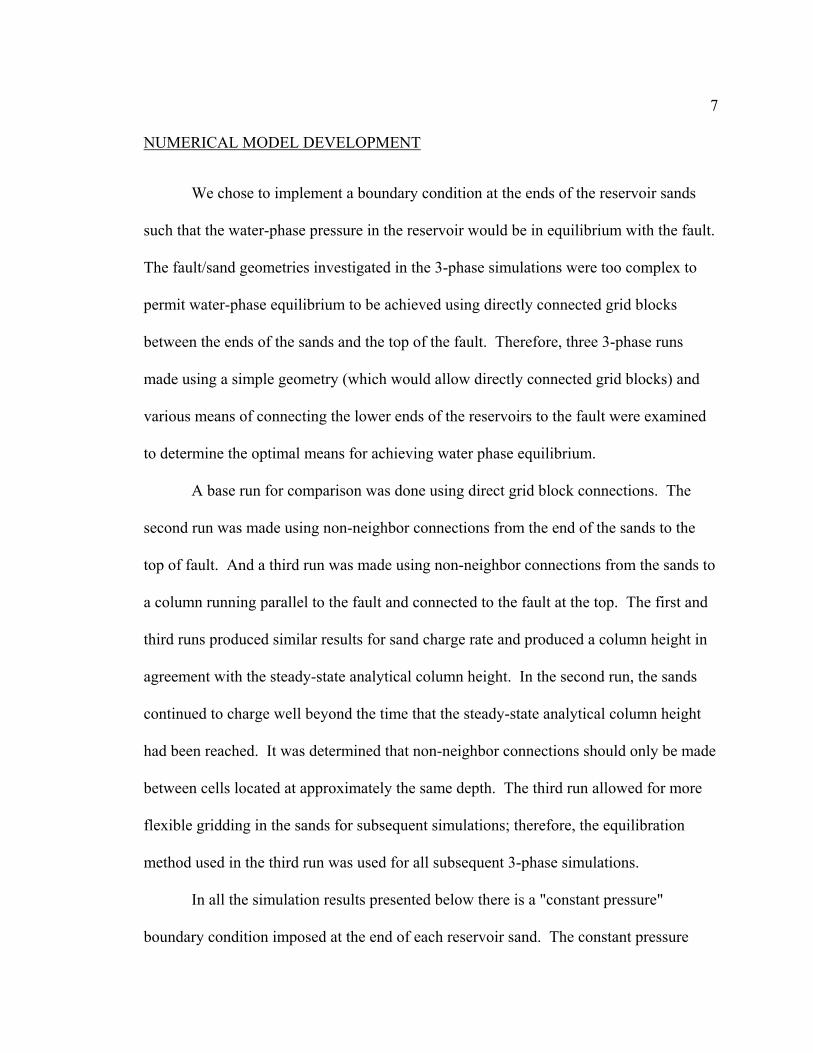
NUMERICAL MODEL DEVELOPMENT
We chose to implement a boundary condition at the ends of the reservoir sands
such that the water-phase pressure in the reservoir would be in equilibrium with the fault.
The fault/sand geometries investigated in the 3-phase simulations were too complex to
permit water-phase equilibrium to be achieved using directly connected grid blocks
between the ends of the sands and the top of the fault. Therefore, three 3-phase runs
made using a simple geometry (which would allow directly connected grid blocks) and
various means of connecting the lower ends of the reservoirs to the fault were examined
to determine the optimal means for achieving water phase equilibrium.
A base run for comparison was done using direct grid block connections. The
second run was made using non-neighbor connections from the end of the sands to the
top of fault. And a third run was made using non-neighbor connections from the sands to
a column running parallel to the fault and connected to the fault at the top. The first and
third runs produced similar results for sand charge rate and produced a column height in
agreement with the steady-state analytical column height. In the second run, the sands
continued to charge well beyond the time that the steady-state analytical column height
had been reached. It was determined that non-neighbor connections should only be made
between cells located at approximately the same depth. The third run allowed for more
flexible gridding in the sands for subsequent simulations; therefore, the equilibration
method used in the third run was used for all subsequent 3-phase simulations.
In all the simulation results presented below there is a "constant pressure"
boundary condition imposed at the end of each reservoir sand. The constant pressure

8
boundary is modeled by adding `non-neighbor connections' (not shown in the figures)
between the end of the sand and a column of cells running parallel to the fault (not shown
in figures). The top of this column is connected to the top cell in the fault. This keeps
the aquifer region of each sand in hydrodynamic equilibrium with the fault. Also, in all
the simulations there is a well injecting oil and a well injecting gas at a constant rate at
the bottom of the fault zone and there is a well producing with a constant bottom hole
pressure specification at the top of the fault zone. The fault is one cell thick.
NUMERICAL MODEL RESULTS
Two 3-phase runs were made and are noted as Run 5 and Run 6. Both 3-phase
runs consist of a 60 foot thick fault and three sands attached to the hanging wall side of
the fault. In Run 5 the fault is inclined at an angle 10o from vertical and the upper sand is
sealed by the fault and the lower two sands have a rollover anticline structure (see Figure
3-8). In Run 6 the fault is inclined at an angle 5o from vertical and all three sands are
sealed by the fault (see Figure 3-9). The input data for the 3-phase simulations are
summarized in Table 3-3. Results of the 3-phase numerical modeling are discussed
below.
Table 3-3: Summary of 3-Phase Simulation Input Parameters
Run Oil Flux STB/day/ft2
Gas Flux MCF/day/ft2
Injection Pressure psia
Seal Type
5 3.14x10⁻⁷ 4.49x10⁻⁷ 8600 Anticlinal 6 4.34x10⁻⁷ 9.92x10⁻⁷ 8450 Fault

9
Run 5: Anticlinal Model
The anticlinal model (Run 5) was run to investigate the sand charge rate for each
fluid and the path that is followed to reach the steady state hydrocarbon column height in
a combination fault seal/anticlinal system. The injected gas-to-oil ratio (GOR) was set to
cause the bubble-point pressure to occur between the middle and lower sands. The
theoretical steady-state hydrocarbon column height (measured from the highest point in
the sand) for each sand was calculated as described above. A comparison of the
analytical heights to the numerical is given in Table 3-4 and is discussed below. Steady-
state column heights based on capillary pressure are calculated at the sand/fault interface.
The calculated heights then are added to the height of the anticline above the fault
intercept to determine the analytical column heights for the anticlinal structures.
Figure 3-10, Figure 3-11, and Figure 3-12 show oil in place and free gas in place
versus time for the upper, middle and lower sands, respectively for Run 5. Figure 3-13
through Figure 3-16 present oil and gas saturation maps at times of 1, 4, 7, and 10
million years, respectively for Run 5. Note in the saturation figures that the vertical
dimension of the sands have been expanded and “ha” represents the analytical column
heights.
Table 3-4: Comparison of Numerical and Analytical Column Heights, Run 5: Anticlinal Model
Total Height (ft) Gas Height (ft) Sand Numerical Analytical Numerical Analytical
Upper 2400 2431 390 29 Middle 3895 3563 1850 2020 Lower 3060 3183 250 0

10
The lower sand is an anticline structure and there is only an oil phase present in
the fault at the sand interface. The high pressure drop at the sand/fault interface initially
causes some gas to flash (come out of solution) and enter the sand. This gas quickly
migrates to the top of the structure but does not exist in quantities sufficient to block oil
flow. The difference in the analytical and numerical gas column heights shown in Table
3-4 for the lower sand is a result of the flashed gas. Figure 3-12 shows that the oil
charges the lower sand at a relatively constant rate and reaches steady state at
approximately 1.5 million years.
The middle sand is an anticline structure and there are separate oil and gas phases
present in the fault at the sand interface. At steady state, Pw, Po, and Pg will be in
equilibrium between the fault and the reservoir at the fault-reservoir interface. The
pressure of the oil and gas phases are determined by adding the oil-water capillary
pressure to the water phase pressure and adding the oil-gas capillary pressure to the oil
phase pressure, respectively. Initially the water saturation, Sw, in the sand is 1.0, the
capillary pressures, Pcow and Pcog are 0.0 and Pg=Po=Pw.. As oil and gas migrate the fault,
water saturation, Sw, decreases and gas saturation, Sg, increases, increasing Pcow and Pcog
respectively. This increases Po and Pg within the fault and creates a driving force causing
the oil and gas to charge the reservoir sand. Because Pcow is a function of Sw only, Pg is
calculated from Po, and Pcog << Pcow, we expect that almost all the oil and gas would
charge the sand until Sw in the sand is such that, Pcow in the sand at the fault-sand
interface approaches Pcow in the fault. Because the ratio of gas to oil flux (1.42
MCF/STB) in the fault is not the same as the ratio of gas to oil expected to be in place in

11
the sand (2.32 MCF/STB) at steady-state, one of the phases (in this case the oil phase)
overcharges the reservoir. Then as Pcow in the sand approaches Pcow in the fault, the
hydrocarbon phase which has overcharged the reservoir sand will begin to be expelled
and will be replaced by the undercharged phase.
As the column height grows, gravity segregation occurs and the anticline above
the fault interface should become gas saturated. As segregation occurs and a gas cap
forms in the anticline, the oil in the leg opposite the fault is trapped and the oil in leg
adjacent to the fault is displaced back into the fault (see Figure 3-13 through Figure 3-
16). Gas will continue to charge until the leg opposite the fault reaches equilibrium and
residual oil saturation is reached in the adjacent leg. Note Figure 3-13 through Figure 3-
16 show both the sands and fault to scale and a blowup of each sand so that the saturation
distributions can be seen more clearly.
The upper sand is sealed only by the fault (capillary pressure). For reasons
discussed above both fluids initially charge the sand. For this case of fault seal the gas
initially overcharges the reservoir. Figure 3-10 shows that at 3 million years the charge
rate begins to decline for both fluids. By 4 million years the gas is no longer charging the
sand and by 5 million years gas is being discharged by the sand. Through this time the
oil continues to charge the sand and displace the gas. By 10 million years the steady-
state total column height has almost been reached (Figure 3-16). However, the gas
column height still exceeds the steady-state value and gas is being displaced by oil.
Figure 3-14 through Figure 3-16 show that the gas height reaches a maximum at about 4
million years and then begins to recede leaving a residual saturation as an artifact of the

12
maximum height reached. Steady-state conditions were not reached in the upper sand
in this simulation.
Run 6: Fault Seal Model
The fault seal model (Run 6) was run to investigate the effect of pressure (depth)
on the hydrocarbon column height in a fault seal model where the sands have little or no
rollover. The GOR for Run 6 was set to create a separate gas phase throughout the fault.
A comparison of the analytical column heights to the numerical is given in Table 3-5 and
discussed below. Figure 3-17, Figure 3-18, and Figure 3-19 show oil in place and free
gas in place versus time in the upper, middle, and lower sands respectively for Run 6.
Figure 3-20 through Figure 3-24 present oil and gas saturation maps at times of 2, 4, 10,
15, and 20 million years, respectively for Run 6.
Table 3-5: Comparison of Numerical and Analytical Column Height, Run 6: Fault Seal Model
Total Height (ft) Gas Height (ft) Sand Numerical Analytical Numerical Analytical
Upper 3025 3312 735 50 Middle 2990 2494 40 54 Lower 2235 1957 40 52
Because the physical properties (B, µ, and ρ) and the mass flux (due to solution
gas traveling with the oil phase) of the oil and gas phases are strong functions of
pressure, the oil (So) and gas (Sg) saturations within the fault zone change as the
hydrocarbons migrate up the fault. As the fluids migrate up the fault, the pressure
decreases. This causes gas traveling in the oil phase to come out of solution and causes
expansion of the free gas. This in turn causes the gas saturation within the fault to

13
increase. Even though the mass traveling in the oil phase decreases as the oil migrates
up the fault, the oil phase saturation increases. This is due to the increase in viscosity and
density of the oil phase as gas is evolved from the oil.
The decrease in pressure as we move up the fault also effects the hydrocarbon
column height. For systems at pressures below the bubble point, ρo increases as pressure
decreases (because of the gas coming out of solution). Therefore, the effect on column
height for the oil phase will always be an increase as both So (Pcow) and ρo increase as the
oil migrates up the fault (see equation (3-3)). The effect on column height is very small
for the gas phase and gas column height can either increase or decrease depending on the
shape of the oil-gas capillary pressure curve. This is a result of offsetting effects of the
increase in Sg (see equation (3-2)) and Pcog causing an increase in column height against
the decrease in ρg (equation (3-4)) causing a decrease in column height.
For systems at pressures above the bubble point, there is only oil phase present.
The effect on column height of the oil phase above the bubble is analogous to the effect
on column height of the gas phase below the bubble point pressure.
Since there is free gas present in the fault we expect both free gas and oil to
charge the reservoir sands. Additionally, since the analytical gas column height predicted
for each of the three sands is small, we would expect the gas phase to overcharge the
sands and subsequently be displaced by the oil phase. We see this happening as all three
sands initially are charged with gas and oil (Figure 3-20). The lower, middle and upper
sands begin discharging gas at 2 (Figure 3-19), 4 (Figure 3-18), and 4.5 (Figure 3-17)
million years, respectively.

14
From 2 million years to 7 million years the lower sand continues to charge with
oil and discharge the excess gas (Figure 3-19). By 7 million years the lower sand has
reached steady state and the numerical column heights are in agreement with those
calculated analytically (Table 3-5). Similarly, from 4 million years to 20 million years
the middle sand continues to charge with oil and discharge excess gas (Figure 3-18). By
20 million years the middle sand has reached steady state and the numerical column
heights are in agreement with those calculated analytically (Table 3-5).
Gas begins to be expelled from the upper sand at 4.5 million years, shortly after
gas has begun to be expelled from the middle sand. The upper sand does not reach
steady state in the simulation. We can see by the slope of the gas in place curves in
Figure 3-17 through Figure 3-19 during the gas expulsion time period that as we move
up the column, the gas is expelled more slowly. As gas is discharged from lower sands,
there is a temporary increase in gas flux in the fault above that sand and consequently an
increase in the gas saturation within the fault above that sand (Figure 3-25) causing
overcharging of the shallower sands. This causes the maximum transient gas column
height to increase as we move up the fault (see Figure 3-21). The presence of a gas cap
within the sand limits the oil charge rate by decreasing kro increasing the distance the oil
must migrate at a low kro.
As previously mentioned, all the modeling is isothermal, and temperature
changes, as the oil and gas migrate up the fault, would also effect density and viscosity of
the fluids.

15
IMPLICATIONS OF 3-PHASE FAULT SEAL MODEL
Two major observations can be drawn from the 3-phase fault seal model:
1. For constant oil and gas flux rates within the fault, depth has only a small
effect on steady-state gas column height and steady-state oil column height
will decrease with increasing depth.
2. Transient effects can lead to the presence of significant gas columns which are
not predicted by the steady-state analytical model. The column heights will
eventually go to steady state, but it will take a long time. Furthermore,
transient gas column height will be higher in shallow sands as oil charges the
lower sands and gas is flushed out.

16
Oil Column
QoQg
Gas Column
Po = Pb
Po > Pb
Po < Pb
Fault
ReservoirSand
Figure 3-1: 3-Phase migration schematic. Po = oil phase pressure and Pb = bubble point pressure. Below the bubble point pressure, a discrete gas phase is present.

17
1
10
100
1000
10000
0 0.1 0.2 0.3 0.4 0.5 0.6 0.7 0.8 0.9 1Liquid Saturation (1-Sg)
Cap
illar
y Pr
essu
re (P
cog)
- ps
i
Sand
Fault
Figure 3-2: Oil-gas capillary pressure scaled by multiplying the oil-water capillary pressure, Figure 2-4, by the ratio the oil-gas interfacial tension (5 dynes/cm) to the oil water interfacial tension (20 dynes/cm).

18
0
0.1
0.2
0.3
0.4
0.5
0.6
0.7
0.8
0.9
1
0 0.1 0.2 0.3 0.4 0.5 0.6 0.7 0.8 0.9 1
Liquid Saturation (Swirr+So)
Rel
ativ
e Pe
rmea
bilit
y (k
r)
krokrg
Sw irr
Figure 3-3: Reservoir sand 2-phase oil-gas relative permeability at irreducible water saturation (Swirr), assumed to be the same as the 2-phase oil-water relative permeability, Figure 2-6.

19
0
0.1
0.2
0.3
0.4
0.5
0.6
0.7
0.8
0.9
1
0 0.1 0.2 0.3 0.4 0.5 0.6 0.7 0.8 0.9 1
Liquid Saturation (Swirr+So)
Rel
ativ
e Pe
rmea
bilit
y (k
r)
krokrg
Sw irr
Figure 3-4: Fault zone 2-phase oil-gas relative permeability at irreducible water saturation (Swirr), assumed to be the same as the 2-phase oil-water relative permeability, Figure 2-5.

20
Gas
Water Oil
Figure 3-5: Reservoir sand 3-phase oil-gas relative permeability, Modified Stone I Model (Aziz and Settari, 1979).

21
0.0010.01
0.70.6
0.03
0.10.20.3
0.40.5
Figure 3-6: Fault zone 3-phase oil-gas relative permeability, Modified Stone I Model (Aziz and Settari, 1979).

22
Free Water Level
Dept
h
Pressure
Free Oil Level
Pw Po Pg
hgas
hoil
Figure 3-7: Fluid pressure in the reservoir sand vs. depth schematic for a 3-phase hydrostatic system.

23
4000 feet
4000
feet
Figure 3-8: Anticlinal structure geometry (Run 5) where hydrocarbons are trapped by the anticline. The fault is 60 feet wide and the sand is 50 feet thick (see Table 3-1).

24
4000 feet
4000
feet
Figure 3-9: Fault seal geometry (Run 6) where hydrocarbons are trapped by capillary pressure. The fault is 60 feet wide and the sand is 50 feet thick (see Table 3-1).

25
0 1 2 3 4 5 6 7 8 9 100
100
200
300
400
500
600
700
800
900
1000
Time - m.y.
Hyd
roca
rbon
in P
lace
Oil - MSTB
Free Gas - MMCF
Figure 3-10: Hydrocarbon in Place versus Time in the Upper Sand (Run 5: Anticlinal Model).

26
0 1 2 3 4 5 6 7 8 9 100
100
200
300
400
500
600
700
800
900
1000
1100
1200
Time - m.y.
Hyd
roca
rbon
in P
lace
Oil - MSTB
Free Gas - MMCF
Figure 3-11: Hydrocarbon in Place versus Time in the Middle Sand (Run 5: Anticlinal Model).

27
0 1 2 3 4 5 6 7 8 9 100
100
200
300
400
500
600
700
800
900
1000
Time - m.y.
Hyd
roca
rbon
in P
lace
Oil - MSTB
Free Gas - MMCF
Figure 3-12: Hydrocarbon in Place versus Time in the Lower Sand (Run 5: Anticlinal Model).

28
ha
ha
ha
ha
ha
SATURATION
0.00 0.15 0.30 0.45 0.60 0.75
Q = 0.83 STB/YRQ = 1.18 MCF/YRGOR = 1413 SCF/STB
o
gk = 0.017 mdk = 1.0 md
fs
Fault = 60 ft x 120 ft wideSand = 50 ft x 120 ft thick
5000 10000
10000
15000
0
Sg
5000 10000
10000
15000
0
So
T = 1 m.y.
Figure 3-13: Hydrocarbon Saturation at 1 Million Years (Run 5: Anticlinal Model). Where T is the time of the simulation, kf is the fault zone permeability, ks is the reservoir sand permeability, Qo is the oil charge rate, Qg is the gas charge rate and GOR is the ratio of injected gas to oil.

29
ha
ha
ha
ha
ha
SATURATION
0.00 0.15 0.30 0.45 0.60 0.75
Q = 0.83 STB/YRQ = 1.18 MCF/YRGOR = 1413 SCF/STB
o
gk = 0.017 mdk = 1.0 md
fs
Fault = 60 ft x 120 ft wideSand = 50 ft x 120 ft thick
5000 10000
10000
15000
0
Sg
5000 10000
10000
15000
0
So
T = 4 m.y.
Figure 3-14: Hydrocarbon Saturation at 4 Million Years (Run 5: Anticlinal Model). Where T is the time of the simulation, kf is the fault zone permeability, ks is the reservoir sand permeability, Qo is the oil charge rate, Qg is the gas charge rate and GOR is the ratio of injected gas to oil.

30
ha
ha
ha
ha
ha
SATURATION
0.00 0.15 0.30 0.45 0.60 0.75
Q = 0.83 STB/YRQ = 1.18 MCF/YRGOR = 1413 SCF/STB
o
gk = 0.017 mdk = 1.0 md
fs
Fault = 60 ft x 120 ft wideSand = 50 ft x 120 ft thick
5000 10000
10000
15000
0
Sg
5000 10000
10000
15000
0
So
T = 7 m.y.
Figure 3-15: Hydrocarbon Saturation at 7 Million Years (Run 5: Anticlinal Model). Where T is the time of the simulation, kf is the fault zone permeability, ks is the reservoir sand permeability, Qo is the oil charge rate, Qg is the gas charge rate and GOR is the ratio of injected gas to oil.

31
ha
ha
ha
ha
ha
SATURATION
0.00 0.15 0.30 0.45 0.60 0.75
Q = 0.83 STB/YRQ = 1.18 MCF/YRGOR = 1413 SCF/STB
o
gk = 0.017 mdk = 1.0 md
fs
Fault = 60 ft x 120 ft wideSand = 50 ft x 120 ft thick
5000 10000
10000
15000
0
Sg
5000 10000
10000
15000
0
So
T = 10 m.y.
Figure 3-16: Hydrocarbon Saturation at 10 Million Years (Run 5: Anticlinal Model). Where T is the time of the simulation, kf is the fault zone permeability, ks is the reservoir sand permeability, Qo is the oil charge rate, Qg is the gas charge rate and GOR is the ratio of injected gas to oil.

32
0 1 2 3 4 5 6 7 8 9 10 11 12 13 14 15 16 17 18 19 200
100
200
300
400
500
600
700
800
900
1000
Time - m.y.
Hyd
roca
rbon
in P
lace
Oil - MSTB
Free Gas - MMCF
Figure 3-17: Hydrocarbons in Place versus Time in the Upper Sand (Run 6: Fault Seal Model).

33
0 1 2 3 4 5 6 7 8 9 10 11 12 13 14 15 16 17 18 19 200
100
200
300
400
500
600
700
800
900
1000
1100
1200
Time - m.y.
Hyd
roca
rbon
in P
lace
Oil - MSTB
Free Gas - MMCF
Figure 3-18: Hydrocarbons in Place versus Time in the Middle Sand (Run 6: Fault Seal Model).

34
0 1 2 3 4 5 6 7 8 9 10 11 12 13 14 15 16 17 18 19 200
100
200
300
400
500
600
700
800
900
1000
Time - m.y.
Hyd
roca
rbon
in P
lace
Oil - MSTB
Free Gas - MMCF
Figure 3-19: Hydrocarbons in Place versus Time in the Lower Sand (Run 6: Fault Seal Model).

35
ha
ha
ha
ha
ha
ha
SATURATION
0.00 0.15 0.30 0.45 0.60 0.75
5000 10000
10000
15000
0
5000 10000
10000
15000
0
Q = 1.14 STB/YRQ = 2.61 MCF/YRGOR = 2286 SCF/STB
o
gk = 0.017 mdk = 1.0 md
fs
Fault = 60 ft x 120 ft wideSand = 50 ft x 120 ft thick
So
Sg
T = 2 m.y.
Figure 3-20: Hydrocarbon Saturation at 2 Million Years (Run 6: Fault Seal Model). Where T is the time of the simulation, kf is the fault zone permeability, ks is the reservoir sand permeability, Qo is the oil charge rate, Qg is the gas charge rate and GOR is the ratio of injected gas to oil.

36
ha
ha
ha
ha
ha
ha
SATURATION
0.00 0.15 0.30 0.45 0.60 0.75
5000 10000
10000
15000
0
5000 10000
10000
15000
0
Q = 1.14 STB/YRQ = 2.61 MCF/YRGOR = 2286 SCF/STB
o
gk = 0.017 mdk = 1.0 md
fs
Fault = 60 ft x 120 ft wideSand = 50 ft x 120 ft thick
So
Sg
T = 4 m.y.
Figure 3-21: Hydrocarbon Saturation at 4 Million Years (Run 6: Fault Seal Model). Where T is the time of the simulation, kf is the fault zone permeability, ks is the reservoir sand permeability, Qo is the oil charge rate, Qg is the gas charge rate and GOR is the ratio of injected gas to oil.

37
ha
ha
ha
ha
ha
ha
SATURATION
0.00 0.15 0.30 0.45 0.60 0.75
5000 10000
10000
15000
0
5000 10000
10000
15000
0
Q = 1.14 STB/YRQ = 2.61 MCF/YRGOR = 2286 SCF/STB
o
gk = 0.017 mdk = 1.0 md
fs
Fault = 60 ft x 120 ft wideSand = 50 ft x 120 ft thick
So
Sg
T = 10 m.y.
Figure 3-22: Hydrocarbon Saturation at 10 Million Years (Run 6: Fault Seal Model). Where T is the time of the simulation, kf is the fault zone permeability, ks is the reservoir sand permeability, Qo is the oil charge rate, Qg is the gas charge rate and GOR is the ratio of injected gas to oil.

38
ha
ha
ha
ha
ha
ha
SATURATION
0.00 0.15 0.30 0.45 0.60 0.75
5000 10000
10000
15000
0
5000 10000
10000
15000
0
Q = 1.14 STB/YRQ = 2.61 MCF/YRGOR = 2286 SCF/STB
o
gk = 0.017 mdk = 1.0 md
fs
Fault = 60 ft x 120 ft wideSand = 50 ft x 120 ft thick
So
Sg
T = 15 m.y.
Figure 3-23: Hydrocarbon Saturation at 15 Million Years (Run 6: Fault Seal Model). Where T is the time of the simulation, kf is the fault zone permeability, ks is the reservoir sand permeability, Qo is the oil charge rate, Qg is the gas charge rate and GOR is the ratio of injected gas to oil.

39
ha
ha
ha
ha
ha
ha
SATURATION
0.00 0.15 0.30 0.45 0.60 0.75
5000 10000
10000
15000
0
5000 10000
10000
15000
0
Q = 1.14 STB/YRQ = 2.61 MCF/YRGOR = 2286 SCF/STB
o
gk = 0.017 mdk = 1.0 md
fs
Fault = 60 ft x 120 ft wideSand = 50 ft x 120 ft thick
So
Sg
T = 20 m.y.
Figure 3-24: Hydrocarbon Saturation at 20 Million Years (Run 6: Fault Seal Model). Where T is the time of the simulation, kf is the fault zone permeability, ks is the reservoir sand permeability, Qo is the oil charge rate, Qg is the gas charge rate and GOR is the ratio of injected gas to oil.

40
20 m.y.
9 m.y.
4 m.y.
2 m.y.
1 m.y.
0 0.01 0.02 0.03 0.04 0.05
5000
6000
7000
8000
9000
10000
11000
12000
13000
14000
15000
16000
17000
18000
Gas Saturation
Dep
th -
feet
Fault Seal Model
Upper Sand
Middle Sand
Lower Sand
Figure 3-25: Fault zone gas saturation at various times (Run 6). As gas migrates up the fault, a shift in the saturation curve to the left, decrease in gas saturation, indicates that gas is charging the sand and a shift to the right, increase in gas saturation, indicates that the sand is expelling gas.

41

1
BIBLIOGRAPHY
Antonellini, M., and A. Aydin, 1994, Effect of Faulting on Fluid Flow in Porous Sandstones: Petrophysical Properties: AAPG Bulletin, v. 78, p. 35-377.
Amyx, J. W., D. M. Bass Jr., and R. L. Whiting, 1960, Petroleum Reservoir Engineering: New York, McGraw-Hill. 610 p.
Aziz, K., and A. Settari, 1979, Petroleum Reservoir Simulation: London, Applied Science Publishers LTD. 476p.
Beggs, H. D. and J. R. Robinson,1975, Estimating the Viscosity of Crude Oil Systems: Journal of Petroleum Technology, p. 1140-1141.
Bennett, M., 1996, Simulation of Secondary Migration in Faults: Dynamic Controls on Hydrocarbon Column Height: M.S. thesis in Mineral Engineering, The Pennsylvania State University.
Blunt, M., D. Zhou, and D. Fenwick, 1995, Three-Phase Flow and Gravity Drainage in Porous Media: Transport in Porous Media, v. 20, p. 77-103.
Bouvier, J. D., C. H. Kaars-Sijpesteijn, D. F. Kluesner, C.C. Onyejekwe, and R. C. van der Pal, 1989, Three-Dimensional Seismic Interpretation and Fault Sealing Investigations, Nun River Field, Nigeria: AAPG Bulletin, v. 73, p. 1397-1414.
Caine, J., J. Evans, and C. Forster, 1996, Fault Zone Architecture and Permeability Structure: Geology, v. 24, p. 1025-1028.
Hippler, S. J., 1993, Deformation Microstructures and Diagenesis in Sandstone Adjacent to an Extensional Fault: Implications for the Flow and Entrapment of Hydrocarbons: AAPG Bulletin, v. 77, p. 625-637.
Jorden, J. R., and F. L. Campbell, 1984, Well Logging I - Rock Properties, Borehole Environment, Mud, and Temperature Logging: New York, Society of Petroleum Engineers of AIME, 167p.
Lee, A. L., M. H. Gonzalez, and B. E. Eakin, 1966, The Viscosity of Natural Gases, Journal of Petroleum Technology, pp. 997-1000.

2
McCain, W. D., 1973, The Properties of Petroleum Fluids, Tulsa, PennWell Publishing Company. 305p.
Pittman, E. D., 1981, Effect of Fault-Related Granulation on Porosity and Permeability of Quartz Sandstones, Simpson Group (Ordivician), Oklahoma: AAPG Bulletin, v. 65, p. 2381-2387.
Schowalter, T.T., 1979, Mechanics of Secondary Hydrocarbon Migration and Entrapment: AAPG Bulletin, v. 63, p. 723-760.
Vasquez, M. and H. D. Beggs, 1980, Correlations for Fluid Physical Property Prediction: Journal of Petroleum Technology, p. 968-970.

Appendix A
GEO-PRESSURE ANALYTICAL EXAMPLE
General Equation for 1-dimensional incompressible flow in oilfield units
QA
kkr dPdz
o o
o
wo= −
0 001127.cos
µρ θ
(A-1)
Oil Column Height
( )hP
ocow
w o=
−144ρ ρ
(A-2)
where: A - Cross-sectional area of fault, ft2
ho - Oil column height, ft
k - Intrinsic permeability, md
kro - Relative permeability to oil, dimensionless
Pcow - Capillary pressure, psi
Pw - Water phase pressure, psi
Qo - Oil flow rate, STB/D
Sw - Water phase saturation, dimensionless
z - Depth below datum, ft
µo - Oil viscosity, cp
ρo - Oil density, lb/ft3

2
ρw - Water density, lb/ft3
θ - Angle of fault from vertical
Geo-pressure Model Input Parameters
Qo - 2.124x10⁻³ STB/D ρo - 53 lb/ft3 A - 7200 ft2 ρw - 67 lb/ft3 kfault - 0.017 md µo - 0.352 cp
Example using EPR Fault Zone Capillary Pressure Data
Parameter Case 1 Case 2 dP/dz 0.8 0.465 (hydrostatic) kro 0.0013 0.0056 Sw 0.965 0.942 Pcow 32 65 ho 329 669
Example using Thomeer’s Capillary Pressure Relationship
Parameter Case 1 Case 2 dP/dz 0.8 0.465 (hydrostatic) kro 0.0013 0.0056 Sw 0.965 0.942 Pcow 16.1 16.3 ho 166 168

0.9 0.91 0.92 0.93 0.94 0.95 0.96 0.97 0.98 0.99 10
0.005
0.01
Water Saturation
Rela
tive
Perm
eabi
lity
Fault Zone Oil Relative Permeability
hydrostatic
0.8 psi/ft
Figure A-1: Expanded oil relative permeability in the fault zone.

4
0.9 0.91 0.92 0.93 0.94 0.95 0.96 0.97 0.98 0.99 11
10
100
1000
1
10
100
1000
Water Saturation
Capi
llary
Pre
ssur
e - p
si
Oil
Heig
ht A
bove
Fre
e W
ater
Lev
el -
ft
EPR Fault Zone Data
Thomeer's Relationship
Oil-Water Capillary Pressure
0.8 psi/fthydrostatic
10286
1029
103
669
329
166
Figure A-2: Expanded capillary pressure in the fault zone.

5

Appendix B
3-PHASE PVT DATA

0 1000 2000 3000 4000 5000 6000 7000 8000 9000 100000
500
1000
1500
2000
2500
3000
Pressure - psia
Rso
- SC
F/ST
B
Figure B-1: Solution Gas-Oil Ratio (Rso) versus Pressure for a 35o API oil and 0.8 specific gravity gas at 300o F (Vazquez and Beggs, 1980)

0 1000 2000 3000 4000 5000 6000 7000 8000 9000 100001.0
1.2
1.4
1.6
1.8
2.0
2.2
2.4
Pressure - psia
Bo -
bbl/S
TB
Figure B-2: Oil Formation Volume Factor (Bo) versus Pressure for a 35o API oil and 0.8 specific gravity gas at 300o F (Vazquez and Beggs, 1980)

0 1000 2000 3000 4000 5000 6000 7000 8000 9000 100000
0.001
0.002
0.003
0.004
Pressure - psia
Bg -
bbl/S
CF
Figure B-3: Gas Formation Volume Factor (Bg) versus Pressure for a 0.8 specific gravity gas at 300o F (McCain, 1973)

0 1000 2000 3000 4000 5000 6000 7000 8000 9000 100000.1
0.2
0.3
0.4
0.5
0.6
Pressure - psia
Oil v
iscos
ity -
cp
Figure B-4: Oil Viscosity (µo) versus Pressure for a 35o API oil and 0.8 specific gravity gas at 300o F (Vazquez and Beggs, 1980)

6
0 1000 2000 3000 4000 5000 6000 7000 8000 9000 100000.010
0.015
0.020
0.025
0.030
0.035
0.040
Pressure - psia
Gas
visc
osity
- cp
Figure B-5: Gas Viscosity (µg) versus Pressure for a 0.8 specific gravity gas at 300o F (Lee, et al., 1966)

Appendix C
EXAMPLE OF 3-PHASE ANALYTICAL SOLUTION FOR HYDROCARBON COLUMN HEIGHT
The 3-phase equation for oil flux through a hydrostatic water column can be written as
follows for field units:(C-1)
( )QA
k k r
Bo
ow o
o o=
⋅ ⋅ ⋅−
⋅
0 0 0 1 1 2 71 4 4
.ρ ρ
µ
(C-1)
And the equation for gas flux as:
( ) ( )QA
k k r
B
R so k k r
Bg
gw g
g g
ow o
o o= ⋅
⋅ ⋅−
⋅+
⋅ ⋅ ⋅−
⋅
0 0 0 1 1 2 7 1 4 4 1 4 4.
ρ ρ
µ
ρ ρ
µ
(C-2)
Total column height is written as:
hP
o il g a sc o w
w o+ =
⋅−
1 4 4ρ ρ
(C-3)
and gas column height as:
hP
g a sc o g
o g=
⋅−
1 4 4ρ ρ
(C-4)
where:

2
A - Cross-sectional area of fault, ft2
Bg - Gas formation volume factor, res.bbl./SCF
Bo - Oil formation volume factor, res.bbl./STB
h - Height, ft
k - Intrinsic permeability, md
kr - Relative permeability, dimensionless
Pc - Capillary pressure, psi
Qg - Gas flow rate, SCF/D
Qo - Oil flow rate, STB/D
Rso - Solution gas-oil ratio, SCF/STB
µ - Viscosity, cp
ρ - Density, lb/ft3
Subscripts: g - gas
o - oil
w - water
Given the following data:
Depth 12826 ft Qo 6.26E-03 STB/D Qg 32.055 SCF/D A 7200 sq. ft. k 0.017 md Pw (hydrostatic) 5964.09 psia ρw 67 lb/ft3

3
Step 1. Using Pw as a first estimate for Po and Pg, determine values for all pressure
dependent parameters from PVT data (Figure C-1 - Figure C-7).
Iteration Po Pg Bo Bg Rso µo µg ρo ρg 0 5964.09 5964.09 1.74 0.00069 1299 0.244 0.028 38.59 15.68
Step 2. Rearrange equation (C-1) to solve for kro
( )k rQ Bk A
oo o o
w o=
⋅ ⋅⋅ ⋅ ⋅ −
⋅1 4 40 0 0 1 1 2 7
µρ ρ.
(C5)
Step 3. Use values from step 1 in equation (C-5) and calculate kro to be 0.0977
Step 4. Rearrange equation (C-2) to solve for krg
( )k r
B Qk A
R s k rB
gg g
w g
g o o w o
o o=
⋅−
⋅⋅⋅ ⋅
−⋅ ⋅ −
⋅
µρ ρ
ρ ρµ
1 4 40 0 0 1 1 2 7.
(C-6)
Step 5. Use values from step 1 in equation (C-6) and calculate krg to be 0.0094
Step 6. Enter 2-phase oil-gas relative permeability chart (Figure C-8) and determine the
gas saturation where a krg of 0.0094 intercepts the gas relative permeability curve. (Sg =
0.07)
Step 7. Enter 3-phase oil relative permeability chart (Figure C-9) and determine the
water saturation where a gas saturation of 0.07 intercepts the kro equals 0.0977 relative
permeability curve. (Sw = 0.82)
Step 8. Enter the oil-water capillary pressure chart (Figure C-10) and determine the Pcow
where an Sw of 0.82 intercepts the fault zone capillary pressure curve. (Pcow = 630 psi)
Step 9. Enter the oil-gas capillary pressure chart (Figure C-11) and determine the Pcog
where an Sg of 0.07 intercepts the fault zone capillary pressure curve. (Pcog = 22 psi)

4
Step 10. Add Pcow to Pw to determine a new Po . (Po = 6594 psia)
Step 11. Add Pcog to Po to determine a new Pg . (Pg = 6616 psia)
Step 12. Compare new hydrocarbon phase pressures to previous iteration. If difference is
greater than 1 psi repeat steps 1 through 11 using new pressures.
The following table shows the results of the remaining iterations for this example.
Iteration Po Pg Bo Bg Rso µo µg ρo ρg 1 5964.1 5964.1 1.74 0.00069 1299 0.244 0.028 38.59 15.68 2 6594.1 6616.3 1.83 0.000655 1464 0.231 0.0298 37.9 16.56 3 6518.1 6539.8 1.81 0.000663 1443 0.232 0.0294 37.98 16.37 4 6518.1 6539.8
Iteration ρo ρg kro krg Sg Sw Pcow Pcog 1 38.59 15.68 0.0977 0.0094 0.07 0.82 630 22.2 2 37.9 16.56 0.0949 0.0093 0.069 0.83 554 21.7 3 37.98 16.37 0.0946 0.0093 0.069 0.83 554 21.7 4
Step 13. Use the values for density and capillary pressure from the last iteration in
equation (C-3) to calculate hydrocarbon column height (above free water level) to be
2,751 ft.
Step 14. Use the values for density and capillary pressure from the last iteration in
equation (C-4) to calculate gas column height (above free oil level) to be 62 ft.

1000 2000 3000 4000 5000 6000 7000 80001.1
1.2
1.3
1.4
1.5
1.6
1.7
1.8
1.9
2
2.1
Pressure - psia
Bo -
bbl/S
TB
Iteration 3
Iteration 1
Figure C-1: Oil Formation Volume Factor versus Pressure

1000 2000 3000 4000 5000 6000 7000 80000
0.001
0.002
0.003
0.004
Pressure - psia
Bg -
bbl/S
CF
Iteration 3Iteration 1
Figure C-2: Gas Formation Volume Factor versus Pressure

1000 2000 3000 4000 5000 6000 7000 80000
500
1000
1500
2000
Pressure - psia
Rso
- SC
F/ST
B
Iteration 3
Iteration 1
Figure C-3: Solution Gas-Oil Ratio versus Pressure

1000 2000 3000 4000 5000 6000 7000 80000.1
0.2
0.3
0.4
0.5
0.6
Pressure - psia
Oil v
iscos
ity -
cp
Iteration 3Iteration 1
Figure C-4: Oil Viscosity versus Pressure

1000 2000 3000 4000 5000 6000 7000 80000.01
0.015
0.02
0.025
0.03
0.035
Pressure - psia
Gas
visc
osity
- cp
Iteration 3
Iteration 1
Figure C-5: Gas Viscosity versus Pressure

1000 2000 3000 4000 5000 6000 7000 800036
37
38
39
40
41
42
43
44
45
46
47
Pressure - psia
Oil D
ensit
y - l
b/cf
Iteration 3
Iteration 1
Figure C-6: Oil Density versus Pressure

1000 2000 3000 4000 5000 6000 7000 80000
5
10
15
20
Pressure - psia
Gas
Den
sity
- lb/
cf
Iteration 3
Iteration 1
Figure C-7: Gas Density versus Pressure

0.6 0.7 0.8 0.9 10
0.01
0.02
0.03
0.04
0.05
0.06
0.07
0.08
0.09
0.1
Swirr + So
Rel
ative
Per
mea
bility
(kr)
Iteration 3
Iteration 1
kro krg
Figure C-8: 2-Phase Oil-Gas Relative Permeability versus Liquid Saturation

Figure C-9: 3-Phase Oil Relative Permeability versus Water and Gas Saturation

0 0.1 0.2 0.3 0.4 0.5 0.6 0.7 0.8 0.9 11
10
100
1000
10000
Water Saturation - (Sw)
Cap
illary
Pre
ssur
e (P
cow
) - p
si
Iteration 3Iteration 1
Figure C-10: Oil-Water Capillary Pressure versus Water Saturation

15
0 0.1 0.2 0.3 0.4 0.5 0.6 0.7 0.8 0.9 11
10
100
1000
10000
Liquid Saturation - (1 - Sg)
Cap
illry
Pres
sure
(Pco
g) -
psi
Iteration 3
Iteration 1
Figure C-11: Oil-Gas Capillary Pressure versus Liquid Saturation

Appendix D
FAULT-ZONE GEOMETRY AND ANISOTROPY EFFECTS IN 2-PHASE SYSTEMS
MODEL OBJECTIVES
The purpose of this modeling work was to investigate the effect of fault
anisotropy upon reservoir charge rate. In previous simulations (Bennett, 1996) it had
been noted that virtually all the oil injected into the fault would charge the reservoir sand
until the oil column height approached the steady-state column height. As the steady
state column height was approached, oil would begin to bypass the reservoir and migrate
to shallower reservoirs. Anisotropic effects were evaluated on the basis of pseudo steady
state reservoir bypass, or the percentage of oil being injected into the fault which
bypasses the reservoir sand and continues migrating up the fault. This is measured when
the reservoir charge rate has become stable and the oil column is still much less than the
steady-state column height.
The bypass is illustrated in Figure D-1 and Figure D-2. Given a single sand
system charging at a constant volumetric rate of Qi (Figure D-1), some of the
hydrocarbon will enter the sand (Qc) and some of the hydrocarbon will bypass the sand
and flow up the fault (Qb). Since we are evaluating an incompressible system, the
principle of mass conservation gives, Qb + Qc = Qi. We define the percent bypassing the
reservoir as Qb/Qi•100. This percent bypass will remain relatively constant until the

2
steady-state column height is approached, indicating that the sand is charging at a
relatively constant rate. This is illustrated in Figure D-2 which plots cumulative volumes
versus time. The top curve represents cumulative volume injected (Qi*t) at the bottom of
the fault versus time. The fairly constant slope regions of the other two curves (between
0.4 and 5.0 million years) are the pseudo steady-state regions where the sand is charging
at a relatively constant rate and a fairly constant fraction of the hydrocarbon is bypassing
the sand and continuing up the fault. Late in the simulation the oil in place curve flattens
out, indicating the sand is reaching its maximum (or steady state) oil in place and there is
a corresponding increase in the slope of the bypass curve as more oil bypasses the sand
and continues up the fault.
OVERVIEW
We consider two basic models: 1) "sand smear" and 2) "shale smear". The sand-
smear model is comprised of a relatively thick fault (33 feet) with a thin (3 feet) low-
permeability core (Figure D-3). The physical model for this permeability structure is that
the fault prior to significant displacement had, overall, a relatively high permeability.
Perhaps, for example, the fault was entirely within a sandstone bed. When the
displacement occurred a large damaged zone representing the total thickness of the fault
was created. The majority of the displacement however was focused along the core of
the fault. This localized displacement pulverized the sand matrix causing a loss of
permeability along the central core. This geometry is described by Caine, et al., (1996)
as a combined conduit-barrier fault structure. It was also noted by Caine, et al., (1996)

3
that this type of fault has a permeability structure which causes flow to be preferentially
oriented parallel to the fault.
The shale-smear model contrasts that of the sand-smear model in that the fault is
thinner (7 feet) and the core now has a high, not low, permeability (Figure D-4). In this
case the fault is within interbedded sands and shales and the shale is relatively ductile.
As fault displacement occurs, shales are dragged along the fault resulting in the
generation of a low-permeability sheath around the fault zone. This sealing mechanism
is common in oilfields of the Niger Delta as described by Bouvier, et al., (1989).
MODEL CONSTRAINTS
Figure D-5 illustrates a typical simulation grid for both the sand-smear and shale-
smear models. Note that there are three grid blocks across the width of the fault. The
middle column is too thin to be apparent in Figure D-5. In all the simulation results
presented for both the sand-smear and shale-smear models there is a constant pressure
boundary condition imposed at the downdip end of each reservoir sand (Figure D-5).
The constant pressure boundary is modeled by adding grid blocks (not shown in Figure
D-5) between the end of the sand and the top of the fault. This keeps the aquifer region
of each sand in hydrodynamic equilibrium with the top of the fault. In all the simulations
there is a well injecting oil at a constant rate at the bottom of the fault zone and there is a
well producing with a constant bottom hole pressure (hydrostatic) specification at the top
of the fault zone (Figure D-5). Rock properties and grid geometries for both the sand-
smear and shale-smear models are listed in Table D-1. Fluid properties are listed in
Table D-2.

4
Table D-1: Rock Properties and Grid Geometry, Sand-Smear and Shale-Smear Models Rock Properties Reservoir Fault Sheath Fault Core Permeability (horizontal)
1.00 md 1.7x10⁻² - 1.7x10⁻⁶ md (sand-smear) 2.4x10⁻⁴ - 2.4x10⁻⁵ md (shale-smear)
2.4x10⁻⁴ - 2.4x10⁻⁸ md (sand-smear) 1.7x10⁻² - 1.7x10⁻³ md (shale-smear)
Permeability (vertical)
0.1 md 0.017 md (sand-smear) 0.00024 md (shale-smear)
0.00024 md (sand-smear) 0.017 md (shale-smear)
Porosity 20 % 15 % 15 % Thickness 50-200 ft 30 ft (sand-smear)
3 ft (shale-smear) 3 ft (sand-smear) 0.6 - 1.2 ft (shale-smear)
Width 120 ft 120 ft 120 ft Angle from horizontal
10o 80o 80o
Table D-2: Fluid Properties, Sand-Smear and Shale-Smear Models
Fluid Properties Oil Water Density 53.05 lb/ft3 62.42 lb/ft3 Viscosity 0.35194 cp 0.18386 cp
The reservoir sand and fault zone oil-water capillary pressure data given in Figure
2-4 were used for all models presented in this section. The Leverett-J function (Amyx et
al., 1960) can be used to scale capillary pressure as a function of permeability (k) and
porosity (φ). In the previous modeling effort (Bennett, 1996), it was determined that
capillary pressure should be scaled in the direction of highest permeability. Because the
vertical permeability of the fault zone in all the runs was held constant and was equal to
or greater than the horizontal permeability, oil-water capillary pressure was not scaled.
Both regions within the fault zone use the capillary pressure data given in Figure 2-4.
Fault zone and reservoir sand oil-water relative permeability data are give in
Figures 2-5 and 2-6, respectively. All fault zone rock and fluid properties, with the
exception of horizontal permeability, were the same for all sand-smear and shale-smear
simulations.

5
SAND-SMEAR MODEL
The input data and results for the sand-smear simulations are summarized in
Table D-3. In all sand-smear simulations the core of the fault was modeled with a
vertical permeability of 0.00024 md and the sheath with a vertical permeability of 0.017
md. Various ratios of vertical to horizontal permeability (kv/kh) were investigated by
holding the vertical permeability constant according to Table D-1, while decreasing the
horizontal permeability of both the fault core and sheath in each simulation to create the
permeability ratios in Table D-3. The fault was modeled with three horizontal grid
blocks, one for the core and one on each side of the core for the sheath (Figure D-5). The
reservoir sand was modeled as being either 50 feet thick (one grid block) or 200 feet
thick (4 grid blocks) [Table D-1]. The fault zone capillary pressure curve given in
Chapter 2 (Figure 2-4) was used for both zones of the fault. The oil injection rate for all
sand-smear runs was 4.74x10⁻⁴ res.bbl/day (6.27x10⁻⁸ res.bbl/day/ft2).
Table D-3: Summary of Simulations with Anisotropic Fault, Sand-Smear Model Run Name Fault Permeability
Ratio, kv/kh Sand Thickness
Feet Number of Cells in
Sand Reservoir Bypass
Percent Run A1 1 50 1 5 Run A2 10 50 1 45 Run A3 100 50 1 87 Run A4 1,000 50 1 97 Run A5 1 200 4 2 Run A6 10 200 4 39 Run A7 100 200 4 85 Run A8 1,000 200 4 96 Run A9 10,000 200 4 100 Run A10 10 200 4 35 Run A11 100 200 4 41 Run A12 1,000 200 4 55 Run A13 100 200 4 40

6
The major conclusions and observations from the sand-smear are:
1. The anisotropy of the fault has a significant impact on reservoir bypass.
2. The location of the source bed relative to the potential reservoir sands (same or
opposite side) is an important factor in controlling how effectively the sands are
charged.
3. Sand thickness has only a minor impact on reservoir bypass.
4. Reservoir charge rate is controlled primarily by the horizontal permeability of the
damaged fault core when the source and reservoir are on opposite sides of the
fault.
Additional information on the sand-smear model runs is given below.
Run A1 through Run A9 investigate the effect of fault anisotropy and sand
thickness upon oil bypass. For all these runs the injection and production wells are
located on the footwall (high permeability) side of the fault, opposite the sand. The sands
are attached to the hanging-wall side of the fault and the low-permeability core of the
fault acts as a barrier to flow from the fault to the sand.
Run A1 through Run A4 investigate the effect of increasing fault anisotropy in
one order of magnitude increments upon oil by-pass of a 50 foot sand. The 5 percent oil
bypass in Run A1 demonstrates that even for an isotropic fault, the low-permeability core
can act as barrier to oil migration to the sand. By imposing an anisotropy (kv/kh) in the
fault of one order of magnitude (Run A2), oil bypass of the sand is increased to 45
percent. Increasing anisotropy to a factor of 100 (Run A3) causes bypass to increase to

7
87 percent. Increasing the anisotropy to a factor of 1000 causes almost complete (97
percent) bypass of the potential reservoir sand.
Run A5 through Run A8 are similar to runs Run A1 through Run A4 with the
sand thickness increased to 200 feet (and from 1 grid block to 4 grid blocks thick).
Comparing runs with the same anisotropy and different sand thickness shows that
increasing the sand thickness has only a minor effect in decreasing oil bypass.
Additionally, Run 9 was made with an anisotropy of 10,000. This run shows that the
resistance to horizontal flow in the fault for anisotropy in excess of 1,000 would not
allow capillary forces to drive oil into the sand (bypass is 100 percent).
Figure D-6 shows the oil saturation in the fault and reservoir sand, for Run A5
through Run A8, 1 million years after initiating oil injection. It can be seen that even
though the oil injection rate into the fault is the same for all four runs, much less oil
charges the sand as the anisotropy is increased. This is particularly noticeable in Run A7
and Run A8 which have anisotropy ratios of 100 and 1,000 respectively.
Additionally, there is a significant change in oil distribution (Figure D-6) within
the fault as anisotropy is increased. In Run A5 the oil saturation is fairly uniform across
the fault. In Run A6 the oil saturation is slightly higher on the footwall side of the fault
(opposite the sand) were the injection and production wells are located. In Run A7 the
oil saturation on the footwall side of the fault is twice that of the hangingwall side and in
Run A8 the saturation difference across the fault is nearly a factor of four.
Run A10 through Run A12 are the same as Run A6 through Run A8, respectively
except the oil injection is distributed across the fault by using a row of cells across the

8
bottom of the fault with flow properties equivalent to the sand. Run A10 shows that oil
by-pass is decreased by 10 percent for a fault with an anisotropy ratio of 10. The
reduction in oil by-pass is much more prominent in Run A11 and Run A12 where
anisotropy is 100 and 1,000 and by-pass is 41 and 55 percent, respectively. This
indicates that oil bypass is significantly influenced by anisotropy of the high permeability
zone of the fault (Run A10 through Run A12) as well as the barrier effect of the low
permeability core (Run A6 through Run A8). This implies that the location of the source
bed (same or opposite side as the reservoir) becomes more important in evaluating
reservoir charging as fault zone anisotropy increases.
Run A13 was run to confirm the findings of runs Run A10 through Run A12.
This run was similar to Run A11 except flow properties equivalent to the sand were
assigned to the top and bottom rows of cells in the fault. Oil bypass for this run was
similar to the results for Run A11 indicating the location of the production well at the top
of the fault is not very important in these simulations.
SHALE-SMEAR MODEL
The input data and results for the three shale-smear simulations are summarized
in Table 4 and the results are discussed below. Both the production well and injection
well were located in the core of the fault. The oil injection rate was 2.37x10⁻⁴ res.bbl/day
(one-half that of the sand-smear model) and the reservoir sand thickness was 50 feet for
all shale-smear runs. Numerous unsuccessful attempts were made to run models with a
fault geometry consisting of a 3 ft sheath and a 0.3 ft core at various flux rates.

9
Table D-4: Summary of Simulations with Anisotropic Faults, Shale-Smear Model
Run
Fault Anisotropy kv/kh
Fault Core Thickness
ft
Oil Flux Fault Core
res.bbl/day/ft2
Oil Flux Whole Fault
res.bbl/day/ft2
Percent Bypass
Run A14 1 1.2 1.65x10⁻⁶ 1.50x10⁻⁷ 72 Run A15 1 0.6 3.30x10⁻⁶ 1.57x10⁻⁷ 8 Run A16 10 0.6 3.30x10⁻⁶ 1.57x10⁻⁷ 99
The major conclusions and observations from the shale-smear model are:
1. The effects of fault anisotropy on reservoir bypass are much more dramatic for
the shale-smear model than for the sand-smear model.
2. Relative thickness of the fault core to the sheath, has a significant impact on
reservoir bypass
Additional information on the shale-smear model runs is given below.
Run A15 was used as a base run to investigate the effect of relative core thickness
and anisotropy within the fault. Figure D-7 shows the oil saturation in the fault for Run
A15. Note that the fault core saturation has been blownup and placed beside the fault for
clarity. It can be seen that even for the isotropic case in the shale-smear model the oil
saturation is much higher in the fault core (0.10) than in the sheath (0.05)
Run A14 shows the effect of increasing the core thickness relative to the low-
permeability exterior thickness without changing the injection rate. Even though the
fault is isotropic, increasing the core thickness provides a less resistant path from
injection well to production well. This decreases the oil saturation in the fault and thus
the capillary pressure driving the oil into the sand. Oil bypass is increased from 8 percent
to 72 percent for the same oil injection rate.

10
Run A16 shows the effect of fault anisotropy in the shale-smear model. Near
complete oil by-pass (99 percent) occurs at an anisotropy ratio of 10. By comparison an
anisotropy in excess of 1,000 is necessary to achieve complete oil bypass in the sand-
smear model. The additional flow up the core relative the sheath can also be seen in the
oil saturation where the core oil saturation has increased to 0.17 while oil saturation in
the sheath has dropped to 0.03.

11
Transient OilColumn Height
Steady-State OilColumn Height
Qb
Qc
Qi
Figure D-1: Fault/reservoir flow schematic depicting oil charging the fault Qi, oil charging the sand Qc and oil bypassing the sand Qb at pseudo steady-state conditions.

12
0 1 2 3 4 5 60
100
200
300
400
500
600
700
800
900
1000
1100
1200
1300
7
Time - m.y.
Cum
ulat
ive
Oil
- MST
B
Oil Injected
Oil in Place (Sand)
Oil Bypassing Sand
Figure D-2: Fault/reservoir cumulative flow for Run A2 showing pseudo steady-state (1 to 5 million years) and steady-state (t > 5.5 million years) time periods.

13
Sandk = 1.0 md
Damaged Zonek = 0.017 md
Corek = 0.00024 md
Fault
Figure D-3: Schematic of the sand-smear model geometry showing the low permeability core and high permeability damaged zone.

14
Sandk = 1.0 md
Corek = 0.017 md
Sheathk = 0.00024 md
Figure D-4: Schematic of the shale-smear model geometry showing the high permeability core and low permeability sheath.

15
Constant Pressure
Boundary (hydrostatic) Constant Oil Flux (Qo)
200 Feet 200 Feet
Constant PressureBoundary (hydrostatic)
Figure D-5: Typical model grid geometry and boundary conditions for sand-smear and shale-smear models.

16
200 feet
Oil Saturation
k /k = 1V h
0.0001 0.05 0.1 0.15 0.2 0.7
k /k = 10V h
k /k = 100V h k /k = 1000
V h
RUN A5 RUN A6
RUN A7 RUN A8
1000
feet
Qo
Qo
Qo
Qo
Figure D-6: Oil saturation at 1 million years for sand-smear model with source on footwall side of fault and potential reservoir sands on hangingwall side. As kv/kh increases, horizontal flow through the fault decreases, and oil saturation is skewed to the footwall (source) side of the fault.

17
0.200.100.00
Oil Saturation
50 feet
200
feet
RUN A15
Figure D-7: Fault zone oil saturation in the shale-smear model. Oil saturation in the high permeability core is twice that of the sheath