Nov 1 - 2 2005: Review MeetingACCLIMATE Overview of Unmanned Aerial Vehicle Researches in UC,...
65
Nov 1 - 2 2005: Review Meeting ACCLIMATE Overview of Unmanned Aerial Vehicle Researches in UC, Berkeley David H. Shim, Shankar Sastry Project Manager, Berkeley Aerobot Team University of California, Berkeley ACCLIMATE Review November 2, 2005 http:// robotics.eecs.berkeley.edu /bear
-
date post
20-Dec-2015 -
Category
Documents
-
view
213 -
download
0
Transcript of Nov 1 - 2 2005: Review MeetingACCLIMATE Overview of Unmanned Aerial Vehicle Researches in UC,...

Nov 1-2 2005: Review Meeting ACCLIMATE
Overview of Unmanned Aerial Vehicle Researches in UC, Berkeley
David H. Shim, Shankar Sastry
Project Manager, Berkeley Aerobot TeamUniversity of California, Berkeley
ACCLIMATE Review
November 2, 2005
http://robotics.eecs.berkeley.edu/bear

Nov 1-2 2005: Review Meeting ACCLIMATE
Acknowledgements
•Principal Investigator: Professor Shankar Sastry, Dept of EECS, UC Berkeley
•Project Manager:David Hyunchul Shim, Ph.D.
•Postdoctoral Researchers:
Jonathan Sprinkle, Ph. D. (embedded software)
Mike Eklund, Ph.D. (underwater vehicle, Boeing OCP)
•Graduate Researchers:
Hoam Chung (model predictive control)
Todd Templeton (vision-based geographic reconstruction)
Jongho Lee (time-triggered RTOS)
•Technical Support
Travis Pynn
Nov 1-2 2005: Review Meeting ACCLIMATE
Mission Statement
•Develop a comprehensive set of theories and technologies for the joint operation of heterogeneous autonomous agents and human participants.
•Implement scalable, effective, and reliable platforms for autonomous systems research
•Validate the proposed ideas on the developed

Nov 1-2 2005: Review Meeting ACCLIMATE
Research Fields
• Flight Control system identification, feedback law design• Guidance static/dynamic path planning formation, collision avoidance, pursuit-evasion• Sensing Enhancement vision-based landing, terrain map building, • Navigation: INS/GPS integration• System integration• Software development: OCP, Giotto• Communications
Nov 1-2 2005: Review Meeting ACCLIMATE
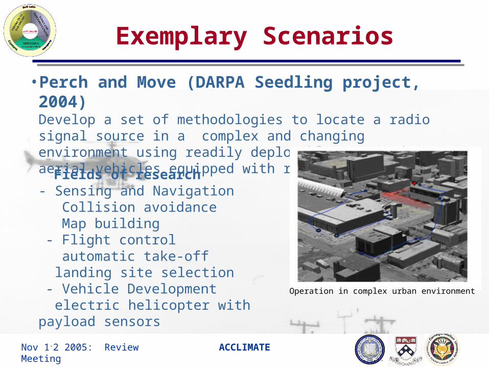
Exemplary Scenarios
• Perch and Move (DARPA Seedling project, 2004)Develop a set of methodologies to locate a radio signal source in a complex and changing environment using readily deployable unmanned aerial vehicles equipped with radio sensors
Fields of research- Sensing and Navigation
Collision avoidance Map building - Flight control automatic take-off
landing site selection - Vehicle Development
electric helicopter with payload sensors Operation in complex urban environment

Nov 1-2 2005: Review Meeting ACCLIMATE
Exemplary Scenarios
• Convoy Protection (Fort Hunter Liggett, 2005)Develop a set of UAVs that fly with the convoy, providing realtime surveillance video feed with various angles. The UAVs typically take off from a small pod and land on one of the convoy vehicle with high accuracy
Fields of research- Sensing and Navigation
Target detection/following Vision-based navigation
Collision avoidance Map building
- Flight control precision automatic take-off and
landing
Nov 1-2 2005: Review Meeting ACCLIMATE
Berkeley UAV Platforms

Nov 1-2 2005: Review Meeting ACCLIMATE
BEAR Fleet: rotorcrafts
Ursa Magna 1,2 (June 1999~present)Advanced navigation&control algorithm development platformMulti-agent scenarios, formation flight,Vision-based landing
Ursa Major 1 (Nov. 2002 ~)Low-cost, high-payload platformAggressive Maneuver, Vision-based landingMulti-agent scenarios, Model-predictive control
Ursa Electra (July 2003~present)Fully autonomous electric helicopter First-hand test vehicle for advanced concepts
Ursa Maxima (July 2000~present)High-payload platform for Multi-agent scenarios, formation flight, obstacle avoidance

Nov 1-2 2005: Review Meeting ACCLIMATE
BEAR Fleet: Ursa Magna1,2
Laser Rangefinder
UltrasonicHeight meter
Length: 3.5m Body Width:0.7mHeight: 1.08mDry Weight: 44 kg Payload: 20kgEngine Output: 12 hpRotor Diameter: 3.070mFlight time: 30 minAvionics operation time: 180 min
IntegratedNav/Comm Module
Wavelan Antenna
GPS Antennanow equipped with laser scanner in place of camera for OA experiment

Nov 1-2 2005: Review Meeting ACCLIMATE
BEAR Fleet: Ursa Maxima 1,2
Length: 3.63m Body Width:0.72mHeight: 1.08mDry Weight: 58 kg Payload: 30kgEngine Output: 21 hpRotor Diameter: 3.115mFlight time: 30 minAvionics operation time: 180 min
Laser Scanner on pan/tilt mount
Flight Control System
Wavelan Antenna
GPS Antenna
Laser scanner control computer
Equipped with onboard alternator to power avionics and sensors

Nov 1-2 2005: Review Meeting ACCLIMATE
BEAR Fleet: Ursa Major1
Avionics Enclosure
Length: 1.5m Body Width:0.7mHeight: 0.7mDry Weight: 7 kg Payload: 10kgRotor Diameter: 2.0mFlight time: 30 minSystem operation time: 60 min
Based on Bergen Industrial Twin Helicopter
Twin gas engine
onboard computer
Nov 1-2 2005: Review Meeting ACCLIMATE
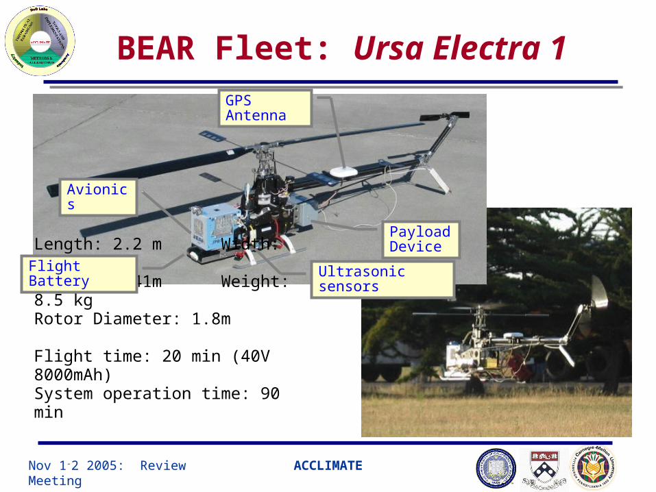
Length: 2.2 m Width: 0.26mHeight: 0.41m Weight: 8.5 kgRotor Diameter: 1.8m
Flight time: 20 min (40V 8000mAh)System operation time: 90 min
Payload Device
Avionics
Ultrasonic sensorsFlight Battery
GPSAntenna
BEAR Fleet: Ursa Electra 1
Nov 1-2 2005: Review Meeting ACCLIMATE
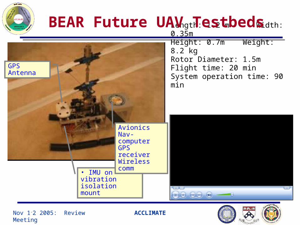
Length: 1.2 m Width: 0.35mHeight: 0.7m Weight: 8.2 kgRotor Diameter: 1.5mFlight time: 20 minSystem operation time: 90 min
GPSAntenna
• IMU on vibration isolation mount
AvionicsNav-computerGPS receiverWireless comm
BEAR Future UAV Testbeds
Nov 1-2 2005: Review Meeting ACCLIMATE
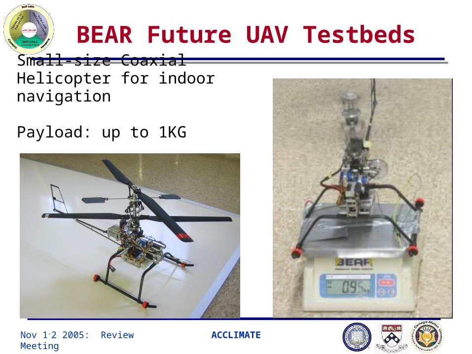
BEAR Future UAV Testbeds
Small-size Coaxial Helicopter for indoor navigation
Payload: up to 1KG

Nov 1-2 2005: Review Meeting ACCLIMATE
Berkeley UAV System Architecture
UAV Onboard System
INS
Wireless LAN (EC/S)
OnboardPayload
computer
ReferenceTrajectory
AdjustedTrajectory
VehicleManagement
Computer
GPS
Ultrasonic
ContactSWs
GroundMonioring
Station
DGPS correction
ServoChannels
Air
fra
me
Other AgentsUAV
orUGV
EngineRPM
GPS BaseStation
Wireless Network Channel (IEEE 802.11b)
ExternalMPC Engine
Sensors
Scalable, dynamically configurable system for multiple heterogeneous agent scenario is achieved by
• Standard sensor/actuator configuration • Common code architecture• Standardized communication protocol and interfacing method
• Scalable ad-hoc wireless
network

Nov 1-2 2005: Review Meeting ACCLIMATE
Modified light weight scannerMaximum Detection Range: 50m
Laser Range Finder
Wireless Communication
Short Range: Wireless LANLong Range(up to 30mi): Wireless Modems
Pentium III 700MHzQNX RTOS
Flight Controller: ADL P3
IMU+GPS100Hz Update
Inertial Navigation Sensor
CMIGITS-II
2cm StDAccuracy20Hz Update
GPS: Novatel OEM4
Laptop/PDAWindows XP/Windows CE
Ground Control Station
Motorized scanner tilt mount
Berkeley BEAR Fleet: Ursa Maxima 1

Nov 1-2 2005: Review Meeting ACCLIMATE
Avionics Software Architecture
Wirele
ss E
thern
et
Radio Receiver/Servo Control Unit
ShMemPRTKBDQIGPS
INS
DQICONTMain loop
ShMemXe
RS-232NovAtel
GPS
ShMemusensor
VCOMM LSCANOnboard MPC
ComputerRS232 RS232
3D LaserScanner
I/O
Ac c
ess
4 Hz
100 Hz
OrinocoEC/S
RS
-23
2
DG
PS
corr
ection
ServoInterface
ShMemRXIN
46 HzProxy Proxy
ShMemLaser
GroundStation
GPSBase station
Wirele
ss E
thern
et
ExternalMPC Engine
Ground systems
• Multi-process architecture with IPC• Processes dedicated for major navigation sensors and actuators running at
nonuniform rates• Interprocess communication: POSIX-compliant shared memory with QNX-
proprietary proxy for thread synchronization• Telemetry via wireless modem or IEEE802.11b ad-hoc mode

Nov 1-2 2005: Review Meeting ACCLIMATE
Pioneer Ground Robots
• Hardware
– Micro controller: motion control
– Onboard computer: communication, video
processing, camera control
• Sensors – Sonars: obstacle avoidance, map building
– GPS & compass: positioning
– Video camera: map building, navigation, tracking
• Communication– Serial– Wave-LAN: communication between robots and
base station– Radio modem: GPS communication
GPS Antenna
Ultrasonic array
Lucent WaveLAN
PTZ Color Camera
GPS
4WD PT
Nov 1-2 2005: Review Meeting ACCLIMATE
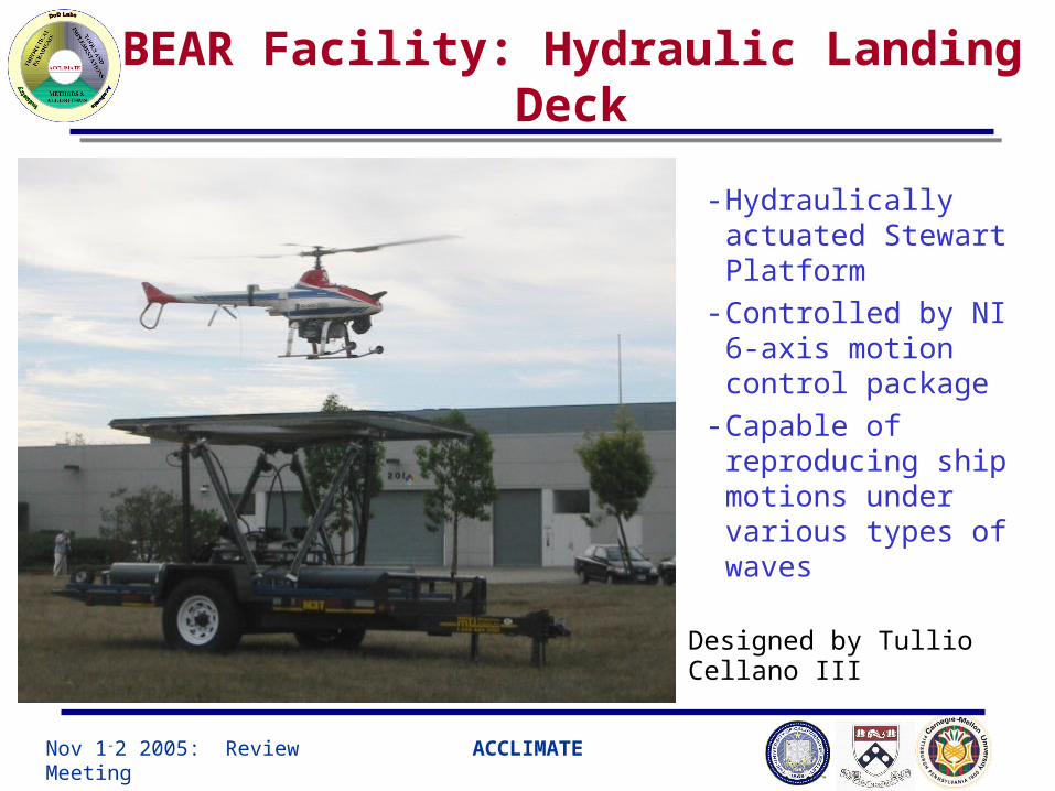
BEAR Facility: Hydraulic Landing Deck
- Hydraulically actuated Stewart Platform
- Controlled by NI 6-axis motion control package
- Capable of reproducing ship motions under various types of waves
Designed by Tullio Cellano III
Nov 1-2 2005: Review Meeting ACCLIMATE
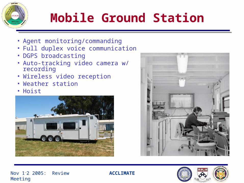
Mobile Ground Station
• Agent monitoring/commanding• Full duplex voice communication• DGPS broadcasting• Auto-tracking video camera w/ recording• Wireless video reception• Weather station• Hoist

Nov 1-2 2005: Review Meeting ACCLIMATE
Hand-held UAV Interfaces
Mobile Access and Command Extension (MACE) - “fly-by-fingertip” operation using touch screen- minimal obscurity monocle display- Real-time vehicle location & status monitoring- Waypoint programming
Nov 1-2 2005: Review Meeting ACCLIMATE
UAV Component Technologies
Nov 1-2 2005: Review Meeting ACCLIMATE
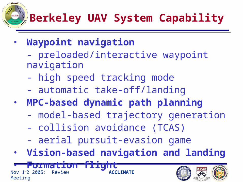
Berkeley UAV System Capability
• Waypoint navigation- preloaded/interactive waypoint navigation - high speed tracking mode- automatic take-off/landing
• MPC-based dynamic path planning - model-based trajectory generation- collision avoidance (TCAS)- aerial pursuit-evasion game
• Vision-based navigation and landing• Formation flight

Nov 1-2 2005: Review Meeting ACCLIMATE
Flight Mode-based Way-point navigation
• A helicopter flight can be composed with a number of flight primitives
such as take-off, hover, turn, vertical flight, forward flight, etc.• A script language (VCL) provides an abstraction layer from high-level
waypoint request to low-level vehicle control
Take- off Hover
Pirouette
Land Ascend/Descend
Forward Flight
Low-speed
X- Y flight
Bank- to-turn
GO {AUTO,MANUAL} : Change Flight mode to either automatic or manual
TakeoffTo <coord>{abs,rel} : perform autonomous take-off
Hover <coord>{abs,rel} {heading=<heading>{deg,rad}} <duration>{sec,min} : hover with given heading angle for given time
FlyTo <coord>{abs,rel} {vel <velocity>{mps,kmps,fps,knots,mph}} {passby,stopover} {autoheading}
: Cruise to certain way point stopping over or passing by
MoveTo <coord>{abs,rel} {vel <velocity>{mps,kmps,fps,knots,mph}} {autoheading}
: Visit a sequence of way points with fixed heading
Land : Perform automatic landing
** Helicopter flight is often more convoluted than a sequence of flight
primitives MPC-based waypoint navigator

Nov 1-2 2005: Review Meeting ACCLIMATE
VCL-based waypoint navigation
Perch & Move Flight Sequence (Aug 2004)

Nov 1-2 2005: Review Meeting ACCLIMATE
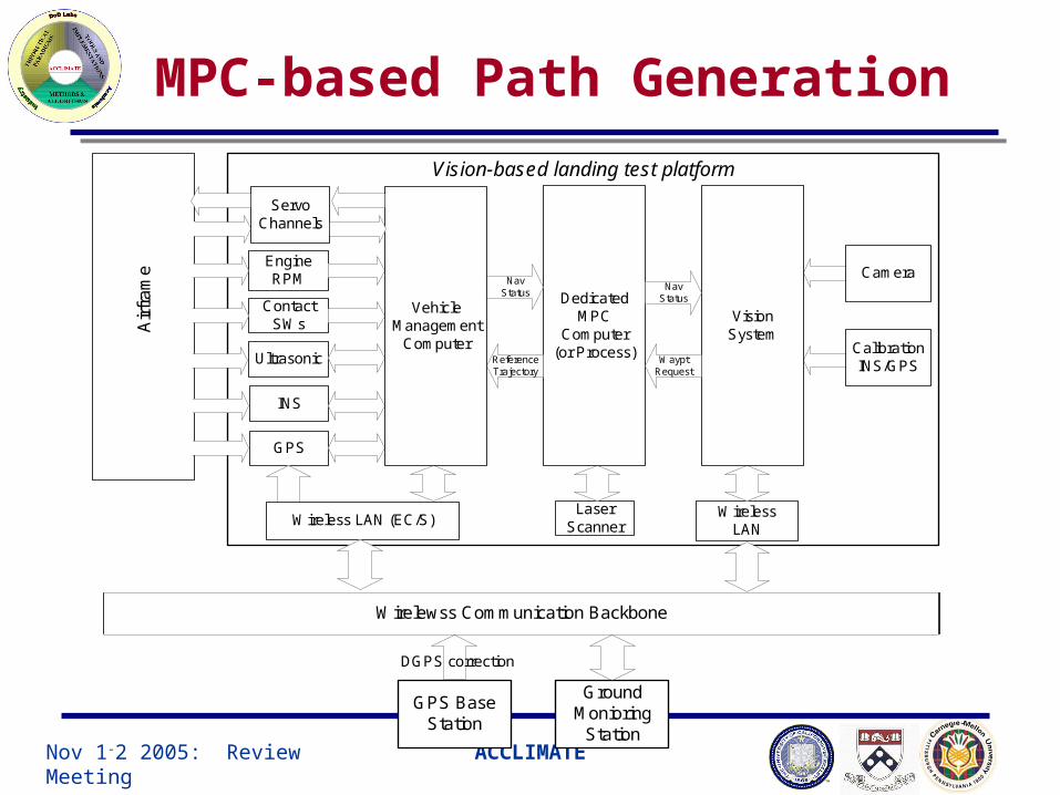
MPC-based Path Generation
Vision-based landing test platform
INS
Wireless LAN (EC/S)
NavStatus
ReferenceTrajectory
VehicleManagement
Computer
GPS
Ultrasonic
ContactSWs
GroundMonioring
Station
DGPS correction
ServoChannels
Air
fra
me
EngineRPM
GPS BaseStation
Wirelewss Communication Backbone
VisionSystem
WirelessLAN
Camera
CalibrationINS/GPS

Nov 1-2 2005: Review Meeting ACCLIMATE
Vision-based landing

Nov 1-2 2005: Review Meeting ACCLIMATE
Model-predictive approach
• A promising control methodology for a system with input saturation, system nonlinearity, and state constraints in a dynamic environment
• Stabilization and tracking problem is solved as an optimization problem of a cost function
• Tracking error and control energy are penalized over a finite time interval from present to future
• Control input saturation can be easily handled by simply forcing the saturation during optimization
• State constraints can be included by introducing appropriate cost functions

Nov 1-2 2005: Review Meeting ACCLIMATE
• A sequence of control {u(t)}, t=tk,…tk+h that minimizes the weighting
function over a finite horizon is computed every sampling time
• Only u(t) at t=tk is used for control output. The rest may be recycled as
the initial value to speed up the optimization at next sample hit
• Generally very expensive in terms of computing power (>100 MFLOPs)
but within reach of most latest CPUs (Pentium 4 class)
• Very efficient optimization algorithm is desired
Gradient-search method (Bitmead et al) is adopted here.
Model-predictive approach

Nov 1-2 2005: Review Meeting ACCLIMATE
• Partially nonlinear system model is discretized (Euler)
• Cost function is defined as the sum of quadratic tracking error and
control input over finite horizon: t=tk … tk+N
where
Cost function for tracking error
Model-predictive approach
Nov 1-2 2005: Review Meeting ACCLIMATE
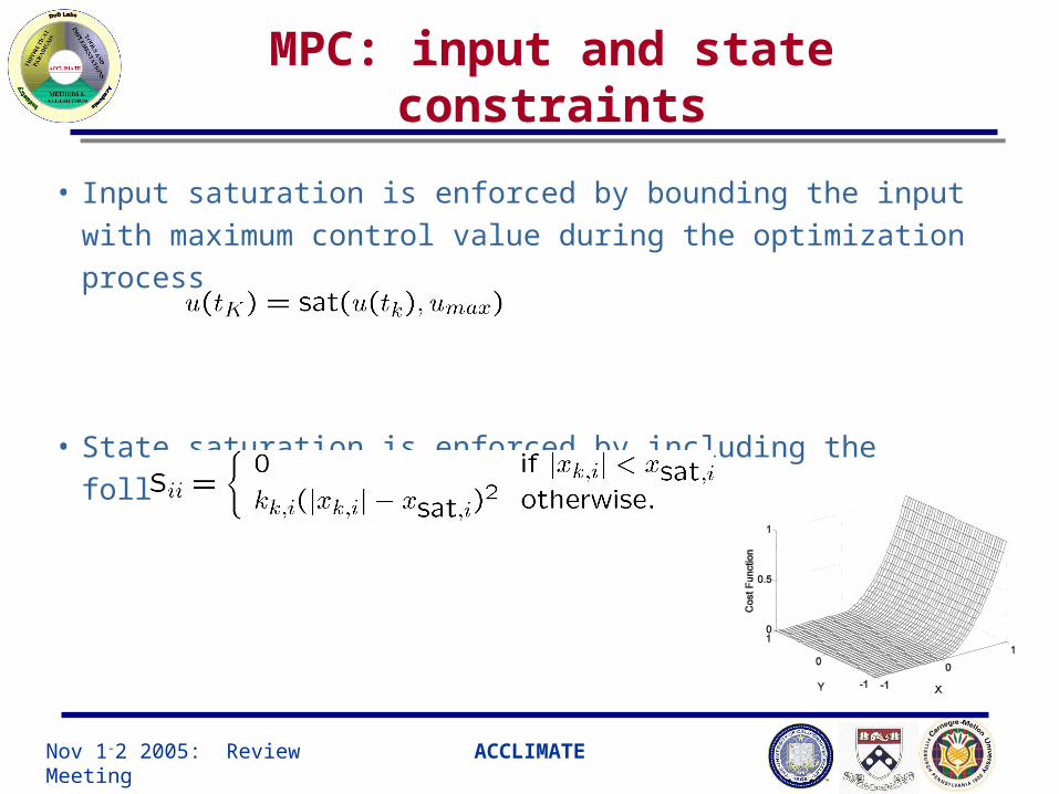
MPC: input and state constraints
• Input saturation is enforced by bounding the input with maximum
control value during the optimization process
• State saturation is enforced by including the following state penalty –
Nov 1-2 2005: Review Meeting ACCLIMATE
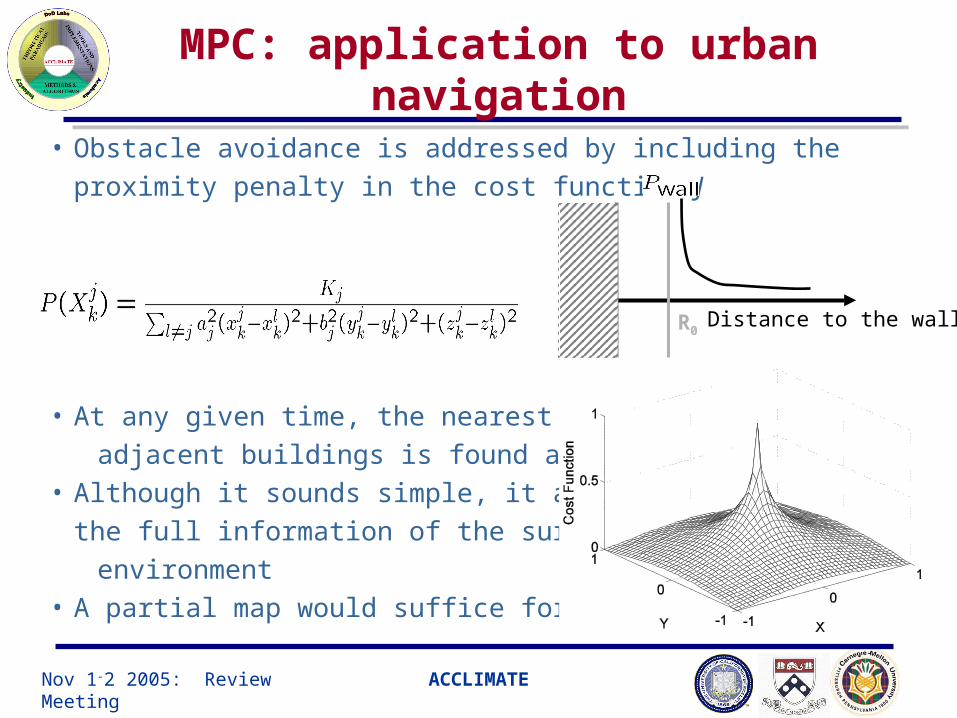
MPC: application to urban navigation
• Obstacle avoidance is addressed by including the proximity penalty in
the cost function J
• At any given time, the nearest point to
adjacent buildings is found and used.• Although it sounds simple, it assumes
the full information of the surrounding
environment • A partial map would suffice for MPC
Distance to the wallR0
Nov 1-2 2005: Review Meeting ACCLIMATE
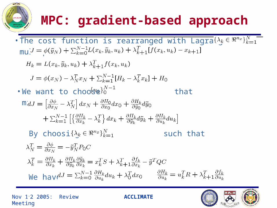
MPC: gradient-based approach
• The cost function is rearranged with Lagrange multiplier:
• We want to choose that minimizes J
By choosing such that
We have
Nov 1-2 2005: Review Meeting ACCLIMATE
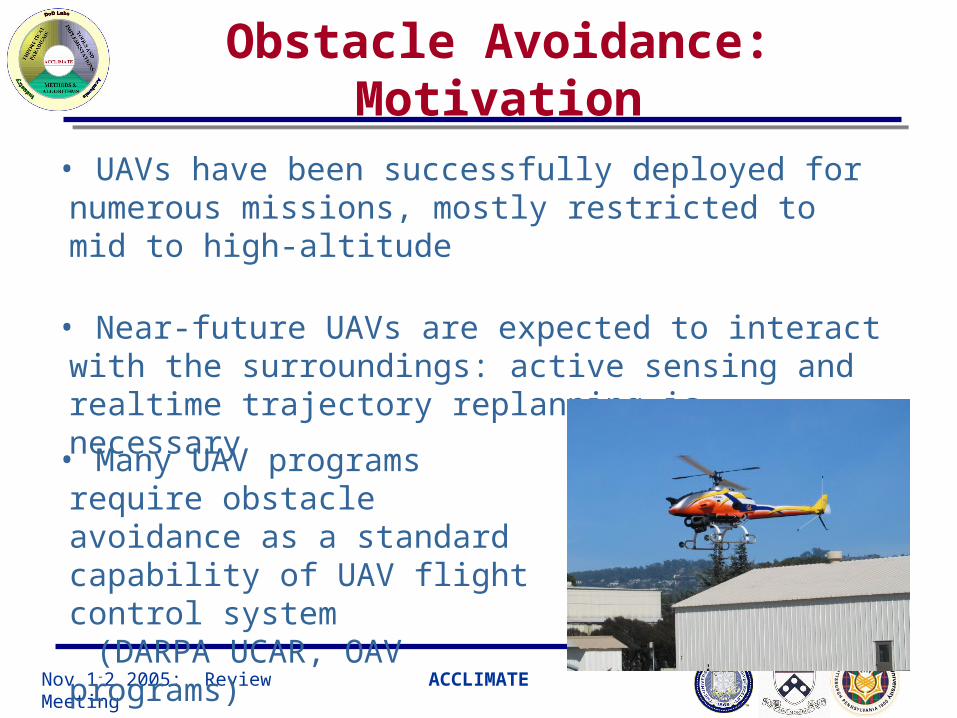
Obstacle Avoidance: Motivation
• UAVs have been successfully deployed for numerous missions, mostly restricted to mid to high-altitude
• Near-future UAVs are expected to interact with the surroundings: active sensing and realtime trajectory replanning is necessary
• Many UAV programs require obstacle avoidance as a standard capability of UAV flight control system
(DARPA UCAR, OAV programs)
Nov 1-2 2005: Review Meeting ACCLIMATE
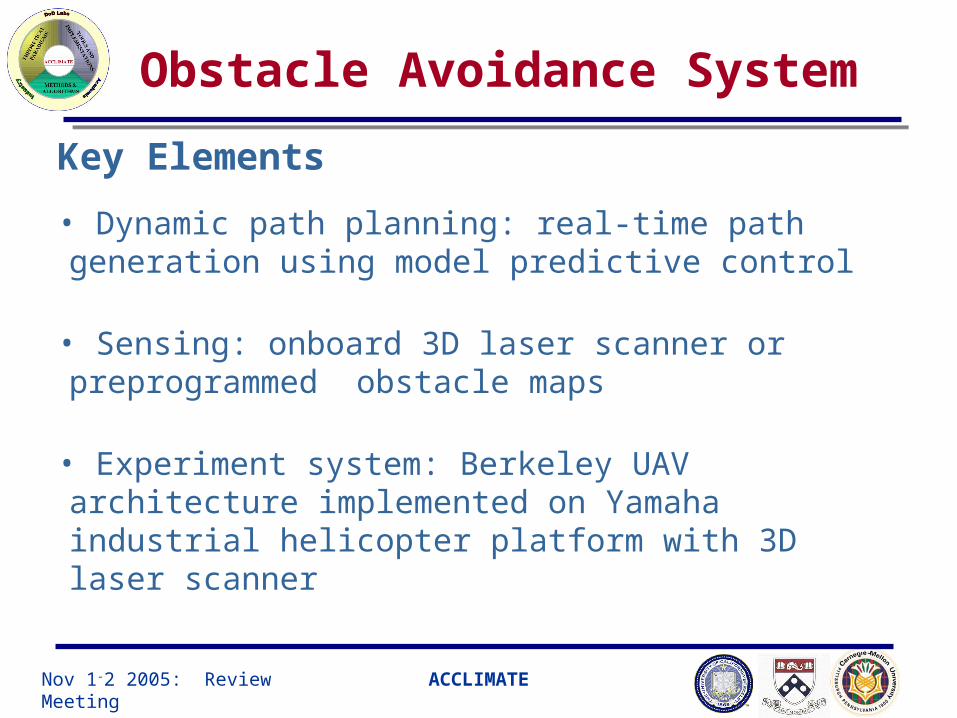
Obstacle Avoidance System
• Dynamic path planning: real-time path generation using model predictive control
• Sensing: onboard 3D laser scanner or preprogrammed obstacle maps
• Experiment system: Berkeley UAV architecture implemented on Yamaha industrial helicopter platform with 3D laser scanner
Key Elements
Nov 1-2 2005: Review Meeting ACCLIMATE
MPC-based Path Generation
Vision-based landing test platform
INS
Wireless LAN (EC/S)
DedicatedMPC
Computer(or Process)
NavStatus
ReferenceTrajectory
VehicleManagement
Computer
GPS
Ultrasonic
ContactSWs
GroundMonioring
Station
DGPS correction
ServoChannels
Air
fra
me Engine
RPM
GPS BaseStation
Wirelewss Communication Backbone
LaserScanner
VisionSystem
WirelessLAN
Camera
CalibrationINS/GPS
NavStatus
WayptRequest

Nov 1-2 2005: Review Meeting ACCLIMATE
20
40
60
80
-20
0
20
40
25303540
Collision pt:(50,0,33)ft
20
40
60
80
-20
0
20
40
25303540
Collision Avoidance using NMPTC
•Five helicopters are given a destination point.•The shortest (optimal) trajectory will lead to a collision.
•Each vehicle can detect other vehicles position only within the sensing/communication region.
•Can each vehicle fly safely and optimally?
Unsafe Desired Trajectory Resolved by NMPTC with Collision Avoidance
Nov 1-2 2005: Review Meeting ACCLIMATE
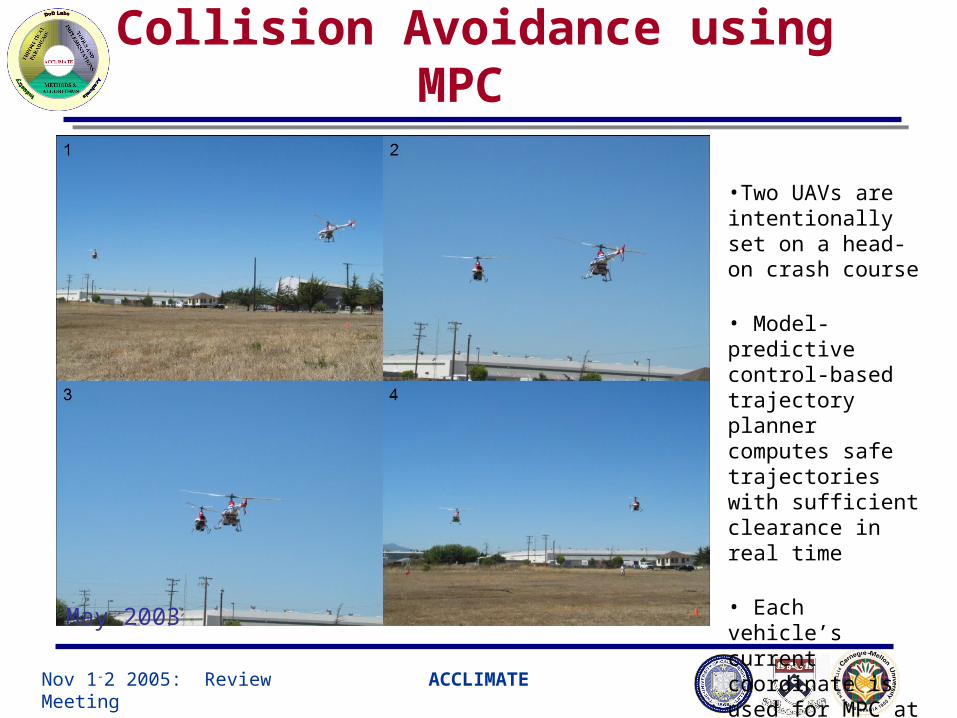
Collision Avoidance using MPC
•Two UAVs are intentionally set on a head-on crash course
• Model-predictive control-based trajectory planner computes safe trajectories with sufficient clearance in real time
• Each vehicle’s current coordinate is used for MPC at each computation
May 2003
Nov 1-2 2005: Review Meeting ACCLIMATE
Collision Avoidance using NMPTC

Nov 1-2 2005: Review Meeting ACCLIMATE
NMPTC for Dynamic Environment
1. Initial position 2. Popup wall
3. Ceiling lowers 4. column

Nov 1-2 2005: Review Meeting ACCLIMATE
NMPC in 3-D complex environment
NMPC
• The nearest point of the surrounding buildings found• The obstacle weighting function is applied.• Receding horizon approach is advantageous
than potential function approach when the
helicopter stuck in deadlock by including the finite
future behavior in the cost function
Nov 1-2 2005: Review Meeting ACCLIMATE
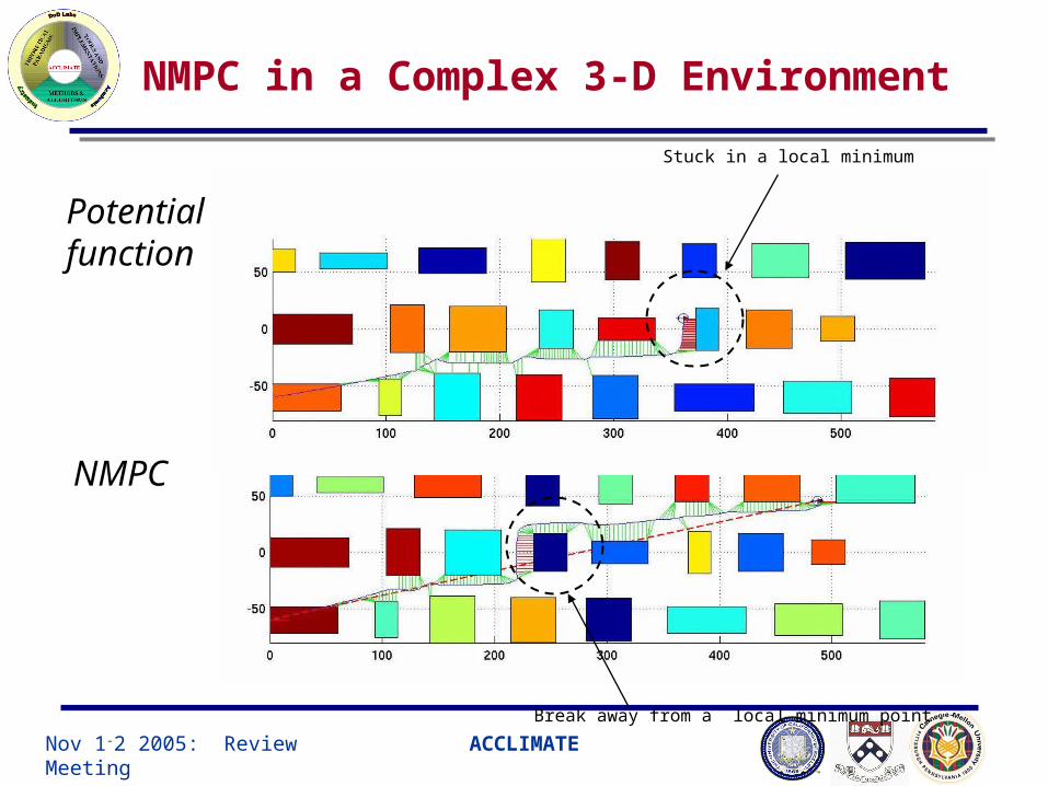
NMPC in a Complex 3-D Environment
Potential function
NMPC
Stuck in a local minimum
Break away from a local minimum point

Nov 1-2 2005: Review Meeting ACCLIMATE
NMPC in 3-D complex environment

Nov 1-2 2005: Review Meeting ACCLIMATE 0
10
20
30
40
50
-10
0
10
20
30
40
0123
Obstacle Sensing: map-based
• Map-based approach
- Obstacle map is measured and stored in the computer
- Upon request, the nearest obstacle coordinate is passed to
the MPC unit
- Sensing is always perfect,
thus eliminating any risks due to
sensing failure or any
unpredicted control behavior
Nov 1-2 2005: Review Meeting ACCLIMATE
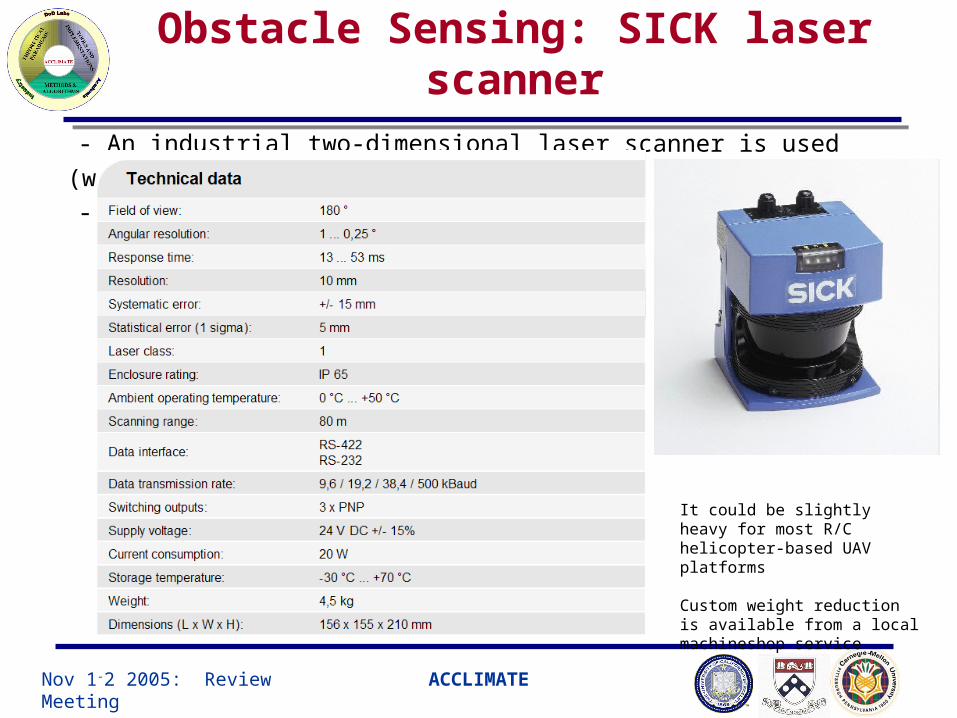
Obstacle Sensing: SICK laser scanner
- An industrial two-dimensional laser scanner is used (www.sick.de)
-
It could be slightly heavy for most R/C helicopter-based UAV platforms
Custom weight reduction is available from a local machineshop service

Nov 1-2 2005: Review Meeting ACCLIMATE
Object Detection with Laser Scanner
Simulated Urban Objects
UAV in the air
Electric powerlines
Trees
Powerpole
- Laser scanner in general can detect natural and
artificial objects very well with great accuracy
(powerlines, buildings, trees… but not glass)
- active sensing: no lighting is required

Nov 1-2 2005: Review Meeting ACCLIMATE
Nearest-point Method
min/O BX
min
2( ) arg min
iO obs
iO ref O ref
S
X
X X X X
( ( )) ( ( )) ( ( ))trk obstq k q k q k x x x
1( ( )) ( ) ( ) ( ) ( )
2
Ttrkref refq k k k Q k k x y x y x
Cost Function:
where
min
min
2
2min
2 1
( ( )) (( ( ) ( ))
( ( ) ( ))
( ( ) ( )) )
obst Sobs
S
S
q k K x k x k
y k y k
z k z k
x
At each k over finite horizon, the nearest
point on the obstacle from the
hypothetic vehicle location is found

Nov 1-2 2005: Review Meeting ACCLIMATE
Local partial map building for MPC
Raw scan datafrom LaserScanner
Filter outinaccurate
measurements
Convert tolocal cartesian
coordinates
Find N1 pointsclosest to host
vehicle
Register in adatabase with
N2 points
Nearestobstacle pt to
MPC
Vehicle positionand attitude from
Host vehicle
Data is held in FIFO

Nov 1-2 2005: Review Meeting ACCLIMATE
Experiment Setup
• Testbed Ursa Magna 2 will be used for map-based OA Ursa Maxima 1 will be used for laser scanner based OA
• System Setup Vehicle onboard navigation system Ground Monitoring and Command Station Ground-based MPC engine running on MATLAB in realtime Ground-based 3D visualization station of laser scanner in realtime Wireless Ethernet communication among systems
•Crew Experiment Coordinator: in charge of experiment sequencing Safety pilot: in charge of routine flight and emergency take-over Ground Operator: assists Experiment Coordinator to monitor Ground station Camera Crew: takes video record of all experiment activities
Nov 1-2 2005: Review Meeting ACCLIMATE
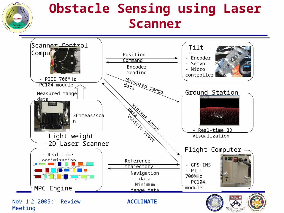
Scanner Control Computer Tilt Mount- Encoder
- Servo- Micro controller
Flight Computer
Ground Station
- GPS+INS- PIII 700MHz PC104 module
- Real-time 3D Visualization
- PIII 700MHz PC104 module
MPC Engine
- Real-time optimization
Position Command
Encoder reading
Measured range data
Minim
um range data
Vehicle state
Reference trajectory
Navigation dataMinimum range
data
Light weight2D Laser Scanner
Measured range data
- 361meas/scan
Obstacle Sensing using Laser Scanner
Nov 1-2 2005: Review Meeting ACCLIMATE
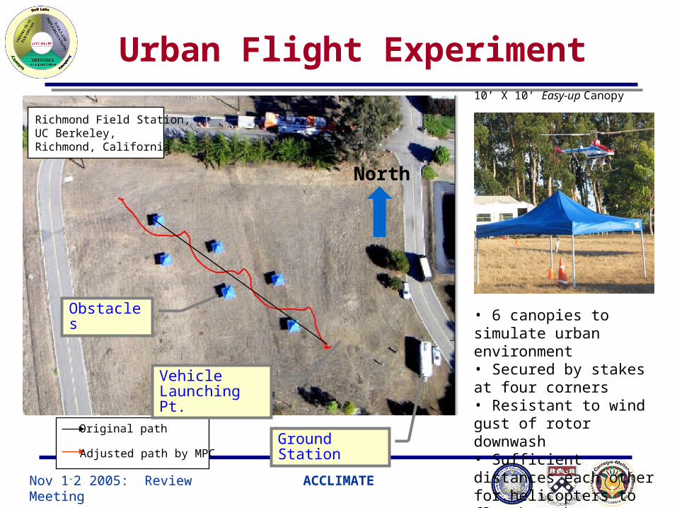
Urban Flight Experiment
North
10’ X 10’ Easy-up Canopy
• 6 canopies to simulate urban environment• Secured by stakes at four corners• Resistant to wind gust of rotor downwash• Sufficient distances each other for helicopters to fly through
Original path
Adjusted path by MPC
Vehicle Launching Pt.
Ground Station
Obstacles
Richmond Field Station, UC Berkeley, Richmond, California

Nov 1-2 2005: Review Meeting ACCLIMATE
DARPA/Berkeley Press Release (Dec 2004)

Nov 1-2 2005: Review Meeting ACCLIMATE
Urban Flight Experiment: birdeye view

Nov 1-2 2005: Review Meeting ACCLIMATE
Urban Flight Experiment: on ground
Nov 1-2 2005: Review Meeting ACCLIMATE
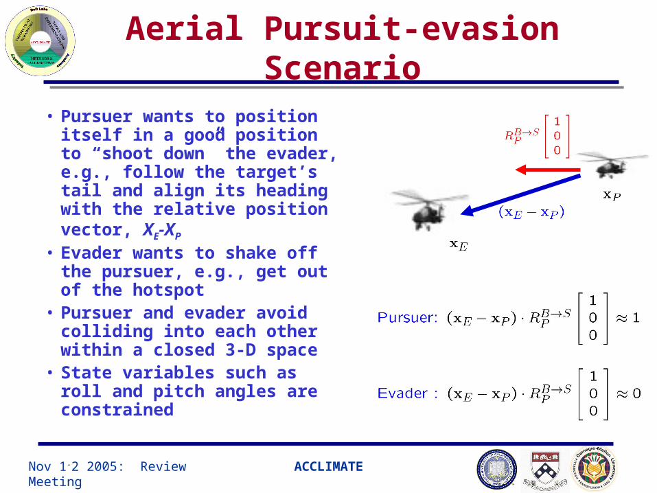
Aerial Pursuit-evasion Scenario
• Pursuer wants to position itself in a good position to “shoot down” the evader, e.g., follow the target’s tail and align its heading with the relative position vector, XE-XP
• Evader wants to shake off the pursuer, e.g., get out of the hotspot
• Pursuer and evader avoid colliding into each other within a closed 3-D space
• State variables such as roll and pitch angles are constrained
Nov 1-2 2005: Review Meeting ACCLIMATE
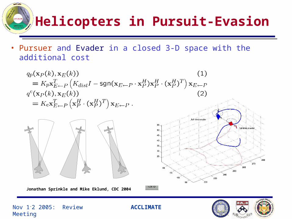
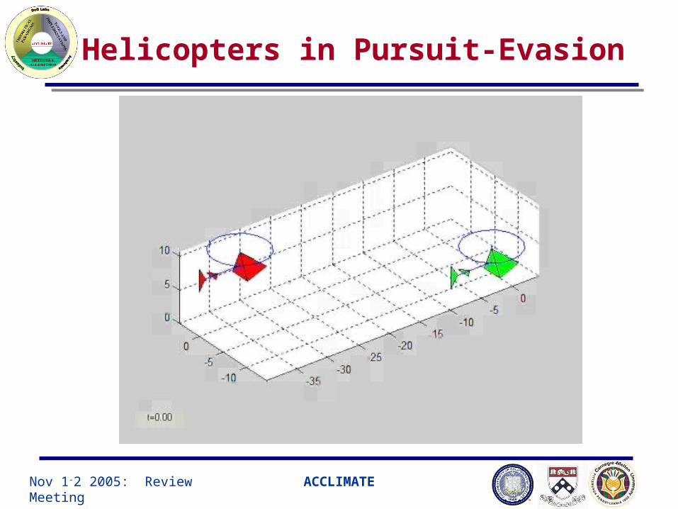
Helicopters in Pursuit-Evasion
• Pursuer and Evader in a closed 3-D space with the additional cost
Jonathan Sprinkle and Mike Eklund, CDC 2004
Nov 1-2 2005: Review Meeting ACCLIMATE
Helicopters in Pursuit-Evasion
Nov 1-2 2005: Review Meeting ACCLIMATE
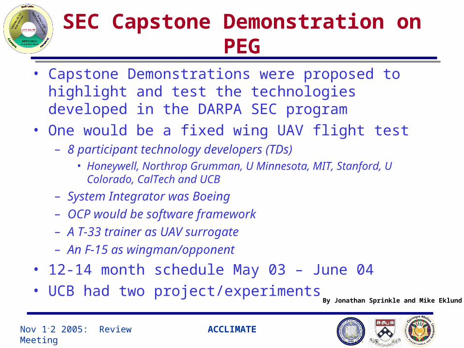
SEC Capstone Demonstration on PEG
• Capstone Demonstrations were proposed to highlight and test the technologies developed in the DARPA SEC program
• One would be a fixed wing UAV flight test– 8 participant technology developers (TDs)
• Honeywell, Northrop Grumman, U Minnesota, MIT, Stanford, U Colorado, CalTech and UCB
– System Integrator was Boeing– OCP would be software framework– A T-33 trainer as UAV surrogate– An F-15 as wingman/opponent
• 12-14 month schedule May 03 – June 04• UCB had two project/experiments By Jonathan Sprinkle and Mike Eklund

Nov 1-2 2005: Review Meeting ACCLIMATE
Flight Test: Range Area R-2515
Ingress
Endpoint
36 nmi
26 nmi
By Jonathan Sprinkle and Mike Eklund
Nov 1-2 2005: Review Meeting ACCLIMATE
Flight Test: Range Area R-2515
By Jonathan Sprinkle and Mike Eklund

Nov 1-2 2005: Review Meeting ACCLIMATE
Additional Slides

Nov 1-2 2005: Review Meeting ACCLIMATE
Vision-based landing: motivation
• Challenges• Hostile operating environments
– high winds, pitching flight deck, ground effect
• UAV undergoing changing nonlinear dynamics
Why the vision sensor?• Passive sensor (for stealth)• Gives relative UAV motion to
flight deck
Goal: Autonomous UAV landing on a ship’s flight deck
U.S. Navy photo

Nov 1-2 2005: Review Meeting ACCLIMATE
Ship deck landing problem (ONR 2002)

Nov 1-2 2005: Review Meeting ACCLIMATE
Formation Flight: Mesh Controller
• Mesh Controller tasks:– Obtain the leader and 2 neighboring helicopters’ current positions
– Compute mesh stable trajectories based on the acquired position information and send commands to the navigation computer
FlightComputer
MeshController
RS-232Wireless
Token Ring
Neighbor 1
Neighbor 2
Leader
On UAV
Nov 1-2 2005: Review Meeting ACCLIMATE
Experiment: Mesh Controller (2002)