NorthWestern - Neagh Bann CFRAM Study · CFRAM Catchment Flood Risk Assessment and Management FRMP...
152
North Western - Neagh Bann CFRAM Study Strategic Environmental Assessment - Scoping Report IBE0700Rp0014 rpsgroup.com/ireland
Transcript of NorthWestern - Neagh Bann CFRAM Study · CFRAM Catchment Flood Risk Assessment and Management FRMP...

North Western - Neagh Bann CFRAM StudyStrategic Environmental Assessment - Scoping Report
IBE0700Rp0014
rpsgroup.com/ireland

rpsgroup.com/ireland
Photographs of flooding on cover provided by Rivers Agency

rpsgroup.com/ireland
DOCUMENT CONTROL SHEET
Client OPW
Project Title North Western - Neagh Bann CFRAM Study
Document Title IBE0700Rp0014_NW_SEA_Scoping_Report_D01
Document No. IBE0700Rp0014
This Document Comprises
DCS TOC Text List of Tables List of Figures No. of Appendices
1 1 40 1 1 5
Rev. Status Author(s) Reviewed By Approved By Office of Origin Issue Date
D01 Draft R. Bingham K. Smart S. Mathews
A. Gaughran G. Glasgow Belfast 14/09/2015
North Western - Neagh Bann
CFRAM Study
Strategic Environmental Assessment
Scoping Report

rpsgroup.com/ireland
Copyright
Copyright - Office of Public Works. All rights reserved. No part of this report may be copied or
reproduced by any means without prior written permission from the Office of Public Works.
Legal Disclaimer
This report is subject to the limitations and warranties contained in the contract between the
commissioning party (Office of Public Works) and RPS Group Ireland

NWNB CFRAM Study SEA Scoping Report - DRAFT
IBE0700Rp00014 i Rev D01
TABLE OF CONTENTS
1 INTRODUCTION ........................................................................................................................ 1
1.1 BACKGROUND ................................................................................................................. 1
1.2 STRATEGIC ENVIRONMENTAL ASSESSMENT ...................................................................... 2
1.3 SCREENING FOR SEA ...................................................................................................... 3
1.4 SCOPING FOR SEA .......................................................................................................... 4
1.5 SEA GUIDANCE ............................................................................................................... 4
1.6 STATUTORY CONSULTEES FOR SEA ................................................................................. 4
1.7 APPROPRIATE ASSESSMENT............................................................................................. 5
2 FLOOD RISK IN IRELAND ........................................................................................................ 7
2.1 THE FLOODS DIRECTIVE................................................................................................... 7
2.2 FLOODS DIRECTIVE APPLICATION IN IRELAND .................................................................... 7
2.3 THE NWNB CFRAM STUDY .............................................................................................. 8
2.4 OVERVIEW OF POLICY CONTEXT ..................................................................................... 11
3 SCOPING FOR THE NWNB CFRAM STUDY......................................................................... 14
3.1 SCOPE OF THE PLAN ...................................................................................................... 14
3.2 GEOGRAPHIC SCOPE ..................................................................................................... 15
3.3 TEMPORAL SCOPE ......................................................................................................... 17
3.4 SCOPING OF STRATEGIC ENVIRONMENTAL ASSESSMENT TOPICS ..................................... 17
4 BASELINE AND ENVIRONMENTAL PROBLEMS ................................................................ 22
4.1 OVERVIEW OF CURRENT STATE OF THE ENVIRONMENT ................................................... 22
5 FRAMEWORK FOR ASSESSING ENVIRONMENTAL EFFECTS......................................... 26
5.1 SEA APPROACH ............................................................................................................ 26
5.2 LONG LIST OF METHODS FOR ASSESSMENT .................................................................... 26
5.3 DRAFT SEA OBJECTIVES ............................................................................................... 28
5.4 ASSESSMENT OUTPUTS ................................................................................................. 31
5.4.1 Mitigation ........................................................................................................ 37
5.4.2 Monitoring ....................................................................................................... 37
6 CONSULTATION AND NEXT STEPS ..................................................................................... 38
6.1 CONSULTATION.............................................................................................................. 38
6.2 NEXT STEPS .................................................................................................................. 39

NWNB CFRAM Study SEA Scoping Report - DRAFT
IBE0700Rp00014 ii Rev D01
LIST OF FIGURES
Figure 1.1 Overview of SEA Process .............................................................................................. 3
Figure 1.2 Inter-relationships between the FRMP, SEA and AA Processes .................................... 6
Figure 2.1 NWNB CFRAM study area, UoMs and AFAs ................................................................ 11
Figure 3.1 Spatial Scales of NWNB CFRAM Study, FRMPs and SEAs ....................................... 16
Figure 5.1 Interactions of the Plan and Environmental Assessments ........................................... 33
Figure 5.2 Example Output of Environmental Assessment ........................................................... 34
LIST OF TABLES
Table 1.1 Summary Description of Main Steps in SEA Process ......................................................... 2
Table 2.1 Summary of Key Plans, Programmes and Legislation Relevant to the FRMPs ............... 12
Table 3.1 Proposed Elements of the Plan to be Assessed ............................................................... 14
Table 3.2 AFAs in the NWNB CFRAM Study .................................................................................... 16
Table 3.3 Scoping of SEA Issues ...................................................................................................... 18
Table 3.4: Potential Inter-Relationships between SEA Topics ....................................................... 21
Table 4.1: Summary of Proposed Environmental Baseline Data and Sources .............................. 22
Table 5.1: Flood Risk Management Methods ................................................................................. 26
Table 5.2: Draft SEA Objectives ..................................................................................................... 29
Table 5.3: Additional Draft SEA Objectives .................................................................................... 30
Table 5.4: Description of MCA / SEA Environmental Impact Scores ............................................. 32
Table 6.1: Draft Anticipated Milestones .......................................................................................... 39
Table 6.2: Proposed Timescale for SEA of the NWNB FRMPs ..................................................... 39

NWNB CFRAM Study SEA Scoping Report - DRAFT
IBE0700Rp00014 iii Rev D01
APPENDICES
APPENDIX A OPW SEA Screening 22 Pages
APPENDIX B SEA Guidance 2 Pages
APPENDIX C Plans and Programmes 32 Pages
APPENDIX D Social and Environmental MCA Scorings and Weightings 34 Pages
APPENDIX E NWNB CFRAM Study Stakeholder List 10 Pages

NWNB CFRAM Study SEA Scoping Report - DRAFT
IBE0700Rp00014 iv Rev D01
ACRONYMS
AA Appropriate Assessment
AFA Area for Further Assessment
CAFE Clean Air for Europe [Directive]
CFRAM Catchment Flood Risk Assessment and Management
FRMP Flood Risk Management Plan
DAFM Department of Agriculture, Food and the Marine
DAHG Department of Arts, Heritage and the Gaeltacht
DARD Department of Agriculture and Rural Development (NI)
DCENR Department of Communications, Energy and Natural Resources
DECLG Department of Environment, Community and Local Government
ERBD Eastern River Basin District
EPA Environmental Protection Agency
FEMFRAM Fingal East Meath Flood Risk Assessment and Management Study
FPM Freshwater Pearl Mussel
FRA Flood Risk Assessment
FRMP Flood Risk Management Plan
GSI Geological Survey of Ireland
GSNI Geological Survey of Northern Ireland
HA Hydrometric Area
HPW High Priority Watercourse
IFI Inland Fisheries Ireland
LA Local Authority
LAP Local Area Plan
MCA Multi-Criteria Analysis
MIDA Marine Irish Digital Atlas
MPA Marine Protected Area
MPW Medium Priority Watercourse
NBIRBD Neagh Bann International River Basin District
NIEA Northern Ireland Environment Agency
NISRA Northern Ireland Statistics and Research Agency
NWIRBD North Western International River Basin District
OD Ordnance Datum
OPW Office of Public Works
OSi Ordnance Survey Ireland
OSPAR (Oslo Paris) Convention on the protection of North-East Atlantic marine environment
PFRA Preliminary Flood Risk Assessment

NWNB CFRAM Study SEA Scoping Report - DRAFT
IBE0700Rp00014 v Rev D01
RBD River Basin District
SEA Strategic Environmental Assessment
SERBD South Eastern River Basin District
SMR Sites and Monuments Record (NI)
SWRBD South Western River Basin District
SuDS Sustainable Drainage Systems
UNESCO United Nations Educational, Scientific and Cultural Organisation
UoM Unit of Management
WHO World Health Organisation
WRBD Western River Basin District

NWNB CFRAM Study SEA Scoping Report - DRAFT
IBE0700Rp00014 1 Rev D01
1 INTRODUCTION
1.1 BACKGROUND
This Strategic Environmental Assessment (SEA) Scoping Report has been prepared in accordance
with the European Communities (Environmental Assessment of Certain Plans and Programmes)
Regulations 2004 [S.I. 435/2004] and the Planning and Development (Strategic Environmental
Assessment) Regulations 2004 [S.I. 436/2004], and their recent amendments of European
Communities (Environmental Assessment of Certain Plans and Programmes) (Amendment)
Regulations 2011 [S.I. 200/2011] and the Planning and Development (Strategic Environmental
Assessment) (Amendment) Regulations 2011 [S.I. 201/2011].
The purpose of this Scoping Report is to provide sufficient information on the North Western - Neagh
Bann (NWNB) Catchment-based Flood Risk and Management (CFRAM) Study to enable the
consultees to form an opinion on the appropriateness of the scope, format, level of detail, methodology
for assessment and the consultation period proposed for the Environmental Reports.
The CFRAM studies and the SEA of the Flood Risk Management Plans (FRMPs) are being completed
on behalf of the Office of Public Works (OPW).
The views and opinions of the consultees are sought on the following questions:
1) Is there any information missing from the key plans and programmes listed, relevant to the
CFRAM studies, that you think should be included, and why?
2) Do you agree with the geographical and temporal scope of the assessment?
3) Do you agree with the scoping of the environmental assessment topics?
4) Have we identified the key environmental issues relevant to the CFRAM studies?
5) Are we proposing the most appropriate data and scale of data to be used?
6) Can you propose any other data to be used in the SEA and why it would be beneficial?
7) Do you agree with the approach to the assessment?
8) Do you agree with the draft SEA objectives?
9) Do you agree with the proposed project timescales and proposed consultees in the SEA
process?

NWNB CFRAM Study SEA Scoping Report - DRAFT
IBE0700Rp00014 2 Rev D01
1.2 STRATEGIC ENVIRONMENTAL ASSESSMENT
The SEA Directive requires that certain Plans and Programmes, prepared by statutory bodies, which
are likely to have a significant impact on the environment, be subject to the SEA process. The SEA
process is broadly comprised of the steps shown in Figure 1.1, which are given a summary
description in Table 1.1.
Table 1.1 Summary Description of Main Steps in SEA Process
Step Description Status
Screening Determines whether SEA is required for a Plan / Programme, in consultation with the designated statutory consultees.
Completed (see Appendix A)
Scoping Determines the scope and level of detail of the assessment for the SEA, in consultation with the designated statutory consultees.
Ongoing
Environmental Assessment
Formal and transparent assessment of the likely significant impacts on the environment as a result of implementing the Plan / Programme, including all reasonable alternatives. The output from this is an Environmental Report which must go on public display along with the draft Plan.
Anticipated Q3 2015
SEA Statement
Summarises the process undertaken and identifies how environmental considerations and consultations have been integrated into the final Plan / Programme.
Anticipated Q4 2016

NWNB CFRAM Study SEA Scoping Report - DRAFT
IBE0700Rp00014 3 Rev D01
Figure 1.1 Overview of SEA Process
1.3 SCREENING FOR SEA
The OPW carried out a Strategic Environmental Assessment Screening in 2011 for all the CFRAM
studies in Ireland and determined that SEA of the FRMPs would be required due to the following
reasons:
• The FRMPs will be carried out for areas typically greater than 1,000 km2 and
collectively they will cover the entire landmass of the Republic of Ireland. The
SCREENING
ADOPTION OF THE PLAN
AND ISSUANCE OF SEA
STATEMENT
PUBLIC CONSULTATION ON
ENVIRONMENTAL REPORT &
DRAFT PLAN
Current Stage in the
Process
SCOPING
(Including Statutory Consultation)
ENVIRONMENTAL ASSESSMENT
ISSUANCE OF ENVIRONMENTAL
REPORT & DRAFT PLAN
SCREENING OF PROPOSED
AMENDMENTS TO PLAN

NWNB CFRAM Study SEA Scoping Report - DRAFT
IBE0700Rp00014 4 Rev D01
outcomes of the FRMPs therefore have the potential to have a significant effect on the
Environment. Carrying out SEAs will allow for the early consideration of environmental
issues and the incorporation of these issues into the formulation of the
recommendations for flood risk management within the FRMPs.
• The FRMPs will form a framework for future projects and allocation of resources
concerning reduction of flooding risk.
• The FRMPs will influence spatial plans at both regional and local level.
• The FRMPs are likely to require an assessment under Article 6 of the EU Habitats
Directive.
A copy of the SEA Screening Report that was produced in September 2011 can be found in Appendix
A of this report.
1.4 SCOPING FOR SEA
This Environmental Scoping Report is presented as part of the scoping phase of the SEAs for the
NWNB FRMPs. The purpose of this Scoping Report is to provide sufficient information on the NWNB
CFRAM study to enable the consultees to form an opinion on the appropriateness of the scope,
format, level of detail, methodology for assessment and the consultation period proposed for the
Environmental Reports.
1.5 SEA GUIDANCE
Key guidance documents that are to be used in the SEAs for the NWNB FRMPs are listed in
Appendix B of this SEA Scoping document.
1.6 STATUTORY CONSULTEES FOR SEA
Under Article 6 of the SEA Directive, the competent authority preparing the Plan or Programme (in this
case the OPW) is required to consult with specific environmental authorities (statutory consultees) on
the scope and level of detail of the information to be included in the Environmental Report. Under S.I.
200 of 2011 these five statutory consultees are established within the national legislation as being:
• Environmental Protection Agency (EPA);
• Department of Environment, Community and Local Government (DECLG);
• Department of Agriculture, Food and the Marine (DAFM);
• Department of Communications, Energy and Natural Resources (DCENR); and
• Department of Arts, Heritage and the Gaeltacht (DAHG).
Given the transboundary location of the NWNB CFRAM study with Northern Ireland, there is the
potential for transboundary impacts from implementation of the FRMPs and therefore there is a

NWNB CFRAM Study SEA Scoping Report - DRAFT
IBE0700Rp00014 5 Rev D01
requirement to undertake transboundary consultations as part of this SEA process. The statutory
consultee established within the SEA legislation for Northern Ireland is the Northern Ireland
Environment Agency (NIEA) (formerly Environment and Heritage Service).
1.7 APPROPRIATE ASSESSMENT
The Habitats Directive (Council Directive 92/43/EEC) on the conservation of natural habitats and of
wild fauna and flora obliges member states to designate, protect and conserve habitats and species of
importance in a European Union context. Article 6(3) of the Habitats Directive requires that “Any plan
or project not directly connected with or necessary to the conservation of a site but likely to have a
significant effect thereon, either individually or in combination with other plans or projects, shall be
subject to appropriate assessment of its implications for the site in view of the site’s conservation
objectives.” This Directive was initially transposed into Irish Law through several pieces of legislation;
however these have now been consolidated into the European Communities (Birds and Natural
Habitats) Regulations 2011. Any proposed plan or project in Ireland that has potential to result in a
significant effect on a designated European Site will require an Appropriate Assessment (AA). Case
law has determined that the likelihood need not be great, merely possible, and that the precautionary
principle must apply as set out in European Commission Guidance and as required by CJEU case law
(i.e. C 127/02 ‘Waddenzee’).
Appropriate Assessments for the NWNB FRMPs are being carried out in parallel with the SEA
process. The findings of these AAs will be used to guide the development of the alternatives to be
considered as part of the SEA. The first stage of the AA process is Screening, which is to determine
whether implementation of the NWNB FRMPs has the potential to have a significant effect on
designated European Sites. Figure 1.2 demonstrates inter-relationships between the FRMPs, SEA
and Appropriate Assessment.

NWNB CFRAM Study SEA Scoping Report - DRAFT
IBE0700Rp00014 6 Rev D01
Data Collection
Strategic Environmental Assessment
Appropriate AssessmentCFRAM Plan Process
Flood Risk Review
Surveys (Hydrology/Hydraulics/Assets)
Hydrological Analysis
Hydraulic Analysis
Flood Risk Assessment
Options Development to Manage Risk
FinalFlood Risk Management Plans
DraftFlood Risk Management Plans
Draft Plan Consultation
Draft Options Consultation
Draft Mapping Consultation
SEA Environmental Report
Environmental Assessment of Alternatives
SEA Scoping
SEA Environmental Statement
SEA Scoping Consultation
SEA Consultation
Natura Impact Statement (NIS)
Appropriate Assessment
SEA Screening
Appropriate Assessment Screening
Baseline Flood and Receptor Data
Final NIS - Conclusion of Appropriate Assessment
Figure 1.2 Inter-relationships between the FRMP, SEA and AA Processes

NWNB CFRAM Study SEA Scoping Report - DRAFT
IBE0700Rp00014 7 Rev D01
2 FLOOD RISK IN IRELAND
2.1 THE FLOODS DIRECTIVE
The EU Directive on the assessment and management of flood risks [2007/60/EC], often referred to as
the Floods Directive, came into force in late 2007. It is a framework directive that requires Member
States to follow a certain process, namely:
• Undertake a Preliminary Flood Risk Assessment (PFRA) by 22 December 2011, to
identify areas of existing or foreseeable future potentially significant flood risk
(originally referred to as ‘Areas of Potential Significant Risk’, or ‘APSRs’, but now
referred to as ‘Areas for Further Assessment’, or ‘AFAs’);
• Prepare flood hazard and risk maps for the AFAs by 22 December 2013; and,
• Prepare flood risk management plans by 22 December 2015, setting objectives for
managing the flood risk within the AFAs and setting out a prioritised set of measures
for achieving those objectives.
The Directive requires that the PFRA, flood maps and flood risk management plans are prepared in
cooperation and coordination with neighbouring states in cross-border river basins, and with the
implementation of the Water Framework Directive (WFD). The Directive also requires that the PFRA
and flood maps are published, and that public and stakeholder consultation and engagement is
undertaken in the preparation of the flood risk management plans.
2.2 FLOODS DIRECTIVE APPLICATION IN IRELAND
The Floods Directive is being implemented in Ireland through the European Communities
(Assessment and Management of Flood Risks) Regulations 2010 [S.I.122/2010], which appoints the
OPW as the Competent Authority for the Plans. The Statutory Instrument also identifies roles for other
organisations; such as the Local Authorities, Waterways Ireland and ESB, to undertake certain duties
with respect to flood risk within their existing areas of responsibility.
In Ireland, the approach to implementing the Directive has focused on a National Flood Risk
Assessment and Management programme. This was developed to meet the requirements of the
Floods Directive, as well as to deliver on core components of the 2004 National Flood Policy. Pilot
CFRAM studies have been undertaken since 2006 in the Dodder and Tolka catchments, the Lee
Catchment, the Suir Catchment and in the Fingal / East Meath area.
CFRAM studies were subsequently commissioned at the scale of the River Basin Districts (RBDs)
delineated for the first cycle of the implementation of the Water Framework Directive (WFD). The
following eight River Basin Districts have been defined for the island of Ireland:

NWNB CFRAM Study SEA Scoping Report - DRAFT
IBE0700Rp00014 8 Rev D01
• North Western International
RBD (IRBD);
• Neagh-Bann IRBD;
• North Eastern RBD;
• Western RBD;
• Eastern RBD;
• Shannon IRBD;
• South Eastern RBD; and
• South Western RBD.
2.3 THE NWNB CFRAM STUDY
CFRAM studies and their product – FRMPs – are at the core of the national policy for flood risk
management and the strategy for its implementation. The methodology featured in each CFRAM study
includes the collection of survey data and the assembly and analysis of meteorological, hydrological
and tidal data, which are used to develop a suite of hydraulic computer models. Flood maps are one of
the main outputs of the study and are the way in which the model results are communicated to end
users. The studies will assess a range of potential options to manage the flood risk and determine
which, if any, is preferred for each area and will be recommended for implementation within the Flood
Risk Management Plans. The CFRAM studies will focus on areas where the risk is understood to be
most significant.
Each Study will provide for number of key stages:
• Data Collection & Surveying;
• Flood Risk Review;
• Hydrology Analysis;
• Detailed Hydraulic Modelling;
• Flooding Mapping;
• Development of Flood Risk Management (FRM) options;
• Strategic Environmental Assessment & Appropriate Assessment;
• Flood Risk Management Plan.
The objectives of CFRAM studies are to:
• Identify and map the existing and potential future1 flood hazard within the Study Area;
• Assess and map the existing and potential future flood risk2 within the Study Area;
1 Potential future flood hazards and risk include those that might foreseeably arise (over the long-term) due to the projected effects of climate change, future development and other long-term developments.
2 Flood risk is defined as a combination of probability and degree of flooding and the adverse consequences of flooding on human health, people and society, the environment, cultural heritage and economic activity and infrastructure.

NWNB CFRAM Study SEA Scoping Report - DRAFT
IBE0700Rp00014 9 Rev D01
• Identify viable structural and non-structural options and measures for the effective and
sustainable management of flood risk in the Areas for Further Assessment (AFA) and
within the Study Area as a whole, and
• Prepare a set of FRMPs for the Study Area, and undertake associated Strategic
Environmental and, as necessary, Appropriate Assessment, that sets out the policies,
strategies, measures and actions that should be pursued by the relevant bodies,
including the OPW, Local Authorities and other Stakeholders, to achieve the most
cost-effective and sustainable management of existing and potential future flood risk
within the Study Area, taking account of environmental plans, objectives and
legislative requirements and other statutory plans and requirements.
It is not an objective of the Project to develop detailed designs for individual risk management
measures.
The NWNB CFRAM study commenced in April 2012 and will run until the end of 2016. The study
comprises the North Western and the Neagh Bann International River Basin Districts. The North
Western district is a cross-border river basin district with approximately 7,400 km2 in Ireland and 4,900
km2 in Northern Ireland. It takes in all of County Donegal, large parts of Fermanagh, Cavan, Derry,
Monaghan and Tyrone, significant areas of Leitrim and Longford and a small portion of Sligo. The
district is home to less than half a million people and has a low average population density. Less than
2% of the land area is urbanised and many people live in small villages or single dwellings in rural
areas. Most or the main urban areas are located at rivers, including Ballybofey, Buncrana, Cavan
town, Donegal town, Letterkenny and Lifford. The fertile soils of the Foyle and Erne basins support
beef, dairy, sheep and pig farming as well as crop cultivation. Further west the landscape is
mountainous, with many coniferous forest plantations and some sheep and cattle grazing. The
spectacular coastline, the surfing beaches and the remote beauty spots attract many tourists.
The Neagh Bann district is also a cross-border river basin district with approximately 2,000 km2 in
Ireland and 6,000 km2 in Northern Ireland. It takes in all of County Armagh, large parts of Antrim,
Lough, Monaghan and Derry, significant areas of Down, Meath and Tyrone and small areas of Cavan
and Fermanagh. The district is home to over half a million people. Most of the main urban areas are
located alongside rivers including Ardee, Dundalk, Carrickmacross, Castleblaney, Dungannon,
Monaghan and Newry. In rural areas many people live in small villages or single dwellings. Agriculture,
mainly livestock grazing on pasture land, is the main activity in the district.
The Local Authorities within the NWNB CFRAM study area are:
• Cavan County Council;
• Donegal Council;
• Leitrim County Council;
• Longford County Council;
• Louth County Council;
• Meath County Council;
• Monaghan County Council;
• Sligo County Council.

NWNB CFRAM Study SEA Scoping Report - DRAFT
IBE0700Rp00014 10 Rev D01
The NWNB CFRAM study area includes three Units of Management (UoM). The UoMs constitute
major catchments / river basins (typically greater than 1,000 km2) and their associated coastal areas,
or conglomerations of smaller river basins and their associated coastal areas. The North Western
IRBD includes two UoMs in Ireland, UoM 01 (Donegal) and UoM 36 (Erne). The Neagh Bann IRBD
covers represents one single UoM in Ireland, UoM 06 (Neagh Bann). The UoMs and the AFAs in the
NWNB CFRAM study area are shown in Figure 2.1.
UoM 01 includes hydrometric areas 01, 37, 38, 39 and 40. It covers an area of 4,610 km2 and
includes the majority of County Donegal. The principal river system in UoM 01 is the River Foyle
(which flows northwards from the confluence of the rivers Finn and Mourne at Lifford and Strabane
towns). The Foyle forms the international border between the Republic of Ireland and Northern Ireland,
draining the Mourne, Finn and Deele tributaries, discharging into Lough Foyle. The Foyle River is tidal
along its entire length (to Lifford) and a tidal influence has been noted in the lower reaches of the Finn
as far up as Castlefinn. In addition to the Foyle River system, there are numerous rivers and streams
discharging to the estuaries and coastal waters all around the Donegal coastline including the
Leannan, Owenea and Owencarrow rivers. Within UoM 01 there are 25 AFAs. Most of these areas
are situated along the coastline and so most experience coastal flooding. Inland AFAs experience
fluvial flooding. However, some of the coastal AFAs experience both coastal and fluvial flooding.
UoM 36 includes hydrometric areas 35 and 36. It covers an area of 2,742 km2 and includes the
majority of County Cavan as well as areas of counties Leitrim, Monaghan, Longford, Donegal and
Sligo. The principal river in UoM 36 is the Erne (which drains part of County Cavan before crossing
the border into Northern Ireland near Belturbet). In addition to the Erne River system, there are
numerous smaller rivers and streams including the Annalee, Woodford and Finn rivers. Lakes in UoM
36 include Lough Oughter, Lough Melvin and Lough Gowna as well as numerous other smaller lakes.
Within UoM 36 there are five AFAs.
UoM 06 includes hydrometric areas 03 and 06. It covers an area of 1,779 km2 and includes the
majority of County Louth, much of County Monaghan and parts of Meath and Cavan. The principal
rivers in UoM 06 are the Fane, Glyde and Dee rivers (which flow eastwards into the Irish Sea) and the
Blackwater River (which flows over the border into Northern Ireland in the northern reaches of the
UoM). Within UoM 06 there are nine AFAs.

NWNB CFRAM Study SEA Scoping Report - DRAFT
IBE0700Rp00014 11 Rev D01
Figure 2.1 NWNB CFRAM study area, UoMs and AFAs
2.4 OVERVIEW OF POLICY CONTEXT
As part of the SEA process the context of the NWNB CFRAM study must be established with regard to
other plans and programmes that have been adopted at International, European and National levels.
In particular the interaction of the environmental protection objectives and standards included within
these plans and programmes with the NWNB FRMPs requires consideration.
Table 2.1 identifies the main significant environmental plans, programmes and legislation, adopted at
International, European Community or Member State level, which would be expected to influence, or
be influenced by, the NW FRMPs. While it is recognised that there are many plans, programmes and
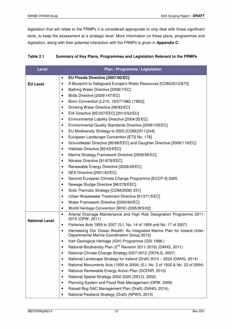
NWNB CFRAM Study SEA Scoping Report - DRAFT
IBE0700Rp00014 12 Rev D01
legislation that will relate to the FRMPs it is considered appropriate to only deal with those significant
texts, to keep the assessment at a strategic level. More information on these plans, programmes and
legislation, along with their potential interaction with the FRMPs is given in Appendix C.
Table 2.1 Summary of Key Plans, Programmes and Legislation Relevant to the FRMPs
Level Plan / Programme / Legislation
EU Level
• EU Floods Directive [2007/60/EC]
• A Blueprint to Safeguard Europe’s Water Resources [COM(2012)673]
• Bathing Water Directive [2006/7/EC]
• Birds Directive [2009/147/EC]
• Bonn Convention [L210, 19/07/1982 (1983)]
• Drinking Water Directive [98/83/EC]
• EIA Directive [85/337/EEC] [2014/52/EU]
• Environmental Liability Directive [2004/35/EC]
• Environmental Quality Standards Directive [2008/105/EC]
• EU Biodiversity Strategy to 2020 [COM(2011)244]
• European Landscape Convention [ETS No. 176]
• Groundwater Directive [80/68/EEC] and Daughter Directive [2006/118/EC]
• Habitats Directive [92/43/EEC]
• Marine Strategy Framework Directive [2008/56/EC]
• Nitrates Directive [91/676/EEC]
• Renewable Energy Directive [2009/28/EC]
• SEA Directive [2001/42/EC]
• Second European Climate Change Programme [ECCP II] 2005.
• Sewage Sludge Directive [86/278/EEC]
• Soils Thematic Strategy [COM(2006) 231]
• Urban Wastewater Treatment Directive [91/271/EEC]
• Water Framework Directive [2000/60/EC]
• World Heritage Convention [WHC-2005/WS/02]
National Level
• Arterial Drainage Maintenance and High Risk Designation Programme 2011-2015 (OPW, 2011)
• Fisheries Acts 1959 to 2007 (S.I. No. 14 of 1959 and No. 17 of 2007)
• Harnessing Our Ocean Wealth: An Integrated Marine Plan for Ireland (Inter-Departmental Marine Coordination Group 2012)
• Irish Geological Heritage (IGH) Programme (GSI 1998-)
• National Biodiversity Plan (2nd Revision 2011-2016) (DAHG, 2011)
• National Climate Change Strategy 2007-2012 (DEHLG, 2007)
• National Landscape Strategy for Ireland (Draft) 2014 – 2024 (DAHG, 2014)
• National Monuments Acts (1930 to 2004) (S.I. No. 2 of 1930 & No. 22 of 2004)
• National Renewable Energy Action Plan (DCENR, 2010)
• National Spatial Strategy 2002-2020 (DELG, 2002)
• Planning System and Flood Risk Management (OPW, 2009)
• Raised Bog SAC Management Plan (Draft) (DAHG, 2014),
• National Peatland Strategy (Draft) (NPWS, 2014)

NWNB CFRAM Study SEA Scoping Report - DRAFT
IBE0700Rp00014 13 Rev D01
• Review of Raised Bog Natural Heritage Area Network (NPWS, 2014)
• Report of the Flood Policy Review Group (OPW, 2004)
Regional Level
• Flood Risk Management Plans
• River Basin Management Plans
• Regional Planning Guidelines
• Regional Development Strategies/Plans
• Groundwater Protection Schemes
Sub-Regional
• County and Town Development Plans
• County Landscape Character Assessments
• County Renewable Energy Strategies
• Economic development plans for rural and urban areas
• Freshwater Pearl Mussel Sub-Basin Management Plans
• Greater Dublin Strategic Drainage Strategy
• Heritage Plans
• Housing Strategies
• Local Area Plans
• Local Biodiversity Action Plans
• Local Catchment Flood Risk Management Plans
• Planning Schemes for Strategic Development Zones (SDZ)
• Shellfish Pollution Reduction Programmes
• Sludge Management Plans
• Special Amenity Area Orders
• Water Quality Management Plans
Proposed Scoping Questions:
Is there any information missing from the key plans and programmes listed in Table 2.1 or Appendix
C, relevant to the CFRAM studies, that you think should be included, and why?
NWNB CFRAM Study SEA Scoping Report - DRAFT
IBE0700Rp00014 14 Rev D01
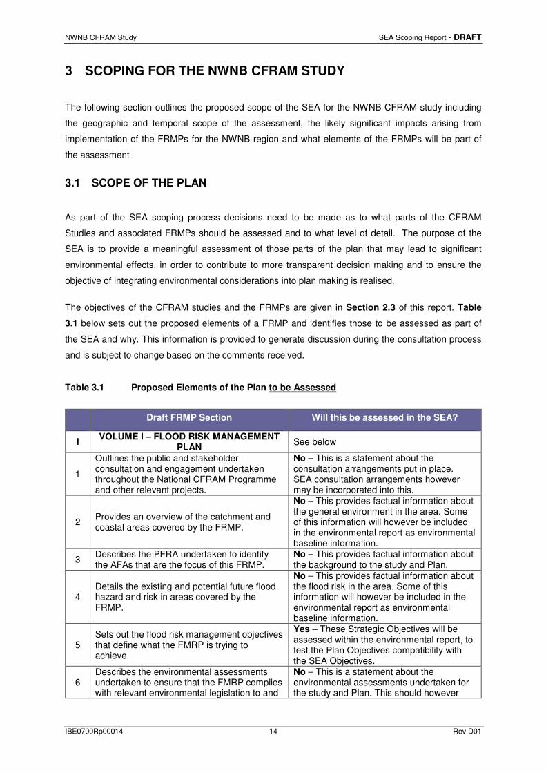
3 SCOPING FOR THE NWNB CFRAM STUDY
The following section outlines the proposed scope of the SEA for the NWNB CFRAM study including
the geographic and temporal scope of the assessment, the likely significant impacts arising from
implementation of the FRMPs for the NWNB region and what elements of the FRMPs will be part of
the assessment
3.1 SCOPE OF THE PLAN
As part of the SEA scoping process decisions need to be made as to what parts of the CFRAM
Studies and associated FRMPs should be assessed and to what level of detail. The purpose of the
SEA is to provide a meaningful assessment of those parts of the plan that may lead to significant
environmental effects, in order to contribute to more transparent decision making and to ensure the
objective of integrating environmental considerations into plan making is realised.
The objectives of the CFRAM studies and the FRMPs are given in Section 2.3 of this report. Table
3.1 below sets out the proposed elements of a FRMP and identifies those to be assessed as part of
the SEA and why. This information is provided to generate discussion during the consultation process
and is subject to change based on the comments received.
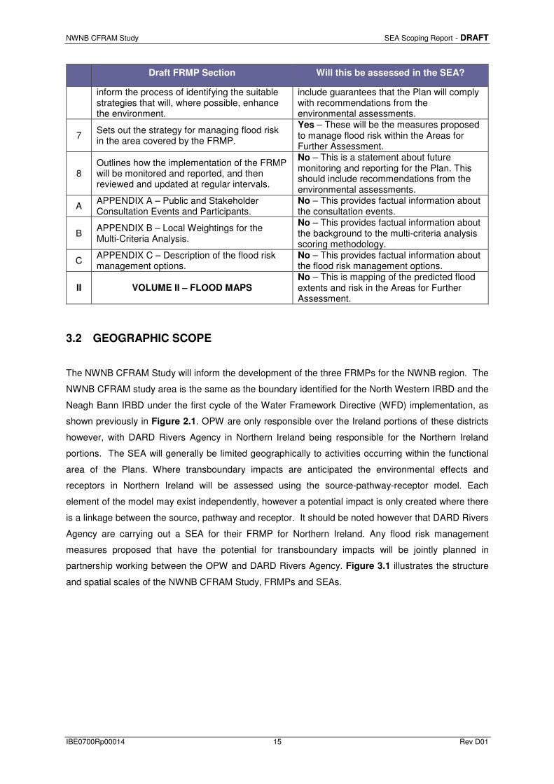
Table 3.1 Proposed Elements of the Plan to be Assessed
Draft FRMP Section Will this be assessed in the SEA?
I VOLUME I – FLOOD RISK MANAGEMENT
PLAN See below
1
Outlines the public and stakeholder consultation and engagement undertaken throughout the National CFRAM Programme and other relevant projects.
No – This is a statement about the consultation arrangements put in place. SEA consultation arrangements however may be incorporated into this.
2 Provides an overview of the catchment and coastal areas covered by the FRMP.
No – This provides factual information about the general environment in the area. Some of this information will however be included in the environmental report as environmental baseline information.
3 Describes the PFRA undertaken to identify the AFAs that are the focus of this FRMP.
No – This provides factual information about the background to the study and Plan.
4 Details the existing and potential future flood hazard and risk in areas covered by the FRMP.
No – This provides factual information about the flood risk in the area. Some of this information will however be included in the environmental report as environmental baseline information.
5 Sets out the flood risk management objectives that define what the FMRP is trying to achieve.
Yes – These Strategic Objectives will be assessed within the environmental report, to test the Plan Objectives compatibility with the SEA Objectives.
6 Describes the environmental assessments undertaken to ensure that the FMRP complies with relevant environmental legislation to and
No – This is a statement about the environmental assessments undertaken for the study and Plan. This should however
NWNB CFRAM Study SEA Scoping Report - DRAFT
IBE0700Rp00014 15 Rev D01
Draft FRMP Section Will this be assessed in the SEA?
inform the process of identifying the suitable strategies that will, where possible, enhance the environment.
include guarantees that the Plan will comply with recommendations from the environmental assessments.
7 Sets out the strategy for managing flood risk in the area covered by the FRMP.
Yes – These will be the measures proposed to manage flood risk within the Areas for Further Assessment.
8 Outlines how the implementation of the FRMP will be monitored and reported, and then reviewed and updated at regular intervals.
No – This is a statement about future monitoring and reporting for the Plan. This should include recommendations from the environmental assessments.
A APPENDIX A – Public and Stakeholder Consultation Events and Participants.
No – This provides factual information about the consultation events.
B APPENDIX B – Local Weightings for the Multi-Criteria Analysis.
No – This provides factual information about the background to the multi-criteria analysis scoring methodology.
C APPENDIX C – Description of the flood risk management options.
No – This provides factual information about the flood risk management options.
II VOLUME II – FLOOD MAPS No – This is mapping of the predicted flood extents and risk in the Areas for Further Assessment.
3.2 GEOGRAPHIC SCOPE
The NWNB CFRAM Study will inform the development of the three FRMPs for the NWNB region. The
NWNB CFRAM study area is the same as the boundary identified for the North Western IRBD and the
Neagh Bann IRBD under the first cycle of the Water Framework Directive (WFD) implementation, as
shown previously in Figure 2.1. OPW are only responsible over the Ireland portions of these districts
however, with DARD Rivers Agency in Northern Ireland being responsible for the Northern Ireland
portions. The SEA will generally be limited geographically to activities occurring within the functional
area of the Plans. Where transboundary impacts are anticipated the environmental effects and
receptors in Northern Ireland will be assessed using the source-pathway-receptor model. Each
element of the model may exist independently, however a potential impact is only created where there
is a linkage between the source, pathway and receptor. It should be noted however that DARD Rivers
Agency are carrying out a SEA for their FRMP for Northern Ireland. Any flood risk management
measures proposed that have the potential for transboundary impacts will be jointly planned in
partnership working between the OPW and DARD Rivers Agency. Figure 3.1 illustrates the structure
and spatial scales of the NWNB CFRAM Study, FRMPs and SEAs.

NWNB CFRAM Study SEA Scoping Report - DRAFT
IBE0700Rp00014 16 Rev D01
NWNB CFRAM Study
UoM01FRMP &
SEA
UoM06FRMP &
SEA
UoM36FRMP &
SEA
25 AFA 9 AFA5 AFA
Spatial Scale
Plans in study grouped into the NW and NB IRBDs.
SEA Scoping by NWNB study area.
Plans and SEA Environmental Reports
produced by UoM
Measures for AFAs planned and assessed
at UoM, HA, Sub Catchment &
AFA scales
National CFRAM ProgrammePFRA & SEA Screening at
National level
North Western IRBD Neagh Bann IRBDNorth Western IRBD
Figure 3.1 Spatial Scales of NWNB CFRAM Study, FRMPs and SEAs
The geographic scope of the environmental assessment within the SEA will however have to be
flexible, dependant upon the geographic extent of potential impacts from implementing the measures
proposed in the draft FRMPs. More information on potential environmental impacts from implementing
flood risk management measures is given in Section 5 of this Scoping Report. A full list of the AFAs
to be investigated as part of the NWNB CFRAM Study is given in Table 3.2.
Table 3.2 AFAs in the NWNB CFRAM Study
AFA County UoM HA
Ballybofey / Stranorlar Donegal 1 1 Castlefinn Donegal 1 1 Convoy Donegal 1 1
Killygordon Donegal 1 1 Lifford Donegal 1 1
Donegal Donegal 1 37 Killybegs Donegal 1 37 Ardara Donegal 1 38
Bunbeg - Derrybeg Donegal 1 38 Carrowkeel Donegal 1 38
Downies Donegal 1 38 Dunfanaghy Donegal 1 38
Dungloe Donegal 1 38 Glenties Donegal 1 38
Bridge End Donegal 1 39 Buncrana & Luddan Donegal 1 39
Burnfoot Donegal 1 39 Letterkenny Donegal 1 39
Newtown Cunningham Donegal 1 39

NWNB CFRAM Study SEA Scoping Report - DRAFT
IBE0700Rp00014 17 Rev D01
Rathmelton Donegal 1 39 Rathmullan Donegal 1 39 Carndonagh Donegal 1 40 Clonmany Donegal 1 40
Malin Donegal 1 40 Moville Donegal 1 40
Annagassan Louth 6 6 Ardee Louth 6 6
Carlingford Louth 6 6 Carrickmacross Monaghan 6 6
Dundalk & Blackrock South Louth 6 6 Greenore Louth 6 6 Inishkeen Monaghan 6 6 Monaghan Monaghan 6 6
Termonfeckin Louth 6 6 Ballinamore Leitrim 36 36
Ballybay Monaghan 36 36 Ballyconnell Cavan 36 36
Bundoran & Tullaghan Donegal 36 36 Cavan Cavan 36 36
3.3 TEMPORAL SCOPE
The NWNB CFRAM Study and associated FRMPs will cover the period from 2015 to 2021, and will be
reviewed every six years. In line with the SEA Directive; short, medium and long-term impacts
(including reference to secondary, cumulative, synergistic, permanent and temporary, positive or
negative effects) will be considered during the assessments of the FRMPs. Within the environmental
assessment the short, medium and long term will have a slightly different definition than the Plan
timescales. The short term defines the construction / installation of a flood risk management option,
the medium term will be the immediate operational years (e.g. 0 – 6 years) following the construction /
installation of an option, while the long term will be the long term operation of an option (e.g. 6 years
onwards). The SEA takes this different temporal scope to demonstrate the potential impact of a
development from its construction, through operation and beyond the temporal scope of the Plan.
3.4 SCOPING OF STRATEGIC ENVIRONMENTAL ASSESSMENT TOPICS
In accordance with S.I. 435 of 2004 as amended, consideration has been given to the type of
environmental effects, both positive and negative, that could be expected to arise from implementation
of the FRMPs in the NWNB region. A draft of Table 3.3 was issued as part of early stakeholder
engagement (for full details see Section 6) and the current version reflects comments received to
date. It is anticipated that this table will evolve as the NWNB CFRAM Study and associated FRMPs
develop and as a clearer picture of the types of measures being considered and the receiving
environment becomes fully apparent.

NWNB CFRAM Study SEA Scoping Report - DRAFT
IBE0700Rp00014 18 Rev D01
Table 3.3 Scoping of SEA Issues
SEA Topics Scoped In /
Out Environmental Awareness Issues
Biodiversity, Flora & Fauna
In
• Effects on protected areas: European (SACs, SPAs) • Effects on flora and fauna, (including migratory bird species etc.) • Effects on Freshwater Pearl Mussel (Margaritifera spp) protected
areas and other populations of Freshwater Pearl Mussel. • Effects on salmonids, other protected fish and shellfish species. • Effect on annex species in non-annex habitats e.g. crayfish in
canals • Effects on Ramsar sites, UWWTD sensitive waters, NHAs, pNHAs. • Effects on sensitive habitats (i.e. peatlands, limestone habitats) • Effects on wetlands • Effects and opportunities on refuge for fauna • Potential introduction of alien species and invasive species • Potential for habitat loss and fragmentation. • Potential for habitat creation and enhancement. • Potential for interaction with Habitats Directive, i.e. Article 6. • Potential for impacts on biodiversity from breaching of natural
catchments and the transfer of water. • Potential impacts from silt movement. • Potential impacts from changes in flow velocities.
Population & Human Health
In
• Recreational use of water (e.g. bathing, fishing, canal use, sailing, canoeing and kayaking).
• Possible effects on tourism (e.g. navigation, fishing, water sports, sailing).
• Improving degraded sites affecting water quality • Effects on connectivity of communities, both physical links and
communications. • Include amenity value of natural environment e.g. river walks • Effects on disadvantaged communities • Effects from drinking water abstraction (surface and groundwater). • Effects on drinking water protected areas. • Effects on overall water quality, including municipal and private
drinking water supplies. • Effects from invasive species (e.g. Giant Hogweed). • Effects on contact water sports. • Effects related to flooding of septic tanks and waste water
treatment plants. • Include health value of natural environment e.g. river walks. • Effects of disturbing rodents during works near water.
Geology, Soils and Landuse
In
• Land vulnerable to erosion • Erosion and soil function • Effects on coastal erosion • Influence on land use practices (e.g. fertiliser application) • Effects of less frequent flooding on soil quality • Effects on geomorphology (i.e. river channels, landforms) • Effects on areas where sewage sludge is spread as fertilizer • Effects in relation to peat slides • Effects on increased drainage on soils • Effects on caves and potholes • Effects on groundwater table and contamination of groundwater • Change in land use based on risk to water quality, quantity and
flooding thus reducing value of land either by limiting development potential or requiring a change in land use.
• Effects on access to lands

NWNB CFRAM Study SEA Scoping Report - DRAFT
IBE0700Rp00014 19 Rev D01
SEA Topics Scoped In /
Out Environmental Awareness Issues
Water In
• Pressures and impacts on ecological status of water bodies • Morphological impacts on water bodies from engineering and other
works. • Impacts on water supply (including potable) and water
conservation • Potential to improve water body status, including heavily modified
and artificial water bodies. • Effects of upstream storage on water quality. • Effects of freshwater flooding in estuaries. • Effects of breaching natural catchments and the transfer of water. • Potential impacts from silt movement.
Air Out
• FRMPs unlikely to have significant effects on Air (or odour); with only short term impacts of measures being identified. Due to the lack of potential issues with Air, and in line with all other CFRAM studies in Ireland, the Air topic is proposed to be scoped out of the SEA process and will not be assessed within the environmental report.
Climatic Factors In
• Climate change mitigation and adaptation, including effects from severe weather events and coastal zone management.
• Effects on sea level rise and maintenance of sea defences. • Effect of carbon sinks, such as forestry and peatland.
Material Assets & Infrastructure
In
• Protection of water-related assets • Sustainable use of water (link to water receptor) • Effects on potential future demand for food/biofuel production • Effects on energy, telecommunications infrastructure, residential
and commercial properties, farm assets, personal property • Effects on shipping and ports; traffic and transportation, roads,
railways lines, light houses, airports. • Effects on individual risk receptors that can affect large numbers of
people, for example, hospitals, garda stations, banks. • Effects on wind farms should be considered • Effects on irrigation • Effects on landfills • Effects on agriculture and crops • Secondary costs associated with flooding of infrastructure • Opportunities for uses of poorer agricultural lands • Effects on Bord na Mona assets • Effect on animal welfare.
Cultural, Architectural & Archaeological Heritage
In
• Nationally designated sites and monuments within an appropriate distance of water bodies (distance to be confirmed during FRMP development)
• Effects on water-based archaeological features • Effects on cultural heritage features in the vicinity of floodplains
and/or watercourses (i.e. mills, mill races, weirs and bridges) • Effects on key national sites • Effects on historic landscapes • Effects on cultural-scapes • Effects on historic ford crossings • Effects on industrial and engineering archaeology. • Potential for disturbance of previously undiscovered archaeological
remains near or within water bodies during development of water-related infrastructure (e.g. wastewater treatment facilities, flood defences, crossings). For example much of Ireland’s inshore cultural marine heritage is unrecorded.
• Effects on areas of architectural significance • Effects on locally important buildings

NWNB CFRAM Study SEA Scoping Report - DRAFT
IBE0700Rp00014 20 Rev D01
SEA Topics Scoped In /
Out Environmental Awareness Issues
• Gaeltacht areas and the Irish language.
Landscape & Visual Amenity In
• Effects on areas of designated landscape quality and scenic views (i.e. in CDPs and other plans).
• Effect on parks, gardens and designed landscapes • Effects on the general landscape as well as riverscapes,
lakescapes and seascapes • Potential for positive impacts should be considered and targets of
improvement set • Effects on historic landscapes
Amenity, Tourism and Recreational Use
In • Effects on heritage assets that benefit tourism • Effects on beaches and coastal areas • Effects on tourism and recreational facilities
Fisheries and Angling
In
• Effects on fisheries and fish habitats • Effects on fish migration • Effects on commercial, recreational and tourism fishing • Spread of invasive species • Effects on aquaculture and shellfish production
Flood Related Social or Socio-Economic Issues
In • Effects on connectivity of communities • Effects on vulnerable social receptors, eg schools, hospitals,
nursing homes)
It should be noted that OPW have requested additional environmental topic areas that are not
specified within the SEA Directive, to be included within the environmental assessments for the
FRMPs in Ireland. These environmental topic areas will be included within the assessment for the
environmental report and are as follows:
• Amenity, Tourism and Recreational Use;
• Fisheries and Angling, and
• Flood Related Social or Socio-Economic Issues.
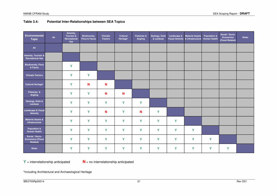
Table 3.4 highlights the potential inter-relationships between the SEA topics at a strategic Plan level.
These potential interactions will be taken into account in the assessment of options / alternatives.
Proposed Scoping Questions:
Do you agree with the geographical and temporal scope of the assessment?
Do you agree with the scoping of the environmental assessment topics?
Have we identified the key environmental issues relevant to the CFRAM studies?
NWNB CFRAM Study SEA Scoping Report - DRAFT
IBE0700Rp00014 21 Rev D01
Table 3.4: Potential Inter-Relationships between SEA Topics
Environmental
TopicAir
Amenity,
Tourism &
Recreational
Use
Biodiversity,
Flora & Fauna
Climatic
Factors
Cultural
Heritage*
Fisheries &
Angling
Geology, Soils
& Landuse
Landscape &
Visual Amenity
Material Assets
& Infrastructure
Population &
Human Health
Social / Socio-
Economics
(Flood Related)
Water
Air
Amenity, Tourism &
Recreational Use
Biodiversity, Flora
& Fauna Y
Climatic Factors Y Y
Cultural Heritage* Y N N
Fisheries &
Angling Y Y N N
Geology, Soils &
Landuse Y Y Y Y Y
Landscape & Visual
Amenity Y Y N Y N Y
Material Assets &
Infrastructure Y Y Y Y Y Y Y
Population &
Human Health Y Y Y Y Y Y Y Y
Social / Socio-
Economics (Flood
Related) Y Y Y Y Y Y Y Y Y
Water Y Y Y Y Y Y Y Y Y Y
Y = interrelationship anticipated N = no interrelationship anticipated
*Including Architectural and Archaeological Heritage

NWNB CFRAM Study SEA Scoping Report - DRAFT
IBE0700Rp00014 22 Rev D01
4 BASELINE AND ENVIRONMENTAL PROBLEMS
In line with the SEA Directive, an environmental baseline will be compiled for each of the SEAs of the
FRMPs within the NWNB CFRAM study. These will include: a description of the state of the
environment at present; a discussion of the key problems/ issues currently being faced in the area;
and a description of the expected evolution of the environment should the FRMP not be implemented,
i.e. in the absence of the plan. It should be noted that these FRMPs each cover large areas of Ireland
and will need to be consistent across all RBDs. It is therefore proposed that the baseline data to be
used in the environmental assessments are at a high / strategic level to allow a reliable and replicable
assessment across all RBDs in Ireland.
4.1 OVERVIEW OF CURRENT STATE OF THE ENVIRONMENT
The SEA Environmental Report will contain a full description of the Environmental Baseline data within
the study area. The key baseline information intended to be used are detailed in Table 4.1. It is
proposed that much of the baseline information will be presented in the form of maps, diagrams and
graphs, with supporting text in the Environmental Report with the focus on data directly relevant to the
FRMPs.
Table 4.1: Summary of Proposed Environmental Baseline Data and Sources
Environmental Baseline Data Data Sources
Biodiversity, Flora and Fauna
Location and Condition of Designated Sites
NPWS, EPA & NIEA data: • SACs & Water Dependent SACs • SPAs & Water Dependent SPAs • NHAs & pNHAs • ASSIs • Ramsar Sites • Freshwater Pearl Mussel Catchments & Sensitive
Areas • Nature Reserves • Wildfowl Sanctuaries • Nutrient Sensitive Areas • Shellfish Areas • Salmonid Lakes and Rivers
Birdwatch Ireland data: • IWeBs Keysites
OSPAR data: • Marine Protected Areas
Current threats to Biodiversity Biodiversity Ireland data: • Invasive Species records
Population & Human Health

NWNB CFRAM Study SEA Scoping Report - DRAFT
IBE0700Rp00014 23 Rev D01
Environmental Baseline Data Data Sources
Numbers of Population and Occupancy
CSO & NISRA data: • Census Small Areas
Numbers and Locations of Health Care Services
HSE data: • Hospitals • Health Centres
Geology, Soils & Landuse
Soil and Geological Features
GSI, GSNI & EPA data: • Bedrock & Aquifers • Soil & Subsoil type/permeability/vulnerability • Active Quarries & Historic Mines • Geological Heritage Sites • Landslide locations
Landuse
NPWS, EPA & GSI data: • CORINE landcover • Ancient and Established Woodland • Native Woodland
Water – Surface water, Groundwater, Coastal & Estuarine
Locations, Status and Risk of Water Bodies
EPA, NIEA & WFD data: • WFD Management Units • Ecological status and risk of surface, coastal and
transitional water bodies • Rivers and lakes
Climate
General climatic summary Met Éireann regional information. Data collected for CFRAM Study.
Climatic change information Data collected and calculated for CFRAM Study.
Material Assets & Infrastructure
Number and Type of Infrastructure
NRA data: • Roads
DAFFT, Iarnrod Eireann & IAA data: • Ports and Harbours • Rail • Airports
Civil Defence, DEHLG & OPW data: • Civil Defence HQs • Fire Stations • Garda Stations
EPA & WFD data: • IED Sites • Water Treatment and Waste Water Treatment Plants • Landfills • Drinking Water
Data collected for CFRAM Study
Energy and Renewable Energy Locations and Status
Eircom & ESB data: • Telephone Exchanges • Power stations and Substations
AIRO data: • Wind Farms

NWNB CFRAM Study SEA Scoping Report - DRAFT
IBE0700Rp00014 24 Rev D01
Environmental Baseline Data Data Sources
Cultural, Archaeological & Architectural Heritage
Location and Status of Protected Sites
DEHLG, NIAH, NPWS & NIEA data: • Record of Monuments & SMR • NIAH Buildings & Listed Buildings • UNESCO World Heritage Sites • Listed Parks, Gardens and Demesnes.
INFOMAR data: • Shipwrecks
Landscape & Visual Amenity
Landscape Character Areas and Sensitive Landscapes
Information from CDPs: • Landscape Conservation Areas • Landscape Character Areas • Sensitive Landscapes
Amenity, Tourism and Recreational Use
Location of Designated Sites NPWS , NIEA & WFD data:
• National Parks • Bathing Waters
Locations of Amenities
OPW data: • Galleries, Museums & Theatres
Irish Sports Council data: • Trails
DECLG data: • Social Amenity Areas
EPA & NIEA data: • Designated Bathing Waters
Data collected for CFRAM Study
Fisheries & Angling
Locations for Fishing and Species
MIDA & IFI data: • Ports • Fishing Spots • Angling spots
EPA & NIEA data: • Salmon lakes/rivers • Inshore Fisheries – Aquaculture
Flood Related Social or Socio-economic Issues
Numbers and Locations of Educational Institutions
DoE & Higher Education Authority data: • Primary Schools • Post Primary Schools • Third Level Institutions
Numbers and Locations of Care Facilities
HSE data: • Nursing Homes • Residential Care for the Elderly
It is key that the current state of the environment be described using the most recent and up-to-date
environmental data, information and reports. Where updates of significant environmental data and
associated reports become available during the SEA process, consideration will be given to
incorporating the new information into the description of the current state of the environment. Where

NWNB CFRAM Study SEA Scoping Report - DRAFT
IBE0700Rp00014 25 Rev D01
data gaps are found for particular aspects of the current state of the environment, the significance of
these data gaps should be clearly stated. In addition, it will be stated whether these gaps can be
reasonably and realistically addressed during the SEA process. The environmental baseline
information will form the indicators which the flood risk management options will have the potential to
impact upon. Future variation in these indicators due to the FRMPs will be monitored as part of the
Plan and SEA review.
Proposed Scoping Questions –
Are we proposing the most appropriate data and scale of data to be used?
Can you propose any other data to be used in the SEA and why it would be beneficial?

NWNB CFRAM Study SEA Scoping Report - DRAFT
IBE0700Rp00014 26 Rev D01
5 FRAMEWORK FOR ASSESSING ENVIRONMENTAL EFFECTS
5.1 SEA APPROACH
As previously discussed and illustrated in Section 3.2 there will be a FRMP produced for each of the
UoM. For each FRMP produced there will be an associated SEA Environmental Report and Natura
Impact Statement (output of AA). The Natura Impact Statements will feed into and influence the SEA
Environmental Report and both environmental reports will feed into and influence the draft FRMPs as
they evolve. Following completion of all three documents there will be a consultation period to allow
statutory and non-statutory consultees, along with the public, to comment on the Plans and Reports
produced.
Within each FRMP the proposed flood risk management Methods necessary at an AFA level will be
considered. For each AFA to be assessed the starting point will be a long list of flood risk management
Methods that could be implemented. These Methods will go through an initial screening to determine
their technical and economic feasibility, along with their anticipated high level environmental impacts.
The environmental considerations in the screening will be based on the potential for high level impacts
on designated European Sites and UNESCO world heritage sites in the first instance.
Methods that are found to be technically, economically and environmentally acceptable in the
preliminary screening will then be combined into groups of Options, which will be subjected to detailed
Multi-Criteria Analysis, looking at technical, economic, social and environmental criteria. The highest
scoring Option for each AFA will be put forward into the draft FRMP as the preferred Measure. The
SEA will be critical for this MCA as provides the necessary information for the environmental and
social inputs.
5.2 LONG LIST OF METHODS FOR ASSESSMENT
The below Table 5.1 demonstrates the long list of flood risk management Methods to be applied
across all AFAs, which will be subject to a preliminary screening assessment at the AFA level.
Table 5.1: Flood Risk Management Methods
Method Description
Do Nothing Implement no new flood risk management measures and abandon any existing practices.
Maintain Existing Regime Continue with any existing flood risk management practices, such as reactive maintenance.

NWNB CFRAM Study SEA Scoping Report - DRAFT
IBE0700Rp00014 27 Rev D01
Method Description
Do Minimum
Implement additional minimal measures to reduce the flood risk in specific problem areas without introducing a comprehensive strategy, includes channel or flood defence maintenance works / programme.
Planning and Development Control
Zoning of land for flood risk appropriate development, prevention of inappropriate incremental development, review of existing Local Authority policies in relation to planning and development and of inter-jurisdictional co-operation within the catchment, etc.
Building regulations Regulations relating to floor levels, flood-proofing, flood resilience, sustainable drainage systems, prevention of reconstruction or redevelopment in flood-risk areas, etc.
Catchment Wide Sustainable Drainage Systems (SuDS)
Implement SuDS on a catchment wide basis.
Land Use management (NFM)
Creation of wetlands, riparian buffer zones, etc.
Strategic Development Management
Necessary floodplain development (proactive integration of structural measures into development designs and zoning, regulation on developer-funded communal retention, drainage and / or protection systems, etc.)
Upstream Storage Single or multiple site flood water storage, flood retardation, etc.
Improvement of Channel Conveyance
In-channel works, floodplain earthworks, removal of constraints / constrictions, channel / floodplain clearance, etc.
Hard Defences Construct walls, embankments, demountable defences, Rehabilitate and / or improve existing defences, etc.
Relocation of Properties Relocation of properties away from flood risk.
Diversion of Flow Full diversion / bypass channel, flood relief channel, etc.
Other works Minor raising of existing defences / levels, infilling gaps in defences, site specific localised protection works, etc.
Flood Warning / Forecasting
Installation of a flood forecasting and warning system and development of emergency flood response procedures.
Public Awareness Campaign Targeted public awareness and preparedness campaign.
Individual Property Flood Resistance Protection / flood-proofing and resilience.

NWNB CFRAM Study SEA Scoping Report - DRAFT
IBE0700Rp00014 28 Rev D01
5.3 DRAFT SEA OBJECTIVES
The proposed FRMP objectives and the shortlisted Options will be assessed against the SEA
Objectives to examine the likely significant environmental impacts of the draft FRMPs. This
assessment should be relatively strategic, with the aim of reporting likely impacts at the UoM level to
reflect the scale at which the Plans are set. These Objectives will be used to assess the FRM Options
and will feed directly into the Multi-Criteria Analysis (MCA) being undertaken. This MCA will consider
the issues of social and environmental impacts alongside the technical and economic criteria. The
MCA framework has been developed to take account of the broader range of issues relevant to
delivery of the FRMP in the development and selection of FRM Options, and their subsequent
prioritisation. The draft SEA Objectives and Sub-Objectives to be used within the MCA are given in
Table 5.2.
The SEA will include add two additional objectives for the environmental assessment, which are not
currently within the MCA objectives. These objectives are given in Table 5.3 and will cover the
environmental topics of Soil and Climatic Factors. These objectives were incorporated into an earlier
pilot SEA in Ireland, for the Dodder FRMP.

NWNB CFRAM Study SEA Scoping Report - DRAFT
IBE0700Rp00014 29 Rev D01
Table 5.2: Draft SEA Objectives
Criteria Objective Sub-Objective
Social
A Minimise risk to human health and life i) Minimise risk to human health and life of residents
ii) Minimise risk to high vulnerability properties
B Minimise risk to community i) Minimise risk to social infrastructure and amenity
ii) Minimise risk to local employment
Environmental
C Support the objectives of the WFD i) Provide no impediment to the achievement of water body objectives and, if possible, contribute to the achievement of water body objectives.
D Support the objectives of the Habitats Directive i) Avoid detrimental effects to, and where possible enhance, Natura 2000 network, protected species and their key habitats, recognising relevant landscape features and stepping stones.
E Avoid damage to, and where possible enhance, the flora and fauna of the catchment i)
Avoid damage to or loss of, and where possible enhance, nature conservation sites and protected species or other know species of conservation concern.
F Protect, and where possible enhance, fisheries resource within the catchment
i) Maintain existing, and where possible create new, fisheries habitat including the maintenance or improvement of conditions that allow upstream migration for fish species.
G Protect, and where possible enhance, landscape character and visual amenity within the river corridor i)
Protect, and where possible enhance, visual amenity, landscape protection zones and views into / from designated scenic areas within the river corridor.
H Avoid damage to or loss of features, institutions and collections of cultural heritage importance and their setting
i) Avoid damage to or loss of features, institutions and collections of architectural value and their setting.
ii) Avoid damage to or loss of features, institutions and collections of archaeological value and their setting.

NWNB CFRAM Study SEA Scoping Report - DRAFT
IBE0700Rp00014 30 Rev D01
Table 5.3: Additional Draft SEA Objectives
Criteria Objective Sub-Objective
Indicator Minimum
requirement Aspirational
target
Climatic Factors I
No increase in flood risk to other areas i)
Avoid increase in flood risk to other areas due to flood risk management options taking the possible impacts of climate change into account
Other areas at risk from flooding
No non-intentional increase in flood risk to other areas
Intentional decrease in flood risk to other areas
Geology, Soils and Landuse J Protect soil function i) Avoid loss of soil from erosion Area at risk from
flooding No increase in area at risk from flooding
Reduction in area at risk from flooding to zero
NWNB CFRAM Study SEA Scoping Report - DRAFT
IBE0700Rp00014 31 Rev D01
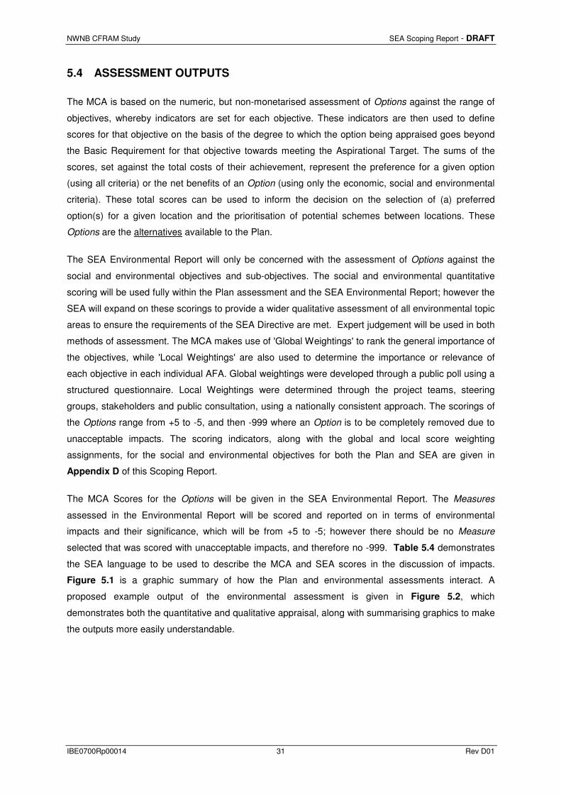
5.4 ASSESSMENT OUTPUTS
The MCA is based on the numeric, but non-monetarised assessment of Options against the range of
objectives, whereby indicators are set for each objective. These indicators are then used to define
scores for that objective on the basis of the degree to which the option being appraised goes beyond
the Basic Requirement for that objective towards meeting the Aspirational Target. The sums of the
scores, set against the total costs of their achievement, represent the preference for a given option
(using all criteria) or the net benefits of an Option (using only the economic, social and environmental
criteria). These total scores can be used to inform the decision on the selection of (a) preferred
option(s) for a given location and the prioritisation of potential schemes between locations. These
Options are the alternatives available to the Plan.
The SEA Environmental Report will only be concerned with the assessment of Options against the
social and environmental objectives and sub-objectives. The social and environmental quantitative
scoring will be used fully within the Plan assessment and the SEA Environmental Report; however the
SEA will expand on these scorings to provide a wider qualitative assessment of all environmental topic
areas to ensure the requirements of the SEA Directive are met. Expert judgement will be used in both
methods of assessment. The MCA makes use of 'Global Weightings' to rank the general importance of
the objectives, while 'Local Weightings' are also used to determine the importance or relevance of
each objective in each individual AFA. Global weightings were developed through a public poll using a
structured questionnaire. Local Weightings were determined through the project teams, steering
groups, stakeholders and public consultation, using a nationally consistent approach. The scorings of
the Options range from +5 to -5, and then -999 where an Option is to be completely removed due to
unacceptable impacts. The scoring indicators, along with the global and local score weighting
assignments, for the social and environmental objectives for both the Plan and SEA are given in
Appendix D of this Scoping Report.
The MCA Scores for the Options will be given in the SEA Environmental Report. The Measures
assessed in the Environmental Report will be scored and reported on in terms of environmental
impacts and their significance, which will be from +5 to -5; however there should be no Measure
selected that was scored with unacceptable impacts, and therefore no -999. Table 5.4 demonstrates
the SEA language to be used to describe the MCA and SEA scores in the discussion of impacts.
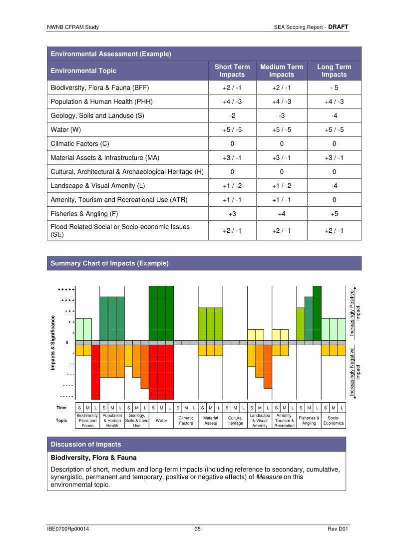
Figure 5.1 is a graphic summary of how the Plan and environmental assessments interact. A
proposed example output of the environmental assessment is given in Figure 5.2, which
demonstrates both the quantitative and qualitative appraisal, along with summarising graphics to make
the outputs more easily understandable.

NWNB CFRAM Study SEA Scoping Report - DRAFT
IBE0700Rp00014 32 Rev D01
Table 5.4: Description of MCA / SEA Environmental Impact Scores
Score Description
+ 5 Highly significant positive environmental impacts
+ 4 Significant positive environmental impacts
+ 3 Moderate positive environmental impacts
+ 2 Slight positive environmental impacts
+ 1 Minimal positive environmental impacts
0 No environmental impacts
- 1 Minimal negative environmental impacts
- 2 Slight negative environmental impacts
- 3 Moderate negative environmental impacts
- 4 Significant negative environmental impacts
- 5 Highly significant negative environmental impacts
- 999 Unacceptable impacts

NWNB CFRAM Study SEA Scoping Report - DRAFT
IBE0700Rp00014 33 Rev D01
Preliminary Screening
NWNB CFRAM Study
FRM Methods To reduce flood risk in AFAs.
Methods applied at UoM, Catchment and AFA scale. See Table 5.1 for full list.
AFAs within Unit of Management
Potential Options Methods that pass Preliminary Screening are grouped
into Potential Options for a specific area.
FRM MeasuresPreferred Options to be taken forward into the FRMP
become Flood Risk Management Measures
UoM Specific Flood Risk Management Plan
Environmental Screening Inputs & SEA Scoping
MCA -Environmental and
Social Criteria
Environmental Screening Inputs & AA Screening
MCA -Environmental (AA)
Criteria
UoM Specific Environmental
Report
UoM - AA
Preferred OptionsThe highest scroring Potential Options from the MCA
become Preferred Options.
UoM - SEA
Feedback Loop
Multi-Criteria Analysis
UoM Specific Natura Impact
Statement
Figure 5.1 Interactions of the Plan and Environmental Assessments

NWNB CFRAM Study SEA Scoping Report - DRAFT
IBE0700Rp00014 34 Rev D01
Figure 5.2 Example Output of Environmental Assessment
RBD Name & Code
UoM Number
AFA Name & Code
Receiving Environment
Environment Issues
• Environmental issues relevant to this area that have the potential to be impacted upon by flooding or flood risk management.
• Example Issue 2
Proposed Flood Risk Management Measure
Description of the preferred flood risk management Options that are combining to become the proposed Measure for this AFA.
MCA Scores
Option
MCA Appraisal Scores
TO
TA
L -
MC
A
Ben
efit
Sco
re
Cost (€'000s)
MCA Score /
Cost BCR
Tec
hnic
al
Soc
ial
Eco
nom
ic
Env
iron
/ C
ultu
ral
XXX 0 0 0 0 000 €xxx 0 0
NWNB CFRAM Study SEA Scoping Report - DRAFT
IBE0700Rp00014 35 Rev D01
Environmental Assessment (Example)
Environmental Topic Short Term
Impacts Medium Term
Impacts Long Term
Impacts
Biodiversity, Flora & Fauna (BFF) +2 / -1 +2 / -1 - 5
Population & Human Health (PHH) +4 / -3 +4 / -3 +4 / -3
Geology, Soils and Landuse (S) -2 -3 -4
Water (W) +5 / -5 +5 / -5 +5 / -5
Climatic Factors (C) 0 0 0
Material Assets & Infrastructure (MA) +3 / -1 +3 / -1 +3 / -1
Cultural, Architectural & Archaeological Heritage (H) 0 0 0
Landscape & Visual Amenity (L) +1 / -2 +1 / -2 -4
Amenity, Tourism and Recreational Use (ATR) +1 / -1 +1 / -1 0
Fisheries & Angling (F) +3 +4 +5
Flood Related Social or Socio-economic Issues (SE) +2 / -1 +2 / -1 +2 / -1
Summary Chart of Impacts (Example)
+ + + + +
+ + + +
+ + +
+ +
+
0
-
- -
- - -
- - - -
- - - - -
S M L S M L S M L S M L S M L S M L S M L S M L S M L S M L S M L
Topic
Incr
easi
ngly
Pos
itive
Im
pact
Time
Cultural Heritage
Landscape & Visual Amenity
Amenity, Tourism & Recreation
Material Assets
Socio-Economics
Incr
easi
ngly
Neg
ativ
e Im
pactIm
pa
cts
& S
ign
ific
an
ce
Biodiversity, Flora and
Fauna
Geology, Soils & Land
UseWater
Population & Human
Health
Climatic Factors
Fisheries & Angling
Discussion of Impacts
Biodiversity, Flora & Fauna
Description of short, medium and long-term impacts (including reference to secondary, cumulative, synergistic, permanent and temporary, positive or negative effects) of Measure on this environmental topic.

NWNB CFRAM Study SEA Scoping Report - DRAFT
IBE0700Rp00014 36 Rev D01
Population & Human Health
Description of short, medium and long-term impacts (including reference to secondary, cumulative, synergistic, permanent and temporary, positive or negative effects) of Measure on this environmental topic.
Geology, Soils & Landuse
Description of short, medium and long-term impacts (including reference to secondary, cumulative, synergistic, permanent and temporary, positive or negative effects) of Measure on this environmental topic.
Water
Description of short, medium and long-term impacts (including reference to secondary, cumulative, synergistic, permanent and temporary, positive or negative effects) of Measure on this environmental topic.
Climatic Factors
Description of short, medium and long-term impacts (including reference to secondary, cumulative, synergistic, permanent and temporary, positive or negative effects) of Measure on this environmental topic.
Material Assets & Infrastructure
Description of short, medium and long-term impacts (including reference to secondary, cumulative, synergistic, permanent and temporary, positive or negative effects) of Measure on this environmental topic.
Cultural, Architectural & Archaeological Heritage
Description of short, medium and long-term impacts (including reference to secondary, cumulative, synergistic, permanent and temporary, positive or negative effects) of Measure on this environmental topic.
Landscape & Visual Amenity
Description of short, medium and long-term impacts (including reference to secondary, cumulative, synergistic, permanent and temporary, positive or negative effects) of Measure on this environmental topic.
Amenity, Tourism and Recreational Use
Description of short, medium and long-term impacts (including reference to secondary, cumulative, synergistic, permanent and temporary, positive or negative effects) of Measure on this environmental topic.
Fisheries & Angling
Description of short, medium and long-term impacts (including reference to secondary, cumulative, synergistic, permanent and temporary, positive or negative effects) of Measure on this environmental topic.
Flood Related Social or Socio-economic Issues
Description of short, medium and long-term impacts (including reference to secondary, cumulative, synergistic, permanent and temporary, positive or negative effects) of Measure on this environmental topic.
Additional Impacts
Additional secondary, cumulative, synergistic, permanent and temporary, positive or negative effects.
NWNB CFRAM Study SEA Scoping Report - DRAFT
IBE0700Rp00014 37 Rev D01
5.4.1 Mitigation
Mitigation measures will be recommended where flood risk management Measures are predicted to
have any negative impacts on any environmental topic area. The mitigation measures will aim to
prevent, reduce and as fully as possible offset any significant adverse effects on the environment due
to implementation of the FRMP.
5.4.2 Monitoring
The SEA Directive requires that the significant environmental effects of the implementation of a Plan
are monitored in order to identify at an early stage unforeseen adverse effects and in order to
undertake appropriate remedial action. This monitoring programme will be based on the Targets and
Indicators established in the SEA Objectives (given in Appendix D). This programme will aim to be
realistic and achievable, with existing monitoring arrangements being used where possible. Examples
of likely monitoring to be proposed are:
• Reported conservation status of designated sites relating to flood risk management following
implementation of Measures, to gauge impacts on Biodiversity, Flora and Fauna.
• Numbers of listed heritage features, including their setting and heritage value, at risk from
flooding following implementation of Measures, to gauge impacts on cultural, architectural
and archaeological heritage.
Proposed Scoping Questions –
Do you agree with the approach to the assessment?
Do you agree with the draft SEA objectives?

NWNB CFRAM Study SEA Scoping Report - DRAFT
IBE0700Rp00014 38 Rev D01
6 CONSULTATION AND NEXT STEPS
6.1 CONSULTATION
Under Article 6 of the SEA Directive (and Article 11 of SI 435 of 2004), the competent authority, (in this
case the OPW), preparing the plan or programme is required to consult with specific “environmental
authorities” (statutory consultees) throughout the SEA process. These statutory consultees are
established within the national legislation as being the:
• Environmental Protection Agency (EPA);
• Department of Environment, Community and Local Government (DECLG);
• Department of Agriculture, Food and the Marine (DAFM);
• Department of Communications, Energy and Natural Resources (DCENR); and
• Department of Arts, Heritage and the Gaeltacht (DAHG).
These statutory consultees will be formally consulted on as part of the scoping of the SEA for the
NWNB FRMPs. Given the transboundary location of the NWNB CFRAM study with Northern Ireland,
there is the potential for transboundary impacts from implementation of the FRMPs and therefore there
is a requirement to undertake transboundary consultations as part of this SEA process. The statutory
consultee established within the SEA legislation for Northern Ireland is the Northern Ireland
Environment Agency (NIEA) (formerly Environment and Heritage Service).
This Scoping Report will also be published on the OPW and NWNB CFRAM study websites, including
contact details, so that interested parties can submit comments and feedback on the report.
Comments and submissions received on the report will be logged, reviewed and applied to the SEA
process, where relevant.
The Environmental Reports, once completed will also be sent to the statutory consultees and will be
issued for public consultation along with the Natura Impact Statement and the Draft FRMPs.
Stakeholders will have the opportunity to comment on the Plans and Environmental Reports.
Comments and submissions received on the reports will be logged, reviewed and applied where
relevant.
In addition to the consultation required under the SEA Directive and implementing regulations, a
comprehensive consultation programme has been developed as part of the CFRAM study and
consultation on the SEA will be a significant feature of this as the plans evolve. In the first instance an
NWNB CFRAM Stakeholder Group has been established. The members of the Stakeholder Group are
outlined in Appendix E. These Stakeholders, which include transboundary stakeholders, will be
consulted regarding this SEA Scoping Report.
A workshop was held with the group on 8th November 2012 in the Four Seasons Hotel, Monaghan.
Presentations were given by the OPW and RPS on the Plan and also on the role of the SEA and
associated Appropriate Assessment. An earlier version of the scoping issues table (Table 3.3) was

NWNB CFRAM Study SEA Scoping Report - DRAFT
IBE0700Rp00014 39 Rev D01
presented for comment and tabled at workshop discussions among those present. All responses
received on the day were taken into account in developing this Scoping Report.
Early SEA scoping also featured at the Public Consultation Days which took place between January
and March 2015 in relation to the draft flood mapping. A questionnaire was developed to collect
feedback at these events and included a section asking consultees to rate the importance of a range
of factors to be considered in flood risk management planning. These factors included the main SEA
topics.
Early feedback received on the scoping of the SEA for the NWNB FRMPs has been incorporated as
best possible into this report and into Table 3.3.
6.2 NEXT STEPS
Table 6.1 demonstrates the proposed upcoming time stages for the Plan, SEA and AA.
Table 6.1: Draft Anticipated Milestones
NWNB FRMPs Dates Strategic Environmental Assessment /
Appropriate Assessment
Development of FRMPs for NWNB CFRAM study
September 2015 – March 2016
Strategic Environmental Assessment and Appropriate Assessment. Writing of SEA Environmental Report and Natura Impact Statement.
Public and statutory consultation on draft FRMPs for NWNB CFRAM study
May 2016 – August 2016
Statutory, Non Statutory and Public Consultation on SEA Environmental Report and Natura Impact Statement
Release of Final FRMPs for NWNB CFRAM study Early 2017 SEA Environmental Statement
The proposed timescale to complete the SEA process is given in Table 6.2.
Table 6.2: Proposed Timescale for SEA of the NWNB FRMPs
Actions Timescales
Scoping January 2012 – September 2015
Consultation September / October 2015
Environmental Assessment October 2015 – March 2016
Public Consultation May 2016 – August 2016
Environmental Statement Early 2017
NWNB CFRAM Study SEA Scoping Report - DRAFT
IBE0700Rp00014 40 Rev D01
Scoping is a dynamic process and is expected to continue throughout the SEA process, up to the
publication of the Environmental Report. This Scoping Report will be available on the OPW and
NWNB CFRAM Study websites with the purpose of engaging the wider public in the ongoing
consultation on these plans.
The contact for any information regarding the Strategic Environmental Assessment of the proposed
NWNB FRMPs is as follows:
By post
Richard Bingham
NWNB CFRAM Study SEA
RPS
Enterprise Fund Business Centre
Ballyraine
Letterkenny
Co Donegal
Ireland
By email [email protected]
Via the national and NWNB
CFRAM Study websites
www.cfram.ie
www.northwestcframstudy.ie
www.neaghbanncframstudy.ie
Will be forwarded automatically to the communications coordinator
Via direct consultation with
team members at events
The NWNB CFRAM Study communications coordinator and various relevant team members will be on hand at NWNB CFRAM Study events as well as national events.
Proposed Scoping Questions –
Do you agree with the proposed project timescales and proposed consultees in the SEA process?

NWNB CFRAM Study SEA Scoping Report - DRAFT
IBE0700Rp00014 41 Rev D01
APPENDIX A
OPW SEA Screening

NWNB CFRAM Study SEA Scoping Report - DRAFT
IBE0700Rp00014 42 Rev D01

STRATEGIC ENVIRONMENTAL
ASSESSMENT SCREENING REPORT
CATCHMENT FLOOD RISK
MANAGEMENT PLANS (2015 – 2021)
Determination of the need for strategic environmental assessment for
Catchment Flood Risk Management Plans prepared under the National
Catchment Flood Risk Assessment and Management (CFRAM)
Programme
RP/002/D
FRAM Section
Office of Public Works

Doc. No. RP/002/D Page 1 Date: - 19th September 2011
PROJECT NATIONAL CATCHMENT FLOOD RISK ASSESSMENT AND
MANAGEMENT (CFRAM) PROGRAMME
PROJECT No.
PROJECT ENGINEER:
CLIENT: ENGINEERING SERVICES
OFFICE OF PUBLIC WORKS
DOCUMENT TITLE: SEA SCREENING REPORT CATCHMENT FLOOD RISK
MANAGEMENT PLANS (2015-2021)
DOCUMENT No.: RP/002/D
REV. STATUS AUTHOR(S) REVIEWED BY APPROVED BY ISSUE DATE
A Draft
Rosemarie
Lawlor
Mark Adamson Not Issued
B Draft Richael Duffy John Martin Not Issued
C Draft Richael Duffy
John Martin &
Mark Adamson
Not Issued
D Final Richael Duffy
John Martin &
Mark Adamson
John Martin &
Mark Adamson
19/09/2011

Doc. No. RP/002/D Page 2 Date: - 19th September 2011
CONTENTS
1.0 INTRODUCTION _____________________________________________________ 3
1.1. Background__________________________________________________________ 3
1.2. Screening Statement ___________________________________________________ 4
2.0 STUDY PURPOSE, STUDY AREA AND PROGRAMME____________________ 4
2.1. Study Purpose________________________________________________________ 4
2.2. Study Area __________________________________________________________ 6
2.3. Programme __________________________________________________________ 8
3.0 SCREENING CHECK, STAGE ONE _____________________________________ 8
4.0 ENVIRONMENTAL SIGNIFICANT SCREENING, STAGE TWO ____________ 8
4.1. The Characteristics of the plan having regard, in particular to: __________________ 9
4.1.1 Criteria No. 1 ______________________________________________________ 9
4.1.2 Criteria No. 2 ______________________________________________________ 9
4.1.3 Criteria No. 3 _____________________________________________________ 10
4.1.4 Criteria No. 4 _____________________________________________________ 10
4.1.5 Criteria No. 5 _____________________________________________________ 11
4.2. Characteristics of the effects and of the area likely to be affected having regard to _ 11
4.2.1 Criteria No. 1 _____________________________________________________ 11
4.2.2 Criteria No. 2 _____________________________________________________ 11
4.2.3 Criteria No. 3 _____________________________________________________ 12
4.2.4 Criteria No. 4 _____________________________________________________ 12
4.2.5 Criteria No. 5 _____________________________________________________ 12
4.2.6 Criteria No. 6 _____________________________________________________ 13
4.2.7 Criteria No. 7 _____________________________________________________ 13
5.0 PROPOSED TIMETABLE AND APPROACH FOR THE SEA PROCESS_____ 14
5.1. Summary of SEA process______________________________________________ 14
5.2. Stage 1 - Constraints and SEA scoping ___________________________________ 14
5.3. Stages 2 & 3 ________________________________________________________ 16
5.4. Consultation ________________________________________________________ 16
6.0 CONCLUSIONS______________________________________________________ 17
7.0 REFERENCES _______________________________________________________ 19
Appendix A ______________________________________________________________ 20

SEA Screening Report Catchment Flood Risk Management Plans (2015-2021)
Doc. No. RP/002/D Page 3 Date: - 19th September 2011
1.0 INTRODUCTION
1.1. BACKGROUND
The Office of Public Works (OPW) has recognised the levels of flood risk that exist in certain
parts of the country and the potential for significant increases in this risk due to climate
change, ongoing development and other pressures that may arise in the future. The OPW in
partnership with Local Authorities are therefore seeking solutions to manage this flood risk in
a sustainable and cost effective manner.
Flood risk in Ireland has historically been addressed through the use of structural or
engineered solutions to existing problems, such as through the implementation of flood relief
schemes to protect towns / areas already at risk. In line with internationally changing
perspectives, the Irish Government adopted a new policy in 2004 that shifted the emphasis in
addressing flood risk towards:
− A catchment-based context for managing risk,
− More pro-active risk management, with a view to avoiding or minimising future
increases in risk,
− Increased use of non-structural and flood impact mitigation measures.
Notwithstanding this shift, engineered solutions to protect communities against existing risks
are likely to continue to form a key component of the overall flood risk management strategy.
In line with government policy on flood risk management, as adopted in 2004, the OPW is in the
process of implementing a Catchment-based Flood Risk Assessment and Management (CFRAM)
Study programme as a means of addressing the flooding risk over the long-term in Ireland.
The EU Directive on the assessment and management of flood risk (the ‘Floods Directive’ –
[2007/60/EC]) requires Member States to prepare flood maps for areas of potentially significant
flood risk, and to develop flood risk management plans (FRMPs) setting out measures aimed at
achieving objectives to manage the risk in these areas. In Ireland, these requirements (transposed
into national law through S.I. No. 122 of 2010) are being implemented through the CFRAM
Studies. The outputs from the CFRAM Studies will be catchment-based flood risk management
plans (CFRMPs) and associated flood maps. The CFRMPs will be valid for the period 2015- 2021
and will be reviewed on a six-yearly basis.

SEA Screening Report Catchment Flood Risk Management Plans (2015-2021)
Doc. No. RP/002/D Page 4 Date: - 19th September 2011
1.2. SCREENING STATEMENT
The European Communities (Environmental Assessment of Certain Plan and Programmes)
Regulations 2004 (S.I. No. 435 of 2004) (hereafter referred to as ‘the Regulations’) and the
European Communities (Environmental Assessment of Certain Plans And Programmes)
(Amendment) Regulations, 2011 (S.I 200 of 2011) require a screening of individual plans or
programmes, based on the criteria in Schedule 1 of the regulations. These criteria must be taken
into account in determining whether or not significant effects on the environment would be likely to
arise.
The OPW considers that an SEA should be undertaken as a matter of good practice for all CFRAM
Studies to ensure that environmental effects and potential benefits are fully integrated into the
decision-making process on appropriate flood risk management measures and strategies that will
form the core of the CFRMPs. The purpose of this screening statement is to validate this position.
Under the CFRAM Programme, CFRAM Studies will be undertaken throughout the country. The
specification and process for each CFRAM Study is essentially the same, and it is not possible at
this stage to differentiate particular impacts that could arise from the CFRMPs produced under
different Studies. It has therefore been deemed appropriate that a single screening assessment
should be undertaken to cover all CFRMPs, rather than individual assessments for each CFRMP.
The process used in validating this position is consistent with the determination process as
recommended by the Environmental Protection Agency (EPA) publication entitled
Development of Strategic Environmental Assessment (SEA) Methodologies for Plans and
Programmes in Ireland – Synthesis Report (hereafter referred to as the “EPA Publication”),
specifically Stage 1 (Screening of Plans and Programmes).
2.0 STUDY PURPOSE, STUDY AREA AND PROGRAMME
2.1. STUDY PURPOSE
The objectives of CFRAM Studies are to:
• To produce detailed flood mapping in order to identify and map the existing and
potential future flood hazard and risk areas within the study area.
• Build the strategic information base necessary for making informed decisions in
relation to managing flood risk.

SEA Screening Report Catchment Flood Risk Management Plans (2015-2021)
Doc. No. RP/002/D Page 5 Date: - 19th September 2011
• Identify viable structural and non-structural measures and options for managing the
flood risks for localised high-risk areas and within the catchment as a whole.
• Prepare a Flood Risk Management Plan for each Unit of Management (UoM) that
sets out the measures and policies, including guidance on appropriate future
development, that should be pursued by the local authorities, the OPW and other
stakeholders to achieve the most cost effective and sustainable management of flood
risk within the study area taking account of the effects of climate change and
complying with the requirements of the Water Framework Directive.
• Implement the requirements of EU Directive on the assessment and management of
flood risks (2007/60/EC).
Table 1 below provides a non-exhaustive list of potential measures that could be considered.
This includes small and large-scale structural and non-structural solutions for protection of
individual properties to the construction of large flood storage areas. As the studies progress,
the most appropriate flood risk management measures for the catchments will be identified
and included in the CFRMPs. These measures will address the need for improved flood risk
management both now and in the future.
Do Nothing Implement no new flood risk management measures and abandon any
existing practices
Existing Regime Continue with any existing flood risk management practices, such as
reactive maintenance
Do Minimum Implement additional minimal measures to reduce the flood risk in
specific problem areas without introducing a comprehensive strategy
Non-Structural
Measures
• Planning and development control measures (zoning of land for
flood risk-appropriate development, prevention of inappropriate
incremental development, review of existing Local Authority
policies in relation to planning and development and of inter-
jurisdictional co-operation within the catchment, etc.)
• Building regulations (regulations relating to floor levels, flood-
proofing, flood-resilience, sustainable drainage systems,
prevention of reconstruction or redevelopment in flood-risk
areas, etc.)
• Sustainable urban drainage systems
• Installation of a flood forecasting and warning system and
development of emergency flood response procedures
• Targeted public awareness and preparedness campaign

SEA Screening Report Catchment Flood Risk Management Plans (2015-2021)
Doc. No. RP/002/D Page 6 Date: - 19th September 2011
• Individual property flood resistance (protection / flood-proofing)
and resilience
• Land use management, including creation of wetlands, riparian
buffer zones, etc
Structural
Measures
(Potential Future
Risk)
Strategic development management for necessary floodplain
development (pro-active integration of structural measures into
development designs and zoning, regulation on developer-funded
communal retention, drainage and / or protection systems, etc.)
Structural
Measures
(Existing Risk)
• Storage (single or multiple site flood water storage, flood
retardation, etc.)
• Flow diversion (full diversion / bypass channel, flood relief
channel, etc.)
• Increase conveyance (in-channel works, floodplain earthworks,
removal of constraints / constrictions, channel / floodplain
clearance, etc.)
• Construct flood defences (walls, embankments, demountable
defences, etc.)
• Rehabilitate, improve existing defences
• Relocation of properties
• Localised protection works (e.g., minor raising of existing
defences / levels, infilling gaps in defences, etc.)
Channel or Flood Defence Maintenance Works / Programme
Other works that might be of particular relevance to, or suitability for, a given location
Table 1 List of potential flood risk management measures
2.2. STUDY AREA
The CFRAM Programme is national. However, individual CFRAM Studies, and the Flood Risk
Management Plans that will be produced through the Studies, cover discrete areas as set out below.
The OPW have generally defined the hydrometric areas, which comprise a major catchment, or
conglomerations of smaller river catchments, and their associated coastal areas, as the Units of
Management (UoMs) for implementing the Floods Directive in Ireland. The exception to this
approach are the three cross-border River Basin Districts (RBDs) which have each been defined as
a single UoM. A CFRMP will be prepared for each UoM, or for sub-areas of UoMs in cross-border
RBDs. However, for the purposes of efficiency and co-ordination with the implementation of the
WFD, the OPW have awarded the contracts for carrying out the CFRAM studies at the RBD level.
Figure 1 shows the areas for which CFRMPs will be prepared.

SEA Screening Report Catchment Flood Risk Management Plans (2015-2021)
Doc. No. RP/002/D Page 7 Date: - 19th September 2011
The studies will focus primarily on developed areas, areas subject to significant development
pressure, or areas with other known significant vulnerabilities to flooding, known to have
experienced flooding in the past or that could potentially be at flood risk, now or in the future.
Figure 1 Spatial Scope of each CFRMP (grouped by RBD contract)

SEA Screening Report Catchment Flood Risk Management Plans (2015-2021)
Doc. No. RP/002/D Page 8 Date: - 19th September 2011
2.3. PROGRAMME
In October 2010 the OPW began procuring the CFRAM studies and it is envisaged that they will
all be commissioned by December 2011. The Floods Directive requires that the all CFRMPs are
completed by the end of 2015 and reviewed every six years thereafter.
3.0 SCREENING CHECK, STAGE ONE
The first step of the validation process was to undertake a pre-screening check using the decision
tree presented in Figure 2 of the EPA publication “Development of Strategic Environmental
Assessment (SEA) Methodologies for Plans and Programmes in Ireland”
The decision tree is based on a series of administrative questions that allows rapid screening–
out of plans and programmes that are clearly not going to have an environmental impact, and
screening-in of those that definitely do require an SEA. The decision tree and responses to
the administrative questions as they apply to the CFRMPS are presented in Appendix A
The outcome of the pre-screening stage is that the CFRMPs will require a SEA because they:
• are intended for adoption by Local Authorities (Article 20 of S.I. 122 of 2010).
• are required by legislation (S.I. 122 of 2010)
• do not have a sole purpose of serving national defence or civil emergency, nor are they co-
financed by EU funding
• are for water management and will impact on land use
• are likely to require an assessment under Article 6 of the EU Habitats Directive
4.0 ENVIRONMENTAL SIGNIFICANT SCREENING, STAGE TWO
The pre-screening process indicated that a SEA is required for the CFRMPs. The CFRMPs were
further assessed by querying the plans against the environmental criteria contained in Schedule 1 of
the Planning and Development (Strategic Environmental Assessment) Regulations 2004. (S.I. No.
435 of 2004). This task is described as Task 1.2 in previously referred to EPA publication.

SEA Screening Report Catchment Flood Risk Management Plans (2015-2021)
Doc. No. RP/002/D Page 9 Date: - 19th September 2011
4.1. THE CHARACTERISTICS OF THE PLAN HAVING REGARD, IN PARTICULAR TO:
4.1.1 CRITERIA NO. 1
The degree to which the plan or programme, or modification to a plan or programme, sets a
framework for projects and other activities, either with regard to the location, nature, size and
operating conditions or by allocating resources.
Each CFRMP will contain a Programme of Works outlining a prioritized programme of polices,
actions and measures to be implemented within the catchment, which may give rise to further
projects. Thus, the CFRMPs will form a framework for future projects and allocation of resources
concerning reduction of flooding risk.
4.1.2 CRITERIA NO. 2
The degree to which the plan or programme, or modification to a plan or programme, influences
other plans including those in a hierarchy.
The flood maps produced as part of the CFRAM studies should be taken into account in
strategic land use planning and development control to meet the requirements of the
Guidelines on Spatial Planning and Flood Risk Management (DEHLG & OPW, 2009). Table
2 below contains a list of spatial planning documents that are relevant to flood risk
management. plans at both regional and local level are likely to include recommendations
from the studies.
Scale Documents
National • National Development Plan (2007-2011)
• National Spatial Strategy (2003)
Regional • Regional Planning Guidelines
• Regional Development Plans / Strategies
• Development Plans of participating Local Authorities
Local • Local Area Plans (LAPs)
• Non-statutory Area Action Plans (AAP’s)
Table 2 List of Spatial Planning Documents relevant to the CFRMPs

SEA Screening Report Catchment Flood Risk Management Plans (2015-2021)
Doc. No. RP/002/D Page 10 Date: - 19th September 2011
4.1.3 CRITERIA NO. 3
The relevance of the plan or programme, or modification to a plan or programme, for the
integration of environmental considerations in particular with a view to promoting sustainable
development.
The flood risk management measures proposed for a particular CFRMP will be assessed
against a range of criteria including Technical, Economic, Social and Environmental. The
environmental criteria are made up of the following:
• Support the objectives of the WFD
• Minimise the risk of environmental pollution
• Avoid damage to, and where possible enhance, the flora and fauna of the catchment
• Avoid damage to, and where possible enhance, fisheries within the catchment
• Protect, and where possible enhance, landscape character and visual amenity within the
catchment
• Avoid damage to or loss of features of cultural heritage importance, their setting and
heritage value within the catchment
By assessing the flood risk management objectives against these criteria the integration of
environmental considerations in the plan will be achieved.
The flood maps produced, as part of the CFRAM studies should be taken into account in
strategic land use planning and development control and will therefore contribute towards
sustainable development.
4.1.4 CRITERIA NO. 4
Environmental problems relevant to the plan or programme, or modification to a plan or
programme
Some environmental problems relevant to the CFRMPs are likely to include water quality issues
(groundwater and surface water), habitat degradation and loss, soil contamination, soil erosion and
the spread of invasive species.
SEA Screening Report Catchment Flood Risk Management Plans (2015-2021)
Doc. No. RP/002/D Page 11 Date: - 19th September 2011
The CFRMPs will aim to manage flood risk in the study areas in a manner that is compatible with
the continued protection of existing habitats and will support the objectives of the WFD with regard
to Good Ecological Status/Potential (GES/GEP) of the water bodies within the study area.
4.1.5 CRITERIA NO. 5
The relevance of the plan or programme, or modification to a plan or programme, for the
implementation of European Union Legislation on the Environment (Plans linked to Waste-
management or Water Protection)
The CFRMPs will address the requirements of the European Union Directive on the Assessment
and Management of Flood Risks (Directive 2007/60/EC). There is a strong link between this
directive and the WFD and close liaison is underway with the RBD projects to ensure the CFRMPs
facilitate the achievement of GES/GEP where appropriate and relevant to flood risk management.
4.2. CHARACTERISTICS OF THE EFFECTS AND OF THE AREA LIKELY TO BE
AFFECTED HAVING REGARD TO
4.2.1 CRITERIA NO. 1
The probability, duration, frequency and reversibility of the effects
The key objective of the CFRAM studies, and the CFRMPs produced through the Studies, is to
recommend measures and polices that should be pursued in order to manage flood risk within the
study areas in a sustainable and cost effective manner. An objective of the selection process of
measures will promote the recommendation of those flood risk management measures that also
have positive environmental and other broader effects. If negative effects are identified mitigation
measures will be proposed to either avoid the negative effects, or (if this is not possible) to reduce
the scale, duration and nature of the effects. Consequently it is expected that the effects on the
environment will generally be positive and of a long-term nature, although some negative effects,
particularly short-term, may arise.
4.2.2 CRITERIA NO. 2
The cumulative nature of the effects
For the reasons set out under Criteria 1 above, it is envisaged that the cumulative environmental
effects will generally be positive. Producing the CFRMPs at catchment scale will allow the overall
effects of the proposals to be considered collectively and will aid the identification of cumulative
effects. As part of the SEA process the cumulative effects of the CFRMP in combination with the
effects of other plans and programmes will also be examined.
SEA Screening Report Catchment Flood Risk Management Plans (2015-2021)
Doc. No. RP/002/D Page 12 Date: - 19th September 2011
4.2.3 CRITERIA NO. 3
The transboundary nature of the effects
Most of the CFRMPs will have has no national transboundary effects. However, a number of the
CFRMPs, including some produced as part of the Shannon CFRAM, the North Western CFRAM
and Neagh Bann CFRAM studies will cover catchments that cross over into Northern Ireland.
4.2.4 CRITERIA NO. 4
The risk to human health or the environment (e.g. due to accidents)
It is the intended objective of the CFRAM studies to develop an economically, socially and
environmentally appropriate long-term strategy for managing the flood risk. In the development of
this long term strategy cognisance shall be taken of the results from the SEA process. It is therefore
envisaged that CFRMPs will not pose any significant risk to the environment or human health.
4.2.5 CRITERIA NO. 5
The magnitude and spatial extent of the effects (geographical area and size of the population
likely to be affected)
The area covered by each CFRMP will either be a catchment or a collection of smaller catchments
and their associated coastal areas, and will typically be greater than 1000 km
2
in size. The measures
proposed by the CFRMP will be assessed for at least four Spatial Scales of Assessment (SSAs) that
will include:
• the Unit of Management (UoM)
• each Analysis Unit (AU). These are sub-catchments or coastal areas within the Unit of
Management.
• Areas for Further Assessment (AFAs). Theses are communities with quantifiable flood
risk and include towns, villages and areas where significant development is anticipated.
• Individual Risk Receptors (IRRs). These are essential infrastructure assets
It is envisaged that the non-structural measures (e.g. public awareness, flood forecasting and
warning systems) will be applied at the UoM and AU spatial scales and are unlikely to have any
direct environmental impacts.
The structural measures are likely to be applied at the AFA and IRR spatial scales. The magnitude
and spatial extent of the effects of these measures is difficult to asses at this stage, however given

SEA Screening Report Catchment Flood Risk Management Plans (2015-2021)
Doc. No. RP/002/D Page 13 Date: - 19th September 2011
that they will be applied in towns and villages it is envisaged that they have a beneficial effect for
large sections of the population.
4.2.6 CRITERIA NO. 6
The value and vulnerability of the area likely to be affected due to:
a) special natural characteristics or cultural heritage
There are a number if Natura 2000 sites and NHA’s within each CFRAM study area. There
are also numerous cultural heritage sites and features listed on the Records of Monuments and
Places. The intention of the CFRMPs is to avoid damage and where possible enhance the
Flora and Fauna and to avoid damage to or loss of features of Cultural Heritage. It is difficult
to determine potential effects on specific areas at this stage, however, it is recognised that
there is potential for some effects, which will be fully investigated as part of the SEA process.
Screening for Appropriate Assessment (AA) will also be carried out and based on the finding
of the screening assessment a detailed AA may be carried out. Therefore, consultations with
the National Parks and Wildlife Service in the Department of Arts, Heritage and the Gaeltacht
and other relevant environmental stakeholders will be carried out throughout the studies.
b) exceeded environmental quality standards or limit values
It is anticipated that the environmental quality standards or limit values will not be exceeded.
c) intensive land-use
The CFRMPs will not propose the intensification of existing land uses.
4.2.7 CRITERIA NO. 7
The effects on areas or landscapes which have a recognised national, European Union or
international protection status
The CFRAM study areas include a range of areas or landscapes that have varying levels of
protection under EU and National Law and in the various Development Plans for the Region.
Determining potential effects on specific areas or landscapes is difficult at this early stage,
however, the potential for effects cannot be ruled out.

SEA Screening Report Catchment Flood Risk Management Plans (2015-2021)
Doc. No. RP/002/D Page 14 Date: - 19th September 2011
5.0 PROPOSED TIMETABLE AND APPROACH FOR THE SEA PROCESS
5.1. SUMMARY OF SEA PROCESS
The Strategic Environmental Assessment (SEA) for each CFRMP will be undertaken in three main
stages in parallel with the assessment of flood risk, identification of flood risk management options
and development of the CFRMP:
Stage 1: Constraints and SEA scoping - will identify environmental constraints and
opportunities to inform the identification of options and will establish the appraisal framework
Stage 2: Option appraisal - will use the appraisal framework to identify the potential
strategic environmental impacts of all identified options
Stage 3: Strategic environmental assessment - will assess the environmental impacts of the
identified preferred options and the actions required to mitigate and monitor these impacts.
5.2. STAGE 1 - CONSTRAINTS AND SEA SCOPING
During the scoping stage large-scale changes with potential to significantly influence flood risk
within the catchment over the next 100 years will be identified (e.g. climate changes, urban growth
and large-scale land use changes).
The data collection exercise will include the collection of existing planning documentation and
spatial data for the catchment. It will also identify predicted future trends over the 100 year
planning horizon of the CFRMP.
Planning documentation includes international, national and local plans, and strategies relevant to
the catchment and flood risk management. This includes:
− Spatial and development planning e.g. National Development Plan, National Spatial Strategy,
Local Area Plans, local Area Action Plans.
− Sectoral plans e.g. County Infrastructure and Development Operational Plans, River Basin
District Management Plans.
− Environmental plans e.g. National Biodiversity Plan, National and County Heritage Plans,
Archaeology 2020 report.

SEA Screening Report Catchment Flood Risk Management Plans (2015-2021)
Doc. No. RP/002/D Page 15 Date: - 19th September 2011
Further documents are likely to be identified during consultations with stakeholders as the scoping
stage progresses. These documents will also be reviewed and examined and the relevant policies
and information contained within these will be incorporated into the study.
The collected information will be used to develop a framework of environmental objectives, targets
and indicators and for the appraisal of the proposed flood risk management option. Table 3 below
provides an example of an objective and associated sub-objectives, indicators and targets that could
be used to form the appraisal framework.
Objective Sub-Objective Target Indicator
To Protect and
enhance cultural
heritage features
To minimise adverse
effects on undiscovered
or buried archaeology
No detrimental
effects to buried
archaeology
Area and quality of
potential
archaeological assets
threatened
To protect designated
archaeological and
historic features within
the floodplain
No Detrimental
effects to National
Monument and other
designated features.
Number of National
Monuments and
other designated
features protected
from adverse effects
of flooding
Table 3 Example of an objective and associated sub-objectives, indicators and targets to be used to form the
appraisal framework.
Environmental authorities (as defined by the Regulations and the European Communities
(Environmental Assessment of Certain Plans And Programmes) (Amendment) Regulations, 2011
(S.I 200 of 2011)), other statutory bodies and local organisations will have an opportunity to
contribute to the identification of key issues and development of the objective frameworks by
responding to consultation letters and attending a planned stakeholders workshop.
An Environmental Scoping report will be produced documenting the outcome of the scoping stage.
This will report on the tasks completed during the scoping stage as described above. This report
will be issued to the environmental authorities, other statutory bodies and local organisations
involved in the scoping process for their review and comment. Members of the public will also
have opportunities to comments on the Scoping report. If significant changes are required following
this consultation, the report will be amended and re-issued.

SEA Screening Report Catchment Flood Risk Management Plans (2015-2021)
Doc. No. RP/002/D Page 16 Date: - 19th September 2011
5.3. STAGES 2 & 3
Stage 1 as reported in the Scoping report, provides the basis for the subsequent stages of the SEA.
In Stage 2 (Optional appraisal) the key environmental constraints and opportunities identified
within the catchment will guide the identification of appropriate flood risk management options.
The appraisal framework will then be used to identify the preferred strategic options. The outcome
of these assessments will be reported in the Preliminary Options Report.
Stage 3 (Strategic Environmental Assessment) will involve an assessment of the significant
environmental effects of the preferred strategic options and the identification of mitigation and
monitoring requirements. The outcome of this assessment will be reported in the SEA
Environmental Report. This document along with the CFRMP will be issued to the environmental
authorities, other statutory bodies and local organisations involved in the study for their review and
comments. Copies will made available to the public via the CFRAM study website and will be
available to view at the Public Consultation Days. If significant changes to the draft CFRMP are
required following this consultation, a “fast-track” SEA will be undertaken. A SEA statement will
be published describing these changes together with a formal publication of the final CFRMP.
5.4. CONSULTATION
A Steering Group comprising representatives from the senior management of all of the Local
Authorities within the Study Area will be established and this group will meet approximately every
six months. The Steering Group meetings will ensure that information on the overall direction and
outputs of the study are communicated to the Local Authorities and will also provide a forum for
the Local Authorities to provide input on the direction of the study and key findings from the study.
A Progress Group will also be set up. Members of the Progress Group will be nominated by the
Steering Group and will be made up of representatives from some of the Local Authorities within
the Study Area. This group will meet approximately every six weeks to provide advice on local
issues, technical matters and the outputs from the study.
In addition, a number of statutory and non-statutory organisations have been identified as
stakeholders for the CFRMP and SEA. This Stakeholder group is made up of the Environmental
Authorities, Primary Stakeholders (Government Departments and County Councils) and Secondary
Stakeholders (e.g. Non-governmental organisations). A stakeholder register will be established for
each CFRAM Study and regularly reviewed to ensure that it remains up-to-date.

SEA Screening Report Catchment Flood Risk Management Plans (2015-2021)
Doc. No. RP/002/D Page 17 Date: - 19th September 2011
An extensive consultation programme has been developed with a number of workshop sessions
being held at the following key stages in the course of the development of the CFRMPs and the
SEA: -
• SEA Scoping Stage
• Draft Flood Map Preparation Stage
• FRM Objectives Stage
• Preliminary Option Report Stage
• Draft FRMP Stage
Members of the public, and other interested parties will also be consulted throughout the course of
the CFRAM studies. Public open days will be held at the key stages listed above. Submissions and
comments can be made through the study website which will be set up for each CFRAM study.
The consultation programme will help raise awareness and enable members of the public and
stakeholders to participate in the decision-making processes, as appropriate.
6.0 CONCLUSIONS
Following the screening process, where the context of the CFRMPs have been assessed against the
screening check and the environmental significance criteria as set out in Schedule 1 of the
Regulations it is clear that a full Strategic Environmental Assessment is required for the following
reasons:
• The outcome of the Stage One screening check indicates that SEA is required.
• The CFRMPs will be carried out for areas typically greater than 1000 km
2
and collectively
they will cover the entire landmass of the Republic of Ireland. The outcomes of the CFRMPs
therefore have the potential to have a significant effect on the Environment. Carrying out
SEAs will allow for the early consideration of environmental issues and the incorporation of
these issues into the formulation of the recommendations for flood risk management within
the CFRMPs.
• The CFRMPs will form a framework for future projects and allocation of resources
concerning reduction of flooding risk.
• The CFRMPs will influence spatial plans at both regional and local level.

SEA Screening Report Catchment Flood Risk Management Plans (2015-2021)
Doc. No. RP/002/D Page 18 Date: - 19th September 2011
• The CFRMPs are likely to require an assessment under Article 6 of the EU Habitats
Directive.

SEA Screening Report Catchment Flood Risk Management Plans (2015-2021)
Doc. No. RP/002/D Page 19 Date: - 19th September 2011
7.0 REFERENCES
DEHLG and OPW (2009) The Planning System and Flood Risk Management - Guidelines for
Local Authorities.
Environmental Protection Agency (2003) Development of Strategic Environmental Assessment
(SEA) Methodologies for Plans and Programmes in Ireland (2001-DS-EEP-2/5). Synthesis Report
and associated Final Report. Report prepared for the Environmental Protection Agency by ERM
Environmental Resources Management Limited.
European Communities (Environmental Assessment of Certain Plans and Programmes)
Regulations 2004 (S.I. 435 of 2004).
European Communities (Environmental Assessment of Certain Plans And Programmes)
(Amendment) Regulations, 2011 (S.I. 200 of 2011).
European Communities (Assessment And Management Of Flood Risks) Regulations 2010 (S.I. 122
of 2010)
EU, 2007. Directive 2007/60/EC on the Assessment and Management of Flood Risk. Official
Journal of the European Communities L288 of 6
th
November 2007, p.27.
EU, 2000. Directive 2007/60/EC on the Assessment and Management of Flood Risk. Official
Journal of the European Communities L327 of 22
nd
December 2000, p.1-73.

SEA Screening Report Catchment Flood Risk Management Plans (2015-2021)
Doc. No. RP/002/D Page 20 Date: - 19th September 2011
Appendix A
DECISION TREE


NWNB CFRAM Study SEA Scoping Report - DRAFT
IBE0700Rp00014 67 Rev D01
APPENDIX B
SEA Guidance

NWNB CFRAM Study SEA Scoping Report - DRAFT
IBE0700Rp00014 68 Rev D01
Ireland
Article 8 (Decision Making) of EU Directive 2001/42/EC on Strategic Environmental Assessment (SEA)
as amended. DoECLG Circular (PL 9/2013).
Development of Strategic Environmental Assessment (SEA) Methodologies for Plans and
Programmes in Ireland. Synthesis Report. 2003. Environmental Protection Agency.
http://www.epa.ie/downloads/advice/ea/name,13547,en.html
Further Transposition of EU Directive 2001/42/EC on Strategic Environmental Assessment (SEA).
DoECLG Circular (PSSP 6/2011).
Implementation of SEA Directive (2001/42/EC). Assessment of Certain Plans and Programmes on the
Environment. Guidelines for Regional Planning Authorities. November 2004. Department of
Environment, Heritage and Local Government.
http://www.environ.ie/en/Publications/DevelopmentandHousing/Planning/FileDownLoad,1616,en.pdf
Strategic Environmental Assessment (SEA) Checklist - Consultation Draft. January 2008.
Environmental Protection Agency.
http://www.epa.ie/downloads/consultation/strategic_environmental_assessment_jan086.pdf
Guidelines on SEA. Department of Communications, Energy and Natural Resources. Available at:
http://www.dcmnr.gov.ie/Marine/Environmental+Assessment/Environmental+Assessment.htm
Northern Ireland
A Practical Guide to the Strategic Environmental Assessment Directive. September 2005. Office of
the Deputy Prime Minister. http://www.ehsni.gov.uk/bm_sea_practicalguide.pdf
Strategic Environmental Assessment. Services and Standards for Responsible Authorities.
Environment and Heritage Service. http://www.ehsni.gov.uk/sea-servicesandstandards.pdf
Other
Strategic Environmental Assessment DRAFT Practical Guidance for Practitioners on How to Take
Account of Air. June 2008. Scotland & Northern Ireland Forum for Environmental Research.
Strategic Environmental Assessment DRAFT Practical Guidance for Practitioners on How to Take
Account of Soil. June 2008. Scotland & Northern Ireland Forum for Environmental Research.
NWNB CFRAM Study SEA Scoping Report - DRAFT
IBE0700Rp00014 69 Rev D01
Strategic Environmental Assessment DRAFT Practical Guidance for Practitioners on How to Take
Account of Water. June 2008. Scotland & Northern Ireland Forum for Environmental Research.
Strategic Environmental Assessment and Biodiversity: Guidance for Practitioners. June 2004.
Countryside Council for Wales, English Nature, the Environment Agency and the RSPB.
http://www.english-nature.org.uk/pubs/publication/PDF/SEAbiodiversityGuide.pdf
Strategic Environmental Assessment Toolkit (Version 1). September 2006. Scottish Executive.
http://www.scotland.gov.uk/Publications/2006/09/13104943/0
Strategic Environmental Assessment Website. Guidance on Air, Soil and Water. September 2009.
SNIFFER. http://www.seaguidance.org.uk/1/Homepage.aspx

NWNB CFRAM Study SEA Scoping Report - DRAFT
IBE0700Rp00014 70 Rev D01
APPENDIX C
Plans, Programmes and Legislation

NWNB CFRAM Study SEA Scoping Report - DRAFT
IBE0700Rp00014 71 Rev D01

NWNB CFRAM Study SEA Scoping Report - DRAFT
IBE0700Rp00014 72 Rev D01
PRELIMINARY REVIEW OF LEGISLATIONS, PLANS, POLICIES AND PROGRAMMES
The draft tables below provide a summary of the relevant EU Directives, the transposing regulations and/or the regulatory framework for environmental protection
and management arising from them. The information is not exhaustive and it is recommended to consult the Directive, Regulation, Plan or Programme to become
familiar with the full details of each. These tables will be updated accordingly following the receipt of scoping responses and will be presented in the SEA
Environmental Report later in the process.
EUROPEAN
Directive/ Plan/Programme
High Level Description Key Objectives, Actions etc. Relevant Legislation in Ireland
Relevance to NWNB CFRAM Study
Biodiversity, Flora and Fauna
The EU Birds Directive 2009/147/EC
Protects all wild birds, their nests, eggs and habitats within the European Community. It gives EU member states the power and responsibility to classify Special Protection Areas (SPAs) to protect birds which are rare or vulnerable in Europe, as well as all migratory birds which are regular visitors.
• Preserve, maintain or re-establish a sufficient diversity and area of habitats for all the species of birds referred to in Annex I.
• Preserve, maintain and establish biotopes and habitats to include the creation of protected areas (Special Protection Areas); ensure the upkeep and management in accordance with the ecological needs of habitats inside and outside the protected zones, re-establish destroyed biotopes and creation of biotopes
• Measures for regularly occurring migratory species not listed in Annex I is required as regards their breeding, moulting and wintering areas and staging posts along their migration routes. The protection of
European Communities (Birds and Natural Habitats) Regulations 2011 (S.I. No. 477/2011)
The NWNB CFRAM study should ensure that European Sites are suitably protected from loss or damage.
The flood risk management strategies are expected to require a screening for Appropriate Assessment, following which there may be requirement for a Natura Impact Statement to ensure that any strategies proposed do not adversely affect SPAs and SACs.

NWNB CFRAM Study SEA Scoping Report - DRAFT
IBE0700Rp00014 73 Rev D01
Directive/ Plan/Programme
High Level Description Key Objectives, Actions etc. Relevant Legislation in Ireland
Relevance to NWNB CFRAM Study
wetlands and particularly wetlands of international importance.
The EU Habitats Directive (92/43/EEC)
Builds on the Birds Directive (see above) by protecting natural habitats and other species of wild plants and animals. Together with the Birds Directive, it underpins a European network of protected areas known as Natura 2000: Special Protection Areas (SPAs, classified under the Birds Directive) and Special Areas of Conservation (SACs, classified under the Habitats Directive).
• Propose and protect sites of importance to habitats, plant and animal species.
• Establish a network of Natura 2000 sites hosting the natural habitat types listed in Annex I and habitats of the species listed in Annex II, to enable the natural habitat types and the species' habitats concerned to be maintained or, where appropriate, restored at a favourable conservation status in their natural range.
• Carry out comprehensive assessment of habitat types and species present.
• Establish a system of strict protection for the animal species and plant species listed in Annex IV.
European Communities (Birds and Natural Habitats) Regulations 2011 (S.I. No. 477/2011)
The Wildlife Act 1976 (S.I. No. 39/1976) and The Wildlife (Amendment) Act 2000 (S.I. No. 38/2000)

NWNB CFRAM Study SEA Scoping Report - DRAFT
IBE0700Rp00014 74 Rev D01
Directive/ Plan/Programme
High Level Description Key Objectives, Actions etc. Relevant Legislation in Ireland
Relevance to NWNB CFRAM Study
The EU Biodiversity Strategy to 2020 [COM(2011)244] “Our life insurance, our natural capital”
Aimed at reversing biodiversity loss and speeding up the EUs transition towards a resource efficient and green economy. Primary objectives of the strategy include:
• conserving and restoring nature;
• maintaining and enhancing ecosystems and their services;
• ensuring the sustainability of agriculture, forestry and fisheries;
• Ensuring the sustainable use of fisheries resources
• combating invasive alien species; and
• addressing the global biodiversity crisis.
• To mainstream biodiversity in the decision making process across all sectors.
• To substantially strengthen the knowledge base for conservation, management and sustainable use of biodiversity.
• To increase awareness and appreciation of biodiversity and ecosystems services.
• To conserve and restore biodiversity and ecosystem services in the wider countryside.
• To conserve and restore biodiversity and ecosystem.
• services in the marine environment
• To expand and improve on the management of protected areas and legally protected species.
• To substantially strengthen the effectiveness of International governance for biodiversity and ecosystem services.
Actions for Biodiversity 2011-2016’, Ireland’s 2nd National Biodiversity Plan (DAHG, 2011)
The NWNB CFRAM study should have regard for this strategy and look for opportunities to conserve, and, where possible, restore or enhance biodiversity.
The Convention on the Conservation of Migratory Species of Wild Animals (also known as CMS or “The Bonn Convention” [L210, 19/07/1982 (1983)]
The Bonn Convention focuses on preserving the habitats used by migratory species and aims to enhance the conservation of terrestrial, marine and avian species on a global scale throughout their range.
• Establishes a legal foundation for internationally coordinated conservation measures throughout a migratory range.
• Migratory species threatened with extinction are listed on Appendix I of the Convention. CMS Parties strive towards strictly protecting these animals, conserving or restoring the
European Communities (Birds and Natural Habitats) Regulations 2011 (S.I. No. 477/2011)
The NWNB CFRAM study should have regard for the implications on migratory species of introducing new flood risk management strategies.

NWNB CFRAM Study SEA Scoping Report - DRAFT
IBE0700Rp00014 75 Rev D01
Directive/ Plan/Programme
High Level Description Key Objectives, Actions etc. Relevant Legislation in Ireland
Relevance to NWNB CFRAM Study
places where they live, mitigating obstacles to migration and controlling other factors that might endanger them.
• In Europe, legislation to ensure that the provisions of the Bonn convention are applied includes the Birds Directive and the Habitats Directive.
Climatic Factors
Second European Climate Change Programme (ECCP II) 2005.
Climate Change Agreement [UNFCCC, 2007]
Objectives seek to develop the necessary elements of a strategy to implement the Kyoto protocol.
The climate and energy package is a set of binding legislation which aims to ensure the European Union meets its ambitious climate and energy targets for 2020. These targets, known as the "20-20-20" targets, set three key objectives for 2020:
• A 20% reduction in EU greenhouse gas emissions from 1990 levels;
• Raising the share of EU energy consumption produced from renewable resources to 20%;
• A 20% improvement in the EU's energy efficiency.
Develop a framework for a low carbon economy which will be achieved through a National Mitigation Plan (to lower Ireland’s level greenhouse emissions) and a National Adaptation Framework (to provide for responses to changes caused by climate change). This includes:
• Reform of the EU Emissions Trading System (EU ETS) to include a cap on emission allowances in addition to existing system of national caps
• Agreement of national targets for non-EU ETS emissions from countries outside the EU
• Commitment to meet the national renewable energy targets of 16% for Ireland by 2020
• Preparation of a legal framework for technologies in carbon capture and storage
National Climate Change Strategy (DELG, 2000) and National Climate Change Strategy 2007-2012 (DEHLG, 2007)
The Climate Action and Low Carbon Development Bill 2015 [2/2015]
The NWNB CFRAM study should aim to contribute towards climate change mitigation. The study could potentially have implications on achieving renewable energy targets as maintenance and construction of flood risk management infrastructure may contribute to energy use or may complement energy production.

NWNB CFRAM Study SEA Scoping Report - DRAFT
IBE0700Rp00014 76 Rev D01
Directive/ Plan/Programme
High Level Description Key Objectives, Actions etc. Relevant Legislation in Ireland
Relevance to NWNB CFRAM Study
Renewable Energy Directive (2009/28/EC)
• Provides a framework for the production and promotion of energy from renewable sources Identifies national targets for renewable sources consumed in transport, electricity and heating and cooling by 2020. States must:
• Meet a target of 20% for renewable energy sources
• Outline how the national target will be met under the Directive
• Prepare and implement a national energy action plan
• Where possible, the electricity distribution network should give priority to generating units using energy from renewable sources
• Requirement for public bodies to take steps in ensuring all new or recently renovated (>2011) public buildings fulfil an exemplary role in the context of the Directive.
European Union (Renewable Energy) Regulations 2014. (S.I. No. 483/2014)
The CFRAM studies could potentially have implications on achieving renewable energy targets as maintenance and construction of flood risk management infrastructure may contribute to energy use or may influence renewable energy production.
Cultural, Architectural and Archaeological Heritage
United Nations Convention Concerning the Protection of the World Cultural and Natural Heritage (Paris 1972) “The World Heritage Convention” [WHC-2005/WS/02]
Objectives seek to ensure the identification, protection, conservation, presentation and transmission to future generations of cultural and natural heritage and ensure that effective and active measures are taken for these.
The Convention recognises the way in which people interact with nature and encourages signatories to
• integrate the protection of cultural and natural heritage into regional planning programmes,
• set up staff and services at their sites,
• undertake scientific and technical
• Establishment of measures for the protection of monuments of national importance by virtue of the historical, architectural, traditional, artistic or archaeological interest attaching to them. Includes the site of the monument, the means of access to it and any land required to preserve the monument from injury or to preserve its amenities.
• World Heritage Sites in Ireland are specific locations that have been included in the UNESCO World Heritage Programme list of sites of outstanding cultural or natural importance to the common heritage of humankind. Two such sites in Ireland have been designated
National Heritage Plan 2002 - 2007 (DAHG, 2002)
The NWNB CFRAM study should consider sites of cultural and natural heritage and ensure they are protected from loss or damage resulting from flood management measures.

NWNB CFRAM Study SEA Scoping Report - DRAFT
IBE0700Rp00014 77 Rev D01
Directive/ Plan/Programme
High Level Description Key Objectives, Actions etc. Relevant Legislation in Ireland
Relevance to NWNB CFRAM Study
conservation research and
• adopt measures which give this heritage a function in the day-to-day life of the community.
Geology, Soils and Landuse
EU Thematic Strategy for Soil Protection [COM(2006) 231] (including proposals for a Soil Framework Directive)
Highlights a need for action to prevent the ongoing deterioration of Europe's soils.
The Soil Thematic Strategy would seek to:
• Establish common principles for the protection and sustainable use of soils;
• Prevent threats to soils, and mitigate the effects of those threats;
• Preserve soil functions within the context of sustainable use; and
• Restore degraded and contaminated soils to approved levels of functionality.
• Objective of integrating soil protection into other EU policies, including agriculture and rural.
• Promotion of rehabilitation of industrial sites and contaminated land.
No current legislation in Ireland specific to the protection of soil resources.
The provisions of the European Strategy should form a framework for soil protection and improvement that the NWNB CFRAM study should take into account.
Landscape and Visual Amenity
European Landscape Convention (ETS No. 176), Florence, 20 October 2000
• Promotion of the protection, management and planning of European landscapes and organising European co-operation on landscape issues.
• Respond to the public’s wish to enjoy high-quality landscapes and to play an active part in the development of landscapes.
• Each administrative level (national,
The Planning and Development Acts 2000 - 2010 (S.I. No. 30/2000, S.I. No. 30/2010)
The NWNB CFRAM study could potentially have implications on landscapes and visual amenity.

NWNB CFRAM Study SEA Scoping Report - DRAFT
IBE0700Rp00014 78 Rev D01
Directive/ Plan/Programme
High Level Description Key Objectives, Actions etc. Relevant Legislation in Ireland
Relevance to NWNB CFRAM Study
• Applies to the entire territory of the Parties and covers natural, rural, urban and peri-urban areas.
• Inclusion of landscapes that might be considered outstanding as well as everyday or degraded landscapes.
• Aimed at the protection, management and planning of all landscapes and raising awareness of the value of a living landscape.
• Complements the Council of Europe’s and UNESCO’s heritage conventions.
regional and local) should draw up specific and/or sectoral landscape strategies within the limits of its competences. These are based on the resources and institutions which, when co-ordinated in terms of space and time, allow policy implementation to be programmed. The various strategies should be linked by landscape quality objectives.
National Spatial Strategy 2002-2020 “People, Places and Potential” (DELG, 2002)
Population and Human Health
Drinking Water Directive (98/83/EC)
• Aimed at the improvement and maintenance of the quality of water intended for human consumption.
• Aims to protect human health from the adverse effects of any contamination of water intended for human consumption by ensuring that it is wholesome and clean.
• Sets values applicable to water intended for human consumption for a defined range of parameters.
• Requires implementation of all measures necessary to ensure that regular monitoring of the quality of water intended for human consumption is carried out, in order to check that the water available to consumers meets the requirements set out in the legislation.
• Any failure to meet the required standards is immediately investigated in order to identify the cause.
• Any necessary remedial action is taken as soon as possible to restore
European Union (Drinking Water) Regulations 2014 (S.I. No. 106/2007) (as amended)
European Communities (Water Policy) Regulations 2003 (S.I. No. 722/2003)
The NWNB CFRAM study may have implications for waters used as a drinking water supply.

NWNB CFRAM Study SEA Scoping Report - DRAFT
IBE0700Rp00014 79 Rev D01
Directive/ Plan/Programme
High Level Description Key Objectives, Actions etc. Relevant Legislation in Ireland
Relevance to NWNB CFRAM Study
its quality and gives priority to their enforcement action.
• Undertake remedial action to restore the quality of the water where necessary to protect human health.
• Notification of consumers when remedial action is being undertaken, except where the competent authorities consider the non-compliance with the required standards value to be trivial.
Bathing Water Directive (revised) 2006 [2006/7/EC]
The overall objective of the revised Bathing Water Directive remains the protection of public health whilst bathing. It:
• imposes stricter standards for water quality and the implementation of new method of assessment.
• establishes a more pro-active approach to the assessment of possible pollution risks, and to the management of bathing waters; and
• places considerable emphasis on promoting increased public involvement, and for improved dissemination of information on bathing water quality to the general public.
• Updates the way in which water quality is measured, focusing on fewer microbiological indicators, and setting different standards for inland and coastal bathing sites.
• Reduces the health risks linked to bathing by setting scientifically based minimum water quality standards.
• Makes changes to monitoring and sampling frequency.
• Allows a limited number of water samples to be disregarded during short term pollution incidents, if the event is predicted and the public warned beforehand.
• Provides better information to the public, allowing more informed choices to be made about the risk of bathing.
• Improves the overall management of bathing water quality by requiring an
Bathing Water Quality (Amendment) Regulations 2008 (S.I. No. 79/2008) (as amended)
The NWNB CFRAM study should consider the contribution that measures could make towards the attainment of bathing water quality standards. Coastal outfalls and flooding events can be linked with bathing water pollution.

NWNB CFRAM Study SEA Scoping Report - DRAFT
IBE0700Rp00014 80 Rev D01
Directive/ Plan/Programme
High Level Description Key Objectives, Actions etc. Relevant Legislation in Ireland
Relevance to NWNB CFRAM Study
assessment of potential sources of pollution.
• Is compatible with other EU water related legislation, in particular the Water Framework Directive.
Water
The ‘Floods’ Directive, 2007 (2007/60/EC)
This Directive provides a framework for the assessment and management of flood risks, aiming to reduce the adverse consequences associated with flooding for human health, the environment, cultural heritage and economic activity.
Member States must:
• assess the risk of flooding of all water courses and coast lines,
• map the flood extent and assets and humans at risk in these areas at River Basin level and in areas covered by Article 5(1) and 13(1); and
• implement flood risk management plans and take adequate and coordinated measures to reduce this flood risk.
Member States are required to first carry out a preliminary assessment by 2011 to identify the river basins and associated coastal areas at risk of flooding. For such zones they would then need to draw up flood risk maps by 2013 and establish flood risk management plans focused on prevention, protection and preparedness by the end of 2015. The public must be informed and allowed to participate in the planning process.
European Communities (Assessment and Management of Flood Risks) Regulations 2010
European Union (Environmental Impact Assessment) (Flood Risk) Regulations 2012 (S.I. No. 470/2012)
The National Preliminary Flood Risk Assessment describes the areas that have potential for significant flood risk. Consequently, Flood Risk and Flood Hazard maps in addition to Flood Risk Management Plans are being produced. These regional scale plans will be the key outputs of the NWNB CFRAM study.

NWNB CFRAM Study SEA Scoping Report - DRAFT
IBE0700Rp00014 81 Rev D01
Directive/ Plan/Programme
High Level Description Key Objectives, Actions etc. Relevant Legislation in Ireland
Relevance to NWNB CFRAM Study
The EU Water Framework Directive (2000/60/EC), (as amended by Decision 2455/2001/EC and Directives 2008/32/EC, 2008/105/EC and 2009/31/EC.
Aims to improve water quality and quantity within rivers, estuaries, coasts and aquifers.
Aims to prevent the deterioration of aquatic ecosystems and associated wetland by setting out a timetable until 2027 to achieve good ecological status or potential.
Member States are required to manage the effects on the ecological quality of water which result from changes to the physical characteristics of water bodies.
Action is required in those cases where these “hydro-morphological” pressures are having an ecological impact which will interfere with the ability to achieve WFD objectives.
The following Directives have been subsumed into the Water Framework Directive :
• The Drinking Water Abstraction Directive
• Sampling Drinking Water Directive
• Exchange of Information on Quality of Surface Freshwater Directive
• Shellfish Directive
• Freshwater Fish Directive
• Groundwater (Dangerous Substances) Directive
• Identification and establishment of individual river basin districts.
• Preparation of individual river basin management plans for each of the catchments. These contain the main issues for the water environment and the actions needed to deal with them.
• Establishment of a programme of monitoring water quality in each RBD.
• Establishment of a Register of Protected Areas (includes areas previously designated under the Freshwater Fish and Shellfish Directives which have become sites designated for the protection of economically significant aquatic species under WFD and placed on the Protected Areas register).
• Promotion of sustainable management of the water environment by carefully considering current land use and future climate scenarios, minimising the effects of flooding and drought events and facilitating long term improvements in water quality, including the protection of groundwater near landfill sites, as well as minimising agricultural runoff.
European Communities (Water Policy) Regulations, 2003 (S.I. No. 722/ 2003)
European Communities Environmental Objectives (Surface Waters) Regulations, 2009 (S.I. No. 272/2009)
The NWNB CFRAM study will need to consider the requirements of the WFD and ensure that it does not compromise its objectives, and that it contributes to achieving its aims. The WFD uses the same study areas (river basin districts) as the Floods Directive (see above) and is based on the same 6 year cycle of planning.
Water quality and quantity is linked to the NWNB CFRAM study as flooding events can lead to water pollution and changes in water levels. The NWNB CFRAM study should promote sustainable management of the water environment by carefully considering current land use and future climate scenarios, minimise the effects of flooding and drought events and to facilitate long term improvements in water quality, including the protection of groundwater.

NWNB CFRAM Study SEA Scoping Report - DRAFT
IBE0700Rp00014 82 Rev D01
Directive/ Plan/Programme
High Level Description Key Objectives, Actions etc. Relevant Legislation in Ireland
Relevance to NWNB CFRAM Study
• Dangerous Substances Directive
The Groundwater Directive (80/68/EEC) and,
Groundwater Daughter Directive (2006/118/EC)
• Aims to protect groundwater from pollution by controlling discharges and disposals of certain dangerous substances to groundwater.
• Made under the Water Framework Directive, the Daughter Directive aims to prevent and limit inputs of pollutants to groundwater.
• Establishment of criteria for assessing good groundwater status and for the identification of significant and sustained upwards trends and the starting points for trend reversal.
• Threshold values adopted for the pollutants, groups of pollutants and indicators of pollution which have been identified as contributing to the characterisation of bodies or groups of bodies of groundwater as being at risk.
European Communities Environmental Objectives (Groundwater) Regulations, 2010 (S.I. No. 9/2010)
• The NWNB CFRAM study should, where possible, contribute to the protection of groundwater from point source and diffuse pollution that could be caused or exacerbated by flooding.
The Nitrates Directive (91/676/EC)
• Objectives of reducing water pollution caused or induced by nitrates from agricultural sources and preventing further pollution.
• Key requirements are the designation of Nitrate Vulnerable Zones and the establishment of action programmes in relation to these zones.
• Aims to create good farming practices by establishing a voluntary code of good agricultural practice.
• Identify and designate zones at risk of surface water and groundwater pollution from nitrates.
• Implement compulsory action programmes for nitrates vulnerable zones.
• Enforce the implementation of a national Nitrates Action Programme.
• Monitoring of water quality to assess nitrogen compounds.
• Introduction of 2-metre wide uncultivated and unsown buffer zones adjacent to streams/drains, where tillage crops are grown.
European Union (Good Agricultural Practice for Protection of Waters) Regulations 2014. S.I. No. 31/2014 (“the Nitrates Regulations”)
Impacts on water quality are of relevance to the NWNB CFRAM study as flooding can be linked with water pollution.

NWNB CFRAM Study SEA Scoping Report - DRAFT
IBE0700Rp00014 83 Rev D01
Directive/ Plan/Programme
High Level Description Key Objectives, Actions etc. Relevant Legislation in Ireland
Relevance to NWNB CFRAM Study
Urban Wastewater Treatment Directive 91/271/EEC. Amended under Directive 98/15/EEC
• The primary objective is to protect the environment from the adverse effects of discharges of urban wastewater, by the provision of urban wastewater collecting systems (sewerage) and treatment plants for urban centres.
• The Directive also provides general rules for the sustainable disposal of sludge arising from wastewater treatment.
• Establishes minimum requirements for urban waste water collection and treatment systems in specified agglomerations to include special requirements for sensitive areas and certain industrial sectors.
• Urban waste water entering collecting systems shall before discharge, be subject to secondary treatment.
• Annex II requires the designation of areas sensitive to eutrophication which receive water discharges.
European Communities (Urban Waste Water Treatment) Regulations 2001 (S.I. No. 254/2001)
Impacts on water quality are of relevance to the NWNB CFRAM study as flooding can be linked with water pollution.
Environmental Quality Standards Directive (Directive 2008/105/EC) (also known as the Priority Substances Directive), as amended by Directive 2013/39/EU.
• Establishes environmental quality standards (EQS) for priority substances and certain other pollutants as provided for in Article 16 of the Water Framework Directive and aims to achieve good surface water chemical status in accordance with the provisions and objectives of Article 4 of the Water Framework Directive.
• Apply the EQS laid down in Part A of Annex I to this Directive for bodies of surface water.
• Determine the frequency of monitoring in biota and/or sediment of substances.
• Monitoring shall take place at least once every year, unless technical knowledge and expert judgment justify another interval.
• Notify the European Commission if the substances for which EQS have been established if a deviation of the monitoring is planned along with the rationale and approach.
• Establish an inventory, including maps, if available, of emissions, discharges and losses of all priority substances and pollutants listed in Part A of Annex I to this Directive for
European Communities Environmental Objectives (Surface Waters) Regulations 2009 (S.I. No. 272/2009)
European Communities (Water Policy) Regulations 2003 (S.I. No. 722 of 2003)
Impacts on water quality are of relevance to the NWNB CFRAM study as flooding can be linked with water pollution.

NWNB CFRAM Study SEA Scoping Report - DRAFT
IBE0700Rp00014 84 Rev D01
Directive/ Plan/Programme
High Level Description Key Objectives, Actions etc. Relevant Legislation in Ireland
Relevance to NWNB CFRAM Study
each river basin district.
A Blueprint to Safeguard Europe’s Water Resources (2012)
To ensure sufficient availability of good quality water for sustainable and equitable water use
• Aims to ensure the availability of a sufficient quantity of good quality water.
• Aims to improve the implementation of current EU water policy.
• Promotes the integration of water and other policies.
• Outlines actions required for the implementation of current water legislation, integration of water policy objectives into other policies, and filling the gaps in particular as regards water quantity and efficiency.
European Communities (Water Policy) Regulations, 2003 (S.I. No. 722/2003)
The NWNB CFRAM study will have regard to this Blueprint and will (in combination with other users and bodies) cumulatively contribute towards the achievement of the objectives of the regulatory framework for environmental protection and management.
Marine Strategy Framework Directive (2008/56/EC).
• Establishes a framework whereby the necessary measures are undertaken to achieve or maintain good environmental status in the marine environment by the year 2020.
• Requires the development and implementation of marine strategies in order to protect and preserve the marine environment, prevent its deterioration or, where practicable, restore marine ecosystems in areas where they have been adversely affected.
• It aims to prevent and reduce inputs in the marine environment, with a view to phasing out pollution as
• Preparation of an assessment of the current environmental status of the waters concerned and the environmental impact of human activities.
• Establishment of a series of environmental targets and associated indicators.
• Development of a programme of measures designed to achieve or maintain good environmental status, by 2020.
• Establishment of a monitoring programme for ongoing assessment and regular updating of targets.
• Cooperation with transboundary
European Communities (Marine Strategy Framework) Regulations 2011 (S.I. No. 249/2011)
The NWNB CFRAM study may have implications on the environmental status of coastal waters, as it extends to coastal flooding.
NWNB CFRAM Study SEA Scoping Report - DRAFT
IBE0700Rp00014 85 Rev D01
Directive/ Plan/Programme
High Level Description Key Objectives, Actions etc. Relevant Legislation in Ireland
Relevance to NWNB CFRAM Study
defined in Article 3(8), so as to ensure that there are no significant impacts on or risks to marine biodiversity, marine ecosystems, human health or legitimate uses of the sea.
Member States to implement these measures.
Environment and Sustainable Development
EIA Directive (2011/92/EU as amended by 2014/52/EU)
• Requires the assessment of the environmental effects of public and private projects which are likely to have significant effects on the environment.
• Aims to assess and implement avoidance or mitigation measures to eliminate environmental effects, before consent is given of projects likely to have significant effects on the environment by virtue, inter alia, of their nature, size or location are made subject to a requirement for development consent and an assessment with regard to their effects.
• All projects listed in Annex I are considered as having significant effects on the environment and compulsorily require an EIA.
• For projects listed in Annex II, a "screening procedure" is required to determine the effects of projects on the basis of thresholds/criteria or a case by case examination. The competent authority may give a decision on whether a project requires EIA.
• Requirement for identification, description and assessment in an appropriate manner, in the light of each individual case, on the direct and indirect effects of a project on the following factors: human beings, fauna and flora, soil, water, air, climate and the landscape, material assets and the cultural heritage, the interaction between each factor.
• Requirement for consultation with relevant authorities, stakeholders and public allowing sufficient time to make a submission before a
European Communities (Environmental Impact Assessment) Regulations 1989 (S.I. No. 349/1989) (as amended)
European Union (Environmental Impact Assessment) (Flood Risk) Regulations 2012 (S.I. No 470/2012)
The NWNB CFRAM study will have regard to the EIA regulations in the development of any future flood risk management schemes.

NWNB CFRAM Study SEA Scoping Report - DRAFT
IBE0700Rp00014 86 Rev D01
Directive/ Plan/Programme
High Level Description Key Objectives, Actions etc. Relevant Legislation in Ireland
Relevance to NWNB CFRAM Study
decision is made.
• Establishment of a recognised structure and content for the Environmental Impact Statement, which is the document submitted as a written account of the EIA.
• Inclusion of proposed flood risk management schemes in EIA screening process
Environmental Liability Directive (2004/35/EC)
• Establishes a framework for environmental liability based on the ‘polluter-pays' principle, to prevent and remedy environmental damage.
• Relates to environmental damage caused by occupational activities (listed in Annex III), and to any imminent threat of such damage occurring by reason of any of those activities; damage to protected species and natural habitats caused by any occupational activities other than those listed in Annex III, and to any imminent threat of such damage occurring by reason of any of those activities, whenever the operator has been at fault or negligent.
• Describes procedures for circumstances where environmental damage has occurred. Requires the polluter to take all practicable steps to immediately control, contain, remove or otherwise manage the relevant contaminants and/or any other damage factors in order to limit or to prevent further environmental damage and adverse effects on human health or further impairment of services and the necessary remedial measures.
• Establishes measures for cases where environmental damage has not yet occurred, but there is an imminent threat of such damage occurring.
• The regulations make the polluter financially liable and allow the competent authority to initiate cost recovery proceedings where appropriate.
European Communities (Environmental Liability) Regulations 2008 [S.I. No. 547/2008]
Flooding events can lead to water pollution. The NWNB CFRAM study will be obliged to comply with the requirements of the regulations.

NWNB CFRAM Study SEA Scoping Report - DRAFT
IBE0700Rp00014 87 Rev D01
NATIONAL
Directive/ Plan/Programme
High Level Description Key Objectives, Actions etc. Related Legislation or Plans
Relevance to NWNB CFRAM Study
Biodiversity, Flora and Fauna
‘Actions for Biodiversity 2011-2016’, Ireland’s 2nd National Biodiversity Plan (DAHG, 2011)
• National strategy for the maintenance and enhancement of biological diversity, which should be integrated across other policy sectors.
• Identification and protection of key biological resources and the monitoring of potentially damaging processes and activities.
• Preparation of Local Biodiversity Action Plans by Local Authorities to protect, enhance and promote local biodiversity
UN Convention on Biological Diversity (1992) Strategic Plan 2011 to 2020 “Living in Harmony with Nature”.
The NWNB CFRAM study should look for opportunities to conserve, and where possible restore, biodiversity.
Flora (Protection) Order 1999 (S.I. No. 94/1999)
• Enforces the protection of rare and endangered plants.
• Derived from Section 21 of the Wildlife Act, objectives include it being illegal to alter, damage or interfere in any way with named flora species or their habitats. This protection applies wherever the plants are found and is not confined to sites designated for nature conservation.
The Wildlife Act 1976 (S.I. No. 39/1976) and The Wildlife (Amendment) Act 2000 (S.I. No. 38/2000)
The NWNB CFRAM study should have regard to the protection of flora in accordance with the Order.
The Fisheries Acts, 1959 to 2007 (S.I. No. 14 of 1959 and No. 17 of 2007) and the Inland Fisheries Act 2010 (No. 10 of 2010)
• These acts provide for the efficient and effective management, conservation, protection, development and improvement of fisheries, hatcheries and fish farms. The species protected include all freshwater fish, sea bass and certain molluscs.
• Inland Fisheries Ireland which replaced the Fisheries Boards following the Inland Fisheries Act (2010) must ensure the suitability of fish habitats, including taking consideration of the conservation of biodiversity in water ecosystems.
• The Act also requires those involved in aquaculture to obtain a licence.
• As well as enforcing provisions of
Local Government Water Pollution Acts 1977 (S.I. No. 1/1977) & 1990 (S.I. No. 21/1990)
The NWNB CFRAM study should take into account the legislation which does not allow barriers to migration or the obstruction of the passage of fish or the impairment of the usefulness of the bed and soil of any waters as spawning grounds or their capacity to produce the food of fish

NWNB CFRAM Study SEA Scoping Report - DRAFT
IBE0700Rp00014 88 Rev D01
Directive/ Plan/Programme
High Level Description Key Objectives, Actions etc. Related Legislation or Plans
Relevance to NWNB CFRAM Study
the Fisheries Acts, IFI is empowered to enforce the Water Pollution Acts 1977 & 1990, and at fisheries sensitive locations where industrial, local authority and agricultural discharges have resulted in a serious deterioration in water quality, including fish kills, successful prosecutions have been taken.
Climatic Factors
National Renewable Energy Action Plan (DCENR, 2010)
• Sets out the national strategic approach and measures to deliver on the Renewable Energy Directive 2009/28/EC
• Aims to achieve target of 16% renewable energy usage by 2020
Sets national targets to be met by 2020 as follows:
• 40% electricity consumption from renewable sources
• 10% electric vehicles by 2020
• 12% renewable heat by 2020
European Communities (Renewable Energy) Regulations 2011 (S.I. No. 147/2011)
Requirement of the Renewable Energy Directive (2009/28/EC)
The NWNB CFRAM study should have regard for achieving renewable energy targets as maintenance and construction of flood risk management infrastructure may contribute to energy use or may influence energy production
National Climate Change Strategy 2007-2012 (DEHLG, 2007)
• Establishes a framework for action to reduce Ireland's greenhouse gas emissions
Sets out principles and actions for the reduction of CO2 emissions in Ireland in the following areas:
• energy supply
• transport
• waste management
• industry, commercial and services sector
• agriculture
European Communities (Renewable Energy) Regulations 2011 (S.I. No. 147/2011) “The Framework for Climate Change Bill”
The NWNB CFRAM study will have regard to this strategy and will (in combination with other users and bodies) cumulatively contribute towards the achievement of the objectives of the regulatory framework for environmental protection and management.

NWNB CFRAM Study SEA Scoping Report - DRAFT
IBE0700Rp00014 89 Rev D01
Directive/ Plan/Programme
High Level Description Key Objectives, Actions etc. Related Legislation or Plans
Relevance to NWNB CFRAM Study
• residential
• public sector
National Climate Change Adaptation Framework – Building Resilience to Climate Change (DECLG, 2012)
Aims to provide the policy context for a strategic national adaptation response to climate change, promote dialogue and understanding of adaptation issues identify and promote adaptation solutions and committing to actions to support the adaptation process
Cultural, Architectural and Archaeological Heritage
The National Monuments Acts (1930 to 2004) (S.I. No. 2/1930 & No. 22/2004)
• Objectives seek to ensure the identification, protection, conservation, presentation and transmission to future generations of cultural and natural heritage and ensure that effective and active measures are taken for these.
• Establishment of measures for the protection of monuments of national importance by virtue of the historical, architectural, traditional, artistic or archaeological interest attaching to them. Includes the site of the monument, the means of access to it and any land required to preserve the monument from injury or to preserve its amenities.
• Establishment of a National Inventory of Architectural Heritage (NIAH). The objective of the NIAH is to aid in the protection and conservation of the built heritage, especially by advising planning authorities on the inclusion of particular structures in the Record of Protected Structures (RPS).
• Sites included in the RPS are awarded automatic protection and may not be demolished or materially altered without grant of permission under the Planning Acts.
• Policy created on licensing of excavations and guidelines for licensees on strategies and method statements, reports and publications.
The Architectural Heritage (National Inventory) and Historic Monuments (Miscellaneous Provisions) Act 1999 (S.I. No. 119/1999)
The Planning and Development Act 2000 (S.I. No. 30/2000)
Framework and Principles for the Protection of the Archaeological Heritage (DAHG, 1999)
Policy and Guidelines on Archaeological Excavation (DAHG,
The NWNB CFRAM study should consider sites of archaeological, architectural, cultural and natural heritage and ensure they are protected from loss or damage resulting from flood management measures.

NWNB CFRAM Study SEA Scoping Report - DRAFT
IBE0700Rp00014 90 Rev D01
Directive/ Plan/Programme
High Level Description Key Objectives, Actions etc. Related Legislation or Plans
Relevance to NWNB CFRAM Study
1999)
Architectural Heritage Protection - Guidelines for Planning Authorities (DAHG, 2011)
Geology, Soils and Landuse
Food Harvest 2020 “A vision for Irish agri-food and fisheries” (DAFF, 2010)
• A strategy to chart the direction of agri-food, forestry and fisheries for the ten year period to 2020.
• Aims to innovate and expand the Irish food industry in response to increased global demand for quality foods
• Sets out a vision for the potential growth in agricultural output after the removal of milk quotas in 2015
• Aims to increase the value of primary output of the agriculture, fisheries and forestry sector by 33% over compared to the 2007-2009 average.
European Communities (Food and Feed Hygiene) Regulations 2009 (S.I. No. 432/2009) (as amended)
European Communities (Hygiene of Foodstuffs) (S.I. No. 369/2006)
The NWNB CFRAM study should consider landuse factors, such as agriculture, in its strategies.
Agri-vision 2015 Action Plan (DAFF, 2006)
• Outlines the vision for agricultural industry to improve competitiveness and response to market demand while respecting and enhancing the environment.
• Emphasises the link between agricultural production and public goods such as the landscape, heritage, and biodiversity.
The NWNB CFRAM study should consider landuse factors, such as agriculture, in its strategies.
Rural Environmental Protection Scheme (REPS)
Agri-Environmental Options Scheme(AEOS)
Green, Low-Carbon,
• Agri-environmental funding schemes administered by the Department of Agricuture, Food and the Marine aimed at rural development for environmental enhancement and protection
The NWNB CFRAM study should consider landuse factors, such as agriculture, in its strategies.

NWNB CFRAM Study SEA Scoping Report - DRAFT
IBE0700Rp00014 91 Rev D01
Directive/ Plan/Programme
High Level Description Key Objectives, Actions etc. Related Legislation or Plans
Relevance to NWNB CFRAM Study
Agri-environment Scheme (GLAS)
Raised Bog SAC Management Plan (Draft) (DAHG, 2014),
National Peatland Strategy (Draft) (NPWS, 2014)
Review of Raised Bog Natural Heritage Area Network (NPWS, 2014)
• Aims to meet nature conservation obligations in regards to the loss of natural bog habitats, while having regard to national and local economic, social and cultural needs.
• Ensure that the implications of management choices for water levels, quantity and quality are fully explored, understood and factored into policy making and land use planning.
• Review the current raised bog NHA network in terms of its contribution to the national conservation objective for raised bog habitats and determine the most suitable sites to replace the losses of active raised bog habitat and high bog areas within the SAC network and to enhance. the national network of NHAs
The Wildlife (Amendment) Act 2000 (S.I. No. 38/2000)
European Communities (Birds and Natural Habitats) Regulations 2011 (S.I. No. 477/2011)
The NWNB CFRAM study should take into consideration areas of bog habitat or peatland.
Irish Geological Heritage (IGH) Programme (GSI 1998-)
Programme to raise awareness about geological heritage and to recognise and protect geological heritage (or geoheritage).
Establishment of county geological sites and integration of these into the planning system.
Preparation of guidelines to aid the extractive industry in addressing geological heritage, particularly in the end usage of quarries.
Targeted mapping to provide more detail in priority areas and areas of low data coverage
Designation of three UNESCO-supported Global Geoparks – Copper
National Heritage Plan 2002 - 2007 (DAHG, 2002)
The Wildlife (Amendment) Act 2000 (S.I. No. 38/2000)
The NWNB CFRAM study should take into consideration areas of geological heritage.

NWNB CFRAM Study SEA Scoping Report - DRAFT
IBE0700Rp00014 92 Rev D01
Directive/ Plan/Programme
High Level Description Key Objectives, Actions etc. Related Legislation or Plans
Relevance to NWNB CFRAM Study
Coast (Waterford), Marble Arch Caves (Fermanagh-Cavan) and Burren & Cliffs of Moher (Clare),
Landscape and Visual Amenity
National Landscape Strategy for Ireland (Draft) 2014 – 2024 (DAHG, 2014)
• Strategy for the provision of a framework for the protection of the many cultural, social, economic and environmental values embedded in the landscape.
• To be implemented by the State, working in co - operation with public authorities, stakeholders, communities and individuals.
• Objectives include to establish and to implement, through a series of actions, policies aimed at understanding, managing, protecting and planning the landscape.
• Sets out specific measures to integrate and embed landscape considerations in all sectors which influence the landscape and improve and enhance the quality of decision - making by those who have an impact on it.
The NWNB CFRAM study will have regard to this strategy and will (in combination with other users and bodies) cumulatively contribute towards the achievement of the objectives of the regulatory framework for environmental protection and management.
Material Assets and Infrastructure
National Infrastructure and Capital Investment Plan 2012-2016 (Department of Public Expenditure and Reform, 2011)
• Replaces the National Development Plan. Assesses the existing capacity of Ireland’s infrastructure and identifies remaining gaps which must be addressed to aid economic recovery, social cohesion and environmental sustainability.
The approach identifies four main components of the investment strategy, namely:
• Economic infrastructure – encompassing transport networks, energy provision and
The NWNB CFRAM study will have regard to this plan and will (in combination with other users and bodies) cumulatively contribute towards the achievement of its objectives.

NWNB CFRAM Study SEA Scoping Report - DRAFT
IBE0700Rp00014 93 Rev D01
Directive/ Plan/Programme
High Level Description Key Objectives, Actions etc. Related Legislation or Plans
Relevance to NWNB CFRAM Study
telecommunications capacity.
• Investment in the productive sector and human capital – such as direct supports for enterprise development; science, technology and innovation advancement; supports for tourism, agriculture, fisheries and forestry; and capital investment in education infrastructure.
• Environmental infrastructure – including our waste and water systems and investment for environmental sustainability.
• Critical social investment – such as the health service and social housing programmes.
Water
Harnessing Our Ocean Wealth: An Integrated Marine Plan for Ireland (The Inter-Departmental Marine Coordination Group (MCG), 2012)
• Aims to build on Ireland’s rich maritime heritage and increase engagement with the sea.
• Strengthen maritime identity increase awareness of the value (market and nonmarket), opportunities and social benefits of engaging with the sea
• Establishes two targets:
o Double the value of our ocean wealth to 2.4% of GDP by 2030
o Increase the turnover from Ireland’s ocean economy to exceed €6.4bn by 2020
• Focuses on creating a thriving maritime economy, whereby Ireland harnesses the market opportunities to achieve economic recovery and socially inclusive, sustainable growth.
• Sets out to achieve healthy
The NWNB CFRAM study will have regard to this plan and will (in combination with other users and bodies) cumulatively contribute towards the achievement of its objectives.

NWNB CFRAM Study SEA Scoping Report - DRAFT
IBE0700Rp00014 94 Rev D01
Directive/ Plan/Programme
High Level Description Key Objectives, Actions etc. Related Legislation or Plans
Relevance to NWNB CFRAM Study
ecosystems that provide monetary and non-monetary goods and services
Arterial Drainage Maintenance and High Risk Designation Programme 2011-2015 (Office of Public Works, 2011)
• Sets out the roles and responsibilities of the OPW in maintaining all rivers, embankments and urban flood de fences on which it has executed works since the 1945 Act in “proper repair and effective condition”.
• Part 1 of the Programme comprises Arterial Drainage Maintenance (including Scheme Channel Maintenance Works, Maintenance of Scheme Structures, Scheme Embankment Maintenance and Flood Relief Scheme Maintenance.
• Part 2 of the Programme comprises High Risk Channel Designation.
Arterial Drainage Act, 1945 (S.I No 3/1945) as amended and extended 1995 (S.I. No. 14/1995)
In future planning cycles it is likely that the arterial drainage plans will be brought together with flood risk management planning under the NWNB CFRAM study.
Environment and Sustainable Development
National Spatial Strategy for Ireland 2002-2020 People, Places and Potential (DELG, 2002)
• Planning framework for Ireland
• Aims to achieve a better balance of social, economic and physical development across Ireland, supported by effective planning
• Proposes that areas of sufficient scale and critical mass will be built up through a network of gateways, hubs and key town
Local Government (Planning and Development) Act, 1963 (as amended) (S.I. No. 28/1963) Requirement of the Planning and Development (Amendment) Act 2010 (S.I. No. 30/2010)
The NWNB CFRAM study will have regard to this strategy and will (in combination with other users and bodies) cumulatively contribute towards the achievement of its objectives.

NWNB CFRAM Study SEA Scoping Report - DRAFT
IBE0700Rp00014 95 Rev D01
REGIONAL/SUB-REGIONAL
Plan/Programme High Level Description Key Objectives, Actions etc. Related Legislation or Plans
Relevance to NWNB CFRAM Study
County and Town Development Plans
• Outlines planning objectives for County/Town development over six year lifespan
• Strategic framework for planning and sustainable development including those set out in National Spatial Strategy and Regional Planning Guidelines
• Identifies future infrastructure, development and zoning required • Protects and enhances amenities and environment.
• Guides planning authority in assessing proposals.
Requirement of the Planning and Development Act 2000 (S.I. No. 30/2000) as amended
The NWNB CFRAM study will have regard to these plans and will (in combination with other users and bodies) cumulatively contribute towards the achievement of its objectives.
Local Area Plans • Statutory document which provides detailed planning policies to ensure proper planning and sustainable development of area.
• Sets out objectives for future planning and development.
• Identifies issues of relevance to the area and outlines principles for future development of area.
• Is consistent with relevant County/Town Development Plans, National Spatial Strategy and Regional Planning Guidelines
Local Government (Planning and Development) Act, 1963 (S.I. No. 28/1963) (as amended)
Requirement of the Planning and Development (Amendment) Act (2010) (S.I. No. 30/2010)
The NWNB CFRAM study will have regard to these plans and will (in combination with other users and bodies) cumulatively contribute towards the achievement of its objectives.
Planning Schemes for Strategic Development Zones (SDZ)
• An area of land designated by the Government to contain specified developments of economic or social importance to the State.
• Aims to create sustainable communities under a master plan to facilitate the requirements by which it was acquired by the State.
• Development includes necessary infrastructural and community facilities and services.
Local Government (Planning and Development) Act, 1963 (S.I. No. 28/1963) (as amended)
The NWNB CFRAM study will have regard to these Zones and will (in combination with other users and bodies) cumulatively contribute towards the achievement of its objectives.

NWNB CFRAM Study SEA Scoping Report - DRAFT
IBE0700Rp00014 96 Rev D01
Plan/Programme High Level Description Key Objectives, Actions etc. Related Legislation or Plans
Relevance to NWNB CFRAM Study
Housing Strategies • Ensures proper planning and sustainable development of the area of the development plan.
• Provides housing policy for existing and future population of the area.
• Identifies the existing needs or likely future need for housing.
• Ensures the availability of housing for persons of different levels of income.
• Ensures a mixture of housing types to suit demographics.
• Each Local Authority is required to prepare a housing strategy and review it every two years.
Local Government (Planning and Development) Act, 1963 (S.I. No. 28/1963) (as amended)
Requirement of the Planning and Development Act 2000 (S.I. No. 30/2000) as amended
The NWNB CFRAM study will have regard to these Strategies plan and will (in combination with other users and bodies) cumulatively contribute towards the achievement of its objectives.
Biodiversity Action Plans • Aims to protect, conserve, enhance and restore biodiversity and ecosystem services across all spectrums.
• Outlines the status of biodiversity and identifies species of importance.
• Outlines objectives and targets to be met to maintain and improve biodiversity.
• Aims increase awareness.
The NWNB CFRAM study will have regard to these plans and will (in combination with other users and bodies) cumulatively contribute towards the achievement of its objectives.
Heritage Plans • Aims to highlight the importance of heritage at a strategic level.
• Manage and promote heritage as well as increase awareness.
• Aim to conserve and protect heritage.
The NWNB CFRAM study will have regard to these plans and will (in combination with other users and bodies) cumulatively contribute towards the achievement of its objectives.
County Landscape Character Assessments
• Characterises the geographical dimension of the landscape.
• Identifies the quality, value, sensitivity and capacity of the landscape area.
• Guides strategies and guidelines for the future development of the landscape.
Requirement of the Planning and Development Act 2000 (S.I. No. 30/2000) as amended
Landscape and
The NWNB CFRAM study will have regard to these plans and will (in combination with other users and bodies) cumulatively contribute towards the achievement of its objectives.

NWNB CFRAM Study SEA Scoping Report - DRAFT
IBE0700Rp00014 97 Rev D01
Plan/Programme High Level Description Key Objectives, Actions etc. Related Legislation or Plans
Relevance to NWNB CFRAM Study
Landscape Assessment Guidelines (DoEHLG, 2000)
Special Amenity Area Orders
• Aims to protect special areas of landscape, environmental or amenity value
Local Government (Planning and Development) Act, 1963 (S.I. No. 28/1963) (as amended)
The NWNB CFRAM study will have regard to these orders and will (in combination with other users and bodies) cumulatively contribute towards the achievement of its objectives.
Shellfish Pollution Reduction Programmes
• Aims to improve water quality and ensure the protection or improvement of designated shellfish waters in order to support shellfish life and growth and contribute to the high quality of shellfish products directly edible by man.
• Identifies key and secondary pressures on water quality in designated shellfish areas.
• Outlines specific measures to address identified key and secondary pressures on water quality.
• Addresses the specific pressures acting on water quality in each area.
European Communities (Quality of Shellfish Waters) Regulations 2006 (SI 268/2006) (as amended) and requirement of Shellfish Waters Directive (2006/113/EC) for designated shellfish waters
Impacts on water quality are of relevance to the NWNB CFRAM study as flooding can be linked with water pollution.
Freshwater Pearl Mussel Sub-Basin Management Plans
• Identifies the current status of the species and the reason for loss or decline.
• Identifies measure required to improve or restore current status.
• Identifies pressures on Freshwater Pearl Mussels for each of the designated populations in Ireland.
• Outlines restoration measures required to ensure favourable conservation status.
Requirement of Water Framework Directive (2000/60/EC) and Habitats Directive (92/43/EEC) European Communities (Water Policy) Regulations 2003 (S.I. No. 722 of 2003) European Communities (Birds and Natural Habitats) Regulations 2011 (S.I. No. 477/2011)
Impacts on water quality are of relevance to the NWNB CFRAM study as flooding can be linked with water pollution.
NWNB CFRAM Study SEA Scoping Report - DRAFT
IBE0700Rp00014 98 Rev D01
Plan/Programme High Level Description Key Objectives, Actions etc. Related Legislation or Plans
Relevance to NWNB CFRAM Study
The Wildlife Act 1976 (S.I. No. 39/1976) and The Wildlife (Amendment) Act 2000 (S.I. No. 38/2000)
Groundwater Protection Schemes
• Preserve and prevent deterioration in quality and identify the status of groundwater.
• Protect groundwater quality for drinking water purposes.
• Provides a framework for and informs planning authorities.
• Assess and identify the vulnerability, aquifer potential and source protection of groundwater.
• Map Groundwater Protections Zones.
• Identify groundwater protection responses for existing and potential environmental risks.
• Integrate Groundwater Protection Schemes into County Development Plans.
Impacts on water quality are of relevance to the NWNB CFRAM study as flooding can be linked with water pollution.
County Renewable Energy Strategies
• Aims to ensure competitive, secure and sustainable energy
• Progress renewable energy forms at county level.
• Develop sustainable energy forms including renewable electricity, bioenergy, wind energy etc.
Renewable Energy Directive (2009/28/EC) European Communities (Renewable Energy) Regulations 2011 (S.I. No. 147/2011) The Framework for Climate Change Bill
The NWNB CFRAM study will have regard to these Strategies and will (in combination with other users and bodies) cumulatively contribute towards the achievement of its objectives.
Sludge Management Plans
• Outlines how all types of non-hazardous sludge arising from waste water and water treatment, agriculture and industry will be dealt with.
Waste Management Act 1996 (as amended) Waste Management (Use of Sewage Sludge in Agriculture) Regulations, 1998 (as amended)
The NWNB CFRAM study will have regard to these plans and will (in combination with other users and bodies) cumulatively contribute towards the

NWNB CFRAM Study SEA Scoping Report - DRAFT
IBE0700Rp00014 99 Rev D01
Plan/Programme High Level Description Key Objectives, Actions etc. Related Legislation or Plans
Relevance to NWNB CFRAM Study
Urban Waste Water Treatment Directive (91/271/EEC) European Communities (Urban Waste Water Treatment) Regulations 2001 (S.I. No. 254/2001)
achievement of its objectives.
Economic development plans for rural and urban areas
Plans to enable areas to achieve sustained and sustainable economic growth and development.
• Identifies opportunities for development of the economy in an areas
• Identifies challenges that may be preventing economic development
• Identifies what is required to ensure that the opportunities are realised and jobs created
The NWNB CFRAM study will have regard to these plans and will (in combination with other users and bodies) cumulatively contribute towards the achievement of its objectives.
River Basin Management Plans and associated Programmes of Measures - including International (Northern Ireland) Plans and Programmes
• Establish a framework for the protection of water bodies at River Basin District (RBD) level
• Preserve, prevent the deterioration of water status and where necessary improve and maintain “good status” of water bodies in that RBD
• Promote sustainable water usage
• Aims to protect and enhance all water bodies in the RBD and meet the environmental objectives outlined in Article 4 of the Water Framework Directive
• Identifies and manages water bodies in the RBD
• Establishes a programme of measures for monitoring and improving water quality in the RBD
• Involves the public through consultations
Requirement of the Water Framework Directive (2000/60/EC) European Communities (Water Policy) Regulations, 2003 (SI No. 722) (as amended) Guidelines for the Establishment of River Basin District Advisory Councils (RBDAC) (WFD Ireland)
Water quality and quantity is linked to the NWNB CFRAM study as flooding events can lead to water pollution and changes in water levels. The NWNB CFRAM study should promote sustainable management of the water environment by carefully considering current land use and future climate scenarios, minimise the effects of flooding and drought events and to facilitate long term improvements in water quality, including the protection of groundwater.

NWNB CFRAM Study SEA Scoping Report - DRAFT
IBE0700Rp00014 100 Rev D01
Plan/Programme High Level Description Key Objectives, Actions etc. Related Legislation or Plans
Relevance to NWNB CFRAM Study
Water Quality Management Plans
• Aims to manage and protect water at catchment based level
• Ensure quality of water covered by the plan is maintained and protected
• Manages the status of water at catchment level
• Aims to prevent and abate pollution of waters
Requirement of the local Government (Water Pollution) Act 1977 (S.I. No. 1/1977)
Water quality and quantity is linked to the NWNB CFRAM study as flooding events can lead to water pollution and changes in water levels. The NWNB CFRAM study should promote sustainable management of the water environment by carefully considering current land use and future climate scenarios, minimise the effects of flooding and drought events and to facilitate long term improvements in water quality, including the protection of groundwater.
Regional Planning Guidelines
• Gives regional effect to National Spatial Strategy
• Guides development for each county in the region
• Inform County Development Plans in situ with National Spatial Strategy recommendations
Planning and Development (Amendment) Act 2010 (S.I. No. 30/2010)
The NWNB CFRAM study will have regard to these planning guidelines and will (in combination with other users and bodies) cumulatively contribute towards the achievement of its objectives.

NWNB CFRAM Study SEA Scoping Report - DRAFT
IBE0700Rp00014 101 Rev D01
APPENDIX D
Social and Environmental MCA Scorings and Weightings

NWNB CFRAM Study SEA Scoping Report - DRAFT
IBE0700Rp00014 102 Rev D01

NWNB CFRAM Study SEA Scoping Report - DRAFT
IBE0700Rp00014 103 Rev D01
OBJECTIVE A (i)
Objective Minimise risk to human health and life – Residents
Indicator Annual Average Number of residential properties at risk from flooding
Scoring Based on calculated assessment, adjusted by professional judgement
Basic Requirement Number of properties at risk is not increased
Aspirational Target 100% reduction in number of residential properties at risk
Global Weighting 27
Local Weighting Based on calculated assessment, adjusted by professional judgement
Guidance on Assignment of Local Weightings
The local weightings should be calculated based on a score derived from the number of residential properties potentially affected by flooding, and the highest probability (lowest magnitude) of flood event that causes flooding of each property.
Receptor Scoring
All residential properties should be treated as equal for the purposes of the calculated score. To ensure that the local weighting on this category is appropriately scaled, each ground floor property should be afforded a score of 2, and each property above ground floor may be afforded a score of 1.
Probability Factoring
For each property, the score (2) is then factored by the probability of the highest probability (least severe) flood event that causes flooding of that property, where the factor applied is calculated as:
Factor = Probability of flooding (expressed as the AEP, e.g., 0.01 for 1%)
Total AFA Score (Local Weighting)
For the given AFA, the total AFA score is calculated as the sum of the factored scores for all of the residential properties at risk from flooding, subject to a maximum score of 5.
Other Factors
Known Areas of Highly Vulnerable People
The risk to life associated with the flooding of residential properties is related to the vulnerability of the people living in that property, with the elderly and very young particularly vulnerable.
The scoring should typically assume that a reasonable cross section of society exists in those that inhabit all of the properties at risk within an AFA. However, if it is known that an area is occupied by particularly vulnerable or resilient set of people then professional judgement should be applied to increase or decrease the score accordingly.
Rate of Onset
The risk to health and life is associated with the flooding of residential properties is related to the rate of onset of flooding and hence the time available to evacuate the vulnerable people. It is assumed that typically it will be evident that flooding may occur with a 1 to 2 hours available to then evacuate the vulnerable people before the depth / velocity of flood water creates difficulties for evacuation and / or a moderate risk to life. However, if the rate of onset is significantly greater or less than this, then professional judgement should be applied to decrease or increase the score

NWNB CFRAM Study SEA Scoping Report - DRAFT
IBE0700Rp00014 104 Rev D01
accordingly.
Flood Depths and Velocities (Risk to Life)
The risk to life associated with the flooding of residential properties is related to the projected depths of flooding and the velocity of overland flood flow (i.e., the risk to life). It is assumed that typically a Low risk to life will exist for the community in general and residential areas within a community in particular. However, if the risk to life is greater than this, then professional judgement should be applied to increase or the score accordingly.
Existing Flood Warning Schemes
Where an existing flood warning scheme is in place, then the local weighting should be multiplied by a factor of 0.5, 0.7 and 0.9 for effective advance warning periods in excess of 6 hours, 4 hours and 2 hours respectively.
Final Local Weighting
Note that final local weighting taking into account the application of the factors for known areas of highly vulnerable people, the rate of onset, flood depths and velocities and the presence of existing flood warning schemes should still not exceed a maximum of 5.
The above provides guidance on the setting of local weightings for this objective. However, professional judgement should also be applied and should take into account other factors that may influence the risk to life, such as the presence of basement properties.
Guidance on Option Scoring
Residual Risk Score
The residual risk score for a flood risk management option should be calculated in the same manner as the local weighting, but based on the flood hazard with the option applied.
In the case of measures providing flood defence, then the residual risk score can be calculated simply by adjusting the factor for probability to that of the standard of protection (following the simplistic assumption that once the standard of protection is exceeded for a given flood defence, then no defence is provided).
Option Scoring
Options are scored based on the degree of reduction in the risk to residential properties, calculated using the residual risk score as determined for the relevant option, and the final local weighting, and multiplied by a factor of 5.
The score for a given option should be calculated as:
Option Score = 5 X [ (Local Weighting – Residual Risk Score) / Local Weighting ]
The other factors detailed under the guidance on the assignment of Local Weighting should also be taken into account in assigning the score for a measure.
Standard of Protection Factor
A Standard of Protection Factor is not applicable to this objective, as it is implicit within the scoring process.
Non-Structural Option Risk Reduction
Flood warning does not reduce hazard, but generally can reduce risk. In the case of risk to people in residential properties, advance warning of an impending flood can be vital in providing sufficient time to evacuate the residents, and so flood forecasting and warning can significantly reduce the risk to life. The option score for non-structural warnings involving advance warning should therefore be 4, 2 and 1 for effective advance warning periods in excess of 6 hours, 4 hours and 2 hours respectively.

NWNB CFRAM Study SEA Scoping Report - DRAFT
IBE0700Rp00014 105 Rev D01
The above provides guidance on the setting of local weightings and scoring for this objective. However, professional judgement should also be applied.

NWNB CFRAM Study SEA Scoping Report - DRAFT
IBE0700Rp00014 106 Rev D01
OBJECTIVE A (ii)
Objective Minimise risk to human health and life – High vulnerability properties
Indicator Number and type of high vulnerability properties at risk from flooding
Scoring Based on calculated assessment, adjusted by professional judgement
Basic Requirement Number of high vulnerability properties at risk not increased
Aspirational Target 100% reduction in number of high vulnerability properties at risk
Global Weighting 17
Local Weighting Based on calculated assessment, adjusted by professional judgement
Guidance on Assignment of Local Weightings
The local weightings should be calculated based on a score derived from the number and type of high vulnerability properties potentially affected by flooding, and the highest probability (lowest magnitude) of flood event that causes flooding of that property.
Property Scoring
Each type of high vulnerability property is assigned a score. The types of high vulnerability properties are categorised and scored as follows:
Property Type Score
Hospitals 500 (IRR)
Nursing / Residential Homes 250
Prisons 250
Camping / Caravan / Halting Sites 100
Schools 50
Probability Factoring
For each property, the score is then factored by the probability of the highest probability (least severe) flood event that causes flooding of that property, where the factor applied is calculated as:
Factor = Probability of flooding (expressed as the AEP, e.g., 0.01 for 1%)
Other Factors
Rate of Onset of Flooding
The risk to life associated with the flooding of high vulnerability properties is related to the rate of onset of flooding and hence the time available to evacuate the vulnerable people. It is assumed that typically it will be evident that flooding may occur with a 1 to 2 hours available to then evacuate the vulnerable people before the depth / velocity of flood water creates difficulties for evacuation and / or a moderate risk to life. However, if the rate of onset is significantly greater or less than this, then professional judgement should be applied to decrease or increase the score accordingly.
Flood Depths and Velocities (Risk to Life)
The risk to life associated with the flooding of high vulnerability properties is related to the projected depths of flooding and the velocity of overland flood flow (i.e., the risk to life). It is assumed that typically a Low risk to life will exist for high vulnerability properties. However, if the risk to life is greater than this, then professional judgement should be applied to increase or the score

NWNB CFRAM Study SEA Scoping Report - DRAFT
IBE0700Rp00014 107 Rev D01
accordingly.
Calculation of Other Factors
The rate of onset of flooding and the risk to life at the high vulnerability property can be determined from the outputs of the hydraulic modelling and flood mapping.
Total AFA Score (Local Weighting)
For the given AFA, the total AFA score is calculated as the sum of the factored scores for each property at risk from flooding, subject to a maximum score of 5.
Note that final local weighting taking into account the application of the factors for Rate of Onset of Flooding and Flood Depths and Velocities (Risk to Life) should still not exceed a maximum of 5.
The above provides guidance on the setting of local weightings for this objective. However, professional judgement should also be applied.
Guidance on Option Scoring
Residual Risk Score
The residual risk score for a flood risk management option should be calculated in the same manner as the local weighting, but based on the flood hazard with the option applied.
In the case of measures providing flood defence, then the residual risk score can be calculated simply by adjusting the factor for probability to that of the standard of protection (following the simplistic assumption that once the standard of protection is exceeded for a given flood defence, then no defence is provided).
Option Scoring
Options are scored based on the degree of reduction in the risk to high vulnerability properties, calculated using the residual risk score as determined for the relevant option, and the final local weighting, and multiplied by a factor of 5.
The score for a given option should be calculated as:
Option Score = 5 X [ (Local Weighting – Residual Risk Score) / Local Weighting ]
The other factors detailed under the guidance on the assignment of Local Weighting should also be taken into account in assigning the score for a measure.
Standard of Protection Factor
A Standard of Protection Factor is not applicable to this objective, as it is implicit within the scoring process.
Non-Structural Option Risk Reduction
Flood warning does not reduce hazard, but generally can reduce risk. In the case of high vulnerability properties, advance warning of an impending flood can be vital in providing sufficient time to evacuate the vulnerable people, and so flood forecasting and warning can significantly reduce the risk to life. The option score for non-structural warnings involving advance warning should therefore be 4, 2 and 1 for effective advance warning periods in excess of 6 hours, 4 hours and 2 hours respectively.
The above provides guidance on the setting of local weightings and scoring for this objective. However, professional judgement should also be applied.

NWNB CFRAM Study SEA Scoping Report - DRAFT
IBE0700Rp00014 108 Rev D01
OBJECTIVE B (i)
Objective Minimise risk to community – Social Infrastructure and Amenity
Indicator Number of social infrastructure assets at risk from flooding
Scoring Based on calculated assessment, adjusted by professional judgement
Basic Requirement Number of social infrastructure assets at risk not increased
Aspirational Target 100% reduction in number of social infrastructure assets at risk
Global Weighting 9
Local Weighting Based on calculated assessment, adjusted by professional judgement
Guidance on Assignment of Local Weightings
The local weightings should be calculated based on a score derived from the number of social infrastructure and amenity assets potentially affected by flooding, and the highest probability (lowest magnitude) of flood event that causes flooding of each asset.
Receptor Scoring
All social infrastructure and amenity assets should be treated as equal for the purposes of the calculated score. To ensure that the local weighting on this category is appropriately scaled, each asset should be afforded a score of 25.
A weighing has not been applied to the scores, as all social infrastructure and amenity assets (where included) were designated during the PFRA vulnerability assessment as being of ‘moderate’ vulnerability, except for schools where a ‘high’ vulnerability classification was assigned due to elevated risk to human health and life arising from the concentration of children, which is provided for under Objective 3 (Economic).A. (ii).
The relevant social infrastructure and amenity assets include:
− Schools and educational facilities
− Libraries
− Community centres
− Local and central government offices, including post offices
− Emergency services facilities (fire, Garda, civil defence, RNLI and coast guard stations)
− Health centres (other than hospitals and nursing homes)
− Churches and other religious centres
− Parks and public gardens, sports facilities, playgrounds
− Local cultural heritage sites or collections, sites of ecological interest or other sites of social amenity
Probability Factoring
For each asset, the score (25) is then factored by the probability of the highest probability (least severe) flood event that causes flooding of that asset, where the factor applied is calculated as:
Factor = Probability of flooding (expressed as the AEP, e.g., 0.01 for 1%)
Total AFA Score (Local Weighting)
For the given AFA, the total AFA score is calculated as the sum of the factored scores for all of the

NWNB CFRAM Study SEA Scoping Report - DRAFT
IBE0700Rp00014 109 Rev D01
social infrastructure and amenity assets at risk from flooding, subject to a maximum score of 5.
Other Factors
Assets of Particular Social Value
A particular social infrastructure and amenity asset may be of exceptional local importance, i.e., where the loss of the asset (permanently or over a long period of time) would have a very severe detrimental impact on the functioning of the community as a whole and on the day-today lives of the people in the community (i.e., well beyond the normal expected impact that the loss of one of the listed social infrastructure assets might have. In such cases, professional judgement should be applied to increase the weighting accordingly.
Note that final local weighting taking into account the application of the factors for assets of particular social value should still not exceed a maximum of 5.
The above provides guidance on the setting of local weightings for this objective. However, professional judgement should also be applied.
Guidance on Option Scoring
Residual Risk Score
The residual risk score for a flood risk management option should be calculated in the same manner as the local weighting, but based on the flood hazard with the option applied.
In the case of measures providing flood defence, then the residual risk score can be calculated simply by adjusting the factor for probability to that of the standard of protection (following the simplistic assumption that once the standard of protection is exceeded for a given flood defence, then no defence is provided).
Option Scoring
Options are scored based on the degree of reduction in the risk to social infrastructure and amenity, calculated using the residual risk score as determined for the relevant option, and the final local weighting, and multiplied by a factor of 5.
The score for a given option should be calculated as:
Option Score = 5 X [ (Local Weighting – Residual Risk Score) / Local Weighting ]
The other factors detailed under the guidance on the assignment of Local Weighting should also be taken into account in assigning the score for a measure.
Standard of Protection Factor
A Standard of Protection Factor is not applicable to this objective, as it is implicit within the scoring process.
Non-Structural Option Risk Reduction
Flood warning does not reduce hazard, but generally can reduce risk. However, social infrastructure and amenity assets will still be damaged in the event of a flood regardless of the advance warning of the flooding (unless combined with individual protection measures), and so the negative impact (damage to the fabric and disruption to the service the asset provides) will still occur. While it is recognised that advance warning gives more time to prepare damage reduction measures, etc., it is considered that such mitigation measures should be part of a well-formed flood event emergency response plan, and so the advance warning will bring limited benefit. As such, a zero degree of reduction of risk to social infrastructure and amenity should be assumed in relation to non-structural options.
Enhancement or Creation of Social Amenity Sites
Where an option would enhance an existing social amenity site, or involve the creation of a new
NWNB CFRAM Study SEA Scoping Report - DRAFT
IBE0700Rp00014 110 Rev D01
site, then professional judgement should be used to increase the score afforded that option under this Objective, taking account of the number and value of the sites involved.
The above provides guidance on the setting of local weightings and scoring for this objective. However, professional judgement should also be applied.

NWNB CFRAM Study SEA Scoping Report - DRAFT
IBE0700Rp00014 111 Rev D01
OBJECTIVE B (ii)
Objective Minimise risk to community - Local Employment
Indicator Number of non-residential (i.e., commercial) properties at risk from flooding
Scoring Based on calculated assessment, adjusted by professional judgement
Basic Requirement Number of non-residential properties at risk not increased
Aspirational Target 100% reduction in number of non-residential properties at risk
Global Weighting 7
Local Weighting Based on calculated assessment, adjusted by professional judgement
Guidance on Assignment of Local Weightings
The local weightings should be calculated based on a score derived from the number of non-residential properties (taken as a place of employment) potentially affected by flooding, and the highest probability (lowest magnitude) of flood event that causes flooding of each property.
Receptor Scoring
All non-residential properties that are not derelict should be treated as equal for the purposes of the calculated score. To ensure that the local weighting on this category is appropriately scaled, each property should be afforded a score of 5.
A differential weighting has not been applied to the count, as reliable information would not be available as to the number of employees for any given property, nor of the indirect employment associated with that property / business
The relevant non-residential properties include:
− Offices
− Shops
− Services (Restaurants, Pubs, Hotels, etc.)
− Factories, Workshops and other Manufacturing Facilities
− Warehouses
− Health Centres (including hospitals and nursing homes)
− Other places of employment
Probability Factoring
For each property, the score (5) is then factored by the probability of the highest probability (least severe) flood event that causes flooding of that property, where the factor applied is calculated as:
Factor = Probability of flooding (expressed as the AEP, e.g., 0.01 for 1%)
Total AFA Score (Local Weighting)
For the given AFA, the total AFA score is calculated as the sum of the factored scores for all of the non-residential properties at risk from flooding, subject to a maximum score of 5.
Other Factors

NWNB CFRAM Study SEA Scoping Report - DRAFT
IBE0700Rp00014 112 Rev D01
Properties of Particular Importance for Local Employment
A particular non-residential property may be of exceptional local importance, i.e., where the property is the location for the employment of a particularly large number of people or a very high proportion of the people employed within the local area. Flooding of such a property (and the interruption to business and potential closure) would have a very severe detrimental impact on the community and could lead to a significant rise in local unemployment. In such cases, professional judgement should be applied to increase the weighting accordingly.
Local Employment Generated through Tourism
Local employment may be generated through local features and assets that are not based in particular buildings (and hence not included as non-residential properties). Such features may include local angling sites, tourist features or walks, sites of ecological value, heritage sites, etc. Flooding of such features and assets may negatively impact on local employment. In such cases, professional judgement should be applied to increase the weighting accordingly.
Note that final local weighting taking into account the application of the factors for properties of particular importance for local employment should still not exceed a maximum of 5.
The above provides guidance on the setting of local weightings for this objective. However, professional judgement should also be applied.
Guidance on Option Scoring
Residual Risk Score
The residual risk score for a flood risk management option should be calculated in the same manner as the local weighting, but based on the flood hazard with the option applied.
In the case of measures providing flood defence, then the residual risk score can be calculated simply by adjusting the factor for probability to that of the standard of protection (following the simplistic assumption that once the standard of protection is exceeded for a given flood defence, then no defence is provided).
Option Scoring
Options are scored based on the degree of reduction in the risk to local employment, calculated using the residual risk score as determined for the relevant option, and the final local weighting, and multiplied by a factor of 5.
The score for a given option should be calculated as:
Option Score = 5 X [ (Local Weighting – Residual Risk Score) / Local Weighting ]
The other factors detailed under the guidance on the assignment of Local Weighting should also be taken into account in assigning the score for a measure.
Standard of Protection Factor
A Standard of Protection Factor is not applicable to this objective, as it is implicit within the scoring process.
Non-Structural Option Risk Reduction
Flood warning does not reduce hazard, but generally can reduce risk. However, non-residential properties will still be damaged in the event of a flood regardless of the advance warning of the flooding (unless combined with individual property protection measures), and so the negative impact (damage to the fabric and disruption to the employment the property provides) will still occur. While it is recognised that advance warning gives more time to prepare damage reduction measures, etc., it is considered that such mitigation measures should be part of a well-formed flood

NWNB CFRAM Study SEA Scoping Report - DRAFT
IBE0700Rp00014 113 Rev D01
event emergency response plan, and so the advance warning will bring limited benefit. As such, a zero degree of reduction of risk to local employment should be assumed in relation to non-structural options.
The above provides guidance on the setting of local weightings and scoring for this objective. However, professional judgement should also be applied.

NWNB CFRAM Study SEA Scoping Report - DRAFT
IBE0700Rp00014 114 Rev D01
OBJECTIVE C
Objective Support the objectives of the WFD
Sub-Objective Provide no impediment to the achievement of water body objectives and, if possible, contribute to the achievement of water body objectives.
Scoring Likelihood to impact on water body status elements:
− Biology;
− Physico-chemical;
− Hydrology and morphology;
− Priority substances and priority hazardous substances.
Basic Requirement Provide no constraint to the achievement of water body objectives.
Aspirational Target Contribute to the achievement of water body objectives.
Global Weighting 16
Local Weighting 5
Guidance on Assignment of Local Weightings
The Local Weighting to be applied for this objective is constant, and should always be set equal to 5 as WFD objectives must be achieved and are relevant to all waterbodies.
Guidance on Option Scoring
Scoring should be guided by professional judgement with reference to the scoring guidance below and the generic desciption of the likely impacts of measures on water body status.
The scoring of the options for this objective should take into account the duration and permanence of the likely impact(s) of the options on water body status elements, the sensitivity of the receiving water bodies, and the potential sources of pollution in the flood extent area.
Duration is defined in terms of:
• long term; • medium term; • short term.
Permanence is defined in terms of:
• permanent; • recurring; • intermittent.
Sensitive water bodies include:
• water bodies listed in the register of protected areas;
• high status water bodies.
Significant polluting sources include:
• plants licensed under Directives 96/61/EC and 91/271/EC;
• septic tanks greater than 500 PE; • significant slurry storage facilities. • establishments defined under Directive
2012/18/EU
Combining positive and negative scores
Most options will have the potential for both positive and negative impacts on water body status as, regardless of the nature of the options, they will all be designed to reduce flood risk which in turn will reduce pollution risk (by reducing the occurence of flood waters carrying pollutants from inundated areas back into the river – the significance of this positive impact varies depending on the potential sources of pollution within the inundated area and the sensitivity of the water body). Therefore, the overall score applied should be a combination of the best case positive score and

NWNB CFRAM Study SEA Scoping Report - DRAFT
IBE0700Rp00014 115 Rev D01
the worst case negative score.
Example of combining scores
Option = hard defences and flow diversion
• +2 due to reduction of pollution risk to sensitive water bodies • -2 due to construction stage impacts associated with walls • -5 associated with diversion of flow into another river In this case, the overall score should be ‘-3’, combining the best case positive score and the worst case negative score.
Comparing options
When scoring multiple options for one AFA, it may happen that the options score the same even if they have varying degrees of impact. Professional judgement should be used to ensure that the scores reflect the varying degrees of impact between the options i.e. the scores should be manually adjusted to reflect the different degrees of impact associated with the different options.
Example of manual adjustment
Option 1 = flow diversion
• +2 due to reduction of pollution risk to sensitive water bodies • -5 associated with diversion of flow into another river Overall score = -3
Option 2 = flow diversion plus walls
• +2 due to reduction of pollution risk to sensitive water bodies • -2 due to construction stage impacts to sensitive water bodies associated with walls • -4 due to excavation and restoration of natural banks in sensitive water bodies • -5 associated with diversion of flow into another river
Overall score = -3 (combining best case positive score and worst case negative score)
These options score the same even though Option 2 has more negative impacts associated with it. In this example, using professional judgement, Option 2 should be manually adjusted downwards by 1 point to reflect the comparitive difference in impacts between the options. If more than two options are being compared, and all differ in terms of the severity of their likely impacts on this objective, but all score the same using this methodology, the options should be manually adjusted upwards or downwards by a maximum of two points in either direction to reflect the comparitive difference in impacts between the options. Such adjustments will ensure that the overall MCA scores for the options reflect their differing degree of potential impact on this objective and will therefore ensure that this objective will have an influence in terms of the choice of a preferred option. In such cases a clear rationale should be recorded for the adjustment. It should be noted that such adjustments may have a significant impact on the overall MCA score of the preferred option (perhaps up to 10% of the overall MCA score).
Scoring Table
Score Duration of impact WB sensitivity Examples
5 Permanent or long-term contribution to the achievement of wb objectives
All Reinstatement of natural hydrological or morphological regime.
4 Medium-term or recurring contribution to the achievement of wb objectives
Sensitive Reduced flooding in area with significant polluting sources in 1% AEP extent. 3 Non-sensitive
2 Short-term or intermittent contribution to the achievement of wb objectives
Sensitive Reduced flooding in area with no significant polluting sources in 1% AEP extent. 1 Non-sensitive
0 No constraint to the All No connectivity between measure

NWNB CFRAM Study SEA Scoping Report - DRAFT
IBE0700Rp00014 116 Rev D01
achievement of wb objectives and channel or flow.
-1
Short-term or intermittent impediment to the achievement of wb objectives
Non-sensitive Construction phase impacts.
In-stream or on-bank maintenance impacts.
Overland floodways.
Off-line storage.
Rehabilitation of existing in-stream or on-bank defences.
-2 Sensitive
-3
Medium-term or recurring impediment to the achievement of wb objectives
Non-sensitive Excavation and restoration of banks.
Flow diversion within the same river.
One-off or very occasional dredging.
Short culverts (e.g. under a road).
-4 Sensitive
-5 Permanent or long-term impediment to the achievement of wb objectives
All
Channelisation / realignment that does not constitute a reinstatement of natural hydrological or morphological regimes.
Regular dredging.
Flow diversion to a different river (See futher guidance in tabvle below).
Extensive culverting.
Tidal barrage.
On-line storage (dams and reservoirs).
Improvement of channel conveyance.
Permanent removal of natural banks.
-999 Unacceptable negative impact where feasible alternative exists

NWNB CFRAM Study SEA Scoping Report - DRAFT
IBE0700Rp00014 117 Rev D01
OBJECTIVE D
Objective Support the objectives of the Habitats and Birds Directives
Sub-Objective Avoid detrimental effects to, and where possible enhance, Natura 2000 network, protected species and their key habitats, recognising relevant landscape features and stepping stones
Scoring Area of Natura 2000 site at risk of flooding and qualitative assessment of impact (flooding may have a positive, neutral or negative impact)
Loss of, or significant changes to habitat of, riverine and wetland species associated with Natura 2000 sites.
Basic Requirement No deterioration in the conservation status of designated sites as a result of flood risk management measures
Aspirational Target Improvement in the conservation status of designated sites as a result of flood risk management measures
Global Weighting 10
Local Weighting By professional judgement, taking account of local advice
Guidance on Assignment of Local Weightings
The local weighting may not exceed a ceiling value of 5. Professional judgement should be applied in assigning this weighing. After consultations with progress group, steering group and members of the stakeholder group, this weighting may change.
The presence of Annex IV (Habitats Directive) species of flora and fauna, and their key habitats, which are strictly protected wherever they occur, whether inside or outside the SAC/SPA, will have an impact on this score.
Guidance on Option Scoring
Scoring by professional judgement, based upon the following key datasets:
- Natura 2000 sites (SACs, SPAs)
- Ramsar Sites
- Annex IV (Habitats Directive) species of flora and fauna, and their key habitats
Note that the scoring allows a negative score of -5 to reflect the importance of avoiding environmental impacts. The positive scores reflect the opportunities for environmental enhancement. The network of sites must also be considered together with the impact upon the individual site.
Score Description
+5 Potential to create new candidate SAC, SPA or Ramsar sites or enhance NHA sites to SAC, SPA or Ramsar status, which extend the existing network of international and European designations as a result of flood risk management measures.
+3 Improvement or enhancement of the condition or management of existing SAC, SPA or Ramsar sites and network as a result of flood risk management measures.
+1 Localised improvement or enhancement of the condition or management of existing SAC, SPA or Ramsar sites and network as a result of flood risk

NWNB CFRAM Study SEA Scoping Report - DRAFT
IBE0700Rp00014 118 Rev D01
management measures.
0 No impact on existing SAC, SPA or Ramsar sites as a result of flood risk management measures.
-1 Any detrimental impact upon existing SAC or SPA site, including a delay in recovery of the site, but excluding impacts on the conservations objectives of the site, as a result of flood risk management measures, where suitable mitigation measures are technically feasible.
-3 Any detrimental impact upon existing SAC or SPA site, including a delay in recovery of the site, but excluding impacts on the conservations objectives of the site, as a result of flood risk management measures, where there are no suitable mitigation measures.
-5 Any detrimental impact upon conservation objectives of existing SAC, SPA or Ramsar site, including a delay in recovery of the site, as a result of flood risk management measures, where suitable mitigation measures are technically feasible.
-999 Any detrimental impact upon existing conservation objectives of SAC, SPA or Ramsar site, as a result of flood risk management measures, where there are no suitable mitigation measures.

NWNB CFRAM Study SEA Scoping Report - DRAFT
IBE0700Rp00014 119 Rev D01
OBJECTIVE E
Objective Avoid damage to, and where possible enhance, the flora and fauna of the catchment
Sub-Objective Avoid damage to, and where possible enhance, legally protected sites / habitats and other sites / habitats of national, regional and local nature conservation importance
Scoring Area of national, regional or local conservation designations at risk of flooding and qualitative assessment of impact (flooding may have a positive, neutral or negative impact)
Loss of, or significant changes to habitat of, riverine and wetland species associated with national, regional and local conservation designations.
Basic Requirement No deterioration of in condition of existing sites due to the implementation of flood risk management option
Aspirational Target Creation of new or improvement in condition of existing sites due to the implementation of flood risk management option
Global Weighting 5
Local Weighting By professional judgement, taking account of local advice
Guidance on Assignment of Local Weightings
The local weighting may not exceed a ceiling value of 5. Professional judgement should be applied in assigning this weighing. After consultations with progress group, steering group and members of the stakeholder group, this weighting may change.
Guidance on Option Scoring
Scoring by professional judgement, based upon the following key datasets:
- Natural Heritage Areas (& proposed Natural Heritage Areas) - Nature Reserves - Wildfowl Sanctuary - OSPAR - National Parks
Note that the scoring allows a negative score of -5 to reflect the importance of avoiding environmental impacts. The positive scores reflect the opportunities for environmental enhancement. The network of sites must also be considered together with the impact upon the individual site.
Score Description
+5 Potential to create new national, regional and local conservation sites as a result of flood risk management measures.
+3 Improvement or enhancement of the condition or management of existing national, regional and local sites as a result of flood risk management measures.
+1 Potential for localised improvement of flora/fauna
0 No impact on existing national, regional and local sites as a result of flood risk management measures.
-1 Potential localised loss of or disturbance to flora/fauna limited by the already modified nature of the channel/shoreline.

NWNB CFRAM Study SEA Scoping Report - DRAFT
IBE0700Rp00014 120 Rev D01
-3 Potential localised loss of or disturbance to flora/fauna
-5 Any detrimental impact upon the condition of existing national, regional or local sites as a result of flood risk management measures, where suitable mitigation measures are technically feasible.
-999 Any detrimental impact upon national, regional or local sites as a result of flood risk management measures, where there are no suitable mitigation measures.
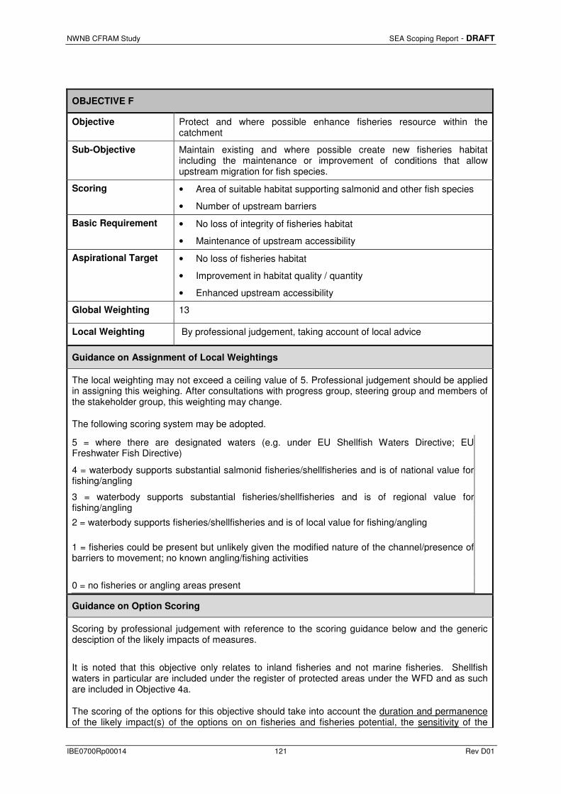
NWNB CFRAM Study SEA Scoping Report - DRAFT
IBE0700Rp00014 121 Rev D01
OBJECTIVE F
Objective Protect and where possible enhance fisheries resource within the catchment
Sub-Objective Maintain existing and where possible create new fisheries habitat including the maintenance or improvement of conditions that allow upstream migration for fish species.
Scoring • Area of suitable habitat supporting salmonid and other fish species
• Number of upstream barriers
Basic Requirement • No loss of integrity of fisheries habitat
• Maintenance of upstream accessibility
Aspirational Target • No loss of fisheries habitat
• Improvement in habitat quality / quantity
• Enhanced upstream accessibility
Global Weighting 13
Local Weighting By professional judgement, taking account of local advice
Guidance on Assignment of Local Weightings
The local weighting may not exceed a ceiling value of 5. Professional judgement should be applied in assigning this weighing. After consultations with progress group, steering group and members of the stakeholder group, this weighting may change.
The following scoring system may be adopted.
5 = where there are designated waters (e.g. under EU Shellfish Waters Directive; EU Freshwater Fish Directive)
4 = waterbody supports substantial salmonid fisheries/shellfisheries and is of national value for fishing/angling
3 = waterbody supports substantial fisheries/shellfisheries and is of regional value for fishing/angling
2 = waterbody supports fisheries/shellfisheries and is of local value for fishing/angling
1 = fisheries could be present but unlikely given the modified nature of the channel/presence of barriers to movement; no known angling/fishing activities
0 = no fisheries or angling areas present
Guidance on Option Scoring
Scoring by professional judgement with reference to the scoring guidance below and the generic desciption of the likely impacts of measures.
It is noted that this objective only relates to inland fisheries and not marine fisheries. Shellfish waters in particular are included under the register of protected areas under the WFD and as such are included in Objective 4a.
The scoring of the options for this objective should take into account the duration and permanence of the likely impact(s) of the options on on fisheries and fisheries potential, the sensitivity of the
NWNB CFRAM Study SEA Scoping Report - DRAFT
IBE0700Rp00014 122 Rev D01
receiving water bodies, and species e.g. salmonid sp. and designated salmonid waters.
Duration is defined in terms of:
• long term; • medium term; • short term.
Permanence is defined in terms of:
• permanent; • recurring; • intermittent.
Sensitive waters include:
• designated salmonid waters
Sensitive species include*:
• Atlantic Salmon • Lamprey • Shad • Pollan • Arctic Char • Smelt
*Based on 2011 IFI National Programme: Habitats Directive and Red Data Book Fish species
Combining positive and negative scores
Instream and bank options have the greatest potential to impact negatively on fisheries, however some options may offer improvements and as such the overall score applied should be a combination of the positive and negative scores with reference to the worst case and best case scores.
Example of combining scores
Option = hard defences and flow diversion
• +2 due to reduction of pollution risk to sensitive water bodies and sensitive species • -2 due to construction stage impacts associated with walls • -5 associated with diversion of flow into another river In this case, the overall score should be ‘-3’, combining the best case positive score and the worst case negative score.
Comparing options
When scoring multiple options for one AFA, it may happen that the options score the same even if they have varying degrees of impact. Professional judgement should be used to ensure that the scores reflect the varying degrees of impact between the options i.e. the scores should be manually adjusted to reflect the different degrees of impact associated with the different options.
Example of manual adjustment
Option 1 = flow diversion
• +2 due to improved fisheries potential as a result of reduction of pollution risk to sensitive water bodies and species
• -5 associated with diversion of flow into another river
Overall score = - 3
Option 2 = flow diversion plus walls
• +2 due to improved fisheries potential as a result of reduction of pollution risk to sensitive water bodies and species
• -2 due to construction stage impacts to sensitive water bodies and species associated with walls
• -4 due to excavation and restoration of natural banks in sensitive water bodies
• -5 associated with diversion of flow into another river

NWNB CFRAM Study SEA Scoping Report - DRAFT
IBE0700Rp00014 123 Rev D01
Overall score = - 3 (combining best case positive score and worst case negative score)
These options score the same even though Option 2 has more negative impacts associated with it. In this example, using professional judgement, Option 2 should be manually adjusted downwards by 1 point to reflect the comparitive difference in impacts between the options. If more than two options are being compared, and all differ in terms of the severity of their likely impacts on this objective, but all score the same using this methodology, the options should be manually adjusted upwards or downwards by a maximum of two points in either direction to reflect the comparitive difference in impacts between the options. Such adjustments will ensure that the overall MCA scores for the options reflect their differing degree of potential impact on this objective and will therefore ensure that this objective will have an influence in terms of the choice of a preferred option. In such cases a clear rationale should be recorded for the adjustment. It should be noted that such adjustments may have a significant impact on the overall MCA score of the preferred option (perhaps up to 10% of the overall MCA score).
Scoring Table
Score Duration of impact Sensitivity Examples
5
Creation of fisheries habitat or removal of barrier to upstream migration for wb where sensitive species are known to be present e.g. salmonids
Any wb Reinstatement of natural hydrological or morphological regime.
4 Creation of fisheries habitat or removal of barrier to upstream migration for wb where other species are present e.g. coarse fish
Any wb Reinstatement of natural hydrological or morphological regime. 3
2 Creation of fisheries potential Any wb Land Use Management
1
0 No change to fisheries potential of the wb Any wb
Measures with no connection to channel, flow, bank side vegetation
-1 Short-term minor impacts to fisheries habitat
Non-sensitive wb Construction phase impacts.
-2 Sensitive wb
-3
Medium to long-term alternation of fisheries habitat
Non-sensitive wb In-stream or on-bank maintenance impacts.
Walls that require excavation and restoration of banks.
Flow diversion within the same river.
Rehabilitation of existing in-stream or on-bank defences.
Dredging
-4 Sensitive wb
-5 Permanent loss or removal of fisheries habitat and / or introduction of barriers to
Any wb Channelisation/realignment.

NWNB CFRAM Study SEA Scoping Report - DRAFT
IBE0700Rp00014 124 Rev D01
upstream migration. Regular dredging.
Extensive culverting.
Tidal barrage.
On-line storage (dams).
Improvement of channel conveyance.
Walls that replace natural banks.
Flow diversion to a different river.
-999 Unacceptable negative impact where feasible alternative exists

NWNB CFRAM Study SEA Scoping Report - DRAFT
IBE0700Rp00014 125 Rev D01
OBJECTIVE G
Objective Protect, and where possible enhance, landscape character and visual amenity within the zone of influence.
Sub-Objective Protect, and where possible enhance, visual amenity, landscape protection zones and views into/from designated scenic areas within the zone of influence.
Scoring 1. Length of waterway corridor qualifying as a landscape protection zone within urban areas
2. Change of quality in existing scenic areas and routes
3. Loss of public landscape amenities
Basic Requirement 1. No significant impact on landscape designation (protected site, scenic route/amenity, natural landscape form) within zone of visibility of measures
2. No significant change in the quality of existing landscape characteristics of the receiving environment
Aspirational Target 1. No change to the existing landscape form
2. Enhancement of existing landscape or landscape feature
Global Weighting 8
Local Weighting By professional judgement, taking account of local advice
Guidance on Assignment of Local Weightings
The local weighting may not exceed a ceiling value of 5. Professional judgement should be applied in assigning this weighing. After consultations with progress group, steering group and members of the stakeholder group, and with the local community, this weighting may change.
Consideration may be given to the following items: • Public use of landscape. • Cultural associations, history and memories
The following scoring system may be adopted.
5 = landscape designated as a internationally/nationally important landscape and potentially affected
4 = landscape character type designated at a county level as highly sensitive and/or exceptional/high value and potentially affected
3 = landscape character type designated at a county level as moderate sensitivity and/or medium value; protected views present that could be affected
2 = landscape character type designated at a county level as low sensitivity and/or low value and potentially affected
1 = no specific landscape sensitivity/value, but landscape features/views are important at a local level and potentially affected
0 = no specific landscape designation, and no landscape value/sensitivity
Guidance on Option Scoring
Scoring should be guided by professional judgement with reference to the scoring guidance below and the generic description of the likely impacts of measures.
The scoring of the options for this objective should take into account the duration and permanence
NWNB CFRAM Study SEA Scoping Report - DRAFT
IBE0700Rp00014 126 Rev D01
of the likely impact(s) of the options on landscape value and the sensitivity of the landscape to change.
Duration is defined in terms of;
• Long term; • Medium term; • Short term.
Permanence is defined in terms of;
• Permanent; • Recurrent; • Intermittent.
Range of Sensitivities include;
• High (International/National); • Moderate (Regional/County/City; • Low (County/City/Local)
Permanence is defined in terms of;
• Permanent; • Recurrent; • Intermittent.
Examples of Sensitive Landscapes include;
• World Heritage Sites (International);
• National Parks (International/National);
• Sensitive/Vulnerable Landscapes (National/Regional/County);
• High Amenity Landscapes/Areas (County);
• Scenic Views/Prospects and Routes (County/Local);
• Sensitive Riverscapes/Seascapes/Streetscapes/Local Amenity Walks (County/City/Local).
Combining Positive and Negative Scores
Constructing hard defences adjacent to watercourses has the potential to impact positively and negatively on landscape. A negative impact may arise from the construction of a visible man-made structure on the opposite bank of a river with a scenic walkway. A positive impact may arise from the removal of invasive species encroaching on the river bank.
+2 due to enhancement of local landscape feature (e.g. removal of invasive vegetative species)
-5 due to construction of hard defence where no defence existed prior
In the above example the overall score should be ‘-3’, combining the best positive score with the worst negative score.
Comparing Options
When scoring multiple options for one AFA, it may happen that the options score the same even if they have varying degrees of impact. Professional judgement should be used to ensure that the scores reflect the varying degrees of impact between the options, i.e. the scores should be manually adjusted to reflect the different degrees of impact associated with the different options.
Example of manual adjustment
Option 1= flood storage
• +1 due to clearance of natural flood storage area
• -1 short term construction stage impacts
• -4 due to change in existing landscape form in the locality
Overall Score = -3 (highest positive added to highest negative)
Option 2 = river morphology changes
• -3 due to construction stage impacts in a riverscape recognised as being of high value in a

NWNB CFRAM Study SEA Scoping Report - DRAFT
IBE0700Rp00014 127 Rev D01
County/City Development Plan
Overall Score = -3
The above options score the same even though Option 2 is more likely to be perceived to have the more significant negative impact arising from the inclusion of the riverscape in a County or City Development Plan. Option 2 should then be manually adjusted downwards by 1 point to reflect the comparative difference in impacts between the options. If more than two options are being compared, and all differ in terms of the severity of their likely impacts on this objective, but all score the same using this methodology, the options should be manually adjusted upwards or downwards by a maximum of 2 points in either direction to reflect the comparative difference between the options.
Scoring Table
Score Duration of Impact Sensitivity Examples
5 Permanent significant enhancement of high sensitivity landscape character/feature in the zone of visibility of the selected measure
High Reinstatement of natural river corridor morphology in a riverscape recognised as being of high value included in a County/City Development Plan
4 Permanent significant enhancement of moderate sensitivity landscape character/feature in the zone of visibility of the selected measure
Moderate Clearance of significant extent of riparian vegetation/man-made obstractions in a river corridor of high landscape/amenity value included in a County/City Development Plan
3 Permanent localised enhancement of high value landscape/feature in the zone of visibility of the selected measure
High Channel widening and deepening at specific location on a watercourse of high landscape value removing risk of flow restriction and visual impacts from blockages with detritus (vegetative/rubbish).
2 Permanent localised enhancement of moderate value landscape character/feature in the zone of visibility of the selected measure
Medium Clearance of local area for use as temporary overland flow storage returning land-use to natural function.
1 Permanent localised enhancement of local sensitivity landscape character/feature in the zone of visibility of the selected measure
Low Removal of artificial visible man-made flow restriction from local amenity view (screens from under bridge on local amenity walk).
0 No change to existing landscape character/feature in the zone of influence of the selected measure
- No change to existing landscape character or features.
-1 Short term impact (construction) on local sensitivity landscape character/feature in the zone of visibility of the selected measure.
Low Construction of extension to local flood embankment prior to establishment of vegetative mitigation (i.e. screening).

NWNB CFRAM Study SEA Scoping Report - DRAFT
IBE0700Rp00014 128 Rev D01
-2 Short term impact (construction) on moderate sensitivity landscape character/feature in the zone of visibility of the selected measure.
Low Construction of significant flood storage area in large area of natural landscape prior to mitigation establishment
-3 Short term impact (construction) on high/moderate value landscape character/feature in the zone of visibility of the selected measure
Medium Re-establishment of natural river corridor morphology in a riverscape recognised as being of high value in a County/City Development Plan
-4 Permanent impact on local/moderate value landscape character/feature in the zone of influence of the selected measure
Medium Construction of permanent hard defences (flood walls) adjacent to a local amenity walkway in a historic garden/demesne
-5 Permanent impact on high value landscape character/feature in the zone of influence of the selected measure
High Construction of tidal barrage in high amenity seascape which is the subject matter of a protected view/prospect
-999 Unacceptable negative impact where feasible options exist
High Site specific.
NWNB CFRAM Study SEA Scoping Report - DRAFT
IBE0700Rp00014 129 Rev D01
OBJECTIVE H (i)
Objective Avoid damage to or loss of features, institutions and collections of cultural heritage importance and their setting, and improve their protection from extreme floods.
Sub-Objective Avoid damage to or loss of features, institutions and collections of architectural value and their setting, and improve their protection from extreme floods where this is beneficial.
Scoring a) The number of architectural features, institutions and collections subject to flooding.
b) The impact of flood risk management measures on architectural features, institutions and collections.
Basic Requirement a) No increase in risk to architectural features, institutions and collections at risk from flooding.
b) No detrimental impacts from flood risk management measures on architectural features, institutions and collections.
Aspirational Target a) Complete removal of all relevant architectural features, institutions and collections from the risk of harm by extreme floods.
b) Enhanced protection and value of architectural features, institutions and collections importance arising from the implementation of the selected measures.
Global Weighting 4
Local Weighting By professional judgement, taking account of local advice
Guidance on Assignment of Local Weightings
The local weighting may not exceed a ceiling value of 5. Professional judgement should be applied in assigning a value to this weighting but some guidance has been provided below. After consultations with progress group, steering group and members of the stakeholder group, this weighting may change.
Reference should be made to the PRFA Methodology for Classifying the Vulnerability of National Monuments from Flooding in the Republic of Ireland (OPW, 2011).
Score Description
5 Internationally important feature(s) (i.e. Structures or sites of sufficient architectural heritage importance to be considered in an international context. These are exceptional structures that can be compared to and contrasted with the finest architectural heritage in other countries) present and potentially affected .
4 Nationally important feature(s) (e.g. Structures or sites that make a significant contribution to the architectural heritage of Ireland. These are structures and sites that are considered to be of great architectural heritage significance in an Irish context) present and potentially affected with a high to moderate vulnerability.
3 A number of sites/features listed on the Record of Protected Structures and/or Recorded by NIAH are present and potentially affected with a high to moderate vulnerability.
2 A number of sites/features listed on the Record of Protected Structures and/or Recorded by NIAH are present and potentially affected with a moderate to low vulnerability.
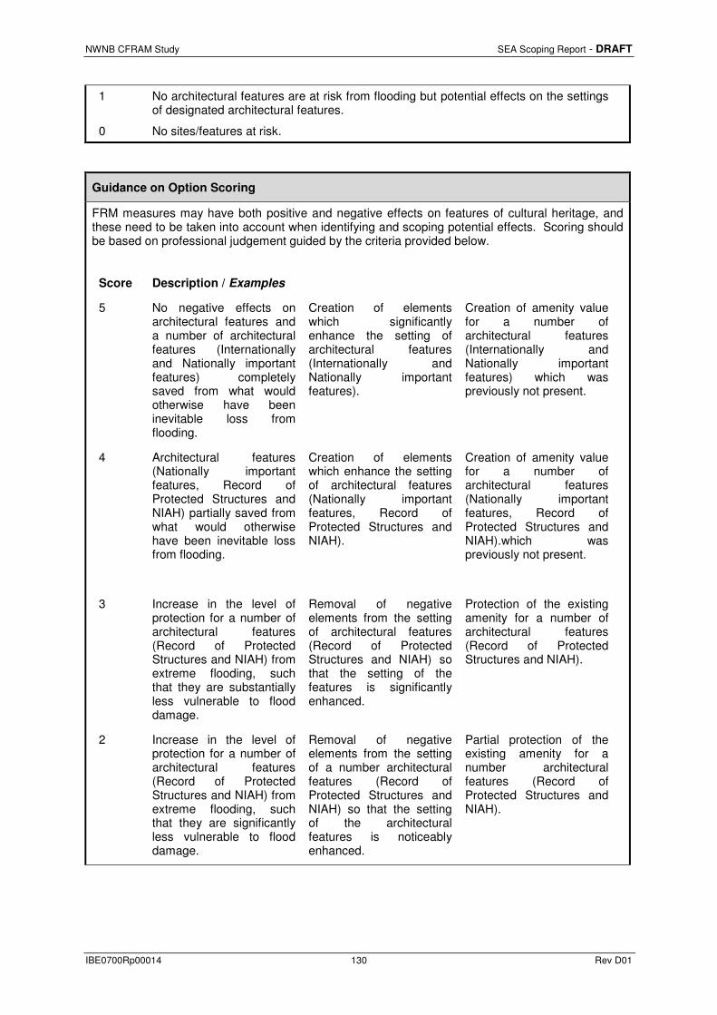
NWNB CFRAM Study SEA Scoping Report - DRAFT
IBE0700Rp00014 130 Rev D01
1 No architectural features are at risk from flooding but potential effects on the settings of designated architectural features.
0 No sites/features at risk.
Guidance on Option Scoring
FRM measures may have both positive and negative effects on features of cultural heritage, and these need to be taken into account when identifying and scoping potential effects. Scoring should be based on professional judgement guided by the criteria provided below.
Score Description / Examples
5 No negative effects on architectural features and a number of architectural features (Internationally and Nationally important features) completely saved from what would otherwise have been inevitable loss from flooding.
Creation of elements which significantly enhance the setting of architectural features (Internationally and Nationally important features).
Creation of amenity value for a number of architectural features (Internationally and Nationally important features) which was previously not present.
4 Architectural features (Nationally important features, Record of Protected Structures and NIAH) partially saved from what would otherwise have been inevitable loss from flooding.
Creation of elements which enhance the setting of architectural features (Nationally important features, Record of Protected Structures and NIAH).
Creation of amenity value for a number of architectural features (Nationally important features, Record of Protected Structures and NIAH).which was previously not present.
3 Increase in the level of protection for a number of architectural features (Record of Protected Structures and NIAH) from extreme flooding, such that they are substantially less vulnerable to flood damage.
Removal of negative elements from the setting of architectural features (Record of Protected Structures and NIAH) so that the setting of the features is significantly enhanced.
Protection of the existing amenity for a number of architectural features (Record of Protected Structures and NIAH).
2 Increase in the level of protection for a number of architectural features (Record of Protected Structures and NIAH) from extreme flooding, such that they are significantly less vulnerable to flood damage.
Removal of negative elements from the setting of a number architectural features (Record of Protected Structures and NIAH) so that the setting of the architectural features is noticeably enhanced.
Partial protection of the existing amenity for a number architectural features (Record of Protected Structures and NIAH).
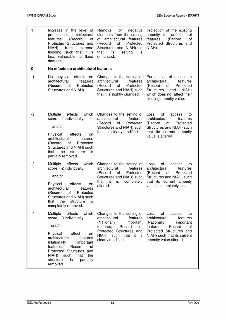
NWNB CFRAM Study SEA Scoping Report - DRAFT
IBE0700Rp00014 131 Rev D01
1 Increase in the level of protection for architectural features (Record of Protected Structures and NIAH) from extreme flooding, such that it is less vulnerable to flood damage.
Removal of negative elements from the setting of architectural features (Record of Protected Structures and NIAH) so that its setting is enhanced.
Protection of the existing amenity for architectural features (Record of Protected Structures and NIAH).
0 No effects on architectural features
-1 No physical effects on architectural features (Record of Protected Structures and NIAH)
Changes to the setting of architectural features (Record of Protected Structures and NIAH) such that it is slightly changed.
Partial loss of access to architectural features (Record of Protected Structures and NIAH) which does not affect their existing amenity value.
-2 Multiple effects which score -1 individually
and/or
Physical effects on architectural features (Record of Protected Structures and NIAH) such that the structure is partially removed.
Changes to the setting of architectural features (Record of Protected Structures and NIAH) such that it is clearly modified.
Loss of access to architectural features (Record of Protected Structures and NIAH) such that its current amenity value is altered.
-3 Multiple effects which score -2 individually
and/or
Physical effects on architectural features (Record of Protected Structures and NIAH) such that the structure is completely removed.
Changes to the setting of architectural features (Record of Protected Structures and NIAH) such that it is completely altered.
Loss of access to architectural features (Record of Protected Structures and NIAH) such that its current amenity value is completely lost.
-4 Multiple effects which score -3 individually
and/or
Physical effect on architectural features (Nationally important features, Record of Protected Structures and NIAH) such that the structure is partially removed.
Changes to the setting of architectural features (Nationally important features, Record of Protected Structures and NIAH) such that it is clearly modified.
Loss of access to architectural features (Nationally important features, Record of Protected Structures and NIAH) such that its current amenity value altered.

NWNB CFRAM Study SEA Scoping Report - DRAFT
IBE0700Rp00014 132 Rev D01
-5 Physical effect on architectural features (Nationally important features, Record of Protected Structures and NIAH) such that the structure is completely removed.
Changes to the setting of architectural features (Nationally important features, Record of Protected Structures and NIAH) such that it is completely altered.
Loss of access to architectural features (Nationally important features, Record of Protected Structures and NIAH) such that its current amenity value is completely lost.
-999 Physical effects on architectural features (Internationally important) such that its Outstanding Universal Value (OUV) is altered.
Effects on the setting of an architectural features (Internationally important) such that its Outstanding Universal Value (OUV) is altered.

NWNB CFRAM Study SEA Scoping Report - DRAFT
IBE0700Rp00014 133 Rev D01
OBJECTIVE H (ii)
Objective Avoid damage to or loss of features, institutions and collections of cultural heritage importance and their setting, and improve their protection from extreme floods.
Sub-Objective Avoid damage to or loss of features, institutions and collections of archaeological value and their setting, and improve their protection from extreme floods where this is beneficial.
Scoring a) The number of archaeological features, institutions and collections subject to flooding.
b) The impact of flood risk management measures on archaeological features, institutions and collections.
Basic Requirement a) No increase in risk to archaeological features, institutions and collections at risk from flooding.
b) No detrimental impacts from flood risk management measures on archaeological features, institutions and collections.
Aspirational Target a) Complete removal of all relevant archaeological features, institutions and collections from the risk of harm by extreme floods.
b) Enhanced protection and value of archaeological features, institutions and collections arising from the implementation of the selected measures.
Global Weighting 4
Local Weighting By professional judgement, taking account of local advice
Guidance on Assignment of Local Weightings
The local weighting may not exceed a ceiling value of 5. Professional judgement should be applied in assigning a value to this weighting but some guidance has been provided below. After consultations with progress group, steering group and members of the stakeholder group, this weighting may change.
Reference should be made to the PRFA Methodology for Classifying the Vulnerability of National Monuments from Flooding in the Republic of Ireland (OPW, 2011).
Score Description
5 Internationally important archaeological feature(s) (i.e. World Heritage Site including those on the tentative list present and potentially affected.
4 Nationally important archaeological feature(s) (e.g. National Monument in State Care, sites on which Preservation Orders or Temporary Preservation Orders have been served) present and potentially affected.
3 A number of sites listed on the RMP/RPS present and potentially affected. (high to moderate vulnerability)
2 A number of sites listed on the RMP/RPS present and potentially affected. (moderate to low vulnerability)
1 Limited potential for effects on the settings of designated archaeological features due to proposed works.
0 No archaeological features at risk.

NWNB CFRAM Study SEA Scoping Report - DRAFT
IBE0700Rp00014 134 Rev D01
Guidance on Option Scoring
FRM measures may have both positive and negative effects on archaeological features, and these need to be taken into account when identifying and scoping potential effects. Scoring should be based on professional judgement guided by the criteria provided below
Score Description / Examples
5 No negative effects on archaeological features,
and,
A number of archaeological features (Recorded Monuments or National Monuments) completely saved from what would otherwise have been inevitable loss from flooding.
Creation of elements which significantly enhance the setting of archaeological features (Recorded Monuments or National Monuments).
Creation of amenity value for a number of archaeological features (Recorded Monuments or National Monuments) which was previously not present.
4 Archaeological features (Recorded Monuments or National Monuments) partially saved from what would otherwise have been inevitable loss from flooding.
Creation of elements which enhance the setting of an archaeological feature (Recorded Monuments or National Monuments).
Creation of amenity value for a number archaeological feature (Recorded Monuments or National Monuments) which was previously not present.
3 Increase in the level of protection for a number of archaeological features (Recorded Monuments) from extreme flooding, such that they are substantially less vulnerable to flood damage.
Removal of negative elements from the setting of archaeological features (Recorded Monuments) so that the setting of the features is significantly enhanced.
Protection of the existing amenity for a number of archaeological features (Recorded Monuments).
2 Increase in the level of protection for a number of archaeological features (Recorded Monuments) from extreme flooding, such that they are significantly less vulnerable to flood damage.
Removal of negative elements from the setting of a number archaeological features (Recorded Monuments) so that the setting of the archaeological features is noticeably enhanced.
Partial protection of the existing amenity for a number of archaeological features (Recorded Monuments).
1 Increase in the level of protection for archaeological features (Recorded Monuments) from extreme flooding, such that it is less vulnerable to flood damage.
Removal of negative elements from the setting of archaeological features (Recorded Monuments) so that it’s setting is enhanced.
Protection of the existing amenity for archaeological features (Recorded Monuments).

NWNB CFRAM Study SEA Scoping Report - DRAFT
IBE0700Rp00014 135 Rev D01
0 No effects on archaeological features
-1 No physical effects on archaeological features (Recorded Monuments or National Monuments)
Changes to the setting of archaeological features (Recorded Monument or National Monument) such that it is slightly changed.
Partial loss of access to archaeological features (Recorded Monuments or National Monuments) which does not affect their existing amenity value.
-2 Multiple effects which score -1 individually
and/or
Physical effects on archaeological features (Recorded Monuments) such that the monument is partially removed.
Changes to the setting of archaeological features (Recorded Monuments) such that it is clearly modified.
Loss of access to archaeological features (Recorded Monuments) such that its current amenity value is altered.
-3 Multiple effects which score -2 individually
and/or
Physical effects on archaeological features (Recorded Monuments) such that the monument is completely removed.
Changes to the setting of archaeological features (Recorded Monuments) such that it is completely altered.
Loss of access to archaeological features (Recorded Monuments) such that its current amenity value is completely lost.
-4 Multiple effects which score -3 individually
and/or
Physical effect on archaeological features (National Monuments) such that the monument is partially removed.
Changes to the setting of archaeological features (National Monuments) such that it is clearly modified.
Loss of access to archaeological features (National Monuments) such that its current amenity value altered.
-5 Physical effect on archaeological features (National Monuments) such that the monument is completely removed.
Changes to the setting of archaeological features (National Monuments) such that it is completely altered.
Loss of access to archaeological features (National Monuments) such that its current amenity value is completely lost.
-999 Physical effects on archaeological features (a World Heritage Site) such that its Outstanding Universal Value (OUV) is altered.
Effects on the setting of an archaeological feature (a World Heritage Site) such that its Outstanding Universal Value (OUV) is altered.

NWNB CFRAM Study SEA Scoping Report - DRAFT
IBE0700Rp00014 136 Rev D01
APPENDIX E
NWNB CFRAM Study Stakeholder List

NWNB CFRAM Study SEA Scoping Report - DRAFT
IBE0700Rp00014 137 Rev D01
Title Name Surname Role Organisation Group/Sector
Stakeholders/External Parties
Primary Stakeholders
Mr Toirleach Gourley Progress group Monaghan County Council
County Council
Mr Paddy Connolly Progress group Louth County Council
County Council
Mr Seamus McLoughlin Progress group Cavan County Council
County Council
Ms Eadaoin Healy Progress group Donegal County Council
WFD Co-ordinator
Mr Donal Murphy Progress group Donegal County Council
County Council
Mr Brendan McKenna Progress group Leitrim County Council
County Council
Ms Fiona Fallon Progress group Meath County Council
County Council
Mr Tom Murtagh Progress group Longford County Council
County Council
Mr Tom Kilfeather Progress group Sligo County Council
County Council
Mr Padraig Maguire Progress group Monaghan County Council
Local Government
Mr Jimmy Murphy Progress group Rivers Agency, NI
State agency or body
Mr Lawlor Loughs Agency State agency or body
Ms Margaret Gowley NIEA State agency or body
Relevant State Bodies
Ms Bernie Kiely Department of Environment, Community and Local Government (DECLG)
Government department
Ms Lorraine O’Donoghue Principal Officer Marine Planning and
Department of Environment, Community and
Government department

NWNB CFRAM Study SEA Scoping Report - DRAFT
IBE0700Rp00014 138 Rev D01
Title Name Surname Role Organisation Group/Sector
Foreshore Local Goverment
Mr PJ Shaw Water Advisor (Foreshore)
Department of Environment, Community and Local Goverment
Government department
Mr Sean Hogan National Director for Fire Emergency Management
Department of Environment, Community and Local Goverment
Government department
Mr William Cormacan Divisional ecologist
National Parks and Wildlife Service
State agency or body
Ms Judit Kelemen Regional Manager
National Parks and Wildlife Service
State agency or body
Mr Peter Cafferkey Nitrates, Biodiversity and Engineering Division
Department of Agriculture, Food and the Marine
Government department
Mr Peter Carvill Secretary of State
Department of Arts, Heritage and Gaeltacht Affairs
Government department
Mr Freddie O'Dwyer Department of Arts, Heritage and Gaeltacht Affairs (Built Heritage and Architectural Policy)
Government department
Mr Catherine Desmond Department of Arts, Heritage and the Gaeltacht (National Monuments Service)
State agency or body
Dr Margaret Fitzgerald Director of Public Health
Health Service Executive (HSE)
State agency or body
Mr Peter Smyth North East region - Estates
Health Service Executive (HSE)
State agency or body
Mr Owen Doyle Bord Iascaigh Mhara (BIM)
State agency or body
Mr Liam Keegan Met Eireann State agency
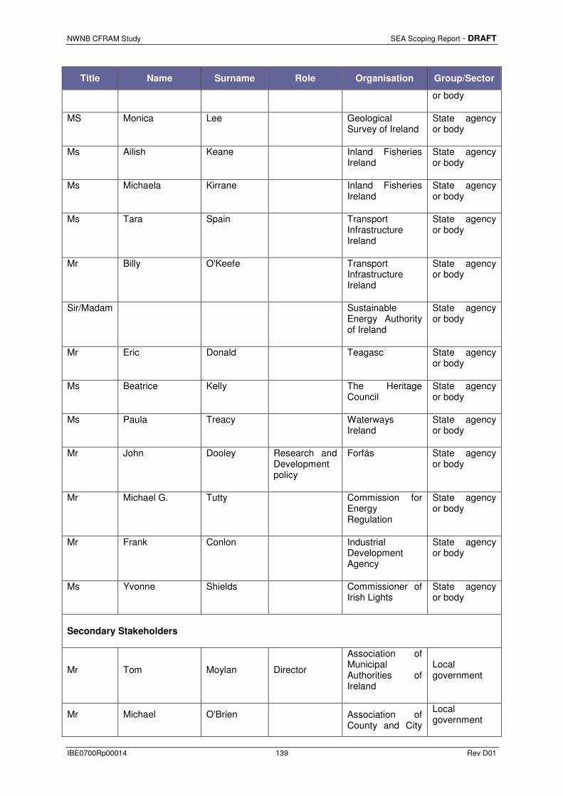
NWNB CFRAM Study SEA Scoping Report - DRAFT
IBE0700Rp00014 139 Rev D01
Title Name Surname Role Organisation Group/Sector
or body
MS Monica Lee Geological Survey of Ireland
State agency or body
Ms Ailish Keane Inland Fisheries Ireland
State agency or body
Ms Michaela Kirrane Inland Fisheries Ireland
State agency or body
Ms Tara Spain Transport Infrastructure Ireland
State agency or body
Mr Billy O'Keefe Transport Infrastructure Ireland
State agency or body
Sir/Madam Sustainable Energy Authority of Ireland
State agency or body
Mr Eric Donald Teagasc State agency or body
Ms Beatrice Kelly The Heritage Council
State agency or body
Ms Paula Treacy Waterways Ireland
State agency or body
Mr John Dooley Research and Development policy
Forfás State agency or body
Mr Michael G. Tutty Commission for Energy Regulation
State agency or body
Mr Frank Conlon Industrial Development Agency
State agency or body
Ms Yvonne Shields Commissioner of Irish Lights
State agency or body
Secondary Stakeholders
Mr Tom Moylan Director
Association of Municipal Authorities of Ireland
Local government
Mr Michael O'Brien Association of County and City
Local government

NWNB CFRAM Study SEA Scoping Report - DRAFT
IBE0700Rp00014 140 Rev D01
Title Name Surname Role Organisation Group/Sector
Councils
Mr Sean Murphy Chambers Ireland
Representative body
Sir/Madam Cavan County Development Board
Development Board
Sir/Madam Donegal County Development Board
Development Board
Sir/Madam Meath County Development Board
Development Board
Sir/Madam Leitrim County Development Board
Development Board
Sir/Madam Louth County Development Board
Development Board
Sir/Madam Longford County Development Board
Development Board
Sir/Madam Sligo County Development Board
Development Board
Ms Edel Crummey Coillte Commercial (state)
Ms Sinead O'Brien Sustainable Water Network (SWAN)
NGO
Mr Eamon Moore SWAN / An Taisce NGO
Mr Michael Eweing
Environmental Pillar & Irish Environment Network
NGO
Ms Tina Aughney Bat Conservation Ireland NGO
Ms Siobhan Egan BirdWatch Ireland NGO
Ms Helen Boland BirdWatch Ireland NGO

NWNB CFRAM Study SEA Scoping Report - DRAFT
IBE0700Rp00014 141 Rev D01
Title Name Surname Role Organisation Group/Sector
Mr Joe Shannon BirdWatch Ireland NGO
Ms Karin Dubksy Coastwatch NGO
Ms Caroline Lewis Irish Natural Forestry Foundation
NGO
Mr Tadhg O'Corcora Irish Peatland Conservation Council
NGO
Ms Fiona Lynch Irish Seal Sanctuary NGO
Mr Padraic Fogarty Irish Wildlife Trust NGO
Mr Barry Kavanagh Irish Wildlife Trust NGO
Ms Linda Lawlor Native Woodland Trust NGO
Ms Bernie Barrett Badgerwatch NGO
Sir/Madam Irish Water and Fish Preservation Society
NGO
Ms Mary Keenan Tree Council of Ireland NGO
Ms Eanna Ni Lamhna President Tree Council of Ireland NGO
Mr James Tallon Mills and Millers of Ireland NGO
Mr Charles Doherty Royal Society of Antiqueries of Ireland
NGO
Ms Jean Kennedy
Inland Waterways Association of Ireland
NGO
Mr Gerry Gunning Irish Farmers Association
Representative body
Mr Bert Stewart Monaghan County Chairman
Irish Farmers Association
Representative body
Ms Mary Buckley Irish Creamery Milk Suppliers Representative

NWNB CFRAM Study SEA Scoping Report - DRAFT
IBE0700Rp00014 142 Rev D01
Title Name Surname Role Organisation Group/Sector
Association (ICMSA)
body
Mr Cecil Fairman
Irish Creamery Milk Suppliers Association (ICMSA)
Representative body
Mr Terry O'Regan Landscape Alliance Ireland
Representative body
Mr Mark Fielding
Irish Small and Medium Enterprises Association (ISME)
Representative body
Mr Caroline Spillane Director General Engineers Ireland Representative
body
Mr Robert Butler Construction Industry Federation
Representative body
Mr Gerry Farrell Irish Concrete Federation
Representative body
Mr Ger Loughlin Irish Residential Boat Owners Association
Representative body
Mr Michael Callaghan National Anglers Representative Association
Representative body
Mr Paddy Byrne Recreational Angling Ireland
Special interest amenity group
Mr John Carroll
Federation of Irish Salmon and Sea Trout Anglers
Special interest amenity group
Mr Noel Carr Secretary
Federation of Irish Salmon and Sea Trout Anglers
Special interest amenity group
Mr Hugh L O'Rourke National Secretary
Irish Federation of Sea Anglers
Special interest amenity group
Mr Brian Cooke Irish Federation of Sea Anglers
Special interest amenity group

NWNB CFRAM Study SEA Scoping Report - DRAFT
IBE0700Rp00014 143 Rev D01
Title Name Surname Role Organisation Group/Sector
Mr Hugh O'Rourke Irish Federation Sea Anglers
Special interest amenity group
Mr Martin Corcoran Rowing Ireland Special interest amenity group
Mr Stuart McGrane Trout Angling Federation of Ireland
Special interest amenity group
Mr Dermot Casey Coarse Angling Federation of Ireland
Special interest amenity group
Mr Richard Caplice Irish Angling Development Alliance
Special interest amenity group
Mr Peter Walsh Irish Angling Development Alliance
Special interest amenity group
Mr Francis Walsh Eircom
Mr Paul Lennon Integrity Bord Gáis Networks
Service provider (state)
Mr Liam P O'Riordan
Conceptual planning. Note that the compant secretary is also called Liam O'Riordan.
Bord Gáis Networks
Service provider (state)
Mr Paul Mallee Chairperson of the Board Bus Eireann Service
provider (state)
Mr Jane Cregan Iarnród Eireann Service provider (state)
Sir/Madam Ballybay Angling Association Interest Group
Mr Colin McKenna Irish Central Border Area Network
Cllr Pat Treanor Irish Central Border Area Network
Ms Chris McCarney Blackwater Regional

NWNB CFRAM Study SEA Scoping Report - DRAFT
IBE0700Rp00014 144 Rev D01
Title Name Surname Role Organisation Group/Sector
Partnership
Ms Dan Curley Blackwater Regional Partnership
Mr. John Bourke
National Organisation of Regional Game Councils
Representative body
Mr Flor Harrington Irish Shellfish Association
Representative body
Mr Joe Lee Irish Salmon Growers’ Association Ltd.
Representative body
Sir/Madam Sea Fisheries Protection Authority
Representative body
Sir/Madam Dundalk Port
Sir/Madam Greenore Port
Sir/Madam Killybegs Harbour
Mr Martin Connell Killybegs Harbour
Mr Tony McNally FWPM Project
Sir/Madam Irish Countrywomen's Association
Mr Bill McCann Harbour Master
Londonderry Port and Harbour (NI agency)