Northern Planning Committee Agenda
78
Please Contact: Gaynor Hawthornthwaite 01270 686467 E-Mail: [email protected] with any apologies or request for further information [email protected] to arrange to speak at the meeting Northern Planning Committee Agenda Date: Wednesday, 1st June, 2016 Time: 10.00 am Venue: The Capesthorne Room - Town Hall, Macclesfield SK10 1EA Please note that members of the public are requested to check the Council's website the week the Northern Planning Committee meeting is due to take place as Officers produce updates for some or all of the applications prior to the commencement of the meeting and after the agenda has been published. The agenda is divided into 2 parts. Part 1 is taken in the presence of the public and press. Part 2 items will be considered in the absence of the public and press for the reasons indicated on the agenda and at the foot of each report. PART 1 – MATTERS TO BE CONSIDERED WITH THE PUBLIC AND PRESS PRESENT 1. Apologies for Absence To receive any apologies for absence. 2. Declarations of Interest/Pre Determination To provide an opportunity for Members and Officers to declare any disclosable pecuniary and non-pecuniary interests and for Members to declare if they have a pre- determination in respect of any item on the agenda. 3. Minutes of the Meeting (Pages 1 - 10) To approve the Minutes as a correct record.
Transcript of Northern Planning Committee Agenda

Please Contact: Gaynor Hawthornthwaite 01270 686467E-Mail: [email protected] with any apologies or
request for further [email protected] to arrange to speak at the meeting
Northern Planning CommitteeAgenda
Date: Wednesday, 1st June, 2016Time: 10.00 amVenue: The Capesthorne Room - Town Hall, Macclesfield SK10 1EA
Please note that members of the public are requested to check the Council's website the week the Northern Planning Committee meeting is due to take place as Officers produce updates for some or all of the applications prior to the commencement of the meeting and after the agenda has been published.
The agenda is divided into 2 parts. Part 1 is taken in the presence of the public and press. Part 2 items will be considered in the absence of the public and press for the reasons indicated on the agenda and at the foot of each report.
PART 1 – MATTERS TO BE CONSIDERED WITH THE PUBLIC AND PRESS PRESENT
1. Apologies for Absence
To receive any apologies for absence.
2. Declarations of Interest/Pre Determination
To provide an opportunity for Members and Officers to declare any disclosable pecuniary and non-pecuniary interests and for Members to declare if they have a pre-determination in respect of any item on the agenda.
3. Minutes of the Meeting (Pages 1 - 10)
To approve the Minutes as a correct record.

4. Public Speaking
A total period of 5 minutes is allocated for each of the planning applications for the following:
Ward Councillors who are not members of the Planning Committee The relevant Town/Parish Council
A period of 3 minutes is allocated for each of the planning applications for the following individuals/groups:
Members who are not members of the planning committee and are not the Ward Member
Objectors Supporters Applicants
5. 16/1560M - Ned Yates Nurseries, Moor Lane, Wilmslow, Cheshire SK9 6DN: Erection of 14 no. dwellings with associated access and infrastructure for Elan Homes (Pages 11 - 26)
To consider the above application.
6. 15/2354M - Bowling Green, Ingersley Vale, Bollington, Cheshire: Outline application for proposed 11 no. 2.5 storey and 2 no. 2 storey residential housing - resubmission of 15/0669M for Tullis Russell (Pages 27 - 40)
To consider the above application.
7. 15/5668M - 20 Chapel Lane, Wilmslow, Cheshire SK9 5HX: Demolition of 2 existing dwellings on 20 & 18a Chapel Lane and erection of block containing 12 apartments for Mr Craig Ainscough, Eventus Properties Limited (Pages 41 - 54)
To consider the above application.
8. 15/5800M - Brickyard Farm, 25 Adlington Road, Wilmslow, Cheshire SK9 2BJ: Proposed 2 storey extension to existing farm house, erection of 3 number 2 storey detached properties & associated works for Mr Chris Williamson, David Wilson Homes North West / Mrs Margaret Cooke (Pages 55 - 66)
To consider the above application.
9. 15/3259M - 75 Lacey Green, Wilmslow, Cheshire SK9 4BG: Construction of one detached dwelling with new access for A Chesworth (Pages 67 - 76)
To consider the above application.

CHESHIRE EAST COUNCIL
Minutes of a meeting of the Northern Planning Committeeheld on Wednesday, 4th May, 2016 at Meeting Room, Macclesfield Library,
Jordangate, Macclesfield
PRESENT
Councillor G M Walton (Chairman)Councillor C Browne (Vice-Chairman)
Councillors C Andrew, M Beanland, E Brooks, S Edgar (Substitute), T Fox, M Hardy, A Harewood, L Jeuda and N Mannion
OFFICERS
Adam Barnes (Senior Planning Officer)Patricia Evans (Senior Planning and Highways Lawyer)Peter Hooley (Planning and Enforcement Manager)Neil Jones (Principal Development Officer – Highways)Gaynor Hawthornthwaite (Democratic Services Officer)
110 APOLOGIES FOR ABSENCE
Apologies were received from Councillors S Gardiner, S Gardner,G Hayes, O Hunter and J Macrae.
111 DECLARATIONS OF INTEREST/PRE DETERMINATION
Councillor G Walton reported that with reference to the application 15/1886M site visit that was held on Friday 29th April, concern had been raised regarding the Ward Member’s comments on the application. Councillors G Walton, C Browne, N Mannion, T Fox and A Harewood declared that any comments that they might have heard on the site visit most certainly had not influenced any views that they had and as such, had kept an open mind.
Councillor E Brooks declared that she had pre-determined application number 15/1886M and would, therefore, withdraw from the meeting and take no part in the discussion or voting on this application.
It was noted that Members of the Committee had received associated correspondence in respect of application number 15/4117M and 15/4854M. Members of the Committee had also received telephone calls from McCarthy and Stone Retirement Lifestyles in respect of application number 15/4854M, but nothing had influenced their views and had kept an open mind.
Councillor G Walton declared that he had called in application number 15/4117M which was in his Ward. He would, therefore, vacate the Chair

for the consideration of this application. He would speak as the Ward Member and would not take part in the debate or vote.
With regard to application number 15/5807M Councillor G Walton declared that he was the Ward Member and would, therefore, vacate the Chair for the consideration of this application. He would speak as the Ward Member and then withdraw from the meeting.
In the interests of openness, Councillor C Browne declared that with regard to application number 15/4117M he had an acquaintance with one of the neighbours as a Governor of Wilmslow High School about 8 years ago, but this had not influenced his decision in any way and as such, had kept an open mind.
With regard to application 15/4117M Councillor M Hardy declared that in the interests of openness he knew one of the objectors. He had not discussed this application and had kept an open mind.
Mr P Hooley, Planning and Enforcement Manager, confirmed that he has had no involvement in application 15/5807M and declared a personal interest on the grounds that the applicant is known to him and would, therefore, leave the room prior to consideration of the application.
112 MINUTES OF THE MEETING
That the minutes of the meeting held on 6th April 2016 be approved as a correct record and signed by the Chairman.
113 PUBLIC SPEAKING
That the public speaking procedure be noted.
114 15/1886M - WITHINLEE HOLLOW, WITHINLEE ROAD, MOTTRAM ST ANDREW, MACCLESFIELD, CHESHIRE SK10 4AT: THE ERECTION OF A SINGLE CONTEMPORARY 2 STOREY 4 BEDROOM DWELLING WITH EXTERNAL UNDERGROUND GARAGE AND CENTRAL COURTYARD, ALL SITUATED IN A NORTHEAST - SOUTHWEST SETTING WITHIN A 0.831 ACRE (3,364M2) SLOPING PLOT. THE PRINCIPLE LIVING AREAS ARE LOCATED ON THE FIRST FLOOR (AT GROUND LEVEL) AND BEDROOMS AND HOME LEISURE SPACES ARE LOCATED WITHIN THE SUB-LEVEL (BELOW GROUND LEVEL) FOR CARL DAVIS, LINGFIELD HOMES & PROPERTY DEVELOPMENT LTD
Prior to consideration of this application, as stated in her declaration, Councillor E Brooks left the meeting and returned following consideration of the application.
The Planning and Enforcement Manager reported a correction to the fourth paragraph on page 16 which should read:

“However, it is important to reiterate at paragraph 60 of the NPPF:
‘…decisions should not attempt to impose architectural styles or particular tastes and they should not stifle innovation, originality or initiative through unsubstantiated requirements to conform to certain development forms or styles.’ “
(Councillor P Findlow (Ward Member), Councillor T Jackson (on behalf of Prestbury Parish Council), Mr P Yates (Objector), Mr C Davies and Mr D Roberts (on behalf of the Applicant) attended the meeting and spoke in respect of the application)
The Committee considered a report, written and verbal updates regarding the above application.
RESOLVED
That, contrary to the Planning Officer’s recommendation for approval, the application be REFUSED for the following reasons:
1. Contrary to Low Density Housing Policy2. Highways safety (substandard visibility at access point onto
Withinlee Road)
115 15/4117M - LAND ADJACENT TO HIGHLANDS, CONGLETON ROAD, ALDERLEY EDGE, CHESHIRE SK9 7AD: CONSTRUCTION OF ONE PART TWO-STOREY, PART THREE-STOREY DETACHED INFILL DWELLING WITH DETACHED GARAGE, NEW ACCESS AND LANDSCAPING FOR MR AND MRS N MCGUINESS
Having made a declaration, Councillor G Walton vacated the Chair in favour of the Vice-Chairman and did not take part in the debate or vote.
(Councillor G Walton (Ward Member), Mr M Toulmin (Objector) and Mr R Gascoigne (on behalf of agent) attended the meeting and spoke in respect of the application)
The Committee considered a report regarding the above application.
RESOLVED
That, contrary to the Planning Officer’s recommendation for approval, the application be REFUSED for the following reasons:
Inappropriate development in the Green Bet and impact on openness (not considered to be infilling in village under para 89 of NPPF)

116 15/4854M - 2-6 HOLLY ROAD NORTH, WILMSLOW, CHESHIRE: ERECTION OF RETIREMENT LIVING HOUSING (CATEGORY II TYPE ACCOMMODATION), COMMUNAL FACILITIES, LANDSCAPING AND CAR PARKING FOR MCCARTHY AND STONE RETIREMENT LIFESTYLES
The Planning and Enforcement Manager read out a representation from Councillor R Menlove (Ward Member) who was unable to attend the meeting.
Mr C Butt (on behalf of agent) attended the meeting and spoke in respect of the application)
The Committee considered a report and written update regarding the above application.
RESOLVED
That for the reasons set out in the report, the application be APPROVED subject to:
Minor revisions to the plans and materials proposed in order to improve the design of the building from the street scene
A Section 106 Agreement to secure the off site provision of affordable housing
And the following conditions:
1. Development in accord with approved plans2. Landscaping - submission of details3. Tree retention4. Tree protection5. Commencement of development (3 years)6. Construction specification/method statement7. Landscaping (implementation)8. Tree pruning / felling specification9. Details of materials to be submitted10.Protection for breeding birdsLevels survey11.Additional landscaping details required- Boundary treatment12.Obscure glazing requirement13.Protection of highway from mud and debris14.Submission of construction method statement

15.Sustainable drainage scheme16.Scheme for the managment and maintenance of surface water17.Scheme for Dust Control during construction18.Scheme for pile driving to be submitted19.Scheme for cycle storage to be provided20.Car parking layout to be submitted and agreed21.Floor Floating22.Surface water drainage scheme to be submitted23.Drainage to be put on a seperate system24.Electric vehcile charging points to be provided25.Details of balcony screens measuing 1.8m to be provided26.Refuse facilities to be approved27.Storage of mobility scooters28.Submission of operational plan29.Maximum number of units of 3030.Hours of construction
In order to give proper effect to the Committee’s intentions and without changing the substance of the decision, authority is delegated to the Planning and Enforcement Manager, in consultation with the Chairman (or in his absence the Vice Chair) of Northern Planning Committee to correct any technical slip or omission in the wording of the resolution, between approval of the minutes and issue of the decision notice.
Following consideration of this application, Councillor M Beanland left the meeting and did not return.
The meeting adjourned for lunch from 13.00 pm until 13.30 pm.
117 16/0604C - LAND ADJACENT TO PADGATE, TWEMLOW LANE, CRANAGE: RESIDENTIAL DEVELOPMENT OF 4NR DETACHED DWELLINGS (4/5 BED) AND 1NR COTTAGE MEWS BLOCK OF 5 DWELLINGS (1BED FLAT; 2/3 BED HOUSES) INCLUSIVE OF ASSOCIATED EXTERNAL WORKS AND LANDSCAPING FOR MR MATTHEW POCHIN, BOOTS GREEN PROPERTIES LIMITED
(Councillor A Kolker had not registered his intention to address the Committee as the Ward Member. However, in accordance with paragraph 2.8 of the public speaking rights at Strategic Planning Board and Planning Committee meetings, the Chairman agreed to allow Councillor Kolker to speak)

Councillor L Dooley (on behalf of Cranage Parish Council) attended the meeting and spoke in respect of the application. Ms S Gabbidon (on behalf of the Applicant) had registered to speak, but was unable to attend the meeting.
The Committee considered a report regarding the above application.
RESOLVED
That authority be DELEGATED to the Planning and Enforcement Manager in Consultation with the Chairman and Vice-Chairman of Northern Planning Committee to APPROVE the application for the reasons set out in the report, subject to completion of a Section 106 legal agreement to secure:
Confirmation from the Council’s Education Department of any contributions required.
A 21 day notification period to Jodrell Bank (Manchester University) of the intent to grant planning permission; and
A Section 106 Agreement to secure the provision of three on-site affordable dwellings – to be split as per IPS into two Affordable Rent and one for Intermediate Tenure
And the following conditions:
1. Time – 2 years2. In accordance with approved plans3. Materials – Prior submission/approval4. Site drained on a separate system5. Prior approval of a surface water drainage and maintenance plan6. Prior approval of a Flood Risk Assessment7. Prior approval of a Piling Method Statement8. Prior approval of a dust mitigation scheme9. Prior approval of soil testing results for imported material10.Works to stop if contamination encountered11.Prior approval of a scheme for Archaeological works12.Prior approval of a Landscaping scheme13.Landscaping – Implementation14.Prior approval of tree/hedgerow protection15.Prior approval of a ‘No dig’ method statement of any areas of hard
surfacing in tree root protection areas16.Prior approval of boundary treatment17. Implementation of protected species mitigation18.Prior approval of Electromagnetic Screening19.Removal of PD Rights: Classes A-E, Part 1, Schedule 2 on Plot 9 only
and Class A, Part 2, Schedule 2 for the entire site20.Completion of a Section 278 for road widening prior to commencement
of development.21.Construction Management Plan22.Gable ends

23.Visibility splays to be maintained within site24.Tree landscaping
In order to give proper effect to the Committee’s intentions and without changing the substance of the decision, authority is delegated to the Planning Manager (Regulation) in consultation with the Chair (or in there absence the Vice Chair) of the Southern Planning Committee, to correct any technical slip or omission in the wording of the resolution, between approval of the minutes and issue of the decision notice.
Should the application be subject to an appeal approval is given to enter into a S106 Agreement to secure the following Heads of Terms:
Provision of 3 on-site affordable dwellings - to be split as per IPS into 2 Affordable Rent and 1 for Intermediate Tenure
Following consideration of this application, Councillor M Hardy left the meeting and did not return.
118 14/5667M - THE TRUSTEE'S OF WILMSLOW CONGREGATION OF JEHOVAH'S WITNESSES, 48, KNUTFSFORD ROAD, CHORLEY, ALDERLEY SK9 7SF: DEMOLITION OF EXISTING BUILDING AND OUT-BUILDINGS AND CONSTRUCTION OF NEW PLACE OF CHRISTIAN WORSHIP TO REPLICATE EXISTING BUILDING FOR THE TRUSTEES OF WILMSLOW CONGREGATION OF JEHOVAH'S WITNESSES
(Mr M Steele (on behalf of the Applicant) attended the meeting and spoke in respect of the application)
The Committee considered a report regarding the above application.
RESOLVED
That for the reasons set out in the report the application be APPROVED subject to the following conditions:
1. Commencement of development (3 years)2. Development in accord with approved plans3. Submission of samples of building materials4. Landscaping - submission of details5. Landscaping (implementation6. Provision of car parking7. Construction of access8. Protection from noise during construction (hours of construction)

9. IWorks within the public highway10.Contaminated Land11.Contamination12.Piling13.Dust management14.External Lighting15.Contamination note16.NPPF17.Construction Management Plan18.Re-use of materials from existing building.
119 15/5807M - CHELFORD GARAGE, ALDERLEY ROAD, CHELFORD, MACCLESFIELD, CHESHIRE SK11 9AP: REMOVAL OF EXISTING BELOW GROUND FUEL STORAGE TANKS AND INSTALLATION OF 2 NO NEW 60,000 LITRE DOUBLE SKIN BELOW GROUND STORAGE TANKS. REMOVAL OF EXISTING FORECOURT CANOPY AND INSTALLATION OF NEW AT INCREASED CLEAR HEIGHT OF 4.5 METRES MIN. FORECOURT REINSTATEMENT INCLUDING NEW PUMP ISLANDS AND PUMPS. REPLACEMENT TANK VENT STACK AND RE-LOCATION OF AIR/WATER MACHINE. 3 NO. NEW CAR PARKING PLACES FOR SHELL UK RETAIL
Having made a declaration, Councillor G Walton vacated the Chair in favour of the Vice-Chairman and did not take part in the debate or vote.
Prior to consideration of this application, as stated in his declaration, Mr P Hooley left the meeting and did not return.
Prior to consideration of this application, as stated in his declaration, Councillor G Walton spoke as the Ward Member and then left the meeting and did not return.
The Committee considered a report and verbal update regarding the above application.
RESOLVED
That for the reasons set out in the report the application be APPROVED subject to the following conditions:
1. Commencement of development (3 years)2. Development in accord with approved plans3. Protection from noise during construction (hours of construction)4. Pile Driving

5. Contamination Report6. Contamination7. NPPF
In order to give proper effect to the Committee’s intentions and without changing the substance of the decision, authority is delegated to the Head of Planning and Regulation, in consultation with the Chair (or in his absence the Vice Chair) of Northern Planning Committee, to correct any technical slip or omission in the wording of the resolution, between approval of the minutes and issue of the decision notice.
Should this application be the subject of an appeal, authority be delegated to the Planning and Place Shaping Manager in consultation with the Chairman of the Northern Planning Committee to enter into a planning agreement in accordance with the S106 Town and Country Planning Act to secure the Heads of Terms for a S106 Agreement.
The meeting commenced at 10.00 am and concluded at 2.10 pm
Councillor G M Walton (Chairman)


Application No: 16/1560M
Location: NED YATES NURSERIES, MOOR LANE, WILMSLOW, CHESHIRE, SK9 6DN
Proposal: Erection of 14 no. dwellings with associated access and infrastructure
Applicant: Elan Homes
Expiry Date: 01-Jul-2016
REASON FOR REPORT
The application is a major development that requires a committee decision.
SUMMARYThe application site is a previously developed site in the Green Belt and the proposal is not considered to have a greater impact on openness of the Green Belt or the purpose of including land in the Green Belt than the existing development. The proposal is therefore an appropriate form of development in the Green Belt. The Council cannot demonstrate a 5 year supply of deliverable housing sites and therefore the presumption in favour of sustainable development at paragraph 14 of the Framework applies where it states that LPAs should grant permission unless any adverse impact of doing so would significantly and demonstrably outweigh the benefits from it, when assessed against the Framework as a whole; or specific policies in the Framework indicate development should be restricted.
The benefits in this case are:• The development would provide benefits in terms of much needed market housing which would help in the Councils delivery of 5 year housing land supply.• The development would make financial contributions to public open space in the local area.• The development would provide economic benefits through the provision of employment during the construction phase, new homes and benefits for local businesses.• The proposals would result in a reduction in vehicle movements and levels of commercial activity, which would be a benefit local residents
The development would have a neutral impact upon the following subject to mitigation:• The impact upon ecology and trees is considered to be neutral subject to the imposition of conditions.• There is not considered to be any significant drainage implications raised by this development.
The adverse impacts of the proposal include:

• The proposed development would be more visible from surrounding vantage points than the existing, however this would result in only very limited harm to the character of the area, and proposed landscaping would provide suitable mitigation. • There would be a loss of employment in the local area due to the relocation of the existing businesses
The comments received in representation relating to material planning considerations have been considered in the preceding text. However, on the basis of the above, it is considered that the proposal represents sustainable development and paragraph 14 is engaged. Furthermore, applying the tests within paragraph 14 it is considered that the adverse effects of the scheme are significantly and demonstrably outweighed by the benefits. Accordingly the application is recommended for approval subject to conditions and the Heads of Terms listed in the report. However, as noted above in order to allow time for the updated bat surveys to be completed, it is recommended that the application is delegated back to officers in consultation with the Chairman for approval.
RECOMMENDATION Delegate back to Planning & Enforcement Manager in consultation with the Chairman to approve subject to conditions and a Section 106 agreement
PROPOSAL
This application seeks full planning permission for the construction of 14 no. dwellings with associated access and infrastructure. SITE DESCRIPTION
The application site comprises a number of buildings and structures associated with Ned Yates Garden Centre (with retail shop and restaurant), Jacques Landscaping, and a car repair business, along with areas of hardstanding, storage and car parking associated with those uses. The site is located within the Green Belt as identified in the Macclesfield Borough Local Plan.
RELEVANT HISTORY
No history relevant to the current proposal.
NATIONAL & LOCAL POLICY
National PolicyThe National Planning Policy Framework establishes a presumption in favour of sustainable development. Of particular relevance are paragraphs:14. Presumption in favour of sustainable development.50. Wide choice of quality homes56-68 Requiring good design
69-78 Promoting healthy communities89. Green Belt
Development PlanThe Development Plan for this area is the 2004 Macclesfield Borough Local Plan. The relevant Saved Polices are:Macclesfield Borough Local Plan PolicyNE11 Nature conservation interestsBE1 Design GuidanceGC1 Green BeltRT7 Cycleways, Bridleways and FootpathsH1 Housing requirementH2 Environmental Quality in Housing DevelopmentsH8 Provision of Affordable HousingH13 Protecting Residential Areas; DC1 Design criteria for new buildDC3 Amenities of residential propertyDC5 Design – natural surveillanceDC6 Circulation and AccessDC8 LandscapingDC35 Materials and FinishesDC36 Road layouts and circulationDC37 Landscaping in housing developmentsDC38 Space, light and PrivacyDC40 Childrens Play Provision and Amenity SpaceDC63 Contaminated land
Cheshire East Local Plan Strategy – Proposed Changes VersionRelevant policies of this document are:MP1 Presumption in favour of sustainable developmentPG1 Overall Development StrategyPG2 Settlement hierarchyPG6 Spatial Distribution of DevelopmentSD1 Sustainable Development in Cheshire EastSD2 Sustainable Development PrinciplesIN1 InfrastructureIN2 Developer contributionsSC1 Leisure and RecreationSC2 Outdoor sports facilitiesSC3 Health and Well-beingSC4 Residential MixSC5 Affordable HomesSE1 DesignSE2 Efficient use of landSE3 Biodiversity and geodiversitySE4 The LandscapeSE5 Trees, Hedgerows and WoodlandSE6 Green InfrastructureSE9 Energy Efficient Development
SE12 Pollution, Land contamination and land instabilitySE13 Flood risk and water managementCO1 Sustainable Travel and Transport CO4 Travel plans and transport
Supplementary Planning Documents:Interim Planning Statement: Affordable Housing (Feb 2011)National Planning Practice GuidanceSPG Planning Obligations
CONSULTATIONS
Head of Strategic Infrastructure - No objections
Environmental Health - No objections subject to conditions relating to dust control, electric vehicle charging and contaminated land.
Housing - No objections subject to 30% affordable provision
ANSA – Comments not received at time of report preparation
Education – Comments not received at time of report preparation Public Rights of Way – No objections
Flood Risk Manager - Comments not received at time of report preparation
United Utilities - No objections subject to conditions relating to foul and surface waters
Manchester Airport – No objections subject to detailed surface water drainage strategy
Wilmslow Town Council – No objections
REPRESENTATIONS
Neighbour notification letters were sent to all adjoining occupants, a site notice erected and a press advert was placed in the Wilmslow Express.
12 letters of representation have been received – 2 make general comments, 9 support the proposal and 1 raises concerns / objections:
General comments: S106 money should be used to improve highway (traffic calming), local schools or
Gravel Lane Park. Additional traffic may present a risk to pedestrians, cyclists and horse riders. Is affordable housing being provided on site? If allowed, one of the Green Belt sites identified in the emerging local plan should be
reduced accordingly

Support Bungalows cater for a wider range of people Support principle of using brownfield site A good development for Wilmslow Good access to local services Reduction in traffic movements Ecological impact kept to a minimum Development will take pressure off Green Belt sites
Object 14 houses on a small plot Maintenance of character of area Road may be overwhelmed by increase in traffic Prolonged inconvenience and annoyance caused by the building works Safety issues during the development phase and no pavement on road with potential
for significant increase in traffic, particularly before and after school Possibility of direct damage to neighbouring property Proximity of the nearest bungalow to adjoining neighbour
APPRAISAL
The key issues are: Whether the proposal is acceptable in the Green Belt
Impact upon nature conservation interests
Impact upon character of the area
Amenity of neighbouring property
Highway safety
Housing Land SupplyFollowing the receipt of the Further Interim Views in December 2015, the Council has now prepared proposed changes to the Local Plan Strategy (LPS), alongside new and amended strategic site allocations, with all the necessary supporting evidence. The proposed changes have been approved at a Full Council meeting held on the 26 February 2016 for a period of 6 weeks public consultation which commenced on Friday 4 March 2016.
The information presented to Full Council as part of the LPS proposed changes included the Council’s ‘Housing Supply and Delivery Topic Paper’ of February 2016.

This topic paper sets out various methodologies and the preferred approach with regard to the calculation of the Council’s five year housing land supply. From this document the Council’s latest position indicates that during the plan period at least 36,000 homes are required. In order to account for the historic under-delivery of housing, the Council have applied a 20% buffer as recommended by the Local Plan Inspector. The topic paper explored two main methodologies in calculating supply and delivery of housing. These included the Liverpool and Sedgefield approaches.
The paper concludes that going forward the preferred methodology would be the ‘Sedgepool’ approach. This relies on an 8 year + 20% buffer approach which requires an annualised delivery rate of 2923 dwellings.
The 5 year supply requirement has been calculated at 14617, this total would exceed the total deliverable supply that the Council is currently able to identify. The Council currently has a total shortfall of 5,089 dwellings (as at 30 September 2015). Given the current supply set out in the Housing Topic Paper as being at 11,189 dwellings (based on those commitments as at 30 September 2015) the Council remains unable to demonstrate a 5 year supply of housing land. However, the Council through the Housing Supply and Delivery Topic paper has proposed a mechanism to achieve a five year supply through the Development Plan process.
National Planning Policy Guidance (NPPG) indicates at 3-031 that deliverable sites for housing can include those that are allocated for housing in the development plan (unless there is clear evidence that schemes will not be implemented within five years).
Accordingly the Local Plan provides a means of delivering the 5 year supply with a spread of sites that better reflect the pattern of housing need however at the current time, the Council cannot demonstrate a 5 year supply of housing.
Further to this, the NPPF clearly states at paragraph 49 that:
“housing applications should be considered in the context of the presumption in favour of sustainable development. Relevant policies for the supply of housing should not be considered up-to-date if the local planning authority cannot demonstrate a five-year supply of deliverable housing sites.”
This must be read in conjunction with the presumption in favour of sustainable development as set out in paragraph 14 of the NPPF which for decision taking means:
“where the development plan is absent, silent or relevant policies are out-of-date, granting permission unless:
any adverse impacts of doing so would significantly and demonstrably outweigh the benefits, when assessed against the policies in the Framework taken as a whole; or
specific policies in the Framework indicate development should be restricted.”
Therefore, the key question is whether there are any significant adverse impacts arising from the proposal that would weigh against the presumption in favour of sustainable development.

ENVIRONMENTAL SUSTAINABILITY
Green BeltLocal Plan policy GC1 and paragraph 89 of the Framework state that the construction of new buildings within the Green Belt is inappropriate unless it is for one of the listed exceptions. The relevant exception in this case is “limited infilling or the partial or complete redevelopment of previously developed sites (brownfield land), whether redundant or in continuing use (excluding temporary buildings), which would not have a greater impact on the openness of the Green Belt and the purpose of including land within it than the existing development”.
It is confirmed that the site is a previously developed site in the Green Belt. The majority of the existing buildings are largely concentrated in the south western corner of the site, others are loosely spread across the site. The maximum ridge height of any of the existing buildings is 6.3 metres. The structure to the eastern side is an open sided timber pergola type structure, which is relatively lightweight in form, and has a maximum height of around 3 metres. There are numerous other structures such as fenced compounds, skips, shipping containers and vehicles which all currently impact upon the openness of the Green Belt. The common factor with all these ancillary items is that they are all relatively low level.
The proposed dwellings have ridge heights ranging between 5.1 metres and 7.2 metres, and the buildings are spread across the site. In order to demonstrate the impact on openness, the applicant has submitted volume calculations for the existing and proposed buildings. The existing buildings have combined volume of 7,664 cu.m. and the proposed have a combined volume of 8,474 cu.m. A difference of 810 cu.m, an 11% increase. In addition the proposal will result in a reduction in the amount of hardstanding across the site of 2371sqm or a 39% reduction on the existing. This existing hardstanding accommodates:
Parking of cars by visitors and staff; Parking of vans, skip waggons, goods vehicles associated with the landscaping
business; Storage of a range of materials associated with both the garden centre use and the
landscape contractors use; Storage of rubble, concrete, pallets and other ‘waste’ materials carried out on site. Shipping containers associated with the existing uses.
All these items do have an existing impact upon the openness of the Green Belt as do the general levels of activity associated with the lawful uses of the site. Overall it is considered that the proposed development will not have a greater impact on openness than the existing development. Furthermore, the proposed development is located in the area occupied by the existing buildings and hardstanding and does not encroach further into the countryside. The proposal is also not considered to have greater impact on the purpose of including land within it than the existing development. The proposal is therefore not inappropriate development in the Green Belt. It is however recommended that permitted development rights are removed to ensure that there is no greater impact upon the openness or character of the Green Belt.
Design / characterLocal Plan policies BE1, H13 and DC1 address matters of design and appearance. Policy BE1 states that the Council will promote high standards of design and new development

should reflect local character, use appropriate materials and respect form, layout, siting, scale and design of surrounding buildings and their setting. Policy DC1 states that the overall scale, density, height, mass and materials of new development must normally be sympathetic to the character of the local environment, street scene, adjoining buildings and the site itself. The National Planning Policy Framework also notes that “good design is a key aspect of sustainable development”.
The site is located within a semi-rural area where the built up area “thins out”, and agricultural / equestrian buildings are interspersed with dwellings. The local area is characterised by a variety of house types – predominantly two storey terraced, semi-detached and detached properties constructed in brick. The design of the proposed dwellings is considered to be adequately in keeping with this established context. Due to the increased height of the buildings, it is considered that the proposed development will be more visible from surrounding vantage points than the existing, however landscaping is proposed which will help to mitigate this impact.
Of perhaps more significance is the boundary treatment. Due to its semi rural location soft boundary treatments will help the development better integrate with its surroundings. There appear to be some significant lengths of walls / fences proposed particularly along the site boundaries, where softer treatments would perhaps better reflect the site’s context. Discussions are ongoing in this regard to see if the boundary treatment can be softened.
Subject to outcome of these discussions, overall the proposal is not considered to have a significant impact upon the character of the area, and would accord with policies BE1 and DC1 of the Local Plan.
Trees Comments from the Council’s Forestry Officer are awaited and will be provided as an update.
EcologyThe nature conservation officer has commented on the application and confirms that it is supported by an extended phase one habitat survey application which includes the results of a bat survey.
Evidence of roosting bats was recorded in a number of buildings on site. Based on the quantity of fields signs observed and the result of the bat activity surveys it appears that there are minor roosts of two species of bat present.
The bat activity surveys were however undertaken late in the season so the nature conservation officer advises that it is possible that evidence of a more significant roost may have been missed.
Mitigation and compensation proposals have been submitted which include the creation of a replacement bat loft. These proposals are considered to be suitable to address the loss of the identified roosts and may also be suitable to compensate for a more significant roost.
There is however a risk that Natural England may reject a subsequent licence application due to the proposals being ‘over mitigation’ for the loss of minor roosts.

As the optimal bat survey season is now upon us the nature conservation has recommended that a further bat activity survey be undertaken to allow the level of bat activity to be more confidently established. This further survey should focus on those buildings where evidence of bat roosting has already been recorded and the results of the surveys should inform the development of a proportionate mitigate package.
These surveys require multiple visits, which will unfortunately take us past the committee date. However, given that mitigation in the form of a replacement bat loft has been proposed that may also be suitable mitigation for a larger roost, it is suggested that the application is delegated back to the Planning & Enforcement Manager in consultation with the Chairman to determine, once the appropriate mitigation has been identified. Assessment against the habitats regulations will also be carried out at that time.
Residential AmenityLocal Plan policies H13, DC3 and DC38 seek to protect the amenity of residential occupiers. Policy DC3 states that development should not significantly injure the amenities of adjoining or nearby residential property and sensitive uses due to matters such as loss of privacy, overbearing effect, loss of sunlight and daylight and traffic generation and car parking. Policy DC38 sets out guidelines for space between buildings.
There is only one neighbour that shares a boundary with the application site. Moor Lane House is located immediately adjacent to the south west boundary of the site. The existing buildings on the site are also concentrated in this area, and the proposal moves the built form further away from the boundary compared to the existing buildings.
The corner of the dwelling on Plot 14, which is a bungalow, is located approximately 1.8 metres from the boundary shared with Moor Lane House. This represents an improved relationship compared to the existing situation, and given the single storey nature of the proposed dwelling, there is not considered to be any significant impact upon the living conditions of the occupiers of Moor Lane House. The rear elevation of Plot 11, will be over 20 metres from the rear elevation of the neighbour, which is below the guidelines in policy DC38 but does still represent an improvement compared to the existing situation.
The proposed layout shows that the most of the proposed dwellings are able to meet the distance guidelines set out in policy DC38 of the local plan. Some distances between proposed dwellings do fall 1 or 2 metres short of these guidelines; however, any shortfall is minimal and is not considered to have such a significantly adverse impact upon the living conditions of future occupiers to justify a refusal of planning permission. No further amenity issues are raised, the proposal is therefore considered to comply with policies H13, DC3 and DC38 of the local plan.
AccessibilityThere are three primary schools within walking distance, and local shops are available at Lindow Parade on Chapel Lane, which is also within walking distance and would provide for most day to day needs. The nearest bus stop is approximately 250 metres from the application site on Moor Lane with Wilmslow Town centre approximately 3kms from the site. The closest healthcare provision is again close to Wilmslow Town Centre at the corner of Bedells Lane and Chapel Lane. Local facilities are therefore considered to be accessible by a range of transport options from the application site.

HighwaysThe Strategic Infrastructure Manager (SIM) has provided the following comments on the application:
Local highway networkMoor Lane is a lightly trafficked lane; in the vicinity of the site the carriageway width varies between 4.0m and 6.0m with no footway provision and a speed limit of 60mph; although immediately to the east of the site the limit reduces to 30mph. Site observations indicate that actual speeds are generally lower than 30mph due to the alignment and character of the road.
Internal site layoutReferring to the revised Elan Homes drawing number WM-PL-001 rev J, the internal site layout has been designed to adoptable standards and off-street parking provision is in accordance with CEC’s minimum standards for residential dwellings. The proposed layout is acceptable to the SIM.
AccessAccess to the site is taken from a priority controlled junction with Moor Lane located in the position of the existing site access; the proposed junction layout is illustrated in in Elan Homes drawing number WM-PL-001 rev F. The layout comprises:
A site access carriageway width of 4.8m; Corner radii of 6.0m; and 2.0m wide footways.
Site access visibility with Moor Lane is substandard, however, the site has been in use for a number of years serving the Garden Centre, Landscaping and Car Repair businesses and a review of road traffic Personal Injury Accident (PIA’s) statistics reveals there have been no reported PIA;s in the vicinity of or associated with the site access. Given the limited scale of the development proposal it is unlikely that there will be a material impact on road safety in the vicinity of the site access.
In terms of junction geometry, layout and visibility, the access proposals are considered to be acceptable to serve a development of 14 dwellings in this location.
Traffic ImpactA development of 14 dwellings would be expected to generate less than 10 two way trips during the morning and evening commuter peak periods; this level of traffic generation would not be expected to have a material impact on the operation of the adjacent or wider highway network. Furthermore, the development proposals are likely to generate fewer peak hour and daily trips than the site could generate, if the existing uses were all fully operational.
Overall the SIM has no objection to the proposed development, and no highway safety issues are raised.
Flood RiskComments from the Flood Risk Manager are awaited and will be reported to Members in an update.

Contaminated landThe contaminated land officer notes that the application site is within 250m of a known landfill site or area of ground that has the potential to create gas, and given that the proposal is for new residential properties which are a sensitive end use and could be affected by any contamination present, a condition requiring a phase 1 contaminated land survey is recommended.
SOCIAL SUSTAINABILITY
Affordable HousingThe Councils Interim Planning Statement: Affordable Housing (IPS) states in Settlements with a population of 3,000 or more that we will negotiate for the provision of an appropriate element of the total dwelling provision to be for affordable housing on all unidentified ‘windfall’ sites of 15 dwellings or more or larger than 0.4 hectares in size. The desired target percentage for affordable housing for all allocated sites will be a minimum of 30%, in accordance with the recommendations of the Strategic Housing Market Assessment carried out in 2013. This percentage relates to the provision of both social rented and/or intermediate housing, as appropriate. Normally the Council would expect a ratio of 65/35 between social rented and intermediate housing.
This is a proposed development of 14 dwellings on a site which is larger than 0.4ha and so therefore in order to meet the Council’s Policy on Affordable Housing there is a requirement for 4 dwellings to be provided as affordable dwellings. 3 units should be provided as Affordable rent and 1 unit as Intermediate tenure.
The SHMA 2013 shows the demand in the sub area of Handforth & Wilmslow is for 49 x 3 bed, 5 x 4 bed, 13 x 1 bed older person and 3 x 2 bed older person dwellings. The demand on Cheshire Homechoice is for 115 x 1 bed, 144 x 2 bed, 77 x 3 bed and 18 x 4 bed dwellings. The Vulnerable and Older Peoples Housing Strategy also evidences that there is a need for older person’s accommodation in Wilmslow therefore the proposed bungalows on this site would be acceptable.
The Affordable Housing IPS requires that the affordable units should be tenure blind and pepper potted within the development, the external design, comprising elevation, detail and materials should be compatible with the open market homes on the development thus achieving full visual integration and also that the affordable housing should be provided no later than occupation of 50% of the open market dwellings. The affordable housing should meet the HCA’s housing quality indicator (HQI) standards.
The proposal development includes the provision of four 2 bed bungalows on site as affordable units, one of which will be intermediate with the other three being affordable rent. This can be secured through the s106 agreement. The affordable provision is therefore considered to be acceptable.
EducationComments from the education department relating to capacity in local schools and any required contributions are awaited and will be reported as an update.

Open SpacePolicy DC40 of the Local Plan and SPG on Planning Obligations requires 40sqm of public open space (POS) per family dwelling. A financial contribution will be required in lieu of on site provision at a rate of £3,000 per family dwelling. This would result in a total POS contribution of £42,000.
In addition contributions towards off site provision of outdoor sport and recreation facilities (ROS) in the local area will be required at a rate of £1,000 per family dwelling. Although this is waived for the affordable units. Therefore this will result in a total ROS contribution of £10,000.
ECONOMIC SUSTAINABILITY
With regard to the economic role of sustainable development, the proposed development will help to maintain a flexible and responsive supply of land for housing as well as bringing direct and indirect economic benefits to Wilmslow town centre including additional trade for local shops and businesses (in closer proximity to the site than the town centre), jobs in construction and economic benefits to the construction industry supply chain. There would of course be a loss of employment in the local area due to the relocation of the existing businesses. It is understood that the site owners are looking to relocate to somewhere within Cheshire East.
HEADS OF TERMS
If the application is approved a Section 106 Agreement will be required, and should include: £42,000 POS contribution
£10,000 ROS contribution
Provision, tenure and phasing of 30% affordable housing
Community Infrastructure Levy (CIL) RegulationsIn order to comply with the Community Infrastructure Levy (CIL) Regulations 2010 it is now necessary for planning applications with legal agreements to consider the issue of whether the requirements within the S106 satisfy the following:
(a) necessary to make the development acceptable in planning terms;(b) directly related to the development; and (c) fairly and reasonably related in scale and kind to the development.
The provision of affordable housing, and financial contributions towards public open space and outdoor sport and recreation are necessary, fair and reasonable to provide a sustainable form of development, to contribute towards sustainable, inclusive and mixed communities and to comply with local and national planning policy.
All elements are necessary, directly relate to the development and are fair and reasonable in relation to the scale and kind of the development

PLANNING BALANCE
The application site is a previously developed site in the Green Belt and the proposal is not considered to have a greater impact on openness of the Green Belt or the purpose of including land in the Green Belt than the existing development. The proposal is therefore an appropriate form of development in the Green Belt. The Council cannot demonstrate a 5 year supply of deliverable housing sites and therefore the presumption in favour of sustainable development at paragraph 14 of the Framework applies where it states that LPAs should grant permission unless any adverse impact of doing so would significantly and demonstrably outweigh the benefits from it, when assessed against the Framework as a whole; or specific policies in the Framework indicate development should be restricted.
The benefits in this case are: The development would provide benefits in terms of much needed market housing
which would help in the Councils delivery of 5 year housing land supply. The development would make financial contributions to public open space in the local
area. The development would provide economic benefits through the provision of
employment during the construction phase, new homes and benefits for local businesses.
The proposals would result in a reduction in vehicle movements and levels of commercial activity, which would be a benefit local residents
The development would have a neutral impact upon the following subject to mitigation: The impact upon ecology and trees is considered to be neutral subject to the
imposition of conditions. There is not considered to be any significant drainage implications raised by this
development.
The adverse impacts of the proposal include: The proposed development would be more visible from surrounding vantage points
than the existing, however this would result in only very limited harm to the character of the area, and proposed landscaping would provide suitable mitigation.
There would be a loss of employment in the local area due to the relocation of the existing businesses.
The comments received in representation relating to material planning considerations have been considered in the preceding text. However, on the basis of the above, it is considered that the proposal represents sustainable development and paragraph 14 is engaged. Furthermore, applying the tests within paragraph 14 it is considered that the adverse effects of the scheme are significantly and demonstrably outweighed by the benefits. Accordingly the application is recommended for approval subject to conditions and the Heads of Terms listed above. However, as noted above in order to allow time for the updated bat surveys to be completed, it is recommended that the application is delegated back to officers in consultation with the Chairman for approval.

RECOMMENDATIONDelegate to Planning & Enforcement Manager in consultation with the Chairman to approve subject to conditions and a s106 agreement.
In the event of any changes being needed to the wording of the Committee’s decision (such as to delete, vary or add conditions / informatives / planning obligations or reasons for approval/refusal)
prior to the decision being issued, the Planning and Enforcement Manager has delegated authority to do so in consultation with the Chairman of the Northern Planning Committee, provided that the
changes do not exceed the substantive nature of the Committee’s decision.
Application for Full Planning
RECOMMENDATION: Approve subejct to a Section 106 Agreement and the following conditions
1. Commencement of development (3 years)2. Development in accord with approved plans3. Submission of samples of building materials4. Removal of permitted development rights5. Submission of construction method statement6. Fould and surface water drainage details to be submitted7. Electric vehicle charging points to be provided8. Scheme to minimise dust emissions arising from demolition / construction activities to
be submitted9. Post demolition Phase II ground investigation and risk assessment to be submitted10.Any soil or soil forming materials to be brought to site for use in garden areas or soft
landscaping shall be tested for contamination11.Advise LPA of any unforeseen contamination12.Nesting birds survey to be submitted13.Refuse storage facilities to be submitted


Application No: 15/2354M
Location: BOWLING GREEN, INGERSLEY VALE, BOLLINGTON, CHESHIRE
Proposal: Outline application for proposed 11 no. 2.5 storey and 2 no. 2 storey residential housing - resubmission of 15/0669M
Applicant: Tullis Russell
Expiry Date: 16-Dec-2015
SUMMARY
The site is allocated as ‘Existing Open Space’ in the Local Plan and is currently in use as bowling green. An improved bowling green has already been approved and will be tied to this application as part of a s106 agreement. Cheshire East cannot demonstrate a 5 year supply of deliverable housing sites the presumption in favour of sustainable development at paragraph 14 of the Framework applies where it states that LPAs should grant permission unless any adverse impact of doing so would significantly and demonstrably outweigh the benefits from it, when assessed against the Framework as a whole; or specific policies in the Framework indicate development should be restricted.
The loss of the bowling green is compensated by the creation of a new bowling green elsewhere in Bollington of a higher quality. Sport England and ANSA have no objections to the proposal.
The scale of the development reflects the character and appearance of the area with matters relating to appearance and landscaping being reserved for future consideration.
The development raises no issues in respect of residential amenity, noise, ecology or trees.
Balanced against this are the adverse impacts of the development including the loss of open space, but this is mitigated to a degree by a £39,000 financial contribution in lieu of replacement on-site provision.
On the basis of the above, it is considered that the proposal represents sustainable development and paragraph 14 is engaged. Furthermore, applying the tests within paragraph 14 it is considered that the adverse effects of the scheme are significantly and demonstrably outweighed by the benefits
SUMMARY RECOMMENDATIONApprove subject to conditions and a s106 agreement.

REASON FOR REPORT
The application is a major development and has been advertised as a departure and therefore requires a committee decision.
PROPOSALThe application seeks outline approval for 11 no. 2.5 storey and 2 no. 2 storey residential properties.
The application is in outline with access, layout and scale for approval at this time. Appearance and landscaping have been reserved for future approval.
SITE DESCRIPTIONThe application site is located on the eastern side of Ingersley Vale and consists of a bowling green, a clubhouse and a small parking area. The site has some mature vegetation along the western and northern boundaries.
To the south of the site is are a row of cottages of a traditional appearance, open land is located to the west and some large three storey properties are located to the north of the site. On the opposite side of Ingersley Vale is a reservoir and a garden serving a residential property. Beyond these land uses is the River Dean.
RELEVANT HISTORY15/0669M - Outline application for 19no 2 bed apartments & 1no 2 bed bungalow. Withdrawn 8 April 2015.
38350P – Extension to existing clubhouse to form lounge. Approved 23.08.1984
NATIONAL & LOCAL POLICYNational PolicyThe National Planning Policy Framework establishes a presumption in favour of sustainable development. Of particular relevance are paragraphs:14. Presumption in favour of sustainable development.50. Wide choice of quality homes56-68. Requiring good design69-78. Promoting healthy communities100. Flood risk
Development Plan
BE1 (Design principles for new developments)DC1 (High quality design for new build)
DC3 (Protection of the amenities of nearby residential properties)DC6 (Safe and convenient access for vehicles, special needs groups and pedestrians)DC9 (Tree Protection)DC17 (Water Resources)DC35 (Materials and Finishes)DC38 (Guidelines for space, light and privacy for housing development)DC40 (Children’s Play Provision and Amenity Space)DC41 (Infill Housing Development or Redevelopment)H1 (Phasing Policy)H2 (Environmental Quality in Housing Developments)H5 (Windfall Housing)RT1 (Protection of Open Spaces)
Cheshire East Local Plan Strategy – Submission Version (CELP) The following are considered relevant material considerations as indications of the emerging strategy:MP1 Presumption in favour of sustainable developmentPG1 Overall Development StrategySD1 Sustainable Development in Cheshire EastSD2 Sustainable Development PrinciplesIN1 InfrastructureIN2 Developer contributionsSC4 Residential MixSE1 DesignSE2 Efficient use of land
Other Material Considerations:National Planning Practice Guidance (NPPG)
CONSULTATIONS (External to Planning)
Environment Agency – No objection.
United Utilities – No objection. Conditions have been requested requiring that the site be drained on separate systems and that a surface water drainage scheme be submitted prior to development commencing on the site.
Flood Risk Manager – No objection. Conditions have been requested with regard to a scheme for the surface water drainage from the site and that the surface water run off from the site shall not exceed current rates.
Environmental Health – No objection. Conditions have been requested relating to bin storage, contamination and submission of a construction environmental management plan.
Head of Strategic Infrastructure – No objection.
Sport England – No objection subject to the replacement bowling facility is available for use before the development on the existing bowling green is commenced.
ANSA (open space) – No objection. A financial contribution of £39,000 is required in lieu of any on-site open space being required and that the replacement bowling facilities are available and ready for use before the use of the existing bowling green is ceased.
VIEWS OF THE PARISH / TOWN COUNCILComments have been received from Bollington Town Council and Rainow Parish Council.
Bollington Town Council The Town Council debated this matter at some length with input from members of the public and RESOLVED to recommend refusal on the following grounds:1) Loss of local open space because the proposed replacement bowling green was distant from the current location.2) Loss of a local bowling green3) No replacement planned, only a donation to a new green, which could be provided on land at Kerridge Cricket Club. However. this sum would fall well short of the cost of a new bowling green.4) Land ownership of the new development appeared to be in dispute in that a resident of one of the existing three-storey houses adjacent to the proposed development pointed out that some of this land was land within the red line of his deeds.5) Insufficient Neighbourhood Notification 6) 61 homes had already been approved in Ingersley Vale, which would if constructed add significantly to traffic congestion on the approaching narrow streets. This development would add to that.
Rainow Parish Council Rainow Parish Council object to this application:
The application is contrary to Saved Policy RT1 of the Macclesfield Borough Local Plan. The site is designated in the Plan as an open space and Policy RT1 states that public and private open spaces should be protected from development. It is understood that Policy RT1 will be retained within the proposed new Cheshire East Local Plan and thus will apply for the foreseeable future. Thus the application, by applying for development on a designated open space, is in direct contravention of Policy RT1 and this will Policy continue to apply under the proposed future Local Plan.
The green is an important community feature and well used by residents.
Road access is limited to narrow roads which already suffer congestion and parking issues and together with the approved development at Ingersley Vale Mill would, if this development goes ahead, make the area congested.
The three story development is very large and would affect the amenity of the cottages nearby.”

OTHER REPRESENTATIONSA total of 21 representations have been received as a result of the application, 13 of which are objections and 8 are in support.
The points of objection relate to;
- The proposals adjoin a conservation area and harm the character and appearance of this conservation area.
- The development is out of scale with its surroundings.- The layout results in an overdevelopment of the site.- The proposal will lead to an excessive amount of traffic making the road very
dangerous.- Lack of parking within the site for the new dwellings. - Traffic restrictions are required along Ingersley Vale.- The Application is contrary to Saved Policy RT1, Protection of Open Spaces of the
Macclesfield Borough Local Plan 2004, and would result in the loss of a valuable area of recreation and amenity open space.
- The application is contrary to the National Planning Policy Framework (paragraph 128) and policies in the Macclesfield Borough Local Plan and the submitted Cheshire East Local Plan as it would adversely affect the heritage asset which is the Bollington Conservation Area which immediately adjoins the application site on two sides.
- The presumption in favour of sustainable development does not apply to this site as there are adverse impacts, namely the loss of the protected area of local open space and the adverse effect on the Bollington Conservation Area as a heritage asset which outweigh any benefits from this development.
- Loss of a community facility and a valuable greenspace.- The proposal will cause overlooking and impact on privacy.
The points of support relate to;
- The development provides much need housing.- The proposals will assist Tullis Russell in their growth plans to the benefit of the local
economy. - Improved bowling facilities will be built elsewhere and the current facilities are
underused. - Local businesses will benefit from additional residents moving to the area.- The widening of Ingersley Vale will benefit new and existing residents. - The Members of the bowling club support the proposals
APPRAISAL
The main issues in the consideration of this application are the suitability of the site for residential development having regard to matters of planning policy and housing land supply, loss of existing open space, highway safety and traffic generation, contaminated land, air

quality, noise impact, landscape impact, hedge and tree matters, ecology, amenity, design / character and sustainability.
Principle of DevelopmentThe site is allocated as an area of ‘Existing Open Space’ as identified in the Macclesfield Borough Local Plan 2004 where policy RT1 states the following;
Areas of recreational land and open space as shown on the proposals map will be protected from development. Redevelopment of a building footprint which does not harm the integrity of the open space will normally be permitted. Open space uses will be enhanced as appropriate. Additional or replacement educational buildings may be permitted provided that the integrity of the open spaces is not harmed.
At a national level the relevant paragraph within the National Planning Policy Framework is paragraph 74, this reads as follows;
Existing open space, sports and recreational buildings and land, includingplaying fields, should not be built on unless:● an assessment has been undertaken which has clearly shown the openspace, buildings or land to be surplus to requirements; or● the loss resulting from the proposed development would be replaced byequivalent or better provision in terms of quantity and quality in a suitablelocation; or● the development is for alternative sports and recreational provision, theneeds for which clearly outweigh the loss.
This is supported by national planning practice guidance.
The site is currently in use as a bowling green and is run by the membership of the bowling club and the site is leased from Tullis Russell and therefore is in private ownership. No public access is available to the site so it performs no function in terms of being a piece of public open space. Whilst this is not a requirement in itself for an area of open space to be maintained the site only performs a limited function as open space and serves only a small area.
A planning application has been submitted and subsequently approved for a replacement bowling facility, the application reference being 16/0214M. This site is located at Kerridge Cricket Club and results in an uplift in terms of the bowling facilities available in the area. The existing bowling green is not of a sufficient size and shape to meet Sport England requirements and the replacement bowling green will alleviate this issue.
In order to ensure that the replacement bowling green will be delivered and ready for use before the cessation of the use of the existing bowling green the applicant has agreed to enter a s106 agreement that will set out this approach. The agreement will also set out the terms of the management of the new bowling green going forward in the future and how it will be made available for public use.

Sport England have been consulted throughout this process and support the proposals to improve bowling provision in the Bollington area on the basis that there is no break in the availability of bowling provision in the area.
As part of the s106 agreement a financial contribution of £39,000 is required to improve areas of open space with the Bollington area. This is in lieu of any on-site provision. This approach has been fully agreed with ANSA who support the proposals.
Housing Land SupplyFollowing the receipt of the Further Interim Views in December 2015, the Council has now prepared proposed changes to the Local Plan Strategy (LPS), alongside new and amended strategic site allocations, with all the necessary supporting evidence. The proposed changes have been approved at a Full Council meeting held on the 26 February 2016 for a period of 6 weeks public consultation which commenced on Friday 4 March 2016.
The information presented to Full Council as part of the LPS proposed changes included the Council’s ‘Housing Supply and Delivery Topic Paper’ (CD 9.7) of February 2016. This topic paper sets out various methodologies and the preferred approach with regard to the calculation of the Council’s five year housing land supply. From this document the Council’s latest position indicates that during the plan period at least 36,000 homes are required. In order to account for the historic under-delivery of housing, the Council haveapplied a 20% buffer as recommended by the Local Plan Inspector.
The topic paper explored two main methodologies in calculating supply and delivery of housing. These included the Liverpool and Sedgefield approaches.The paper concludes that going forward the preferred methodology would be the ‘Sedgepool’ approach. This relies on an 8 year + 20% buffer approach which requires an annualised delivery rate of 2923 dwellings.
The 5 year supply requirement has been calculated at 14,617, this total would exceed the total deliverable supply that the Council is currently able to identify. The Council currently has a total shortfall of 5,089 dwellings (as at 30 September 2015). Given the current supply set out in the Housing Topic Paper as being at 11,189 dwellings (based on those commitments as at 30 September 2015) the Council remains unable to demonstrate a 5 year supply of housing land. However, the Council through the Housing Supply and Delivery Topic paper has proposed a mechanism to achieve a five year supply through the Development Plan process.
National Planning Policy Guidance (NPPG) indicates at 3-031 that deliverable sites for housing can include those that are allocated for housing in the development plan (unless there is clear evidence that schemes will not be implemented within five years).
Accordingly the Local Plan provides a means of delivering the 5 year supply with a spread of sites that better reflect the pattern of housing need however at the current time, the Council cannot demonstrate a 5 year supply of housing. This is an important material consideration in support of the proposal.
SustainabilityThe National Planning Policy Framework definition of sustainable development is:

“Sustainable means ensuring that better lives for ourselves don’t mean worse lives for future generations. Development means growth. We must accommodate the new ways by which we will earn our living in a competitive world. We must house a rising population, which is living longer and wants to make new choices. We must respond to the changes that new technologies offer us. Our lives, and the places in which we live them, can be better, but they will certainly be worse if things stagnate. Sustainable development is about change for the better, and not only in our built environment”
There are, however, three dimensions to sustainable development: economic, social and environmental. These dimensions give rise to the need for the planning system to perform a number of roles:
an environmental role – contributing to protecting and enhancing our natural, built and historic environment; and, as part of this, helping to improve biodiversity, use natural resources prudently, minimise waste and pollution, and mitigate and adapt to climate change including moving to a low carbon economy
an economic role – contributing to building a strong, responsive and competitive economy, by ensuring that sufficient land of the right type is available in the right places and at the right time to support growth and innovation; and by identifying and coordinating development requirements, including the provision of infrastructure;
a social role – supporting strong, vibrant and healthy communities, by providing the supply of housing required to meet the needs of present and future generations; and by creating a high quality built environment, with accessible local services that reflect the community’s needs and support its health, social and cultural well-being; and These roles should not be undertaken in isolation, because they are mutually dependent.
SOCIAL SUSTAINABILITY
Residential AmenityLocal Plan policies DC3, DC38 and H13 seek to ensure that new development does not significantly injure the amenities of adjoining or nearbyresidential property due to amongst other things, loss of privacy, overbearing effect, loss of sunlight and daylight, noise, traffic generation, access and car parking.
New residential developments should generally achieve a distance of between 21m and 25m between principal windows and 13m to 14m between a principal window and a blank elevation. This is required to maintain an adequate standard of privacy and amenity between residential properties and these are set out in Policy DC38.
The application is in outline and appearance is a matter that has been reserved for approval at a future date. The layout is orientated in a way that any overlooking or impact on privacy can be avoided with suitably designed elevations.
The layout does not afford any opportunity for any overshadowing to neighbouring properties. Plot 13 is sited next to 52 Ingersley Vale and the front and rear elevations are almost on a level with each other. Therefore no overshadowing will occur nor will the property have an
overbearing impact. Plots 1 and 2 are set at a lower height than the rest of the proposed properties and reflect the height of the properties to the south, Rainow Mill Cottages.
The proposals are for residential use in a residential area and therefore this will raise no impacts in terms of noise or other environmental impacts. The construction process may raise some issues and as a result a condition will be imposed on the decision notice.
ENVIRONMENTAL SUSTAINABILITY
HighwaysThe application has been supported by a Transport Statement and subsequent tracking information to demonstrate that vehicles varying in size can manoeuvre within the site.
Each property has provision for two parking spaces when taking the garages into account and this is in compliance with the relevant standards.
A key part of the proposal is the widening of Ingersley Vale which allows vehicles to pass.
The Strategic Highways Manager (SHM) has no objections and the proposal is therefore considered to be acceptable in highway safety terms and in compliance with the relevant policies in the adopted and emerging local plans.
Layout & DesignThe layout of the site is essentially a row of 11 three storey properties with two smaller properties at the southernmost part of the site. The layout of these properties follows the character of the built form along Ingersley Vale both in building line and scale of the properties. The reduction in height of plots 1 and 2 reflects the reduction in scale of the dwellings to the south of the application site.
Whilst concerns have been raised in respect of the impact of the development on the Conservation Area it is considered that views into and from the conservation area to the site are limited to the west. Any relationship will be the identical to the three-storey properties to the north of the site as they are similar in character. To the south the views are more prominent, however the design of the dwellings reflects the scale of the buildings within the Conservation Area. Details of the materials and fenestration of the properties will be considered as part of any subsequent reserved matters application.
The small area of open space proposed benefits from good natural surveillance from the proposed properties and helps in providing some visual relief from built development along Ingersley Vale. Details of the landscaping is a matter that has been reserved for future consideration.
Trees / EcologyTrees

The application is supported by an Arboricultural Implications Assessment and Arboricultural Method Statement by Mulberry.
Given the present usage the existing tree cover is associated with the periphery of the site, and in the main the northern and western boundaries. The tree survey identifies the trees as being of low to moderate (Category C – B) amenity value, with no significant specimens (Category A) present and the Council’s arboriculturist has agreed with this assessment.
The site stands on the edge of the Conservation Area, with none of the trees currently formally protected. The absence of any specimens which contribute significantly to both the amenity of the immediate area and the wider landscape precludes their consideration for formal protection.
The absence of formal protection does not prevent some of the existing trees being retained and assimilated within any final development layout. The line of Cypress associated with the northern boundary and the mature Oak and Ash (T1 & T2) stand to the rear of an existing retaining wall which has acted as a root barrier in terms of root migration to the south. This feature should be retained with any final development layout accommodated to the south.
A further Arboricultural Implications Assessment will be required taking into account the landscape proposals at that time and this will be included as a condition on the decision notice.
EcologyThe application is supported by an Extended Phase 1 Habitat Survey and Bat Report. This has been fully assessed by the Nature Conservation Officer who has accepted the findings of the reports and recommended a condition is attached to the decision notice that requires protective measures to be put in place should any bird nests be discovered.
FloodingBoth the Environment Agency and United Utilities have been consulted on the application and no objections have been raised subject to conditions for surface water and foul water drainage.
Contaminated landA condition is recommended requiring submission of phase I contaminated land investigation to assess the contamination risks. The condition will also require more detailed site investigations depending on the findings of the phase I report.
ECONOMIC SUSTAINABILITYIt is accepted that the construction of a housing development of this size would bring the usual economic benefit to the closest shops in Bollington for the duration of the construction, and would potentially provide local employment opportunities in construction and the wider economic benefits to the construction industry supply chain. There would be some economic and social benefit by virtue of new resident’s spending money in the area and using local services.

As such, it is considered that the proposed development would be economically sustainable.
HEADS OF TERMSIf the application is approved a Section 106 Agreement will be required, and should include:
- Delivery of the replacement bowling facilities and its management going forward.- £39,000 in lieu of on site public open space.
Community Infrastructure Levy (CIL) RegulationsIn order to comply with the Community Infrastructure Levy (CIL) Regulations 2010 it is now necessary for planning applications with legal agreements to consider the issue of whether the requirements within the S106 satisfy the following:
(a) necessary to make the development acceptable in planning terms;(b) directly related to the development; and (c) fairly and reasonably related in scale and kind to the development.
The public open space contribution and requirements to provide the replacement bowling green are fair and reasonable to provide a sustainable form of development, to contribute towards sustainable, inclusive and mixed communities and to comply with local and national planning policy.
All elements are necessary, directly relate to the development and are fair and reasonable in relation to the scale and kind of the development
PLANNING BALANCE
The site is allocated as ‘Existing Open Space’ in the Local Plan and is currently in use as bowling green. An improved bowling green has already been approved and will be tied to this application as part of a s106 agreement. Cheshire East cannot demonstrate a 5 year supply of deliverable housing sites the presumption in favour of sustainable development at paragraph 14 of the Framework applies where it states that LPAs should grant permission unless any adverse impact of doing so would significantly and demonstrably outweigh the benefits from it, when assessed against the Framework as a whole; or specific policies in the Framework indicate development should be restricted.
The benefits in this case are: The development would provide benefits in terms of much needed affordable housing
provision and would help in the Councils delivery of 5 year housing land supply. The development would result in an improvement in facilities for bowling in Bollington. A length of Ingerley Vale will be widened allowed vehicles to pass. The development would provide economic benefits through the provision of
employment during the construction phase, new homes and benefits for local businesses.
The development would have a neutral impact upon the following subject to mitigation:

The impact upon protected species/ecology is considered to be neutral subject to the imposition of conditions.
There is not considered to be any significant drainage implications raised by this development.
The impact upon trees is considered to be neutral. The impact upon the residential amenity/noise/air quality/landscape and contaminated
land could be mitigated through the imposition of planning conditions. Highway impact would be broadly neutral due to the scale of the development
The adverse impacts of the development would be:
The loss of open space.
The comments received in representation relating to material planning considerations have been considered in the preceding text. However, on the basis of the above, it is considered that the proposal represents sustainable development and paragraph 14 is engaged. Furthermore, applying the tests within paragraph 14 it is considered that the adverse effects of the scheme are significantly and demonstrably outweighed by the benefits. Accordingly the application is recommended for approval subject to conditions below and the Heads of Terms listed above
RECOMMENDATION
The application is recommended for approval subject to the completion of a s106 agreement and conditions:
In the event of any changes being needed to the wording of the Committee’s decision (such as to delete, vary or add conditions / informatives / planning obligations or reasons for approval/refusal) prior to the decision being issued, the Head of Planning (Regulation) delegated authority to do so in consultation with the Chairman of the Strategic Planning Board, provided that the changes do not exceed the substantive nature of the Committee’s decision.
1. Commencement of development2. Submission of reserved matters3. Development in accord with approved plans

4. Materials to be submitted with reserved matters5. Ground levels to be submitted with reserved matters application6. Submission of construction method statement7. Submit Arboricultural Impact Assessment8. Foul drainage / surface water drainage9. Contaminated land, requirement for surveys10.Submission of habitat surevy if tree clearence in bird nesting season11.site to drain on seperate systems

Application No: 15/5668M
Location: 20, CHAPEL LANE, WILMSLOW, CHESHIRE, SK9 5HX
Proposal: Demolition of 2 existing dwellings on 20 & 18a Chapel Lane and erection of block containing 12 apartments.
Applicant: Mr Craig Ainscough, Eventus Properties Limited
Expiry Date: 15-Mar-2016
REASON FOR REPORT
The application has been called to Committee by the local Ward Member, Cllr Menlove, for the following reason:This is a radical redevelopment of the site on a significantly larger footprint and replaces two storey buildings with a three storey building. It will increase the traffic on an already busy road and the entrance/exit to the site is very near to a busy and dangerous junction. If the application were to be approved it should include S106 money to improve the junction and the pedestrian crossing there.
SUMMARY
The site is located within a Predominantly Residential Area where the principle of redeveloping the site for residential purposes is acceptable. The Council cannot demonstrate a 5 year supply of deliverable housing sites and therefore the presumption in favour of sustainable development at paragraph 14 of the Framework applies where it states that LPAs should grant permission unless any adverse impact of doing so would significantly and demonstrably outweigh the benefits from it, when assessed against the Framework as a whole; or specific policies in the Framework indicate development should be restricted.
The benefits in this case are:• The development would provide benefits in terms of much needed market housing which would help in the Councils delivery of 5 year housing land supply.• The development would make financial contributions to public open space in the local area.• The development would provide economic benefits through the provision of employment during the construction phase, new homes and benefits for local businesses.
The development would have a neutral impact upon the following subject to mitigation:• The impact upon ecology and trees is considered to be neutral subject to the imposition of conditions.• There is not considered to be any significant drainage implications raised by this development.• There would not be a significant impact upon the character of the area.

• Highway impact would be broadly neutral due to the scale of the development The adverse impacts of the proposal are considered to be:• An increase in the potential for overlooking of neighbouring gardens.
The comments received in representation relating to material planning considerations have been considered in the preceding text. However, on the basis of the above, it is considered that the proposal represents sustainable development and paragraph 14 is engaged. Furthermore, applying the tests within paragraph 14 it is considered that the adverse effects of the scheme are significantly and demonstrably outweighed by the benefits. The potential for overlooking is increased but this is not beyond what would be expected in a residential area.
RECOMMENDATIONApprove subject to conditions and a s106 agreement
PROPOSAL
This application seeks full planning permission for the demolition of two existing dwellings the erection of block containing 12 apartments.
SITE DESCRIPTION
The application site comprises two detached two-storey dwellings, detached outbuilding and surrounding gardens. There are a variety of building types and uses in the local area. The site located within a Predominantly Residential Area as identified in the Macclesfield Borough Local Plan.
RELEVANT HISTORY
No history relevant to the current proposal.
NATIONAL & LOCAL POLICY
National PolicyThe National Planning Policy Framework establishes a presumption in favour of sustainable development. Of particular relevance are paragraphs:14. Presumption in favour of sustainable development.50. Wide choice of quality homes56-68. Requiring good design69-78. Promoting healthy communities
Development PlanThe Development Plan for this area is the 2004 Macclesfield Borough Local Plan. The relevant Saved Polices are:NE11 relating to nature conservation; BE1 Design Guidance; H2 Environmental Quality in Housing Developments; H5 Windfall Housing Sites; H9 Affordable Housing; H13 Protecting
Residential Areas; DC1 and DC5 Design; DC3 Residential Amenity; DC6 Circulation and Access; DC8 Landscaping; DC9 Tree Protection; DC35, DC36, DC37, DC38 relating to the layout of residential development; T3 Pedestrians; T4 Access for people with restricted mobility; and T5 Provision for Cyclists.
The saved Local Plan policies are consistent with the NPPF and should be given full weight.
Cheshire East Local Plan Strategy – Submission Version (CELP) The following are considered relevant material considerations as indications of the emerging strategy:
MP1 Presumption in favour of sustainable developmentPG1 Overall Development StrategyPG2 Settlement hierarchyPG6 Spatial Distribution of DevelopmentSD1 Sustainable Development in Cheshire EastSD2 Sustainable Development PrinciplesIN1 InfrastructureIN2 Developer contributionsSC4 Residential MixSC5 Affordable HomesSE1 DesignSE2 Efficient use of landSE3 Biodiversity and geodiversitySE4 The LandscapeSE5 Trees, Hedgerows and WoodlandSE6 Green InfrastructureSE9 Energy Efficient DevelopmentSE12 Pollution, Land contamination and land instabilitySE13 Flood risk and water managementCO1 Sustainable Travel and Transport CO4 Travel plans and transport assessments
Supplementary Planning Documents:Interim Planning Statement: Affordable Housing (Feb 2011)
CONSULTATIONS
Head of Strategic Infrastructure – No objections subject to appropriate visibility
Environmental Health - No objections subject to conditions relating to pile foundations, dust control, travel planning and electric vehicle infrastructure.
Housing - No objections
Flood Risk Manager – No objections subject to conditions relating to surface water
United Utilities - No objections subject to condition relating to foul and surface waters

Wilmslow Town Council – Recommend refusal on the grounds of its detrimental impact on the streetscene and overdevelopment of the site adversely impacting on neighbouring properties.
REPRESENTATIONS
Neighbour notification letters were sent to all adjoining occupants, a site notice erected and a press advert was placed in the Wilmslow Express.
6 letters of representation have been received objecting to the proposal on the following grounds:
Nothing to suggest that the immediate area, and the town itself, would be better served by the proposed redevelopment
The existing apartment block on the adjacent site is alien to the local area.
Proposal will impose further on the character of the area
Overpowering to surrounding houses
Overshadowing
Precedent will be set
SHMA 2013 suggests flats are not a popular choice
Loss of privacy
Loss of light
Increased noise and pollution
Impact on water table / drainage
Light pollution
Increased traffic congestion
Construction noise and disruption
Impact on wildlife
Loss of two fine houses
Loss of house value
1 further letter has been received that does not object to the proposal but raises concern about the traffic at the Chapel Lane / Bedells Lane junction. They would like some traffic calming measures to be considered.

APPRAISAL
The key issues are: Impact upon nature conservation interests
Impact upon character of the area
Amenity of neighbouring property
Impact upon trees of amenity value
Highway safety
ENVIRONMENTAL SUSTAINABILITY
Design / CharacterParagraph 56 of the NPPF notes that “the Government attach great importance to the design of the built environment. Good Design is a key aspect of sustainable development, indivisible from good planning”.
Policy BE1 of the local plan requires new development to achieve the following design principles:
Reflect local character Respect form, layout, siting, scale and design of surrounding buildings and their setting Contribute to a rich environment and add to the vitality of the area Be human in scale and not normally exceed 3 storeys Use appropriate facilities
The local area is characterised by a variety of buildings, which are predominantly two or three storeys. There are some larger buildings, such as the Wilmslow Unified Church, a relatively recent four storey building on the adjacent site on Chapel Lane, and the four storey building on the site of the former Council offices adjacent to the health centre currently being constructed.
The existing dwellings are not considered to be of any significant architectural merit. The proposed building will comprise three storeys and will be constructed in reclaimed Cheshire brick, natural stone and slate with hardwood windows. The proposal has been designed to reflect the character of the surrounding Victorian properties with features such as projecting bays, fenestration with a strong vertical emphasis and overhanging eaves with decorative timber brackets. The building will sit further forward in the site than the existing dwellings, however the position of these dwellings are something of an anomaly compared to the other properties along this section of Chapel Lane, which are set much closer to the road. The proposal will bring the building in line with these other residential buildings. For this reason and due to its increase in height from a maximum of 8.8 metres on 20 Chapel Lane to 11.8 metres, the building will be visible above and through the boundary vegetation. However, it
will be seen in the context of other multi-storey buildings including the immediately adjacent property. Whilst the footprint of the apartment building is larger than the two dwellings, the proposed development does not come as close to the side boundaries as the existing dwellings. The majority of the landscaping to the south and west boundaries can therefore be retained and will serve to filter views of the building from Hawthorn Street / Beddels Lane and Chapel Lane.
Overall, the proposal is not considered to have any significant impact upon the character of the area, and therefore complies with the requirements of policy BE1 of the local plan.
Trees The submitted Design and Access Statement identifies that there is significant tree cover and hedging to the south of the site along Chapel Lane and to the east along Bedells Lane which contribute to the visual quality and character of the street scene. Trees within the site are currently not protected by a Tree Preservation Order or lie within a Conservation Area, however the Arboricultural Statement has identified trees that are of such quality as to be a material consideration to the application
The proposal will require the removal of three low (C) category trees (a young Yew tree, Apple and Ornamental conifer) and a group of Cypress, Juniper Cherry and Holly (Group G2) within the centre of the site.
A further three moderate (B) category Holly trees (Group G1) located on the Chapel Lane frontage and adjacent to the existing access are proposed to be removed to accommodate the development. The removal of these three trees is considered acceptable given that their contribution to the wider amenity of the area is not significant.
The site contains a substantial Holly hedge located behind an existing wall along the Bedells Lane/Chapel Lane frontage, a short section of which will be required for removal to accommodate the widening of the existing access, and the provision of appropriate visibility splays.
Following initial concerns, the applicant has submitted additional information relating to the impact of the proposed driveway upon the RPAs of some of the retained trees and possible shading. Further comments from the Forestry Officer are awaited and will be reported in an update.
EcologyRecent bat surveys have been carried out and the report has been submitted to the Council. Comments from the nature conservation officer are awaited and will be reported in an update.
Residential AmenityLocal Plan policies H13, DC3 and DC38 seek to protect the amenity of residential occupiers. Policy DC3 states that development should not significantly injure the amenities of adjoining or nearby residential property and sensitive uses due to matters such as loss of privacy, overbearing effect, loss of sunlight and daylight and traffic generation and car parking. Policy DC38 sets out guidelines for space between buildings.

The existing dwellings are set back into the site coming within 4 metres of the rear boundary shared with the properties on Albert Road. The proposed layout shows the apartment building retaining between 13 and 14 metres to the rear boundary. Along the rear boundary there are outbuildings in the garden of number 20 and a very high wall (up to approximately 4 metres). There are also outbuildings in the gardens of 13 and 15 Albert Road and the south elevation of the dwelling known as the Coach House (between 11 and 13 Albert Road) also sits on the northern boundary of the application site.
With the exception of the Coach House the dwellings on Albert Road that back onto the application site are Victorian semi-detached properties which have accommodation in their roofspaces and as such are relatively tall buildings with heights of approximately 10.5 metres. The Coach House is much more compact structure with a height of approximately 5 metres.
The proposed apartment block retains approximately 28.5 metres to the main rear elevations and habitable room windows of the properties on Albert Road with the exception of the Coach House. 14 metres is retained to the blank gable wall of the Coach House. Policy DC38 of the local plan has a guideline distance of 32 metres between habitable rooms on three storey properties, and 16.5m is the guideline distance for a habitable room facing a blank gable. There is therefore some shortfall in the guideline distance.
Due to the boundary treatment and existing buildings close to the rear boundaries, the distance of the apartment building from neighbouring gardens and properties is not considered to result in an overbearing structure. Similarly, due to the proximity of the existing dwellings to the rear boundaries, the proposed apartment building will not result in a significantly greater impact upon the amount of light received by the neighbouring properties. In terms of privacy, the existing dwellings have habitable room windows on their rear elevation, however views from these of neighbouring properties are largely restricted by the intervening vegetation and structures. It is acknowledged that the increased height of the building will increase the potential for overlooking. However, given the fact that neighbouring gardens are overlooked by each other and the distances involved, any potential overlooking is considered to be at a level that would be expected in a residential area. The proposal is therefore not considered to have a significantly adverse impact upon the residential amenity of neighbouring properties.
Some noise and disruption from construction activities is unfortunately a temporary manifestation from the development process, and subject to the appropriate controls recommended by environmental health, the impact of the construction process upon neighbouring properties will be acceptable. Similarly, as the site is located in an urban area there will not be any significant light pollution arising from the proposal.
AccessibilityThe site is located on the edge of Wilmslow town centre, within very easy walking distance to the shops and services within the town centre. The site is therefore considered to be in a very accessible and sustainable location.
HighwaysThe Strategic Infrastructure Manager has commented on the application and noted that increasing the number of dwellings on site from 2 to 12 represents a material intensification of

use and concerns were raised that the proposed site exit does not provide sufficient vehicle to vehicle and vehicle to pedestrian inter-visibility to be safe.
Revisions to the proposed access have therefore been negotiated and revised plans are awaited. Further details on this will be provided as an update. Adequate car parking is provided within the site, and no concerns are raised with regard to the extent of traffic generation from the site and any associated impact upon the local highway network. No further highway safety issues are therefore raised.
Flood RiskThe Flood Risk Management team raises no objections to the proposal subject to conditions relating to the drainage and disposal of surface water.
SOCIAL SUSTAINABILITY
Housing land supplyFollowing the receipt of the Further Interim Views in December 2015, the Council has now prepared proposed changes to the Local Plan Strategy (LPS), alongside new and amended strategic site allocations, with all the necessary supporting evidence. The proposed changes have been approved at a Full Council meeting held on the 26 February 2016 for a period of 6 weeks public consultation which commenced on Friday 4 March 2016.
The information presented to Full Council as part of the LPS proposed changes included the Council’s ‘Housing Supply and Delivery Topic Paper’ of February 2016.
This topic paper sets out various methodologies and the preferred approach with regard to the calculation of the Council’s five year housing land supply. From this document the Council’s latest position indicates that during the plan period at least 36,000 homes are required. In order to account for the historic under-delivery of housing, the Council have applied a 20% buffer as recommended by the Local Plan Inspector. The topic paper explored two main methodologies in calculating supply and delivery of housing. These included the Liverpool and Sedgefield approaches.
The paper concludes that going forward the preferred methodology would be the ‘Sedgepool’ approach. This relies on an 8 year + 20% buffer approach which requires an annualised delivery rate of 2923 dwellings.
The 5 year supply requirement has been calculated at 14617, this total would exceed the total deliverable supply that the Council is currently able to identify. The Council currently has a total shortfall of 5,089 dwellings (as at 30 September 2015). Given the current supply set out in the Housing Topic Paper as being at 11,189 dwellings (based on those commitments as at 30 September 2015) the Council remains unable to demonstrate a 5 year supply of housing land. However, the Council through the Housing Supply and Delivery Topic paper has proposed a mechanism to achieve a five year supply through the Development Plan process.
National Planning Policy Guidance (NPPG) indicates at 3-031 that deliverable sites for housing can include those that are allocated for housing in the development plan (unless there is clear evidence that schemes will not be implemented within five years).

Accordingly the Local Plan provides a means of delivering the 5 year supply with a spread of sites that better reflect the pattern of housing need however at the current time, the Council cannot demonstrate a 5 year supply of housing.
Affordable HousingThe IPS: Affordable Housing states that for settlements with a population of 3,000 or more affordable housing is required on developments which are for 15 dwellings or more, or are over 0.4ha.
This is an application for 12 apartments on a site of 0.22ha and as such does not trigger the requirement for affordable housing.
EducationComments from the education department are awaited and will be reported in an update.
Open SpaceComments from ANSA are awaited. However, policy DC40 of the Local Plan and SPG on Planning Obligations requires 40sqm of public open space per family dwelling. Given the absence of open space on the site financial contributions will be required in lieu of on site provision at a rate of £1,500 per bed space in the apartments. As the apartments are all two-bed the financial contribution would be £3,000 per apartment.
In addition contributions towards off site provision of outdoor sport and recreation facilities in the local area will be required at a rate of £500 per apartment.
ECONOMIC SUSTAINABILITY
With regard to the economic role of sustainable development, the proposed development will help to maintain a flexible and responsive supply of land for housing as well as bringing direct and indirect economic benefits to Wilmslow town centre including additional trade for local shops and businesses (in closer proximity to the site than the town centre), jobs in construction and economic benefits to the construction industry supply chain.
RESPONSE TO OBJECTIONS
With regard to the comments received in representation not addressed above, there is reference to the loss of house values, which is not a material planning consideration. The issue of a precedent being set is also raised, however all applications are assessed on their own merits, and future any applications on other sites will be assessed as such at that time.
HEADS OF TERMS
If the application is approved a Section 106 Agreement will be required, and should include: £36,000 in lieu of on site public open space. £6,000 contribution towards outdoor sport and recreation in the local area
Community Infrastructure Levy (CIL) Regulations

In order to comply with the Community Infrastructure Levy (CIL) Regulations 2010 it is now necessary for planning applications with legal agreements to consider the issue of whether the requirements within the S106 satisfy the following:
(a) necessary to make the development acceptable in planning terms;(b) directly related to the development; and (c) fairly and reasonably related in scale and kind to the development.
The public open space contribution and recreation and outdoor sport contribution are fair and reasonable to provide a sustainable form of development, to contribute towards sustainable, inclusive and mixed communities and to comply with local and national planning policy.
All elements are necessary, directly relate to the development and are fair and reasonable in relation to the scale and kind of the development
PLANNING BALANCE
The site is located within a Predominantly Residential Area where the principle of redeveloping the site for residential purposes is acceptable. The Council cannot demonstrate a 5 year supply of deliverable housing sites and therefore the presumption in favour of sustainable development at paragraph 14 of the Framework applies where it states that LPAs should grant permission unless any adverse impact of doing so would significantly and demonstrably outweigh the benefits from it, when assessed against the Framework as a whole; or specific policies in the Framework indicate development should be restricted.
The benefits in this case are: The development would provide benefits in terms of much needed market housing
which would help in the Councils delivery of 5 year housing land supply. The development would make financial contributions to public open space in the local
area. The development would provide economic benefits through the provision of
employment during the construction phase, new homes and benefits for local businesses.
The development would have a neutral impact upon the following subject to mitigation: The impact upon ecology and trees is considered to be neutral subject to the
imposition of conditions. There is not considered to be any significant drainage implications raised by this
development. There would not be a significant impact upon the character of the area. Highway impact would be broadly neutral due to the scale of the development
The adverse impacts of the proposal are considered to be:
An increase in the potential for overlooking of neighbouring gardens.
The comments received in representation relating to material planning considerations have been considered in the preceding text. However, on the basis of the above, it is considered

that the proposal represents sustainable development and paragraph 14 is engaged. Furthermore, applying the tests within paragraph 14 it is considered that the adverse effects of the scheme are significantly and demonstrably outweighed by the benefits. The potential for overlooking is increased but as noted above, this is not beyond what would be expected in a residential area. Accordingly the application is recommended for approval subject to conditions and the Heads of Terms listed above.
RECOMMENDATIONThe application is recommended for approval
In the event of any changes being needed to the wording of the Committee’s decision (such as to delete, vary or add conditions / informatives / planning obligations or reasons for approval/refusal)
prior to the decision being issued, the Planning and Enforcement Manager has delegated authority to do so in consultation with the Chairman of the Northern Planning Committee, provided that the
changes do not exceed the substantive nature of the Committee’s decision.
Application for Full Planning
RECOMMENDATION: Approve subejct to a Section 106 Agreement and the following conditions
1. Commencement of development (3 years)2. Development in accord with approved plans3. Submission of samples of building materials4. Details of the method, timing and duration of any pile driving operations to be
submitted5. Submission of construction method statement6. Detailed design and associated management and maintenance plan of surface water
drainage to be submitted7. Detailed proposals for disposal of surface water to be submitted8. Scheme to minimise dust emissions arising from demolition / construction activities to
be submitted9. Travel plan to be submitted10.Electric vehicle infrastructure to be provided

11.Foul and surface water shall be drained on separate systems


Application No: 15/5800M
Location: Brickyard Farm, 25, ADLINGTON ROAD, WILMSLOW, CHESHIRE, SK9 2BJ
Proposal: Proposed 2 storey extention to existing farm house, erection of 3 number 2 storey detached properties & associated works.
Applicant: Mr Chris Williamson, David Wilson Homes North West / Mrs Marg
Expiry Date: 04-Mar-2016
REASON FOR REPORT
The application has been called to Committee by the local Ward Member, Cllr Fox, due to concerns about the emergency access.
SUMMARY
The site is located on land safeguarded under local plan policy GC7. The wider safeguarded site is currently being developed for 204 dwellings. The Macclesfield Borough Local Plan period ran for 7 years between January 2004 and 2011, and we are now therefore well beyond the plan period. Policy GC7 has also been identified by an Inspector as being out of date, and Council cannot demonstrate a 5 year supply of deliverable housing sites and therefore the presumption in favour of sustainable development at paragraph 14 of the Framework applies where it states that LPAs should grant permission unless any adverse impact of doing so would significantly and demonstrably outweigh the benefits from it, when assessed against the Framework as a whole; or specific policies in the Framework indicate development should be restricted.
The development would provide benefits in terms of additional market housing which would make a small contribution to the Councils delivery of a 5 year housing land supply. It would also provide economic benefits through the provision of employment during the construction phase and benefits for local businesses.
Whist clarification is still required on the impact upon protected species and protected trees, the impact upon other matters of public interest such as highway safety, residential amenity, drainage implications, the character of the area is all considered to be broadly neutral subject to the imposition of appropriate conditions as required. The only adverse impact of the proposal arising from the development is the conflict with local plan policy GC7.
The comments received in representation relating to material planning considerations have been considered in the report. However, on the basis of the above, it is considered that the proposal represents sustainable development and paragraph 14 is engaged. Furthermore, applying the tests within paragraph 14 it is considered that the adverse effects of the scheme

are significantly and demonstrably outweighed by the benefits. Accordingly the application is recommended for approval subject to conditions.
RECOMMENDATION Delegate back to Planning & Enforcement Manager in consultation with the Chairman to approve subject to conditions
PROPOSAL
This application seeks full planning permission for a two-storey extension to the existing farm house, and the erection of 3no. two-storey detached properties & associated works.
SITE DESCRIPTION
The application site comprises the farmhouse and outbuildings of Brickyard Farm with front garden area and access driveway. The site is identified as safeguarded land in the Macclesfield Borough Local Plan.
RELEVANT HISTORY
14/0007M - Erection of 204 dwellings including demolition of outbuildings, public open space, highways works, entry statement signs and associated infrastructure – Approved 09.10.2014
NATIONAL & LOCAL POLICY
National PolicyThe National Planning Policy Framework establishes a presumption in favour of sustainable development. Of particular relevance are paragraphs:14. Presumption in favour of sustainable development.50. Wide choice of quality homes56-68. Requiring good design69-78. Promoting healthy communities
Development PlanThe Development Plan for this area is the 2004 Macclesfield Borough Local Plan. The relevant Saved Polices are:Macclesfield Borough Local Plan PolicyNE11 Nature conservation interestsNE17 Improvements to Nature conservation in the countrysideBE1 Design GuidanceGC7 Safeguarded LandRT1 Areas of Open SpaceRT7 Cycleways, Bridleways and FootpathsH1 Housing requirementH2 Environmental Quality in Housing Developments

H8 Provision of Affordable HousingH13 Protecting Residential Areas; T3 PedestriansT4 Access for people with restricted mobilityT5 Provision for CyclistsT6 Highway improvements and traffic managementDC1 Design criteria for new buildDC3 Amenities of residential propertyDC5 Design – natural surveillanceDC6 Circulation and AccessDC8 LandscapingDC14 Noise mitigationDC17 and DC18 Water Resources DC35 Materials and FinishesDC36 Road layouts and circulationDC37 Landscaping in housing developmentsDC38 Space, light and PrivacyDC40 Childrens Play Provision and Amenity SpaceDC63 Contaminated land
Cheshire East Local Plan Strategy – Proposed Changes VersionRelevant policies of this document are:MP1 Presumption in favour of sustainable developmentPG1 Overall Development StrategyPG2 Settlement hierarchyPG6 Spatial Distribution of DevelopmentSD1 Sustainable Development in Cheshire EastSD2 Sustainable Development PrinciplesIN1 InfrastructureIN2 Developer contributionsSC1 Leisure and RecreationSC2 Outdoor sports facilitiesSC3 Health and Well-beingSC4 Residential MixSC5 Affordable HomesSE1 DesignSE2 Efficient use of landSE3 Biodiversity and geodiversitySE4 The LandscapeSE5 Trees, Hedgerows and WoodlandSE6 Green InfrastructureSE9 Energy Efficient DevelopmentSE12 Pollution, Land contamination and land instabilitySE13 Flood risk and water managementCO1 Sustainable Travel and Transport CO4 Travel plans and transport assessments
CONSULTATIONS

Head of Strategic Infrastructure – Comments awaited
Environmental Health - No objections subject to conditions relating to pile foundations and dust control. Further comments awaited following receipt of contaminated land report. Public Rights of Way – No objections subject to advisory note
Flood Risk Manager – Comments awaited
United Utilities - No objections
Wilmslow Town Council – Raise strong reservations regarding access to and from the site and the highway due to this junction’s close proximity to a bend in the road where accidents have occurred.
REPRESENTATIONS
To date, 7 letters of representation have been received objecting to the proposal on the following grounds:
Concern about use of emergency access by entire development Impact on doctors, hospitals and schools The development will add to the obvious risks especially for young pedestrians and
cyclists on the way to Vardon Bridge. The lane should only be used by Brickyard Farm and by Emergency Vehicles. The application should certainly not be granted without another independent Road
Safety Audit report. In the submitted drawings the Emergency Access road is illustrated as a pedestrian
and cycle route. This would create unacceptable dangers for young children using this route.
A press advert is required to advertise the development as a departure from the local plan; however, this was missed off the original consultation process. This will therefore extend the publicity period for the application, and is one reason for the recommendation to delegate the application back to officers - to allow the publicity period to expire.
APPRAISAL
The key issues are: Impact upon nature conservation interests
Impact upon character of the area
Amenity of neighbouring property
Impact upon trees of amenity value
Highway safety

Principle of developmentThe application site is allocated in the Macclesfield Borough Local Plan (2004) as Safeguarded Land. Safeguarded land is land that may be required to serve development needs well beyond the Local Plan period (2011). Policy GC7 of the Local Plan explains that the land is not allocated for development at the present time and policies relating to development in the countryside will apply. The reasoning for policy GC7 explains the land “may only be allocated in the future within the strategic planning context and following the guidance for the assessment of development sites contained in PPG3 Housing (2000)”. Policy GC5 deals with development in the open countryside, which “will not be permitted unless it is essential for agriculture, forestry, outdoor recreation or for other uses appropriate to a rural area”. The development does not fall into one of those categories.
As a result, it constitutes a “departure” from the development plan and there is a presumption against the proposal, under the provisions of sec.38(6) of the Planning and Compulsory Purchase Act 2004 which states that planning applications and appeals must be determined “in accordance with the plan unless material considerations indicate otherwise".
The issue in question is whether there are other material considerations associated with this proposal, which are sufficient to outweigh the policy concerns.
The extension to the existing farmhouse falls to be considered against policy GC12 of the local plan, which allows for extensions to existing dwellings of up to 30% of the original floorspace of the house. One of the exceptions to this policy is when the property lies in a group of houses or ribbon of development and the extension would not be prominent, as is the case here. The proposed extension is therefore considered to comply with the requirements of policy GC12.
In terms of the new dwellings, the site is now located between the housing development approved under 14/0007M, which was approved on safeguarded land, and is now a committed site in the Proposed Changes Version of the emerging local plan, and the predominantly residential area of Overhill Lane. This small section of safeguarded land therefore serves little strategic purpose. Furthermore, as noted at the time of 14/0007M the Macclesfield Borough Local Plan period ran for 7 years between January 2004 and 2011, and we are now therefore well beyond the plan period. Policy GC7 has also been identified by an Inspector as being out of date, and as such paragraph 14 of the Framework is triggered where it states:
“where the development plan is absent, silent or relevant policies are out-of-date, granting permission unless:
any adverse impacts of doing so would significantly and demonstrably outweigh the benefits, when assessed against the policies in the Framework taken as a whole; or
specific policies in the Framework indicate development should be restricted.”
ENVIRONMENTAL SUSTAINABILITY
Design / Character

Paragraph 56 of the NPPF notes that “the Government attach great importance to the design of the built environment. Good Design is a key aspect of sustainable development, indivisible from good planning”.
Policy BE1 of the local plan requires new development to achieve the following design principles:
Reflect local character Respect form, layout, siting, scale and design of surrounding buildings and their setting Contribute to a rich environment and add to the vitality of the area Be human in scale and not normally exceed 3 storeys Use appropriate facilities
The local area is characterised by a variety of buildings, which are predominantly two or three storeys. The modest extension to the farmhouse is in keeping with the existing building, and it is a positive aspect of the proposal that the attractive farmhouse is being retained. The design of the new houses will be similar to the house types approved in more significant numbers on the adjacent site and will therefore be in keeping with the local area.
Overall, the proposal is not considered to have any significant impact upon the character of the area, and therefore complies with the requirements of policy BE1 of the local plan.
Trees The Council’s Forestry Officer has requested clarification in the form of an Arboricultural Impact Assessment to determine the impact of the extension to Brickyard Farm on the offside group of protected Norway Maple and Ash (Group G46 of the Macclesfield Borough Council (Wilmslow Park No.2 Wilmslow) Tree Preservation Order 1974).
Further details will be provided as an update.
EcologyThe nature conservation officer has provided the following comments on the application:
BatsA minor bat roost was previously recorded within the buildings at this site. As we are now at the optimum time for bat surveys, an updated bat survey has been requested, but the findings will not be available prior to the committee meeting. It is therefore proposed that the application is delegated back to officers in consultation with the Chairman to determine once the surveys have been completed. The survey report should include mitigation and compensation proposals to address any adverse impacts identified. Assessment against the habitats regulations will take place prior to the determination of the application.
HedgerowsNative species hedgerows are a priority habitat and hence a material consideration. Native species hedgerows are present upon the southern boundary of the application site. It is recommended that these hedgerows be retained as part of the proposed development, and as such the landscaping details will need to be amended to show this.
Nesting Birds

If planning consent is granted a condition requiring a nesting bird survey is recommended.
Residential AmenityLocal Plan policies H13, DC3 and DC38 seek to protect the amenity of residential occupiers. Policy DC3 states that development should not significantly injure the amenities of adjoining or nearby residential property and sensitive uses due to matters such as loss of privacy, overbearing effect, loss of sunlight and daylight and traffic generation and car parking. Policy DC38 sets out guidelines for space between buildings.
Brickyard Farm is located close to the rear boundary of 11 Overhill Lane, but the extension does not bring the building any closer. This relationship is therefore acceptable. Plots B1 and B2 both meet the separation distance guidelines to the adjoining neighbours on Overhill Lane. The garage of plot B1 comes within 8.5 metres of the rear elevation of Blackcomb (shown as Lindfield on the plans), however due to the scale and form of the proposed garage and the substantial boundary treatment along the southern boundary of the site, there is not considered to be any significant loss of space, light or privacy arising from the proposal.
No further amenity issues are raised.
AccessibilityWilmslow train station and leisure centre are approximately 1.6km from the site, with the town centre a further 400m beyond these facilities. The town centre can be accessed on foot or cycle. The facilities at Dean Row are also an option for residents. No accessibility issues were raised at the time of the approval of the wider site. The site is therefore considered to be in a moderately accessible and sustainable location.
HighwaysThree of the four dwellings that are the subject of this application will be accessed from the new Bollin Park development site. Only one property, plot B1 will be accessed along the emergency access route directly from Adlington Road. This is the same as the existing situation where Brickyard Farmhouse utilises this for their access. It is proposed that Brickyard Farmhouse utilises the access through the new Bollin Park development. The emergency access will not be used by other vehicles other than in an emergency. The access will be controlled by demountable bollards and a condition can be imposed to ensure that the emergency access is not used other than by plot B1 and emergency vehicles.
The Strategic Infrastructure Manager has commented on the application and requested clarification on what measures are proposed to prevent Brickyard Farm and plots B2 and B3 (and the proposed housing estate) from using the emergency access; and refuse vehicle servicing for plot B1. These matters will be reported in an update.
Flood RiskComments from the Flood Risk Manager are awaited and will be reported as an update.
SOCIAL SUSTAINABILITY
Housing land supplyFollowing the receipt of the Further Interim Views in December 2015, the Council has now prepared proposed changes to the Local Plan Strategy (LPS), alongside new and amended

strategic site allocations, with all the necessary supporting evidence. The proposed changes have been approved at a Full Council meeting held on the 26 February 2016 for a period of 6 weeks public consultation which commenced on Friday 4 March 2016.
The information presented to Full Council as part of the LPS proposed changes included the Council’s ‘Housing Supply and Delivery Topic Paper’ of February 2016.
This topic paper sets out various methodologies and the preferred approach with regard to the calculation of the Council’s five year housing land supply. From this document the Council’s latest position indicates that during the plan period at least 36,000 homes are required. In order to account for the historic under-delivery of housing, the Council have applied a 20% buffer as recommended by the Local Plan Inspector. The topic paper explored two main methodologies in calculating supply and delivery of housing. These included the Liverpool and Sedgefield approaches.
The paper concludes that going forward the preferred methodology would be the ‘Sedgepool’ approach. This relies on an 8 year + 20% buffer approach which requires an annualised delivery rate of 2923 dwellings.
The 5 year supply requirement has been calculated at 14617, this total would exceed the total deliverable supply that the Council is currently able to identify. The Council currently has a total shortfall of 5,089 dwellings (as at 30 September 2015). Given the current supply set out in the Housing Topic Paper as being at 11,189 dwellings (based on those commitments as at 30 September 2015) the Council remains unable to demonstrate a 5 year supply of housing land. However, the Council through the Housing Supply and Delivery Topic paper has proposed a mechanism to achieve a five year supply through the Development Plan process.
National Planning Policy Guidance (NPPG) indicates at 3-031 that deliverable sites for housing can include those that are allocated for housing in the development plan (unless there is clear evidence that schemes will not be implemented within five years).
Accordingly the Local Plan provides a means of delivering the 5 year supply with a spread of sites that better reflect the pattern of housing need, however at the current time the Council cannot demonstrate a 5 year supply of housing. This is a matter that weighs in favour of the proposal.
Affordable HousingThe IPS: Affordable Housing states that for settlements with a population of 3,000 or more affordable housing is required on developments which are for 15 dwellings or more, or are over 0.4ha. As such there is no requirement for affordable housing.
Open Space The proposal does not trigger any requirement for public open space, and the site will be well served by the existing open space at Browns lane and the additional open space approved as part of 14/0007M.
ECONOMIC SUSTAINABILITY

With regard to the economic role of sustainable development, the proposed development will help to maintain a flexible and responsive supply of land for housing as well as bringing direct and indirect economic benefits to Wilmslow town centre including additional trade for local shops and businesses (in closer proximity to the site than the town centre), jobs in construction and economic benefits to the construction industry supply chain.
PLANNING BALANCE
The site is located on land safeguarded under local plan policy GC7. The wider safeguarded site is currently being developed for 204 dwellings. The Macclesfield Borough Local Plan period ran for 7 years between January 2004 and 2011, and we are now therefore well beyond the plan period. Policy GC7 has also been identified by an Inspector as being out of date. The Council cannot demonstrate a 5 year supply of deliverable housing sites and therefore the presumption in favour of sustainable development at paragraph 14 of the Framework applies where it states that LPAs should grant permission unless any adverse impact of doing so would significantly and demonstrably outweigh the benefits from it, when assessed against the Framework as a whole; or specific policies in the Framework indicate development should be restricted.
The development would provide benefits in terms of additional market housing which would make a small contribution to the Councils delivery of a 5 year housing land supply. It would also provide economic benefits through the provision of employment during the construction phase and benefits for local businesses.
Whist clarification is still required on the impact upon protected species and protected trees, the impact upon other matters of public interest such as highway safety, residential amenity, drainage implications, the character of the area is all considered to be broadly neutral subject to the imposition of appropriate conditions as required. The only adverse impact of the proposal arising from the development is the conflict with local plan policy GC7.
The comments received in representation relating to material planning considerations have been considered in the preceding text. However, applying the tests within paragraph 14 it is considered that the adverse effects of the scheme are significantly and demonstrably outweighed by the benefits. Accordingly the application is recommended for approval subject to conditions below. However, as noted above in order to allow time for the press advert to runs its course and for the updated bat surveys to be completed, it is recommended that the application is delegated back to officers in consultation with the Chairman for approval.
RECOMMENDATIONDelegate back to Planning & Enforcement Manager in consultation with the Chairman to approve subject to conditions
In the event of any changes being needed to the wording of the Committee’s decision (such as to delete, vary or add conditions / informatives / planning obligations or reasons for approval/refusal)

prior to the decision being issued, the Planning and Enforcement Manager has delegated authority to do so in consultation with the Chairman of the Northern Planning Committee, provided that the
changes do not exceed the substantive nature of the Committee’s decision.
1. Commencement of development (3 years)2. Development in accord with approved plans3. Materials as application4. Pile Driving5. Submission of construction method statement6. Scheme to minimise dust emissions to be submitted7. Nesting birds survey to be submitted8. Emergency access to be utilised only by plot B1 and emergency services9. Details of refuse storage facilities to be submitted
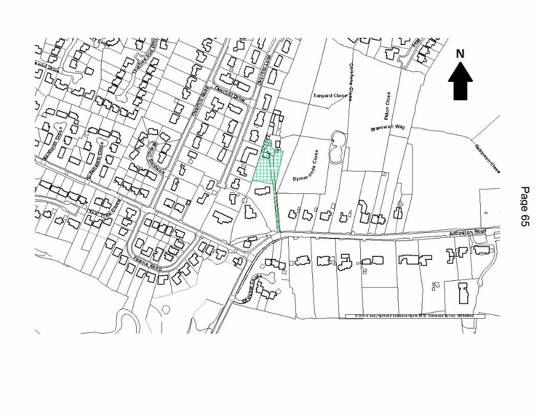


SUMMARY
This application seeks outline planning consent for the construction of a new dwelling in the area to the north-west of number 75 Lacey Green. Only access is included in this application, all other matters are to be reserved for a future application.
Although the site area is designated as open space in the Local Plan the area is not considered to physically, functionally or visually form part of the open space attached to Lacey Green Park and so the development is not considered to harm the integrity of the allocated open space which is considered to be sufficient to outweigh the policy presumption against development in Local Plan policy RT1. The proposed development could be implemented without any significant impacts on the neighbouring amenity and an access onto the main highway could be achieved without any highway safety issues. The site is sustainable and so the application is recommended for approval.
RECOMMENDATION: Approve, subject to conditions
Application No: 15/3259M
Location: 75, Lacey Green, Wilmslow, Cheshire, SK9 4BG
Proposal: Construction of one detached dwelling with new access
Applicant: A Chesworth
Expiry Date: 11-Sep-2015
REASON FOR REPORT
The application is to be presented at Northern Planning Committee because it would represent a departure from Macclesfield Borough Local Plan policy RT1.
DESCRIPTION OF SITE AND CONTEXT
The application site consists of an area of land to the rear of number 75 Lacey Green. Residential properties surround the site to the east, south and west with Lacey Green Park to the north. The existing house and most of the garden are within a Predominantly Residential Area as defined in the local plan. The rear section of garden is within an area of Existing Open Space.
The site boundaries consist of fencing and mature tree planting. The surrounding properties consist predominantly of semi-detached and detached properties in spacious plots.

DETAILS OF PROPOSAL
Outline planning permission is sought for the construction of a new two storey dwelling in the rear section of the garden of number 75. The application seeks approval for access only with all other matters reserved for subsequent approval. Whilst an indicative site plan has been submitted with the application, these matters are to be reserved to be assessed under any future Reserved Matters application.
RELEVANT HISTORY
None
POLICIES
Macclesfield Borough Local Plan – saved policies
BE1 (Design principles for new developments)DC1 (High quality design for new build)DC2 (Design quality for extensions and alterations)DC3 (Protection of the amenities of nearby residential properties)DC6 (Safe and convenient access for vehicles, special needs groups and pedestrians)DC8 (Landscaping)DC9 (Tree Protection)DC38 (Guidelines for space, light and privacy for housing development)DC41 (Infill Housing Development or Redevelopment)RT1 (Protection of Open Spaces)H1 (Phasing Policy)H2 (Environmental Quality in Housing Developments)H5 (Windfall Housing)H13 (Protecting residential areas)
The saved Local Plan policies are consistent with the NPPF and should be given full weight.
Other Material Considerations
National Planning Policy Framework (NPPF) National Planning Practice Framework (NPPG)
National Policy:
The National Planning Policy Framework establishes a presumption in favour of sustainable development. Of particular relevance are paragraphs 1, 4, 5, 6, 7, 10 and 74.
Cheshire East Local Plan Strategy – Submission Version (CELP)
The following are considered relevant material considerations as indications of the emerging strategy:

MP1 (Presumption in Favour of Sustainable Development)SD1 (Sustainable Development in Cheshire East)SD2 (Sustainable Development Principles)SE1 (Design)
CONSULTATIONS (External to Planning)
Forestry: no objections subject to conditionsSport England: no objectionsHighways: no objections to the amended site planUnited Utilities: no objections subject to conditions relating to drainageNature Conservation: no objectionsANSA: Comments awaited
VIEWS OF THE PARISH / TOWN COUNCIL
Wilmslow Town Council: recommend refusal on the grounds of this being infill development and overdevelopment of the plot. The Planning Committee also raised concerns regarding access to the proposed new dwelling.
OTHER REPRESENTATIONS
Representations from 3no. different properties have been received. A summary of these can be viewed below:
The area does not form part of the rear garden of number 75. The large open gardens are what make Lacey Green an attractive place to live. Overdevelopment. Would add to traffic issues in the area. The proposed style and design not in keeping with the original or neighbouring
properties, which are circa 1930s. Whilst the proposed distance is within the guidance set the inclusion of windows in the
gable end means that the garden of number 71 would be overlooked for the first time to the rear.
Deeds show this area as woodland, it is not obvious that it forms part of the garden of number 75.
A recent application at 106/108 Lacey Green was refused for a similar development. The development would lead to a decrease in security for the properties on Barlow Rd
with the introduction of a gate into the park. The rear windows at first floor and possibly the loft would overlook properties on
Barlow Rd. Appropriate boundary planting should be included in any approval to provide good
security and privacy.
Other issues have been raised which are not relevant to the planning application such as covenants and sewer positions.
OFFICER APPRAISAL

Key Issues
Principle of development, impact on Lacey Green Park which is identified as open space,
Impact on the character of the area, Impact on the amenity of neighbouring properties, Highway safety implications
Principle of Development
The application site lies mainly within an area designated as open space in the Local Plan. The open space designation is extended from Lacey Green Park to the north which links onto the application site. It is unclear as to why the open space designation extends into the area owned by number 75 Lacey Green, whether it was a historical error or whether this area once formed part of the park.
Local Plan policy RT1 protects such areas from development and states that redevelopment of a building footprint which does not harm the integrity of the open space will normally be permitted. Open space uses will be enhanced as appropriate.
The above policy is consistent with more general policies regarding open space contained within the NPPF and should therefore be given significant weight when determining this application.
With regard to open space, paragraph 74 of the NPPF states that existing open space should not be built on unless:
An assessment has been undertaken which has clearly shown the open space, buildings or land to be surplus to requirements; or
The loss resulting from the proposed development would be replaced by equivalent or better provision in terms of quantity and quality in a suitable location; or
The development is for alternative sports and recreation provision, the needs for which clearly outweigh the loss.
The key issues surrounding the designation are; how the site area has historically been used, site ownership and the contribution the site area makes to the wider open space of the park.
It has been stated by some neighbours that the area in question has not always formed part of the garden of number 75 and has formed a separate wooded area, the majority of which has recently been felled in preparation of the application. While the loss of the trees is regrettable they were not formally protected and the area is not a conservation area and so this is out of our control.
Evidence has been provided by the applicant in the form of a sworn affidavit from the owner of number 74 Lacey Green stating that the area outlined in red on the location plan has always formed part of the garden of number 75 having lived at number 74 since 1976. Photographs showing the area of land surrounded by trees with a mown lawn have also been provided.

The applicant has also provided a conveyance from 1971 when the wooded area to the rear of the application site was compulsory purchased by the Urban District Council of Wilmslow. It clearly states that the land was purchased from number 75 and does not include the area to which the application relates. In 1991 the area of land was transferred to Mary Wilson following the death of Stanley Wilson and a copy of the High Court Justice decision with plan is included as evidence. This same area was wholly transferred in 2012 when the applicant bought the property.
The evidence submitted provides a strong case that the area in question has formed part of the land owned by number 75 since at least 1976, and along with the photographs and sworn affidavit of number 74 ‘the balance of probabilities’ would suggest that the area has also formed part of the garden of number 75.
The Council do not possess any evidence to contradict the information provided by the applicant. The deeds provided by the neighbour showing the site area as separate from number 75 and forming part of a wooded area can only be given limited weight given the age of the ordnance survey plan (1977) and the fact that the current ordnance survey plan does not show a separation between the site area and the rear garden of number 75.
The fence between the site area and the park also physically separates the two areas and it is claimed that this has been present since 1976 at least. The physical, functional and visual separation of the application site from the park leads to the conclusion that the site area does not and has not for some time contributed to the open space within the park. It is considered that the application site would not harm the integrity of the open space.
The proposal does involve development on an area identified as open space which does conflict with the requirements of RT1, however the reasons stated above including the ownership and use of the land, the separation of the area from the rest of the park and the fact that the development would not harm the integrity of the open space are all material considerations that are considered to be sufficient to outweigh the policy presumption against the development.
Policy DC41 of the Local Plan states that ‘the proposal should normally enjoy open outlook onto a highway or open space from one elevation. Tandem and back land development will not normally be permitted where this would result in substandard outlook, overlooking and disturbance by through traffic.
The front elevation of the property would overlook Lacey Green Park and so is considered to have an ‘open outlook’. Neighbours have mentioned a nearby development at 106/108 Lacey Green which was also for new properties within the rear garden of existing properties, and was refused. This is acknowledged however, this particular proposal was allowed on appeal in December 2015.
ENVIRONMENTAL SUSTAINABILITY
Visual Impact
Existing properties in the area consist of a variety of two-storey detached, semi-detached and terraced dwellings and apartment buildings. The application site comprises an existing two-

storey semi-detached dwelling with driveway and parking to the side and a large rear garden. The site is bordered by a semi-detached dwelling to the south and three-storey apartment buildings and associated garaging to the north.
The proposal is for a two storey dwelling with detached garage. The side elevation of the dwelling as viewed from Lacey Green would be seen from the access point set back approximately 62 metres from the road. It would not therefore be prominent from the road or harmful to the character and appearance of the area. The front elevation would be seen from Lacey Green Park. However, it would be seen within the context of a wooded area and against the backdrop of existing dwellings to the south.
The proposed development would not be prominent or harmful or out of keeping with the scale and appearance of other buildings in the locality. The details regarding the design of the development including its scale and siting would be considered at the Reserved Matters stage and so cannot be assessed as part of this Outline application.
Amenity
The objections have been carefully considered. The site layout plan submitted is indicative only but it is considered that due to the size of the plot, any future Reserved Matters application would be able to ensure that sufficient distances to neighbouring property would be able to be achieved to ensure that the development would accord with local plan policies DC3, DC13, DC38, DC41 and that a commensurate degree of space, light and privacy would be able to be achieved between all neighbouring properties. The distance between the rear of the proposed dwelling and the rear of numbers 2-8 Barlow Road is at least 46m which would more than accord with the space, light and privacy guidelines set out in policy DC38 which requires a distance of 25m back to back.
The would be a distance of approximately 51m from the side elevation of the proposed dwelling and the rear elevation of numbers 75 and 73 Lacey Green.
The proposed dwelling would be accessed by a driveway following the north boundary of the site to the rear section of the garden. This would adjoin the rear of a garage block and the side elevation of an apartment building. The driveway would serve the proposed new dwelling.
Due to the nature of the proposal and the number of vehicle movements associated with one proposed dwelling, there would be little noise and disturbance to the residents of the apartment building.
Highways
Sufficient parking spaces would be provided for both the existing and proposed dwellings. Accordingly no objections are raised by the Strategic Infrastructure Manager.
Sustainability

The site is located within walking distance (approximately 950m) of Wilmslow town centre to the south which provides a wide range of shops and services. It is also within walking distance (approximately 1.3 km) of Wilmslow train station which provides regular services to wider areas including Manchester City Centre. Lacey Green Primary School is less than 500 metres from the application site on Holly Bank Road. The site is also within 100 metres of a bus stop which is served by the 378 bus route which provides regular services between Stockport and Wilmslow. The site is therefore considered to be in a highly sustainable location where residential development should be encouraged.
Trees
The submitted Arboricultural Statement (Cheshire Woodlands Ref CW/7548-AS1 dated 13th July 2015) indicates that four short sections of ornamental boundary hedge adjacent to the highway will require removal to accommodate improvements to the existing access into the site and for the creation of two parking spaces. The hedges (mainly Privet and Hawthorn) are not significant amenity features within the locale and will have only a minor impact upon the character and appearance of the area.
The majority of trees within the site are proposed to be retained with some pruning required to accommodate the proposed new driveway and working space around the proposed new build (Group G2 offsite). The proposed pruning is not deemed significant and will have no impact upon the long term health and safe well being of retained trees.
Installation of the driveway will occur within the root protection area of two trees, a low category Elm (T1) on the Lacey Green frontage and a boundary Oak (T5). Our Forestry Officer is satisfied that given the species tolerance and vitality of the trees a proposal for a tailored engineer designed hard surface as indicated in the supporting arboricultural report will be sufficient to ensure the trees’ long term health.
SOCIAL SUSTAINABILITY
The development would make a small contribution to delivering housing supply. The size of the plot is considered to be sufficient to ensure that the siting and scale of the development would not adversely impact on neighbouring amenity. This would be considered under any future Reserved Matters application. However, it is only for a single dwelling and therefore the impact is limited.
ECONOMIC SUSTAINABILITY
With regard to the economic role of sustainable development, the proposed development will help to maintain a flexible and responsive supply of land for housing to a small extent as well as to some extent bringing direct and indirect economic benefits to the town including additional trade for local shops and businesses. However, it is only for a single dwelling and therefore the impact is limited.
PLANNING BALANCE
Whilst the objections are noted, the site has been sufficiently demonstrated to have been under the ownership of number 75 Lacey Green and functioned as the garden to this property

since at least 1976, which together with the fact that the proposal does not appear to have ever been used as part of the park and would not harm the integrity of the open space outweigh the policy presumption against development in policy RT1. The Strategic Infrastructure Manager raises no objections on highway safety grounds. All other matters regarding the siting, scale, appearance and landscaping of the site would be considered at the Reserved Matters stage.
Bearing all the above points in mind, it is considered that the proposal accords with all other relevant Development Plan policies and as such it is recommended the application be approved, subject to relevant conditions.
RECOMMENDATION
Approve subject to conditions
In order to give proper effect to the Committee’s intentions and without changing the substance of the decision, authority is delegated to the Planning and Enforcement Manager, in consultation with the Chairman (or in his absence the Vice Chair) of Northern Planning Committee to correct any technical slip or omission in the wording of the resolution, between approval of the minutes and issue of the decision notice.
Application for Outline Planning
RECOMMENDATION: Approve subject to following conditions
1. Time limit for submission of reserved matters2. Implementation of reserved matters3. Submission of reserved matters4. Commencement of development5. Pile Driving details to be submitted6. Refuse storage facilities to be approved7. Submission of construction method statement8. Ground levels to be submitted with reserved matters application9. Removal of permitted development rights10.Tree retention11.Tree protection12.Construction specification/method statement