NORTHERN KWAZULU-NATAL STRENGTHENING PPROJECT of Draft Scoping Repo… · · 2017-08-24ESKOM’S...
9
Transcript of NORTHERN KWAZULU-NATAL STRENGTHENING PPROJECT of Draft Scoping Repo… · · 2017-08-24ESKOM’S...

1
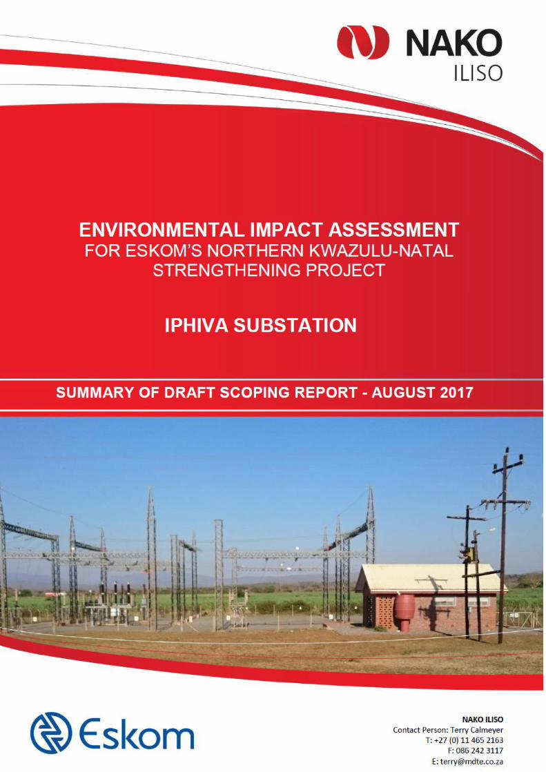
ESKOM’S NORTHERN KWAZULU-NATAL STRENGTHENING PPROJECT:
IPHIVA MAIN TRANSMISSION SUBSTATION
ENVIRONMENTAL IMPACT ASSESSMENT
SUMMARY OF THE DRAFT SCOPING REPORT
Background
ESKOM Holdings SOC Ltd (Eskom) has commissioned a project to strengthen the supply of
electricity in northern KwaZulu-Natal (KZN). NAKO ILISO has been appointed to undertake an
Environmental Impact Assessment (EIA) to support the applications for Environmental Authorisation.
The project has been divided into the followig four components, each of which has an application:
Iphiva Main Transmission Substation (MTS);
Normandie-Iphiva 400 kV Transmission Powerline;
Iphiva-Duma 400 kV Transmission Powerline; and
132 kV Distribution Powerlines.
This report documents the process and findings of the scoping phase of the EIA for the proposed
new Iphiva MTS, and presents a Plan of Study (PoS) for the Impact Assessment phase of the project.
This report will be subject to a public comment period after which it will be finalised and submitted to
the competent authority for review.
Need for the project
The northern KZN network is currently fed at 132 kV by the Normandie and Impala MTSs. The major
load centres are Pongola and the Makhatini Flats. The Normandie MTS is situated approximately
160 km north of Pongola and the Impala MTS is situated approximately 180 km south of the
Makhatini Flats. High voltage drops are experienced in the 132 kV network and further increase in
demand will lead to unacceptable voltage levels. Outage of a major 132 kV line could lead to voltage
collapse, this hampers maintenance and refurbishment of the remaining network.
Project Description
In order to strengthen and alleviate current and future network constraints in northern KZN, it is
proposed that the Iphiva 400/132 kV MTS be introduced in the area, which will de-load the main sub-
transmission network and improve the voltage regulation in the area. The Iphiva MTS will be
integrated with the existing electricity network by 400 kV Transmission powerline to Nomandie and
Duma MTSs, and approximately 165 km of 132 kV Distribution powerlines.
Listed Activities
The proposed project triggers several activities listed in the National Environmental Management
Act 107 of 1998 (NEMA), as amended, as requiring environmental authorisation before they can

2
commence. The purpose of this study is to undertake an EIA process, with associated Public
Participation Process (PPP) and specialist studies, to enable the competent authority to decide
whether the project should go ahead or not, and if so, then on what conditions.
Receiving Environment
The project is located in the KZN Province. The description below refers to the larger study area that
encompasses the powerlines associated with the proposed substation that are subjects of separate
Scoping Reports.
The climate of the area is typified by warm to hot summers, high evaporation, dry warm winters and
a mean annual rainfall between 495 and 1 560 mm. Average rainfall is higher in the west and
decreases gradually to the east. The dominant landscape features are valley slopes to undulating
hills and flat plains with a network of trailing rivers and smaller streams. The northern and central
parts of the study area are more mountainous and have extreme topographical features.
The region is well known for its large wetlands, river systems, grassland hills, bushveld and diverse
micro-habitats. The study area falls within the Maputaland-Pondoland-Albany hotspot, which is rich
in floral diversity and is part of the Maputaland Centre of Plant Endemism. 58 of Southern Africa's
endemic and near endemic avifaunal species are found within the project area.
There are only a few large towns, namely Mhuze and Pongola, in the area. The rest of the area
consist of settlements in areas under traditional leadership, commercial farms as well as game
reserves. The land under traditional management belongs to the Ingonyama Trust. Settlement
patterns are scattered. Dwellings consist mostly of brick or traditional structures. Most people have
isiZulu as home language.
Basic and social infrastructure is limited and does not meet the needs of the entire population in the
area. Municipalities in the area are faced with challenges that urban municipalities do not have. The
settlement patterns make it extremely challenging to provide infrastructure such as piped water and
sanitation. Road infrastructure in general needs some upgrading and the conditions of the roads
make it challenging to reach the communities that need to be served. As there are few employment
opportunities in these areas, many males have migrated to urban areas in search of employment,
resulting in a community that stays behind with more females than males, as well as a very young
population group. Other challenges include poverty, unemployment, illiteracy and skills levels and
crime. Subsistence farming is a very important livelihood strategy and informal trading plays a much
greater role in survival than in urban areas.
Most of the municipal areas have shown an increase both in the number of people as well as the
number of households. In most areas the household sizes have decreased. This can be due to
children leaving their parents’ house to stay on their own and start families of their own.
In terms of commercial farming, sugar cane and forestry are concerns when it comes to the presence
of powerlines. Sugar cane need to be burnt, and as such cannot always be planted below powerlines.
Although there are other methods to harvest sugar cane under powerlines, these are more expensive

3
and labour intensive. Fire is a risk for forestry, and a spark or a snapped power line could cause
extensive damage.
Alternatives
Eskom and the Environmental Assessment Practitioner (EAP) undertook a desktop assessment
followed by site visits to identify possible sites for the construction of the proposed Iphiva Substation.
Thirteen (13) potential sites were evaluated for technical feasibility. Environmental aspects were
then identified to comparatively assess the technical feasible sites, in consultation with the specialists
and Interested and Affected Parties (I&APs).
The EAP recommends that sites Iphiva 3 and 6 be further assessed in specialist studies and the
Impact Assessment Phase of the project.
The relative impacts of the alternative substation sites are affected by the various 400 kV and 132 kV
powerlines that will connect with the substation. In order to consider the interactions between these
components, the EIAs for the substation site, 400 kV powerlines and 132 kV powerlines have been
undertaken concurrently and in an integrated manner.
Public Participation in the Scoping Phase
Public participation is an important aspect of any EIA, with the objective to assist stakeholders to
table issues of concern, suggestions for enhanced benefits and to comment on the findings of the
EIA. The PPP is designed to provide sufficient and accessible information to I&APs in an objective
manner.
An I&AP database has been established to record the details of stakeholders that wish to register
for the project. Key stakeholders have been identified and notified of the project and their
opportunities to participate. A Background Information Document was compiled and distributed to all
registered I&APs and at meetings. Newspaper advertisements were placed in three newspapers in
English and isiZulu. Onsite notices were erected at 17 locations in the study area. Meetings were
held with Key Stakeholder and Authorities at four venues in the study area, in order to present the
proposed project to them, and give them an opportunity to raise any concerns that they migt have.
Similar meetings, in isiZulu, took place with each of the 31 Traditional Councils in the study area.
Focus Group Meetings with Ezemvelo KZN Wildlife and the landowners of the substation site
alternatives also took place. All comments made have been captured in a Comments and
Responses Report.
This draft report is now available for a 30-day public comment period. All comments received will
be considered and the report will be finalised for submission to the competent authority.
Key Issues
The following key issues have been identified:

4
Impacts on areas protected by National and Provincial legislation resulting in loss of plants and
animals of conservation value and a loss in the income from and value of the facilities, primarily
due to visual impacts;
Impacts on the rich and diverse fauna and flora (specifically large birds);
Impacts on landuse, particularly for sugar cane farmers;
Impacts on Heritage Resources;
Social impacts;
Economic,
Impacts on the biophysical environment resulting from access roads;
Construction Impacts;
Cumulative impacts; and
Cost to Eskom and the consumer.
Plan of Study for Environmental Impact Assessment
The approach of this study is to avoid environmental impacts by identifying a substation site and
assocaited corridors for each powerline within which the powerline can be constructed that will have
the least impacts on the environment (biophysical, socio-economic and heritage).
The EIA phase will build on the Scoping Report and, with input from specialists, will focus on
assessing the key impacts, determining their significance, and recommending appropriate measures
to mitigate negative impacts and enhance benefits. The contents of the EIA Report will be as
prescribed in the EIA Regulations, 2014, as amended.
Some of the key issues identified during the Scoping Phase will require further investigation by
appropriately qualified and experienced specialists. The specialist studies to be undertaken during
the EIA phase are summarised below. These studies will be synthesised and integrated into the
overall impact assessment (full specialist reports will be included as appendices to the EIR), and
recommendations for mitigation will be included in the Environmental Management Programme
(EMPr). The contents of all specialist reports will include information as prescribed in the EIA
Regulations, 2014, as amended.
An ecological assessment of the local flora and fauna (plant and animal) communities associated
with the proposed substation sites will be undertaken to determine the current state. Information
generated from this survey will be used to assess the impacts that the construction, operational and
decommissioning activities will have on this environment. The vegetation/habitat types will be
delineated and their sensitivity described. Any flora and fauna species or assemblages that will be
directly impacted upon by the project will be identified. This includes the state of the communities
present and the identification of possible Red Data species in accordance with the International
Union for the Conservation of Nature (IUCN), National and Provincial criteria. An assessment of the
impacts associated with various activities on the health of the flora and fauna species or
assemblages will be undertaken; and measures that should be included in the EMPr to prevent or
limit impacts to flora and fauna species or assemblages will be recommended.

5
Impacts on birds that could be associated with a project of this nature include: collision of birds with
the overhead cables; electrocution; destruction of habitat; and disturbance of birds. Collisions are
the biggest potential risk to avifauna, while habitat destruction is also expected to be an important
impact of this project.
In the avi-fauna specialist study, data from a desktop level will be examined to determine the location
and abundance of power line sensitive Red Data Listed species as well as potentially “power line
sensitive” species in the study area. A desk top examination, using Google Earth imagery will be
done to compare the alternatives. The area will be visited in the summer months, and traversed by
vehicle and on foot to obtain a first-hand understanding of the proposed substation sites and
powerline routes, habitat and avifauna, and to determine which bird micro-habitats are present and
relevant to the study. This will involve driving the study area, taking photographs, and walking certain
accessible areas, to see as much as possible of the proposed substation sites and routes for the
powerlines. The impacts of the proposed substation and powerlines on avifauna will be predicted on
the basis of experience in gathering and analysing data on avifaunal impacts with powerlines.
Recommended mitigation measures for significant impacts will be proposed.
A thorough assessment of wetlands associated with the substations will be undertaken, while only
a preliminary desktop assessment of wetlands associated with the powerlines will be done. The
objectives of the Wetlands Impact Assessment include Delineation of wetland boundaries;
Assessment of wetland baseline integrity and functionality; Assessment of the potential impacts of
the proposed development on wetlands; Guidance on placement of infrastructure to ensure a no-
nett-loss of wetlands; and to prescribe mitigation and management measures.
The soil specialist will undertake soil observations on a 150 x150 m grid for the alternative substation
sites to determine the soil form, as well as the depth to limiting layer (e.g. clay layers, hard rock, hard
and soft plinthite) and general soil physical properties like finger feel clay content. Chemical
characteristics will be done per laboratory analysis. Land capability and land use will also be
assessed. Sensitive sites like wetlands will be demarcated by soil auger. Agricultural activities (like
crop, pasture, or natural field) will be noted. Google Earth images will be used as bases for selection
of sampling points, especially to determine fields with agricultural activities. GPS co-ordinates of
each sample point will be recorded. Interpretations will be based on field survey data and site specific
requirements. The classic concepts of land capability, as established by Klingebiel and Montgomery
(1961) will be used as far as possible.
Geotechnical Investigations will be undertaken at the Iphiva Substation Site alternatives to confirm
that conditions are suitable for the construction of the proposed substation.
The Heritage Impact Assessment will comply with Section 38(3) of the National Heritage
Resources Act (No 25 of 1999). The Heritage Resources Agencies will be furnished with information
on identified heritage resources; assessments of the cultural significance of identified heritage
resources; assessment of identified heritage impacts; evaluation of heritage impacts relative to the
socio-economic benefits of the project; consideration of alternatives; recommended management or
mitigation measures; any limitations or conditions of the development; and the general protection
6
applicable in terms of the National Heritage Resources Agency (NHRA) and the KwaZulu-Natal
Heritage Agency (KZNHA). The Heritage Impact Assessment (HIA) will consider archaeology,
palaeontology and meteorites, battlefields, rock art, and historic fortifications, battlefield sites, public
monuments and memorials, burial grounds and graves, graves of victims of conflict, heritage
landmarks, provincial landmarks and structures.
The visual specialist study will define the spatial context of influence of the proposed project in
terms of the visibility of the overhead powerlines and the substation, and to identify potential sensitive
receptor locations. The development is expected to result in moderate to high visual impacts, which
will require a Level 4 visual assessment as described in the Guideline for Involving Visual and
Aesthetic Specialist on EIA Processes (Oberholzer, 2005). A site visit will be undertaken. The
landscape will be mapped using Geographic Information System (GIS) technology. The physical and
technical characteristics of the project components will be described and illustrated. The visual
resource (landscape character, landscape quality, sense of place and visual receptors) will be
described; and the information will be depicted by maps. Critical areas will be highlighted. Analysis
of the proposed development in terms of the criteria such as visual intrusion, visibility, visual
exposure, visual absorption capacity and viewer sensitivity to determine the intensity of the impact
will be undertaken. A 3D GIS terrain model will be used to assess the visibility of the infrastructure
as a whole, or parts thereof, from significant viewpoints within the viewshed. Emphasis will be placed
on potential visual receptors and critical views towards the proposed development. Photographs and
a GPS will be used to record relevant geographical locations within the vicinity of the corridors.
Unique viewpoints will be selected according to land uses and different landscape characteristics.
The impact significance will be determined by synthesising the assessment criteria. Recommend
mitigation measures to reduce the potential negative impacts; and photomontages will be used to
compare the existing views with the probable effect of the proposed infrastructure.
Demographic, economic, geographic, institutional, legal, emancipatory, empowerment, and socio-
cultural processes will be investigated in the Social Impact Assessment: Health and social well-
being, quality of the living environment, material well-being, cultural impact, family and community
impacts, institutional, legal, political and equity impacts, and gender impacts will also be investigated.
Fieldwork will be conducted to obtain information and communicate with key stakeholders.
Methodologies will include in-depth interviews, participatory rural appraisal, in-the-moment
discussion groups, focus groups and immersions. Field notes will be kept of all interviews and focus
groups. The final report will focus on current conditions, providing baseline data. Each category will
discuss the current state of affairs, but also investigate the possible impacts that might occur in
future. The impacts identified in this scoping report will be revisited and rated. New impacts that have
not been identified will be added to the report. Recommendations for mitigation will be made at the
end of the report.
One of the key issues that landowners affected by the proposed project have raised is the impact on
the eco-tourism activities and knock-on effects including decline in property values, loss of jobs, and
reduced budgets for conservation of animals. The social specialist study only allowed for this to be
assessed on a qualitative level. Interaction with the landowners has highlighted that the project
could be opposed should this aspect not be adequately addressed. The inclusion of a more detailed

7
economic assessment has therefore been commissioned. The assessment will consider area of
influence for a specific impact as well as a regional / national impact. The site specific analysis will
have a strong focus on the site and immediate surroundings which depends on existing land uses,
sense of place aspects and local development opportunities. The regional / national impact is
quantified through the use of econometric modelling and multipliers and indicate the value of the
investment through gross value added (GVA), employment creation business sales, etc. as a result
of the project.
Conclusion and Recommendation
The EAP recommends that this Scoping Report be accepted by the competent authority and that the
Impact Assessment Phase of the EIA proceeds according to the Plan of Study presented.

8