North Sydney Council Traffic & Parking Area Scheme ... · NSW Road Safety Strategy ... North Sydney...
107
North Sydney Council Traffic & Parking Area Scheme & Action Plan TAPAS Zone 3
Transcript of North Sydney Council Traffic & Parking Area Scheme ... · NSW Road Safety Strategy ... North Sydney...

North Sydney Council Traffic & Parking Area Scheme
& Action Plan TAPAS Zone 3


SMEC | North Sydney Council TAPAS Zone 3 Action Plans Draft Report | Page i
DOCUMENT CONTROL
Title North Sydney Council Traffic and Parking Area Schemes (TAPAS) Action Plans Draft Report
Prepared for North Sydney Council
Project Ref TBC
Name Position Signed/Approved Date
Originators Federico Ramos Senior Traffic Engineer 24/02/2017
Reviewer Andrew Brown Associate Transport Planner 21/03/2017
Approver Colin Henson Project Development and Planning Manager
Details of Revisions Rev Date Description WVR No. Approved 1 21/03/2017 Draft Report 24/02/2017
CONTACT DETAILS SMEC Australia Pty Ltd | www.smec.com
Level 5, 20 Berry Street North Sydney NSW 2060 Tel: 02 9925 5555 Fax: 02 9925 5566
Representative: Federico Ramos P: 02 9925 5533 E: [email protected]
www.smec.com
SMEC | North Sydney Council TAPAS Zone 3 Action Plans Draft Report | Page ii
TABLE OF CONTENTS INTRODUCTION .................................................................................................................... 5
Background ................................................................................................................ 5 Community Strategic Plan ........................................................................................ 5 Study Objectives ........................................................................................................ 6 Data Collection and Review ...................................................................................... 6 Community Engagement Feedback ......................................................................... 7 Literature Review ....................................................................................................... 7 Strategic Planning Context ....................................................................................... 7
Disability Discrimination Act, 1992 ............................................................................ 7 Commonwealth Disability Standards for Accessible Public Transport ...................... 8 NSW Long Term Transport Master Plan ................................................................... 8 Transport for NSW – Sydney’s Walking Future ......................................................... 9 Transport NSW Disability Action Plan 2012-2017 ..................................................... 9 NSW Road Safety Strategy ..................................................................................... 10 NSW Walking Strategy ............................................................................................ 10 NSW Ageing Strategy 2020 ..................................................................................... 10
Local Planning Context ........................................................................................... 10 North Sydney Local Environmental Plan 2013 ........................................................ 11 North Sydney Development Control Plan 2013 ....................................................... 11 North Sydney Integrated Traffic and Parking Strategy ............................................ 12 North Sydney Integrated Cycling Strategy .............................................................. 13 Draft North Sydney Transport Strategy ................................................................... 14
STUDY AREA CHARACTERISTICS ................................................................................... 16 Characteristics of Study Area ................................................................................. 16 Functional Road Hierarchy ..................................................................................... 16
Administrative Road Hierarchy ................................................................................ 16 Functional Road Hierarchy ...................................................................................... 16
Journey to Work Data (JTW) and Commuter Mode Share ................................... 17 Household vehicle ownership .................................................................................. 18 BTS Travel Zone System in the Core Study Area ................................................... 18 Population and Land Uses ...................................................................................... 19 Commuter Transport Mode Share ........................................................................... 20
Local Area Traffic Management Devices ............................................................... 22 Parking Facilities ...................................................................................................... 22
Current Management Framework............................................................................ 22 On-street Parking Control Typologies ..................................................................... 22 Current Permit Parking Scheme Operations ........................................................... 22 Restricted Parking Controls Operations .................................................................. 23 Mobility Parking Operations ..................................................................................... 23 School Related Parking Control Operations ............................................................ 23 Car Share Operations .............................................................................................. 23

SMEC | North Sydney Council TAPAS Zone 3 Action Plans Draft Report | Page iii
Metered Parking Operations ................................................................................... 23 Walking and Cycling Facilities ............................................................................... 23
Walking Facilities .................................................................................................... 23 Cycling Facilities ..................................................................................................... 24
Public Transport Facilities ...................................................................................... 26 Bus Services ........................................................................................................... 26 Rail & Ferry Services .............................................................................................. 27
Crash Data Analysis ................................................................................................ 28
SIGNIFICANT DEVELOPMENTS .......................................................................................... 5 Sydney Metro ............................................................................................................. 5
Crows Nest Station ................................................................................................... 5 Victoria Cross Station ............................................................................................... 6
Traffic Impact Assessment of Ongoing Development ........................................... 6 Cumulative Traffic Generation Assessment ............................................................. 6
EXISTING TRANSPORT ISSUES IDENTIFIED THROUGH COMMUNITY ENGAGEMENT 8 Introduction ................................................................................................................ 8 Transport for NSW ..................................................................................................... 8 Roads and Maritime Services................................................................................... 9 Cycling Strategy ...................................................................................................... 10 Matters Referred to Other Council Departments.................................................. 10
TAPAS ACTIONS PLANS ................................................................................................... 12
Action Plan Development ....................................................................................... 12 Existing Conditions (Problem Score) ...................................................................... 12 Community Strategic Plan Criteria .......................................................................... 12 Total Project Score ................................................................................................. 13
Parking Review ........................................................................................................ 14 TAPAS Actions – Parking ....................................................................................... 14
APPROVALS PROCESSES ............................................................................................... 16
APPENDIX A – PRIORITISED ACTION PLAN ........................................................................... 17
List of Figures
Figure 1: TAPAS Action Plan Study Area ............................................................................................................................................................. 5 Figure 2: Household vehicle ownership in North Sydney LGA (2011 Census data) ........................................................................................... 18 Figure 3: BTS Travel Zone System in the Study Area (TZ 2011, source BTS)..................................................... Error! Bookmark not defined. Figure 4: Transport Mode Share-Study Area as Place of Residence (2011 Census data) ................................................................................ 21 Figure 5: Transport Mode Share-Study Area as Place of work (2011 Census data) .......................................................................................... 21 Figure 6 Existing Cycle Network Typology Map .................................................................................................................................................. 25 Figure 7 Existing Bus Network ............................................................................................................................................................................ 26
SMEC | North Sydney Council TAPAS Zone 3 Action Plans Draft Report | Page iv
Figure 8 Ferry and Rail Services ........................................................................................................................................................................ 27 Figure 9 Summary of Type of Crash for the Study Area (volume) ..................................................................................................................... 28 Figure 10 Summary of Type of Crash for the Study Area (percentage) ............................................................................................................. 29 Figure 11 Location of Recorded Crashes ............................................................................................................................................................. 2 Figure 12: Location of Recorded Crashes involving Cyclists................................................................................................................................ 3 Figure 13: Location of Recorded Crashes involving Pedestrians ......................................................................................................................... 4 Figure 14: Public Exhibition Responses ............................................................................................................... Error! Bookmark not defined.
List of Tables Table 2-1 Functional Classification of Roads ................................................................................................................................................ 17 Table 2-2 Population growth forecast 2016 to 2041 ...................................................................................................................................... 19 Table 2-3 Employment growth forecast 2016 to 2041 ................................................................................................................................... 19 Table 2-4 Daily Travel Mode Split in the Study Area, 2011 Census Data .................................................................................................... 20 Table 5: Developments in TAPAS Zone 3 with Traffic Generation greater than 5vph ............................................................................... 7

SMEC | North Sydney Council TAPAS Zone 3 Action Plans Draft Report | Page v
INTRODUCTION
Background
Council has developed the Integrated Traffic and Parking Strategy to holistically manage traffic and parking across the North Sydney Local Government Area (LGA).
An important component of the Strategy is the delivery of appropriate Traffic and Parking Area Scheme (TAPAS) Action Plans. TAPAS Action Plans are area-wide traffic plans which take into account the current and future traffic and parking situation in the area and recommend traffic and parking measures to protect, maintain and improve access and parking.
There are a total of seven TAPAS zones within the study area, as indicated in Figure 1. SMEC has been commissioned by Council to develop TAPAS Action Plans for zones 1, 2 and 3, which are located to the west of the Pacific Highway, as shown in Figure 1. This report focuses on Zone 3.
Figure 1: TAPAS Action Plan Study Area
Community Strategic Plan

SMEC | North Sydney Council TAPAS Zone 3 Action Plans Draft Report | Page vi
The Community Strategic Plan is Council’s most important strategic document. It provides a planning and action framework and is part of Council’s integrated planning, reporting and decision making framework.
The Community Strategic Plan is designed to respond to community agreed priorities for the decade 2013 to 2023. The priorities and strategies will help manage inevitable change while protecting what the community values most. The priorities were identified through a community engagement program.
The Council’s land use, infrastructure planning, social, environmental and economic plans are all interconnected, allowing the Council to plan holistically for the future.
The Community Strategic Plan recognises the community’s desire for Council to maximise parking and improve the way it is managed and to expand community engagement to ensure the Council is hearing from all stakeholders. In this regard, the development of the TAPAS Action Plans recognises the demand for parking and takes account of traffic and parking issues raised by the community in the development of measures.
Study Objectives
The primary goal of the study is to create an area-based TAPAS Action Plan for each of the TAPAS zones, in accordance with the North Sydney Integrated Traffic and Parking Strategy. The key objectives of the TAPAS Action Plan, as identified in the project brief, are as follows:
Identify the existing traffic, parking, walking, cycling and public transport situation in the TAPAS zone;
Identify future traffic demand as a result of increased density and development;
Identify the traffic and parking needs of the community based on community engagement feedback and Council’s parking strategies;
Identify existing Local Area Traffic Management (LATM) devices and parking controls in the TAPAS zone, including turn restrictions; and
Prepare a Traffic and Parking Plan, including comprehensive maps for the TAPAS zone, which include measures to ameliorate impacts on residential areas and to ensure safety. The Plans should include a list of projects supplemented by a map showing the location of each project.
Data Collection and Review

SMEC | North Sydney Council TAPAS Zone 3 Action Plans Draft Report | Page vii
The data review and collection process has involved desk top review of a range of information found online, as well as documents and reports that have been provided by Council for consideration in the study. Such information includes, but is not limited to the following:
Crash data within the study area;
Previous pedestrian and bike plans/ reports/ studies;
Relevant traffic and speed survey count data;
Relevant parking data and information provided by Council;
Pedestrian and vehicle turning count data conducted by Council;
Data relating to recent or likely future significant developments in the area; and
Traffic and parking studies and reports relevant to the TAPAS zone under consideration.
Community Engagement Feedback
North Sydney Council is committed to community engagement to ensure the Council is hearing from all stakeholders.
To this end, feedback from community engagement undertaken by the Council regarding a wide range of traffic and parking matters has been reviewed by the study team. This information has been used to guide and inform the development of measures that will be included in the relevant TAPAS Action Plans to address issues raised by the community.
Detail concerning the development of the TAPAS Action Plans is discussed in Section 5 of this report.
Literature Review
A literature review has been undertaken of National, State Government and Council policies, standards and guidelines, as well as additional documents, studies and information provided by North Sydney Council, which will inform the development of the Traffic and Parking Area Scheme Action Plans. For purpose of this report, these policies and documents are considered in the following sections.
Strategic Planning Context
Disability Discrimination Act, 1992 One of the key aspects of the Federal Disability Discrimination Act (1992) is the provision of equal services to all. The act legislates the right for equal participation of all members of the community in daily life and is composed of three topics: equality, independence and functionality. The objectives of the act include the following:
To eliminate, as far as possible, discrimination against persons on the ground of disability;
SMEC | North Sydney Council TAPAS Zone 3 Action Plans Draft Report | Page viii
To ensure that persons with disabilities have the same rights to equality as the rest of the community; and
To promote recognition and acceptance within the community of the principle that persons with disabilities have the same fundamental rights as the rest of the community.
As such, proposed TAPAS measures should provide equal access for all, wherever possible. North Sydney Council should aim to accommodate as many people as possible (including those with disability) as effectively as possible within available budgets. As further improvements to public infrastructure and facilities are made, more people with disability will benefit.
It is recognised that a lack of consideration of these users by anyone in the design and delivery chain makes it difficult for all who follow, particularly the end users. This study’s objectives are in line with the objectives set out in the Act.
Commonwealth Disability Standards for Accessible Public Transport The Disability Discrimination Act 1992 seeks to provide equity for people with disabilities, which includes suitable access to public transport services. The purpose of the Commonwealth Disability Standards for Accessible Public Transport is to ensure that public transport operators and providers remove discrimination from public transport services. The standards prescribe certain sections of various Australian Standards and include specific requirements for access paths, manoeuvring areas, ramps, surfaces, handrails, lighting, street furniture, bus stops and other infrastructure. This study incorporates these principles with attention being placed in and around public transport infrastructure, including existing and proposed rail stations.
NSW Long Term Transport Master Plan Transport for NSW published the NSW Long Term Transport Master Plan in 2012. The plan includes the objectives of increasing use of alternative modes of transport for short, local trips to achieve improved environmental outcomes, health benefits and to reduce traffic congestion.
When homes and jobs are within walking distance of each other and within easy walking distance of public transport, accessibility to jobs and services increases and commuting is easier. More people walking, or cycling to catch the train, bus or ferry also means less pressure on town centre streets, busy bus services and commuter car parking. When planning new developments, the surrounding transport infrastructure should have a network of connections that consider:
Personal safety and security, including adequate lighting and activated public spaces;
Adequate footpath and cycle path widths;
Safe and convenient crossings of roads at intersections and midblock locations;
Convenient and legible access to public transport; and
Good signage and way-finding to support efficient movement.
The NSW Long Term Transport Master Plan is mostly applicable to greenfield areas such that the required infrastructure for alternative modes of transport can be incorporated. Nevertheless, the objectives outlined in the Master Plan are all relevant and directly applicable to infrastructure for such users throughout the study area. These objectives have therefore been adopted, where possible.
SMEC | North Sydney Council TAPAS Zone 3 Action Plans Draft Report | Page ix
Transport for NSW – Sydney’s Walking Future This strategic document provides assurances regarding the following components, representing a step towards an integrated transport system in NSW.
Promotion of walking for transport, including signage on walking routes and improved information online and at interchanges to help customers to plan their journey;
Support the connection of people to places through safe walking networks around centres and public transport interchanges;
Engagement with partners across government, with councils, non-government organisations and the private sector to maximise effectiveness of actions;
Promotion of the many benefits of walking for health and well-being, the environment and communities;
Investment in new walking links that connect people to places and public transport with adequate facilities;
The Transport Access Program will continue to deliver benefits to all pedestrians getting to, from and around public transport interchanges. Upgrades will improve pedestrian safety, personal security and amenity;
Engagement with and support councils to deliver cost effective improvements to local walking networks;
The needs of pedestrians will be prioritised in the planning, design and construction of new transport and urban development projects;
Pedestrian safety will be improved through a new Pedestrian Safety Strategy, which will encompass all existing safety programs and also explore new measures; and
Support community based initiatives that promote walking as a vital part of the transport mix and get people walking more for transport.
This study is consistent with the principles outlined in this document as they support growth linked to safety and comfort for pedestrians, while encouraging the integration of different modes of transport. The intention to improve accessibility throughout the LGA will act towards achieving the above objectives, albeit predominantly indirectly as a result of improved infrastructure and accessibility.
Transport NSW Disability Action Plan 2012-2017 Transport for NSW funds specific programs to deliver pedestrian facilities like bridges over busy roads, pedestrian crossings, fencing and shared paths that are used by many pedestrians (as well as cyclists) for transport, exercise and recreation. Public education campaigns also target key risk groups such as older road users and the safe operation of motorised wheelchairs and mobility scooters. The mobility and safety of pedestrians at public transport interchanges is an area of increasing focus.

SMEC | North Sydney Council TAPAS Zone 3 Action Plans Draft Report | Page x
There is an expectation that mobility plans are prepared for all transport interchanges at the design phase to ensure that customers can move safely between modes of transport. This study takes into consideration the need to facilitate connectivity for pedestrians to and from public transport interchanges.
NSW Road Safety Strategy NSW Road Safety Strategy was prepared in 2012 by Transport for NSW. The strategy covers the potential to address fatal and serious injury crashes on the road network through improved intersection design, eliminating or shielding road users from road side objects or opposing vehicles and by considering pedestrians and bicycle riders particularly in urban areas. The NSW Safer Roads program targets infrastructure safety works programs including safety barriers, highway route reviews, local roads, pedestrian safety measures and motorcycle recreational routes.
During the development of TAPAS Action Plans cognisance is given to the intentions and recommended measures listed in the NSW Road Safety Strategy. At the same time, it is recognised that many of the measures may not be applicable or appropriate, given that, for example, an “innovative technology solution” may not be required or identified as beneficial/ realistic within the LGA.
NSW Walking Strategy In September 2011, the NSW Government released NSW 2021 A Plan to Make NSW Number One. This set of documents includes a target to increase walking for short trips and a commitment to develop a NSW Walking Strategy. Walking programs were also reviewed as part of the Long Term Transport Masterplan for NSW. “Sydney's Walking Future, Connecting People and Places” was subsequently released by Transport for NSW. This study is in line with both strategies as it recommends realistic measures to encourage walking within the LGA.
NSW Ageing Strategy 2020 The NSW Ageing Strategy released in 2012 identifies people aged over 65 as the fastest growing population group in NSW. An estimated 2 million community transport trips are provided each year to help older people access recreation, shopping, medical care, community services and social activities in NSW. This travel demand will continue to grow with this population group forecast to double by 2050. As a user group, older pedestrians are generally over represented in fatal crashes. It is therefore necessary to promote safe walking routes that are designed with consideration of older aged groups.
Local Planning Context
SMEC | North Sydney Council TAPAS Zone 3 Action Plans Draft Report | Page xi
North Sydney Local Environmental Plan 2013 The Local Environmental Plan aims to make local environmental planning provisions for land in North Sydney in accordance with the relevant environmental planning Act. The key aims of the Plan are as follows:
to promote development that is appropriate to its context and enhances the amenity of the North Sydney community and environment;
to ensure that new development is compatible with the desired future character of an area in terms of bulk, scale and appearance;
to maintain a diversity of activities while protecting residential accommodation and local amenity;
to ensure that new development on foreshore land does not adversely affect the visual qualities of that foreshore land when viewed from Sydney Harbour and its tributaries;
to ensure that new development does not adversely affect residential amenity in terms of visual and acoustic privacy, solar access and view sharing, and to maintain and provide for an increase in dwelling stock, where appropriate;
to maintain a diversity of employment, services, cultural and recreational activities;
to ensure that non-residential development does not adversely affect the amenity of residential properties and public places, in terms of visual and acoustic privacy, solar access and view sharing;
to maintain waterfront activities and ensure that those activities do not adversely affect local amenity and environmental quality;
to maintain and protect natural landscapes, topographic features and existing ground levels;
to minimise stormwater run-off and its adverse effects and improve the quality of local waterways;
to identify and protect the natural, archaeological and built heritage of North Sydney and ensure that development does not adversely affect its significance; and
to provide for the growth of a permanent resident population and encourage the provision of a full range of housing, including affordable housing.
North Sydney Development Control Plan 2013 The purpose of the Development Control Plan is to supplement the Local Environment Plan and provide more detailed provisions to guide future development, such that impacts on the community and environment are minimised. The key aims of the Plan are as follows:
Ensure that development positively contributes to the quality of the natural and built environments;
Encourage development that contributes to the quality of the public domain;
Ensure that development is economically, socially and environmentally sustainable;

SMEC | North Sydney Council TAPAS Zone 3 Action Plans Draft Report | Page xii
Ensure future development has consideration for the needs of all members of the community;
Ensure development positively responds to the qualities of the site and its context;
Ensure development positively responds to the character of the surrounding area; and
Ensure that the aims of Council’s 2020 Vision – North Sydney Community Strategic Plan are achieved.
It is recognised that increased traffic flow, congestion and parking demand leads to reduced levels of service for public transport through longer journey times, and loss of fleet efficiency. For pedestrians, increased traffic means more difficulty in walking and increased noise levels on major roads. This can result in roads that are intimidating environments for pedestrians. These conditions can also lead to loss in residential amenity and increased use of private vehicles, as alternative transport modes become less attractive.
The objectives of the Plan are therefore also to ensure that:
existing levels of traffic generation are contained and reduced;
public transport, including walking and cycling, is the main form of travel mode;
parking is adequate and managed in a way that maintains pedestrian safety and the quality of the public domain whilst minimising traffic generation;
parking is limited to minimise impacts on surrounding areas;
parking is accessible to all user groups;
minimal impacts occur on the provision of on-street parking;
ensure consideration is given to the provision of bicycle parking and facilities; and
the actions of the Metropolitan Plan for Sydney 2036 are implemented.
The integration of engineering considerations with planning, architecture and landscaping is important for the purpose of servicing the future infrastructure needs of the North Sydney Local Government Area.
North Sydney Integrated Traffic and Parking Strategy The North Sydney Council Local Government Area is one of the most highly urbanised areas in Australia. North Sydney Council is experiencing a notable increase in traffic and parking demand. This demand is being caused by an increase in car usage by the existing population, an increase in the number of workers and visitors to the area and an increase in residential and commercial development in the area.
This increasing demand for traffic and parking has instigated the need for the Council to develop an Integrated Traffic and Parking Strategy, which is the guiding document for the way Council manages traffic and parking across the area both now and into the future. The purpose of the Strategy is to:
Provide vision, goals and targets for parking and traffic management in the LGA;

SMEC | North Sydney Council TAPAS Zone 3 Action Plans Draft Report | Page xiii
Provide a strategic approach to current issues and needs for the management of traffic and parking across the LGA;
Ensure that traffic and parking is balanced to meet the needs of road users, particularly residents and businesses;
Ensure that traffic and parking is managed is a sustainable manner; and
Provide a management framework for consultation, monitoring and evaluation.
The development of the Integrated Traffic and Parking Strategy is aimed at creating a more integrated, strategic and proactive approach to traffic and parking management across the area. To do this, the Traffic and Parking Area Scheme (TAPAS) has been formulated.
In North Sydney, TAPAS are a fundamental tool for traffic calming and parking planning at the local level. They consider neighbourhood traffic and parking related issues within the context of the overall road network within each TAPAS zone.
The benefits of the establishment of TAPAS areas are as follows:
Major traffic and parking issues can be assessed on a holistic area wide basis, taking into account metropolitan transport issues and requirements;
Traffic and parking management will shift from a reactive (current) approach to a proactive approach. Instead of waiting for issues to be brought to Council’s attention, the TAPAS will identify major issues and propose solutions;
Provide a more unified approach to traffic and parking and improves planning and coordination issues in traffic and parking management as both traffic and parking are intrinsically related;
Traffic and parking plans can be tailored to meet the needs and expectation of the local community;
Traffic and parking consultation areas are based on Council’s Precinct System – which assists in community engagement and consultation;
The ability to prioritise area-wide traffic and parking facilities for budget allocation and implementation; and
The TAPAS approach rationalises a number of Council’s existing complex processes for managing traffic and parking. The rationalisation and simplification of these processes will lead to better decision making and a more efficient use of Council’s resources.
All major traffic and parking changes will be considered, designed, prioritised and implemented as part of TAPAS studies and Action Plans. As discussed in Section 1.1, the purpose of this study is to develop TAPAS for Zone 3.
North Sydney Integrated Cycling Strategy North Sydney Council has a goal to increase cycling as a sustainable transport option. Increasing cycling can also help to reduce traffic congestion and demand for parking; reduce air and noise pollution; improve community health and wellbeing; and create opportunities for community interaction and connectedness.

SMEC | North Sydney Council TAPAS Zone 3 Action Plans Draft Report | Page xiv
Cycling in North Sydney is currently limited by an incomplete and disconnected cycle network. Gaps and difficult sections in the network discourage potential cyclists and lessen the safety and amenity of those riding in the area. Members of the North Sydney community have told Council that they would like to cycle for everyday transport, but that they feel unable to do so due to poor network connections and concerns about safety.
To improve the overall cycling network and increase cycling participation, Council has produced the Integrated Cycling Strategy. The goals of the Strategy are to:
Deliver an accessible, safe and connected cycle network by 2020;
Make cycling an attractive choice for short trips within the LGA; and
Increase and diversify participation in cycling (people of all ages and abilities will view cycling as a safe, everyday transport option).
To achieve these goals Council will undertake the following:
Implement priority routes to address key gaps in the network;
Advocate for step free access to the Sydney Harbour Bridge Cycleway;
Update existing routes and improve quality across the network;
Install coherent and consistent bicycle wayfinding signage;
Install bicycle parking that caters for existing demand and future increases;
Provide supporting infrastructure such as public maps, bicycle pumps and water refill stations to support the cycling network; and
Conduct communications, events and programs to promote cycling and increase safety and awareness.
Cycling is already part of Council’s vision for a sustainable North Sydney. The North Sydney Community Strategic Plan sets a goal for Council to encourage sustainable transport. One of the key objectives relating to this goal is to provide ‘a network of accessible, safe and linked cycle paths throughout North Sydney’.
The proposed actions within the Strategy are designed to transform cycling in North Sydney, so that cycling becomes accessible as an everyday transport option for a diverse range of community members.
Draft North Sydney Transport Strategy North Sydney has developed a Draft North Sydney Transport Strategy (draft NSTS) which is currently under review. It is expected that the draft NSTS will be adopted later in 2017.
Transport has emerged as one of the most important urban planning issues facing Global Sydney. The draft NSTS is intended to be Council’s guiding document for the delivery of its transport planning and management functions. This includes strategic transport planning, delivery of local transport projects and transport advocacy. The draft NSTS builds on the directions, outcomes and strategies detailed in North Sydney’s Community Strategic Plan 2013-

SMEC | North Sydney Council TAPAS Zone 3 Action Plans Draft Report | Page xv
23 (CSP) and Ecologically Sustainable Development Best Practice Project 2013 (ESD) to create an over-arching transport planning and management framework for the whole of Council.
Key elements of the draft NSTS include:
a holistic Vision for transport in North Sydney;
a principled, best practice approach to achieving this Vision;
requirements for the development of mode specific action plans;
a Council-wide transport implementation framework;
a delivery methodology that will help to ensure quick, consistent and robust responses to increasingly complex transport issues for Council initiated projects, policies and wider transport advocacy; and
shared CSP/NSTS measuring and reporting requirements.

SMEC | North Sydney Council TAPAS Zone 3 Action Plans Draft Report | Page xvi
STUDY AREA CHARACTERISTICS
Characteristics of Study Area
North Sydney Council serves an area of 10km2, which incorporates business districts and diverse residential areas. Suburbs in the North Sydney area include Cammeray, Cremorne, Crows Nest, Kirribilli, McMahons Point, Milsons Point, Neutral Bay, North Sydney, St Leonards, Waverton and Wollstonecraft.
Almost half of North Sydney’s residents are aged between 20 and 44 years. There is a comparatively low proportion of households with children. The population is highly mobile. Just under half of all residents rent. The dwelling density is higher than in most other parts of Sydney and is increasing. Four in five residents live in medium to high-density housing. North Sydney has a high level of visitors who travel to North Sydney for work. In regard to students attending schools and tertiary institutions, only one in five lives in the area.
The principal commercial activities in the North Sydney Central Business District (CBD) are advertising, marketing, retail, information technology, finance, telecommunications and property development.
Functional Road Hierarchy
Administrative Road Hierarchy Roads and Maritime Services (RMS) has adopted an administrative Road Hierarchy to manage the road network across NSW. The three administrative classes are:
State Roads; Regional Roads; and Local Roads
In terms of traffic management, Council has been delegated the responsibility for managing traffic on local and regional roads. The RMS has an input into the local and regional road system through Council’s Traffic Committee and through direct contact with Council. Changes to the local road system by Council which influence traffic flows require the submission of a Traffic Management Plan (TMP) to the RMS for approval. Although State Roads remain under the care and control of RMS, Council works closely with RMS to ensure that traffic on the State Road network does not adversely impact on the Regional or Local Road network to which it is responsible for.
Functional Road Hierarchy The functional classification of roads relates to their role within the overall road network. Changes to traffic flows on roads can then be assessed within the context of the functional road hierarchy. RMS has developed guidelines for functional classifications of roads. These guidelines are published in the document titled “The Functional Classification of Roads”.
Council recognises the importance of defining the roles of roads within the overall road network and proposes to adopt the RMS Functional Classification of Roads. The four functional road classes are:
Arterial Road - typically a main road carrying in excess of 15,000 vehicles per day and over 1,500 vehicles per hour in the peak period. They predominately carry traffic from one region to another, forming principal avenues for metropolitan traffic movements.

SMEC | North Sydney Council TAPAS Zone 3 Action Plans Draft Report | Page xvii
Sub Arterial Road – typically a secondary road carrying between 5,000 – 20,000 vehicles per day and over 500 and 2,000 vehicles per hour in the peak period. They predominately carry traffic from one sub-region to another forming secondary inter-regional transport links.
Collector Road – typically a minor road carrying between 2,000 and 10,000 vehicles per day and over 250 and 1,000 per hour in the peak period. They provide a link between local areas and regional areas carrying low traffic volumes. At volumes greater than 5,000 vehicles per day, residential amenity begins to decline. Trunk collector and spine roads with limited property access can carry traffic flows greater than 5,000 vehicles per day.
Local Road – typically a local street carrying less than 2,000 vehicles per day and 250 vehicles per hour in the peak period. They provide direct access to individual houses and carry low traffic volumes.
A summary of road characteristics under the functional classification system is outlined in Table 2-1 Functional Classification of Roads.
Table 2-1 Functional Classification of Roads
Road Type Traffic Volume (AADT) Through Traffic Inter-Connections Speed Limit
(km/h)
Arterial/ Freeway No Limit Yes Sub-Arterial 70-110
Sub-Arterial <20,000 Some Arterial/ Collector 60-80
Collector <5,000 Little Sub-Arterial/ Local 40-60
Local <2,000 No Collector 40
It should be noted that the road classifications and characteristics are notional concepts developed a significant time after the North Sydney road network was constructed. As such, the characteristics of the roads in the study area do not perfectly match their classification and are more appropriately adopted in “greenfield” developments. This is consistent with the road network throughout the greater Sydney area and NSW.
The more significant arterial and collector roads throughout the study area are listed below.
Arterial Roads – Pacific Highway
Collector Roads - River Road, Shirley Road, and Bay Road.
Journey to Work Data (JTW) and Commuter Mode Share

SMEC | North Sydney Council TAPAS Zone 3 Action Plans Draft Report | Page xviii
The Bureau of Transport Statistics (BTS) provides journey to work (JTW) for the Sydney Metropolitan Area which includes a comprehensive sample of commuter travel, collected during the 2011 Census Year.
Household vehicle ownership According to the 2011 Census of Population and Housing data, around 62,300 people live in the North Sydney LGA area and the average household size is 1.8. 51% of households in the North Sydney LGA own 1 vehicle and 17% of households do not own any vehicle. The household vehicle ownership in North Sydney LGA is shown in Figure 2.
Figure 2: Household vehicle ownership in North Sydney LGA (2011 Census data)
BTS Travel Zone System in the Core Study Area Journey to Work 2011 census data has been analysed within the BTS 2011 travel zone system in the study area.
17%
51%
20%
3% 0%9%
Household vehicle ownership
0 veh
1 vehicle
2 vehs
3 vehs
4 and more vehs
not stated
SMEC | North Sydney Council TAPAS Zone 3 Action Plans Draft Report | Page xix
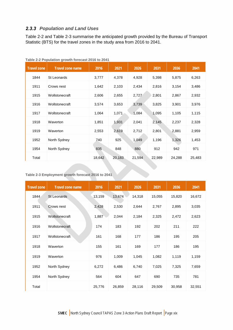
Population and Land Uses Table 2-2 and Table 2-3 summarise the anticipated growth provided by the Bureau of Transport Statistic (BTS) for the travel zones in the study area from 2016 to 2041.
Table 2-2 Population growth forecast 2016 to 2041
Travel zone Travel zone name 2016 2021 2026 2031 2036 2041
1844 St Leonards 3,777 4,378 4,928 5,398 5,875 6,263
1911 Crows nest 1,642 2,103 2,434 2,816 3,154 3,486
1915 Wollstonecraft 2,606 2,655 2,727 2,801 2,867 2,932
1916 Wollstonecraft 3,574 3,653 3,739 3,825 3,901 3,976
1917 Wollstonecraft 1,064 1,071 1,084 1,095 1,105 1,115
1918 Waverton 1,851 1,931 2,041 2,145 2,237 2,328
1919 Waverton 2,553 2,619 2,712 2,801 2,881 2,959
1952 North Sydney 740 925 1,049 1,196 1,326 1,453
1954 North Sydney 835 848 880 912 942 971
Total 18,642 20,183 21,594 22,989 24,288 25,483
Table 2-3 Employment growth forecast 2016 to 2041
Travel zone Travel zone name 2016 2021 2026 2031 2036 2041
1844 St Leonards 13,159 13,674 14,318 15,055 15,820 16,672
1911 Crows nest 2,428 2,530 2,644 2,767 2,895 3,035
1915 Wollstonecraft 1,887 2,044 2,184 2,325 2,472 2,623
1916 Wollstonecraft 174 183 192 202 211 222
1917 Wollstonecraft 161 168 177 186 195 205
1918 Waverton 155 161 169 177 186 195
1919 Waverton 976 1,009 1,045 1,082 1,119 1,159
1952 North Sydney 6,272 6,486 6,740 7,025 7,325 7,659
1954 North Sydney 564 604 647 690 735 781
Total 25,776 26,859 28,116 29,509 30,958 32,551
SMEC | North Sydney Council TAPAS Zone 3 Action Plans Draft Report | Page xx
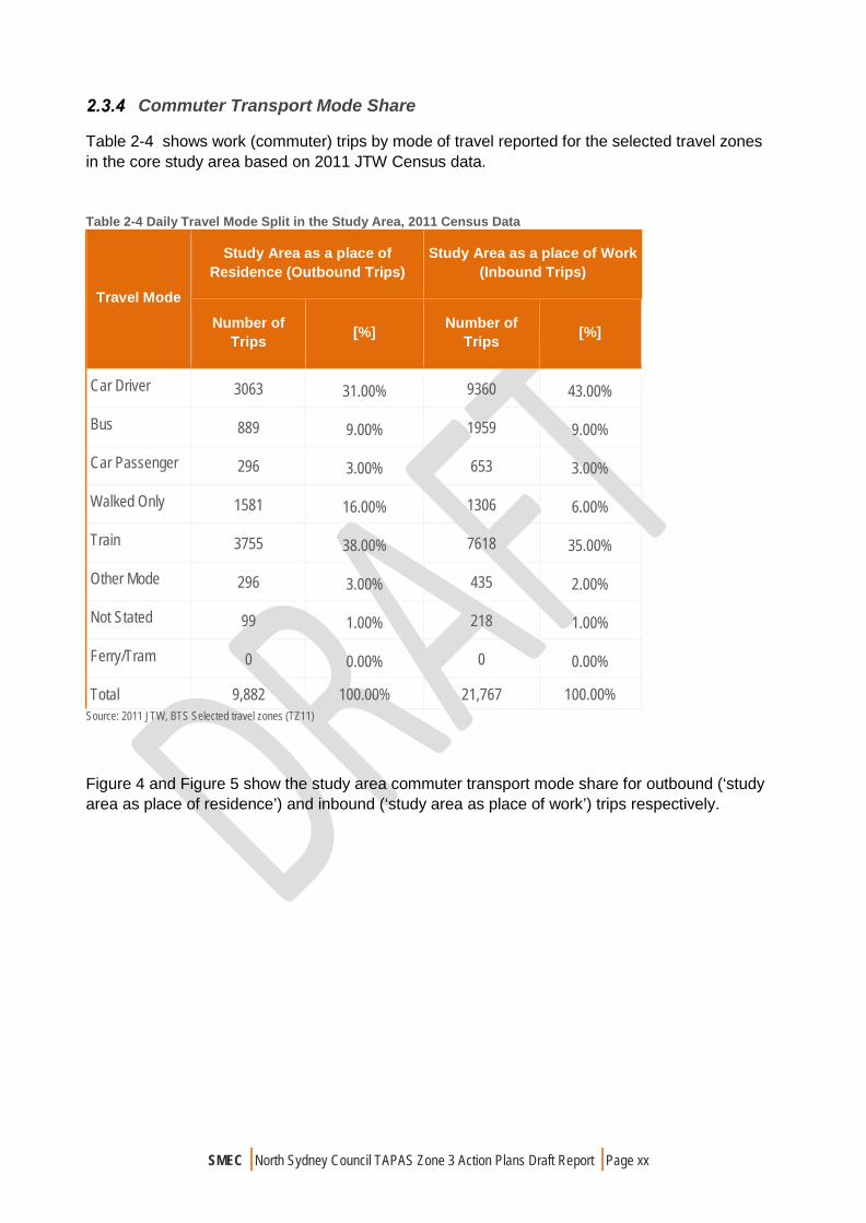
Commuter Transport Mode Share
Table 2-4 shows work (commuter) trips by mode of travel reported for the selected travel zones in the core study area based on 2011 JTW Census data.
Table 2-4 Daily Travel Mode Split in the Study Area, 2011 Census Data
Travel Mode
Study Area as a place of Residence (Outbound Trips)
Study Area as a place of Work (Inbound Trips)
Number of Trips [%] Number of
Trips [%]
Car Driver 3063 31.00% 9360 43.00%
Bus 889 9.00% 1959 9.00%
Car Passenger 296 3.00% 653 3.00%
Walked Only 1581 16.00% 1306 6.00%
Train 3755 38.00% 7618 35.00%
Other Mode 296 3.00% 435 2.00%
Not Stated 99 1.00% 218 1.00%
Ferry/Tram 0 0.00% 0 0.00%
Total 9,882 100.00% 21,767 100.00% Source: 2011 JTW, BTS Selected travel zones (TZ11)
Figure 4 and Figure 5 show the study area commuter transport mode share for outbound (‘study area as place of residence’) and inbound (‘study area as place of work’) trips respectively.

SMEC | North Sydney Council TAPAS Zone 3 Action Plans Draft Report | Page xxi
Figure 3: Transport Mode Share-Study Area as Place of Residence (2011 Census data)
Figure 4: Transport Mode Share-Study Area as Place of work (2011 Census data)
SMEC | North Sydney Council TAPAS Zone 3 Action Plans Draft Report | Page xxii
In 2011, about 9,900 residents travelled from the study area to work. The census data showed that around 34% of work related trips from the study area were made by motorists in private vehicles either as a car driver or car passenger. Driving a car and taking train are the most dominant transport modes with the proportion of 31% and 38% of work related trips respectively. Currently, there is a relatively low usage of bus services in the study area with only 9% of workers travelling by bus.
Similarly, in 2011, about 22,000 employees travelled to the study area to work. From the inbound trip statistics, it can be seen that taking train and driving a car are still by far the dominant mode of transport to work comprising about 78% of all work related trips. Only 9% of employees travelled by bus and 6% walked. From JTW data it can be concluded that taking train and driving a private car are the dominant modal transport choice for daily commuters.
Local Area Traffic Management Devices
A range of traffic management devices are employed within the North Sydney Council TAPAS areas. Examples include but are not limited to pedestrian refuges, raised pedestrian refuges, rain gardens, speed cushions, school zones, one way streets, restricted turns and reduced speed limits i.e. 10 km/h and 40km/hr. It should be noted that some of the above noted traffic management devices are State Government traffic management matters, which are not under the care and control of the Council.
Parking Facilities
Current Management Framework On-street parking is currently managed through 33 Parking Areas across the LGA and three Parking Zones (High Demand, Medium Demand and Low Demand). Within these 33 Parking Areas there are approximately 23,500 on-street parking spaces.
In many Parking Areas of North Sydney, the demand for on-street parking is greater than the supply of on-street parking. Since North Sydney Council is unable to increase the supply of on-street parking, the only way to manage the parking in some areas and give residents and visitors fair access to the resource is to place time restrictions on the available parking spaces.
On-street Parking Control Typologies To ensure that Council is managing parking fairly and equitably across the LGA, various parking controls have been installed on public roads. An LGA-wide audit of parking controls was undertaken in 2013.
Current Permit Parking Scheme Operations Council operates three types of Permit Parking Schemes, subject to certain conditions and approvals. A parking permit issued by Council under any of the following schemes exempts the permit holder from charge or time restrictions whilst parked in a permit parking zone:
Resident Parking Scheme Visitor Parking Scheme Carers Parking Scheme
SMEC | North Sydney Council TAPAS Zone 3 Action Plans Draft Report | Page xxiii
Restricted Parking Controls Operations In addition to the resident parking scheme controls, Council operates a significant amount of parking controls across the LGA. The three main types are as follows:
Long term Parking Controls - greater than 2-hour parking (i.e. 4P, 8P, 9P, 10P) Medium term Parking Controls – 1 and 2-hour parking (i.e. 1P, 2P). Short term Parking Controls - less than 1-hour parking (i.e. 15min, 30min)
Mobility Parking Operations Mobility Parking Spaces are managed in accordance with Council’s three Parking Zones (high demand, medium demand and low demand). Due to an increasing demand for mobility parking spaces, Council’s current practice is not to approve the installation of mobility parking spaces within high demand parking areas or in medium demand parking areas which are within 200m of an area zoned as Commercial or Mixed Use as defined by the LEP.
School Related Parking Control Operations Council assists local schools in terms of providing ‘Kiss and Ride’ zones. A ‘Kiss and Ride Zone’ provides an appropriate place to drop off or pick up children at school. There are different types of “Kiss and Drop” zones which operate across the LGA, including the following:
No Parking 8.00am – 9.30am, 2.30pm – 4.30pm School Days 5 Min 8.00am – 9.30am – 2.30pm, 4.30pm School Days
Car Share Operations There are dedicated car share parking spaces installed in various locations across the North Sydney LGA. These spaces are signposted as “No Parking Authorised Car Share Vehicles Excepted” and can only be used by a car share vehicle displaying an appropriate permit.
Metered Parking Operations Council currently has 433 multi-bay and 6 pay and display Parking Meters servicing 2,681 individual meter spaces. The parking meters throughout the LGA are located in the North Sydney CBD, the major shopping and business areas; Crow’s Nest, St Leonards, Neutral Bay, Cremorne, Milsons Point, Kirribilli and other fringe/shoulder areas that are in high demand for parking turnover.
Walking and Cycling Facilities
Walking Facilities The study area is well served by the provision of footpaths and pedestrian facilities. Nevertheless there is room for improvement particularly at key intersections throughout the North Sydney CBD.

SMEC | North Sydney Council TAPAS Zone 3 Action Plans Draft Report | Page xxiv
Cycling Facilities There is an extensive cycle network throughout the study area consisting of on and off road cycle routes including shared paths. The existing cycling infrastructure in the study area is shown in Figure 6.

SMEC | North Sydney Council TAPAS Zone 3 Action Plans Draft Report | Page xxv
Figure 5 Existing Cycle Network Typology Map

SMEC | North Sydney Council TAPAS Zone 3 Action Plans Draft Report | Page xxvi
Public Transport Facilities
Bus Services Most roads in the study area are serviced by public transport buses. There are plenty of bus routes in the study area which mostly operate along Pacific Highway, Miller Street, Falcon Street, Willoughby Road and Blues Point Road. Figure 7 shows existing bus routes in the study area.
Figure 6 Existing Bus Network

SMEC | North Sydney Council TAPAS Zone 3 Action Plans Draft Report | Page xxvii
Rail & Ferry Services The nearest rail stations in the study area are Milsons point Station, North Sydney Station, Waverton Station and Wollstonecraft Station as highlighted in Figure 8Error! Reference source not found.. These stations are part of the T1 North Shore, Northern and Western line and have frequent services particularly during peak periods.
The nearest rail stations in the study area are Milsons Point Wharf, McMahons Point, Greenwich Point Wharf and Greenwich as highlighted in Figure 8.
Figure 7 Ferry and Rail Services

SMEC | North Sydney Council TAPAS Zone 3 Action Plans Draft Report | Page xxviii
Crash Data Analysis
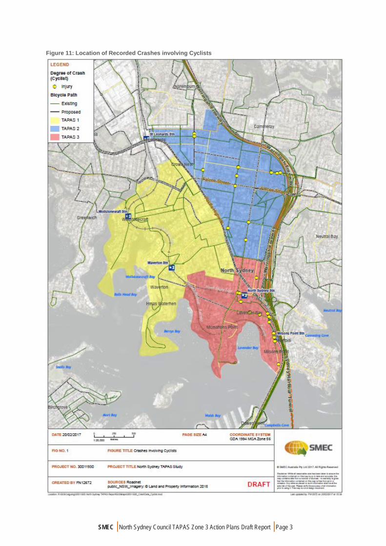
A crash assessment has been conducted for the study area using crash data supplied by Roads and Maritime Services for the five-year period from Jan 2011 to Jan 2015 inclusive. The data covers crashes reported to the police and includes fatal, injury and/ or non-casualty crashes.
A total of 610 crashes were recorded in the five-year period within the study area. There were four fatal crashes recorded and 48.3 per cent of the total crashes involved at least one injury. About 27.5 per cent of all crashes occurred at intersections and about 19.3 per cent of all crashes involved pedestrians or pedal cycles.
Figure 9 and Figure 10 show the number and percentage of crashes per movement type.
Figure 8 Summary of Type of Crash for the Study Area (volume)

SMEC | North Sydney Council TAPAS Zone 3 Action Plans Draft Report | Page xxix
Figure 9 Summary of Type of Crash for the Study Area (percentage)
According to Figure 8, it is noted that the dominant crash types in the study area include vehicles from same directions, intersection vehicles from adjacent approaches and off path on straight collisions. As illustrated in Figure 9, these types of crashes comprise about 20.8, 17.3 and 15.5 per cent, respectively.
There were a significant number of collisions occurring along the Pacific Highway and Warringah Freeway as well as on approach to their intersections. These crashes were not assessed in detail given that the Pacific Highway as well as all of its signalised intersections are under the care and control of the RMS and are therefore more appropriate for the RMS to address.
The following pedestrian crash clusters were identified in TAPAS Zone 3:
The Middlemiss Street / Lavender Street / Alfred Street intersection (2 crashes within 30m);
The Blue Street / Blues Point Road intersection (2 crashes); Alfred Street directly in front of Milsons Point Station (2 crashes); and Miller Street within 20m of Berry Street to the south (2 crashes).
It should also be noted that an isolated pedestrian fatality occurred on Spring Street.
The following cyclist crash clusters were identified in TAPAS Zone 3:
The Middlemiss Street / Lavender Street / Alfred Street intersection (4 crashes within 30m)
Alfred Street directly in front of Milsons Point Station (4 crashes); and The Blue Street / Blues Point Road intersection (2 crashes).


SMEC | North Sydney Council TAPAS Zone 3 Action Plans Draft Report | Page 1
Several vehicular crash clusters were identified throughout the TAPAS Zone including:
Blues Point Road, particularly near its intersection with Miller Street; Alfred Street particularly at its intersection with Lavender Street, its intersection with
Fitzroy Street and directly in front of Milsons Point Station; Walker Street; and Berry Street.
Figure 10 illustrates the location of all recorded crashes along the corridor for the five-year period between 2010 and 2015.

SMEC | North Sydney Council TAPAS Zone 3 Action Plans Draft Report | Page 2
Figure 10 Location of Recorded Crashes
SMEC | North Sydney Council TAPAS Zone 3 Action Plans Draft Report | Page 3
Figure 11: Location of Recorded Crashes involving Cyclists

SMEC | North Sydney Council TAPAS Zone 3 Action Plans Draft Report | Page 4
Figure 12: Location of Recorded Crashes involving Pedestrians
SMEC | North Sydney Council TAPAS Zone 3 Action Plans Draft Report | Page 5
SIGNIFICANT DEVELOPMENTS
Sydney Metro
Sydney Metro is Australia’s biggest public transport project which will deliver 31 metro stations and more than 65 kilometres of new metro rail. Metro means a new generation of world-class fast, safe and reliable trains easily connecting customers to where they want to go. The services start in the first half of 2019 and customers won’t need timetables as they’ll just turn up and go with a train every four minutes in the peak. When Sydney Metro is extended into the central business district (CBD) and beyond in 2024, metro rail will run from Sydney’s booming North West region under Sydney Harbor, through new underground stations in the CBD and beyond to the south west. There will be ultimate capacity for a metro train every two minutes in each direction under the city, a level of service never before seen in Sydney. Sydney’s new metro railway will have a target capacity of about 40,000 customers per hour, similar to other metro systems worldwide. Sydney’s current suburban system can reliably carry 24,000 people an hour per line. Sydney Metro, together with signaling and infrastructure upgrades across the existing Sydney rail network, will increase the capacity of train services entering the Sydney CBD – from about 120 an hour today to up to 200 services beyond 2024. That’s an increase of up to 60 per cent capacity across the network to meet demand.
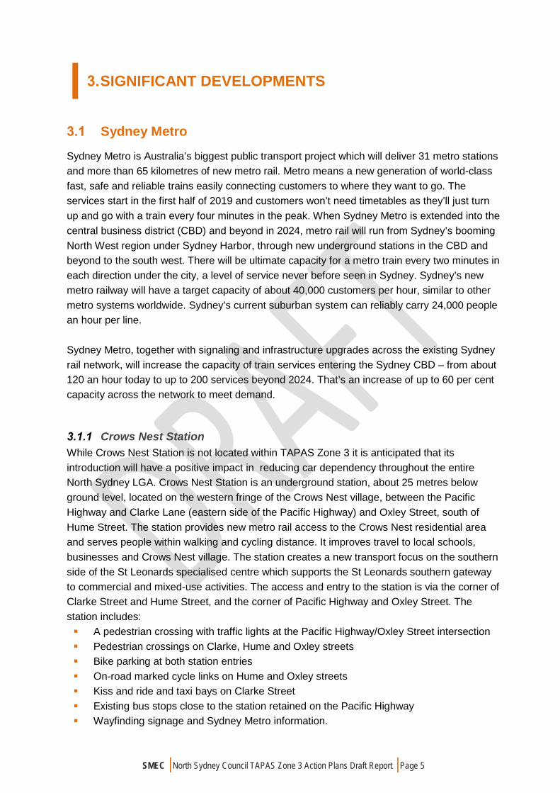
Crows Nest Station While Crows Nest Station is not located within TAPAS Zone 3 it is anticipated that its introduction will have a positive impact in reducing car dependency throughout the entire North Sydney LGA. Crows Nest Station is an underground station, about 25 metres below ground level, located on the western fringe of the Crows Nest village, between the Pacific Highway and Clarke Lane (eastern side of the Pacific Highway) and Oxley Street, south of Hume Street. The station provides new metro rail access to the Crows Nest residential area and serves people within walking and cycling distance. It improves travel to local schools, businesses and Crows Nest village. The station creates a new transport focus on the southern side of the St Leonards specialised centre which supports the St Leonards southern gateway to commercial and mixed-use activities. The access and entry to the station is via the corner of Clarke Street and Hume Street, and the corner of Pacific Highway and Oxley Street. The station includes: A pedestrian crossing with traffic lights at the Pacific Highway/Oxley Street intersection Pedestrian crossings on Clarke, Hume and Oxley streets Bike parking at both station entries On-road marked cycle links on Hume and Oxley streets Kiss and ride and taxi bays on Clarke Street Existing bus stops close to the station retained on the Pacific Highway Wayfinding signage and Sydney Metro information.

SMEC | North Sydney Council TAPAS Zone 3 Action Plans Draft Report | Page 6
Victoria Cross Station Victoria Cross Station is an underground station, about 31 metres below ground level, located beneath Miller Street (to the north of the Pacific Highway) between McLaren Street and south of Berry Street. The station provides new metro rail access to the North Sydney business, education and residential area. Station access and entry is via the pedestrian plaza opening to Miller, Denison and Berry streets. The Station access and entry is via the pedestrian plaza opening to Miller, Denison and Berry streets. The station includes: new bike parking near the corner of Miller and Berry streets new kiss and ride bays on Berry Street existing bus stops close to the station retained on Miller Street wayfinding signage and Sydney Metro information within the North Sydney CBD a traction substation integrated into the station building (partially underground) a services building on Miller Street to the north of the station providing station and tunnel
services Enhancement of pedestrian infrastructure around the station. This is being investigated
further in consultation with Roads and Maritime Services and North Sydney Council.
Traffic Impact Assessment of Ongoing Development
A strategic traffic impact assessment has been undertaken in the context of the Council’s Local Environmental Plan and Development Control Plan, which assesses the cumulative traffic generation from major traffic generating developments identified or proposed within each of the three TAPAS zones. This exercise was based on approved developments and related information provided by the Council. A high level assessment has also been undertaken to test the road networks ability to handle the increased density and any potential traffic flow and on-street parking problems resulting from major traffic generating developments. In this regard, functions of the road network in terms of access, particularly for pedestrians near to new transport infrastructure, has been considered.
Cumulative Traffic Generation Assessment A comprehensive list of developments approved by Council since 2001 has been assessed to determine the likely increase in traffic. The list did not specify which developments had been constructed or are under construction. For the purpose of this assessment, it is assumed that any proposed development that has been approved prior to 2011 has already been constructed and is generating traffic. As such, any proposed development approved in 2011 onwards is assumed to not yet be constructed and is yet to increase traffic on the surrounding road network. In addition to the above, any development anticipating to generate an additional 5 trips or less during peak periods is considered to be relatively insignificant in terms of its traffic impact such that they have not been included in the assessment.

SMEC | North Sydney Council TAPAS Zone 3 Action Plans Draft Report | Page 7
The anticipated trip generation has been determined based on the RMS Technical Directions (TDT 2013/04a) Guide to Traffic Generating Developments Updated traffic surveys which suggests the following weekday peak period traffic generation rates for residential units in the St Leonards area: AM Peak: 0.14 trips / unit PM Peak: 0.07 trips / unit
It is considered that these trips are appropriate to adopt for similar developments within TAPAS zone 3. The total number of proposed developments approved in 2011 onwards in which more than 5 additional trips are anticipated to be generated include the following:
74 – 80 Alfred Street, Milsons Point; 88 Alfred Street, St Leonards; 30 Alfred Street, St Leonards; and 12 – 16 Berry St, North Sydney.
Table 5: Developments in TAPAS Zone 3 with Traffic Generation greater than 5vph
TAPAS Zone
Location & Development
AM Peak
PM Peak
1 74 – 80 Alfred Street, Milsons Point 19
10
- Mixed use development (129 units)
3 88 Alfred Street, Milsons Point 18
9
- Mixed use development (123 units)
30 Alfred St, Milsons Point
10
5
- Mixed use development (66 units)
12 – 16 Berry St, North Sydney 7
4
- Mixed use development (48 units)
Total 131 67
It is noted that the vast majority of proposed developments are located on Alfred Street, whereby the greatest potential traffic impact is anticipated to occur at the Alfred Street / Lavender Street / Middlemiss Street intersection. The intersection also acts as the access to the Cahill Expressway which is under the care and control of the RMS. It is therefore considered more appropriate for the RMS to consider the impact of the developments on the intersection’s operation.
SMEC | North Sydney Council TAPAS Zone 3 Action Plans Draft Report | Page 8
EXISTING TRANSPORT ISSUES IDENTIFIED THROUGH COMMUNITY ENGAGEMENT
Introduction
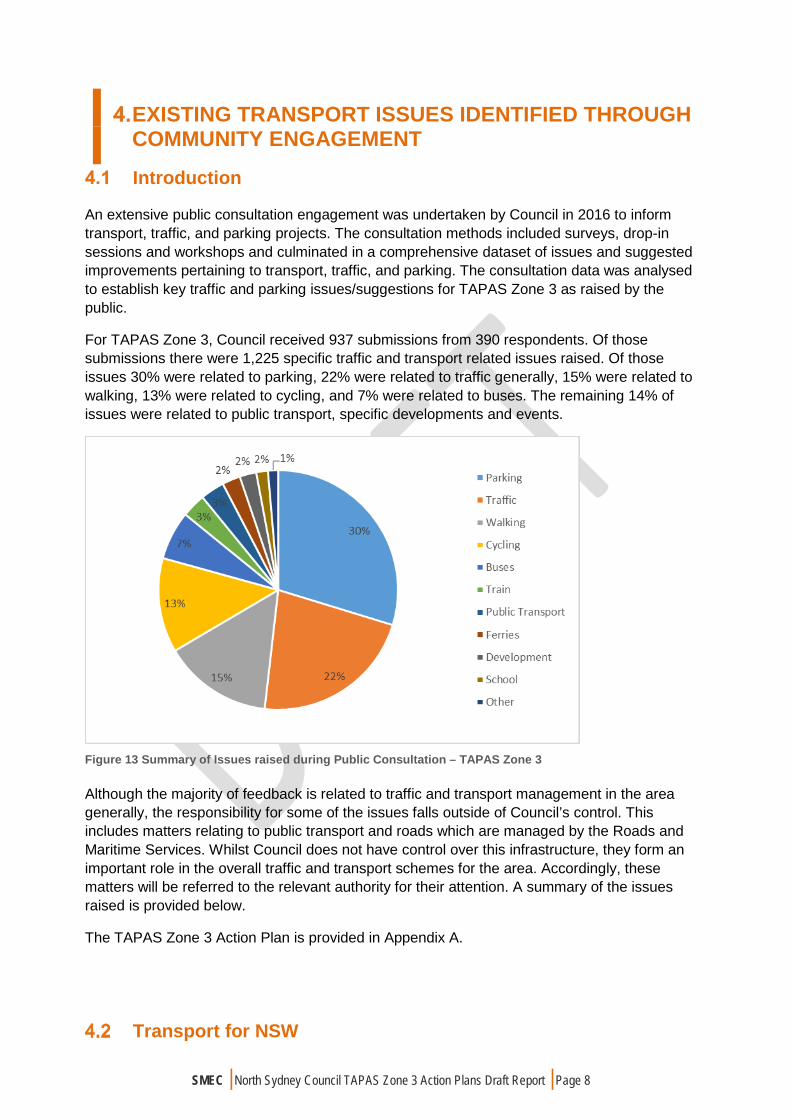
An extensive public consultation engagement was undertaken by Council in 2016 to inform transport, traffic, and parking projects. The consultation methods included surveys, drop-in sessions and workshops and culminated in a comprehensive dataset of issues and suggested improvements pertaining to transport, traffic, and parking. The consultation data was analysed to establish key traffic and parking issues/suggestions for TAPAS Zone 3 as raised by the public.
For TAPAS Zone 3, Council received 937 submissions from 390 respondents. Of those submissions there were 1,225 specific traffic and transport related issues raised. Of those issues 30% were related to parking, 22% were related to traffic generally, 15% were related to walking, 13% were related to cycling, and 7% were related to buses. The remaining 14% of issues were related to public transport, specific developments and events.
Figure 13 Summary of Issues raised during Public Consultation – TAPAS Zone 3
Although the majority of feedback is related to traffic and transport management in the area generally, the responsibility for some of the issues falls outside of Council’s control. This includes matters relating to public transport and roads which are managed by the Roads and Maritime Services. Whilst Council does not have control over this infrastructure, they form an important role in the overall traffic and transport schemes for the area. Accordingly, these matters will be referred to the relevant authority for their attention. A summary of the issues raised is provided below.
The TAPAS Zone 3 Action Plan is provided in Appendix A.
Transport for NSW

SMEC | North Sydney Council TAPAS Zone 3 Action Plans Draft Report | Page 9
There were 146 issues raised with respect to public transport in TAPAS Zone 3. 59 (40%) of these responses related to timetables for various modes of public transport. The most recurring of these was the frequency of bus services. A summary of the issues raised and the raw feedback will be forwarded to Transport for NSW for their attention (Appendix D). Table 4.1: Summary of issues raised for attention of Transport for NSW
Frequency Transport Mode
Issue Category Buses Ferries Public Transport Trains Grand Total Public Transport - Timetables
35 17 17 12 81
Public Transport - Infrastructure
5 4 4 12 25
Public Transport - Stop/ Station / Wharf locations
12 1 13
Public Transport - Connections
3 5 1 9
Other 1 1 6 8 Public Transport - Routes
7 7
Public Transport - Passenger Congestion
2 1 3 6
Public Transport - Accessibility
1 1 2 4
Positive feedback
1 1 2
Public Transport - Cost
1 1
Grand Total 63 28 28 37 156
Roads and Maritime Services
There were 100 issues raised with respect to roads and routes which are managed by Roads and Maritime Services. 67 (67%) of these responses related to traffic and congestion generally, and the most recurring of these was along the Pacific Highway and signalised intersections on River Road. A summary of the issues raised and the raw feedback will be forwarded to RMS for their attention (Appendix E). Table 4.2: Summary of issues raised for attention of RMS
Mode Frequency Vehicle 82 Walking 25 Cycling 3
SMEC | North Sydney Council TAPAS Zone 3 Action Plans Draft Report | Page 10
Grand Total 110
Cycling Strategy
As noted previously, 7% of issues raised related to cycling. This included a range of issues such as cycling safety and connectivity, as well as perceived safety of other road users due to the lack of separated cycling infrastructure. Council has already developed and is in the process of implementing the North Sydney Integrated Cycling Strategy, some of the issues raised have already been addressed as part of the cycling strategy and some are new matters that require further action. Many of the submissions justify the work that Council has already planned and highlight the need for more dedicated cycling infrastructure. The items raised are listed in the TAPAS Zone 3 Action Plan.
In addition, all future road facilities will be designed with cyclists in mind to ensure they do not create additional hazards or pinch points.
Matters Referred to Other Council Departments
92 submissions were received which fall under the responsibility of various Council departments but contribute to the overall transport amenity of the area. These include conditions of footpaths, enforcement of parking restrictions, events management bus stop infrastructure and driveway approvals. A list of these issues has been summarised in Table 3.7 and will be referred to the appropriate departments within Council for their attention (Appendix F).
244 of the submissions received could not be used further for reasons such as there was not enough information provided, the issue fell within a different TAPAS Zone, or the issue was outside of the North Sydney Council LGA. A comment has been provided against each of these in Appendix G to explain why these have not been included in the Action Plans, or if they have been referred to the Action Plan for a different TAPAS Zone.
Table 4-3:: Summary of issues raised for attention of other Council departments
Council Department and Issue Category Frequency CIS 24
Refer to CIS 24 OSE 8
Refer to OSE 6 Sustainability 2
Rangers 22 Enforcement 22
Street Furniture 2 Planter box construction 2
Works Engineers 38 Footpath repair program 7 Refer to Works Engineers 31
Grand Total 94

SMEC | North Sydney Council TAPAS Zone 3 Action Plans Draft Report | Page 11

SMEC | North Sydney Council TAPAS Zone 3 Action Plans Draft Report | Page 12
TAPAS ACTIONS PLANS
Action Plan Development
Following identification of issues through community feedback and the physical audit of existing facilities in the TAPAS zones, a suite of facility improvements has been developed to address the issues identified.
Council’s traffic actions and those identified by this study have been assessed against several different criteria as per the North Sydney Integrated Traffic and Parking Strategy (2015) to prioritise the actions on a relative basis. The scoring methodology consists of two parts – an assessment of the current conditions (problem score) and an assessment of the proposed treatment (solution score).
Existing Conditions (Problem Score)
The problem score, P, is derived from the following quantitative criteria:
road classification; traffic volume vs desired volume; 85th percentile speed vs desired speed of 40km/h; crash data including weighted scores for severity and vulnerable road users; relative pedestrian and cyclist volumes; and surrounding land uses
Community Strategic Plan Criteria
The solution score, S, is derived from the project assessment framework set out in the 2017 Draft North Sydney Transport Strategy which consists of a score from -3 to 3 based on how relatively consistent the proposal is with the following criteria:
Safe Travel - Improve community safety by creating slow speed road environments where more vulnerable road users are protected from higher impact road users and the number of crashes and severity of injuries is minimised
Transport Security - Improve personal security through improved streetscape design, increased street activity and passive surveillance
Social Wellbeing - Provide social spaces where human interaction is given the highest priority and the negative impacts of traffic are minimised, promoting incidental social interaction, increasing civic pride, reducing anti-social behaviour and community policing requirements
Active Health - Provide infrastructure that encourages healthy and active lifestyle/travel choices
Fair Access to Parking - Reduce demand for parking and / or provide more equitable access to existing parking supply
Environmental Sustainability - Encourage the use of low greenhouse gas emitting transport options
Local Environments - Encourage the use of travel modes that have minimal impact on air quality, water quality and noise
SMEC | North Sydney Council TAPAS Zone 3 Action Plans Draft Report | Page 13
Transport Affordability - Encourage the use of travel options with lower social, health and economic costs and higher social, health and economic benefits
Congestion - Apply travel demand management principles to minimise traffic demand and associated traffic congestion
Business Activity - Increase business opportunities by improving the look/ amenity of North Sydney throughout the day and in to the evening while, at the same time, reducing the whole of life cost of transport networks, including the ongoing costs associated with cleaning and maintaining assets
Total Project Score
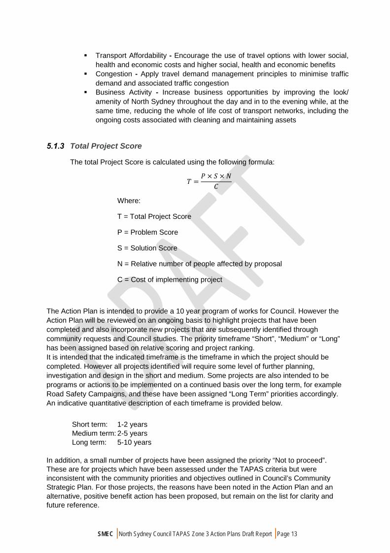
The total Project Score is calculated using the following formula:
𝑇𝑇 =𝑃𝑃 × 𝑆𝑆 ×𝑁𝑁
𝐶𝐶
Where:
T = Total Project Score
P = Problem Score
S = Solution Score
N = Relative number of people affected by proposal
C = Cost of implementing project
The Action Plan is intended to provide a 10 year program of works for Council. However the Action Plan will be reviewed on an ongoing basis to highlight projects that have been completed and also incorporate new projects that are subsequently identified through community requests and Council studies. The priority timeframe “Short”, “Medium” or “Long” has been assigned based on relative scoring and project ranking. It is intended that the indicated timeframe is the timeframe in which the project should be completed. However all projects identified will require some level of further planning, investigation and design in the short and medium. Some projects are also intended to be programs or actions to be implemented on a continued basis over the long term, for example Road Safety Campaigns, and these have been assigned “Long Term” priorities accordingly. An indicative quantitative description of each timeframe is provided below.
Short term: 1-2 years Medium term: 2-5 years Long term: 5-10 years
In addition, a small number of projects have been assigned the priority “Not to proceed”. These are for projects which have been assessed under the TAPAS criteria but were inconsistent with the community priorities and objectives outlined in Council’s Community Strategic Plan. For those projects, the reasons have been noted in the Action Plan and an alternative, positive benefit action has been proposed, but remain on the list for clarity and future reference.
SMEC | North Sydney Council TAPAS Zone 3 Action Plans Draft Report | Page 14
The outcomes of the TAPAS assessment have been used to produce the TAPAS Action Plan which is provided at Appendix A.
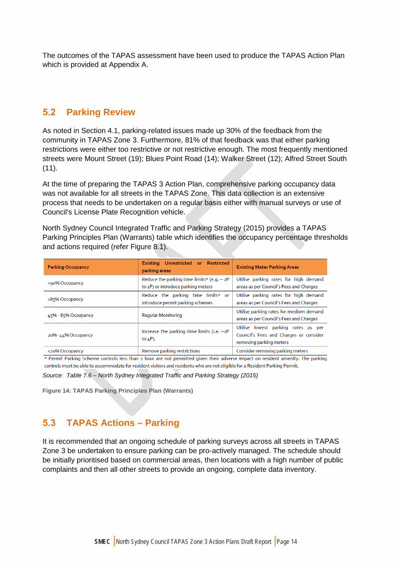
Parking Review
As noted in Section 4.1, parking-related issues made up 30% of the feedback from the community in TAPAS Zone 3. Furthermore, 81% of that feedback was that either parking restrictions were either too restrictive or not restrictive enough. The most frequently mentioned streets were Mount Street (19); Blues Point Road (14); Walker Street (12); Alfred Street South (11).
At the time of preparing the TAPAS 3 Action Plan, comprehensive parking occupancy data was not available for all streets in the TAPAS Zone. This data collection is an extensive process that needs to be undertaken on a regular basis either with manual surveys or use of Council's License Plate Recognition vehicle.
North Sydney Council Integrated Traffic and Parking Strategy (2015) provides a TAPAS Parking Principles Plan (Warrants) table which identifies the occupancy percentage thresholds and actions required (refer Figure 8.1).
Source: Table 7.6 – North Sydney Integrated Traffic and Parking Strategy (2015) Figure 14: TAPAS Parking Principles Plan (Warrants)
TAPAS Actions – Parking
It is recommended that an ongoing schedule of parking surveys across all streets in TAPAS Zone 3 be undertaken to ensure parking can be pro-actively managed. The schedule should be initially prioritised based on commercial areas, then locations with a high number of public complaints and then all other streets to provide an ongoing, complete data inventory.

SMEC | North Sydney Council TAPAS Zone 3 Action Plans Draft Report | Page 15
Table 5-1 TAPAS Parking Actions
ID Location Description of Request or Issue Action Category
Action Priority
P.1 Bank St More parking spaces could be created by allowing 2 or 3 spaces over the railway line west side of street.
Parking Provide New Parking Spaces in Bank St
long
P.3 CBD Insufficient parking for drop-off and pick-up around North Sydney Train Station
Parking Provide Drop off / Pick up spaces
Long
P.4 CBD Insufficient amount of motorbike parking in CBD
Parking Provide Motorbike Spaces
Medium
P.5 CBD Lack of accessible parking spaces – various locations
Parking Provide Accessible Parking Spaces
Medium
P.6 Mount St, Post Office
Inadequate parking for drop-off and pick-ups
Parking Provide Drop off / Pick up spaces
Medium
P.7 TAPAS Zone 3
228 submissions regarding insufficient parking restrictions in various street throughout TAPAS Zone 3
Parking Area-wide review of parking restrictions in TAPAS Zone 3
Short

SMEC | North Sydney Council TAPAS Zone 3 Action Plans Draft Report | Page 16
APPROVALS PROCESSES The approvals process for the TAPAS actions involved several different steps to be approved for final recommendations. The steps were:
1. Draft TAPAS Action Plans submitted to Council for endorsement to place on public exhibition;
2. Draft TAPAS Action Plans placed on public exhibition for a minimum of 28 days;
3. Feedback from Steps 1-3 incorporated into TAPAS Action Plans;
4. Final TAPAS Action Plans submitted to Council for adoption;
5. 5-10 year program of works developed from TAPAS Action Plans;
6. Ongoing review of TAPAS Action Plans included completed and new assessed and prioritised items; and
7. Projects referred to Traffic Committee for approval prior to implementation.
North Sydney Council has been delegated certain powers from RMS to manage traffic matters on North Sydney roads. The North Sydney Traffic Committee considers all proposed changes to traffic and parking arrangements within the North Sydney LGA. Any recommendations from the traffic committee must be taken into consideration by North Sydney Council before making a determination to proceed.
The Action Plan will be reviewed on an ongoing basis to highlight completed actions. The Action Plan will also be updated with new projects that are identified by the community or through studies and subsequently prioritised using the TAPAS assessment criteria.
SMEC | North Sydney Council TAPAS Zone 3 Action Plans Draft Report | Page 16
APPENDIX A – PRIORITISED ACTION PLAN

TAPAS Zone 3 Action Plan
ID Location Description of Request or Issue Action Category Action Notes PriorityC.1 North Sydney 3 Submissions
North Sydney generally ‐ getting through North Sydney & onto the Harbour Bridge Lower North Shore ‐ lack of continuous dedicated Bike paths
Cyclists coming from North Sydney cant see the lights
North Sydney generally ‐ getting through North Sydney & onto the Harbour Bridge Lower North Shore ‐ lack of continuous dedicated Bike paths
Cycling Strategy Install separated cycleway Short
C.2 Blue St Shared Path at Miller St & Blue St ‐ Cyclists are a dangerous problem
Blue St ‐ cycling ‐ alternative route heeded as unsafe to share with buses
Blue St outside train station ‐ No bike lanes;
Cycling Strategy Implement Cycle Route 1 from 2014 Cycling Strategy
Long
C.3 Blues Point Rd 8 SubmissionsBlues Point Rd, McMahons Point ‐ No Bike paths make it extremely dangerous to cycle.
Cyclists , bikes everywhere (but not fast) cars + bikes need to improve especially cycleway that were not on the cycle plan, disastrous position between Blue and Union St on Blues Point Rd. Cars parked on cycleway : forced into road.
Blues Point Rd ‐ Shared bike & pedestrian paths generally ‐ Can be a problem for pedestriansWalking up Blues Pt Rd to Nth Sydney Stn in Summer ‐ By the time you get there in you're a lather of sweat.;
Walking ‐ dodging bikes at the top of Miller St when approach Nth Syd Stn ‐ Bike paths should be directed down Blues Pt Rd to Lavender St.
Bike ‐ Poor road conditions, narrow streets, no bike lane
All bikes paths need to be checked and improved e.g.. Blues point road
Blues Point Rd, McMahons Point ‐ When cycling, the preponderance of parked cars poses a risk when people open their car doors without looking. Also, the bicycle symbol seems to count for nothing.
St. Peters Park, Blue Pt Rd ‐ shared use ‐ bicycles should be dismounted.;
Cycling Strategy Implement On‐Road Cycle Route Upgrade Medium
1

TAPAS Zone 3 Action Plan
C.4 Alfred St 24 SubmissionsAlfred St, Milsons Point ‐ Cyclists take up a fair amount of the road;
Alfred St South ‐ Needs a bike path
ALFRED ST AND SURROUNDING FOOTPATHS ‐ HIGH DENSITY OF CYCLISTS BREAKING THE LAW AT LIGHTS AND FOOTPATHS MAKES IT VERY DANGEROUS FOR ELDERLY PEDESTRIANS
Area of concern for cyclists‐cars come off bridge
Lavender St, Alfred St ‐ Car/ bicycle mix;
Alfred St ‐ Push bikes continually ignore red lights and traffic rules.;
Alfred St, Milsons Point ‐ Cyclists ignoring red lights at crossing outside train station. Very unsafe when they race straight through red lights with no care for pedestrians.;
Alfred St, Milson Point ‐ Bikes not following road rules and being very reckless/dangerous.
Cyclists go in hurry up path to bridge‐ more an issue for pedestrians
Lavender St, roundabout, Milsons Pt NSW 2061 ‐ Bicycles turn up from nowhere and from behind cars, trucks and buses
2. In relation to cyclists I am very pleased to see more people cycling but the off ramp from the Bridge across Burton Street; the plaza used by the markets and onto Alfred Street needs better management. Once again because they are coming down hill they are travelling very fast and then hit Alfred Street full of cars, pedestrians and buses. Once I saw cyclists hit an older couple near the bottom of the Bridge off ramp on Burton Street.
Cycling Strategy a. Implement Cycle Route 1 and 3 from 2014 Cycling Strategy
b. Advocate to State Government for Step free access to Harbour Bridge
Long
C.5 Miller St 6 SubmissionsA lot of cyclists leave Miller to go down to go through the park ‐‐> not enough room as there is a bus stop, a path ‐‐> very messy.
3) Cyclists heading up Miller Street in evening peak is dangerous due to their slower speed and fast passing buses and cars.
North Sydney, Miller St in particular ‐ I like cycling but roads have become too busy.; Peak hours ‐ the bunching of buses along Miller St combined with cyclists on the road make driving very very stressful. Need a separate cycleway ‐ don't know where but maybe cyclists have to take other roads not main roads.
Miller Street ‐ As above (No Bike paths make it extremely dangerous to cycle) ‐ suggest lane for specific times ‐ early morning.;
Union St, Miller St ‐ Unsafe for bicycles ‐ more dedicated bicycle lanes please;*
Cycling ‐ northbound cycling on Pacific Highway in North Sydney and multiple lane change into right hand turn lane at Miller Street intersection is highly exposed to motor traffic; and lack of space available on Miller Street at corner of Mount Street to accommodate cyclists doing the alternative hook turn manouevre from Pacific Highway onto Miller Street northbound
Cycling Strategy Install separated cycleway Medium
2
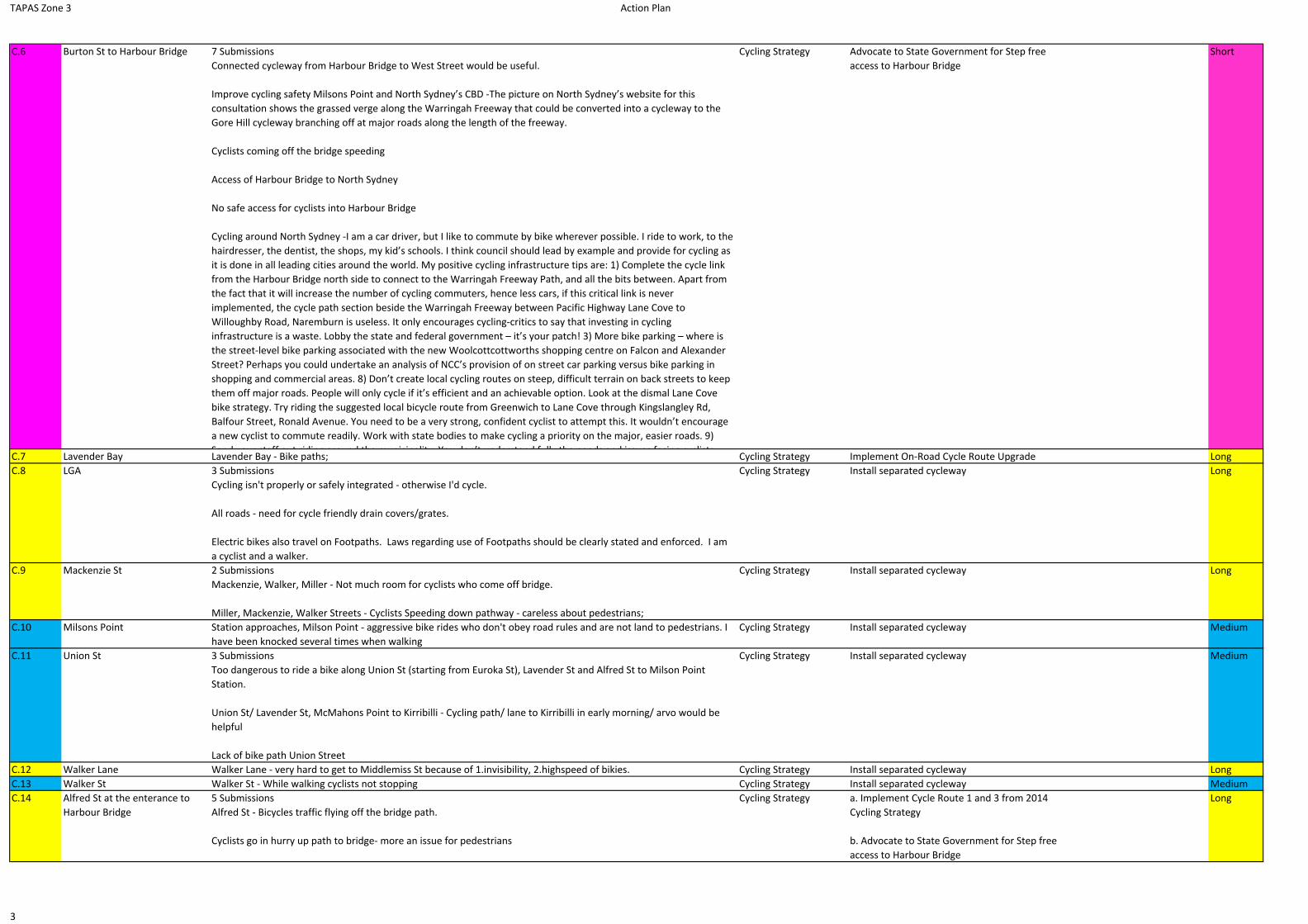
TAPAS Zone 3 Action Plan
C.6 Burton St to Harbour Bridge 7 SubmissionsConnected cycleway from Harbour Bridge to West Street would be useful.
Improve cycling safety Milsons Point and North Sydney’s CBD ‐The picture on North Sydney’s website for this consultation shows the grassed verge along the Warringah Freeway that could be converted into a cycleway to the Gore Hill cycleway branching off at major roads along the length of the freeway.
Cyclists coming off the bridge speeding
Access of Harbour Bridge to North Sydney
No safe access for cyclists into Harbour Bridge
Cycling around North Sydney ‐I am a car driver, but I like to commute by bike wherever possible. I ride to work, to the hairdresser, the dentist, the shops, my kid’s schools. I think council should lead by example and provide for cycling as it is done in all leading cities around the world. My positive cycling infrastructure tips are: 1) Complete the cycle link from the Harbour Bridge north side to connect to the Warringah Freeway Path, and all the bits between. Apart from the fact that it will increase the number of cycling commuters, hence less cars, if this critical link is never implemented, the cycle path section beside the Warringah Freeway between Pacific Highway Lane Cove to Willoughby Road, Naremburn is useless. It only encourages cycling‐critics to say that investing in cycling infrastructure is a waste. Lobby the state and federal government – it’s your patch! 3) More bike parking – where is the street‐level bike parking associated with the new Woolcottcottworths shopping centre on Falcon and Alexander Street? Perhaps you could undertake an analysis of NCC’s provision of on street car parking versus bike parking in shopping and commercial areas. 8) Don’t create local cycling routes on steep, difficult terrain on back streets to keep them off major roads. People will only cycle if it’s efficient and an achievable option. Look at the dismal Lane Cove bike strategy. Try riding the suggested local bicycle route from Greenwich to Lane Cove through Kingslangley Rd, Balfour Street, Ronald Avenue. You need to be a very strong, confident cyclist to attempt this. It wouldn’t encourage a new cyclist to commute readily. Work with state bodies to make cycling a priority on the major, easier roads. 9) Send your staff out riding around the municipality You don’t understand fully the needs and issues facing cyclists
Cycling Strategy Advocate to State Government for Step free access to Harbour Bridge
Short
C.7 Lavender Bay Lavender Bay ‐ Bike paths; Cycling Strategy Implement On‐Road Cycle Route Upgrade LongC.8 LGA 3 Submissions
Cycling isn't properly or safely integrated ‐ otherwise I'd cycle.
All roads ‐ need for cycle friendly drain covers/grates.
Electric bikes also travel on Footpaths. Laws regarding use of Footpaths should be clearly stated and enforced. I am a cyclist and a walker.
Cycling Strategy Install separated cycleway Long
C.9 Mackenzie St 2 SubmissionsMackenzie, Walker, Miller ‐ Not much room for cyclists who come off bridge.
Miller, Mackenzie, Walker Streets ‐ Cyclists Speeding down pathway ‐ careless about pedestrians;
Cycling Strategy Install separated cycleway Long
C.10 Milsons Point Station approaches, Milson Point ‐ aggressive bike rides who don't obey road rules and are not land to pedestrians. I have been knocked several times when walking
Cycling Strategy Install separated cycleway Medium
C.11 Union St 3 SubmissionsToo dangerous to ride a bike along Union St (starting from Euroka St), Lavender St and Alfred St to Milson Point Station.
Union St/ Lavender St, McMahons Point to Kirribilli ‐ Cycling path/ lane to Kirribilli in early morning/ arvo would be helpful
Lack of bike path Union Street
Cycling Strategy Install separated cycleway Medium
C.12 Walker Lane Walker Lane ‐ very hard to get to Middlemiss St because of 1.invisibility, 2.highspeed of bikies. Cycling Strategy Install separated cycleway LongC.13 Walker St Walker St ‐ While walking cyclists not stopping Cycling Strategy Install separated cycleway MediumC.14 Alfred St at the enterance to
Harbour Bridge5 SubmissionsAlfred St ‐ Bicycles traffic flying off the bridge path.
Cyclists go in hurry up path to bridge‐ more an issue for pedestrians
Cycling Strategy a. Implement Cycle Route 1 and 3 from 2014 Cycling Strategy
b. Advocate to State Government for Step free access to Harbour Bridge
Long
3

TAPAS Zone 3 Action Plan
C.16 William St Cycling ‐ Lack of contraflow bicycle lane/share path on William Street southbound to connect the Edward/Mount Streets and Blue/Miller/Mackenzie Streets Routes
Cycling Strategy Install separated cycleway Long
C.17 Lavender St 9 SubmissionsLavender St, Alfred St ‐ Car/ bicycle mix;
Lavender St, roundabout, Milsons Pt NSW 2061 ‐ Bicycles turn up from nowhere and from behind cars, trucks and buses
Lavender St ‐ safe parking of motor bikes; dangerous cyclists
Lavender St, Milsons Point ‐ Bikers not following basic traffic rules and pulling out in front of cars and round‐about.
Roundabouts dangerous for cyclists
13. North Sydney Cycle Link – Middlemiss and Lavender: This is a major blockage and deterrent. Install short raised cycle path from Milsons Park, past and through viaduct opening to north side of rail line. Much cheaper than City cycle links strategy.
Improve cycling safety Milsons Point and North Sydney’s CBD ‐Work with NSW Government to fund and install a short cycle bridge over Milson Point station’s entrance from the Sydney Harbour Bridge cycleway. Install a cycleway at ground level along the western side of the railway line from Milson Point station to Lavender St. Install a cycle/pedestrian bridge over Lavender St roundabout and through the glass windows of one of the leased buildings under the railway then over the Pacific Hwy and then under High St bridge. A large concrete tube could be slid through the leased building near the roof that would be soundproof. Continue cycleway along the edge of the Warringah Freeway to Mount St. In future cycleway could continue along the edge of the Warringah Freeway to completely remove conflict between vehicles and driveways in North Sydney. This will create a high speed cycle highway from Sydney’s CBD through Milsons Point and around the edge of North Sydney’s CBD to improve safety and reduce conflicts.
Improve cycling safety Milsons Point and North Sydney’s CBD I am concerned about the safety of cyclist between
Cycling Strategy Implement On‐Road Cycle Route Upgrade Medium
C.18 Blue St at Arthur St * Cycling ‐ Shared path between Blue Street & Arthur Street (thence to Middlemiss Street) is too narrow and has too many street fixtures/fittings
Blue St, Arthur St ‐ Sharing footpaths with bikes ‐ dangerous
Walking up Blue St, Arthur St. exit (near Pacific Highway) is shared path with bike and pedestrians ‐‐> very dangerous.
Cycling Strategy Implement Cycle Route 1 from 2014 Cycling Strategy
Long
C.19 Pacific Highway (Berry St to Lavender St)
6 Submissions
Pacific highway ‐ cycles using pathway dangerouslyPacific Highway, North Sydney ‐ Shared footpath with bikes from Blue St to Arthur St along the Pacific Highway. It is so dangerous for people walking down.
Pacific Highway, Miller St ‐ No bike lanesPacific Hwy to Blue/Miller St ‐ is a disaster and I have experienced push bikes running in to myself
PACIFIC HWY, NORTH SYDNEY ‐ BIKE PATHS
It would be really good to see a bike lane built along Pacific Highway from the Bridge to Lane Cove
Pacific Hwy North Sydney ‐ Bike path between Walker and Miller streets. Lots of bikes crossing numerous lanes to turn right into Miller.
Cycling Strategy Install separated cycleway Short
4
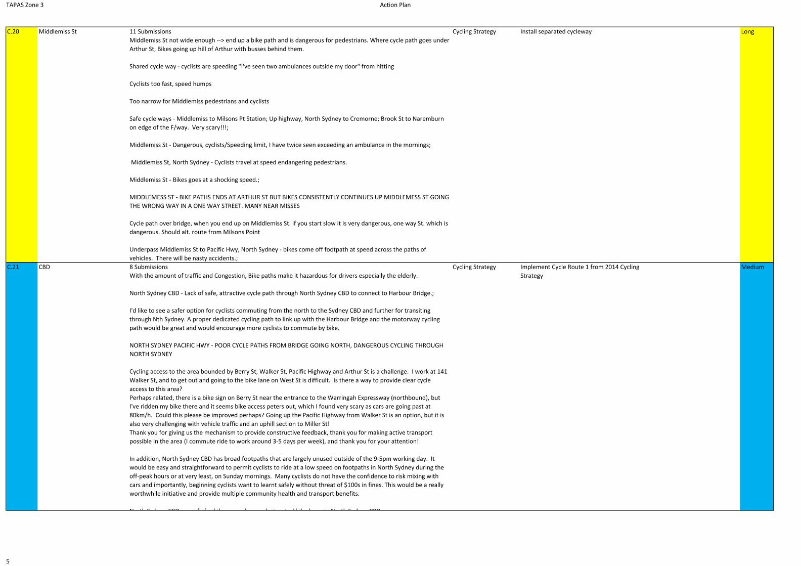
TAPAS Zone 3 Action Plan
C.20 Middlemiss St 11 SubmissionsMiddlemiss St not wide enough ‐‐> end up a bike path and is dangerous for pedestrians. Where cycle path goes under Arthur St, Bikes going up hill of Arthur with busses behind them.
Shared cycle way ‐ cyclists are speeding "I've seen two ambulances outside my door" from hitting
Cyclists too fast, speed humps
Too narrow for Middlemiss pedestrians and cyclists
Safe cycle ways ‐ Middlemiss to Milsons Pt Station; Up highway, North Sydney to Cremorne; Brook St to Naremburn on edge of the F/way. Very scary!!!;
Middlemiss St ‐ Dangerous, cyclists/Speeding limit, I have twice seen exceeding an ambulance in the mornings;
Middlemiss St, North Sydney ‐ Cyclists travel at speed endangering pedestrians.
Middlemiss St ‐ Bikes goes at a shocking speed.;
MIDDLEMESS ST ‐ BIKE PATHS ENDS AT ARTHUR ST BUT BIKES CONSISTENTLY CONTINUES UP MIDDLEMESS ST GOING THE WRONG WAY IN A ONE WAY STREET. MANY NEAR MISSES
Cycle path over bridge, when you end up on Middlemiss St. if you start slow it is very dangerous, one way St. which is dangerous. Should alt. route from Milsons Point
Underpass Middlemiss St to Pacific Hwy, North Sydney ‐ bikes come off footpath at speed across the paths of vehicles. There will be nasty accidents.;
Cycling Strategy Install separated cycleway Long
C.21 CBD 8 SubmissionsWith the amount of traffic and Congestion, Bike paths make it hazardous for drivers especially the elderly.
North Sydney CBD ‐ Lack of safe, attractive cycle path through North Sydney CBD to connect to Harbour Bridge.;
I'd like to see a safer option for cyclists commuting from the north to the Sydney CBD and further for transiting through Nth Sydney. A proper dedicated cycling path to link up with the Harbour Bridge and the motorway cycling path would be great and would encourage more cyclists to commute by bike.
NORTH SYDNEY PACIFIC HWY ‐ POOR CYCLE PATHS FROM BRIDGE GOING NORTH, DANGEROUS CYCLING THROUGH NORTH SYDNEY
Cycling access to the area bounded by Berry St, Walker St, Pacific Highway and Arthur St is a challenge. I work at 141 Walker St, and to get out and going to the bike lane on West St is difficult. Is there a way to provide clear cycle access to this area?Perhaps related, there is a bike sign on Berry St near the entrance to the Warringah Expressway (northbound), but I've ridden my bike there and it seems bike access peters out, which I found very scary as cars are going past at 80km/h. Could this please be improved perhaps? Going up the Pacific Highway from Walker St is an option, but it is also very challenging with vehicle traffic and an uphill section to Miller St!Thank you for giving us the mechanism to provide constructive feedback, thank you for making active transport possible in the area (I commute ride to work around 3‐5 days per week), and thank you for your attention!
In addition, North Sydney CBD has broad footpaths that are largely unused outside of the 9‐5pm working day. It would be easy and straightforward to permit cyclists to ride at a low speed on footpaths in North Sydney during the off‐peak hours or at very least, on Sunday mornings. Many cyclists do not have the confidence to risk mixing with cars and importantly, beginning cyclists want to learnt safely without threat of $100s in fines. This would be a really worthwhile initiative and provide multiple community health and transport benefits.
North Sydney CBD unsafe for bikes need more designated bike lanes in North Sydney CBD;
Cycling Strategy Implement Cycle Route 1 from 2014 Cycling Strategy
Medium
5

TAPAS Zone 3 Action Plan
G.1 LGA 3 SubmissionsShuttle bus between train station ‐‐> Could just service the wharves. (Free shuttle, e.g. 20 seater bus)
Shuttle bus (Potential solution to a number of issues relating to mode choice/car reliance.)
In North Sydney I would like to be more flexible on public transport. I would like to have a short loop service that takes passengers in the peak hours from the Military Rd to Milson Pt. / North Sydney to Cremorne Pt. Station / .... so they can go either on the Rail or Ferry and during the evening hours back again.
Consider Shuttle Service
consider Shuttle Bus Services between Train Stations and Wharves throughout the LGAconsider Shuttle Bus Services throughout the LGA
long
G.2 Berry St 5 SubmissionsBerry St, North Sydney ‐ traffic Congestion ‐ traffic merging from Pacific Hwy to Berry St;
Berry St ‐ Traffic Congestion Berry St, North Sydney ‐ Traffic Congestion
Berry St, North Sydney ‐ Traffic Congestion
North Sydney ‐ Berry St traffic is a problem all day.
Berry St ‐ Getting onto freeways is time consuming during peak hoursTraffic on Miller St Congestion ‐
RMS Lobby the RMS to direct Citybound traffic down Pacific Highway instead of via Berry St
long
G.3 TAPAS 3 Area Extended TAPAS area to include 3 currently. Parking by farther afield residents – drive to station. Solution – shuttle to collect around the further extremities of the LGA and TAPAS areas to get to Transport Hub, e.g. Milsons Point Station, ferry, etc.
Consider Shuttle Service
consider Shuttle Bus Services within TAPAS 3 area
long
G.4 Pacific Highway at Miller and Walker
2 SubmissionsPacific Highway, Walker and Miller St are too congested and dangerous, coming over Neutral Bay Overpass
Walker St, Pacific Hwy Junction ‐ Congestion
Lobby for improvements to Public Transport
There is no opportunity to increase road capacity. Public Transport can generally transport a larger volume of people than private vehicles and requires less road space to do so.Lobby State Governments for improvements to public transport in Pacific Highway close to the CBD
long
G.5 McMahons Point Small shuttle bus service for McMahons Point to North Sydney Station. Regular state buses are too large, not well used.
Consider Shuttle Service
consider Shuttle Bus Services between North Sydney and McMahons Point
long
G.6 Greenwood Plaza Greenwood Plaza parking ‐ Make unlimited parking with free shuttle bus weekends and evenings Consider Shuttle Service
consider Shuttle Bus Services from Greenwood Plaza at nights and on weekends
long
G.7 Milsons Point Recommend shuttle bus to Milsons Point Station from Neutral Bay Military Rd that runs late PM early AM. Consider Shuttle Service
consider Shuttle Bus Services between Milsons Point and Neutral Bay
long
G.8 North Sydney North Sydney, Crows Nest, Neutral Bay ‐ Introduce a free shuttle Bus. Consider Shuttle Service
consider Shuttle Bus Services between North Sydney, Crows Nest and Neutral Bay
long
P.1 Bank St More parking spaces could be created by allowing 2 or 3 spaces over the railway line west side of street. Parking Provide New Parking Spaces in Bank St longP.2 Blues Point Rd at Union St Issue 1
Problem with parking near intersection of Blues Point Rd & Union/Miller StOn Union St, just outside the Commodore Hotel, there are two Northbound lanes. The kerbside lane is a part‐time, bus stop (Mon‐Fri 6:30am & Saturday 7:00am‐6:30pm) the remainder of the time parking is permitted.When car park here (or Taxis wait for fares outside the Commodore, then all traffic must proceed up blues Point Rd in the right‐hand lane. However, frequently cars stop and block that lane while they wait to turn right into Lavender Street. When this happens, all traffic is blocked. Even if the cars turning right proceed into the intersection and wait, because of not quite‐straight nature of the intersection, there is rarely enough room for other traffic to slip poast.This is not normally a problem when this area operates as a bus‐stop as buses only occasionally drive by, and even then don’t stop for long, or often, at all.Can I suggest that that zone outside the Commodore become No Stopping or No Standing when it is not a Bus Zone – or maybe more simply, make it a full‐time bus zone?
Parking No action required Bus Zone has been removed fully and replaced with No Stopping
Not to proceed
6
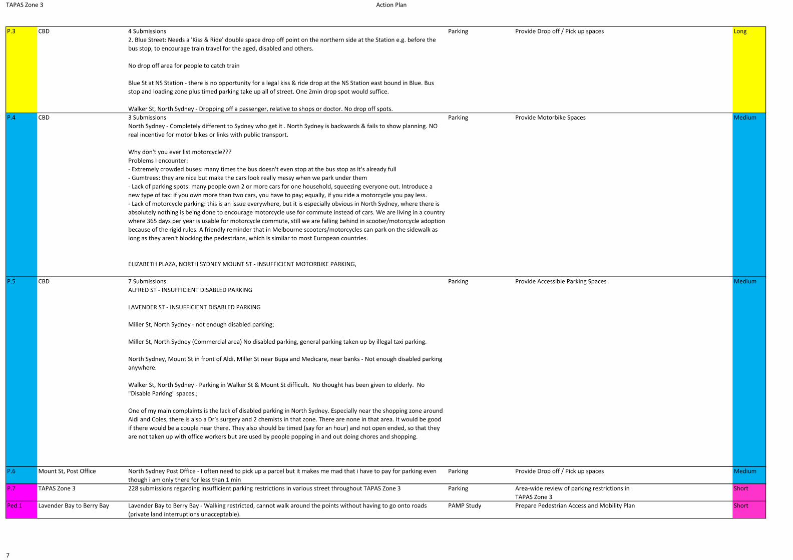
TAPAS Zone 3 Action Plan
P.3 CBD 4 Submissions2. Blue Street: Needs a 'Kiss & Ride' double space drop off point on the northern side at the Station e.g. before the bus stop, to encourage train travel for the aged, disabled and others.
No drop off area for people to catch train
Blue St at NS Station ‐ there is no opportunity for a legal kiss & ride drop at the NS Station east bound in Blue. Bus stop and loading zone plus timed parking take up all of street. One 2min drop spot would suffice.
Walker St, North Sydney ‐ Dropping off a passenger, relative to shops or doctor. No drop off spots.
Parking Provide Drop off / Pick up spaces Long
P.4 CBD 3 SubmissionsNorth Sydney ‐ Completely different to Sydney who get it . North Sydney is backwards & fails to show planning. NO real incentive for motor bikes or links with public transport.
Why don't you ever list motorcycle???Problems I encounter:‐ Extremely crowded buses: many times the bus doesn't even stop at the bus stop as it's already full‐ Gumtrees: they are nice but make the cars look really messy when we park under them‐ Lack of parking spots: many people own 2 or more cars for one household, squeezing everyone out. Introduce a new type of tax: if you own more than two cars, you have to pay; equally, if you ride a motorcycle you pay less.‐ Lack of motorcycle parking: this is an issue everywhere, but it is especially obvious in North Sydney, where there is absolutely nothing is being done to encourage motorcycle use for commute instead of cars. We are living in a country where 365 days per year is usable for motorcycle commute, still we are falling behind in scooter/motorcycle adoption because of the rigid rules. A friendly reminder that in Melbourne scooters/motorcycles can park on the sidewalk as long as they aren't blocking the pedestrians, which is similar to most European countries.
ELIZABETH PLAZA, NORTH SYDNEY MOUNT ST ‐ INSUFFICIENT MOTORBIKE PARKING,
Parking Provide Motorbike Spaces Medium
P.5 CBD 7 SubmissionsALFRED ST ‐ INSUFFICIENT DISABLED PARKING
LAVENDER ST ‐ INSUFFICIENT DISABLED PARKING
Miller St, North Sydney ‐ not enough disabled parking;
Miller St, North Sydney (Commercial area) No disabled parking, general parking taken up by illegal taxi parking.
North Sydney, Mount St in front of Aldi, Miller St near Bupa and Medicare, near banks ‐ Not enough disabled parking anywhere.
Walker St, North Sydney ‐ Parking in Walker St & Mount St difficult. No thought has been given to elderly. No "Disable Parking" spaces.;
One of my main complaints is the lack of disabled parking in North Sydney. Especially near the shopping zone around Aldi and Coles, there is also a Dr’s surgery and 2 chemists in that zone. There are none in that area. It would be good if there would be a couple near there. They also should be timed (say for an hour) and not open ended, so that they are not taken up with office workers but are used by people popping in and out doing chores and shopping.
Parking Provide Accessible Parking Spaces Medium
P.6 Mount St, Post Office North Sydney Post Office ‐ I often need to pick up a parcel but it makes me mad that i have to pay for parking even though i am only there for less than 1 min
Parking Provide Drop off / Pick up spaces Medium
P.7 TAPAS Zone 3 228 submissions regarding insufficient parking restrictions in various street throughout TAPAS Zone 3 Parking Area‐wide review of parking restrictions in TAPAS Zone 3
Short
Ped.1 Lavender Bay to Berry Bay Lavender Bay to Berry Bay ‐ Walking restricted, cannot walk around the points without having to go onto roads (private land interruptions unacceptable).
PAMP Study Prepare Pedestrian Access and Mobility Plan Short
7
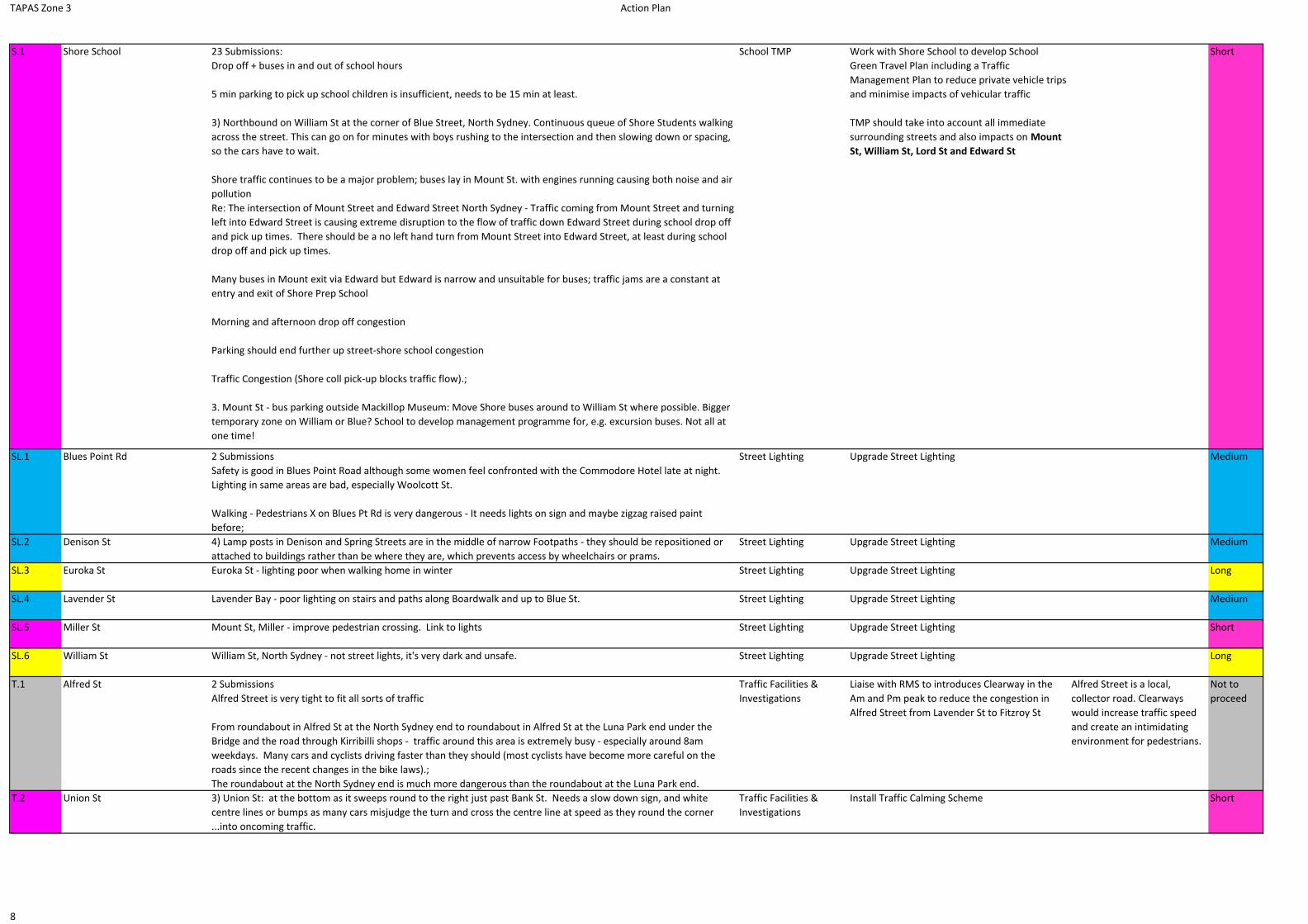
TAPAS Zone 3 Action Plan
S.1 Shore School 23 Submissions:Drop off + buses in and out of school hours
5 min parking to pick up school children is insufficient, needs to be 15 min at least.
3) Northbound on William St at the corner of Blue Street, North Sydney. Continuous queue of Shore Students walking across the street. This can go on for minutes with boys rushing to the intersection and then slowing down or spacing, so the cars have to wait.
Shore traffic continues to be a major problem; buses lay in Mount St. with engines running causing both noise and air pollutionRe: The intersection of Mount Street and Edward Street North Sydney ‐ Traffic coming from Mount Street and turning left into Edward Street is causing extreme disruption to the flow of traffic down Edward Street during school drop off and pick up times. There should be a no left hand turn from Mount Street into Edward Street, at least during school drop off and pick up times.
Many buses in Mount exit via Edward but Edward is narrow and unsuitable for buses; traffic jams are a constant at entry and exit of Shore Prep School
Morning and afternoon drop off congestion
Parking should end further up street‐shore school congestion
Traffic Congestion (Shore coll pick‐up blocks traffic flow).;
3. Mount St ‐ bus parking outside Mackillop Museum: Move Shore buses around to William St where possible. Bigger temporary zone on William or Blue? School to develop management programme for, e.g. excursion buses. Not all at one time!
School TMP Work with Shore School to develop School Green Travel Plan including a Traffic Management Plan to reduce private vehicle trips and minimise impacts of vehicular traffic
TMP should take into account all immediate surrounding streets and also impacts on Mount St, William St, Lord St and Edward St
Short
SL.1 Blues Point Rd 2 SubmissionsSafety is good in Blues Point Road although some women feel confronted with the Commodore Hotel late at night. Lighting in same areas are bad, especially Woolcott St.
Walking ‐ Pedestrians X on Blues Pt Rd is very dangerous ‐ It needs lights on sign and maybe zigzag raised paint before;
Street Lighting Upgrade Street Lighting Medium
SL.2 Denison St 4) Lamp posts in Denison and Spring Streets are in the middle of narrow Footpaths ‐ they should be repositioned or attached to buildings rather than be where they are, which prevents access by wheelchairs or prams.
Street Lighting Upgrade Street Lighting Medium
SL.3 Euroka St Euroka St ‐ lighting poor when walking home in winter Street Lighting Upgrade Street Lighting Long
SL.4 Lavender St Lavender Bay ‐ poor lighting on stairs and paths along Boardwalk and up to Blue St. Street Lighting Upgrade Street Lighting Medium
SL.5 Miller St Mount St, Miller ‐ improve pedestrian crossing. Link to lights Street Lighting Upgrade Street Lighting Short
SL.6 William St William St, North Sydney ‐ not street lights, it's very dark and unsafe. Street Lighting Upgrade Street Lighting Long
T.1 Alfred St 2 SubmissionsAlfred Street is very tight to fit all sorts of traffic
From roundabout in Alfred St at the North Sydney end to roundabout in Alfred St at the Luna Park end under the Bridge and the road through Kirribilli shops ‐ traffic around this area is extremely busy ‐ especially around 8am weekdays. Many cars and cyclists driving faster than they should (most cyclists have become more careful on the roads since the recent changes in the bike laws).;The roundabout at the North Sydney end is much more dangerous than the roundabout at the Luna Park end.
Traffic Facilities & Investigations
Liaise with RMS to introduces Clearway in the Am and Pm peak to reduce the congestion in Alfred Street from Lavender St to Fitzroy St
Alfred Street is a local, collector road. Clearways would increase traffic speed and create an intimidating environment for pedestrians.
Not to proceed
T.2 Union St 3) Union St: at the bottom as it sweeps round to the right just past Bank St. Needs a slow down sign, and white centre lines or bumps as many cars misjudge the turn and cross the centre line at speed as they round the corner ...into oncoming traffic.
Traffic Facilities & Investigations
Install Traffic Calming Scheme Short
8
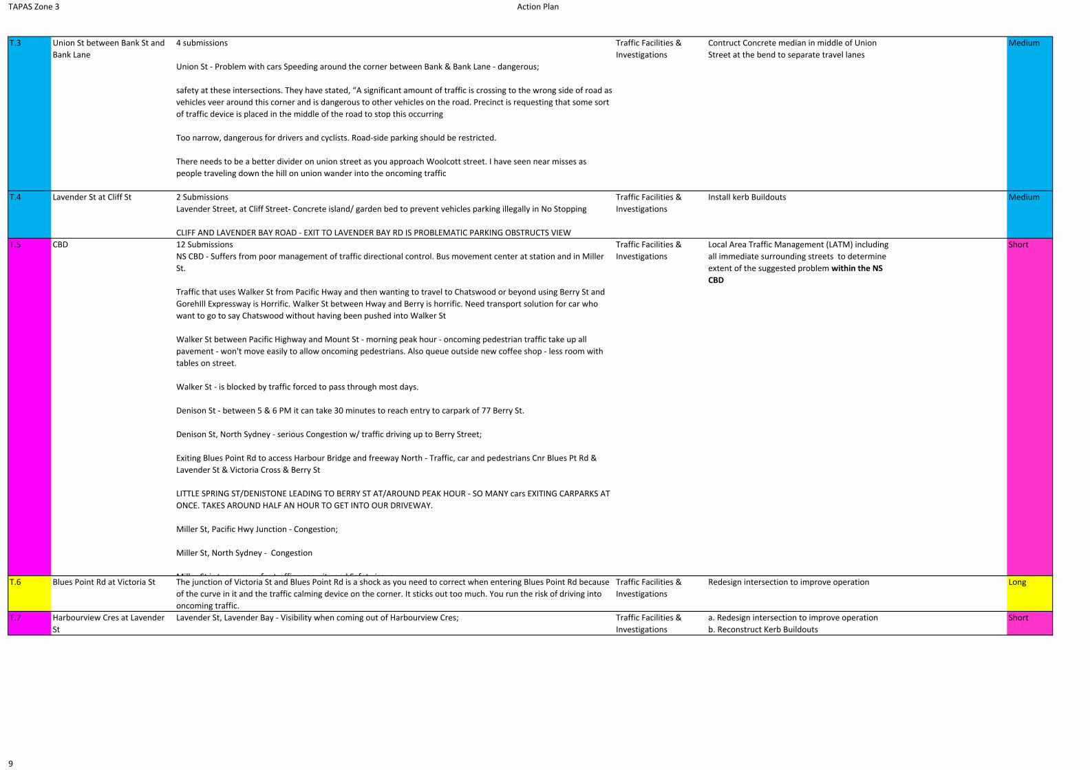
TAPAS Zone 3 Action Plan
T.3 Union St between Bank St and Bank Lane
4 submissions
Union St ‐ Problem with cars Speeding around the corner between Bank & Bank Lane ‐ dangerous;
safety at these intersections. They have stated, “A significant amount of traffic is crossing to the wrong side of road as vehicles veer around this corner and is dangerous to other vehicles on the road. Precinct is requesting that some sort of traffic device is placed in the middle of the road to stop this occurring
Too narrow, dangerous for drivers and cyclists. Road‐side parking should be restricted.
There needs to be a better divider on union street as you approach Woolcott street. I have seen near misses as people traveling down the hill on union wander into the oncoming traffic
Traffic Facilities & Investigations
Contruct Concrete median in middle of Union Street at the bend to separate travel lanes
Medium
T.4 Lavender St at Cliff St 2 SubmissionsLavender Street, at Cliff Street‐ Concrete island/ garden bed to prevent vehicles parking illegally in No Stopping
CLIFF AND LAVENDER BAY ROAD ‐ EXIT TO LAVENDER BAY RD IS PROBLEMATIC PARKING OBSTRUCTS VIEW
Traffic Facilities & Investigations
Install kerb Buildouts Medium
T.5 CBD 12 SubmissionsNS CBD ‐ Suffers from poor management of traffic directional control. Bus movement center at station and in Miller St.
Traffic that uses Walker St from Pacific Hway and then wanting to travel to Chatswood or beyond using Berry St and GorehIll Expressway is Horrific. Walker St between Hway and Berry is horrific. Need transport solution for car who want to go to say Chatswood without having been pushed into Walker St
Walker St between Pacific Highway and Mount St ‐ morning peak hour ‐ oncoming pedestrian traffic take up all pavement ‐ won't move easily to allow oncoming pedestrians. Also queue outside new coffee shop ‐ less room with tables on street.
Walker St ‐ is blocked by traffic forced to pass through most days.
Denison St ‐ between 5 & 6 PM it can take 30 minutes to reach entry to carpark of 77 Berry St.
Denison St, North Sydney ‐ serious Congestion w/ traffic driving up to Berry Street;
Exiting Blues Point Rd to access Harbour Bridge and freeway North ‐ Traffic, car and pedestrians Cnr Blues Pt Rd & Lavender St & Victoria Cross & Berry St
LITTLE SPRING ST/DENISTONE LEADING TO BERRY ST AT/AROUND PEAK HOUR ‐ SO MANY cars EXITING CARPARKS AT ONCE. TAKES AROUND HALF AN HOUR TO GET INTO OUR DRIVEWAY.
Miller St, Pacific Hwy Junction ‐ Congestion;
Miller St, North Sydney ‐ Congestion
Miller St is too narrow for traffic security and Safety issue
Traffic Facilities & Investigations
Local Area Traffic Management (LATM) including all immediate surrounding streets to determine extent of the suggested problem within the NS CBD
Short
T.6 Blues Point Rd at Victoria St The junction of Victoria St and Blues Point Rd is a shock as you need to correct when entering Blues Point Rd because of the curve in it and the traffic calming device on the corner. It sticks out too much. You run the risk of driving into oncoming traffic.
Traffic Facilities & Investigations
Redesign intersection to improve operation Long
T.7 Harbourview Cres at Lavender St
Lavender St, Lavender Bay ‐ Visibility when coming out of Harbourview Cres; Traffic Facilities & Investigations
a. Redesign intersection to improve operationb. Reconstruct Kerb Buildouts
Short
9
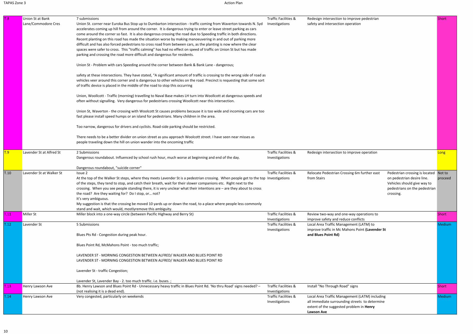
TAPAS Zone 3 Action Plan
T.8 Union St at Bank Lane/Commodore Cres
7 submissionsUnion St. corner near Euroka Bus Stop up to Dumbarton intersection ‐ traffic coming from Waverton towards N. Syd accelerates coming up hill from around the corner. It is dangerous trying to enter or leave street parking as cars come around the corner so fast. It is also dangerous crossing the road due to Speeding traffic in both directions. Recent planting on this road has made the situation worse by making manoeuvering in and out of parking more difficult and has also forced pedestrians to cross road from between cars, as the planting is now where the clear spaces were safer to cross. This "traffic calming" has had no effect on speed of traffic on Union St but has made parking and crossing the road more difficult and dangerous for residents.
Union St ‐ Problem with cars Speeding around the corner between Bank & Bank Lane ‐ dangerous;
safety at these intersections. They have stated, “A significant amount of traffic is crossing to the wrong side of road as vehicles veer around this corner and is dangerous to other vehicles on the road. Precinct is requesting that some sort of traffic device is placed in the middle of the road to stop this occurring
Union, Woollcott ‐ Traffic (morning) travelling to Naval Base makes LH turn into Woollcott at dangerous speeds and often without signalling. Very dangerous for pedestrians crossing Woollcott near this intersection.
Union St, Waverton ‐ the crossing with Woolcott St causes problems because it is too wide and incoming cars are too fast please install speed humps or an island for pedestrians. Many children in the area.
Too narrow, dangerous for drivers and cyclists. Road‐side parking should be restricted.
There needs to be a better divider on union street as you approach Woolcott street. I have seen near misses as people traveling down the hill on union wander into the oncoming traffic
Traffic Facilities & Investigations
Redesign intersection to improve pedestrian safety and intersection operation
Short
T.9 Lavender St at Alfred St 2 SubmissionsDangerous roundabout. Influenced by school rush hour, much worse at beginning and end of the day.
Dangerous roundabout, "suicide corner"
Traffic Facilities & Investigations
Redesign intersection to improve operation Long
T.10 Lavender St at Walker St Issue 2At the top of the Walker St steps, where they meets Lavender St is a pedestrian crossing. When people get to the top of the steps, they tend to stop, and catch their breath, wait for their slower companions etc. Right next to the crossing. When you see people standing there, it is very unclear what their intentions are – are they about to cross the road? Are they waiting for? Do I stop, or… not?It’s very ambiguous. My suggestion is that the crossing be moved 10 yards up or down the road, to a place where people less commonly stand and wait, which would, mostlyremove this ambiguity.
Traffic Facilities & Investigations
Relocate Pedestrian Crossing 6m further east from Stairs
Pedestrian crossing is located on pedestrian desire line. Vehicles should give way to pedestrians on the pedestrian crossing.
Not to proceed
T.11 Miller St Miller block into a one‐way circle (between Pacific Highway and Berry St) Traffic Facilities & Investigations
Review two‐way and one‐way operations to improve safety and reduce conflicts
Short
T.12 Lavender St 5 Submissions
Blues Pts Rd ‐ Congestion during peak hour.
Blues Point Rd, McMahons Point ‐ too much traffic;
LAVENDER ST ‐ MORNING CONGESTION BETWEEN ALFRED/ WALKER AND BLUES POINT RDLAVENDER ST ‐ MORNING CONGESTION BETWEEN ALFRED/ WALKER AND BLUES POINT RD
Lavender St ‐ traffic Congestion;
Lavender St, Lavender Bay ‐ 2. too much traffic. i.e. buses. ;
Traffic Facilities & Investigations
Local Area Traffic Management (LATM) to improve traffic in Mc Mahons Point (Lavender St and Blues Point Rd)
Medium
T.13 Henry Lawson Ave 8b. Henry Lawson and Blues Point Rd ‐ Unnecessary heavy traffic in Blues Point Rd. ‘No thru Road’ signs needed? – (not realising it is a dead end).
Traffic Facilities & Investigations
Install "No Through Road" signs Short
T.14 Henry Lawson Ave Very congested, particularly on weekends Traffic Facilities & Investigations
Local Area Traffic Management (LATM) including all immediate surrounding streets to determine extent of the suggested problem in Henry Lawson Ave
Medium
10

TAPAS Zone 3 Action Plan
T.15 Milsons Point 4 SubmissionsCombination of poor lighting, taxis, cyclists, bus stop all in one place, very dangerous area. Influenced by school rush hour, much worse at beginning and end of the day.
Milsons Pt. Roundabout at Exit from Harbour Bridge at Middlemiss St ‐ Dangerous ‐ bikes exit from Need: Warning signs, Motorist ‐ Care cyclists, Cyclists ‐ slow down.
Runoff from bridge‐heavy traffic
Leaving Warringah Fwy at Milsons Point ‐ traffic Congestion, slow.
Traffic Facilities & Investigations
Local Area Traffic Management (LATM) to improve traffic in Milsons Point
Medium
T.16 Blues Point Rd at East Cres Blues Point Rd ‐ Consideration to roundabout at Blues Point Hotel (top of East Crescent) to facilitate better flows along Blues Point Rd.
Traffic Facilities & Investigations
Redesign intersection operation to improve safety
Long
T.17 Harbourview Cres at the Cul‐De‐Sac
Harbourview Crescent, Lavender Bay ‐ Turning problems for visitors at Kirribilli Club ‐ A roundabout at the end of Harbourview Crs would improve Safety and ease traffic Congestion in that area.
Traffic Facilities & Investigations
Redesign intersection operation to improve safety
Long
T.18 Cliff St Share path here Traffic Facilities & Investigations
Introduce 10km/h Shared Zones Long
T.19 William St from Blue St to Blues Point Rd
William St shared. Traffic Facilities & Investigations
Introduce 10km/h Shared Zones Long
T.20 Berry St Interested to see what's going on. Would like to see Berry St as a shared pedestrian area. Traffic Facilities & Investigations
Introduce 10km/h Shared Zones Medium
T.21 Alfred St at North Sydney Olympic Pool
A pedestrian footpath across Alfred St at North Sydney Olympic Pool entrance is needed. This would make it safer for patrons entering and leaving the pool from this busy street. Many swimmers using the pool have drawn attention to this dangerous crossing. Please consider a pedestrian crossing to provide safer access to the pool. https://www.youtube.com/watch?v=P6N6zZW6PXk
Traffic Facilities & Investigations
install Pedestrian Crossing / Refuge Island Short
T.22 Dumbarton St Mitchell St and Victoria St are both one way and in opposing directions. I understand and support the reason (both narrow). However, there are posts in the roadway at the western end of Victoria, preventing access and these are a real nuisance. For the 200 or so residents of Munro St, in order to get to the shops and restaurants in McMahon's Point we have to drive the entire length of Dunbarton St, make a dangerous right turn (blind summit) into Union St, drive down to the traffic lights and wait to turn right into Blue's Point Rd. This is about 5 times as far as using Victoria eastbound, making 2 hazardous right turns and causing the emissions of extra carbon dioxide. Please consider removing the posts that cause this crazy situation. I appreciate 2 or 3 parking spots at that end of Victoria will need to be cancelled, but for the convenience of 200 residents of Munro, and for environmental impact reasons, it should be done
Traffic Facilities & Investigations
Local Area Traffic Management (LATM) including all immediate surrounding streets to determine possibility of re‐opening access from Dumbarton St into Victoria St
Long
T.23 Middlemiss St Middlemiss Lane ‐pedestrians on road Traffic Facilities & Investigations
Introduce 10km/h Shared Zones Medium
T.24 Middlemiss St at Walker St Middlemiss St (Walker St end), North Sydney ‐ Busy intersection especially in peak periods, yet one east bound lane in Berry St is blocked off by footpath extension!
Traffic Facilities & Investigations
Redesign intersection to improve operation Long
T.25 Arthur St Arthur St Approach to Cahill Express & Kirribilli: Such a bottle neck in the evenings & long delays. Perhaps no parking could free up lane to Kirribilli direction.
Traffic Facilities & Investigations
No action required (Existing Clearway between 6‐10 am and 3‐7 pm in place)
Not to proceed
T.26 Thomas St 3 SubmissionsThomas St, McMahons Point ‐ traffic travels too fast, children and elderly put at serious risk. Cyclists travelling in the wrong direction, especially electric bicycles.
Speed of cars going down hill to Thomas of major concern. Speed bumps should be installed.
Thomas Street ‐ too many motorists are Speeding down the street to short cut access to Blues Point Road (towards traffic lights at Union & B Point Rd.;
Traffic Facilities & Investigations
Install Traffic Calming Scheme Medium
11

TAPAS Zone 3 Action Plan
T.27 Union St between Dumbarton St and Woolcott St
7 submissionsUnion St. corner near Euroka Bus Stop up to Dumbarton intersection ‐ traffic coming from Waverton towards N. Syd accelerates coming up hill from around the corner. It is dangerous trying to enter or leave street parking as cars come around the corner so fast. It is also dangerous crossing the road due to Speeding traffic in both directions. Recent planting on this road has made the situation worse by making manoeuvering in and out of parking more difficult and has also forced pedestrians to cross road from between cars, as the planting is now where the clear spaces were safer to cross. This "traffic calming" has had no effect on speed of traffic on Union St but has made parking and crossing the road more difficult and dangerous for residents.
Union St ‐ Problem with cars Speeding around the corner between Bank & Bank Lane ‐ dangerous;
safety at these intersections. They have stated, “A significant amount of traffic is crossing to the wrong side of road as vehicles veer around this corner and is dangerous to other vehicles on the road. Precinct is requesting that some sort of traffic device is placed in the middle of the road to stop this occurring
Union, Woollcott ‐ Traffic (morning) travelling to Naval Base makes LH turn into Woollcott at dangerous speeds and often without signalling. Very dangerous for pedestrians crossing Woollcott near this intersection.
Union St, Waverton ‐ the crossing with Woolcott St causes problems because it is too wide and incoming cars are too fast please install speed humps or an island for pedestrians. Many children in the area.
Too narrow, dangerous for drivers and cyclists. Road‐side parking should be restricted.
There needs to be a better divider on union street as you approach Woolcott street. I have seen near misses as people traveling down the hill on union wander into the oncoming traffic
Traffic Facilities & Investigations
Install Traffic Calming Scheme Short
T.28 Dind St 3 Submissions7a. Dind St and Alfred St ‐ Adjust kerb returns so that traffic in Dind St can see south past Luna Park sign.
line of sight issue
3.Dind Street, at Alfred Street‐ Adjust kerb returns to see past Luna Park sign
Traffic Facilities & Investigations
No action required Matter has already been resloved by reconstruction of kerb returns
Not to proceed
T.29 Blues Point Rd 4 SUBMISSIONSfast travelling vehicles;
Blues Point Rd ‐ Traffic ‐ 1. Speeding up the hill in late evenings ‐ place ripple strips to stop this.;
Blues Pt Rd East Cr St ‐ Traffic exceeding speed limits. Ignoring one way street signs
Blues Point Rd after hours becomes a racetrack. Cars drive slowly to the parking area at the bottom to see if any police are about. If no police, they turn around and go up and Blues Point Road at full speed ‐ burn outs, excessive speed and noise. Very dangerous. Solution: 1) a speed hump at entry to parking area at bottom of Blues Point Rd ‐ people also drive to fast into the area where there are always pedestrians around here. 2) Ripple strips every 50 metres or so up to Blues Point Hotel. Ripple strips slow fast traffic.
Traffic Facilities & Investigations
Install Traffic Calming Scheme Short
T.30 Carr St Carr St to McMahons Pt & Milson's Pt), with fast cars & heavy lorries. Traffic Facilities & Investigations
Install Traffic Calming Scheme Short
T.31 Lavender St 5 SubmissionsLavender St ‐ Traffic should be calmed ‐ too many large, fast vehicles eg. trucks, taxis, motorcycles.
speeding motorists
7b. Lavender St ‐ Entire length calming.
6.Lavender Street, entire length ‐ traffic calming
Rat running
Traffic Facilities & Investigations
Install Traffic Calming Scheme Short
T.32 Victoria St Speed is of concern especially adjacent to playground in Victoria. Speed bumps? Traffic Facilities & Investigations
Install Traffic Calming Scheme Medium
12

TAPAS Zone 3 Action Plan
T.33 Lavender St 5 SubmissionsLavender St, Lavender Bay ‐ 1.Not enough zebra walk & cross ways.;
Lavender Street, Clark Park to Alfred Street, particularly at Arthur Street‐ Pedestrian facility, narrowing/kerb nib, gutter gardens
refuge island in the middle of Lavender Street
I am also concerned about pedestrians crossing the road at the exit of the freeway near the roundabout at Lavender St.
Lavender St, Albert St ‐ crossing difficult with cyclists
Traffic Facilities & Investigations
install Pedestrian Crossing / Refuge Island Short
T.34 Middlemiss St Crossing as pedestrians‐lots of cyclists‐cars from each direction Traffic Facilities & Investigations
install Pedestrian Crossing / Refuge Island Short
T.35 Alfred St at Fitzroy St 4 SubmissionsRoundabout at Fitzroy and Alfred St South ‐ Really needs a pedestrian crossing here as more and more people are using this area to cross the road; need crossing to get across Alfred Street.
Find St; Cnr Alfred/Fitzroy Sts ‐ lack of pedestrian Crossings
Roundabout dangerous for cyclists and no way to get to bridge but through that roundabout
Alfred St, Milsons Pt ‐ another pedestrian crossing needed between Chinese church and Lavender St;
Traffic Facilities & Investigations
install Pedestrian Crossing / Refuge Island Short
T.36 Blues Point Rd at Princess St Pedestrian facility to cross the road safely Traffic Facilities & Investigations
install Pedestrian Crossing / Refuge Island Short
T.37 Berry St 2 SubmissionsEXITING DENISTONE RD LEADING TO BERRY ST ‐ MANY PEDESTRIANS RUNNING ACROSS THE ROAD (BERRY ST), DANGEROUS. COUNCIL OFTEN PARKS LARGE SIGNS BLOCKING THE VISIBILITY UP BERRY ST.
Miller Street, Berry St ‐ Pedestrians crossing against traffic
Traffic Facilities & Investigations
install Pedestrian Crossing / Refuge Island Short
T.38 Henry Lawson Avenue, roundabout
modify the existing roundabout to terminate buses turning issues Traffic Facilities & Investigations
Redesign intersection operation to improve safety
Long
T.39 Henry Lawson Ave, "tear drop" near ferry wharf
modifications to existing landsape island Traffic Facilities & Investigations
Remove last 18m of landscape island or trim the island by 0.5m along last 18m
See T.48 Not to proceed
T.40 Chuter St, entire length speeding motorists , speed hiumnospossible shared zone Traffic Facilities & Investigations
Introduce 10km/h Shared Zones Long
T.41 Chuter St, entire length speeding motorists , speed hiumnospossible shared zone Traffic Facilities & Investigations
Install Traffic Calming Scheme Medium
T.42 Alfred St at Lavender St 7 SubmissionsNo Pedestrian crossing to get around roundabout to get to pedestrian area
replace existing refuge with pedestrian crossing
5.Alfred Street, at Lavender Street, southern side ‐ Pedestrian crossing to replace existing refuge
5. Alfred St – south of Lavender St roundabout ‐ Pedestrian crossing needed to replace refuge at roundabout.
2.Alfred Street, near the Chinese Church ‐ Pedestrian facility
Issue with pedestrian Safety
2. Dangerous roundabout suicidal corner
Traffic Facilities & Investigations
Upgrade existing Refuge Island with Pedestrian Crossing
Short
T.43 Mitchell St, entire length 2 Submissionsspeeding motorists
speeding motorists just prior to intersection with Queens Avenue
Traffic Facilities & Investigations
Install Traffic Calming Scheme Long
T.44 Waiwera Street at East Crescent Street
physical barriers to prevent illegal turns into East Crest Traffic Facilities & Investigations
Contruct Concrete median to prevent u‐turns Long
13

TAPAS Zone 3 Action Plan
T.45 Miller St Participants identified general safety concerns associated with the interaction of buses and pedestrians in the high pedestrian activity area on Miller Street, North Sydney CBD.
Traffic Facilities & Investigations
No action required Matter may have been resolved now by reconstruction of new wider footpath and new bus shelters in Miller St at Pacific Highway
Not to proceed
T.46 Blue St at North Sydney Station 2 SubmissionsNorth Sydney (outside station) ‐ pedestrian Safety. Have witnessed people almost hit by cars.
Blue St, North Sydney station outside Greenwood Plaza ‐ Need a pedestrian crossing badly!!!!
Traffic Facilities & Investigations
install Pedestrian Crossing / Refuge Island Short
T.47 Union Street, at Thomas Street Kerb blisters/ Rain Gardens Traffic Facilities & Investigations No action required
Existing Rain Gardens in Place Not to proceed
T.48 Henry Lawson Avenue, at Blues Point Road
intersection of Hewnry Lawson Ave and Blues Point Rd are to wide and needs to be narrowed Traffic Facilities & Investigations
Redesign intersection to improve operation Medium
T.49 Alfred Street and Dind Street, Milsons Point
line of sight issue at the Intersection of Dind and Alfred St and dangerous bend in Dind Street Traffic Facilities & Investigations
No action required
Median Island in Dind St and kerb extension at the intersection of Alfred St South and Dind St
Not to proceed
T.50 Lavender St Between Alfred St and Arthur St
2 SubmissionsLavender St at Arthur St, Lavender Bay ‐ crossing ‐ street too wide and traffic too fast;
4. Lavender St: intersections with Arthur, Harbourview and Cliff ‐ Narrowing, , rain gardens etc. to facilitate pedestrian movement, calm traffic and allow easier exits from side streets to Lavender St.
Traffic Facilities & Investigations
Install Traffic Calming Scheme Short
T.51 Blues Point Rd at Henry Lawson Ave
7 Submissions8a. Henry Lawson and Blues Point Rd ‐ Modify pedestrian crossing to enable a crossing on south side of intersection.
Existing refuge Island at the intersection to be upgraded or relocated
7. Henry Lawson Avenue and Blues Pt Rd intersection ‐ Modify existing or enable new pedestrian crossing on south side of Henry Lawson
Pedestrians cross illegally (get stuck at intersections)‐peninsula residents have to come this way out
Blues Point Rd ‐ is becoming increasingly busy and noisy. Difficult to cross anywhere.; Crossing in McMahons Point shopping area is not well marked ‐ many drivers don't see it. When I drive I have noticed it is not easy to see.;
"Safety" crossing at the bottom of BP Rd ‐ in unsafe spot ‐ should be across the mouth of the parking area.
1. Bottom of Blues Point Rd, McMahons Point ‐ We need to cross from Blues Point Tower at the bottom of Blues Point Rd (#14) to Henry Lawson Avenue several times a day to use the bus and the ferry, and there is no safe dedicated crosswalk to slow the traffic that races up and down that stretch. There should be painted lines and guard rails to protect all pedestrian traffic & yellow signs to warn & slow down oncoming traffic to a stop when we all need to cross there: precisely it should be installed from the sidewalk and mouth of the driveway to the Blues Point Lawson Avenue which runs Past the bus stop and feeds down to the ferry terminal. (It is much more sensible than block that way with a disruptive bed of plants currently there.);
Traffic Facilities & Investigations
install Pedestrian Crossing / Upgrade existing Refuge Island
Short
T.52 Alfred St at Cliff St 2 SubmissionsAlso, today too many bikes and difficult to cross the road now along Alfred St, which includes nearby streets.;
there is no safe crossing facilities in Alfred St near Chinese church
Traffic Facilities & Investigations
install Pedestrian Crossing / Refuge Island Short
T.53 Lord Street entire length shared zone in Lord Street's entire length Traffic Facilities & Investigations
Introduce 10km/h Shared Zones Long
T.54 Alfred Street at Milsons Point Station
Pedestrian crossing Alfred St, Milson Point (opposite Station) ‐ cyclists disregard the pedestrian crossing green light. More enforcement needed.
Traffic Facilities & Investigations
install Pedestrian Crossing / Refuge Island Short
T.55 William St at Pacific Highway Intersection of William St & Pacific Hwy ‐ There is a stop but cars don't stop. Needs a pedestrian crossing. Traffic Facilities & Investigations
install Pedestrian Crossing / Refuge Island Medium
14

TAPAS Zone 3 Action Plan
T.56 Union St between Dumbarton St and Woolcott St
7 submissionsUnion St. corner near Euroka Bus Stop up to Dumbarton intersection ‐ traffic coming from Waverton towards N. Syd accelerates coming up hill from around the corner. It is dangerous trying to enter or leave street parking as cars come around the corner so fast. It is also dangerous crossing the road due to Speeding traffic in both directions. Recent planting on this road has made the situation worse by making manoeuvering in and out of parking more difficult and has also forced pedestrians to cross road from between cars, as the planting is now where the clear spaces were safer to cross. This "traffic calming" has had no effect on speed of traffic on Union St but has made parking and crossing the road more difficult and dangerous for residents.
Union St ‐ Problem with cars Speeding around the corner between Bank & Bank Lane ‐ dangerous;
safety at these intersections. They have stated, “A significant amount of traffic is crossing to the wrong side of road as vehicles veer around this corner and is dangerous to other vehicles on the road. Precinct is requesting that some sort of traffic device is placed in the middle of the road to stop this occurring
Union, Woollcott ‐ Traffic (morning) travelling to Naval Base makes LH turn into Woollcott at dangerous speeds and often without signalling. Very dangerous for pedestrians crossing Woollcott near this intersection.
Union St, Waverton ‐ the crossing with Woolcott St causes problems because it is too wide and incoming cars are too fast please install speed humps or an island for pedestrians. Many children in the area.
Too narrow, dangerous for drivers and cyclists. Road‐side parking should be restricted.
There needs to be a better divider on union street as you approach Woolcott street. I have seen near misses as people traveling down the hill on union wander into the oncoming traffic
Traffic Facilities & Investigations
install Pedestrian Crossing / Refuge Island Short
T.57 Miller St at Blue St Shared pathway Miller St next to Zurich Building ‐ there was a sign saying `cyclists must not exceed walking pace.' The sign is no longer there. There are blind spots (because of vegetation) on this pathway and cyclists frequently ride too fast.;
Traffic Facilities & Investigations
Re‐install "cyclists must not exceed walking pace" sign
Short
T.66 Mount Street, at Miller Street traffic congestion at the intersection of Mount St and Miller St Traffic Facilities & Investigations
Local Area Traffic Management (LATM) including all immediate surrounding streets to determine extent of the suggested problem within the NS CBD
Long
T.70 Blues Point Rd, Unin St to Henry Lawson Ave
BLUES POINT ROAD ‐ SPEED CAMERAS, NEED CONTROL OF FAST DRIVING (TO POINT) CHILDREN, ANIMALS ETC AND IS RESIDENTAL AREA. SHOULD BE SPEED LIMIT OF 40KPH
Traffic Facilities & Investigations
40km/h Speed Zone Short
T.71 Princess St at Blues Point Rd Continues footpath in Princess St's intersection with Blues Point Rd Traffic Facilities & Investigations
Pedestrian crossing or continuous footpath treatment
Short
15

Bay
PO
INE
STREET
HARRIOTT
KING
WOOLCOTTAVENUE
STREET
BAY
CARR
LANE
J OHNSTREET
OPENSP ACE
CLI FTON
STREET
(unformed)
WOOLCOTTSTREE TOPE NS PACE
HARRIOTT
STREET
WOOLCOTTSTREET
DAVIDEARLE
RESERVE
NEST
COMMODORE
CRESCENT
JOHN
CLI FTONSTREET
CLIFTONSTREET
ROADRESERVE
WAVERTON
STREET
BOATBUI LDERSWALK
AVENUE
BANK
EUROKA
STREET
ANCRUMST REETRES ERVE
WAVERTON
LANE
ANCRUM
UNION
EUROKA LANE
STREET
COMMODORESTREET
MUNRO
STREET
EUROKAS TREET
PLAYGROUND
DUMBARTON
GANNU RA RE S ERVE
TYEPARK
Blues Point
BLUES POINT
RES ERVE
OLYMPIC
Luna ParkWharf
OLYMPICPARK
McMahons Point
HOPKINS P
ARK
HENRY LAWSON RES ERVE AVENUE
McMahon's PointWharfLAWSON
PAULSTREE
THENRY
EASTCRESCENT
STREETLOOKOUT
NORTHCLI FF
STREET
MARY
WOLLSTONECRAFT
LANE
WARUNG STREET
SOUTH
LLOYDREES
LOOKOUT
EAST
BLUES
DINDSTREE
T
MI DDLE
DO W
LINGST REETROADRES ERVE
STREETDOWLINGSTREET
STREET
STREET
PARKER
STREET
CRESCENT
Lavender
Bay
STREET
WEST
CRESCENT
McMANUS
B URTO N
LA NE
GLEN
STREET
FRENCH
LANE
FRENCHSTREET
RESERVE
STREET
WES T
C RESCE
N T
S T RE E T
R OAD
RES ER
VE
FRENCH
NOTTINGHAMSTREE T
NOTTINGHAMSTRE ETRESER VE
MILSONSPOINTSTATION
STREET
SAWMILLERS
RE SERVE
STREETB
AY
VIEW
MI L MIL S T REE TROA D RES E RVE
MARY F
REN CH
R ES ER
VE
MILMIL
STREE
TAVENUE
WAIWERA
LAVENDERBAYFORESHORE
PRINCES
STREET
PRINC
ES
Lavender BayWharf
WELLINGTON
LANE
STREET
ALFRED
QUEENS
BOB GORDONRES ERVEVICTO
RI A
CRESCENT
ENNIS
ROAD
CLIFF
POINT
KING
GEORGE
STREET
PLACE
VICTORIA/MITCHELL
STREETJUNCTION
STR
EET
QUIBAREE PARK
MITCHEL
L
HARBOURVIEW
LAVENDER
WENDYS GARDEN
CRESCENTVIC
TORIAST
REET
PLAYGROU
ND
STREET
MITCHEL
L
STRE ET
PARK
CLARKPARK
VICTORIA
WAT T PARKO'BRIE
NS
GARDENS
WALKERSTREETROADRESERVE
STREET
STREET
THOMAS
STREET
WEBB
STREET
STREET
CHUTER
STREET
STREET
VICTORIA
PLACE
ARTHUR
HOLT STREET
LANE
ENNI S
( Pat hway)
LANE
BRET TWHIT ELE YPLACE
BRAY
WALKER
STREET
STREET
STREET
MOUNT
STREET
MOUNT
STREET
SPRING
ELI ZABETH
PLAZA
EDWARD
ORMISTON AVENUEHILL STREET
STREET
WHEELERLANE
WILLIAM P
ACIFIC
WALKER
STREET
ALFRED
LITTLE
MILLER
STREET
OAK
LANE M
ILLER
ALFRED
STREET
LI TTLE
SPRING
STREET
LANE
OAKSTRE
ET
DENI SON
STREET
GAS
JUNCTIONLANE
DONBAN
K
MUSEU
MGARD
ENS
CHARLE
SSTR
EET
ARTHUR
STREET
STREET
WHALING
DORIS F IT T ONPARK
BLUE
LORD
STREET
MACDONALDLANE
STREET
SHORT
STREET
NAPIER
STREET
LITTLE
HIGHWAY
STREET
EXPRESSWAY
NORTH SYDNEYSTATION
STREET
STPETERSPARK
STREET
HUNTER CRESCENT
ROAD
BERRY
STREET
MACKENZIE
STREET
WILLIAM
LANE
BERRY
ROAD
RILEY
WILONAAVENUESTREETWARD
STREET
LORDSTREET ROADRESERVE
MILLER
STREET
MIDDLEMISS
EDWARD
LANE
THOMAS
STREET
BANK
RE SERVE
WARRINGAH
DOOHAT
AVENUE
RILEY S
TREET
ROAD C
LOSURE
NORTH
STREET
BROWNSLANE
ROADRESERVE
STREET
PRIORY
B ROWN S
LANE W EST
HAMPDEN STREET
HIGHWAY
HARNETT
STREET
CHUTER
STREET
ANGELO
STREET
TOONGARA
H
R OADROA D
RE S ERVE
BROWNS
ROAD
LANE
WALKER
TOONGARAHROAD
BANK
STREET
WALKER
STREET
ARTHUR
STREET
STREET
STREET
LAVENDER
McLAREN
ALFRED
McHATT
ON
KELRO
McDOUGALL
BRADFIELD
PARK
HIGH ST REE T RESE RVE
DARLEY
NEUTRAL
STREET
GREENWAYDRIVE
(Priv a
teRoad)
NEUTRALSTREET
ROADRESERVE
KURRABA
ROAD
NEUTRAL
STREET
HIGH
STREET
KIRRIBI LLI
VI LLAGESQUARE
NI CHOLAS
STREET
BENT
LOWE
R
NOOK
LANE
BROUGHTON
STREET
DRIVE
BROUGHTON
Milsons Po
STREET
WILLOUG
DORIS
BRADFI EL
NOOK
EATON
B
BRARR YAA
ORMISTOTT N AVAA ENUE
ALFRED
ALFRED
STREET
WHALING
STREET
LITTLE
EEXXPPRREESSSSWWWAA
WWYYAAA
RINGAH
NORTH
ALFRED
DARLEY
NEUTRARRL
STREET
NEUTRALSTREET
ROA
OODAA
RESERVEVV
KURRARR BA
ROAAOO
NEUTRARRL
STREET
HIGH
STRTT EET
NI CHOLALLS
STRTTEET
BENT
LOWE
R
NOOK
LALLNE
STREE
NOOK
EATON
AYYA
RREEEETT
HHARRIOTT
KING
WO
STREET
BABBY
LANE
HARRIOTT
STREET
NEST
WA
WWVAAERTRRON
AVAAENUE
WAVAAERTON
LALLNE
STREET
MOUNT
STREET
STREET
WHEELERLALLNE
STREET
OAK
LALLNAAE
OAOO KSTRE
ET DONBAN
K
MUSEU
MGAGG RDE
NSNN
CHARLE
SSTR
EET
STREET
LORD
SHORTRR
STREET
NANNPIER
STREET
BERRY
STREET
ROAD
RILEY
EDWA
WWRD
LALLNAAE
BANAAK
RE SERVE
DOOHAT
AVAA ENUE
RILEY S
TREET
RROADAA CLO
SUREE
STREE
BROWNSLANAAE
ROAOODAA
RESERVEPRIORY
B ROWNWW S LANAA
E W EST
HWA
WWYA
TOONOOGARA
H
R OAOO DAA ROAOO D
RE S ERVE
BROWNS
ROAD
TOONGARARRHROAD
McHATT
ONWO
HOMAS
OCOTOTAVENUEE
CARR
J OHHNNSTREET
OPENNSP ACE
CLI FTOTTN
STRERRET
(unfoffrmrredee)
WWOOOOOO
LCOOCCTOO
TTSTREE TOPE NS PACEE
WOOLCOTTTTSTREETEE
DAVAAIVVDEAARRAAAALLE
RESEERRVVEVV
COMMODODDRERR
CRESCECC
NT
JOHN
CLI FTONSTREET
CLIFTONSTREET
ROAOODRESERVE
STREET
BO
BABB NAA K
EUROKAKK
STREET
AANNAAAA CCRRCCCC UUMMSSTT RREEEETRES ERVE
ANCRUM
UNION
EUROKAKK LALL NE
STREET
COMMOMM DODD RESTSS REETEE
MUNRO
STREET
EUROKAKKS TREET
PLAYAAGROUOOND
DUMBARTRRON
GANNU RA RE S ERVE
TYEPPPARAAK
BLUES POINT
RES ERVVVE
OLYLL MPIC
OLYMPICPARAAK
HOPKINS P
ARK
HENRY LAAAWSOONN RES ERVE AVAAENUE
LAWAA SONPAUAA L
STREETHENRYRR
EASTTCRESCCEENNTT
STREEETLOOOOOKOOUUT
NORTRRHCLI FF
STRERRET
MAARAAY
WOLLOOLSTSSONOOECEERARFAATT
LALLNAAE
WARUNG STREET
SOUTH
LLOYOODREES
LOOOOKOUOOT
EAST
BLUES
DINDSTREE
T
MI DDLE
DO W
LINGST REETROAOODRES ERVE
STREETDOWLILLNGSTREERREETT
STREET
STREET
PAPP RKRR ER
STSS RERR ET
CRESCENT
STREET
WEST
CRESCENT
McMANAAUS
BB UURRTTOO NN
LLAA NNE
GLEN
STREET
FRERRNCHCC
LALLNAAE
FRENCHSTREET
RESERVE
STREET
WWWWES T
C RESCECC
N TT
SSSS TT RE E T
R OAD
REESS EERR
VVEE
FRENCH
NOTTINGHAMSTSSREE T
NOTTINGHAMAASTRE ETRESER VE
MILSONSPOINTSTATTTAAION
STSS REET
SAWMILLERS
RE SERVE
STREETB
AYAA
VIEW
MMIMMMM LLL MMIL S T REE TRROOAOO D REES EE RVVVEEE
MAMM RAA Y FREN CCCHCC
R ES ER
VEEE
MILMIL
STSSREE
TAVAA ENUE
WA
WWIWERARR
LLAVENDERBAYAAFORESHORE
PRINCES
STREET
PRINC
ES
WE
WWLLINGTGGONOO
LALLNAAE
STREET
ALFRED
QUEENS
BOB GORDDONRES ERVEEVICTOTT
RIIRRAAI
CRESCENT
CLIFF
POINT
KING
GEORGE
STREET
PLALLCE
VIVVCTORIA/M//ITCHELL
STREETJUNCTCCIONOO
STTRR
EE
RR
EETQUIBARRREE PARRRK
MITCHEL
L
HARBOURVRRIEW
LAVAA ENDER
WENDYS GAGG RDEN
CRESCENTVVVVIC
TCC ORIA
STREETTT
PLAYAA GRO
UND
STREET
MIMMTCCHEEL
L
STTRE EET
PPAARKK
CLAARRKPAARK
VICTORIA
WAT T PARKO'OOBRIE
NSNN
GAGG RDENSNN
WWAALKERSTREETROA
OODAA
RESERVE
STREET
STREET
THOMASAA
STREET
WEBB
STREET
STREET
CHUTER
STREET
STREET
VICTOTTRIA
PLALLCE
ARTHUR
HOLT STREET
LANAAE
BRET TWWHIT ELE YPLACAA E
WA
WWLKER
STREETSTREET
MOUNT
STREET
SPRING
EELLII ZZAABAAETH
PLALLZAZZ
EDWARD
HILL STREET
WILLIAM PP
APPCIFIC
WA
WWLKER
LITTLE
MILLER
STREET
MILLER
LI TTLE
SSPPRRII NNGG
SSTTREET
LALLNE
DENI SON
STREET
GASAA
JUNCTIOIINLANE
ARTHUR
STREET
DORIS F IT T ONPARK
BLUE
LORD
STREET
MACDONALDLANE
HIGHWAWWYAA
STREET
WAYA
NORRTH SSSSSYDNNEYSTATT TTTTTION
STREET
STPETERSPARK
STREET
HUNTER CRESCENT
ROAD
MACKENZIE
STREET
WILLIAM
LANE
BERRY
WILONAAVENUESTREET
ORDSTREE RO DR SERVE
MILLER
STREET
MIDDLEMISS
TH
STREET
EET
CHUTER
STREET
LANE
WA
WWLKER
BANK
WALKER
STREET
ARTHUR
STREET
STREET
STREET
LALL VAA ENDER
BRADFIELDDD
PPPAARRRKKK
BOA
OTAABUI LDERSWA
WWLAAK
LAVVEEN
WOOLCOTOOTAVENU
STREET
LORD
STREET
LORDSTREET ROAO DAA RESERVE
STREET
XPRESSWA
WYA
J
O
BOA
OOTAABUI LD
ALK
R
LAVENDER
Y
STREET
BERRY
SSWAYA
WOOLCOTOTAVENUEE
STREET
LORD
STREET
LORDSTREET ROAOO DAA RESERVE
STREET
ENNIS
ROAD
ENNNNNI S
( Pat hhwayaa)
LANE
YYY
McDOUGALL
HIGH ST REE T RESE RVE
GRERRENWA
WWYAA
DRIVEVV
(Priv avv
teRoaood)
HIGH
KIRRIBI LLI
VI LLAGAAESQUARAAE
BROUGHTON
STREET
DRIVIIE
BROUGHTON
WILLOO
YYY
HIGH
Y
C
YYYYYY
HIGH
C
YY
WARD
STREET
WA
WWRRINGAH
STREET
HAMPDEN STREET
HIGHWA
WYAA
HARNETT
STREET
ANGELO
STREET
STREET
McLAREN
KELL
RRINGAHH
IGHWA
WWYA
STREET
BERRY
WA
WWRRINGAHH
IGHWA
WYA
STREE
BERRY
THOMASAS
choJES
Text Box
T21
choJES
Text Box
T35
choJES
Text Box
T17
choJES
Text Box
T18
choJES
Oval
choJES
Text Box
SL5
choJES
Text Box
T54
choJES
Text Box
T52
choJES
Polygon
choJES
Text Box
C4
choJES
Polygon
choJES
Text Box
C6
choJES
Text Box
T4
choJES
Text Box
T9
choJES
Polygon
choJES
Text Box
C14
choJES
Text Box
T7
choJES
Text Box
T42
choJES
Text Box
T50
choJES
Text Box
T34
choJES
Text Box
T23
choJES
Polygon
choJES
Text Box
C18
choJES
Polygon
choJES
Text Box
C12
choJES
Text Box
T24
choJES
Polygon
choJES
Text Box
G4
choJES
Polygon
choJES
Text Box
G6
choJES
Polygon
choJES
Text Box
C9
choJES
Polygon
choJES
Text Box
C2
choJES
Oval
choJES
Text Box
SL4
choJES
Text Box
T12
choJES
Text Box
T31
choJES
Text Box
T33
choJES
Text Box
T46
choJES
Text Box
T57
choJES
Polygon
choJES
Text Box
C17
choJES
Text Box
T19
choJES
Text Box
T51
choJES
Text Box
T13
choJES
Text Box
T48
choJES
Text Box
T14
choJES
Text Box
T38
choJES
Text Box
T16
choJES
Text Box
T44
choJES
Oval
choJES
Text Box
SL1
choJES
Text Box
T29
choJES
Polygon
choJES
Text Box
C3
choJES
Text Box
T36
choJES
Text Box
T43
choJES
Text Box
T6
choJES
Text Box
T32
choJES
Text Box
T2
choJES
Text Box
T40
choJES
Text Box
T26
choJES
Text Box
T41
choJES
Text Box
T22
choJES
Text Box
T56
choJES
Text Box
T27
choJES
Text Box
T30
choJES
Text Box
T8
choJES
Text Box
T3
choJES
Polygon
choJES
Text Box
C11
choJES
Polygon
choJES
Text Box
P1
choJES
Text Box
T53
choJES
Oval
choJES
Text Box
S1
choJES
Oval
choJES
Text Box
S1
choJES
Oval
choJES
Text Box
S1
choJES
Oval
choJES
Text Box
S1
choJES
Oval
choJES
Text Box
SL3
choJES
Polygon
choJES
Text Box
C16
choJES
Oval
choJES
Text Box
SL6
choJES
Text Box
T11
choJES
Text Box
T55
choJES
Polygon
choJES
Text Box
G4
choJES
Oval
choJES
Text Box
SL2
choJES
Polygon
choJES
Text Box
C13
choJES
Polygon
choJES
Text Box
C5
choJES
Text Box
T20
choJES
Text Box
T37
choJES
Polygon
choJES
Text Box
C19
choJES
Polygon
choJES
Text Box
G2
choJES
Polygon
choJES
Text Box
C20
ngutra
Line
ngutra
Line
ngutra
Line
ngutra
Line
kemmic
Text Box
TAPAS Wide P7
SMEC | North Sydney Council TAPAS Zone 3 Action Plans Draft Report | Page 17
APPENDIX B – ITEMS REFERRED TO TRANSPORT FOR NSW

TAPAS Zone 3 Items referred to TfNSW
Consultation Method Sub. No Comment/Response Road 1 Road 2 Road 3 Road 4 Mode Issue Action Comments
Survey 2068 Alfred St S, Milsons Point - too many bus services, blocking traffic during rush hours; Alfred Street South Buses Public Transport - Timetables TfNSW TfNSw
Survey 2077 1.Alfred St S. - Inadequate bus shelters for winter conditions; Alfred St South Buses Public Transport - Infrastructure
TfNSW TfNSW
Survey 2077 2. Military Rd - As above (inadequate bus shelters for winter conditions);Areas 1 & 2 (Alfred St S., Military Rd) - Diminished frequency of buses on Saturdays - a busy shopping day?Why ;
Military Rd Buses Public Transport - Infrastructure
TfNSW TfNSW
Survey 2077 All Areas - Inadequate information for visitors regarding how to plan and access Opal Cards especially for short term visitors.
Alfred Street South Buses Public Transport - Timetables TfNSW TfNSw
Survey 2213 Milsons Point, Alfred St South - Bus stop near Lavender Street needs a bus seat for us older resident - the old seat was never replaced.;
Alfred St South Lavender St
Buses Public Transport - Timetables TfNSW TfNSw
Survey 2213 Milsons Point, Alfred St South - The buses from Mosman etc. should terminate under the Harbour Bridge allowing travellers to connect with the ferry.
Alfred St South Buses Public Transport - Stop/ Station / Wharf locations
TfNSW TfNSw
Survey 1996 Berrys Bay - No ferries. this side of McMahons Pt. Why?? A beautiful harbour to transverse and no ferry wharf;
Berry's Bay Ferries Other TfNSW TfNSW
Edward Precinct 119 9. New Metro Station at Berry St - Buses and train/pedestrian interchange. Suggest interchange underground sited under Pacific Hwy/Miller so can service both stations – pass by tunnels. Exit buses near Arthur St for south trips; Take Berry St car traffic underground from Pacific Hwy to Freeway. Or other suggestion to remove most vehicular traffic from Berry?; Assess parking impact to Edward Precinct and start to implement controls.
Berry St Miller St Pacific Hwy
Arthur St Public Transport
Public Transport - Connections TfNSW TfNSW
Workshop 4 Bus stop on corner of Blue and Miller St. Shore school busses stop pedestrians from crossing. Blue St Miler St Buses Public Transport - Stop/ Station / Wharf locations
TfNSW TfNSW
Workshop 4 School bus parks here, blocked road at drop off and pick up. Blue St Miler St Buses Public Transport - Stop/ Station / Wharf locations
TfNSW TfNSW
Workshop 3 Blue St outside North Sydney Station --> Timetable holder is blank. Blue St Buses Public Transport - Timetables TfNSW TfNSW
Survey 2070 Blue St, N. Syd. - Buses late Blue St Buses Public Transport - Timetables TfNSW TfNSW
Survey 2107 Blue St Bus Stop near station - overcrowded with school kids oblivious to their surroundings; Blue St Buses Other TfNSW TfNSW
Online Submission 13 Good having so many bus services coming through Blue St by the train station northbound but should bring some buses to Blue St southbound too so that we don't have to cross so many streets and walk up and down slopes or steps to get to or from buses on Pacific Highway going south. Need extended bus service between N Syd Stn and McMahons Pt wharf outside of peak hours and on weekends to help elderly residents' travel. The bus timetable at the bus stop on Blues Pt Rd southbound south of Blues St should indicate which 265 goes to McMahons Pt and which to Lane Cove as they both stop there.
Blue St Buses Public Transport - Timetables TfNSW TfNSW
Survey 2051 Congestion Blue Street - There is a bus stop for Mosman/ Lane Cove buses on Miller St that is only 50 metres from stop on corner of Blue St, Miller St. It could be eliminated for buses transit improvement.;
Blue St Buses Public Transport - Timetables TfNSW TfNSW
Survey 2051 Blue Street, North Sydney - Bus stops for waiting passengers are unpleasant and do not offer shade, or protection from wind or rain, and noisome bins adjacent.
Blue St Buses Public Transport - Infrastructure
TfNSW TfNSW
Survey 1066 Blue St, North Sydney - Bus stop stands specifically no. 263 should stop at stand d with no. 227 and 230.
Blue St Buses Public Transport - Timetables TfNSW TfNSW
Workshop 4 Bus resting zone - could be used as parking. (Can't buses wait at ferry?) Blue St Warung St Buses Public Transport - Stop/ Station / Wharf locations
TfNSW TFNSW
Workshop 5 Bus up Blue Point Rd on weekend Blues Point Rd buses Public Transport - Timetables TfNSW TfNSW
Page 1 of 9

TAPAS Zone 3 Items referred to TfNSW
Consultation Method Sub. No Comment/Response Road 1 Road 2 Road 3 Road 4 Mode Issue Action Comments
Online Submission 4 Public Transport - well served by trains and ferries. Need more buses down Blues Point Road Blues Point Rd Buses Public Transport - Stop/ Station / Wharf locations
TfNSW TfNSW
Workshop 4 Blues point Road has village atmosphere but big buses that barely fit through come flying past with few people on them. Opportunity to terminate to North Sydney and have smaller buses go through this area off-peak
Blues Point Rd Buses Public Transport - Routes TfNSW TfNSW
Survey 2005 Ferry wharf - difficult access onto ferry Blues Point Rd Ferries Public Transport - Accessibility TfNSW TfNSW
Survey 2091 Rail - why are they always doing track work on the weekend?; Blues Point Rd Train Other TfNSW TfNSW
Survey 2091 Ferry - Why do we need a huge wharf? Closing the current wharf and building a big one will be a waste of money.
Blues Point Rd Ferries Other TfNSW TfNSW
Survey 2092 Genera North Shore Area, Blues Point Rd - Bus Speeding down the road endangering everybody & noisy.
Blues Point Rd Buses Other TfNSW TfNSW
Survey 2098 Blues Pt Rd, McMahons Pt - no buses on Sundays - No buses.;
North Sydney Station - buses leaving early sometimes from N. Sydney station - really difficult if carrying a lot of shopping. Buses leaving early.;
North Sydney Station, Blue Pt Rd - Buses not reliable - some do not turn up - have to leave very early if important appointment, in case bus does not turn up.
Blues Point Rd Buses Other TfNSW TfNSW
Survey 2127 Blues Point Rd - not enough and not regular buses. 265 Timetable is not reliable. Blues Point Rd Buses Other TfNSW TfNSW
Survey 2200 Blues Point Rd - Bus stop outside Blues Point Hotel stops traffic.; Blues Point Rd Buses Public Transport - Stop/ Station / Wharf locations
TfNSW TfNSW
Survey 2164 Blues Pt Rd - I am concerned about State Govt intention to tunnel under harbour and bring up split from waterfront McMahons Point. If this is done by road it will make McMahon's Point unliveable for years. It must be taken away by water please!
Blues Point Rd Vehicle Other TfNSW TfNSW
Survey 2208 Corner of Blues Point and Blues Rd - Bus stops are too close the corner and block the turn left lane. Even 20m back would be helpful;
Blue St Blues Point Rd
Buses Public Transport - Stop/ Station / Wharf locations
TfNSW TfNSW
Survey 2010 Bus Stop at corner of Blues Point Rd & Union St - should be no stopping outside of bus stop times as otherwise traffic gets blocked when the other lane has a car turning right in it
blues point rd Union St Buses Other TfNSW TfNSW
Survey 2188 Blues Point Rd, North Sydney - Buses running late;Bicycles on the pavement (esp. in Miller St)
Blues Point Rd Buses Public Transport - Timetables TfNSW TfNSW
Survey 2207 ?Pedestrian crossing end of Burton St (access to station) - (elevated) should be considered; Burton St Walking Other TfNSW TfNSW
Survey 2205 Crows Nest, Lane Cove - lack of frequent, reliable public transportation, train lines will be preferred.;
Crows Nest Train Other TfNSW TfNSW
Page 2 of 9

TAPAS Zone 3 Items referred to TfNSW
Consultation Method Sub. No Comment/Response Road 1 Road 2 Road 3 Road 4 Mode Issue Action Comments
Survey 164 I have relocated to Australia from Austria and was flabbergasted by the public transport in Sydney. Don't get me wrong it is a fantastic city and the public transport is okay, but I think it could be much more efficient. I think there is too much emphasis on the roads.
Getting to Ultimo or back by bus takes about 1h which is a lot of time for a short distance. Motorists block the bus lanes and there are not enough buses. There is a very long line of passengers in the morning trying to get to the city and the buses don't stop anymore because they are full.
I could take the light rail to central but to get to the next rail station is also complicated, also it would mean paying twice. I would love to get there by bike and then take the train but this is outright dangerous, especially in the morning traffic. Motorists are inconsiderate and sometimes even abusive towards bicycles, especially on larger roads. So going by bike all they way to Ultimo over the Harbor Bridge is also not an option.
Moreover if I go to go to Balmoral Beach, there are enough buses going down there during the day, but they stop after 7 for some reason. I have to hike up the hill to Spit Rd. to catch a bus there.
The service to Crows Nest is also not really available, we stopped using the bus to go there since walking is the faster option.
In North Sydney I would like to be more flexible on public transport. I would like to have a short loop service that takes passengers in the peak hours from the Military Rd to Milson Pt. / North Sydney to Cremorne Pt. Station / .... so they can go either on the Rail or Ferry and during the evening hours back again. Also I would like to be able to go to Milson Pt/North Sydney. and the Harbor Bridge on a segregated bike lane.
Crows Nest; Milsons Point Station;
North Sydney Station
Public Transport
Other TfNSW TfNSW
Survey 2124 Ferry: Darling Harbour Service - the cancellation of 9.35pm from Circular Quay is most inconvenient. Only hourly service after 9.05 terrible.;
Darling Harbour Ferries Public Transport - Timetables TfNSW TfNSW
Survey 2124 New McMahon's Point Wharf - The new wharf is oversized and unnecessary and unsightly. McMahon's Point Wharf Ferries Public Transport - Infrastructure
TfNSW TfNSW
Survey 978 Big Bear Neutral Bay - Buses don't stop during peak hour as they are full. Buses Public Transport - Timetables TfNSW TfNSW
Survey 978Earle Street, Cremorne - Limited buses on 201 Routes - should be all day.
Earle st Buses Public Transport - Timetables TfNSW TfNSW
Survey 2145 E Crescent St - steps from ferry stop at McMahons Pt East Cres St Ferries Public Transport - Infrastructure
TfNSW TfNSW
Survey 2145 E Crescent St - not enough ferries late night East Cres St Ferries Public Transport - Timetables TfNSW TfNSW
Union Precinct 98 Many buses in Mount exit via Edward but Edward is narrow and unsuitable for buses; traffic jams are a constant at entry and exit of Shore Prep School
Edward St Mount St Buses Other TfNSW TfNSW
Survey 670 5. Linked to above, already noticing that the bus stops on the Highway near the schools are very busy at peak departure times (can block pedestrians; insufficient weather protection). In a couple of years there will be an extra 250 kids at Cammeraygal, and Dem is also growing. Need to keep a close eye on pedestrian patterns (and car drop off/pick up) and make sure public transport links are optimised.
Pacific Highway Public Transport
Other TfNSW TfNSW
Survey 454 MCMAHONS PT FERRY - BUSES DONT MEET ENOUGH FERRIES Mcmahons Point Wharf Public Transport
Other TfNSW TfNSw
Survey 2206 Ferry Wharf - poor coordination between buses & ferries; Mcmahons Point Wharf Public Transport
Other TfNSW TfNSw
Page 3 of 9

TAPAS Zone 3 Items referred to TfNSW
Consultation Method Sub. No Comment/Response Road 1 Road 2 Road 3 Road 4 Mode Issue Action Comments
Survey 1842 Milsons Pt - Bus service infrequent and not useful. Ferries infrequent in the weekends and finish early on sundays
Alfred St Fitzroy St Public Transport
Public Transport - Timetables TfNSW TfNSw
Survey 2346Train - Greenwood plaza now full of stalls where walk through;
Greenwood Plaza Train Public Transport - Infrastructure
TfNSW TfNSW
Survey 432 BUS INTERSECTION NORTH SYDNEY - CONGESTION IN BUS STOP NORTH SYDNEY BUS STOP NORTH SYDNEY BUS STOP NEXT TO GREENWOOD PLAZA. 265 BUS AND PRIVATE BUS 260 STOP AT THE SAME TIME AT THE SAME BUS STOP,SPECIALLY AFTER 16:00 HRS.
Greenwood Plaza Buses Public Transport - Timetables TfNSW TfNSW
Survey 2051 Henry Lawson Dr, McMahon's Pt - 1.Bus leaving just as ferry is berthing at wharf, not waiting for passengers.;2.Buses late/ not arriving at all on occasions.;
Henry Lawson Ave Milsons point Wharf
Buses Public Transport - Timetables TfNSW TfNSW
Survey 1418 Waverton Station - trains not stopping at Waverton. Waverton Station Train Public Transport - Timetables TfNSW TfNSW
Survey 1418 Waverton - additional ferries and ferry stop, e.g. at Waverton and the marina. Waverton Ferries Public Transport - Timetables TfNSW TfNSW
Survey 349 WYCOMBE RD, NEUTRAL BAY - SCHOOL BUS IS OFTEN EXTREMELY LATE Wycombe Rd Buses Public Transport - Timetables TfNSW TfNSW
Workshop 4 train line going? Disaster if replaced with high-rises. Should be tourist walkway with water views (Wendy's Secret Garden)
Greenwood Plaza Train Other TfNSW TfNSW
Survey 509 Lavender Bay - parking; limited bus service Lavender Bay Buses Public Transport - Timetables TfNSW TfNSW
Survey 1169 Lavender Bay boardwalk and Wendy's Garden - concerned about a clear future for Luna Park and rail siding and need for transparency
Lavender Bay Train Other TfNSW TfNSW
Survey 2638 Milsons Pt roundabout (end of Lavender Bay Rd) - Cyclists speed down all & go straight on to roundabout without looking for pedestrians or cars - danger to both & themselves.
Alfred St South Lavender Bay
Train Other TfNSW TfNSW
Survey 2182 McMahons, Milsons - weekend ferries and evenings to Balmain/Thomas St are limited or non-existent and bus services up from ferry wharf disappear. Perhaps a little shuttle service?;
Thomas St Public Transport
Public Transport - Timetables TfNSW TfNSW
Survey 2194 Lavender St near Alfred St - Bus stop just before pedestrian crossing so buses block drivers vision when walking across crossing, dangerous for pedestrians;
Alfred st Lavender St
buses Public Transport - Stop/ Station / Wharf locations
TfNSW TfNSW
Survey 2075 Lawson Pde - 265 Bus Timetable should operate 7 days Lawson Pde buses Public Transport - Timetables TfNSW TfNSW
Workshop 4 Ferries – Don’t come frequently enough or fast enough to use all the time, feels like more of a novelty.
Luna Park Wharf McMahon's Point Wharf
Ferries Public Transport - Timetables TfNSW TfNSW
Survey 2097 McMahons Pt - not enough buses - esp at weekends. NONE on Sunday.;
McMahons Pt - And buses need to coordinate with ferries at McMahons Pt - also Milsons Point
McMahons Pt Public Transport
Public Transport - Timetables TfNSW TfNSw
Survey 2132 McMahons Point - the ferry link bus does not seem to link with ferry Timetable.; McMahons Pt Ferries Public Transport - Timetables TfNSW TfNSw
Survey 2187 Put on more regular services weekends - bus - from McMahon's Point on Sunday;
I have objection to the fact that SAT & SUN transport bus & ferry from McMahon's Pt - Weeds - MORE SERVICES.;
Ferries from McMahon's Point SAT& SUN - FROM - 6.15am as on weekday PUT ON BUS - from McMahon's on Sunday.
McMahons Pt Public Transport
Public Transport - Timetables TfNSW TfNSw
Survey 2201 McMahons Pt - No bus to shops and station on Sundays. This will be really a problem when our wharf is closed.
McMahons Pt Buses Public Transport - Timetables TfNSW TfNSw
Page 4 of 9
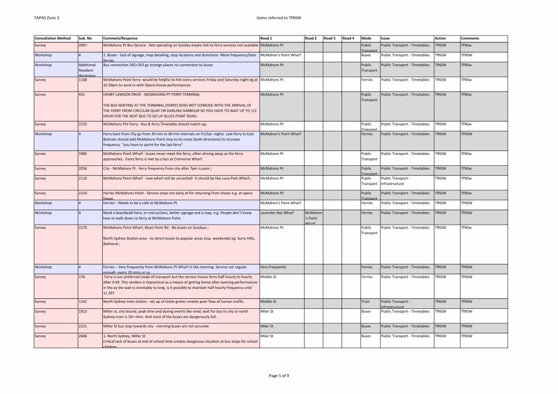
TAPAS Zone 3 Items referred to TfNSW
Consultation Method Sub. No Comment/Response Road 1 Road 2 Road 3 Road 4 Mode Issue Action Comments
Survey 2007 McMahons Pt Bus Service - Not operating on Sunday means link to ferry services not available McMahons Pt Public Transport
Public Transport - Timetables TfNSW TfNSw
Workshop 4 1. Buses - lack of signage, map detailing, stop locations and directions- More frequency/later ferries
McMahon's Point Wharf Buses Public Transport - Timetables TfNSW TfNSW
Workshop Additional Resident Workshop
Bus connection 265+263 go strange places no connection to buses McMahons Pt Public Transport
Public Transport - Timetables TfNSW TfNSw
Survey 1168 McMahons Point ferry: would be helpful to hVe extra services Friday and Saturday night eg at 10.30pm to work in with Opera House performances.
McMahons Pt Ferries Public Transport - Timetables TfNSW TfNSw
Survey 431 HENRY LAWSON DRIVE - MCMAHONS PT FERRY TERMINAL
THE BUS WAITING AT THE TERMINAL (FERRY) DOES NOT COINCIDE WITH THE ARRIVAL OF THE FERRY FROM CIRCULAR QUAY OR DARLING HARBOUR SO YOU HAVE TO WAIT UP TO 1/2 HOUR FOR THE NEXT BUS TO GO UP BLUES POINT ROAD.
McMahons Pt Public Transport
Public Transport - Timetables TfNSW TfNSw
Survey 2235 McMahons Pnt Ferry - Bus & ferry Timetable should match up; McMahons Pt Public Transport
Public Transport - Timetables TfNSW TfNSw
Workshop 4 Ferry back from City go from 30 min to 60 min intervals on Fri/Sat nights. Late ferry to East Balmain should add McMahons Point stop to its route (both directions) to increase frequency. "you have to sprint for the last ferry"
McMahon's Point Wharf Ferries Public Transport - Timetables TfNSW TfNSW
Survey 1985 McMahons Point Wharf - buses never meet the ferry, often driving away as the ferry approaches. Every ferry is met by a bus at Cremorne Wharf.
McMahons Pt Public Transport
Public Transport - Timetables TfNSW TfNSw
Survey 2056 City - McMahons Pt - ferry frequency from city after 7pm is poor.; McMahons Pt Public Transport
Public Transport - Timetables TfNSW TfNSw
Survey 2110 McMahons Point Wharf - new wharf will be unroofed! It should be like Luna Park Wharf.; McMahons Pt Public Transport
Public Transport - Infrastructure
TfNSW TfNSw
Survey 2154 Ferries McMahons Point - Service stops too early at for returning from shows e.g. at opera house.
McMahons Pt Public Transport
Public Transport - Timetables TfNSW TfNSw
Workshop 4 Ferries – Needs to be a café at McMahons Pt McMahon's Point Wharf Ferries Public Transport - Timetables TfNSW TfNSW
Workshop 4 Need a boardwalk here, or instructions, better signage and a map, e.g. People don’t know how to walk down to ferry at McMahons Point.
Lavender Bay Wharf McMahon's Point Wharf
Ferries Public Transport - Timetables TfNSW TfNSW
Survey 2170 McMahons Point Wharf, Blues Point Rd - No buses on Sundays.;
North Sydney Station area - no direct buses to popular areas (esp. weekends) eg. Surry Hills, Balmoral.;
McMahons Pt Public Transport
Public Transport - Timetables TfNSW TfNSw
Workshop 4 Ferries – Very frequently from McMahons Pt Wharf in the morning. Service not regular enough, every 20 mins or so.
Very frequently Ferries Public Transport - Timetables TfNSW TfNSW
Survey 176 Ferry is our preferred mode of transport but the service moves form half hourly to hourly after 9.49. This renders it impractical as a means of getting home after evening performances in the as the wait is inevitably to long. is it possible to maintain half hourly frequency until 11.30?
Middle St Ferries Public Transport - Timetables TfNSW TfNSW
Survey 1162 North Sydney train station - set up of ticket grates creates poor flow of human traffic. Middle St Train Public Transport - Infrastructure
TfNSW TfNSW
Survey 1913 Miller st, city bound, peak time and during events like vivid, wait for bus to city or north Sydney train is 20+ mins. And most of the buses are dangerously full.
Miler St Buses Public Transport - Timetables TfNSW TfNSW
Survey 2221 Miller St bus stop towards city - morning buses are not accurate Miler St Buses Public Transport - Timetables TfNSW TfNSW
Survey 2606 1. North Sydney, Miller StCritical lack of buses at end of school time creates dangerous situation at bus stops for school children.
Miler St Buses Public Transport - Timetables TfNSW TfNSW
Page 5 of 9
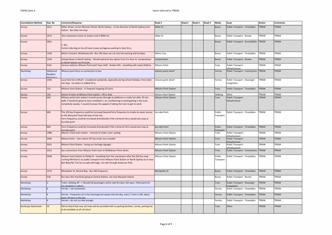
TAPAS Zone 3 Items referred to TfNSW
Consultation Method Sub. No Comment/Response Road 1 Road 2 Road 3 Road 4 Mode Issue Action Comments
Survey 2611 Miller Street, corner McLaren Street, North Sydney - In the direction of North Sydney train station. Bus does not stop
Miller St Buses Public Transport - Timetables TfNSW TfNSW
Survey 1673 Bus movement center at station and in Miller St. Miller St Buses Public Transport - Routes TfNSW TfNSW
Survey 26613. Bus Cannot take dog on bus & have to pay outrageous parking to take ferry.
Buses Public Transport - Accessibility TfNSW TfNSW
Survey 1550 Milner Crescent, Wollstonecraft - Bus 265 does not run into the evening and Sundays. Milner Cres Buses Public Transport - Timetables TfNSW TfNSW
Survey 1550 Camperdown to North Sydney - Would welcome bus option from Cnr Ross St. Camperdown to North Sydney via Pyrmont.
Camperdown Buses Public Transport - Routes TfNSW TfNSW
Survey 2101 Various stations; Milsons Point (and Town Hall) - Broken lifts - travelling with small children. Milsons Point Train Public Transport - Infrastructure
TfNSW TfNSW
Workshop Additional Resident Workshop
Milsons point ferry no connection to bus milsons point wharf Ferries Public Transport - Connections TfNSW TfNSW
Survey 1590 Luna Park Ferry Wharf - crowded at weekends, especially during school holidays. Ferry does not stop - no notice or added ferry
milsons point wharf Ferries Public Transport - Passenger Congestion
TfNSW TfNSW
Survey 123 Milsons Point Station - in frequent stopping of trains. Milsons Point Station Train Public Transport - Timetables TfNSW TfNSW
Survey 142 Extent of stairs at Milsons Point station + lift is slow Misons Point Station Walking Other TfNSW TfNSWSurvey 669 Milsons point train station's tunnel access through to platforms is really hot after 20 min
walk, it would be good to have ventilation / air conditioning to avoid getting in the train completely sweaty. It would increase the appeal of taking the train to get to work.
Milsons Point Station Train Public Transport - Infrastructure
TfNSW TfNSW
Survey 669 The 225 bus frequency could be increased beyond ferry frequency to create an easier access to the Wynyard-Town hall area of the city.Ferry frequency could be increased dramatically if the cremorne ferry would also stop at Kurraba point
Kurraba Point Public Transport
Public Transport - Timetables TfNSW TfNSW
Survey 669 Ferry frequency could be increased dramatically if the cremorne ferry would also stop at Kurraba point
Kurraba Point Public Transport
Public Transport - Timetables TfNSW TfNSW
Survey 1988 Milson's Point train station - removal of under cover seating Milsons Point Station Train Public Transport - Infrastructure
TfNSW TfNSW
Survey 2046 Milsons Point - train station lift too small, too crowded Milsons Point Station Train Public Transport - Infrastructure
TfNSW TfNSW
Survey 2021 Milsons Point Station - losing our heritage signage; Milsons Point Station Train Public Transport - Infrastructure
TfNSW TfNSW
Survey 2014 Bus connections from Milsons Point train to McMahons Point wharf, Milsons Point Station Train Public Transport - Connections TfNSW TfNSW
Survey 2648 Milsons Point Station to Phillip St - travelling from the city/airport after the 263 bus stop running PM there's no public transport from Milsons Point Station or North Sydney to or near Ben Boyd Rd. Too far to walk with bags, not safe through Anderson Park.
Milsons Point Station Public Transport
Public Transport - Timetables TfNSW TfNSW
Survey 1270 Montpelier St, Neutral Bay - Bus 263 frequency Montpelier St Buses Public Transport - Timetables TfNSW TfNSW
Survey 518 Bus lane 263 should be going to Central Station, not only Wynyard station. Buses Public Transport - Routes TfNSW TfNSW
Workshop 3 Trains: Getting off --> Should tell passengers which side the door will open. Particularly for the disabled or elderly.
Train Public Transport - Passenger Congestion
TfNSW TfNSW
Workshop 4 Ferries – not convenient Ferries Public Transport - Timetables TfNSW TfNSW
Workshop 4 Ferries – Frequency ok in the mornings but wanes into the day, every 7 mins in AM, about every 20 mins in the day.
Ferries Public Transport - Timetables TfNSW TfNSW
Workshop 4 Ferries – do not run late enough. Ferries Public Transport - Timetables TfNSW TfNSW
Hardcopy Submission 34 We've heard that new rail hubs will be provided with no parking facilities. Surely, parking has to be available at all rail sites?
Train Other TfNSW TfNSW
Page 6 of 9

TAPAS Zone 3 Items referred to TfNSW
Consultation Method Sub. No Comment/Response Road 1 Road 2 Road 3 Road 4 Mode Issue Action Comments
Online Submission 36 ferries are becoming too expensive. If we are to pay this price there should be more trips more often, and more to the correct timetable, not 2 mins early, or 10 mins late. obviously with ships it's hard, but its not that hard.
Ferries Public Transport - Timetables TfNSW TfNSW
Online Submission 36 ferries are becoming too expensive. If we are to pay this price there should be more trips more often, and more to the correct timetable, not 2 mins early, or 10 mins late. obviously with ships it's hard, but its not that hard.
Ferries Public Transport - Cost TfNSW TfNSW
Survey 435 CITY - FERRY TIMES LATE AT NIGHT. FROM EVERY 30 MIN TO CHANGING TO EVERY HOUR AND STOPPING AROUND 11PM IS INCONVENIENT ON THURS-SATS EVENINGS. I UNDERSTAND LIMITING SERVICE EARLIER IN THE WEEK,
Ferries Public Transport - Timetables TfNSW TfNSW
Workshop Additional Resident Workshop
Access to public transport is negatively affected by significant reduction in ferry services outside of peak hours.
Public Transport
Public Transport - Connections TfNSW TfNSW
Workshop Additional Resident Workshop
Access to public transport is negatively affected by poor public transport connectivity. Connectivity between proposed B-line services and the proposed North Sydney METRO station was highlighted as an opportunity missed.
Public Transport
Public Transport - Connections TfNSW TfNSW
Workshop 1 (Train) Track work on North Shore line extremely loud for shift work and very frequent compared to other precincts.
Track work on Train Other TfNSW TfNSw
Survey 1147 Trains replaced by buses on weekends. LGA Public Transport
Public Transport - Timetables TfNSW TfNSW
Survey 1147 N. Sydney is actually pretty good for public transport - the real problems come from Sydney/NSW's uncoordinated and road-centric transport planning.
LGA Public Transport
Public Transport - Connections TfNSW TfNSW
Survey 118 Bus 263 - does not connect with North Sydney Train Station. It would be good if you could have a bus/rail combo
NS Train Station Buses Public Transport - Timetables TfNSW TfNSW
Survey 1989 North Sydney Train Station - poor design when entering & exiting during peak times. Expensive.
NS Train Station Public Transport
Public Transport - Infrastructure
TfNSW TfNSW
Survey 1994 North Sydney Train Station - Trains aren't very frequent outside of peak hours; NS Train Station Train Public Transport - Timetables TfNSW TfNSW
Survey 2116 North Sydney Station - Trains on weekends are very infrequent to go to the city. NS Train Station Train Public Transport - Timetables TfNSW TfNSW
Survey 2136 North Sydney Station - the internal design does not cope with the numbers commuting.;More lifts, more escalators/ change staircase/ access points
NS Train Station Train Public Transport - Timetables TfNSW TfNSW
Survey 2259 North Sydney Station rail often out on w/ends - not sure about station being available on many weekends due to work etc.;
NS Train Station Train Public Transport - Timetables TfNSW TfNSW
Survey 1306 North Sydney/ Milsons Pt station - public transport links. Public transport links to Parramatta. Poor due to North Sydney links. Need a bus of Parramatta.
Milsons Point Station NS Station Public Transport
Public Transport - Connections TfNSW TfNSW
Survey 434 NORTH SYDNEY TRAIN STATIONS - OFTEN VERY CROWDED CAN SOME TRAINS START AT NORTH SYDNEY WHEN GOING TO CITY
NS Train Station Train Public Transport - Passenger Congestion
TfNSW TfNSW
Survey 2175 Train - North Sydney Tunnel - Train noise - horn blasting & track noise/rail grinding. Train Public Transport - Infrastructure
TfNSW TfNSW
Survey 1810 McMahons Point, more bus options for ferry to and from parking. McMahons point Buses Public Transport - Timetables TfNSW TfNSW
Survey 1101 Bus lanes 263 should be going to Central Station, not only to Wynyard. Buses Public Transport - Routes TfNSW TfNSW
Survey 88 1) Northbound on Blues Point Road, cnr Union Street. Out of Bus zone hours, this intersection is blocked by cars at the red arrow turning right and parked cars. The Bus zone should be 'No Parking' at all other times, so the intersection is not blocked.
Blues Point Rd Union St Buses Other TfNSW TfNSW
Survey 1587 Wollstonecraft train station - many trains don't stop at night (only St Leonards or Nth Sydney) Wollstoncraft Station Train Public Transport - Timetables TfNSW TfNSW
Survey 1587 Pacific Hwy, Crows Nest - buses are sparse at night Pacific Highway Buses Public Transport - Timetables TfNSW TfNSW
Page 7 of 9

TAPAS Zone 3 Items referred to TfNSW
Consultation Method Sub. No Comment/Response Road 1 Road 2 Road 3 Road 4 Mode Issue Action Comments
Survey 402 BUSES FROM WATSONS ST TO CITY OR CHATSWOOD - BUSES OFTEN DONT STOP. GOING TO CITY IS NOT SUCH A PROBLEM BUT HEADING TO CHATSWOOD ARE LESS FREQUENT
Buses Public Transport - Timetables TfNSW TfNSW
Workshop 4 Could have Sunday parking in bus zones as bus zones not used on Sunday Blues Point Rd Parker St West St Buses Public Transport - Stop/ Station / Wharf locations
TfNSW TfNSW
Survey 2138 Paul St - too many steps to ferry suggest an escalator to come up.; Paul St Ferry Wharf
Ferries Public Transport - Infrastructure
TfNSW TfNSW
Survey 2346 Bus - no centralised place in CBD area for buses going to Nth Sydney; CBD Buses Public Transport - Stop/ Station / Wharf locations
TfNSW TfNSW
Online Submission 114 We live adjacent to the railway line as it exits Nth Sydney Station. We have serious issues with noise as there is NO sound barrier to reduce the noise of the trains. Sydney Rail also do not address the weed problem along the fencing - merely cutting rather than removing roots of weeds, so there is constant regrowth. Surely more economical to remove than have to regularly cut back! The verge under railway bridge at Eastern end of Woolcottcottcott St is an eyesore full of weeds - would benefit from landscaping.
NS Train Station Train Other TfNSW TfNSW
Workshop 4 When exiting the station its very hard to see which bus is coming Nothing to announce bus arrival or where its going.
Blue St Buses Public Transport - Timetables TfNSW TfNSW
Workshop 4 No seats on North Sydney platform North Train Public Transport - Infrastructure
TfNSW TfNSW
Workshop 4 Two entries and exits (clogged in peak hour). No control of human traffic. Dangerous. In London, stand two abreast on escalators to increase flow). Also, rear access from Mackenzie St is locked by Zurich Insurance due to graffiti, etc. Could be used as additional station gateway.
Blue St Train Public Transport - Infrastructure
TfNSW TfNSW
Workshop 4 Bus full so you can't get on or off at North Sydney Station, next stop is Miller St full so you Buses Public Transport - Timetables TfNSW TfNSW
Workshop 6 Commuter traffic at railway stations Blue St congestion Public Transport - Passenger Congestion
TfNSW TfNSW
Workshop 4 Late trains, no direct lines. Both stations. trains, no Train Public Transport - Timetables TfNSW TfNSW
Workshop 4 Weekend track work- has to take bus. Could track work not be done at night? track work Train Public Transport - Timetables TfNSW TfNSW
Survey 1688 Wollstonecraft/Waverton/North SYdney/Milsons Point - Stations without elevators or 2 elevators that dont work.
Milsons Point Station; NS Train Station
Waverton Station
Wollstonecraft Station
Public Transport
Public Transport - Infrastructure
TfNSW TfNSW
Survey 2086 Buses are really noisy at night.;Trains & ferries are good services. Why are you doing this study? What is wrong with transport in N. Sydney? We are concerned that you will change the parking arrangements.
Union St Buses Other TfNSW TfNSw
Survey 2177 Union St - traffic;Train - great
Public Transport
Other TfNSW TfNSw
Workshop Additional Resident Workshop
Advertising at bus stops make it difficult to see the bus coming-design element for bus stop buses Public Transport - Infrastructure
TfNSW TfNSW
Survey 874 Hayes St Wharf - only one service an hour. Pls give us a more frequent service on Sats & Suns. congestion Public Transport - Timetables TfNSW TfNSW
Survey 1221 Occasionally trains skip Waverton station - it would be good to have more that stop there, particularly late at night. Buses heading towards the harbour bridge clog up the roads quite a bit as they take several lanes to turn into Berry St and then again into Miller St.
Waverton Station train Public Transport - Timetables TfNSW TfNSW
Survey 1839 From Waverton to Crows Nest and McMahons Point, bus 265 runs too infrequently to be used as a regular transport option, ferry from McMahons not frequent enough to be considered as regular commute option.
Buses Public Transport - Timetables TfNSW TfNSW
Survey 1664 Waverton Station - There is a siding next to Waverton station where trains are "stored" and then departs to the city. Why cant Waverton residents get on this train? Very frustrating.
Waverton Station train Public Transport - Timetables TfNSW TfNSW
Page 8 of 9
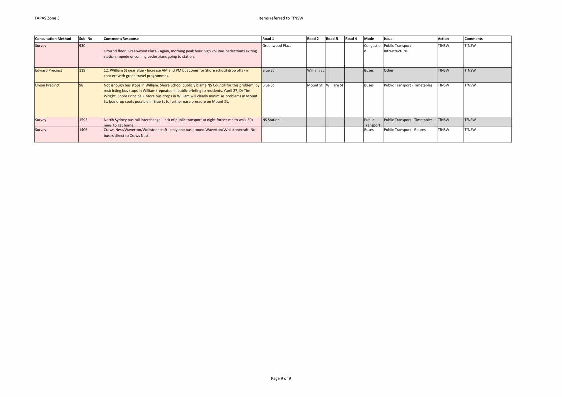
TAPAS Zone 3 Items referred to TfNSW
Consultation Method Sub. No Comment/Response Road 1 Road 2 Road 3 Road 4 Mode Issue Action Comments
Survey 930Ground floor, Greenwood Plaza - Again, morning peak hour high volume pedestrians exiting station impede oncoming pedestrians going to station.
Greenwood Plaza Congestion
Public Transport - Infrastructure
TfNSW TfNSW
Edward Precinct 119 12. William St near Blue - Increase AM and PM bus zones for Shore school drop offs - in concert with green travel programmes.
Blue St William St Buses Other TfNSW TfNSW
Union Precinct 98 Not enough bus stops in William. Shore School publicly blame NS Council for this problem, by restricting bus stops in William (repeated in public briefing to residents, April 27, Dr Tim Wright, Shore Principal). More bus drops in William will clearly minimise problems in Mount St; bus drop spots possible in Blue St to further ease pressure on Mount St.
Blue St Mount St William St Buses Public Transport - Timetables TfNSW TfNSW
Survey 1593 North Sydney bus rail interchange - lack of public transport at night forces me to walk 30+ mins to get home.
NS Station Public Transport
Public Transport - Timetables TfNSW TfNSW
Survey 1406 Crows Nest/Waverton/Wollstonecraft - only one bus around Waverton/Wollstonecraft. No buses direct to Crows Nest.
Buses Public Transport - Routes TfNSW TfNSW
Page 9 of 9

SMEC | North Sydney Council TAPAS Zone 3 Action Plans Draft Report | Page 18
APPENDIX C – ITEMS REFERRED TO ROADS AND MARITIME SERVICES
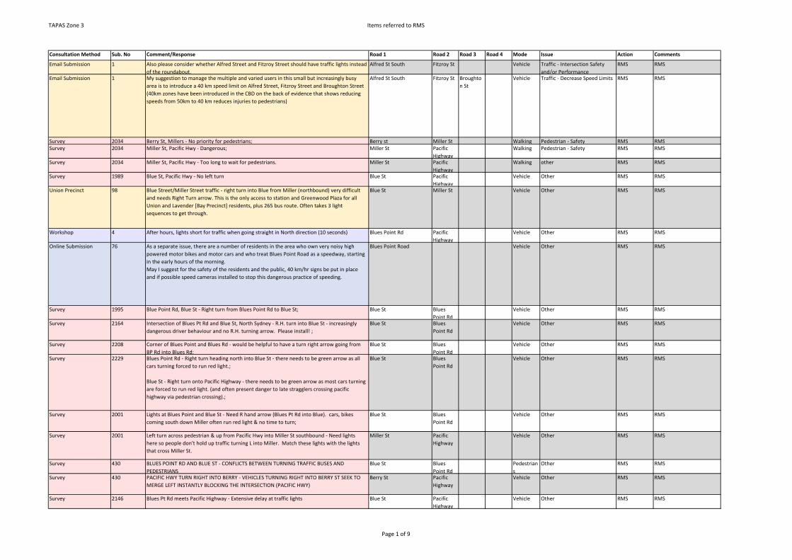
TAPAS Zone 3 Items referred to RMS
Consultation Method Sub. No Comment/Response Road 1 Road 2 Road 3 Road 4 Mode Issue Action Comments
Email Submission 1 Also please consider whether Alfred Street and Fitzroy Street should have traffic lights instead of the roundabout.
Alfred St South Fitzroy St Vehicle Traffic - Intersection Safety and/or Performance
RMS RMS
Email Submission 1 My suggestion to manage the multiple and varied users in this small but increasingly busy area is to introduce a 40 km speed limit on Alfred Street, Fitzroy Street and Broughton Street (40km zones have been introduced in the CBD on the back of evidence that shows reducing speeds from 50km to 40 km reduces injuries to pedestrians)
Alfred St South Fitzroy St Broughton St
Vehicle Traffic - Decrease Speed Limits RMS RMS
Survey 2034 Berry St, Millers - No priority for pedestrians; Berry st Miller St Walking Pedestrian - Safety RMS RMSSurvey 2034 Miller St, Pacific Hwy - Dangerous; Miller St Pacific
HighwayWalking Pedestrian - Safety RMS RMS
Survey 2034 Miller St, Pacific Hwy - Too long to wait for pedestrians. Miller St Pacific Highway
Walking other RMS RMS
Survey 1989 Blue St, Pacific Hwy - No left turn Blue St Pacific Highway
Vehicle Other RMS RMS
Union Precinct 98 Blue Street/Miller Street traffic - right turn into Blue from Miller (northbound) very difficult and needs Right Turn arrow. This is the only access to station and Greenwood Plaza for all Union and Lavender [Bay Precinct] residents, plus 265 bus route. Often takes 3 light sequences to get through.
Blue St Miller St Vehicle Other RMS RMS
Workshop 4 After hours, lights short for traffic when going straight in North direction (10 seconds) Blues Point Rd Pacific Highway
Vehicle Other RMS RMS
Online Submission 76 As a separate issue, there are a number of residents in the area who own very noisy high powered motor bikes and motor cars and who treat Blues Point Road as a speedway, starting in the early hours of the morning.May I suggest for the safety of the residents and the public, 40 km/hr signs be put in place and if possible speed cameras installed to stop this dangerous practice of speeding.
Blues Point Road Vehicle Other RMS RMS
Survey 1995 Blue Point Rd, Blue St - Right turn from Blues Point Rd to Blue St; Blue St Blues Point Rd
Vehicle Other RMS RMS
Survey 2164 Intersection of Blues Pt Rd and Blue St, North Sydney - R.H. turn into Blue St - increasingly dangerous driver behaviour and no R.H. turning arrow. Please install! ;
Blue St Blues Point Rd
Vehicle Other RMS RMS
Survey 2208 Corner of Blues Point and Blues Rd - would be helpful to have a turn right arrow going from BP Rd into Blues Rd;
Blue St Blues Point Rd
Vehicle Other RMS RMS
Survey 2229 Blues Point Rd - Right turn heading north into Blue St - there needs to be green arrow as all cars turning forced to run red light.;
Blue St - Right turn onto Pacific Highway - there needs to be green arrow as most cars turning are forced to run red light. (and often present danger to late stragglers crossing pacific highway via pedestrian crossing).;
Blue St Blues Point Rd
Vehicle Other RMS RMS
Survey 2001 Lights at Blues Point and Blue St - Need R hand arrow (Blues Pt Rd into Blue). cars, bikes coming south down Miller often run red light & no time to turn;
Blue St Blues Point Rd
Vehicle Other RMS RMS
Survey 2001 Left turn across pedestrian & up from Pacific Hwy into Miller St southbound - Need lights here so people don't hold up traffic turning L into Miller. Match these lights with the lights that cross Miller St.
Miller St Pacific Highway
Vehicle Other RMS RMS
Survey 430 BLUES POINT RD AND BLUE ST - CONFLICTS BETWEEN TURNING TRAFFIC BUSES AND PEDESTRIANS
Blue St Blues Point Rd
Pedestrians
Other RMS RMS
Survey 430 PACIFIC HWY TURN RIGHT INTO BERRY - VEHICLES TURNING RIGHT INTO BERRY ST SEEK TO MERGE LEFT INSTANTLY BLOCKING THE INTERSECTION (PACIFIC HWY)
Berry St Pacific Highway
Vehicle Other RMS RMS
Survey 2146 Blues Pt Rd meets Pacific Highway - Extensive delay at traffic lights Blue St Pacific Highway
Vehicle Other RMS RMS
Page 1 of 9
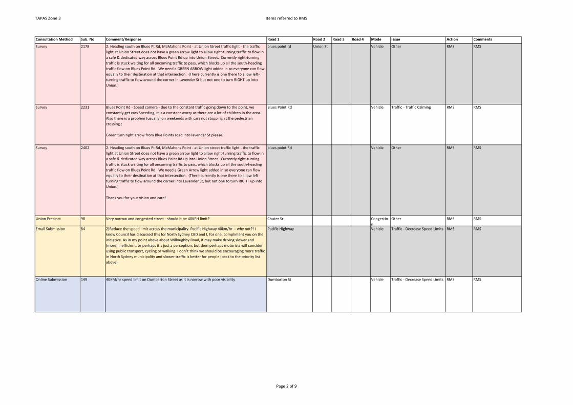
TAPAS Zone 3 Items referred to RMS
Consultation Method Sub. No Comment/Response Road 1 Road 2 Road 3 Road 4 Mode Issue Action Comments
Survey 2178 2. Heading south on Blues Pt Rd, McMahons Point - at Union Street traffic light - the traffic light at Union Street does not have a green arrow light to allow right-turning traffic to flow in a safe & dedicated way across Blues Point Rd up into Union Street. Currently right-turning traffic is stuck waiting for all oncoming traffic to pass, which blocks up all the south-heading traffic flow on Blues Point Rd. We need a GREEN ARROW light added in so everyone can flow equally to their destination at that intersection. (There currently is one there to allow left-turning traffic to flow around the corner in Lavender St but not one to turn RIGHT up into Union.)
blues point rd Union St Vehicle Other RMS RMS
Survey 2231 Blues Point Rd - Speed camera - due to the constant traffic going down to the point, we constantly get cars Speeding, it is a constant worry as there are a lot of children in the area. Also there is a problem (usually) on weekends with cars not stopping at the pedestrian crossing.;
Green turn right arrow from Blue Points road into lavender St please.
Blues Point Rd Vehicle Traffic - Traffic Calming RMS RMS
Survey 2402 2. Heading south on Blues Pt Rd, McMahons Point - at Union street traffic light - the traffic light at Union Street does not have a green arrow light to allow right-turning traffic to flow in a safe & dedicated way across Blues Point Rd up into Union Street. Currently right-turning traffic is stuck waiting for all oncoming traffic to pass, which blocks up all the south-heading traffic flow on Blues Point Rd. We need a Green Arrow light added in so everyone can flow equally to their destination at that intersection. (There currently is one there to allow left-turning traffic to flow around the corner into Lavender St, but not one to turn RIGHT up into Union.)
Thank you for your vision and care!
blues point Rd Vehicle Other RMS RMS
Union Precinct 98 Very narrow and congested street - should it be 40KPH limit? Chuter Sr Congestion
Other RMS RMS
Email Submission 84 2)Reduce the speed limit across the municipality. Pacific Highway 40km/hr – why not?! I know Council has discussed this for North Sydney CBD and I, for one, compliment you on the initiative. As in my point above about Willoughby Road, it may make driving slower and (more) inefficient, or perhaps it’s just a perception, but then perhaps motorists will consider using public transport, cycling or walking. I don ’t think we should be encouraging more traffic in North Sydney municipality and slower traffic is better for people (back to the priority list above).
Pacific Highway Vehicle Traffic - Decrease Speed Limits RMS RMS
Online Submission 149 40KM/hr speed limit on Dumbarton Street as it is narrow with poor visibility Dumbarton St Vehicle Traffic - Decrease Speed Limits RMS RMS
Page 2 of 9

TAPAS Zone 3 Items referred to RMS
Consultation Method Sub. No Comment/Response Road 1 Road 2 Road 3 Road 4 Mode Issue Action Comments
Survey 482 1) Dumbarton St, McMahons Point: This is a busy recreational walking/running Routes along a very narrow road (some parts single width) with steep hills on blind bends rising at either end. The single footpath is inaccessible to prams, groups or wheelchairs due to it's narrow width and the power poles , meaning 95% of people walk along the road itself. Many near misses have been observed from our home as cars fly down the hills at speed, round the bend and squeal to a stop. Strongly recommend a 20-30km speed zone with prominent "SLOW DOWN" and "beware of pedestrians/children playing" signage be put in place. The powerlines going underground would also help.
Dumbarton ST Vehicle Traffic - Decrease Speed Limits RMS RMS
Survey 482 4) Blues Point Rd: right turn into Blue St. needs a green arrow. Very dangerous currently at peak times.
Blues Point Rd Blue St Vehicle Traffic - Intersection Safety and/or Performance
RMS RMS
Survey 482 5) Blue St, right turn onto Pacific Highway. Needs a green arrow of it's own as pedestrian traffic from the train is very heavy at peak times, meaning often just one car makes the turn per cycle - leading to serious traffic Congestion, dangerous turns and light-running.
Blue St Pacific Highway
Vehicle Traffic - Intersection Safety and/or Performance
RMS RMS
Survey 670 4. Increasing concern at Cammeraygal that some of the students are not crossing the Pacific Highway safely - perhaps consider mid-road barrier fence. With increasing population density on the East side of the Highway, there will be more children crossing to the schools on the West side (Dem and Cammeraygal).
Pacific Highway Walking Pedestrian - Safety RMS RMS
Survey 1160 Lane 8 on the Bridge - traffic banks up to toll gates merge in from three lanes to one lane. Solution = open lane 7 to all traffic in non peak hour times for lane 7. Lane 7 is open pathway from 10am to 3pm. Open whole length of lane 7 in non peak hour times.
Harbour bridge Vehicle Other RMS RMS
Survey 1812 Harbour Bridge and roads leading to it, peak hour Congestion morning and evening Harbour bridge Congestion
Other RMS RMS
Survey 2147 Harbour Crescent to exit into Lavender St, Milsons Pt - a traffic light would be helpful to help to exit Lavender St. Loading zones block view for traffic from the roundabout of Lavender St.
Harbour Cres Lavender St
Vehicle Traffic - Intersection Safety and/or Performance
RMS RMS
Survey 1618 Too many speed zone changes on Pacific Hwy, North Sydney in a short stretch. Pacific Highway Vehicle Other RMS RMS
Online Submission 10 2. Merging traffic from High St onto Pacific Hwy - This is a very dangerous zone as there are multiple lanes merging across one another. The traffic coming off the Southbound freeway onto High St, is merging left onto Pacific Hwy, while the traffic from Pacific Hwy is merging right to turn into Walker St creating a network of overlapping lanes and traffic chaos. Simple solution would be to time the traffic lights better so that the lights on Pacific Hwy before the High St junction remain red, whilst the traffic light on High St and Arthur St are green to allow this traffic to come up and merge onto Pacific Hwy. Then the lights on High & Arthur St turn red whilst the lights on Pacific Hwy are green to allow these vehicles to merge right to turn onto Walker St at which point the lights on Pacific and Walker should also be green to allow this group of cars to pass through.
High St Pacific Highway
Vehicle Traffic - Intersection Safety and/or Performance
RMS RMS
Workshop 4 Dangerous intersection. Bus come in, can't go around. Cars come from rat running --> increased traffic
Lavender St Blues Point Rd
Congestion
other RMS RMS
Survey 1994 Lavender, Blues Pt Road - Traffic lights intersection is very noisy;
Blue Pts Rd - Congestion during peak hour.
Blues Point rd Lavender St
Vehicle Traffic - Intersection Safety and/or Performance
RMS RMS
Page 3 of 9
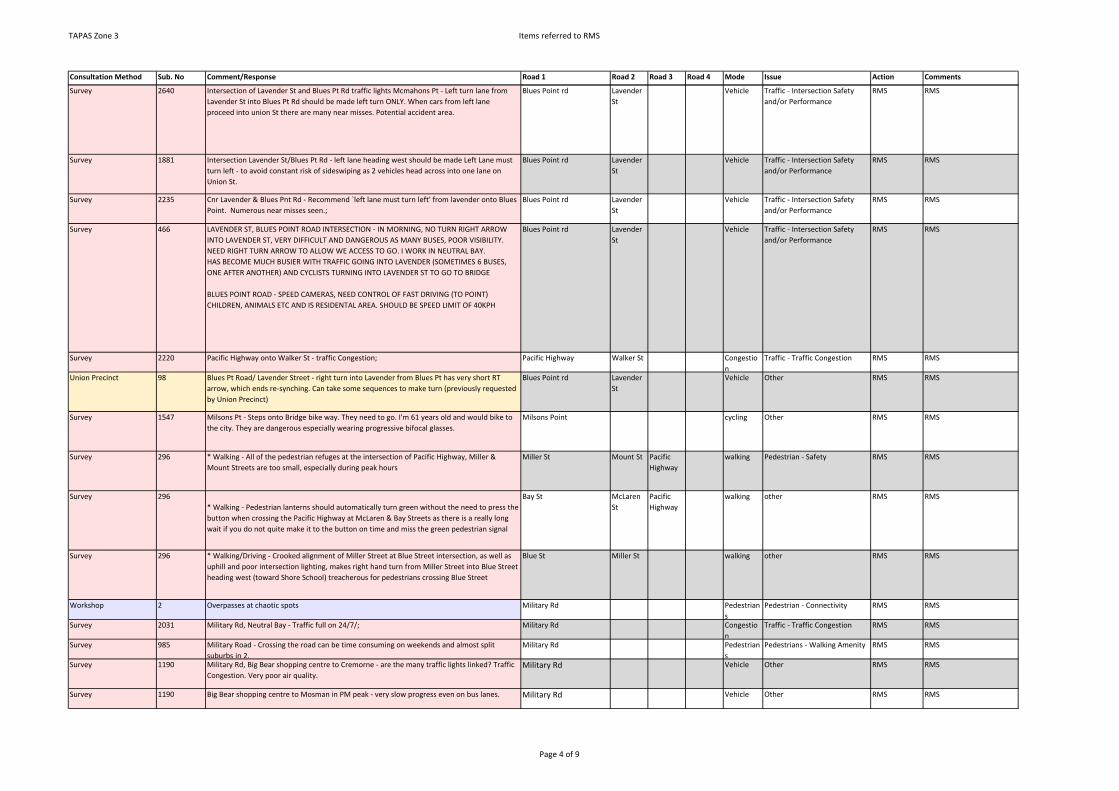
TAPAS Zone 3 Items referred to RMS
Consultation Method Sub. No Comment/Response Road 1 Road 2 Road 3 Road 4 Mode Issue Action Comments
Survey 2640 Intersection of Lavender St and Blues Pt Rd traffic lights Mcmahons Pt - Left turn lane from Lavender St into Blues Pt Rd should be made left turn ONLY. When cars from left lane proceed into union St there are many near misses. Potential accident area.
Blues Point rd Lavender St
Vehicle Traffic - Intersection Safety and/or Performance
RMS RMS
Survey 1881 Intersection Lavender St/Blues Pt Rd - left lane heading west should be made Left Lane must turn left - to avoid constant risk of sideswiping as 2 vehicles head across into one lane on Union St.
Blues Point rd Lavender St
Vehicle Traffic - Intersection Safety and/or Performance
RMS RMS
Survey 2235 Cnr Lavender & Blues Pnt Rd - Recommend `left lane must turn left' from lavender onto Blues Point. Numerous near misses seen.;
Blues Point rd Lavender St
Vehicle Traffic - Intersection Safety and/or Performance
RMS RMS
Survey 466 LAVENDER ST, BLUES POINT ROAD INTERSECTION - IN MORNING, NO TURN RIGHT ARROW INTO LAVENDER ST, VERY DIFFICULT AND DANGEROUS AS MANY BUSES, POOR VISIBILITY.NEED RIGHT TURN ARROW TO ALLOW WE ACCESS TO GO. I WORK IN NEUTRAL BAY.HAS BECOME MUCH BUSIER WITH TRAFFIC GOING INTO LAVENDER (SOMETIMES 6 BUSES, ONE AFTER ANOTHER) AND CYCLISTS TURNING INTO LAVENDER ST TO GO TO BRIDGE
BLUES POINT ROAD - SPEED CAMERAS, NEED CONTROL OF FAST DRIVING (TO POINT) CHILDREN, ANIMALS ETC AND IS RESIDENTAL AREA. SHOULD BE SPEED LIMIT OF 40KPH
Blues Point rd Lavender St
Vehicle Traffic - Intersection Safety and/or Performance
RMS RMS
Survey 2220 Pacific Highway onto Walker St - traffic Congestion; Pacific Highway Walker St Congestion
Traffic - Traffic Congestion RMS RMS
Union Precinct 98 Blues Pt Road/ Lavender Street - right turn into Lavender from Blues Pt has very short RT arrow, which ends re-synching. Can take some sequences to make turn (previously requested by Union Precinct)
Blues Point rd Lavender St
Vehicle Other RMS RMS
Survey 1547 Milsons Pt - Steps onto Bridge bike way. They need to go. I'm 61 years old and would bike to the city. They are dangerous especially wearing progressive bifocal glasses.
Milsons Point cycling Other RMS RMS
Survey 296 * Walking - All of the pedestrian refuges at the intersection of Pacific Highway, Miller & Mount Streets are too small, especially during peak hours
Miller St Mount St Pacific Highway
walking Pedestrian - Safety RMS RMS
Survey 296* Walking - Pedestrian lanterns should automatically turn green without the need to press the button when crossing the Pacific Highway at McLaren & Bay Streets as there is a really long wait if you do not quite make it to the button on time and miss the green pedestrian signal
Bay St McLaren St
Pacific Highway
walking other RMS RMS
Survey 296 * Walking/Driving - Crooked alignment of Miller Street at Blue Street intersection, as well as uphill and poor intersection lighting, makes right hand turn from Miller Street into Blue Street heading west (toward Shore School) treacherous for pedestrians crossing Blue Street
Blue St Miller St walking other RMS RMS
Workshop 2 Overpasses at chaotic spots Military Rd Pedestrians
Pedestrian - Connectivity RMS RMS
Survey 2031 Military Rd, Neutral Bay - Traffic full on 24/7/; Military Rd Congestion
Traffic - Traffic Congestion RMS RMS
Survey 985 Military Road - Crossing the road can be time consuming on weekends and almost split suburbs in 2.
Military Rd Pedestrians
Pedestrians - Walking Amenity RMS RMS
Survey 1190 Military Rd, Big Bear shopping centre to Cremorne - are the many traffic lights linked? Traffic Congestion. Very poor air quality.
Military Rd Vehicle Other RMS RMS
Survey 1190 Big Bear shopping centre to Mosman in PM peak - very slow progress even on bus lanes. Military Rd Vehicle Other RMS RMS
Page 4 of 9
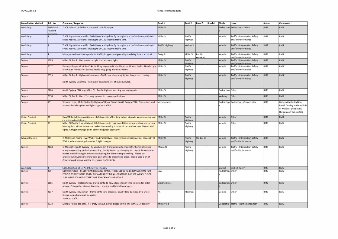
TAPAS Zone 3 Items referred to RMS
Consultation Method Sub. No Comment/Response Road 1 Road 2 Road 3 Road 4 Mode Issue Action Comments
Workshop Additional resident workshop
Traffic islands on Miller St too small to hold people Miller St Pedestrians
Pedestrian - Safety RMS RMS
Workshop 4 Traffic lights favour traffic. Taxi drivers and cyclists fly through - you can't take more than 8 steps, ratio is 10 seconds walking to 90-120 seconds traffic time.
Miller St Pacific Highway
Vehicle Traffic - Intersection Safety and/or Performance
RMS RMS
Workshop 4 Traffic lights favour traffic. Taxi drivers and cyclists fly through - you can't take more than 8 steps, ratio is 10 seconds walking to 90-120 seconds traffic time.
Pacific Highway Walker St Vehicle Traffic - Intersection Safety and/or Performance
RMS RMS
Workshop 4 More jay-walkers since speeds for traffic dropped and green light walking time is so short Berry St Miller St Pacific Highway
Vehicle Traffic - Intersection Safety and/or Performance
RMS RMS
Survey 1989 Miller St, Pacific Hwy - needs a right turn arrow at lights Miller St Pacific Highway
Vehicle Traffic - Intersection Safety and/or Performance
RMS RMS
Survey 2017 Driving - the ped/X at the Coke building to post office holds up traffic very badly. Need a right arrow turn from Miller St onto Pacific Hwy going into Nth Sydney;
Miller St Pacific Highway
Vehicle Traffic - Intersection Safety and/or Performance
RMS RMS
Survey 2033 Miller St, Pacific Highway Crossroads - Traffic not observing lights - dangerous crossing.;
North Sydney Generally - Too busily populated lots of building work.
Miller St Pacific Highway
Vehicle Traffic - Intersection Safety and/or Performance
RMS RMS
Survey 2266 North Sydney CBD, esp. Miller St - Pacific Highway crossing are inadequate.; Miller St Pedestrians
Other RMS RMS
Survey 2310 Miller St, Pacific Hwy - Too long to want to cross as pedestrian Miller St Walking Other RMS RMS
Survey 951 Victoria cross - Miller St/Pacific Highway/Mount Street, North Sydney CBD - Pedestrians walk across all roads against red lights! Ignore traffic!
Victoria cross Pedestrians
Pedestrian - Connectivity RMS Liaise with the RMS to install fencing in the middle of Miller St and Pacific Highway on the existing Median.
Union Precinct 98 Hwy/Miller left turn westbound - left turn into Miller long delays at peaks as per crossing not coordinated with lights.
Miller St Pacific Highway
Vehicle Other RMS RMS
Union Precinct 98 Miller St/Pacific Hwy at Mount St left turn - onto Hwy from Miller very often blocked by cars heading into Mount where the pedestrian crossing is unrestricted and not coordinated with lights. A major blockage point at morning peak especially.
Miller St Pacific Highway
Vehicle Other RMS RMS
Edward Precinct 119 2. Miller and Pacific Hwy; Walker and Pacific Hwy - Cars verging across junction. Especially at Walker where can stop buses for 3 light changes.
Miller St Pacific Highway
Walker St Vehicle Traffic - Intersection Safety and/or Performance
RMS RMS
Survey 2278 1. Mount St, North Sydney - As you turn left from highway to mount St, there's always so many people using pedestrian crossing, the lights end up changing and my car & sometimes others are still sitting in intersection waiting for them to stop dawdling. Please put underground walking tunnels from post office to greenwood plaza. Would stop a lot of Congestion & people waiting to cross at traffic lights.;
Mount St Pacific Highway
Vehicle Traffic - Intersection Safety and/or Performance
RMS RMS
Workshop 4 Speed limit on bikes; And they cycle in a row Cycling Cycling -Safety RMS RMSSurvey 435 NORTH SYDNEY - PEDESTRIAN CROSSING TIMES. THERE NEEDS TO BE LONGER TIME FOR
PEOPLE TO CROSS THE ROAD. THE AVERAGE TIME ALLOCATED IS 8-10 SEC WHICH IS NOR SUFFICIENT FOR WIDE STREETS OR FOR CROWDS OF PEOPLE
LGA Pedestrians
Other RMS RMS
Survey 1155 North Sydney - Victoria Cross: traffic lights do now allow enough time to cross for older people. This applies at most Crossings, phasing and lights favour cars.
Victoria Cross pedestrians
Other RMS RMS
Survey 2117 North Sydney to Mosman - traffic lights slow progress, usually take back road via Shore School, again back road via water; reduced traffic
NS Mosman Vehicle Other RMS RMS
Survey 2273 Military Rd is a car park. It is crazy to have a draw bridge in this city in the 21st century. Military Rd Congestion
Traffic - Traffic Congestion RMS RMS
Page 5 of 9

TAPAS Zone 3 Items referred to RMS
Consultation Method Sub. No Comment/Response Road 1 Road 2 Road 3 Road 4 Mode Issue Action Comments
Survey 88 2) Northbound on Pacific Highway at the left turn into Miller Street. Pedestrians hold up buses and cars in a continuous flow across to the traffic island or into Greenwood Plaza.
Miller St Pacific Highway
Congestion
Other RMS RMS
Online Submission 122 I have noticed many students from the new Cammeraygal High School crossing the Pacific Highway unsafely. We need a divided median with a fence to discourage our young adults from making a life threatening mistake.
Pacific Highway Walking Other RMS RMS
Survey 2278 2. Pacific Hwy turning right onto Berry St - Both lights change at the same time for opposite traffic turning into Berry St. People turning right into Berry have to change lanes straight away with cars zooming around the corner. Dangerous corner.;
Berry St Pacific Highway
Vehicle Traffic - Intersection Safety and/or Performance
RMS RMS
Online Submission 66 Traffic Lights, intersecting Pacific Highway and Berry Street. When turning right from Pacific Highway onto Berry Street, the driver must watch out for oncoming traffic from the opposite direction (St Leonards - > North Sydney) as both drivers merge onto Berry Street. I believe a simple reconfiguration of the traffic lights would allow drivers from Pacific Highway to safely turn onto Berry Street, whilst the oncoming traffic would be altered to wait for these drivers. I have seen too many near-misses that have led to accidents.
Berry St Pacific Highway
Vehicle Other RMS RMS
Survey 2024 Pacific Highway, Blues Point Road - Driving - Junction - It is always chaotic. People walking into Greenwood.;
Blues Point Rd Pacific Highway
Vehicle Traffic - Intersection Safety and/or Performance
RMS RMS
Survey 2203 Left Hand turn from Pacific Hwy into Miller Street by car - pedestrian walkway is very dangerous. Should be controlled by traffic lights.
Miller St Pacific Highway
Pedestrians
Other RMS RMS
Survey 2001 Lights Pacific Hwy, Miller St - Stop R hand turn. No need to turn. R here travelling Nth from McMahons Pt and holds up traffic.;
Miller St Pacific Highway
Vehicle Other RMS RMS
Survey 2677 Crn Pacific Hwy + Miller St - We have a major concern for pedestrian welfare + bike riders - when car driving + coming up the highway off the bridge + travelling north - and making a left hand turn into Miller St at Greenwood corner people come running out of the building + are constantly walking on the crossing + all along Miller St. Bicycle riders are difficult to see at dusk + in peak hour- Someone will be hit one day - its a very hazardous situation. Maybe railing like used at other roadsides should be installed so pedestrians are safe. Or pedestrians could have 'walk' + 'don't walk' lights. Please consider this. Also taxies often pull in on the lights of Miller St to off load passengers making it difficult to see to the left, and cars travelling S down Miller St, make it difficult to get thru the fed. Crossing when car drivers have to take a chance at merging into Miller St. Proposed railing like used in middle of Pacific Hwy + opposite side of Hwy. (see graph)
Miller St Pacific Highway
Vehicle Other RMS RMS
Survey 2199 Corner Pacific Hway & Miller St ped crossing & Hway going north & left into Miller - pedestrian crossing needs control over pedestrians;
Miller St Pacific Highway
Vehicle Other RMS RMS
Survey 2167 Pacific Highway - if headed north bound, it is difficult to turn onto Miller St. South bound (when driving) as the pedestrian crossing is on the corner ;
Miller St b/w Mount St & Berry St - when I am driving, pedestrians take great risks crossing Miller St & standing on the very narrow island.;
Miller St Pacific Highway
Vehicle Other RMS RMS
Survey 2297 Crows Nest to North Sydney, Pacific Hwy - Waiting time at pedestrian crossing/ traffic. Pacific Highway Pedestrians
Pedestrian - Safety RMS RMS
Survey 2083 Pacific Highway, North Sydney - when going onto Pacific Highway from High Mount Street, it is dangerous to change so many lanes to make the left turn onto Blue Street - many cars that also want to merge right from Bondfield Highway.;
Pacific Highway Blue St High St Vehicle Other RMS RMS
Page 6 of 9

TAPAS Zone 3 Items referred to RMS
Consultation Method Sub. No Comment/Response Road 1 Road 2 Road 3 Road 4 Mode Issue Action Comments
Mapping Tool 45 Dangerous Lane Barriers: There are barriers between the left lane and the other lanes on Pacific Highway.These barriers are very dangerous to bike riders. Cyclists cannot go up on the footpath (where marked), because there's not enough room for bikes and pedestrians walking the other way, so going up on the road is the most appropriate.Those barriers prevent any busses/cars from overtaking cyclists. Given that it's up hill for cyclists, they are slow and many busses/cars get annoyed and tailgate the cyclists very close. Some even speed up to get in front of the cyclists before the barriers start. I've had many close calls (of serious injury or even death) riding up that section of road. It is the most dangerous part of the whole council area. Removal of the barriers will allow busses/cars to go around the cyclists. They do not achieve anything other than cause problems. If it is unsafe for drivers to change lanes to the left, they will not do it. No need to prevent the possibility, especially since it causes more danger.
Pacific Highway Cycling Cycling -Safety RMS RMS
Survey 2180 North Sydney, Pacific Highway near Kirribilli - Lights need to be synchronized so that coming off Warringah going south towards Alfred St, and round roundabout, and heading west along Pacific Highway. cars veering to Walker St North, clash with cars joining Pacific H'Way & heading up towards Miller St, for Blues Pt Rd, dangerous.
Alfred St Pacific Highway
Vehicle Other RMS RMS
Survey 508 Pacific Hwy/Blue St/Arthurs St - pedestrian crossing at lights tuning right to get onto expressway is a nightmare at peak. Too many pedestrians, not enough time for cars to turn right and left at lights.
Arthur St Blue St Pacific Highway
Vehicle Other RMS RMS
Survey 2078 Pacific Hwy, Miller St - the crossing as you turn into Miller to go down from heading north on Pacific *cyclists, pedestrians, cars. It is dangerous as pedestrians can walk across the crossing part to the lights. They should have to wait until the light changes. It is so dangerous! cars back up as selfish pedestrians stroll across even though they can't walk across the whole road. Cyclists are also in that lane. The pedestrian "walk" sign should begin at the pavement - Not on the island.
Miller St Pacific Highway
Walking Other RMS RMS
Survey 2157 Pacific Highway, Miller St, Blues Point Rd, Walker St - traffic lights are not long enough for pedestrians to cross the road.;
Blues point rd Miller St Pacific highway
Vehicle Traffic - Intersection Safety and/or Performance
RMS RMS
Workshop 4 Wider roads, e.g.. Pacific Highway pedestrian crossing, don’t given you enough time, should have a countdown timer.
Pacific Highway Walker St Pedestrians
Pedestrian - Connectivity RMS RMS
Survey 2068 Pacific Highway, Walker St, North Sydney - pedestrian Crossings/traffic lights green phase too short;
Pacific Highway Walker St Vehicle Other RMS RMS
Workshop 5 Off Pacific Highway turning onto Blue Point Rd - There is now divider but people turning left go across traffic onto Blue Street --> Better signage or flash system needed.
Blue St Blues Point Rd
Pacific Highway
Vehicle Other RMS RMS
Page 7 of 9
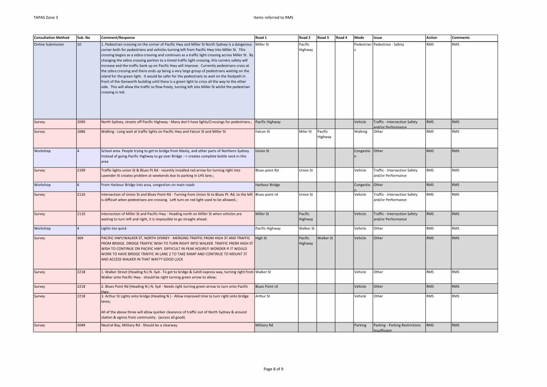
TAPAS Zone 3 Items referred to RMS
Consultation Method Sub. No Comment/Response Road 1 Road 2 Road 3 Road 4 Mode Issue Action Comments
Online Submission 10 1. Pedestrian crossing on the corner of Pacific Hwy and Miller St North Sydney is a dangerous corner both for pedestrians and vehicles turning left from Pacific Hwy into Miller St. This crossing begins as a zebra crossing and continues as a traffic light crossing across Miller St. By changing the zebra crossing portion to a timed traffic light crossing, this corners safety will increase and the traffic bank up on Pacific Hwy will improve. Currently pedestrians cross at the zebra crossing and there ends up being a very large group of pedestrians waiting on the island for the green light. It would be safer for the pedestrians to wait on the footpath in front of the Genworth building until there is a green light to cross all the way to the other side. This will allow the traffic to flow freely, turning left into Miller St whilst the pedestrian crossing is red.
Miller St Pacific Highway
Pedestrians
Pedestrian - Safety RMS RMS
Survey 2049 North Sydney, streets off Pacific Highway - Many don't have lights/Crossings for pedestrians.; Pacific Highway Vehicle Traffic - Intersection Safety and/or Performance
RMS RMS
Survey 1686 Walking - Long wait at traffic lights on Pacific Hwy and Falcon St and Miller St Falcon St Miler St Pacific Highway
Walking Other RMS RMS
Workshop 4 School area. People trying to get to bridge from Manly, and other parts of Northern Sydney. Instead of going Pacific Highway to go over Bridge --> creates complete bottle neck in this area
Union St Congestion
Other RMS RMS
Survey 2199 Traffic lights union St & Blues Pt Rd - recently installed red arrow for turning right into Lavender St creates problem at weekends due to parking in LHS lane.;
Blues point Rd Union St Vehicle Traffic - Intersection Safety and/or Performance
RMS RMS
Workshop 6 From Harbour Bridge into area, congestion on main roads Harbour Bridge Congestion
Other RMS RMS
Survey 2110 Intersection of Union St and Blues Point Rd - Turning from Union St to Blues Pt. Rd, to the left is difficult when pedestrians are crossing. Left turn on red light used to be allowed.;
Blues point rd Union St Vehicle Traffic - Intersection Safety and/or Performance
RMS RMS
Survey 2110 Intersection of Miller St and Pacific Hwy - Heading north on Miller St when vehicles are waiting to turn left and right, it is impossible to go straight ahead.
Miller St Pacific Highway
Vehicle Traffic - Intersection Safety and/or Performance
RMS RMS
Workshop 4 Lights too quick Pacific Highway Walker St Vehicle Other RMS RMS
Survey 369 PACIFIC HWY/WALKER ST, NORTH SYDNEY - MERGING TRAFFIC FROM HIGH ST AND TRAFFIC FROM BRIDGE. DRIDGE TRAFFIC WISH TO TURN RIGHT INTO WALKER. TRAFFIC FROM HIGH ST WISH TO CONTINUE ON PACIFIC HWY. DIFFICULT IN PEAK HOURS!! WONDER IF IT WOULD WORK TO HAVE BRIDGE TRAFFIC IN LANE 2 TO TAKE RAMP AND CONTINUE TO MOUNT ST AND ACCESS WALKER IN THAT WAY?? GOOD LUCK
High St Pacific Highway
Walker St Vehicle Other RMS RMS
Survey 2218 1. Walker Street (Heading N.) N. Syd - To get to bridge & Cahill express way, turning right from Walker onto Pacific Hwy - should be right turning green arrow to allow;
Walker St Vehicle Other RMS RMS
Survey 2218 2. Blues Point Rd (Heading N.) N. Syd - Needs right turning green arrow to turn onto Pacific Hwy;
Blues Point rd Vehicle Other RMS RMS
Survey 2218 3. Arthur St Lights onto bridge (Heading N.) - Allow improved time to turn right onto bridge lanes;
All of the above three will allow quicker clearance of traffic out of North Sydney & around station & egress from community. (access all good).
Arthur St Vehicle Other RMS RMS
Survey 2049 Neutral Bay, Military Rd - Should be a clearway. Military Rd Parking Parking - Parking Restrictions Insufficient
RMS RMS
Page 8 of 9

TAPAS Zone 3 Items referred to RMS
Consultation Method Sub. No Comment/Response Road 1 Road 2 Road 3 Road 4 Mode Issue Action Comments
Survey 2211 Pacific Hway Nth Syd - impossible for elderly to cross with Safety. Green walk lights not long enough. I have to stand in middle of road to enable my husband to cross as he uses a "walking frame". We have lived in area 65 years & all medical service are in area noted on map.;
Pacific Highway Walking Other RMS RMS
Survey 2211 Impossible to cross with Green light. Mount St Pacific Highway
Walker St Walking other RMS RMS
Survey 2189 Walker St, Pacific Hwy - cars turning southbound are forced to turn at the same time pedestrians cross & often dangerously push through pedestrian only crossing time & diagonal? Perhaps a pedestrian tunnel or bridge?;
Walker St vehicle Other RMS Liaise with the RMS to increase the pedestrian crossing timing at the intersection
Survey 1541 North Sydney Intersection of Walker St and Pacific Hwy - When travelling southbound on Walker St and turning right onto Pacific Hwy can be quite dangerous as no specific green light allowing traffic to turn right.
Pacific Highway Walker St vehicle Other RMS RMS
Survey 1720 Pacific Hwy and Walker St merge - cars merge poorly in/on intersection. Pacific Highway VehicleTraffic - Intersection Safety and/or Performance
RMSreview intersection for improvments
Workshop 5 Very dangerous area. Clash of directions trying to turn into Walker St, when cross Expressway - crossing from 3 lanes to 2 lanes…confusing and dangerous
Walker St Warringah Expressway
Vehicle Other RMS RMS
Workshop 4 Merging people coming off bridge going through too many lanes of traffic to get off the road. Cars can go left/right at junction, very dangerous area
Arthur St High St Pacific Highway
Wwarringah Express
Vehicle Traffic - Intersection Safety and/or Performance
RMS RMS
Workshop 2 Bridge traffic flow in all directions Vehicle Other RMS RMSSurvey 930 Bay way to avoid Military Rd using High, Ben Boyd, Wycombe, Murdoch, Hampdon, Spofforth
- Peak hour - traffic crawls/dead stop (starts to free up after Mosman exit in Spofforth).Military Rd - congested always peak hour.
Military Rd Congestion
Other RMS RMS
Survey 2107 Turn from William St onto Pacific Highway - cars aren't on a stop sign but pedestrians just walk across constantly.
William St Pacific Highway
Pedestrians
Traffic - Intersection Safety and/or Performance
RMS RMS
Survey 1871 Walker St, North Sydney - Traffic lights at Mount St and Walker St are poorly tmed with right hand turn light from Pacific Hwy to walker St
Walker st Traffic Other RMS RMS
Page 9 of 9

SMEC | North Sydney Council TAPAS Zone 3 Action Plans Draft Report | Page 19
APPENDIX D – ITEMS REFERRED TO OTHER COUNCIL DEPARTMENTS

TAPAS Zone 3 Items referred to other Council Departments
Consultation Method Sub. No Comment/Response Road 1 Road 2 Road 3 Road 4 Mode Issue Action Comments
Survey 1249 Seriously limited parking in the shopping precinct surrounding Aldi and Coles. It was extremely shortsighted to allow Coles to open without parking. As these Supermarkets are on a hill carrying shopping, or hauling a personal shopping trolley is arduous. I like to shop locally and walk whenever possible, but this is frequently not the case given the amount of shopping I do.
Mount St Walker Development
Parking - Parking Restrictions Insufficient
CIS CIS
Workshop 7 Traffic controllers reducing traffic to one lane in peak hour Alfred St South Congestion
Other Rangers Enforcment
Workshop 7 Marking of footpaths years ago, now they need levelling out. Alfred St South Middlemiss St
Walking Pedestrians - Footpath Surface Conditions
Works Engineers
Poor footpath surface conditions, footpath restorations
Workshop Evaluation 3 123 Have a look at the parking signs around 70 Alfred St, near the station. If you read them correctly as worded the only time you can park there at night is between 12 midnight Sunday and 8.30am Monday morning. Not a very useful period, otherwise you really would have to get up and move car every 2 hours during the night AND feed the meter. Perhaps you could also look at OVER Zealous Parking Officers...WHY book a car for overstaying a meter when half or more of the parking bays are unoccupied!
Alfred Street South Parking Parking - Too much enforcement
rangers Enforcment
Survey 464 ALFRED ST MILSONS POINT - CONSTRUCTION SITE LACK OF RESIDENT PARKING, LACK OF VISIBLE SHOPPING PRECINCT TRAFFIC
Alfred St South Development
Other CIS CIS
Lavender Bay Precinct 59 3. Alfred St/Lavender St roundabout - Cars, pedestrians and cycles conflict. Solution given Council at workshop; Lack of parking in new developments. Need at least 1 space/residence and visitor parking.
Alfred St South Lavender St
Development
Parking - Create New Supply CIS CIS
Workshop 4 No one patrolling parking meters at night Arthur St Parking Parking - Too little enforcement
Rangers Enforcement
Workshop 4 Issues with construction signalled in these areas Alfred St Arthur St Cliff St Pacific Highway
Development
Other CIS CIS
Union Precinct 98 ‘No Stopping’ signs at Bank Lane have faded and not readable. Bank Lane Parking OtherWorks Engineers
Review Signs
Union Precinct 98 Occasional illegal construction vehicle parking on side of lane renders the garages or parking spaces of houses opposite unusable.
Bank Lane Development
Parking - Too little enforcement
Rangers Enforcment
Online Submission 6 In addition, it would be helpful if Bank St was actually policed by parking inspectors (I have live here for 6 years and only have seen parking inspections once the whole time and I *never* see parking tickets on cars).
Oh, and BTW, thank you for engaging in GoGet carshare. This is a fantastic initiative that means many residents can give up (or cope) with only one car.
Thank you for considering these suggestions.
Banks St Parking Parking - Too little enforcement
Rangers enforcment
Edward Precinct 119 10.Sustainability – incorporate Council’s Ecologically Sustainability Development (ESD) Policy to Michael Mabbs and City of Sydney Cooling and Greening our Roads Initiatives - Add street trees, light coloured roads, mid road plantings, e.g. on West end of Berry.
Berry St Other OSE More Street Trees
Workshop 4 "Concerned about the number of developments, 14 towers being built - 7000 more people in area. Already difficult to get around. Everyone goes through Greenwood Plaza - need more access points; cannot sustain more; dangerous during peak hours".
Berry St Development
Other CIS CIS
Workshop Additional Resident workshop
Dangerous road service Blue St Union St Vehicle Road Surface Damage Works Engineers
Refer to Works Engineers
Workshop 4 Corner of Blue and Miller St, people park in no stopping zone and this stops busses. ( St Honore?).
Blue St Miller St Parking Parking - Too little enforcement
Rangers Enforcement
Page 1 of 6

TAPAS Zone 3 Items referred to other Council Departments
Consultation Method Sub. No Comment/Response Road 1 Road 2 Road 3 Road 4 Mode Issue Action Comments
Survey 2170 Blues Point Reserve Car Park - Go Get space for `lizzie'' frequently taken by other cars.; Blues Point Reserve car park
Car share Parking - Too little enforcement
Rangers Enforcment
Survey 2005 Blues Point Road - Poor quality footpath surfacing - uneven etc, need smooth transitions for road crossing;
Blues Point Rd Walking Pedestrians - Footpath Surface Conditions
Works Engineers
Poor footpath surface conditions, footpath restorations
Survey 2025 Blues Point Rd - Footpath - Tree roots lifting the path causing people to fall - slippery metal man - hole cover.;
Blues Point Rd Walking Pedestrians - Footpath Surface Conditions
Works Engineers
Poor footpath surface conditions, footpath restorations
Survey 2225 Blues Pt Rd between Blue & Union - Poor road conditions on inside of road. Dangerous cars not parking in yellow grides ;
blues point rd Vehicle Road Surface Damage Works Engineers
Refer to Works Engineers
Mapping Tool 41 Very poor road surface, dangerous to cyclists: The inside lane road surfaces both southbound and northbound are very poor, with frequent breaks, small holes and drops that are dangerous to cyclist. The road includes bicycle tracks, though these are badly marked. Vehicles are often badly parked with their offside wheels outside the yellow guides, occupying all or part of the bike lanes.
Blues Point Rd William St Cycling Road Surface Damage Works Engineers
Refer to Works Engineers
Survey 2414 Footpaths dug up for contruction take months/years to be fixed temporary fixes are rarely done well.
LGA Walking Pedestrians - Footpath Surface Conditions
Works Engineers
Poor footpath surface conditions, footpath restorations
Workshop 4 1-way street with gym which was approved by Council but no parking was included. Chuter St Development
Parking - Parking Restrictions Insufficient
CIS CIS
Workshop 4 Gym on Chuter St - Ridiculous permit. How did they get permit? Get fined for noise in residential area, they pay, fined again, pay again. Non compliance. Also problem with parking due to new gym.
Chuter St Development
Parking - Parking Restrictions Insufficient
CIS CIS
Workshop 4 Redevelopment of Vibe Hotel North Sydney + Astonia Alfred St Dind St Development
Other CIS Cis
Survey 2090 P/S. Please note with too many residence units now, it is very to find parking lots for seasons parking residence. On week end (after 5pm Friday) along Cliff St, lots been taken. Therefore, no parking lots available for residence till Monday morning. Suggest regular visits by the Marshal. Much parking problems now as compared few years ago. I presume some owners given seasons parking, even with car lot in the building. Council should change to late parking allow, say after midnight.
Cliff St Parking Parking - Too little enforcement
Rangers Enforcment
Workshop 7 Coles should not have been built without parking off-street (basement etc.) Walker St Development
Parking - Create New Supply CIS CIS
Survey 1161 East Crescent St, McMahons Point - not always a foot path, foot path not wide enough. East Cres St Walking Pedestrians - Footpath Provisions
Works Engineers
refer to works Engineers
Survey 2342 Walking around Lavender Bay - Can you build a walkway along the water in front of E crest street houses? It's such a shame the public can't enjoy the view on this part of the walk around the bay and have to take the residential streets instead. We could have a walk like Coogee to Bronte if you opened this part up.
East Cres St Walking Pedestrians - Footpath Provisions
Works Engineers
refer to works Engineers
Edward Precinct 119 6. Edward St - Oak to end of Edward: Shore parents parking on the road from 2:30pm from end of Edward and back up part Oak. Under Braithwaite DA approval a SE drop off was installed. Ask planning to review terms of consent and request Shore to send more Prep School grades to SE drop off area. This is a safety issue for residents as no emergency vehicle access is possible.
Edward St Oak St School Parking - Concerns Related to DA
CIS CIS
Edward Precinct 119 8. End Edward St southbound - Suggest Shore do a road/land exchange with NSC - end of road for park on current basketball courts. Design better drop off as part of swap/settlement and e.g. around outside of basketball courts.
Edward St School Parking - Create New Supply CIS CIS
Survey 512 Edward St, Highway, West St - surface is improving but still bad in places. Edward St Pacific Highway
West St Vehicle Road Surface Damage Works Engineers
Refer to Works Engineers
Page 2 of 6

TAPAS Zone 3 Items referred to other Council Departments
Consultation Method Sub. No Comment/Response Road 1 Road 2 Road 3 Road 4 Mode Issue Action Comments
Edward Precinct 11919. Edward St at end Lord Lane - Insert planting bed in no parking section. Greens and slows Shore traffic. N.B. don’t remove the parking along here for e.g. 8-10AM and 2-3:30PM as Shore cars will just race along it – very dangerous.
Edward St Lord lane VehicleTraffic - Intersection Safety and/or Performance
Street Furniture
planter box construction
Edward Precinct 1191. Edward St between Oak and Mount: Planter - Edward. Support these for cooling effects and traffic calming and streetscape benefits. Can more be added, e.g. middle of Berry near Edward.
Edward St Oak St Mount St Vehicle Traffic - Traffic CalmingStreet Furniture
planter box construction
Survey 93 Danger of falls in Euroka St with tree branches and leaf litter not being cleaned up.Safety for my wife walking through Railway parade at night from Waverton Station.Dirty path through Railway Parade from grass mowing and other things. On most mornings I have to clean grass off my shoes when I get to work.Can't walk from Saw Millers Reserve to Waverton Oval or McMahons Point.
Euroka St Railway Parade
Walking Pedestrian - Safety OSE OSE
Workshop 4 11 towers going up in North Sydney (mainly residential) Where will they park? Residential puts pressure on roads whereas office buildings put pressure on public transport --> but will inject business into North Sydney during weekends if residential
Denison St Glen St Development
Parking - Parking Restrictions Insufficient
CIS CIS
Survey 472 GLEN ST - PARKING, NOT ENOUGH FOR THE NEW APARTMENTS, NO PARKING FOR DELIVERIES
Glen St Development
Parking - Parking Restrictions Insufficient
CIS CIS
Survey 2179 Harbourview Cres next to Kirribilli RSL - illegal parking in tow away zone but no car ever gets penalised.
Cres next to Kirribilli RSL Parking Parking - Too little enforcement
Rangers enforcment
Lavender Bay Precinct (minutes)
52 8. Henry Lawson Ave, "tear drop" near ferry wharf- Remove last 18m of landscape island or trim the island by 0.5m along last 18m
Henry Lason Ave Other Works Engineers
Refer to Works Engineers
Workshop 4 Walking across to North Sydney shops, railing is low. This is dangerous for children. Arthur St High St Pacific Hwy
Walking Pedestrian - Safety Works Engineers
refer to Works Engineer
Union Precinct 98 Lack of any pedestrian safety as there are no footpaths. Holt St Walking Pedestrians - Footpath Provisions
Works Engineers
Refer to Works Engineers
Workshop 4 New pathways being built that don’t have ramps, e.g. King George St. and Rest Crescent St. King George St Waiwera St
Walking Pedestrian - Connectivity Works Engineers
refer to Works Engineer
Survey 2123 Lavender Bay - Existing parking restrictions in residential streets not policed enough, including disabled spaces.
Lavender Bay Parking Parking - Too little enforcement
Rangers Enforcment
Survey 2238 Lavender Bay: Walking - 1. Foreshore is not maintained: leaking pipes, no proper footpath (becomes muddy when wet) Piers not maintained, broken fences, litter (not enough garbage bins), ugly toilet block.;
Lavender Bay Walking Other Works Engineers
refer to Works Engineers
Survey 2238 2. restricted access to foreshore. Lavender Bay Walking Pedestrian - Connectivity Works Engineers
refer to Works Engineers
Survey 1436 North Sydney Bowling Club - development of commercial restaurants "The Greens" but no parking available at all and pushing bowlers out unnecessarily
North Sydney Bowling Club
development
Parking - Create New Supply CIS CIS
Survey 2182 Bike trails - still to discover! But there is a big need for more. ALSO - the vegetation on Miller St shared bike/walking section needs to be significantly cut back. Very unsafe near Blue Street.
Blue St Miller St Cycling Cycling -Safety OSE Trim vegetations in Miller St newar Blue Street
Survey 2194 Lavender St, Lavender Bay - Narrow footpath along road in front of Clark Park only really wide enough for 1 person;
Lavender St Walking Pedestrians - Footpath Provisions
Works Engineers
refer to works Engineers
Survey 2194 Lavender St opposite Clark Park - on footpath in front of residences some of the footpath has lifted, is a trip hazard.
Lavender St Walking Pedestrians - Footpath Surface Conditions
Works Engineers
Poor footpath surface conditions, footpath restorations
Survey 463 LAVENDER BAY DECK - COULD DO WITH SOME MAINTENENCE AS LOTS OF JOGGERS AND WALKERS USE
Lavender Bay Deck Walking Pedestrians - Footpath Provisions
Works Engineers
refer to works Engineers
Workshop 4 Particularly with construction (Issue with pedestrian Safety) Little Walker St Mount St Pacific Hwy
Pedestrians
Pedestrian - Safety Rangers Enforcement
Survey 2052 McMahons Point Ferry stop and Foreshore around Blues Point - Walking around is difficult; interrupted by fisherman - leave rubbish, obstruct path, prevent residents enjoying the harbour.
McMahons Pt Walking Pedestrians - Walking Amenity Works Engineers
refer to works Engineers
Page 3 of 6

TAPAS Zone 3 Items referred to other Council Departments
Consultation Method Sub. No Comment/Response Road 1 Road 2 Road 3 Road 4 Mode Issue Action Comments
Survey 2052 Middle Street, McMahons Point - please resurface road - is terrible.; Middle St Vehicle Road Surface Damage Works Engineers
Refer to Works Engineers
Survey 465 WALKER ST, BERRY ST, NORTH SYDNEY - ROAD WORKS IN PEAK HOUR Berry St Miller St Walker St Vehicle Roadworks Works Engineers
refer to Works Engineers
Survey 2052 Miller Street, North Sydney - Walking through is terrible - dingey, bird poo (pest species), nowhere nice to sit and therefore economically dead.;
Miler St Walking Other OSE OSE
Survey 2258 Miller St - Traffic. All the construction Miler St Development
Traffic - Traffic Congestion CIS CIS
Survey 2002 pathway too narrow near Blue St & down to MacKenzie!!; Blue St Mackenzie St
Pedestrians
Pedestrians - Footpath Provisions
Works Engineers
refer to works Engineers
Survey 2266 North Sydney CBD, esp. Miller St - Lack of footpath space, especially around bus stops. Miller St Pedestrians
Pedestrians - Footpath Provisions
Works Engineers
Refer to Works Engineers
Survey 1992 Footpaths issue - Safety - Repairs constantly necessary for Safety where roots cause unevenness eg. Milsons Pt to North Sydney alongside bridge (both sides). Also especially near the motorshow rooms uneven paths and water overflows from bridge and other drains - slip danger.
Milsons Point North Sydney
Walking Pedestrians - Footpath Surface Conditions
Works Engineers
refer to Works Engineers
Union Precinct 98 Commercial garbage trucks for businesses very noisy on steep ramps and at non-friendly hours. Can Council control these private contractors to come in business hours?
Mitchell St Vehicle Other OSE OSE
Survey 2385 Mount St, Walker St, North Sydney - Parking problem as a result of constant development; Mount St Walker St Development
Other CIS CIS
Survey 474 ANY NEW SCHOOLS IN THE AREA - FOR FUTURE PLANNING - PICKUP AND DROP OFF ZONES FOR CHILDREN NEED TO BE PLANNED ON SITE AND IDEALLY UNDERCOVER FOR SAFETY OF CHILDREN AND GOOD FLOW OF TRAFFIC
McMahons Point School School Zone Congestion CIS CIS
Survey 474 AROUND THE FORESHORES EG MCMAHONS POINT - WALKING ALL AROUND THE FORESHORES SHOULD BE POSSIBLE - PART OF A VERY OLD PLAN 1970S FOR THE HARBOUR
McMahons Point Walking Other Works Engineers
refer to Works Enginners
Workshop 4 Driveways and garages should be approved because they take one spot away from the road but offer numerous on-land parking spaces.
Development
Other CIS CIS
Workshop 6 Thinks that when metro link opens there will be new train station. Generate more parking, 10 years in future hasn’t actually happened yet
Development
Other CIS CIS
Workshop Additional resident workshop
So much development right near shops Development
Other CIS CIS
Survey 2706 Pacific Highway - pavement is too narrow Pacific Highway Walking Pedestrians - Footpath Provisions
Works Engineers
refer to works Engineers
Survey 2706 Alfred Street - pavement too narrow on west side Alfred St Vehicle Pedestrians - Footpath Provisions
Works Engineers
Works Engineers
Survey 2343 Rocklands Rd, Wollstonecraft - the road needs to be re-surfaced - very ruff and dangerous Rocklands Rd Vehicle Road Surface Damage Works Engineers
Refer to Works Engineers
Survey 2261Traffic signs - (see hard copy photo) 2) could also do with occasional cleaning to make them clearer, especially at dangerous intersections e.g. 5-ways at Crows Nest Rd, McKye St, Waverton.
Crows Nest Rd McKye St Parking OtherWorks Engineers
Review Signs
Workshop Additional Resident workshop
Condition of Footpaths Miller St Pacific Highway
Pedestrians
Pedestrians - Footpath Surface Conditions
Works Engineers
Matter resolved by re constructing footpath and new bus shelters
Survey 2482 Pacific Hwy between Blue St and Middlemiss street underpass - pedestrians and bikes share narrow footpath, with trees, where bikes pass dangerously on downhill.
Blue St Middlemiss St
Pacific Highway
Pedestrians
Pedestrians - Footpath Provisions
Works Engineers
Refer to Works Engineers
Survey 2125 Queens Avenue - Parking - narrow lane, double parking. Queens Ave Parking Parking - Too little enforcement
Rangers Enforcment
Workshop Additional resident workshop
Too dark to walk-solar lights Sawmillers park Park Other OSE review street lighting
Survey 2259 noise of trucks - collecting rubbish at 4 am - Shore college; Shore college Vehicle Vehicle-related Pollution OSE OSESurvey 2115 Streets around SHORE School - school boy parking for all day in 2hr zones. Shore college Parking Parking - Too little
enforcementRangers Enforcment
Page 4 of 6
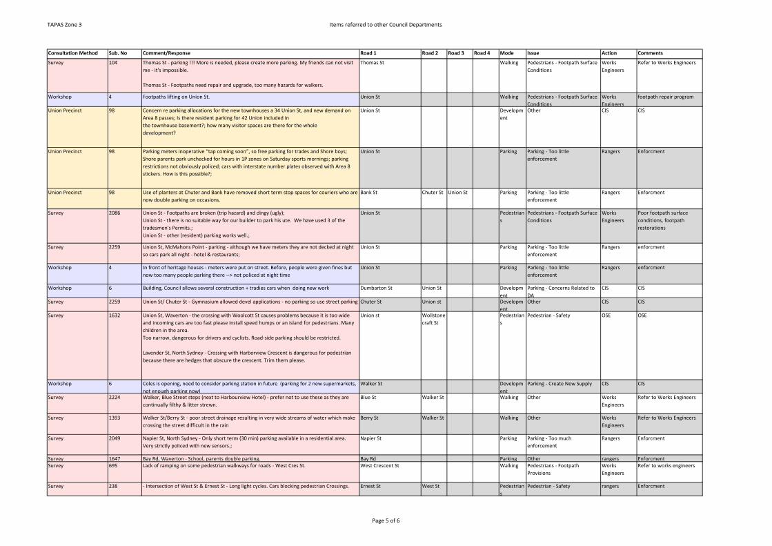
TAPAS Zone 3 Items referred to other Council Departments
Consultation Method Sub. No Comment/Response Road 1 Road 2 Road 3 Road 4 Mode Issue Action Comments
Survey 104 Thomas St - parking !!! More is needed, please create more parking. My friends can not visit me - it's impossible.
Thomas St - Footpaths need repair and upgrade, too many hazards for walkers.
Thomas St Walking Pedestrians - Footpath Surface Conditions
Works Engineers
Refer to Works Engineers
Workshop 4 Footpaths lifting on Union St. Union St Walking Pedestrians - Footpath Surface Conditions
Works Engineers
footpath repair program
Union Precinct 98 Concern re parking allocations for the new townhouses a 34 Union St, and new demand on Area 8 passes; Is there resident parking for 42 Union included inthe townhouse basement?; how many visitor spaces are there for the wholedevelopment?
Union St Development
Other CIS CIS
Union Precinct 98 Parking meters inoperative “tap coming soon”, so free parking for trades and Shore boys; Shore parents park unchecked for hours in 1P zones on Saturday sports mornings; parking restrictions not obviously policed; cars with interstate number plates observed with Area 8 stickers. How is this possible?;
Union St Parking Parking - Too little enforcement
Rangers Enforcment
Union Precinct 98 Use of planters at Chuter and Bank have removed short term stop spaces for couriers who are now double parking on occasions.
Bank St Chuter St Union St Parking Parking - Too little enforcement
Rangers Enforcment
Survey 2086 Union St - Footpaths are broken (trip hazard) and dingy (ugly);Union St - there is no suitable way for our builder to park his ute. We have used 3 of the tradesmen's Permits.;Union St - other (resident) parking works well.;
Union St Pedestrians
Pedestrians - Footpath Surface Conditions
Works Engineers
Poor footpath surface conditions, footpath restorations
Survey 2259 Union St, McMahons Point - parking - although we have meters they are not decked at night so cars park all night - hotel & restaurants;
Union St Parking Parking - Too little enforcement
Rangers enforcment
Workshop 4 In front of heritage houses - meters were put on street. Before, people were given fines but now too many people parking there --> not policed at night time
Union St Parking Parking - Too little enforcement
Rangers enforcment
Workshop 6 Building, Council allows several construction + tradies cars when doing new work Dumbarton St Union St Development
Parking - Concerns Related to DA
CIS CIS
Survey 2259 Union St/ Chuter St - Gymnasium allowed devel applications - no parking so use street parking Chuter St Union st Development
Other CIS CIS
Survey 1632 Union St, Waverton - the crossing with Woolcott St causes problems because it is too wide and incoming cars are too fast please install speed humps or an island for pedestrians. Many children in the area.Too narrow, dangerous for drivers and cyclists. Road-side parking should be restricted.
Lavender St, North Sydney - Crossing with Harborview Crescent is dangerous for pedestrian because there are hedges that obscure the crescent. Trim them please.
Union st Wollstonecraft St
Pedestrians
Pedestrian - Safety OSE OSE
Workshop 6 Coles is opening, need to consider parking station in future (parking for 2 new supermarkets, not enough parking now)
Walker St Development
Parking - Create New Supply CIS CIS
Survey 2224 Walker, Blue Street steps (next to Harbourview Hotel) - prefer not to use these as they are continually filthy & litter strewn.
Blue St Walker St Walking Other Works Engineers
Refer to Works Engineers
Survey 1393 Walker St/Berry St - poor street drainage resulting in very wide streams of water which make crossing the street difficult in the rain
Berry St Walker St Walking Other Works Engineers
Refer to Works Engineers
Survey 2049 Napier St, North Sydney - Only short term (30 min) parking available in a residential area. Very strictly policed with new sensors.;
Napier St Parking Parking - Too much enforcement
Rangers Enforcment
Survey 1647 Bay Rd, Waverton - School, parents double parking. Bay Rd Parking Other rangers EnforcmentSurvey 695 Lack of ramping on some pedestrian walkways for roads - West Cres St. West Crescent St Walking Pedestrians - Footpath
ProvisionsWorks Engineers
Refer to works engineers
Survey 238 - Intersection of West St & Ernest St - Long light cycles. Cars blocking pedestrian Crossings. Ernest St West St Pedestrians
Pedestrian - Safety rangers Enforcment
Page 5 of 6
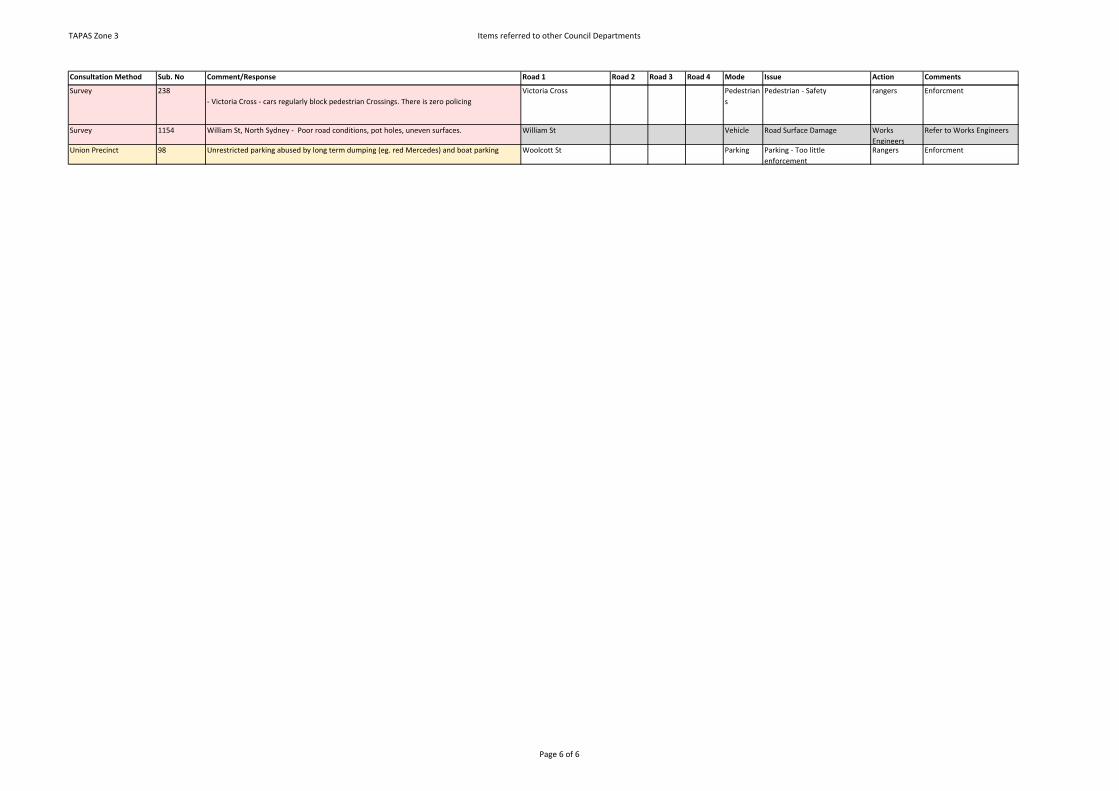
TAPAS Zone 3 Items referred to other Council Departments
Consultation Method Sub. No Comment/Response Road 1 Road 2 Road 3 Road 4 Mode Issue Action Comments
Survey 238- Victoria Cross - cars regularly block pedestrian Crossings. There is zero policing
Victoria Cross Pedestrians
Pedestrian - Safety rangers Enforcment
Survey 1154 William St, North Sydney - Poor road conditions, pot holes, uneven surfaces. William St Vehicle Road Surface Damage Works Engineers
Refer to Works Engineers
Union Precinct 98 Unrestricted parking abused by long term dumping (eg. red Mercedes) and boat parking Woolcott St Parking Parking - Too little enforcement
Rangers Enforcment
Page 6 of 6

SMEC | North Sydney Council TAPAS Zone 3 Action Plans Draft Report | Page 20
APPENDIX E – ITEMS NOTED AS PART OF THIS STUDY

TAPAS Zone 3 Items noted as part of this Study
Consultation Method Sub. No Comment/Response Road 1 Road 2 Road 3 Road 4 Mode Issue Action Comments
Workshop 7 Cyclists competing with cars buses especially in morning Alfred St South Cycling Cycling -Safety Noted not enough information
WorkshopAdditional resident workshop
No students crossing-should be crossing Alfred St South Walking 0 not enough information
Workshop 4 Parking signs need to feed meter all night, signs not clear Alfred St South Parking Parking - Parking Configuration 0 No specific location details provided
Survey 1750 Alfred St paking, bikes, traffic Alfred Street South 0 Not enough information
Survey
2031 Alfred St, Milsons Point - cyclists - accident will happen soon.;
Milsons Point - Not enough Bike paths.
Alfred Street South Cycling Cycling -Safety noted Not enough information
Survey
2066 Alfred Street - Parking;Cyclists everywhere!
Alfred Street South Cycling Cycling -Safety noted Not enough information
Survey 2246 Alfred St - Bike Traffic Alfred Street South Cycling Cycling -Safety noted Not enough information
Survey 2226 Alfred St, M. Point - bikes not looking at cars & Speeding parking for visitors parking for l-bedder elderly people.
Alfred Street South Cycling Cycling -Safety noted Not enough information
Email Submission
1 I would like to contribute the following ideas and suggestions for the Parking Traffic and Transport consultation for Milsons Point and Kirribilli.
I have lived in this area for 7 years and have noticed increased traffic as more apartments and residents move in, especially along Alfred Street.
Alfred St South 0 Not enough information
Email Submission
1 I have also noticed more cyclists in the area using Alfred Street and the link to the Harbour bridge as part of their commute or ride.
I am concerned about 3 areas:
Alfred St South 0 Not enough information
Survey 437 METER HOSPITAL AREA - INSUFFICIENT PARKING, DISABLED PARKING Rockland Rd Mobility Noted Not enough information
Survey 2114 Alfred St, Milsons Point - traffic Alfred St South 0 Not enough informationSurvey 2236 Alfred St South, Milsons Point - Dind St Alfred St South 0 Not enough information
Email Submission
1 1. The intersection of Alfred Street South and Fitzroy Street - on weekends and in school holidays there are lots of families who cross the street around the area of the roundabout on the way from the train station to Lunar Park, Bradfield Park or the Pool. There is also the playground on the corner. I have often seen cars stopping abruptly for pedestrians because they are driving down the hill too fast.
Alfred St South Fitzroy St Walking Pedestrian - Safety Noted review options to improve pedestrian safety
Survey 332 SPOFFORTH ST - SCHOOL ACCESS 0 Not enough information
Survey 332 KURRABA THE BACK WAY - TOO MUCH TRAFFIC DIVERTING 0 Not enough information
Survey 1163 Alfred St - bikes Alfred St South Cycling 0 Not enough information provided
Survey 2602 Over the entire area - traffic Congestion; bicyclist and skateboards on Footpaths; poor state of Footpaths.
Noted no specific location detrails provided
Survey
2134 All streets in this area - not enough safe, viable and maintained Bike paths.;
Kirribilli, Milsons Point - Insufficient areas to park in.
Noted no specific location detrails provided
Survey 345 ALL SUBURBS - MORE BIKE PATHS, MORE BIKE FRIENDLY INFRASTRUCTURE EG BIKE RACKS Noted no specific location detrails provided
Survey 2088 Every Street - cycling Safety - we need separated cycleways Noted no specific location detrails provided
Survey 2728 Amherst St, Cammeray - parking and traffic Amherst St Noted Not enough informationSurvey 2728 Miller St, North Sydney - parking and traffic Noted Not enough informationSurvey 2728 Milsons Point - parking Noted Not enough information
Workshop4 Regarding sensors on meters: (annoyance) Don't like it. Have to move car frequently. Should
be able to feed for more time. Arthur St Parking noted not enough information
Page 1 of 14

TAPAS Zone 3 Items noted as part of this Study
Consultation Method Sub. No Comment/Response Road 1 Road 2 Road 3 Road 4 Mode Issue Action Comments
Email Submission
88 We reside at 7 Bank Street, North Sydney and have problems with vehicles blocking (fully or partially) our driveway. When this happens we are either fully locked in/out or have to leave/enter in a hazardous fashion. It would assist us and the community if marking lines were placed on the road adjacent to driveways.
Banks St Vehicle Parking - Parking Access for Residents
Noted Matter Resolved
Union Precinct 98 Spaces adjacent to narrow driveways should have markings - cars park into driveways
rendering them useless/dangerous. e.g. #7 &13 BankBank St Parking Parking - Parking Access for
ResidentsNoted Application for line
marking / No Parking signs across driveways
Union Precinct 98 Boat and trailers occupy long term spaces unreasonably Bank St Parking Parking - Parking Configuration noted Boat trailer parking laws have been introduced.
Survey 1995 Bank St - Parking/ Shore boys travelling up and down the street at high speed Bank St Vehicle Other Noted Refer to NSW Police for enforcment
Survey 2022 Bank St, North Sydney - finding an all day car park for my dad's car, which I borrow sometimes;
Bank St 0 Not enough information
Survey 2177 Bank St - parking; Bank St 0 Not enough information
Workshop4 "Understanding of councils directions towards parking and development. Council
accountability e.g. permission for detection under the road". Bay View St Noted not enough information
Survey
2036 Bayview St, East Crescent - Selfish or bad parking by taking up 2 spots. Solution put white T mark on road and take way no stopping/parking sign.
Bay View St East Crescent St
Parking Parking - Parking Configuration Noted Linemarking generally results in loss of overall number of parking spaces.
WorkshopAdditional Resident Workshop
Main vehicle throughfare-major pedestrians very dangerous/unsafe Berry St noted Not enough information
Survey 1449 Berry St North Sydney - bus stops, parking, constant road works Berry St noted Not enough information
Survey 1449 Miller St, North Sydney - bus stops, parking, constant road works Miller St noted Not enough information
Survey 1449 Walker St, North Sydney - bus stops, parking, constant road works Walker St noted Not enough information
Workshop 5 Heritage houses 0 not enough information
Survey
2402 1. Bottom of Blues Point Rd, McMahons Point - We need to cross from Blues Point Tower at the bottom of Blues Point Rd (#14) to Henry Lawson Avenue several times a day to use the bus and the ferry, and there is no safe dedicated crosswalk to slow the traffic that races up and down that stretch. There should be painted lines and guard rails to protect all pedestrian traffic & yellow signs to warn & slow down oncoming traffic to a stop when we all need to cross there: precisely it should be installed from the sidewalk and mouth of the driveway to the Blues Point Lawson Avenue which runs Past the bus stop and feeds down to the ferry terminal. (It is much more sensible than block that way with a disruptive bed of plants currently there.);
blues point rd henry Lawson Ave
Walking Other 0 Duplicate of Submission # 2178
Survey 2125 Blues Point Rd - Bike paths, taxi's and private doing U turns over solid lines. backing out into traffic parking.;
blues point rd Vehicle Other Noted Refer to NSW polcie for enforcment
Survey 2125 Princes St - Taxi's Private - using Princes St entrance to do U-Turns back into Blues point Rd, a
pedestrian and car hazard.;Princes St Pedestrian
sPedestrian - Safety Noted Refer to NSW polcie for
enforcment
Workshop 4 A lot of cyclists jump the red light, even when pedestrians are crossing. Blue St Blue Point Rd
Miller St Walking Pedestrian - Safety Noted Refer to NSW polcie for enforcment
Survey 2256 Blue St - Pedestrians ignore Don't Walk sign - making right turn onto highway extremely difficult.;
Blue St Walking Positive Feedback Noted no action
Survey 2107 Corner/right-hand turn from Blue onto William St - cars fail to stop and to obey give way sign.;
Blue St William St Vehicle Traffic - Intersection Safety and/or Performance
Noted refer to NSW Police for enforcment
Survey 1156 Blue St, Mount Rd, Miller St and Pacific Hwy - traffic 0 Not enough information
Workshop 4 Boats parking here Blues Point Rd Parking Other Noted Boat trailer parking laws have been introduced.
Page 2 of 14

TAPAS Zone 3 Items noted as part of this Study
Consultation Method Sub. No Comment/Response Road 1 Road 2 Road 3 Road 4 Mode Issue Action Comments
Survey
300 Car - issues with Taxi's parked illegally causing a major Safety hazard and frustration (especially when they park on Blues Point Road heading north and just before it joins the Pacific Highway)
Blues Point Rd Congestion
Other Noted Refer to Taxi Counil to advise Taxi drivers do not park illegaly / Refer to NSW police for enforcment
Workshop 4 Pedestrian safety suggest more parking. Blues Point Rd noted not enough information
Survey 2170 Frequent noise late at night from people parking cars and playing music, shouting, being
drunk etc (mainly in summer).Blues Point Reserve car park
Other Noted Antisocial behaviour
Survey 105 Blues Point Rd - when cars park too close to entry hard to see oncoming traffic. Blues Point Rd Vehicle Parking - Parking Access for
ResidentsNoted Application for line
marking / No Parking signs across driveways
Survey 2006 Blues Point Rd, around the station - Taxis turning unexpectedly; Blues Point Rd Vehicle Other Noted refer to taxi Council
Survey 2192 Blues Pt Rd - cars parking across out driveway blocking our ability to use our car without any
capacity to have it moved.Blues Point Rd Parking Parking - Parking Access for
ResidentsNoted Application for line
marking / No Parking signs across driveways
Survey
1998 Blues Point Rd - J-Walkers, inattentive pedestrians;
Miller St - J-Walkers, inattentive pedestrians;
Blue St - J-Walkers, inattentive pedestrians.
noted not enough information
Survey
1430 Five ways at Blues Point Rd vs Pacific Hwy vs Miller St - dangerous crossing and taxis stopped in ind lane, students, cyclists, pedestrians
Five ways at Blues Point Rd vs Pacific Hwy vs Miller St - right hand lane turning right blocks traffic thru part
noted not enough information
WorkshopAdditional Resident workshop
Cycleway/shared zone noted no specific location details provided
Survey 2148 Milsons Point, Broughton Lane from Express way to Milsons Pt - Bike paths - riders who do
not get off their bikes when signs are clearly visible.noted Not enough information
Survey 2148 Milsons Point, Broughton Lane from Express way to Milsons Pt - Bike paths - riders who do
not get off their bikes when signs are clearly visible.noted Not enough information
Survey 2004 Intersection Carr St, Crows Nest Rd - drivers don't know how to safely enter or cross the intersection;
0 Not enough information
Survey 2414 All - Lack of Vulnerable Road user law A/O Awardness in 95% of car drivers. 0 Not enough information
WorkshopAdditional resident workshop
Narrow, one way traffic stand still, accident Noted not enough information
Survey 2258 Crows Nest - Parking - there is limited parking and congested roads, adding pressure when trying to park
Crows Nest Noted No Specific Location details provided
Workshop 4 More village spaces. Replicate Crows nest and its beautiful trees, etc. Less parking and more shared, pretty space.
Crows Nest Development
Other Noted OSE / CIS
Survey 1815 Crows Nest/North Sydney, insufficient parking space Crows Nest Noted No Specific Location details provided
Survey 2149 Crows Nest - parking;
Chatswood - parking;Lane Cove - parking
Crows Nest Noted No Specific Location details provided
Survey 1492 Parking in Crows Nest and North Sydney Crows Nest North Sydney
Noted No Specific Location details provided
Survey 1566 Parking Crows NestParking North Sydney
Crows Nest North Sydney
Noted No Specific Location details provided
Survey
2219 Cnr Little Spring/ Denison St, North Sydney - drivers frequently running stop signs - unsafe for pedestrians;
St, North Sydney - serious Congestion w/ traffic driving up to Berry Street;
Cnr Little Spring/ Denison St, North Sydney - drivers frequently running stop
Vehicle Other Noted refer to NSW Police for enforcment
Page 3 of 14
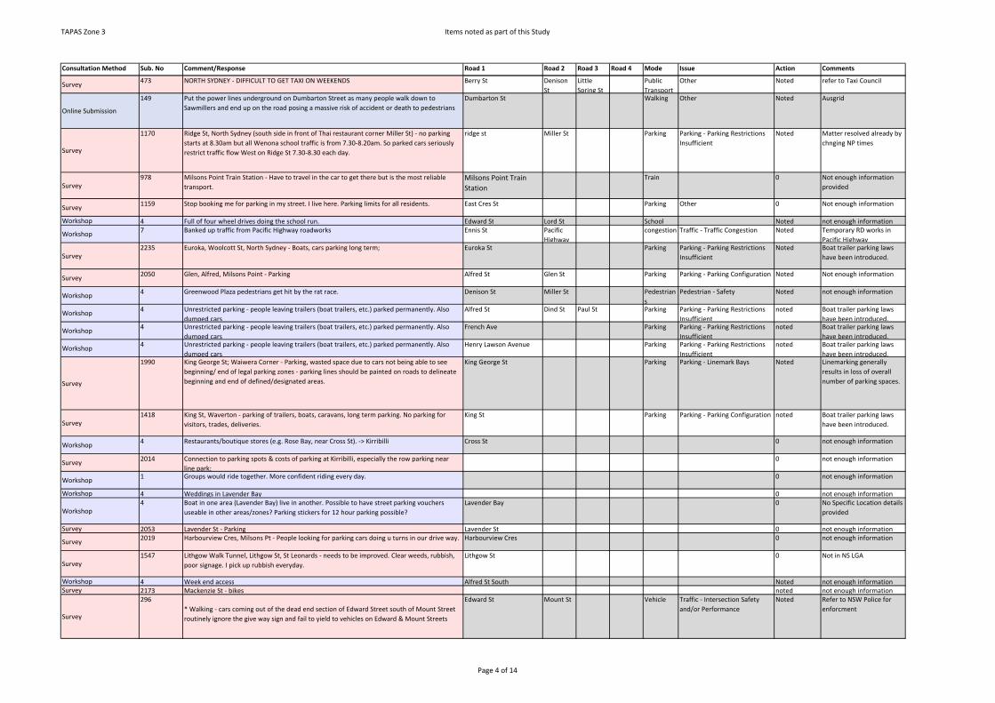
TAPAS Zone 3 Items noted as part of this Study
Consultation Method Sub. No Comment/Response Road 1 Road 2 Road 3 Road 4 Mode Issue Action Comments
Survey 473 NORTH SYDNEY - DIFFICULT TO GET TAXI ON WEEKENDS Berry St Denison St
Little Spring St
Public Transport
Other Noted refer to Taxi Council
Online Submission
149 Put the power lines underground on Dumbarton Street as many people walk down to Sawmillers and end up on the road posing a massive risk of accident or death to pedestrians
Dumbarton St Walking Other Noted Ausgrid
Survey
1170 Ridge St, North Sydney (south side in front of Thai restaurant corner Miller St) - no parking starts at 8.30am but all Wenona school traffic is from 7.30-8.20am. So parked cars seriously restrict traffic flow West on Ridge St 7.30-8.30 each day.
ridge st Miller St Parking Parking - Parking Restrictions Insufficient
Noted Matter resolved already by chnging NP times
Survey 978 Milsons Point Train Station - Have to travel in the car to get there but is the most reliable
transport.Milsons Point Train Station
Train 0 Not enough information provided
Survey 1159 Stop booking me for parking in my street. I live here. Parking limits for all residents. East Cres St Parking Other 0 Not enough information
Workshop 4 Full of four wheel drives doing the school run. Edward St Lord St School Noted not enough information
Workshop 7 Banked up traffic from Pacific Highway roadworks Ennis St Pacific Highway
congestion Traffic - Traffic Congestion Noted Temporary RD works in Pacific Highway
Survey 2235 Euroka, Woolcott St, North Sydney - Boats, cars parking long term; Euroka St Parking Parking - Parking Restrictions
InsufficientNoted Boat trailer parking laws
have been introduced.
Survey 2050 Glen, Alfred, Milsons Point - Parking Alfred St Glen St Parking Parking - Parking Configuration Noted Not enough information
Workshop 4 Greenwood Plaza pedestrians get hit by the rat race. Denison St Miller St Pedestrians
Pedestrian - Safety Noted not enough information
Workshop 4 Unrestricted parking - people leaving trailers (boat trailers, etc.) parked permanently. Also dumped cars
Alfred St Dind St Paul St Parking Parking - Parking Restrictions Insufficient
noted Boat trailer parking laws have been introduced.
Workshop 4 Unrestricted parking - people leaving trailers (boat trailers, etc.) parked permanently. Also dumped cars
French Ave Parking Parking - Parking Restrictions Insufficient
noted Boat trailer parking laws have been introduced.
Workshop 4 Unrestricted parking - people leaving trailers (boat trailers, etc.) parked permanently. Also dumped cars
Henry Lawson Avenue Parking Parking - Parking Restrictions Insufficient
noted Boat trailer parking laws have been introduced.
Survey
1990 King George St; Waiwera Corner - Parking, wasted space due to cars not being able to see beginning/ end of legal parking zones - parking lines should be painted on roads to delineate beginning and end of defined/designated areas.
King George St Parking Parking - Linemark Bays Noted Linemarking generally results in loss of overall number of parking spaces.
Survey 1418 King St, Waverton - parking of trailers, boats, caravans, long term parking. No parking for
visitors, trades, deliveries.King St Parking Parking - Parking Configuration noted Boat trailer parking laws
have been introduced.
Workshop 4 Restaurants/boutique stores (e.g. Rose Bay, near Cross St). -> Kirribilli Cross St 0 not enough information
Survey 2014 Connection to parking spots & costs of parking at Kirribilli, especially the row parking near line park;
0 not enough information
Workshop 1 Groups would ride together. More confident riding every day. 0 not enough information
Workshop 4 Weddings in Lavender Bay 0 not enough information
Workshop4 Boat in one area (Lavender Bay) live in another. Possible to have street parking vouchers
useable in other areas/zones? Parking stickers for 12 hour parking possible? Lavender Bay 0 No Specific Location details
provided
Survey 2053 Lavender St - Parking Lavender St 0 not enough information
Survey 2019 Harbourview Cres, Milsons Pt - People looking for parking cars doing u turns in our drive way. Harbourview Cres 0 not enough information
Survey 1547 Lithgow Walk Tunnel, Lithgow St, St Leonards - needs to be improved. Clear weeds, rubbish,
poor signage. I pick up rubbish everyday.Lithgow St 0 Not in NS LGA
Workshop 4 Week end access Alfred St South Noted not enough informationSurvey 2173 Mackenzie St - bikes noted not enough information
Survey
296* Walking - cars coming out of the dead end section of Edward Street south of Mount Street routinely ignore the give way sign and fail to yield to vehicles on Edward & Mount Streets
Edward St Mount St Vehicle Traffic - Intersection Safety and/or Performance
Noted Refer to NSW Police for enforcment
Page 4 of 14
TAPAS Zone 3 Items noted as part of this Study
Consultation Method Sub. No Comment/Response Road 1 Road 2 Road 3 Road 4 Mode Issue Action Comments
Survey 2239 All of McMahons Pt - lack of parking; McMahons Pt Parking noted no specific location detail provided
Survey
2732 McMahons Point - parking, designation of spaces is too conservative e.g. parking could be allowed a bit closer to corners. Some parking signs are confusing, compounded by 2 or more signs for one area. Sometimes it takes 5 minutes to work out what the restrictions are.
McMahons Pt Parking noted no specific location detail provided
Survey 2172 McMahons Point - parking McMahons Pt Parking noted no specific location detail provided
Survey
2217 McMahons Pt, Waverton - trailers parked permanently taking up car spaces; 0 no specific location details provided
Survey 2092 Middle St, McMahons Point - cars parking across my garage making it impossible to get car
in/out of garage.;Middle St Parking Parking - Parking Access for
ResidentsNoted Application for line
marking / No Parking signs across driveways
Survey 2193 Middle St - Garage blocked by cars. Tel police many times. Middle St Parking Parking - Parking Access for
ResidentsNoted Application for line
marking / No Parking signs across driveways
Survey 1991 Walker St; Miller St, CBD -Taxis in clearways
Miller St Walker St Vehicle Other noted Refer to NSW police for enforcment
Workshop 4 Signage are police presence for bikes Middlemiss St 0 not enough informationWorkshop 7 Bike Lane 0 not enough informationWorkshop 4 Middlemiss St - Cyclists Middlemiss St Cycling 0 not enough information
Survey 2220 Middlemiss Street - Bikes coming from Milson's Point into Middlemiss Middlemiss St Cycling 0 not enough information
Survey
465 MILLER AND WALKER STREETS, NORTH SYDNEY - TAXIS STOPPING TO PICK UP/DROP OFF PASSENGERS BLOCKING TRAFFIC IN PEAK HOUR
WALKER ST, BERRY ST, NORTH SYDNEY - ROAD WORKS IN PEAK HOUR
Miller St Walker St Vehicle Other noted Refer to NSW police for enforcment
Workshop 3 Pedestrian crossing is dangerous Military Rd Wickham St
0 not enough information
Survey
985 All through LAG - Although the hills do make it trickier anyway I probably cycle least in Sydney out of cities I lived in as there are not many safe bike lanes & hatred between road users.
noted no specific location details provided
Survey 1110 North Sydney - Lack of affordable parking stations noted no specific location details provided
Survey
1190 Generally in North Sydney - the key issue is over use of private motor vehicles. Only when trips are taxed will some sanity return, or public transport becomes clearly more effective e.g. Light rail from City/Neutral Bay/Mosman/Northern Beaches.
LGA Vehicle Positive Feedback Noted noted
Workshop 4 Office workers cross without looking Blue St Miller St Walking Pedestrian - Safety Noted No specific location details provided
Workshop 4 Roadworks heading to congestion. Near Rag and Famish Hotel. Nowhere for people to stand at lights.
Miller St BerrySt Noted Civil Works completed - matter resolved
Workshop 4 Push bikes going wrong way on one way road. Miller St Mopunt St
Pacific Highway
Noted No specific location details provided
Workshop4 Taxi drivers blocking crossings and crawling for fares, slowing traffic and stopping at no-
stopping zones and hoarding parking spacesHarbourview Cres Miller St Pacific
HighwayVehicle Other Noted Police Enforcement
Workshop 2 N/A Berry St Miller St Millitary rd
0 not enough information
Workshop
Additional Resident Workshop
Location + bus facilities-huge bus interchange + very busy- need better facilities-block footpaths and unsafe
Miller St Buses Public Transport - Infrastructure
Noted Matter resolved by reconstruction of footpath and new bus shelters in Miller St
Workshop 2 The CBD 4 way pedestrian crossing – should have them CBD 4 way pedestrian Pedestrians
Pedestrian - Connectivity Noted not enough information
Page 5 of 14

TAPAS Zone 3 Items noted as part of this Study
Consultation Method Sub. No Comment/Response Road 1 Road 2 Road 3 Road 4 Mode Issue Action Comments
Survey
510 Miller St - sidewalk repairs taking forever to fix Miler St Walking Pedestrians - Footpath Provisions
Noted Matter resolved by reconstruction of footpath and new bus shelters in Miller St
Survey 2006 Miller St - Taxi, bus, cyclists Congestion from those; Miler St Congestio
nTraffic - Traffic Congestion Noted Refer to TfNSW/ Taxi
Council and review Cycling strategy
Survey 2057 Miller Street, North Sydney - Series of red traffic lights Miler St 0 not enough information
Survey 2319 Miller St - traffic; Crossings Miler St 0 no specific location details provided
Survey (late) L1 Miller Street - telecom pit covers Miler St 0 no specific location details provided
Survey 2477 Miller St - set down locations Miler St 0 no specific location details provided
Survey
2184 Everywhere - Walking - pedestrians especially toddlers & the elderly endangered by cyclists on shared pathways & cyclists illegally using Footpaths. Also Footpaths leased to cafes & restaurants restricting space for pedestrians.;
LGA Cycling 0 no specific location provided
Survey 1669 Miller St, North Sydney - Parking 0 no specific location provided
Survey 1673 Opportunity with light rail to investigate major change. Miller St noted not enough information provided
Survey 951 Military Road/Wycombe Road, Neutral Bay - Pedestrians and bike rider ignore red lights and
walk/ride in front of traffic.Military Rd Wycomb
e RdWalking noted not enough information
Survey
2661 2. KirribilliParking! Who can do anything 30mins? What can you do in 30mins?
Kirribilli Parking Parking - Parking configuration 0 No specific location details provided
Survey 2661 Parking is outrageous - killing business forces one to drive to other shopping districts. Parking 0 No specific location details provided
Survey 2045 Miller St - Parking Spaces; Parking 0 No specific location details provided
Survey
2059 Milsons Point - Parking! You rape local residents in fees & infringements then ask for their support to oppose council mergers - good luck. Having metered parking till midnight is a cynical grab for money.;
Milsons Point 0 Not enough information provided
Survey 2096 Milsons Point - not enough parking - problem area marked on map Milsons Point 0 no specific location details provided
Survey 2101 Milsons Point - Parking - lack of, thus parked illegally, access to our apartment blocked by
delivery vans, work trucks, vans etc.; Milsons Point Parking Parking - Parking Access for
ResidentsNoted Application for line
marking / No Parking signs across driveways
Survey 1693 Crows Nest - Parking or lack of longer time parking. Crows Nest Parking 0 No Specific Location Details provided
Survey 195 Green Square, North Sydney - Wilsons Car Park is way too expensive Green Square Parking Parking - Cost of Parking too high
noted Not enough information provided
Survey 329 MILSON POINT - PARKINGNORTH SYDNEY - PARKING
0 No Specific Location Details provided
Workshop 6 Shore School - a lot of traffic on union street - rat running through Morton Street morton st Union St Vehicle Noted not enough information
Survey 518 Mosman beach - parking very expansive. 0 Not enough information
Survey
518 Neutral Bay - police traffic control needed, as too many Speeding, possibly drink drivers, along Ben Boyd Rd, between Military Rd and Kurraba Rd, dangerous to pedestrians.
Ben Boyd rd Vehicle Pedestrian - Safety NOTED Refer to NSW Police for enforcment
Survey
1691 Most Streets - Footpaths in disrepair creating dangerous trip hazards. 0 No specific location details provided
WorkshopAdditional Resident workshop
Cycleway 0 not enough information
Page 6 of 14

TAPAS Zone 3 Items noted as part of this Study
Consultation Method Sub. No Comment/Response Road 1 Road 2 Road 3 Road 4 Mode Issue Action Comments
WorkshopAdditional Resident Workshop
Pedestrian/traffic/parking congestion/pedestrians going through Greenwood 0 not enough information
Workshop 4 One way pedestrian crossing, really bad at drop off and pickup. Edward St Mount St 0 not enough information
Workshop 4 Elizabeth plaza could be nicer, e.g. cafes, etc. Mount St Pacific Highway
0 not enough information
WorkshopAdditional Resident workshop
Should be closed off highway be a plaza- not agreed would be told disaster. Pedestrians crossing dangerous here, need lights for pedestrians.
0 not enough information
WorkshopAdditional Resident workshop
0 not enough information
WorkshopAdditional Resident workshop
Need shared way 0 No specific location details provided
Workshop 4 Close all the way to Coles. Denison St Mount St Walker St 0 not enough information
Workshop
Additional Resident Workshop
Pedestrian traffic congestion-bus stop design needs improving Miller St Mount St Pedestrians
Pedestrians - Walking Amenity noted matter resolved by reconstruction of footpath and new bus shelters
WorkshopAdditional resident workshop
Red crossing dangerous 0 No specific location details provided
Survey 1802 North Sydney parking restrictions (meters) weekday evenings prevent dining out. LGA Parking Parking - Parking Configuration 0 No specific location details provided
Survey 2189 Bus stop on Mount St in front of MLC building - No space for pedestrians to walk past bus
stop. Often forced onto road.;Miller St Buses Public Transport -
Infrastructurenoted Matter resolved by
reconstructing footpath and new bus shelters
Workshop 2 Halved street capacity Arthur St Mount St 0 not enough informationWorkshop 4 Push lines going wrong way on one way road 0 not enough informationWorkshop 4 Cars not rat running as nowhere to go 0 not enough informationWorkshop 4 Timed week end parking 0 not enough informationWorkshop 4 Signs not clear 0 not enough information
Workshop 4 Half hour free parking - Could this be doubled for locals (permit) 0 not enough information
Workshop 4 Only parking on 1 side of road 0 not enough informationWorkshop 4 Survey for individual streets needed 0 not enough information
Workshop4 Local businesses struggle with only 2 hour parking as people can't travel here from other
parts of Sydney and park. 0 not enough information
Workshop 4 Older residents need to be able to drive to public transport (unmetered parking after 7pm would help with this)
0 not enough information
Workshop 4 Bike paths aren’t connected. Cycling 0 not enough informationWorkshop 4 There are no bike paths! --> dangerous cycling. Cycling 0 not enough informationWorkshop 4 Walking routes around this are good 0 not enough informationWorkshop 4 Footpaths all over are cracked. 0 not enough informationWorkshop 4 Council kayaking parking would be good 0 not enough information
Workshop 5 1. Residents who can't park (heritage homes), school areas, residents with garage but who park in street.
0 not enough information
Workshop5 People with garage but have 2 cars. Some garages are filled with rubbish and park (both cars)
on street --> others can't park. Residents parking only. 0 not enough information
Workshop 5 Due to the number of schools in North Sydney (St Mary's, Monte etc.) the entire North Sydney area is gridlocked.
0 not enough information
Workshop 7 No dedicated paths but no cycle paths 0 not enough informationHardcopy Submission 33 CBD - toll charges;. CBD 0 not enough informationHardcopy Submission 33 CBD - buses good, but bus stops could be better. CBD Buses 0 not enough information
Page 7 of 14
TAPAS Zone 3 Items noted as part of this Study
Consultation Method Sub. No Comment/Response Road 1 Road 2 Road 3 Road 4 Mode Issue Action Comments
Online Submission
52 I strongly believe the that restricted parking should operate for longer hours. This is because residents with off street parking park on the street during the unrestricted hours. I think the position would be helped by keeping parking restricted until, say, 9pm Monday - Friday. In addition, I suggest parking be restricted on weekends (suggest 3 hours). More needs to be done to discourage "2 car" households in this area which is very well serviced by public transport. I suggest those with off street parking be required to park across their driveway - if they seek a second permit. Otherwise the "driveway" is a permanent lost car space from the street.
Parking Parking - Parking Restrictions Insufficient
Noted no specific location details provided
Lavender Bay Precinct 59 Identify additional on street parking spaces Noted no specific location details provided
Lavender Bay Precinct 59 Boat and trailer parking in residential streets Noted no specific location details provided
Lavender Bay Precinct 59 Short term meters when no longer needed Noted no specific location details provided
Lavender Bay Precinct 59 Rangers booking cars when plenty of vacant spots available – especially at night Noted no specific location details provided
Hardcopy Submission
61 Improving Pedestrian Safety in North Sydney’s CBD - The following will allow pedestrians to again trust signalised pedestrian crossings and increase the flow of vehicles around North Sydney. Remove clutter around pedestrian crossings and allow the elderly, disabled and children easier and safer passage around North Sydney. Work with the RMS and NSW Centre for Road Safety to: a) Trial auto-Introduction of pedestrian crossings at certain crossings in CBD and near schools; b) Auto introduction of all pedestrian crossings in CBD during daylight hours 7 days a week; c) Install new countdown timers at crossings without vehicle conflict; d) Improve cycling of traffic signals after hours to reduce vehicles waiting at red lights for 80 sec; e) As new laybacks are installed widen ramp to allow multiple prams and elderly to use at same time; f) Increase width of footpath layback’s that are being replaced due to CBD footpath upgrade; g) Make sure that all pedestrian crossings are to the correct RMS technical directives (td); h) Remove speed hump signs from all raised pedestrian crossings as per RMS td; I) Install 25km/hr sign onto pedestrian crossing signs at all raised pedestrian crossings; j) At all new raised pedestrian crossings no layback, surface is level with footpath as per RMS td.
CBD Noted no specific location details provided
Online Submission
92 Many pavements in the area are irregular and poorly lit in the evening, especially now that the days are getting shorter. At times it can be quite precarious negotiating the uneven surfaces when coming home from work at night. However I would rather have uneven walking surfaces if the alternative meant the loss of trees.
Noted not enough information
Survey 144 Nil 0 Not enough information
Survey 348 Parking availability is low in most centres, large amounts of road works at same time, many
roads and curbs not pram friendly 0 no specific location details
provided
Survey
433 NORTH SYDNEY, KIRRIBILLI, LAVENDER BAY, WILLOUGHBY - PARKING LACK OF FREE CONVENIENT PARKING SITES ACCESSIBLE TO SHOPS, RESTAURANTS, MEDICAL OFFICES AND CLOSE TO TRAIN AND FERRY
0 no specific location details provided
Survey 768 Keep cyclists off Urban Footpaths 0 no specific location details provided
Survey 769 Parking meters everywhere - I detest them 0 no specific location details provided
Survey 2055 No issues. Runs very well 0 not enough information
Page 8 of 14

TAPAS Zone 3 Items noted as part of this Study
Consultation Method Sub. No Comment/Response Road 1 Road 2 Road 3 Road 4 Mode Issue Action Comments
Survey 2058 None (issues or problems) 0 not enough information
Survey 2073 None to speak of - being retired we don't have the same issues as workers. 0 not enough information
Survey 2108 None 0 not enough informationSurvey 2174 Bus Good 0 not enough informationSurvey 2174 Rail Good; 0 not enough information
Survey 2183 All bikes should ride in single line at all times especially on Sunday morning. 0 not enough information
Survey 2234 Nil for train or ferry or bus. Live in most convenient part of North Sydney - very luck person!! 0 not enough information
Survey 2237 None 0 not enough information
Survey 2259 Walking from public transport to home - hotel - drunkenness/violence at times so hesitant to
use public transport at night when coming home.;0 not enough information
Survey 2268 Whole North Sydney Area - `U-turns' should be banned everywhere.; 0 not enough information
WorkshopAdditional Resident workshop
CBD generally not pedestrian friendly 0 not enough information
WorkshopAdditional Resident workshop
Improve condition of cycle paths 0 not enough information
WorkshopAdditional Resident workshop
Overall consideration where there are traffic lights in North Sydney 0 not enough information
Workshop
4 Commute to Rhodes. "Interesting to see this process (Council workshop). Commute is 1 hour door-to-door. Lot of car parks closed, i.e. Wilson's car park, no weekends or nights".
Rhodes 0 not enough information
Survey
2212 1. Car Parking & Permits - It's too difficult to obtain two Permits when each of us must have a car for work & other responsibilities. If we are residences we should be able to park our cars more freely.;
Parking 0 not enough information
Survey
2212 2. Car Parking & valet parking - On Friday nights & Saturdays the restaurant at McMahons Point wharf was running a valet parking service. How ridiculous! People who live here & need parking were but out by this. It went on for ages.;
Parking 0 not enough information
Survey 323 NEUTRAL BAY SIDE STREET PARKING - 2 HRS NOT ENOUGH 0 No specific Location details provided
Survey 323 MILSONS POINT STATION- TAXI NOT TAKING PASSENGERS Milsons Point Station Public Transport
Other noted Refer to Taxi Council
Survey 323NEUTRAL BAY - TAXI NOT TAKING PASSENGERS
0 No specific Location details provided
Survey 2017 Ferry, Bus, Car and Parking - New ferry wharf proposal is too big; 0 No specific Location details provided
Survey 2092 General North Shore area - Dangerous to ride bike on the road.; Cycling Cycling -Safety Noted No specific Location details provided
Survey 325 NORTH SYDNEY - LITTLE TO NO ON-STREET PARKING, TRAFFIC IS DENSE. 0 No specific Location details provided
Survey 1644 North Sydney - Parking 0 No specific Location details provided
Survey 1891 North Sydney - Fast Traffic 0 No specific Location details provided
Survey 1983 North Sydney - parking and traffic 0 No specific Location details provided
Survey 2012 North Sydney - Please put car park sensors. Mobility Parker Scheme abusers. 0 No specific Location details provided
Survey 2028 North Sydney - Parking restrictions 0 No specific Location details provided
Survey 2080 Walk to work in N. Sydney - No Issues! 0 No specific Location details provided
Survey 2346 Walking - too much circulating traffic looking for parking esp. nr ACU in Nth Sydney 0 No specific Location details provided
Page 9 of 14

TAPAS Zone 3 Items noted as part of this Study
Consultation Method Sub. No Comment/Response Road 1 Road 2 Road 3 Road 4 Mode Issue Action Comments
Survey 1813 North Sydney, lack of shopping and café facilities on Sundays, which are in walking distance there.
0 not enough information provided
Survey 2016 North Sydney - Traffic failing to give way to pedestrians 0 No specific Location details provided
Survey
1074 Hills when walking (hence no cycling).Train is great.Parking in N Sydney CBD is a nightmare and far too expensive for (eg) a simple trip to the shops or to a restaurant. I avoid it completely.
0 No specific Location details provided
Survey 1843 No difficulty with Crossings, Bike paths, bus stop locations, parking or traffic. 0 No specific Location details provided
Survey 2052 North Sydney LGA - Cycleways - please fund greater links, parking, signage.; 0 No specific Location details provided
Survey 2072 Nth Sydney Area - Parking - Too expensive. 0 No specific Location details provided
Survey 2138 North Sydney - parking is too expensive 0 No specific Location details provided
Survey
2171 People if walking at North Sydney and crossing while not looking, on mobile phones etc. ORDER. People not aware of surrounds!!;
Retired people like me are well provided for and I am grateful.
0 not enough information provided
Survey 2176 North Sydney - poor switching of intersections crossing lights: most drive from red to red.;
North Sydney - No/ few Bike paths0 not enough information
provided
Survey 2479 Some Footpaths are very uneven in North Sydney council area 0 No specific Location details provided
Survey
2555 North Sydney - weekend parking rates very inconsistent - some metres charge a fortune, others have free parking.North Sydney - no tap and go at metres (says "coming soon").
0 No specific Location details provided
Survey 2705 Nth Sydney in general - parking specifically disabled spots
Nth Sydney in general - bus frequency & direct Routes to Lane Cove0 No specific Location details
provided
Survey 2706 Streets & Footpaths - often cluttered with posts/ signs etc.
Pacific Highway - pavement is too narrowAlfred Street - pavement too narrow on west side
0 No specific Location details provided
WorkshopAdditional Resident Workshop
Private vehicle traffic congestion (through traffic) 0 No specific Location details provided
Survey
2429 Any street in North Sydney and Crows Nest - parking fees, availability;
Wollstonecraft, Shirley Rd - street parking availability limited space/ time;
0 No specific Location details provided
Survey 2176 North Sydney - lack of parking spaces;Lavender Bay - parking too restrictive;
0 No specific Location details provided
Survey 216 North Sydney CBD - limited parking, poor narrow pedestrian Footpaths, traffic Congestion,
traffic queuing across intersections0 No specific Location details
provided
Survey 1117 North Sydney CBD - No parking spaces 0 No specific Location details provided
Survey 2163 North Sydney CBD - traffic 0 No specific Location details provided
WorkshopAdditional Resident workshop
Needs better bike infrastructure 0 No specific Location details provided
Survey 2441 North Sydney CBD - pedestrian Safety; 0 No specific Location details provided
Survey 1677 Crows Nest - Parking in Crows Nest for shopping is not good. Crows NEst 0 No Specific Location provided
Survey 843 As a disabled person I find that North Sydney is one of the best councils by a long shot. Well done!
Mobility Positive Feedback Noted noted
Page 10 of 14

TAPAS Zone 3 Items noted as part of this Study
Consultation Method Sub. No Comment/Response Road 1 Road 2 Road 3 Road 4 Mode Issue Action Comments
Survey 1276 All over North Sydney - Bike Paths and parking 0 No specific Location details provided
Survey 2548 Roads all over - round abouts everywhere. No one knows how to use them. 0 No specific Location details provided
Survey 1597 North Sydney Post Office - Parking throughout North Sydney
Crows Nest All Streets - Parking throughout Crows Nest
Crows NEst 0 No Specific Location provided
Survey 2261 Traffic signs - (see hard copy photo) 1) can be excessive e.g. corner North Sydney station and
Hazelbank Rd, Wollstonecraft. Hazelbank Rd NS Station Parking Other 0 No Specific Location details
provided
Survey 434 MORE BIKE PATHS SEPARATE FROM THE ROAD Noted No specific location details provided
Survey 1671 All North Sydney - No free parking. There are 3 free parking facilities in Crows Nest LGA Parking 0 No specific location details provided
Survey 1748 North Sydney and Crows Nest Crossings Pedestrians
0 No specific location details provided
Survey 1810 North Sydney and Lane Cove Parking Parking 0 No specific location details provided
Survey
2041 North Sydney - Parking;
McMahons Point - Parking;
Crows Nest - Parking
Parking 0 No specific location details provided
Survey 2046 North Sydney, Milsons Point - limited parking;too expensive;
Parking 0 No specific location details provided
Survey 171 - North Sydney CBD - Parking: Motorcycle
- Neutral Bay - Walking: Poorly maintained Footpaths & Parking: MotorcycleParking 0 No specific location details
provided
Survey
307 North Sydney - traffic Crossings, parking Neutral Bay/Cammeray - traffic Crossings, parking Crows Nest - traffic Crossings, parking Willoughby - traffic Crossings, parking
0 Not enough information
Survey
846 North Sydney, Neutral Bay, Cremorne, Kirribilli, Mosman - cycling is too dangerous. I cycle only at 6am Sunday morning because traffic and lack of connecting cycle paths, particularly between Neutral Bay and Harbour Bridge.North Sydney - Parking too short and too expensive to use the commercial area of North Sydney.Neutral bay/Cremorne - Military Rd a nightmare all the time, especially on weekends. It stops me going anywhere on a weekend.
Separate cycle paths are desperately needed!!!
0 Not enough information
Survey 1674 North Sydney Waverton - Bike Paths, not family friendly. 0 Not enough information
Survey 1617 All of North Sydney - Lack of Cycling paths
Wollstonecraft - Parking
0 Not enough information
Survey
915 North Sydney - Lack of free parking spaces for residents of the Council areaCremorne - People parking illegally in street and one car taking the space of two cars
0 Not enough information
Survey 1238 North Sydney - parking.
North Sydney, Cremorne, Mosman, Neutral Bay - traffic, parking.0 Not enough information
Survey 2273 North Sydney - Taxis parking in non taxi zone. It is hard enough to get a parking spot. 0 Not enough information
Survey 2156 North Sydney, Milsons Pt - Bikes on foot paths;Crossings - lack of parking
0 No specific location details provided
Survey 1101 Mosman Beach only for very rich people. 0 not in NS LGA
Page 11 of 14
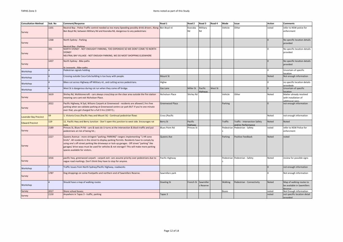
TAPAS Zone 3 Items noted as part of this Study
Consultation Method Sub. No Comment/Response Road 1 Road 2 Road 3 Road 4 Mode Issue Action Comments
Survey
1101 Neutral Bay - Police Traffic control needed as too many Speeding possibly drink drivers. Along Ben Boyd Rd, between Military Rd and Kooraba Rd, dangerous to any pedestrians
Ben Boyd rd Kooraba Rd
Military Rd
Vehicle Other noted refer to NSW polcie for enforcment
Survey 1268 North Sydney - Parking
Neutral Bay - Parking
0 No specific location details provided
Survey
391 NORTH SYDNEY - NOT ENOUGHT PARKING, TOO EXPENSIVE SO WE DONT COME TO NORTH SYDNEYNEUTRAL BAY VILLAGE - NOT ENOUGH PARKING, WE DO MOST SHOPPING ELSEWHERE
0 No specific location details provided
Survey 1437 North Sydney - Bike paths
St Leonards - Bike paths
0 No specific location details provided
Workshop 4 Pedestrian signals holding 0 Uncertain of specific location
Workshop 4 Crossing outside Coca-Cola building is too busy with people. Mount St Noted Not enough information
Workshop 4 Bikes cut across Highway off Military rd., and cutting across pedestrians. Highw 0 no specific location details providedy
Workshop 4 West St is dangerous during rat run when they come off bridge. Gas Lane Miller St Pacific Highway
West St 0 Uncertain of specific location
Survey 1619 Shirley Rd, Wollstonecraft - cars always cross/stop on the clear area outside the fire station
meaning cars cant exit Nicholson Place.Nicholson Place Shirley Rd Vehicle Other Noted Matter already resolved
with installation of additional signs
Survey
2022 Pacific Highway, N Syd, Wilsons Carpark at Greenwood - residents are allowed 2 hrs free parking when we validate parking at Greenwood centre car park BUT if you're one minute over that, you get charged for a full 3 hrs (150!!!).;
Greenwood Plaza Parking 0 not enough information
Lavender Bay Precinct 59 1. Victoria Cross (Pacific Hwy and Mount St) - Continual pedestrian flows Cross (Pacific Noted not enough information
Edward Precinct 119 11. Pacific Hwy and Berry Junction - Don’t open this junction to west side. Encourages rat runs.
Berry St Pacific Highway
Traffic Traffic - Intersection Safety and/or Performance
Noted Noted
Survey 2189 Princes St, Blues Pt Rd - cars & taxis do U-turns at the intersection & block traffic and put
pedestrians at risk of being hit.;Blues Point Rd Princes St Pedestrian
sPedestrian - Safety noted refer to NSW Police for
enforcment
Survey
2227 Queens Avenue - more stringent "parking; PARKING" rangers implementing "1 HR zone limits". All residents in the street to display parking Permits. Residents have to comply by using one's off-street parking like driveways or lock-up garages. Off street "parking" like garages/ drive ways must be used for vehicles & not storage!! This will make more parking spaces available for visitors.
Queens Ave Parking Positive Feedback Noted noted
Survey 1016 pacific hwy, greenwood carpark - carpark exit- cars assume priority over pedestrians due to
vague road markings. Don't think they have to stop for anyone.Pacific Highway Pedestrian
sPedestrian - Safety Noted review for possible signs
Workshop 7 Traffic Issues from North Sydney/Pacific Highway, roadworks 0 not enough information
Survey 1787 Dog droppings on some Footpaths and northern end of Sawmillers Reserve. Sawmillers park 0 Not enough information
Workshop4 Should have a map of walking routes Dowling St French St Sawmiller
s ReserveWalking Pedestrian - Connectivity Noted Map of walking routes to
be available in Sawmillers Reserve
Survey 2017 Shore school buses; Buses noted Not Enough information
Survey 2150 Anywhere in Tapas 3 - traffic, parking Tapas 3 noted not specific location detail provided
Page 12 of 14

TAPAS Zone 3 Items noted as part of this Study
Consultation Method Sub. No Comment/Response Road 1 Road 2 Road 3 Road 4 Mode Issue Action Comments
Online Submission
76 As a resident in the area for approximately 20 years, the availability of parking space has substantially deteriorated in recent times.Even though I hold a Resident Parking Permit (Area 6), on numerous occasions I have found it very difficult to park on:-1. Mondays-Fridays 12 noon-2 pm.... 5 pm-8 pm...even though there are time limits/parking meters.2. Saturdays and Sundays, as per above times BUT without any restrictions.I would like to propose that 1 hour parking limits be established 24/7, for non-residents, and that strict enforcement measures be put in place by increasing parking officers.
Noted no specific location details provided
Union Precinct 98 1P restrictions are working well, spaces turn over regularly; no need or desire at all for parking meters.
Thomas St Parking Positive Feedback Noted No Action is required
Survey 1802 Throughout North Sydney lack of cycle lanes. LGA Cycling Cycling - Connectivity noted no specific location details provided
Workshop 7 Lot of cyclists not from here-don’t want to see Council dollars to improve for them-another really did not agree
Council dollars Noted not enough information
Workshop 7 Cyclists should obey traffic lights should obey traffic Noted not enough information
Workshop4 Bad for pedestrians Alfred St Lavender
StMiddlemiss St
Milsons Point Station
Walking Pedestrian - Safety 0 not enough information
WorkshopAdditional Resident Workshop
Getting out of North Sydney-not good NS Station 0 not enough information provided
Workshop 4 Glass from beer bottles is so dangerous. Union St 0 not enough information
Workshop 4 Construction work (domestic and commercial) esp. on Saturdays near Luna Park Alfred St South Union St noted not enough information
Workshop 4 New development. School - parents bringing kids in Union St noted not enough information
Email Submission
92 Regarding the residents' parking scheme, I have not had any serious problem finding a parking space in the 4 months we have been living at Union St. I feel that if it isn't broke, don't fix it!
Union St parking Positive Feedback Noted No Action required
Union Precinct
98 The restricted NO Right Turn into Shore drop off is constantly abused and queues From down Union. Impossible to police as right turn into drive for staff and others is not restricted.
Union St Vehicle Traffic - Intersection Safety and/or Performance
Noted Refer To NSW Police for enforcment
Union Precinct
98 Extreme glare from setting sun at Union crest and Shore driveway makes it extremely dangerous for cars and pedestrians alike if RH turns are allowed to continue; Shore have application before DoP to increase staff car park by 55 spaces so problem will get significantly worse.
Union St Vehicle Traffic - Intersection Safety and/or Performance
Noted Refer To NSW Police for enforcment
Union Precinct
98 Shore driveway and traffic at entry is haphazard, U turns and street pick ups observed at a very dangerous position at crown of hill; long term solution will require a median strip in Union across driveway to ensure LH turn only.
Union St Vehicle Traffic - Intersection Safety and/or Performance
Noted Refer To NSW Police for enforcment
Union Precinct 98 Taxis park at side entry to Commodore Hotel creating congestion at bottom of Union. Union St Vehicle Traffic - Intersection Safety and/or Performance
Noted Refer To NSW Police for enforcment
Survey 2174 Union St - school and through traffic; noted not enough information provided
Survey
2152 Victoria cross - turning traffic blocked - underpass for pedestrians. Victoria Cross Pedestrians
Pedestrian - Connectivity Noted Cost prohibitive. Transport Strategy focus is to prioritise pedestrians over vehicles.
Survey
94 3) Poorly thought out location of street furniture should be rectified. Eg. location of bus stop signs and other poles next to the bus shelters at Victoria Cross bus stop on Miller Street southbound unnecessarily hinder pedestrian access.
Miller St Walking Other Noted Matter resolved after reconstruction of footpath and new bus shelters in Miller St
Workshop 4 Through traffic East Cres Middlemiss St
Waiwera St
noted not enough information
Page 13 of 14

TAPAS Zone 3 Items noted as part of this Study
Consultation Method Sub. No Comment/Response Road 1 Road 2 Road 3 Road 4 Mode Issue Action Comments
Workshop
4 Turning right onto Waiwera St to avoid lights and back-up traffic from intersection of Blues Point Rd and Lavender St. It is a very narrow road with parking on both sides of rd. --> dangerous
Waiwera St noted not enough information
Lavender Bay Precinct (minutes)
52 4. Waiwera Street, at East Crescent Street- Chicane/ kerb blister to prevent people illegally turning into East Crescent St and then into Middle St
East Cres Waiwera St
Middle St Vehicle Traffic - Intersection Safety and/or Performance
Noted Refer To NSW Police for enforcment
Lavender Bay Precinct 59 6. Waiwera St/East Crescent St - Chicane/blister to prevent illegal turns into East Cr St and then Middle St.
East Cres Waiwera St
Middle St Vehicle Traffic - Intersection Safety and/or Performance
Noted Refer To NSW Police for enforcment
WorkshopAdditional Resident Workshop
People do not obey no stopping sign Blues point Rd Walker St Vehicle other noted Refer To NSW Police for enforcment
Survey 2213 North Sydney, Walker St - pedestrians should only cross the road at crossing - currently a
nightmare for drivers dodging them.;Walker St Walking Positive Feedback noted no specific location details
provided
Workshop 4 Input - traffic- 600 new apartments and school on street. Pedestrian perspective Pacific Highway Walker St Noted not enough information
Survey
2210 Walker St, North Sydney - parking;
Military Rd, Cremorne - parking;
Pacific Highway, North Sydney - traffic
Parking noted no specific location details provided
Survey 1664 Brennan Park Area, Carr St - Often boats park on the very few parking spots and dont move
for weeks on end. They often drain fuel onto the street below as well.Carr St Parking Parking - Parking Restrictions
Insufficientnoted Boat trailer parking laws
have been introduced.
Workshop 4 Graeme – West Crescent St, 10 years a resident. West Crescent St 0 not enough information
WorkshopAdditional resident workshop
New units near TAFE (cement trucks etc.) Ernest St noted not enough information
Survey 238 - Intersection of West St & Ernest St - There is a "turn left after stopping sign" where drivers
never stop & threaten pedestrians dailyErnest St West St Pedestrian
sPedestrian - Safety noted Refer to NSW Police for
Enforcment
Workshop 4 Garbage trucks block whole street on collection mornings William St Vehicle 0 not enough information
Workshop 4 Cyclists now trying to around Pacific Highway and Miller St. Mount St William St Noted not enough information
Workshop 4 William St trying to cycle against traffic Mount St Cycling Other Noted not enough information
Milson Precinct 101 William St SHORE and North Sydney Post Office - All need to be readable at night. William St Noted not enough information
Survey 2107 William St - cars going the wrong way downt he street (it is one way); William St Vehicle Other noted Refer to NSW Police for enforcment
Lavender Bay Precinct 59 2. Coca Cola building (corner William and Mount Streets - Continual pedestrian flows; Need to
simplify confusing and multiple parking signsMount St William St Walking Noted not enough information
Survey 1996 Woolcott Ave, Carr St area - boars on trailers permanently parked on road and taking up
valuable parking spots for residents.Carr St Woolcott
AveParking Parking - Parking Configuration noted Boat trailer parking laws
have been introduced.
Survey 2202 Woolcott St, Euroka St - boat parking in unrestricted zone - months so locals (cars) cannot park
Euroka St Woolcott St
Parking Parking - Parking Configuration noted Boat trailer parking laws have been introduced.
Survey 1406 Crows Nest - no train station, only buses. I find trains an easier form of transport. Crows Nest Public Transport
Public Transport - Stop/ Station / Wharf locations
noted Metro Station is under construction.
Survey 1406 North Sydney - no all day parking. Compromises parking for locals. It's all metered parking.
Parking has become too restricted in time limit.noted no specific location details
provided
Survey 2239 Woolcott St, Euroka St, Munro St - Footpaths not kept clean; Walking Other 0 not enough information provided
Page 14 of 14