North Park - San Diego · The North Park Community Plan strives to reflect and protect North...
182
City of San Diego DRAFT JUNE 2015 Community Plan North Park
Transcript of North Park - San Diego · The North Park Community Plan strives to reflect and protect North...

City of San Diego
DRAFT JUNE 2015Community Plan North Park

2
NORTH PARK COMMUNITY PLAN UPDATE PUBLIC REVIEW DRAFT June 2015
Acknowledgments
MAYORKevin Faulconer
CITY ATTORNEYJan Goldsmith
CITY COUNCILSherri Lightner, District 1Lorie Zapf, District 2Todd Gloria, District 3Myrtle Cole, District 4Mark Kersey, District 5Chris Cate, District 6Scott Sherman, District 7David Alvarez, District 8Marti Emerald, District 9
PLANNING COMMISSIONTim GolbaStephen HaaseDouglas AustinSusan PeersonTheresa QuirozAnthony WagnerJames Whalen
PLANNING DEPARTMENTTom Tomlinson, Interim DirectorNancy Bragado, Deputy DirectorTait Galloway, Principal PlannerMarlon Pangilinan, Senior PlannerBernard Turgeon, Senior PlannerSamir Hajjiri, Senior Traffic EngineerGeorge Ghossain, Associate Traffic EngineerQuan Hang, Associate Traffic EngineerRobin Shifflet, Development Project Manager IIIHoward Greenstein, Park DesignerToni Dillon, Community Development Specialist IV Kelley Stanco, Senior PlannerJeanne Krosch, Senior PlannerMichael Klein, Information Systems Analyst IVJan Atha, Principal Drafting AideLeo DeJesus, Principal Drafting AideJenny An, Associate PlannerElizabeth Ocampo Vivero, Associate PlannerBobby Mordenti, Associate Planner
CONTRIBUTIONS BY Brian Schoenfisch, Principal PlannerLara Gates, Community Development Specialist IVMelissa Garcia, Senior PlannerSara Osborn, Senior PlannerMaureen Gardiner, Associate Traffic EngineerJohn Urata, Principal Drafting AideDeborah Sharpe, Project OfficerAudra Antczak, InternBrady Balolong, InternJoAnn Carlisle, InternAutumn Galambos, InternKyle Stevens, InternMichael Tactay, Intern
3
iDEVELOPMENT SERVICES DEPARTMENTBob Vacchi, DirectorDan Normandin, Senior PlannerAnna McPherson, Senior Planner
NORTH PARK COMMUNITY PLANNING COMMITTEEVicki Granowitz, ChairRené VidalesSarah McAlearBrandon HilpertRobert BarryHoward BlacksonDionné CarlsonSteve CodraroDaniel GebreselassiePeter HillRachel LevinLucky MorrisonRoger MorrisonDang NguyenRick Pyles
COMMUNITY PLAN UPDATE ADVISORY COMMITTEE MEMBERSSal ArechigaKitty CallenSteve ChippJeremy CurranCheryl DyeLynn ElliottKatherine HonWes HudsonRoger LewisLinda MorrisJudith O’BoyleSusan Riggs TinskyKeoni RosaChristy ScannellRyan SilvaRob SteppkeElizabeth StudebakerLynn SusholtzDavid Varner
Stephen Whitburn
CONSULTANT TEAMCollaborative Services, Inc.KTU+AKimley-Horn & AssociatesHistoric Resources GroupAECOMKLR Planning BW Research Partnership

Table of Contents
INTRODUCTION1.1 Community Profile 2
1.2 Community Planning Framework 6
1.3 Community Plan Guiding Principles 7
1.4 Legislative Framework 8
1.5 Planning Process 10
1.6 Elements of the Community Plan and Plan Organization 10
LAND USE2.1 Physical Environment 14
2.2 Land Use Framework 17
2.3 Village Areas 26
MOBILITY3.1 Active Transportation 31
3.2 Transit 37
3.3 Street System 41
3.4 Intelligent Transportation System 43
3.5 Parking 44
URBAN DESIGN4.1 Public Realm 50
4.2 Urban Design Character Areas 51
ECONOMIC PROSPERITY5.1 Commercial Business Districts 73
5.2 Community Revitalization 76
PUBLIC FACILITIES SERVICES & SAFETY6.1 Public Facilities & Services 83
6.2 Health & Safety 90
4
NORTH PARK COMMUNITY PLAN UPDATE PUBLIC REVIEW DRAFT June 2015

RECREATION7.1 Parks and Recreation Facilities 93
7.2 Preservation 104
7.3 Accessibility 105
7.4 Open Space Lands and Resource-Based Parks 106
SUSTAINABILITY & CONSERVATION8.1 Sustainable Development 110
8.2 Climate Change 115
8.3 Natural Resource Conservation 116
8.4 Air Quality and Health 122
NOISE AND LIGHT9.1 Motor Vehicle Noise 125
9.2 Transit-Related Noise 126
9.3 Commercial and Mixed-Use Activity 126
9.4 Light 127
HISTORIC PRESERVATION10.1 Prehistoric and Historic Context 131
10.2 Identification and Preservation of Historical Resources 135
10.3 Educational Opportunities and Incentives Related To Historical Resources 141
ARTS AND CULTURE11.1 Public Art 157
IMPLEMENTATION12.1 Zoning 160
12.2 Community Plan Implementation Overlay Zone (CPIOZ) 161
12.3 CPIOZ Development Regulations 162
12.4 Financing Mechanisms 169
12.5 Priority Public Improvements and Funding 169
12.6 Action Items and Priorities 169
5
iTABLE OF CONTENTS

List of FiguresFigure 1-1: Community Location 3
Figure 1-2: North Park Neighborhoods 5
Figure 2-1: Community Plan Land Use Map 18
Figure 2-2: Community Plan Land Use Map – North 19
Figure 2-3: Community Plan Land Use Map – South 20
Figure 2-4: Village Areas 27
Figure 3-1: Pedestrian Routes 34
Figure 3-2: Planned Bicycle Facilities 36
Figure 3-3: Planned Transit Service 39
Figure 3-4: Existing Roadway Classifications 40
Figure 3-5: Future Roadway Classifications 42
Figure 4-1: Urban Design Character Areas 52
Figure 4-2: Typical Public Right-Of-Way Zones 54
Figure 4-3: Design Transition Areas 60
Figure 4-4: Gateways And Nodes 62
Figure 4-5: Street Tree Palette 66
Figure 4-6: Recommended Street Trees 68
Figure 5-1: Business Improvement and Maintenance Assessment Districts 77
Figure 6-1: Existing and Proposed Pubic Facilities 84
Figure 7-1: Parks, Recreation Facilities, and Open Space 100
Figure 9-1: Noise Contours 128
Figure 10-1: Location of City of San Diego Register Designated Historic Sites 145
Figure 10-2: Location of City of San Diego Register Designated Historic District 146
Figure 10-3: Location of Potential Historic Districts Identified in the Historic Resource Reconnaissance Survey 149
Figure 10-4: Location of Potential Historic Districts Identified During Public Outreach 153
Figure 10-5: Location of All Potential Historic Districts in North Park 154
Figure 12-3: Community Plan Implementation Overlay Zone 163
Figure 12-4: Lower Profile Ground Floor Height Diagram 165
Figure 12-5: Upper -Story Stepbacks Diagram 167
6
NORTH PARK COMMUNITY PLAN UPDATE PUBLIC REVIEW DRAFT June 2015

List of TablesTable 2-1: General Plan-Related Land Use Topics and Policies 13
Table 2-2: North Park Existing Land Use 14
Table 2-3: North Park Community Plan Land Use Designations 15
Table 4-1: General Plan-Related Urban Design Topics and Policies 49
Table 4-2: Street Tree Selection Guide 65
Table 6-1: General Plan-Related Public Facilities Topics and Policies 82
Table 7-1: Population-Based Parks and Recreation Facilities Inventory and Recommendations 95
Table 7-2: Summary of Existing and Proposed Population-Based Parks and Recreation Facilities 99
Table 8-1: General Plan-Related Conservation Sustainability Topics and Policies 110
Table 10-1: National Register Historic Resources in North Park 137
Table 10-2: City of San Diego Register Historic Resources in North Park 142
Table 10-3: Potentially Significant Individual Resources 147
Table 10-4: Potential Historic Districts Identified in the North Park Historic Resource Reconnaissance Survey 150
Table 10-5: Residential Courts to be Included in a Multiple Property Listing as Identified in the 2015 Historic Resource Reconnaissance Survey Grouped by Theme 150
Table 10-6: Potentially Significant Individual Resources Identified During Public Outreach, Grouped by Theme 151
Table 10-7: Potential Historic Districts Identified During Public Outreach 152
Table 12-1: PDO to Citywide Zone Conversion 160
Table 12-2: Common Outdoor Space 168
Table 12-3: Summary of Design Requirements for Commercial & Mixed-Use Buildings 168
Table 12-4: City of San Diego Financing Mechanisms 170
Table 12-5: Local, State, and Federal Financing Mechanisms 171
Table 12-6: Developer/Property Owner/User Financing Mechanisms 173
AppendiciesAppendix A - Recreation
Appendix B - Conservation
Appendix C - Historic Preservation
7
iTABLE OF CONTENTS

8
NORTH PARK COMMUNITY PLAN UPDATE PUBLIC REVIEW DRAFT June 2015
This page is intentionally left blank.

11.1 COMMUNITY PROFILE1.2 COMMUNITY PLANNING FRAMEWORK1.3 COMMUNITY PLAN GUIDING PRINCIPLES 1.4 LEGISLATIVE FRAMEWORK1.5 PLANNING PROCESS1.6 ELEMENTS OF THE COMMUNITY PLAN
AND PLAN ORGANIZATION
INTRODUCTION

IntroductionNorth Park is a dynamic urban community located in the central core of the City of San Diego. Originally settled at the turn of the 20th century, North Park has evolved into a thriving area community of thriving neighborhoods with a diversity of housing, strong commercial districts, and a growing arts community. The North Park Community Plan strives to reflect and protect North Park’s uniqueness while planning for future growth in the community.
The North Park Community Plan is an update of the 1986 Greater North Park Community Plan which was preceded by the 1970 Park North-East Community Plan and the 1969 North Park Commercial Area Plan. A component of San Diego’s General Plan, the North Park Community Plan is a guide for how the community will grow and develop over 15 to 20 years. The plan includes specific goals and recommendations regarding the use and development of land and addresses mobility, economic prosperity, public facilities, conservation, open space and recreation. The plan also envisions a sustainable community that preserves historic resources and North Park’s unique and aesthetic character.
recorded just after the turn of the 20th century. The community is traversed by two major east-west streets, University Avenue and El Cajon Boulevard with Adams Avenue, also an east-west street, serving the northern portion of the community. Park Boulevard, which serves as the communities western boundary, 30th Street, and Texas Street are north-south streets of significance within the community and are characterized by the streetcar and automobility-oriented commerical dating as far back as the 1920’s and 1930’s.
North Park’s public transportation system is supplemented with a strong grid street pattern that facilitates multi-modal circulation. The built environment of North Park includes vibrant commercial corridors surrounded by multi-family residential single-family neighborhoods concentrated in the northern and southern portions of the community.
1.1 Community Profile
COMMUNITY SETTING The community of North Park encompasses approximately 1,980 acres located in the central portion of the City of San Diego (Figure 1-1). North Park is bordered by the communities of Uptown on the west, Mission Valley on the north, the Mid-City communities of Normal Heights and City Heights on the east, and Greater Golden Hill to the south. Balboa Park, the 1,400 acre urban cultural park abuts the community on the southwest.
North Park is defined by its mesa tops with canyon and hillside areas. The majority of North Park is relatively flat or gently sloping with pronounced hillside areas located in the northern boundary of the community adjacent to Mission Valley, and the southeastern portion of the community adjacent to Greater Golden Hill.
North Park is one of the older urbanized communities in the City of San Diego with original subdivisions being
North Park is a community of historic neighborhoods. The North Park Theater built in 1923 is model example of North Park’s redevelopment and revitalization efforts.
2
NORTH PARK COMMUNITY PLAN UPDATE PUBLIC REVIEW DRAFT June 2015

Figure 1-1: Community Location
3
1INTRODUCTION

HISTORIC CONTEXTNorth Park traces its development history to shortly after the turn of the 20th century when land in the vicinity of 30th Street and University Avenue was subdivided. The name “North Park” was derived from the fact that it was located to the north of “South Park” which was then centered around 30th and Beech Streets.
Residential development during the first half of the 20th century was made possible by a streetcar system which accommodated movement within and outside the community. The streetcar system also led to the development of active commercial districts along University Avenue and El Cajon Boulevard. Although the streetcar system was dismantled in the 1940’s, North Park continued to grow after World War II and became a suburban shopping district. However, with the
development of freeways and shopping centers in Mission Valley in the 1960s, North Park evolved into a bedroom community with a population primarily dependent upon other areas of the City for jobs, services and goods. It was during this time that North Park entered a period of decline with failing business districts and deteriorating neighborhoods.
The 1990s brought the start of a renaissance to North Park. Residential areas stabilized with reinvestment and a renewed interest in the preservation of North Park’s historic architecture. Commercial areas also saw a revival and an eclectic arts district began to emerge. The revitalization of North Park continues to enhance its diverse and vibrant character. See Historic Preservation Element for more information related to the community’s history development periods.
NORTH PARK NEIGHBORHOODSSeveral neighborhoods exist within the North Park community - See Figure 1-2: North Park Neighborhoods. While neighborhood boundaries are officially defined, they are illustrated in this plan and based upon contributing factors such as historical documents, county assessor’s parcel maps, property deeds, subdivision maps, police beat maps, the existence of active neighborhood organizations, and residents’ perceptions about where they live within the North Park community. Through the years residents within these neighborhoods have come together to focus on their local needs, improvement opportunities, and to celebrate their local identity within the greater North Park community. Although Figure 1-2 shows several active neighborhoods within the community, other neighborhoods can emerge as local residents in other areas of the North Park community organize and promote their own neighborhood identity.
POPULATION CHARACTERISTICSThe current population of North Park is 45,997. Residents represent all economic backgrounds and are diverse in composition. Based on the build out of the community plan the population of North Park community is estimated to be approximately 61,965.
Bungalow courtyard homes are a contributing aspect of North Park’s residential neighborhoods.
River rock column monuments depicting an ostrich symbol Identity markers for the University Heights neighborhood.
4
NORTH PARK COMMUNITY PLAN UPDATE PUBLIC REVIEW DRAFT June 2015

Figure 1-2: North Park Neighborhoods
5
1INTRODUCTION

1.2 Community Planning Framework
SHARED PLANNING PROCESS WITH UPTOWN AND GOLDEN HILLThe three communities have also been part of one of the longest historical development periods in the region due to their central location and accommodative zoning which has left a range of building forms and architectural styles as well as historic resources in need of preservation. This has sometimes resulted in awkward scale transitions and juxtaposition of building styles as the rate of development has oftentimes been modest or uneven. The relatively intense concentrations of retail and employment uses nearby in Downtown and Mission Valley draw certain retail formats and employment away from these communities. As these communities developed prior to current citywide public facilities standards, locating and financing new public facilities is difficult due to lack of available land as well as a limited rate of new development. Aging right-of-way infrastructure often needs to be upgraded and/or replaced.
The North Park Community Plan provides a long range guide for the future physical development of the community and was updated concurrently with the community plans for Uptown and Golden Hill. A goal of the concurrent updates is to address key issues and propose solutions as they relate to attributes shared by each of the three communities. The updates started in 2009 with an intensive public outreach effort centered around individual community meetings that included stakeholder committees, neighborhood associations, workshops on key topics, a multi-day charrette and meetings of the North Park Planning Committee, the City’s recognized community planning group.
Various attributes related to urban design, historic, preservation, open space, and mobility are common to each of the three communities at both larger and smaller scales leading to the development of shared planning solutions with refinements appropriate to individual community and neighborhood contexts. Each community is situated within a landform that is part of a broad mesa interspersed with many natural or semi-developed canyons allowing a distinctive combination of outward views and interaction with open space along most community edge points. These characteristics also provide a sense of seclusion from adjacent communities not uncommon for San Diego’s neighborhoods, and importantly, support the interconnectedness between the three communities. Adjacent freeways reinforce this relationship as they have usually followed canyons and other low points in San Diego.
The three communities surround regionally significant and historic Balboa Park. As development radiated out from Downtown San Diego along streetcar lines, later forming commercial districts along arterial streets and major crossings, a legacy remains of traditional storefronts uniquely suited to small and sole-proprietor businesses.
A grid pattern of streets enhances connectivity and promotes walkability yet traffic congestion occurs where street widths narrow or access is funneled due to canyon and freeway interfaces.
North Park, along with adjacent neighbors Uptown and Golden Hill, share direct access to Balboa Park.
Shared transportation networks - Mid-City Rapid Bus connect North Park and surrounding community residents to regional transportation network.
6
NORTH PARK COMMUNITY PLAN UPDATE PUBLIC REVIEW DRAFT June 2015

1.3 Community Plan Guiding Principles Core Values for North Park:1. A diversity of housing types with varying
levels of affordability.
2. Businesses that contribute to the vitality and growth of the community in harmony with residential neighborhoods.
3. A circulation system that offers safe, multi-modal access between jobs, shopping, recreation, businesses, schools, and residential neighborhoods.
4. A community that is a center for creativity and enriched by public art.
5. Employment and mixed-use centers that allow North Park residents to work where they live through the attraction of new businesses and higher paying jobs.
6. A high level of public facilities that not only meet the needs of the community, but serve to enhance community identity.
7. A community that fosters the expansion of recreational opportunities through traditional and innovative ways.
8. Open space resources that are managed and maintained.
9. Sustainable residential neighborhoods and business districts.
10. Cultural and historic resources that are respected and preserved through historic designations and adaptive reuse.
Through the public outreach and input from the Community Plan Update Advisory Committee, North Park Planning Committee, and members of the community the following issues have been identified:
• Preservation of community character including historical, architectural, and cultural resources
• Preservation of single-family neighborhoods
• Focus on sustainability
• Housing and commercial rehabilitation through adaptive reuse
• Promotion of art and culture
• The success of commercial areas and their effect on adjacent single-family neighborhoods
• Expansion and enhancement of a multi-modal transportation network that includes biking, walking, and transit use
• Identif ication of additional recreational opportunities
• Compatibility of new development into existing neighborhoods
The following are North Park’s Guiding Principles which form the ‘heart’ of the Community Plan. They have been developed through an extensive public involvement process and describe the broad direction and vision for North Park. They also form the basis for the goals and recommendations of the Plan.
A 3-day charrette focused on urban design, mobility, recreation, and historic resources to development ideas for the community plan.
7
1INTRODUCTION

1.4 Legislative Framework
GENERAL PLANThe General Plan sets out a long-range vision and policy framework to guide future development, provide public services, and maintain the qualities that define San Diego and contain a set of overall guiding principles (see inset Section 1.2 below). The General Plan shifts focus from how to develop vacant land to how to design infill development and reinvest in existing communities. A key component guiding these efforts is the City of Villages Strategy which proposes growth be directed into pedestrian-friendly mixed-use activity centers linked to an improved regional transit system.
Regional and local investments that promote transit and bicycle use support this strategy. By increasing transportation choices, a reduction in overall vehicle miles travelled can be achieved which is a key contributor to broader sustainable development initiatives. Better mobility options are also needed for those who cannot drive, do not own a motor vehicle, or prefer to reduce their dependence on the automobile. Benefits to individual as well as public health can be achieved with any reduction in air pollutants as well as a shift in favor of walking.
These villages or activity centers are to be formally identified through the community plan update process. The mixed-use commercial districts and higher density neighborhoods along transit lines are candidate village locations within each of the three communities. The policies of each plan can be used to focus needed investments in infrastructure, transit and other mobility improvements.
The North Park Community Plan is a component of the General Plan. It is intended to further express the General Plan policies for the North Park community through the provision of more site-specific recommendations that implement goals and policies, and guide zoning and the Capital Improvement Plan. The General Plan and the North Park Community Plan work together to establish the framework for growth and development in the community. Some specific General Plan policies are referenced within the Community Plan to emphasize their
General Plan Guiding Principles
1. An open space network formed by parks, canyons, river valleys, habitats, beaches and ocean;
2. Diverse residential communities formed by the open space network;
3. Compact and walkable mixed-use villages of different scales within communities;
4. Employment centers for a strong economy;
5. An integrated regional transportation network of walkways, bikeways, transit, roadways, and freeways that efficiently link communities and villages to each other and to employment centers;
6. High quality, affordable, and well-maintained public facilities to serve the City’s population, workers, and visitors;
7. Historic districts and sites that respect our heritage;
8. Balanced communities that offer opportunities for all San Diegans and share citywide responsibilities;
9. A clean and sustainable environment; and
10. A high aesthetic standard.
significance for North Park, but all applicable General Plan policies may be cited in conjunction with the community plan, whether or not they are specifically referenced. Both the General Plan and the North Park Community Plan should be consulted for land use planning matters in the community. While the Community Plan addresses specific community needs, its policies and recommendations remain in harmony with the General Plan, city-wide policies, and other community plans.
8
NORTH PARK COMMUNITY PLAN UPDATE PUBLIC REVIEW DRAFT June 2015

LAND DEVELOPMENT CODEThe City’s Land Development Code contains planning, zoning, subdivision and building regulations which implement the policies of the General Plan and community plans. Located in the City’s Municipal Code, the Land Development Code includes regulations for areas throughout the City as well as planned district ordinances with specialized zoning for specific geographic areas of the City. Land use in the North Park community is regulated by both citywide regulations as well as the ”tailored zoning” through the use of the Community Plan Implementation Overlay Zone (CPIOZ). Regulations include standards for allowable land uses, densities, building heights, setbacks and other development issues.
FEE IMPACT STUDYThe North Park Fee Impact Study (FIS) identifies public facilities needed to maintain existing levels of service within the community. The FIS is based on the policies and build-out assumptions of the Community Plan. The FIS establishes the collection of Development Impact Fees (DIF) to mitigate the impact of new development through provisions of a portion of the financing needed for public facilities identified in the Fee Impact Study (FIS). The DIF does not fund facilities to serve the existing population. But rather, it is a mechanism to mitigate the impact of new development on the community.
AIRPORT LAND USE COMPATIBILITY PLANThe Airport Land Use Compatibility Plan (ALUCP) for the San Diego International Airport (SDIA) provides policies and criteria for land use compatibility in the vicinity of SDIA.. The Community of North Park is subject to the Airport Land Use Compatibility Overlay Zone and the overflight of aircraft arriving to and departing from SDIA. The community is located in Airport Influence Review Area 2 which requires residential property owners to disclose that the property is near an airport and may be affected by the overflight of aircraft when selling property. In addition, proposals for some structures may be required to provide notification to the Federal Aviation Administration.
MULTIPLE SPECIES CONSERVATION PROGRAM The Multiple Species Conservation Program (MSCP) is a comprehensive, long-term habitat conservation planning program that is designed to preserve native habitat for multiple species. This is accomplished by identifying areas for directed development and areas to be conserved in perpetuity, referred to as the Multi-Habitat Planning Area (MHPA), to achieve a workable balance between smart growth and species conservation. A portion of the open space lands within North Park are within the MHPA. Open space lands within the MHPA are addressed in the Conservation and Recreation Elements of the Community Plan and are implemented by the City’s MSCP Subarea Plan.
ENVIRONMENTAL REVIEWA Programmatic Environmental Impact Report (EIR) was prepared in concert with the North Park Community Plan pursuant to the California Environmental Quality Act (CEQA) to address potential environmental impacts that would result from implementation of the Community Plan. Where impacts were identified, measures to reduce or avoid impacts were identified and incorporated into the community plan to the extent feasible.
As development is proposed in North Park, the City will prepare an Initial Study in accordance with CEQA to determine whether the potential impacts associates with a proposed project were anticipated by the community plan EIR. If additional environmental impacts are anticipated, additional environmental review may be required.
RELATED PLANS AND STUDIESIn addition to the General Plan and documents outlined above, a number of plans, “legacy” studies and other efforts have been prepared for North Park. These range from design guidelines to parking management plans and other studies. Although most of these studies are not officially-adopted City documents, they offer a wealth of analysis and public deliberation on planning issues and have been used as appropriate in the preparation of the North Park Community Plan. Appendix A contains a listing of some of the previous plans and studies prepared for the North Park community.
9
1INTRODUCTION

1.5 Planning ProcessThe North Park Community Plan is the result of extensive community outreach process. A community plan update advisory committee was formed to guide the process, identify issues and review the draft plan. The North Park Community Plan Update Advisory Committee (CPUAC) was made up of members of the North Park Planning Committee and other interested community members, property owners and stakeholders. The Committee met regularly during the update and all meetings of the committee were open to the public. Public workshops and an intensive three-day charrette were also held to solicit community ideas and comments. The Community Plan represents a culmination hundreds of hours of thoughtful consideration and review by an engaged citizenry.
Principles. Goals are followed by a context discussion, broken down by topic area. Finally, each element provides specific recommendations for North Park which provide a specific action or strategy to achieve a goal. The ten elements are patterned after the General Plan and include:
1. Land Use
2. Mobility
3. Urban Design
4. Economic Prosperity
5. Public Facilities, Services & Safety
6. Recreation
7. Sustainability and Conservation
8. Noise and Light Pollution
9. Historic Preservation
10. Arts and Culture
Following the ten elements, the Community Plan concludes with an Implementation Section. This chapter identifies the variety of tools available to implement community plan goals and recommendations. The section contains an action matrix containing specific actions needed to implement the plan. Appendices, though not adopted City policy, provide background materials used in the preparation of the Community Plan.
The Urban Design and Arts and Culture Elements of the community plan place an emphasis on North Park as a center for arts and cuture.
1.6 Elements of the Community Plan and Plan Organization
The North Park Community Plan is the City’s policy statement for the continued development of North Park and the distribution of land uses. The plan is implemented by a variety of ordinances, activities and programs including the City’s Land Development Code, the North Park Fee Impact Study, the City’s Capital Improvement Program, and public and private development. The Community Plan is not a static document and should be continually monitored to respond to unanticipated changes affecting the community. Any proposed amendments to this plan should be carefully reviewed for consistency with the vision, values and goals of the North Park Community Plan and General Plan.
The Community Plan is organized into twelve elements and supporting appendices. Following an introduction, each element contains the overarching goals for that subject, written as end statements for what will occur when the vision has been achieved. Each of the goals relate to one or more of the Community Plan’s Guiding
10
NORTH PARK COMMUNITY PLAN UPDATE PUBLIC REVIEW DRAFT June 2015

22.1 PHYSICAL ENVIRONMENT2.2 LAND USE FRAMEWORK2.3 VILLAGE AREAS
LAND USE
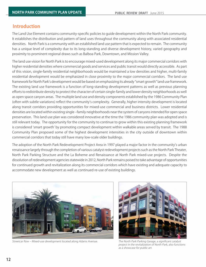
IntroductionThe Land Use Element contains community-specific policies to guide development within the North Park community. It establishes the distribution and pattern of land uses throughout the community along with associated residential densities. North Park is a community with an established land use pattern that is expected to remain. The community has a unique level of complexity due to its long-standing and diverse development history, varied geography and proximity to prominent regional draws such as Balboa Park, Downtown, and Mission Valley.
The land use vision for North Park is to encourage mixed-used development along its major commercial corridors with higher residential densities where commercial goods and services and public transit would directly accessible. As part of this vision, single-family residential neighborhoods would be maintained a low densities and higher, multi-family residential development would be emphasized in close proximity to the major commercial corridors. The land use framework for North Park’s development would be based on emphasizing its already “smart growth” land use framework. The existing land use framework is a function of long-standing development patterns as well as previous planning efforts to redistribute density to protect the character of certain single-family and lower density neighborhoods as well as open space canyon areas. The multiple land use and density components established by the 1986 Community Plan (often with subtle variations) reflect the community’s complexity. Generally, higher intensity development is located along transit corridors providing opportunities for mixed-use commercial and business districts. Lower residential densities are located within existing single –family neighborhoods near the system of canyons intended for open space preservation. This land use plan was considered innovative at the time the 1986 community plan was adopted and is still relevant today. The opportunity for the community to continue to grow within this existing planning framework is considered ‘smart growth’ by promoting compact development within walkable areas served by transit. The 1988 Community Plan proposed some of the highest development intensities in the city outside of downtown within commercial corridors that today still have many low-scale older buildings.
The adoption of the North Park Redevelopment Project Area in 1997 played a major factor in the community’s urban renaissance largely through the completion of various catalyst redevelopment projects such as the North Park Theater, North Park Parking Structure and the La Boheme and Renaissance at North Park mixed-use projects. Despite the dissolution of redevelopment agencies statewide in 2012, North Park remains poised to take advantage of opportunities for continued growth and revitalization along its commercial corridors which have existing and adequate capacity to accommodate new development as well as continued re-use of existing buildings.
12
NORTH PARK COMMUNITY PLAN UPDATE PUBLIC REVIEW DRAFT June 2015
Streetcar Row – Mixed-use development located along Adams Avenue. The North Park Parking Garage, a significant catalyst project in the revitalization of North Park, also functions as a showcase for public art.

Land Use Element GoalsThe following have been established as the goals of the Land Use Element of the North Park Community Plan:
1. A diversity of housing options through new construction and the preservation of existing quality housing stock
2. High-quality development with medium to high residential densities, centrally located with the community to form an attractive and vital central area focused in between El Cajon Boulevard and University Avenue
3. Appropriately located, attractive commercial and office facilities offering a wide variety of goods, services, and employment to benefit the entire community
4. Continued revitalization of North Park’s Business districts while respecting p o t e n t i a l i m p a c t s t o a d j a c e n t neighborhoods
5. Diverse employment opportunities in North Park
6. Villages with a lively, walkable, and unique atmosphere that builds upon existing neighborhoods and includes places to live and work
7. Buffer areas that minimize impacts between commercial and residential uses
8. Commercial/Residential Transition Areas that promote compatible development and reinvestment along the community’s commercial districts
RELATED CONTENT IN OTHER ELEMENTSCross references to other plan element policies are used to demonstrate the interrelationships between elements and how together they represent an integrated vision of for the community.
Table 2-1: General Plan-Related Land Use
General Plan-Related Topics
Policies
Community Planning LU-C.4
Airport Compatibility LU-D.1 – LU-D.3, LU-D.6 – LU-D.12, LU-D.14
Balanced Communities LU-6.1 – LU-6.10
Environmental Justice LU-H.1 – LU-H.7
Mixed-Use and Commercial Areas LU-I.1 – LU-I.16
Office and Business Park Development UD-C.1 – UD-C.3, UD-C.5
Public Spaces and Civic Architecture UD-C.1, UD-C.5, UD-E.1
Non-Base Sector Employment Uses EP-E.1
Commercial Land Use EP-A.6 – EP-A.9
Business Development EP-B.1 – EP-B.16
Visitor Industries EP-F.1 – EP-F.4, EP-I.1 – EP-I.4
Land Use Noise Attenuation NE-E.1-5
Topics and Policies
13
2LAND USE

2.1 Physical Environment
EXISTING LAND USESingle-family land uses make up 592 acres or 30percent of the total acres within the community and is the predominant land use within the North Park community. Multi-family use which occupies the central core of the community accounts for 422 acres or 21percent of the total acreage in the community. Commercial uses including employment, retail, and services cover approximately 81 acres or 4percent of the total area within the community, mostly in the form of strip commercial development. Mixed-Use development currently occupies 12 acres or 1 percent percent of the total acres within the community.
LAND USE DISTRIBUTIONDesignated land uses in North Park land uses single-family, multi-family, open space, commercial/mixed-use, park, and institutional uses. The land use distribution of the North Park community remains largely the same as it was planned in the previous 1986 community plan with commercial/mixed use located along the major commercial-transit corridors of the community, multi-family residential uses occupying the center of the community and transitioning in intensity away from the main commercial corridors. Single-family land uses are primarily located in the northern and southern ends of the community along with the community’s open spaces areas. Institutional uses within the community are primarily in the form of public private schools located throughout the community along with a fire station and library located in the eastern half of the community. See Table 2-2 North Park Existing Land Use.
The concept of maintaining consistent land use designations on both sides of east-west running streets such as Meade, Madison, and Monroe Avenues was carried over from the 1986 plan and applied to the single-family residential neighborhoods located in the southern end of the community to encourage land use symmetry as well as lower scale development and pedestrian orientation along those streets.
Existing Land Use Acreage % of Total
AcreageRoads 664 33%Single-Family Residential 591.7 30%Multi-Family Residential 421.9 21%Park, Open Space & Recreation 166.7 8%Commercial Employment, Retail & Services 80.7 4%
Institutional & Public and Semi-Public Facilities 44.2 2%
Vacant 13 1%Mixed-Use 11.5 1%Industrial Employment 1.4 0.07%Group Quarters 0.5 0.03%TOTAL 1996 100%
Table 2-2: North Park Existing Land Use
LAND USE PLANLand use intensity is related to the specific type of use as well as the materialization of a particular use (or multiple uses) within a developed or built form. A generalized description of land use categories is provided in Table 2.3. Each land use designation also contains quantifiable standards of building intensity. Zone designations are used where specific land use and development standards correlate to the applied zoning program.
14
NORTH PARK COMMUNITY PLAN UPDATE PUBLIC REVIEW DRAFT June 2015
Low intensity mixed-use development within the Egyptian Thematic District along Park Boulevard.

Table 2-3: North Park Community Plan Land Use DesignationsIntensity
General Plan Land Use
Community Plan
Designation
Specific Use Considerations
Description Residential Density
(dwelling units/acre)
Development Form
Park
, Ope
n Sp
ace
& Re
crea
tion
Open Space None Provides for the preservation of land that has distinctive scenic, natural or cultural features; that contributes to community character and form; or that contains environmentally sensitive resources. Applies to land or water areas that are undeveloped, generally free from development, or developed with very low-intensity uses that respect natural environmental characteristics and are compatible with the open space use. Open Space may have utility for: primarily passive park and recreation use; conservation of land, water, or other natural resources; historic or scenic purposes; visual relief; or landform preservation.
0-4 OR-1-1 zone
Population-based Parks
None Provides for areas designated for passive and/or active recreational uses, such as community parks and neighborhood parks. It will allow for facilities and services to meet the recreational needs of the community as defined by the community plan.
N/A OP-1-1 Zone
Resid
entia
l
Residential - Low
None Provides for single-family housing within a low residential density range and limited accessory uses.
1-9 RS-1-7 zone0.60 FAR
Residential – Low-Medium
None Provides for both single-family and multifamily housing within a low-medium residential density range.
10-15 RM-1-1 zone0.75 FAR
Residential - Medium
None Provides for both single-family and multifamily housing within a medium residential density range.
16-29 RM-2-4 and RM-2-5 zones
1.2 to 1.35 FARResidential –
Medium-HighNone Provides for multifamily housing within
a medium-high residential density range.
30-44 RM-2-6 and RM-2-7 zones
1.50 to 1.80 FARResidential -
HighNone Provides for multi-family housing with a
high density range.45-54 RM-3-8 zone
2.25 FAR
Com
mer
cial E
mpl
oym
ent,
Reta
il, &
Serv
ices
Neighborhood Commercial
Residential Permitted
Provides local convenience shopping, civic uses, and services serving an approximate three mile radius. Housing may be allowed up to a medium residential density within a mixed-use setting
0-29 CN-1-1 and CN-1-3 zones1.0 FAR
Provides local convenience shopping, civic uses, and services serving an approximate three mile radius. Housing may be allowed up to a medium-high residential density within a mixed-use setting
0-44 CN-1-4 zone1.0 FAR
15
2LAND USE

IntensityGeneral
Plan Land Use
Community Plan
Designation
Specific Use Considerations
Description Residential Density
(dwelling units/acre)
Development Form
Com
mer
cial E
mpl
oym
ent,
Reta
il, &
Serv
ices
Community Commercial
Residential2 Permitted
Provides for shopping areas with retail, service, civic, and office uses for the community at-large within three to six miles. Housing may be allowed up to a high residential density within a mixed-use setting
0-54 CC-3-7 Zone2.0 FAR
Community Commercial 0-73 CC-3-8 and CC-3-9 zones
2.0 FAR
Inst
itutio
nal, P
ublic
& Se
mi-
Publ
ic Fa
ciliti
es
Institutional None Provides a designation for uses that are identified as public or semi-public facilities in the community plan and which offer public and semi-public services to the community. Uses may include but are not limited to: military facilities, community colleges, communication and utilities, transit centers, schools, libraries, police and fire facilities, post offices, hospitals, park-and-ride lots, government offices and civic centers.
N/A Varies3
1 A density bonus to the next highest residential range is available within the same General Plan Land Use Category as an incentive for public benefits. See Section 2.3 Villages and Implement Chapter in the community plan.2 Stand-alone residential development would be allowed in linear commercial areas between commercial nodes.3 Refer to Municipal Code Regulations for specific institutional uses.
Table 2-3: North Park Community Plan Land Use Designations
16
NORTH PARK COMMUNITY PLAN UPDATE PUBLIC REVIEW DRAFT June 2015
Land use and transit are linked – the distribution and types of land use s can have a direct influence on community travel patterns and the placement of transit facilities.
Medium density row home development along Hamilton Street.

POPULATION DENSITYFuture population can be estimated based upon the number of dwelling units expected to be achieved with the application of planned land uses and development intensity. As of 2013, there were approximately 25,205 dwelling units in the community with a total population of 45,799. At community plan build out, dwelling units are expected to increase to 35,488 during the horizon of this plan and he community is estimated to have a future household population of 61,965.
2.2 Land Use FrameworkThis community plan provides land use recommendations that includes preservation of single-family and low density areas, maintaining higher residential densities at the community core focused along and between El Cajon Boulevard and University Avenue, preservation of open space and canyon areas, encouraging mixed-use development and pedestrian orientation in commercial areas, and preserving the cultural and heritage resources of North Park.
The land uses and residential intensities in the North Park Community Plan are summarized and illustrated on the Community Plan Land Use Map (Figure 2-1) and separated into two sections for more detail (Figures 2-2 and 2-3). The Community Plan Land Use Map is intended to guide development and represent a diagrammatic illustration of land use policies. The map also shows opportunity areas where density bonuses can be applied as a development incentive for the provision of public amenities (See the incentive zoning discussion in Urban Villages Section 2.3 and Implementation chapter of the community plan). Designation of a area for a certain use and intensity does not necessarily mean that the site will be built out within the horizon of this plan.
These three maps together provide a general guide to land use distribution and diagrammatic illustration of land use policies, including allocation of residential density. These maps are also intended to guide development at the project level. Designation of a site for a certain use and intensity does not necessarily mean that the site will be built out within the horizon of this plan.
RESIDENTIALResidential land uses form the basis and majority of land use acreage in the community. Residential densities within the community vary throughout the community. High to very high residential densities are designated along the community’s major east-west commercial/mixed-use corridors – El Cajon Boulevard and University Avenue. The 30th Street commercial/mixed-use corridor transitions from medium high residential density in the northern part of the community where it intersects with Adams Avenue, then transitions to medium residential density at within the center of the community. Areas of high to very high residential density occur where 30th Street intersects with El Cajon Boulevard and University Avenue. The center of the community between the two corridors include a large portion of medium-high to high residential density designated properties. Multi-family residential densities transition from high to very high residential density to low residential density north of el cajon boulevard and south of el cajon boulevard. The low residential density areas of the community, include stable single-family neighborhoods are located generally at the northern and southern ends of the community. These areas also contain North Park’s open space canyons. These areas are characterized by the canyons and hillsides bordering Mission Valley to the north and the various finger canyons shared by the Golden Hill Community to the south.
17
2LAND USE

Figure 2-1: Community Plan Land Use Map
18
NORTH PARK COMMUNITY PLAN UPDATE PUBLIC REVIEW DRAFT June 2015

Figure 2-2: Community Plan Land Use Map – North
19
2LAND USE

Figure 2-3: Community Plan Land Use Map – South
20
NORTH PARK COMMUNITY PLAN UPDATE PUBLIC REVIEW DRAFT June 2015

Policies LU-2.1 Maintain the low density character of pre-
dominantly single family areas, outside of the designated higher density areas primari-ly located along El Cajon Boulevard and Uni-versity Avenue, and encourage rehabilitation and where appropriate. In particular:a. Maintain the lower density residential
character of the neighborhood north of Adams Avenue.
b. Maintain the lower density character or the residential area south of Landis Street.
c. Maintain the single-family character of area west of 30th Street and south of Dwight, and on Felton Street and 33rd Street south of Landis Street.
LU-2.2 Maintain consistent residential land use designations along east-west running streets within the northern and southern sin-gle-family neighborhoods of North Park such as Madison Avenue, Monroe Avenue, Meade Avenue, Wightman Street, Gunn Street,
Landis Street, Dwight Street, Myrtle Avenue, and Upas Street in order to promote and maintain a walkable and pedestrian scale within these neighborhoods.
LU-2.3 Allow stand-alone residential development or live-work units as an option along linear commercial corridors between major mixed-use nodes such as along Adams Avenue between 30th Street and Texas Street and along 30th Street between Adams Avenue and El Cajon Boulevard.
LU-2.4 Provide a diverse mix of housing opportu-nities, including senior and housing for the disabled, within close proximity to transit and services.
LU-2.5 Maintain the higher residential densities along University Avenue between Park Bou-levard and Idaho Street.
LU-2.6 Maintain higher density multi-family resi-dential in close proximity of the University Avenue commercial corridor.
21
2LAND USE
A main focus of the community plan is to focus development opportunities along commercial transit corridors while maintaining the low density character of single-family neighborhood areas.
The Lynhurst Building has been an example of mixed-use development within the North Park community for over a century.
Senior housing in close proximity to the Mid-City Rapid Bus along Park Boulevard.

COMMERCIAL/MIXED-USECommercial land uses are located primarily along the community’s transportation corridors: El Cajon Boulevard, University Avenue, Adams Avenue and 30th Street. Smaller “islands” of commercial-retail also exist within the single-family residential neighborhoods located in the southern part of the community at 30th Street and Redwood and Thorn and 32nd Street. Commercial uses at 30th Street and Juniper Street connect with the larger commercial business district in the South Park neighborhood of the Greater Golden Hill community. These commercial areas in addition to allowing stand-alone commercial uses also provide for mixed-use development. Despite mixed-use development being a widely accepted smart growth approach to in-fill development and re-investment in older urban communities, mixed-use development along portions of El Cajon Boulevard and University Avenue within North Park have resulted in a condition where commercial storefronts have become vacant over long periods of time or where marginal, and often times less desirable commercial uses such as liquor stores and pay-day lending establishments have come to occupy highly visual street corners and intersections. The plan allows
linear areas along commercial streets between mixed-use nodes as “multiple use” areas which would allow either stand alone commercial development or multi-family residential infill development as a means to increase the population density within commercial and mixed-use areas to support to local businesses.
Despite the success of North Park’s commercial areas, areas of concern within the community are primarily those where commercially zoned properties abut single-family residential areas such as the juxtaposition of commercial and residential uses along 30th Street south of Gunn Street and along El Cajon Boulevard. The presence of bars, drive-thru establishments, and other hospitality-related businesses that tend to draw evening crowds have the potential to generate noise, litter, congestion, and other disruptive activity. It will be essential that a strong emphasis on compatibility be placed on new commercial uses within these areas as well as evaluation of existing uses that seek expansion or changes to business operations. See Urban Design Element and Noise and Light Pollution Element.
22
NORTH PARK COMMUNITY PLAN UPDATE PUBLIC REVIEW DRAFT June 2015
Eating and drinking establishments within community’s commercial districts have contributed much to North Park’s urban appeal.
Modern mixed-use development along 30th Street.

POLICIES AND RECOMMENDATIONSLU-2.7 Support a diversity of compatible goods and
specialty services, along commercial streets like 30th Street and Upas Street, so that that the needs of local residents can be met locally.
LU-2.8 Encourage mixed-use development long all Neighborhood and Community Commercial designated corridors in the community and at major village centers, commercial nodes and intersections especially at the following locations:a. Where 30th Street intersects with Adams
Avenue, El Cajon Boulevard, University Avenue, and Upas Street
b. Where Texas Street intersects with El Cajon Boulevard and University Avenue
c. Along all Neighborhood and Community Commercial designated corridors in the community,
LU-2.9 Encourage mixed-use development to include retail, offices, and housing at medi-um to very high densities within commercial nodes.
LU-2.10 Design commercial spaces within mixed-use developments for maximum flexibility and reuse to prevent long-term vacant commer-cial storefronts.
LU-2.11 Enhance the level and quality of business activity in North Park by encouraging infill of retail and commercial uses and mixed-use development that emphasizes adaptive re-use.
LU-2.12 Enforce and improve the appearance of commercial development through estab-lishment of overall design standards that encourage adaptive re-use and preservation of historic structures.
LU-2.13 Encourage and maintain small locally-owned stores, provided that their uses remain com-patible with surrounding neighborhoods.
LU-2.14 Promote the multi-use of underutilized strip commercial areas and surface parking lots for activities such farmers’ markets, art and cultural festivals, and other community events.
LU-2.15 Promote the revitalization within business districts while preventing the potential im-pacts to adjacent residential neighborhoods
LU-2.16 Encourage multiple use along Park Boule-vard between Adams Avenue and Meade Avenue emphasizing higher residential density and office use.
LU-2.17 Maintain commercial development and encourage mixed-use development east of Idaho street.
LU-2.18 Encourage multiple use along 30th Street including higher density residential develop-ment and office use.
LU-2.19 Encourage and continue the temporary use of surface parking lots for community events such as fairs, festivals, farmers markets, etc.
LU-2.20 Allow stand alone multi-family development or allow mixed-used development as an option along linear commercial corridors between mixed-nodes in order to increase the population density within these areas and support commercial use.
LU-2.21 Consider the utilization of amortization as a tool to address aspects of eating and drinking establishments that create conflicts within the areas of the community where commercial uses directly abut single-family residences, such as drive-thru’s associated with food establishments, hours of oper-ation, music, live performances, outdoor service, etc.
23
2LAND USE

INSTITUTIONALInstitutional uses provide either public or private facilities that serve a public benefit. These uses may serve the community or a broader area. Typically, the larger or more significant public uses such as schools and fire stations are identified on the land use map. Major institutional land uses within the community consist mainly of Fire Station 14, the North Park Branch Library, and several public and private schools. The policies within this element also apply to institutional uses as a category, including religious facilities, charter schools and social service providers. Institutional uses often require a Conditional Use Permit or other type of discretionary permit per the San Diego Municipal Code. The expansion and associated upgrade of private schools within North Park has been an issue as these facilities are typically constrained by locations within built-out residential neighborhoods. Suitable development intensity for new or expanded institutional uses should be evaluated within the context of the surrounding neighborhood and consider all relevant factors including traffic impacts, parking demand, and neighborhood character impacts.
LU-2.25 Continue to maintain school sites for a public serving purpose such as a park, community/recreation center, when they are considered for reuse and no longer serve to function as educational centers.
LU-2.26 Any expansion or redevelopment of insti-tutional uses should incorporate intensified usage of existing institutional sites based on remaining on-site development capacity subject to discretionary review for impacts to visual quality, traffic, and noise. Should any acquisition of adjacent properties be proposed, existing structures are to be adap-tively re-used and maintained on site.
The North Park Branch Library.St. Augustine High School has occupied its current location in the community since 1923.
POLICIESLU-2.22 Revert the underlying land use of institu-
tional uses to that of the adjacent land use designation when public properties cease to operate and are proposed for development.
LU-2.23 Strive to achieve early and meaningful participation for nearby residents related to future development and expansion plans for institutional uses within the community.
LU-2.24 Evaluate use permits and other discretionary actions for appropriate development inten-sity and effects on visual quality and neigh-borhood character. Additional impacts, such as those related to mobility, noise and parking demand should also be evaluated as needed.
24
NORTH PARK COMMUNITY PLAN UPDATE PUBLIC REVIEW DRAFT June 2015

PARKS Parks and open spaces fulfill a variety of important purposes in the community including active and passive recreation, conservation of resources and protection of views, and providing visual relief in a built out urban environment. Open space is generally free from development o may be developed with limited, low-intensity uses in a manner that respects the natural environment and conserves sensitive environmental resources.
OPEN SPACEThe description of the purpose and values for open space is shown on Table 2-3, North Park Community Plan Land Use Designations. Protection of resources within lands designated as open space affects multiple property owners (including the City of San Diego) and is accomplished primarily through application of various development regulations of the Municipal Code, particularly the Environmentally Sensitive Lands Regulations. The City has pursued acquisition of private parcels or acquisition of easement as a means of conserving open space resources and protecting environmentally sensitive areas from development.
The policies and recommendations listed below pertain to Open Space as a land use. Policies for protection and conservation or environmentally sensitive resources with open space land are also contained with the Conservation Element, and policies related to views and hillside development area contained in the Urban Design Element.
POLICIES LU-2.27 Preserve the remaining undeveloped can-
yons and hillsides as important features of visual of open space, community definition and environmental quality.
LU-2.28 Protect designated open space from de-velopment and secure public use where desirable by obtaining necessary property rights through public acquisition of parcels or easements.
LU-2.29 Allow development of limited, low intensity uses in a manner that respects the natural environment and conserves environmental-ly sensitive lands and resources for parcels within designated open space.
LU-2.30 Obtain conservation or no-build easements for protection of environmentally sensitive resources through review and approval of discretionary development permits for For private property within designated open spaces.
LU-2.31 Utilize publicly-controlled open space for passive recreation where desirable and feasible.
Switzer Canyon is enjoyed in the community as an open space amenity.
Bird Park, located at the very edge of Balboa Park and the North Park Community provides passive recreation and plays host to community summer concerts.
25
2LAND USE

2.3 Village AreasThe City of Villages strategy as discussed in the General Plan, calls for the creation of mixed-use villages of different scales and sizes located throughout the City that are pedestrian friendly, centers of community activity, connected by transit and where future growth is focused. Prior to the adoption of the General Plan, North Park was already in a position to promote “village-like” development with identified areas for mixed-use development already focused along major transportation corridors and policies for improving the pedestrian environment by enhancing pedestrian activity in business districts and neighborhoods were already in place. North Park along with several of San Diego’s older, developed urban communities is expected to see an improved level of walkability, bicycling, and transit through the implementation of transportation-related projects and improvements and efforts that are focused within a number of community village areas and linear commercial corridors in the community. Projects such as the University Avenue Mobility Plan (UAMP) which focuses on multi-modal improvements along University Avenue between Florida Street and Boundary Street and the Mid-City Rapid Bus which upon completion will run along North Park’s stretch of El Cajon Boulevard will ultimately provide safety, walkability, improved level of service and faster travel times across the community’s village and mixed-use areas. It is within these areas, where transportation and land use planning complement each other and have the potential of being highly effective in bringing residents closer to local and regional destinations in a manner that is safe, efficient, and healthy for residents and the environment.
COMMUNITY VILLAGEThe Community Village in North Park covers most of the commercial properties along University Avenue between Idaho Street and Bancroft Street and centered around the University Avenue/30th Street intersection. The area within the village includes an existing library, elementary school, theater, designated mini-park, high-density residential development, various commercial services as well as a growing arts district, culture, and entertainment district. See Figure 2-4 Village Areas.
North Park’s community village activity is focused around 30th Street and University which includes such multi-family housing, bars and restaurants, shopping, art galleries within a very walkable, pedestrian environment.
Mixed-use development within the neighborhood village focused around Adams Avenue and 30th Street.
OTHER VILLAGE TYPES & MIXED-USE LOCATIONSAlthough the Community Village identified at University Avenue/30th Street is considered the main village center of the community, areas like El Cajon Boulevard have continued to be major commercial corridors combining both auto and pedestrian oriented services. Other areas based on their village propensity characteristics have the potential to emerge as neighborhood villages and commercial/mixed-use nodes. These areas include:• 30th Street south between North Park Way and Upas
Street• El Cajon Boulevard • Adams Avenue at 30th Street• Texas Street at University Avenue and at El Cajon
Boulevard
26
NORTH PARK COMMUNITY PLAN UPDATE PUBLIC REVIEW DRAFT June 2015

Figure 2-4: Village Areas
27
2LAND USE

COMMUNITY PLAN IMPLEMENTATION OVERLAY ZONE (CPIOZ)The Community Plan Implementation Overlay Zone (CPIOZ) is applied within the community and neighborhood villages (see Section 12, Implementation section). The purpose of the overlay zone is to supplement the Municipal Code by providing development regulations that are tailored to specific circumstances and/or sites within the community and have been adopted as part of this community plan. The CPIOZ Type A (ministerial review) and Type B (discretionary review) are applied where supplemental development regulations are desired to better implement community plan recommendations, particularly those of related to urban design – building height, setbacks, upper-story stepbacks, building transitions, etc.
POLICIES LU-3.1 Provide public spaces within each Commu-
nity and Neighborhood Center (Refer to General Plan Policies UD-C.1, UD-C.5 and UD-E.1).
LU-3.2 Prioritize the implementation of future park sites and public space within village areas with input from the public.
LU-3.3 Consider application of incentive zoning where increased building heights in com-munity identified opportunity areas, would allow a portion of the project site at the ground level area to be available for public benefits such parks, plazas, public parking, community space, etc.
Public amenities provided by private development can assist in addressing the need for more public space in community and neighborhood villages.
The North Park Mini-Park will add public space to North Park’s community village.
INCENTIVE ZONING PROGRAMPolicy LU-F.3 of the General Plan encourages the use of incentive zoning measures to achieve a desired mix of land use and public benefits. The program furthers the General Plan’s City of Villages Strategy to include public amenities in mixed-use village areas. Opportunities for creating public amenities are limited within developed communities. The incentive zoning program is a voluntary opportunity for new, private development to provide public infrastructure/amenities such as parks, plazas, or additional public parking within business districts for increased residential density or additional building height. These community benefits would exceed any related requirements for new development. Implementation of the incentive zoning program can incorporate public amenities into infill projects and mixed-use village areas.
LU-3.4 Encourage the creation and use of an incentive zoning program that provides incentives such as added height and density in exchange for public space (See Implemen-tation Section).
LU-3.5 Grant flexibility within the aspects of re-quired parking, building height limits, and maximum density in order to facilitate the provision of appropriate community benefits with new development.
LU-3.6 Continue to promote North Park’s Commu-nity Village as a attractive destination for liv-ing, working, shopping, and entertainment.
28
NORTH PARK COMMUNITY PLAN UPDATE PUBLIC REVIEW DRAFT June 2015

33.1 ACTIVE TRANSPORTATION3.2 TRANSIT 3.3 STREET SYSTEM3.4 INTELLIGENT TRANSPORTATION SYSTEM3.5 PARKING
MOBILITY

IntroductionThe community plan places an emphasis on high quality reliable multi-modal network that strengthens the land use vision and promotes a clean and sustainable environment. All forms of transportation have an important role in the community. The policies within the Mobility Element provide goals, policies and recommendations to create a multi-modal transportation system that provides safe and efficient transportation choices for the community.
Travel choices need to be broadened so that a good portion of trips can be made without a car. Walking, bicycling, and transit should not be modes of last resort; rather they should be convenient, pleasant, safe and desirable modes of travel. To this end, the Mobility Element includes goals, policies, and recommendations that will lead to a robust multimodal network that encourages walking, bicycling, and taking transit while continuing to provide for needed vehicular access in the community.
Mobility plays a major role in the vision for North Park community. North Park provides opportunities for with new retail, restaurants, housing, and entertainment venues along its key commercial corridors and business districts. With mixed-use development, an increasing number of residents are within walking distance of shopping, entertainment, and commercial services and are opting to use transit, to walk and/or bicycle as their mode of transportation. The mobility element provides goals and policies to strengthen and create a richly connected urban community through a well implemented system of accessible, convenient, reliable, and resilient multi-modal transportation options that improve mobility for local residents, businesses, and organizations.
The community plan envisions creating viable transportation choices through a more balanced use of streets. The incorporation of complete streets concepts allows streets to accommodate all modes of transportation to coexist. The community’s complete streets strategy would focus improvements within the existing rights-of-way, with an emphasis on walking, bicycling, and transit. This strategy will result in a more efficient use of streets and provide multimodal connections to destinations such as schools, parks, employment, and shopping. A complete streets approach to mobility planning will enable safe, comfortable, and attractive access to pedestrians, bicyclists, transit and automobiles.
Multi-modal balance can be achieved by considering all modes of transportation and the needs of all current and future users.
The Complete Streets concept encourages street connectivity and aims to establish a comprehensive, integrated mobility network for all modes of travel.
30
NORTH PARK COMMUNITY PLAN UPDATE PUBLIC REVIEW DRAFT June 2015
30
NORTH PARK COMMUNITY PLAN UPDATE PUBLIC REVIEW DRAFT June 2015
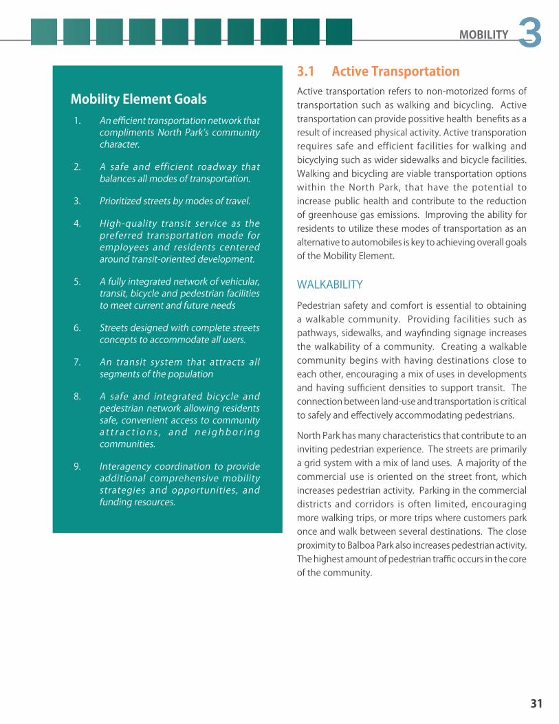
Mobility Element Goals1. An efficient transportation network that
compliments North Park’s community character.
2. A safe and efficient roadway that balances all modes of transportation.
3. Prioritized streets by modes of travel.
4. High-quality transit service as the preferred transportation mode for employees and residents centered around transit-oriented development.
5. A fully integrated network of vehicular, transit, bicycle and pedestrian facilities to meet current and future needs
6. Streets designed with complete streets concepts to accommodate all users.
7. An transit system that attracts all segments of the population
8. A safe and integrated bicycle and pedestrian network allowing residents safe, convenient access to community a t t r a c t i o n s , a n d n e i g h b o r i n g communities.
9. Interagency coordination to provide additional comprehensive mobility strategies and opportunities, and funding resources.
3.1 Active TransportationActive transportation refers to non-motorized forms of transportation such as walking and bicycling. Active transportation can provide possitive health benefits as a result of increased physical activity. Active transporation requires safe and efficient facilities for walking and bicyclying such as wider sidewalks and bicycle facilities. Walking and bicycling are viable transportation options within the North Park, that have the potential to increase public health and contribute to the reduction of greenhouse gas emissions. Improving the ability for residents to utilize these modes of transportation as an alternative to automobiles is key to achieving overall goals of the Mobility Element.
WALKABILITYPedestrian safety and comfort is essential to obtaining a walkable community. Providing facilities such as pathways, sidewalks, and wayfinding signage increases the walkability of a community. Creating a walkable community begins with having destinations close to each other, encouraging a mix of uses in developments and having sufficient densities to support transit. The connection between land-use and transportation is critical to safely and effectively accommodating pedestrians.
North Park has many characteristics that contribute to an inviting pedestrian experience. The streets are primarily a grid system with a mix of land uses. A majority of the commercial use is oriented on the street front, which increases pedestrian activity. Parking in the commercial districts and corridors is often limited, encouraging more walking trips, or more trips where customers park once and walk between several destinations. The close proximity to Balboa Park also increases pedestrian activity. The highest amount of pedestrian traffic occurs in the core of the community.
31
3
31
3MOBILITY

The community’s grid pattern of streets is a mobility asset by providing multiple access points to destinations throughout the community. This pattern provides better connectivity and disperses traffic to create comparatively more walkable commercial and residential neighborhoods. The community is also served by relatively convenient transit access. These characteristics are conducive to walkability and also provide mobility options for those who cannot drive, do not own a motor vehicle, or prefer to reduce their dependence on the automobile.
Sidewalk mobility for pedestrians with and without mobility devices such as wheelchairs and motorized scooters is of primary importance to the creation of a walkable community. It is therefore important to provide adequate travel width for mobility devices. In areas of high pedestrian activity, a desirable objective is sidewalk widths sufficient for two people to pass a third person comfortably, although availability of adequate right-of-way poses a constraint in many areas.
Pedestrian routes in North Park are described below, and are shown in Figure 3-1. Pedestrian enhancements recommended along these pedestrian routes include but are not limited to bulb-outs curb extensions, enhanced crossing treatments, and traffic calming, leading pedestrian intervals, and pedestrian scramble crossing phases to increase safety and operational improvements.
General Plan policies ME-A.1 through ME-A.9 and Table ME-1, Pedestrian Improvement Toolbox, as well as the community-based policies in this element should be considered for guidance.
• District Sidewalks have heavy pedestrian levels with an identifiable focus to encouraging walking within a district node.
• Corridor Sidewalks have moderate pedestrian levels that connect to district nodes.
• Connector Sidewalks have lower pedestrian levels that connect industrial areas to corridor or district sidewalks.
• Neighborhood Sidewalks have low to moderate pedestrian levels within residential areas.
• Ancillary Pedestrian Facilities have moderate to high pedestrian levels that include bridges over streets, and plazas, promenades, or courtyards away from streets.
• Paths are exclusive to pedestrians and bicycles and are not associated with streets.
30th Street provides the only direct through-roadway connection across North Park to the Golden Hill Community.
It is essential for the creation of a walkable community to have adequate sidewalk width to accommodate pedestrians in high-pedestrian activity areas.
32
NORTH PARK COMMUNITY PLAN UPDATE PUBLIC REVIEW DRAFT June 2015
32
NORTH PARK COMMUNITY PLAN UPDATE PUBLIC REVIEW DRAFT June 2015

POLICIESME-1.1 Enhance pedestrian travel routes based
upon infrastructure conditions and level of use.
ME-1.2 Provide pedestrian amenities including street trees, street furniture, and signage to enhance the pedestrian experience.
ME-1.3 Provide marked crosswalks and pedestri-an countdown signals and/or pedestrian phasing at signalized intersections along the pedestrian routes identified in Figure 3-1.
ME-1.4 Consider the installation of corner bulbouts along the following pedestrian corridors:a. University Avenue at the intersections with
Arnold Avenue and Pershing Avenueb. Park Boulevard at the intersections with
Upas Street and Myrtle Avenuec. Texas Street at intersections between
Wightman Street and Meade Avenued. 30th Street at the intersections with
Howard Avenue, North Park Way, and Dwight Street
ME-1.5 Support and promote pedestrian facility improvements at the intersection of Upas Street and 30th Street.
ME-1.6 Support and promote sidewalk modifica-tions along University Avenue between Park Boulevard and Florida Street.
ME-1.7 Install missing sidewalks and curb ramps and remove any other barriers to accessibility.
ME-1.8 Relocate above-ground infrastructure espe-cially along mixed-use corridors, and transit stops.
ME-1.9 Locate public utilities outside of the pe-destrian zone and designed so as not to obstruct a clear path of travel. Public utilities should be screened from public view, and placed underground where feasible.
ME-1.10 Prioritize activities within the sidewalk and make mobility functions such as pedestrian access, bicycle parking and transit stops the main priority.
ME-1.11 Include pedestrian mobility enhancements in future transit and bicycle projects.
ME-1.12 Implement pedestrian enhancements alon identified pedestrian routes.
ME-1.13 Improve the pedestrian environment adjacent and along routes to transit stops through the installation and maintenance of signs, crosswalks, and other appropriate measures.
ME-1.14 Provide shade-producing street trees and street furnishings with an emphasis along routes to schools and transit.
Mid-block crossings can be considered and utilized to accommodate pedestrian access across streets with infrequent intersections.
North Park’s grid pattern street system is a major factor in promoting walkability.
33
3
33
3MOBILITY
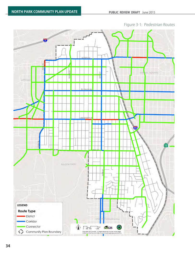
Figure 3-1: Pedestrian Routes
34
NORTH PARK COMMUNITY PLAN UPDATE PUBLIC REVIEW DRAFT June 2015
34
NORTH PARK COMMUNITY PLAN UPDATE PUBLIC REVIEW DRAFT June 2015
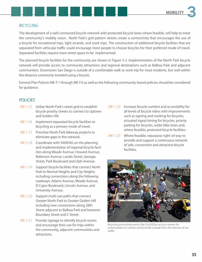
BICYCLINGThe development of a well-connected bicycle network with protected bicycle lanes where feasible, will help to meet the community’s mobiliy vision. North Park’s grid pattern streets create a connectivity that encourages the use of a bicycle for recreational trips, light errands, and work trips. The construction of additional bicycle facilities that are separated from vehicular traffic could encourage more people to choose bicycles for their preferred mode of travel. Separated facilities require more street space to be implemented.
The planned bicycle facilities for the community are shown in Figure 3-2. Implementation of the North Park bicycle network will provide access to community attractions and regional destinations such as Balboa Park and adjacent communities. Downtown San Diego is outside of a comfortable walk to work trip for most residents, but well within the distance commonly traveled using a bicycle.
General Plan Policies ME-F.1 through ME-F.6 as well as the following community-based policies should be considered for guidance.
Bicycling promoting events like CicloSDias act as a means for communities to connect and provide a break from the stresses of car traffic.
POLICIESME-1.15 Utilize North Park’s street grid to establish
bicycle priority streets to connect to Uptown and Golden Hill.
ME-1.16 Implement separated bicycle facilities to bicycling as a primary mode of travel.
ME-1.17 Prioritize North Park bikeway projects to eliminate gaps in the network.
ME-1.18 Coordinate with SANDAG on the planning and implementation of regional bicycle facil-ities along Meade Avenue, Howard Avenue, Robinson Avenue, Landis Street, Georgia Street, Park Boulevard and Utah Avenue.
ME-1.19 Support bicycle facilities that connect North Park to Normal Heights and City Heights including connections along the following roadways: Adams Avenue, Meade Avenue, El Cajon Boulevard, Lincoln Avenue, and University Avenue.
ME-1.20 Support multi-use paths that connect Greater North Park to Greater Golden Hill including new connections along 28th Street adjacent to Balboa Park and between Boundary Street and C Street.
ME-1.21 Provide signage to identify bicycle routes and encourage their use for trips within the community, adjacent communities and attractions.
ME-1.22 Increase bicycle comfort and accessibility for all levels of bicycle riders with improvements such as signing and marking for bicycles, actuated signal timing for bicycles, priority parking for bicycles, wider bike lanes and, where feasible, protected bicycle facilities.
ME-1.23 Where feasible, repurpose right-of-way to provide and support a continuous network of safe, convenient and attractive bicycle facilities.
35
3
35
3MOBILITY

Figure 3-2: Planned Bicycle Facilities
36
NORTH PARK COMMUNITY PLAN UPDATE PUBLIC REVIEW DRAFT June 2015
36
NORTH PARK COMMUNITY PLAN UPDATE PUBLIC REVIEW DRAFT June 2015

3.2 Transit Expanding transit services to create a viable travel choice in North Park is an essential component to the North Park Mobility Element. Transit improves community livability by increasing access to civic, commercial and employment destinations. Transit in Golden Hill should be attractive, convenient and act as a viable choice of travel, reducing dependence on the automobile. Linking transit and land use is an essential component of the community plan’s vision, with transit stations integrated into walkable, transit oriented neighborhoods and centers. North Park has a high transit ridership. Improvements will provide a faster and more efficient service. Additional amenities such as shade structures or shade producing trees around transit stops would improve the overall transit experience for riders.
Future transit service is identified in the Regional Transportation Plan (RTP). The 2050 RTP identifies Rapid Transit, Trolley (also know as light rail transit), and Streetcar service within North Park. The planned transit system will improve the type of service, frequency of service and areas to which patrons can reach using transit. The following summarizes some of the transit service enhancements contingent upon future funding within North Park:
RAPID BUS This rapid bus service is planned between downtown San Diego and the North Park area. The route would be the same as the local service bus route 2, but will have fewer stations, quick boarding operations, and transit priority treatments at signalized intersections, resulting in faster travel times, as compared to the local buses. The service will operate throughout the day at 10-minute frequencies. The expected year for completion is 2030.
This rapid bus service is planned between the 32nd Street Trolley Station and the Golden Hill and North Park areas. The route is planned to include El Cajon Boulevard, Park Boulevard, and 30th Street. The route would have limited stations, quicker boarding operations, and transit priority treatments at signalized intersections, resulting in faster travel times, as compared to local buses. The expected year for completion is 2035.
STREETCARThis streetcar service is planned to connect the Golden Hill community with North Park, Petco Park and the Gaslamp district of downtown. The route would likely use a combination of 30th Street, B Street, and Market Street. The streetcar would operate within a travel lane shared with vehicular traffic and would have stops every two to three blocks. The service will strengthen the connection between Greater Golden Hill, Downtown, and North Park, with a primary target of serving retail and tourism activities. With frequent stations, the streetcar will have slower operating speeds, as compared to Rapid Bus service. The expected year for completion is 2035.
North Park is linked to the regional transit system via the Mid-City Rapid Bus.
37
3
37
3MOBILITY

MID-CITY TROLLEY EXTENSIONSANDAG is planning the Mid-City Trolley Extesion from Downtown to the Mid-City communities and San Diego State via El Cajon Boulevard and Park Boulevard. The expected year for completion of this improvement is 2035. Figure 3-3 illustrates the transit network with the buildout of the 2050 Regional Transportation Plan.
General Plan policies ME-B.1 through ME-B.10, as well as the following community-based policies should be consulted for guidance.
POLICIESME-2.1 Implement transit system priority for buses
and queue jumps to improve the efficiency of travel by bus, where approriate.
ME-2.2 Consider the use of exclusive or restricted transit lanes where there is sufficient rider-ship.
ME-2.3 Enchance the pedestrian and bicycle ame-neties around transit stops such as bicycle parking, shade trees and landscaping to increase the comfort and convenience for transit riders.
ME-2.4 Work with MTS to increase the transit rider experience by placing shade structures, benches and timetables at bus stops, where feasible.
ME-2.5 Work with SANDAG to implement electronic arrival schedules where appropriate and im-plement real time transit schedule updates to provide timely and efficient loading.
ME-2.6 Work with SANDAG to implement transit infrastructure and service enhancements in the Regional Transportation Plan.
ME-2.7 Work with MTS and SANDAG to implement transit priority measures to improve transit travel times.
ME-2.8 Coordinate with MTS on bicycle and pedes-trian infrastructure improvements to avoid adverse impacts to existing and planned bus services to the community.
A streetcar line between North Park and Downtown would provide another travel option in the community and serve as a tourism booster for the community.
Queue jumps provide transit priority on roadways and improves efficiency of travel by bus.
38
NORTH PARK COMMUNITY PLAN UPDATE PUBLIC REVIEW DRAFT June 2015
38
NORTH PARK COMMUNITY PLAN UPDATE PUBLIC REVIEW DRAFT June 2015

Figure 3-3: Planned Transit Service
39
3
39
3MOBILITY

Figure 3-4: Existing Roadway Classifications
40
NORTH PARK COMMUNITY PLAN UPDATE PUBLIC REVIEW DRAFT June 2015
40
NORTH PARK COMMUNITY PLAN UPDATE PUBLIC REVIEW DRAFT June 2015

3.3 Street SystemNorth Park’s existing street system is a grid pattern. North Park is served by two major streets, El Cajon Boulevard and University Avenue, which provide east-west access to the Uptown community on the west and to the Mid-City and College communities on the east. Adams Avenue also provides a connection to the east, linking Greater North Park neighborhoods of Normal Heights and University Heights with the Mid-City neighborhoods of Normal Heights, Kensington and Talmadge. The major north-south streets in the community are 30th Street, which provides a link with the Golden Hill community and Downtown; Texas Street, which provides access to Mission Valley and into Balboa Park; and Park Boulevard, which is adjacent to Uptown and provides access to Balboa Park and to Downtown. Other surface streets of importance are two east-west streets, Meade Avenue and Lincoln Avenue and two north-south streets, Utah Street and 32nd Street. Figure 3-4 illustrates the existing roadway classifications.
The community plan envisions repurposing streets to incorporate multiple modes of travel and parking. By creating an efficient and attractive multimodal network, people can bicycle, walk, and use transit that ideally can contribute to less automobile congestion and a more healthy community. Figure 3-5 illustrates the planned street classifications.
General Plan Policies ME-C.1 through MC-C.7 and Table ME-2 (Traffic Calming Toolbox), as well as the following community-based policies provide guidance for street, freeway, and intersection improvements.
Pedestrian and bicycle improvements along Texas Street provide mobility connections between North Park and Mission Valley.
POLICIESME-3.1 Implement road diets (reduction in number
of traffic lanes) or lane diets (narrowing traf-fic lanes) where appropriate to accommo-date transit and bicycles within the existing street right-of-way.
ME-3.2 Provide a complete streets network, that accommodates multiple modes of transpor-tation throughout the community to accom-adate all users of the roadway.
ME-3.3 Direct future transportation trips to walking, biking and transit modes by creating a safe, effective multimodal network.
ME-3.4 Implement focused intersection improve-ments to provide safety and operations for all modes at major commercial intersections and destination in the community and to and from Balboa Park.
ME-3.5 Coordinate with Caltrans and SANDAG to identify and implement needed freeway and interchange improvements at North Park Way.
ME-3.6 Repurpose right-of-way to provide high quality bicycle, pedestrian, and transit facili-ties while maintaining vehicular access
ME-3.7 Implement focused intersection improve-ments to improve safety and operations for all modes.
ME-3.8 Provide street trees, street lighting, and implement a wayfinding program.
ME-3.9 Incorporate balanced multi-modal concepts into planning, design, retrofit and mainte-nance of streets.
ME-3.10 Ensure efficient movement and delivery of goods to retail uses while minimizing im-pacts on residential and mixed use areas.
41
3
41
3MOBILITY
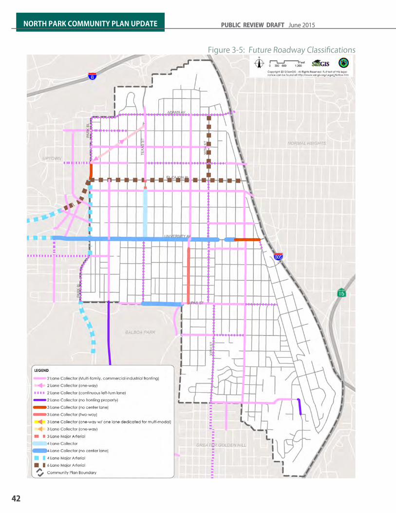
Figure 3-5: Future Roadway Classifications
42
NORTH PARK COMMUNITY PLAN UPDATE PUBLIC REVIEW DRAFT June 2015
42
NORTH PARK COMMUNITY PLAN UPDATE PUBLIC REVIEW DRAFT June 2015

3.4 Intelligent Transportation System
Repurposing right-of-way can provide opportunities not only for other modes of transit, but for public space as well.
Texas Street provides a continuous connection through North Park between Balboa Park and Mission Valley.
Facilities that promote biking should accommodate all cyclists regardless of skill.
Intelligent Transportation Systems (ITS) is the application of technology to transportation systems with the goal to maximize efficiency of services while increasing vehicle throughput, reducing congestion, and providing quality information to the commuting public. The application of ITS technologies can influence choices across all modes of travel.
General Plan Policies ME-D.1 through ME-D.6 as well as the following community-based policies should be considered when evaluating ITS improvements.
POLICIESME-4.1 Support implementation of ITS strategies
such as smart parking technology, traffic and transit information dynamic message signs, traffic signal coordination, and transit priority.
ME-4.2 Encourage accommodation of emerging technologies such as car charging stations into future infrastructure and development projects.
ME-4.3 Utilize ITS technology such as traffic signal coordination and transit priority measures to move people safely and efficiently through the community.
43
3
43
3MOBILITY

3.5 Parking Both on- and off-street parking are in high demand in North Park, especially in the Core area. The high parking demand is concentrated mainly in the Core area, bounded by North Park Way to Howard Avenue and from Hamilton Street to Iowa Street. The North Park Parking Structure provides convenient parking for the business patrons and visitors to the community. Other areas with high parking demand include 30th Street and University Avenue. Greater management of parking spaces can help achieve mobility, environmental, and community development goals.
POLICIESME-5.1 Consider additional diagonal parking on
various side-streets adjacent to the Core area and mixed-use corridors, and within multi-family neighborhoods to increase parking supply where feasible.
ME-5.2 Provide on-street parking on all streets to support adjacent uses and enhance pedestri-an safety and activity where feasible.
ME-5.3 Include primarily parallel on-street parking on high-volume arterial and collector streets and angled parking on lower-speed and lower-volume streets.
ME-5.4 Limit driveway curb cuts to the extent possi-ble to maximize the curb length available for on-street parking. Driveway access should be provided through alleys or shared drive-ways.
ME-5.5 Explore opportunities to incorporate re-verse angle (i.e., back in) diagonal parking to improve safety for bicyclists, calm traffic and reduce conflicts with on-coming traffic. This is particularly appropriate in locations with generous street widths (50’ or greater), where a narrower travel lane can accompany this configuration.
ME-5.6 Avoid conflicts between front-in angled parking and marked bicycle lanes. In these locations, a six-foot buffer must be provid-ed. Bicycle lanes may abut the parking area when back-in angled parking is used.
ME-5.7 Support the construction of additional park-ing structures near El Cajon Boulevard and 30th Street and in close proximity to mixed-use corridors.
Reversed angled parking could provide opportunities for more parking in the community and safer streets.
Bike corrals can accommodate more bicycle parking than typical sidewalk bicycle racks, especially where sidewalk widths are limited in width.
44
NORTH PARK COMMUNITY PLAN UPDATE PUBLIC REVIEW DRAFT June 2015
44
NORTH PARK COMMUNITY PLAN UPDATE PUBLIC REVIEW DRAFT June 2015
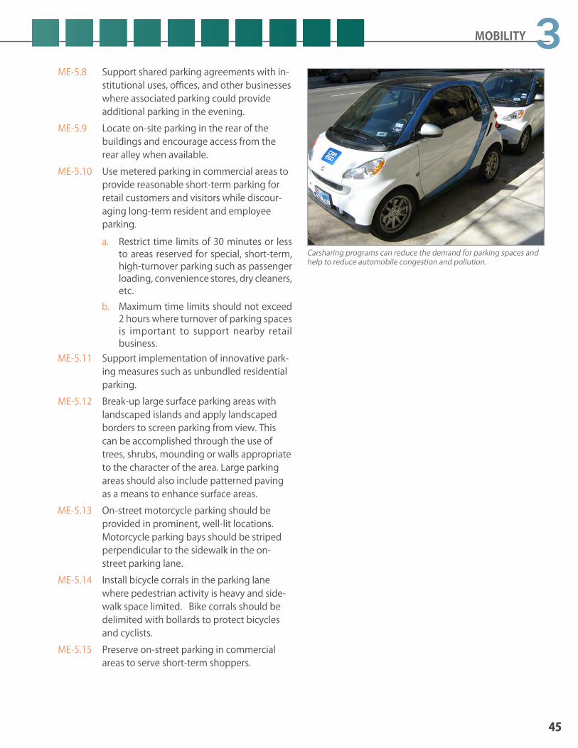
Carsharing programs can reduce the demand for parking spaces and help to reduce automobile congestion and pollution.
ME-5.8 Support shared parking agreements with in-stitutional uses, offices, and other businesses where associated parking could provide additional parking in the evening.
ME-5.9 Locate on-site parking in the rear of the buildings and encourage access from the rear alley when available.
ME-5.10 Use metered parking in commercial areas to provide reasonable short-term parking for retail customers and visitors while discour-aging long-term resident and employee parking. a. Restrict time limits of 30 minutes or less
to areas reserved for special, short-term, high-turnover parking such as passenger loading, convenience stores, dry cleaners, etc.
b. Maximum time limits should not exceed 2 hours where turnover of parking spaces is important to support nearby retail business.
ME-5.11 Support implementation of innovative park-ing measures such as unbundled residential parking.
ME-5.12 Break-up large surface parking areas with landscaped islands and apply landscaped borders to screen parking from view. This can be accomplished through the use of trees, shrubs, mounding or walls appropriate to the character of the area. Large parking areas should also include patterned paving as a means to enhance surface areas.
ME-5.13 On-street motorcycle parking should be provided in prominent, well-lit locations. Motorcycle parking bays should be striped perpendicular to the sidewalk in the on-street parking lane.
ME-5.14 Install bicycle corrals in the parking lane where pedestrian activity is heavy and side-walk space limited. Bike corrals should be delimited with bollards to protect bicycles and cyclists.
ME-5.15 Preserve on-street parking in commercial areas to serve short-term shoppers.
45
3
45
3MOBILITY

This page is intentionally left blank.
46
NORTH PARK COMMUNITY PLAN UPDATE PUBLIC REVIEW DRAFT June 2015
46
NORTH PARK COMMUNITY PLAN UPDATE PUBLIC REVIEW DRAFT June 2015

4URBAN DESIGN
4.1 PUBLIC REALM4.2 URBAN DESIGN CHARACTER AREAS

48
NORTH PARK COMMUNITY PLAN UPDATE PUBLIC REVIEW DRAFT June 2015
Introduction
Urban Design addresses the defining features and relationships of new buildings, groups of buildings, spaces, and landscapes with those of existing neighborhoods, districts and corridors. It assimilates the relationships between buildings, streets, land use, open spaces, circulation, height, density, parking, and parks. Within the North Park community, it has been demonstrated that new uses and development can be integrated into the historic fabric of neighborhoods and districts, if they protect or build upon existing character defining features. North Park’s original urban design and planning principles promoted human-scale, pedestrian oriented residential and commercial land uses with each of its older neighborhoods having their own diversity and character with representative traditional architectural styles such as California bungalow, Craftsman and Spanish / Mediterranean architecture.
From the 1960s to the 1980s, North Park developed and grew with little regard to the scale, character, and the context of its original buildings and homes. Single-family homes were replaced with long, narrow apartment buildings with front parking lots that disrupted the scale, diminished the character, and reduced the walkability of neighborhoods. Similar intrusions occurred in the “Main Street” business districts, changing the walkable human scaled storefront character of these areas into strip commercial auto-oriented uses. As the community continues to see infill development and building renovations, this plan places an emphasis on new development to include innovative and dynamic forms while still being sensitive to adjacent neighbors. The Urban Design Element provides policies to protect, enhance and encourage quality design that takes into account the unique features of North Park while recognizing that there will be changes to the urban form and a need to respond to future urban design issues.
VISIONInterconnected neighborhoods, commercial districts, and corridors that provide the setting for new buildings with a high-level of design and allows North Park’s distinctive character to continually evolve as well as protect the fabric of older buildings and neighborhood character.

URBAN DESIGN
49
4Urban Design Element Goals1. A built environment that enhances North
Park’s quality of life and community character.
2. New buildings that protect and enhance a neighborhood’s distinctive context and vitality and complement the character and scale of neighboring buildings.
3. Preservation of the architectural variety and distinctive neighborhood character. Preservation, restoration and adaptive reuse of unique architecturally significant structures.
4. Unique thematic districts that express culture and neighborhood identity through the built environment.
5. Public spaces that evoke pride and enrich the lives of the community.
6. A sense of arrival at major community gateways.
7. A pedestrian oriented public realm with aesthetic quality, functionality, and sustainability through the design of buildings, public improvements, landscaping, and public art.
8. Enhancement of the visual interface between Balboa Park/open space and the community. Sustainable street trees and landscaping in the public realm that contributes to community character.
GENERAL PLAN CROSS-REFERENCE The City of San Diego General Plan provides citywide urban design-related policies to be applied in conjunction with the urban design policies in the community plan. Policies may also be referenced further, emphasized or detailed in the context of a community to provide further community-specific direction. General Plan Urban Design Element policies particularly significant to the North Park community are listed as noted in Table 4-1.
Table 4-1: General Plan-Related Urban Design Topics and Policies
General Plan-related Topics
Policies
Development adjacent to Canyons & Other Natural Features
UD-A.3
Landscape Guidelines UD-A.8
Parking UD-A.11, UD-A.12
Wireless Facilities UD-A.15
Utilities UD-A.16
Safety & Security (Crime Prevention through Environmental Design – CEPTED)
UD-A.17
Residential Design UD-B.1 – UD-B.8
Mixed-Use and Commercial Development UD-C.1 – UD-C.8
Public Spaces & Civic Architecture UD-E.1 – UD-E.2
Public Art & Cultural Amenities UD-F.1 – UD-F.5
Urban Runoff & Stormwater Management CE-E.1 – CE-E.7
Urban Forestry CE-J.1 – CE –J.5
Sustainable Development Practices CE-A.5 – CE-A.12
Streetscape Design UD-C.7
Pedestrian Access to Developments UD-A.5, UD-A.9
Site Design & Building Orientation UD-A.3 – UD-A.6
Building Compatibility & Transitions UD-B.2
Building Quality, Durability, Materials & Colors UD-A.4, UD-A.5 & CE-A.9

50
NORTH PARK COMMUNITY PLAN UPDATE PUBLIC REVIEW DRAFT June 2015
UE2.7 Encourage sidewalk widening in front of commercial, mixed-use buildings to create pockets of gathering and sitting areas and outdoor sitting for restaurants.
UE2.8 Encourage a consistent theme for mixed-use corridors utilizing coordinated street furnish-ings, banners and signage.
UE2.9 Encourage streetscape improvements along mixed-use corridors including gateways and nodes.
UE2.10 Locate and design utilities outside of the sidewalk to maintain a clear path of travel.
UE2.11 Screen above ground utility equipment by being integrated in a building’s architecture, placed underground, and/or screened by landscaping where feasible.
UE2.12 Preserve and incorporate the historic scoring pattern, color, texture, and material of the community’s older, historic sidewalks when replacing sidewalks.
UE2.13 Preserve the original sidewalk contractor date stamps in place.
UE2.14 Keep the pedestrian zone and street corners within sidewalks clear of obstructions and visual clutter.
POLICIESUE2.1 Locate project features such as public seat-
ing, cafe and restaurant spaces, patios, and plazas along the sidewalk to activate the public realm along the street.
UE2.2 Consider plazas, courtyards, pocket parks, and terraces with commercial and mixed-use buildings.
UE2.3 Incorporate planted walls, planting contain-ers, and seating as a part of the on-site open space within buildings to help define public or semi-public spaces.
UE2.4 Provide pedestrian oriented lighting for safety and surveillance.
UE2.5 Encourage the creation of public plazas at gateways, nodes, and street corners with transit stops to help activate street corners and provide a foreground to building en-trances.
UE2.6 Design the pedestrian zone to include street furnishings, seating, gathering space and retail frontage zone. a. El Cajon Boulevard should have a minimum
sidewalk width of 15 feet. b. University Avenue, Adams Avenue, and
30th Street should have no less than 10 feet in sidewalk width.
4.1 Public RealmThe public realm refers to the public space that is created when buildings across a street frame the street. The public realm extends between property lines on each side of a street and incorporates sidewalks, street trees, and the roadway. Through intentional design, the roadway, parkways, sidewalks, and areas immediately next to the building can create opportunities for social interaction, business activation, and an attractive pedestrian area.
Although the public realm includes the roadway, Refer to the Mobility Element for policies and recommendations for bicycles, transit, and all motorized vehicles. Portions on-street parking lanes may be considered as public realm spaces for uses such as parklets or bike corrals on a case-by-case basis as discussed in the Mobility Element.
How buildings interface with the sidewalks and parkways and enhance multi-modal connectivity is a focus of this urban design element. Sidewalks can incorporate pedestrian access, gathering space, unique design, and public art. The community plan envisions transforming auto-oriented streets into shared public spaces that accommodate all users while also incorporating elements of sustainability. This vision will be accomplished though a combination of design strategies including reduction in impervious surfaces, expansion and enhancement of parkways, sidewalks, and public spaces.
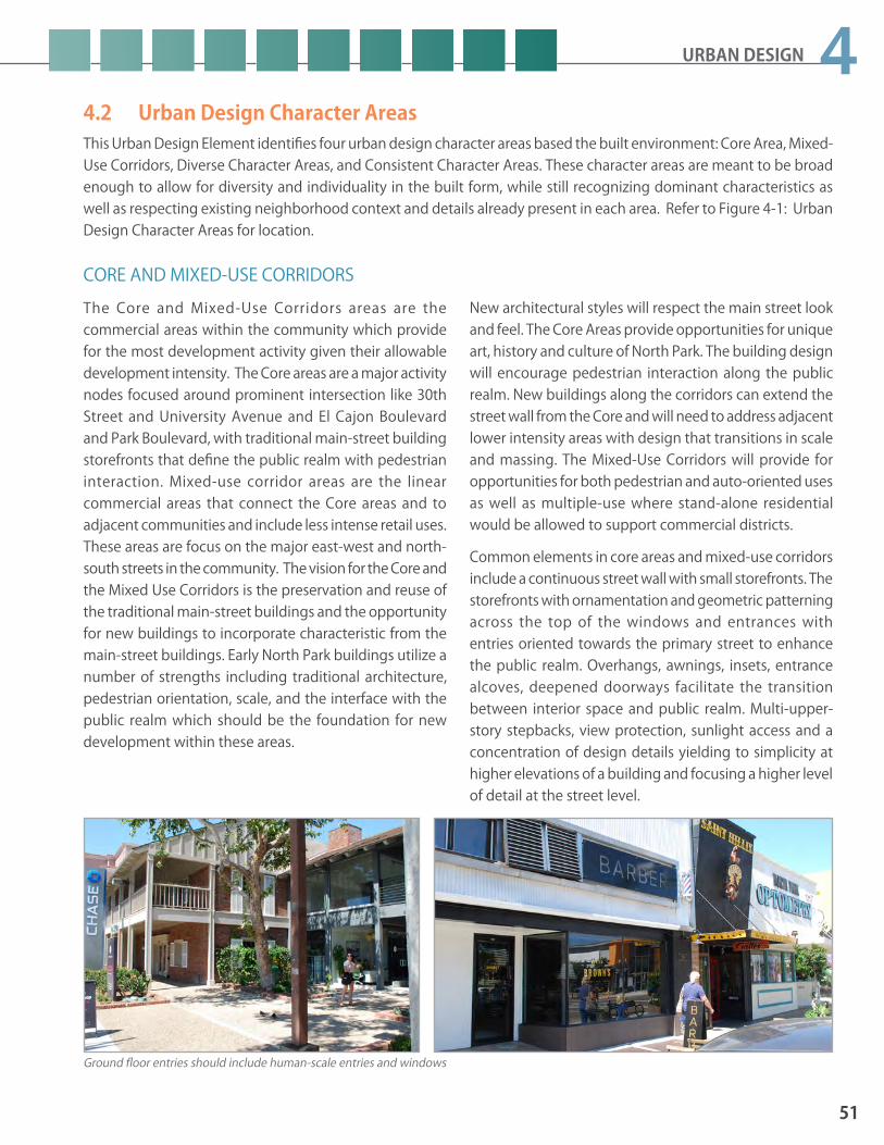
URBAN DESIGN
51
44.2 Urban Design Character Areas
CORE AND MIXED-USE CORRIDORS The Core and Mixed-Use Corridors areas are the commercial areas within the community which provide for the most development activity given their allowable development intensity. The Core areas are a major activity nodes focused around prominent intersection like 30th Street and University Avenue and El Cajon Boulevard and Park Boulevard, with traditional main-street building storefronts that define the public realm with pedestrian interaction. Mixed-use corridor areas are the linear commercial areas that connect the Core areas and to adjacent communities and include less intense retail uses. These areas are focus on the major east-west and north-south streets in the community. The vision for the Core and the Mixed Use Corridors is the preservation and reuse of the traditional main-street buildings and the opportunity for new buildings to incorporate characteristic from the main-street buildings. Early North Park buildings utilize a number of strengths including traditional architecture, pedestrian orientation, scale, and the interface with the public realm which should be the foundation for new development within these areas.
New architectural styles will respect the main street look and feel. The Core Areas provide opportunities for unique art, history and culture of North Park. The building design will encourage pedestrian interaction along the public realm. New buildings along the corridors can extend the street wall from the Core and will need to address adjacent lower intensity areas with design that transitions in scale and massing. The Mixed-Use Corridors will provide for opportunities for both pedestrian and auto-oriented uses as well as multiple-use where stand-alone residential would be allowed to support commercial districts.
Common elements in core areas and mixed-use corridors include a continuous street wall with small storefronts. The storefronts with ornamentation and geometric patterning across the top of the windows and entrances with entries oriented towards the primary street to enhance the public realm. Overhangs, awnings, insets, entrance alcoves, deepened doorways facilitate the transition between interior space and public realm. Multi-upper-story stepbacks, view protection, sunlight access and a concentration of design details yielding to simplicity at higher elevations of a building and focusing a higher level of detail at the street level.
Ground floor entries should include human-scale entries and windows
This Urban Design Element identifies four urban design character areas based the built environment: Core Area, Mixed-Use Corridors, Diverse Character Areas, and Consistent Character Areas. These character areas are meant to be broad enough to allow for diversity and individuality in the built form, while still recognizing dominant characteristics as well as respecting existing neighborhood context and details already present in each area. Refer to Figure 4-1: Urban Design Character Areas for location.

52
NORTH PARK COMMUNITY PLAN UPDATE PUBLIC REVIEW DRAFT June 2015
Figure 4-1: Urban Design Character Areas

URBAN DESIGN
53
4POLICIESUE1.1 Locate building frontages at the property
line to create a street wall.UE1.2 Design buildings to be compatible in scale,
massing, and style with any adjacent older character defining buildings.
UE1.3 Design visible elevations with consistent architectural detail, articulation and design elements.
UE1.4 Incorporate and utilize quality building ma-terials, textures, and detailing to emphasize features of the building such as entries, cor-ners, and walkways and add overall interest to building facades.a. Use non-reflective window coatings.b. Incorporate traditional storefront elements
in new and contemporary commercial buildings by including a solid base for storefront windows. Use high quality durable materials such as smooth stucco, masonry, or stone for the window base.
UE1.5 Incorporate changes in building material, colors, awning treatments, and offsetting planes reduce building mass to a pedestrian scale.
UE1.6 Incorporate natural features and landscaped spaces into developments to provide a sense of openness, continuity and to enhance the environment of the community.
UE1.7 Encourage and incorporate a design theme within Park Boulevard and Adams Avenue commercial node based on the relationship with the nearby Trolley Barn Park and the existing historical features to enhance and upgrade the Park Boulevard and Adams Avenue commercial node.
UE1.8 Preserve and encourage the enhancement of the Adams Avenue “Antique Row” and commercial node.
UE1.9 Provide improvements such as public art, monuments, decorative signage to enhance the entryway into North Park on Adams Avenue.
Craftsman architecture is a common character defining style of North Park’s residential single family neighborhoods.
Articulating building elevations with various textures, window arrangements, and other architectural features adds interest and helps to diminsh apparent scale.
Outdoor seating and sidewalk cafes should be incorporated while providing adequate pedestrian access along the sidewalk.
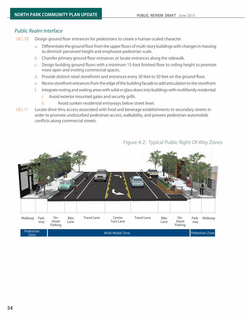
54
NORTH PARK COMMUNITY PLAN UPDATE PUBLIC REVIEW DRAFT June 2015
Public Realm InterfaceUE1.10 Design ground floor entrances for pedestrians to create a human-scaled character.
a. Differentiate the ground floor from the upper floors of multi-story buildings with changes in massing to diminish perceived height and emphasize pedestrian scale.
b. Chamfer primary ground floor entrances or locate entrances along the sidewalk.c. Design building ground floors with a minimum 15-foot finished floor to ceiling height to promote
more open and inviting commercial spaces.d. Provide distinct retail storefronts and entrances every 30 feet to 50 feet on the ground floor. e. Recess storefront entrances from the edge of the building facade to add articulation to the storefront.f. Integrate resting and waiting areas with solid or glass doors into buildings with multifamily residential.
i. Avoid exterior mounted gates and security grills. ii. Avoid sunken residential entryways below street level.
UE1.11 Locate drive-thru access associated with food and beverage establishments to secondary streets in order to promote undisturbed pedestrian access, walkability, and prevent pedestrian-automobile conflicts along commercial streets.
Figure 4-2: Typical Public Right-Of-Way Zones
WalkwayWalkway Park-way
Park-way
On-Street
Parking
On-Street
Parking
Bike Lane
Bike Lane
Travel Lane Travel LaneCenter Turn Lane
Pedestrian Zone Multi-Modal Zone Pedestrian Zone

URBAN DESIGN
55
4Commercial-Residential Use CompatibilityUE1.12 Buffer residential uses at the adjoining prop-
erty line through installation of solid mason-ry walls and landscaping.
UE1.13 Utilize parking levels or rooftops as appropri-ate when locating generators, exhaust vents, trash enclosures and other service equip-ment.
UE1.14 Contain and vent exhaust fumes associat-ed with odor-generating uses away from adjacent residential uses as well as pedes-trian areas such as sidewalks and plazas. For mixed-use buildings, exhaust vents should be located below the fourth floor and should be directed away from operable windows, air vents and balconies within the building.
UE1.15 Utilize plantings to form “green” walls and screens between buildings and adjacent properties.
ParkingUE1.16 Encourage the consolidation, removal, and
or relocation of driveways and curb-cuts from mixed-use corridors.
UE1.17 Maintain existing alleys for access. UE1.18 Design commercial parking areas to mini-
mize impact on the public realm.a. Encourage automobile parking below
grade. b. Screen surface parking lots and parking
structures with buildings from the primary street frontage and provide access from side streets or alleys.
c. Consider public art to add articulation to the building facades of above ground parking structures to minimize bulk and scale from secondary streets.
Outdoor seating areas activate the public realm.
Incorporate pedestrian-oriented, glare-free lighting.
Use parkways to capture runoff.

56
NORTH PARK COMMUNITY PLAN UPDATE PUBLIC REVIEW DRAFT June 2015
DIVERSE CHARACTER AREASBuildings from the 1960s to 1980s were not especially sensitive to design treatments or the character of North Park. Much of the original character is no longer dominant and consistent in these areas. The existing character has resulted from diverse changes in scale, style, form and building materials that are in contrast with neighborhood origins. The vision of the diverse character areas focuses on preserving what remains of the traditional architectural and design themes and details within these neighborhoods, and the redesign or replacement of buildings from the 1960s to the 1980s with buildings that are consistent with the pedestrian orientation and scale of the original design character. Open street facing facades with central courtyards were prevalent throughout North Park and increase the potential for interaction between public and private space. The intent is to provide flexibility in design and encourage innovation.
POLICIESUE1.19 Consider new and unique architectur-
al design while respecting the scale of older buildings.a. Articulate building facades to
provide a human scale in building design, detailing and windows and visual interest.
b. Orient multiple features of a building to the street to provide a visual and physical transition such as main entries, windows, balconies, porches, yards, and patios.
c. Incorporate architectural features in the front yard to create visual transitions between new and existing buildings, such as trellises, wing walls (attached to building), garden walls (free standing), porches, fencing, and arbors.
d. Incorporate multiple windows in the street-facing facade of the building.
e. Utilize entries, arcades, stairs, overhangs, and unique creative building shapes and angles.
f. Consider open street-facing facades with a central courtyard.
g. Create a gradual transition with multiple layers between public realm and private space.
h. Provide consistent landscape coverage with a variety of plant sizes and species.
i. Discourage fencing on the front yard that exceeds three feet in height.
Consistent Character Areas include:Human Scale. Building elements including mass and overall height designed proportionally to a human context.
Orientation to the street. Entries, porches, living rooms, family rooms, and multiple window oriented to the public street.
Transitions between Public and Private Space. Parkways, yards, enclosed patios, stoops, porches, and alcoves that transition the public street to the private interior.
The de-emphasis of vehicular parking. Garages with long driveways to the side and garages at the end of these driveways leading into the alley.
Attention to detail. Design details are expressed in window, door, and exterior finishes. Include windows divided with mullions, sashes, and insets; doors with glass, insets and ornamentation; and exterior cladding with articulation of joints, scoring, overlapping materials, or plaster ornamentation.
Variations in roof forms and building mass. Roof lines that are simple in geometry and silhouette against the sky are common in North Park.
Simple building materials that are mostly wood and stucco with troweled smooth finishes.
A horizontal orientation. Horizontal articulation, multiple side by side window sets, building siding with horizontal lines, window sets that stretch to form a horizontal orientation.

URBAN DESIGN
57
4CONSISTENT CHARACTER AREASA higher level of design quality and detailing was largely consistent from the 1910’s through the 1950’s. Though design and style variations occur even in consistent neighborhoods, these variations are perceived as being part of the same historic period and are typically of the same scale and use of similar materials and design detail. North Park’s Consistent Character Areas contain traditional and historic architectural styles. The most consistently observed styles are California Bungalows, Craftsman and its variations including neoclassical row homes. Other common styles include Spanish Colonial Revival, Mission Revival, and Minimal Traditional. While traditional and historic architectural styles are present throughout North Park, historic residential architecture, in particular, is valued within the Consistent Character Areas. Refer to the Historic Preservation Element. While traditional architectural styles display a great diversity in detailing, they still utilized a common sense of scale to unify neighborhoods blocks.
The vision for the consistent character areas is the maintenance and renovation of defining character buildings. New buildings will need to respect and
enhance the defining character that dominates these neighborhoods. Care must be taken to fit new buildings into the fabric of the existing neighborhoods to ensure that they blend into the existing character. These areas are a series of character defining neighborhoods, each one expressing their pride and history through entry or gateway monument, educational signage and the application of streetscape and lighting improvements that expresses the history of these areas.
New buildings will not replication of any of these historical styles. The community plan envisions and encourages context-sensitive design based on knowledge of traditional structures near new buildings. The plan encourages a compatibility of scale and incorporation of key design elements as a way of relating to traditional architectural styles. New buildings should explore stylistic interpretations of these traditional architectural styles without copying them. Garages and garage doors can influence the character of a structure based on size alone. Careful thought should be given to both garage placement and design to not allow it to dominate the character of the home.
Egyptian RevivalSpanish Colonial Spanish RevivalPrairie Style
Neoclassical RowhomesVictorian California Bungalow Craftsman
The architectural styles shown above are some of the dominant styles in North Park. Single family homes reflect these styles that reference a period of North Park’s development history. New projects should tak ecare to respect the existing character in both single family and multi-family areas.

58
NORTH PARK COMMUNITY PLAN UPDATE PUBLIC REVIEW DRAFT June 2015
POLICIESUE1.20 Design buildings that complement the form
and character of defining buildings on both sides of the same block.a. Articulate building facades to add visual
interest and to break-up the massing.b. Use building materials consistent character
defining buildings.i. Utilize common materials such as
wood, stone, stucco, plaster and clear glass, with clay tile roofs or wood or wood like shingles.
ii. Limit galvanized metal, perforated metals, brick, precision cut block, split face block, masonry units, tinted windows, steel framed windows to accent areas since they are not considered common materials.
c. Use the characteristic window sizing and proportionality.
d. Reduce the visual presence of garages.i. Locate garages along the rear property
line to access from the alley.ii. Locate garages along the side yard
setback at least from the primary building facade with a driveway
iii. Articulate garage doors with a multi-panel design, colors, or varying materials.
iv. The level of detailing and materials used in the garage door should also relate to the main building.
v. Metal, aluminum or vinyl garage doors are not recommended unless they are painted to match other colors of the primary building.
UE1.21 Preserve and retain the single-family char-acter created by small lots along Mission Avenue.
UE1.22 Activate the streetscape and provide sur-veillance of the public realm through the placement of windows, providing main entry access, porches, sitting areas, etc. along the street fronting facade of the building.
UE1.23 Maintain the prevailing front yard setbacks within single-family residential neighbor-hoods that are greater than the required setback of the zone in order to maintain the historical development patterns along streets such as Spruce Street, Dale Street, 28th Street, and Pershing Drive.
UE1.24 Delineate parkways within the public realm with plants, gravel, pavers/bricks, stone or other decorative groundcover while discour-aging the concrete paving.
UE1.25 Preserve and retain the existing single-fami-ly, large lot character of the Panorama Drive Neighborhood as well as the existing palm trees in this area.
UE1.26 Enhance 28th Street as a link from the commercial area along University Avenue to Balboa Park through the maintenance of historically scored sidewalks, the existing palm tree pattern, and/or the consideration of green street-related improvements for treating and filtrating stormwater.
Parking structures should be designed above and/or behind mixed-use and have an aethistic appeal.

URBAN DESIGN
59
4DEVELOPMENT TRANSITIONSIn order to accommodate the development intensity envisioned in the community plan it is essential that new development be sensitively designed so that they transition from higher intensity areas to lower intensity areas. This is most essential where maximum building heights differ greatly between adjacent properties or alleys as a result of zoning. Creating gradual development transitions can be done most successfully through design that addresses setbacks and upper-story stepbacks for the portion of the a building over a certain threshold. Refer to Figure 4-3: Design Transitions Areas for location where development transition policies should be applied.
POLICIESUE1.27 Design buildings to create compatible transi-
tion when they are located adjacent to areas designated at a lower density.
UE1.28 Consider the dominant architectural style of adjacent buildings including roof forms, architectural features, and materials.
UE1.29 Consider the massing, scale, and height of adjacent buildings by using architectural design features to maintain a sense of scale and transition to adjacent buildings with lower heights:a. Dividing the building heights of new
buildings into one and two-story components.
b. Varying the rooflines c. Offsetting wall planes. d. Providing openings, projections, recesses
and other building details.e. Incorporating upper-story step backs
along shared property lines.UE1.30 Design the side and rear elevations of build-
ings with as much quality as the front facade and incorporate windows while respecting the need for light, air and privacy of the adja-cent buildings.
Existing Street Facades & Streetscape
Improved Street Facades & Streetscape
Parking in the front yard overwhelms the sidewalk and requires expansive curb-cuts
Blank facades with no “eyes on the street”
Building lacks a sense of entry
Missing street trees and landscaping
Limited street and project lighting
Remove curb-cuts from building entrances. Incorporate landscaping and lighting at entrances.
Plant street trees and other landscaping to enhance the building street edge
Screen the parking, wherever possible
Introduce permeable surfaces and landscaped parkways
Re-paint the facade to add visual interest
Incorporate window treatments and a change in materials to “soften” the facade
Existing multi-family projects can be retrofitted to better address the public realm and decrease the impact to the sidewalk and walkability of a neighborhood.

60
NORTH PARK COMMUNITY PLAN UPDATE PUBLIC REVIEW DRAFT June 2015
Figure 4-3: Design Transition Areas
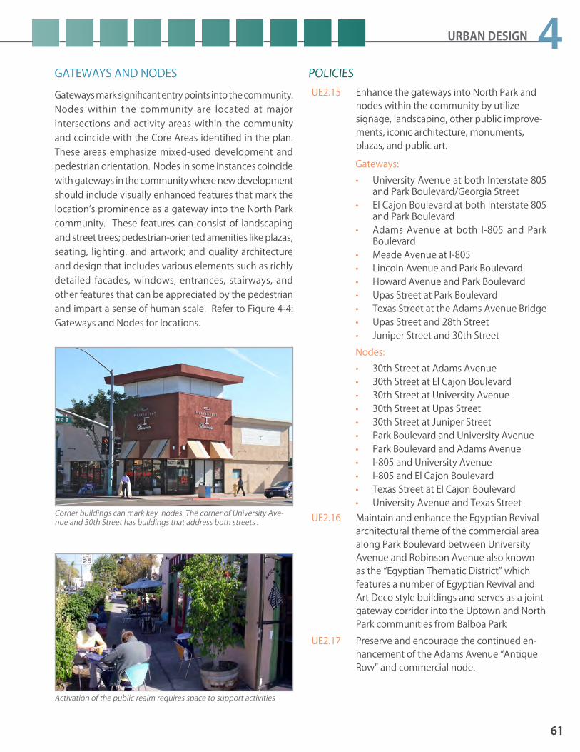
URBAN DESIGN
61
4GATEWAYS AND NODESGateways mark significant entry points into the community. Nodes within the community are located at major intersections and activity areas within the community and coincide with the Core Areas identified in the plan. These areas emphasize mixed-used development and pedestrian orientation. Nodes in some instances coincide with gateways in the community where new development should include visually enhanced features that mark the location’s prominence as a gateway into the North Park community. These features can consist of landscaping and street trees; pedestrian-oriented amenities like plazas, seating, lighting, and artwork; and quality architecture and design that includes various elements such as richly detailed facades, windows, entrances, stairways, and other features that can be appreciated by the pedestrian and impart a sense of human scale. Refer to Figure 4-4: Gateways and Nodes for locations.
POLICIESUE2.15 Enhance the gateways into North Park and
nodes within the community by utilize signage, landscaping, other public improve-ments, iconic architecture, monuments, plazas, and public art.
Gateways: • University Avenue at both Interstate 805
and Park Boulevard/Georgia Street• El Cajon Boulevard at both Interstate 805
and Park Boulevard• Adams Avenue at both I-805 and Park
Boulevard• Meade Avenue at I-805 • Lincoln Avenue and Park Boulevard• Howard Avenue and Park Boulevard • Upas Street at Park Boulevard• Texas Street at the Adams Avenue Bridge• Upas Street and 28th Street• Juniper Street and 30th StreetNodes:• 30th Street at Adams Avenue• 30th Street at El Cajon Boulevard• 30th Street at University Avenue• 30th Street at Upas Street• 30th Street at Juniper Street• Park Boulevard and University Avenue• Park Boulevard and Adams Avenue• I-805 and University Avenue• I-805 and El Cajon Boulevard• Texas Street at El Cajon Boulevard• University Avenue and Texas Street
UE2.16 Maintain and enhance the Egyptian Revival architectural theme of the commercial area along Park Boulevard between University Avenue and Robinson Avenue also known as the “Egyptian Thematic District” which features a number of Egyptian Revival and Art Deco style buildings and serves as a joint gateway corridor into the Uptown and North Park communities from Balboa Park
UE2.17 Preserve and encourage the continued en-hancement of the Adams Avenue “Antique Row” and commercial node.
Corner buildings can mark key nodes. The corner of University Ave-nue and 30th Street has buildings that address both streets .
Activation of the public realm requires space to support activities

62
NORTH PARK COMMUNITY PLAN UPDATE PUBLIC REVIEW DRAFT June 2015
Figure 4-4: Gateways And Nodes

URBAN DESIGN
63
4SUSTAINABLE BUILDING DESIGNSustainable building design is an essential element to reduce energy and resource consumption. North Park can be a model of sustainable development that demonstrates how to build responsibly within the limits of our resources. See also policies contained in the Sustainability and Conservation Element related to sustainable development and natural resource conservation.
UE2.24 Incorporate elements to reduce the use of non-renewable energy such as photovoltaic panels and small low-impact wind turbines.
UE2.25 Incorporate of photovoltaic panels on flat roofs that are discretely located to limit any visibility from the street or glare to adjacent properties.
UE2.26 Encourage recycled, rapidly renewable, and locally sourced materials that reduce im-pacts related to materials extraction, pro-cessing, and transportation.
UE2.27 Incorporate sustainable landscape treat-ments such as artificial turf, drought-toler-ant, and climate-appropriate plant species, planting materials, and light-colored paving materials.
UE2.28 Incorporate storm water capture, retention, and infiltration for landscape irrigation, and lowered runoff by using permeable or po-rous paving materials.
UE2.29 Utilize Sustainability Tools located in Table 8-2 of the Sustainability and Conservation Element as they apply to new development.
POLICIES UE2.18 Incorporate of building features that reduce
water consumption such as water efficient applicants and fixtures.
UE2.19 Incorporate of building features that reduce water consumption such as natural ventila-tion, reduction in solar heat gain, and natural day-lighting.
UE2.20 Incorporate overhead architectural features that provide shade, passive cooling, and reduce daytime heat gain such as eaves, awnings, canopies, trellises, or cornice treat-ments at entrances and windows.
UE2.21 Incorporate inset windows and incorporate well-designed trims and details that consider heat gain and shading.
UE2.22 Incorporate green roofs, gardens, and other vegetated roof systems to help reduce the solar heat gain of building roofs.
UE2.23 Incorporate white or reflective paint on rooftops and light paving materials to reflect heat away from buildings and reduce the need for mechanical cooling.
Sustainable design can include material selection, equipment systems, and passive energy saving techniques such as widened parkway with native plants, large canopy trees that create shade, and permeable surfaces that allow for water capture and filtration.

64
NORTH PARK COMMUNITY PLAN UPDATE PUBLIC REVIEW DRAFT June 2015
URBAN FORESTRYStreet trees are encouraged throughout all areas of North Park. A consistent street tree palette will enhance neighborhood identity, unify corridors, add visual interest, reduce the heat island effect, and provide shade and street tree coverage within the public realm. Consistency of street trees is not imperative on all streets, given existing conditions where there is already a mixture trees. However, the desire is to establish a hierarchy of street based on level of use, size, and function. These policies are used in conjunction with Table 4-2: Street Tree Selection Guide. Figure 4-5: Recommended Street Trees shows street locations and Figure 4-6: Tree Palette Guide shows the recommended street trees species. All other areas should utilize guidance from the City of San Diego Tree Selection matrices based on planting widths and add tree species that already existing in the area. Consistency of street trees is not imperative on all streets, given existing conditions where there is already a mixture trees. However, the desire is to establish a hierarchy of street based on level of use, size, and function.
POLICIES UE2.30 Retain mature and health street trees when
feasible.UE2.31 Utilize street trees to establish a linkage
between blocks.UE2.32 Utilize large canopy street trees where ap-
propriate. UE2.33 Space trees consistently at an interval equal
to provide rhythm and continuity. UE2.34 Plant trees in areas where sufficient root
growth and drainage can be accommodat-ed.
UE2.35 Utilize structural soils over compacted soils, open planters with shrubs and groundcover over tree grates, and deep tree well pits with corner subsurface drainage options over low permeable soil types typical of North Park.
UE2.36 Utilize tree root barriers along walkways in order to minimize sidewalk upheaval.
UE2.37 Create a network of green streets that pro-vides urban greening features that enhance the pedestrian and bicycle environment, storm water management features, and opportunities for additional street trees.
Street trees create a physical barrier between pedestrian areas and vehicular areas.
Trees can create shade and energy savings for homes and a pleasant walking environment.

URBAN DESIGN
65
4Key Street Segment Primary Tree Secondary TreeA University Avenue Park Boulevard to Ray Street Bradford Pear Queen Palm*B University Avenue Ray Street to Boundary Street Chinese Flame Carrot WoodC 30th Street Meade Avenue to Redwood Street Chinese Flame Queen Palm*D 30th Street Redwood Street to Juniper Street Sycamore or London Plane Marina MadroneE El Cajon Boulevard All Eucalyptus JacarandaF Park Boulevard Meade Avenue to Robinson Avenue
Sweet Gum Queen Palm*G Park Boulevard Robinson Avenue to Upas Street Sycamore or London Plane California Bay LaurelH Adams Avenue All Sweet Gum or Cassia Queen Palm*I Dwight Street All Carrot Wood Queen Palm*J Illinois Street All St. Mary’s Magnolia Queen Palm*K Mississippi Street Adams Avenue to Dwight Street Purple Leaf Plum Queen Palm*L Mississippi Street Dwight Street to Upas Street Sycamore or London Plane Western RedbudM North Park Way All Chinese Elm Chinese FlameN Idaho Street Adams Avenue to University Avenue Australian Willow Queen Palm*O Oregon Street Adams Avenue to University Avenue Tipu Tree Queen Palm*P Upas Street Park Boulevard to 31st Street Brisbane Box Queen Palm*Q Boundary Street Redwood Street to University Avenue
Marina Madrone Western RedbudR Boundary Street University Avenue to Adams Avenue Catalina Ironwood Holly OakS Redwood Street Pershing Drive to Boundary Street Coast Live Oak Western Redbud
T Robinson Avenue Park Boulevard to Alabama Street Sycamore or London Plane Western Redbud
U Landis Street Alabama Street to Nile Street Sycamore or London Plane Western Redbud
V Mission Avenue All Torrey Pine SycamoreW Madison Avenue Mission Avenue to Ohio Street Torrey Pine SycamoreX Pershing Avenue All Torrey Pine Toyon* - Note: Existing palm trees are the dominant species in these streets and should not be removed. Infill plantings and secondary plantings should not be palm trees, but other canopy trees as indicated.
Table 4-2: Street Tree Selection Guide

66
NORTH PARK COMMUNITY PLAN UPDATE PUBLIC REVIEW DRAFT June 2015
Lyonothamnus floribundus (Catalina Ironwood)
Magnolia grandiflora (St. Marys Magnolia)
Pinus torreyana (Torrey Pine)
Platanus acerifolia “Bloodgood” (London Plane)
Tipuana tipu (Tipu)
Ulmus parvifolia (Chinese Elm)
Umbellularia californica (California Bay Laurel )
Quercus ilex (Holly Oak)
Quercus agrifolia (Coast live oak)
Pyrus calleryana (Bradford Pear)
Prunus cerasifera (Purple Leaf Plum)
Plantanus racemosa (California Sycamore)
Figure 4-5: Street Tree Palette
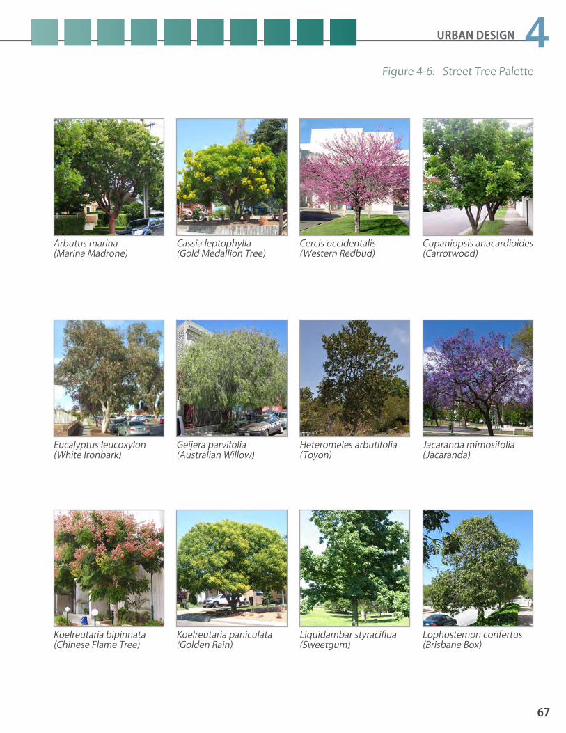
67
4URBAN DESIGN
Arbutus marina(Marina Madrone)
Cassia leptophylla (Gold Medallion Tree)
Cercis occidentalis (Western Redbud)
Cupaniopsis anacardioides (Carrotwood)
Eucalyptus leucoxylon (White Ironbark)
Geijera parvifolia (Australian Willow)
Heteromeles arbutifolia (Toyon)
Jacaranda mimosifolia (Jacaranda)
Koelreutaria bipinnata (Chinese Flame Tree)
Koelreutaria paniculata (Golden Rain)
Lophostemon confertus (Brisbane Box)
Liquidambar styraciflua (Sweetgum)
Figure 4-6: Street Tree Palette
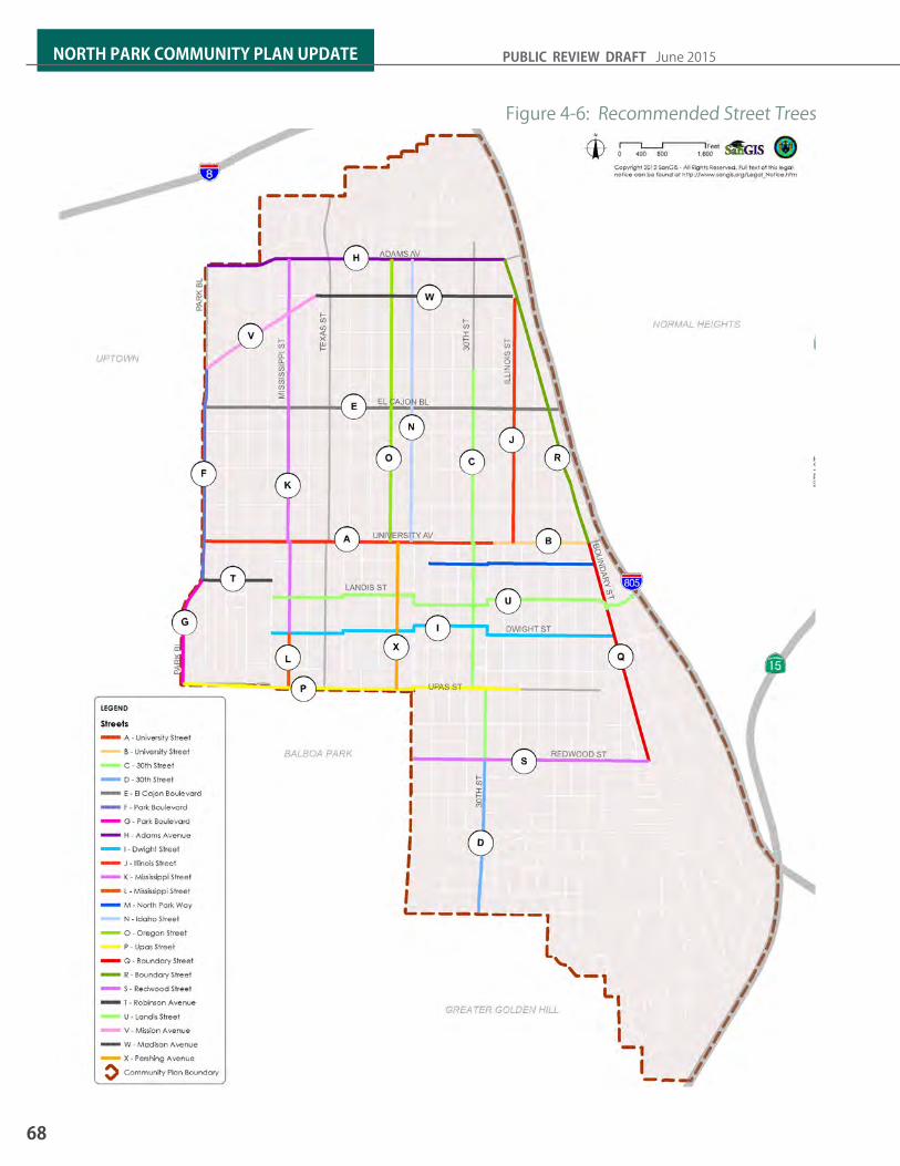
68
NORTH PARK COMMUNITY PLAN UPDATE PUBLIC REVIEW DRAFT June 2015
Figure 4-6: Recommended Street Trees

URBAN DESIGN
69
4CANYONS AND OPEN SPACE PRESERVATIONCanyons providing open space features that shape the community identity and built form. Open space areas provide visual relief within the urbanized environment. Building design will responsive to the community’s unique canyon environment and steep slopes.
POLICIES UE2.1 Maintain the scale and character of the
canyon and hillside neighborhoods and landforms by designing new buildings to minimize bulk and be low-scale.
UE2.2 Maintain views from public vantage points and streets as well as public access to can-yon areas.
UE2.3 Design buildings along the canyon edge to conform to the hillside topography.
a. Provide a setback from top of slope. b. Incorporate landscape screening.c. Design roof pitches to mimic the slope.d. Provide a stepped foundation down the
slope, rather than cantilevering over the canyon to accommodate a reasonable building size for lots with limited flat area.
e. A l i g n v e h i c l e a c c e s s a n d o t h e r improvements to conform to existing slopes and minimize grading.

70
NORTH PARK COMMUNITY PLAN UPDATE PUBLIC REVIEW DRAFT June 2015
Consistent lighting design can incorporate banners and way-finding designed through the public art process.
Widened walkways & street furnishings are an opportunity to incorpo-rate a theme for a business district or retail area.
PUBLIC ART AND CULTURAL AMENITIESPromoting public art and celebrating artistic culture are widely acknowledged facets of North Park’s community identity. Within the community’s commercial environment, the emphasis on art and culture can be seen in murals, art installations, in galleries, public events, and as a result of the growth in the local craft food and beverage establishments. The infusion of art and culture within the urban environment has created exciting and interesting places in the community and has contributed to North Park’s attraction as a destination. See also policies located in the Arts and Culture Element.
POLICIES UE2.4 Provide and incorporate places, spaces, care-
fully planned details, and genuine building materials to craft valuable and interesting experiences for people walking through new developments, public streets, and civic spaces.
UE2.5 Design public art installations as works on permanent and/or temporary display with extensive communication about art to those experiencing the installation.
UE2.6 Cultivate North Park’s craft food and bever-age cultural.
UE2.7 Encourage new development to contribute public art to serve as an interface between art, buildings, parking structures, spaces, people, and culture such as the incorpora-tion of monuments, sculptures, fountains, building details and artful decorations to communicate beauty, monumentality, re-membrance, and celebration.
UE2.8 Provide for new art opportunities on Ray Street by providing spaces for temporary and permanent public art as a part of all new developments along the commercial por-tions of the street.

5ECONOMIC PROSPERITY
5.1 COMMERCIAL BUSINESS DISTRICTS5.2 COMMUNITY REVITALIZATION

72
NORTH PARK COMMUNITY PLAN UPDATE PUBLIC REVIEW DRAFT June 2015
NORTH PARK 2012• Commercial businesses employed nearly
5,800 people within North Park. • Nearly 400 workers were government
employees. • An estimated 2,500 persons were self-
employed • Nearly 490,000 square feet of office space
exists. • Over 1.8 million square feet of retail space
exists. • A very limited amount of flex and light
industrial space, at 63,000 square feet exists.
Introduction North Park promotes small businesses, supports arts, culture, entertainment and services in its commercial districts. The community continues to create pedestrian-friendly destinations for shopping, dining, entertainment and local services for North Park residents and visitors. The history of North Park also figures prominently into the community’s vision for its commercial districts. improving neighborhood economic conditions and the physical infrastructure of North Park is a part of the community’s vision.
Economic Prosperity Element Goals1. Successful, home-grown arts and culture, and entertainment\hospitality districts which appeal to
both residents and tourists.
2. Infill development, including mixed use (where appropriate) for the purposes of increasing employment opportunities in village centers.
3. Diverse mix of business types to support day time and night time activities.
4. Unique, pedestrian-oriented commercial districts reflective of their history.
5. Regional reputation as an affordable location for creative business, knowledge based industries and the green economy.
6. Vibrant neighborhood commercial districts where the residents purchase a significant share of their basic needs and services from within the community.
7. Enhancement of commercial districts appearance and upgraded infrastructure for associated commercial districts.
8. Increase awareness of North Park’s funding needs for successful local economic development and revitalization actions.
9. Social equity and social justice to be included in economic prosperity and community revitalization policies.

ECONOMIC PROSPERITY
73
55.1 Commercial Business DistrictsCommercial activity in North Park tends to be greatest at key nodes or intersections, such as Park Boulevard and Adams Avenue; major intersections along 30th Street at Adams Avenue, El Cajon Boulevard, University Avenue, and Upas Street; and, at El Cajon Boulevard at Park Boulevard and Texas Street. Commercial activity dominates corridors between these nodes, especially on El Cajon Boulevard, University Avenue, 30th Street, and to a lesser extent Adams Avenue and Park Boulevard.
Most of North Park’s commercial districts are distinct compared with conventional shopping centers because of the unique offerings and pedestrian-orientation. However, El Cajon Boulevard is distinct from North Park’s other districts. While El Cajon Boulevard can be as pedestrian-oriented as other grand commercial boulevards, it also has a tradition of auto-orientation associated with its historical role, traffic volume capacity, and larger lots.
El Cajon Boulevard, from Florida to Texas, has emerged as a concentration of ethnic restaurants and the Lafayette Hotel has undergone renovation to restore its reputation as a visitor and regional event destination. University Avenue and 30th Street business district has a concentration of restaurants and nightlife activities. Adams Avenue also has many diverse restaurants and nightlife activates.
Smaller professional service firms are attracted to North Park because of its emergence as a community for creativity, its amenities, diversity, affordable rent, and centrality in the region. North Park’s monthly office lease rates are 80 percent of the City’s average lease rates; this affordability is one reason for North Park’s low vacancy rates. The North Park office inventory is a small share of the regional market, which provides a limited foundation for business and professional services in the community.
Given North Park’s emerging business orientation towards smaller independent boutique service businesses and retail, and given continued regional competition, the amount of commercial land along these corridors may exceed demand, especially further away from activity nodes.
El Cajon Boulevard is a historic and major commercial-transit corridor that spans across North Park and the Mid-City communities.
The North Park community has the benefit of having four business district organizations looking after the success of its commercial areas.
NORTH PARK 2030• Employment is estimated to grow by 17%
adding over 1,400 jobs.• Industry sectors which are expected to
experience growth include health services, leisure and hospitality, professional and business services, retail trade, finance and real estate, and government.
• Industry sectors that are estimated to exper ience contract ion include manufacturing, wholesale trade, information services, agriculture and mining, and other personal services.

74
NORTH PARK COMMUNITY PLAN UPDATE PUBLIC REVIEW DRAFT June 2015
The University Heights – Park Boulevard Business District is shared by both the North Park and Uptown communities.
The Adams Avenue Business Improvement District which runs through Normal Heights, Kensington, Antique Row, and University Heights annually plays host to the Adams Avenue Street Fair and Adams Avenue Unplugged which are the City’s largest free music festivals.
In addition to housing, additional office space could help support the community’s commercial districts by increasing the number of employees and consumers in the community.
Despite the great amount of retail space in North Park, residents are currently doing much of their shopping outside the community. While conventional retail outlets have struggled, North Park’s diverse population has generated demand for unique food and retail outlets that serve their tastes. The reduction in North Park’s sales has been mostly in food stores, packaged liquor, autos, apparel, and other conventional retail outlets, such as, those selling furniture, appliances, household fixtures, electronics and general merchandise.
From 1990 to 2012, taxable retail sales in North Park fell by approximately 8 percent compared to a Citywide increase of 18 percent in taxable retail sales during this period. The largest drop in sales was for food stores. Estimated taxable sales generated by bars and restaurants did grow by 74 percent in the past two decades. These bars and restaurants generated 28 percent of all 2012 taxable sales in North Park, compared to 17 percent of all City restaurants and bars taxable sales during this same period.
An opportunity exists to recapture some of the retail trade in North Park. Despite the contraction in sales during the last two decades, the buying power will rise as North Park grows its local market. The expected increase in North Park’s population and the other central communities’ will generate future support for general neighborhood retail services, such as grocers.
Additional buying power in the existing commercial districts and corridors can also be enhanced with mixed use development within the neighborhood village centers. It is more important to have a mixture of uses within a defined walkable area than to require every building to be mixed.
Given the amount of land in North Park along the commercial corridors, some properties in locations along these corridors could be put to uses other than retail. Other uses such as housing and office would help support more concentrated commercial districts and existing retail, providing an increase in consumers and buying power nearby. In these commercial areas, retail can be an optional use, particularly along portions of the corridors that are not near the higher-activity commercial nodes or intersections.

ECONOMIC PROSPERITY
75
5POLICIES EP-1.1 Identify and implement nationally recog-
nized best practices that promote an in-clusive approach to addressing the needs of both hospitality businesses and nearby residents (e.g. patron and business person-al behavioral issues, accountability, and enforcement, noise and trash management, cigarette and food packaging litter, parking issues, public restroom access).
EP-1.2 Ensure clean and safe business environ-ments that attract pedestrian traffic and local investment (e.g. graffiti prevention/removal, safe sidewalks that are ADA compli-ant and encourage side walk cafes, sidewalk cleaning and safety ambassadors.)
EP-1.3 Concentrate commercial activity in the vicin-ity of mixed use corridor intersections, with pedestrian orientation to distinguish the nodes and Adams Avenue and 30th Street, University Avenue and 30th Street, and Uni-versity Avenue and Upas Street.
EP-1.4 Encourage mixed use development shop-keeper units, to attract residents to the core commercial areas, where appropriate.
EP-1.5 Promote development of physical space such as shopkeeper units, co-work spac-es, and business incubators that supports targeted commercial uses and start-up and entrepreneurial enterprises.
EP-1.6 Activate alleys in the commercial mixed-use areas to improve aesthetics and safety by improving urban design and allowing com-mercial shop and service activities.
EP-1.7 Consider allowing shared parking for mixed use new commercial developments that are within identified village centers
EP-1.8 Support the North Park Business Improve-ment District association’s efforts to promote the use of the North Park public garage, including the addition of signage to make visitors to this commercial district aware of this parking facility.
EP-1.9 Encourage the Business Improvement District associations to consider a North Park and Business Improvement Districts’ “branding strategies” and signage to market the respective commercial districts, while respecting each district’s unique character.
EP-1.10 Position and promote North Park for smaller, independent professional business service firms associated with knowledge based businesses and creative and sustainable industries.
EP-1.11 Attract and support quality sit-down restau-rants that appeal to a broad range of demo-graphics including young families.
EP-1.12 Attract and support destination restaurants that draw consumers from outside the com-munity.
EP-1.13 Recapture a greater share of local North Park residents’ expenditures with improved basic retail and personal services, as well as promotional efforts.
EP-1.14 Introduce more diversified housing choic-es and mixture of incomes to enhance the buying power within North Park, particularly between University Avenue and El Cajon Boulevard.
EP-1.15 Improve the pedestrian, bicycle, and transit infrastructure in North Park’s commercial districts to position it as one of the most sus-tainable districts in San Diego, and promote this attribute to compete regionally.
EP-1.16 Support the installation and maintenance of high-quality streets and sidewalks, well-land-scaped medians and parkways, enhanced pedestrian crossings, pedestrian-oriented and historically sensitive lighting, creative streetscaping amenities (e.g. street furniture, planters, public art) and street signage.

76
NORTH PARK COMMUNITY PLAN UPDATE PUBLIC REVIEW DRAFT June 2015
5.2 Community RevitalizationNorth Park’s many businesses are known to produce what they sell, whether it’s food, arts and culture, hospitality entertainment, or services. North Park has repositioned itself in the regional market and capturing a dedicated share of the local market. Private and public investment in historic landmarks, such as the North Park Theater on University Avenue and the Lafayette Hotel on El Cajon Boulevard, are recreating anchors of performing arts and leisure and hospitality businesses. With efforts in the community such as the Sustainable North Park Main Street Program and North Park Eco District, which emphasize resource conservation and efficiency, North Park is emerging as a center for sustainability and a setting for the green economy.
North Park has a reputation as an Arts, Culture, and Entertainment District, organically evolving from Ray Street, in no small part due to the efforts of local community organizations. In addition, North Park, due to its proximity, may even be able to capture some of San Diego’s visitor trade in Downtown and Balboa Park if transportation links are enhanced.
Community dedication to quality of life in North Park is demonstrated by the different self-assessments which residents, property owners and business owners have approved for their community. The Business Improvement District associations and Maintenance Assessment District funds continue to be invested in the north park community to revitalize the area and increase economic prosperity. See figure 5-1: Business Improvement and Maintenance Assessment Districts. These districts are a funding mechanism for services to the area above-and-beyond the city’s general benefit services. The business improvement district associations sponsored events which spotlight the community character of their district. The historic districts and main street designation continue to preserve neighborhood character.
The City’s Economic Development Department and Planning Department will continue to work with the residents, community and business organizations in North Park for continued successful revitalization.
Maintaining the efforts and existing revitalization tools listed below, in addition to seeking additional economic development tools, within the pedestrian-oriented commercial and mixed use nodes, will enhance and create competitive commercial destinations.
Street trees and landscaping can be a major economic generator for commercial districts by attracting pedestrians.
The growth and popularity of North Park’s art, culture, and entertain-ment district has been major a contributing factor in North Park’s revitalization.

ECONOMIC PROSPERITY
77
5Figure 5-1: Business Improvement and Maintenance Assessment Districts
?àE
North Park BIDNorth Park BID
El Cajon BoulevardEl Cajon BoulevardGateway BIDGateway BID
Adams Avenue BIDAdams Avenue BID
BALBOA PARK
GREATER GOLDEN HILL
NORMAL HEIGHTS
UPTOWN
%&s(
!"_$PA
RK
BL
ADAMS AV
TEX
AS
ST
30TH
ST
PAR
K B
L
UNIVERSITY AV
30TH
ST
UPAS ST
EL CAJON BL
Adams AvenueDistrict
Adams AvenueDistrict
Adams AvenueDistrict
North ParkDistrict
UniversityHeightsDistrict
Copyright 2012 SanGIS - All Rights Reserved. Full text of this legalnotice can be found at http://www.sangis.org/Legal_Notice.htm
0 800 1,600400Feeto
LEGEND
Maintenance Assessment DistrictsAdams Avenue
North Park
University Heights
Business Improvement DistrictsBusiness Improvement Districts within Greater North Park
Community Plan Boundary

78
NORTH PARK COMMUNITY PLAN UPDATE PUBLIC REVIEW DRAFT June 2015
PUBLIC ART Support the inclusion of art or cultural uses in private development projects within the community. Encourage North Park’s business associations to participate in the development and implementation of a North Park Art Master Plan, which includes public art as a commercial revitalization tool. Refer to the Arts and Culture Element.
URBAN FORESTRYExpand the urban forest in North Park in hopes of improving the walkability and quality of life.
NATIONAL MAIN STREET ORGANIZATIONSOrganizations may be designated as Main Street organizations. Main Street use the preservation-based Main Street Four-Point Approach which supports small independent business owners through revitalization efforts by leveraging local assets - historic, cultural, architectural and community pride. The North Park Organization of Businesses received a Main Street designation in 1996 and thus uses the DBA of North Park Main Street.
SMALL BUSINESS ASSISTANCE Public\Private partnerships to facilitate access to small business financial assistance programs and other support resources.
STOREFRONT IMPROVEMENT PROGRAM (SIP)The City’s SIP assists small business owners in revitalizing building facades through design assistance and financial incentives. Many North Park businesses have used this Program.
MAINTENANCE ASSESSMENT DISTRICTS (MAD)MADs are established by the City as property-based special assessment districts. Adoption of a MAD provides property owners with the opportunity to self-assess to pay for improvements, maintenance, services and activities beyond those general benefits provided by the City. North Park has an active MAD. Refer to PFSSE.
BUSINESS IMPROVEMENT DISTRICTS (BID)BIDs are geographic areas, established by the City, where the businesses have voted to self-assess, to fund activities and services, which promote the business district. These activities and services are above-and-beyond general benefit City services. Three BIDs are located in North Park, the Adams Avenue BID (which continues into Mid-City), El Cajon Gateway BID and North Park BID.
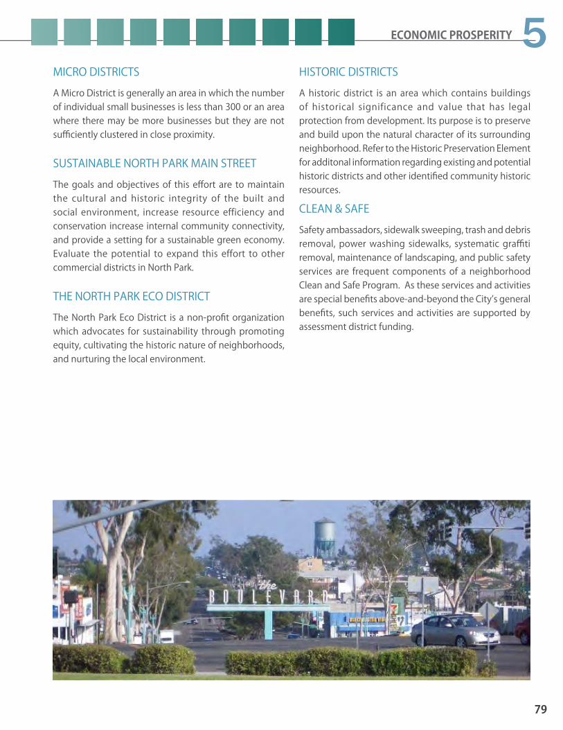
ECONOMIC PROSPERITY
79
5MICRO DISTRICTSA Micro District is generally an area in which the number of individual small businesses is less than 300 or an area where there may be more businesses but they are not sufficiently clustered in close proximity.
SUSTAINABLE NORTH PARK MAIN STREETThe goals and objectives of this effort are to maintain the cultural and historic integrity of the built and social environment, increase resource efficiency and conservation increase internal community connectivity, and provide a setting for a sustainable green economy. Evaluate the potential to expand this effort to other commercial districts in North Park.
THE NORTH PARK ECO DISTRICTThe North Park Eco District is a non-profit organization which advocates for sustainability through promoting equity, cultivating the historic nature of neighborhoods, and nurturing the local environment.
HISTORIC DISTRICTSA historic district is an area which contains buildings of historical significance and value that has legal protection from development. Its purpose is to preserve and build upon the natural character of its surrounding neighborhood. Refer to the Historic Preservation Element for additonal information regarding existing and potential historic districts and other identified community historic resources.
CLEAN & SAFESafety ambassadors, sidewalk sweeping, trash and debris removal, power washing sidewalks, systematic graffiti removal, maintenance of landscaping, and public safety services are frequent components of a neighborhood Clean and Safe Program. As these services and activities are special benefits above-and-beyond the City’s general benefits, such services and activities are supported by assessment district funding.

80
NORTH PARK COMMUNITY PLAN UPDATE PUBLIC REVIEW DRAFT June 2015
POLICIES EP-2.1 Position and expand North Park’s arts district
on Ray Street to attract regional patrons with continued events and promotions, including the development of the North Park Theater to accommodate special events.
EP-2.2 Market the Downtown and Balboa Park visitor trade and improve convenient trans-portation linkages from those destinations to North Park, including a potential street car linkage.
EP-2.3 Improve the gateway to North Park on Uni-versity Avenue from Park Boulevard and In-terstate 805 with streetscape improvements and concentrated redevelopment.
EP-2.4 Consider a Micro Assessment District for 30th Street businesses located in North Park and Golden Hill to support, dining, the arts, and entertainment along this commercial corridor.
EP-2.5 Promote the development of attractive and unique gathering spaces, such as mini-parks, pocket parks, parklets, interior and exterior plazas which include public art and visi-tor-friendly seating areas, as appropriate.
EP-2.6 Encourage the Business Improvement District associations to develop a communi-ty-based North Park Economic Development Strategy building upon the City’s recently adopted Economic Development Strategy.
EP-2.7 Encourage the Business Improvement Dis-trict associations to develop and implement a Business Targeting and Attraction Strategy.
EP-2.8 Support the Business Improvement District associations’ efforts to identify new funding sources for local economic development and revitalization efforts in North Park.
EP-2.9 Work with the Business Improvement Dis-trict associations to strengthen the connec-tions between the northern and southern commercial districts in North Park.
EP-2.10 Continue to expedite the implementation of the University Mobility Plan (and future like projects) to lessen traffic congestion, encour-age use of public transit, improve parking conditions and provide pedestrian friendly streetscape.
EP-2.11 Utilize economic development tools and programs to attract and retain small busi-nesses, through the maintenance and enhancement of commercial areas.
Parklets are an innovative way to transform parking into unique gathering spaces within commercial districts. The City’s first parklet is located at 30th Street and University Avenue.
Older buildings can be retrofitted to create new indoor - outdoor experiences.
66.1 PUBLIC FACILITIES & SERVICES6.2 HEALTH & SAFETY
PUBLIC FACILITIES SERVICES & SAFETY

82
NORTH PARK COMMUNITY PLAN UPDATE PUBLIC REVIEW DRAFT June 2015
General Plan-Related Topics
Policies
Public Facilities Financing PF-A.2Public Facilities and Service Prioritization PF-B.3
Evaluation of Growth, Facilities, and Services PF-C.1 & PF-C.3
Water Infrastructure PF-H.3.cLibraries PF-J.3 & PF-J.5Schools PF-K.6 & PF-K.9
Table 6-1: General Plan-Related Public Facilities Topics and Policies
KEY GENERAL PLAN POLICIESThe North Park Community Plan Public Facilities, Services & Safety Element further the policies contained in the General Plan. Policies related to this element involve pursuing diverse funding sources for new facilities, considering development’s impact on addressing public facility needs as well as continuing to pursue joint use opportunities for shared facilities with the School District. The General Plan is an overarching document with goals and policies that apply broadly to all of the City’s community planning areas, these broad policies remain in the General Plan, but are listed on Table 6-1 as reference in this plan to avoid redundancy.
IntroductionThe General Plan provides a comprehensive discussion of public facilities, services and safety. This community plan addresses priorities for improved public service delivery within the community and identifies potential characteristics for facility expansion. The emphasis of the Public Facilities, Services and Safety Element is to identify existing facilities and services and address the capacity and needs for future services. The element specifically addresses public facilities needs and prioritization, policies related to fire-rescue, police, stormwater, water and sewer infrastructure, waste management, libraries, schools, parks, public utilities, and health and safety. Public facilities and services are also discussed within other elements such as the recreation element which specifically addresses population-based parks and recreation facilities needs.
As an older, urbanized community, North Park is often faced with infrastructure and facilities that do not meet current standards. The remaining service life and maintenance needs of aging infrastructure is a persistent issue in an older community. Therefore, meeting the community’s future public facilities needs should focus on expansion of existing facilities or re-use of existing buildings within the community suitable for this purpose. To better accommodate the sharing of facilities located within adjacent communities such as libraries, improved transit and bicycle access should be provided to facilities nearby, particularly those within Downtown and Balboa Park.
Public Facilities, Services & Safety Goals
1. A high level of sustainable public facilities and services to meet the diverse needs of the community
2. Public facilities that are located near one another to improve access and to take advantage of interconnecting public uses
3. Incentives to provide privately funded facilities for public use
4. Public facilities sized proportionately to the density of the community population
5. Timely maintenance, repair and replacement when needed to maintain or improve the serviceability of the community’s older infrastructure.

PUBLIC FACILITIES, SERVICES & SAFETY
83
66.1 Public Facilities & Services
PUBLIC FACILITY NEEDS & PRIORITIZATION As an urbanized community, North Park, is faced with aging infrastructure and facilities that need to be maintained and upgraded to meet current standards. Figure 6.1 illustrates where current facilities exist and identifies sites for future facilities. The City’s two main funding sources for providing and improving facilities include Development Impact Fees (DIF) and the General Fund. DIF collects a proportional fair share of capital improvements needed to offset the impact of development. The General Fund is relied on for facility improvement and upgrades and operational and maintenance costs.
Development Impact Fees and the General Fund have helped to alleviated growing facilities needs, but a deficit remains leaving the City and community with the challenge to find alternative means of funding public improvements.
To address limited funding for annual capital improvements, the City has instituted a prioritization and ranking strategy that integrates community input. This effort allows the City to strategize funding and be more responsive to the community’s facility and infrastructure priorities. Although the City is making incremental changes in how Capital Improvement Program (CIP) projects are funded to provide more timely improvements, the unfortunate reality is there remains an existing facilities and infrastructure deficit in North Park. There are a number of obstacles in alleviating the infrastructure deficit, including, the increased costs in acquisition and construction, lack of available land, and funding constraints and competing needs. It is up to the City and the community of North Park to work together, to find creative solutions for meeting facility and infrastructure needs, and ultimately improve the quality of life. Solutions such as clustering facilities, land value recapture, providing broader community serving facilities, offering equivalences, seeking City wide or regional initiatives for new sources of revenue, and exploring public-private opportunities are just some ways that may make it possible to accommodate new facilities for the next generation.
Fire Station 14 located at 32nd Street and Lincoln Avenue provides fire and life safety service to the North Park community.
The North Park Library located 31st Street and North Park Way is one of two libraries serving residents within the North Park community.
The North Park community is served by the Mid-City Neighborhood Division of the Police Department.

84
NORTH PARK COMMUNITY PLAN UPDATE PUBLIC REVIEW DRAFT June 2015
Figure 6-1: Existing and Proposed Pubic Facilities
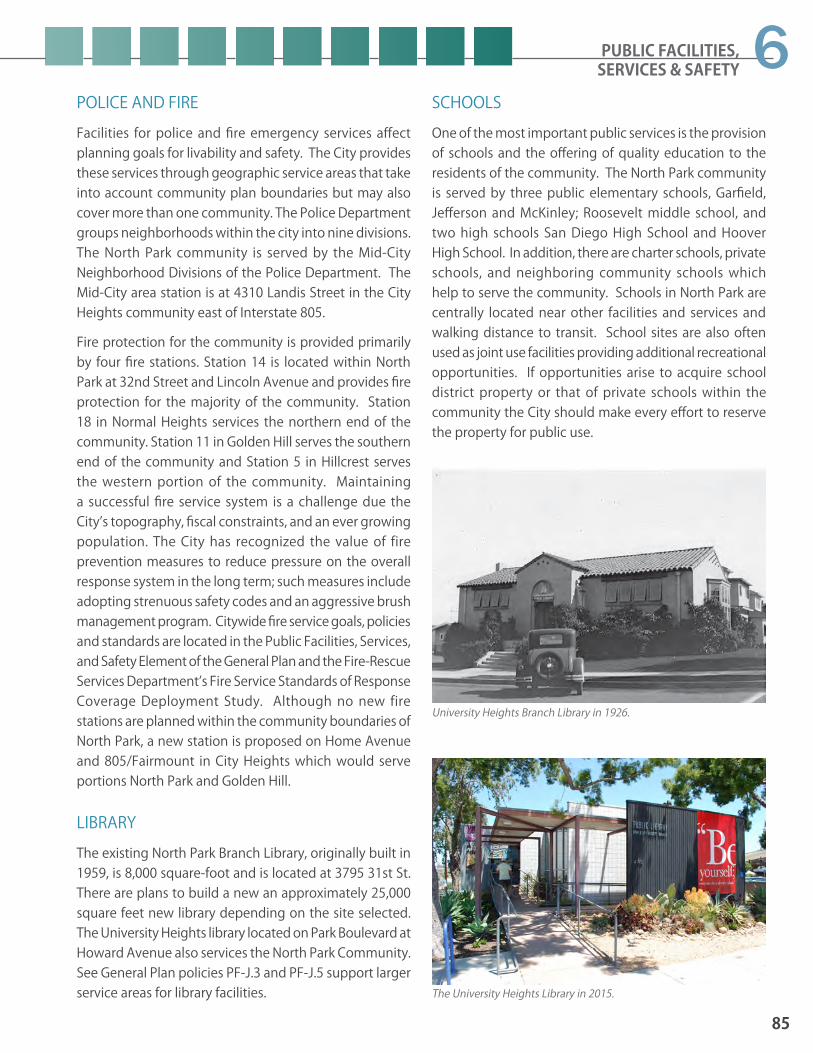
PUBLIC FACILITIES, SERVICES & SAFETY
85
6POLICE AND FIREFacilities for police and fire emergency services affect planning goals for livability and safety. The City provides these services through geographic service areas that take into account community plan boundaries but may also cover more than one community. The Police Department groups neighborhoods within the city into nine divisions. The North Park community is served by the Mid-City Neighborhood Divisions of the Police Department. The Mid-City area station is at 4310 Landis Street in the City Heights community east of Interstate 805.
Fire protection for the community is provided primarily by four fire stations. Station 14 is located within North Park at 32nd Street and Lincoln Avenue and provides fire protection for the majority of the community. Station 18 in Normal Heights services the northern end of the community. Station 11 in Golden Hill serves the southern end of the community and Station 5 in Hillcrest serves the western portion of the community. Maintaining a successful fire service system is a challenge due the City’s topography, fiscal constraints, and an ever growing population. The City has recognized the value of fire prevention measures to reduce pressure on the overall response system in the long term; such measures include adopting strenuous safety codes and an aggressive brush management program. Citywide fire service goals, policies and standards are located in the Public Facilities, Services, and Safety Element of the General Plan and the Fire-Rescue Services Department’s Fire Service Standards of Response Coverage Deployment Study. Although no new fire stations are planned within the community boundaries of North Park, a new station is proposed on Home Avenue and 805/Fairmount in City Heights which would serve portions North Park and Golden Hill.
LIBRARYThe existing North Park Branch Library, originally built in 1959, is 8,000 square-foot and is located at 3795 31st St. There are plans to build a new an approximately 25,000 square feet new library depending on the site selected. The University Heights library located on Park Boulevard at Howard Avenue also services the North Park Community. See General Plan policies PF-J.3 and PF-J.5 support larger service areas for library facilities.
SCHOOLSOne of the most important public services is the provision of schools and the offering of quality education to the residents of the community. The North Park community is served by three public elementary schools, Garfield, Jefferson and McKinley; Roosevelt middle school, and two high schools San Diego High School and Hoover High School. In addition, there are charter schools, private schools, and neighboring community schools which help to serve the community. Schools in North Park are centrally located near other facilities and services and walking distance to transit. School sites are also often used as joint use facilities providing additional recreational opportunities. If opportunities arise to acquire school district property or that of private schools within the community the City should make every effort to reserve the property for public use.
University Heights Branch Library in 1926.
The University Heights Library in 2015.

86
NORTH PARK COMMUNITY PLAN UPDATE PUBLIC REVIEW DRAFT June 2015
PUBLIC UTILITIES AND UNDERGROUND UTILITIESGas and electricity are provided by the San Diego Gas & Electric Company and several gas and electric lines traverse the area. San Diego Gas and Electric Company has a number of programs related to conservation, including commercial and residential energy audits, low interest loan programs for energy conservation, retrofit installations and rebates for solar water heaters. The City is actively involved in undergrounding of existing overhead power lines.
MAINTENANCE ASSESSMENT DISTRICT AND PROPERTY AND BUSINESS IMPROVEMENT DISTRICTMaintenance Assessment District (MAD) is a tool property owners use to assess themselves to receive enhanced maintenance, landscaping, and lighting services. These services are above and beyond the City’s baseline general services.
A Property and Business Improvement District (PBID) is a tool available to property and business owners to improve a commercial area and is a special benefit assessment district designed to raise funds within a specific geographic area. Funds may be raised through a special assessment on real property, businesses, or a combination of both, and are used to provide supplemental services beyond those provided by the city.
OVERHEAD UTILITIES AND STREETLIGHTS Although community undergrounding projects are underway, electricity is largely carried in overhead wires along many streets in the community resulting in negative visual conditions. The City has formally adopted a policy for the undergrounding of overhead utility lines to protect public health, safety, and general welfare. This community plan reinforces Citywide efforts to place utility lines underground.
Portions of the community lack adequate street lighting. Street lighting is important to improve safety for pedestrians, vehicles, and property at night. Street lighting is to be strategically added in the community during the planning period. The community has expressed a strong desire that the installation of new streetlights utilize the historic design already used within portions of the community.
Bio-filtration techniques can work together with storm drain infrastructure to treat storm water and reduce storm water pollution.

PUBLIC FACILITIES, SERVICES & SAFETY
87
6WATER, SEWER AND STORMWATER INFRASTRUCTURE
water facilities and address water efficiency, conservation, recycled and reclaimed water, cost effectiveness and timely construction. The City also monitors and maintains the water and sewer system on an ongoing basis because of the age of the water and sewer infrastructure in the older communities. In a continuing replacement program, outmoded concrete sewer mains and cast iron water mains are being replaced on a citywide basis. Replacement is currently scheduled based on breaks or blockages in the mains.
Storm drains are designed to handle normal water flow, but occasionally during heavy rain, flooding will occur. Storm drain infrastructure within the community’s streets often discharges into the natural canyon areas causing erosion. Storm water pollution affects human life as well as aquatic plant and animal life. Oil and grease from parking lots and roads, leaking petroleum storage tanks, pesticides, cleaning solvents, and other toxic chemicals can contaminate storm water and be transported into water bodies and receiving waters.
While storm drain infrastructure within public streets in the community still needs to be upgraded, new regulations require storm water flow to be controlled within individual sites. The City’s Municipal Storm Sewer System Permit (MS4 Permit), issued by the San Diego Regional Water Quality Control Board (RWQCB), requires all development and redevelopment projects to implement storm water source control and site design practices to minimize the generation of pollutants. Additionally, the Permit requires new development and significant redevelopment projects that exceed certain size threshold to implement Structural Storm Water Best Management Practices (Structural BMPs) to reduce pollutant in storm water runoff and control runoff volume. There is also an increased reliance on Low Impact Development (LID) strategies to meet the MS4 Permit requirements and total maximum daily load as well. Examples of LID techniques are bio-retention cells, green roofs, porous pavement, infiltration basins and biofiltration planters.
On average, San Diego must import nearly 90 percent of its water from other areas, specifically northern California and the Colorado River. Potential water supply offsets such as conservation and water reclamation have only recently entered the water supply picture, but even the most optimistic projections credit those offsets with no more than 20 to 25 percent of total demand. San Diego will therefore continue to rely heavily upon imported water for its water supply needs far into the foreseeable future.
Beginning in 2007, the City increased water and sewer rates to replace and improve both the water and sewer systems infrastructure. Some pipelines have been in operation for a hundred years and need to be replaced. The City of San Diego Public Utility Department’s Capital Improvement Program Guidelines and Standards provides the framework for the design and construction of new water facilities and address water efficiency, conservation, recycled and reclaimed water, cost effectiveness and timely construction.
In a continuing main replacement program, concrete sewer mains and cast iron water mains are being replaced and the City schedules many of these water and sewer main replacement projects for the same time and location to minimize the impact on the community. Replacement is currently scheduled based on breaks or blockages in the mains. As incidents mount, main replacement is scheduled for accomplishment through the annual Capital Improvements Program.
The community’s water, sewer and stormwater infrastructure has issues with aging, insufficient capacity and outmoded design. The City is addressing these issues for the water and sewer systems through rate increases beginning in 2007 to replace and improve infrastructure. In the older portions of the City, such as in North Park, some pipelines have been in operation for a hundred years and are in more urgent need of replacement. The City of San Diego Public Utility Department’s Capital Improvement Program Guidelines and Standards provides the framework for the design and construction of new

88
NORTH PARK COMMUNITY PLAN UPDATE PUBLIC REVIEW DRAFT June 2015
POLICIES
GENERAL FACILITIES AND SERVICESPF-1.1 Provide educational facilities, law enforce-
ment, fire protection, libraries and public utilities in accordance with City standards. a. Consider locating and clustering public
facilities such as a library, post office, and TOD-like amenities together to create an active center and take advantage of shared uses like parking and open space areas.
b. Consider creating a campus that serves the broader and surrounding communities, such as at the Educational Center on Normal Street in the Uptown Community.
c. Incorporate art in public facilities.PF-1.2 Provide facilities that accommodate a full
range of City programs to serve residents and cultivate civic involvement. a. Encourage the school district to participate
in this community process. b. Use joint-use agreements to increase
recreational opportunities and activate school sites with residents after hours.
c. Establish a Community Relations Office in the hub of the community near 30th Street and University Avenue.
FIREPF-1.3 Maintain the high level of fire protection
throughout the North Park community.a. Support efforts by the City to educate
and inform the community regarding fire prevention techniques.
b. Support regular upgrading of North Park fire stations as necessary to adequately respond to fires and emergencies.
POLICEPF-1.4 Reduce incidence of criminal activity within
the North Park neighborhoods. (Refer to General Plan section PF-E related to policy service and Urban Design section UD-A for crime prevention through design). a. Continue Neighborhood Watch Programs. b. Neighborhood organizations should
maintain a close relationship and have a continuing exchange of information with patrol officers.
c. Promote the development of Community Alert Programs where they do not presently exist.
d. Maintain a community relations program between police and residents.
e. When feasible, introduce foot patrols to districts of high crime.
f. Development projects should provide adequate lighting, visibility for surveillance, and gradations between public and private spatial territories.
LIBRARYPF-1.5 Seek community input and participation in
all future decisions concerning the develop-ment or expansion of library facilities serving the North Park community.
PF-1.6 Support the extension of hours, expansion of book and periodical collections, and hiring of additional staff as necessary to provide adequate access to a full range of published materials.
Maintenance Assessment Districts (MAD’s) and Business Improvement Districts (BID’s) are fund enhancements that are both beneficial to pedestrian, consumers, and businesses alike.

PUBLIC FACILITIES, SERVICES & SAFETY
89
6SCHOOLSPF-1.7 Improve public education facilities and the
image of schools in North Park so families stay and send their children to neighbor-hood schools and maximize the use of the facilities.a. Encourage full-time use of school facilities,
including community use during non-school hours for educational, recreational and cultural needs.
b. Coordinate CIP projects with school facility upgrades to improve the interface between the public realm and the facility.
c. Consider strategic street closures as a method of adding needed land area for additional parks space next to schools and to help activate areas within the community.
d. Explore the possibility of joint use buildings for commercial and educational uses.
e. Acquire excess school district property or that of private schools within the North Park community to reserve the property for public use.
PUBLIC UTILITIES & UNDERGROUNDINGPF-1.8 Program the undergrounding of telephone
and electric power lines to underground all utilities and boxes. (Refer to General Plan policy section PF-M).a. E v a l u a t e t h e p r i o r i t i z a t i o n o f
undergrounding with the North Park community in order to address priority streets and future projects that may need to be expedited in the future.
PF-1.9 Buffer the physical and visual impacts of en-ergy facilities on adjacent uses through the use of adequate landscaping and screening, as well as, maintain access to energy facili-ties for repair and maintenance.
PF-1.10 Enhance the streetscape and encourage building facade improvements to utility fa-cilities such as telecommunication buildings with prominent street frontage.
Historic “acorn” style street lighting not only improves safety for pedestrians, vehicles, and properties at night; it is also an integral component of North Park’s historic character.
Use of “purple pipe” or reclaimed water is ideal for irrigation along sidewalks, streets, medians, and other right-of-way.

90
NORTH PARK COMMUNITY PLAN UPDATE PUBLIC REVIEW DRAFT June 2015
WATER , SEWER, AND STORMWATER INFRASTRUCTUREPF-1.11 Implement water improvements programs
so there are systematic improvements and gradual replacement of water and sewer fa-cilities throughout the community. Also see General Plan PF-F.6 PF-G.2, PF-H.3, and PF-I.1.a. Replace facilities and infrastructure as
required to maintain or improve the serviceability;
b. Improve energy and water conservation in the design, location, and operation of new facilities;
c. Collaborate with the North Park community and other entities when funding and siting improvements to coordinate timing and replacement of infrastructure.
d. Consider non-invasive means when replacing sewers in the urban canyons.
e. Provide water recycling opportunities throughout the community.
MAINTENANCE ASSESSMENT DISTRICT & BUSINESS IMPROVEMENT DISTRICTPF-1.12 Support programs in North Park where
property owners assess themselves for the benefit of public enhancements beyond the general services provided by the City. These enhancements include but are not limed to: landscape, lighting, streetscape improve-ments and maintenance, security, signage and banners, street furniture.
Increasing brush management awareness especially for resident’s residing adjacent to North Park hillsides and canyons assists in brush fire prevention.
6.2 Health & Safety
GEOLOGICAL AND SEISMIC HAZARDSGeological considerations relate to drainage systems and seismic safety (earthquake fault zones and steep areas of unstable soil). The geology complements open space areas since geological criteria is important in relating land use to seismic risk zones, with the protection of particularly sensitive geological areas from the safety hazards resulting from development encroachment. Major fault lines in the North Park community run along the eastern portion of the community stretching over North Park from Mission Valley to the north to Balboa Park and the Golden Hill Community to the south.
The General Plan provides also policy support for disaster preparedness and Seismic Safety in the Public Facilities, Services & Safety Element sections PF-P and PF-Q. Design considerations with regards to safety are located in the Urban Design Element.
FIRE HAZARDS Fire protection service is described in Section 6.1. The natural environment throughout San Diego presents considerable demands on fire and rescue services under various conditions and can also affect response times. For times of additional need, the City augments its own forces with Automatic Aid agreements with adjoining jurisdictions, and Mutual Aid agreements with County, State, and federal government agencies.
POLICIESPF-2.1 Maintain a high level of fire protection
throughout the community, particularly in the neighborhoods adjacent to natural open space.
PF-2.2 Modernize and/or replace facilities and equipment to meet the needs of the com-munity as fire fighting technology improves.
PF-2.3 Support efforts by the City to educate and inform the community regarding fire pre-vention techniques, particularly those relat-ed to brush management and wild land fires.

77.1 PARKS AND RECREATION FACILITIES7.2 PRESERVATION7.3 ACCESSIBILITY7.4 OPEN SPACE LANDS AND RESOURCE-
BASED PARKS
RECREATION
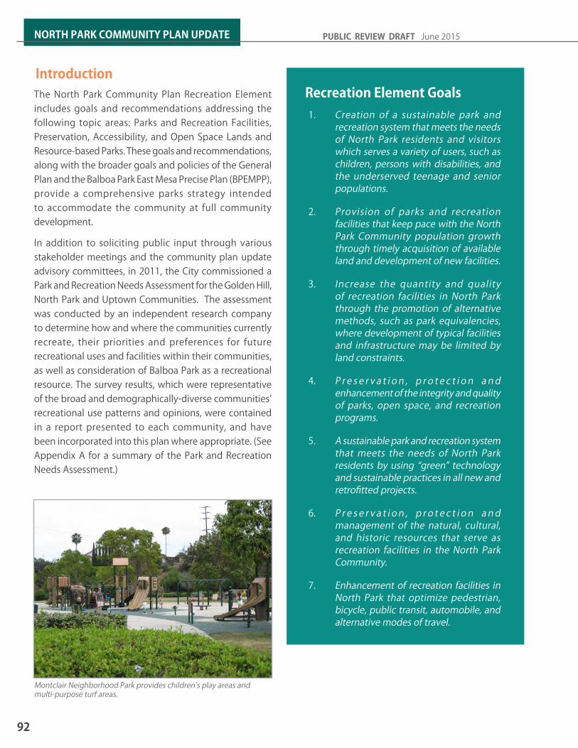
IntroductionThe North Park Community Plan Recreation Element includes goals and recommendations addressing the following topic areas: Parks and Recreation Facilities, Preservation, Accessibility, and Open Space Lands and Resource-based Parks. These goals and recommendations, along with the broader goals and policies of the General Plan and the Balboa Park East Mesa Precise Plan (BPEMPP), provide a comprehensive parks strategy intended to accommodate the community at full community development.
In addition to soliciting public input through various stakeholder meetings and the community plan update advisory committees, in 2011, the City commissioned a Park and Recreation Needs Assessment for the Golden Hill, North Park and Uptown Communities. The assessment was conducted by an independent research company to determine how and where the communities currently recreate, their priorities and preferences for future recreational uses and facilities within their communities, as well as consideration of Balboa Park as a recreational resource. The survey results, which were representative of the broad and demographically-diverse communities’ recreational use patterns and opinions, were contained in a report presented to each community, and have been incorporated into this plan where appropriate. (See Appendix A for a summary of the Park and Recreation Needs Assessment.)
Recreation Element Goals1. Creation of a sustainable park and
recreation system that meets the needs of North Park residents and visitors which serves a variety of users, such as children, persons with disabilities, and the underserved teenage and senior populations.
2. Provision of parks and recreation facilities that keep pace with the North Park Community population growth through timely acquisition of available land and development of new facilities.
3. Increase the quantity and quality of recreation facilities in North Park through the promotion of alternative methods, such as park equivalencies, where development of typical facilities and infrastructure may be limited by land constraints.
4. P r e s e r v a t i o n , p r o t e c t i o n a n d enhancement of the integrity and quality of parks, open space, and recreation programs.
5. A sustainable park and recreation system that meets the needs of North Park residents by using “green” technology and sustainable practices in all new and retrofitted projects.
6. P r e s e r v a t i o n , p r o t e c t i o n a n d management of the natural, cultural, and historic resources that serve as recreation facilities in the North Park Community.
7. Enhancement of recreation facilities in North Park that optimize pedestrian, bicycle, public transit, automobile, and alternative modes of travel.
Montclair Neighborhood Park provides children’s play areas and multi-purpose turf areas.
92
NORTH PARK COMMUNITY PLAN UPDATE PUBLIC REVIEW DRAFT June 2015

RECREATION
7.1 Parks and Recreation Facilities
PARKS AND RECREATION FACILITIES STANDARDSThe General Plan Recreation Element describes three categories of parks within the City of San Diego: Open Space Lands, Resource-based Parks, and Population-based Parks. (See Section RE-4 Open Space Lands and Resource-Based Parks for descriptions.) Population-based parks and recreation facilities are typically located within close proximity to residents and are intended to serve the daily recreational needs of the neighborhoods and the community. The General Plan standard is to provide a minimum of 2.8 useable acres of public park land per 1,000 residents.
There are six categories of population-based parks: 1) major park; 2) community park; 3) neighborhood park; 4) mini-park; 5) pocket park or plaza; and 6) special activity park. A recreation center, typically 17,000 square feet in size, should be provided for every 25,000 residents, and an aquatic complex should be provided for every 50,000 residents. The General Plan Recreation Element, Table RE-2, Parks Guidelines, provides the descriptions and minimum standards for these park and recreation facilities.
8. Design all new recreation facilities for an inter-connected park and open space system that is integrated into and accessible to North Park Community residents.
9. Retrofit all existing park and recreational facilities to meet the 1990 Americans with Disabilities Act (ADA) to accommodate persons with all disabilities as funding becomes available.
10. A balance of recreational facilities that are available for programmed and non-programmed uses.
11. Comprehensive pedestrian and bicycle connections between parks and open space lands within and adjacent to the North Park Community, as well as to surrounding communities.
12. An open space and resource-based park system in the North Park Community that provides for the preservation and management of significant natural and man-made resources.
13. Natural terrain and drainage systems of North Park’s open space lands and resource-based parks that preserve the natural habitat and cultural resources.
14. A system of pedestrian paths and bikeways linking population-based parks with resource-based parks and open space lands within the North Park Community.
North Park Community Park Recreation Center to be expanded to provide additional multi-purpose community rooms.
93
7

EXISTING AND FUTURE POPULATION-BASED PARKS AND RECREATION FACILITIESFacilities that may be considered as population-based park equivalencies include:
1. Joint use facilities;
2. Trails through open space;
3. Portions of resource-based parks;
4. Privately-owned, publicly-used parks;
5. Non-traditional parks, such as rooftop or indoor recreation facilities; and
6. Facility or building expansion or upgrades.
North Park is an urbanized community where park equivalencies are appropriate for satisfying some of the community’s population-based park needs. The community and City identified and evaluated population-based park and recreation opportunities, as well as potential park equivalency sites, for their recreational value, possible uses and functions, public accessibility, consistency with General Plan policies and guidelines, and other land use policy documents (e.g., Balboa Park Master Plan and Balboa Park East Mesa Precise Plan).
Table 7-1 and 7-2 summarize the existing and future parks, park equivalencies and recreation facilities that have been selected by the North Park Community to supplement their existing population-based park and recreation facilities inventory. The table also includes recommendations contained in the Balboa Park East Mesa Precise Plan for the Neighborhood Edge, including the Morley Field Area, where appropriate, as well as recommendations generated by the community and City staff for facilities outside of Balboa Park.
General Plan GuidelinesParks:
61,965 people divided by 1,000 = 61.965 x 2.8 acres = 173.50 acres of population-based parks
Recreation Center:
(17,000 square feet) Serves population of 25,000: 61,965 people divided by 25,000 people = 2.48 Recreation Centers = 42,160 square feet total
Aquatic Complex:
Serves population of 50,000: 61,965 people divided by 50,000 people = 1.24 Aquatic Complexes
At the plan horizon, the projected household population for the North Park Community is 61,965. Based on the General Plan standard for population-based parks and recreation facilities, the community should be served by a minimum of 173.50 useable acres of park land. The projected population warrants approximately two and one-half recreation centers equivalent to 42,160 total square feet, and approximately one and one-quarter aquatic complexes.
Opportunities for additional park land and recreation facilities within the North Park Community are anticipated to come primarily through development of private and public properties and through the application of park equivalencies. While the City’s primary goal is to obtain land for population-based parks, where vacant land is limited, unavailable or is cost-prohibitive, the General Plan allows for the application of park equivalencies to be determined by the community and the City through a set of guidelines.
94
NORTH PARK COMMUNITY PLAN UPDATE PUBLIC REVIEW DRAFT June 2015

RECREATION
Parks/ Recreation
Facilities
Existing Useable Acreage
Future Useable Acreage
Parks and Recreation Facilities Descriptions
Parks and Recreation Facilities Recommendations
Major Parks - NoneCommunity ParksNorth Park Community Park
7.90 Existing park and recreation facilities consisting of a recreation center, a teen center, an adult center, a comfort station, a lighted ball field, multipurpose turf areas, a children’s play area, three tennis courts, handball courts, walkways, seating and picnic tables. Of the 7.90 acres, 2.84 acres is part of the joint use area with ALBA school.
Replace natural turf on ball field with synthetic turf and provide new sports field lighting to increase use.
Neighborhood ParksMontclair Park 4.97 Existing park consisting of passive
recreation amenities, including multi-purpose turf area, children’s play area, seating, picnicking, walkways, and landscaping.
Mini ParksUniversity Avenue Mini Park
1.59 Proposed mini park on undeveloped private property at southeast corner of University Ave. and Louisiana St. (2305 and 2311 University Ave.) to accommodate passive recreational uses.
Acquire, design and construct park amenities to support passive recreation, such as a children’s play area, seating, picnicking, walkways, landscaping, and public art.
Pocket Parks/Plazas34th Street Pocket Park
0.15 Proposed pocket park is within the street-right-of-way and is the official trailhead to Juniper Canyon Open Space.
Vacate the street right-of-way, acquire site, design and construct park amenities to support passive recreation, such as a children’s play area, seating, picnicking, walkways, and landscaping.
Cedar Ridge Park
0.27 Existing park consisting of passive recreation amenities, including multi-purpose turf area, children’s play area, seating, walkways, and landscaping.
Design and construct ADA/accessibility improvements to the children’s play area, the path of travel, and other areas of the park as needed.
North Park Mini-Park
0.50 Proposed park on City-owned property, on an undeveloped site.
Construct the park amenities consistent with the approved General Development Plan.
Redwood & 32nd Streets Pocket Park
0.14 Proposed park on City-owned property, on an undeveloped site.
Design and construct park amenities for passive recreation, such as a children’s play area, seating, walkways, picnicking, and landscaping.
Teresita & Maple Streets Pocket Park
0.17 Proposed pocket park on undeveloped street right-of-way to accommodate passive recreational uses, including a trailhead into Juniper Canyon Open Space.
Vacate street right-of-way, acquire site, design and construct park amenities to support passive recreation, such as a children’s play area, seating, picnicking, walkways, landscaping, and a trail system staging area.
Table 7-1: Population-Based Parks and Recreation Facilities Inventory and Recommendations
95
7

Parks/ Recreation
Facilities
Existing Useable Acreage
Future Useable Acreage
Parks and Recreation Facilities Descriptions
Parks and Recreation Facilities Recommendations
Special Activity Parks - NoneRecreation CentersMorley Field Pétanque Center (within Balboa Park)
N/A N/A Existing 1,548 sq.ft. Pétanque Center (formerly senior center) is proposed to be expanded to enhance recreational programs and services; this facility could be combined with the proposed Morley Field Recreation Center.
Expand/renovate the existing Pétanque Center to increase the size to 5,160 square feet or incorporate the expansion into the proposed Morley Field Recreation Center to provide enhanced recreational programs and services consistent with the recommendations in the BPEMPP.
Morley Field Recreation Center (within Balboa Park)
N/A N/A Proposed 17,000 sq.ft. Recreation Center to be located within the Morley Field area of Balboa Park.
Design and construct a new 17,000 sq. ft. recreation center to accommodate community meetings, gymnasium, recreation and fitness programs, and restrooms, consistent with the recommendations in the BPEMPP.
North Park Recreation Center
N/A N/A Existing facility consisting of 11,232 sq. ft. provides an indoor gymnasium, teen center and multi-purpose/arts & crafts rooms housed in three separate buildings; facilities are outdated and in need of upgrades to fully serve the community.
Expand the existing recreation center to provide a 17,000 sq.ft. recreation facility (possibly add second story); Provide improvements and ADA upgrades. In the interim, redesign current foyer to serve as lobby area for recreation center; install additional outdoor security lighting, and extend security system into multi-purpose/arts & crafts room.
Renaissance at North Park
N/A N/A Proposed 3,000 sq.ft. of community rooms within the Renaissance at North Park mixed-use development located at El Cajon Blvd. and 30th Street.
Design and construct the space to accommodate a variety of community oriented meeting and recreation programs.
Aquatic ComplexesBud Kearns Aquatic Complex (within Morley Field area of Balboa Park)
N/A N/A Existing aquatic complex located in North Park on Upas Street, with an existing pool and support facilities that are undersized and outdated. (Shared between Golden Hill and North Park Communities)
Replace the existing public pool facilities with an expanded state-of-the-art aquatic complex to serve the Golden Hill and North Park Communities. Provide a new pool house, approximately 5,000 square feet, and universal access and water amenities, such as a children’s wading pool with water play element, and therapeutic pool facilities, consistent with the recommendations in the Balboa Park East Mesa Precise Plan.
Table 7-1: Population-Based Parks and Recreation Facilities Inventory and Recommendations
96
NORTH PARK COMMUNITY PLAN UPDATE PUBLIC REVIEW DRAFT June 2015

RECREATION
Parks/ Recreation
Facilities
Existing Useable Acreage
Future Useable Acreage
Parks and Recreation Facilities Descriptions
Parks and Recreation Facilities Recommendations
Joint Use FacilitiesALBA Charter School (formerly North Park Elementary School)
0.12 Existing joint use facilities consisting of kindergarten play area, amphitheater, and outdoor lunch area pursuant to long-term lease agreement. The total joint use acreage is 2.96, of which 2.84 acres is located on North Park Community Park and 0.12 acres is located on School District property.
Birney Elementary School
0.96 Existing joint use facilities consisting of turf multi-purpose playfield, multi-purpose courts, and hardscape for court games pursuant to long-term lease agreement. Facility is a total of 1.82 acres and is shared with; North Park (0.96 acres) and Uptown (0.86 acres).
Garfield Elementary School
0.70 Existing joint use facilities consisting of turf multi-purpose fields pursuant to long-term agreement.
Jefferson Elementary School
1.45 Existing joint use facilities consisting of multi-purpose synthetic turf playfield, multi-purpose courts, and hardscape for court games pursuant to long-term lease agreement.
McKinley Elementary School
2.67 Proposed joint use facilities at school site. Construct the joint use amenities consistent with the approved General Development Plan.
Trails; Useable acres credit for trails was determined by multiplying the linear footage of trail by 24’-0” width and dividing by one acre in square feet (43,560)Juniper/34th Streets Canyon Open Space Trails
4.24 7,700 linear feet of existing and proposed trails located in Juniper/34th Streets Canyon Open Space (City-owned, MHPA-designated) which provide passive recreation.
Expand the existing 6,600 linear feet of trails by designing and constructing approximately 1,100 linear feet of new trails and provide trail improvements, such as interpretive signs, protective fencing, native landscaping, trash and recycling containers, overlooks, etc., where needed and appropriate for the trail type, as determined and approved by City.
Switzer Canyon Open Space Trails
3.58 6,500 linear feet of existing and proposed trails located in Switzer Canyon Open Space (City-owned, MHPA-designated) which provide passive recreation.
Expand the existing 5,400 linear feet of trails by designing and constructing approximately 1,100 linear feet of new trails and provide trail improvements, such as interpretive signs, protective fencing, native landscaping, trash and recycling containers, overlooks, etc., where needed and appropriate for the trail type, as determined and approved by City.
Table 7-1: Population-Based Parks and Recreation Facilities Inventory and Recommendations
97
7
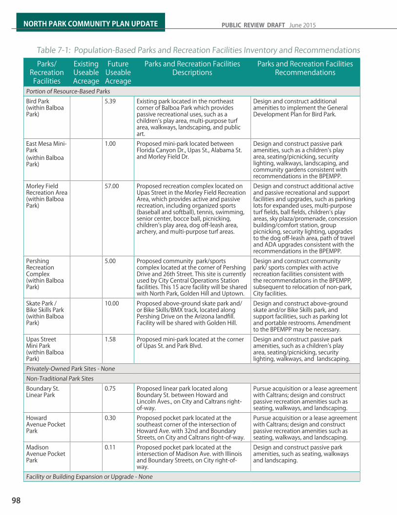
Parks/ Recreation
Facilities
Existing Useable Acreage
Future Useable Acreage
Parks and Recreation Facilities Descriptions
Parks and Recreation Facilities Recommendations
Portion of Resource-Based ParksBird Park (within Balboa Park)
5.39 Existing park located in the northeast corner of Balboa Park which provides passive recreational uses, such as a children’s play area, multi-purpose turf area, walkways, landscaping, and public art.
Design and construct additional amenities to implement the General Development Plan for Bird Park.
East Mesa Mini-Park (within Balboa Park)
1.00 Proposed mini-park located between Florida Canyon Dr., Upas St., Alabama St. and Morley Field Dr.
Design and construct passive park amenities, such as a children’s play area, seating/picnicking, security lighting, walkways, landscaping, and community gardens consistent with recommendations in the BPEMPP.
Morley Field Recreation Area (within Balboa Park)
57.00 Proposed recreation complex located on Upas Street in the Morley Field Recreation Area, which provides active and passive recreation, including organized sports (baseball and softball), tennis, swimming, senior center, bocce ball, picnicking, children’s play area, dog off-leash area, archery, and multi-purpose turf areas.
Design and construct additional active and passive recreational and support facilities and upgrades, such as parking lots for expanded uses, multi-purpose turf fields, ball fields, children’s play areas, sky plaza/promenade, concession building/comfort station, group picnicking, security lighting, upgrades to the dog off-leash area, path of travel and ADA upgrades consistent with the recommendations in the BPEMPP.
Pershing Recreation Complex (within Balboa Park)
5.00 Proposed community park/sports complex located at the corner of Pershing Drive and 26th Street. This site is currently used by City Central Operations Station facilities. This 15 acre facility will be shared with North Park, Golden Hill and Uptown.
Design and construct community park/ sports complex with active recreation facilities consistent with the recommendations in the BPEMPP, subsequent to relocation of non-park, City facilities.
Skate Park / Bike Skills Park (within Balboa Park)
10.00 Proposed above-ground skate park and/or Bike Skills/BMX track, located along Pershing Drive on the Arizona landfill. Facility will be shared with Golden Hill.
Design and construct above-ground skate and/or Bike Skills park, and support facilities, such as parking lot and portable restrooms. Amendment to the BPEMPP may be necessary.
Upas Street Mini Park (within Balboa Park)
1.58 Proposed mini-park located at the corner of Upas St. and Park Blvd.
Design and construct passive park amenities, such as a children’s play area, seating/picnicking, security lighting, walkways, and landscaping.
Privately-Owned Park Sites - NoneNon-Traditional Park Sites Boundary St. Linear Park
0.75 Proposed linear park located along Boundary St. between Howard and Lincoln Aves., on City and Caltrans right-of-way.
Pursue acquisition or a lease agreement with Caltrans; design and construct passive recreation amenities such as seating, walkways, and landscaping.
Howard Avenue Pocket Park
0.30 Proposed pocket park located at the southeast corner of the intersection of Howard Ave. with 32nd and Boundary Streets, on City and Caltrans right-of-way.
Pursue acquisition or a lease agreement with Caltrans; design and construct passive recreation amenities such as seating, walkways, and landscaping.
Madison Avenue Pocket Park
0.11 Proposed pocket park located at the intersection of Madison Ave. with Illinois and Boundary Streets, on City right-of-way.
Design and construct passive park amenities, such as seating, walkways and landscaping.
Facility or Building Expansion or Upgrade - None
Table 7-1: Population-Based Parks and Recreation Facilities Inventory and Recommendations
98
NORTH PARK COMMUNITY PLAN UPDATE PUBLIC REVIEW DRAFT June 2015

RECREATION
Population-Based Parks Useable AcresExisting Population-based Parks and Park Equivalencies 16.37 acresProposed Population-based Parks and Park Equivalencies 94.17 acresTotal Existing and Proposed Population-based Parks and Equivalencies
110.54 acres
Population-based Park Requirements at full community development
173.50 acres
Population-based park deficit at full community development 62.96 acres
Recreation Centers Square FeetExisting Recreation Center: North Park Recreation Center 11,232 SFProposed Recreation Center addition: North Park Recreation Center (for a total of 17,000 square feet)
5,768 SF
Existing Recreation Center: Morley Field Pétanque Center 1,548 SFProposed Recreation Center addition: Morley Field Pétanque Center (for a total of 5,160 square feet)
3,612 SF
Proposed Recreation Center: Morley Field Recreation Center 17,000 SFProposed Recreation Center: Renaissance at North Park 3,000 SFTotal Existing and Proposed Recreation Centers 42,160 SFRecreation Center Requirement at full community development
42,160 SF
Recreation Center Deficit at full community development No DeficitAquatic Complexes Unit
Existing Aquatic Complex: Bud Kearns Community Swimming Pool
0.00
Proposed Aquatic Complex addition: Bud Kearns Community Swimming Pool
1.24*
Total Existing and Proposed Aquatic Complexes 1.24*Aquatic Complexes Requirement at full community development
1.24*
Aquatic Complex deficit at full community development No Deficit*Bud Kearns Community Swimming Pool will be shared. Greater Gold-en Hill requires 0.44, and North Park requires 1.24, aquatic complexes. The proposed, larger facility will satisfy the combined requirements (1.68 aquatic complexes) for both communities.Note: Identification of private property as a potential park site does not preclude permitted development per the designated land use.
Table 7-2: Summary of Existing and Proposed Population-Based Parks and Recreation Facilities
99
7

Figure 7-1: Parks, Recreation Facilities, and Open Space
100
NORTH PARK COMMUNITY PLAN UPDATE PUBLIC REVIEW DRAFT June 2015
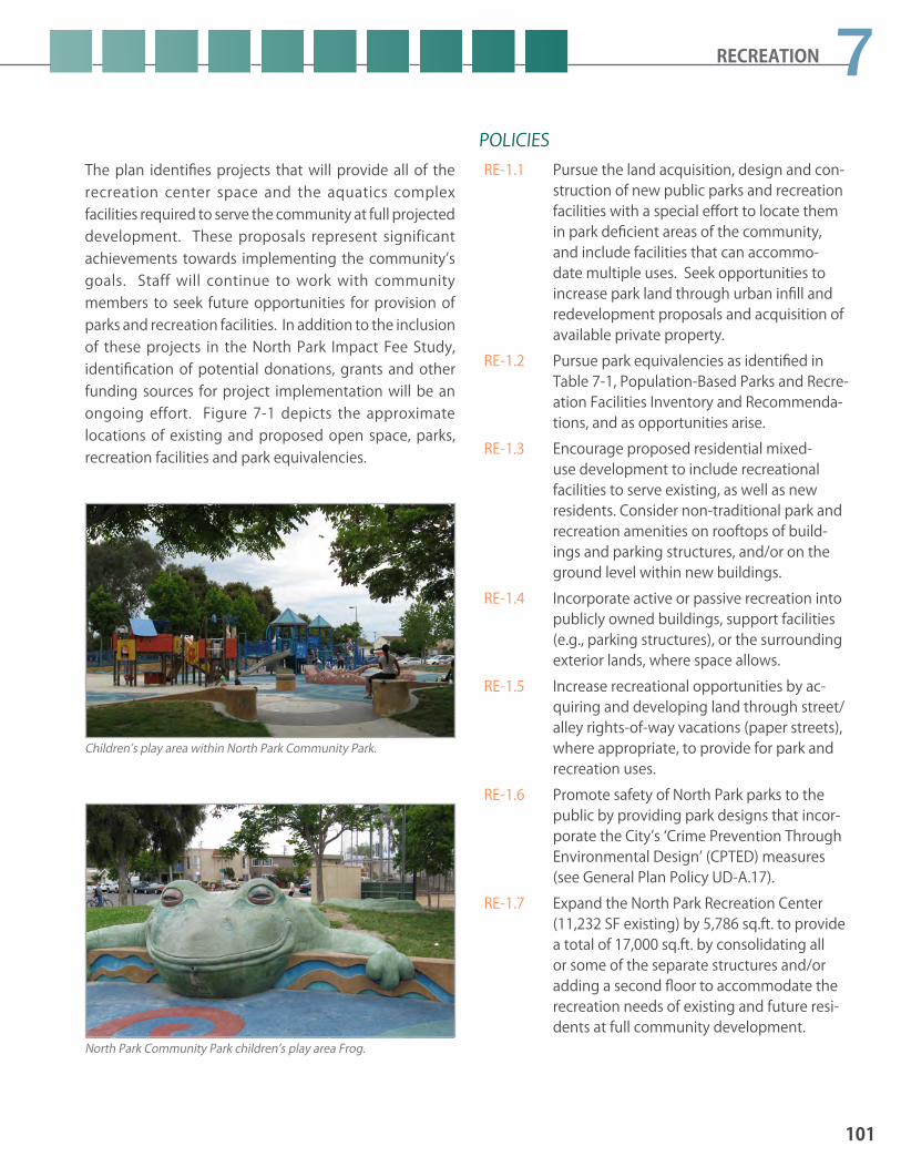
RECREATION
The plan identifies projects that will provide all of the recreation center space and the aquatics complex facilities required to serve the community at full projected development. These proposals represent significant achievements towards implementing the community’s goals. Staff will continue to work with community members to seek future opportunities for provision of parks and recreation facilities. In addition to the inclusion of these projects in the North Park Impact Fee Study, identification of potential donations, grants and other funding sources for project implementation will be an ongoing effort. Figure 7-1 depicts the approximate locations of existing and proposed open space, parks, recreation facilities and park equivalencies.
POLICIES RE-1.1 Pursue the land acquisition, design and con-
struction of new public parks and recreation facilities with a special effort to locate them in park deficient areas of the community, and include facilities that can accommo-date multiple uses. Seek opportunities to increase park land through urban infill and redevelopment proposals and acquisition of available private property.
RE-1.2 Pursue park equivalencies as identified in Table 7-1, Population-Based Parks and Recre-ation Facilities Inventory and Recommenda-tions, and as opportunities arise.
RE-1.3 Encourage proposed residential mixed-use development to include recreational facilities to serve existing, as well as new residents. Consider non-traditional park and recreation amenities on rooftops of build-ings and parking structures, and/or on the ground level within new buildings.
RE-1.4 Incorporate active or passive recreation into publicly owned buildings, support facilities (e.g., parking structures), or the surrounding exterior lands, where space allows.
RE-1.5 Increase recreational opportunities by ac-quiring and developing land through street/alley rights-of-way vacations (paper streets), where appropriate, to provide for park and recreation uses.
RE-1.6 Promote safety of North Park parks to the public by providing park designs that incor-porate the City’s ‘Crime Prevention Through Environmental Design’ (CPTED) measures (see General Plan Policy UD-A.17).
RE-1.7 Expand the North Park Recreation Center (11,232 SF existing) by 5,786 sq.ft. to provide a total of 17,000 sq.ft. by consolidating all or some of the separate structures and/or adding a second floor to accommodate the recreation needs of existing and future resi-dents at full community development.
Children’s play area within North Park Community Park.
North Park Community Park children’s play area Frog.
101
7

RE-1.8 Implement recommendations contained in the Balboa Park East Mesa Precise Plan for the Mesa Rim and Neighborhood Edge which specifically serve the neighborhood and community park needs of the North Park Community, as follows:a. Construct park improvements in the
northeast corner along 28th Street to Redwood Street, including a children’s play area, gateway and entry garden.
b. Enhance the main entry to Morley Field area at Texas Street.
c. Renovate open lawn areas for multipurpose recreational uses.
d. Provide additional security lighting along the park edge.
e. Maintain irrigated lawn throughout the neighborhood edge for informal play; irrigate with reclaimed water when available.
f. Plant large canopy trees throughout the neighborhood edge, using care to maintain clear visibility across the area for security surveillance.
g. Construct a children’s play area in the Eucalyptus grove across from the Morley Field Tennis Club (East Mesa Mini Park).
h. Provide enhanced pedestrian crossings at all intersections which enter into Balboa Park; engage community input for these designs.
i. Design and construct the proposed Pershing Recreation Complex to serve the North Park, Golden Hill and Uptown Communities, when feasible to do so.
RE-1.9 Implement recommendations contained in the Balboa Park East Mesa Precise Plan for the Morley Field area which specifically serves the neighborhood and community park needs of the North Park Community, as follows:a. Renovate the existing pool house to
create a new 17,000 square foot recreation center.
b. Replace the Bud Kearns Community Swimming Pool with an aquatic complex sized to accommodate both the North Park and Golden Hill Communities’ needs, including a new pool house which accommodates multiple user types, and which is solar heated or heated by methane gas from the former Arizona Landfill collection system.
c. Construct four rearranged lighted, ball fields and a common gathering area (sky plaza) for organized sports leagues, including support facilities, such as a concession/restroom building, spectator stands and enhanced pathways/promenades.
d. Construct one multipurpose lighted sports field east of the ball field complex.
e. Reconfigure parking to concentrate vehicles for safer and more convenient use.
f. Construct a group picnic area at the south end of Morley Field.
g. Construct a group picnic area and two children’s play areas between the ball fields and the pool/recreation center area.
h. Relocate two tennis courts north of the competition court to the east end of the block of courts to accommodate an expanded clubhouse and gathering area.
102
NORTH PARK COMMUNITY PLAN UPDATE PUBLIC REVIEW DRAFT June 2015

RECREATION
RE-1.10 Design and construct a skate park/bike skills park within the former Arizona Landfill area, if feasible, or elsewhere within the commu-nity at a location to be determined through a community planning process.
RE-1.11 Pursue lease agreements with public agen-cies (e.g., San Diego Unified School Dis-trict, Caltrans, etc.) to incorporate active or passive recreation into existing buildings or surrounding grounds, where non-pro-grammed space is available and appropriate for public use.
RE-1.12 Consider the demolishment of the exist-ing 1,706 square foot Adult Center located within North Park Community Park, due to prohibitive and non-cost effective renova-tion costs. And, the relocation of the senior, social and community programs to the other existing and proposed recreation centers described in this plan. Convert this area to useable park land.
RE-1.13 Develop smaller neighborhood parks, mini parks and pocket parks thoughout the com-munity, especially in areas more distant from larger public park facilities.
RE-1.14 Pursue opportunities to provide facilities for active uses for teenagers and young adults, such as BMX tracks, soccer fields, ballparks, skate parks, and paintball facilities.
RE-1.15 Ensure that the design of public parks provided on privately owned land comply with Council Policy 600-33, provide popula-tion-based park amenities per the General Plan, and that the hours of public use shall be consistent with typical publicly-operated parks and facilities.
Garfield Joint Use Facility features passive lawn areas and basketball courts.
Morley Field, within Balboa Park, provides several ball fields and areas for soccer.
Bud Kerns Pool House, within Balboa Park, to be expanded to provide an aquatic complex for the North Park community.
103
7

7.2 PreservationThe demand for park and recreation opportunities will continue to grow as the population of the North Park Community continues to grow. Undeveloped land for parks is difficult to find in North Park making preservation of park facilities essential to providing recreation opportunities in the community. Preservation can include improvements to existing facilities to increase their life span, or expand their uses and sustainability. The Morley Field Area of Balboa Park will continue to serve as the main recreation venue for the community. With increased demand and usage, the facilities will need to be reconstructed, upgraded and expanded with sustainable and green technology features. To optimize the space to be fully utilized and to provide new recreation amenities that are needed by the existing and future community residents.
Preservation can also include the enhancement of resource-based parks and open space lands that provides a balance between protecting the natural resources and allowing for a certain level of public recreation use. Within North Park this would include concentrating active recreational use improvements towards larger resource-based parks, such as at Morley Field, and focusing passive use improvements at open space areas, such as Switzer Canyon and Juniper/34th Streets Canyons Open Space areas which are within the Multiple Habitat Planning Areas (MHPA). Aside from trails, only passive uses are allowed in the MHPA, therefore, to protect the natural resources and still add recreation value, interpretive signs at open space parks can educate the public on the unique natural habitat, scenic value and the history of the place. (See Conservation Element for additional information on preservation of natural resources.)
POLICIESRE-2.1 Expand/upgrade the recreation facilities at
Morley Field consistent with the Balboa Park East Mesa Precise Plan to meet existing and future demand, as described in RE-1.9. Use sustainable methods and materials (such as native and low-water using plants), and “green” technology that also respects any historical significance of the area.
RE-2.2 Preserve, expand and enhancem park and recreation facilities to increase their life span, and to optimize their uses and sustainability.
RE-2.3 Provide sufficient human and economic resources to preserve and enhance the exist-ing parks and open space areas.
RE-2.4 Preserve and protect Switzer Canyon and Juniper/34th Streets Canyons Open Space areas by limiting public use to designated trails and providing interpretive signs de-scribing the biologic and scenic value of the open space systems.
RE-2.5 Preserve, protect and restore canyons and hillsides as important visual features of com-munity definition.
RE-2.6 Provide pocket parks with ecologically-sensi-tive recreational uses as enhanced trailheads to open space systems.
RE-2.7 Protect and preserve native species and the unique habitats they depend upon within the open space systems consistent with the MSCP guidelines. (See Conservation Ele-ment.)
Overview of the trail system in Switzer Canyon Open Space.
104
NORTH PARK COMMUNITY PLAN UPDATE PUBLIC REVIEW DRAFT June 2015

RECREATION
7.3 AccessibilityAccessibility to park and recreation facilities within the North Park Community has three main components: 1) all facilities should be located within walking distance of neighborhoods and employment centers; 2) facilities should be accessible to the broadest population possible; and 3) facilities should be open for use by the general public with a balance between programmed and non-programmed activities.
All parks and recreation facilities within the North Park Community are planned to be linked by a network of existing and proposed transit routes, bikeways, and pedestrian paths. For a discussion of future accessibility and linkages to parks and open space see the Mobility Element.
All new and existing parks and recreation facilities within the North Park Community are required to meet ADA requirements when they are constructed or retrofitted for improvements or upgrades. This could include adding accessible pedestrian ramps, providing paved pathways at acceptable gradients that lead from a public sidewalk or parking area to a children’s play area or other park destination (referred to as the “path of travel”), other improvements include the provision of disabled parking spaces, remodeling of restrooms and building interiors.
Accessibility facilities includes the availability of active and passive recreation to all residents. Organized sport leagues can make use of the facilities at specific times while making the facilities available at other times for unstructured play and impromptu users. The schedule is adjusted each year to make sure a balance is provided for community residents.
When special uses are designed into parks, such as dog off-leash areas or community gardens, these areas should also include amenities, such as pathways, benches, or picnic tables on the perimeter that could accommodate more than one type of user and enhance the recreational and leisure experience. Special uses, such as dog off-leash areas and community gardens, would be required to undergo a City-approval process prior to facility construction.
POLICIESRE-3.1 Ensure all existing and future parks and rec-
reation facilities meet local, state and federal accessibility guidelines.
RE-3.2 Implement recommendations contained in the Balboa Park East Mesa Precise Plan which specifically aim to improve the existing and future accessibility to and from recreation facilities and the North Park Community, particularly as follows: a. Provide 8’-0” wide sidewalks with 10’-
0” wide planted parkways and security lighting within the Neighborhood Edge of Balboa Park along 28th and Upas Streets, and provide parallel parking adjacent to the curb, to connect the Neighborhood Edge with the surrounding community.
b. Construct pedestrian/bicycle paths and bridges where necessary, within the Neighborhood Edge of Balboa Park to facilitate the park circulation system.
RE-3.3 Provide information kiosks and maps at key park sites and community gateways that provide way-finding information about pedestrian, bicycle and transit routes to all parks that serve North Park.
Kiosks in Morley Field provide way-finding information about pedestrian, bicycle and transit routes.
105
7

7.4 Open Space Lands and Resource-Based Parks
RE-4.5 Pursue public access easements for approxi-mately 351 linear feet of existing trails locat-ed on privately-owned open space, where appropriate within the Juniper/34th Streets Canyons Open Space system to maintain connectivity between trail segments.
RE-4.6 Provide a recognizable entrance (trailhead) to the Switzer Canyon Trail system at Red-wood and 31st Streets. The trailhead should include a kiosk that includes a way-finding map that shows how the canyon interfaces with the North Park Community.
RE-4.7 Provide interpretive signs at major trailheads to Switzer Canyon and Juniper/34th Streets Canyons Open Space trail systems to edu-cate users on the sensitive natural habitat, cultural resources and/or scenic qualities of these areas.
Open space lands are City-owned property consisting of canyons, mesas, and other natural landforms. This open space is intended to preserve and protect native plants and animals, while providing public access and enjoyment by the use of hiking, biking and equestrian trails. See Figure 7-1, Parks, Recreation Facilities and Open Space.
In North Park, there are two open space canyons: Switzer Canyon (approximately 20.51acres) and Juniper/34th Street Canyons (approximately 51.44 acres, of which 32.06 acres are within the North Park Community and 19.38 acres are within the Golden Hill Community) which provide low intensity recreational uses, such as hiking and bird watching. Any proposed improvements to the trail systems shall be consistent with Natural Resource Management Plans, if any, or other governing documents.
Resource-based parks are located at sites of distinctive natural or man-made features and serve the citywide population and visitors alike. Balboa Park is an approximately 1,200-acre regional facility contiguous to the southwestern edge of the North Park Community, as well as to the Uptown and Golden Hill Communities. Balboa Park features specialty gardens and horticultural interests, and houses numerous arts museums, educational, recreational, social and sports organizations, primarily on the Central Mesa. The adopted Balboa Park Master Plan generally defers to the preparation of a precise plan for improvements within the Morley Field area and the Arizona Landfill; the adopted Balboa Park East Mesa Precise Plan addresses existing and future needs in the areas contiguous to the North Park Community by expanding and enhancing park and recreation diverse uses and experiences, as well as preserving sensitive habitat.
POLICIESRE-4.1 Protect and enhance the natural resources
of open space lands by re-vegetating with native plants and utilizing open wood fenc-es, where needed, adjacent to very sensitive areas to provide additional protection while still allowing views into the area.
RE-4.2 Ensure all storm water and urban run-off drainage into resource-based parks or open space lands to be filtered or treated before entering the area.
RE-4.3 Provide recognizable entrances (trailhead) to the Juniper/34th Streets Canyons Trail sys-tem. The trailheads may include a kiosk that includes a map of how the canyon interfaces with the North Park Community.
RE-4.4 Construct approximately 2,045 linear feet of new trails on publicly-owned open space to connect with existing trails within Switzer Canyon and Juniper/34th Streets Canyons trail systems. Co-locate trails and utility access roads on publicly-owned open space, wherever possible.
106
NORTH PARK COMMUNITY PLAN UPDATE PUBLIC REVIEW DRAFT June 2015

88.1 SUSTAINABLE DEVELOPMENT8.2 CLIMATE CHANGE 8.3 NATURAL RESOURCE CONSERVATION 8.4 AIR QUALITY AND HEALTH
SUSTAINABILITY & CONSERVATION

108
NORTH PARK COMMUNITY PLAN UPDATE PUBLIC REVIEW DRAFT June 2015
Community Sustainability and Conservation:“ To establish the North Park community as a leader in the creative design and implementation of urban community strategies and practices which emphasize environmental and cultural stewardship, sustainable green economies, and social equity, and which actively engage and connect local residents, businesses, and organizations.”
Introduction Conservation is the planned management, preservation, and wise utilization of natural resources and landscapes.
Sustainable development is development which respects the balance and relationship between the economy, ecology and equity.
The principles of conservation stress humankind’s relationship to the natural environment and understand the benefits conferred socially as well as environmentally. Socially, these benefits can accrue to all people as well as future generations so there can be a sense of equity in the appropriate practice of conservation and the implementation of sustainable development.
Many elements of conservation and sustainability have much broader geographic and political relationships and may be more suited to implement on a citywide or even regional basis. However, there is much that can be done at the local community level and individual communities can also be at the forefront of the policy discussion. The purpose of the City’s General Plan Conservation Element is for the City to become an international model of sustainable development, and to provide for the long-term conservation and sustainable management of the City’s natural resources, recognizing they define the City’s identity, contribute to its economy, and improve its quality of life. Specific element policies relate to sustainable development, open space and landform preservation, water resource management, urban runoff management, air quality, biological diversity, wetlands, energy independence, urban forestry, and environmental education.
The North Park community recognizes the importance of natural resources and the need for conservation. Many residents are proud of the community’s environmental tradition, and actively participate in maintaining clean and healthy natural surroundings. The Sustainability and Conservation Element of the North Park Community Plan is intended to further express the General Plan’s Conservation Element policies through the provision of community-specific recommendations, many of which derive from the Sustainable North Park Main Street Guidelines and the establishment of the North Park Eco District.
The Sustainable North Park Main Street Guidelines were developed to act as a catalyst for sustainable development of the North Park community and to serve as a model for other urban communities. The North Park Eco District is a community-based initiative committed to cultivating and celebrating North Park as a livable, mindful and inspiring neighborhood with a thriving green economy.
Through development project review, infrastructure investment, and individual action, the Sustainability and Conservation Element strives to conserve resources, minimize individual ecological footprints, reduce greenhouse gas emissions, reduce vehicle miles traveled, and promote health, well-being, a green economy, community identity and equity.

109
8SUSTAINABILITY & CONSERVATION
Sustainability & Conservation Element Goals1. Implementation of statewide greenhouse gas emission goals at the community level in a manner that
enhances the quality of life, supports the local economy, and further expresses the unique character of North Park
2. A community that is supportive of regional and local initiatives to improve air quality in San Diego County
3. An environment that encourages a healthy lifestyle for its residents
4. Improved public health as a result of investment by residents, visitors, and businesses in North Park as a sustainable community
5. Integration of economic, ecologic, and social equity considerations into North Park’s land development policies and process
6. North Park as a recognized leader in green lifestyles
7. A rich social setting that connects people, promotes local culture, and supports the local economy
8. North Park as an economically vibrant center for green businesses and jobs.
9. An educated community that is less reliant on outside public sources for water and energy
10. Community branding and promotion as a sustainable community
11. Long-term programs that establish a more sustainable urban forest with tree species that meet aesthetic, city, and environmental standards
12. Sustainable landscapes that are responsive to the environment, are re-generative, increase energy efficiency, and actively contribute to the development of a healthy North Park community
13. Community Gardens that preserve green space in the neighborhood, build a sense of community and social connection, restore unused property, and provide a catalyst for neighborhood and community development
14. Restoration of previously disturbed canyons
15. Protection of natural canyon habitat from building encroachment and incompatible uses while enhancing its ecological diversity
16. Preservation and protection of natural open space networks to create corridors for wildlife habitation and passive recreation opportunities
17. A community engaged in social, civic, and cultural activities that strengthen community bonds, enhance community pride, and foster a sense of investment in the future
18. Partnerships and strategies to continue to make North Park a more sustainable community

110
NORTH PARK COMMUNITY PLAN UPDATE PUBLIC REVIEW DRAFT June 2015
Community Plan Policy General Plan Policy
Reduce the community’s carbon footprint CE-A.2Employ sustainable/green building techniques CE-A.5
Reduce construction and demolition waste CE-A.8
Use sustainable building materials CE-A.9Implement sustainable landscape design and maintenance CE-A.11
Reduce urban heat island effect CE-A.12Conserve landforms, canyon lands & open space CE-B.1
Apply Environmentally Sensitive Lands Regulations CE-B.2
Incorporate trails and greenways CE-B.5
Conserve water resources CE-D.1(d) & (h), CE-D.5
Control urban runoff CE-E.2Improve air quality by landscaping CE-F.4Protect biological diversity within open space CE-G.1, CE-G.3
Develop a sustainable urban forest CE-J.1Support urban agriculture CE-L.3
Table 8-1: General Plan-Related Conservation Sustainability Topics and Policies
KEY GENERAL PLAN POLICIESThe City of San Diego General Plan establishes citywide policies to be cited in conjunction with a community plan. Policies may also be further referenced, emphasized or detailed in a community plan to provide community-specific direction. General Plan Conservation Element policies particularly significant to the Uptown community are listed by their notation in cross-reference Table 8-1.
8.1 Sustainable DevelopmentThe General Plan bases its goals and policies regarding climate change and natural resources on a number of basic principles that are intended to guide future development in ways that conserve natural, non-renewable resources through sustainable development practices. This model of development considers a balance between natural resources and economic prosperity while protecting the public health, safety and welfare and reducing our environmental footprint.
The City’s main responsibility when implementing State climate change laws and guidelines, center around its authority to regulate land use. Through sensible land use regulation that reduces the number of vehicle miles traveled and promotes sustainable building and development practices, the City can achieve a meaningful reduction in carbon emissions. Actions that reduce dependence on the automobile by promoting walking, bicycling and transit use are key aspects of any strategy to reduce carbon emissions.
The General Plan discussion on this topic is multi-faceted. Strategies included in the Conservation Element address: development and use of sustainable energy types, including solar; reuse or recycling of building material; adaptively retrofitting and reusing existing buildings; constructing energy efficient buildings with healthy and energy-efficient interior environments; creating quality outdoor living spaces; improving materials recycling programs; and, sustainable local food practices.
At the community plan level, policies and initiatives that further General Plan sustainable development policies focus on those that reduce dependence on the private automobile, protect and enhance the urban forest, and provide for storm water infiltration, water conservation and other green building practices. Applicable policies are located throughout the plan elements while specific policy direction is provided below.

111
8SUSTAINABILITY & CONSERVATION
North Park’s grid pattern street system provides a convenient foundation for encouraging non-motorized transportation such bicycling and walking.
Adaptive reuse of older buildings is not only an efficient use of existing buildings, but a way to preserve community history.
Community gardens provide locally sourced food and are spaces for community building and learning.
POLICIES SE-1.1 Design new development and build-upon
the existing community’s street grid network to create a more functional environment for pedestrians and bicyclists to reduce local dependence on the automobile as a mode of transportation.
SE-1.2 Existing buildings with important architec-tural or historic character are valued within the community. The most comprehensive energy reduction strategy is to promote the continued use or adaptive reuse of these buildings as well as any needed upgrades to their energy use efficiency. Structures that meet the Historical Resources criteria for designation shall be preserved and reposi-tioned if necessary to maintain their eco-nomic viability.
SE-1.3 Each multi-family development should create a meaningful visually and function-ally cohesive outdoor gathering space that considers protection from excess noise, shadow impacts, and maximizes the positive effects of prevailing breezes to reduce heat and provide natural ventilation to individual residences.
SE-1.4 Encourage the use of solar energy systems to supplement or replace traditional build-ing energy systems.
SE-1.5 Provide and/or retrofit lighting within the public-right-of-way that is energy efficient. Use solar powered lights where practical.
SE-1.6 Seek small City-owned sites not suitable for recreation use as opportunities for commu-nity gardens.
SE-1.7 Encourage underdeveloped commercial/industrial lots and buildings for use as small farms with associated sale of agricultural products.
SE-1.8 Promote community initiatives for local-ly-sourced and more environmentally sus-tainable goods and services.

112
NORTH PARK COMMUNITY PLAN UPDATE PUBLIC REVIEW DRAFT June 2015
LOCAL “GREEN” INITIATIVESAlong with North Park’s emergence as a center for arts, culture, and entertainment is an effort to promote revitalization of historic commercial districts and the support of small, independently-owned businesses through the development of a sustainable business district program – Sustainable North Park Main Street (SNPMS). The program’s four overarching goals are to:
• Maintain the cultural and historic integrity of the built and social environment
• Increase resource efficiency and conservation within the business district
• Increase internal community connectivity
• Provide a setting for a sustainable green economyThe SNPMS addresses the need for preservation of historically significant and contributing structures, and places a heavy emphasis on the reuse of materials and structures, and a reintroduction of business practices that focuses on requiring less energy and waste. Although the emphasis on providing policy direction on business practices is not enforced by the community plan, the SNPMS’s goals provide a shared opportunity to develop the future growth, identity, and success of North Park around a shared vision of localism, historic preservation, and environmental stewardship within not only in an already established business district, but community wide.
POLICIESSE-1.9 Ensure that development within North Park
comprehensively reflects all sustainability considerations – environmental, financial, and cultural.
SE-1.10 Support community stakeholders in their efforts to promote North Park’s emerging green clusters and facilitate green business growth through data collection and incen-tive programs.
SE-1.11 Support community organizations in es-tablishing a Sustainability Resource Center to provide information and resources to residents, businesses, schools, nonprofits, developers, and design and construction professionals.
SE-1.12 Promote community walkability through such features as: mid-block pedestrian cross-ings; “pop-outs”; “North Park” branded tree grates; pedestrian-oriented landscaping; and energy efficient pedestrian-scale lighting that enhances pedestrian safety and reflects the historic character of North Park.
SE-1.13 Provide networks of urban public open spaces, pocket parks, parklets, plazas, and outdoor gathering spaces connected by creative way-finding elements.
SE-1.14 Promote community use of bicycles through the installation of bike corrals, bike lanes, bike share stations, and bicycle parking for new multi-family and commercial develop-ment.
SE-1.15 Support the timely implementation of the University Avenue Mobility Plan (UAMP).
SE-1.16 Encourage new commercial and residential development to provide electric vehicle charging stations.
SE-1.17 Encourage businesses to offer carpool/car share and transit incentives to customers and employees.
SE-1.18 Promote community stewardship of local-ly-sourced and environmentally friendly goods and services.
SE-1.19 Support North Park businesses in establish-ing a composting cooperative to facilitate waste recovery and contribute compost to community gardens.
SE-1.20 Encourage local artist-generated wall murals and other public art to enhance public spac-es and help brand North Park as an inviting art and culture district for pedestrians and bicycles.

113
8SUSTAINABILITY & CONSERVATION
SE-1.21 Provide pedestrian-scale amenities such as kiosks, lamppost banners, street planters, and solar-powered electrical outlets in tree wells.
SE-1.22 Support sustainable infill and adaptive reuse which preserves North Park’s historic build-ings and leverages energy efficient construc-tion.
SE-1.23 Encourage the establishment of a sustain-able community resource center to provide technical, financial, marketing and other assistance to the North Park business com-munity.
SE-1.24 Support the creation of an ad-hoc North Park Sustainable Community Task Force (NPSC) to assess North Park’s strengths and weak-nesses related to community sustainability partnerships, initiatives, outreach, funding and other resources.
SE-1.25 Connect North Park residents with educa-tional opportunities and job training and placement programs to meet North Park workforce and employer needs.
SE-1.26 Promote partnerships and strategies, such as Sustainable North Park Man Street’s Sustain-ability Demonstration Project, to make North Park a more sustainable community for all residents and businesses.
SE-1.27 Promote energy conservation as a means to lower the cost of energy bills for individual residents and businesses.
SE-1.28 Encourage the implementation of energy efficient measures that exceed California Code, such as:• Energy-efficient machinery for laundry
operations;• Energy-efficient kitchens in restaurants
and residential uses;• Encourage storefront shading;• Encourage the use of water efficient
machinery for laundry operations and encourage capture of gray water for implementation in other uses;
• Solar tubes & skylights to reduce daytime energy consumption for lighting;
• Passive or zero net energy strategies in new building design (See Conservation and Sustainability Element Toolbox Table 8-2).
SE-1.29 Encourage eco-friendly North Park com-munity-oriented special events, including parades, music and art festivals, bicycle rides, restaurant crawls, craft fairs, etc.
SE-1.30 Support local entities efforts to brand and market North Park as a sustainable commu-nity and leader in water and energy resource management.
SE-1.31 Promote community projects, programs, and services that foster awareness of cultural diversity and heritage to perpetuate and maintain its local traditions.
SE-1.32 Promote car and bicycle sharing programs as cost-effective alternatives to car ownership for residents and employees.
Opportunities exist for the installation of photo-voltaic systems atop the flat roofs of many businesses in North Park’s business districts.
The Sri Chinmoy Peace Garden, established in February 2013 is an example of a privately-owned public space that utilizes drought-tolerant landscaping.

114
NORTH PARK COMMUNITY PLAN UPDATE PUBLIC REVIEW DRAFT June 2015
URBAN FORESTRY, URBAN AGRICULTURE, AND SUSTAINABLE LANDSCAPE DESIGN
SE-1.40 Work with local organizations to develop a North Park Community Forest Master Plan, to include such elements as: tree preserva-tion, tree placement, shade considerations, tree diversity, preferred tree list and planting specifications.
SE-1.41 Encourage the planting of native and/or drought –tolerant landscaping in medians, parkway strips, at public facilities, and as a replacement of private lawns.
SE-1.42 Locate community gardens in North Park where there is sufficient demand, appro-priate land, and will not generate adverse impacts on adjacent uses.
SE-1.43 Encourage the marketing and sales of local agricultural products to local residents, vendors, and restaurants through farmers markets and other direct farm-to-table sales.
SE-1.44 Ensure that local development regulations allow for small-scale, compatible agricultural use of property, including edible landscap-ing, community gardens, and roadside food stands in appropriate areas of North Park
SE-1.45 Support the various land use-related “inter-ventions” developed as part of the Sustain-able North Park Main Street Program and consider their potential incorporation within new development.
Treatment of the urban landscape is essential in creating a sustainable experience within the community. Although sustainable building practices are often hidden and experienced via a building’s operation, structural materials used, and component features, it’s effect on the public experience is more directly felt. San Diego’s tree canopy is a major infrastructural element and provides many added benefits to the pedestrian environment and the overall quality of life in urban areas – such as visual relief and beautification, energy conservation, and the minimization of heat gain. The movement towards urban agriculture or “farm-to-table” food production has been supported Citywide with ordinances encouraging the creation of community gardens, beekeeping, raising chickens and goats, and farmers markets and has allowed communities such as North Park to develop local agriculture economies and increase healthy and organic food access to the public.
POLICIESSE-1.33 Apply street tree policies to private develop-
ment, community planting projects and in the pursuit of grant funding.
SE-1.34 Increase the community’s overall tree can-opy in North Park to cover to the citywide target goal of 20% in urban residential areas and 10% in commercial areas to provide air quality benefits and urban runoff manage-ment.
SE-1.35 New development should be designed and constructed to retain significant, mature and healthy trees located within required land-scape setbacks, and within other portions of the site as feasible.
SE-1.36 Add or replace street trees to fill existing gaps and provide continuous, regularly spaced tree canopies.
SE-1.37 Encourage new development to retain exist-ing significant and mature trees.
SE-1.38 Establish pilot programs and projects that demonstrate the benefits of drought-toler-ant and native landscaping through collabo-ration with external agencies and organiza-tions, such as local watershed organizations and utility districts.
SE-1.39 Encourage local nurseries to promote the use of drought-tolerant and native vegeta-tion.

115
8SUSTAINABILITY & CONSERVATION
8.2 Climate Change The Conservation Element of the General Plan discusses climate change and provides a broad range of policies designed to promote sustainability and reduce greenhouse gas emissions (See General Plan policies CE-A-1 through CE-A-13). At the time of this Community Plan update, the City is also engaged in preparing a Climate Action Plan (CAP) that will address mitigation, as well as adaptation measures to proactively prepare for a range of anticipated climate change impacts. Although climate change is a global issue, individual communities can help reduce the emissions that contribute to climate change and devise local plans, policies, and efforts to adapt to anticipated changes.
POLICIES SE-2.1 Ensure that new development is consistent
with the General Plan and Community Plan sustainability policies and the City’s Climate Action Plan.
SE-2.2 Preserve and enhance North Park’s attributes as a walkable community to provide resi-dents with attractive alternatives to driving especially by establishing multi-modal con-nections to local schools, North Park’s three business districts, and Balboa Park as well as local community and neighborhood parks.
SE-2.3 Preserve, protect, and enhance, as appropri-ate, the community’s carbon sequestration resources, also referred to as “carbon sinks” to improve air quality and reduce net carbon emissions.
SE-2.4 Support community organizations in their efforts to produce an inventory of North Park’s natural resources, including a list of existing opportunities for carbon sequestra-tion resources.
Increasing North Park’s tree canopy can provide multiple benefits from reducing summer heat temperatures to contributing to more pedestrian foot traffic in business districts.
Given San Diego’s arid climate, drought tolerant landscaping is an appropriate and cost-efficient measure for all new development.
In addition to community gardens, farmers markets provide local agriculture products to local residents.

116
NORTH PARK COMMUNITY PLAN UPDATE PUBLIC REVIEW DRAFT June 2015
8.3 Natural Resource Conservation Conservation efforts are important for the community’s remaining open spaces, canyon landforms, natural habitats and public views. Local community initiatives to reduce consumption of potable water and effectively manage storm water runoff can also help achieve important regional goals to reduce dependence on imported water and protect water quality within streams, beaches and bays. While the General Plan, this community plan, San Diego’s Multiple Species Conservation Program (MSCP), and zoning regulations provide the primary legal framework for natural resource conservation, the community’s residents play an important role in determining the ultimate success of preservation and restoration programs. The boundaries of many residential neighborhoods surround the canyon areas providing an opportunity not only for visual enjoyment of these unique areas but also involvement in protection, education and restoration efforts.
of sensitive natural resources and restricts any type of development that impacts resources. Therefore, a comprehensive, systemic approach was developed in order to evaluate boundaries of community plan open space and the MHPA with respect to their protection of natural resources. This evaluation resulted in reconfiguring the Open Space boundary in the 1988 community plan to exclude most developed areas from Open Space due to their lack of natural resources as well as the long-established land use pattern in the community. Areas that contained sensitive biology that were previously excluded from the MHPA were also added by a MHPA boundary correction that added XX-acres of land containing sensitive biological resources and steep slopes, and removed XX-acres of developed/Urban lands (reference Appendix X).
NATURAL RESOURCE MAPPING As part of the community plan update process, the areas designated as open space in the 1988 Community Plan were reviewed using detailed maps available with Geographic Information Systems (GIS) software. The areas intended for preservation by the San Diego MSCP Subarea Plan were also reviewed. This mapping effort reviewed the following GIS data layers:
• Existing Multi-Habitat Planning Area (MHPA) and Community Plan Open Space boundaries
• 1992 and 2012 aerial maps
• Public ownership
• City dedicated and designated park and open space lands
• SANDAG conserved lands database
• Topography
• Vegetation types – 1997 and 2012As a result, many areas designated Open Space in the previous community plan were found to contain a significant amount of existing development (e.g. houses, streets). The MHPA boundary was particularly affected and did not correlate well to either the community plan Open Space boundary nor to the actual location of sensitive biological resources intended for conservation While the framework for open space conservation in the 1988 community plan allowed some development within open space, especially along canyon edges, the current framework established by the General Plan and MSCP intend mapped open space distinctly for conservation Open space and canyon areas are an integral part of North Park’s
single-family neighborhoods.

117
8SUSTAINABILITY & CONSERVATION
OPEN SPACE, LANDFORMS, AND NATURAL HABITATSState law recognizes that open space land is a limited and valuable resource that should be conserved wherever possible. Open space serves as visual relief to urban development adding character and identity to a community and its neighborhoods. Protecting the community’s open spaces serves as a fundamental component of natural resource conservation efforts by protecting canyon landforms, steep hillsides, sensitive biology, scenic resources & public views. Open space also has value for managing urban runoff and protecting water resources, understanding geology, as a buffer from climate change, enhancing urban forestry efforts, and as a component of sustainable development. Open Space lands and resource-based parks (e.g. Balboa Park) are also discussed in the Recreation Element as valued resources that may also provide public access and enjoyment. Open Space as a land use applied in the community is discussed in the Land Use Element.
Canyon landforms are a major defining characteristic of the community and its neighborhoods. Steep hillsides are associated with canyons, and to a lesser extent, the terraced landforms. Through long-standing policies, private development has largely been kept to canyon edges leaving many canyons as valuable open spaces, although development has occurred within steep hillsides to some extent. These natural open space areas are largely interspersed throughout the community and range from the steep, southern hillsides of Mission Valley, the western slopes within the Mission Hills neighborhood, the southerly-oriented Maple/Reynard canyon system, and the canyon extension of Balboa Park north of Upas Street in Hillcrest. Many canyon areas are covered by a grid of dedicated street rights-of-way which have not been improved because of the steep terrain. These dedicated street reservations are city-owned and provide opportunities for view retention, hiking trails, and connecting public open space unless they are vacated and sold or developed for access.
Portions of these canyons have also been disturbed by residential development within the canyons and along the canyon rims. Street improvements have also
intersected or protruded into these canyons. The overall effect has been to interrupt the natural topographic and biological continuity of the canyon systems. Breaks in the development that surround canyon interfaces provide important interactive opportunities with open space. Most publicly-owned parcels within canyon open space are also included as dedicated open space lands for park and recreation use.
MULTIPLE SPECIES CONSERVATION PROGRAM AND BIOLOGICAL DIVERSITYThe Multiple Species Conservation Program (MSCP) is a long-term habitat conservation planning program for southwestern San Diego County. The City’s MSCP Subarea Plan was adopted in 1997 and the MHPA is the plan’s habitat preserve area. The MHPA was designed to be a managed, connected network of habitat and open space to ensure long-term biological diversity. The Subarea Plan provides policies, management directives and acquisition requirements for the preserve as well as Land Use Adjacency Guidelines for development within or adjacent to the MHPA. The MHPA, as shown in Appendix B, covers several of the canyon systems within the Community Plan area.
Natural habitat areas in the community include the remaining locations of indigenous plant communities, restored native plant communities, and naturalized landscapes mainly found in the canyons and adjacent hillsides. The open space areas include coastal sage scrub, chaparral, grasslands, riparian/wetlands, and native and non-native woodland habitats. Biological diversity refers to the degree of variation of life forms within an ecosystem. These habitats support a variety of migrant and year-round fauna, including California gnatcatcher and Cooper’s Hawk, by providing shelter, foraging opportunities, and connectivity to other local and regional habitats.
The community’s “urban” canyons provide habitat for native species to continue to reproduce and find new territories, and provide necessary shelter and foraging opportunities for migrating species (primarily avian species). They also contribute to the public’s experience of nature and the local native environment. Conserving biodiversity will require effective protection, management, and restoration of remaining natural habitats.

118
NORTH PARK COMMUNITY PLAN UPDATE PUBLIC REVIEW DRAFT June 2015
ENVIRONMENTALLY SENSITIVE LANDS REGULATIONS
SE-3.6 Areas mapped as designated open space should be preserved through easements, open space dedication and/or fee title own-ership by the City of San Diego.
SE-3.7 Restore or enhance natural biological values and improve visual aesthetics where streets and storm drain systems abut or cross can-yons landforms or steep hillsides. Habitat restoration efforts should aid wildlife move-ment by providing vegetative cover and controlling and directing access to designat-ed trails.
SE-3.8 Foster local stewardship and develop pos-itive neighborhood awareness of the open space preserve areas with environmental education programs through local schools, community groups, neighborhood and homeowner’s associations, and non-profit groups that address the local ecosystem and habitat preservation. Incorporate hands-on learning via neighborhood hikes, or other initiatives that present information in a man-ner that will increase interest in the natural environment.
Local canyon clean ups have contributed to efforts to spread awareness of the value of canyons and increase stewardship of North Park’s natural resources.
The Environmentally Sensitive Lands regulations “ESL” are intended to protect, preserve, and, where damaged, restore the environmentally sensitive lands of San Diego. These lands include the steep hillsides, sensitive biological resources, lands within the MHPA, and flood hazard areas found in the community and coastal resources found elsewhere. ESL prohibits disturbance of natural resources wherever they are located within private as well as public property, and contains development regulations that allow development within sites containing environmentally sensitive lands subject to certain restrictions. Development in the community planning area is expected to comply with ESL and any impacts to habitats as the result of development would be mitigated in accordance with the provisions of ESL and the City of San Diego’s Biology Guidelines.
POLICIESSE-3.1 Implement applicable requirements of the
Environmentally Sensitive Lands regulations, Biology Guidelines, and MSCP Subarea Plan for preservation, mitigation, acquisition, res-toration, and management and monitoring of biological resources.
SE-3.2 Minimize grading of steep hillsides and other significant natural features within the community.
SE-3.3 Graded areas and areas of invasive vege-tation should be re-vegetated with native vegetation to restore biological diversity and minimize erosion and soil instability.
SE-3.4 Repair and retrofit storm drain discharge systems to prevent erosion and improve water quality by adequately controlling flow and providing filtration. Storm drain outfalls should limit the use of concrete in favor of more natural, vegetated designs.
SE-3.5 Support canyon habitat restoration efforts and invasive species removal by seeking grant funding and working with neighbor-hood and community groups involved in these efforts.

119
8SUSTAINABILITY & CONSERVATION
CANYON SEWER PROGRAMDuring the early 1900’s, as the City of San Diego developed, sewer lines were added in the canyons to utilize gravity flow to transport sewage to the west for treatment. Of the 2,894 miles of sewer lines in the city, 253 miles are currently situated in canyons and other environmentally sensitive areas. These pipelines and manholes have historically had limited cleaning because the original maintenance paths to these facilities were not adequately maintained. As a result, a number of sewer spills have occurred within urban canyons or other inaccessible areas over the years. In 2001, in order to address this problem, the City initiated the Long-Term Canyon Sewer Maintenance Program. The focus of the program was to evaluate each of the City’s sewer lines in canyons and environmentally sensitive areas for long-term maintenance access needs. In January of 2002, the City Council adopted two council policies related to this purpose.
Council Policy 400-13 identifies the need to provide maintenance access to all sewers in order to reduce the potential for spills. The policy requires that environmental impacts from access paths in environmentally sensitive areas should be minimized to the maximum extent possible through the use of sensitive access path design, canyon-proficient maintenance vehicles, and preparation of plans that dictate routine maintenance and emergency access procedures.
Council Policy 400-14 outlines a program to evaluate the potential to redirect sewage flow out of canyons and environmentally sensitive areas and into streets or other accessible locations. The policy includes an evaluation procedure that requires both a physical evaluation and a cost-benefit analysis. Based on the analysis, if redirection of flow outside the canyon is found to be infeasible, a Long-Term Maintenance and Emergency Access Plan is required. The plan would be specific to the canyon evaluated, and would prescribe, long term access locations for routine maintenance and emergency repairs along with standard operating procedures identifying cleaning methods and inspection frequency.
POLICIESSE-3.9 Evaluate impacts of sewer cleaning and
maintenance actives located in the commu-nity consistent with Council Policies 400-13 and 400-14 to assure an effective, efficient and environmentally sensitive means to accomplish these activities.
SE-3.10 Continue communication between the com-munity and the City to report sewer spills or other potential problems as quickly as possible to minimize environmental damage and scope of repair.
Impacts to canyon sewer lines can be minimized through the use of sensitive path designs, canyon-proficient vehicles, and routine maintenance and emergency access plans.

120
NORTH PARK COMMUNITY PLAN UPDATE PUBLIC REVIEW DRAFT June 2015
SCENIC RESOURCES & PUBLIC VIEWSScenic resources and public views are intended to be preserved and enhanced. Types of scenic resources considered by this plan include:
• Viewsheds: generally unobstructed panoramic view from a public vantage point
• Scenic Overlooks: view over private property from a public right-of-way
• View Corridors: view along public rights-of-way framed by permitted development
Due to the community’s sloping topography, public views (both near and far) are common. Views are particularly associated with the community’s natural, scenic amenities of San Diego Bay, Balboa Park, Mission Valley as well as the community’s many canyons. Un-improved rights-of-way, or ‘paper streets’, are common in the community and provide opportunities for public views when they intersect or abut canyons or steep hillsides. Views from public vantage points (e.g. public streets, trails, parks) are intended to be protected.
POLICIESSE-3.11 Public views from identified vantage points,
to and from community landmarks and scenic vistas shall be retained and enhanced as a public.
SE-3.12 Select street trees for their ability to provide canopy and frame public views (refer to the Urban Design Element’s Urban Forestry section).
SE-3.13 Where streets and public right-of-way ease-ments intersect or abut canyon landforms or designed open space, ensure unobstructed visual access that provides or preserves public views. Landscaping may be provided at these locations but should be designed to frame, not screen or obstruct public views.
SE-3.14 Evaluate the need for modified or increased setbacks when building adjacent to public view angles. Reject or object to reduced set-backs that obscure established public van-tage points unless alternative or improved public views are proposed.
WATER RESOURCE MANAGEMENTIn San Diego, the natural water cycle is dominated by moist air from the pacific that condenses as rain, fog or mountain snow and collects within the rivers and streams of local watersheds. Due to the pronounced dry season, rivers and streams often flow intermittently. Rainfall within local watersheds is also insufficient to effectively supply water to the region’s population, therefore the primary water supply is from sources outside the region, largely from the Colorado River and watersheds in Northern California. The City’s historically reliable water supply is credited to its ability to secure and import water from these sources. However, these sources face limitations especially in times of drought. The conveyance systems needed to provide this water also consume resources, particularly large amounts of energy.
The City has no direct control over its imported water supply, but is a member agency of the San Diego County Water Authority which is responsible for securing the region’s imported water supply, largely from the Metropolitan Water District of Southern California in Los Angeles. The California Constitution also requires uses of the state's water be both reasonable and beneficial, and places a limitation on water rights by prohibiting waste and unreasonable use. However, the interpretation of what is wasteful can vary significantly depending on circumstances such as drought conditions. Water conservation is therefore an important aspect of environmental sustainability.
POLICIESSE-3.15 Encourage new development and building
retrofits to incorporate as many water-wise practices as possible. Specifically encourage:• Use of recycled and/or gray water
landscape irrigation systems;• Retrofit public areas with low-water use
vegetation and/or alternative permeable surface materials that meet adopted landscape regulations;
• Ensure that any ‘community greening’ projects utilize water-efficient landscape design.

121
8SUSTAINABILITY & CONSERVATION
URBAN RUNOFF MANAGEMENTUrban runoff is surface water runoff generated from developed or disturbed land associated with urbanization. The increase in impervious surfaces and fewer opportunities for infiltration within the landscape increase the magnitude and duration of storm flows and provide a source for sediment and pollutants to enter the water source. Urban runoff is a major component of urban flooding and is a particular problem for management of watersheds. Urban runoff is the largest pollution source of Southern California's coastal beaches and near-shore waters. Urban runoff control programs typically focus on managing the effect that new impervious surfaces have on stream channels, but may also provide remediation of existing problems. The northern portion of the community is within the San Diego Watershed which comprises the San Diego River and the southern portion is within the Pueblo San Diego Watershed which ultimately discharges into San Diego Bay.
POLICIESSE-3.16 Incorporate sustainable site planning prac-
tices (Low Impact Development) that work with the natural hydrology of a site, includ-ing the design or retrofit of landscaped or impervious areas to better capture and use storm water runoff on-site.
SE-3.17 Encourage property owners to design or retrofit landscaped or impervious areas to better capture stormwater runoff.
SE-3.18 Incorporate Low Impact Development (LID) design practices, including such features as bioswales, rain gardens, permeable paving materials, green roofs and rainwater cisterns into project throughout the community.
SE-3.19 Identify opportunities for additional hy-dro-modification management measures to protect natural drainages from erosion and other problems. Give particular attention to the steeper canyon drainages receiving run-off directly from developed areas through storm drains or other conveyance systems.
SE-3.20 Maintain best management practices in all development to limit erosion and sedimen-tation.
Bioswales and other filtrating techniques can serve the dual function of creating aesthetically pleasing urban areas and treating stormwater.
Residences can contribute also contribute to stormwater filtration efforts by reducing the amount of impervious driveway surfaces.

122
NORTH PARK COMMUNITY PLAN UPDATE PUBLIC REVIEW DRAFT June 2015
8.4 Air Quality and Health Suitable air quality is important in fostering a healthy living environment. Poor air quality creates health problems for groups with sensitivities such as children, the elderly, and persons with respiratory problems. Local air quality is affected most significantly by motor vehicles and other fossil-fuel burning vehicles, accounting for approximately 80 percent of air pollution emissions in the San Diego region. Freeways are also a primary source of concentrated adverse health effects resulting from air (and noise) pollution. These associations are diminished with distance from the pollution source. The City of San Diego 2008 General Plan Conservation Element addresses air quality in the San Diego Air Basin and includes policies designed to improve air quality on a citywide level. Location-specific conditions can lead to community-based recommendations for improvement.
POLICIESSE-4.1 Encourage the relocation of incompatible
uses that contribute to poor air quality.SE-4.2 Designate and enforce appropriate trucking
routes in order to limit impacts of trucks on residential areas within the North Park community.
SE-4.3 Support community organizations in their efforts to educate residents and business-es on the benefits of alternative modes of transportation.
SE-4.4 Encourage street tree ad private tree plant-ing programs throughout the community to increase absorption of carbon dioxide and pollutants.
SE-4.5 Encourage businesses and residents to implement and participate in healthy living programs.
Air quality and walkability are significant characteristics for healthy neighborhoods.
Bicycling promoting events in the community can educate residents about biking as a convenient and viable alternative mode of transportation.
Tree planting efforts in the community not only contribute to improving air quality, but also beautify community roadways.

99.1 MOTOR VEHICLE NOISE9.2 TRANSIT-RELATED NOISE9.3 COMMERCIAL AND MIXED-USE ACTIVITY9.4 LIGHT
NOISE AND LIGHT

IntroductionThe Noise Element provides specific policies to guide compatible land uses and provides for the incorporation of possible attenuation measures for new uses in order to ensure the protection of people living and working in the community from excessive noise. These policies work in with conjunction with the General Plan which already provides policy direction for noise-related issues and City noise-related ordinances which already limit noise levels and operational hours associated with both residential and commercial uses.
Community Noise Equivalent Level or CNEL is the noise rating scale used for land use compatibility. The CNEL rating represents the average of equivalent noise levels, measured in decibels (dB), at a location for a 24-hour period, with upward adjustments added to account for increased noise sensitivity in the evening and night periods. The General Plan specifies that noise levels at or below 70 dB are conditionally compatible for multi-family residential uses and 65 dB for single family, children’s schools and other sensitive receptors uses if sound attenuation measures are included to reduce the interior noise levels to 45 Db. Typical attenuation measures are addressed in the General Plan.
Since no industrial, train, or airport facilities are located within close proximity to the North Park community, most of the noise generation within the community
Noise and Light Element Goals:1. Minimal exposure of residential and
other noise sensitive land uses to excessive vehicle noise and night time commercial activities.
2. A community that reduces light pollution by lowering elevated light levels while reducing waste of energy and improving the built environment.
3. Illuminated roadways, public, and private spaces while minimizing unnecessary light pollution.
4. Prevention of excessive glare, light at night, and light directed skyward to conserve energy and reduce obtrusive lighting.
5. Development projects that contribute to the reduction or elimination of light spillage into sensitive environments and preserve the night sky.
6. Community lighting projects that improve North Park’s quality of life.
results from roadway activity. Traffic volumes on all existing freeways, prime arterials, major streets, and many of the community’s collector streets typically generate on average noise levels of 65 dB and greater on adjacent properties. Figure 9.1 illustrates the future noise contours from freeways and major roads in the community. Another growing concern among residents within the community is noise generated from commercial development. With North Park’s popular night scene and growing hospitality industry, both residents and business owners have been faced with the issue of dealing with noise issues resulting from the success of commercial and entertainment areas and their effect on adjacent residential areas.
As North Park’s commercial areas continue to grow and expand with the influx of new commercial establishments and mixed, commercial-residential developments, more instances of exposure to the unwanted effects of light pollution could become more prevalent in the community especially within community’s popular commercial areas and business districts. The Light Pollution component of this Element addresses night time safety, roadway and site design as well as light trespass into natural areas and the night sky in order to reduce the unwanted spillover effects of lighting.
124
NORTH PARK COMMUNITY PLAN UPDATE PUBLIC REVIEW DRAFT June 2015

With the many streets that cross the community, roadway noise generated by motor vehicles is the primary source of noise within the community.
9.1 Motor Vehicle NoiseThe City’s General Plan identifies motor vehicle noise as a major contributor of noise within the City emanating from arterial roads, interstate freeways, state highways. Within North Park significant motor vehicle noise is generated primarily from the community’s commercial corridors of University Avenue and El Cajon Boulevard as well as the Interstate 805 Freeway. Collector streets such as 30th Street, Adams Avenue, and Upas Street which provide traffic connections between commercial areas and single family neighborhoods located at the northern and southern ends of the community have also raised a growing concern and need for attenuating motor vehicle traffic noise.
The use of traffic calming measures to slow down traffic, increase pedestrian safety, and livability has been widely accepted in the community’s residential neighborhoods. Additionally, reducing vehicular speeds for safety reasons have the added benefit of reducing roadway noise associated with cars.
POLICIESNE-1.1 Encourage the use of traffic calming mea-
sures as a means to enhance safety and reduce noise associated with cars, especially along streets where future mixed-use devel-opment will place residents in close proxim-ity to neighborhood commercial corridors like 30th Street.
NE-1.2 Establish wayfinding signs within the community to facilitate efficient and more immediate vehicle access to community destinations such as parks, schools, business areas, the theater, and the North Park Park-ing structure for motorists.
NE-1.3 Raise awareness to changes in vehicle speed on major thoroughfares especially in low density residential areas through the incor-poration of neighborhood identity-specific traffic calming measures such as thematic landscaping, community identity signs, and public art along streets such as 30th Street, Upas Street, Pershing Drive, Texas Street, Florida Drive, and Park Boulevard.
NE-1.4 Actively pursue funding and grant oppor-tunities for passive parks that could serve as landscape buffer areas along freeway corridors.a. Include a dense planting of native and/
or drought resistant trees and shrubs to prevent gaps in landscape buffers.
b. Use drought resistant evergreen trees within landscape buffer areas to provide year-long noise attenuation.
NE-1.5 Encourage traffic calming and speed reduc-tion awareness to effect positive change along neighborhood streets.
125
9

9.2 Transit-Related NoiseThe implementation of Mid-City Rapid Bus service and the strong desire to reintroduce the streetcar in and El Cajon Boulevard, future streetcar service routes could include operating on or within close proximity to residential streets.
POLICIESNE-2.1 Work with SANDAG, MTS, and Caltrans to
install and evaluate noise mitigation systems to minimize impacts to existing businesses and residences and maintain compliance for visually impaired access adjacent to new rapid bus and future streetcar mass transit systems.
NE-2.2 Incorporate the use of innovative technolo-gies to reduce noise associated with transit vehicles such as electric powered buses, tires with noise reducing tread designs, and open-graded/rubber asphalt concrete.
9.3 Commercial and Mixed-Use Activity
With the growing success of North Park’s hospitality industry, the community has been challenged with minimizing noise impacts to adjacent residences while supporting the popularity of its local restaurants, clubs, and bars. Additionally, the trend for eating and drinking establishments to incorporate open windows and patios that take advantage of San Diego’s favorable climate and promote street activity has exposed surrounding neighborhoods to more urban noise.
POLICIESNE-3.1 Implement operational measures in areas
where commercial-residential adjacency issues exist that could:a. Inst i tute appropr iate open/c lose
window hours for eating and drinking establishments;
b. Ensure that the volume of amplified music is lowered during the last hour of service;
c. Encourage the use of evening security staff to control loitering after hours and crowds;
d. Apply limitations on alcohol service on patios that would involve limiting the number of patios allowing alcohol service, as well as limiting the hours and maximum capacity/size of patio enclosures;
e. Allow bars to remain open to serve food after alcohol has stopped being served;
f. Evaluate the possible effect of remodels/new eating and drinking establishments that incorporate “open air” or large outdoor eating and drinking venues. Include acoustical studies or industry averages to evaluate potential noise as a condition of permit approval and/or during review of a change in type of business related to eating and drinking establishments;
NE-3.2 Include acoustical studies to evaluate potential noise impacts as a condition of permit approval and/or during a review for a change in the type of business related to eating and drinking establishments.
Innovative noise minimizing technologies are available to reduce the amount of noise that transit riders and residents would be subject to.
126
NORTH PARK COMMUNITY PLAN UPDATE PUBLIC REVIEW DRAFT June 2015

NE-3.3 Locate the commercial portion of new mixed-use developments away from existing single-family residences.
NE-3.4 Continue the promotion of “quiet-in-res-idential neighborhoods” signs to bring awareness to evening commercial patrons who walk through residential neighbor-hoods.
NE-3.5 Incorporate sound attenuation measures such as sound walls, dense drought-tolerant landscaping, and visual-only confirmation order screens where commercial fast food drive thru’s are permitted especially adjacent to residential areas.
NE-3.6 Encourage truck deliveries to occur on commercial streets and so that residential streets and neighborhoods are not negative-ly affected.
NE-3.7 Incorporate sound attenuation measures such as sound absorbent wall/ceiling materi-als, sound walls, and dense, drought-tolerant landscaping where commercial uses such as restaurants and bars are permitted, especial-ly adjacent to residential areas.
9.4 LightWith the continuing urbanization of San Diego’s communities, unwanted intrusion of artificial light into the environment, not only has the effect of being a nuisance, but can also be disruptive to human health and the ecosystem. In 2012, the City of San Diego adopted modifications to its Green Building regulations to reduce light pollution from residential buildings. These modifications require outdoor lighting systems to comply with the California Energy Code; minimize light trespass, glare, and urban sky glow in order to preserve the enjoyment of the night sky; and minimize the amount of light entering identified, sensitive biological resource areas.
POLICIESNE-4.1 Encourage the use adjustable lighting
fixtures to redirect lighting to where it is needed in varying conditions, or landscaping such as trees and shrubs to block light spill-age or adjustable lighting fixtures to redirect lighting to where it is needed in varying conditions.
NE-4.2 Avoid use of signs that include blinking vid-eo clips or other forms of digital animation, electronic message boards or displays, mar-quee signs, and electronic display systems.
NE-4.3 Ensure that the benefits of lighting projects and improvements are shared equally in the community.
NE-4.4 Ensure that lighting projects respect and maintain or improve their surroundings through context-sensitive design, such as preserving views and natural features around canyons and open space.
NE-4.5 Utilize adequate, uniform, and glare-free lighting, such as dark-sky compliant fixtures, to avoid uneven light distribution, harsh shadows, and light trespass onto adjacent properties.
NE-4.6 Utilize quality materials in new development that will reduce light reflection and glare.
North Park’s increase in commercial activity is attributed to the popularity of its neighborhood eating and drinking establishments.
127
9

Figure 9-1: Noise Contours
128
NORTH PARK COMMUNITY PLAN UPDATE PUBLIC REVIEW DRAFT June 2015

1010-1 PREHISTORIC AND HISTORIC CONTEXT10-2 IDENTIFICATION AND PRESERVATION OF
HISTORICAL RESOURCES10-3 EDUCATIONAL OPPORTUNITIES AND
INCENTIVES RELATED TO HISTORICAL RESOURCES
HISTORIC PRESERVATION

Historic Preservation Goals:1. Identification and preservation of
significant historical resources in North Park.
2. Educational opportunities and incentives related to historical resources in North Park.
IntroductionThe purpose of the City of San Diego General Plan Historic Preservation Element is to preserve, protect, restore and rehabilitate historical and cultural resources throughout the City of San Diego. It is also the intent of the element to improve the quality of the built environment, encourage appreciation for the City’s history and culture, maintain the character and identity of communities, and contribute to the City’s economic vitality through historic preservation. The element’s goals for achieving this include identifying and preserving historical resources, and educating citizens about the benefits of, and incentives for, historic preservation.
The North Park Historic Preservation Element contains specific goals and recommendations to address the history and cultural resources unique to North Park in order to encourage appreciation of the community’s history and culture. These policies along with the General Plan policies provide a comprehensive historic preservation strategy for North Park. The North Park Historic Preservation Element was developed utilizing technical studies prepared by qualified experts, as well as extensive outreach and collaboration with Native American Tribes, community planning groups and preservation groups.
An Archaeological Study and Historic Survey Report were prepared in conjunction with the Community Plan. The Archaeological Study describes the pre-history of the North Park Area; identifies known significant archaeological resources; provides guidance on the identification of possible new resources; and includes recommendations for proper treatment. The Historic Survey Report (consisting of a Historic Context Statement and reconnaissance survey) provides information regarding the significant historical themes in the development of North Park, the property types associated with those themes, and the location of potential historic resources. These documents, along with the results of extensive community outreach which led to the identification of additional potential historical resources, have been used to inform not only the policies and recommendations of the Historic Preservation Element, but also the land use policies and recommendations throughout the Community Plan.
130
NORTH PARK COMMUNITY PLAN UPDATE PUBLIC REVIEW DRAFT June 2015
No longer having to traverse the ridge bisecting Hillcrest from North Park, the Georgia Street Bridge was a crucial transportation link when construct-ed in 1914. This parabolic hinged-arch naturally served as a means for streetcars to connect San Diego with North Park and beyond. The image above at University Ave and Park Blvd (then 12th Ave) portrays this local landmark during the late 1940’s.

10.1 Prehistoric and Historic ContextNorth Park is located on a mesa, a high plateau with an overall flat top, punctuated by hills and numerous canyons. Steep canyons lined with chamise chapparal chaparral that lead to Mission Valley to the north and southeast into Las Choyas Valley serve as wildlife corridors and, prehistorically, were probably used by Kumeyaay inhabitants and their ancestors as travel routes in to the valley areas, much as they are today. North Park was first connected to the city center by the electric streetcar in 1890, with the construction of the Park Boulevard Line. This affordable, convenient mode of transportation, in combination with the city’s substantial growth and installation of supporting utilities within the community, prompted the subdivision of land in the early twentieth century. North Park is almost exclusively residential, with commercial uses located along major transportation corridors. Although the built environment in North Park represents all its periods of development, the majority of development in the area appears to have taken place between the 1920s and the early 1940s, during the height of the streetcar period.
The following is a summation of the pre-historic and historic development of the North Park Community. A complete discussion of the community’s Prehistory and History can be found in the Archaeology Study and the Historic Context Statement, elaborated in Appendix C.
PREHISTORYThe prehistory of the San Diego region is evidenced through archaeological remains representing more than 10,500 years of Native American occupation, locally characterized by the San Dieguito complex, the Archaic La Jollan and Pauma Complexes and the Late Prehistoric. Based on ethnographic research and archaeological evaluations, Late Prehistoric materials in southern San Diego County are believed to represent the ancestral Kumeyaay.
The Ethnohistoric Period, sometimes referred to as the ethnographic present, commences with the earliest European arrival in San Diego and continued through the Spanish and Mexican periods and into the American period. The founding of Mission San Diego de Alcalá in 1769 brought about profound changes in the lives of the Kumeyaay. The coastal Kumeyaay were quickly brought into the mission or died from introduced diseases. Earliest accounts of Native American life in San Diego were recorded as a means to salvage scientific knowledge of native lifeways. These accounts were often based on limited interviews or biased data collection techniques. Later researchers and local Native Americans began to uncover and make public significant contributions in the understanding of native culture and language. These studies have continued to the present day and involve archaeologists and ethnographers working in conjunction with Native Americans to address the continued cultural significance of sites and landscapes across the County. The myths and history that is repeated by the local Native American groups now and at the time of earlier ethnographic research indicate both their presence here since the time of creation and, in some cases, migration from other areas. The Kumeyaay are the identified Most Likely Descendents for all Native American human remains found in the City of San Diego.
By the time Spanish colonists began to settle in Alta California in 1769, the North Park area was within the territory of the Kumeyaay people, who spoke a Yuman language of the Hokan linguistic stock. The Kumeyaay had a hunting and gathering economy based primarily on various plant resources. For the Kumeyaay people in the North Park area, grass seeds were probably the primary food, supplemented by various other seeds such as sage, sagebrush, lamb’s quarters, and pine nuts. Villages and campsites were generally located in areas where water was readily available, preferably on a year-round basis. The San Diego River which is located approximately 1 mile from the northern end of the community planning area provided an important resource not only as a reliable source of water, but as a major transportation corridor through the region.
HISTORIC PRESERVATION
131
10

HISTORYThe rich history of North Park reveals broad patterns of the community’s historical development that are represented by the physical development and character of the built environment. These broad patterns can be generally characterized into four themes significant to the development of the community: Early Settlement of North Park: 1893-1906; Development of North Park: 1907-1929; Influence of the Great Depression & World War II in North Park: 1930-1945; and Post-World War II Development in North Park: 1946-1970.
EARLY SETTLEMENT OF GREATER NORTH PARK: 1893-1906In the mid-19th century, San Diego had approximately 650 residents. However, new arrivals were transforming the small Mexican community into a growing commercial center. In 1867, Alonzo Erastus Horton acquired nearly 1,000 acres of land two miles south of “Old Town”, where downtown San Diego sits today. Dubbed “New San Diego”, Horton orchestrated the creation of a new downtown, relocating the city’s first bank, main newspaper, and several government buildings to this site. Thus Old Town was supplanted as the City’s primary commercial center. The arrival of the railroad in the 1880s linked San Diego with the eastern United States and sparked its first building boom. By 1887, San Diego’s population had spiked to 40,000, and large tract of new development began to appear on the hills immediately adjacent to Downtown.
By 1892, substantial infrastructure improvements were underway, including public utilities, street paving, sewer systems, and the electrification of the streetcar system. These improvements would be critical to the development of new suburbs surrounding downtown and the 1,400-acre City Park, including present-day North Park.
North Park initially developed as an agricultural community. In 1893, James Monroe Hartley purchased forty acres on what was then the northeastern edge of the city. He named the area Hartley’s North Park, due to its location relative to City Park (Balboa Park), and planted a lemon orchard. Over the next decade, several other families established residences and citrus ranches in North Park. By 1900, there were seven land owners and fifty-five residents between Florida Canyon and the eastern City limits at Boundary Street. However, by 1905 most of the groves had been decimated by drought. This, combined with ongoing infrastructure improvements, paved the way for the subdivision of these agricultural lands for residential development.
DEVELOPMENT OF NORTH PARK: 1907-1929The expansion of the city’s streetcar system into North Park – including the Adams Avenue Line (1907), University Avenue Line (1907), and 30th Street Line (1911) – had a tremendous impact on the development of North Park. Early real estate subdivisions closely followed the routes of the streetcar lines. As San Diego’s population reached 75,000 by 1920, most new development occurred in areas east of downtown. By 1924, North Park was considered the fastest growing neighborhood in San Diego.
The 1915 Panama-California Exposition was held in City Park, at the edge of the burgeoning North Park communities. Over its two-year run, the Exposition attracted over 3.7 million visitors, many of whom chose to relocate to San Diego permanently. Due to this steady stream of new residents, local developers began to subdivide new tracts of land, particularly in the areas immediately surrounding the park.
In the 1920s, as developers installed the infrastructure, mostly middle-class families erected the modest residences that make up much of North Park’s residential
132
NORTH PARK COMMUNITY PLAN UPDATE PUBLIC REVIEW DRAFT June 2015
The image above shows the No. 2 trolley line crossing Switzer Canyon during the 1940s enroute to Golden Hill and eventually terminating at Broadway and Fifth Ave Downtown.

building stock today. During this period, architectural preferences shifted away from Victorian styles to the Craftsman style, whose deep eaves and large porches were well-suited to San Diego’s mild climate. North Park’s largest subdivision is University Heights, much of which was developed in the first decades of the 20th century. The Burlingame tract, developed by prominent local real estate speculators Joseph McFadden and George Buxton, retains much of its original character. The Kalmia Place tract overlooking Balboa Park had a comprehensive landscape plan and architectural supervisors to ensure a consistently high standard of design throughout the tract. During this same period, bungalow courts were proliferated throughout North Park, primarily in the area between University and Adams Avenues.
One of North Park’s earliest commercial nodes, at the intersection of 30th Street and University Avenue streetcar lines, would develop into the community’s primary business district. By 1922, there were fifty businesses along the two streets, and by the 1930s North Park’s commercial center was second only to Downtown San Diego. As automobile ownership increased, commercial centers began to move away from the streetcar routes.
In North Park, commercial development shifted to El Cajon Avenue (now El Cajon Boulevard). Unlike University Avenue, which was developed for the pedestrian, businesses on El Cajon Boulevard primarily catered to the motorist. Eventually, El Cajon Boulevard would become the official western terminus of US Route 80.
As the population of North Park exploded, the existing water supply system needed to be upgraded. A new filtration plant and a reservoir were built in University Heights, and a water tank was added in 1910 in order to provide sufficient water pressure. Similarly, the growing population put a strain on the city’s power sources, so in 1927 San Diego Consolidated Gas & Electric Company (SDCG&E) built Substation F on El Cajon Boulevard.
Substantial civic and institutional development took place in North Park throughout the 1920s. During this period, the community received its first localized branches of public services, including a fire station and a post office. Several educational facilities were established, including Park Villas Elementary School and Jefferson Elementary
school, as well as two private schools, Saint Augustine Boys’ School and the Academy of Our Lady of Peace School for Girls. Between 1922 and 1924, five religious congregations built new facilities in North Park, including Trinity Methodist Church, St. Patrick’s Catholic Church, Plymouth Congregational Church, North Park Baptist Church, and St. Luke’s Episcopal Church.
INFLUENCE OF THE GREAT DEPRESSION & WORLD WAR II IN NORTH PARK: 1930-1945The Great Depression had an immediate impact on what had been one of the fastest growing communities in San Diego, and construction would remain slow into the early 1940s. Residential construction essentially ceased, and many business ventures failed along established commercial thoroughfares such as University Avenue. However, the 1935 California Pacific International Exposition, also held in Balboa Park, helped North Park rebound more quickly than other communities. That same year, a sign with the community’s name was suspended across the intersection of 30th Street and University Avenue. However, it was United States’ entrance into World War II that effectively ended the economic downturn and boosted the regional economy. This was particularly true in San Diego; with its extensive military and manufacturing facilities now devoted to the defense industry, of which proved instrumental with the City receiving the highest per capita share of war contracts in the state.
HISTORIC PRESERVATION
133
10
The University Heights Water Storage and Pumping Station Historic District is listed on the National Historic Register of Historic Places.

POST-WORLD WAR II DEVELOPMENT IN NORTH PARK: 1946-1970businesses – such as gas stations, car lots, and auto parts stores – began to appear alongside existing grocery stores, meat markets, pharmacies, and clothing shops. Similarly, this trend led to new building forms, such as drive-ins, and pushed commercial structures back on their lots to accommodate surface parking. This was particularly true along El Cajon Boulevard, where nearly 300 new businesses opened between 1940 and 1950.
U.S. Route 395 became San Diego’s first freeway when it was built in 1941. The construction of this and other freeways would hasten the decline of the streetcar system throughout the City, including in North Park. By the early 1960s, commercial activity along University Avenue and El Cajon Boulevard began to decline, due in part to the construction of Interstate 8, which drew vehicular traffic away from these thoroughfares. In addition, the opening of nearby shopping centers – such as College Grove, Mission Valley Shopping Center, and Grossmont Center – provided new competition for retail outlets along North Park’s commercial corridors.
In the 1970s, the commercial areas along University Avenue and El Cajon Boulevard were transformed yet again by new demographics in the area, as people of Chinese, Filipino, and Vietnamese descent moved into the adjacent residential areas. Coupled with the community’s own revitalization efforts, North Park has experienced a resurgence of neighborhood-oriented businesses in recent decades.
Like other large cities, San Diego’s wartime and postwar population growth far outpaced its ability to provide sufficient services and housing. However, the formation of the Federal Housing Administration (FHA) helped to reignite the construction of single-family homes, in part, by establishinged building guidelines for a modest and affordable single family residence, termed the minimum house. Soon, unimproved lots in established neighborhoods throughout North Park were infilled with single-family homes and residential courts inspired by FHA designs. The high demand for new homes produced large-scale suburban tracts on the periphery of the City. However, as this part of the city was largely built out by this time, there was not much of this kind of development in North Park.
The exception to this pattern was the area located between Boundary and the 805 Freeway, on the eastern edge of North Park, which contains development from the 1940s through the 1970s, alongside some earlier residences. Developers of multi-family housing favored higher densities over the residential courts of the pre-war period. The result was the proliferation of the two-story stucco box apartment building, designed to maximize the number of units and provide the required the parking on a single residential lot.
As the economy slowly began to rebound, new businesses occupied existing storefronts along established commercial corridors, often renovating their facades with more contemporary details. The modernization of storefronts occurred along Main Streets and commercial corridors throughout California, and included new large display windows which allowed merchandise to be visible to passing motorists. Such changes reflect the evolution of a thriving commercial core.
Along University Avenue, new commercial properties were constructed and existing storefronts were renovated, as this area began to shift from a neighborhood retail area to a regional shopping district to compete with the new shopping center in Mission Valley. At the same time, increased reliance on the automobile and local road improvements meant the arrival of new businesses which catered to the needs of the motorist. Auto-related
134
NORTH PARK COMMUNITY PLAN UPDATE PUBLIC REVIEW DRAFT June 2015
Installed in 1935 above 30th St and University Ave, the North Park Sign is a neighborhood landmark. First replaced in 1949 when the streetcar wires were removed; the current generation of the sign still proudly declares the center of this community.

10.2 Identification and Preservation of Historical ResourcesEARLY SETTLEMENT: 1893-1906A property may be significant under this theme for its association with important trends and patterns of development in North Park during this period, including early settlement of the area; or the agricultural industry. A property may also be significant as a good or rare example of a popular architectural style from the period, such as Stick/Eastlake or Queen Anne. Extant property types are likely limited to single family residences.
DEVELOPMENT OF NORTH PARK: 1907-1929 A property may be significant under this theme for its association with important trends and patterns of development in North Park during this period, including the community’s greatest economic and building boom; completion of the streetcar system; development of its earliest subdivisions; hosting of the Panama-California Exposition; the early influence of the automobile; proliferation of the bungalow court; civic improvements, such as the expansion of the municipal water, gas, and electrical systems; or the establishment of early public and private institutions, such as churches, schools, and social clubs. A property may also be significant as a good or rare example of a popular architectural style from the period, such as Craftsman or Period Revival. Extant property types may include single family residences; multi-family residences (bungalow courts and apartment houses); commercial buildings; infrastructural facilities; and civic and institutional facilities.
Cultural sensitivity levels and the likelihood of encountering prehistoric archaeological resources within the North Park community area are rated low, moderate or high, based on the results of the records searcheds, the Native American Heritage Commission (NAHC) sacred lands file check, and regional environmental factors. Sensitivity ratings may be adjusted based on the amount of disturbance that has occurred which may have previously impacted archaeological resources. Based on the results of the record search, the NAHC sacred lands file check, and regional environmental factors, the community of North Park has two cultural sensitivity levels. Since the majority of the community is developed, the cultural sensitivity for the entire community of North Park would be considered low. There is very little undeveloped land within the area, with the exception of canyon areas. Due to the steepness of the majority of these canyons, the cultural sensitivity for these areas is low. However, at the base of these canyons, especially leading into the Mission Valley area, there is a potential for cultural resources to be present, therefore, the cultural sensitivity rating for this area is considered high.
In addition to the four main themes significant in the development of North Park, the Historic Context Statement also identified the property types that are historically significant through different time periods in Greater North Park. Historically significant development included the following property types, styles and significance thresholds.
Resources must be evaluated within their historic context(s) against the City’s adopted criteria for designation of a historical resource, as provided in the General Plan and the Historical Resources Guidelines of the Land Development Manual. Guidelines for the application of these criteria were made part of the Historical Resources Guidelines to assist the public, project applicants, and others in the understanding of the designation criteria.
HISTORIC PRESERVATION
135
10

INFLUENCE OF THE GREAT DEPRESSION & WORLD WAR II: 1930-1945A property may be significant under this theme for its association with important trends and patterns of development in North Park during this period, including the development of the FHA and the “minimum house”; the hosting of the California Pacific International Exposition; the economic recovery and building boom due to the local defense industries, especially aircraft manufacturing; the shift from streetcars to the automobile; the introduction of neon signage; or the construction of civic improvements, such as public parks. A property may also be significant as a good or rare example of a popular architectural style from the period, such as Period Revival, Streamline Moderne, Late Moderne, or Minimal Traditional. Extant property types may include single family residences; multi-family residences (residential courts and apartment houses); commercial buildings; and civic and institutional facilities.
POST-WORLD WAR II DEVELOPMENT: 1946-1970A property may be significant under this theme for its association with important trends and patterns of development in North Park during this period, including the postwar economic and building boom; patterns of infill development in established neighborhoods; the proliferation of the “minimum house”; or the development of automobile corridors. A property may also be significant as a good or rare example of a popular architectural style from the period, such as Minimal Traditional, Ranch, Modern or Googie. Extant property types may include single family residences; multi-family residences (residential courts, courtyard apartments, stucco box and apartment tower); commercial buildings; and civic and institutional facilities.
136
NORTH PARK COMMUNITY PLAN UPDATE PUBLIC REVIEW DRAFT June 2015
1910 Robinson Avenue built in 1937 characterizing the Streamline Moderne architecture style, is a potentially significant individual resource identified in the 2015 North Park Historic Resource Recon-naissance Survey.
4175 Park Boulevard, an identified potentially significant individual resource in the community was built in 1965 represents the Googie architectural style.

DESIGNATED HISTORICAL RESOURCESNorth Park is home to three National Register-listed resources (Table 10-1), including one Historic District. These include the Georgia Street Bridge; the Lafayette Hotel (Imig Manor); and the University Heights Water Storage and Pumping Station Historic District. The Georgia Street Bridge is listed for its significance to San Diego’s transportation history and as the work of a master designer that embodies the distinctive characteristics of a type, period and method of construction. The Lafayette Hotel on El Cajon Boulevard is listed for its association with community development patterns of El Cajon Boulevard, as the first Post-WWII suburban resort hotel established in San Diego, as a significant example of Colonial Revival architecture, and for representing a unique example of work designed by Master Architect Frank L. Hope Jr. The University Heights Water Storage and Pumping Station Historic District on Idaho Street is listed for its significance related to community planning and development as well as engineering.
As of April 2015, the North Park community contains 100 individually designated historic resources (Table 10-2 and Figure 10-2) and 4 designated historic districts (Figure 10-3) – Shirley Ann Place, University Heights Water Storage and Pumping Station, Burlingame and North Park Dryden - containing approximately 300 contributing resources that have been listed on the City’s register by the Historical Resources Board.
These resources reflect a range of property types, from single and multi-family to commercial, hotel, and institutional. Also included are the Winks Neon Sign and the National Register-listed Georgia Street Bridge. Only one designated property, the Frary House – a 1905 Craftsman style single family home on Grim Street – reflects the Early Settlement of North Park. The vast majority of the designated resources (88 of 100) reflect the second period of development, when the expansion of the streetcar made development of the community feasible. Most of these resources are single family homes, but also include several multi-family buildings, the 30th Street Garage and the North Park Theater. Eight Depression and World War II era resources are also designated, and consist primarily of single family homes constructed in the Spanish Eclectic style. Lastly, four Post-War resources are listed – Lafayette Hotel/Imig Manor, the Gustafson Furniture Building, the Woolworth Building, and the Winks/Deturi/Shoe Palace Shoe Repair Neon Sign.
These designated historical resources are protected and preserved through existing General Plan policies, the historical resources regulations and guidelines of the Municipal Code, and City policies and procedures. These protections require historic review of all projects impacting these resources. Projects that do not comply with the U.S. Secretary of the Interior Standards for the Treatment of Historic Properties are required to process a development permit with deviations that is subject to review under the California Environmental Quality Act (CEQA).
Site Address Reference No. Historic Name Year Built
Property Type
2223 El Cajon Blvd 12000443 Lafayette Hotel / Imig Manor 1945 Hotel2223 El Cajon BlvdGeorgia Street(Btwn 3800 & 3900 Blks)
99000158 Georgia Street Bridge 1914 Bridge
2436 Idaho Street 13000417 University Heights Water Storage and Pumping Station Historic District
1924-1967
Infrastructure
Table 10-1: National Register Historic Resources in North Park
HISTORIC PRESERVATION
137
10

POTENTIALLY SIGNIFICANT HISTORICAL RESOURCESwest side of Texas and the east side of Louisiana were largely developed that same year with approximately 26 California bungalows on standard residential lots. Sometime between 1925 and 1927, the rear portions of these lots were re-subdivided and developed by the same owners, and the rear alleyway was rededicated as Shirley Ann Place. All of these residences were developed within a narrow period of time (approximately 1924 to 1934). Also, it appears that the residences within the designated district and those in the potential expansion area retain a similar level of integrity. This potential district expansion is eligible under San Diego criterion A, and is significant under the themes of “Development in North Park: 1907-1929” and “Influence of the Great Depression & World War II in North Park: 1930-1945.”
Lastly, the survey identified Residential Courts as significant resources scattered throughout the North Park Community Planning area, which are deserving of designation and preservation under a Multiple Property Listing. A MPL is a group of related significant properties with shared themes, trends and patterns of history. Such properties are typically grouped within a general geographic area, but not necessarily in a sufficient concentration to form a historic district. A MPL may be used to nominate and register thematically related historic properties simultaneously or to establish the registration requirements for properties that may be nominated individually or in groups in the future. The locations of the Residential Courts identified are listed in Table 10-4.
Substantial public outreach with the North Park Community Planning group, regional and local preservation groups, and community members occurred throughout the development of the Historic Context and completion of the survey. This information was considered and often incorporated into the results and recommendations of the survey. Following distribution of the Draft Survey Report, staff conducted additional outreach with these groups in order to identify any resources not included in the survey which the community believed to be historically significant. Based on the results of this outreach, the following resources have been identified as potentially significant, requiring additional site-specific evaluation (Table 10-5).
A Historical Resource Reconnaissance Survey was undertaken based on the information provided in the Historic Context Statement to identify potentially historic properties within North Park for consideration in the community plan and for possible future designation. The survey identified 48 properties as potentially significant individual resources. These include 11 single family homes, 6 multi-family properties, 17 commercial buildings, 12 civic and institutional buildings, and 2 infrastructure elements. Most of these 48 resources relate to the themes “Development of North Park: 1907-1929” (20) and “Influence of the Great Depression & World War II in North Park: 1930-1945” (15), with an additional 7 resources each related to “Early Settlement of Greater North Park: 1893-1906” and 6 resources related to “Post-World War II Development in North Park: 1946-1970.” One of these resources, the University Heights Water Tower at 4208 Idaho Street, has since been listed on the National Register as part of a historic district.
In addition to potentially individually significant resources, the survey identified four new potential historic districts, as well as a potential expansion to the existing Shirley Ann Place Historic District. The name, location, size, period of significance and relationship to North Park’s significant development themes are summarized in Table 10-4. More detailed information, including listing of contributing resources, can be found in the North Park Survey Report. The survey also identified one grouping of buildings along Park Boulevard which may be eligible for designation as a historic district in conjunction with additional properties on the west side of Park Boulevard in the adjacent Uptown Planning Area. Confirmation of eligibility as a historic district will require an intensive-level survey evaluation of all properties, across the Plan boundaries.
Additionally, the survey also identified the Shirley Ann Place Residential Historic District Expansion, which proposes to expand the boundaries of the designated historic district one half-block east to Texas Street, and one half-block west to Louisiana Street. Research supports this district expansion, which reveals that in 1924 the Alberta Security Company purchased the entire extent boundedby Texas, Louisiana, Madison and Monroe.The
138
NORTH PARK COMMUNITY PLAN UPDATE PUBLIC REVIEW DRAFT June 2015
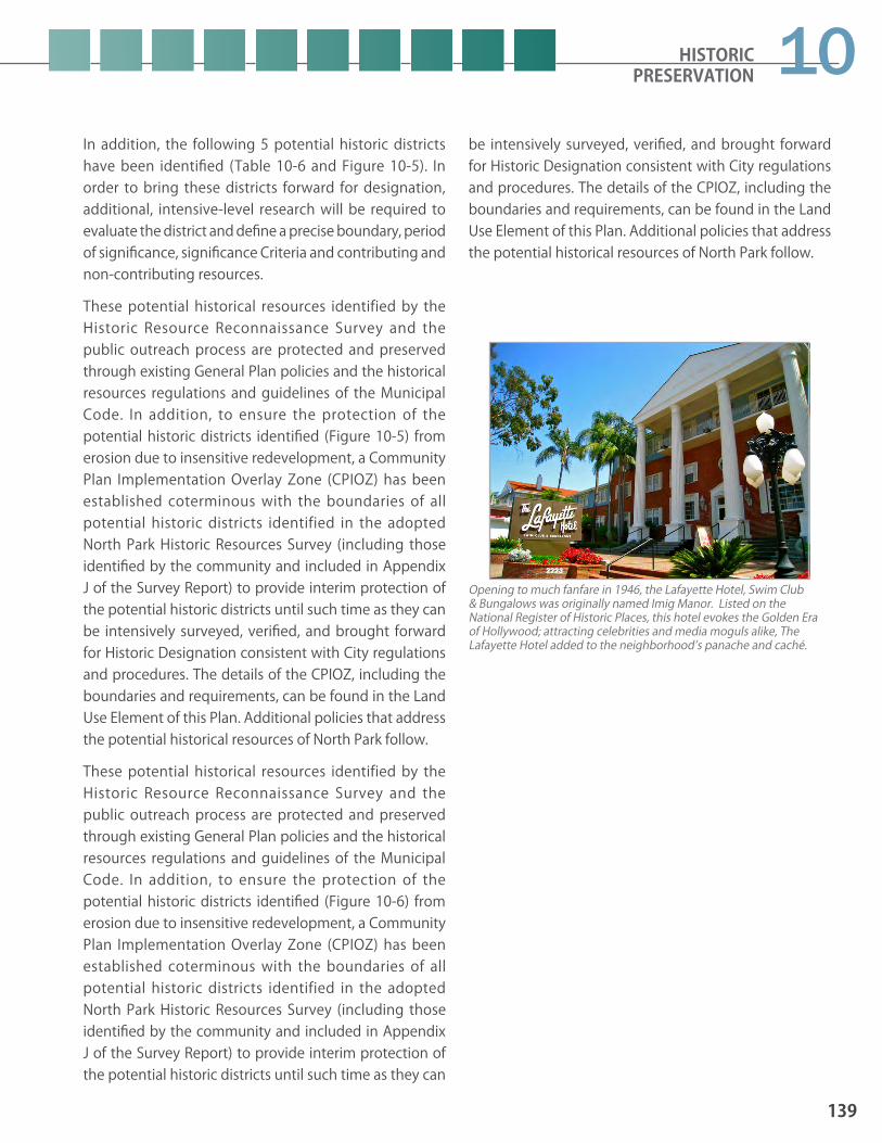
In addition, the following 5 potential historic districts have been identified (Table 10-6 and Figure 10-5). In order to bring these districts forward for designation, additional, intensive-level research will be required to evaluate the district and define a precise boundary, period of significance, significance Criteria and contributing and non-contributing resources.
These potential historical resources identified by the Historic Resource Reconnaissance Survey and the public outreach process are protected and preserved through existing General Plan policies and the historical resources regulations and guidelines of the Municipal Code. In addition, to ensure the protection of the potential historic districts identified (Figure 10-5) from erosion due to insensitive redevelopment, a Community Plan Implementation Overlay Zone (CPIOZ) has been established coterminous with the boundaries of all potential historic districts identified in the adopted North Park Historic Resources Survey (including those identified by the community and included in Appendix J of the Survey Report) to provide interim protection of the potential historic districts until such time as they can be intensively surveyed, verified, and brought forward for Historic Designation consistent with City regulations and procedures. The details of the CPIOZ, including the boundaries and requirements, can be found in the Land Use Element of this Plan. Additional policies that address the potential historical resources of North Park follow.
These potential historical resources identified by the Historic Resource Reconnaissance Survey and the public outreach process are protected and preserved through existing General Plan policies and the historical resources regulations and guidelines of the Municipal Code. In addition, to ensure the protection of the potential historic districts identified (Figure 10-6) from erosion due to insensitive redevelopment, a Community Plan Implementation Overlay Zone (CPIOZ) has been established coterminous with the boundaries of all potential historic districts identified in the adopted North Park Historic Resources Survey (including those identified by the community and included in Appendix J of the Survey Report) to provide interim protection of the potential historic districts until such time as they can
be intensively surveyed, verified, and brought forward for Historic Designation consistent with City regulations and procedures. The details of the CPIOZ, including the boundaries and requirements, can be found in the Land Use Element of this Plan. Additional policies that address the potential historical resources of North Park follow.
HISTORIC PRESERVATION
139
10
Opening to much fanfare in 1946, the Lafayette Hotel, Swim Club & Bungalows was originally named Imig Manor. Listed on the National Register of Historic Places, this hotel evokes the Golden Era of Hollywood; attracting celebrities and media moguls alike, The Lafayette Hotel added to the neighborhood’s panache and caché.

POLICIESHP-2.1 Provide interim protection of all potential
historic districts identified in the adopted North Park Historic Resources Survey (includ-ing those identified by the community and included in Appendix J of the Survey Report) until such time as they can be intensively surveyed, verified, and brought forward for Historic Designation consistent with City regulations and procedures.
HP-2.2 Intensively survey and prepare nominations for the potential historic districts identified in the North Park Historic Resources Survey, and bring those nominations before the Historical Resources Board for review and designation.
HP-2.3 Provide support and guidance to community members and groups who wish to prepare and submit historic district nominations to the City, consistent with adopted Guidelines.
HP-2.4 Provide support and guidance to communi-ty members and groups who wish to pre-pare and submit individual historic resource nominations to the City, consistent with the Municipal Code and adopted Guidelines.
HP-2.5 Work with members of the community to identify and evaluate additional properties that possess historic significance for social or cultural reasons (such an association with an important person or event) for potential historic designation.
HP-2.6 Prepare a Historic Context and Multiple Property Listing addressing courtyard apartments/bungalow courtyards for review and designation by the Historical Resources Board.
HP-2.7 Preserve and protect historic lighting fixtures within designated and potential historic districts. Encourage the use of “acorn” style lighting fixtures within designated and potential historic districts when new lighting fixtures are introduced or non-historic light-ing fixtures are replaced.
HP-2.8 Conduct project specific Native American consultation early in the development re-view process to ensure adequate treatment and mitigation for significant archaeological sites with cultural and religious significance to the Native American community in ac-cordance with all applicable local, state and federal regulations and guidelines.
HP-2.9 Consider eligible for listing on the City’s Historical Resources Register any significant archaeological or Native American cultural sites that may be identified as part of future development within North Park, and refer site to the Historical Resources Board for designation, as appropriate.
140
NORTH PARK COMMUNITY PLAN UPDATE PUBLIC REVIEW DRAFT June 2015
Taking advantage of San Diego’s benign climate by orienting detached or semi-detached units around a central courtyard, this type of courtyard apartments/bungalow courtyards became a popular form of dense and affordable housing in North Park during its greatest economic building boom that saw the completion of the streetcar system, and the 1915 Panama-California Exposition.

POLICIESHP-3.1 Provide opportunities for education and
interpretation of North Park’s diverse history through the distribution of printed bro-chures, mobile technology (such as phone apps) and walking tours, and the installation of interpretative signs, markers, displays, and exhibits at public buildings and parks.
HP-3.2 Partner with local community and historic organizations, including the North Park His-torical Society, to better inform and educate the public on the merits of historic pres-ervation by providing information on the resources themselves, as well as the purpose and objectives of the preservation program.
HP-3.3 Outreach to the North Park Business Im-provement District (BID), local businesses and other organizations operating within the 30th Street/University Avenue Commer-cial Historic District and the various individ-ually significant designated and potential resources to provide information on the benefits and responsibilities of historic re-source stewardship.
HP-3.4 Work with businesses and organizations to create and promote new marketing and her-itage tourism programs and opportunities.
HP-3.5 Promote the maintenance, restoration, rehabilitation and continued private own-ership and utilization of historical resources through existing incentive programs and develop new approaches, such as architec-tural assistance and relief from setback re-quirements through a development permit process, as needed.
10.3 Educational Opportunities and Incentives Related To Historical ResourcesRevitalization and adaptive reuse of historic buildings and districts conserves resources, uses existing infrastructure, generates local jobs and purchasing, supports small business development and heritage tourism and enhances quality of life and community character. The successful implementation of a historic preservation program requires widespread community support. In order to better inform and educate the public on the merits of historic preservation, information on the resources themselves, as well as the purpose and objectives of the preservation program, must be developed and widely distributed.
There are a number of incentives available to owners of historic resources to assist with the revitalization and adaptive reuse of historic buildings and districts. The California State Historic Building Code provides flexibility in meeting building code requirements for historically designated buildings. Conditional Use Permits are available to allow adaptive reuse of historic structures consistent with the U.S. Secretary of the Interior’s Standards and the character of the community. The Mills Act, which is a highly successful incentive, provides property tax relief to owners to help rehabilitate and maintain designated historical resources. Additional incentives recommended in the General Plan, including an architectural assistance program, are being developed and may become available in the future.
In addition to direct incentives to owners of designated historical resources, all members of the community enjoy the benefits of historic preservation through reinvestment of individual property tax savings into historical properties and an increased historic tourism economy. There is great opportunity to build on the existing local patronage and tourism base drawn to the community’s neighborhoods and shopping districts by highlighting and celebrating the rich history of North Park.
In addition to the General Plan Historic Preservation Element POLICIES, the following recommendations are specific to North Park for implementation of educational opportunities and incentives for preservation of the community’s historical resources.
HISTORIC PRESERVATION
141
10
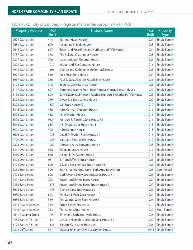
Table 10-2: City of San Diego Register Historic Resources in North ParkProperty Address HRB
Site #Historic Name Year
BuiltProperty
Type2629 28th Street 444 Martin J. Healy House 1927 Single Family2639 28th Street 609 Josephine Shields House 1923 Single Family2645 28th Street 697 Edwin and Rose Emerson/Hurlburt and Tifal House 1924 Single Family2737 28th Street 388 The Rolland C. Springer House 1925 Single Family2807 28th Street 720 Louis and Jane Florentin House 1921 Single Family2829 28th Street 1012 Miguel and Ella Gonzalez House 1916 Single Family2915 28th Street 1106 George and Kathagene McCormack House 1928 Single Family3021 28th Street 550 Jack Rosenberg House 1927 Single Family3037 28th Street 356 Paul E. Stake/George W. Schilling House 1936 Single Family3103 28th Street 348 Beers-La Cava/Kosmas House 1928 Single Family3117 28th Street 627 Antoine & Jeanne Frey - Rear Admiral Francis Benson House 1930 Single Family3133 28th Street 824 Sam & Mary McPherson/Ralph E. Hurlburt & Charles H. Tifal House 1925 Single Family3303 28th Street 789 Owen S. & Rose L. King House 1920 Single Family3393 28th Street 1157 J.B. Spec House #2 1917 Single Family3446 28th Street 456 John Carman Thurston House 1916 Single Family3505 28th Street 452 Kline/Dryden House 1916 Single Family3520 28th Street 962 Winslow R. Parsons Spec House #1 1916 Single Family3563 28th Street 835 J. B. Draper Spec House No. 1 1915 Single Family3571 28th Street 428 John Kenney House 1915 Single Family3676 28th Street 1033 David O. Dryden Spec. House #2 1916 Single Family2722 29th Street 1028 Isaac and Flora Walker House 1912 Single Family2808 29th Street 1082 John and Anna Norwood House 1923 Single Family3411 29th Street 558 Eldora Rudrauff House 1919 Single Family3560 29th Street 880 Joseph E. McFadden House 1911 Single Family3593 29th Street 931 E.A. and Effie Tindula House 1925 Single Family3794 29th Street 890 S.S. and Rosa Kendall Spec House #1 1921 Single Family3335 30th Street 506 30th Street Garage/ North Park Auto Body Shop 1923 Commercial2405 32nd Street 608 Godfrey and Emily Strobeck Spec House #1 1926 Single Family2411 32nd Street 725 Russell and Emma Bates House 1927 Single Family2435 32nd Street 1178 Russell and Emma Bates Spec House #2 1927 Single Family3005 33rd Street 1045 George Gans Spec House #4 1926 Single Family3030 33rd Street 873 Frank and Millie Lexa House 1924 Single Family3036 33rd Street 539 The George Gans Spec House #1 1926 Single Family2242 Adams Avenue 362 Crook-Foster Residence 1914 Single Family2448 Adams Avenue 713 The Adams Apartments 1930 Multi-Family 4641 Alabama Street 1097 Elmer and Katherine Muhl House 1926 Single Family2435 Bancroft Street 1134 Levi and Hannah Lindskoog Spec House #1 1929 Single Family3125 Bancroft Street 1131 George Gans Spec House #5 1926 Single Family2203 Cliff Street 581 Edwina Bellinger/David O. Dryden House 1913 Single Family
142
NORTH PARK COMMUNITY PLAN UPDATE PUBLIC REVIEW DRAFT June 2015

Table 10-2: City of San Diego Register Historic Resources in North ParkProperty Address HRB
Site #Historic Name Year
BuiltProperty
Type2230 Cliff Street 524 Herbert S. Moore House 1913 Single Family2738 Dale Street 787 John & Alice Woodside Spec House #1 1917 Single Family3036 Dale Street 1165 Hilton and Louise Richardson House 1923 Single Family3134 Dale Street 1022 W.J. Chadwick Spec House #1 1920 Single Family3141 Dale Street 1035 T.M. and Leonora H. Russell Spec House #1 1922 Single Family2223 El Cajon Boulevard 319 Imig Manor 1945 Hotel2930 El Cajon Boulevard 517 Gustafson Furniture Building 1948 Commercial3705 El Cajon Boulevard 381 Hille-Schnug House 1880s Single Family3120 Felton Street 921 George Gans Spec House #3 1927 Single Family4674-4676 Florida Street 339 San Diego Electric Railway Cars 126, 128, 138 1911 Railway CarsGeorgia Street(Btwn 3800 & 3900 Blks)
325 Georgia Street Bridge 1914 Bridge
4358 Georgia Street 834 Solomon & Betty Frank House 1922 Single Family2832 Granada Avenue 1010 Albert and Anna Kenyon/Archibald McCorkle House 1912 Single Family3215 Granada Avenue 826 Heilman Brothers Spec House #1 1912 Single Family3235 Granada Avenue 549 E.W. Newman Spec House 1912 Single Family3444 Granada Avenue 475 The Damarus/ Bogan House 1922 Single Family3540 Granada Avenue 1176 William Smith Spec House #1 1923 Single Family2704 Gregory Street 603 H. M. and Isabel Jones House 1930 Single Family2806 Gregory Street 1030 Elmer and Ida Hall House 1932 Single Family3227 Grim Avenue 183 Frary House 1905 Single Family4044 Hamilton Street 909 Gilbert & Alberta McClure House 1927 Single Family4050-4056 Hamilton St 989 Gilbert and Alberta McClure Rental House & Apts 1929 Multi-Family3565 Herman Avenue 792 George Gans Spec House #2 1925 Single Family3547-3549 Indiana Street 1141 Jessie Brown Spec Houses #1 and #2 1923 Multi-Family 3054 Juniper Street 747 Edwin and Cecilia Smith/Greta Steventon House 1919 Single Family3105 Kalmia Street 478 Duvall-Lee House 1915 Single Family3147 Kalmia Street 430 Benbough/Adams House 1912 Single Family3155 Kalmia Street 435 William A. McIntyre Spec House 1912 Single Family3004 Laurel Street 163 Dr. Harry & Rachel Granger Wegeforth House 1912 Single Family3048 Laurel Street 438 Cottee/McCorkle House 1912 Single Family3674 Louisiana Street 981 Alonzo and Sophia Finley House 1911 Single Family3794 Louisiana Street 1083 Daniel and Anna Boone House 1920 Single Family2840 Maple Street 551 Cortis & Elizabeth Hamilton/Richard S. Requa House 1941 Single Family2941 Palm Street 423 David Drake House 1924 Single Family3055 Palm Street 974 F. List and C. Bell Mcmechen House 1927 Single Family2875-2889 Palm Street 872 Martin and Katherine Ortilieb Duplex 1927 Multi-Family4741 Panorama Drive 769 Ora and Myrtle Ginther House 1926 Single Family4747 Panorama Drive 1121 John C. and Marie O. Turner House 1926 Single Family
HISTORIC PRESERVATION
143
10

Table 10-2: City of San Diego Register Historic Resources in North ParkProperty Address HRB
Site #Historic Name Year
BuiltProperty
Type4769 Panorama Drive 1107 Delia Reinbold House 1911 Single Family4773 Panorama Drive 1016 Louis H. and Charlotte L. Quayle House 1926 Single Family4780 Panorama Drive 675 Helen Crenshaw/David O. Dryden House 1914 Single Family4785 Panorama Drive 538 The Richard S. Woods House 1913 Single Family3993 Park Boulevard 293 Grace Lutheran Church, Parsonage, & Sunday School 1930 Institutional3503 Pershing Avenue 839 Addie McGill/David O. Dryden House Spec House #1 1917 Single Family3694 Pershing Avenue 843 David E. & Jennie McCracken House 1925 Single Family3503 Ray Street 493 Carter Construction Co. Swiss Chalet 1912 Single Family2890 E Redwood Street 900 George and Amalia Gans House 1928 Single Family2516 San Marcos Avenue 124 Fulford Bungalow #1 1913 Single Family2518 San Marcos Avenue 125 Fulford Bungalow #2 1913 Single Family2519 San Marcos Avenue 454 Mabel Whitsitt House 1935 Single Family2520 San Marcos Avenue 126 Fulford Bungalow #3 1913 Single Family2523 San Marcos Avenue 457 Whiteman House 1914 Single Family3405 Texas Street 832 George & Helen Corbit Spec House No. 1 1924 Single Family3535 Texas Street 540 The Edwin and Anna Elizabeth McCrea House 1924 Single Family2901 University Avenue 239 Winks/Deturi/Shoe Palace/Shoe Repair/Neon Sign 1949 Sign3067-3075 University Ave 1043 Woolworth Building 1949 Commercial2140 Upas Street 1056 J. Francis and Clara Munro House 1926 Single Family3585 Villa Terrace 724 Maynard and Bessie Heatherly House 1926 Single Family3602 Villa Terrace 996 Fredrick and Ada Sedgwick/Pear Pearson House 1922 Single Family3525 Wilshire Terrace 676 Dr. Edward Hardy House 1938 Single Family*This table includes all properties designated by the Historical Resources Board as as of April 2015
144
NORTH PARK COMMUNITY PLAN UPDATE PUBLIC REVIEW DRAFT June 2015

Figure 10-1: Location of City of San Diego Register Designated Historic Sites
HISTORIC PRESERVATION
145
10

Figure 10-2: Location of City of San Diego Register Designated Historic District
146
NORTH PARK COMMUNITY PLAN UPDATE PUBLIC REVIEW DRAFT June 2015

Property Address Year Built Style Property TypeEarly Settlement of Greater North Park: 1893-1906
3729 30th Street* 1897 Mission Revival Civic/Institutional4212 Florida Street 1900 Queen Anne Single Family4216 Florida Street 1900 Queen Anne Single Family1915 Howard Avenue 1900 Folk Victorian Single Family1919 Howard Avenue 1900 Queen Anne Single Family3727 Park Boulevard 1900 Stick/Eastlake Single Family2860 Redwood Street 1900 Italianate Single Family
Development of North Park: 1907-19293553 28th Street* 1925 Craftsman Single Family2361-2367 30th Street* 1920 Renaissance Revival Commercial3382-3396 30th Street 1919 Spanish Colonial Revival Commercial3585 30th Street* 1929 Renaissance Revival Civic/Institutional2454-2474 Adams Avenue* 1928 Pueblo Revival Multi-Family2204 Cliff Street 1914 Craftsman Single Family2935-2947 El Cajon Boulevard
1925 Commercial Vernacular Commercial
3169 El Cajon Boulevard* 1926 Renaissance Revival Infrastructure4208 Idaho Street* 1924 Utilitarian Infrastructure3226-3266 Nutmeg Street* 1922 Spanish Colonial Revival Civic/Institutional4860 Oregon Street* 1916
1920sRenaissance Revival
Spanish Colonial RevivalCivic/Institutional
4744 Panorama Drive* 1907 Craftsman Single Family3645 Park Boulevard* 1925 Spanish Colonial Revival Multi-Family3783 Park Boulevard* 1928 Egyptian Revival Commercial3791 Park Boulevard* 1928 Renaissance Revival Multi-Family4237-4251 Park Boulevard* 1926 Art Deco Commercial3030 Thorn Street* 1924 Spanish Colonial Revival Civic/Institutional2505 University Avenue 1922 Commercial Vernacular Commercial2525-2543 University Avenue 1925 Commercial Vernacular Commercial2900-2912 University Avenue 1929 Spanish Colonial Revival Commercial
Table 10-3: Potentially Significant Individual Resources
Potentially significant individual resouces were Identified in the 2015 North Park Historic Resource Reconnaissance Survey and are organized by theme
HISTORIC PRESERVATION
147
10

Table 10-3: Potentially Significant Individual ResourcesProperty Address Year Built Style Property Type
Influence of the Great Depression & World War II in North Park: 1930-19454333 30th Street* 1940 Spanish Colonial Revival Civic/Institutional2228 33rd Street* 1938 Streamline Moderne Single Family3925-3935 Alabama Street 1930 Spanish Colonial Revival Multi-Family3810 Bancroft Street 1935 Streamline Moderne Civic/Institutional2900 El Cajon Boulevard 1938 Modern Commercial3004-3022 Juniper Street 1930 Spanish Colonial Revival Commercial2848 Kalmia Place* 1937 Streamline Moderne Single Family4469-4517 Ohio Street 1940 Minimal Traditional Multi-Family3655 Park Boulevard* 1930 Spanish Colonial Revival Civic/Institutional3076-3090 Polk Avenue* 1930 Art Deco Civic/Institutional1910 Robinson Avenue* 1937 Streamline Moderne Multi-Family3029 University Avenue* 1942 Late Moderne Commercial3036 Upas Street 1930 Streamline Moderne Commercial3040 Upas Street 1930 Streamline Moderne Commercial3795 Utah Street* 1931 Art Deco Civic/Institutional
Post-World War II Development in North Park: 1946-19702110 El Cajon Boulevard 1960 Modern Commercial2144 El Cajon Boulevard 1964 Modern Commercial2445 El Cajon Boulevard* 1965 Googie Commercial3791 Grim Avenue 1951 Modern Civic/Institutional4175 Park Boulevard* 1965 Googie Commercial4193 Park Boulevard* 1966 Modern Civic/Institutional*This resource also appears eligible for listing in the National Register and the California Register.
Potentially significant individual resouces were Identified in the 2015 North Park Historic Resource Reconnaissance Survey and are organized by theme
148
NORTH PARK COMMUNITY PLAN UPDATE PUBLIC REVIEW DRAFT June 2015
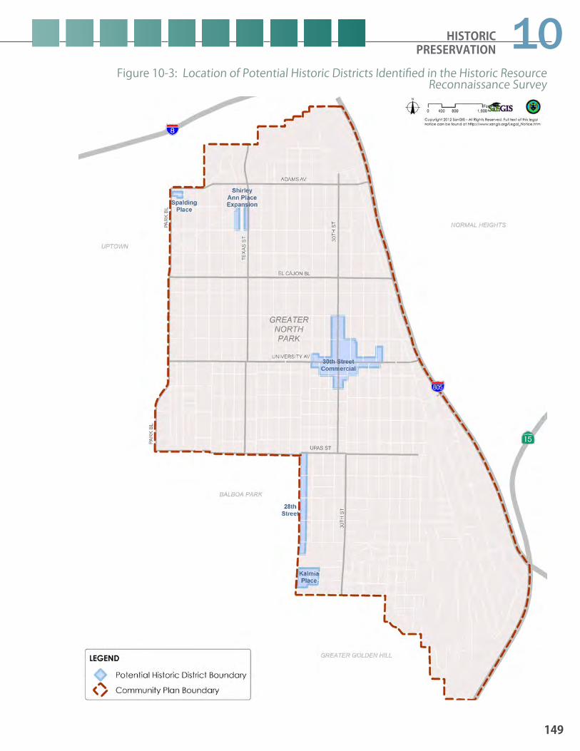
Figure 10-3: Location of Potential Historic Districts Identified in the Historic Resource Reconnaissance Survey
HISTORIC PRESERVATION
149
10
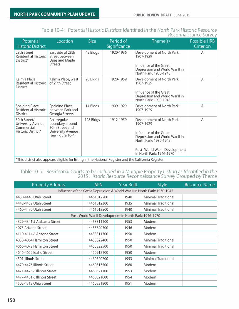
Potential Historic District
Location Size Period of Significance
Theme(s) Possible HRB Criterion
28th Street Residential Historic District*
East side of 28th Street between Upas and Maple Streets
45 Bldgs 1920-1936 Development of North Park: 1907-1929
Influence of the Great Depression and World War II in North Park: 1930-1945
A
Kalmia Place Residential Historic District
Kalmia Place, west of 29th Street
20 Bldgs 1920-1959 Development of North Park: 1907-1929
Influence of the Great Depression and World War II in North Park: 1930-1945
A
Spalding Place Residential Historic District
Spalding Place between Park and Georgia Streets
14 Bldgs 1909-1929 Development of North Park: 1907-1929
A
30th Street/ University Avenue Commercial Historic District*
An irregular boundary around 30th Street and University Avenue (see Figure 10-4)
128 Bldgs 1912-1959 Development of North Park: 1907-1929
Influence of the Great Depression and World War II in North Park: 1930-1945
Post- World War II Development in North Park: 1946-1970
A
*This district also appears eligible for listing in the National Register and the California Register.
Table 10-4: Potential Historic Districts Identified in the North Park Historic Resource Reconnaissance Survey
Property Address APN Year Built Style Resource NameInfluence of the Great Depression & World War II in North Park: 1930-1945
4430-4440 Utah Street 4461012200 1940 Minimal Traditional4442-4452 Utah Street 4461012300 1935 Minimal Traditional4460-4470 Utah Street 4461012500 1940 Minimal Traditional
Post-World War II Development in North Park: 1946-19704329-4341½ Alabama Street 4453311100 1953 Modern4075 Arizona Street 4455820300 1946 Modern4110-4114½ Arizona Street 4455311700 1950 Modern4058-4064 Hamilton Street 4455822400 1950 Minimal Traditional4066-4072 Hamilton Street 4455822500 1950 Minimal Traditional4646-4652 Idaho Street 4450912100 1950 Modern4501 Illinois Street 4460520700 1953 Minimal Traditional4470-4476 Illinois Street 4460513500 1960 Modern4471-4475½ Illinois Street 4460521100 1953 Modern4477-4481½ Illinois Street 4460521000 1954 Modern4502-4512 Ohio Street 4460531800 1951 Modern
Table 10-5: Residential Courts to be Included in a Multiple Property Listing as Identified in the 2015 Historic Resource Reconnaissance Survey Grouped by Theme
150
NORTH PARK COMMUNITY PLAN UPDATE PUBLIC REVIEW DRAFT June 2015

Table 10-6: Potentially Significant Individual Resources Identified During Public Outreach, Grouped by Theme
Property Address APN Year Built Style Property TypeDevelopment of North Park: 1907-1929
2432 El Cajon Boulevard* 4453421200 c.1925 False Front Commercial2621 El Cajon Boulevard* 4454220400 c.1910s No Style Commercial3094 El Cajon Boulevard 4461831500 1927 Spanish Eclectic Institutional3093-3095 El Cajon Boulevard 4462530700 c.1922 Streamline Moderne Commercial
Influence of the Great Depression & World War II in North Park: 1930-19452528 El Cajon Boulevard 4453513000 c.1935 Art Deco Institutional2903-2911 El Cajon Boulevard 4462320500 c.1937 Streamline Moderne Commercial2921-2923 El Cajon Boulevard 4462320400 c.1940 Modern Commercial2927-2931 El Cajon Boulevard 4462320300 c.1935 Modern Commercial2923-2935 Meade Avenue 4461622300 c.1942 Moderne Commercial4121 Utah Street** 4463021300 1921 Craftsman Residential
Post-World War II Development in North Park: 1946-19704334-4382 30th Street 4461622900 c.1950s Aztec Bowl Neon Sign Sign1835 El Cajon Boulevard 4453801400 c.1969 Modern Commercial1940 El Cajon Boulevard 4453222500 c.1946 Modern Commercial2136 El Cajon Boulevard 4453311500 c.1955 Modern Commercial2222 El Cajon Boulevard 4453321400 unkwn Wonder Weaver Painted
SignSign
2548-2550 El Cajon Boulevard 4453511600 1955 Modern Commercial3035 El Cajon Boulevard 4462330600 c.1962 Modern Commercial3051 El Cajon Boulevard 4462530100 c.1951 Colonial Commercial3069-3075 El Cajon Boulevard 4462530300
4462530400c.1946 Streamline Moderne Commercial
3984 Idaho Street*** 4457112600 1921 Vernacular Residential2717 University Avenue 4530821100 c.1956 Modern Institutional*It has been indicated that this building may be socially/historically significant.**This building was the childhood home baseball Hall-of-Famer Ted Williams.***This building was the home of tennis champion Maureen Connolly during her accomplishments in the 1950s.
HISTORIC PRESERVATION
151
10
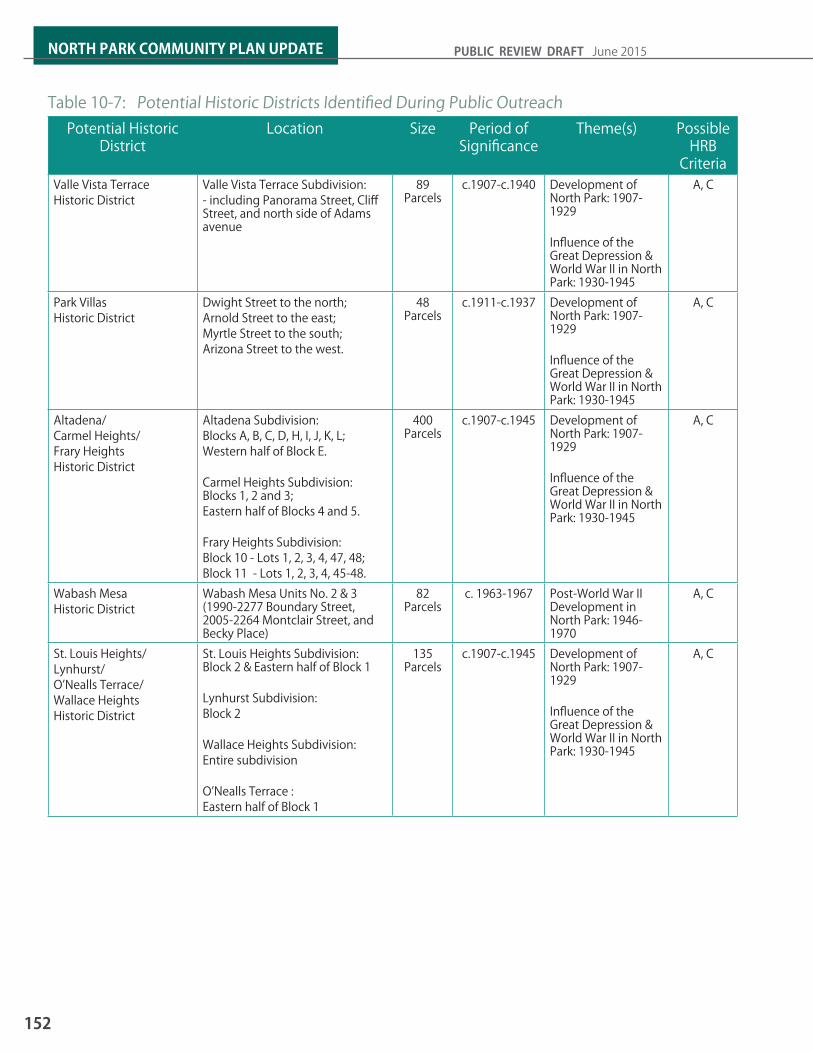
Potential Historic District
Location Size Period of Significance
Theme(s) Possible HRB
CriteriaValle Vista Terrace Historic District
Valle Vista Terrace Subdivision:- including Panorama Street, Cliff Street, and north side of Adams avenue
89 Parcels
c.1907-c.1940 Development of North Park: 1907-1929
Influence of the Great Depression & World War II in North Park: 1930-1945
A, C
Park Villas Historic District
Dwight Street to the north;Arnold Street to the east;Myrtle Street to the south; Arizona Street to the west.
48 Parcels
c.1911-c.1937 Development of North Park: 1907-1929
Influence of the Great Depression & World War II in North Park: 1930-1945
A, C
Altadena/Carmel Heights/Frary Heights Historic District
Altadena Subdivision:Blocks A, B, C, D, H, I, J, K, L;Western half of Block E. Carmel Heights Subdivision: Blocks 1, 2 and 3; Eastern half of Blocks 4 and 5.
Frary Heights Subdivision:Block 10 - Lots 1, 2, 3, 4, 47, 48; Block 11 - Lots 1, 2, 3, 4, 45-48.
400 Parcels
c.1907-c.1945 Development of North Park: 1907-1929
Influence of the Great Depression & World War II in North Park: 1930-1945
A, C
Wabash Mesa Historic District
Wabash Mesa Units No. 2 & 3 (1990-2277 Boundary Street, 2005-2264 Montclair Street, and Becky Place)
82 Parcels
c. 1963-1967 Post-World War II Development in North Park: 1946-1970
A, C
St. Louis Heights/Lynhurst/ O’Nealls Terrace/Wallace Heights Historic District
St. Louis Heights Subdivision: Block 2 & Eastern half of Block 1
Lynhurst Subdivision: Block 2
Wallace Heights Subdivision:Entire subdivision O’Nealls Terrace : Eastern half of Block 1
135 Parcels
c.1907-c.1945 Development of North Park: 1907-1929
Influence of the Great Depression & World War II in North Park: 1930-1945
A, C
Table 10-7: Potential Historic Districts Identified During Public Outreach
152
NORTH PARK COMMUNITY PLAN UPDATE PUBLIC REVIEW DRAFT June 2015

Figure 10-4: Location of Potential Historic Districts Identified During Public Outreach
HISTORIC PRESERVATION
153
10

Figure 10-5: Location of All Potential Historic Districts in North Park
154
NORTH PARK COMMUNITY PLAN UPDATE PUBLIC REVIEW DRAFT June 2015

11ARTS AND CULTURE
Mural by Joachim Ixcalli

IntroductionBy embracing public art and artists as vital to the creation of unique public places that provide physical, social, cultural and economic benefits, the community of North Park is setting a Citywide standard for a proactive, thoughtful and responsible approach to urban planning.
Rather than an afterthought or last-minute embellishment to a building project, public art can serve as an integral part of the architecture, landscape and urban design of a site. Incorporating public art into the fundamental aspects of planning elevates the quality of the urban environment and promotes a cohesive vision for the character of public places and neighborhoods throughout North Park. The preservation of historic and architecturally significant buildings is fundamental to the Community’s artistic vision.
The North Park Community Plan redefines the relationship of art to urban space as an integral part of both the urban infrastructure and the natural environment. This plan seeks to make North Park’s commitment to excellence in design, architecture and art readily apparent. By committing to a diversity of public artworks of undisputed quality and excellence as integral to the success of its comprehensive planning effort, North Park assumes a leadership role as a forward-looking, progressive neighborhood dedicated to defining a unique sense of place spaces, improving the quality of development through the inclusion of public art, and creating for its residents, business owners, artists, and visitors.
RELATIONSHIP TO THE GENERAL PLAN The General Plan establishes over-riding policies and guidelines that guide all community plan policies. Several policies that apply to North Park Community Plan and the Arts and Cultural Element are in the General Plan. These policies are contained in Public Art and Cultural Amenities section of the Urban Design Element of the General Plan and cover public art policies related to community and citywide identity, public opportunities for collaboration for the development and public art process.
Ray street which as at the center of north park’s art district, hosts gath-erings of local and nationally known artists, galleries and art-related events and venues.
Public art can promote transit use as well as community pride.
156
NORTH PARK COMMUNITY PLAN UPDATE PUBLIC REVIEW DRAFT June 2015
Community Vision for Arts and Culture :“Arts, culture, and the humanities incorporated into the planning process as a guide for North Park’s economic and social development .”

ARTS & CULTURE
11.1 Public ArtPublic art helps to transform space into a more welcoming and beautiful environment. It provides a healthy means of fostering art within a community and is a direct reflection of a community’s values. North Park prides itself as a community that celebrates public art. It’s business district - North Park Main Street is renowned not only for its local businesses, but as an arts and culture district as well. Its formation as part of the national Main Street program to preserve the community’s historic business core, has been key to North Park’s economic and arts renaissance. Continuing to grow North Park’s arts and culture traditions will involve creating and building new partnerships, fostering and designing spaces and places for art to grow, spreading awareness, and recognizing and promoting North Park as a center for arts and culture.
Arts and Culture Element Goals:The North Park Community Plan reconsiders the role public art can play in planning. It addresses potential intersections between public art, redevelopment, new development, streetscape, cultural arts, social services, recreational facilities, transit and public space.
1. A d e f i n e d a n d i n t e r c o n n e c t e d relationship between public art , other North Park goals, and funding mechanisms;
2. Creation of a broad range of artistic possibilities and efforts in North Park;
3. Recognition of artists as thoughtful contributors to the design of the environment; and
4. Interdisciplinary collaboration between artists and developers, designers, and architects.
5. Integrat ion of arts and culture throughout North Park as a significant tool for reinforcing community identity, increasing public use and enjoyment of public facilities, making memorable spaces in the community, leveraging North Park’s cultural assets for economic growth, and to communicate the community’s unique cultural identity.
6. A sustainable cultural ecosystem.
7. Preservation of historic places and buildings as a feature of North Park’s cultural identity.
Partnerships established between developers, businesses, artists, and the community can be most effective in gaining support for public art.
Weeenosaurus Rex by Mark Paul Deren
157
11
POLICIESAC-1.1 Develop North Park’s cultural and creative
workforce bysupporting the full range of art-ists and arts and culture resources in North Park by developing strategies to retain artists and cultural workers in all visual and performing arts disciplines.
AC-1.2 Build partnerships between the business community and the cultural sector.a. Link artists and arts organizations with
prospective developers to create unique projects that tie together the commercial and arts and culture communities. Encourage sponsorship of individual and group presentations, exhibitions, performances, presentations, and special events such as festivals and cultural celebrations.
b. Gain support of local art organizations and programs to attract funding from alternative grant sources.
c. Encourage businesses to support and sponsor art in areas adjacent to their storefront and in the community.
AC-1.3 Provide space for North Park’s cultural and creative sector.a. Develop mixed-use artist centers,
affordable live/work housing, and a series of facilities that include quality exhibition space, teaching studios, shared work spaces, and meeting/lecture spaces.
b. Utilize vacant and/or underutilized storefronts and other non-residential buildings for temporary art exhibitions.
c. Encourage the provision of spaces for performances and art events in the neighborhood parks, transit stations, residential developments, public areas within private developments.
AC-1.4 Cultivate arts education for all ages by supporting the efforts of the community’s arts education providers through in-school, after-school and lifelong learning opportu-nities.
AC-1.5 Encourage a multi-faceted approach to public art by providing a range of public art opportunities that include artists’ participa-tion in the design of civic spaces and private development; functional items such as street furnishings and way-finding elements; a collection of artworks by nationally and internationally renowned artists; temporary installations; artist residency programs; and projects specifically for local artists.
AC-1.6 Expand awareness of North Park as a Center of Arts and Culture by strengthening market-ing programs aimed at building participation in arts and culture for residents and visitors to attract new audiences and dollars in order to for arts, culture and tourism to flourish.
AC-1.7 Introduce and encourage art, both public and private, in a manner respectful of North Park’s historic architecture and landscapes, and consistent with the Secretary of the Inte-rior Standards of Historic Preservation.
AC-1.8 Include public art or cultural amenities in each new development project and engage artists early in the project design process to achieve integration between art and archi-tecture.
AC-1.9 Recognize the contribution and importance of North Park’s historic architecture to the community’s unique character and artistic environment.
AC-1.10 Recognize the positive economic impact of an arts-rich place-making environment in at-tracting businesses that provide high-paying jobs (ensure nexus with economic prosperity element). See the following study as refer-ence: • Arts and Economic Prosperity IV http://www.
artsusa.org/pdf/information_services/research/services/economic impact/aepiv/AEP4_NationalSummaryReport.pdf
158
NORTH PARK COMMUNITY PLAN UPDATE PUBLIC REVIEW DRAFT June 2015

1212.1 ZONING 12.2 COMMUNITY PLAN IMPLEMENTATION
OVERLAY ZONE (CPIOZ)12.3 CPIOZ DEVELOPMENT REGULATIONS12.4 FINANCING MECHANISMS 12.5 PRIORITY PUBLIC IMPROVEMENTS AND
FUNDING 12.6 ACTION ITEMS AND PRIORITIES
IMPLEMENTATION

IntroductionThe community plan establishes policies and recommendations to guide the growth of the North Park community and provide for its quality of life. The formulation and adoption of a community plan is only the first step in a two-step process. The second and equally important step is the implementation of the policies and recommendations of the plan.
The plan is implemented through a number of different mechanisms which are outlined in this chapter. Necessary actions and key parties responsible for realizing the plan’s vision are identified. Implementing the plan’s proposals will require the active participation of City of San Diego departments and agencies, regional agencies such as SANDAG, and MTS, and the community.
A number of key actions are identified for the City and the North Park community to pursue in order to implement the plan’s policies and recommendations. These actions include, but are not limited to:
• Administration of the Community Plan Implementation Overlay Zone (CPIOZ).
• Approve and regularly update a Fee Impact Study (IFS) identifying the capital improvements and other projects necessary to accommodate present and future community needs as identified throughout this Plan.
• Implement facilities and other public improvements in accordance with the IFS.
• Pursue grant funding to implement unfunded needs identified in the IFS.
• Implement the Plan’s urban design policies and recommendation through the review of development projects. Longer-term implementation strategies have been identified and focus on various programs, financing mechanisms, and capital improvement priorities that could be considered toward this effort.
The previous community plan provided for community-specific tailored zoning as part of a Planned District. The implementation program for the community plan update included a review of the existing Planned District zones. As a result, the Planned District is being replaced with a combination of citywide zones and tailored zoning using the Community Plan Implementation Overlay Zone.
Mid-City Communities Planned District Zones
Compatible Citywide Zones
MR-3000 RM-1-1MR-1750 RM-2-4MR-1500 RM-2-5MR-1250B RM-2-6MR-1000 RM-3-7MR-800B RM-3-8CN-1-2, CC-3-5 CN-1-1CL-5, CN-3 CN-1-3CL-2, CV-3 CN-1-4CL-1 CC-3-7CN-1 CC-3-8
Table 12-1: PDO to Citywide Zone Conversion12.1 Zoning The update to the community plan includes a zoning implementation program that consists of specific rezone actions as well as a larger conversion of the Mid-City Communities Planned District zones to a zone program that uses a combination of citywide zone and community-specific tailored zoning through the CPIOZ. The zoning implementation program is to be processed concurrently with the community plan update. The recommended Planned District / citywide zone conversions are summarized in the table below.
160
NORTH PARK COMMUNITY PLAN UPDATE PUBLIC REVIEW DRAFT June 2015

IMPLEMENTATION
12.2 Community Plan Implementation Overlay Zone (CPIOZ)The purpose and applicability of the CPIOZ within each sub-district and development category is described as follows:
12.2-1 SUB-DISTRICT APPLICABILITYThe CPIOZ is applied geographically within the community to the following five sub-district. See Figure 12-1: Community Plan Implementation Overlay Zone (CPIOZ) Sub-Districts Map.
(a) SFR-A – Single-Family Residential Neighborhoods within RS Zones (Type A)
(1) Apply supplemental development regulations to new and expanded structures to ensure neighborhood compatibility.
(A) CPIOZ Type A shall apply to any expansion of the structural envelope within a lot or premise that includes a street facing building façade on a front and/or side yard. The design requirements contained in Section 12.3 apply.
(b) HR-B – Hillside Residential & Canyon Rim Neighborhoods within any zone (Type B)
(1) Apply design guidelines and supplemental development regulations to new and expanded structures to ensure neighborhood compatibility and to preserve the visual quality of the canyon environment.
(A) CPIOZ Type B shall apply to any expansion of the structural envelope within a lot or premise that that results in a total floor area increase of 15 percent or more square feet. Policies and guidelines of the community plan apply, including those for Public Views and Canyons, and Hillsides and Open Space in the Urban Design Element.
(c) CM-X and MF - A/B – Commercial, Multi-Family & Mixed-Use Neighborhoods (CPIOZ Type A/B)
(1) Apply design and supplemental development regulations to new development within a lot or premise to ensure neighborhood compatibility.
(A) (CPIOZ Type A shall apply to implement the development regulations listed in Section 12.3.
(d) Potential Historic Districts (Content to be provided with subsequent draft)
The Community Plan Implementation Overlay Zone (CPIOZ) is applied within the boundaries of the North Park community per Chapter 13, Article 2, Division 14 of the Municipal Code. The purpose of the overlay zone is to supplement the Municipal Code by providing development regulations that are tailored to specific circumstances and/or sites within the community and have been adopted as part of the North Park Community Plan. The CPIOZ also provides for a discretionary review process to more effectively implement community plan policies and recommendations, particularly those of the Urban Design Element.
The CPIOZ is applied to specific geographic areas within the community and also to specific development circumstances. The CPIOZ provides community-specific development regulations and supersedes equivalent regulations in the zones applied within the community. This CPIOZ is not intended to address use. Use categories are determined by the applicable base zone.
The CPIOZ has two types differentiated by their review process: Type A (ministerial review), and Type B (discretionary review). Both types are applied within the community depending on geographic district criteria or regulatory format (e.g. development regulations, height limits or design guidelines). Development proposals identified as CPIOZ Type B require discretionary review to determine if the development proposal is consistent with the community plan as well as the applicable regulations listed below. Such proposals shall be required to process and obtain approval of a Process Three Site Development Permit in accordance with Chapter 12, Article 6, Division 5 of the Municipal Code. Exceptions from these regulations may be granted per Municipal Code Section 132.1403 for development that is minor, temporary, or incidental and is consistent with the purpose and intent of this CPIOZ. Any development proposals that do not comply with the Community Plan, the base zone regulations or these supplemental CPIOZ regulations shall be required to process a community plan amendment and or rezone. The CPIOZ is also applied to specific development categories.
161
12

12.2-2 DEVELOPMENT CATEGORY APPLICABILITY
(a) Incentive Zone Program
Establishes a voluntary development option for additional residential density within specific districts in exchange for public benefits (also refer to Land Use Element for discussion).
(1) CPIOZ Type B shall apply to allow for additional base density up to the maximums shown on Land Use Element Figure 2-1: Community Plan Land Use, 2-2: Community Plan Land Use – North, and 2-3: Community Plan Land Use - South. A development agreement or similar mechanism as determined by the City is required as part of program implementation.
12.3 CPIOZ Development RegulationsThis section contains development regulations including statements related to the purpose and intent of the regulations.
12.3-1 SINGLE-FAMILY NEIGHBORHOOD DESIGN REQUIREMENTS
(2) Public Open Space – Development projects that reserve a portion of their site for the development of public open space (e.g. public park, plaza, etc. as defined by the General Plan) may qualify for a FAR bonus of 0.5.
(3) Public Parking – One square foot of FAR bonus may be granted for every square foot of parking area made permanently available for public parking use. A public parking easement shall be executed with restrictions and covenants acceptable to the City.
(Applies to areas identified as SFR on Figure 12-1)
Most of the community’s single-family neighborhoods have retained their original character and most homes have retained their traditional architecture and human scale. These include a human-scale of building elements including building mass and overall height; street orientation of porches, entries and living areas; de-emphasis of vehicular parking; attention to architectural detail; variation of simple, geometric roof forms and building massing (often with a horizontal orientation).
Alterations and additions to buildings, or the building of new structures, shall observe basic design forms similar to other homes within surrounding blocks such as street orientation, location within the lot, use of materials, and proportions related to building bulk, massing, and scale. Structural additions or new structures within a lot or premise shall use design forms similar to those used for the primary dwelling unit.
The following design requirements apply to newly constructed dwellings or accessory buildings within a lot or premise as well as to structural additions.
(a) Street Yard Setbacks
Uniform setbacks are a neighborhood character-defining feature that shall be maintained within blocks and neighborhoods. Front and street side setback variances are therefore discouraged. However, within certain blocks or neighborhoods, zone setbacks are less than the prevailing development pattern. Building to these setbacks would disrupt the character of the block or neighborhood and is subject to the following:
(1) Maintain prevailing front yard and street yard setbacks established by existing structures within a block.
(A) The prevailing setback shall be established by the average maximum street wall setback of all lot frontages within the block face of the subject property;
(B) Require a survey of building street wall setbacks within both sides of the block face when new structures or additions are proposed that face a public street;
(C) New structures and additions shall not encroach more than 5 feet into the prevailing setback.
162
NORTH PARK COMMUNITY PLAN UPDATE PUBLIC REVIEW DRAFT June 2015

IMPLEMENTATION
?àE
BALBOA PARK
GREATER GOLDEN HILL
NORMAL HEIGHTS
UPTOWN?àE
%&s(
!"_$PA
RK
BL
ADAMS AV
TEX
AS S
T
30TH
ST
40TH
ST
PAR
K B
L
UNIVERSITY AV
30TH
ST
UPAS ST
EL CAJON BL
Copyright 2012 SanGIS - All Rights Reserved. Full text of this legalnotice can be found at http://www.sangis.org/Legal_Notice.htm
0 800 1,600400Feeto
LEGEND
CPIOZ
HR-B
CMX-A/B
MF-A/B
SFR-A
Community Plan Boundary
Figure 12-3: Community Plan Implementation Overlay Zone
163
12

(b) Architectural Features
Traditional design includes many unique architectural features that are worthy of preservation. Of these, street facing entries, windows, covered porches and forecourts are important character-defining features that shall be maintained or replicated in their original architectural form subject to the following:
(1) The removal or partial removal of more than 50 percent of a porch or forecourt shall be prohibited. Activities for maintenance, repair or architectural enhancement are exempt.
(2) The following shall be required for new or expanded dwelling units:
(A) Provide one porch or forecourt with a minimum 6 foot depth along 70 percent of any street facing building facade;
(B) Provide a primary entry door visible from the street;
(C) Provide at least one window with transparent glazing of at least 12 square feet on each street-facing building façade.
(c) Garages and Accessory Buildings
The location of garages shall be subordinate to the primary dwelling unit. Hollywood (or ribbon style) driveway pavement configurations are encouraged. The following regulations shall apply:
(1) Access to garages and off-street parking shall be from alleys where available;
(2) Where alley access is not available, garages shall not be located within the front 30 percent of the lot. Driveways shall be a single-width not more than 10 feet wide;
(3) The design of all accessory buildings and detached garages shall be integrated into the design of the primary dwelling as subordinate elements and designed with the same materials and of the same architectural style.
(d) First Story
A lower profile ground floor height is a feature of the community’s traditional architecture. Street facing building facades shall establish apparent height relationships between first and second stories similar to homes within surrounding blocks. Traditional eight foot wall plate heights are encouraged. The following regulations shall apply:
(1) The top plate height of a single or first story shall not extend more than 12 feet above existing grade. Basements or crawl spaces used to accommodate slopes within hillside lots are not included in the height measurement (see Figure 12-2: Lower Profile Ground Floor Height Diagram);
(2) Daylight or partial above-grade basements are not allowed within the front or street side yard building façades. Basements or crawl spaces used to accommodate slopes within hillside lots are not included in the height measurement (see Figure 12-2: Lower Profile Ground Floor Height Diagram).
(e) Second Story
Many traditional neighborhoods contain a majority of single-story homes, and two story homes typically incorporate design features that reduce the scale and visual impact of the second story. The following regulations shall apply:
(1) Structural additions to street facing building façades of existing dwellings above the first story shall step back a minimum of 6 feet from the first story building façade (applies to a minimum 70 percent of a single building façade);
(2) At the side setback line, the height of the building envelope above 19 feet in height is established by a 45-degree building envelope plane sloping inward to the maximum permitted 30-foot structure height (Reference Municipal Code Diagram 131-04M). Applies to a minimum 70 percent of a building façade;
(3) For interior side yard building facades, window designs that direct views into neighboring windows shall be avoided through use of offsets, staggering, clerestory designs or translucent glazing; and
164
NORTH PARK COMMUNITY PLAN UPDATE PUBLIC REVIEW DRAFT June 2015

IMPLEMENTATION
(4) Decks and balconies larger than 15 square feet within 15 feet of an interior side or rear residential abutting property line shall be prohibited.
(f) Materials
Traditional building practices and materials contribute greatly to the architectural character of older neighborhoods. The following regulations shall apply:
(1) Traditional stucco, wood and masonry are allowed materials;
(2) New structural additions shall replicate the materials and finishes on the existing dwelling;
(3) When using stucco, the method of application and finish shall be similar to homes within surrounding blocks. Contemporary rough-texture finishes are prohibited unless currently used.
12.3-2 COMMERCIAL, MIXED-USE & MULTI-FAMILY NEIGHBORHOOD DESIGN REQUIREMENTS
Applies to areas identified as CMX and MF - A/B on Figure 12-1. See Figure 12-3: Upper Story Stepbacks Diagram.
(a) General Requirements (applies to all development types)
(1) Yards, Setbacks & Building Façade Stepbacks – To ensure that new development provides adequate separation, bulk/scale control and landscaping from public streets and abutting property lines apply the following:
(A) Street-facing residential (ground level). A minimum setback and grade level change shall be provided to preserve the privacy of residential units that face public streets.(i) Residential front and street side setbacks
shall be the greater of either the base zone requirement or a 6-foot minimum;
(ii) When street facing building facades are setback less than 15 feet from property line, provide a positive grade change of at least 2 feet from the public sidewalk to the dwelling units on the first story.
(B) Sideyards (residential/residential-adjacent): Development within residentially-zoned lots and when abutting such lots shall provide:(i) A 6-foot wide minimum side setback at
ground level to include a minimum 3-foot wide landscape planter measured from abutting property line.
Exception for a lot or premise less than 50 feet in width: each side setback may be calculated as 10 percent of lot width, but not less than 4 feet, and the planter width reduced to 2 feet;
(C) Sideyards (commercial/commercial-adjacent). Development within commercially-zoned lots or abutting such lots shall provide:(i) A side setback is not required;
(ii) A 6-foot deep façade stepback at a height of 36 feet;
(iii) A 3-foot deep façade stepback for the top or upper story.
Crawl Space
Front YardSidewalk
Street
12’
Floor
Figure 12-4: Lower Profile Ground Floor Height Diagram
165
12

(D) Sideyard façade stepbacks: All building facades that abut an interior side setback shall provide: (i) A 6-foot deep façade stepback at a height
of 36 feet;
(ii) A 3-foot deep façade stepback for the top or upper story.
(E) Rear yards (residential/residential-adjacent). Development within residentially zoned lots and abutting such lots shall provide:(i) A 15-foot minimum rear setback, except
where the rear yard abuts an alley then a setback is not required;
(ii) A 3-foot deep façade stepback at a height of 36 feet.
(F) Rear yards (commercial/commercial adjacent). Development within commercially-zoned lots and abutting such lots shall provide:(i) A 6-foot minimum rear setback, except
where the rear yard abuts an alley than a setback is not required.
(2) Outdoor Terrace Allowance – Building façade stepbacks may incorporate outdoor terraces as an amenity for users of the building. Any open fencing/safety barriers used for this purpose that have at least 75 percent of surface area open to light are not included in the calculation of structure height.
(3) Façade Length Allowance – In order to allow design variation, the following requirements that apply to the length of a building façade or street shall apply only to a minimum 80 percent of the applicable façade length or building frontage: 12.3.4 (a)(1)(D) sideyard façade stepbacks; (b)(2) Street Wall Design, (b)(3) Commercial Uses, (b)(7) Build-to-Line, and (b)(8) Façade Transparency.
(4) Parking Location – Above-grade parking shall be located toward the rear of a lot or premise and be separated from the front lot line by enclosed building area.
(5) Parking Access – Parking shall be accessed from an alley. If alley access is not available, parking shall be accessed from a secondary street when available. Any garage entries shall be setback from the sidewalk.
(6) Utilities – Utility equipment such as electrical transformers and generators may be located above grade only if located on private property, outside the public right-of-way. Utility equipment shall be located below grade if within the public right-of-way.
(A) Areas housing trash, storage, or other utility services shall be located in a garage or be completely concealed from view from the public right-of-way and adjoining developments, except for utilities required to be exposed by the City or utility company.
(B) Backflow prevention devices shall be located in a building alcove, landscaped area, or utility room within the building, outside of the public right-of-way, and completely screened from view.
(7) Billboard Abatement – The Municipal Code’s sign regulations prohibit billboards. A lot or premise shall comply with the sign regulations by removing any existing billboards when such lot or premise develops or redevelops to a more intense use.
(b) Commercial Requirements (Includes commercial mixed-use)
The following requirements apply to single commercial use developments, and developments with a mix of uses, including storefront retail, residential and office. See Figure 12-3: Upper-Story Setbacks Diagram:
(1) Sidewalk Width – Require additional setbacks or easements where necessary to establish a minimum 12-foot wide sidewalk zone between the curb and any street facing property line
(2) Street Wall Design – To ensure that new development provides design parameters intended to control bulk and provide consistent neighborhood scale elements within building facades facing public streets, apply the following:
(A) A minimum setback of 10 feet shall be provided at a façade height of 36 feet from each property line that abuts a public street;
(B) A minimum 6 foot deep building façade stepback shall be provided for the upper story.
166
NORTH PARK COMMUNITY PLAN UPDATE PUBLIC REVIEW DRAFT June 2015

IMPLEMENTATION
(3) Commercial Uses (Street Activating) – A minimum 80 percent of the ground floor building frontage shall be limited to Retail Sales and Commercial Services uses as identified in Chapters 13 of the Municipal Code.
(4) Commercial Space Depth – Municipal Code Section 131.0540(c) applies where lot depths are greater than 100 feet. Where lot depths are equal to or less than 100 feet, provide a minimum 40-foot depth of useable ground floor commercial space along the building frontage.
(5) Commercial Space Ground Floor Height – Provide a minimum floor-to-ceiling height of 15 feet (minimum 12-foot clear height).
(A) Mezzanine and loft space may be exempt from this requirement when located at least 25 feet inward from any street facing building façade;
(B) For commercial base zones with a 30 foot maximum height, apply instead a 36 foot maximum height for buildings of 3 stories.
(6) Ground Floor Elevation – Design ground-floor elevations for commercial uses to be level with the elevation of the adjacent public sidewalk and not more than 2 feet above the sidewalk grade.
(7) Build-to Line – A street wall of at least 12 feet in height shall be built within 6 feet of the public right-of-way along the lot frontage except where a sidewalk or other public space is provided.
(8) Façade Transparency – Provide façade transparency comprised of clear, non-reflective windows that allow views of indoor space at a height between 2 feet and 10 feet for ground floor street facing building facades. Windows or other transparent materials that provide visibility into a garage or similar area do not count toward the required transparency.
(9) Building Base – For commercial/residential mixed-use buildings, differentiate the non-residential ground floor from above stories by identifying one (1) change in material and one (1) color change along street facing building facades.
(10) Building Corner – Buildings at street intersections shall include one of the following features at building corners: a cupola, a material change, window fenestration, or a chamfered or rounded corner with exaggerated roof element.
(11) Commercial Parking Requirement – As an incentive to provide viable designs for ground floor commercial space, the first 4,000 gross square feet of ground floor commercial space shall be exempt from commercial parking requirements.
(c) Multi-Family Residential Requirements (also includes residential mixed-use)
The following standards apply to multi-family residential developments or mixed-use developments with a multi-family residential component:
(1) Street Wall Design – Provide a 6-foot deep façade stepback at a height of 36 feet except for commercial mixed-use developments in which 12.3.4(b)(2) Street Wall Design shall apply.
(2) Common Exterior Open Space – Each development of 10 or more dwelling units shall provide a unified, common, outdoor open space useable to all residents. The open space shall be based upon a percentage of the lot area as identified in Table 1 and designed to incorporate:
Sidewalk 12-15’
Stre
et W
all
Build-to-Line0-6’ MAX
Street
10’ MIN
4’ MIN
Property Line
36’ MAX Ht.
Figure 12-5: Upper -Story Stepbacks Diagram
167
12

Size of Lot or Premise (Net Square Feet)
Common Outdoor Space
<13,500 sf 10 percent13,500 – 30,000 sf 15 percent>30,000 sq sf 20percent
Table 12-2: Common Outdoor Space
(A) A minimum dimension of 20 feet;(B) A location at either finished grade or on a
podium level; (C) A minimum 10 percent planted area (the
remainder may be hardscape);(D) Access to all residents through a common
corridor.
(3) Private Exterior Open Space – Municipal Code Section 131.0455 applies except for developments of 10 or more dwelling units. For developments of 10 or more dwelling units that provide Common Outdoor Open Space, at least 50 percent of all dwelling units shall provide private open space on a balcony, patio, or roof terrace, with a minimum area of 40 square feet each, and an average horizontal dimension of 6 feet. Balconies shall be proportionately distributed throughout the development in relationship to floor levels and sizes of units.
(4) Pet Open Space – Each development with 20 or more residential dwelling units shall provide a minimum area of 100 square feet improved for use by pets and clearly marked for such exclusive use. Such areas shall include permeable surfaces, a hose bib, and be drained to the public sewer system (except for at-grade lawn areas).
(5) Defensible Space Requirements – Each development with 4 or more dwelling units shall provide the following within each street facing building façade:
(A) A minimum of one primary residential entry;(B) A minimum 30 percent street wall transparency
of clear, non-reflective windows that allow views of indoor space at the ground level or first story.
Structure Height Up to 65’ – Base Zone or Figure 2, whichever
is more restrictive.Setbacks Front 0-6’ max. Side (commercial adjacent) No requirementSide (residential adjacent) 6’ min.Rear (commercial adjacent) No requirementRear (residential adjacent) 10’min.Street Wall Design & MassingMid-façade stepback 10’ min. depth from property
line at 36’ façade heightUpper story stepback 6’ min. depth for top story
Building Articulation Municipal Code Section 131.0554 applies
Sideyard Façade Setbacks Applies above ground levelMid-façade (residential adjacent)
6’ min. depth at 36’ façade height
Mid-façade (commercial adjacent)
6’ min. depth at 36’ façade height
Upper story façade stepback 3’ min. depth for top story
Ground Floor CharacteristicsUses Retail Sales & Commercial
Services Height 15’ minimum floor to ceiling
Elevation 2’ maximum above sidewalk grade
Street wall coverage Minimum 80 percent of lot width
(C) A minimum of one private exterior useable area, such as a balcony or terrace, above the first story with a minimum net area of 100 square feet. For developments of 10 or more dwelling units, a minimum net area of 40 square feet is required.
(6) Height Limit within the RM-1-1 Zone – The front 30 percent of the lot shall have a 16-foot height limit for all new construction of 2 or more dwelling units.
(7) Front Setback RM-4-10 zone – A minimum 10 foot front setback shall be provided.
Table 12-3: Summary of Design Requirements for Commercial & Mixed-Use Buildings
168
NORTH PARK COMMUNITY PLAN UPDATE PUBLIC REVIEW DRAFT June 2015

IMPLEMENTATION
12.4 Financing Mechanisms This section discusses the estimated costs for infrastructure and streetscape improvements for the Village areas, Core, and Mixed-Use Corridor and various financing mechanisms that could be used to encourage public and private development and investment in the community. Table 12-4: City of San Diego Financing Methods describes potential fi¬nancing strategies that can be pursued by the City of San Diego, their eligible uses, and parameters in which they can be applied. Table 12-5 Local, State and Federal Financing Methods describes potential state and federal funding programs, their eligible uses, and parameters for application. Table 12-6: Developer/Property Owner/User Financing Methods describes financing programs that can be directly or in partnership with the City applied to developers, property owners, and users in the Village areas, Core, and Mixed-Use Corridors, eligible uses; and the parameters for their application.
Implementing improvement projects will require varying levels of funding. A variety of funding mechanisms are available depending on the nature of the improvement project:
• Updated impact fees for new development.
• Requiring public improvements as part of new development.
• Establishing community benefit districts, such as property-based improvement and maintenance districts for streetscape, lighting, sidewalk improvements, etc.
12.5 Priority Public Improvements and Funding
Suggested improvements to streets and parks described in this plan vary widely in their range and scope some can be implemented incrementally as scheduled street maintenance occurs, and others will require significant capital funding from City, state, regional, and federal agencies, or are not feasible until significant redevelopment occurs. Grants and other sources of funding should be pursued wherever possible
12.6 Action Items and Priorities This section identifies actions that implement the policies for the Plan. These encompass administrative strategies and physical improvements for mobility, streetscape, infrastructure, and open space. In undertaking these, the City will be making a significant and visible economic commitment to realize the vision of the planning area. They will add value and improve the visual character of the area, thereby laying the foundation for future private sector investment and new development.
The actions are assigned a priority of high, medium, or low and an estimated time frame depending on their importance to help affect or achieve the vision. The highest priorities recognize those items that can be implemented relatively quickly and are within the City’s control, as well as those that offer the greatest leverage in stimulating private reinvestment and change. Generally, they fall into three categories:
(a) Development and implementation of programs to attract developers and secure funding for area improvements;
(b) Amendment of regulatory requirements and procedural processes to facilitate development consistent with the Plan; and
(c) Planning for and construction of improvements that provide infrastructure and services sufficient to support planned new development, and improve the quality of place (e.g., pedestrian-oriented streetscape and open space amenities and signage programs).
This is intended to provide a mechanism to establish annual programmatic and budgeting priorities and monitor progress in achieving the Plan’s visions. In conjunction with the City’s annual budget process, the identified tasks and projects and their priority may be adjusted given funding availability, feasibility of implementation, timing of private development, or as new projects funding opportunities present themselves over time. Detailed mobility improvements are detailed in the Impact Fee Study.
169
12

Funding Mechanism Description Eligible Uses Funding Parameters
Capital Improvement Program (CIP)
The CIP is the City’s multi-year planning instrument used to facilitate the timing and financing of capital improvements. The CIP identifies the sources of funds available for capital improvement projects.
• Lease or purchase of land and rights-of-way.
• Construction of buildings or facilities.
• Public infrastructure construction.
• Purchase of major equipment and vehicles.
• Studies and plans associated with capital projects.
• Projects requiring debt obligation and borrowing.
Additionally, the City can elect to dedicate portions of specific General Fund revenues, e.g., TOT, sales tax, etc. to targeted capital improvements if the City determines that sufficient benefit exists for the assistance.
Community Development Block Grants (CDBG) / Section 108
• Annual grants for use towards economic development, public facilities, and housing rehabilitation.
• Section 108 loans provide front-end financing for large-scale community and economic development projects that cannot be financed from annual grants.
• Acquisition and disposition of property.
• Clearance and demolition • Public facilities and site
work.• Funds must be targeted to
specific areas benefiting low- and moderate-income persons or to eliminate “blight”.
Varies, funds are provided by HUD and administered by cities.
Deferral of Permits/FeesDeferral of select permits and fees that results in upfront development cost reductions.
Permit and fee charges payable to the City.
An application must request fee deferral as part of their project.
Table 12-4: City of San Diego Financing Mechanisms
170
NORTH PARK COMMUNITY PLAN UPDATE PUBLIC REVIEW DRAFT June 2015

IMPLEMENTATION
Funding Mechanism Description Eligible Uses Funding Parameters
California Infrastructure And Economic Development Bank (I-Bank)
Low cost financing to public agencies for a wide variety of infrastructure projects.
• City streets.• Educational facilities.• Environmental mitigation
measures.• Parks and recreational
facilities. • Public transit.
The infrastructure State Revolving Fund Program offered by the I-Bank offers loans ranging between $250,000 to $10,000,000 with eligible repayment sources including General Fund revenues, tax increment revenues, and property assessments.
New Market Tax Credits
The New Markets Tax Credit (NMTC) Program was established in 2000 as part of the Community Renewal Tax Relief Act of 2000. The goal of the program is to spur revitalization efforts of low-income and impoverished communities across the United States and Territories. The NMTC Program provides tax credit incentives to investors for equity investments in certified Community Development Entities, which invest in low-income communities. The credit equals 39% of the investment paid out (5% in each of the first three years, then 6% in the final four years, for a total of 39%) over seven years (more accurately, six years and one day of the seventh year).
NMTCs are intended to spur the investment of new capital through Qualified Equity Investments (QEIs) in Community Development Entities (CDEs). Each CDE is certified as such by the CDFI Fund and must use substantially all of its QEIs to provide financial support (generally debt or equity financing) called Qualified Low-Income Community Investments (QLICIs) to Qualified Active Low-Income Community Businesses (QALICBs) by public agency.
CDEs obtain NMTCs awards by submitting an application describing the business plan under which they will use NMTC financing to generate community benefits. In order to be competitive, CDEs generally agree (1) to use more than 85% of QEI proceeds to make QLICIs, (2) to provide NMTC financing under terms and conditions significantly more favorable than those provided by conventional sources and (3) to make QLICIs in communities characterized by greater distress than reflected in the NMTC eligibility criteria.
Transnet
Half-cent sales tax for local transportation projects that has been instrumental in expanding the transportation system, reducing traffic congestion, and bringing critical transit projects to life. Over the next 40 years, TransNet will generate $14 billion for transportation improvement projects and programs.
• The local half-cent sales tax pays for upgrades to streets, highways, and transit systems, as well as environmental protection.
• It is expected to raise $14 billion for important upgrades – such as adding high occupancy vehicle lanes and transit facilities – to Interstates 5 and 15, and 805, as well as State Route 94.
• The TransNet extension also funds local roads, bike and pedestrian paths, smart growth projects, and habitat preservation, as well as new Rapid bus lines and rail service expansion.
• Each local agency shall biennially develop a five-year list of projects to be funded with revenues made available for local street and road improvements under Section 4(D).
• All projects to be funded with revenues made available under must be consistent with the Regional Transportation Plan (RTP). Project priorities or phasing shall also be consistent with the RTP.
Table 12-5: Local, State, and Federal Financing Mechanisms
171
12

Funding Mechanism Description Eligible Uses Funding Parameters
Proposition 1b
• Highway Safety, Traffic Reduction, Air Quality, and Port Security Bond Act of 2006.
• Approved in 2006, made available $20 billion for state and local improvement projects.
• Congestion relief.• Improve air quality.• Enhance safety and security
of transportation systems.
• Varies, competitive application process
• The program currently contains $1.5 million in funds available.
Propositions 42 and 1A
• Proposition 42 required a portion of sales tax on gasoline be transferred to the Transportation Infrastructure Fund (TIF).
• Amended by Proposition 1A to limit the State’s ability to suspend transfer of revenues from the TIF during fiscal difficulties.
• Congestion relief. • Safety enhancements. • Local streets repair. • Public transportation.
Funds provided directly for local road improvements, as well as for capital projects (highway and transit) selected by Caltrans in the State Transportation Improvement Program.
Proposition 84
Proposition 84 provides funding for a broad range of projects including water quality; Statewide water planning; protection of coastal waters, rivers, lakes, and streams; wildlife conservation; and sustainable communities and climate change.
• Incentives for the development of local land use plans that are designed to promote water conservation, reduce automobile use and fuel consumption, encourage greater infill and compact development, and revitalize urban and community centers.
• Eligible projects include specific plans, infill plans, zoning ordinances, and other implementation instruments and plans needed for successfully meeting AB 32 greenhouse gas emissions reduction and implementing SB 375, while improving community-wide sustainability.
• A total of $5.38 billion spread over eight broad project areas. One project area is for Sustainable Communities/Climate Change with a $580 million allocation.
• Applications for funding are to be submitted to the Strategic Growth Council, with grants to be issued for projects ranging from $100,000 to $1 million.
Table 12-5: Local, State, and Federal Financing Mechanisms (Continued)
172
NORTH PARK COMMUNITY PLAN UPDATE PUBLIC REVIEW DRAFT June 2015

IMPLEMENTATION
Funding Mechanism Description Eligible Uses Funding Parameters
Landscaping & Lighting Districts/Parking Districts
• Assessment on properties located within a specific district that benefit from landscaping and/or parking.
• Alternatively, collection of parking in-lieu fees on new development in lieu of on-site parking.
• Landscaping districts allow for the funding of lights, recreational equipment, landscaping, and/or parking.
• Parking districts allow for the acquisition, improvement, and operation of shared parking facilities.
• Funds are typically collected concurrently with property tax bill.
• Parking in-lieu fees can be based on cost of off-site parking facilities.
Business Improvement Districts (BID)
Annual fees paid by business owners and/or property owners to fund activities and programs intended to enhance the business environment in a defined area.
• Marketing and promotion.• Security.• Streetscape improvements.• Operating and maintenance
of public improvements.• Special events.
• Once established, annual BID fees are mandatory for businesses/ properties located within the BID boundary.
• Business-based BID fees are collected with business license fees; property-based BID assessments are collected on property tax bills.
Developer Impact Fees (DIF)Fees paid by developers to pay all or a portion of the costs of any public facility that benefits their development.
Capital facilities or ongoing services, such as: School impact fee, Mitigation fee (police, fire, park), Water meter installation, Sanitation capacity charge, Water system, facility/backup facility charge.
Fees are paid in the form of a specified amount as a condition to the issuance of building permits, an occupancy permit, or subdivision map approval.
Exactions
Payments made by developers or property owners in addition to, or in lieu of, development impact fees.Funds contributed are used to install selected public improvements. Alternatively, developers are required to construct and deliver specific improvements.
• Dedication of right-of-way streets and utilities.
• Provision of open space. • Parks or landscape
improvements.• Schools and community
facilities.
Typically paid or committed as part of the development approval process.
Table 12-6: Developer/Property Owner/User Financing Mechanisms
173
12

This page is intentionally left blank.
174
NORTH PARK COMMUNITY PLAN UPDATE PUBLIC REVIEW DRAFT June 2015