North Park Lake Area Master Plan - Welcome | … Park Lake Area Master Plan — Allegheny County,...
43
North Park Lake Area Master Plan Allegheny County, PA Prepared by: GAI Consultants, Inc. 385 East Waterfront Drive Homestead, PA 15120-5005 412.476.2000 April 2012 Prepared for: Allegheny County Parks Foundation 535 Smithfield Street, Suite 525 Pittsburgh, PA 15222 412.281.5595
Transcript of North Park Lake Area Master Plan - Welcome | … Park Lake Area Master Plan — Allegheny County,...
North Park Lake AreaMaster PlanAllegheny County, PA
Prepared by:GAI Consultants, Inc.385 East Waterfront DriveHomestead, PA 15120-5005412.476.2000
April 2012
Prepared for:Allegheny County Parks Foundation535 Smithfield Street, Suite 525Pittsburgh, PA 15222412.281.5595

North Park Lake Area Master Plan — Allegheny County, Pennsylvania | 1
North Park Lake AreaMaster PlanAllegheny County, PA
Prepared by:GAI Consultants, Inc.385 East Waterfront DriveHomestead, PA 15120-5005412.476.2000
April 2012
Prepared for:Allegheny County Parks Foundation535 Smithfield Street, Suite 525Pittsburgh, PA 15222412.281.5595
i | North Park Lake Area Master Plan — Allegheny County, Pennsylvania
ACKNOWLEDGEMENTS
PROJECT FUNDINGCounty of AlleghenyAllegheny County Parks Foundation
• Colcom Foundation• Hillman Foundation• Richard King Mellon Foundation
PROJECT COMMITTEEAndy Baechle – Allegheny County ParksGil Coda – Allegheny County Public WorksChristine Fulton – Allegheny County Parks FoundationClarence Hopson – Allegheny County ParksTom Mulroy – Allegheny County Parks Foundation Joseph Olczak – Allegheny County Public WorksRon Schipani – Allegheny County Parks FoundationDon Schmitt – Allegheny County Parks
MASTER PLAN CONSULTANTSGAI Consultants – Todd Brant, Jayson Livingston, John Coyne, and John WojtynaSTRADA – Michael Stern and Claudia SaladinSci-Tek Consultants – Gary Van Balen and Kevin Clark
FOCUS GROUP PARTICIPANTSThe Community
• Friends of North Park• Park User Groups• Individual Park Users
Local Government• The Office of Senator Orie• Town of McCandless• Township of Hampton• Township of Pine
County of Allegheny• Allegheny County Economic Development• Allegheny County Council• Allegheny County Parks Department• Allegheny County Public Works Department
Allegheny County Parks Foundation
North Park Lake Area Master Plan — Allegheny County, Pennsylvania | ii
Table of Contents
Acknowledgements
Table of Contents
Introduction
Site Assessment
Public Engagement
Recommendations
Initial Projects
Future Projects
Summary
Table of Contents: APPENDIX
..........................................................................i
.............................................................................ii
.....................................................................................1
...............................................................................3
........................................................................12
.........................................................................15
...............................................................................28
..............................................................................33
........................................................................................35
.......................................................38
1 | North Park Lake Area Master Plan — Allegheny County, Pennsylvania
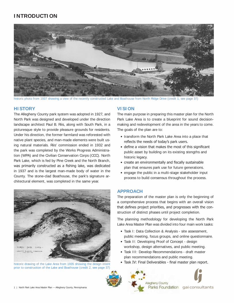
historic photo from 1937 showing a view of the recently constructed Lake and Boathouse from North Ridge Drive (credit 1, see page 37)
HISTORYThe Allegheny County park system was adopted in 1927, and North Park was designed and developed under the direction landscape architect Paul B. Riis, along with South Park, in a picturesque style to provide pleasure grounds for residents. Under his direction, the former farmland was reforested with native plant species, and man-made elements were built us-ing natural materials. Riis' commission ended in 1932 and the park was completed by the Works Progress Administra-tion (WPA) and the Civilian Conservation Corps (CCC). North Park Lake, which is fed by Pine Creek and the North Branch, was primarily constructed as a fishing lake, was dedicated in 1937 and is the largest man-made body of water in the County. The stone-clad Boathouse, the park's signature ar-chitectural element, was completed in the same year.
VISIONThe main purpose in preparing this master plan for the North Park Lake Area is to create a blueprint for sound decision-making and redevelopment of the area in the years to come. The goals of the plan are to:
• transform the North Park Lake Area into a place that reflects the needs of today’s park users.
• define a vision that makes the most of this significant public asset by building on its existing stengths and historic legacy.
• create an environmentally and fiscally sustainable plan that ensures park use for future generations.
• engage the public in a multi-stage stakeholder input process to build consensus throughout the process.
historic drawing of the Lake Area from 1935 showing the design intent prior to construction of the Lake and Boathouse (credit 2, see page 37)
INTRODUCTION
APPROACHThe preparation of the master plan is only the beginning of a comprehensive process that begins with an overall vision that defines project priorities, and progresses with the con-struction of distinct phases until project completion.
The planning methodology for developing the North Park Lake Area Master Plan was divided into four main work tasks:
• Task I: Data Collection & Analysis - site assessment, public meeting, focus groups, and online questionnaire.
• Task II: Developing Proof of Concept - design workshop, design alternatives, and public meeting.
• Task III: Develop Recommendations - draft master plan recommendations and public meeting.
• Task IV: Final Deliverables - final master plan report.
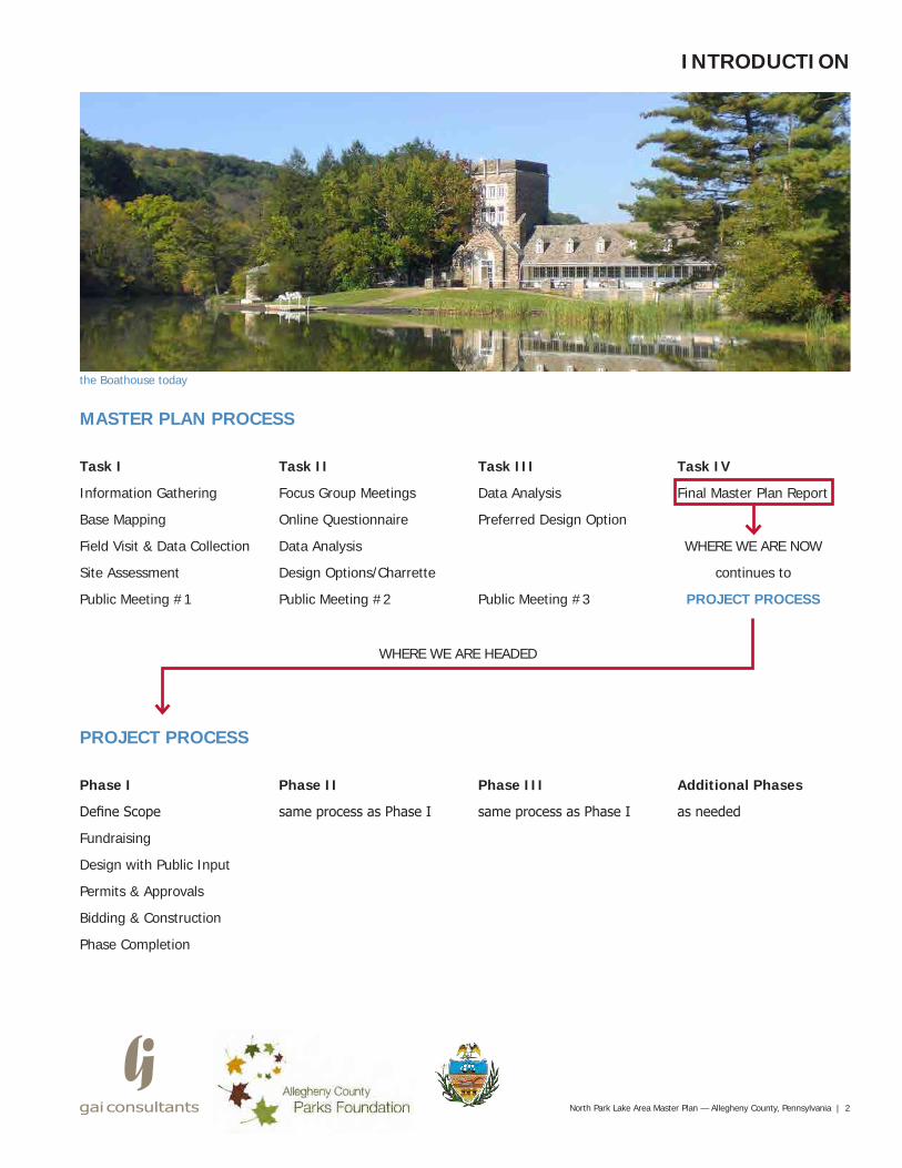
MASTER PLAN PROCESS
Task I Task II Task III Task IV
Information Gathering Focus Group Meetings Data Analysis Final Master Plan Report
Base Mapping Online Questionnaire Preferred Design Option
Field Visit & Data Collection Data Analysis WHERE WE ARE NOW
Site Assessment Design Options/Charrette continues to
Public Meeting #1 Public Meeting #2 Public Meeting #3 PROJECT PROCESS
North Park Lake Area Master Plan — Allegheny County, Pennsylvania | 2
INTRODUCTION
the Boathouse today
PROJECT PROCESS
Phase I Phase II Phase III Additional Phases
Define Scope same process as Phase I same process as Phase I as needed
Fundraising
Design with Public Input
Permits & Approvals
Bidding & Construction
Phase Completion
WHERE WE ARE HEADED
3 | North Park Lake Area Master Plan — Allegheny County, Pennsylvania
SITE ASSESSMENT
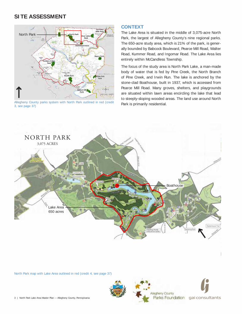
Allegheny County parks system with North Park outlined in red (credit 3, see page 37)
North Park map with Lake Area outlined in red (credit 4, see page 37)
North Park
NORTH PARK3,075 ACRES
Boathouse
CONTEXTThe Lake Area is situated in the middle of 3,075-acre North Park, the largest of Allegheny County's nine regional parks. The 650-acre study area, which is 21% of the park, is gener-ally bounded by Babcock Boulevard, Pearce Mill Road, Walter Road, Kummer Road, and Ingomar Road. The Lake Area lies entirely within McCandless Township.
The focus of the study area is North Park Lake, a man-made body of water that is fed by Pine Creek, the North Branch of Pine Creek, and Irwin Run. The lake is anchored by the stone-clad Boathouse, built in 1937, which is accessed from Pearce Mill Road. Many groves, shelters, and playgrounds are situated within lawn areas encircling the lake that lead to steeply-sloping wooded areas. The land use around North Park is primarily residential.
Lake Area650 acres
North Park Lake Area Master Plan — Allegheny County, Pennsylvania | 4
SITE ASSESSMENT
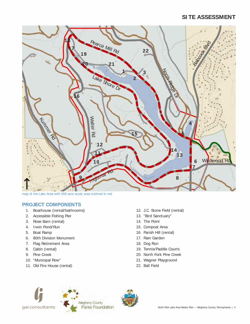
map of the Lake Area with 650-acre study area outlined in red
PROJECT COMPONENTS1. Boathouse (rental/bathrooms)2. Accessible Fishing Pier3. Rose Barn (rental)4. Irwin Pond/Run5. Boat Ramp6. 80th Division Monument7. Flag Retirement Area8. Cabin (rental)9. Pine Creek10. "Municipal Row"11. Old Fire House (rental)
12. J.C. Stone Field (rental)13. "Bird Sanctuary"14. The Point15. Compost Area16. Parish Hill (rental)17. Rain Garden18. Dog Run19. Tennis/Paddle Courts20. North Fork Pine Creek21. Wagner Playground22. Ball Field
1 3
4
13
76
89
10
11
1214
15 5
16
17
18
19
2120
22
2
Pearce Mill Rd
Lake Shore Dr
Walter Rd
Kumm
er Rd
Ingomar Rd
North Ridge Dr
Babc
ock
Blvd
Wildwood Rd
5 | North Park Lake Area Master Plan — Allegheny County, Pennsylvania
5 Dog Run 6 Rose Barn
SITE ASSESSMENT
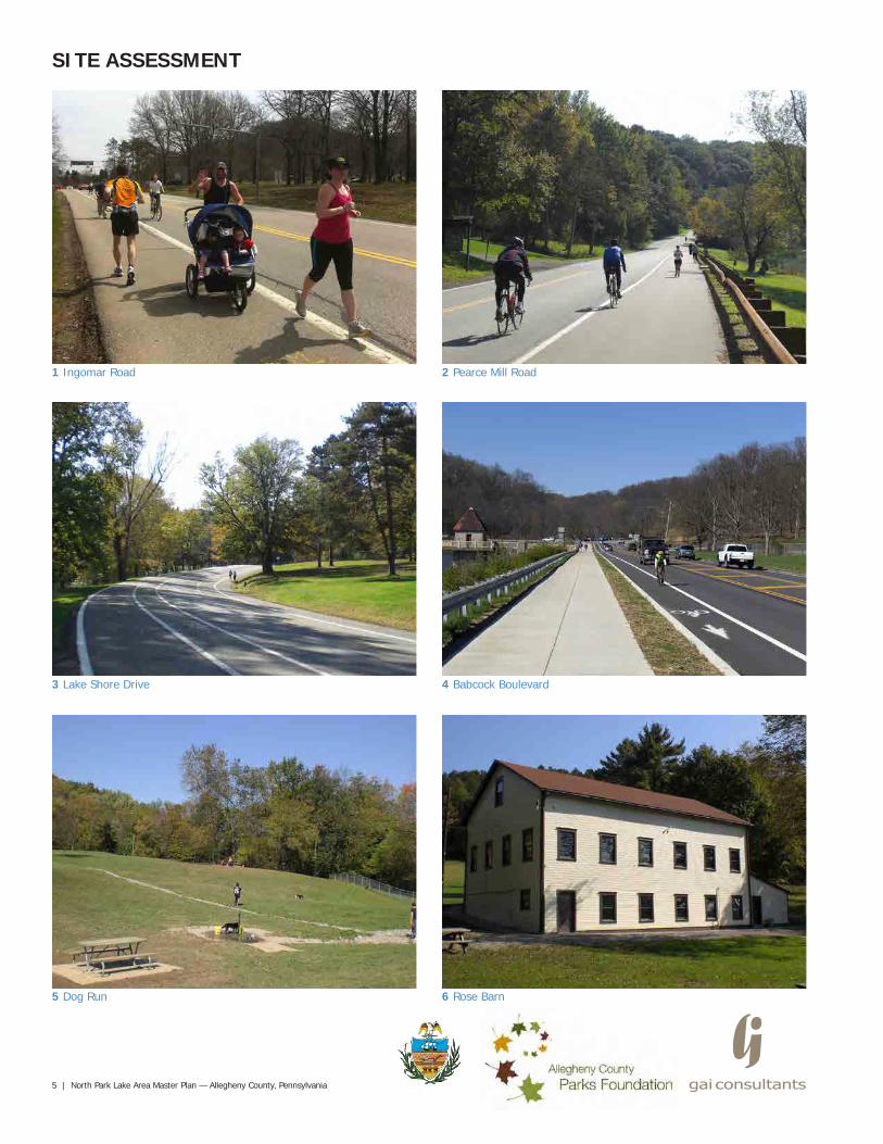
1 Ingomar Road 2 Pearce Mill Road
3 Lake Shore Drive 4 Babcock Boulevard
North Park Lake Area Master Plan — Allegheny County, Pennsylvania | 6
7 Stone Pavilion 8 Timber Pavilion
9 Tennis Courts 10 Wagner Playground
12 Wooded Areas11 Park Lawn
SITE ASSESSMENT
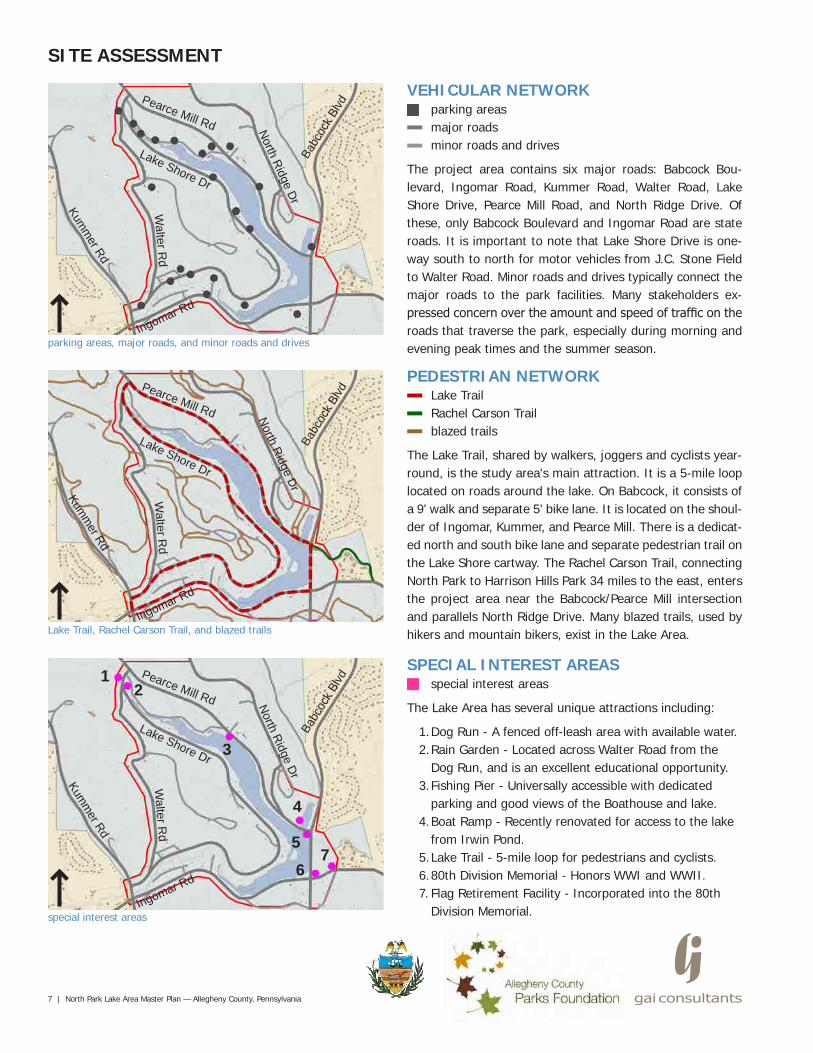
PEDESTRIAN NETWORKLake TrailRachel Carson Trailblazed trails
The Lake Trail, shared by walkers, joggers and cyclists year-round, is the study area's main attraction. It is a 5-mile loop located on roads around the lake. On Babcock, it consists of a 9' walk and separate 5' bike lane. It is located on the shoul-der of Ingomar, Kummer, and Pearce Mill. There is a dedicat-ed north and south bike lane and separate pedestrian trail on the Lake Shore cartway. The Rachel Carson Trail, connecting North Park to Harrison Hills Park 34 miles to the east, enters the project area near the Babcock/Pearce Mill intersection and parallels North Ridge Drive. Many blazed trails, used by hikers and mountain bikers, exist in the Lake Area.
VEHICULAR NETWORKparking areasmajor roadsminor roads and drives
The project area contains six major roads: Babcock Bou-levard, Ingomar Road, Kummer Road, Walter Road, Lake Shore Drive, Pearce Mill Road, and North Ridge Drive. Of these, only Babcock Boulevard and Ingomar Road are state roads. It is important to note that Lake Shore Drive is one-way south to north for motor vehicles from J.C. Stone Field to Walter Road. Minor roads and drives typically connect the major roads to the park facilities. Many stakeholders ex-pressed concern over the amount and speed of traffic on the roads that traverse the park, especially during morning and evening peak times and the summer season.
Lake Trail, Rachel Carson Trail, and blazed trails
parking areas, major roads, and minor roads and drives
7 | North Park Lake Area Master Plan — Allegheny County, Pennsylvania
special interest areas
Ingomar Rd
Lake Shore Dr
North Ridge Dr
Pearce Mill Rd
Walter R
d
SITE ASSESSMENT
Kumm
er Rd
Babc
ock B
lvd
Ingomar Rd
Lake Shore Dr
North Ridge Dr
Pearce Mill Rd
Walter R
d
Kumm
er Rd
Babc
ock B
lvd
Ingomar Rd
Lake Shore Dr
North Ridge Dr
Pearce Mill Rd
Walter R
d
Kumm
er Rd
Babc
ock B
lvd
SPECIAL INTEREST AREASspecial interest areas
The Lake Area has several unique attractions including:
1. Dog Run - A fenced off-leash area with available water.2. Rain Garden - Located across Walter Road from the
Dog Run, and is an excellent educational opportunity.3. Fishing Pier - Universally accessible with dedicated
parking and good views of the Boathouse and lake.4. Boat Ramp - Recently renovated for access to the lake
from Irwin Pond.5. Lake Trail - 5-mile loop for pedestrians and cyclists.6. 80th Division Memorial - Honors WWI and WWII.7. Flag Retirement Facility - Incorporated into the 80th
Division Memorial.
12
3
4
5
67
North Park Lake Area Master Plan — Allegheny County, Pennsylvania | 8
recreational facilities
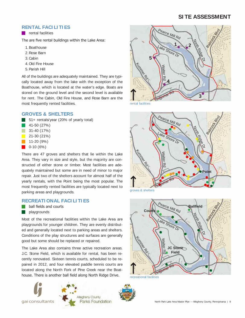
RECREATIONAL FACILITIESball fields and courtsplaygrounds
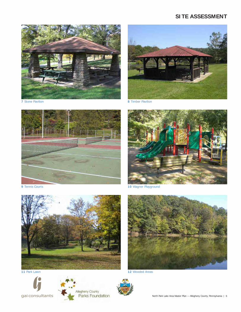
Most of the recreational facilities within the Lake Area are playgrounds for younger children. They are evenly distribut-ed and generally located next to parking areas and shelters. Conditions of the play structures and surfaces are generally good but some should be replaced or repaired.
The Lake Area also contains three active recreation areas. J.C. Stone Field, which is available for rental, has been re-cently renovated. Sixteen tennis courts, scheduled to be re-paired in 2012, and four elevated paddle tennis courts are located along the North Fork of Pine Creek near the Boat-house. There is another ball field along North Ridge Drive.
SITE ASSESSMENT
Ingomar Rd
Lake Shore DrNorth Ridge Dr
Pearce Mill Rd
Walter R
d
Kumm
er Rd
Babc
ock B
lvd
Ingomar Rd
Lake Shore Dr
North Ridge Dr
Pearce Mill Rd
Walter R
d
Kumm
er Rd
Babc
ock B
lvd
Ingomar Rd
Lake Shore Dr
North Ridge Dr
Pearce Mill Rd
Walter R
d
Kumm
er Rd
Babc
ock B
lvd
Point
groves & shelters
GROVES & SHELTERS51+ rentals/year (20% of yearly total)41-50 (27%)31-40 (17%)21-30 (21%)11-20 (9%)0-10 (6%)
There are 47 groves and shelters that lie within the Lake Area. They vary in size and style, but the majority are con-structed of either stone or timber. Most facilities are ade-quately maintained but some are in need of minor to major repair. Just two of the shelters account for almost half of the yearly rentals, with the Point being the most popular. The most frequently rented facilities are typically located next to parking areas and playgrounds.
rental facilities
RENTAL FACILITIESrental facilities
The are five rental buildings within the Lake Area:
1. Boathouse2. Rose Barn3. Cabin4. Old Fire House5. Parish Hill
All of the buildings are adequately maintained. They are typi-cally located away from the lake with the exception of the Boathouse, which is located at the water's edge. Boats are stored on the ground level and the second level is available for rent. The Cabin, Old Fire House, and Rose Barn are the most frequently rented facilities.
JC StoneField
CourtsBallfield
1 2
3
4
5
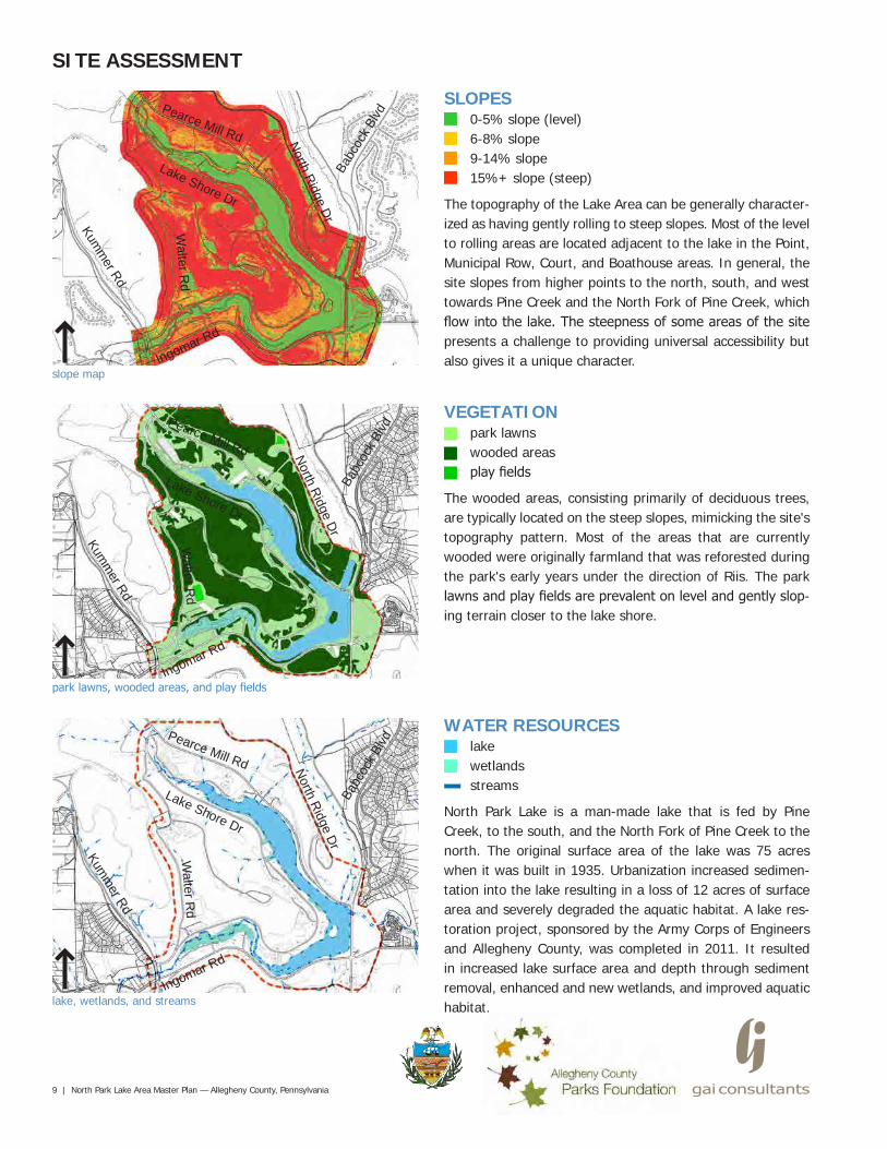
SLOPES0-5% slope (level)6-8% slope9-14% slope15%+ slope (steep)
The topography of the Lake Area can be generally character-ized as having gently rolling to steep slopes. Most of the level to rolling areas are located adjacent to the lake in the Point, Municipal Row, Court, and Boathouse areas. In general, the site slopes from higher points to the north, south, and west towards Pine Creek and the North Fork of Pine Creek, which flow into the lake. The steepness of some areas of the site presents a challenge to providing universal accessibility but also gives it a unique character.
slope map
9 | North Park Lake Area Master Plan — Allegheny County, Pennsylvania
lake, wetlands, and streams
VEGETATIONpark lawnswooded areasplay fields
The wooded areas, consisting primarily of deciduous trees, are typically located on the steep slopes, mimicking the site's topography pattern. Most of the areas that are currently wooded were originally farmland that was reforested during the park's early years under the direction of Riis. The park lawns and play fields are prevalent on level and gently slop-ing terrain closer to the lake shore.
Ingomar Rd
Lake Shore Dr
North Ridge Dr
Pearce Mill Rd
Walter R
d
SITE ASSESSMENT
Kumm
er Rd
Babc
ock B
lvd
Ingomar Rd
Lake Shore Dr
North Ridge Dr
Pearce Mill Rd
Walter R
d
Kumm
er Rd
Babc
ock B
lvd
Ingomar Rd
Lake Shore Dr
North Ridge Dr
Pearce Mill Rd
Walter R
d
Kumm
er Rd
Babc
ock B
lvd
WATER RESOURCESlakewetlandsstreams
North Park Lake is a man-made lake that is fed by Pine Creek, to the south, and the North Fork of Pine Creek to the north. The original surface area of the lake was 75 acres when it was built in 1935. Urbanization increased sedimen-tation into the lake resulting in a loss of 12 acres of surface area and severely degraded the aquatic habitat. A lake res-toration project, sponsored by the Army Corps of Engineers and Allegheny County, was completed in 2011. It resulted in increased lake surface area and depth through sediment removal, enhanced and new wetlands, and improved aquatic habitat.
park lawns, wooded areas, and play fields
North Park Lake Area Master Plan — Allegheny County, Pennsylvania | 10
SITE ASSESSMENT
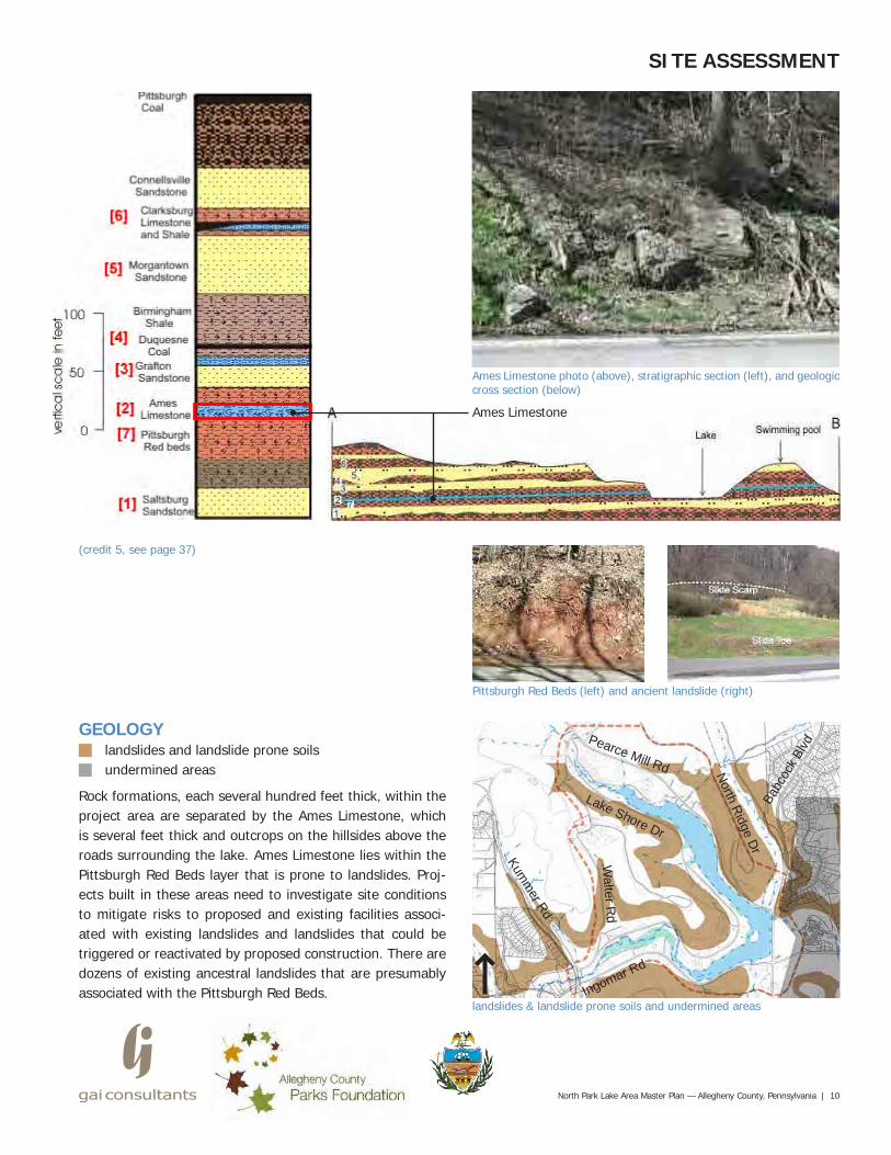
Ames Limestone photo (above), stratigraphic section (left), and geologic cross section (below)
landslides & landslide prone soils and undermined areasIngomar Rd
Lake Shore Dr
North Ridge Dr
Pearce Mill Rd
Walter R
d
Kumm
er Rd
Babc
ock B
lvd
Ames Limestone
GEOLOGYlandslides and landslide prone soilsundermined areas
Rock formations, each several hundred feet thick, within the project area are separated by the Ames Limestone, which is several feet thick and outcrops on the hillsides above the roads surrounding the lake. Ames Limestone lies within the Pittsburgh Red Beds layer that is prone to landslides. Proj-ects built in these areas need to investigate site conditions to mitigate risks to proposed and existing facilities associ-ated with existing landslides and landslides that could be triggered or reactivated by proposed construction. There are dozens of existing ancestral landslides that are presumably associated with the Pittsburgh Red Beds.
Pittsburgh Red Beds (left) and ancient landslide (right)
(credit 5, see page 37)
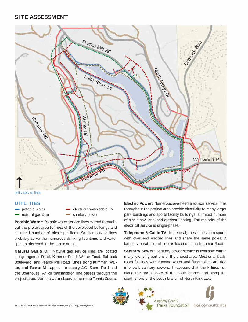
electric/phone/cable TVsanitary sewer
11 | North Park Lake Area Master Plan — Allegheny County, Pennsylvania
SITE ASSESSMENT
UTILITIESpotable waternatural gas & oil
Potable Water: Potable water service lines extend through-out the project area to most of the developed buildings and a limited number of picnic pavilions. Smaller service lines probably serve the numerous drinking fountains and water spigots observed in the picnic areas.
Natural Gas & Oil: Natural gas service lines are located along Ingomar Road, Kummer Road, Walter Road, Babcock Boulevard, and Pearce Mill Road. Lines along Kummer, Wal-ter, and Pearce Mill appear to supply J.C. Stone Field and the Boathouse. An oil transmission line passes through the project area. Markers were observed near the Tennis Courts.
Electric Power: Numerous overhead electrical service lines throughout the project area provide electricity to many larger park buildings and sports facility buildings, a limited number of picnic pavilions, and outdoor lighting. The majority of the electrical service is single-phase.
Telephone & Cable TV: In general, these lines correspond with overhead electric lines and share the same poles. A larger, separate set of lines is located along Ingomar Road.
Sanitary Sewer: Sanitary sewer service is available within many low-lying portions of the project area. Most or all bath-room facilities with running water and flush toilets are tied into park sanitary sewers. It appears that trunk lines run along the north shore of the north branch and along the south shore of the south branch of North Park Lake.
Pearce Mill Rd
Lake Shore Dr
Walter Rd
Kumm
er Rd
Ingomar Rd
North Ridge Dr
Babc
ock
Blvd
Wildwood Rd
utility service lines
North Park Lake Area Master Plan — Allegheny County, Pennsylvania | 12
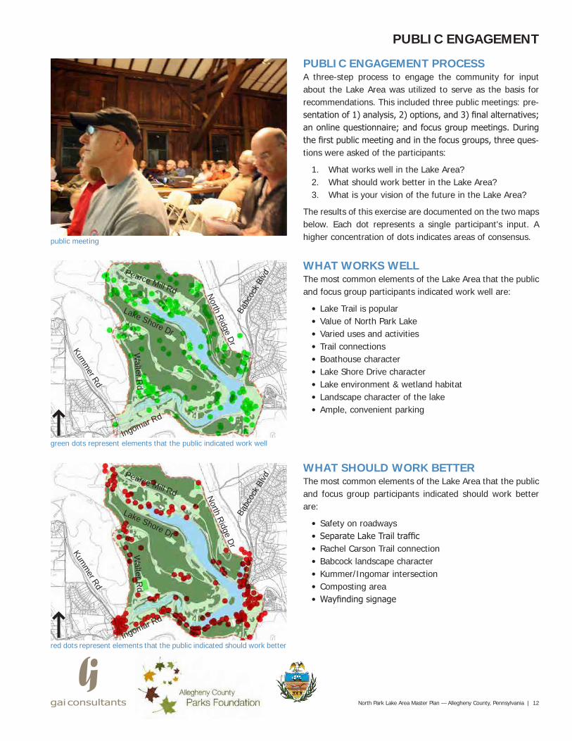
green dots represent elements that the public indicated work well
red dots represent elements that the public indicated should work better
public meeting
PUBLIC ENGAGEMENT PROCESSA three-step process to engage the community for input about the Lake Area was utilized to serve as the basis for recommendations. This included three public meetings: pre-sentation of 1) analysis, 2) options, and 3) final alternatives; an online questionnaire; and focus group meetings. During the first public meeting and in the focus groups, three ques-tions were asked of the participants:
1. What works well in the Lake Area?2. What should work better in the Lake Area?3. What is your vision of the future in the Lake Area?
The results of this exercise are documented on the two maps below. Each dot represents a single participant's input. A higher concentration of dots indicates areas of consensus.
WHAT WORKS WELLThe most common elements of the Lake Area that the public and focus group participants indicated work well are:
• Lake Trail is popular• Value of North Park Lake• Varied uses and activities• Trail connections• Boathouse character• Lake Shore Drive character• Lake environment & wetland habitat• Landscape character of the lake• Ample, convenient parking
WHAT SHOULD WORK BETTERThe most common elements of the Lake Area that the public and focus group participants indicated should work better are:
• Safety on roadways• Separate Lake Trail traffic • Rachel Carson Trail connection• Babcock landscape character• Kummer/Ingomar intersection• Composting area• Wayfinding signage
PUBLIC ENGAGEMENT
Ingomar Rd
Lake Shore Dr
North Ridge Dr
Pearce Mill Rd
Walter R
d
Kumm
er Rd
Babc
ock B
lvd
Ingomar Rd
Lake Shore Dr
North Ridge Dr
Pearce Mill Rd
Walter R
d
Kumm
er Rd
Babc
ock B
lvd
Pittsburgh15%
McCandless23%
Gibsonia19%
Allison Park16%
Glenshaw10%
Wexford9%
Mars3%
Sewickley1%
Butler2%
Cranberry2%
3. Where do you live
Running18%
Walking19%
Dog walking8%
Road cycling20%
Mountain biking10%
Boating6%
Fishing5%
Birding / nature walks
6%
Picnicking8%
8. For which reasons do you use Lake Area?
Running37%
Road Cycling23%
Mt Biking11%
Triathalon6%
Trail/Nature
17%
Other6%
Type of groups
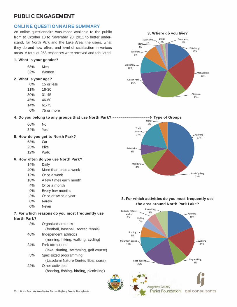
ONLINE QUESTIONNAIRE SUMMARYAn online questionnaire was made available to the public from to October 13 to November 20, 2011 to better under-stand, for North Park and the Lake Area, the users, what they do and how often, and level of satisfaction in various areas. A total of 253 responses were received and tabulated.
1. What is your gender?
68% Men 32% Women
2. What is your age? 0% 15 or less 11% 16-30 30% 31-45 45% 46-60 14% 61-75 0% 75 or more
4. Do you belong to any groups that use North Park?
66% No 34% Yes
5. How do you get to North Park? 63% Car 25% Bike 12% Walk
6. How often do you use North Park? 14% Daily 40% More than once a week 12% Once a week 18% A few times each month 4% Once a month 9% Every few months 3% Once or twice a year 0% Rarely 0% Never
7. For which reasons do you most frequently use North Park? 3% Organized athletics
(football, baseball, soccer, tennis) 46% Independent athletics
(running, hiking, walking, cycling) 24% Park attractions
(lake, skating, swimming, golf course) 5% Specialized programming
(Latodami Nature Center, Boathouse) 22% Other activities
(boating, fishing, birding, picnicking)
13 | North Park Lake Area Master Plan — Allegheny County, Pennsylvania
PUBLIC ENGAGEMENT
3. Where do you live?
8. For which activities do you most frequently use the area around North Park Lake?
Type of Groups

Not Satisfied
39%
Satisfied44%
Very Satisfied
17%
Safety
Not Satisfied
11%
Satisfied80%
Very Satisfied
9%
Educational programs
Not Satisfied
13%
Satisfied72%
Very Satisfied
15%
Recreational facilities
Not Satisfied
9%
Satisfied64%
Very Satisfied
27%
Ecology/environmentNot
Satisfied5%
Satisfied65%
Very Satisfied
30%
ParkingNot
Satisfied26%
Satisfied50%
Very Satisfied
24%
Walkways and trails
North Park Lake Area Master Plan — Allegheny County, Pennsylvania | 14
PUBLIC ENGAGEMENT
9. Rate your level of satisfaction regarding the area around the Lake in North Park in each of the following categories.
Safety Educational programs Recreational facilities
Ecology and environment Parking Walkways and trails
10. What I think works well in the area around the Lake in North Park is...
Top 10 Responses1. Lake Trail is a community amenity.2. Character and function of Lake
Shore Drive.3. Natural setting and atmosphere of
the park.4. Hiking and mountain biking trails.5. North Park Lake.6. Park access and plentiful parking
spaces.7. Many groves and shelters
available for public use.8. Playgrounds.9. Diversity of activities.10. Dog Park.
11. What I think could/should work better in the area around the Lake in North Park is...
Top 10 Responses1. Widen Lake Trail for added safety.2. Separate Lake Trail from road
traffic for added safety.3. Address traffic and safety issues
on Ingomar Road.4. Enforce and control vehicular
speeds on park roads.5. Add signage on Lake Trail to
educate users on trail etiquette.6. Address trail safety.7. Improve maintenance of facilities.8. Address traffic issues on roads.9. Improve groves and shelters.10. Add more park amenities such as
water fountains, benches, etc.
12. What I would like to see most as part of future plans for the area around the Lake in North Park is...
Top 10 Responses1. Widen Lake Trail and separate
from road traffic.2. Better enforcement of speed on
park roads.3. Better maintenance of park areas.4. New trails away from park roads.5. More and improved pedestrian
and jogging trails.6. More and improved bike lanes
and trails.7. Protection and restoration of
natural areas of the park.8. Improved signage and placement.9. Better maintenance of groves.10. More boat ramps/fishing piers.
Note: See Appendix for a complete tabulation of responses for questions 10 through 12.
15 | North Park Lake Area Master Plan — Allegheny County, Pennsylvania
RECOMMENDATIONS
PARK PRINCIPLESIn early November 2011, after the first public meeting, a two-day design charrette, or workshop, with members of the Project Committee and Consultants was conducted to generate initial design options for the Lake Area based on the input received from the community during the public en-gagement process.
Guiding Park PrinciplesThe following principles, a result of the public engagement process, were developed at the charrette to help guide fu-ture decision-making and development of the Lake Area.
• Enhance safety• Educate users about proper trail etiquette• Create and enhance connections• Enhance visual park character/place-making• Provide varied park experiences and uses• Enhance sustainability and ecological services• Promote environmental education• Promote economic sustainability• Preserve historic character and park legacy
plan of overarching ideas
Pearce Mill Rd
Lake Shore Dr
Walter Rd
Kumm
er Rd
Ingomar Rd
North Ridge Dr
Babc
ock
Blvd
Wildwood Rd
"Central Park"
Rachel Carson Trail
5
8
1
1
7
7
8
8
8
6
6
6
2
2
4
7
7
7
OVERARCHING IDEASTo support the principles, ten overarching ideas were flushed out to transform the Lake Area into a facility that meets the needs of today's park users. These prioritized ideas will serve as the basis for the recommendations moving forward.
1. Improve Lake Trail safety by widening and separating trail from road traffic and providing etiquette signage.
2. Transform roads into parkways to enhance character.3. Provide additional pedestrian and bicycle connections
(especially Rachel Carson Trail).4. Improve the entry experience along Babcock
Boulevard as a true park gateway.5. Enhance the Boathouse's image as the "Heart of the
Park" through programming opportunities.6. Create a "Central Park" within the Lake Area by
capitalizing on Lake Shore Drive's positive character.7. Preserve and enhance the natural park character and
sustainability (especially wetlands).8. Provide varied park experiences for users (including
enhancement of the J.C. Stone area).
3
North Park Lake Area Master Plan — Allegheny County, Pennsylvania | 16
RECOMMENDATIONS
existing Babcock Boulevardexisting Babcock Boulevard section
4' 5'Bike
10'Travel Lane
10'Turning Lane
9'Ped Trail
10'Travel Lane
48'
18'Lake Trail
Land
scap
eS
trip
1. IMPROVE LAKE TRAIL SAFETYBabcock Boulevard AssessmentIn 2011, Babcock Boulevard, a State road, was modified to improve safety for all transportation modes by separating bi-cycles from the Lake Trail into a one-way bike lane. A similar concept should be implemented on Ingomar and Pearce Mill Roads, transforming them from roads to parkways.
Highlights• 5-foot wide one-way bike lane clockwise around lake.• 9' wide two-way, pedestrian trail.• Vertical curb and planter strip separates bike lane from
pedestrian trail and provides added pedestrian safety.• Existing steel guiderail behind pedestrian trail provides
added vehicular safety.• Traffic signals were upgraded to improve congestion. North Park Trail Enhancement Project sign
existing Babcock Boulevard plan (credit 6, page 37)
17 | North Park Lake Area Master Plan — Allegheny County, Pennsylvania
RECOMMENDATIONS
existing Lake Trail typical plan along Pearce Mill Road and Ingomar Road
1. IMPROVE LAKE TRAIL SAFETYExisting ConditionThe current trail is too narrow to accommodate multi-use activity on the existing road shoulder.
Highlights• Approximately 8-foot wide combined bicycle and
pedestrian trail.• Lake Trail flush with vehicular traffic creates a potential
hazard for cyclists and pedestrians.• Steel guiderail behind Lake Trail provides added
vehicular safety.
Lake
Sid
e
Slope
Two-way Bike andPedestrian Trail (8' wide)
Steel Guiderail
Shoulder
Travel Lanes
existing Lake Trail typical section along Pearce Mill Road and Ingomar Road
±8'Shoulder
11'Travel Lane
11'Travel Lane
±8'Shoulder
11'Landscape
11'Landscape
60' ROW
Bike/PedLake Trail
ExistingTrees
ExistingTrees
SteelGuiderail
North Park Lake Area Master Plan — Allegheny County, Pennsylvania | 18
RECOMMENDATIONS
Slope
One-way Bike Lane (6'-8' wide)
Wood Guiderail
Shoulder
Travel Lanes
Lake
Sid
e
proposed Lake Trail typical plan along Pearce Mill Road and Ingomar Road
1. IMPROVE LAKE TRAIL SAFETYProposed OptionExpand the road shoulder to accommodate a wider, dedi-cated pedestrian path separated from a one-way bike only lane. The trail would be available for year-round activity.
Highlights• 6'-8' wide one-way bike lane clockwise around lake.• 8'-10' wide two-way, pedestrian, soft surface trail.• Wood guiderail behind pedestrian trail enhances park
character and provides added vehicular safety.• Green wall retains pedestrian trail as needed in areas
restricted by steep slopes.
proposed Lake Trail typical section along Pearce Mill Road and Ingomar Road
±8'Shoulder
11'Travel Lane
11'Travel Lane
6'-8'Bike Lane
11'Landscape
8'-10'Ped Trail
60' ROW
14'-18'Lake Trail
ExistingTrees
ExistingTrees
WoodGuiderail
±3'
LANE
BIKE
Two-way Pedestrian Trail (8'-10' wide)
19 | North Park Lake Area Master Plan — Allegheny County, Pennsylvania
RECOMMENDATIONS
proposed parkway concept
2. TRANSFORM ROADS TO PARKWAYSThe character of Babcock Boulevard, Pearce Mill Road, and Ingomar Road should be improved to reflect their naturalistic park setting through use of consistent detailing and land-scaping throughout. For instance, the metal guiderails could be replaced with a steel-backed timber design that is cur-rently being used by the National Park Service on the Blue Ridge Parkway and in other areas.
In addition, the community expressed a desire to make the Lake Trail experience safer and more enjoyable by separat-ing the pedestrian trail from the adjacent bicycle and vehicu-lar lanes. The public also feels that year-round maintenance of the trail should be a priority due its use during all seasons.
Pearce Mill Rd
Lake Shore Dr
Walter Rd
Kumm
er Rd
Ingomar Rd
North Ridge Dr
Wildwood Rd
parkways precedent (credit 7, see page 37)
"Central Park"
Rachel Carson Trail
Bab
cock
Blv
d
Parkways
North Park Lake Area Master Plan — Allegheny County, Pennsylvania | 20
proposed park connections concept
RECOMMENDATIONS
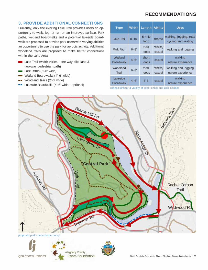
3. PROVIDE ADDITIONAL CONNECTIONSCurrently, only the existing Lake Trail provides users an op-portunity to walk, jog, or run on an improved surface. Park paths, wetland boardwalks and a potential lakeside board-walk are proposed to provide park users with varying abilities an opportunity to use the park for aerobic activity. Additional woodland trails are proposed to make better connections within the Lake Area.
Lake Trail (width varies - one-way bike lane & two-way pedestrian path)Park Paths (6'-8' wide)Wetland Boardwalks (4'-6' wide)Woodland Trails (2'-3' wide)Lakeside Boardwalk (4'-6' wide - optional)
Pearce Mill Rd
Lake Shore Dr
Walter Rd
Kumm
er Rd
Ingomar Rd
North Ridge Dr
Babc
ock
Blvd
Wildwood Rd
connections for a variety of experiences and user abilities
"Central Park"
Rachel Carson Trail
Type Width Length Ability Uses
Lake Trail
Park Path
WetlandBoardwalk
WoodlandTrail
LakesideBoardwalk
8'-10'
6'-8'
4'-6'
6'-8'
4'-6' 4'-6'
med.loops
shortloops
med.loops
5-mileloop
fitness
casual
casual
fitness/casual
fitness/casual
walking and joggingnature experience
walking, jogging, road cycling and skating
walking and jogging
walkingnature experience
walkingnature experience
21 | North Park Lake Area Master Plan — Allegheny County, Pennsylvania
RECOMMENDATIONS
park path precedent (credit 8 , see page 37) proposed two-way, pedestrian, soft-surface park path (6'-8' wide)
6'-8'Park Path
ExistingTrees
ExistingVegetation
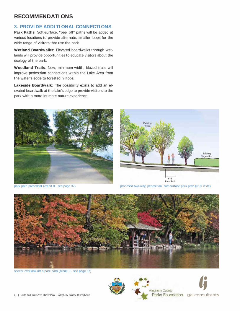
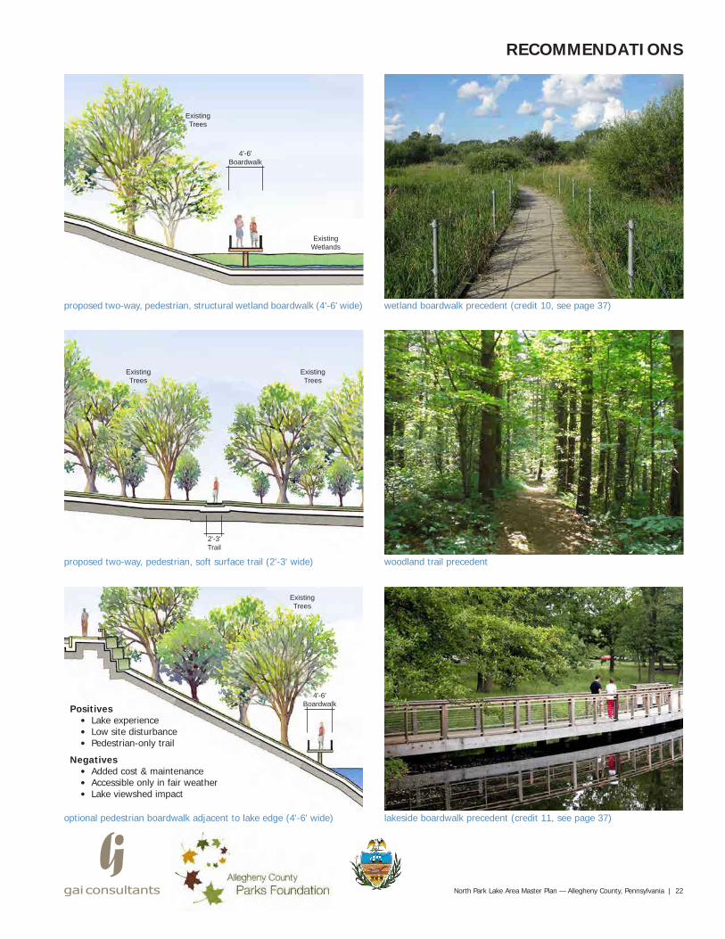
3. PROVIDE ADDITIONAL CONNECTIONSPark Paths: Soft-surface, "peel off" paths will be added at various locations to provide alternate, smaller loops for the wide range of visitors that use the park.
Wetland Boardwalks: Elevated boardwalks through wet-lands will provide opportunities to educate visitors about the ecology of the park.
Woodland Trails: New, minimum-width, blazed trails will improve pedestrian connections within the Lake Area from the water's edge to forested hilltops.
Lakeside Boardwalk: The possibility exists to add an el-evated boardwalk at the lake's edge to provide visitors to the park with a more intimate nature experience.
shelter overlook off a park path (credit 9 , see page 37)
North Park Lake Area Master Plan — Allegheny County, Pennsylvania | 22
RECOMMENDATIONS
wetland boardwalk precedent (credit 10, see page 37)proposed two-way, pedestrian, structural wetland boardwalk (4'-6' wide)
ExistingTrees
ExistingWetlands
4'-6'Boardwalk
woodland trail precedentproposed two-way, pedestrian, soft surface trail (2'-3' wide)
ExistingTrees
2'-3'Trail
ExistingTrees
lakeside boardwalk precedent (credit 11, see page 37)optional pedestrian boardwalk adjacent to lake edge (4'-6' wide)
ExistingTrees
4'-6'BoardwalkPositives
• Lake experience• Low site disturbance• Pedestrian-only trail
Negatives• Added cost & maintenance• Accessible only in fair weather• Lake viewshed impact
23 | North Park Lake Area Master Plan — Allegheny County, Pennsylvania
proposed plan of the Boathouse and parking lot renovations
RECOMMENDATIONS
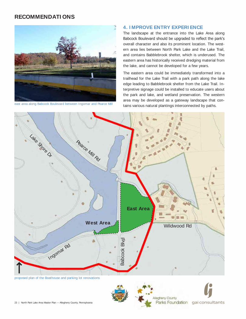
east area along Babcock Boulevard between Ingomar and Pearce Mill
4. IMPROVE ENTRY EXPERIENCEThe landscape at the entrance into the Lake Area along Babcock Boulevard should be upgraded to reflect the park's overall character and also its prominent location. The west-ern area lies between North Park Lake and the Lake Trail, and contains Babblebrook shelter, which is underused. The eastern area has historically received dredging material from the lake, and cannot be developed for a few years.
The eastern area could be immediately transformed into a trailhead for the Lake Trail with a park path along the lake edge leading to Babblebrook shelter from the Lake Trail. In-terpretive signage could be installed to educate users about the park and lake, and wetland preservation. The western area may be developed as a gateway landscape that con-tains various natural plantings interconnected by paths.
Lake Shore Dr
Wildwood Rd
Pearce Mill Rd
Ingom
ar Rd
Babc
ock
Blvd
West Area
East Area
North Park Lake Area Master Plan — Allegheny County, Pennsylvania | 24
proposed plan of the Boathouse and parking lot renovations
Boathouse and parking lot
RECOMMENDATIONS
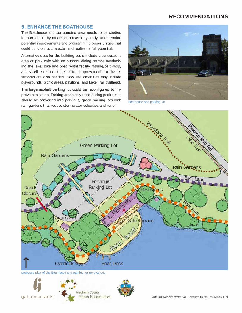
5. ENHANCE THE BOATHOUSEThe Boathouse and surrounding area needs to be studied in more detail, by means of a feasibility study, to determine potential improvements and programming opportunities that could build on its character and realize its full potential.
Alternative uses for the building could include a concessions area or park cafe with an outdoor dining terrace overlook-ing the lake, bike and boat rental facility, fishing/bait shop, and satellite nature center office. Improvements to the re-strooms are also needed. New site amenities may include playgrounds, picnic areas, pavilions, and Lake Trail trailhead.
The large asphalt parking lot could be reconfigured to im-prove circulation. Parking areas only used during peak times should be converted into pervious, green parking lots with rain gardens that reduce stormwater velocities and runoff.
Pearce Mill Rd
Lake Trail
Restrooms
Boath
ouse
Cafe Terrace
Boat DockOverlook
Concession
RoadClosure
Park Path
Bike Lane
Woodland Trail
A
PerviousParking Lot
Green Parking Lot
Rain Gardens
Rain Gardens
25 | North Park Lake Area Master Plan — Allegheny County, Pennsylvania
RECOMMENDATIONS
proposed Lake Shore Drive re-imagined concept
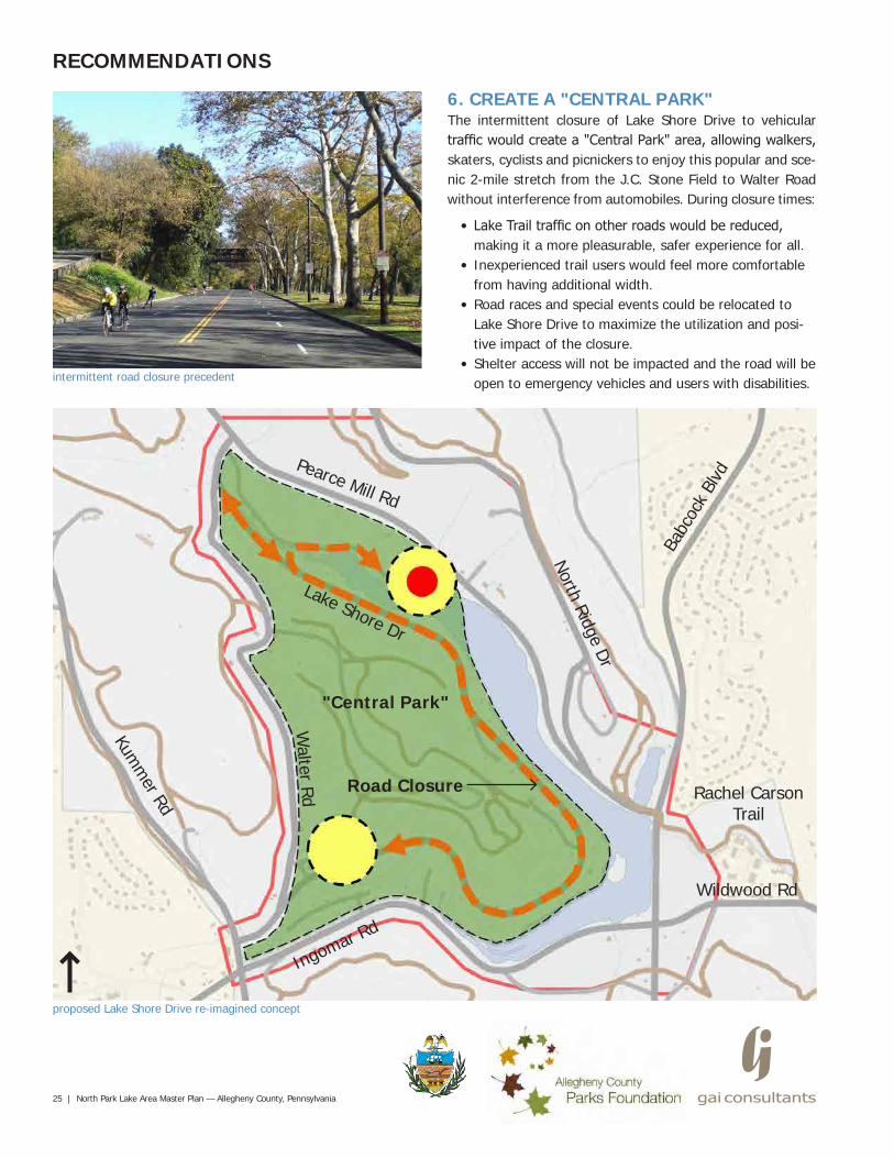
6. CREATE A "CENTRAL PARK"The intermittent closure of Lake Shore Drive to vehicular traffic would create a "Central Park" area, allowing walkers, skaters, cyclists and picnickers to enjoy this popular and sce-nic 2-mile stretch from the J.C. Stone Field to Walter Road without interference from automobiles. During closure times:
• Lake Trail traffic on other roads would be reduced, making it a more pleasurable, safer experience for all.
• Inexperienced trail users would feel more comfortable from having additional width.
• Road races and special events could be relocated to Lake Shore Drive to maximize the utilization and posi-tive impact of the closure.
• Shelter access will not be impacted and the road will be open to emergency vehicles and users with disabilities.
Lake Shore Dr
Walter Rd
Kumm
er Rd
North Ridge Dr
Wildwood Rd
intermittent road closure precedent
"Central Park"
Rachel Carson Trail
Road Closure
Pearce Mill Rd
Ingomar Rd
Babc
ock
Blvd
North Park Lake Area Master Plan — Allegheny County, Pennsylvania | 26
RECOMMENDATIONS
photo of lake on the cover of Landslide 2009 published by the Cultural Landscape Foundation (credit 12, see page 37). Photo © Daniel Parisi.
pervious paver lot allows water to recharge into the soil (credit 13, see page 37)
projects are underway within the park to restore habitat for wildlife and native species
existing parking lot with large expanses of impervious paving that en-ables stormwater to pollute the lake and streams
pervious, grass-cell paver parking lot, which remains green, can be uti-lized during peak use times of the year (credit 14 see page 37)
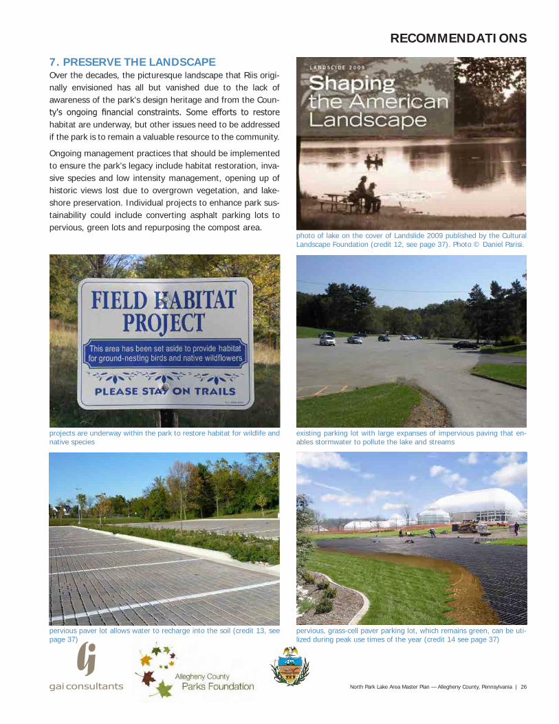
7. PRESERVE THE LANDSCAPEOver the decades, the picturesque landscape that Riis origi-nally envisioned has all but vanished due to the lack of awareness of the park's design heritage and from the Coun-ty's ongoing financial constraints. Some efforts to restore habitat are underway, but other issues need to be addressed if the park is to remain a valuable resource to the community.
Ongoing management practices that should be implemented to ensure the park's legacy include habitat restoration, inva-sive species and low intensity management, opening up of historic views lost due to overgrown vegetation, and lake-shore preservation. Individual projects to enhance park sus-tainability could include converting asphalt parking lots to pervious, green lots and repurposing the compost area.
27 | North Park Lake Area Master Plan — Allegheny County, Pennsylvania
RECOMMENDATIONS
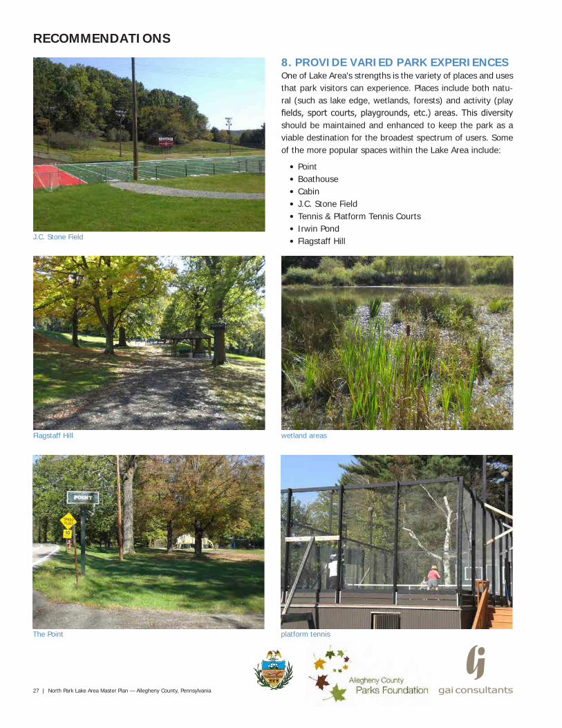
8. PROVIDE VARIED PARK EXPERIENCESOne of Lake Area's strengths is the variety of places and uses that park visitors can experience. Places include both natu-ral (such as lake edge, wetlands, forests) and activity (play fields, sport courts, playgrounds, etc.) areas. This diversity should be maintained and enhanced to keep the park as a viable destination for the broadest spectrum of users. Some of the more popular spaces within the Lake Area include:
• Point• Boathouse• Cabin• J.C. Stone Field• Tennis & Platform Tennis Courts• Irwin Pond• Flagstaff HillJ.C. Stone Field
Flagstaff Hill wetland areas
The Point platform tennis
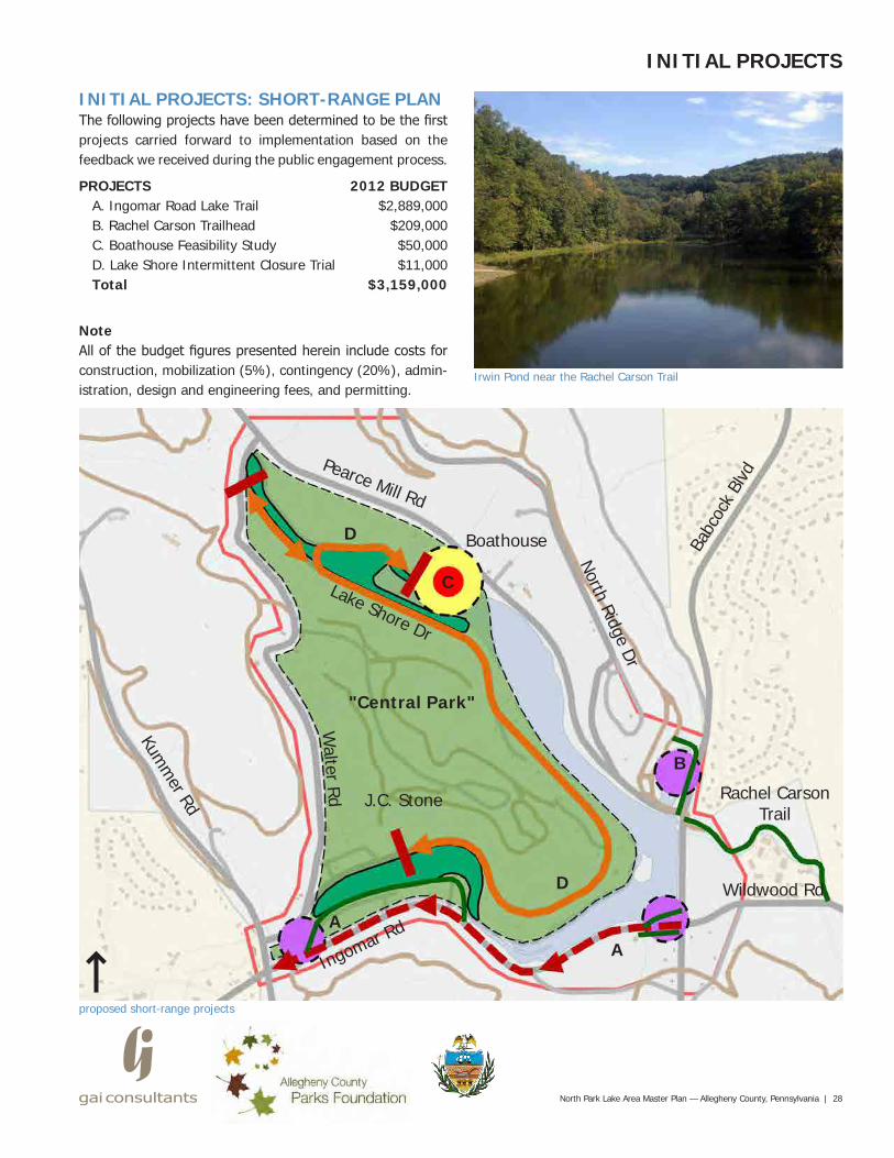
INITIAL PROJECTS: SHORT-RANGE PLANThe following projects have been determined to be the first projects carried forward to implementation based on the feedback we received during the public engagement process.
PROJECTSA. Ingomar Road Lake TrailB. Rachel Carson TrailheadC. Boathouse Feasibility StudyD. Lake Shore Intermittent Closure TrialTotal
NoteAll of the budget figures presented herein include costs for construction, mobilization (5%), contingency (20%), admin-istration, design and engineering fees, and permitting.
North Park Lake Area Master Plan — Allegheny County, Pennsylvania | 28
INITIAL PROJECTS
proposed short-range projects
Lake Shore Dr
Walter Rd
Kumm
er Rd
North Ridge Dr
Wildwood Rd
"Central Park"
Rachel Carson Trail
Pearce Mill Rd
Ingomar Rd
Babc
ock
Blvd
A
Boathouse
J.C. Stone
B
A
D
D
C
Irwin Pond near the Rachel Carson Trail
2012 BUDGET$2,889,000
$209,000$50,000$11,000
$3,159,000
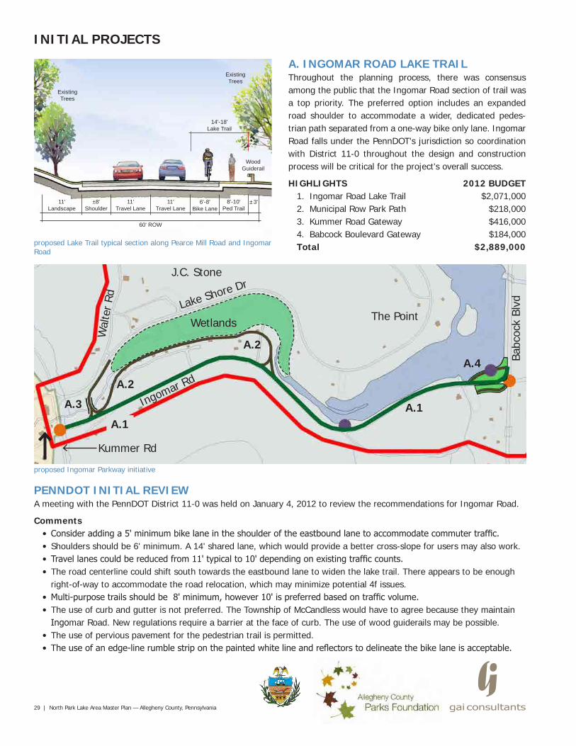
PENNDOT INITIAL REVIEWA meeting with the PennDOT District 11-0 was held on January 4, 2012 to review the recommendations for Ingomar Road.
Comments• Consider adding a 5' minimum bike lane in the shoulder of the eastbound lane to accommodate commuter traffic.• Shoulders should be 6' minimum. A 14' shared lane, which would provide a better cross-slope for users may also work.• Travel lanes could be reduced from 11' typical to 10' depending on existing traffic counts.• The road centerline could shift south towards the eastbound lane to widen the lake trail. There appears to be enough
right-of-way to accommodate the road relocation, which may minimize potential 4f issues.• Multi-purpose trails should be 8' minimum, however 10' is preferred based on traffic volume.• The use of curb and gutter is not preferred. The Township of McCandless would have to agree because they maintain
Ingomar Road. New regulations require a barrier at the face of curb. The use of wood guiderails may be possible.• The use of pervious pavement for the pedestrian trail is permitted.• The use of an edge-line rumble strip on the painted white line and reflectors to delineate the bike lane is acceptable.
29 | North Park Lake Area Master Plan — Allegheny County, Pennsylvania
INITIAL PROJECTS
A. INGOMAR ROAD LAKE TRAILThroughout the planning process, there was consensus among the public that the Ingomar Road section of trail was a top priority. The preferred option includes an expanded road shoulder to accommodate a wider, dedicated pedes-trian path separated from a one-way bike only lane. Ingomar Road falls under the PennDOT's jurisdiction so coordination with District 11-0 throughout the design and construction process will be critical for the project's overall success.
HIGHLIGHTS1. Ingomar Road Lake Trail2. Municipal Row Park Path3. Kummer Road Gateway4. Babcock Boulevard GatewayTotalproposed Lake Trail typical section along Pearce Mill Road and Ingomar
Road
±8'Shoulder
11'Travel Lane
11'Travel Lane
6'-8'Bike Lane
11'Landscape
8'-10'Ped Trail
60' ROW
14'-18'Lake Trail
ExistingTrees
ExistingTrees
WoodGuiderail
±3'
proposed Ingomar Parkway initiative
Lake Shore Dr
Wal
ter
Rd
Kummer Rd
Ingomar Rd
Babc
ock
Blvd
A.1
Wetlands
J.C. Stone
A.4
A.2
A.3
The Point
A.1
A.2
2012 BUDGET$2,071,000
$218,000$416,000$184,000
$2,889,000
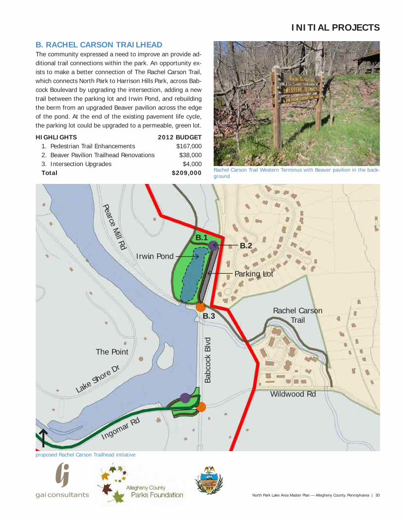
B. RACHEL CARSON TRAILHEADThe community expressed a need to improve an provide ad-ditional trail connections within the park. An opportunity ex-ists to make a better connection of The Rachel Carson Trail, which connects North Park to Harrison Hills Park, across Bab-cock Boulevard by upgrading the intersection, adding a new trail between the parking lot and Irwin Pond, and rebuilding the berm from an upgraded Beaver pavilion across the edge of the pond. At the end of the existing pavement life cycle, the parking lot could be upgraded to a permeable, green lot.
HIGHLIGHTS1. Pedestrian Trail Enhancements2. Beaver Pavilion Trailhead Renovations3. Intersection UpgradesTotal
North Park Lake Area Master Plan — Allegheny County, Pennsylvania | 30
proposed Rachel Carson Trailhead initiative
Wildwood Rd
Rachel Carson Trail
Rachel Carson Trail Western Terminus with Beaver pavilion in the back-ground
Pearce Mill Rd
Babc
ock
Blvd
B.1
The Point
Ingomar Rd
Lake S
hore Dr
Irwin PondB.2
B.3
2012 BUDGET$167,000$38,000$4,000
$209,000
INITIAL PROJECTS
Parking Lot
31 | North Park Lake Area Master Plan — Allegheny County, Pennsylvania
proposed Boathouse Feasibility Study initiative
INITIAL PROJECTS
Boathouse and parking lot
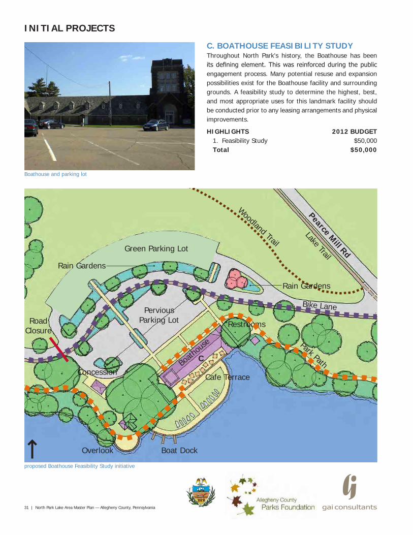
C. BOATHOUSE FEASIBILITY STUDYThroughout North Park's history, the Boathouse has been its defining element. This was reinforced during the public engagement process. Many potential resuse and expansion possibilities exist for the Boathouse facility and surrounding grounds. A feasibility study to determine the highest, best, and most appropriate uses for this landmark facility should be conducted prior to any leasing arrangements and physical improvements.
HIGHLIGHTS1. Feasibility StudyTotal
Pearce Mill Rd
Lake Trail
Restrooms
Boath
ouse
Cafe Terrace
Boat DockOverlook
Concession
RoadClosure
Park Path
Bike Lane
Woodland Trail
C
PerviousParking Lot
2012 BUDGET$50,000
$50,000
Green Parking Lot
Rain Gardens
Rain Gardens
North Park Lake Area Master Plan — Allegheny County, Pennsylvania | 32
INITIAL PROJECTS
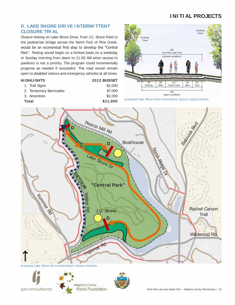
D. LAKE SHORE DRIVE INTERMITTENT CLOSURE TRIALClosure testing on Lake Shore Drive, from J.C. Stone Field to the pedestrian bridge across the North Fork of Pine Creek, would be an economical first step to develop the "Central Park". Testing would begin on a limited basis on a weekday or Sunday morning from dawn to 11:00 AM when access to pavilions is not a priority. The program could incrementally progress as needed if successful. The road would remain open to disabled visitors and emergency vehicles at all times.
HIGHLIGHTS1. Trail Signs2. Temporary Barricades3. AmenitiesTotal proposed Lake Shore Drive intermittent closure typical section
±9'Parking
±6'Bike
±6'Ped
±38'(open condition)
±38'Car-Free Lake Trail
ExistingTrees
ExistingTrees
proposed Lake Shore Drive intermittent closure initiative
Lake Shore Dr
Walter Rd
Kumm
er Rd
North Ridge Dr
Wildwood Rd
"Central Park"
Rachel Carson Trail
Pearce Mill Rd
Ingomar Rd
Babc
ock
Blvd
Boathouse
J.C. Stone
DETOUR
2012 BUDGET$2,000$7,000$2,000
$11,000
±6'Bike
±11'Travel Lane
(closure condition)
D
D
D
33 | North Park Lake Area Master Plan — Allegheny County, Pennsylvania
FUTURE PROJECTS
proposed mid-range projects
Lake Shore Dr
Walter Rd
Kumm
er Rd
North Ridge Dr
Wildwood Rd
"Central Park"
Rachel Carson Trail
Pearce Mill Rd
Ingomar Rd
Babc
ock
Blvd
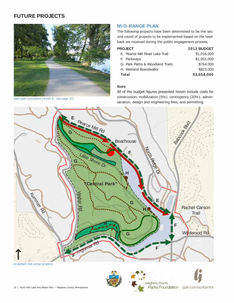
MID-RANGE PLANThe following projects have been determined to be the sec-ond round of projects to be implemented based on the feed-back we received during the public engagement process.
PROJECTE. Pearce Mill Road Lake TrailF. ParkwaysG. Park Paths & Woodland TrailsH. Wetland BoardwalksTotal
NoteAll of the budget figures presented herein include costs for construction, mobilization (5%), contingency (20%), admin-istration, design and engineering fees, and permitting.
2012 BUDGET$1,016,000$1,051,000
$764,000$823,000
$3,654,000
E
E
F
F
F
F
G
G
H
H
G
G
H
Boathouse
park path precedent (credit 8 , see page 37)
North Park Lake Area Master Plan — Allegheny County, Pennsylvania | 34
FUTURE PROJECTS
proposed long-range projects
Lake Shore Dr
Walter Rd
Kumm
er Rd
North Ridge Dr
Wildwood Rd
"Central Park"
Rachel Carson Trail
Pearce Mill Rd
Ingomar Rd
Babc
ock
Blvd
Boathouse
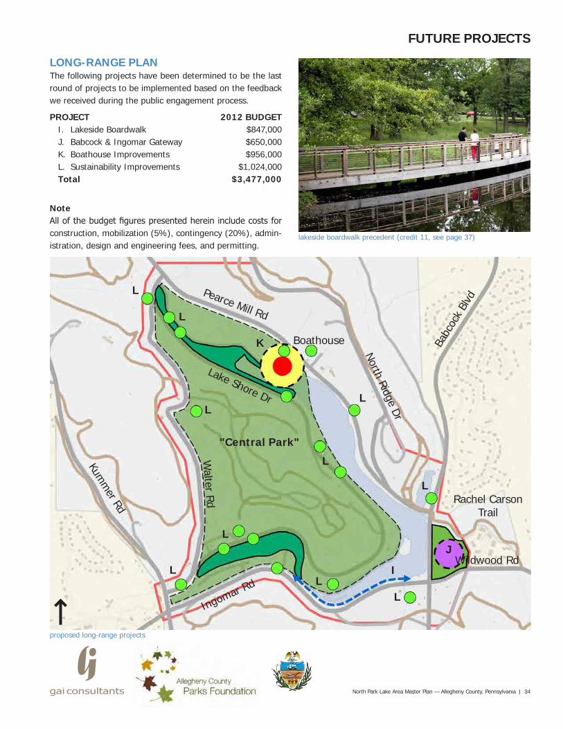
LONG-RANGE PLANThe following projects have been determined to be the last round of projects to be implemented based on the feedback we received during the public engagement process.
PROJECTI. Lakeside BoardwalkJ. Babcock & Ingomar GatewayK. Boathouse ImprovementsL. Sustainability ImprovementsTotal
NoteAll of the budget figures presented herein include costs for construction, mobilization (5%), contingency (20%), admin-istration, design and engineering fees, and permitting.
2012 BUDGET$847,000$650,000$956,000
$1,024,000$3,477,000
I
J
K
L
LL
L
L
L
L
L
LL
lakeside boardwalk precedent (credit 11, see page 37)
35 | North Park Lake Area Master Plan — Allegheny County, Pennsylvania
SUMMARY
walks and charity events are scheduled there throughout the year. The public also stressed that the function of the Lake Trail does not need to change dramatically but safety up-grades are necessary, a recommendation of previous reports conducted for North Park. To this end, Allegheny County re-cently completed an enhancement project, funded by the Pennsylvania Community Transportation Initiative (PCTI) through PennDOT, on the Babcock Boulevard section of the Lake Trail with the primary goal being improved safety for pedestrians, cyclists and vehicles.
As shown in this report, a careful reassessment of the Lake Trail along with thoughtful reconsideration of adjacent road-way character, park connections and entry experiences, uses and amenities, including the Boathouse, and landscape pres-ervation can improve the user experience in the Lake Area while, at the same time, enhance and promote North Park's historic legacy. This approach will significantly heighten the importance, accessibility and enjoyability of the naturally oc-curring environmental assets like the forests, lake, wetlands and streams, and will dramatically increase the site’s overall sustainability and maintainability for future generations of park users.
In the Short-Range Plan, initial project priorities were chosen based on input from the public, focus group participants and the Project Committee, and adjusted based on reasonable construction sequencing and broad impact within the Lake Area. The Mid- and Long-Range Plans build further on the prioritized overarching ideas and the foundation of the Short-Range Plan.
As such, efforts are underway to obtain funding for the initial projects recommended in this report, which is focused on the Ingomar Road section of the Lake Trail (projects A through D). Having a feasible master plan in place, with a series of smaller projects defined in a rational sequence, allows for a more efficient means of raising capital, from both govern-ment and private sources, for successful implementation.
The historic legacy of North Park is profound. It was con-ceived and constructed during a time when the leaders of Allegheny County saw a need to provide natural places for citizens to get away from the rapidly industrializing city. In 1927, the County commissioners hired Paul B. Riis, a leader in the picturesque style of park design popular the 1920's, to carry out a vision for North Park. He oversaw every aspect of park development including construction of roads and shelters, acres of reforestation, and ornamental landscaping. Even though his tenure at the County was short-lived, Riis' lasting impact is visible in North Park to this day.
Other popular amenities that were conceived after Riis' de-parture in 1932 include the Boathouse and North Park Lake, dedicated in 1937, and a 5-mile Lake Trail that loops around the lake on perimeter roadways. However, a decades-long reduction in staffing levels and current economic constraints has created an ongoing maintenance challenge for the Coun-ty, which has led to many functional and aesthetic deficien-cies throughout the Lake Area. Recently though, a joint proj-ect between Allegheny County and the U.S. Army Corps of Engineers was completed that resulted in thousands of cu-bic yards of sediment being removed from North Park Lake. This significant public investment will greatly improve the aquatic habitat and recreation experience of the lake.
The main purpose of this master planning process was to create a framework for sound decision-making to transform the North Park Lake Area into a sustainable place that re-flects the needs of today’s park users, makes the most of this significant public asset by building on its existing strengths and historic legacy, and also works within the maintenance capabilities and budgets of the County's Park and Public Works departments.
During the public engagement process, it was made evident that the Lake Trail is the mosts popular feature within the Lake Area by far. Walkers, runners, and cyclists of all ages and abilities use the trail on a regular basis, and many races,
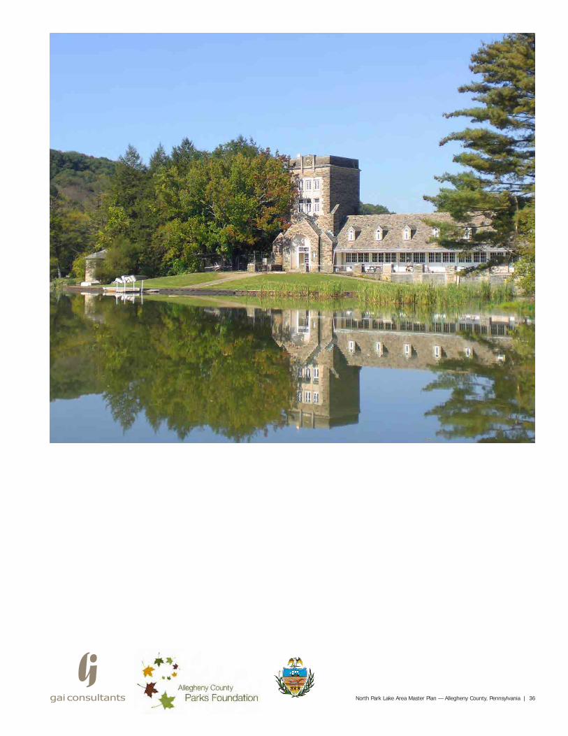
North Park Lake Area Master Plan — Allegheny County, Pennsylvania | 36
37 | North Park Lake Area Master Plan — Allegheny County, Pennsylvania
PHOTO & IMAGE CREDITS1. County Planning Commission. "North Park Lake." May 3, 1935. Allegheny County Department of Public Works. PDF
file.2. Hefelfinger and Austen. "3829-North Park Lake from No. Ridge Drive." June 23, 1937. Allegheny County Department
of Public Works. PDF file.3. Goswick, Christine. "RE: Map for North Park." Message to Todd Brant. September 13, 2011. Email.4. "Map of North Park." Map. Thomas, Eli, 2010. November 2, 2010. Allegheny County Geographic Information Systems.5. "North Park and its Geology." alleghenycounty.us. Allegheny County, n.d. Web. October 10, 2011.6. "Babcock Boulevard Conceptual Enhancement Plan." Map. Michael Baker, Jr., Inc., 2010. May 25, 2010. Allegheny
County Department of Public Works.7. "Relaxing Mountain Get-A-Way at Mountain View Lodge." Photograph. realadventures.com. RealAdvenutes, 2012.
Web. April 11, 2012.8. "Path through the park." Photograph. explorebranson.com. Playing in Branson, 2012. Web. April 11, 2012.9. "Look out point on the lake at Central Park, NYC." Photograph. wikipedia.org. Wikipedia Foundation, Inc., 2010. Web.
November 10, 2011.10. u-murrayhusted (Murray Hustsed, Ursula). "A walk at the Harriet Alexander Nature Center." Photograph. flickr.com.
Yahoo! Inc., 2012. Web. November 10, 2011.11. "Antioch Park." Photograph. bbnarchitects.com. Bowman Bowman Novick, Inc., 2012. Web. November 17, 2011.12. Parisi, Daniel. "North Park." Photograph. tclf.org. The Cultural Landscape Foundation, 2011. Web. 2011. September
25, 2010.13. "Permeable Paving Parking Lot, Hubble Middle School." Photograph. warrenville.il.us. City of Warrenville, 2005. De-
cember 6, 2011.14. "Phipps Breaks Ground on Green Overflow Parking Area." Photograph. geocheminc.com. GeoCHEM, Inc., 2012. Web.
December 1, 2010.
NOTESStatements concerning probable construction cost and/or detailed cost estimates contained herein and in the Appendix pre-pared by GAI represent its judgment as a professional familiar with the construction industry. It is recognized, however, that GAI has no control over the cost of labor, materials or equipment, over the contractors’ methods of determining bid prices, or over competitive bidding or market conditions. Accordingly, GAI cannot and does not guarantee that bids, proposals, or actual costs will not vary from any statement of probable construction cost or other cost estimate prepared by it.
Table of Contents: APPENDIX (separate document)
A: Conduct Site Analysis
B: Develop Alternatives
C: Develop Final Master Plan
D: Cost Opinions
................................................................A1
.................................................................B1
.........................................................C1
............................................................................D1
North Park Lake Area Master Plan — Allegheny County, Pennsylvania | 38