North East Bury St. Edmunds Great Barton Parish...
10
North East Bury St. Edmunds Great Barton Parish Council 5 December 2017 Project Ref 32747
Transcript of North East Bury St. Edmunds Great Barton Parish...

North East Bury St. EdmundsGreat Barton Parish Council
5 December 2017Project Ref 32747

© Broadway Malyan 2
Introduction
Berkeley have been promoting the land at North East Bury St. Edmunds since 2003.
Site area of circa 190 acres.
Site identified in the St. Edmundsbury Core Strategy 2010
Key requirements of the Core Strategy are that the development should:
• Deliver around 1,250 homes of mixed tenure and size including affordable homes
• Maintain the identity and segregation of Great Barton
• Contribute to reducing congestion at appropriate junctions within Bury St. Edmunds
• Provide new high quality public open spaces and sports provision on site
• Provide a new primary school
• Deliver additional community facilities and provide employment opportunities through the creation of a local centre
Vision 2031 DPD (adopted in September 2014) allocated the site in accordance with the provisions of the Core strategy.
The DPD set out a concept statement and concept plan for the development of the site.
© Broadway Malyan 3
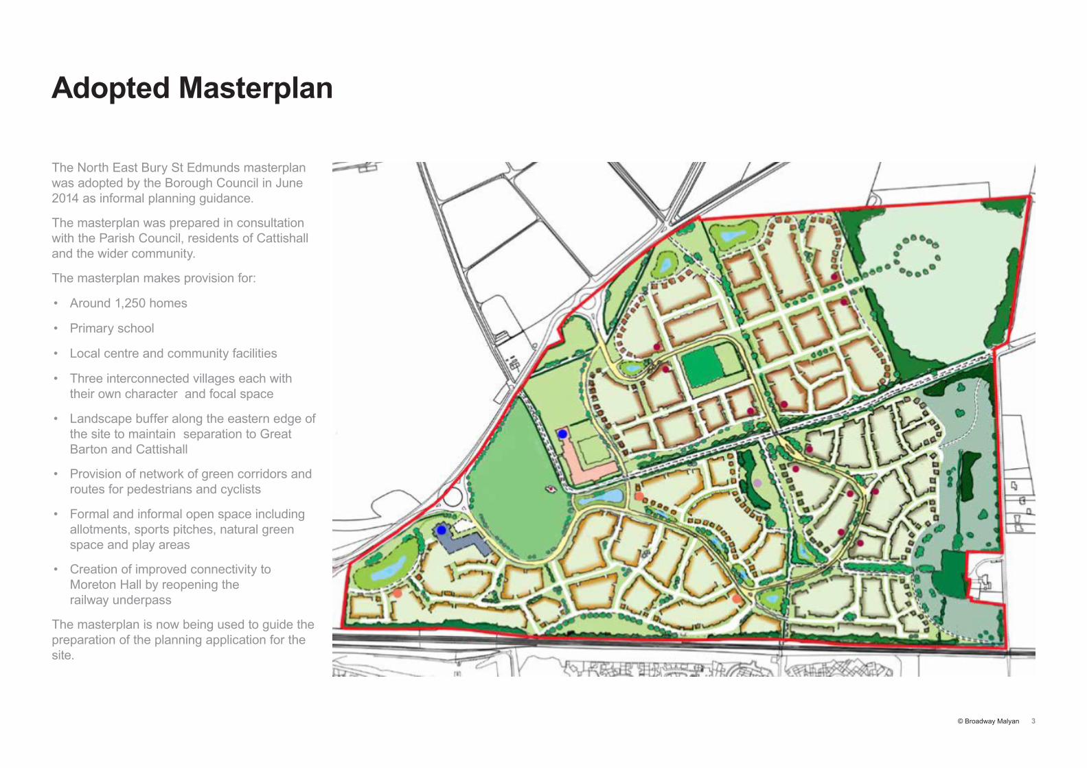
Adopted Masterplan
The North East Bury St Edmunds masterplan was adopted by the Borough Council in June 2014 as informal planning guidance.
The masterplan was prepared in consultation with the Parish Council, residents of Cattishall and the wider community.
The masterplan makes provision for:
• Around 1,250 homes
• Primary school
• Local centre and community facilities
• Three interconnected villages each with their own character and focal space
• Landscape buffer along the eastern edge of the site to maintain separation to Great Barton and Cattishall
• Provision of network of green corridors and routes for pedestrians and cyclists
• Formal and informal open space including allotments, sports pitches, natural green space and play areas
• Creation of improved connectivity to Moreton Hall by reopening the railway underpass
The masterplan is now being used to guide the preparation of the planning application for the site.

© Broadway Malyan 4
Key Site Constraints
Neighbours
• A143 to the north and west
• Cattishall, Holy Innocents’ Church and Great Barton to the east
• Railway and Moreton Hall to the south
Trees and hedgerows
• Green Lane
• Severals Copse and northern hedgerows
• Cattishall boundary
Topography
• Lowest point to the west
• Slopes and valley central
• Flatter raised plateau to the east
© Broadway Malyan 5
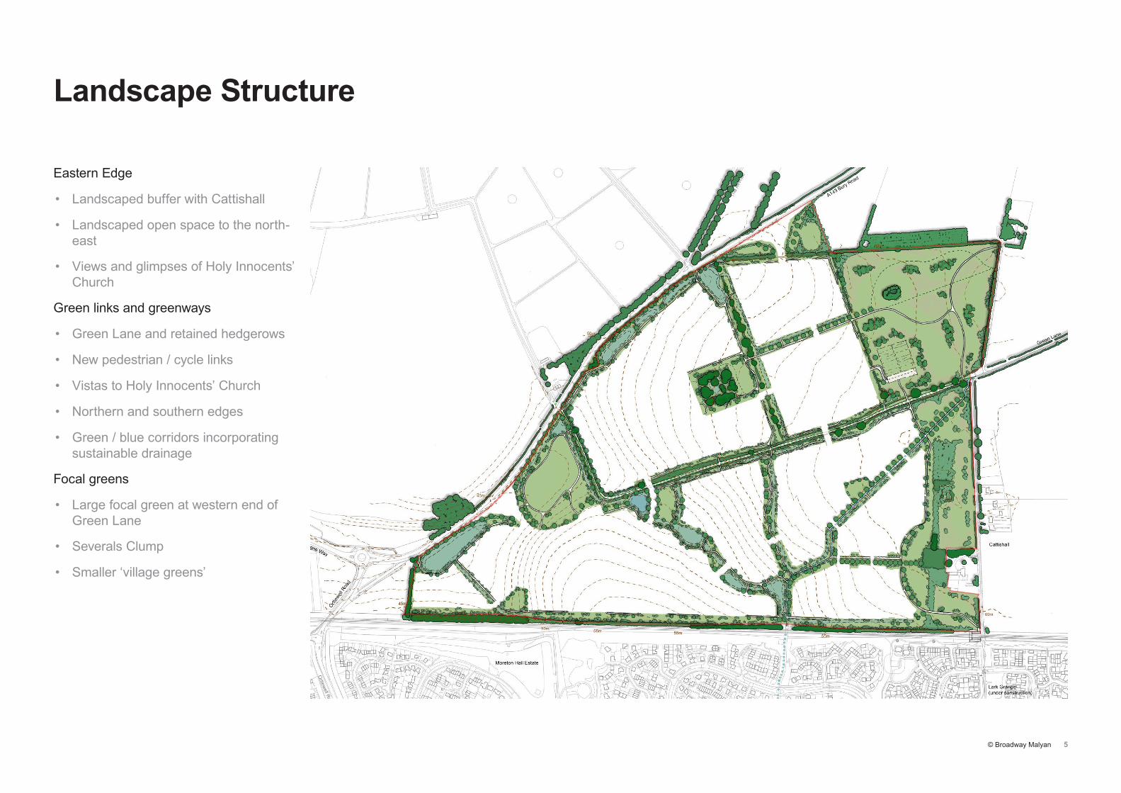
Landscape Structure
Eastern Edge
• Landscaped buffer with Cattishall
• Landscaped open space to the north-east
• Views and glimpses of Holy Innocents’ Church
Green links and greenways
• Green Lane and retained hedgerows
• New pedestrian / cycle links
• Vistas to Holy Innocents’ Church
• Northern and southern edges
• Green / blue corridors incorporating sustainable drainage
Focal greens
• Large focal green at western end of Green Lane
• Severals Clump
• Smaller ‘village greens’
© Broadway Malyan 6
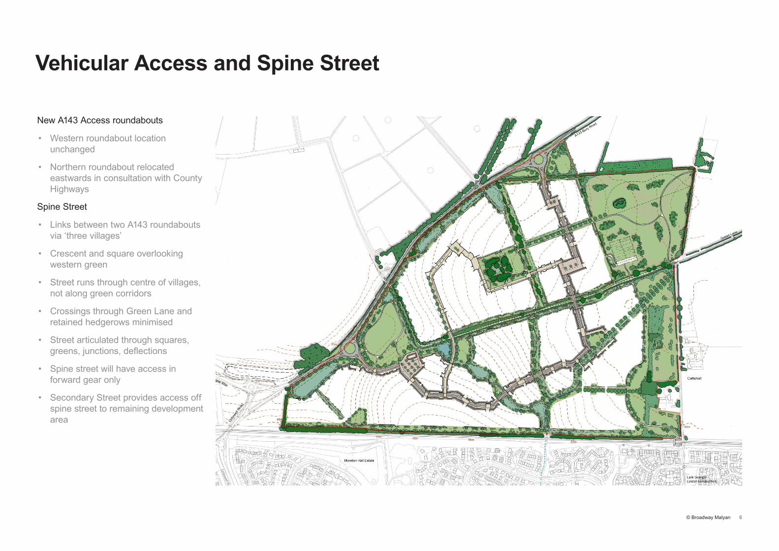
Vehicular Access and Spine Street
New A143 Access roundabouts
• Western roundabout location unchanged
• Northern roundabout relocated eastwards in consultation with County Highways
Spine Street
• Links between two A143 roundabouts via ‘three villages’
• Crescent and square overlooking western green
• Street runs through centre of villages, not along green corridors
• Crossings through Green Lane and retained hedgerows minimised
• Street articulated through squares, greens, junctions, deflections
• Spine street will have access in forward gear only
• Secondary Street provides access off spine street to remaining development area
© Broadway Malyan 7
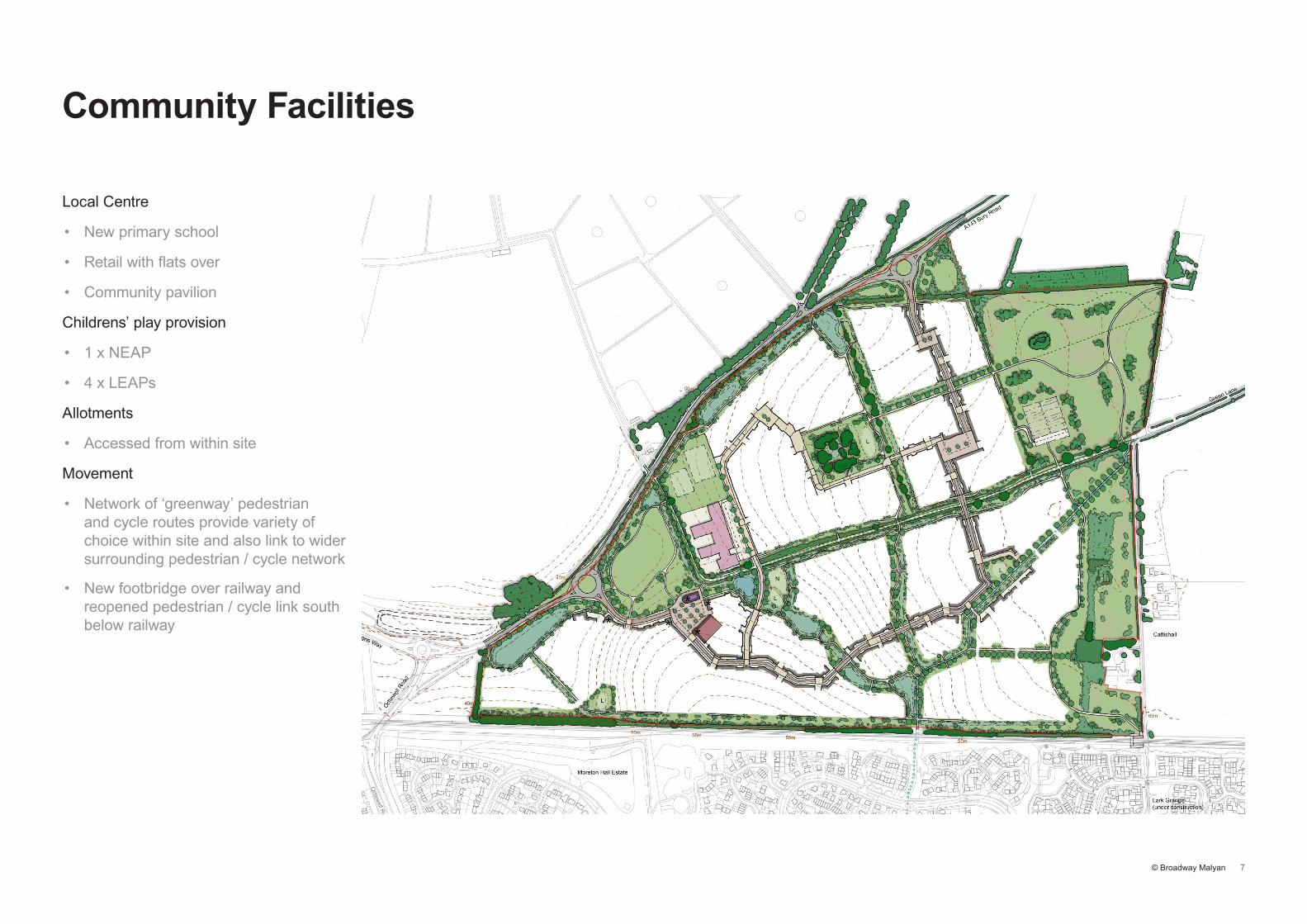
Community Facilities
Local Centre
• New primary school
• Retail with flats over
• Community pavilion
Childrens’ play provision
• 1 x NEAP
• 4 x LEAPs
Allotments
• Accessed from within site
Movement
• Network of ‘greenway’ pedestrian and cycle routes provide variety of choice within site and also link to wider surrounding pedestrian / cycle network
• New footbridge over railway and reopened pedestrian / cycle link south below railway

© Broadway Malyan 8
Proposed Framework Masterplan
Lower Severals
• Arrival into site from Bury St Edmunds
• Laid out around local centre and forms backdrop to focal recreational green
• New frontage to southern greenway and railway
Middle Severals
• Arranged around linear vista to Holy Innocents Church and central green
• Lower density at eastern edge adjoining Cattishall landscaped buffer
• Informal streets and small squares
Upper Severals
• More regular layout responding to the strong geometry of retained hedgerows and Green Lane
• Central landscaped open space around Severals Clump with linear greenway leading north-east aligned with Holy Innocents’ Church
• Streets and squares have a more formal character
© Broadway Malyan 9
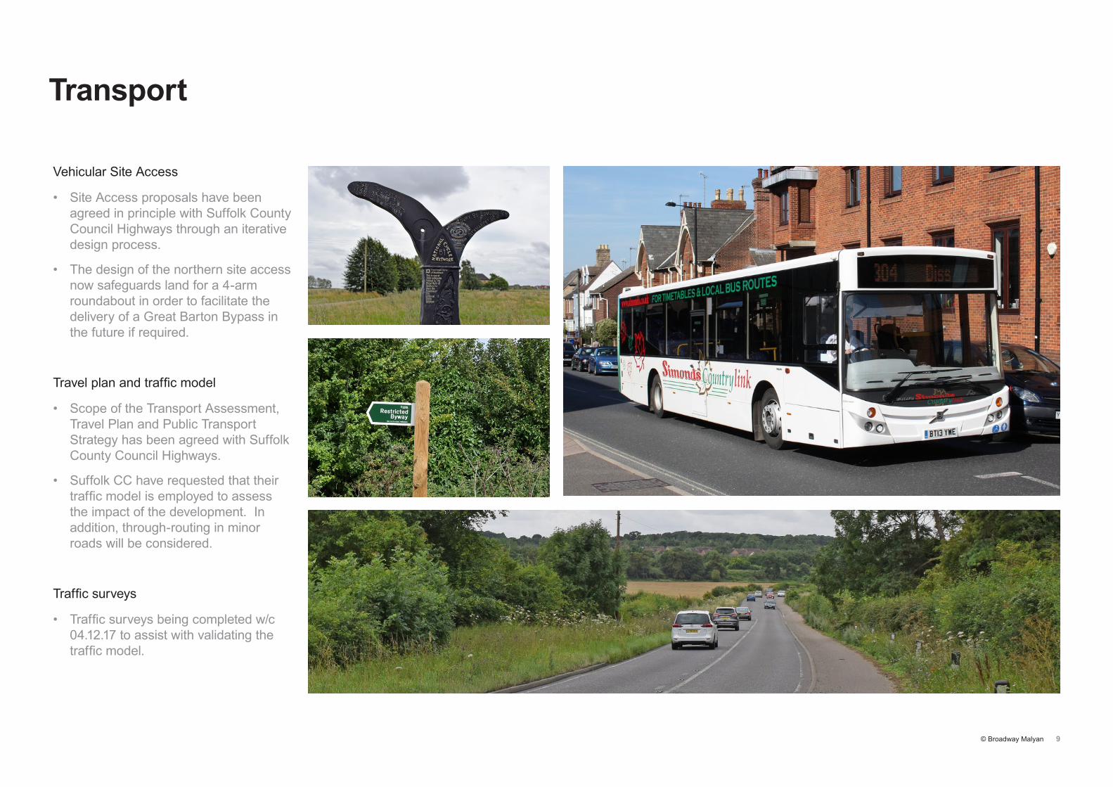
Transport
Vehicular Site Access
• Site Access proposals have been agreed in principle with Suffolk County Council Highways through an iterative design process.
• The design of the northern site access now safeguards land for a 4-arm roundabout in order to facilitate the delivery of a Great Barton Bypass in the future if required.
Travel plan and traffic model
• Scope of the Transport Assessment, Travel Plan and Public Transport Strategy has been agreed with Suffolk County Council Highways.
• Suffolk CC have requested that their traffic model is employed to assess the impact of the development. In addition, through-routing in minor roads will be considered.
Traffic surveys
• Traffic surveys being completed w/c 04.12.17 to assist with validating the traffic model.

© Broadway Malyan 10
Key Dates
Public consultation events
• Two day event in January 2018 to be held in the village hall
• Update leaflet delivered to homes in Great Barton
• Consultation material on the website
Planning application submission
• February/March 2018
Application determination
• Mid 2018
Start on site
• 2019