North Dakota Geological Survey · PDF fileNorth Dakota Geological Survey ... sub-rounded to...
18
North Dakota Geological Survey The subsurface storage potential in the Stutsman County Area By Timothy O. Nesheim Geological Investigation No. 202 North Dakota Geological Survey Edward C. Murphy, State Geologist Lynn D. Helms, Director Dept. of Mineral Resources 2017
Transcript of North Dakota Geological Survey · PDF fileNorth Dakota Geological Survey ... sub-rounded to...

North Dakota Geological Survey
The subsurface storage potential
in the Stutsman County Area By
Timothy O. Nesheim
Geological Investigation No. 202
North Dakota Geological Survey
Edward C. Murphy, State Geologist
Lynn D. Helms, Director Dept. of Mineral Resources
2017

Table of Contents
Introduction . . . . . . . . . . . . . . . . . . . . . . . . . . . . . . . . . . . . . . . . . . . . . . . . . . . . . . . . . . . . . . . . . . . . . 1
Geology . . . . . . . . . . . . . . . . . . . . . . . . . . . . . . . . . . . . . . . . . . . . . . . . . . . . . . . . . . . . . . . . . . . . . . . . . 1
Methods . . . . . . . . . . . . . . . . . . . . . . . . . . . . . . . . . . . . . . . . . . . . . . . . . . . . . . . . . . . . . . . . . . . . . . . . 1
Results . . . . . . . . . . . . . . . . . . . . . . . . . . . . . . . . . . . . . . . . . . . . . . . . . . . . . . . . . . . . . . . . . . . . . . . . . 2
Summary and Conclusions . . . . . . . . . . . . . . . . . . . . . . . . . . . . . . . . . . . . . . . . . . . . . . . . . . . . . . . . . 4
References . . . . . . . . . . . . . . . . . . . . . . . . . . . . . . . . . . . . . . . . . . . . . . . . . . . . . . . . . . . . . . . . . . . . . . 16
Figures
Figure 1 Map of North Dakota with study area . . . . . . . . . . . . . . . . . . . . . . . . . . . . . . . . . . . . . . . . 6
Figure 2 Schematic west to east cross-section of the study area . . . . . . . . . . . . . . . . . . . . . . . . . 7
Figure 3 Structure contour map of the Inyan Kara Formation top . . . . . . . . . . . . . . . . . . . . . . . . 8
Figure 4 Cross-section of the Inya Kara Formation . . . . . . . . . . . . . . . . . . . . . . . . . . . . . . . . . . . . . 9
Figure 5 Structure contour map of the basal Lodgepole Formation porosity zone top . . . . . . . 10
Figure 6 Cross-section of the basal Lodgepole Formation porosity zone . . . . . . . . . . . . . . . . . . . 11
Figure 7 Structure contour map of the Black Island Formation top . . . . . . . . . . . . . . . . . . . . . . . 12
Figure 8 West to east cross-section of the Black Island and Deadwood Formations . . . . . . . . . . 13
Figure 9 Southwest to northeast cross-section of the Black Island and Deadwood Fms . . . . . . 14
Figure 10 Porosity vs permeability data for the Lodgepole and Black Island Formations . . . . . . 15
Table
Table 1 Core analysis data for the Lodgepole and Black Island Formations . . . . . . . . . . . . . . . . . 15
i

INTRODUCTION
In the fall of 2014, plans were announced to construct a large fertilizer plant in the vicinity of Jamestown
(Stutsman County), North Dakota. The proposed fertilizer plant design included converting natural gas
into nitrogen fertilizer, a process that would have created waste that in turn would have needed to be
periodically disposed of. One potential disposal method for waste fluid would be injection into buried
layers of porous sedimentary rock, similar to the disposal of produced water from oil and gas wells in
western North Dakota. The North Dakota Geological Survey (NDGS) began a project to identify potential
zones of porous sedimentary rock that might be suitable for subsurface injection/disposal beneath
Stutsman County and the surrounding area (Figs. 1 and 2). Although the proposed fertilizer plant
construction plans were later tabled, the NDGS continued its project to completion in the event that a
similar need for subsurface waste disposal in the Stutsman County area should arise again.
GEOLOGY
Stutsman County is positioned along the eastern margins of the oil and gas productive Williston Basin.
Sedimentation within the Williston Basin began approximately 500 million years ago during the
Cambrian with the deposition of the Deadwood Formation (Murphy et al., 2009). The majority of the
older (Paleozoic), more deeply buried sedimentary formations consist of carbonate rock while the
younger (Mesozoic-Cenozoic), shallower formations are predominantly clastic (Murphy et al., 2009).
These various clastic and carbonate sedimentary layers all dip gently westwards towards the center of
the basin. Beneath the sedimentary cover are igneous and metamorphic rocks of the Superior Province,
which formed prior to and have been tectonically stable since at least 2.4 billion years before present
(Nesheim, 2012).
METHODS
Wireline logs and lithological reports from the fifty-one wells within the study area were examined to
identify relatively thick (10’s of feet) and porous (>15% porosity) sedimentary rock intervals positioned
below the Cretaceous Pierre Formation that display some level of regional continuity. The Pierre
Formation is composed of upwards of 2,300 feet of marine shale that underlies most of the fresh water
aquifers utilized across North Dakota (Murphy et al., 2009). Isopach (thickness) and structure contour
(feet below sea level) maps were then completed for each identified interval using available wireline
logs. Lithological descriptions for each porous zone were compiled using sample descriptions from
available lithological reports associated with each well. Oil well files were then searched to find core
plug porosity and permeability data for the porous zones from wells both within and surrounding the
study area.
1

RESULTS
Three zones of interest were identified that appear to have good potential for subsurface
disposal/injection: 1) discontinuous sandstones within the Inyan Kara Formation (Figs. 3 and 4), 2) a
high-porosity carbonate zone within the base of the Lodgepole Formation (Figs. 5 and 6), and 3)
sandstone beds within the Black Island and Deadwood Formations (Figs. 7-9). These three units vary in
age and depth. The Inyan Kara Formation was deposited during the Cretaceous, approximately 140 to
130 million years ago, and is buried approximately 2,000 feet below the surface across the study area.
The basal Lodgepole Formation is Mississippian in age and was deposited approximately 350 million
years ago. Where present, it is buried 2,500 to 4,500 feet below the surface with burial depth increasing
westward across the study area. The Black Island and Deadwood Formations were deposited between
450 and 550 million years ago, during the Ordovician to Cambrian, and are buried 2,500 to 5,500 feet
below the surface with the burial depth increasing towards the west. These three units vary geologically
such that the rock type of potential injection/disposal varies in lithology and distribution.
There may be some subsurface injection potential within additional units such as the Red River,
Duperow, Mission Canyon/Charles Formations. Wireline logs and lithological (drilling) reports were
examined from these and other units, and some porous-permeable intervals exist, but do not appear to
be as thick and/or continuous as those identified within the Inyan Kara, Lodgepole, Black Island, and
Deadwood Formations.
Inyan Kara Sandstones
Based on the review of available lithological reports from well files, most of the Inyan Kara sandstone
was described as light to medium grey with variations including white, red, and/or brown as well as
occasional salt-and-pepper or mottled coloration. Grain size ranges from silty/very fine grained to very
coarse and even pebble-sized in places, although most of the grain size variation ranges from medium to
coarse grained. Grain shape is commonly described as sub-angular to sub-rounded and less commonly
ranging to angular or rounded. Mineral composition is predominantly quartz while mafic minerals and
possibly feldspars are occasionally noted. Sand grains are sometimes described as frosted and/or pitted,
but can also be translucent. Mineral grains range from being poorly indurated, unconsolidated to well
indurated, hard/cemented. Calcite cement is periodically noted. Pyrite and/or glauconite are also
present locally.
Porous sandstone intervals in the Inyan Kara Formation are discontinuous throughout the study area,
and may resemble the Inyan Kara of western North Dakota (Bader, 2015; 2016). The Inyan Kara
Formation is the primary unit used for salt water (by-product of oil production) disposal in western
North Dakota. Contouring the net thickness of porous, injectable sandstone across the study area was
considered, but the available well control was determined to be too limited. Instead, a bubble map was
constructed depicting net injectable sandstone thickness for 18 wells across the study area which have
available gamma ray wireline logs necessary to identify clean (low gamma ray) sandstone beds (Fig. 3).
Two-thirds of these wells contain 50 feet or more of clean, porous sandstone that should be suitable for
2

fluid injection. The remaining wells contain less than 50 feet of sandstone and have only moderate to
minimal potential for fluid injection.
Basal Lodgepole Carbonate
The basal Lodgepole section consists of white to tan to grey and, in some places, pink limestone that
sometimes transitions into dolomite within the basal portions of the interval. Occasionally this interval
is described to contain shale fragments, chert, and/or anhydrite inclusions. The porosity is described as
typically fair to good and can include inter-oolitic and/or pin point vuggy porosity. The grain size ranges
from microcrystalline to occasionally course crystalline with both oolitic and fossil fragment grains.
Crinoid fossils were mentioned within one well. The interval is often at least chalky in part and can also
be very dense, non-chalky.
The high porosity carbonate interval within the basal portions of the Lodgepole Formation is typically
100 ft. thick or more where present and extends continuously across the western half of the study area
(Figs. 5 and 6). This interval thins and subcrops (pinches out) in the sub-surface within a several mile
stretch along a north-northeast to south-southwest trend. Thirteen sidewall cores were collected and
analyzed from this interval from True Oil Company’s Juliar 31-35 (NDIC: 11653, API: 33-103-00024-00-
00, Sec. 35 - T148N - R70W), located north of the study area. The porosity of the samples ranged from
14.0% to 23.9% with permeability values of 0.5 to 14 millidarcies and a positive porosity-permeability
trend (Fig. 10, Table 1).
Black Island Sandstones
Sandstone within the Black Island Formation is composed of transparent/colorless to white to light tan-
brown, primarily fine grained, sub-rounded to rounded quartz grains. Grain size does range in places
from very fine to coarse grained and occasionally sub-angular grains may be present. Porosity is
described as fair to excellent inter-granular. Red dolomitic cement and shale along with pyrite occur in
some places. Calcite cement may also be present, but in general Black Island sandstone in the study
area appears to be poorly cemented and contains loose (friable) quartz sand grains.
The Black Island Formation is present throughout most of the study area and is only absent in the south-
central portions of Stutsman County (Fig. 7). The area where the Black Island Formation (and the
underlying Deadwood Fm.) is absent appears to correlate with the Stutsman High, a structural feature
identified by Ballard (1963). The Black Island Formation is roughly 10-20 feet thick where present, and
thins slightly towards the east. Sidewall core plug data for the Black Island from the Juliar 31-35 includes
porosity values of 15.9 to 20.7% with permeability values of 1.2 to 4.5 millidarcies (Fig. 10, Table 1).
However, the Black Island consists of shaly sandstone within the Juliar 31-35, whereas throughout the
study area is mostly clean, non-shaly sandstone. The lower clay (shale) content across the study area
should increase the permeability of the Black Island sandstone.
3

Deadwood Sandstones
Sandstone within the Deadwood Formation ranges from pale red to reddish orange-brown to
white/clear in color. Grain size is typically fine to medium and sub-rounded in shape; although they can
also be angular to sub-angular and/or rounded to well-rounded as well. Deadwood sandstone beds are
also commonly glauconitic and sometimes dolomitic in part. Calcite cement is commonly noted and the
sandstone ranges from friable to moderately consolidated. Porosity is described as fair to good.
Overall, the Deadwood Formation thins eastward across the study area, decreasing in thickness from
over 200 feet to being absent along the eastern edges of the study area (Fig. 8). The Deadwood
Formation is also absent over the Stutsman High in south-central Stutsman County, similar to the
overlying Black Island Formation (Fig. 7). As the Deadwood thins eastward, it also appears to become
more clay-rich (shaly) based on lithological reports and increasing gamma ray and SP wireline log
signatures (Fig. 9). These changes likely decrease the overall permeability of Deadwood sandstone beds
and their potential as a target for fluid injection.
The Deadwood Formation lies directly over the Precambrian basement (Figs. 8 and 9). Many of the
faults within North Dakota likely originate within the Precambrian basement and extend upwards (to
various degrees) into the overlying sedimentary cover. Fluid injection into rock within close lateral and
vertical proximity to pre-existing faults can lead to induced seismicity (NAS, 2012). Fluid injection
increases the pore pressure within the host rock, which in turn can alter the stress regime of a nearby
fault and allow slippage or movement along the fault plane resulting in a seismic event (NAS, 2012).
Therefore, additional study and extra precautions may be necessary before utilizing the Deadwood
Formation for subsurface fluid injection within any area of North Dakota.
SUMMARY AND CONCLUSIONS
The Inyan Kara Formation is the shallowest potential injection unit identified and examined in this paper
and extends across the entire study area. However, the variable net thickness of porous sandstone
within the Inyan Kara means there is risk that the Inyan Kara could be barren of, or contain minimal,
injectable sandstone within a given location. The Inyan Kara Formation is the primary unit for the
disposal of produced water from oil and gas production across western and north-central North Dakota,
and therefore should be suitable for similar subsurface injection in eastern North Dakota, provided it
contains adequate net thicknesses of porous sandstone.
The basal carbonate section of the Lodgepole Formation is continuously thick and at least partially
porous where present. However, it is absent in roughly the eastern third of the study area based upon
the wireline logs and lithological information reviewed. Therefore, the eastern third of the study area
has negligible potential for subsurface injection for this interval. The basal Lodgepole Formation
(Madison Group) is utilized for subsurface injection in southwestern North Dakota (Bowman County) for
4

the produced water from oil wells, and therefore may be similarly suitable in eastern North Dakota
where present.
Both the Black Island and Deadwood Formations appear to contain some quantity of porous quartz
sandstone across most of the study area. However, like the basal porous carbonate interval of the
overlying Lodgepole Formation, the quantity and quality of porous sandstone within both these
formations appear to decrease towards the eastern margins of the study area. These units are also
buried below the Inyan Kara and Lodgepole Formations and therefore would be the most costly to drill
and operate.
5

040
Mile
s
Will
isto
n
Dic
kins
on
Min
ot
Bism
arck
Dev
ils L
ake
Valle
yCi
ty
Gra
nd F
orks Fa
rgo
Jam
esto
wn
Julia
r 31-
35 Stut
sman
Coun
ty
Stud
y A
rea
AA’
Figu
re 1
. Map
of N
orth
Dak
ota
show
ing
coun
ty o
utlin
es (g
rey
lines
), la
rger
citie
s (ye
llow
star
s), a
nd th
e st
udy
area
cent
ered
on
Stut
sman
C
ount
y (r
ed o
utlin
e).
A-A
’ dep
icts
the
loca
tion
and
exte
nt o
f the
Fig
ure
2 sc
hem
atic
cros
s-se
ctio
n th
at d
ispla
ys th
e su
bsur
face
sedi
men
tary
un
its b
enea
th th
e st
udy
area
. Th
e gr
een
diam
ond
show
s the
loca
tion
of th
e Ju
lie 3
1-35
wel
l, fr
om w
hich
the
sidew
all c
ore
plug
por
osity
an
d pe
rmea
bilit
y da
ta fo
r the
Lod
gepo
le a
nd B
lack
Isla
nd F
orm
atio
n co
mes
from
.
6

Wes
tA
-4,0
00 ft
.
-3,0
00 ft
.
-2,0
00 ft
.
-1,0
00 ft
.
Sea
Leve
l
2,00
0 ft.
1,00
0 ft.
671
33-093-00012-00-00
S12 T
140N
R
67W
K.B
. =
1,900 ft.
406
33-093-00006-00-00
S20 T
140N
R
65W
K.B
. =
1,576 ft.
4640
33-003-00004-00-00
S9 T
140N
R
59W
K.B
. =
1,440 ft.
-5,0
00 ft
.
Kid
der C
o.B
arne
s Co.
Stut
sman
Co.
24
33-043-00003-00-00
S36 T
141N
R
73W
K.B
. =
1,968 ft.
Qu
Ku
Kik
Ju
MD
u
Si
Ou
CO
d
P C
EastA'
Exp
lana
tions
Ou
Si
MD
u
Ju
Kik
Ku
Qu
Qu
ate
rn
ary u
nd
iffe
re
ntia
te
d
Cre
ta
ce
ou
s u
nd
iffe
re
ntia
te
d
Cre
ta
ce
ou
s In
ya
n K
ara
F
orm
atio
n
Ju
ra
ssic u
nd
iffe
re
ntia
te
d
Mississip
pia
n-D
evo
nia
n u
nd
iffe
re
ntia
te
d
Silu
ria
n In
te
rla
ke
F
orm
atio
n
Ord
ovicia
n u
nd
iffe
re
ntia
te
d
Ca
mb
ria
n-O
rd
ovicia
n D
ea
dw
oo
d F
orm
atio
n
Pre
ca
mb
ria
n B
ase
me
nt (S
up
erio
r P
ro
vin
ce
)
Un
co
nfo
rm
ity
55
76
33
-0
69
-0
00
31
-0
0-0
0
S3
4 T
15
2N
R
73
W
K.B
. =
1
,5
79
ft.
ND
IC
W
ell #
AP
I W
ell #
Section T
ow
nship R
ange
K
elly B
ushing E
levation
P C
CO
d
Figu
re 2
. Sch
emat
ic w
est t
o ea
st cr
oss-
sect
ion
of th
e st
udy
area
mod
ified
from
Nes
heim
(201
6).
List
ed a
bove
eac
h cr
oss-
sect
ion
wel
l in
desc
endi
ng o
rder
incl
udes
: the
Nor
th D
akot
a In
dust
rial C
omm
issio
n w
ell n
umbe
r, A
PI w
ell n
umbe
r, se
ctio
n-to
wns
hip-ra
nge,
and
kel
ly
bush
ing
elev
atio
n.
7

0 ft
200 ft
400 ft
-200 ft
-400 ft
B'B
- >10
0 ft
- 75
to 1
00 ft
- 25
to 5
0 ft
- 50
to 7
5 ft
- <25
ft- N
/A
Cont
rol W
ells
wit
h N
et In
ject
able
Inya
n Ka
ra S
ands
tone
Thi
ckne
ss
Figu
re 3
. Str
uctu
re co
ntou
r map
of t
he to
p of
the
Inya
n K
ara
Form
atio
n (b
lack
line
s) w
ith b
ubbl
es d
epic
ting
the
estim
ated
net
thic
knes
s of
inje
ctab
le In
yan
Kar
a sa
ndst
one
usin
g th
e m
etho
ds o
f Bad
er (2
015)
.
8
1,700 1,800 1,900 2,000 2,100 2,200 2,300 2,400
1,700 1,800 1,900 2,000 2,100 2,200 2,300 2,400
1,700 1,800 1,900 2,000 2,100 2,200 2,300 2,400
1,700 1,800 1,900 2,000 2,100 2,200 2,300 2,400
1,700 1,800 1,900 2,000 2,100 2,200 2,300 2,400G
amm
a R
ayR
esis
tivity
0.2
2000
incr
easin
gin
tensit
y
Gam
ma
Ray
Res
istiv
ity
0.2
2000
Gam
ma
Ray
Res
istiv
ity
0.2
2000
Gam
ma
Ray
Res
istiv
ity
0.2
2000
Gam
ma
Ray
Res
istiv
ity
0.2
2000
incr
easin
gin
tensit
yin
crea
sing
inten
sity
incr
easin
gin
tensit
yin
crea
sing
inten
sity
MadisonGourp
SwiftFm.Inyan Kara FormationMowry Formation
Cretaceous MTRGreenhorn Fm.
#668
33-0
93-0
0009
-00-
00Se
c. 2
5, T
137N
, R67
WC
alve
rt Ex
plor
atio
n C
o.M
arga
ret M
eyer
s #1
K.B
. = 1
,907
ft
#673
33-0
93-0
0014
-00-
00Se
c. 2
6, T
138N
, R67
WC
alve
rt Ex
plor
atio
n C
o.F.
L. R
ober
tson
#1
K.B
. = 1
,919
ft
#670
33-0
93-0
0011
-00-
00Se
c. 2
4, T
139N
, R67
WC
alve
rt Ex
plor
atio
n C
o.D
. C. W
ood
#1K
.B. =
1,8
74 ft
#672
33-0
93-0
0013
-00-
00Se
c. 2
4, T
139N
, R67
WC
alve
rt Ex
plor
atio
n C
o.V
ince
nt W
anze
k #1
K.B
. = 1
,867
ft
#671
33-0
93-0
0012
-00-
00Se
c. 1
2, T
140N
, R67
WC
alve
rt Ex
plor
atio
n C
o.G
eorg
e G
anse
r #1
K.B
. = 1
,900
ft
BB
’N
orth
Sout
h
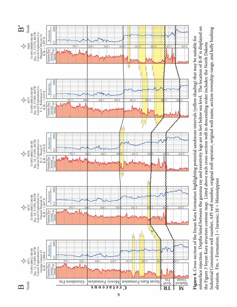
?
Figu
re 4
. Cro
ss-s
ectio
n of
the
Inya
n K
ara
Form
atio
n hi
ghlig
htin
g po
tent
ial s
ands
tone
inte
rval
s (ye
llow
shad
ing)
that
may
be
suita
ble
for
subs
urfa
ce in
ject
ion.
Dep
ths l
isted
bet
wee
n th
e ga
mm
a ra
y an
d re
sistiv
ity lo
gs a
re in
feet
bel
ow se
a le
vel.
The
loca
tion
of B
-B’ i
s disp
laye
d on
th
e Fi
gure
3 In
yan
Kar
a st
ruct
ure
cont
our m
ap.
List
ed a
bove
eac
h cr
oss-
sect
ion
wel
l in
desc
endi
ng o
rder
incl
udes
: the
Nor
th D
akot
a In
dust
rial C
omm
issio
n w
ell n
umbe
r, A
PI w
ell n
umbe
r, or
igin
al w
ell o
pera
tor,
orig
inal
wel
l nam
e, se
ctio
n-to
wns
hip-
rang
e, a
nd k
elly
bus
hing
el
evat
ion.
Fm
. = F
orm
atio
n; J
= Ju
rass
ic; M
= M
ississ
ippi
an
9

-500 ft
-1,000 ft
-1,500 ftC
C’
Lod
gepo
le F
m.
Abs
ent
- Bas
al L
odge
pole
car
bona
te w
ith ≥
100
ft. g
ross
thic
knes
s- S
truct
ure
cont
our o
n ba
sal L
odge
pole
sand
ston
e to
p
- Con
trol w
ell
- Bas
al L
odge
pole
car
bona
te w
ith <
100
ft. g
ross
thic
knes
s
Figu
re 5
. Map
dep
ictin
g th
e ap
prox
imat
e ex
tent
and
stru
ctur
e co
ntou
rs o
n th
e to
p of
a p
orou
s car
bona
te in
terv
al lo
cate
d w
ithin
the
basa
l po
rtio
ns o
f the
Lod
gepo
le F
orm
atio
n. T
he e
xten
t of t
he L
odge
pole
For
mat
ion
is fr
om A
nder
son
(197
4).
10

datu
m
porous carbonate
GR
020
0
616
0.3
-0.1
0.3
-0.1
110
00Ca
lD
PHI (
lime)
Resi
stiv
ity
NPH
I (lim
e)
GR
020
0
0.3
-0.1
0.3
-0.1
110
00D
PHI (
lime)
Resi
stiv
ity1
1000
GR
Neu
tron
Resi
stiv
ity
NPH
I (lim
e)
110
00G
RN
eutr
onRe
sist
ivity
110
00G
RN
eutr
onRe
sist
ivity
3,300 3,400 3,500
3,200 3,300 3,400
2,600 2,700 2,800
2,600 2,700 2,800
2,700 2,800 2,900
1159
933
-103
-000
23-0
0-00
Sec.
28
- T14
5N -
R70
WTr
ue O
il C
ompa
nyK
rueg
er #
42-4
8K
.B. =
1,8
57 ft
602
33-0
93-0
0007
-00-
00Se
c. 4
- T1
43N
- R
69W
S. D
. Joh
nson
Dril
ling
Co.
J. J.
John
son
#1K
.B. =
1,9
44 ft
671
33-0
93-0
0012
-00-
00Se
c. 1
2 - T
140N
- R
67W
Cal
vert
Expl
orat
ion
Co.
Geo
rge
Gan
ser #
1K
.B. =
1,9
00 ft
670
33-0
93-0
0011
-00-
00Se
c. 2
4 - T
139N
- R
67W
Cal
vert
Expl
orat
ion
Co.
D. C
. Woo
d #1
K.B
. = 1
,874
ft
7415
33-0
93-0
0021
-00-
00Se
c. 2
8 - T
137N
- R
67W
Kis
sing
er P
etro
leum
Cor
pSt
ern
#1-2
8K
.B. =
2,1
00 ft
undifferentiatedLodgepole FormationDevonianMississippianC
C’
Nor
thw
est
Sout
h
Figu
re 6
. Cro
ss-s
ectio
n of
the
low
er L
odge
pole
For
mat
ion
with
the
poro
us ca
rbon
ate
inte
rval
colo
red
yello
w.
The
loca
tion
of C
-C’ i
s di
spla
yed
on th
e Fi
gure
5 m
ap.
List
ed a
bove
eac
h cr
oss-
sect
ion
wel
l in
desc
endi
ng o
rder
incl
udes
: the
Nor
th D
akot
a In
dust
rial
Com
miss
ion
wel
l num
ber,
API
wel
l num
ber,
orig
inal
wel
l ope
rato
r, or
igin
al w
ell n
ame,
sect
ion-
tow
nshi
p-ra
nge,
and
kel
ly b
ushi
ng
elev
atio
n.
11

-500 ft
-1,000 ft
-1,500 ft
-2,000 ft
-2,500 ft
-3,000 ft
-3,500 ft
E
E’
DD
’
-1,7
62
110
-2,4
20
218
-3,3
94
241
-2,1
18
137
-3,0
77
-2,2
07
148
-1,6
80
103
-2,0
73
143
-1,8
26 0
-1,9
29
124
-1,8
93
137
-1,7
61 0
-1,7
73
98
-1,6
32
87
-1,6
40 89
-3,1
04
-1,3
60
64
-1,0
34
43
-3,1
24
127
-1,2
94
70
-1,6
47
103
-474 30
-882 47
-1,4
63
86
- 0
ft
Gro
ss T
hick
ness
of
Blac
k Is
land
and
D
eadw
ood
Form
atio
ns
- 0<
30 ft
- 30
-60
ft -
60-9
0 ft
- 90
-120
ft -
120-
150
ft -
150-
180
ft -
180-
210
ft -
210-
240
ft -
240-
270
ft
Figu
re 7
. Iso
pach
of t
he B
lack
Isla
nd a
nd D
eadw
ood
Form
atio
ns (b
lue
colo
ring)
and
stru
ctur
e co
ntou
rs o
n th
e Bl
ack
Isla
nd F
orm
atio
n to
p (b
lack
line
s).
Blac
k do
ts d
ispla
y w
ell c
ontr
ol w
ith th
e su
b-se
a le
vel d
epth
in fe
et o
f the
Bla
ck Is
land
For
mat
ion
top
liste
d ab
ove
each
wel
l and
th
e co
mbi
ned
Blac
k Is
land
-Dea
dwoo
d Fo
rmat
ion
net t
hick
ness
in fe
et li
sted
bel
ow.
12

2,100 ft.2,000 ft.1,900 ft.
3,200 ft. 3,300 ft. 3,400 ft.
5,600 ft.5,500 ft.5,400 ft.5,300 ft.
Res
istiv
ity2
200
SPR
esis
tivity
220
0SP
Res
istiv
ity2
200
SP
Deadwood FormationWinnipeg Group
Icebox Fm.
Bla
ckIs
l. Fm
.
#24
33-0
43-0
0003
-00-
00Se
c. 3
6, T
141N
, R73
WM
agno
lia P
etro
leum
Co.
Nor
th D
akot
a St
ate
“A”
#1K
.B. =
1,9
68 ft
.
#370
33-0
93-0
0005
-00-
00N
WN
W S
ec. 2
1, T
140N
, R65
WH
. Han
son
Oil
Synd
icat
eR
ed O
gilv
ie #
1K
.B. =
1,5
73 ft
.
#464
033
-003
-000
04-0
0-00
SESW
Sec
. 9, T
140N
, R59
WJ.
M. J
ohns
ton
Alla
n E.
Vig
#1
K.B
. = 1
,440
ft.
Cambrian PCOrdovician
- san
dsto
neCo
re L
itho
logi
es:
- sha
ly s
ands
tone
- sha
le
- gra
nite
core
din
terv
al
DD’
Wes
tEa
st
Figu
re 8
. W
est t
o ea
st cr
oss-
sect
ion
of th
e Bl
ack
Isla
nd a
nd D
eadw
ood
Form
atio
ns w
ith p
oten
tially
por
ous s
ands
tone
inte
rval
s co
lore
d in
yel
low
. Th
e lo
catio
n of
D-D
’ is d
ispla
yed
on th
e Fi
gure
7 m
ap.
List
ed a
bove
eac
h cr
oss-
sect
ion
wel
l in
desc
endi
ng
orde
r inc
lude
s: th
e N
orth
Dak
ota
Indu
stria
l Com
miss
ion
wel
l num
ber,
API
wel
l num
ber,
orig
inal
wel
l ope
rato
r, or
igin
al w
ell
nam
e, se
ctio
n-to
wns
hip-
rang
e, a
nd k
elly
bus
hing
ele
vatio
n.
13

3,600 3,700 3,800
3,8003,7003,6003,500
3,000 3,100 3,200 3,300
3,4003,3003,2003,100
2,800 2,900 3,000 3,100
Icebox FormationRoughlock Fm.RR BIPC
Deadwood Fm.
CambrianOrdovician
Gam
ma R
ayR
esis
tivity
220
00
200
Gam
ma R
ayR
esis
tivity
220
00
200
SPR
esis
tivity
220
0-
+
SP-
+SP
Res
istiv
ity2
200
-+
Gam
ma R
ayR
esis
tivity
220
00
100
#741
533
-093
-000
21-0
0-00
Sec.
28
- T13
7N -
R67
WK
issi
nger
Pet
role
um C
orp.
Ster
n #1
-28
K.B
. = 2
,001
ft
#670
33-0
93-0
0011
-00-
00Se
c. 2
4 - T
139N
- R
67W
Cal
vert
Expl
orat
ion
Co.
D. C
. Woo
d #1
K.B
. = 1
,874
ft
#370
33-0
93-0
0005
-00-
00Se
c. 2
1 - T
140N
- R
65W
H. H
anso
n O
il Sy
ndic
ate
Reg
Ogi
lvie
#1
K.B
. = 1
,573
ft
#134
33-0
93-0
0004
-00-
00Se
c. 1
5 - T
142N
- R
65W
Gen
eral
Atla
s Car
bon
Co.
F B
orth
el #
1K
.B. =
1,5
52 ft
#977
633
-093
-000
22-0
0-00
Sec.
8 -
T143
N -
R63
WD
abbl
er P
etro
leum
, Inc
.W
anze
k #3
4-8
K.B
. = 1
,545
ft
EE’
Sout
hwes
tN
orth
east
Figu
re 9
. So
uthw
est t
o no
rthe
ast c
ross
-sec
tion
of th
e Bl
ack
Isla
nd a
nd D
eadw
ood
Form
atio
ns w
ith p
oten
tially
por
ous s
ands
tone
inte
rval
s co
lore
d in
yel
low
. N
ote
how
the
gam
ma
ray
signa
ture
of t
he D
eadw
ood
Form
atio
n in
crea
ses i
n th
e W
anze
k #3
4-8,
whi
ch in
dica
tes t
he
inte
rval
may
bec
ome
mor
e cl
ay-r
ich
and
less
suita
ble
for s
ubsu
rfac
e in
ject
ion.
The
loca
tion
of E
-E’ i
s disp
laye
d on
the
Figu
re 7
map
. Li
sted
abo
ve e
ach
cros
s-se
ctio
n w
ell i
n de
scen
ding
ord
er in
clud
es: t
he N
orth
Dak
ota
Indu
stria
l Com
miss
ion
wel
l num
ber,
API
wel
l nu
mbe
r, or
igin
al w
ell o
pera
tor,
orig
inal
wel
l nam
e, se
ctio
n-to
wns
hip-
rang
e, a
nd k
elly
bus
hing
ele
vatio
n.
14

Depth(ft)
Perm.(md)
Porosity%
OilSat. %
WaterSat. %
Lodgepole Formation
3,005 0.5 14.4 0 43.33,009 0.5 14 0 54.23,051 1.5 18.2 0 73.53,055 0.4 13.1 0 65.23,059 15 23.9 0 69.23,063 2 18.7 0 78.93,067 14 23.1 0 62.53,071 1.5 17.3 0 69.63,075 2.5 18.8 0 61.43,079 4 19.5 0 72.23,083 1.3 14.7 0 633,087 1.6 17.5 0 62.53,091 1.5 16.7 0 88.6
Black Island Formation
4,739 4.5 16.7 0 85.74,741 1.5 20.7 0 84.84,743 4 17.1 0 84.54,745 4.4 19.7 0 76.74,747 4.6 17.3 0 86.54,749 1.2 15.9 0 86.5
Permeability (millidarcies)
Poro
sity
%Sidewall Core Analysis - Juliar 31-35
0.1 1 10 1000
5
10
15
20
25
30
- Lodgepole Fm.Explanation
- Black Island Fm.
Table 1. Core analysis data from sidewall core plugs for the Lodgepole and Black Island Formations from the Juliar 31-35.
Figure 10. Porosity versus permeability of sidewall core plugs of various formations from the Juliar 31-35, located in northern Wells County, just to the north of the study area.
15

REFERENCES
Anderson, S.B., 1974, Pre-Mesozoic Paleogeologic Map of North Dakota: North Dakota Geological
Survey, Miscellaneous Map No. 17, 1 plate.
Bader, J.W., 2015, Inyan Kara Sandstone Isopach Map, Watford City 100K Sheet, North Dakota: North
Dakota Geological Survey, Geologic Investigations No. 189, 1 plate.
Bader, J.W., 2016, Geology of Saltwater Disposal into the Dakota Group of Western North Dakota: North
Dakota Geological Survey, Geologic Investigations No. 192, 32 p.
Ballard, F.V., 1963, The structural and stratigraphic relationships in the Paleozoic rocks of eastern North
Dakota: University of North Dakota, M. S. Thesis, 175 p.
Murphy, E.C., Nordeng, S.H., Juenker, B.J., and Hoganson, J.W., 2009, North Dakota Stratigraphic
Column: North Dakota Geological Survey, Miscellaneous Series No. 91, 1 plate.
NAS, 2013, Induced Seismicity Potential in Energy Technologies, Committee on Induced Seismicity
Potential in Energy Technologies; Committee on Earth Resources; Committee on Geological and
Geotechnical Engineering; Committee on Seismology and Geodynamics; Board on Earth Sciences and
Resources; Division on Earth and Life Studies, National Academy of Sciences, Washington, D.C., 248 p.
Nesheim, T.O., 2012, Review of Radiometric Ages from North Dakota's Precambrian Basement: North
Dakota Geological Survey, Geologic Investigations No. 160, 1 plate.
Nesheim, T.O., 2016, Generalized Geologic Cross-sections of Eastern North Dakota: North Dakota
Geological Survey, Geologic Investigations No. 200, 1 plate.
16