North Coast Basin Prototype Website
30
North Coast Basin Prototype Website PROJECT COMPLETION REPORT February 28, 2005 In accordance with the requirements of OWEB Grant Number 204-926, the Institute for Natural Resources (INR) at Oregon State University is pleased to submit this project completion report for the North Coast Basin Prototype Website project. This report includes comprehensive documentation of the prototype development process and lists all deliverable products, including the prototype website. The prototype, titled the North Coast Explorer, is available online at http://northcoastexplorer.info . BACKGROUND AND OBJECTIVE Development of the prototype website is an integral part of OWEB’s strategy for information systems development. Specifically, the Board, INR, and the Department of Administrative Services Information Resources Management Division (DAS) were directed by the Legislature to develop a statewide information system for natural resources. In addition, the Oregon Geographic Information Council (OGIC) adopted the “Oregon Strategic Plan for Geographic Information Management” in June 2001. This plan called for enhancing interactive mapping services and developing a state-of- the-art data repository that effectively stores framework and other designated data using modern relational database architecture and Internet tools. In December 2002, OGIC acknowledged that the Oregon Plan and OWEB Information System Strategy meets the objectives of the State GIS plan and voted to formally endorse the OWEB strategy. In January 2003 the Board approved funding for creation of a prototype site, called a “portal,” to serve as a starting point for evaluation and implementation of an information system. Subsequently, the OWEB Board unanimously approved the Oregon Plan & OWEB INFORMATION SYSTEM GOAL Supporting decision making at many levels Web Portal Data Users with questions access information through a web portal Tools OWYHEE - MALHEUR POWDER GRANDE RONDE LOWER COLUMBIA HOOD UMATILLA JOHN DAY DESCHUTES LAKES BASINS KLAMATH ROGUE UMPQUA WILLAMETTE SOUTH COAST NORTH COAST Expertise Web portal provides access to available and integrated data, tools, and expertise through a clickable map of Oregon’s basins and watersheds Oregon Geospatial Data Clearinghouse Project Data Watershed Reports Searching and Retrieving Analysis Reporting Decision Support Technical Assistance Local Contacts University Researchers Are conditions getting better or worse for fish in my watershed? How should restoration funding be allocated across the State? Where are the best places to restore habitat? Are current management practices improving water quality and availability in my basin? OWEB 4/1/03 Oregon Plan and OWEB Information System Strategy in May 2003 (Figure 1). A stated objective of the strategy was to create a web portal that people can easily reach through the Internet and which provides access to natural resources data, tools, and expertise. The strategy seeks to have the web portal enable access to threatened or endangered species and habitat data maintained by the Oregon Natural Heritage Information Center (ORNHIC), which is part of INR, and to build upon other related basin-oriented web portal projects. One of the expected first-year products was a completed information system (i.e., portal) for one major basin to demonstrate how Figure 1. Schematic of OWEB the information system will work. Information System Strategy. 1
Transcript of North Coast Basin Prototype Website

North Coast Basin Prototype Website
PROJECT COMPLETION REPORT
February 28, 2005 In accordance with the requirements of OWEB Grant Number 204-926, the Institute for Natural Resources (INR) at Oregon State University is pleased to submit this project completion report for the North Coast Basin Prototype Website project. This report includes comprehensive documentation of the prototype development process and lists all deliverable products, including the prototype website. The prototype, titled the North Coast Explorer, is available online at http://northcoastexplorer.info. BACKGROUND AND OBJECTIVE Development of the prototype website is an integral part of OWEB’s strategy for information systems development. Specifically, the Board, INR, and the Department of Administrative Services Information Resources Management Division (DAS) were directed by the Legislature to develop a statewide information system for natural resources. In addition, the Oregon Geographic Information Council (OGIC) adopted the “Oregon Strategic Plan for Geographic Information Management” in June 2001. This plan called for enhancing interactive mapping services and developing a state-of-the-art data repository that effectively stores framework and other designated data using modern relational database architecture and Internet tools. In December 2002, OGIC acknowledged that the Oregon Plan and OWEB Information System Strategy meets the objectives of the State GIS plan and voted to formally endorse the OWEB strategy. In January 2003 the Board approved funding for creation of a prototype site, called a “portal,” to serve as a starting point for evaluation and implementation of an information system. Subsequently, the OWEB Board unanimously approved the
Oregon Plan & OWEB
INFORMATION SYSTEM GOAL
Supporting decision making at many levels
Web Portal
Data
Users with questions access information through a web portal
Tools
OWYHEE -
MALHEUR
POWDER
GRANDE RONDE
LOWER COLUMBIA
HOOD
UMATILLA
JOHN DAY
DESCHUTES
LAKES BASINS
KLAMATH
ROGUE
UMPQUA
WILLAMETTE
SOUTH
COAST
NORTH
COAST
Expertise
Web portal provides access to available and integrated data, tools, and expertise through a
clickable map of Oregon’s basins and watersheds
Oregon Geospatial Data Clearinghouse
Project Data
Watershed Reports
Searching and Retrieving
Analysis
Reporting
Decision Support
Technical Assistance
Local Contacts
University Researchers
Are conditions getting better or worse for fish in my watershed?
How should restoration funding be allocated across the State?
Where are the best places to restore habitat?
Are current management practices improving water quality and availability in my basin?
OWEB 4/1/03
Oregon Plan and OWEB Information System Strategy in May 2003 (Figure 1). A stated objective of the strategy was to create a web portal that people can easily reach through the Internet and which provides access to natural resources data, tools, and expertise. The strategy seeks to have the web portal enable access to threatened or endangered species and habitat data maintained by the Oregon Natural Heritage Information Center (ORNHIC), which is part of INR, and to build upon other related basin-oriented web portal projects. One of the expected first-year products was a completed information system (i.e., portal) for one major basin to demonstrate how Figure 1. Schematic of OWEB the information system will work. Information System Strategy.
1

In March 2004, the Oregon Watershed Enhancement Board (OWEB) contracted with the Institute for Natural Resources (INR) at Oregon State University to produce a prototype website that informs creation of a statewide natural resource information system to support Oregon Plan for Salmon and Watersheds decision-making at all levels. OWEB selected Oregon State University—and specifically, INR and OSU Libraries—because of its expertise in the development of web portals, such as the Willamette Basin Explorer, and data repositories. INR and OSU Libraries also are working in partnership with the Board, DAS, and OGIC to implement the OGIC strategic plan and the Board’s system strategy. The objective of the prototype is to provide integrated access to natural resources data, tools, and expertise for all or part of the North Coast Basin. As specified by OWEB, the Prototype was designed to serve three user groups: local restoration groups and citizens, Oregon Plan partners, and OWEB’s Board and program staff. REQUIREMENTS OF THE PROTOTYPE At the outset of the project, OWEB and INR agreed upon several minimum requirements that the prototype website must exhibit, such as the ability to:
• Demonstrate access to and integrated use of at least three digital spatial datasets from different sources
• Provide tools for users to submit information to OWEB (e.g., a metadata form by which users can enter information about and upload spatial or non-spatial source files)
• Demonstrate capability to generate basin and watershed reports • Create a communication tool for users (e.g., e-mail links and moderated newsgroup) • Enable text-based and map-based browsing
capabilities • Incorporate guidance from State agency staff about
website look and feel • Integrate and provide interoperability with existing
State metadata systems. OWEB requested that the project take advantage of the products and insights from the Oregon Plan Review occurring concurrently with development of the prototype. The review, also known as the Oregon Coastal Coho Assessment, compiled a vast array of information focused on the geographic scope of the Oregon Coastal Coho Evolutionarily Significant Unit (ESU), an area larger than, but encompassing the North Coast Basin (see Figure 2). A final requirement agreed upon by OWEB and INR was an expected launch of the prototype site on January 31, 2005. Figure 2. The area encompassed by the OWEB North Coast Reporting Basin.
2

THE PROJECT TEAM INR convened a project team to lead design and development of the prototype website. The original project team included:
• Doug Terra, OWEB (co-manager of the project) • Renee Davis-Born, INR (co-manager of the project) • Jimmy Kagan and Kuuipo Walsh, ORNHIC/INR • Tim Fiez, Jeremy Frumkin, and Janine Salwasser, OSU Libraries • Ken Kato, Erik Steiner, and Jim Meacham, University of Oregon (UO) InfoGraphics Lab • Cy Smith, DAS • John Willey, Oregon Department of Environmental Quality (DEQ)
As mentioned previously, both INR and OSU Libraries were involved in development of the Willamette Basin Explorer, a basin-level website that provisions natural resource information in a publicly understandable way. INR staff led two primary tasks: project management and integration of information from ORNHIC into the prototype. OSU Libraries staff oversaw technical aspects of project development, including creation of design options and programming and serving of the prototype website, along with linkage of the prototype to the large natural resource digital library—the Oregon Explorer—that is under development. In addition, the Libraries coordinated stakeholder involvement in the prototype development process via a contractor. INR subcontracted with the UO InfoGraphics Lab to secure cartographic services associated with visualization of spatial data sets, along with creation of content based on the Oregon Plan Review for the prototype. DAS and DEQ staff provided expertise about information system development. As a group, the project team is responsible for all aspects of planning, designing, and developing the prototype, in addition to coordinating review and testing of the site. The project team was expanded to include additional individuals soon after the project had begun. First, staff from the Oregon Department of Fish and Wildlife Natural Resources Information Management Program (NRIMP) were added to the project team. The NRIMP was contracted by OWEB to develop a publicly accessible interface for the data library created as part of the Oregon Plan Review. The project team expanded to include NRIMP staff (i.e., Cedric Cooney, William Herber, and April Waters) to ensure that information compiled for the review was integrated into the prototype and that the prototype’s institutional repository was linked to that being created by NRIMP for the Oregon Plan Review. Also, the project team uncovered the need for the creation of new content for some aspects of the prototype. INR contracted with John Ame, a local science writer, to provide this content. John has worked previously with OWEB on biennial reports and currently is working on the Oregon Plan Review document. THE PROTOTYPE USER GROUP The project team engaged stakeholders from each of the three targeted user groups (i.e., local restoration groups and citizens, Oregon Plan partners, and OWEB’s Board and program staff) at each step in the design, review, and testing of the portal. Involving representative users—especially those with a range of technological ability—in the design process placed the team in the position to meet users’ needs with a web portal that was functional and useful. To encourage local restoration group user involvement, the project team provided these representatives with an honorarium and reimbursed travel expenses. Local users from geographic areas that spanned a large extent of the North Coast Basin (from the Ecola Watershed to the Siuslaw Watershed) were involved, along with representatives from Oregon Plan partners agencies:
3

• Steve Hoffman and Mike Dill, Tillamook Coastal Watershed Resource Center • Wayne Hoffman, MidCoast Watersheds Council • Todd Miller, Siuslaw Watershed Council • Cheth Rowe, Ecola Watershed Council • Liz Dent, Oregon Department of Forestry • Steve Hanson, Oregon Department of Environmental Quality • Jeff Rodgers, Oregon Department of Fish and Wildlife • Ken Bierly, Jay Nicholas, Bobbi Riggers, and Becci Anderson, Oregon Watershed
Enhancement Board • Bonnie Avery, Natural Resources Librarian, OSU Valley Library • Tom Spies, Keith Olsen, and Sally Duncan, Coastal Landscape Analysis and Modeling Study
(CLAMS) • Jenny Bahn, RARE Program at UO / Oregon Watersheds • Eric Nussbaum, Siuslaw Soil and Water Conservation District • Beth Lambert, OSU Extension Service • Kate Kimball, 1000 Friends of Oregon • Diane Kightlinger, ODFW / Oregon Plan Outreach Team
COLLABORATION BETWEEN THE PROJECT TEAM AND THE USER GROUP The Project Team initiated its work on April 20, 2004 with a meeting at which the team agreed upon the project goal, objectives, and scope, reviewed and commented on the project work plan and draft list of user group members, and set a meeting for the first user workshop on May 18, 2004. Five portal user workshops were held between May 2004 and January 2005 to guide design and development of the prototype web portal. With these workshops, the project team was able to achieve the following:
• Refine key questions and data needs to inform design options for the prototype website (workshop #1, 5/18/04)
• Finalize prototype architecture (workshop #2, 6/30/04) • Identify the information needed to populate the site, including priorities for local information
(workshop #2, 6/30/04) • Review and provide feedback about preliminary site structure and early stages of content
(workshop #3, 10/6/04) • Identify the tools needed for the prototype website (workshop #3, 10/6/04) • Evaluate initial progress made on a “mock-up” of the prototype (workshop #4, 11/12/04) • Review and evaluate final progress made on the website (workshop #5, 1/14/05)
At the first workshop, the project team provided overviews of other basin prototypes (i.e. the Willamette Basin Explorer, http://willametteexplorer.info) and data synthesis efforts (i.e., the Oregon Plan Review) so that the development process could take advantage of lessons learned in compiling, synthesizing, and accessing information at a regional scale. In addition, the project team highlighted to users to the existence of the new Oregon Plan for Salmon and Watersheds website (http://www.oregon-plan.org). Because this site provides a vast array of information about the history, structure, and activities of the Oregon Plan, the project team and user group agreed that adding such information to the North Coast Basin prototype would be redundant. Also at that workshop, important progress was made on refining the four questions of highest priority to the users
4

(in particular, OWEB staff). These questions, which guided design of the prototype site—including selection of categories in the “Learn about a Topic” section of site—are:
1) What are the regional trends and current status of salmonids (e.g., coho, chum, steelhead, Chinook) and other native fish species?
2) What are the regional trends and current status of land use and stream habitats (for each species)?
3) Where are the human caused barriers to fish passage and which have the greatest amount of habitat (by species) that currently is inaccessible because of barriers?
4) What streams have the greatest intrinsic potential for production of salmonids (by species)?
At subsequent workshops, the project team was able to provide user representatives with an update of the prototype development and highlight refinements in the portal design, content, and tools that had been developed since the previous workshop. Mid-way through the project, a WIKI communication tool was set-up to facilitate communication during the time between user workshops. The online Wiki tool was used by the project team to share information (such as mock-ups of the web interface design and color options and preliminary lists of spatial data and local statistics) with the prototype user group. In addition, users provided electronic feedback about these topics to the project team—essentially, electronic usability testing. At the last two workshops, use of the Valley Library’s Autzen Classroom facilitated the review of the prototype site because each participant was able to have Internet access from an individual computer. During the course of the design and development process, a number of additional needs were identified—both by the project team and by the user group—in the areas of design, content, and tools. While some of these needs were within the scope of this project, others were not. In Scope
Design • For accessibility, the web presentation of the natural resources data, tools, and expertise will
be suitable for reviewing on a variety of media including standards-compliant web browsers, paper printing, downloading, etc.
• Tracking of usage statistics for the prototype should be included.
Content • Content—and specifically natural resources data—should be broadly considered to include
GIS data, numerical data, documents, maps, photos, and interpretive stories. • Documents in the prototype should include watershed reports and assessments and watershed
council action plans. • The prototype should illustrate how users can access project data. • Background about and contact information for technical assistance experts, local contacts,
and university researchers should be made available. Specific contact information for watershed councils, Soil and Water Conservation Districts, and OSU Extension offices should be included.
5

Tools • Links to other sites such as the Oregon Geospatial Data Clearinghouse should be included. • Searching and retrieving tools, including the facility to search within the portal by keyword,
should be built into the prototype. • Analysis tools, such as data visualization, should be built into the prototype.
Out-of-scope needs are discussed later in the “Remaining Needs: Messages from the Prototype Development Process” section. The project team used the collection of in-scope requirements to build a dynamic, database-driven website that can easily be expanded to include additional content or additional geographic regions. DEVELOPMENT OF THE NORTH COAST EXPLORER INFORMATION ARCHITECTURE AND WEB INTERFACE Organization of Information To provide a foundation for the website, the technical project team organized the site content in three ways: content type, content theme (what is the content about?), and content spatial footprint (i.e., geographic area covered). This organization allowed site content to be presented in many ways such as browse all content about fish (a theme), browse all content pertaining to the region covered by the Tillamook Bay Watershed Council (a spatial reference), or find all reports about Coho in the Alsea sub-basin (combination of content type, theme, and spatial reference). Content Type The team used the following content types (parenthetical information refers to the related key requirement):
• Stories (provide a compelling website) • Maps (access to spatial data) • Statistics (basin and watershed reports requirement) • Reports and publications (basin and watershed reports requirement) • Local resources (access to expertise; provide expert contact information) • Data sets and data sources (access to data)
Thematic Classification In consultation with library specialists and local users, the team created the following classification scheme to describe the themes of all site content. Each content entry in the site is classified by selecting as many values as necessary from the classification tree structure.
Level 1 1. Fish 2. Wildlife 3. Plants 4. Habitat 5. Land Cover
6
Level 2 1. Fish Coho Salmon
Chinook Salmon Chum Salmon Steelhead Trout Cutthroat Trout Lamprey
Other
2. Wildlife Mammals Birds Amphibians Reptiles Insects Other
3. Habitat Ocean Estuary Lake Stream Riparian Wetland Upland Other
4. Land Cover Developed Agriculture Forest Shrub/Grassland Water Other Note: no level 2 classification for plants
Level 3 Fish: Each level 2 could be further divided into:
1. Observation/Habitat Distributions 2. Direct Take 3. Habitat 4. Fish Passage 5. Hatchery Management 6. Other
7
Habitat: Each level 2 could be further divided into: 1. Historic Conditions 2. Biological Habitat 3. Physical Habitat 4. Restoration 5. Other
Note: no level 3 classification for wildlife and land cover Spatial Classification The team used named regions—specifically counties, watershed councils, and 4th field watersheds—to specify the spatial footprint of all site content.
Counties 1. Benton 2. Clatsop 3. Columbia 4. Douglas 5. Lane 6. Lincoln 7. Polk 8. Tillamook 9. Washington 10. Yamhill
North Coast Basin Watershed Councils 1. Necanicum Watershed Council 2. Ecola Creek Watershed Council 3. Upper Nehalem Watershed Council 4. Lower Nehalem Watershed Council 5. Tillamook Bay Watershed Council 6. Netarts Watershed Council 7. Nestucca/Neskowin Watershed Council 8. MidCoast Watersheds Council 9. Salmon-Drift Watershed Council 10. Siletz Watershed Group 11. Yaquina Basin Planning Team 12. Alsea Watershed Council 13. Yachats Area Watershed Council 14. Siuslaw Watershed Council
Sub-basins (4th Field Hydrologic Units) 1. Necanicum 2. Nehalem 3. Wilson/Trask/Nestucca 4. Siletz/Yaquina 5. Alsea 6. Siuslaw 7. Siltcoos
8

Web Site Information Architecture The technical project team designed the website around the key requirements, using them to form the main or first-level navigation choices. This navigation component is present on all site pages except for the mapping and statistics tools, which open in their own windows. With this design, users are only one click away from required content.
Figure 3. Prototype and implemented main navigation elements.
Explanation of Main Navigation Subsections
Learn about a Topic The “Learn about a Topic” section allows users to explore and learn about the content in the North Coast Explorer site by drilling down through the site’s thematic classification structure. Users receive general information by topic and can find links to browse all content (reports, data, etc.) related to the topic.
9

Figure 4. Original concept for Learn about a Topic pages.
First level themes
Second and selected third level themes
Links to content
Story about the topic
Figure 5. Implemented Learn about a Topic page.
10
The original concept was to allow users to filter content on the Learn about a Topic not only by the selected theme, but also by location. However, after user testing and consulting with web design consultants, the team moved this type of capability to the Search tool within the site. The actual implementation of the Learn about a Topic pages does not provide stories for every item in the classification tree because the project budget did not provide the resources to create stories for every thematic entry.
Learn about a Watershed The Learn about a Watershed section allows users to explore the site content by selecting spatial regions, either counties, watershed councils, or 4th field watersheds. The page concept is like that of the Learn about a Topic pages, except that the users are selecting places instead of themes.
Links to content for this spatial area
Story about selected area
Spatial divisions
Areas of the selected spatial division (Watershed Councils in this example)
Figure 6. A Learn about a Watershed page. The Explore Further link shows users all content that has been explicitly classified as having a spatial footprint equal to the selected area (i.e., Tillamook Watershed Council in the example shown in Figure 6), all content that covers the entire north coast region, and all content that has a spatial footprint that intersects the selected spatial area. For example, Tillamook County intersects the Tillamook Watershed Council area, so the Explore Further link for the Tillamook Watershed Council would show users content tied to Tillamook County as well as the watershed area.
11
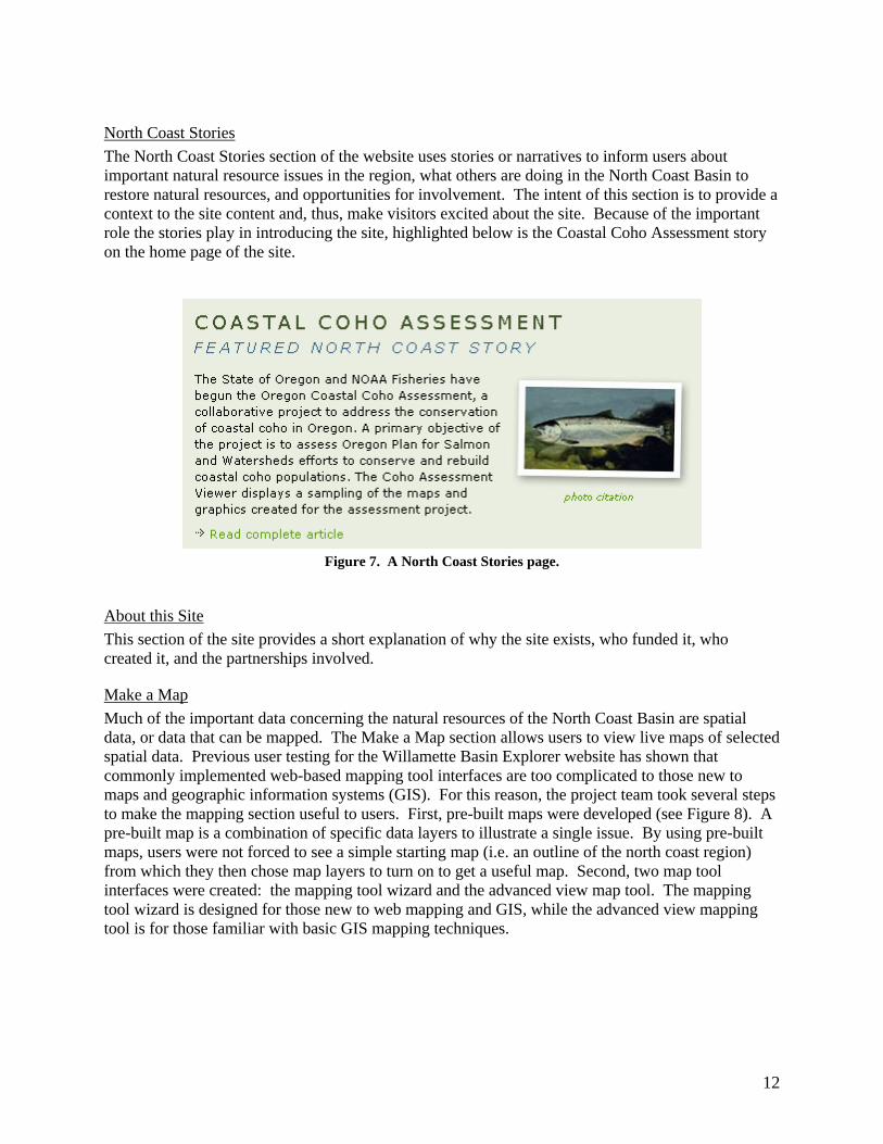
North Coast Stories The North Coast Stories section of the website uses stories or narratives to inform users about important natural resource issues in the region, what others are doing in the North Coast Basin to restore natural resources, and opportunities for involvement. The intent of this section is to provide a context to the site content and, thus, make visitors excited about the site. Because of the important role the stories play in introducing the site, highlighted below is the Coastal Coho Assessment story on the home page of the site.
Figure 7. A North Coast Stories page.
About this Site This section of the site provides a short explanation of why the site exists, who funded it, who created it, and the partnerships involved.
Make a Map Much of the important data concerning the natural resources of the North Coast Basin are spatial data, or data that can be mapped. The Make a Map section allows users to view live maps of selected spatial data. Previous user testing for the Willamette Basin Explorer website has shown that commonly implemented web-based mapping tool interfaces are too complicated to those new to maps and geographic information systems (GIS). For this reason, the project team took several steps to make the mapping section useful to users. First, pre-built maps were developed (see Figure 8). A pre-built map is a combination of specific data layers to illustrate a single issue. By using pre-built maps, users were not forced to see a simple starting map (i.e. an outline of the north coast region) from which they then chose map layers to turn on to get a useful map. Second, two map tool interfaces were created: the mapping tool wizard and the advanced view map tool. The mapping tool wizard is designed for those new to web mapping and GIS, while the advanced view mapping tool is for those familiar with basic GIS mapping techniques.
12
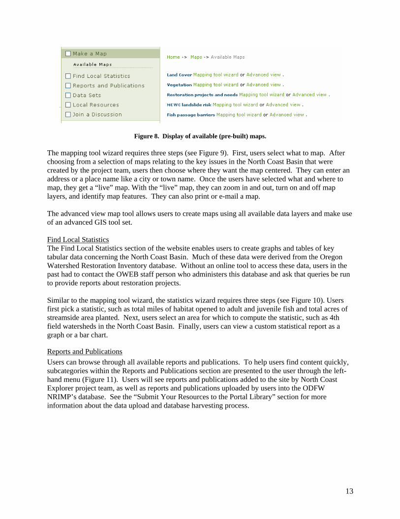
Figure 8. Display of available (pre-built) maps. The mapping tool wizard requires three steps (see Figure 9). First, users select what to map. After choosing from a selection of maps relating to the key issues in the North Coast Basin that were created by the project team, users then choose where they want the map centered. They can enter an address or a place name like a city or town name. Once the users have selected what and where to map, they get a “live” map. With the “live” map, they can zoom in and out, turn on and off map layers, and identify map features. They can also print or e-mail a map. The advanced view map tool allows users to create maps using all available data layers and make use of an advanced GIS tool set. Find Local Statistics The Find Local Statistics section of the website enables users to create graphs and tables of key tabular data concerning the North Coast Basin. Much of these data were derived from the Oregon Watershed Restoration Inventory database. Without an online tool to access these data, users in the past had to contact the OWEB staff person who administers this database and ask that queries be run to provide reports about restoration projects. Similar to the mapping tool wizard, the statistics wizard requires three steps (see Figure 10). Users first pick a statistic, such as total miles of habitat opened to adult and juvenile fish and total acres of streamside area planted. Next, users select an area for which to compute the statistic, such as 4th field watersheds in the North Coast Basin. Finally, users can view a custom statistical report as a graph or a bar chart.
Reports and Publications Users can browse through all available reports and publications. To help users find content quickly, subcategories within the Reports and Publications section are presented to the user through the left-hand menu (Figure 11). Users will see reports and publications added to the site by North Coast Explorer project team, as well as reports and publications uploaded by users into the ODFW NRIMP’s database. See the “Submit Your Resources to the Portal Library” section for more information about the data upload and database harvesting process.
13

Figure 9. The three-step mapping tool wizard.
14
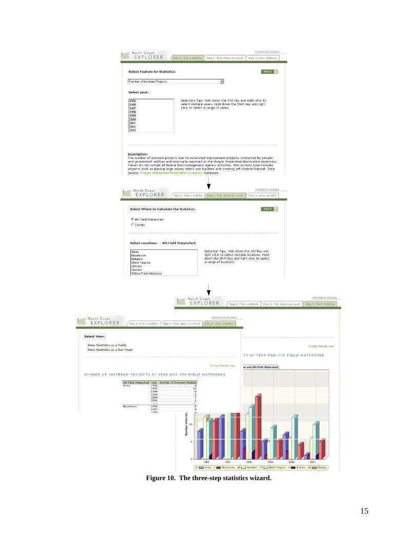
Figure 10. The three-step statistics wizard.
15

Figure 11. Example reports and publications page showing the available sub-categories.
Data Sets To avoid duplicating existing databases, users of the data sets section will find links to websites hosting air- and water-quality monitoring data, data clearinghouses, and metadata search sites, as well as links to individual data sets through the general watershed information sub-category. The watershed information sub-category displays datasets that have been uploaded into the ODFW NRIMP’s database through the same process used for reports and publications.
Local Resources Helping users find appropriate expertise is one of the key principles in OWEB’s statewide information system strategy. To provide this ability in the North Coast Explorer, the project team created listings of watershed councils, soil and water conservation districts, Oregon State University Extension agents, State of Oregon departments and personnel, Oregon Watershed Enhancement Board personnel, federal agencies, and general websites. While such listings are difficult to maintain and keep up-to-date until there are software facilities such as web services provided by agencies to receive contact information, the user group strongly recommended that the site include a comprehensive contact database, thus this capability was included in the prototype website.
Figure 12. Sample local resources page.
16
Join a Discussion Requirements for the prototype website included a way for users to communicate with experts. The project team offered three options to the user group: a listserv, a web-based bulletin board, and a Wiki. Listservs are e-mail-based discussion lists where subscribers receive all postings to the list as e-mail. Listservs are good for people who rely solely on e-mail for electronic communication and do not want to have to go to a website to ask or answers questions. Web-based bulletin boards use the web instead of e-mail to post questions and responses. Most bulletin boards have better search tools than listservs, but bulletin boards need an active community or moderators to make sure that posts to the bulletin board receive responses. A Wiki is a web tool typically used for team collaboration. Users can create web pages and add comments to existing pages. Wikis are best applied when users need to display complex integrated content; however, because of this, they are more difficult to use initially. After reviewing these three options, the user group favored the web-based bulletin board, especially if the bulletin board system could send e-mail notification of posts/activity on the bulletin board. When users click on the Join a Discussion link on the North Coast Explorer, they are taken to a commercial, web-based bulletin board. This bulletin board was initially created by Eric Nussbaum of the Siuslaw Soil and Water Conservation District at the request of a number of local restoration group representatives from the North Coast who attended the OWEB conference in November 2004. After explaining that a communication feature such as this was a tool intended for inclusion in the prototype website, Eric suggested that the technical project team simply integrate the existing tool into the site. Anyone can read and search posts and replies, but to make a post, users must register. Registered users can configure the system to notify them via e-mail of postings and replies. To help introduce users to the bulletin board system, a special web form was created that allows users to post comments about the website anonymously to the bulletin board.
17

Figure 13. Using the bulletin board to display web site comments Search While many sites offer the ability to search for spatial data using spatial footprints or bounding boxes, the prototype allows users to find any of content on the site (e.g., documents, local resources, etc.) for a particular spatial area. Users of the North Coast Explorer can search for content by defining content type (e.g., a report), by content theme (e.g., Coho), by spatial footprint (e.g., a watershed council area), and by free text. The use of content themes allows users to quickly find all content pertaining to a particular topic without having to guess which words to use in a free text search.
18

Figure 14. Search interface for specifying content type, content topic,
and spatial footprint (i.e., geographic location). Submit Your Resources to the Portal Library The prototype requirements specified that a mechanism be provided so that users could add content to the North Coast Explorer. Rather than duplicate databases, the project team partnered with the ODFW NRIMP’s effort to make information from the Oregon Plan Review publicly available. The effort also allows registered users to upload content to a database repository after entering basic metadata. To make the NRIMP system work with the prototype’s architecture, the technical project
19

team and NRIMP staff had to make two modifications. First, the Open Archives Initiative Protocol for Metadata Harvesting (OAI-PMH) was implemented. NRIMP developers added an OAI-PMH server to their system and the technical project team added an OAI-PMH harvester so that metadata can be harvested from NRIMP’s server on a scheduled basis. The harvested metadata (but not the actual dataset/reports) are then added to the North Coast Explorer database. Harvested content is displayed under the Reports and Publications and the Datasets sections, as appropriate. When users click to get the actual report or dataset, they receive the content from the NRIMP system. The second modification to NRIMP’s system was to require users to select appropriate descriptors of content type, content theme, and spatial footprint for the content when uploading new information. This requirement is necessary given that all content on the prototype site must be classified using this system of keywords. NRIMP’s developers refined their site to redirect users to webpages hosted by OSU Libraries through which this descriptor information could be collected. This linkage allows new content being added to the North Coast Explorer to adhere to the classification requirements designed by the project team so that users can browse and search by multiple options.
Figure 15. Architecture of the content submission process. Initially, the technical project manager intended to use graduate students to complete design and programming tasks during the prototype development process. However, in order to adhere to the timeline for launching the prototype in early 2005, OSU Libraries requested that OWEB provide flexibility regarding project staffing. Ultimately, the technical project team included two subcontractors: Edge Design, an Oregon-based web consulting firm that completed the North Coast Explorer’s user interface design and development, and Computer Productivity Plus, an Oregon-based software architecture and design firm, that completed software design and coding services. The
20
addition of these subcontractors enabled the team to design an attractive and easy-to-navigate interface for the website, build a well designed and functional website with a number of unique tools that benefit users, better utilize the funds allocated for prototype development, and ensure timely completion of the project. EVALUATION OF THE PROTOTYPE WEBSITE The project team worked with OWEB staff to outline a number of success measures that were to be considered in the testing and evaluation of the prototype website. Categories of success and the associated measures, listed by OWEB staff for the evaluation of a statewide natural resources information system, are those common to the DeLone & McLean Information System Success Model (for more information, see http://jmis.bentley.edu/articles/v19_n4_p9/):
Information Quality: The prototype’s content should be at a level of quality that prospective users will start at the Portal in their search for answers to critical questions to inform their decision making. Return use is desired.
Measures • Does the site provide accurate information? • Does the site provide believable information? • Does the site provide easy-to-understand information? • Does the site create a sense of personalization for different user types? • Does the site provide information at the right level of detail? • Does the site present information in an appropriate format? • Does the site provide timely and relevant information? • Is the site secure?
System Quality: The measures of desired and valuable characteristics.
Measures • Does the site have a good reputation? • Does the site make users feel confident that any goods/services requested through the system
will be delivered as promised? • Is the site easy to learn to operate? • Is user interaction with the site clear and understandable? • Is the site easy to navigate? • Is the site easy to use? • Does the site have an attractive appearance? • Is the design of the site appropriate to the type of site it is, as defined by user requirements? • Does the site convey a sense of competence? • Does the site create a positive experience for users?
Service Quality: The overall support delivered to the user so that they return to the site and use the site to help answer critical questions or inform their decisions.
Measures • Does the site convey a sense of user community? • Does the site make it easy to communicate with the user community?
21
Usage: A “measure of everything.”
Measures • What are the navigation patterns of users? • What are the site visits patterns? • What is the users’ overall impression of the site?
User Satisfaction: Measuring the users’ opinions of the system covering all uses, from the time they enter the Portal until they exit.
Measures • Are there repeat visits? • What are the results of user surveys?
Net Benefits: “The most important success measures… analyzed in light of information quality and system quality.”
Measures • Does the system provide cost savings? • Does the system provide expanded geographic service areas? • Does the system provide users with time savings benefits?
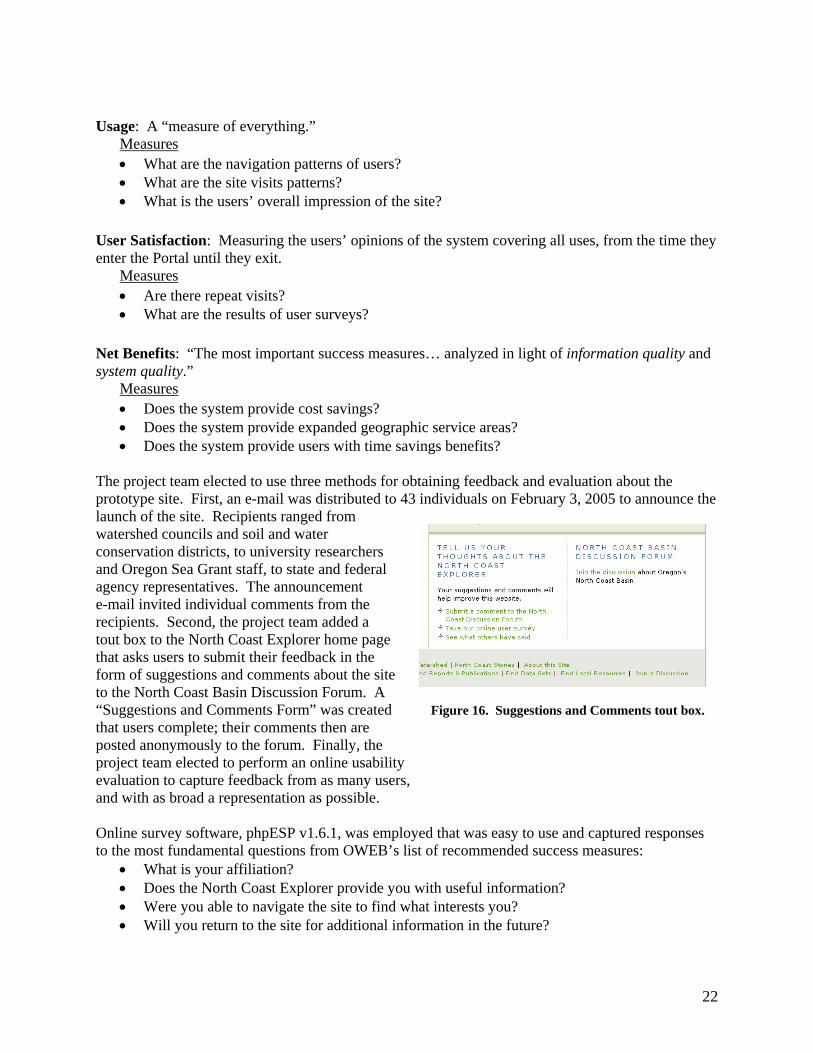
The project team elected to use three methods for obtaining feedback and evaluation about the prototype site. First, an e-mail was distributed to 43 individuals on February 3, 2005 to announce the launch of the site. Recipients ranged from watershed councils and soil and water conservation districts, to university researchers and Oregon Sea Grant staff, to state and federal agency representatives. The announcement e-mail invited individual comments from the recipients. Second, the project team added a tout box to the North Coast Explorer home page that asks users to submit their feedback in the form of suggestions and comments about the site to the North Coast Basin Discussion Forum. A “Suggestions and Comments Form” was created Figure 16. Suggestions and Comments tout box. that users complete; their comments then are posted anonymously to the forum. Finally, the project team elected to perform an online usability evaluation to capture feedback from as many users, and with as broad a representation as possible. Online survey software, phpESP v1.6.1, was employed that was easy to use and captured responses to the most fundamental questions from OWEB’s list of recommended success measures:
• What is your affiliation? • Does the North Coast Explorer provide you with useful information? • Were you able to navigate the site to find what interests you? • Will you return to the site for additional information in the future?
22
Optional questions included in the survey were: • What topics are you interested in and did you find information about these on the North
Coast Explorer? • What features worked well for you? • What features seemed unclear or did not take you to the information you were wanting? • Is there information or features that should be added?
Survey responses, as well as individual comments and forum discussion items, were evaluated by the project team within several weeks of the public release of the North Coast Explorer. Online Survey Responses Three weeks after the North Coast Explorer was launched, five individuals representing three user categories (i.e., Oregon Plan agency staff, interested citizen, scientist) had responded to the online survey. This sample size and representation was not large enough to provide a thorough evaluation of the site’s usability. The alternative plan is for OSU Libraries and INR staff to evaluate the site quarterly when more users have had a chance to discover and use the site. Findings from the limited number of responses to the online survey showed that all users had a positive experience when exploring the prototype website (Figure 17). One of the first comments received stated, “The site looks really good; it’s clear and straightforward and easy to navigate.” All respondents were in agreement or high agreement with Questions 2-4:
• The North Coast Explorer provided me with useful information • I was able to navigate the site to find what interests me • I will return to the site for additional information
Additional information and topics of interest as identified by survey respondents include:
• Information about endangered species, vegetation, ecosystem processes • Photos and illustrations of north coast plants and animals • Reports and research papers that address particular coastal counties • Information about OSU faculty research projects • Agency reports (e.g., ODFW lifecycle monitoring stations, ODFW Oregon Plan monitoring,
Corps of Engineers work) A variety of North Coast Explorer features worked well for these users as evidenced by the following survey remarks: The “links and navigability made sense and were easy to follow”; “the Oregon Coho features were very cool”; and the “URL is very easy to remember.” In addition, users expressed that they like the Reports and Publications section. The features that presented problems for users, were unclear, or did not take users to the information they wanted were the slowness of the mapping tool and confusion associated with the search function, which at the time of the launch, was not fully functional. More content was desired under some of the topic headings, specifically fish and endangered species. In general, the suggestions were to “beef up” various sections, such as Reports and Publications, Datasets, and Learn about a Topic. Suggestions were made to add more reports and scientific information. Specific requests include adding information to the Coastal Coho Assessment story, showing restoration activities occurring on public lands (referencing the Northwest Forest Plan Regional Ecosystem Office restoration projects
23

webpage, http://www.reo.gov/restoration), and providing more information on uplands (e.g., vegetation, habitat structure, change over time). The online survey will remain active in the foreseeable future so that the North Coast Explorer can continue to be evaluated. Because the online survey tool is easy to use from a respondent’s standpoint and provides clear evaluation from a website administrator’s perspective, this periodic evaluation will be a relatively easy task to maintain and complete.
Figure 17. Summary statistics for the required questions in the online survey.
Comments from Individual Users Individual comments received by the INR’s project co-manager after the release of the North Coast Explorer were also very positive and constructive. Eight individuals submitted the following comments via e-mail:
• The site looks very nice. You may want to either note the interactive mapping does not work in Firefox (it looks good in Internet Explorer), or fix it so that it does... Otherwise, nicely done!!
• Very cool site design and information access. I've linked to it in the (Oregon Coastal) Atlas Links page under "Regional Coastal GIS". I really like the look of the "Add to the Library" tool.
• Will you be including such things as taxlots, landslide hazards and air-photos for the North Oregon of Coast?
24

• My congratulations on a wonderful site! I found it to be comprehensive, easy-to-navigate, and innovative, particularly the "Submit Your Resources" section, the "Automatically Refresh Map" checkbox option when working in the "Make a Map" section, the provision of an easy-to-read "Help" column next to the map display, and the ability to quickly change text size when in any part of the site!
• Congratulations!! I took a quick peek and it looks great. I really like the discussion feature. • The site looks good and we would be happy to contribute to any further efforts. • The site is WONDERFUL!!!!! I have been showing it to everyone and cruising over the map
to show the coho return. • There is a very clean feel AND logic to the site, which is so often lacking on the web. I also
like the flow of the writing—having a good writer is another thing frequently skimped on in web design. The stories give just enough of a flavor that people can relate without taking too much time (to read).
Discussion Forum Comments The discussion forum featured on the North Coast Explorer has received some activity since the site’s launch in early February 2005. As illustrated by results from website-use tracking software (see next section), the discussion forum is the most popular directory on the site. A variety of topics have been raised in the discussion forum to date, despite the fact that only four users have actually posted comments to the forum. Users have 1) asked for clarification on particular issues, 2) pointed out perceived errors in terms of website content, 3) commented on the Coastal Coho Assessment analysis, and 4) shared their excitement over learning something new (i.e., one submitter commented, “Great! Finally I figured out what rapid bioassessment is!”). Tracking of Website Use In addition to the aforementioned methods for obtaining feedback and evaluation about the prototype site, the technical project team also added statistical software to track use and behavior patterns of users accessing the site. The software, Summary SP 2.5.2, provides a range of summary and detailed information about site use. As of 2/24/05, the following use and behavior patterns were observed for the North Coast Explorer:
• The total number of visits totals 1,113, with an average of 52 visits per day. • Patterns of use are dependent on the day of the week, with the most visits occurring on
Fridays and the fewest during weekends (see Figure 18). • The total number of page hits is 9,413, with an average of 442 page hits per day. • Twenty-two pieces of content have been downloaded from the site. The most popular
downloads are the mapping tool tutorial and the CLAMS simulation of forest cover change. • In terms of the most popular content, the top five pages are: 1) Learn about a Topic, 2) the
home page, 3) Learn about a Watershed, 4) North Coast Stories, and 5) Data Collections. • The most popular directory on the site is the Discussion Forum. • Fifty percent of the referring domains are users navigating among pages in the site. Other
high-traffic referring domains are oregonstate.edu and oregon.gov, each with 16.67% of the referring domains, and google.com (5.56% of referrals). Rounding out the top five domains from which users come are noaa.gov and comcast.net.
• Visitor behavior tracking shows that, on average, users access 8.5 pages per visit, spend nearly 10 minutes on the site per visit, and average nearly 1.5 days between visits.
• Most visitors enter and exit the site via the home page. • On average, users spent nearly 4 minutes reviewing the discussion forum comments.
25

Figure 18. Summary statistics for daily website use.
The Summary SP software will continue to be used to track use of the North Coast Explorer website in the coming months. This tool will enable OWEB, INR, and OSU Libraries to continue to evaluate use of the site (including popular content) and make decisions about refinements to and expansion of the site based on this feedback. REMAINING NEEDS AND NEXT STEPS Remaining Needs: Messages from the Prototype Development Process As mentioned previously, the prototype design and development process identified a number of additional needs, some of which were not within the scope of this project. These needs include:
Design • A web “steward” should be identified to ensure that data and information on the site is up-to-
date and new information is added regularly. • Privacy issues associated with some documents (e.g., project completion reports) that could
be uploaded to the North Coast Explorer library should be addressed by OWEB. • OWEB should build into grantmaking requirements that all project completion reports and
GIS layers of spatial data must be uploaded to the prototype’s library. • In the future, the site should provide the ability for electronic submission of monitoring data
(e.g., water quality and spawning surveys) from local restoration groups and Oregon Plan partner agencies. Collaboration with the Oregon Plan Monitoring Team would be required to ensure that data standards are met and to explore integration of electronically submitted information with existing datasets.
• In the future, a download-edit-upload tool should be tested that would allow real-time addition of new data (either numerical or spatial).
• Conveying the importance of watershed councils, agencies, and others sharing their information by making it electronically available on the North Coast Explorer should be a priority.
26
Content • The ability to incorporate thematic content about multiple watershed applications, such as
watershed assessments, action plans, restoration and monitoring activities, investment prioritization, and education, should be added.
• More information about the people of the North Coast, with pictures, should be added. In addition, for each watershed council area, details about the number of people living in the area, ecological features, etc. should be expanded.
• The Local Statistics tool should include information about human population, miles of stream, major industries, number of watershed councils, number of threatened and endangered species, precipitation, and other metrics of interest to users.
• OWEB and the Oregon Plan Monitoring Team should consider making monitoring protocols available online.
Tools • Online decision-support tools (e.g., for data analysis such as online restoration prioritization,
estimation of culvert and large woody debris sizes based on upstream watershed area, and landslide probability analysis) should be made available.
• In order for information to be useful to a range of users, data should be presented at multiple scales, including finer scales such as 7th field watersheds at which local restoration groups are working.
• Tax lot information and Total Maximum Daily Load (TMDL) information, along with spatial data from the Aquatic Habitat Inventory should be added to the mapping tool wizard and advanced mapping tool.
• The advanced mapping tool should provide the option of outputting a map in a Shapefile format for use in GIS software.
• The option to generate local statistics by watershed council area should be added. • In the data submission tool, a comment field should be added in which submitters can
highlight datasets that are good candidates for addition to the mapping and/or statistical tools. • A web-enabled version of the Oregon Watershed Restoration Inventory form should be
created that allows users to submit information online that uploads directly to the OWRI database.
Next Steps The development of the North Coast Explorer prototype website is a critical step in the development of the long-term vision to create a single access point for natural resources information in Oregon. In addition to being a priority for the OWEB Board, this objective is a primary facet of the legislation that created the Institute for Natural Resources. As such, the prototype will serve as the critical pilot that informs and guides future activities. The prototype has attributes that allow it to be an effective tool both to assist local restoration groups, Oregon Plan partner agencies, and OWEB to conduct work more efficiently in the North Coast Basin and to expand to better address the objective of natural resources information management. The expansion capacity of the website and associated databases has two components: an internal component that allows for the easy addition of features and content to the existing site, and an external one that creates the opportunity to more easily and cheaply build similar websites in other basins in Oregon. Next steps include demonstration of the utility, viability and significance of the North Coast Explorer and its companion, the Willamette Explorer; development of methodology to
27
expand the utility of these sites; and completion of the strategy to create a basin-level websites for the remainder of the state. Near-Term Priorities The primary, near-term priority is to demonstrate that the prototype site is useful and can be maintained over time. The basic maintenance and storage costs for the hardware, software and access to the site are currently being born by the OSU Libraries. To assure the site remains viable, and the long-term management costs can be covered, INR is working with the library to institutionalize the costs of and responsibility for maintenance activities. INR and OSU Libraries are in the process of characterizing the costs of maintaining the site once the primary objectives are met. These critical maintenance expenses must then be included in the general university operations budget during the 2007-2009 biennium. At present, OSU Libraries have the ability to provide some resources for the stewardship of the site. INR and the library must establish that the site is meeting its objectives and being used by the public. The WebTrends software used by the OSU Libraries (and developed in Oregon) allows for reporting of the volume of use the site is getting, and will continue to be used over time to track information about the North Coast and Willamette Explorer websites. In addition, INR will continue work with OWEB to obtain feedback from primary clients of the prototype site in the North Coast Basin to ensure the site meets their needs and is operating successfully.
For the near term, any additional funding for this project (either from OWEB or other sources) will be focused on making additional materials relevant to the North Coast Explorer site available online. This limited expansion will be enabled through the partnership with the NRIMP effort to expand the existing database to include Oregon watershed council information (e.g., watershed assessments, action plans, etc.). Another important near-term priority is linking the creation of the Network of Oregon Watershed Councils Portal and Collaborative Website, which is being funded by OWEB, with the prototype. All of these activities would be assisted by institutionalizing the OWEB information system, along with the distributed network of watershed council information systems. In terms of projecting basic maintenance costs for maintaining the North Coast Explorer during the coming 6-12 months, the project team estimates that 0.1 FTE would be necessary for this work. The individual maintaining the site should have both web programming and GIS experience, in addition to familiarity with natural resource issues in Oregon. The estimated cost for 12 months of maintenance at this level is approximately $5,600 (includes salary, OPE, and indirect costs at 10%, the rate which OWEB has negotiated with Oregon State University). Mid-Term Priorities Once the viability of the site has been demonstrated, the next priority is to increase its functionality and utility. The most important aspects of this priority are to add new content related to the Oregon Plan Review, restoration projects, and themes and geographic areas highlighted in the prototype site. The objective of these activities is to ensure that the site remains relevant and central to local restoration groups and others working in the North Coast Basin. These priorities may also include adding new functionality developed through other aspects of the information strategy being coordinated by INR and OSU Libraries. An example would be to expand the current search capacity of the prototype site by using the A-9 Search Engine. This capability is being developed by the library as part of the Oregon Explorer project. Another example would be to include new information that has been recently developed through other projects. Possible sources
28

include North Coast-specific information and recommendations included in ODFW’s Comprehensive Wildlife Conservation Strategy, emerging information from CLAMS, updated spatial datasets for tidegate and passage barriers from the Oregon Department of Transportation and other agencies, addition of floodplain spatial data for the North Coast Basin, and other products being developed by new data integration efforts at OWEB.
Addition of new content and tools is essential to assuring the long-term viability of the site because the public requires that sites are updated regularly if they are to continue to be used. In particular, OWEB is the primary source of information such as application deadlines and funding opportunities, contact information for local resources, and relevant changes in programs and laws, which is directly relevant to local restoration groups. Maintaining direct information links among the prototype website, the Oregon Plan website, and the Network of Oregon Watershed Councils Portal, to assure that the sites can be used simultaneously and to the maximum benefit, is critical.
Currently, resources are not in place to pay for the expansion of the existing basin-level websites for the North Coast and Willamette Basins. The work would require staff at OSU Libraries for site maintenance, and additional staff to identify new content. Currently OWEB has information coordination staff focused primarily on the latter activities; however, this staffing is not planned to continue beyond the end of this State fiscal year (June 2005). As a result, additional staff capacity is going to be necessary—either at INR, elsewhere at OSU, or in another State entity. Under the current, fairly limited maintenance needs of the North Coast Explorer and Willamette Explorer sites, the investment required represents a fairly small outlay of time and resources (i.e., approximately 0.1 FTE and $5,600 for basic maintenance of the two sites). However, if the long-term vision of basin, ecoregional and county information portals is to be reached, at least one full-time staff member will be required to supplement content and maintain the websites. Long-Term Priorities: Expansion of the Explorer Approach The long-term objective of this natural resources information system effort is to complete basin and geographic portals for the entire state, and to create a comprehensive Oregon Explorer page to provide statewide access to natural resources information. Recently, a proposal has been submitted to the U.S. Fish and Wildlife Service to work with the Oregon Institute of Technology on development of an Upper Klamath Basin portal. Funding from the Bureau of Reclamation is also available in the Klamath, and a partnership with Humboldt State University is being explored to provide information covering the entire Klamath Basin.
Proposals to work with the Umpqua Watershed Council to develop an Umpqua Basin site have also been drafted. This effort will hopefully allow INR and OSU Libraries to develop a home for the very extensive information developed by the Umpqua Land Exchange Project, and to provide online tools to examine different land ownership patterns in the southern Coast Range. Hopefully, this project also would allow for the display of additional information from the Oregon Plan Review, based on tools developed by UO’s InfoGraphics Lab as part of the North Coast Explorer project.
The current INR Information Program strategy calls for the remainder of the basin portals in Oregon to be developed in partnership with the Northwest Power and Conservation Council. These websites, which would focus on data developed as part of the Council’s sub-basin planning process, will cover either the entire Pacific Northwest (focusing on the Columbia River Basin) or only large river basins in Oregon. The approach taken will depend largely on the development of partnerships with the University of Idaho and the University of Washington, as well as the availability of funding for a larger effort. The Oregon basins with the greatest potential for short-term development are the
29
Walla-Walla and Umatilla Basins, both of which have existing projects that require an online presence, and the Deschutes Basin. Once the entire set of Oregon basin portals are operational, this larger effort also should consider a strategy to assume long-term management of the Network of Oregon Watershed Councils Portal. A wide-ranging strategy is critical given that management costs for maintaining various websites as separate entities will result in duplication and increased expense.
In addition to the effort to complete the basin portals for Oregon, INR and OSU Libraries are developing a strategy that links the Oregon Explorer and associated basin-level portals with the natural resources information maintained and distributed by the State of Oregon. A proposal to build ecoregional portals has been developed in association with the Oregon, Washington and Idaho Departments of Fish and Wildlife and was submitted to the National Fish and Wildlife Foundation in February 2005. While this funding source is very competitive, the proposal also will be submitted to other foundations. Finally, subject-matter portals are to be developed in conjunction with the U.S. Geological Survey and their Biological Research Division’s National Biological Information Infrastructure (NBII). Currently, INR and the University of Idaho are working with USGS to develop a strategic plan for the Pacific Northwest Node of the NBII, which will hopefully be cooperatively maintained by the University of Idaho, the University of Washington, and Oregon State University.
The last key piece in this statewide effort in Oregon is completion of the state GIS utility, which is currently under development by DAS, under contract with PlanGraphics of Kentucky. The contract calls for PlanGraphics to develop a business case and the structure and plan for the GIS Utility. The utility is to be built and maintained by DAS and the GeoSpatial Enterprise Office, managed by Cy Smith. This utility will provide a source for both storing and distributing all framework geographic information in the state. OSU Libraries is a partner in this effort, with OSU maintaining the state’s metadata library (currently called Virtual Oregon). In the future, the library likely also will house the Oregon Geospatial Data Clearinghouse for all data not incorporated into the GIS utility.
30


![SOUTH COAST AIR QUALITY MANAGEMENT DISTRICT FINAL ...€¦ · Quality Management District (SCAQMD) Regulations and improve in-Basin (South Coast Air Basin [Basin]) power reliability,](https://static.fdocuments.us/doc/165x107/5f860f505bc6182863561c78/south-coast-air-quality-management-district-final-quality-management-district.jpg)